ontario ministry of transportation highway 17 planning ......aecom ontario ministry of...
TRANSCRIPT

Prepared by:
AECOM
5600 Cancross Court, Suite A 905.501.0641 tel
Mississauga, ON, Canada L5R 3E9 905.501.0181 fax
www.aecom.com
Project Number:
60241599
Date:
July, 2014
Ontario Ministry of Transportation
Highway 17 Planning & Class EA Study Noise Review GWP 5670-10-00

AECOM Ontario Ministry of Transportation Highway 17 Planning & Class EA Study Noise Review
GWP 5670-10-00
Appendix D-Final Noise Report_July 2014.Docx
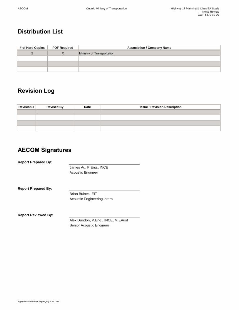
Distribution List
# of Hard Copies PDF Required Association / Company Name
2 X Ministry of Transportation
Revision Log
Revision # Revised By Date Issue / Revision Description
AECOM Signatures
Report Prepared By:
James Au, P.Eng., INCE
Acoustic Engineer
Report Prepared By:
Brian Bulnes, EIT
Acoustic Engineering Intern
Report Reviewed By:
Alex Dundon, P.Eng., INCE, MIEAust
Senior Acoustic Engineer
AECOM Ontario Ministry of Transportation Highway 17 Planning & Class EA Study Noise Review
GWP 5670-10-00
i
Executive Summary
The Ontario Ministry of Transportation has retained AECOM to undertake a Class Environmental Assessment to
identify a recommended plan for a four-lane Highway 17 within the study limits with access restricted to interchange
locations.
The planning alternatives included segments of widening/improving the existing highway and segments of realigned
highway, with interchanges at key connection points and new service roads for some areas. In the Rutherglen and
Amable du Fond areas, widening of the existing highway is not possible due to physical constraints and
environmental conditions. Therefore, realignment alternatives were generated for these two areas while widening
alternatives were generated for the Pimisi Bay and Pautois Creek areas. The evaluation of highway planning
alternatives was completed on a comparative basis for each of the four highway realignment and widening
alternative areas (with associated interchanges and service roads) and a recommended plan was identified in
January 2014, prior to this assessment being conducted.
A detailed noise assessment was completed for the recommended plan which includes improvements to Highway 17
from an undivided two lane highway to a four lane controlled access divided freeway along a new alignment.
According to noise predictions, the proposed changes to Highway 17 would result in medium to high changes in
noise level perception at several nearby receptors (e.g. residences) due to the realigned portions of the highway,
which are primarily in greenfield areas. The noise assessment has been completed using predicted 2035 traffic
volumes.
At one location (R18), a noise barrier appears to be warranted based on MTO policy. The necessity for noise
mitigation, (as presented in Section 4.2), is recommended for further exploration and examination during detail
design for one receptor (R18) where initial analysis indicates that:
The increase in noise caused by the recommended plan at this location is greater than 5 dB;
A noise barrier at this location with a height of 5 metres and a length of 28 metres would meet the minimum
noise reduction requirement of 5 dB; and
A noise barrier is considered economically feasible because the barrier cost per household is less than the
MTO rule of thumb ‘ballpark’ cost limit of $100,000 per receptor.
Noise resulting from construction of the recommended plan varies based upon a variety of factors such as time and
location of operation, size and concurrent use of equipment, and staging of construction. As equipment information
is only available from the contractor that is awarded the construction contract, general recommendations to minimize
the impact of construction noise have been provided.
AECOM Ontario Ministry of Transportation Highway 17 Planning & Class EA Study Noise Review
GWP 5670-10-00
Table of Contents
Distribution List
Executive Summary
page
1. Introduction .................................................................................................................................. 1
2. Environmental Highway Traffic Noise Guidelines ..................................................................... 3
2.1 Criteria ................................................................................................................................................. 3 2.2 Noise Sensitive Areas .......................................................................................................................... 4
3. Assessment of the Recommended Plan – Methodology........................................................... 5
3.1 Traffic Data .......................................................................................................................................... 5 3.2 Area of Investigation ............................................................................................................................ 5 3.3 Areas Requiring Detailed Assessment ................................................................................................ 6 3.4 Noise Prediction Procedure ................................................................................................................. 7
4. Assessment of the Recommended Plan – Results and Recommendations ............................ 9
4.1 Results ................................................................................................................................................. 9 4.2 Noise Mitigation Investigation .............................................................................................................. 9
5. Construction Noise .................................................................................................................... 12
5.1 Municipal Noise Control By-Laws ...................................................................................................... 12 5.2 Construction Noise Control Recommendations ................................................................................ 12
6. Conclusions/Recommendations ............................................................................................... 15
7. References ................................................................................................................................. 16
List of Figures
Figure 1.1: Class EA Study Limits ................................................................................................................................ 1
List of Tables
Table 2.1: MTO Criteria for Investigation of Noise Mitigation ..................................................................................... 3
Table 2.2: Perceived Impact of Increased Sound Levels ............................................................................................ 4
Table 3.1: Traffic Data ................................................................................................................................................. 5
Table 3.2: Assessed Noise Sensitive Locations ......................................................................................................... 6
Table 4.1: Noise Assessment Results – Most Exposed Side ........................................................................................ 9
Table 4.2: Predicted Noise Reduction by Noise Barrier ............................................................................................ 10
Table 4.3: Resultant Noise Barriers and Approximate Costing ................................................................................. 10
AECOM Ontario Ministry of Transportation Highway 17 Planning & Class EA Study Noise Review
GWP 5670-10-00
Appendices
Appendix A: Recommended Plan
Appendix B: Area of Investigation
Appendix C: Detailed Assessment Receptor Locations
Appendix D: Zoning Plan
Appendix E: Proposed Noise Barriers
Appendix F: Traffic Data
Appendix G: Traffic Noise Calculations
AECOM Ontario Ministry of Transportation Highway 17 Planning & Class EA Study Noise Review
GWP 5670-10-00
Appendix D-Final Noise Report_July 2014.Docx 1
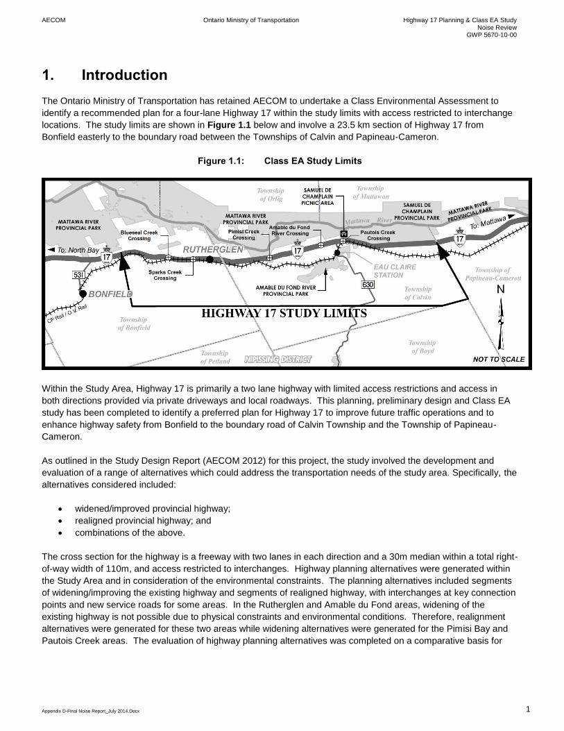
1. Introduction
The Ontario Ministry of Transportation has retained AECOM to undertake a Class Environmental Assessment to
identify a recommended plan for a four-lane Highway 17 within the study limits with access restricted to interchange
locations. The study limits are shown in Figure 1.1 below and involve a 23.5 km section of Highway 17 from
Bonfield easterly to the boundary road between the Townships of Calvin and Papineau-Cameron.
Figure 1.1: Class EA Study Limits
Within the Study Area, Highway 17 is primarily a two lane highway with limited access restrictions and access in
both directions provided via private driveways and local roadways. This planning, preliminary design and Class EA
study has been completed to identify a preferred plan for Highway 17 to improve future traffic operations and to
enhance highway safety from Bonfield to the boundary road of Calvin Township and the Township of Papineau-
Cameron.
As outlined in the Study Design Report (AECOM 2012) for this project, the study involved the development and
evaluation of a range of alternatives which could address the transportation needs of the study area. Specifically, the
alternatives considered included:
widened/improved provincial highway;
realigned provincial highway; and
combinations of the above.
The cross section for the highway is a freeway with two lanes in each direction and a 30m median within a total right-
of-way width of 110m, and access restricted to interchanges. Highway planning alternatives were generated within
the Study Area and in consideration of the environmental constraints. The planning alternatives included segments
of widening/improving the existing highway and segments of realigned highway, with interchanges at key connection
points and new service roads for some areas. In the Rutherglen and Amable du Fond areas, widening of the
existing highway is not possible due to physical constraints and environmental conditions. Therefore, realignment
alternatives were generated for these two areas while widening alternatives were generated for the Pimisi Bay and
Pautois Creek areas. The evaluation of highway planning alternatives was completed on a comparative basis for
AECOM Ontario Ministry of Transportation Highway 17 Planning & Class EA Study Noise Review
GWP 5670-10-00
Appendix D-Final Noise Report_July 2014.Docx 2
each of the four highway realignment and widening alternative areas (with associated interchanges and service
roads) and a recommended plan was identified in January 2014 as shown in Appendix A.
The purpose of this report is to document the detailed noise assessment undertaken for the recommended plan to
identify noise impacts and potential noise mitigation.
AECOM Ontario Ministry of Transportation Highway 17 Planning & Class EA Study Noise Review
GWP 5670-10-00
Appendix D-Final Noise Report_July 2014.Docx 3
2. Environmental Highway Traffic Noise Guidelines
2.1 Criteria
This assessment has been completed in accordance with the requirements stipulated in MTO’s Environmental Guide
for Noise (the Guide) published in 2006.
Under the Guide, the “noise impact” is defined as the difference between the “No Project” and the “With Project”
noise levels during the subject year of assessment (Horizon Year), which is typically 10 years post-construction.
The Guide requires that the most exposed side of a dwelling unit be assessed as part of an initial screening. If the
initial screening indicates that noise mitigation investigation is required, the point of assessment for determining the
noise mitigation requirements is the Outdoor Living Area (OLA).
The OLA can be situated on any side of a noise sensitive area which accommodates outdoor living activities, and is
generally taken to be the backyard. For this assessment, the location has been taken as 3 metres from the façade
with a height of 1.2 metres above ground level.
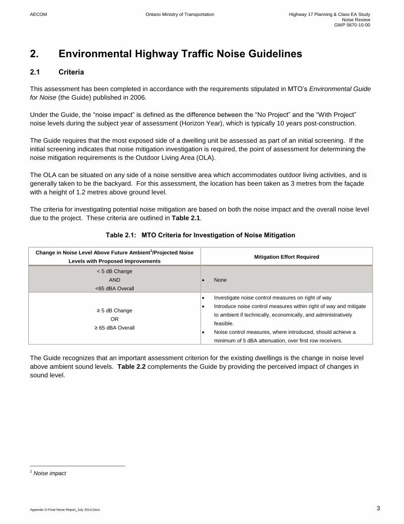
The criteria for investigating potential noise mitigation are based on both the noise impact and the overall noise level
due to the project. These criteria are outlined in Table 2.1.
Table 2.1: MTO Criteria for Investigation of Noise Mitigation
Change in Noise Level Above Future Ambient1/Projected Noise
Levels with Proposed Improvements Mitigation Effort Required
< 5 dB Change
AND
<65 dBA Overall
None
≥ 5 dB Change
OR
≥ 65 dBA Overall
Investigate noise control measures on right of way
Introduce noise control measures within right of way and mitigate
to ambient if technically, economically, and administratively
feasible.
Noise control measures, where introduced, should achieve a
minimum of 5 dBA attenuation, over first row receivers.
The Guide recognizes that an important assessment criterion for the existing dwellings is the change in noise level
above ambient sound levels. Table 2.2 complements the Guide by providing the perceived impact of changes in
sound level.
1 Noise impact
AECOM Ontario Ministry of Transportation Highway 17 Planning & Class EA Study Noise Review
GWP 5670-10-00
Appendix D-Final Noise Report_July 2014.Docx 4
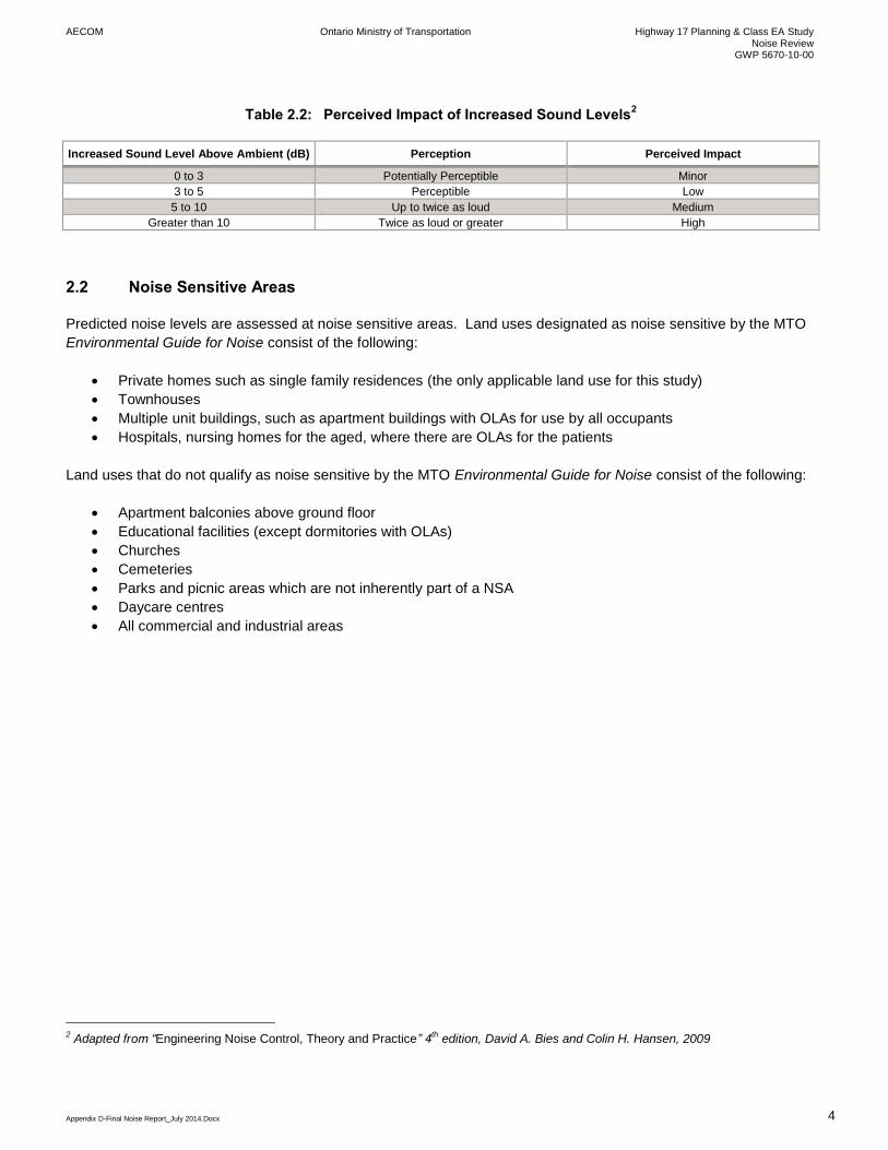
Table 2.2: Perceived Impact of Increased Sound Levels2
Increased Sound Level Above Ambient (dB) Perception Perceived Impact
0 to 3 Potentially Perceptible Minor
3 to 5 Perceptible Low
5 to 10 Up to twice as loud Medium
Greater than 10 Twice as loud or greater High
2.2 Noise Sensitive Areas
Predicted noise levels are assessed at noise sensitive areas. Land uses designated as noise sensitive by the MTO
Environmental Guide for Noise consist of the following:
Private homes such as single family residences (the only applicable land use for this study)
Townhouses
Multiple unit buildings, such as apartment buildings with OLAs for use by all occupants
Hospitals, nursing homes for the aged, where there are OLAs for the patients
Land uses that do not qualify as noise sensitive by the MTO Environmental Guide for Noise consist of the following:
Apartment balconies above ground floor
Educational facilities (except dormitories with OLAs)
Churches
Cemeteries
Parks and picnic areas which are not inherently part of a NSA
Daycare centres
All commercial and industrial areas
2 Adapted from “Engineering Noise Control, Theory and Practice” 4th edition, David A. Bies and Colin H. Hansen, 2009
AECOM Ontario Ministry of Transportation Highway 17 Planning & Class EA Study Noise Review
GWP 5670-10-00
Appendix D-Final Noise Report_July 2014.Docx 5
3. Assessment of the Recommended Plan – Methodology
Several options, including the Do Nothing option, were considered early in the Environmental Assessment process
and were eliminated from further consideration as these options did not address the long term operational safety and
capacity goals (2035 subject year of assessment) for the highway and therefore did not address the objectives of the
project. The assessment of the recommended plan was based on the predicted overall noise level and the noise
impact, which is defined as the noise level difference between:
No Project – no changes to the existing road configuration.
With Project – a four lane divided controlled access freeway along a widened / realigned alignment,
replacing the existing Highway 17. The recommended plan for the highway is shown in Appendix A.
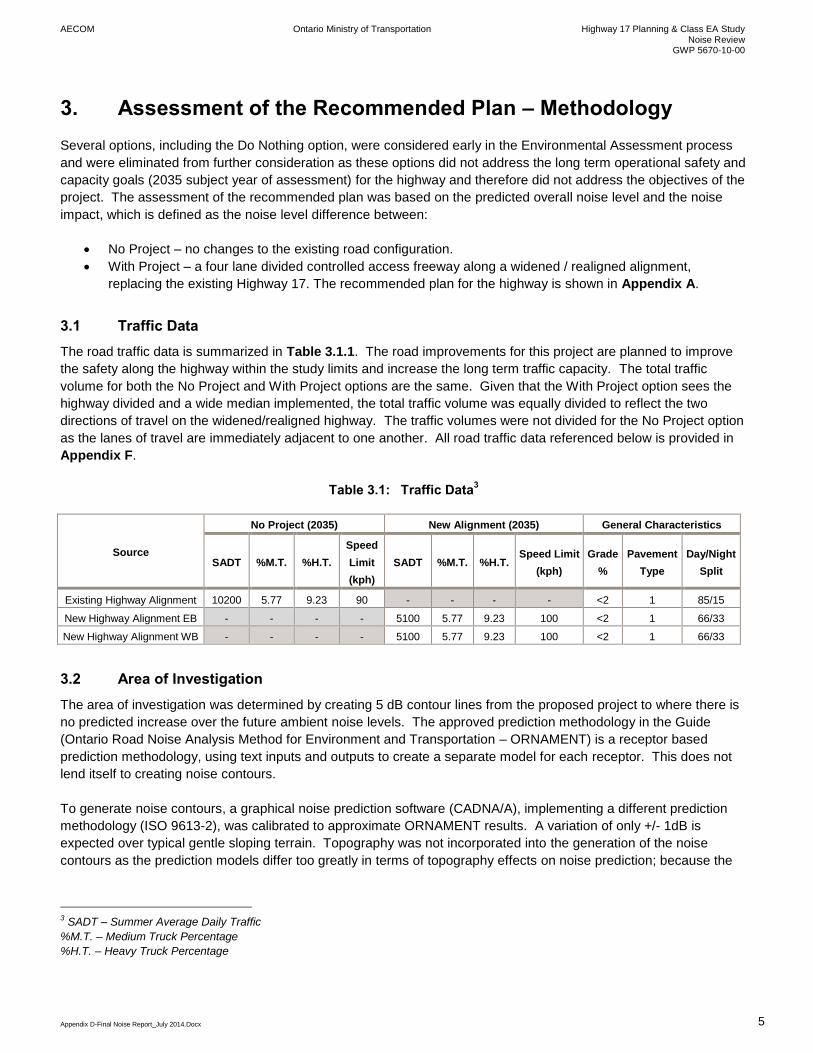
3.1 Traffic Data
The road traffic data is summarized in Table 3.1.1. The road improvements for this project are planned to improve
the safety along the highway within the study limits and increase the long term traffic capacity. The total traffic
volume for both the No Project and With Project options are the same. Given that the With Project option sees the
highway divided and a wide median implemented, the total traffic volume was equally divided to reflect the two
directions of travel on the widened/realigned highway. The traffic volumes were not divided for the No Project option
as the lanes of travel are immediately adjacent to one another. All road traffic data referenced below is provided in
Appendix F.
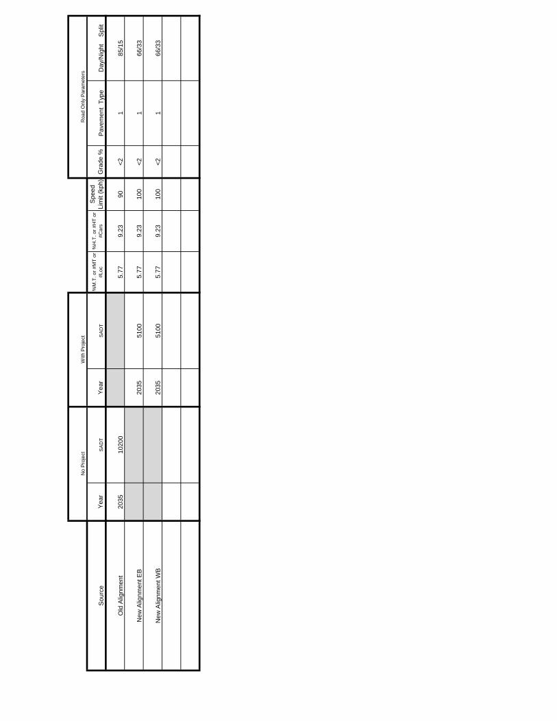
Table 3.1: Traffic Data3
Source
No Project (2035) New Alignment (2035) General Characteristics
SADT %M.T. %H.T.
Speed
Limit
(kph)
SADT %M.T. %H.T. Speed Limit
(kph)
Grade
%
Pavement
Type
Day/Night
Split
Existing Highway Alignment 10200 5.77 9.23 90 - - - - <2 1 85/15
New Highway Alignment EB - - - - 5100 5.77 9.23 100 <2 1 66/33
New Highway Alignment WB - - - - 5100 5.77 9.23 100 <2 1 66/33
3.2 Area of Investigation
The area of investigation was determined by creating 5 dB contour lines from the proposed project to where there is
no predicted increase over the future ambient noise levels. The approved prediction methodology in the Guide
(Ontario Road Noise Analysis Method for Environment and Transportation – ORNAMENT) is a receptor based
prediction methodology, using text inputs and outputs to create a separate model for each receptor. This does not
lend itself to creating noise contours.
To generate noise contours, a graphical noise prediction software (CADNA/A), implementing a different prediction
methodology (ISO 9613-2), was calibrated to approximate ORNAMENT results. A variation of only +/- 1dB is
expected over typical gentle sloping terrain. Topography was not incorporated into the generation of the noise
contours as the prediction models differ too greatly in terms of topography effects on noise prediction; because the
3 SADT – Summer Average Daily Traffic
%M.T. – Medium Truck Percentage
%H.T. – Heavy Truck Percentage

AECOM Ontario Ministry of Transportation Highway 17 Planning & Class EA Study Noise Review
GWP 5670-10-00
Appendix D-Final Noise Report_July 2014.Docx 6
purpose of the noise contours is to identify the areas requiring detailed assessment, where established criteria is
potentially met and/or exceeded.
The noise contours are presented in Appendix B, with the areas requiring a detailed assessment using the approved
STAMSON prediction methodology presented in Section 3.3.
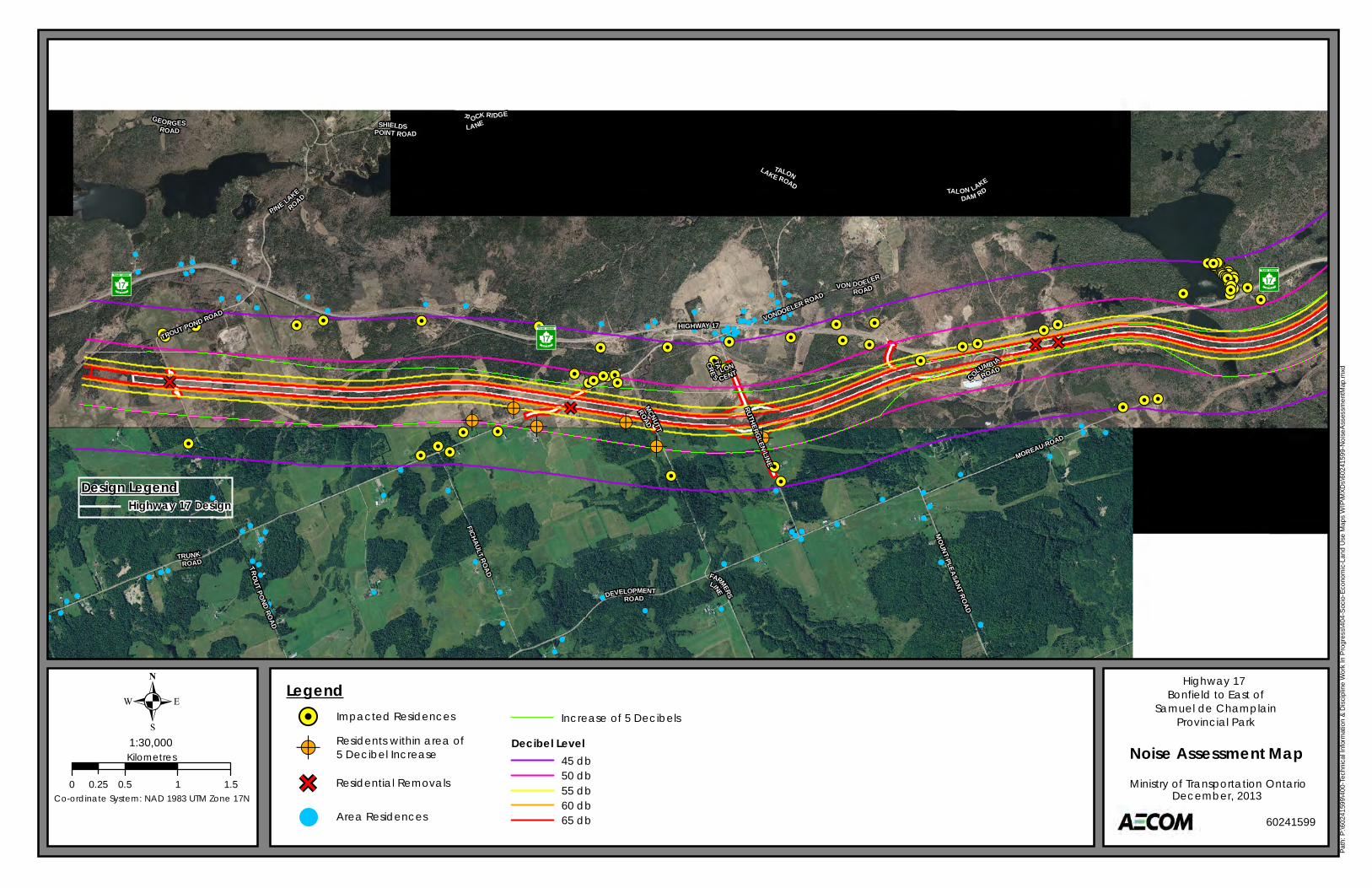
The Study Area can be classified as a Class 3 rural area as per the definitions provided in various Ministry of the
Environment Ontario (MOE) noise guidelines. Where no dominant sources of noise exist, the Guide suggests an
ambient noise level of 45 dBA for Class 3 areas. Therefore, the future No Project ambient noise levels in the Study
Area were taken as the greater of 45 dBA or the future No Project noise levels due to the existing roadways.
3.3 Areas Requiring Detailed Assessment
A review of the Study Area and the noise contours prepared as described in the above section indicates that there
are several noise sensitive areas north and south of the alignment that require a detailed noise assessment. The
noise sensitive areas consist of several single residences and a group of three residences in one area.
Eighteen assessment locations have been identified as representative of the worst case noise sensitive locations.
These locations are detailed in Table 3.2 and on the plan provided in Appendix C, with zoning plans provided in
Appendix D.
Table 3.2: Assessed Noise Sensitive Locations
Assessment
Location
Description Receptors Represented
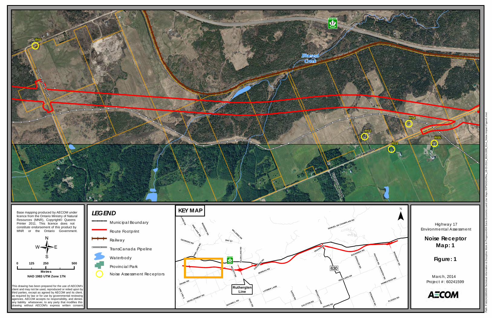
R01 South of Highway 17, 1.02km from Highway 17 and Trout Pond road intersection. Group of three residences
R02 South of Highway 17, 414 metres east along Trunk road from Trunk and Fichault road
intersection, and 146 metres north of trunk road.
Single residence
R03 South of Highway 17, 597 metres east along Trunk road from Trunk and Fichault road
intersection, and 24 metres south of Trunk road.
Single residence
R04 South of Highway 17, 818 metres right from Trunk and Fichault road intersection, and 98
metres north of Trunk road.
Single residence
R05 South of Highway 17, 939 metres east along Trunk road from Trunk and Fichault road
intersection, and 142 metres south of Trunk road.
Single residence
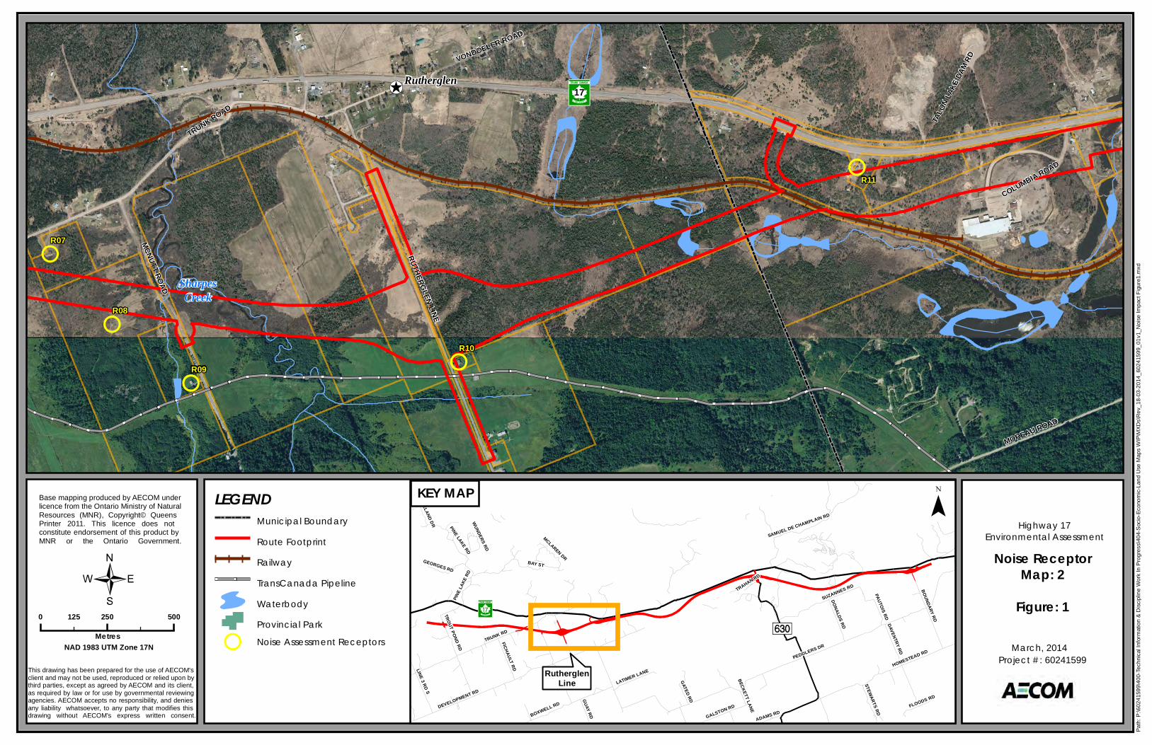
R06 South of Highway 17, 384 metres west along Trunk road from Trunk and McNutt road
intersection, and 45 metres north of trunk road.
Single residence
R07 South of Highway 17, 286 metres west along Trunk road from Trunk and McNutt road
intersection and 106 metres south of Trunk road.
Single residence
R08 South of Highway 17, 392 metres south along McNutt road from Trunk and McNutt road
intersection and 220 metres west of McNutt road.
Single residence
R09 South of Highway 17, 750 metres along McNutt road southeast of Trunk and McNutt road
intersection.
Single residence
R10 South of Highway 17, 1.02 km southeast along Rutherglen line from Trunk road and
Rutherglen line intersection.
Single residence
R11 55 metres south of Highway 17, 767 metres west from Highway 17and Columbia road
intersection along Highway 17.
Single Residence
R12 35 metres north of Highway 17, 407 metres east from Highway 17 and Columbia road
intersection along Highway 17.
Single Residence
AECOM Ontario Ministry of Transportation Highway 17 Planning & Class EA Study Noise Review
GWP 5670-10-00
Appendix D-Final Noise Report_July 2014.Docx 7
Assessment
Location
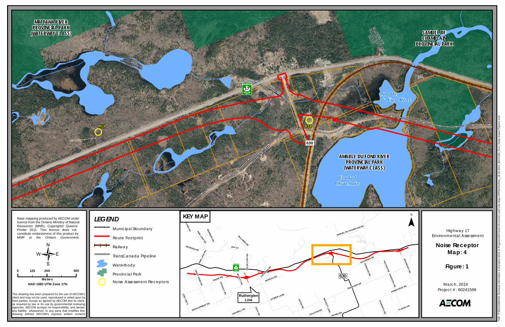
Description Receptors Represented
R13 100 metres north of Highway 17, 1.69 km west from the Highway 17 and Highway 630
intersection along Highway 17.
Single Residence
R14 493 metres south of Highway 17, along Highway 630, and 90 metres east from Highway
630.
Single Residence
R15 South of Highway 17, 118 metres along Suzanne road, east of the Suzanne and Donalds
road intersection.
Single Residence
R16 322 metres south of Highway 17, 1.58 km west from the Highway 17 and Champlain
Provincial Park road intersection along Highway 17.
Single Residence
R17 300 metres south of Highway 17, 1.32 km west from the Highway 17 and Champlain
Provincial Park road intersection along highway 17.
Single Residence
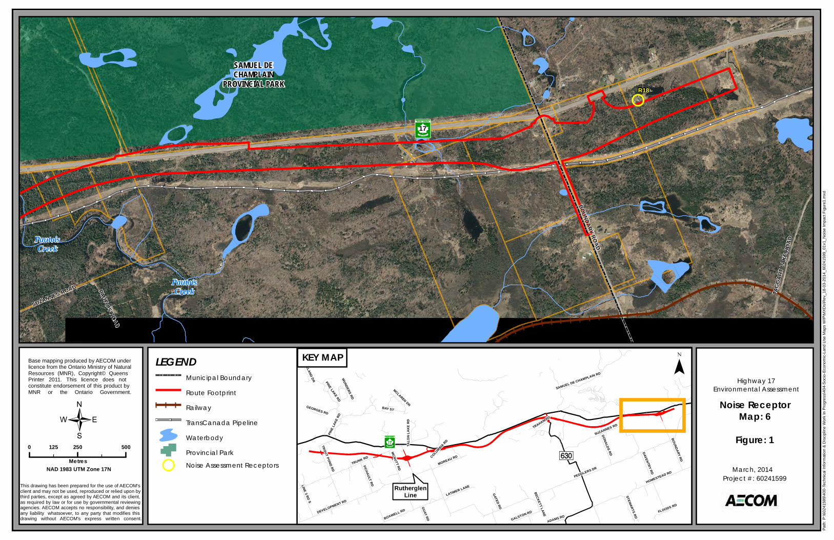
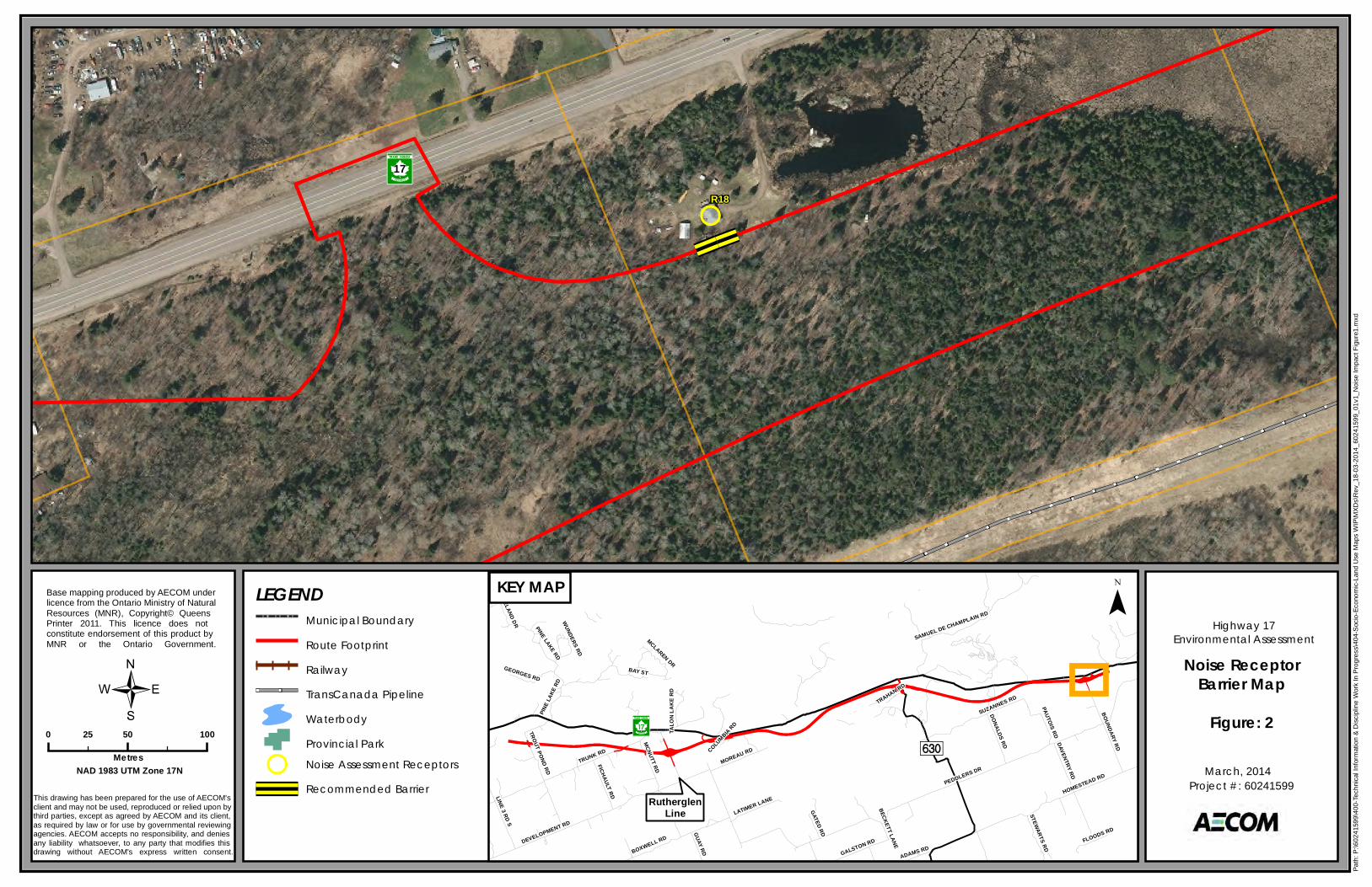
R18 112 metres south of Highway 17, 548 metres east from the Highway 17 and Boundary
road intersection along Highway 17.
Single Residence
3.4 Noise Prediction Procedure
As set out in the Guide, traffic noise levels were calculated using the Ontario Road Noise Analysis Method for
Environment and Transportation (ORNAMENT) method, implemented in the STAMSON (version 5.04) software.
The prediction model inputs include the following considerations:
Road traffic data (see Section 3.1)
o Volumes
o Speed limit
o Vehicle composition (percentage Medium and Heavy Trucks)
Ground characteristics
o Roadway surface type (e.g. Asphalt, concrete)
o Ground topography
o Ground type between assessment locations and roadways
o Roadway layout
Shielding effects
o Berms
o Barriers
o Housing
The traffic data used in the assessment of the recommended plan is described in Section 3.1.
As this project involves the widening and realignment of existing Highway 17 to a freeway cross section, the
assessment of the noise levels was based on the 24 hour equivalent sound level (Leq, 24hr) as required by the Guide.
To assess the noise impact, the predicted “No Project” noise levels (year 2035) were compared to those of the
predicted “With Project” noise levels (year 2035).
As required in the Guide, noise levels on the most exposed side of a noise sensitive land use were calculated to
determine if a noise mitigation investigation would be required. If a noise investigation was required, the noise levels
were assessed at the OLA location, which is the point of assessment for noise mitigation as noted in the Guide.

AECOM Ontario Ministry of Transportation Highway 17 Planning & Class EA Study Noise Review
GWP 5670-10-00
Appendix D-Final Noise Report_July 2014.Docx 8
The modeling assumed a typical asphalt road surface would be used. If a concrete road surface is used, the With
Project noise levels are expected to be up to approximately 3 dB higher than those levels detailed below.
AECOM Ontario Ministry of Transportation Highway 17 Planning & Class EA Study Noise Review
GWP 5670-10-00
Appendix D-Final Noise Report_July 2014.Docx 9
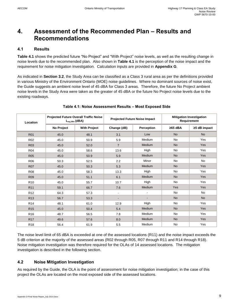
4. Assessment of the Recommended Plan – Results and Recommendations
4.1 Results
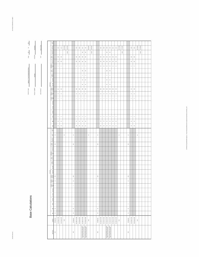
Table 4.1 shows the predicted future “No Project” and “With Project” noise levels, as well as the resulting change in
noise levels due to the recommended plan. Also shown in Table 4.1 is the perception of the noise impact and the
requirement for noise mitigation investigation. Calculation inputs are provided in Appendix G.
As indicated in Section 3.2, the Study Area can be classified as a Class 3 rural area as per the definitions provided
in various Ministry of the Environment Ontario (MOE) noise guidelines. Where no dominant sources of noise exist,
the Guide suggests an ambient noise level of 45 dBA for Class 3 areas. Therefore, the future No Project ambient
noise levels in the Study Area were taken as the greater of 45 dBA or the future No Project noise levels due to the
existing roadways.
Table 4.1: Noise Assessment Results – Most Exposed Side
Location
Projected Future Overall Traffic Noise
Leq,24hr (dBA) Projected Future Noise Impact
Mitigation Investigation
Requirement
No Project With Project Change (dB) Perception ≥65 dBA ≥5 dB impact
R01 45.0 48.1 3.1 Low No No
R02 45.0 50.9 5.9 Medium No Yes
R03 45.0 52.0 7 Medium No Yes
R04 45.0 58.6 13.6 High No Yes
R05 45.0 50.9 5.9 Medium No Yes
R06 50.3 52.5 2.2 Minor No No
R07 45.0 50.3 5.3 Medium No Yes
R08 45.0 58.3 13.3 High No Yes
R09 45.0 51.1 6.1 Medium No Yes
R10 45.0 55.7 10.7 High No Yes
R11 59.1 66.7 7.6 Medium Yes Yes
R12 64.3 57.3 - - No No
R13 56.7 53.3 - - No No
R14 48.1 61.0 12.9 High No Yes
R15 45.0 50.4 5.4 Medium No Yes
R16 48.7 56.5 7.8 Medium No Yes
R17 49.6 57.6 8.0 Medium No Yes
R18 56.4 61.9 5.5 Medium No Yes
The noise level limit of 65 dBA is exceeded at one of the assessed locations (R11) and the noise impact exceeds the
5 dB criterion at the majority of the assessed areas (R02 through R05, R07 through R11 and R14 through R18).
Noise mitigation investigation was therefore required for the OLAs of 14 assessed locations. The mitigation
investigation is described in the following section.
4.2 Noise Mitigation Investigation
As required by the Guide, the OLA is the point of assessment for noise mitigation investigation; in the case of this
project the OLAs are located on the most exposed side of the assessed locations.
AECOM Ontario Ministry of Transportation Highway 17 Planning & Class EA Study Noise Review
GWP 5670-10-00
Appendix D-Final Noise Report_July 2014.Docx 10
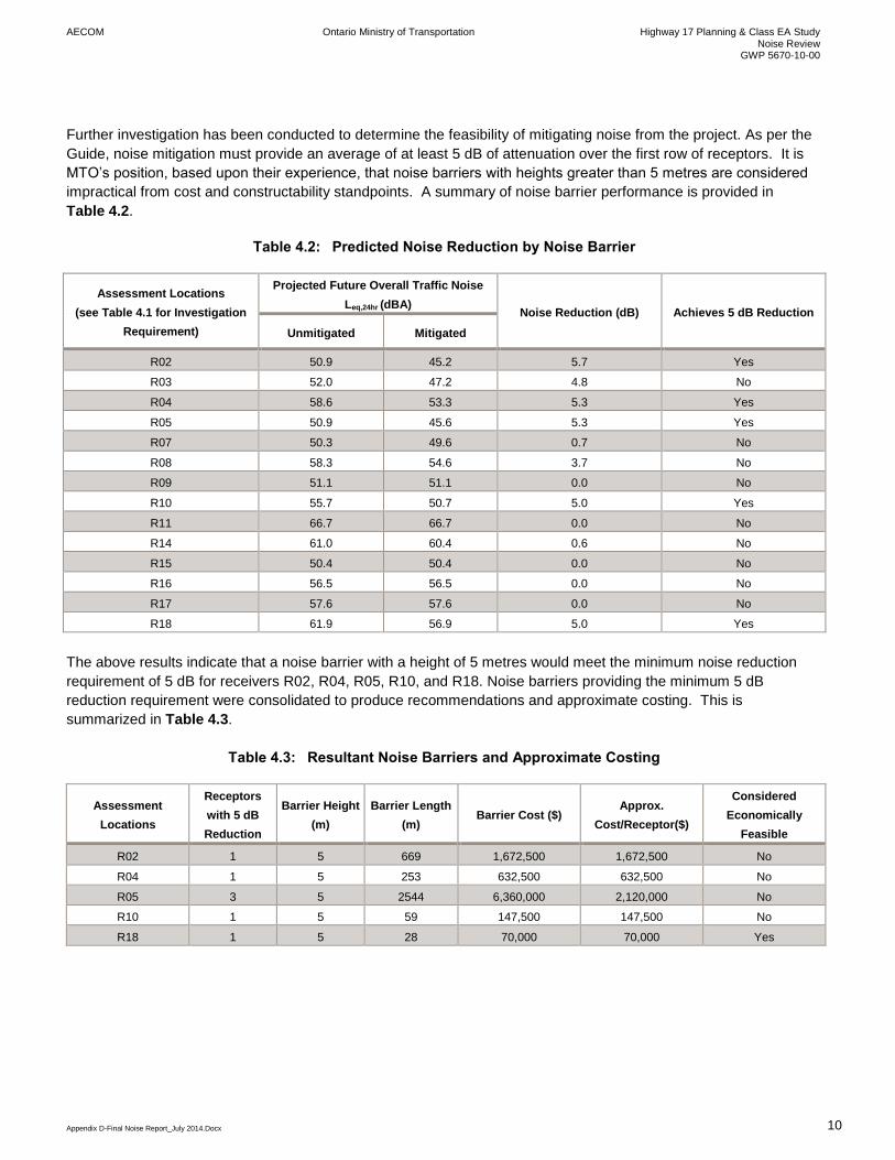
Further investigation has been conducted to determine the feasibility of mitigating noise from the project. As per the
Guide, noise mitigation must provide an average of at least 5 dB of attenuation over the first row of receptors. It is
MTO’s position, based upon their experience, that noise barriers with heights greater than 5 metres are considered
impractical from cost and constructability standpoints. A summary of noise barrier performance is provided in
Table 4.2.
Table 4.2: Predicted Noise Reduction by Noise Barrier
Assessment Locations
(see Table 4.1 for Investigation
Requirement)
Projected Future Overall Traffic Noise
Leq,24hr (dBA) Noise Reduction (dB) Achieves 5 dB Reduction
Unmitigated Mitigated
R02 50.9 45.2 5.7 Yes
R03 52.0 47.2 4.8 No
R04 58.6 53.3 5.3 Yes
R05 50.9 45.6 5.3 Yes
R07 50.3 49.6 0.7 No
R08 58.3 54.6 3.7 No
R09 51.1 51.1 0.0 No
R10 55.7 50.7 5.0 Yes
R11 66.7 66.7 0.0 No
R14 61.0 60.4 0.6 No
R15 50.4 50.4 0.0 No
R16 56.5 56.5 0.0 No
R17 57.6 57.6 0.0 No
R18 61.9 56.9 5.0 Yes
The above results indicate that a noise barrier with a height of 5 metres would meet the minimum noise reduction
requirement of 5 dB for receivers R02, R04, R05, R10, and R18. Noise barriers providing the minimum 5 dB
reduction requirement were consolidated to produce recommendations and approximate costing. This is
summarized in Table 4.3.
Table 4.3: Resultant Noise Barriers and Approximate Costing
Assessment
Locations
Receptors
with 5 dB
Reduction
Barrier Height
(m)
Barrier Length
(m) Barrier Cost ($)
Approx.
Cost/Receptor($)
Considered
Economically
Feasible
R02 1 5 669 1,672,500 1,672,500 No
R04 1 5 253 632,500 632,500 No
R05 3 5 2544 6,360,000 2,120,000 No
R10 1 5 59 147,500 147,500 No
R18 1 5 28 70,000 70,000 Yes
AECOM Ontario Ministry of Transportation Highway 17 Planning & Class EA Study Noise Review
GWP 5670-10-00
Appendix D-Final Noise Report_July 2014.Docx 11
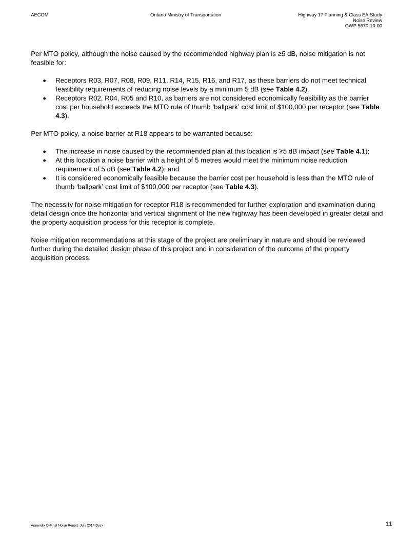
Per MTO policy, although the noise caused by the recommended highway plan is ≥5 dB, noise mitigation is not
feasible for:
Receptors R03, R07, R08, R09, R11, R14, R15, R16, and R17, as these barriers do not meet technical
feasibility requirements of reducing noise levels by a minimum 5 dB (see Table 4.2).
Receptors R02, R04, R05 and R10, as barriers are not considered economically feasibility as the barrier
cost per household exceeds the MTO rule of thumb ‘ballpark’ cost limit of $100,000 per receptor (see Table
4.3).
Per MTO policy, a noise barrier at R18 appears to be warranted because:
The increase in noise caused by the recommended plan at this location is ≥5 dB impact (see Table 4.1);
At this location a noise barrier with a height of 5 metres would meet the minimum noise reduction
requirement of 5 dB (see Table 4.2); and
It is considered economically feasible because the barrier cost per household is less than the MTO rule of
thumb ‘ballpark’ cost limit of $100,000 per receptor (see Table 4.3).
The necessity for noise mitigation for receptor R18 is recommended for further exploration and examination during
detail design once the horizontal and vertical alignment of the new highway has been developed in greater detail and
the property acquisition process for this receptor is complete.
Noise mitigation recommendations at this stage of the project are preliminary in nature and should be reviewed
further during the detailed design phase of this project and in consideration of the outcome of the property
acquisition process.

AECOM Ontario Ministry of Transportation Highway 17 Planning & Class EA Study Noise Review
GWP 5670-10-00
Appendix D-Final Noise Report_July 2014.Docx 12
5. Construction Noise
5.1 Municipal Noise Control By-Laws
The Township of Bonfield sets out noise restrictions and requirements in Noise Control By-Law 86-6. As with most
municipal guidelines, the By-law is directed mainly at typical residential and commercial concerns and addresses
those concerns in a qualitative manner. Relevant portions of the By-law are as follows:
Operation of any item of motor vehicle, motorcycle, or any other vehicle whatsoever without effective
muffling devices in good working order and in constant operation is prohibited.
The discharge of exhaust from any steam engine, stationary internal combustion engine, motor vehicles or
motorcycles, except through a muffler or other device which prevents loud or explosive noise is prohibited.
Noise created by any vehicle which beats material, articles, or objects loaded on such vehicle in a manner
calculated to disturb the repose of residence between 9:00 PM and 6:00 AM on the following day is
prohibited.
The Township of Calvin does not currently have a noise By-law or policy.
In past projects, MTO has provided a public notice to all affected residents within a 500 metre radius of the project
limits. The notice has been delivered approximately 3-4 weeks prior to overnight construction activities and included
the following information:
General information regarding the anticipated construction activities
The address (if available) or general area where the activity will take place
The start and end date, and time of the activity
The sources of the noise
Methods of noise reduction
A contact name/business or organization’s name, address and phone number, email and fax.
Notification was also provided to the local councillors within the Project Area.
5.2 Construction Noise Control Recommendations
The Guide requires that the noise study documentation address the following for construction noise:
Analysis of construction noise impacts and requirements for special provisions
Identification of Noise Sensitive Areas
Identification of municipal noise control By-laws
Need to obtain noise By-law exemptions
An explanation of any hardships to MTO caused by municipal noise control By-laws
Construction noise complaint process
The severity of construction noise impact at Noise Sensitive Areas is dependent on various factors such as time and
location of operation, size and concurrent use of equipment, and staging of construction. As equipment information
is only available from the contractor awarded the construction contract, general recommendations relating to the
management of construction noise are provided as follows:
Adhere to applicable local By-laws. Where adherence to the local By-laws is not possible and mitigation is
not feasible, an exemption should be obtained from the municipality before construction.
AECOM Ontario Ministry of Transportation Highway 17 Planning & Class EA Study Noise Review
GWP 5670-10-00
Appendix D-Final Noise Report_July 2014.Docx 13
Avoid construction activity during the night time, where not required, to reduce the potential impact of
construction noise.
Construction equipment noise emissions should comply with MOE guidelines NPC-115 and NPC-118.
Contract documents provided to the contractor should contain general noise control measures to mitigate
the noise impact at noise sensitive areas including two standard clauses regarding equipment noise:
o Unnecessary noise caused by faulty or non-operating components must be addressed by regularly
maintaining all equipment.
o Duration of construction equipment idling is to be restricted to the minimum time necessary to
complete the specified task.
A noise complaint process may be set in place.
Provide a public notice to all affected residents within a 500 metre radius of the project limits when overnight
construction activities are to occur. The notice is to be delivered at least 3 weeks prior to the overnight
construction activities and shall include the following information:
o General information regarding the anticipated construction activities
o The address (if available) or general area where the activity will take place
o The start and end date, and time of the activity
o The sources of the noise
o Methods of noise reduction
o A contact name/business or organization’s name, address and phone number, email and fax.
Provide notification to the local councillors within the Project Area.
Noise sensitive areas for the construction phase of this project will be the same as the noise sensitive areas included
in the assessment of traffic noise impacts in the above sections.
A review of the Township of Bonfield Noise Control By-law (86-6) has been completed for sections relevant to this
project. As with most municipal guidelines and By-laws, these By-laws are directed mainly at typical residential and
commercial concerns. The Township of Calvin does not currently have a noise By-law or policy. The amalgamated
relevant portions of the By-law are as follows:
Operation of any item of motor vehicle, motorcycle, or any other vehicle whatsoever without effective
muffling devices in good working order and in constant operation is prohibited.
The discharge of exhaust from any steam engine, stationary internal combustion engine, motor vehicles or
motorcycles, except through a muffler or other device which prevents loud or explosive noise is prohibited.
Noise created by any vehicle which beats material, articles, or objects loaded on such vehicle in a manner
calculated to disturb the repose of residence between 9:00 PM and 6:00 AM on the following day is
prohibited.
The need for an exemption to the Township of Bonfield noise control bylaw, and confirmation that no such by-law is
in place in the Township of Calvin should be determined during detail design for the project when a construction
staging strategy has been developed. Construction infringing on the noise By-law should be discussed with the
municipality and exemptions shall be sought if required.
An example noise complaint process is provided below:
Any initial complaint from the public will require verification by the Ministry that all noise control measures to
be applied are in effect. The Ministry will investigate any noise concerns, advise the contractor of any
problems, and enforce its contract.
Notwithstanding compliance with any noise control measures identified in the contract documents, a
persistent complaint will require the Ministry to undertake a field investigation to determine noise level
emissions. Where noise level emissions, for that construction equipment in use, exceed the sound level

AECOM Ontario Ministry of Transportation Highway 17 Planning & Class EA Study Noise Review
GWP 5670-10-00
Appendix D-Final Noise Report_July 2014.Docx 14
criteria for construction equipment contained in the MOE Model Municipal Noise Control By-law, the Ministry
shall require the contractor to comply with the sound level criteria where quieter alternative equipment is
reasonably available. When this occurs, the Ministry shall pay the contractor for the costs incurred. Where
a quieter alternative is not reasonably available, the equipment in use will be accepted.

AECOM Ontario Ministry of Transportation Highway 17 Planning & Class EA Study Noise Review
GWP 5670-10-00
Appendix D-Final Noise Report_July 2014.Docx 15
6. Conclusions/Recommendations
The recommended plan involves improvements to Highway 17, upgrading it to a four lane controlled access freeway,
from 2.2 km east of Highway 531 easterly and ending 8.0 km east of Highway 630. The recommended plan is
expected to have a medium to high perceived noise impact at some noise sensitive receptors.
The necessity for noise mitigation, as presented in Section 4.2, is recommended for further exploration and
examination during detail design for one receptor (R18) where initial analysis indicates that a barrier 5m high and
28m in length could address traffic noise levels from the widened /realigned Highway 17 at an approximate cost of
$70,000.
Noise from the construction of the road widening varies based upon a variety of factors such as time and location of
operation, size and concurrent use of equipment, and staging of construction. Much of this information is currently
unavailable; therefore general recommendations to minimize the impact of construction noise have been provided in
Section 5.1.


AECOM Ontario Ministry of Transportation Highway 17 Planning & Class EA Study Noise Review
GWP 5670-10-00
Appendix D-Final Noise Report_July 2014.Docx 16
7. References
1. Ministry of Transportation Ontario, MTO Environmental Guide for Noise, October 2006.
2. ITE Journal, Traffic Volume Adjustments for Impact Analysis, James A. Bonneson, April 1987.
3. Ontario Ministry of the Environment, Ontario Road noise Analysis Method for Environment and
Transportation (ORNAMENT). Queen’s Printer for Ontario, 1990.
4. Ontario Ministry of Environment, “Noise Assessment Criteria in Land Use Planning Publication LU-131”,
October 1997.
5. United States Federal Highway Administration, “FHWA Traffic Noise Model Version 2.5”, April 2004
6. The Corporation of the Township of Bonfield, By-Law No. 86-6 – Being a By-Law to Control Noises in the
Township of Bonfield, 1986-05.


AECOM Ontario Ministry of Transportation Highway 17 Planning & Class EA Study Noise Review
GWP 5670-10-00
Appendix A
Appendix A: Recommended Plan


AECOM Ontario Ministry of Transportation Highway 17 Planning & Class EA Study Noise Review
GWP 5670-10-00
Appendix B
Appendix B: Area of Investigation

4
44
4
44
4 44 4
4
44
4
4
4
4
444
4
4 4 4
44
4
44
4
44
4
4
4
4
4
4
4
4
44
4
4 4
4 44
4
4
4
44
4 44
44
4
4
4444
44444444444
44
44
44
444
4
4
444
444
4
4
4
4
4 4444
4
4
4
4
4
4
4
4
4
4
4
4
4
44
4
4444
4 444 4444
44
4
4
4
44
444
4
4
4
4
44444444
44444444444444
44
4
4
4
4
4
4
4
44
444
4
4444
4
44
4
4
4
4 4
4
4
4 4
4
4
4
4
4
4
4
4444
444444444
44
4
!H!H!H!H!H!H!H!H!H!H
!H!H!H!H!H!H!H!H!H!H!H!H
!H!H
!H!H
!H !H
!H
!H!H!H
!H!H
!H!H!H
!H!H!H!H!H!H!H!H!H!H!H!H!H!H
!H
!H !H
!H!H
!H !H
!H
!H!H!H
!H
!H
!H !H!H
!H
!H!H!H!H
!H
!H!H!H!H!H!H
!H
!H!H
!H!H!H!H
!H
!H
!H
!H
GE
GE
GEGE
!A !A!A
!A!A
!A
!S
!S
!S!S
TALON LAKE
DAM RD
SHIELDS POINT ROAD
TROUT POND ROAD
MOUNT PLEASANT ROAD
PINE LAKE ROAD
VON DOELER ROAD
TA
LON CRES CENT
TRUNK ROAD
TALON LAKE ROAD
HIGHWAY 17VONDOELER ROAD
COLUMB IA
ROAD
MOREAU ROAD
TROUT POND ROAD
MCNUTT
ROAD
R
OCK RIDGE LANE
FARMERS
LINEDEVELOPMENT ROAD
GEORGES ROAD
RUTHERGLEN LINE
FICHAULT ROAD
60241599
Highway 17 Bonfield to East of
Samuel de ChamplainProvincial Park
Noise Assessment Map
December, 2013Ministry of Transportation Ontario
Path:
P:\60
2415
99\40
0-Tec
hnica
l Infor
matio
n & D
iscipl
ine W
ork In
Prog
ress\4
04-S
ocio-
Econ
omic-
Land
Use
Map
s WIP\
MXDs
\6024
1599
-Nois
eAss
essm
entM
ap.m
xd
0 0.5 1 1.50.25
Kilometres
Co-ordinate System: NAD 1983 UTM Zone 17N
1:30,000.
Highway 17 DesignDesign Legend
Increase of 5 DecibelsLegend
Impacted Residences
Area Residences4
!HResidents within area of5 Decibel Increase!AResidential RemovalsGE
Decibel Level45 db50 db55 db60 db65 db

44
44
4
4
44
4
4444
4444
444
44 44
4
4
444
4
4 4
4
4
4
44
44
4
444
4
4
4
44
4
4 444 44
4
44
4
44
4
4
444
44
44
44
4
44
4
4 4
4
4
44
4
4
4
4
444
44 4
4 4 4 44
44
44 4
444
4
4
4
4
4
4
4
4
4
4
4 4
4
4
4 4
4
4
4
4
4
4
4
4444
44444
4
444
44
44
4444
4
!H!H
!H
!H
!H!H!H!H !H!H!H
!H!H
!H!H!H
!H
!H
!H!H
!H!H!H
!H
!H
!H
!H!H!H!H!H
!H
GE
GE
GEGEGE
GE
GEGEGEGE!A
!S
!S
!S
!S
.Á
.Á
SAMUEL DE
CHAMPLAIN RO
AD
SUZANNES ROAD
BOOTH ROAD
TRAHAN ROAD
PAUTOIS ROAD
HIGHWAY 17
TWIL
IGHT
CAMP
ROAD
PEDDLERS DRIVE
BOUNDARY ROAD TAGG ART
LAKE ROAD
DONALDS ROAD
PAUTOIS ROAD
60241599
Highway 17 Bonfield to East of
Samuel de ChamplainProvincial Park
Noise Assessment Map
December, 2013Ministry of Transportation Ontario
Path:
P:\60
2415
99\40
0-Tec
hnica
l Infor
matio
n & D
iscipl
ine W
ork In
Prog
ress\4
04-S
ocio-
Econ
omic-
Land
Use
Map
s WIP\
MXDs
\6024
1599
-Nois
eAss
essm
entM
ap.m
xd
0 0.5 1 1.50.25
Kilometres
Co-ordinate System: NAD 1983 UTM Zone 17N
1:30,000.
Highway 17 DesignDesign Legend
Increase of 5 DecibelsLegend
Impacted Residences
Area Residences4
!HResidents within area of5 Decibel Increase!AResidential RemovalsGE
Decibel Level45 db50 db55 db60 db65 db

AECOM Ontario Ministry of Transportation Highway 17 Planning & Class EA Study Noise Review
GWP 5670-10-00
Appendix C
Appendix C: Detailed Assessment Receptor Locations

+
+
+
+
+
++
+
+
+
++
+
+
++
+
+
BluesealCreek
TRUNK ROAD
TROUT POND ROAD
FICHAULT ROAD
!"17
R02
R04
R05
R01
R03
Path:
P:\60
2415
99\40
0-Tec
hnica
l Infor
matio
n & D
iscipl
ine W
ork In
Prog
ress\4
04-S
ocio-
Econ
omic-
Land
Use
Map
s WIP\
MXDs
\Rev
_18-0
3-201
4_60
2415
99_0
1v1_
Noise
Impa
ct Fig
ure1.m
xd
LEGENDMunicipal BoundaryRoute FootprintRailwayTransCanada PipelineWaterbodyProvincial Park
+ Noise Assessment Receptors
Highway 17Environmental Assessment
March, 2014Project #: 60241599
This drawing has been prepared for the use of AECOM's client and may not be used, reproduced or relied upon by third parties, except as agreed by AECOM and its client, as required by law or for use by governmental reviewing agencies. AECOM accepts no responsibility, and denies any liability whatsoever, to any party that modifies this drawing without AECOM's express written consent.
0 250 500125
MetresNAD 1983 UTM Zone 17N
/
Base mapping produced by AECOM underlicence from the Ontario Ministry of NaturalResources (MNR), Copyright© Queens Printer 2011. This licence does not constitute endorsement of this product by MNR or the Ontario Government.
Noise ReceptorMap: 1
Figure: 1
!S
!S>Á
RutherglenLine
PEDDLERS DR
TRUNK RD
DEVELOPMENT RD
HOMESTEAD RD
DAVENTRY RD
SUZANNES RD BOUNDARY RD
LINE 3 RD S
SAMUEL DE CHAMPLAIN RD
MOREAU RD
BOXWELL RD
GALSTON RD
MCNUTT RD
PAUTOIS RD
DONALDS RD
GATED RD
LATIMER LANE
GUAY RD
STEWARTS RD
GEORGES RD
PINE L
AKE R
D
BAY ST
ADAMS RD
WUNDERS RD
MCLAREN DRTA
LON
LAKE
RD
PINELAND DR
TRAHAN RD
FLOODS RD
BECKETT LANE
COLUMBIA RD
PINE LAKE RD
¯KEY MAP
+
+
+
+
+
++
+
+
+
++
+
+
+
+
+
+
!\
SharpesCreek
TALO
N LAK
E DAM
RD
MOREAU ROAD
VONDOELER ROAD
COLUMBIA ROAD
TRUNK ROAD
MCNUTT ROAD
RUTHERGLEN LINE
!"17Rutherglen
R07
R09
R10
R11
R08
Path:
P:\60
2415
99\40
0-Tec
hnica
l Infor
matio
n & D
iscipl
ine W
ork In
Prog
ress\4
04-S
ocio-
Econ
omic-
Land
Use
Map
s WIP\
MXDs
\Rev
_18-0
3-201
4_60
2415
99_0
1v1_
Noise
Impa
ct Fig
ure1.m
xd
LEGENDMunicipal BoundaryRoute FootprintRailwayTransCanada PipelineWaterbodyProvincial Park
+ Noise Assessment Receptors
Highway 17Environmental Assessment
March, 2014Project #: 60241599
This drawing has been prepared for the use of AECOM's client and may not be used, reproduced or relied upon by third parties, except as agreed by AECOM and its client, as required by law or for use by governmental reviewing agencies. AECOM accepts no responsibility, and denies any liability whatsoever, to any party that modifies this drawing without AECOM's express written consent.
0 250 500125
MetresNAD 1983 UTM Zone 17N
/
Base mapping produced by AECOM underlicence from the Ontario Ministry of NaturalResources (MNR), Copyright© Queens Printer 2011. This licence does not constitute endorsement of this product by MNR or the Ontario Government.
Noise ReceptorMap: 2
Figure: 1
!S
!S>Á
RutherglenLine
PEDDLERS DRTRUNK RD
DEVELOPMENT RD
HOMESTEAD RD
DAVENTRY RD
SUZANNES RD BOUNDARY RD
LINE 3 RD S
SAMUEL DE CHAMPLAIN RD
BOXWELL RD
GALSTON RD
PAUTOIS RD
DONALDS RD
FICHAULT RD
GATED RD
LATIMER LANE
TROUT POND RD
GUAY RD
STEWARTS RD
GEORGES RD
PINE L
AKE R
D
BAY ST
ADAMS RD
WUNDERS RD
MCLAREN DR
PINELAND DR
TRAHAN RD
FLOODS RD
BECKETT LANE
PINE LAKE RD
¯KEY MAP

+
+
+
+
+
++
+
+
+
++
+
+
+
+
+
+
JohnstonLake
Mattawa River(rivière
Mattawa)
JohnstonLake
TALO
N LA
KE D
AM R
D
MOREAU ROAD
COLUMBIA ROAD
!"17
MATTAWA RIVERPROVINCIAL PARK
(WATERWAY CLASS)
R12
Path:
P:\60
2415
99\40
0-Tec
hnica
l Infor
matio
n & D
iscipl
ine W
ork In
Prog
ress\4
04-S
ocio-
Econ
omic-
Land
Use
Map
s WIP\
MXDs
\Rev
_18-0
3-201
4_60
2415
99_0
1v1_
Noise
Impa
ct Fig
ure1.m
xd
LEGENDMunicipal BoundaryRoute FootprintRailwayTransCanada PipelineWaterbodyProvincial Park
+ Noise Assessment Receptors
Highway 17Environmental Assessment
March, 2014Project #: 60241599
This drawing has been prepared for the use of AECOM's client and may not be used, reproduced or relied upon by third parties, except as agreed by AECOM and its client, as required by law or for use by governmental reviewing agencies. AECOM accepts no responsibility, and denies any liability whatsoever, to any party that modifies this drawing without AECOM's express written consent.
0 250 500125
MetresNAD 1983 UTM Zone 17N
/
Base mapping produced by AECOM underlicence from the Ontario Ministry of NaturalResources (MNR), Copyright© Queens Printer 2011. This licence does not constitute endorsement of this product by MNR or the Ontario Government.
Noise ReceptorMap: 3
Figure: 1
!S
!S>Á
RutherglenLine
PEDDLERS DRTRUNK RD
DEVELOPMENT RD
HOMESTEAD RD
DAVENTRY RD
SUZANNES RD BOUNDARY RD
LINE 3 RD S
SAMUEL DE CHAMPLAIN RD
BOXWELL RD
GALSTON RD
MCNUTT RD
PAUTOIS RD
DONALDS RD
FICHAULT RD
GATED RD
LATIMER LANE
TROUT POND RD
GUAY RD
STEWARTS RD
GEORGES RD
PINE L
AKE R
D
BAY ST
ADAMS RD
WUNDERS RD
MCLAREN DRTA
LON
LAKE
RD
PINELAND DR
TRAHAN RD
FLOODS RD
BECKETT LANE
PINE LAKE RD
¯KEY MAP
+
+
+
+
+
++
+
+
+
++
+
+
+
+
+
+!\
Amabledu Fond River
CrookedChute Lake
SAMUEL DE
CHAMPLAIN
ROAD
TRAHAN ROAD
!"17
>?630
AMABLE DU FOND RIVERPROVINCIAL PARK
(WATERWAY CLASS)
SAMUEL DECHAMPLAIN
PROVINCIAL PARK
MATTAWA RIVERPROVINCIAL PARK
(WATERWAY CLASS)
R14R13
Path:
P:\60
2415
99\40
0-Tec
hnica
l Infor
matio
n & D
iscipl
ine W
ork In
Prog
ress\4
04-S
ocio-
Econ
omic-
Land
Use
Map
s WIP\
MXDs
\Rev
_18-0
3-201
4_60
2415
99_0
1v1_
Noise
Impa
ct Fig
ure1.m
xd
LEGENDMunicipal BoundaryRoute FootprintRailwayTransCanada PipelineWaterbodyProvincial Park
+ Noise Assessment Receptors
Highway 17Environmental Assessment
March, 2014Project #: 60241599
This drawing has been prepared for the use of AECOM's client and may not be used, reproduced or relied upon by third parties, except as agreed by AECOM and its client, as required by law or for use by governmental reviewing agencies. AECOM accepts no responsibility, and denies any liability whatsoever, to any party that modifies this drawing without AECOM's express written consent.
0 250 500125
MetresNAD 1983 UTM Zone 17N
/
Base mapping produced by AECOM underlicence from the Ontario Ministry of NaturalResources (MNR), Copyright© Queens Printer 2011. This licence does not constitute endorsement of this product by MNR or the Ontario Government.
Noise ReceptorMap: 4
Figure: 1
!S
!S>Á
RutherglenLine
PEDDLERS DRTRUNK RD
DEVELOPMENT RD
HOMESTEAD RD
DAVENTRY RD
SUZANNES RD BOUNDARY RD
LINE 3 RD S
SAMUEL DE CHAMPLAIN RD
MOREAU RD
BOXWELL RD
GALSTON RD
MCNUTT RD
PAUTOIS RD
DONALDS RD
FICHAULT RD
GATED RD
LATIMER LANE
TROUT POND RD
GUAY RD
STEWARTS RD
GEORGES RD
PINE L
AKE R
D
BAY ST
ADAMS RD
WUNDERS RD
MCLAREN DRTA
LON
LAKE
RD
PINELAND DR
FLOODS RD
BECKETT LANE
COLUMBIA RD
PINE LAKE RD
¯KEY MAP

+
+
+
+
+
++
+
+
+
++
+
+
++
+
+
PautoisCreek
PautoisCreek
Amabledu Fond
River
SUZANNES ROAD
DONALDSROAD
PAUTOIS ROAD
PAUTOIS ROAD
!"17
SAMUEL DECHAMPLAIN
PROVINCIAL PARK
R16R17
R15
Path:
P:\60
2415
99\40
0-Tec
hnica
l Infor
matio
n & D
iscipl
ine W
ork In
Prog
ress\4
04-S
ocio-
Econ
omic-
Land
Use
Map
s WIP\
MXDs
\Rev
_18-0
3-201
4_60
2415
99_0
1v1_
Noise
Impa
ct Fig
ure1.m
xd
LEGENDMunicipal BoundaryRoute FootprintRailwayTransCanada PipelineWaterbodyProvincial Park
+ Noise Assessment Receptors
Highway 17Environmental Assessment
March, 2014Project #: 60241599
This drawing has been prepared for the use of AECOM's client and may not be used, reproduced or relied upon by third parties, except as agreed by AECOM and its client, as required by law or for use by governmental reviewing agencies. AECOM accepts no responsibility, and denies any liability whatsoever, to any party that modifies this drawing without AECOM's express written consent.
0 250 500125
MetresNAD 1983 UTM Zone 17N
/
Base mapping produced by AECOM underlicence from the Ontario Ministry of NaturalResources (MNR), Copyright© Queens Printer 2011. This licence does not constitute endorsement of this product by MNR or the Ontario Government.
Noise ReceptorMap: 5
Figure: 1
!S
!S>Á
RutherglenLine
PEDDLERS DRTRUNK RD
DEVELOPMENT RD
HOMESTEAD RD
DAVENTRY RD
BOUNDARY RD
LINE 3 RD S
SAMUEL DE CHAMPLAIN RD
MOREAU RD
BOXWELL RD
GALSTON RD
MCNUTT RD
DONALDS RD
FICHAULT RD
GATED RD
LATIMER LANE
TROUT POND RD
GUAY RD
STEWARTS RD
GEORGES RD
PINE L
AKE R
D
BAY ST
ADAMS RD
WUNDERS RD
MCLAREN DRTA
LON
LAKE
RD
PINELAND DR
TRAHAN RD
FLOODS RD
BECKETT LANE
COLUMBIA RD
PINE LAKE RD
¯KEY MAP
+
+
+
+
+
++
+
+
+
++
+
+
++
+
+
PautoisCreek
PautoisCreek
BOUNDARY ROAD
PAUTOIS ROAD
SUZANNES ROAD TAGG
ART L
AKE R
OAD
!"17
SAMUEL DECHAMPLAIN
PROVINCIAL PARK R18
Path:
P:\60
2415
99\40
0-Tec
hnica
l Infor
matio
n & D
iscipl
ine W
ork In
Prog
ress\4
04-S
ocio-
Econ
omic-
Land
Use
Map
s WIP\
MXDs
\Rev
_18-0
3-201
4_60
2415
99_0
1v1_
Noise
Impa
ct Fig
ure1.m
xd
LEGENDMunicipal BoundaryRoute FootprintRailwayTransCanada PipelineWaterbodyProvincial Park
+ Noise Assessment Receptors
Highway 17Environmental Assessment
March, 2014Project #: 60241599
This drawing has been prepared for the use of AECOM's client and may not be used, reproduced or relied upon by third parties, except as agreed by AECOM and its client, as required by law or for use by governmental reviewing agencies. AECOM accepts no responsibility, and denies any liability whatsoever, to any party that modifies this drawing without AECOM's express written consent.
0 250 500125
MetresNAD 1983 UTM Zone 17N
/
Base mapping produced by AECOM underlicence from the Ontario Ministry of NaturalResources (MNR), Copyright© Queens Printer 2011. This licence does not constitute endorsement of this product by MNR or the Ontario Government.
Noise ReceptorMap: 6
Figure: 1
!S
!S>Á
RutherglenLine
PEDDLERS DRTRUNK RD
DEVELOPMENT RD
HOMESTEAD RD
DAVENTRY RD
SUZANNES RD
BOUNDARY RD
LINE 3 RD S
SAMUEL DE CHAMPLAIN RD
MOREAU RD
BOXWELL RD
GALSTON RD
MCNUTT RD
DONALDS RD
FICHAULT RD
GATED RD
LATIMER LANE
TROUT POND RD
GUAY RD
STEWARTS RD
GEORGES RD
PINE L
AKE R
D
BAY ST
ADAMS RD
WUNDERS RD
MCLAREN DRTA
LON
LAKE
RD
PINELAND DR
TRAHAN RD
FLOODS RD
BECKETT LANE
COLUMBIA RD
PINE LAKE RD
¯KEY MAP

AECOM Ontario Ministry of Transportation Highway 17 Planning & Class EA Study Noise Review
GWP 5670-10-00
Appendix D
Appendix D: Zoning Plan

500m 1000m 1500m 2000m 2500m
Note: The base information on this plan was preparedfrom a variety of map sources and was used bypermission of the Township of Bonfield. It is not a legalplan of survey. For precise location of plan featuresrecourse should be had to the original source data.
Digital Map Created By:
CGIS Spatial Solutions
52 South Street
Perth, ON K7H 2G7
TEL: 613-368-4321
www.cgis.com
Bonfield
R
u
t
h
e
r
g
le
n
B
o
n
f
ie
ld
OFFICIAL PLAN
SCHEDULE A
LAND USE DESIGNATIONS
1:100,000
Mattawa River
Provincial Park
S
e
t
t
le
m
e
n
t
A
r
e
a
S
e
e
S
c
h
e
d
u
le
A
1
S
e
t
t
le
m
e
n
t
A
r
e
a
,
S
e
e
S
c
h
e
d
u
le
A
2
Hamlet Settlement Area
Rural Area
Recreational Area
Hazard Land
Aggregate Removal Area
Active
Revoked
Provincial Parks and
Conservation Reserves
Environmental Protection Area
Active Waste Disposal Sites
500m Buffer
Former Waste Disposal Sites
500m Buffer
Provincial Highway
Township Roads
Private Roads
Snowmobile Trail
TransCanada Pipeline
Railway
CP RailwayCP Railway
CP Railway
Boundary Rd
Boundary Rd
Grand Desert Rd
Grand D
esert Rd
Guay Rd
Grand Desert Rd
Boxwell Rd
Laplante Rd
Farmers Line
Development Rd
Development Rd
Development Rd
Bluesea
Rd
Sout
h Sh
ore
Rd
McN
utt Rd
Rutherglen
Line
Fichault Rd
Trout Pond
Rd
Line 3 South
Trunk Rd
Trunk Rd
Trout Pond
Rd
Francoeur Rd
Sunny
side R
d
Maple Rd
Rainville
Rd
Palangio
Rd
Webbs
Rd
Maple Rd H
ighw
ay 5
31
Highway 17
Highway 17Highway 17
Pine Lake
Rd
Shields Point
Rd
Wunders Rd
Pioneer Rd
Trans Canada
Trans Canada
Pineland Dr
Georges
Rd
Hidea
way Ln
Talo
n La
ke R
d
Von Doeler
Rd
Andrews Ln
McLaren Dr
Young
St
Bay St
Line 3
North
Berry Rd
North Star
Dr
Lake
shor
e Rd
Mt. Pleasant Rd
Boody
Rd
Grey RockLn
Con 11Con 12
Con 12Con 13
Con 13Con 14
Con 14Con 15
Con 15Con 16
Con 16Con 17
Lot 33Lot 34
Lot 34Lot 35
Lot 32Lot 33Lot 31
Lot 32Lot 30Lot 31Lot 29
Lot 30Lot 28Lot 29Lot 27
Lot 28Lot 26Lot 27Lot 25
Lot 26Lot 24Lot 25Lot 23
Lot 24Lot 22Lot 23Lot 21
Lot 22Lot 20Lot 21Lot 19
Lot 20Lot 18Lot 19Lot 17
Lot 18Lot 16Lot 17Lot 15
Lot 16Lot 14Lot 15Lot 13
Lot 14Lot 12Lot 13Lot 11
Lot 12Lot 10Lot 11Lot 9
Lot 10Lot 8Lot 9Lot 7
Lot 8Lot 6Lot 7
Con 8
Lot 5Lot 6
Lot 4Lot 5Lot 3
Lot 4Lot 2Lot 3Lot 1
Lot 2
Con 1Con 2
Con 2Con 3
Con 3Con 4
Con 4Con 5
Con 5Con 6
Con 6Con 7
Con 7
Con 9
Con 8
Con 9Con 10
Con 10Con 11
Calvin Tw
p
Boulter Twp
Chi
shol
m T
wp
East
Fer
ris T
wp
Phelps Twp
Olrig Twp
Pipeline
Pipeline
Lake
Lake
Fisher
Lake
Loren
Pine Lake
Barse Lake
SheedyLa Chapelle
Lake
Kaibuskong Bay
Lake Talon
Lake Talon
Turtle Lake
NosbonsingLake
Mattawa River
Provincial Park
Mattawa River
Provincial Park
Boulter Depot
Creek
Conservation
Reserve
Council Adoption: August 28, 2012
MMAH Approval: March 21, 2013
Office Consolidation: April 24, 2013
\
\\
\
\ \ \ \ \ \ \
\\
\\ \ \ \ \ \ \
\\
\\ \
\\
\\
\\ \
\\
\ \ \\
\\
\
\\
\ \\
\
\\
\ \ \ \ \ \\
\\
\ \\
\ \
Ì
Ì
Ì
Ì
Ì
Ì
Ì
CALVIN
GORGEEAU CLAIRE
R
R
RR
R
MX MX
CR
MX
LSR
M3
PE
AC
EFU
L
BURBOTLAKE
CROOKEDLAKE
CHUTEMOORELAKE
PACUADLAKE GEMLAKE
No. 630
PEDDLER'S DRIVE
HIGHWAY No. 17
HW
Y N
o. 630
DO
NA
LD'S
RO
AD
HIG
HW
AY
TWIL
IGHT
CAM
P RD B
OO
TH R
D
SUZANNE'S ROAD
PEDDLER'S DRIVE
GATE
D R
OA
D
BR
ULE
RO
AD
ADAMS ROAD
GALSTON ROAD PR
ATT RO
AD
LATIMER LANE
PEDDLER'S DRIVE
JOHNSTONUPPER
PIMISIBAY
TRANS CANADA PIPELINE
HIGHWAY No. 17
SMITH LAKE
VON DOELER ROAD
TALONLAKEROAD
MOREAU ROAD
BECKETT
177.0 m (509.8 ft)
FLOOD ELEVATION
TRAHAN
LAUDER TOWNSHIP
PAPIN
EAU
TOW
NS
HIP
11
10
9
25263036 31
7
8
6
5
4
2
3
10 6 511151621 20
1
1
8
7
6
5
4
3
2
1
BON
FIELD
TOW
NSH
IP
CR
CO
N A
CRCR
CR
LSR
LAKELAKEJOHNSTON
LANE
RMX MX
BRO
NS
ON
LAK
E R
OAD
FLOODS ROAD
ROADPAUTOIS
BO
UN
DA
RY
RO
AD
ROAD
SAMUEL DE CHAMPLAIN PROVINCIAL PARK
CR
MX
McLAUGHLIN ROAD
MATTAWA RIVER PROVINCIAL PARK
CR
RUBY'SGENERALSTORE
STEW
AR
TS R
OA
D
HOMESTEAD ROAD
DAV
ENTR
Y RO
AD
GRAHAM ROAD
MO
UN
T PLE
AS
AN
T RO
AD
LAN
E
OLRIG TOWNSHIP
MATTAWAN TOWNSHIP
MATTAWA RIVER
Amab
le
du Fond
Riv
er
W
W
LSR LSR LSRLSR
LSR
LSR
LSRLSR
LSR
TOWNSHIP OF CALVIN
BY-LAW No. 2000-011SCHEDULE "A" TO
EAST NIPISSING PLANNING AREAZONING BY-LAW FOR THE
October 20, 2009SCALE
metres1000 30000
\ \ \
Ì
LIMITED SERVICES RURAL
COMMERCIAL / RECREATIONAL
GENERAL INDUSTRIAL
HEAVY INDUSTRIAL
MINERAL AGGREGATE RESOURCE
TOWNSHIP BOUNDARY
OTHER FEATURES
FLOOD ELEVATIONS: SPECIFIC ELEVATIONS SHOWN ON SCHEDULE
WASTE MANAGEMENT FACILITY
ENVIRONMENTAL PROTECTION
NATURAL AND HUMAN MADE HAZARDS
TRANSPORTATION AND INFRASTRUCTURE CORRIDORS
WARM WATER HABITAT
H
O
L
RESOURCE ACCESS ROADS
SNOWMOBILE TRAIL
TRANS CANADA PIPELINE
RAIL LINE
PROVINCIAL HIGHWAY
TOWNSHIP ROADS (Yearly Maintained)
PRIVATE ROADS
LOON
HERONRY
OSPREY
BROOK TROUT SPAWNING AREA
M
P
W
T
A
B
L
R
S
S
L
MX
MINE HAZARD
CANOE TRAIL
W
SMALLMOUTH BASS
WALLEYE
STURGEON
COLD WATER HABITAT
ATLANTIC SALMON
BROOK TROUT
LAKE TROUT
RAINBOW TROUT
SPLAKE
MUSKELLUNGE
PIKE
LARGEMOUTH BASS
RURAL
LEGEND
R
LSR
M3
M1
CR
ZONES
DEER YARD
MOOSE WINTERING AREA
NATURAL HERITAGE FEATURES
WATERFOWL CONCENTRATION AREA
MOOSE AQUATIC FEEDING AREA
B
A
500m INFLUENCE AREA
TOWNSHIP ROADS (Seasonally Maintained)
®

AECOM Ontario Ministry of Transportation Highway 17 Planning & Class EA Study Noise Review
GWP 5670-10-00
Appendix E
Appendix E: Proposed Noise Barriers

+
+
+
+
+
+
+
+
+
+
+
+
+
+
+
+
+
+
!"17
R18
Path:
P:\60
2415
99\40
0-Tec
hnica
l Infor
matio
n & D
iscipl
ine W
ork In
Prog
ress\4
04-S
ocio-
Econ
omic-
Land
Use
Map
s WIP\
MXDs
\Rev
_18-0
3-201
4_60
2415
99_0
1v1_
Noise
Impa
ct Fig
ure1.m
xd
LEGENDMunicipal BoundaryRoute FootprintRailwayTransCanada PipelineWaterbodyProvincial Park
+ Noise Assessment ReceptorsRecommended Barrier
Highway 17Environmental Assessment
March, 2014Project #: 60241599
This drawing has been prepared for the use of AECOM's client and may not be used, reproduced or relied upon by third parties, except as agreed by AECOM and its client, as required by law or for use by governmental reviewing agencies. AECOM accepts no responsibility, and denies any liability whatsoever, to any party that modifies this drawing without AECOM's express written consent.
0 50 10025
MetresNAD 1983 UTM Zone 17N
/
Base mapping produced by AECOM underlicence from the Ontario Ministry of NaturalResources (MNR), Copyright© Queens Printer 2011. This licence does not constitute endorsement of this product by MNR or the Ontario Government.
Noise ReceptorBarrier Map
Figure: 2
!S
!S>Á
RutherglenLine
PEDDLERS DRTRUNK RD
DEVELOPMENT RD
HOMESTEAD RD
DAVENTRY RD
SUZANNES RD
BOUNDARY RD
LINE 3 RD S
SAMUEL DE CHAMPLAIN RD
MOREAU RD
BOXWELL RD
GALSTON RD
MCNUTT RD
PAUTOIS RD
DONALDS RD
FICHAULT RD
GATED RD
LATIMER LANE
TROUT POND RD
GUAY RD
STEWARTS RD
GEORGES RD
PINE L
AKE R
D
BAY ST
ADAMS RD
WUNDERS RD
MCLAREN DRTA
LON
LAKE
RD
PINELAND DR
TRAHAN RD
FLOODS RD
BECKETT LANE
COLUMBIA RD
PINE LAKE RD
¯KEY MAP

AECOM Ontario Ministry of Transportation Highway 17 Planning & Class EA Study Noise Review
GWP 5670-10-00
Appendix F
Appendix F: Traffic Data

Year
Year
%M.T.
or #M
T or
#Loc
%H.T.
or #H
T or
#Cars
Spee
dLim
it (kp
h)Gr
ade %
2035
5.77
9.23
90<2
2035
5.77
9.23
100
<2
2035
5.77
9.23
100
<251
00Ne
w Ali
gnme
nt WB
New
Align
ment
EB
Sourc
e
166
/33
Road
Only
Param
eters
SADT
Pave
ment
Type
Day/N
ight
Split
1
With
Proje
ct SADT
85/15
Old A
lignm
ent
1020
0
No Pr
oject
166
/3351
00

AECOM Ontario Ministry of Transportation Highway 17 Planning & Class EA Study Noise Review
GWP 5670-10-00
Appendix G
Appendix G: Traffic Noise Calculations

AECO
M Ca
nada
Ltd.
ANV G
ROUP
STAM
SON
CALC
SHEE
T
PAGE
1OF
8
ENGI
NEER
DATE
RECE
IVER
SOUR
CEθ1
θ2TO
POW
OODS
No. R
ows
@ D
ensity
Grou
ndSu
rface
Type
Rece
iver
Heigh
t (r)
(m)
Sourc
eRe
ceive
rDis
t (m)
Barr
θ1Ba
rrθ2
Barrie
rHe
ight (m
)Ba
rrier
Rece
iver
Distan
ce (m
)
Eleva
tion
Chan
ge (e
)(m
)So
urce G
round
Eleva
tion (
m)
Rece
iver
Grou
ndEle
vatio
n (m)
Base
of B
arrier
Eleva
tion (
m)Le
q (24
hr)(dB
A)Le
q (Nig
ht)(dB
A)θ1
θ2TO
POW
OODS
No. R
ows
@ D
ensity
Grou
ndSu
rface
Type
Rece
iver
Heigh
t (r)
(m)
Sourc
eRe
ceive
rDis
t (m)
Barr
θ1Ba
rrθ2
Barrie
rHe
ight (m
)Ba
rrier
Rece
iver
Distan
ce (m
)
Eleva
tion
Chan
ge (e
)(m
)So
urce G
round
Eleva
tion (
m)
Rece
iver
Grou
ndEle
vatio
n (m)
Base
of B
arrier
Eleva
tion (
m)Le
q(Day
) or
Leq(1
hr) (d
BA)
Leq (
Night)
(dBA)
R01
Old A
lignme
nt-90
901
--
-1
1.2>5
00-
--
--
-26
0-
45-
New
Align
ment
WB
-9090
3-
--
11.2
397
--
--
225
826
0-
45.43
-
New
Align
ment
EB-90
903
--
-1
1.243
5-
--
-2
258
260
-44
.79-
Total
45-
48.13
2078
5-
Impa
ct3.1
3207
854
-
R02
Old A
lignme
nt-90
901
--
-1
1.2>5
00-
--
--
-25
5-
45-
New
Align
ment
WB1
-9045
3-
--
11.2
318
--
--
524
925
4-
47.42
-
New
Align
ment
EB1
-9045
3-
--
11.2
280
--
--
524
925
4-
48.26
-
Used
avera
ge he
ight a
cross
viewin
gan
gle fo
r Barr
ier Ba
se El
evati
onNe
w Ali
gnme
nt W
B245
904
--
-1
1.231
845
900
215
325
125
426
230
.27-
Used
avera
ge he
ight a
cross
viewin
gan
gle fo
r Barr
ier Ba
se El
evati
onNe
w Ali
gnme
nt EB
245
904
--
-1
1.228
045
900
215
325
125
426
230
.1-
Total
45-
50.94
4139
7-
Impa
ct5.9
4413
967
-
R03
Old A
lignme
nt-90
901
--
-1
1.2>5
00-
--
--
-26
0-
45-
New
Align
ment
WB1
-90-20
3-
--
11.2
385
--
--
1224
826
0-
46.11
-
New
Align
ment
EB1
-90-20
3-
--
11.2
348
--
--
1224
826
0-
46.68
-
Used
avera
ge he
ight a
cross
viewin
gan
gle fo
r Barr
ier Ba
se El
evati
onNe
w Ali
gnme
nt W
B2-20
304
--
-1
1.238
5-20
300
182
1025
026
026
234
.98-
Used
avera
ge he
ight a
cross
viewin
gan
gle fo
r Barr
ier Ba
se El
evati
onNe
w Ali
gnme
nt EB
2-20
304
--
-1
1.234
8-20
300
182
1025
026
026
234
.66-
New
Align
ment
WB3
3090
3-
--
11.2
385
--
--
1124
926
0-
44.75
-
New
Align
ment
EB3
3090
3-
--
11.2
348
--
--
1124
926
0-
45.33
-
Total
45-
51.97
1028
5-
Impa
ct6.9
7102
85-
R04
Old A
lignme
nt-90
901
--
-1
1.2>5
00-
--
--
-26
0-
45-
New
Align
ment
WB
-9090
3-
--
11.2
144
--
--
825
226
0-
54.58
-
New
Align
ment
EB-90
903
--
-1
1.210
8-
--
-8
252
260
-56
.36-
Total
45-
58.57
0862
6-
Impa
ct13
.5708
626
-
Base
Calc
ulatio
nsHig
hway
17 - R
oute
Plann
ing Bo
nfield
Easte
rly
6024
1599
Brian
Bulne
s
PROJ
ECT N
AME
PROJ
ECT N
UMBE
R
BASE
DRA
WIN
GMa
rch 13
, 201
4
No Pr
oject
With
Proje
ct
N:\PR
OJEC
TS\Jo
bs\60
2415
99 H
ighwa
y 17 -
Rou
te Pla
nning
Bonfi
eld\ca
lcs\Ve
r2-up
dated
with
topo
\Stam
son W
orksh
eet_V
er2
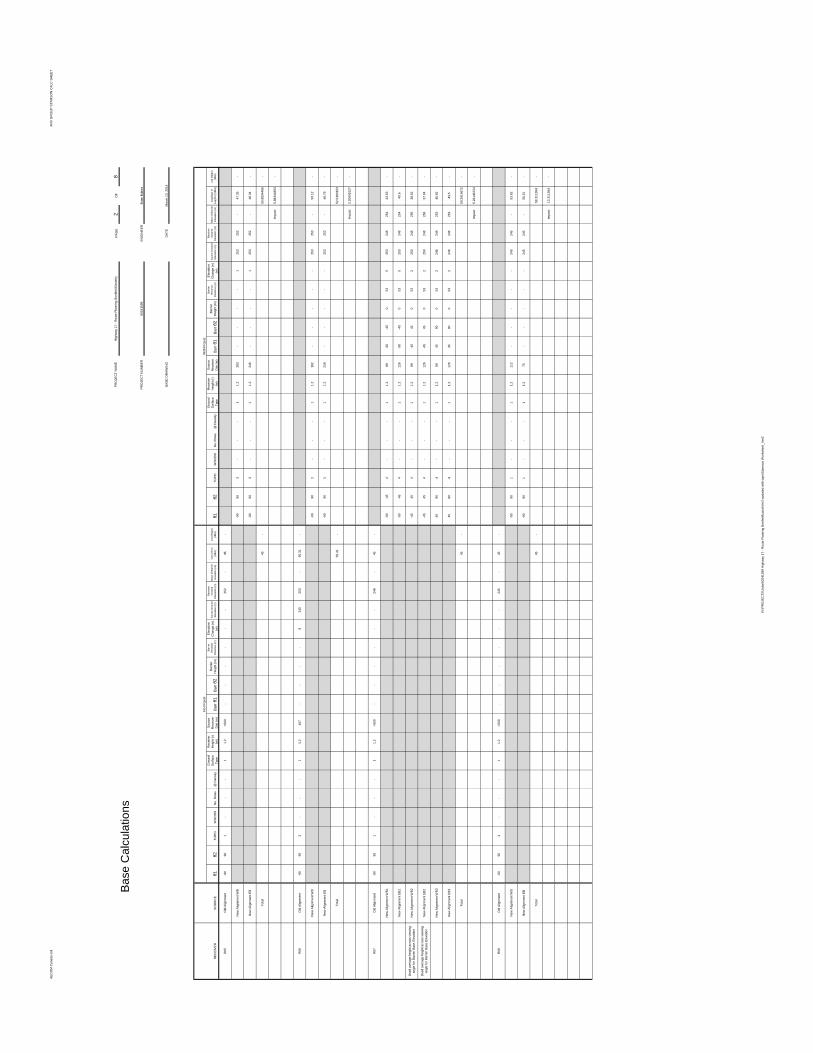
AECO
M Ca
nada
Ltd.
ANV G
ROUP
STAM
SON
CALC
SHEE
T
PAGE
2OF
8
ENGI
NEER
DATE
RECE
IVER
SOUR
CEθ1
θ2TO
POW
OODS
No. R
ows
@ D
ensity
Grou
ndSu
rface
Type
Rece
iver
Heigh
t (r)
(m)
Sourc
eRe
ceive
rDis
t (m)
Barr
θ1Ba
rrθ2
Barrie
rHe
ight (m
)Ba
rrier
Rece
iver
Distan
ce (m
)
Eleva
tion
Chan
ge (e
)(m
)So
urce G
round
Eleva
tion (
m)
Rece
iver
Grou
ndEle
vatio
n (m)
Base
of B
arrier
Eleva
tion (
m)Le
q (24
hr)(dB
A)Le
q (Nig
ht)(dB
A)θ1
θ2TO
POW
OODS
No. R
ows
@ D
ensity
Grou
ndSu
rface
Type
Rece
iver
Heigh
t (r)
(m)
Sourc
eRe
ceive
rDis
t (m)
Barr
θ1Ba
rrθ2
Barrie
rHe
ight (m
)Ba
rrier
Rece
iver
Distan
ce (m
)
Eleva
tion
Chan
ge (e
)(m
)So
urce G
round
Eleva
tion (
m)
Rece
iver
Grou
ndEle
vatio
n (m)
Base
of B
arrier
Eleva
tion (
m)Le
q(Day
) or
Leq(1
hr) (d
BA)
Leq (
Night)
(dBA)
R05
Old A
lignme
nt-90
901
--
-1
1.2>5
00-
--
--
-25
2-
45-
New
Align
ment
WB
-9090
3-
--
11.2
283
--
--
125
325
2-
47.35
-
New
Align
ment
EB-90
903
--
-1
1.224
6-
--
-1
253
252
-48
.34-
Total
45-
50.88
3448
6-
Impa
ct5.8
8344
863
-
R06
Old A
lignme
nt-90
903
--
-1
1.240
7-
--
-8
245
253
-50
.31-
New
Align
ment
WB
-9090
1-
--
11.2
182
--
--
-25
325
3-
50.12
-
New
Align
ment
EB-90
901
--
-1
1.221
9-
--
--
253
253
-48
.79-
Total
50.31
-52
.5160
153
-
Impa
ct2.2
0601
527
-
R07
Old A
lignme
nt-90
901
--
-1
1.2>5
00-
--
--
-24
8-
45-
New
Align
ment
WB1
-90-45
4-
--
11.2
89-90
-450
535
253
248
254
43.53
-
New
Align
ment
EB1
-90-45
4-
--
11.2
126
-90-45
053
525
324
825
440
.6-
Used
avera
ge he
ight a
cross
viewin
gan
gle fo
r Barr
ier Ba
se El
evati
onNe
w Ali
gnme
nt W
B2-45
454
--
-1
1.289
-4545
053
225
024
825
638
.62-
Used
avera
ge he
ight a
cross
viewin
gan
gle fo
r Barr
ier Ba
se El
evati
onNe
w Ali
gnme
nt EB
2-45
454
--
-1
1.212
6-45
450
532
250
248
256
37.04
-
New
Align
ment
WB3
4590
4-
--
11.2
8945
900
532
246
248
253
45.82
-
New
Align
ment
EB3
4590
4-
--
11.2
126
4590
053
224
624
825
343
.5-
Total
45-
50.29
1467
2-
Impa
ct5.2
9146
724
-
R08
Old A
lignme
nt-90
901
--
-1
1.2>5
00-
--
--
-24
5-
45-
New
Align
ment
WB
-9090
1-
--
11.2
112
--
--
-24
524
5-
53.62
-
New
Align
ment
EB-90
901
--
-1
1.275
--
--
-24
524
5-
56.51
-
Total
45-
58.31
1384
-
Impa
ct13
.3113
84-
Highw
ay 17
- Rou
te Pla
nning
Bonfi
eld Ea
sterly
PROJ
ECT N
AME
6024
1599
Brian
Bulne
s
March
13, 2
014
PROJ
ECT N
UMBE
R
With
Proje
ct
BASE
DRA
WIN
G
Base
Calc
ulatio
ns
No Pr
oject
N:\PR
OJEC
TS\Jo
bs\60
2415
99 H
ighwa
y 17 -
Rou
te Pla
nning
Bonfi
eld\ca
lcs\Ve
r2-up
dated
with
topo
\Stam
son W
orksh
eet_V
er2
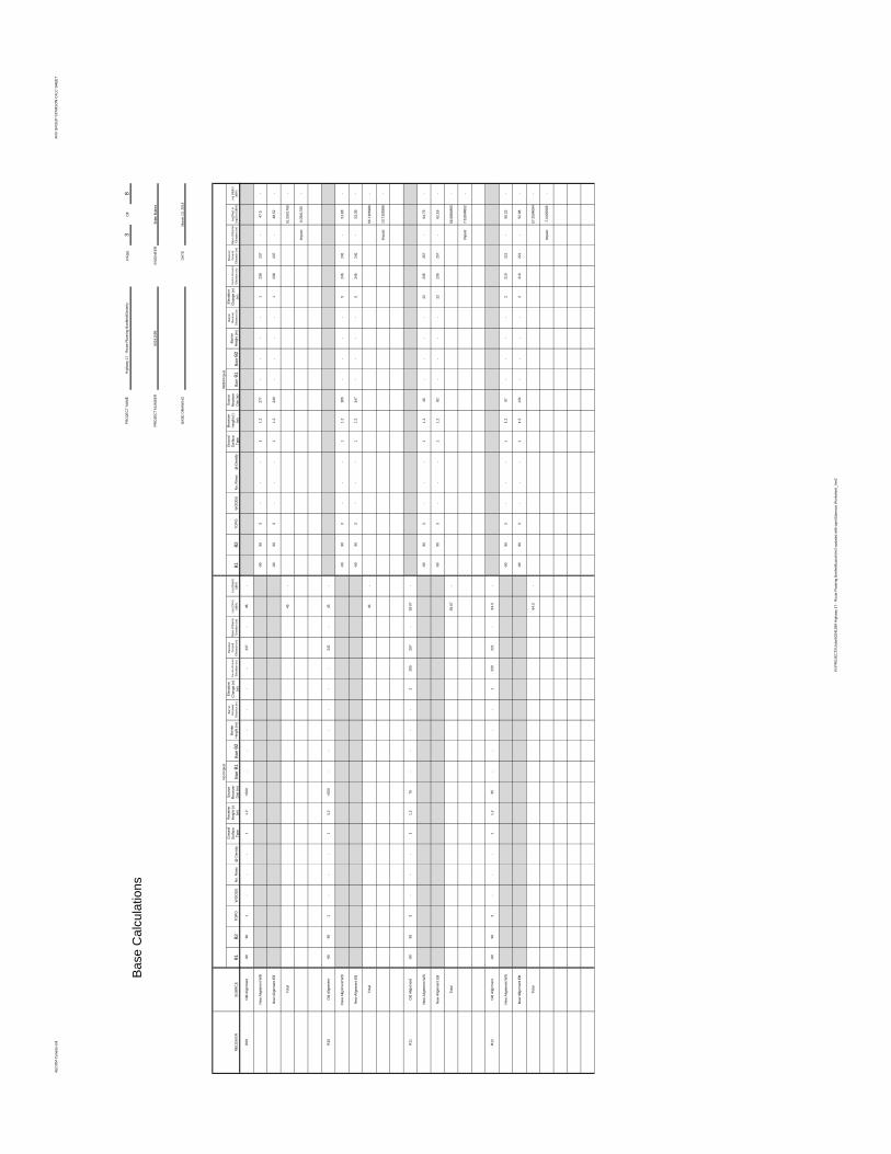
AECO
M Ca
nada
Ltd.
ANV G
ROUP
STAM
SON
CALC
SHEE
T
PAGE
3OF
8
ENGI
NEER
DATE
RECE
IVER
SOUR
CEθ1
θ2TO
POW
OODS
No. R
ows
@ D
ensity
Grou
ndSu
rface
Type
Rece
iver
Heigh
t (r)
(m)
Sourc
eRe
ceive
rDis
t (m)
Barr
θ1Ba
rrθ2
Barrie
rHe
ight (m
)Ba
rrier
Rece
iver
Distan
ce (m
)
Eleva
tion
Chan
ge (e
)(m
)So
urce G
round
Eleva
tion (
m)
Rece
iver
Grou
ndEle
vatio
n (m)
Base
of B
arrier
Eleva
tion (
m)Le
q (24
hr)(dB
A)Le
q (Nig
ht)(dB
A)θ1
θ2TO
POW
OODS
No. R
ows
@ D
ensity
Grou
ndSu
rface
Type
Rece
iver
Heigh
t (r)
(m)
Sourc
eRe
ceive
rDis
t (m)
Barr
θ1Ba
rrθ2
Barrie
rHe
ight (m
)Ba
rrier
Rece
iver
Distan
ce (m
)
Eleva
tion
Chan
ge (e
)(m
)So
urce G
round
Eleva
tion (
m)
Rece
iver
Grou
ndEle
vatio
n (m)
Base
of B
arrier
Eleva
tion (
m)Le
q(Day
) or
Leq(1
hr) (d
BA)
Leq (
Night)
(dBA)
R09
Old A
lignme
nt-90
901
--
-1
1.2>5
00-
--
--
-23
7-
45-
New
Align
ment
WB
-9090
3-
--
11.2
277
--
--
123
823
7-
47.5
-
New
Align
ment
EB-90
903
--
-1
1.224
0-
--
-1
238
237
-48
.52-
Total
45-
51.05
0176
5-
Impa
ct6.0
5017
65-
R10
Old A
lignme
nt-90
901
--
-1
1.2>5
00-
--
--
-24
1-
45-
New
Align
ment
WB
-9090
3-
--
11.2
185
--
--
524
624
1-
51.88
-
New
Align
ment
EB-90
903
--
-1
1.214
7-
--
-5
246
241
-53
.39-
Total
45-
55.71
0598
6-
Impa
ct10
.7105
986
-
R11
Old A
lignme
nt-90
903
--
-1
1.276
--
--
225
525
7-
59.07
-
New
Align
ment
WB
-9090
3-
--
11.2
45-
--
-22
235
257
-64
.79-
New
Align
ment
EB-90
903
--
-1
1.282
--
--
2223
525
7-
62.18
-
Total
59.07
-66
.6884
865
-
Impa
ct7.6
1848
652
-
R12
Old A
lignme
nt-90
903
--
-1
1.235
--
--
122
022
1-
64.3
-
New
Align
ment
WB
-9090
3-
--
11.2
97-
--
-2
219
221
-55
.23-
New
Align
ment
EB-90
903
--
-1
1.213
4-
--
-2
219
221
-52
.98-
Total
64.3
-57
.2594
094
-
Impa
ct-7.
0405
906
-
Base
Calc
ulatio
nsPR
OJEC
T NAM
EHig
hway
17 - R
oute
Plann
ing Bo
nfield
Easte
rly
PROJ
ECT N
UMBE
R
BASE
DRA
WIN
G
6024
1599
Brian
Bulne
s
March
13, 2
014
No Pr
oject
With
Proje
ct
N:\PR
OJEC
TS\Jo
bs\60
2415
99 H
ighwa
y 17 -
Rou
te Pla
nning
Bonfi
eld\ca
lcs\Ve
r2-up
dated
with
topo
\Stam
son W
orksh
eet_V
er2
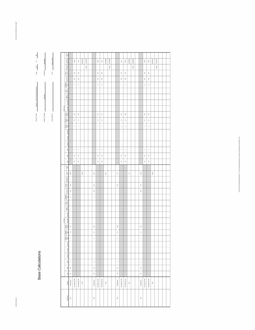
AECO
M Ca
nada
Ltd.
ANV G
ROUP
STAM
SON
CALC
SHEE
T
PAGE
4OF
8
ENGI
NEER
DATE
RECE
IVER
SOUR
CEθ1
θ2TO
POW
OODS
No. R
ows
@ D
ensity
Grou
ndSu
rface
Type
Rece
iver
Heigh
t (r)
(m)
Sourc
eRe
ceive
rDis
t (m)
Barr
θ1Ba
rrθ2
Barrie
rHe
ight (m
)Ba
rrier
Rece
iver
Distan
ce (m
)
Eleva
tion
Chan
ge (e
)(m
)So
urce G
round
Eleva
tion (
m)
Rece
iver
Grou
ndEle
vatio
n (m)
Base
of B
arrier
Eleva
tion (
m)Le
q (24
hr)(dB
A)Le
q (Nig
ht)(dB
A)θ1
θ2TO
POW
OODS
No. R
ows
@ D
ensity
Grou
ndSu
rface
Type
Rece
iver
Heigh
t (r)
(m)
Sourc
eRe
ceive
rDis
t (m)
Barr
θ1Ba
rrθ2
Barrie
rHe
ight (m
)Ba
rrier
Rece
iver
Distan
ce (m
)
Eleva
tion
Chan
ge (e
)(m
)So
urce G
round
Eleva
tion (
m)
Rece
iver
Grou
ndEle
vatio
n (m)
Base
of B
arrier
Eleva
tion (
m)Le
q(Day
) or
Leq(1
hr) (d
BA)
Leq (
Night)
(dBA)
R13
Old A
lignme
nt-90
903
--
-1
1.211
2-
--
-3
221
218
-56
.68-
New
Align
ment
WB
-9090
3-
--
11.2
181
--
--
222
021
8-
50.89
-
New
Align
ment
EB-90
903
--
-1
1.221
8-
--
-2
220
218
-49
.6-
Total
56.68
-53
.3030
216
-
Impa
ct-3.
3769
784
-
R14
Old A
lignme
nt-90
903
--
-1
1.239
3-
--
-3
190
187
-48
.11-
New
Align
ment
WB
-9090
3-
--
11.2
94-
--
-6
193
187
-56
.62-
New
Align
ment
EB-90
903
--
-1
1.264
--
--
619
318
7-
59.1
-
Total
48.11
-61
.0449
685
-
Impa
ct12
.9349
685
-
R15
Old A
lignme
nt-90
901
--
-1
1.2>5
00-
--
--
-19
1-
45-
New
Align
ment
WB
-9090
3-
--
11.2
441
--
--
719
819
1-
47.17
-
New
Align
ment
EB-90
903
--
-1
1.240
9-
--
-7
198
191
-47
.65-
Total
45-
50.42
6928
-
Impa
ct5.4
2692
803
-
R16
Old A
lignme
nt-90
903
--
-1
1.231
8-
--
-1
186
187
-48
.66-
New
Align
ment
WB
-9090
3-
--
11.2
193
--
--
1119
818
7-
53.96
-
New
Align
ment
EB-90
903
--
-1
1.222
6-
--
-11
198
187
-53
.05-
Total
48.66
-56
.5390
911
-
Impa
ct7.8
7909
112
-
Base
Calc
ulatio
ns
With
Proje
ctNo
Proje
ct
March
13, 2
014
BASE
DRA
WIN
G
6024
1599
Brian
Bulne
s
Highw
ay 17
- Rou
te Pla
nning
Bonfi
eld Ea
sterly
PROJ
ECT N
UMBE
R
PROJ
ECT N
AME
N:\PR
OJEC
TS\Jo
bs\60
2415
99 H
ighwa
y 17 -
Rou
te Pla
nning
Bonfi
eld\ca
lcs\Ve
r2-up
dated
with
topo
\Stam
son W
orksh
eet_V
er2
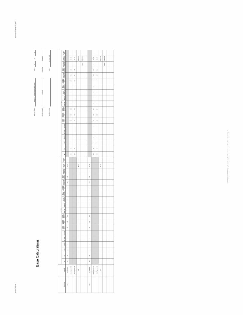
AECO
M Ca
nada
Ltd.
ANV G
ROUP
STAM
SON
CALC
SHEE
T
PAGE
5OF
8
ENGI
NEER
DATE
RECE
IVER
SOUR
CEθ1
θ2TO
POW
OODS
No. R
ows
@ D
ensity
Grou
ndSu
rface
Type
Rece
iver
Heigh
t (r)
(m)
Sourc
eRe
ceive
rDis
t (m)
Barr
θ1Ba
rrθ2
Barrie
rHe
ight (m
)Ba
rrier
Rece
iver
Distan
ce (m
)
Eleva
tion
Chan
ge (e
)(m
)So
urce G
round
Eleva
tion (
m)
Rece
iver
Grou
ndEle
vatio
n (m)
Base
of B
arrier
Eleva
tion (
m)Le
q (24
hr)(dB
A)Le
q (Nig
ht)(dB
A)θ1
θ2TO
POW
OODS
No. R
ows
@ D
ensity
Grou
ndSu
rface
Type
Rece
iver
Heigh
t (r)
(m)
Sourc
eRe
ceive
rDis
t (m)
Barr
θ1Ba
rrθ2
Barrie
rHe
ight (m
)Ba
rrier
Rece
iver
Distan
ce (m
)
Eleva
tion
Chan
ge (e
)(m
)So
urce G
round
Eleva
tion (
m)
Rece
iver
Grou
ndEle
vatio
n (m)
Base
of B
arrier
Eleva
tion (
m)Le
q(Day
) or
Leq(1
hr) (d
BA)
Leq (
Night)
(dBA)
R17
Old A
lignme
nt-90
903
--
-1
1.229
6-
--
-2
186
188
-49
.61-
New
Align
ment
WB
-9090
3-
--
11.2
182
--
--
1320
118
8-
55.08
-
New
Align
ment
EB-90
903
--
-1
1.221
7-
--
-13
201
188
-54
.11-
Total
49.61
-57
.6323
251
-
Impa
ct8.0
2232
513
-
R18
Old A
lignme
nt-90
903
--
-1
1.210
6-
--
-1
219
218
-56
.44-
New
Align
ment
WB
-9090
3-
--
11.2
44-
--
-1
219
218
-60
.54-
New
Align
ment
EB-90
903
--
-1
1.282
--
--
121
921
8-
56.13
-
Total
56.44
-61
.8825
458
-
Impa
ct5.4
4254
584
-
Base
Calc
ulatio
nsPR
OJEC
T NAM
EHig
hway
17 - R
oute
Plann
ing Bo
nfield
Easte
rly
Brian
Bulne
s
BASE
DRA
WIN
G
6024
1599
PROJ
ECT N
UMBE
R
No Pr
oject
With
Proje
ct
March
13, 2
014
N:\PR
OJEC
TS\Jo
bs\60
2415
99 H
ighwa
y 17 -
Rou
te Pla
nning
Bonfi
eld\ca
lcs\Ve
r2-up
dated
with
topo
\Stam
son W
orksh
eet_V
er2
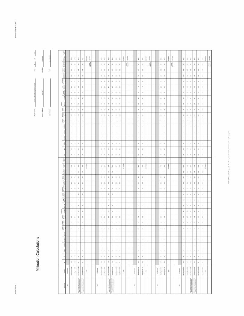
AECO
M Ca
nada
Ltd.
ANV G
ROUP
STAM
SON
CALC
SHEE
T
PAGE
6OF
8
ENGI
NEER
DATE
RECE
IVER
SOUR
CEθ1
θ2TO
POW
OODS
No. R
ows
@ D
ensity
Grou
ndSu
rface
Type
Rece
iver
Heigh
t (r)
(m)
Sourc
eRe
ceive
rDis
t (m)
Barr
θ1Ba
rrθ2
Barrie
rHe
ight (m
)Ba
rrier
Rece
iver
Distan
ce (m
)
Eleva
tion
Chan
ge (e
)(m
)So
urce G
round
Eleva
tion (
m)
Rece
iver
Grou
ndEle
vatio
n (m)
Base
of B
arrier
Eleva
tion (
m)Le
q (24
hr)(dB
A)Le
q (Nig
ht)(dB
A)θ1
θ2TO
POW
OODS
No. R
ows
@ D
ensity
Grou
ndSu
rface
Type
Rece
iver
Heigh
t (r)
(m)
Sourc
eRe
ceive
rDis
t (m)
Barr
θ1Ba
rrθ2
Barrie
rHe
ight (m
)Ba
rrier
Rece
iver
Distan
ce (m
)
Eleva
tion
Chan
ge (e
)(m
)So
urce G
round
Eleva
tion (
m)
Rece
iver
Grou
ndEle
vatio
n (m)
Base
of B
arrier
Eleva
tion (
m)Le
q(Day
) or
Leq(1
hr) (d
BA)
Leq (
Night)
(dBA)
R02
Old A
lignme
nt
New
Align
ment
WB1
-9045
3-
--
11.2
318
--
--
524
925
4-
47.42
--90
454
--
-1
1.231
8-60
455
245
524
925
425
242
.26-
New
Align
ment
EB1
-9045
3-
--
11.2
280
--
--
524
925
4-
48.26
--90
454
--
-1
1.228
0-60
455
245
524
925
425
241
.53-
Used
avera
ge he
ight a
cross
viewin
gan
gle fo
r Barr
ier Ba
se El
evati
onNe
w Ali
gnme
nt W
B245
904
--
-1
1.231
845
900
215
325
125
426
230
.27-
4590
4-
--
11.2
318
4590
021
53
251
254
262
30.27
-
Used
avera
ge he
ight a
cross
viewin
gan
gle fo
r Barr
ier Ba
se El
evati
onNe
w Ali
gnme
nt EB
245
904
--
-1
1.228
045
900
215
325
125
426
230
.1-
4590
4-
--
11.2
280
4590
021
53
251
254
262
30.1
-
Total
50.94
4139
7-
45.20
3192
8-
Noise
Redu
ction
5.740
9469
2-
R03
Old A
lignme
nt
New
Align
ment
WB1
-90-20
3-
--
11.2
385
--
--
1224
826
0-
46.11
--90
-204
--
-1
1.238
5-90
-205
340
1224
826
025
240
.95-
New
Align
ment
EB1
-90-20
3-
--
11.2
348
--
--
1224
826
0-
46.68
--90
-204
--
-1
1.234
8-90
-205
340
1224
826
025
235
.86-
Used
avera
ge he
ight a
cross
viewin
gan
gle fo
r Barr
ier Ba
se El
evati
onNe
w Ali
gnme
nt W
B2-20
304
--
-1
1.238
5-20
300
182
1025
026
026
234
.98-
-2030
4-
--
11.2
385
-2030
018
210
250
260
262
34.98
-
Used
avera
ge he
ight a
cross
viewin
gan
gle fo
r Barr
ier Ba
se El
evati
onNe
w Ali
gnme
nt EB
2-20
304
--
-1
1.234
8-20
300
182
1025
026
026
234
.66-
-2030
4-
--
11.2
348
-2030
018
210
250
260
262
34.66
-
New
Align
ment
WB3
3090
3-
--
11.2
385
--
--
1124
926
0-
44.75
-30
904
--
-1
1.238
530
905
344
1124
926
024
943
.81-
New
Align
ment
EB3
3090
3-
--
11.2
348
--
--
1124
926
0-
45.33
-30
904
--
-1
1.234
830
905
344
1124
926
024
937
.92-
Total
51.97
1028
5-
47.21
0672
2-
Noise
Redu
ction
4.760
3562
8-
R04
Old A
lignme
nt
New
Align
ment
WB
-9090
3-
--
11.2
144
--
--
825
226
0-
54.58
--90
904
--
-1
1.214
4-60
605
739
251
260
257
49.86
-
New
Align
ment
EB-90
903
--
-1
1.210
8-
--
-8
252
260
-56
.36-
-9090
4-
--
11.2
108
-6060
573
925
126
025
750
.67-
Total
58.57
0862
6-
53.29
4156
7-
Noise
Redu
ction
5.276
7058
7-
R05
Old A
lignme
nt
New
Align
ment
WB
-9090
3-
--
11.2
283
--
--
125
325
2-
47.35
--90
904
--
-1
1.228
3-90
905
212
125
325
225
442
.83-
New
Align
ment
EB-90
903
--
-1
1.224
6-
--
-1
253
252
-48
.34-
-9090
4-
--
11.2
246
-9090
521
21
253
252
254
42.29
-
Total
50.88
3448
6-
45.57
8687
5-
Noise
Redu
ction
5.304
7611
6-
R07
Old A
lignme
nt
New
Align
ment
WB1
-90-45
4-
--
11.2
89-90
-450
535
253
248
254
43.53
--90
-454
--
-1
1.289
-90-45
553
525
324
825
441
.55-
New
Align
ment
EB1
-90-45
4-
--
11.2
126
-90-45
053
525
324
825
440
.6-
-90-45
4-
--
11.2
126
-90-45
553
525
324
825
439
.95-
Used
avera
ge he
ight a
cross
viewin
gan
gle fo
r Barr
ier Ba
se El
evati
onNe
w Ali
gnme
nt W
B2-45
454
--
-1
1.289
-4545
053
225
024
825
638
.62-
-4545
4-
--
11.2
89-45
455
532
250
248
256
36.36
-
Used
avera
ge he
ight a
cross
viewin
gan
gle fo
r Barr
ier Ba
se El
evati
onNe
w Ali
gnme
nt EB
2-45
454
--
-1
1.212
6-45
450
532
250
248
256
37.04
--45
454
--
-1
1.212
6-45
455
532
250
248
256
34.67
-
New
Align
ment
WB3
4590
4-
--
11.2
8945
900
532
246
248
253
45.82
-45
904
--
-1
1.289
4560
553
224
624
825
345
.72-
New
Align
ment
EB3
4590
4-
--
11.2
126
4590
053
224
624
825
343
.5-
4590
4-
--
11.2
126
4560
553
224
624
825
343
.36-
Total
50.29
1467
2-
49.56
3248
2-
Noise
Redu
ction
0.728
2190
4-
Mitig
ation
Calc
ulatio
ns
Unmi
tigate
dMi
tigate
d
March
13, 2
014
BASE
DRA
WIN
G
6024
1599
Brian
Bulne
sPR
OJEC
T NUM
BER
PROJ
ECT N
AME
Highw
ay 17
- Rou
te Pla
nning
Bonfi
eld Ea
sterly
N:\PR
OJEC
TS\Jo
bs\60
2415
99 H
ighwa
y 17 -
Rou
te Pla
nning
Bonfi
eld\ca
lcs\Ve
r2-up
dated
with
topo
\Stam
son W
orksh
eet_V
er2
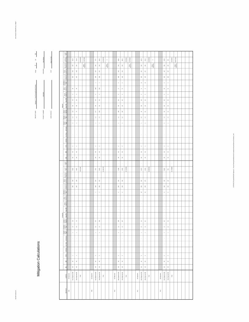
AECO
M Ca
nada
Ltd.
ANV G
ROUP
STAM
SON
CALC
SHEE
T
PAGE
7OF
8
ENGI
NEER
DATE
RECE
IVER
SOUR
CEθ1
θ2TO
POW
OODS
No. R
ows
@ D
ensity
Grou
ndSu
rface
Type
Rece
iver
Heigh
t (r)
(m)
Sourc
eRe
ceive
rDis
t (m)
Barr
θ1Ba
rrθ2
Barrie
rHe
ight (m
)Ba
rrier
Rece
iver
Distan
ce (m
)
Eleva
tion
Chan
ge (e
)(m
)So
urce G
round
Eleva
tion (
m)
Rece
iver
Grou
ndEle
vatio
n (m)
Base
of B
arrier
Eleva
tion (
m)Le
q (24
hr)(dB
A)Le
q (Nig
ht)(dB
A)θ1
θ2TO
POW
OODS
No. R
ows
@ D
ensity
Grou
ndSu
rface
Type
Rece
iver
Heigh
t (r)
(m)
Sourc
eRe
ceive
rDis
t (m)
Barr
θ1Ba
rrθ2
Barrie
rHe
ight (m
)Ba
rrier
Rece
iver
Distan
ce (m
)
Eleva
tion
Chan
ge (e
)(m
)So
urce G
round
Eleva
tion (
m)
Rece
iver
Grou
ndEle
vatio
n (m)
Base
of B
arrier
Eleva
tion (
m)Le
q(Day
) or
Leq(1
hr) (d
BA)
Leq (
Night)
(dBA)
R08
Old A
lignme
nt
New
Align
ment
WB
-9090
1-
--
11.2
112
--
--
-24
524
5-
53.62
--90
902
--
-1
1.211
2-90
905
39-
245
245
243
50.36
-
New
Align
ment
EB-90
901
--
-1
1.275
--
--
-24
524
5-
56.51
--90
902
--
-1
1.275
-9090
539
-24
524
524
352
.49-
Total
58.31
1384
-54
.5645
943
-
Noise
Redu
ction
3.746
7896
9-
R09
Old A
lignme
nt
New
Align
ment
WB
-9090
3-
--
11.2
277
--
--
123
823
7-
47.5
--90
904
--
-1
1.227
7-90
905
204
123
823
723
447
.5-
New
Align
ment
EB-90
903
--
-1
1.224
0-
--
-1
238
237
-48
.52-
-9090
4-
--
11.2
240
-9090
520
41
238
237
234
48.52
-
Total
51.05
0176
5-
51.05
0176
5-
Noise
Redu
ction
0-
R10
Old A
lignme
nt
New
Align
ment
WB
-9090
3-
--
11.2
185
--
--
524
624
1-
51.88
--90
904
--
-1
1.218
5-60
605
175
246
241
241
46.84
-
New
Align
ment
EB-90
903
--
-1
1.214
7-
--
-5
246
241
-53
.39-
-9090
4-
--
11.2
147
-6060
517
524
624
124
148
.32-
Total
55.71
0598
6-
50.65
3042
-
Noise
Redu
ction
5.057
5565
7-
R11
Old A
lignme
nt
New
Align
ment
WB
-9090
3-
--
11.2
45-
--
-22
235
257
-64
.79-
-9090
4-
--
11.2
45-90
905
912
235
257
242
64.79
-
New
Align
ment
EB-90
903
--
-1
1.282
--
--
2223
525
7-
62.18
--90
904
--
-1
1.282
-9090
59
1223
525
724
262
.18-
Total
66.68
8486
5-
66.68
8486
5-
Noise
Redu
ction
0-
R14
Old A
lignme
nt
New
Align
ment
WB
-9090
3-
--
11.2
94-
--
-6
193
187
-56
.62-
-9090
4-
--
11.2
94-90
905
206
193
187
185
54.49
-
New
Align
ment
EB-90
903
--
-1
1.264
--
--
619
318
7-
59.1
--90
904
--
-1
1.264
-9090
520
619
318
718
559
.1-
Total
61.04
4968
5-
60.39
0255
-
Noise
Redu
ction
0.654
7135
2-
Mitig
ation
Calc
ulatio
ns
Unmi
tigate
dMi
tigate
d
BASE
DRA
WIN
G
6024
1599
Brian
Bulne
sPR
OJEC
T NUM
BER
March
13, 2
014
PROJ
ECT N
AME
Highw
ay 17
- Rou
te Pla
nning
Bonfi
eld Ea
sterly
N:\PR
OJEC
TS\Jo
bs\60
2415
99 H
ighwa
y 17 -
Rou
te Pla
nning
Bonfi
eld\ca
lcs\Ve
r2-up
dated
with
topo
\Stam
son W
orksh
eet_V
er2

AECO
M Ca
nada
Ltd.
ANV G
ROUP
STAM
SON
CALC
SHEE
T
PAGE
8OF
8
ENGI
NEER
DATE
RECE
IVER
SOUR
CEθ1
θ2TO
POW
OODS
No. R
ows
@ D
ensity
Grou
ndSu
rface
Type
Rece
iver
Heigh
t (r)
(m)
Sourc
eRe
ceive
rDis
t (m)
Barr
θ1Ba
rrθ2
Barrie
rHe
ight (m
)Ba
rrier
Rece
iver
Distan
ce (m
)
Eleva
tion
Chan
ge (e
)(m
)So
urce G
round
Eleva
tion (
m)
Rece
iver
Grou
ndEle
vatio
n (m)
Base
of B
arrier
Eleva
tion (
m)Le
q (24
hr)(dB
A)Le
q (Nig
ht)(dB
A)θ1
θ2TO
POW
OODS
No. R
ows
@ D
ensity
Grou
ndSu
rface
Type
Rece
iver
Heigh
t (r)
(m)
Sourc
eRe
ceive
rDis
t (m)
Barr
θ1Ba
rrθ2
Barrie
rHe
ight (m
)Ba
rrier
Rece
iver
Distan
ce (m
)
Eleva
tion
Chan
ge (e
)(m
)So
urce G
round
Eleva
tion (
m)
Rece
iver
Grou
ndEle
vatio
n (m)
Base
of B
arrier
Eleva
tion (
m)Le
q(Day
) or
Leq(1
hr) (d
BA)
Leq (
Night)
(dBA)
R15
Old A
lignme
nt
New
Align
ment
WB
-9090
3-
--
11.2
441
--
--
719
819
1-
47.17
--90
904
--
-1
1.244
1-90
905
370
719
819
118
847
.17-
New
Align
ment
EB-90
903
--
-1
1.240
9-
--
-7
198
191
-47
.65-
-9090
4-
--
11.2
409
-9090
537
07
198
191
188
47.65
-
Total
50.42
6928
-50
.4269
28-
Noise
Redu
ction
0-
R16
Old A
lignme
nt
New
Align
ment
WB
-9090
3-
--
11.2
193
--
--
1119
818
7-
53.96
--90
904
--
-1
1.219
3-90
905
156
1119
818
718
753
.96-
New
Align
ment
EB-90
903
--
-1
1.222
6-
--
-11
198
187
-53
.05-
-9090
4-
--
11.2
226
-9090
515
611
198
187
187
53.05
-
Total
56.53
9091
1-
56.53
9091
1-
Noise
Redu
ction
0-
R17
Old A
lignme
nt
New
Align
ment
WB
-9090
3-
--
11.2
182
--
--
1320
118
8-
55.08
--90
904
--
-1
1.218
2-90
905
147
1320
118
818
955
.08-
New
Align
ment
EB-90
903
--
-1
1.221
7-
--
-13
201
188
-54
.11-
-9090
4-
--
11.2
217
-9090
514
713
201
188
189
54.11
-
Total
57.63
2325
1-
57.63
2325
1-
Noise
Redu
ction
0-
R18
Old A
lignme
nt
New
Align
ment
WB
-9090
3-
--
11.2
44-
--
-1
219
218
-60
.54-
-9090
4-
--
11.2
44-60
605
81
219
218
216
55.45
-
New
Align
ment
EB-90
903
--
-1
1.282
--
--
121
921
8-
56.13
--90
904
--
-1
1.282
-6060
58
121
921
821
651
.29-
Total
61.88
2545
8-
56.86
0442
2-
Noise
Redu
ction
5.022
1036
9-
Mitig
ation
Calc
ulatio
ns
Unmi
tigate
dMi
tigate
d
March
13, 2
014
BASE
DRA
WIN
G
6024
1599
PROJ
ECT N
UMBE
RBr
ian Bu
lnes
PROJ
ECT N
AME
Highw
ay 17
- Rou
te Pla
nning
Bonfi
eld Ea
sterly
N:\PR
OJEC
TS\Jo
bs\60
2415
99 H
ighwa
y 17 -
Rou
te Pla
nning
Bonfi
eld\ca
lcs\Ve
r2-up
dated
with
topo
\Stam
son W
orksh
eet_V
er2