ongoing drought-induced uplift in the western united states
TRANSCRIPT

DOI: 10.1126/science.1260279, 1587 (2014);345 Science
et al.Adrian Antal BorsaOngoing drought-induced uplift in the western United States
This copy is for your personal, non-commercial use only.
clicking here.colleagues, clients, or customers by , you can order high-quality copies for yourIf you wish to distribute this article to others
here.following the guidelines
can be obtained byPermission to republish or repurpose articles or portions of articles
): September 30, 2014 www.sciencemag.org (this information is current as of
The following resources related to this article are available online at
http://www.sciencemag.org/content/345/6204/1587.full.htmlversion of this article at:
including high-resolution figures, can be found in the onlineUpdated information and services,
http://www.sciencemag.org/content/suppl/2014/08/21/science.1260279.DC1.html can be found at: Supporting Online Material
http://www.sciencemag.org/content/345/6204/1587.full.html#relatedfound at:
can berelated to this article A list of selected additional articles on the Science Web sites
http://www.sciencemag.org/content/345/6204/1587.full.html#ref-list-1, 2 of which can be accessed free:cites 30 articlesThis article
http://www.sciencemag.org/cgi/collection/geochem_physGeochemistry, Geophysics
subject collections:This article appears in the following
registered trademark of AAAS. is aScience2014 by the American Association for the Advancement of Science; all rights reserved. The title
CopyrightAmerican Association for the Advancement of Science, 1200 New York Avenue NW, Washington, DC 20005. (print ISSN 0036-8075; online ISSN 1095-9203) is published weekly, except the last week in December, by theScience
on
Sep
tem
ber
30, 2
014
ww
w.s
cien
cem
ag.o
rgD
ownl
oade
d fr
om
on
Sep
tem
ber
30, 2
014
ww
w.s
cien
cem
ag.o
rgD
ownl
oade
d fr
om
on
Sep
tem
ber
30, 2
014
ww
w.s
cien
cem
ag.o
rgD
ownl
oade
d fr
om
on
Sep
tem
ber
30, 2
014
ww
w.s
cien
cem
ag.o
rgD
ownl
oade
d fr
om
on
Sep
tem
ber
30, 2
014
ww
w.s
cien
cem
ag.o
rgD
ownl
oade
d fr
om

Impact of Star Formation,” project area B3. H.S.P.M. is verygrateful to the Bundesministerium für Bildung und Forschung forsupport through projects FKZ 50OF0901 (ICC HIFI Herschel)and 05A11PK3 (ALMA ARC Node). R.T.G. acknowledges supportfrom the NASA Astrophysics Theory Program through grantNNX11AC38G. This paper makes use of the following ALMA data:ADS/JAO.ALMA#2011.0.00017.S. ALMA is a partnership of theEuropean Southern Observatory (ESO) (representing its memberstates), NSF (USA), and National Institutes of Natural Sciences
(Japan), together with National Research Council (Canada) andNational Science Council and Academia Sinica Institute ofAstronomy and Astrophysics (Taiwan), in cooperation with theRepublic of Chile. The Joint ALMA Observatory is operated byESO, Associated Universities Incorporated/National RadioAstronomy Observatory, and National Astronomical Observatoryof Japan. The interferometric data are available in the ALMAarchive at https://almascience.eso.org/aq/. The chemical model inputfiles are located at www.astro.cornell.edu/~rgarrod/resources.
SUPPLEMENTARY MATERIALS
www.sciencemag.org/content/345/6204/1584/suppl/DC1Materials and MethodsFigs. S1 to S6Tables S1 and S2References (17–30)
29 May 2014; accepted 20 August 201410.1126/science.1256678
REMOTE HYDROLOGY
Ongoing drought-induced uplift in thewestern United StatesAdrian Antal Borsa,1* Duncan Carr Agnew,1 Daniel R. Cayan1,2
The western United States has been experiencing severe drought since 2013. The solidearth response to the accompanying loss of surface and near-surface water mass shouldbe a broad region of uplift. We use seasonally adjusted time series from continuouslyoperating global positioning system stations to measure this uplift, which we invert toestimate mass loss. The median uplift is 5 millimeters (mm), with values up to 15 mm inCalifornia’s mountains. The associated pattern of mass loss, ranging up to 50 centimeters(cm) of water equivalent, is consistent with observed decreases in precipitation andstreamflow. We estimate the total deficit to be ~240 gigatons, equivalent to a 10-cm layerof water over the entire region, or the annual mass loss from the Greenland Ice Sheet.
Over the past few years, the western con-terminous United States (WUSA) has ex-perienced large interannual variations inhydrological conditions and is currentlyundergoing a severe drought. Coincident
observations of reduced precipitation and stream-flow reflect the impact of the drought but do notdirectly measure the associated deficit in terres-trial water storage (TWS), which is a compre-hensive metric that includes cumulative changes
in vegetation and soil moisture, perennial snowand ice, groundwater, and surface water. Satellitegravity measurements from NASA’s Gravity Re-covery and Climate Experiment (GRACE) havebeen widely used to observe TWS (1, 2), thoughthese results indicate that for transient signalsthe intrinsic spatial resolution of these measure-ments is several hundred kilometers. Additionalinformation about TWS at higher resolution isneeded to understand the extent and impact ofthe current drought at basin to regional scalesacross the WUSA.Like other varying loads onEarth’s surface, the
water mass loss associated with the drought willinduce instantaneous vertical and horizontal dis-
placements from elastic deformation (3). Thesecan bemeasured at themillimeter level using theGlobal Positioning System (GPS), which has beendone for seasonal changes in snowpack (4) andin hydrologic systems such as lakes (5, 6) andriver basins (7, 8). Except very close to the load,these displacements are largely independent oflocal structure (e.g., sedimentary basins behavethe same as bedrock). Displacements from load-ing provide information about changes at inter-mediate spatial scales not otherwise observable,and they integrate the effects of all loads—anadvantage because displacements provide datafrom areas otherwise not measured, and a chal-lenge because inversion is required to find theactual spatial distribution.To study the loading response corresponding
to hydrological changes, we have analyzed thepast 11 years (2003 to 2014) of daily vertical po-sitions estimated for continuous GPS stationsfrom the National Science Foundation’s PlateBoundaryObservatory (PBO) and several smallernetworks. The stations we used were located onthe U.S. mainland west of longitude 109°W andon Vancouver Island. We detrended each timeseries to remove secular tectonicmotion and usedthe seasonal-trend-loess (STL) method (9) to re-move seasonal signals due to water loading(10–12). The STL method is effective on time se-ries like GPS that exhibit modulated behavior(13, 14) that is not well represented by annualand semiannual sinusoids (fig. S1).GPS records transient displacements from
phenomena other than surface loading, in-cluding volcanic or tectonic forcing (15) and the
SCIENCE sciencemag.org 26 SEPTEMBER 2014 • VOL 345 ISSUE 6204 1587
1Scripps Institution of Oceanography, University of CaliforniaSan Diego, La Jolla, CA 92093, USA. 2United StatesGeological Survey, La Jolla, CA 92093, USA.*Corresponding author. E-mail: [email protected]
Fig. 1. Vertical GPS displace-ment time series. Detrendedand seasonally adjusted dailyvertical displacements from 771continuous GPS stations in theWUSA, decimated to weeklyintervals for plotting (gray lines).The thick red line is the medianvalue of all data for each day,and the light red lines indicatethe SD computed from theinterquartile range. The upliftthat began in 2013 is notable forthe period after 2006, when thenumber and distribution of GPSstations greatly expanded acrossthe region with the building ofthe PBO (blue line shows thenumber of stations used in theanalysis).
RESEARCH | REPORTS
poroelastic response of aquifers to groundwaterextraction and recharge (16, 17). In addition, fic-titious vertical displacements can be caused byvariations in the signal-scattering environmentclose to each station (18), but these “multipath”effects contribute, on average, only a few milli-meters of correlated noise to daily position es-timates (19) and are not expected to substantiallyaffect our results. We mitigated the impact ofnonloading signals by excluding all stationswithinthe actively deforming Long Valley caldera (20);all stations in California’s Central Valley, whereagricultural pumping is widespread (21, 22); sta-tions whose seasonal displacements suggest theyare located above an actively pumped aquifer (11);and a few gross outliers (12).After removing these stations, we were left
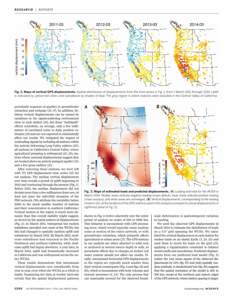
with 771 GPS displacement time series (12) forour analysis. The median vertical displacementover time reveals a period of uplift beginning in2013 and continuing through the present (Fig. 1).Before 2013, the median displacement did notdeviatemore than a fewmillimeters from zero, atleast not since the mid-2005 inception of thePBOnetwork. (We attribute the variability before2006 to the much smaller number of stationsand their concentration in southern California.)Vertical motion in the region is much more dy-namic than this overall stability might suggest,as shown by the spatial pattern of displacements(Fig. 2). In March 2011, widespread but modestsubsidence prevailed over most of the WUSA, butthis had changed to spatially random uplift andsubsidence by March 2012. By March 2013, mod-erate subsidence had returned to the PacificNorthwest and northern California, while mod-erate uplift had begun elsewhere. A year later, inMarch 2014, uplift had dramatically increasedin California and was widespread across the en-tire WUSA.These results demonstrate that interannual
vertical displacements vary considerably fromyear to year, even when theWUSA as a whole isstable. Examining the data at weekly intervalsreveals that the spatial displacement patterns
shown in Fig. 2 evolve coherently over the entireperiod of analysis on scales of 100 to 1000 km.This behavior is inconsistent with GPS process-ing error, which would typically cause randomnoise or motion of the entire network, or withgroundwater extraction, which primarily affectsagricultural or urban areas (17). The GPS stationsin our analysis are either attached to solid rockor anchored at several meters depth in soils, soporoelastic effects due to changes in surface soilwater content should not affect our results. Fi-nally, interannual horizontal GPS displacementsin the region are typically much smaller thantheir vertical counterparts (Fig. 2 and figs. S2 andS3), which is inconsistent with both volcanic andtectonic processes (6, 23). The only process thatcan reasonably account for the observed broad-
scale deformation is spatiotemporal variationin loading.We used the observed GPS displacements in
March 2014 to estimate the distribution of loadson a 0.5° grid spanning the WUSA. We calcu-lated the vertical displacement at each station forsurface loads on an elastic Earth (3, 24, 25) andused these to invert for loads on the grid (12),applying a regularization constraint to balancemodelmisfit and smoothness. Predicted displace-ments from our preferred load model (Fig. 3)reduce the root mean square of the observed dis-placements by 53% (fig. S7) and yield spatially ran-dom residuals. A checkerboard test (fig. S8) suggeststhat the spatial resolution of the model is 200 to300 km, except at the northern and eastern edgesof theGPSnetwork,where station spacing is larger.
1588 26 SEPTEMBER 2014 • VOL 345 ISSUE 6204 sciencemag.org SCIENCE
Fig. 2. Maps of vertical GPS displacements. Spatial distribution of displacements from the time series in Fig. 1, from 1 March 2011 through 2014. Upliftis indicated by yellow-red colors and subsidence by shades of blue. The gray region is where stations were excluded in the Central Valley of California.
Fig. 3. Maps of estimated loads and predicted displacements. (A) Loading estimate for the WUSA inMarch 2014. Redder areas indicate negative loading (mass deficit), bluer areas indicate positive loading(mass surplus), and white areas are unchanged. (B) Vertical displacements, corresponding to the loadingmodel in (A), at the locations of the GPS stations used in this analysis (compare to actual displacements inrightmost panel of Fig. 2).
RESEARCH | REPORTS
The inversion produces an estimate of the loadthat resembles the uplift pattern but is smootherbecause of the constraints imposed. In March2014, when most vertical displacements arefarthest from their long-term averages, our re-sults show crustal unloading over the entireWUSA, with a maximum in the central SierraNevada equivalent to 50 cm of water (Fig. 3).There appears to be a small amount of real non-tectonic loading in Montana, whereas the appar-ent loading just south of the U.S.-Mexico borderis probably caused by postseismic effects fromthe moment magnitude 7.2 El Mayor–Cucapahearthquake in 2010 (26). The arid regions ofeastern California, Oregon, Washington, and west-ern Nevada show little loading. Estimated loadsnear the northern and southern boundaries of thegrid, as well as in Arizona, Utah, andMontana, arepoorly constrained by the GPS data.We interpret the widespread negative loading,
with its central California maximum, to representchanges in terrestrial water storage due to thecurrent WUSA drought. The implied drying rela-tive to the long-term mean appears to be mostacute in coastal and mountainous areas andsubdued in highly arid regions. This is expected,because the change in precipitation in a droughtis proportional to the climatological mean value,so that arid regions lose less water than do wetregions. The area-integrated water deficit overthe WUSA in March 2014 is 240 gigatons, avalue that is insensitive to the degree of smoothingused in the inversion (fig. S6). For perspective,this deficit is equivalent to a uniform 10-cmlayer of water over the entire WUSA and is themagnitude of the current annual mass loss fromthe Greenland Ice Sheet.The temporal and spatial water storage varia-
tions implied by the observed displacements areconsistent with contemporaneous observationsof precipitation and streamflow, all of which un-derscore the extent and severity of the currentdrought in the WUSA. The departure of annualprecipitation from the long-term average (Fig. 4)
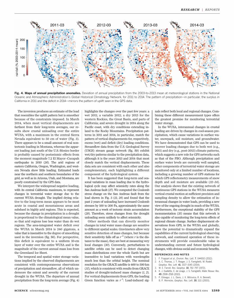
highlights the changes over the past few years: awet 2011; a variable 2012; a dry 2013 for thewestern Rockies, the Great Basin, and parts ofCalifornia; and severe drought in 2014 along thePacific coast, with dry conditions extending in-land to the Rocky Mountains. Precipitation pat-terns in 2011 and 2014, in particular, match thepattern of vertical displacements for, respectively,excess (wet) and deficit (dry) loading conditions.Streamflow data from the U.S. Geological Survey(USGS) stream gauge network (fig. S9) exhibitwet/dry patterns similar to the precipitation data,although it is the years 2013 and 2014 that mostclosely match the vertical displacements. Thesedata sets are consistent with each other and alsocomplementary, each highlighting a differentcomponent of the hydrological system.It has been suggested that long-term and sea-
sonal variations in mass loading due to the hydro-logical cycle may affect seismicity rates along theSan Andreas fault (27). We computed the Coulombstress change on the San Andreas fault from theload shown in Fig. 3 (12, 28) and found that thepast 2 years of unloading have increased Coulombstresses by 100 to 200 Pa, approximately the sameamount as a week of tectonic strain accumulation(29). Therefore, stress changes from the droughtunloading seem unlikely to affect seismicity.Other methods that can directly monitor
changes in total water mass change are sensitiveto different spatial scales. Gravimeters allow verysensitive detection of mass changes, but becausetheir sensitivity falls off as r–2 (where r is the dis-tance to themass), they are best atmeasuring verylocal changes (30). Conversely, perturbations tosatellite orbits can be used to detect changingmass distributions over the whole Earth but areinsensitive to load variations with wavelengthsmuch less than the orbital height. The nominalresolution for theGRACE satellite is 400 to 500km(31), which is consistentwith results fromGRACEstudies of drought-induced mass changes (1, 2).For vertical displacements fromGPS, the loadingGreen function varies as r–1: Load-induced sig-
nals reflect both local and regional changes. Com-bining these different measurement types offersthe greatest promise for monitoring terrestrialwater storage.In the WUSA, interannual changes in crustal
loading are driven by changes in cool-season pre-cipitation, which cause variations in surface wa-ter, snowpack, soil moisture, and groundwater.We have demonstrated that GPS can be used torecover loading changes due to both wet (e.g.,2011) and dry (e.g., post-2013) climate patterns,which suggests a new role for GPS networks suchas that of the PBO. Although precipitation andsurface water levels are currently well sampled,other components of terrestrial water storage aremonitored only at a limited number of locations,including a growing number of GPS stations forwhich GPS reflectometry measurements of snowdepth and soil moisture are available (32–34).Our analysis shows that the existing network ofcontinuous GPS stations in the WUSA measuresvertical crustalmotion at sufficient precision andsampling density to allow the estimation of in-terannual changes in water loads, providing a newviewof the ongoingdrought inmuchof theWUSA.Furthermore, the exceptional stability of the GPSmonumentation (35) means that this network isalso capable of monitoring the long-term effects ofregional climate change. Surface displacement ob-servations from GPS, in the WUSA and globally,have the potential to dramatically expand thecapabilities of the current hydrological observingnetwork, and continued operation of these in-struments will provide considerable value inunderstanding current and future hydrologicalchanges,with obvious social andeconomicbenefits.
REFERENCES AND NOTES
1. F. Frappart et al., Environ. Res. Lett. 7, 044010 (2012).2. A. C. Thomas, J. T. Reager, J. S. Famiglietti, M. Rodell,
Geophys. Res. Lett. 41, 1537–1545 (2014).3. W. E. Farrell, Rev. Geophys. 10, 761–797 (1972).4. K. J. Ouellette, C. de Linage, J. S. Famiglietti, Water Resour. Res.
49, 2508–2518 (2013).5. P. Elósegui, J. L. Davis, J. X. Mitrovica, R. A. Bennett,
B. P. Wernicke, Geophys. Res. Lett. 30, 1111 (2003).
SCIENCE sciencemag.org 26 SEPTEMBER 2014 • VOL 345 ISSUE 6204 1589
Fig. 4. Maps of annual precipitation anomalies. Deviation of annual precipitation from the 2003-to-2013 mean at meteorological stations in the NationalOceanic and Atmospheric Administration’s Global Historical Climatology Network, for 2011 to 2014. The pattern of precipitation—in particular, the surplus inCalifornia in 2011 and the deficit in 2014—mirrors the pattern of uplift seen in the GPS data.
RESEARCH | REPORTS

6. J. Wahr et al., J. Geophys. Res. 117, 1795–1806 (2013).7. M. Bevis et al., Geophys. Res. Lett. 32, L16308 (2005).8. P. Bettinelli et al., Earth Planet. Sci. Lett. 266, 332–344 (2008).9. R. B. Cleveland, W. S. Cleveland, J. E. McRae, I. Terpenning,
J. Off. Stat. 6, 3–73 (1990).10. M. S. Steckler et al., J. Geophys. Res. 115, B08407 (2010).11. D. Argus, Y. Fu, F. Landerer, Geophys. Res. Lett. 41, 1971–1980
(2014).12. Materials and methods are available as supplementary
materials on Science Online.13. R. A. Bennett, Geophys. J. Int. 174, 1052–1064 (2008).14. J. L. Davis, B. P. Wernicke, M. E. Tamisiea, J. Geophys. Res. 117,
B01403 (2012).15. D. Dzurisin, Volcano Deformation: Geodetic Monitoring
Techniques (Springer, New York, 2007).16. N. E. King et al., J. Geophys. Res. 112, B03409 (2007).17. D. L. Galloway, T. J. Burbey, Hydrogeol. J. 19, 1459–1486 (2011).18. P. Elósegui et al., J. Geophys. Res. 100, 9921–9934 (1995).19. M. A. King et al., Surv. Geophys. 31, 465–507 (2010).20. K.-H. Ji, T. A. Herring, A. L. Llenos, Geophys. Res. Lett. 40,
1054–1058 (2013).21. M. E. Ikehara, Hydrol. Sci. J. 39, 417–429 (1994).22. R. T. Hanson et al., in Land Subsidence, Associated Hazards,
and the Role of Natural Resources Development (InternationalAssociation of Hydrological Sciences Press, Wallingford, UK,2010), vol. 339, pp. 467–471.
23. R. Grapenthin, B. G. Ofeigsson, F. Sigmundsson, E. Sturkell,A. Hooper, Geophys. Res. Lett. 37, L20310 (2010).
24. D. C. Agnew, in Treatise on Geophysics: Geodesy, T. A. Herring,Ed. (Elsevier, New York, 2007), pp. 163–195.
25. D. C. Agnew, “SPOTL: Some Programs for Ocean-Tide Loading”(SIO Technical Report, Scripps Institution of Oceanography,La Jolla, CA, 2012); http://escholarship.org/uc/item/954322pg.
26. F. Pollitz, R. Bürgmann, W. Thatcher, Geochem. Geophys. Geosyst.13, Q06002 (2012).
27. C. B. Amos et al., Nature 509, 483–486 (2014).28. L. Astiz, P. M. Shearer, D. C. Agnew, J. Geophys. Res. 105,
2937–2953 (2000).29. B. Smith-Konter, D. Sandwell, P. M. Shearer, J. Geophys. Res.
116, B06401 (2011).30. M. Van Camp, O. de Viron, L. Métivier, B. Meurers, O. Francis,
Geophys. J. Int. 197, 192–201 (2014).31. G. Ramillien, J. S. Famiglietti, J. Wahr, Surv. Geophys. 29,
361–374 (2008).32. K. M. Larson et al., IEEE J. Select. Top. Appl. Earth Obs.
Remote Sens. 3, 91–99 (2010).33. E. D. Gutmann, K. M. Larson, M. W. Williams, F. G. Nievinski,
V. Zavorotny, Hydrol. Processes 26, 2951–2961 (2012).34. W. Wan, K. M. Larson, E. E. Small, C. C. Chew, J. J. Braun,
GPS Solut. 10.1007/s10291-014-0383-7 (2014).35. J. O. Langbein, F. Wyatt, H. Johnson, D. Hamann, P. Zimmer,
Geophys. Res. Lett. 22, 3533–3536 (1995).
ACKNOWLEDGMENTS
The GPS data we use come primarily from the PBO andare publicly available from UNAVCO through the GeodesyAdvancing Geosciences and EarthScope Facility, which issupported by the NSF and NASA under NSF cooperativeagreement no. EAR-1261833. Meteorological data arepublicly available from the National Climatic Data Center’sGlobal Historical Climatology Network. The software used forload computation (SPOTL) is publicly available, and theprocessing software may be obtained from us. We acknowledgethe efforts of many at UNAVCO to produce the exceptionalPBO GPS data set, especially the station installation effortsof C. Walls, K. Austin, and K. Feaux. We thank M. Dettingerfor comments. This work was supported by USGS grantno. G13AP00059.
SUPPLEMENTARY MATERIALS
www.sciencemag.org/content/345/6204/1587/suppl/DC1Materials and MethodsFigs. S1 to S9References
20 June 2014; accepted 8 August 2014Published online 21 August 2014;10.1126/science.1260279
EARLY SOLAR SYSTEM
The ancient heritage of water ice inthe solar systemL. Ilsedore Cleeves,1* Edwin A. Bergin,1 Conel M. O’D. Alexander,2 Fujun Du,1
Dawn Graninger,3 Karin I. Öberg,3 Tim J. Harries4
Identifying the source of Earth’s water is central to understanding the origins oflife-fostering environments and to assessing the prevalence of such environments inspace. Water throughout the solar system exhibits deuterium-to-hydrogen enrichments,a fossil relic of low-temperature, ion-derived chemistry within either (i) the parentmolecular cloud or (ii) the solar nebula protoplanetary disk. Using a comprehensivetreatment of disk ionization, we find that ion-driven deuterium pathways are inefficient,which curtails the disk’s deuterated water formation and its viability as the sole source forthe solar system’s water. This finding implies that, if the solar system’s formation wastypical, abundant interstellar ices are available to all nascent planetary systems.
Water is ubiquitous across the solar sys-tem, in cometary ices, terrestrial oceans,the icy moons of the giant planets, andthe shadowed basins of Mercury (1, 2).Water has left its mark in hydratedmin-
erals in meteorites, in lunar basalts (3), and inmartian melt inclusions (4). The presence ofliquid water facilitated the emergence of lifeon Earth; thus, understanding the origin(s) ofwater throughout the solar system is a key goalof astrobiology. Comets and asteroids (traced bymeteorites) remain the most primitive objects,providing a natural “time capsule” of the condi-tions present during the epoch of planet forma-tion. Their compositions reflect those of the gas,
dust, and—most important—ices encircling theSun at its birth, i.e., the solar nebula protoplan-etary disk. There remain open questions, however,as to when and where these ices formed, whetherthey (i) originated in thedense interstellarmedium(ISM) in the cold molecular cloud core before theSun’s formation or (ii) are products of reprocessingwithin the solar nebula (5–7). Scenario (i) wouldimply that abundant interstellar ices, includingwater and presolar organic material, are incorpo-rated into all planet-forming disks. By contrast,local formation within the solar nebula in scena-rio (ii) would potentially result in large water abun-dance variations from stellar system to system,dependent on the properties of the star and disk.In this work, we aim to constrain the for-
mation environment of the solar system’s water,using deuterium fractionation as our chemicaltracer. Water is enriched in deuterium relative tohydrogen (D/H) compared with the initial bulksolar composition across a wide range of solarsystem bodies, including comets, (8, 9), terres-trial and ancientmartianwater (4), and hydratedminerals in meteorites (10). The amount of deu-
terium relative to hydrogen of a molecule de-pends on its formation environment; thus, theD/H fraction in water, ½D=H�H2O
, can be used todifferentiate between the proposed source en-vironments. Interstellar ices, as revealed by sub-limation in close proximity to forming youngstars, also exhibit high degrees of deuteriumenrichment, ~2 to 30 times that of terrestrialwater (11–14). It is not known to what extentthese extremely deuterated interstellar ices areincorporated into planetesimals or if, instead,the interstellar chemical record is erased byreprocessing during the formation of the disk(15, 16). Owing to water’s high binding energy tograin surfaces, theoretical models predict thatwater is delivered from the densemolecular cloudto the disk primarily as ice, with some fractionsublimated at the accretion shock in the innertens of astronomical units (AU) (15). If a substan-tial fraction of the interstellar water is thermallyreprocessed, the interstellar deuterated recordcould thenbe erased. In this instance, thedisk is leftas primary source for (re-)creating the deuterium-enrichedwater present throughout our solar system.The key ingredients necessary to form water
with high D/H are cold temperatures, oxygen,and a molecular hydrogen (H2) ionization source.The two primary chemical pathways for makingdeuterated water are (i) gas-phase ion-neutralreactions, primarily through H2D
+ and (ii) grain-surface formation (ices) from ionization-generatedhydrogen and deuterium atoms from H2. Bothreaction pathways depend critically on the forma-tion of H2D
+. In particular, the gas-phase channel(i) involves the reaction of H2D
+ ions with atomicoxygen or OH through a sequence of steps toform H2DO
+, which recombines to form a watermolecule. The grain-surface channel (ii) is pow-ered by H2D
+ recombination with electrons orgrains, which liberates hydrogen and deuteriumatoms that react with oxygen atoms on cold dustgrains. H2D
+ becomes enriched relative to Hþ3
because the deuterated isotopologue is ener-getically favored at low temperatures. There is
1590 26 SEPTEMBER 2014 • VOL 345 ISSUE 6204 sciencemag.org SCIENCE
1Department of Astronomy, University of Michigan, 311 WestHall, 1085 South University Avenue, Ann Arbor, MI 48109,USA. 2Department of Terrestrial Magnetism, CarnegieInstitution of Washington, Washington, DC 20015, USA.3Harvard-Smithsonian Center for Astrophysics, HarvardUniversity, Cambridge, MA 02138, USA. 4Department ofPhysics and Astronomy, University of Exeter, Stocker Road,Exeter EX4 4QL, UK.*Corresponding author. E-mail: [email protected].
RESEARCH | REPORTS