oldies but goodies at mv2 50,000 years ... - iadc … · the members of the iadc, have emerged as...
TRANSCRIPT

Number 135 | June 2014
TERRA ETAQUAMaritime Solutions for a Changing World
OLDIES BUT GOODIES AT MV250,000 years ago under the North Sea
ENGINEERING INNOVATIONS preserving habitats and our coasts
ROCK SOLIDhow to link causeways and islands
Omslag nr 135_2014.indd 1 21-05-14 10:50
Editor
Marsha R. Cohen
Editorial Advisory Committee
Robert de Bruin, Chair
René Kolman
Heleen Schellinck
Arno Schikker
Roberto Vidal Martin
Ann Wittemans
IADC Board of Directors
P. de Ridder, President
Y. Kakimoto, Vice President
C. van Meerbeeck, Treasurer
Th. Baartmans
P. Catteau
N. Haworth
P. Tison
P. Verheul
IADC Secretariat
René Kolman, Secretary General
Alexanderveld 84
2585 DB The Hague
Mailing address:
P.O. Box 80521
2508 GM The Hague
The Netherlands
T +31 (0)70 352 3334
F +31 (0)70 351 2654
I www.iadc-dredging.com
I www.terra-et-aqua.com
Please address enquiries to the editor.
Articles in Terra et Aqua do not necessarily
reflect the opinion of the IADC Board or
of individual members.
COVER
Building 41 km of causeways and 25 drilling islands at the Manifa Oil Field in
Saudi Arabia required huge quantities of rock. Amongst other innovative
techniques, hydraulically created sand bunds were finished by using extra-long
reach excavators from the land side to install a slope protection of a rock
underlayer installed on heavy duty geotextile (see page 24).
TERRA ETAQUA
Guidelines for Authors
Terra et Aqua is a quarterly publication of the International Association of Dredging Companies,
emphasising “maritime solutions for a changing world”. It covers the fields of civil, hydraulic
and mechanical engineering including the technical, economic and environmental aspects
of dredging. Developments in the state of the art of the industry and other topics from the
industry with actual news value will be highlighted.
• As Terra et Aqua is an English language journal, articles must be submitted in English.
• Contributions will be considered primarily from authors who represent the various
disciplines of the dredging industry or professions, which are associated with dredging.
• Students and young professionals are encouraged to submit articles based on their research.
• Articles should be approximately 10-12 A4s. Photographs, graphics and illustrations are
encouraged. Original photographs should be submitted, as these provide the best quality.
Digital photographs should be of the highest resolution.
• Articles should be original and should not have appeared in other magazines or publications.
An exception is made for the proceedings of conferences which have a limited reading public.
• In the case of articles that have previously appeared in conference proceedings, permission
to reprint in Terra et Aqua will be requested by the editor.
• Authors are requested to provide in the “Introduction” an insight into the economic,
social and/or environmental drivers behind the dredging project by the editor.
• An emphasis is placed on articles which highlight innovative techniques and applications.
• By submitting an article, authors grant the IADC permission to publish said article in both
the printed and digital versions of Terra et Aqua without limitations and remuneration.
• For the digital version, authors are requested to provide extra material such as additional
photos, links to reports from which articles have been excerpted or short videos.
These can be embedded in the digital version under the same provisions as above.
• The digital version will contain a link to the LinkedIn page of the author.
In case the author does not agree, please inform IADC ([email protected]).
• All articles will be reviewed by the Editorial Advisory Committee (EAC). Publication of an
article is subject to approval by the EAC and no article will be published without approval
of the EAC.
For further information or to subscribe free of charge,
visit our website at www.terra-et-aqua.com.
Download the new interactive digital Terra et Aqua.
MEMBERSHIP LIST IADC 2014Through their regional branches or through representatives, members of IADC operate directly at all locations worldwide
AFRICABKI Egypt for Marine Contracting Works S.A.E., Cairo, EgyptDredging and Reclamation Jan De Nul Ltd., Lagos, NigeriaDredging International Services Nigeria Ltd., Ikoyi Lagos, NigeriaNigerian Westminster Dredging and Marine Ltd., Lagos, NigeriaVan Oord Nigeria Ltd., Victoria Island, Nigeria
ASIABeijing Boskalis Dredging Technology Co. Ltd., Beijing, PR ChinaBoskalis Dredging India Pvt Ltd., Mumbai, IndiaBoskalis International (S) Pte. Ltd., SingaporeDredging International Asia Pacific (Pte) Ltd., SingaporeHyundai Engineering & Construction Co. Ltd., Seoul, KoreaInternational Seaport Dredging Private Ltd., New Delhi, IndiaJan De Nul Dredging India Pvt. Ltd., IndiaJan De Nul Singapore Pte. Ltd., SingaporeP.T. Boskalis International Indonesia, Jakarta, IndonesiaPenta-Ocean Construction Co. Ltd., Tokyo, JapanPT Van Oord Indonesia, Jakarta, IndonesiaToa Corporation, Tokyo, JapanVan Oord (Malaysia) Sdn Bhd, Selangor, MalaysiaVan Oord (Shanghai) Dredging Co. Ltd., Shanghai, PR ChinaVan Oord Dredging and Marine Contractors bv Hong Kong Branch, Hong Kong, PR ChinaVan Oord Dredging and Marine Contractors bv Korea Branch, Busan, Republic of KoreaVan Oord Dredging and Marine Contractors bv Philippines Branch, Manilla, PhilippinesVan Oord Dredging and Marine Contractors bv Singapore Branch, SingaporeVan Oord India Pte Ltd., Mumbai, IndiaVan Oord Thai Ltd., Bangkok, Thailand Zinkcon Marine Singapore Pte. Ltd., Singapore
AUSTRALIA + NEW ZEALANDBoskalis Australia Pty, Ltd., Sydney, AustraliaDredging International (Australia) Pty. Ltd., Brisbane, QLD, AustraliaJan De Nul Australia Ltd., AustraliaNZ Dredging & General Works Ltd., Maunganui, New ZealandVan Oord Australia Pty Ltd., Brisbane, QLD, AustraliaWA Shell Sands Pty Ltd., Perth, Australia
EUROPEAtlantique Dragage Sarl, St. Germain en Laye, FranceBaggermaatschappij Boskalis B.V., Papendrecht, NetherlandsBaggerwerken Decloedt & Zoon NV, Oostende, BelgiumBallast Ham Dredging, St. Petersburg, RussiaBaltic Marine Contractors SIA, Riga, LatviaBKW Dredging & Contracting Ltd., CyprusBoskalis International B.V., Papendrecht, NetherlandsBoskalis Italia Srl., Rome, ItalyBoskalis Nederland B.V., Rotterdam, NetherlandsBoskalis Offshore Subsea Contracting B.V., Papendrecht, NetherlandsBoskalis Sweden AB, Gothenburg, SwedenBoskalis Westminster Ltd., Fareham, UKBoskalis Westminster Middle East Ltd., Limassol, CyprusBoskalis Westminster Shipping BV, Papendrecht, NetherlandsBrewaba Wasserbaugesellschaft Bremen mbH, Bremen, GermanyBW Marine (Cyprus) Ltd., Limassol, CyprusDEME Building Materials NV (DBM), Zwijndrecht, BelgiumDragapor Dragagens de Portugal S.A., Alcochete, PortugalDravo SA, Italia, Amelia (TR), ItalyDravo SA, Lisbon, PortugalDravo SA, Madrid, SpainDredging and Contracting Rotterdam b.v., Bergen op Zoom, Netherlands
Dredging and Maritime Management s.a., Steinfort, LuxembourgDredging International (Luxembourg) SA, Luxembourg, LuxembourgDredging International (UK) Ltd., East Grinstead, UKDredging International N.V., Zwijndrecht, BelgiumHeinrich Hirdes G.m.b.H., Hamburg, GermanyIrish Dredging Company Ltd., Cork, IrelandJan De Nul (UK) Ltd., Ascot, UKJan De Nul n.v., Hofstade/Aalst, BelgiumMijnster Zand- en Grinthandel bv, Gorinchem, NetherlandsNordsee Nassbagger-und Tiefbau GmbH, Bremen, GermanyPaans Van Oord B.V., Gorinchem, NetherlandsRock Fall Company Ltd., Aberdeen, UKRohde Nielsen, Copenhagen, DenmarkSociedade Española de Dragados S.A., Madrid, SpainSocieta Italiana Dragaggi SpA ‘SIDRA’, Rome, ItalySociété de Dragage International ‘SDI’ SA, Lambersart, FranceSodraco International S.A.S., Lille, FranceSodranord SARL, Le Blanc-Mesnil Cédex, FranceTerramare Eesti OU, Tallinn, EstoniaTerramare Oy, Helsinki, FinlandTideway B.V., Breda, NetherlandsTOA (LUX) S.A., Luxembourg, LuxembourgVan Oord (Gibraltar) Ltd., GibraltarVan Oord ACZ Marine Contractors bv, Rotterdam, NetherlandsVan Oord Ireland Ltd., Dublin, IrelandVan Oord Middle East Ltd., Nicosia, CyprusVan Oord Nederland bv, Gorinchem, NetherlandsVan Oord nv, Rotterdam, NetherlandsVan Oord Offshore bv, Gorinchem, NetherlandsVan Oord UK Ltd., Newbury, UK
MIDDLE EASTBoskalis Westminster (Oman) LLC, Muscat, OmanBoskalis Westminster Al Rushaid Co. Ltd., Al Khobar, Saudi ArabiaBoskalis Westminster Middle East Ltd., Abu Dhabi, UAEBoskalis Westminster Middle East Ltd., Manama, BahrainGulf Cobla (Limited Liability Company), Dubai, UAEJan De Nul Dredging Ltd. (Dubai Branch), Dubai, UAEMiddle East Dredging Company (MEDCO), Doha, QatarNational Marine Dredging Company, Abu Dhabi, UAEVan Oord Gulf FZE, Dubai, UAE
THE AMERICASBoskalis International bv Sucural Argentina, Buenos Aires, ArgentinaBoskalis International Uruguay S.A., Montevideo, UruguayBoskalis Panama SA, Panama City, PanamaCompañía Sud Americana de Dragados S.A., Buenos Aires, ArgentinaDragabras Servicos de Dragagem Ltda., BrazilDragamex SA de CV, Mexcio City, MexicoDravensa C.A., Caracas, VenezuelaDredging International de Panama SA, PanamaDredging International Mexico SA de CV, Veracruz, MexicoJan De Nul do Brasil Dragagem Ltda., BrazilMexicana de Dragados S.A. de C.V., Mexico City, MexicoStuyvesant Dredging Company, Louisiana, USAVan Oord Colombia S.A.S., Bogota, ColombiaVan Oord Curaçao nv, Willemstad, CuraçaoVan Oord de México, S.A. de C.V., Mexico City, Mexico Van Oord Dragagens do Brasil Ltd., Rio de Janeiro, BrazilVan Oord Marine Contractors Canada Ltd., Ontario, Canada Westminster Dredging (Overseas) Ltd., Trinidad
Terra et Aqua is published quarterly by the IADC, The International Association
of Dredging Companies. The journal is available on request to individuals or
organisations with a professional interest in dredging and maritime infrastructure
projects including the development of ports and waterways, coastal protection,
land reclamation, offshore works, environmental remediation and habitat restoration.
The name Terra et Aqua is a registered trademark.
For a free subscription register at www.terra-et-aqua.com
© 2014 IADC, The Netherlands
All rights reserved. Electronic storage, reprinting or
abstracting of the contents is allowed for non-commercial
purposes with permission of the publisher.
ISSN 0376-6411
Typesetting and printing by ECC B.V. | Tuijtel B.V.,
Hardinxveld-Giessendam, The Netherlands.
carbon neutralnatureOffice.com | NL-215-669504
print production
Omslag nr 135_2014.indd 2 21-05-14 10:50
Contents 3
EDITORIAL 4
MONITORING PROGRAMME FOR MAASVLAKTE 2, PART IV – 5ARCHAEOLOGICAL AND PALAEONTOLOLOGICAL FINDSWIL BORST, HENK WEERTS, TIEDO VELLINGA AND ANDREA OTTE
Amongst all the studies done at the MV2 Port of Rotterdam expansion,
none was more exciting than the discovery of the Middle Stone Age
civilisation that flourished on the Maas-Rhine delta 9,000 years ago.
“ENGINEERING WITH NATURE” PROMOTES TRIPLE-WIN OUTCOMES 17T.S. BRIDGES, J. LILLYCROP, J.R. WILSON, T.J. FREDETTE, B. SUEDEL, C.J.BANKS AND E.J. RUSSO
When you think out of the box, science and engineering can lead to
practical solutions for both the protection of nature and sustainable
economic developments.
MANIFA OIL FIELD: LARGE SCALE EXPERIENCES 24WITH BREAKWATERS – AN INNOVATIVE APPROACHP. DE POOTER, M. DE MAN, E. VAN MELKEBEEK AND W. VAN ALBOOM
Finding a huge quantity of rock for 41 km of causeways and 25
drilling islands and guaranteeing that the quality was sufficient
required an extremely well thought-out Quality Management System.
BOOKS / PERIODICALS REVIEWED 33
A new book gives guidelines on how to limit the financial risks
of Adverse Physical Condition; and EcoShape’s book, Buildingwith Nature is translated into Spanish and PIANC has just published
three new Working Group reports.
SEMINARS / CONFERENCES / EVENTS 35
HR Wallingford is offering an Environmental course, the IADC
Seminar is taking place in Delft and HAMBURG, WODCON and ICE issue
first Calls for Papers.
CONTENTS

EDITORIALAfter several years of economic doldrums, the global economy is gaining momentum and with
it the dredging industry is re-emerging with vigour. Over the last two years, orders for dredging
and related projects have been picking up speed and – with the newly built ships in the
dredging fleets – the capacity to handle this work has never been better.
Being ready to meet challenges is characteristic of the dredging industry. Despite the sluggish
economy of the past years, the major dredging companies did not stop investing in new plant,
environmental techniques and research in general. On the contrary. The competitive edge is to
be found in R&D and innovation. Now, as the economic climate warms up, the international
dredgers are ready to take on port expansion in South America and new land reclamations in
the Middle East.
Over time, since the 1990s the dredging industry has certainly consolidated. The top players,
the members of the IADC, have emerged as the strongest forces on the dredging scene.
But this climb to the top has not been easy. It has been secured by huge investments in R&D.
Investments which have resulted in efficiency and cost-effective solutions that can take
advantage of the increase in global trade, the search for new energy sources, the challenges
of climate change, the expanding cruise ship travel industry and the necessity to meet the
requirements of a world population ever more conscious of the importance of sustainability
and biodiversity.
This June issue of Terra et Aqua finds us on the brink of a
major maritime event at which many of these subjects will be
profiled – the 33rd World PIANC conference in San Francisco,
with the theme, Navigating the New Millennium. During this
event, the diversity to be found in the dredging and maritime
construction industries will be on display. The IADC will also be
found at the conference, with a presentation by the Secretary
General and a booth (#512), fully stocked with dredging
literature and high-tech information.
Right now on display in the Terra you are reading are a few of
the dredging trends and projects of the last year. For instance,
the Maasvlakte 2 expansion of the Port of Rotterdam,
the Netherlands has come to its conclusion. Amongst the activities at PoR were the amazing
archaeological discoveries of antiquities and fossils from millions of years ago – artefacts never
before seen in the Netherlands.
Crossing over the Atlantic to the “New World”, the environmental accomplishments of the
USACE’s programme, Engineering with Nature – a complementary effort to Building with Nature
and Working with Nature – are described.
And finally a recent major dredging project in the Middle East, in the Kingdom of Saudi Arabia,
the Manifa oilfield drilling islands demonstrates the importance of meeting challenges with
dedicated teams of engineering experts early on.
Speaking of innovations, remember to check out the new interactive version of Terra at the
website www.terra-et-aqua.com.
4 Terra et Aqua | Number 135 | June 2014
Peter de Ridder
President, IADC

ABSTRACT
This is the fourth and last of a series of articles
describing the extensive monitoring related to
the construction of Maasvlakte 2, Port of
Rotterdam, the Netherlands. As far back as
the 1990s during the first studies by the Main
Port Rotterdam (PMR) project organisation
for Maasvlakte 2 (MV2), archaeology was
recognised as a subject of high importance.
When the studies for MV2 were restarted in
2004 by the Port of Rotterdam Authorities
(POR) a decision was made to tackle this
subject as a “risk” item.
The Treaty of Malta (1992) makes it
compulsory to look for archaeological remains
in or on the seabed. In the Netherlands, this
led in 2007, to the (revised) Archaeological
Heritage (Management) Act (Wamz). Following
this, in 2007 POR signed an archaeological
agreement (covenant) with the Cultural
Heritage Agency of the Netherlands (RCE) for
assistance and guidance during construction.
In the covenant the responsibilities and tasks
of RCE and POR were specified as well as the
protocols and the budget reservation.
At the start of the construction, an
archaeology task group was installed. Based
on a guiding paper from RCE, this group,
with representatives of POR, RCE and the
Rotterdam Bureau of Archaeological Research
(BOOR) prepared what the procedure would
be depending on location and type of
archaeological find.
The interdisciplinary approach sought after by
the POR and RCE in which many scientists
from different fields and disciplines have
worked together, has provided very exciting
results. Next to bones also fossil shells, gravel
and other specific geological features were
sorted out. The natural history museum
organised a public friendly weekend in
September 2010 during which youngsters
under supervision of researchers joined
professional and amateur palaeontologists
and geologists.
INTRODUCTION
As far back as the 1990s, during the first
studies by the Main Port Rotterdam (PMR)
project organisation for Maasvlakte 2 (MV2),
archaeology was recognised as a subject of
high importance. When the studies were
restarted in 2004 by the Port of Rotterdam
Authorities (POR) it was decided to tackle this
subject as a “risk” item. Meetings were
organised with the municipal and national
responsible archaeological authorities, i.e., the
Rotterdam Bureau of Archaeological Research
(BOOR) and the Cultural Heritage Agency of
the Netherlands (RCE) respectively.
The Treaty of Malta (1992) makes it
compulsory to look for archaeological remains
in or on the seabed. In the Netherlands, this
led in 2007 to the (revised) Archaeological
Heritage (Management) Act (Wamz).
At the start of the project it was clear that
the RCE would be the competent authority
for the archaeology at sea during construction
of Maasvlakte 2. This study concerned two
aspects: wrecks and drowned landscapes.
Both were believed to be present at the
Maasvlakte 2 location and possibly in the
borrow areas offshore.
At the start of the construction, an
archaeology task group was installed. Based
on a guiding paper from RCE this group,
with representatives of POR, RCE, and BOOR,
prepared what the procedure would be
depending on location and type of
archaeological finds. Details were further
worked out in protocols.
MONITORING PROGRAMME FORTHE MV2, PART IV – ARCHAEOLOGICALAND PALAEONTOLOGICAL FINDS
WIL BORST, HENK WEERTS, TIEDO VELLINGA AND ANDREA OTTE
Above: Overview of the crane ship at work in the
Yangtze Harbour, Port of Rotterdam. Using multibeam
bathymetry and sonar equipment, a search was made
for objects of historical importance and in particular of
shipwrecks and drowned landscapes.
Monitoring Programme for the MV2, Part IV – Archaeological and Palaeontological Finds 5
6 Terra et Aqua | Number 135 | June 2014
sonar is sailed, in combination with
magnetometer (search for metallic objects)
and (if possible and required) shallow seismic.
On those locations where anomalies or clear
objects are found, high definition fullcover
multibeam bathymetry at low speed is sailed
to allow an assessment of the object. If still
unclear, diver inspection might be needed.
During this investigation, 94 observations were
made, which finally led to 9 possible sites of
historical wrecks. At these spots, divers looked
for anything of archaeological value. At one
location in the construction area this resulted
in an archaeological field investigation.
A wooden shipwreck from the 19th century
was excavated (Figure 2).
The contours of the sand extraction area were
modified on the basis of investigations, so
that another shipwreck could be preserved.
The slope stability around that location was
monitored throughout the project (Figure 3).
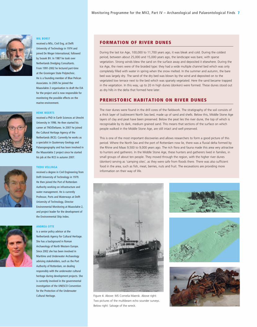
The MS. Cornelia Maersk, build in 1925, sunk
in 1942 in front of the entrance to Rotterdam.
The wreck was situated in the area where
the new wet infrastructure of Maasvlakte 2
was projected. This wreck was not of
archaeological importance, but needed to
be removed (Figure 4).
DROWNED LANDSCAPE: ARCHAEOLOGY AND GEOLOGY IN THE YANGTZE HARBOURIn order to make the new wet infrastructure
of MV2 accessible for ocean-going ships, the
Yangtze Harbour had to be widened,
deepened and dredged through. The bottom
of the Yangtze Harbour was initially dredged
to −17 metres NAP, but in the final
configuration needed to be deepened to
almost −21 m NAP. This deepening and
widening was envisaged to take place at
the end of 2011.
However, based on a 2004 desk study and the
available geological data, it was believed that
the area where the Yangtze Harbour now lies
was inhabited by humans in the Middle Stone
Age (8800 to 4400 BC). The area from the
North Sea to beyond present-day Rotterdam
once formed part of a large river delta that
was rich in food, with aeolian river dunes, river
channels, natural levees and swamps. The river
importance and in particular of shipwrecks or
parts thereof. General practice is that prior to
the start of a dredging work, bathymetric
survey in combination with side scan sonar
and magnetometer are carried out – often at
high speeds (sailed at 20 knots) which in
general is all right for volume assessment and
permit requirements.
In archaeological investigations, however, the
emphasis is different and so is the order of the
surveys. First of all, high definition side scan
At the same time a fair amount of money was
“reserved” by POR in case archaeological finds
did emerge. Thus instead of creating a project
budget, a budget reservation was booked.
From this reservation, money would be spent
only if deemed necessary by the archaeology
task group, with a fixed maximum. Based on a
desktop study into available data of the larger
Maasvlakte area, it was already clear that the
likelihood of finding a drowned landscape
under or next to Maasvlakte 2 was a real
possibility. A special study, followed by an
excavation (if possible) would be initiated to
tackle this special subject.
The archaeological protocols became part of
the tender documents and by doing so they
were treated by the companies bidding for the
works during the tender period as a “risk”
item for which they could make a financial
assessment.
In 2007 POR signed an archaeological
agreement (covenant) with the RCE for
assistance and guidance during construction.
In the covenant the responsibilities and tasks
of RCE and POR were specified as well as the
protocols and the budget reservation.
The archaeological agreement (POR and RCE)
and the protocols are part of the contract
between POR and PUMA, the contractor for
Maasvlakte 2. Implementation protocols state
how archaeological finds must be treated
during construction: Within 24 hours of an
archaeological find, the Contractor must
inform POR and RCE. Then the archaeology
task group, in which now also PUMA was
represented, decides what will be done with it.
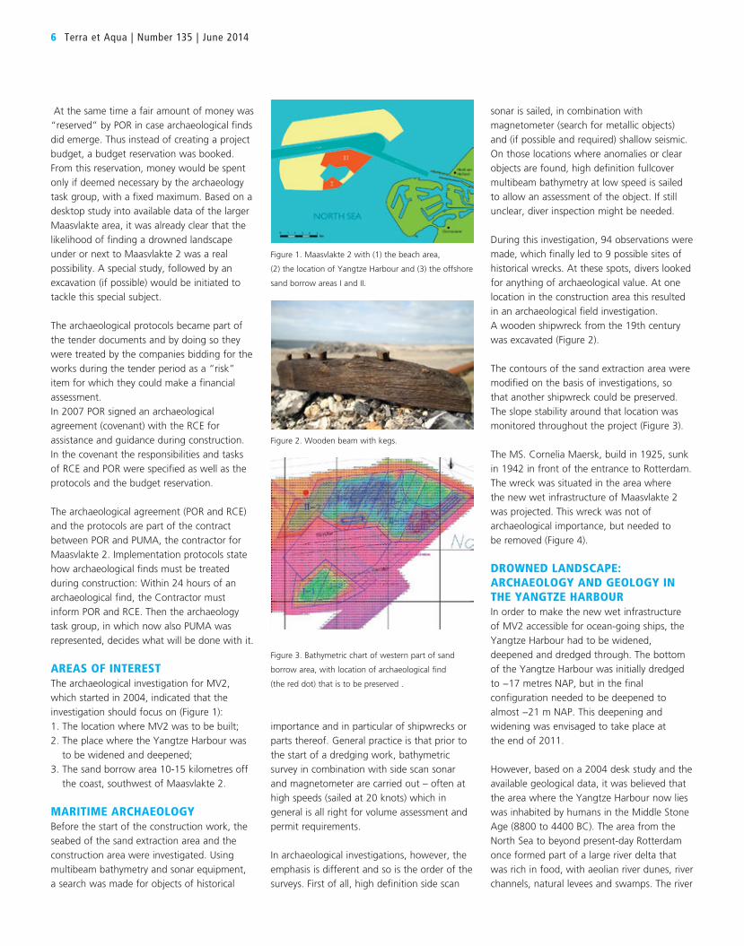
AREAS OF INTERESTThe archaeological investigation for MV2,
which started in 2004, indicated that the
investigation should focus on (Figure 1):
1. The location where MV2 was to be built;
2. The place where the Yangtze Harbour was
to be widened and deepened;
3. The sand borrow area 10-15 kilometres off
the coast, southwest of Maasvlakte 2.
MARITIME ARCHAEOLOGYBefore the start of the construction work, the
seabed of the sand extraction area and the
construction area were investigated. Using
multibeam bathymetry and sonar equipment,
a search was made for objects of historical
Figure 2. Wooden beam with kegs.
Figure 3. Bathymetric chart of western part of sand
borrow area, with location of archaeological find
(the red dot) that is to be preserved .
Figure 1. Maasvlakte 2 with (1) the beach area,
(2) the location of Yangtze Harbour and (3) the offshore
sand borrow areas I and II.
WIL BORST
received a MSc, Civil Eng, at Delft
University of Technology in 1974 and
joined De Weger International, followed
by Svasek BV. In 1987 he took over
Netherlands Dredging Consultants.
From 1991-2002 he lectured part-time
at the Groningen State Polytechnic.
He is a founding member of Blue Pelican
Associates. In 2005 he joined the
Maasvlakte 2 organisation to draft the EIA
for the project and is now responsible for
monitoring the possible effects on the
marine environment.
HENK WEERTS
received a PhD in Earth Sciences at Utrecht
University in 1996. He then started his
career at TNO/Deltares. In 2007 he joined
the Cultural Heritage Agency of the
Netherlands (RCE). Currently he works as
a specialist in Quaternary Geology and
Palaeogeography and has been involved in
the Maasvlakte 2 project since he started
his job at the RCE in autumn 2007.
TIEDO VELLINGA
received a degree in Civil Engineering from
Delft University of Technology in 1979.
He then joined the Port of Rotterdam
Authority working on infrastructure and
water management. He is currently
Professor, Ports and Waterways at Delft
University of Technology, Director
Environmental Monitoring at Maasvlakte 2,
and project leader for the development of
the Environmental Ship Index.
ANDREA OTTE
is a senior policy advisor at the
Netherlands Agency for Cultural Heritage.
She has a background in Roman
Archaeology of North Western Europe.
Since 2002 she has been involved in
Maritime and Underwater Archaeology
advising stakeholders, such as the Port
Authority of Rotterdam, on dealing
responsibly with the underwater cultural
heritage during development projects. She
is currently involved in the governmental
investigation of the UNESCO Convention
for the Protection of the Underwater
Cultural Heritage.
Monitoring Programme for the MV2, Part IV – Archaeological and Palaeontological Finds 7
FORMATION OF RIVER DUNES
During the last Ice Age, 100,000 to 11,700 years ago, it was bleak and cold. During the coldest
period, between about 25,000 and 15,000 years ago, the landscape was bare, with sparse
vegetation. Strong winds blew the sand on the surface away and deposited it elsewhere. During the
Ice Age, the rivers were of the braided type: they had a wide multiple channel bed which was only
completely filled with water in spring when the snow melted. In the summer and autumn, the bare
bed was largely dry. The sand of the dry bed was blown by the wind and deposited on to the
vegetated low terrace next to the bed which was sparsely vegetated. Here the sand became trapped
in the vegetation. In this way, up to 20 m high dunes (donken) were formed. These dunes stood out
as dry hills in the delta that formed here later.
PREHISTORIC HABITATION ON RIVER DUNES
The river dunes were found in the drill cores of the fieldwork. The stratigraphy of the soil consists of
a thick layer of (sub)recent North Sea bed, made up of sand and shells. Below this, Middle Stone Age
layers of clay and peat have been preserved. Below the peat lies the river dune, the top of which is
recognisable by its dark, medium grained sand. This means that sections of the surface on which
people walked in the Middle Stone Age, are still intact and well preserved.
This is one of the most important discoveries and allows researchers to form a good picture of this
period. Where the North Sea and the port of Rotterdam now lie, there was a fluvial delta formed by
the Rhine and Maas 9,500 to 9,000 years ago. The rich flora and fauna made this area very attractive
to hunters and gatherers. In the Middle Stone Age, these hunters and gatherers lived in families, in
small groups of about ten people. They moved through the region, with the higher river dunes
(donken) serving as ‘camping sites’, as they were safe from floods there. There was also sufficient
food in the area, such as fish, meat, berries, nuts and fruit. The excavations are providing more
information on their way of life.
Figure 4. Above: MS Cornelia Maersk. Above right:
Two pictures of the multibeam echo sounder surveys.
Below right: Salvage of the wreck.

8 Terra et Aqua | Number 135 | June 2014
dunes, also referred to as ‘donken’, were high
and dry sandy spots in the wet river delta.
These river dunes were ideal places to spend
night and live for a short time. Here, the
hunters and gatherers once lived high and dry
in temporary encampments. Carefully planned
fieldwork in the Yangtze Harbour revealed the
presence of these sandy dunes located at
levels between −17 and −20 m NAP.
UNIQUE ARCHAEOLOGICAL UNDERWATER RESEARCHSystematic research, desk studies followed by
field surveys, was carried out investigating the
buried former land surface and the possible
traces of hominin occupation. This research
was unique as it was in the Netherlands the
first time that research was done at such a
depth (about – 20m NAP) and so far to the
west of the country. The research was directed
in such a way that the scientists used the
(assumed) knowledge of how these people
would have lived in such an environment in
combination with a staged approach zooming
in on the most promising results of the
previous surveys.
On the basis of existing borings, seismic
measurements and Dutch cone penetration
tests, an area of approximately 120 hectares
was charted. Of the three ‘archaeologically
promising’ zones which emerged from these
initial investigations, two were looked at in
more detail: a buried river dune (donk) and a
silted-up channel, where people in the past
possibly sailed in their canoes. These two areas
were studied more thoroughly by means of
highly detailed seismic research and vibrocore
sampling. On the buried river dune,
archaeological remains were found in three
viborcores. This led to the decision to excavate
three small sections (pits) around the location
of the cores.
RECONSTRUCTION OF STONE AGE FLUVIAL AREAThe last obtained vibro soil corings (2010) and
the samples obtained from them, combined
with all the other field studies and
measurements, provided the scientists with
a detailed picture of the substrate. In the
laboratory, the soil samples are examined
further, for example to work out from pollen
(paleo-botanic study) what plant growth
was like in the past. The biggest surprise
(and reward) was that based on the small
fragments of unburned and burned animal
bone which were found in three samples, it
became immediately clear that humans had
lived in the area.
These finds date from about 7,500- 7,000
Figure 5. Yangtze Harbour in 2008, accessible for
Euromax container ships only.
Figure 9. Burned and unburned animal bones from vibro
cores Yangtze Harbour (proof of human activity).
Figure 6. Left: Layout of Yangtze Harbour, with location
of borings: 2nd stage.
Figure 7. Below left: Geological cross section of Yangtze
Harbour, 3rd stage, showing drowned landscapes
(donks in orange).
Figure 8. Below right: Detailed geotechnical and
geophysical data: seismic lines, borings and Dutch
CPT’s, part of the 3rd stage investigations
Monitoring Programme for the MV2, Part IV – Archaeological and Palaeontological Finds 9
B.C., providing the first scientific proof that
people lived at this spot in the Early-Middle
Stone Age. Up to now, very little was
known about this period so far west in the
Netherlands. The research done here is unique:
the depth, the techniques and the
exceptionally well-preserved remains.
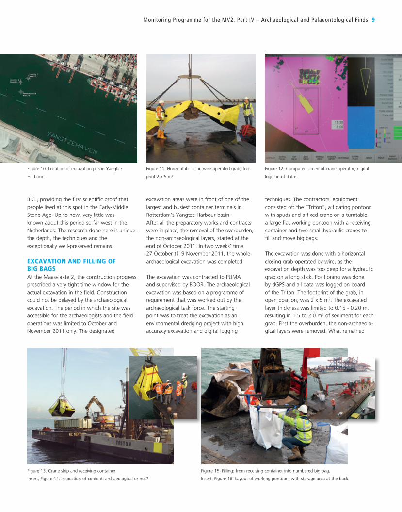
EXCAVATION AND FILLING OF BIG BAGSAt the Maasvlakte 2, the construction progress
prescribed a very tight time window for the
actual excavation in the field. Construction
could not be delayed by the archaeological
excavation. The period in which the site was
accessible for the archaeologists and the field
operations was limited to October and
November 2011 only. The designated
excavation areas were in front of one of the
largest and busiest container terminals in
Rotterdam’s Yangtze Harbour basin.
After all the preparatory works and contracts
were in place, the removal of the overburden,
the non-archaeological layers, started at the
end of October 2011. In two weeks’ time,
27 October till 9 November 2011, the whole
archaeological excavation was completed.
The excavation was contracted to PUMA
and supervised by BOOR. The archaeological
excavation was based on a programme of
requirement that was worked out by the
archaeological task force. The starting
point was to treat the excavation as an
environmental dredging project with high
accuracy excavation and digital logging
techniques. The contractors’ equipment
consisted of: the “Triton”, a floating pontoon
with spuds and a fixed crane on a turntable,
a large flat working pontoon with a receiving
container and two small hydraulic cranes to
fill and move big bags.
The excavation was done with a horizontal
closing grab operated by wire, as the
excavation depth was too deep for a hydraulic
grab on a long stick. Positioning was done
by dGPS and all data was logged on board
of the Triton. The footprint of the grab, in
open position, was 2 x 5 m2. The excavated
layer thickness was limited to 0.15 - 0.20 m,
resulting in 1.5 to 2.0 m3 of sediment for each
grab. First the overburden, the non-archaeolo-
gical layers were removed. What remained
Figure 10. Location of excavation pits in Yangtze
Harbour.
Figure 11. Horizontal closing wire operated grab, foot
print 2 x 5 m2.
Figure 12. Computer screen of crane operator, digital
logging of data.
Figure 13. Crane ship and receiving container.
Insert, Figure 14. Inspection of content: archaeological or not?
Figure 15. Filling: from receiving container into numbered big bag.
Insert, Figure 16. Layout of working pontoon, with storage area at the back.
10 Terra et Aqua | Number 135 | June 2014
was the archaeological layer (sandy topsoil of
the river dune) underneath 0.4 to 0.8 m peat
and fluvial clayish material. This sequence was
excavated in 4 to 5 steps of 0.2 m each.
Because the subrecent marine sand had not
been removed completely, every grab was
checked on the pontoon. Grabs of the
subrecent sand were temporarily stored in a
dump barge lying next to the dredge pontoon.
Grabs with the peat, clay and dune sand were
released in a storage container placed on the
large work pontoon.
The storage container was emptied by a small
hydraulic excavator standing next to the
container. From each grab, the excavator
filled 2 big bags (size 1 m3) being labelled
A and B plus a number. After being filled and
labelled they were placed at the end of the
work pontoon by the other hydraulic crane.
At the end of the day, the bags would be
transported to the quay of the Yangtze
Harbour approximately 1500 m away from the
excavation where they were temporarily stored
on land. To double-check on the progress of
the excavation, a bathymetry in-survey was
carried out by POR’s hydrographic unit at the
start of the excavation. At the end of every
excavation day, an intermediate survey was
carried out with multi-beam equipment. At the
end of each excavation a final out-survey was
done in the same way.
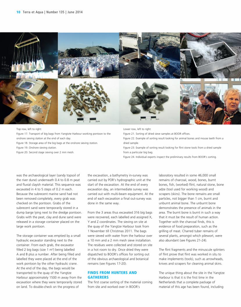
From the 3 areas thus excavated 316 big bags
were recovered, each labelled and assigned X,
Y and Z coordinates. The sieving on site at
the quay of the Yangtze Harbour took from
1 November till Christmas 2011. The bags
were sieved with water from the harbour over
a 10 mm and a 2 mm mesh sieve installation.
The residues were collected and stored on site
in a hot room to dry. Once dried they were
dispatched to BOOR’s offices for sorting out
of the obvious archaeological and botanical
remains (see Figures 17-20).
FINDS FROM HUNTERS AND GATHERERSThe first coarse sorting of the material coming
from site and worked over in BOOR’s
laboratory resulted in some 46,000 small
remains of charcoal, wood, bones, burnt
bones, fish, (worked) flint, natural stone, bone
adze (tool used for working wood) and
scrapers (skins). The bone remains are small
particles, not bigger than 1 cm, burnt and
unburnt animal bone. The unburnt bone
demonstrates the presence of animals in the
area. The burnt bone is burnt in such a way
that it must be the result of human action.
Together with the charcoal finds, this is
evidence of food preparation, such as the
grilling of meat. Charred tuber remains of
several plants, amongst which pilewort, were
also abundant (see Figures 21-24).
The flint fragments and the minuscule splinters
of flint prove that flint was worked in situ to
make implements (tools), such as arrowheads,
knives and scrapers for cleaning animal skins.
The unique thing about the site in the Yangtze
Harbour is that it is the first time in the
Netherlands that a complete package of
material of this age has been found, including
Top row, left to right:
Figure 17. Transport of big bags from Yangtzte Harbour working pontoon to the
onshore sieving station at the end of each day.
Figure 18. Storage area of the big bags at the onshore sieving station.
Figure 19. Onshore sieving station.
Figure 20. Second stage sieving over 2 mm mesh.
Lower row, left to right:
Figure 21. Sorting of dried sieve samples at BOOR offices.
Figure 22. Example of sorting result looking for animal bones and mouse teeth from a
dried sample.
Figure 23. Example of sorting result looking for flint stone tools from a dried sample
from a particular big bag.
Figure 24. Individual experts inspect the preliminary results from BOOR’s sorting.
well-preserved plant and animal remains that
give a good indication of these people’s diet.
Many known sites in the Netherlands exist
where flint of this age and slightly older has
been found, but the organic material (wood,
berries, tubers and so on) was always missing
because it had decayed through time. Here
everything was found together because of the
excellent preservation conditions. This yielded
spectacular new knowledge about how people
at the time lived.
All the sieved material was investigated by
specialists, i.e., on charcoal, paleo-botany,
flint, animal bones (terrestrial and fish) for
in-depth studies. Preliminary (partial) reports
are now available and the final reports (in
English) with all the combined results put in
perspective, will be available mid-2014.
A three-dimensional image of the submerged
landscapes and what life looked like there and
then has been created. The finds and method
have been presented internationally at
scientific conferences both at home and
abroad. The project as a whole has already led
to various scientific publications in the field of
archaeology, underwater archaeology, and
palaeontology and landscape reconstruction.
LESSONS LEARNT SO FAR IN THE YANGTZE HARBOURTreating the archaeological excavation as an
environmental dredging project was the ‘right
choice’ given the local circumstances. All other
techniques that experts proposed were not
feasible in view of the boundary conditions:
limited time available, excavation depth 17-20
m underwater, high turbidity in tidal water (no
visibility for divers), no congestion/delays of
ongoing work allowed, deep drafted container
terminal next door, and more.
Another lesson learnt dealt with the
underwater excavation method. The special
grab that was used had proven itself in
environmental dredging projects. Here, a
heavy grab will sink easily in the ‘soft
contaminated’ sediment layer(s). In this case,
the archaeological layers contained
consolidated very stiff peat that was very
difficult to penetrate or break through.
Having a grab on a wire, compared to one on
a hydraulic stick, means that no extra force for
penetration is available. The grab, being
prevented to sink into the layer at one side,
will no longer excavate horizontally anymore
and make a slight hollow. The small
dimensions of the pits, with the stiff peat
protruding at the sides at some locations
resulted in a slight twist of the grab in the
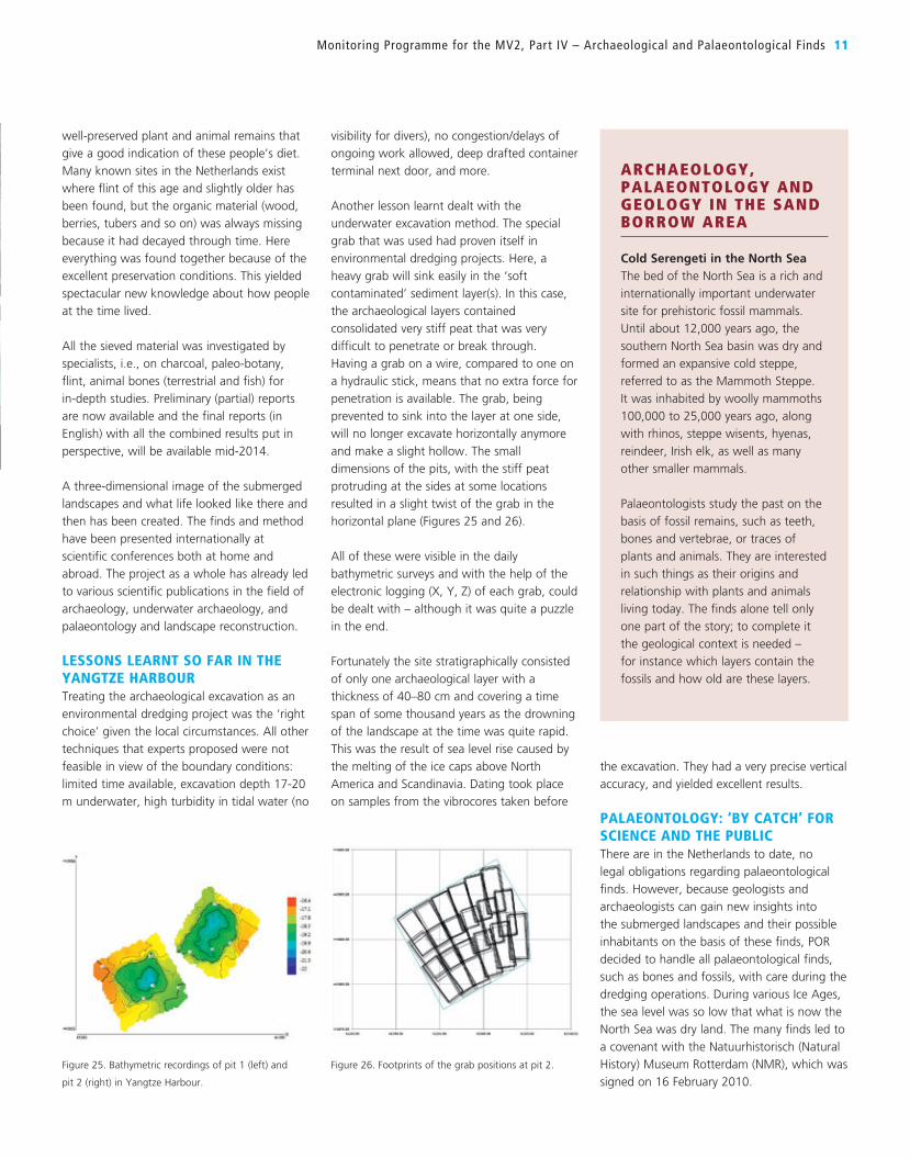
horizontal plane (Figures 25 and 26).
All of these were visible in the daily
bathymetric surveys and with the help of the
electronic logging (X, Y, Z) of each grab, could
be dealt with – although it was quite a puzzle
in the end.
Fortunately the site stratigraphically consisted
of only one archaeological layer with a
thickness of 40–80 cm and covering a time
span of some thousand years as the drowning
of the landscape at the time was quite rapid.
This was the result of sea level rise caused by
the melting of the ice caps above North
America and Scandinavia. Dating took place
on samples from the vibrocores taken before
the excavation. They had a very precise vertical
accuracy, and yielded excellent results.
PALAEONTOLOGY: ‘BY CATCH’ FOR SCIENCE AND THE PUBLICThere are in the Netherlands to date, no
legal obligations regarding palaeontological
finds. However, because geologists and
archaeologists can gain new insights into
the submerged landscapes and their possible
inhabitants on the basis of these finds, POR
decided to handle all palaeontological finds,
such as bones and fossils, with care during the
dredging operations. During various Ice Ages,
the sea level was so low that what is now the
North Sea was dry land. The many finds led to
a covenant with the Natuurhistorisch (Natural
History) Museum Rotterdam (NMR), which was
signed on 16 February 2010.
Monitoring Programme for the MV2, Part IV – Archaeological and Palaeontological Finds 11
Figure 25. Bathymetric recordings of pit 1 (left) and
pit 2 (right) in Yangtze Harbour.
Figure 26. Footprints of the grab positions at pit 2.
ARCHAEOLOGY, PALAEONTOLOGY AND GEOLOGY IN THE SAND BORROW AREA
Cold Serengeti in the North SeaThe bed of the North Sea is a rich and
internationally important underwater
site for prehistoric fossil mammals.
Until about 12,000 years ago, the
southern North Sea basin was dry and
formed an expansive cold steppe,
referred to as the Mammoth Steppe.
It was inhabited by woolly mammoths
100,000 to 25,000 years ago, along
with rhinos, steppe wisents, hyenas,
reindeer, Irish elk, as well as many
other smaller mammals.
Palaeontologists study the past on the
basis of fossil remains, such as teeth,
bones and vertebrae, or traces of
plants and animals. They are interested
in such things as their origins and
relationship with plants and animals
living today. The finds alone tell only
one part of the story; to complete it
the geological context is needed –
for instance which layers contain the
fossils and how old are these layers.

12 Terra et Aqua | Number 135 | June 2014
mammoth fossils and archaeological finds on
six Saturdays at the end of the silt measuring
week. Thanks to the TSHDs, which kept
exposing new and deeper parts of the borrow
area, the fossil finds in particular were
spectacular: over two hundred top-quality
mammal remains, such as teeth, vertebrae and
bones, have now been added to the collection
of the NMR.
Three quarters of the finds are from the woolly
mammoth (Mammuthus primigenius), including the longest mammoth thighbone (as
yet) found in the North Sea, two virtually
complete and exceptionally large pelvic bones
and a tusk (Figures 27 and 28). Other animal
species from the Late Pleistocene fossils which
were dredged up from the sand extraction
area are reindeer, steppe wisent, aurochs, Irish
elk, red deer, woolly rhino, wild horse, cave
lion, harp seal and otter.
head of the TSHD, including palaeontological
finds. As a result, the POR decided, in
consultation with RCE, to organise several
specific fishing trips for palaeontological finds
in the sand extraction area. In the earlier
mentioned protocols such a fishing expedition
was referred to as a “Cerpolex” survey in the
Netherlands and geared at looking for
archaeological and at the same time
palaeontological finds.
In October 2009, the fishing boat OD7 spent
two days in the borrow area trawling for finds.
This trip was so successful that it was decided
to carry out some more trips. For the in-situ
silt (SPM) measurements that were required
for environmental reasons, the POR used a
fishing boat BRA-7 which was at sea for a
week for each campaign. Consequently, in
2010 the BRA-7 was chosen to fish for
The POR ensured that all bones from
mammoths and other fossil mammals found
during the sand extraction on the trailing
suction hopper dredgers (TSHDs) and on the
new reclamation of MV2 go to the NMR.
Thanks to the meticulous records kept by
PUMA, the ‘exact’ sand extraction locations
and depths are known for most of the finds.
Partly as a result of this, the new material is
of great scientific value. The palaeontological
objects are accessible for scientists and the
public; the most beautiful and scientifically
interesting specimens are exhibited in the NMR
as referred to above, but also in the Port’s
FutureLand information centre on Maasvlakte.
Two hundred and more mammal remainsDuring dredging, a number of larger objects
were caught in the ‘bomb grate’ of the drag
Figure 27. In October
2009, a 133 cm long
thigh bone of a woolly
mammoth was dredged
up. This is to date the
largest fossil bone found
in the North Sea in the
Netherlands.
Figure 28. Drawing of a
woolly mammoth with
the tusk, pelvis and thigh
bone indicated in red.
Figure 29. On 18 August 2010, the BRA-7 dredged up
the first fossilised hyena dung ever found in the
Netherlands.
Figure 30. Below and right: A naturally backed knife,
type 3, (cf. Bordes 1961), known as a ‘hand-rug-mes’ in
Dutch, is an artefact made by a human, probably 30 to
50 thousand years ago. No human remains (bones) were
found near it.
Ventral Dorsal
predetermined locations and depths. Again,
this time the north-western slope of the
borrow area would be the target, but with a
more systematical and methodological
approach (Figures 31 and 32).
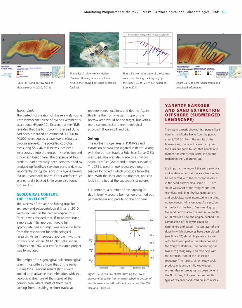
Set-upThe northern slope area in PUMA’s sand
extraction pit was investigated in depth. Along
with the bottom trawl, a Side Scan Sonar (SSS)
was used. Use was also made of a shallow
seismic profiler (xStar) and a Boomer (sparker).
The SSS is used to look sideways along the
seabed for objects which protrude from the
bed. With the xStar and the Boomer, one can
look in the bed at the substrate’s structure.
Furthermore, a number of overlapping (in
depth level) vibrocore borings were carried out
perpendicular and parallel to the northern
Special findsThe perfect fossilisation of this relatively young
(Late Pleistocene) piece of hyena excrement is
exceptional (Figure 29). Research at the NMR
revealed that the light brown fossilised dung
had been produced an estimated 30,000 to
40,000 years ago by a cave hyena (Crocuta crocuta spelaea). The so-called coprolite,
measuring 55 x 44 millimetres, has been
incorporated into the museum’s collection and
is now exhibited there. The presence of this
predator had previously been demonstrated by
dredged-up fossilised skeleton parts and, most
importantly, by typical signs of a hyena having
fed on (mammoth) bones. Other artefacts such
as a naturally backed knife were also found
(Figure 30).
GEOLOGICAL CONTEXT, THE “ENVELOPE” The success of the ad-hoc fishing trips for
archaeo- and palaeontological finds of 2010
were discussed in the archaeological task
force. It was decided that, if to be continued,
a more scientific approach would be
appropriate and a budget was made available
from the reservation for archaeological
research. As an integrated approach with the
University of Leiden, NMR, Naturalis Leiden,
Deltares and TNO, a scientific research project
was formulated.
The design of this geological-palaeontological
search thus differed from that of the earlier
fishing trips. Previous results (finds) were
looked at in advance in combination with the
geological structure of the slopes of the
borrow area where most of them were
coming from, resulting in short tracks at
Monitoring Programme for the MV2, Part IV – Archaeological and Palaeontological Finds 13
YANGTZE HARBOUR AND SAND EXTRACTION OFFSHORE (SUBMERGED LANDSCAPE)
The results already showed that people lived
here in the Middle Stone Age, the period
after 9,700 BC. From the results of the
borrow area, it is now known, partly from
the flints and tools found, that people also
roamed the cold steppe (what is now the
seabed) in the Old Stone Age.
It is important to know if the archaeological
and landscape finds at the Yangtze site can
be connected with the landscape research
in the sand borrow area, some 10-15 km
south-westward of the Yangtze site. The
scientists, including physical geographers
and geologists, were interested in the piling
up (sequences) of landscapes. As a section
of the bed of the North Sea was dug up in
the sand borrow area to a maximum depth
of 20 metres below the original seabed, the
composition of the layers could be
determined and dated. The top layer of the
slope in which vibrocores have been placed
(see Figure 35) should hopefully coincide
with the lowest part of the vibrocore set in
the Yangtze Harbour, thus connecting the
two sites geologically. This may help with
the reconstruction of the landscape
sequence. The reconstruction study could
produce unique scientific knowledge:
A great deal of dredging has been done in
the North Sea, but never before was this
type of research conducted on such a scale.
Figure 32. Shallow seismic device
‘Boomer’ floating on surface towed
next to the fishing boat while searching
for finds.
Figure 33. Northern slope of the borrow
area, short fishing tracks going up
the slope (-40 to -20 m CD) sailed on
6 June 2011.
Figure 34. Side Scan Sonar tracks and
associated information.
Figure 35. Theoretical sketch showing the row of
vibrocore set earlier from original seabed to bottom of
sand borrow area with sufficient overlap and the SSS
(see also Figure 34).
Figure 31. Sand borrow area of
Maasvlakte 2 (in 2010/ 2011).

slope (Figures 33, 34 and 35). Using these
data, the geological structure and stratigraphy
of the pit was mapped in detail. With the aid
of samples from the borings, the age of the
various differentiated layers will be
ascertained. Dating results of the samples by
Optically Stimulated Luminescence (OSL) are
expected to become available later in 2014.
The OSL method allows sand grains to be
dated. In this way all palaeontological finds
from the fishing trips can be placed in their
geological and temporal context. The beds
have been “dated” indirectly by looking at
their heavy mineral composition. From this,
a maximum age of 250,000 years is expected
for the deepest bed.
During the fishing trips, the catches from
the two bottom trawl nets were looked at
separately, systematically and sorted into,
among other things, bone material, flint,
stone, gravel, fossil shells and wood. Also,
a general characterisation was given of, for
example, the presence of lumps of clay,
chunks of peat, residues of wood and the
quantity of serpent stars and starfish. The
data gathered also allowed a more statistical
evaluation of the find in relation to their
geological context.
DATING SAND LAYERSUnder the guidance of TNO | Geological
Survey of the Netherlands, the age of the
samples from the layers from the vibrocores
is determined via Optically Stimulated
Luminescence (OSL) dating and the sediments
are carefully analysed. OSL is a relatively new
dating technique. Some minerals emit a small
light signal when they are heated or a light is
shone on them. This light, or luminescence,
can be used to date sediments, pot fragments
and a number of other artefacts.
Luminescence dating has a longer measuring
range (250,000 years) than the commonly
used 14C or carbon dating method (approx.
50,000 years). The OSL dating takes a long(er)
time to carry out, i.e., from 9 to 12 months
and is not yet a common exercise. The results
at MV2 will become available later in 2014.
14 Terra et Aqua | Number 135 | June 2014
Figure 36. Outer contour of the
sandy beach of Maasvlakte 2.
Figure 38. Amateurs and professional
palaeontologists looking for finds at the beach
(January 2010).
Figure 37. Beach cleaning machine, used as
mechanical aid in combination with hand
picking.
Figure 39. Results of the beach cleaning
operation, each big bag represents
approx. 400 m2 of beach area.
Left, Figure 40. Visitors (children
and parents) helping the researcher
at Naturalis as part of a pubic
friendly event.
Right, Figure 41. The ‘professionals
and amateurs’ at work at Naturalis.
PUZZLE: WALKING WHALE OR SWIMMING MAMMOTH?
Palaeontological research on the whale
and mammoth bones dredged up
using the popular 14C dating method
produced a striking result: both
heavyweights apparently lived in the
same place between about 32,000
and 38,000 years ago.
Shells were also dated to about the
same period. But did the whales walk
on the steppe then or, did the
mammoths swim in the sea?
It seems that the method for 14C-dating shell and bone material of
this age and older found underwater
has some problems. It looks like the
shells and bones are contaminated by
fresh carbon material that is added to
the shells and bones through the
recrystallisation of calcium carbonate
from the groundwater by bacteria
which live in this porous material.
As a result of this ‘contamination’ with
young carbon, the 14C method seems
to yield an age of 32,000 to 38,000
years for all shells and bones of this
age and much older. By comparing the
OSL dates with the 14C ‘age’ of the
fossils from the sand, new light will be
shed on this problem later in 2014.

ARCHAEOLOGY AND PALAEONTOLOGY ON THE OUTER SANDY CONTOUR OF MV2Simply speaking: the sand taken from the
offshore borrow area is put “up-side” down
on the Maasvlakte 2 seabed by dumping,
rainbowing and pumping ashore. So all the
remains of previous life gathered with the
paleo-fishing trips can be found in the sand
on the surface of Maasvlakte 2 as well.
The newly created beach protection (the outer
contour with sand dunes) of Maasvlakte 2 was
searched three times by a group of
palaeontologists, geologists and archaeologists
before it was opened to the public. PUMA
willingly assisted in providing search areas with
exact X, Y and Z coordinates. Through PUMA’s
meticulously held logs of the dredging
locations, these areas could be linked to the
area of origin in the borrow area (Figure 36).
The beach was worked over systematically,
and archaeological and palaeontological finds
and stones and gravel were safeguarded in
two ways: mechanically and hand-picked.
As a result of time constraints and the fact
that the accessibility of an active working site
is difficult, it was investigated if other
“gathering” techniques could be employed.
An often-heard shortcoming of the fishing trip
with a trawling net was that small animal
remains were hardly found. The idea was to
use a conventional beach cleaning machine
that would be compared with hand picking.
The beach cleaner used was 2 m wide, depth
of the knife-conveyor belt variable (up till 15
cm) and a sieve mesh # of 20 mm. The test
was done twice: once in February 2010 and
once in June 2010. In total 16 Big Bag (~1 m3
volume) were filled by the beach cleaner,
covering an area of approx. 16,000 m2.
One bag from each of the predetermined
and stacked out areas on the beach was
sorted out at the natural museum Naturalis
in Leiden (Figures 37, 38 and 39).
The sorting out was a huge job. The natural
museum organised a public friendly weekend
in September 2010 during which youngsters
under supervision of the researchers
participated next to professionals and amateur
palaeontologists and geologists (Figures 40
and 41)
Next to bones also the fossil shells, gravel and
other specific geological features were sorted
out. This was done to see if correlations could
be made related to the geological layers in the
borrow area and whether or not a statistical
analysis was feasible on the finds and these
associated constituent parts.
Many remains of animals from the mammoth
group from the Pleistocene and archaeological
artefacts from the Late Pleistocene and
Holocene have been found. Finds include teeth
from a white shark, a beaver and a rhinoceros.
A lot of unique fossil shells were also found,
and a large number of fossil marine animals
and flints. Some remains proved to be
between 50,000 and a million years old. The
white shark tooth must definitely be a couple
of million years old. The shark did not live
here; the tooth has been transported here by
the palaeo-Scheldt river that cut through
Tertiary deposits in Belgium that are famous
for these shark teeth.
The shells could help with the reconstruction
of the landscape. Furthermore, the shells and
shark teeth provide indications of the origin,
i.e., brought in from the north or south by ice
sheets or rivers. Researchers are now busy
investigating how old the shells are.
A HUMAN FIND AFTER ALL After the beach was opened to the public
many enthusiastic amateurs began searching
daily for fossils and archaeological stuff.
On 19 March 2013, one man, Walter
Langendoen, who already had found some
30 hyeana coprolites, was lucky and found
two small pieces of bones that later on proved
to be human. With the permission of the
finder POR had the pieces investigated by
experts and after 14C-dating they proved to be
~7,600 BC, the same age as the site of the
Yangtze Harbour dune. Mr. Langendoen also
found two spear points made of bone most
probably from the “same” humans. 14C-dating
for those finds is still in progress.
Monitoring Programme for the Mv2, Part IV – Archaeological and Palaeontological Finds 15
Figure 42. Part of a human skull, 9600 years old, found
at MV2. This piece links the three scientific programmes:
geotechnical and palaeontological work at the borrow
area and on the sandy beach and the Yangtze Harbour
archaeology.
Figure 43. The track of TSHD Volvox Maxima on 23 June 2010 (X,Y plot).
Figure 44. Box plot showing the draghead depth along the track of Figure 43, in percentiles.
Figure 45. Track plotted in the borrow area.
16 Terra et Aqua | Number 135 | June 2014
TNO/Deltares surveys into the composition of
the geological layers in the borrow area. The
track is plotted in the borrow area in Figure
45. The earlier mentioned web application is
based on the same procedure and principle.
The geological envelope “reconstructed”POR has access to the “book keeping” of
PUMA during the construction of Maasvlakte
2. In order to comply with the dredging permit
regulations, the position of each dredger is
continuously logged, as well as the status
signals of the complete dredging cycle over
the whole day. Furthermore each load brought
to shore is guided and registered to a specific
placement location that is also logged.
Using these data in a reversed mode it is
possible, in principle, if the exact coordinates
of a find on MV2 are known, to ‘look-up’
which dredger was the last one that delivered
a load of sand at that particular area. Once
the name of the dredger and the data and
time of delivery are known the path in the
borrow area can be reconstructed.
Of course it is unknown where exactly the
bones have been picked up by the dredger,
but the wishkerplot gives a fair indication of
the average depth along the track and the
variations (percentiles) around it. The most
probable layer(s) where the bone fragments
could come from fall within the 14C date.
A web-based application (App) has been
developed on the basis of the above
procedure. Any enthusiastic amateur can
report archaeological and palaeontological
finds on the beach through this App. This will
yield a unique database of finds with exact X,
Y and Z coordinates, which will help scientists
to analyse the gathered information. In return,
the amateurs get back a possible date of how
old their find is and what type of find it is.
This approach has let to the development
of a web-based checker for finds on the
outer perimeter of MV2: see website
www.oervondstchecker.nl. This application
which works on a smartphone, laptop or PC,
was launched on the 25 January 2014.
For the skull fragments found on the outer
perimeter this yield the following:
Coordinates: N 51 57’45.761” &
E 003 57’38.698”. The placement area that
contains those coordinates lists the TSHD
Volvox Maxima as last dredger bringing sand
on 23 June 2010. Based on this information
the track of the Volvox Maxima can be
reconstructed from the black box data and
is shown in Figure 43.
The depth percentiles are shown in Figure 44,
with a median depth of 27.5 m NAP (CD) lying
in deposits of the Early Holocene. The depth
information from the box plot is matched with
the geological information obtained by the
REFERENCES
van Ginkel, Evert; Reumer, Jelle and van der Valk, Bert (2014). Schatten van het Mammoetstrand. Over speuren in grondlagen, opgraven onder water en vissen naar fossielen. Van mammoet tot mensenschedel, van hyenakeutel tot woelmuis. (in Dutch only), Havenbedrijf Rotterdam.
Hijma et al. (2011). “Pleitoceine Rhine-Thames landscapes: geological background for hominin occupation of the southern North Sea region”. Journal of Quartenary Science.
de Kleine, Marco; Vos, Peter C.; Smit, Bjorn; Weerts, Henk; Schiltmans; Borst, Wil and Waldus, Wouter. (2012) “Mapping the archeological potential of the Rotterdam Harbor area, The Netherlands, using marine geophysics in a multidisciplinary and multi stakeholder study.” 25th Symposium on the Application of Geophysics to Engineering & Environmental Problems, Session: Archaeological and Forensics Applications of Near-Surface Geophysics.
Kuitems, Margot and van Kolfschoten, Thijs (editors). (2014). Geo-archeological investigations sand borrow area and outer perimeter Maasvlakte 2. In preparation, June 2014. With contributions from : F.Busschers, D. De Loecker, W. Westerhoff; S. van Heteren,
A. Wiersma, C. Mesdag, N. den Ouden, F. Wesselingh; A. Janse, F. Dieleman, O. van Tongeren
Moree, J.M. and Sier, M.M. (editors). (2014). Twenty meters deep! Mesolithic habitation in Yangtze Harbour-Maasvlakte Rotterdam. Landscape development and habitation in Early Holoceen. In preparation, June 2014.
Otte, Andrea et al. (2013). “Construction of the Maasvlakte 2 harbor and drowned prehistoric landscapes and archaeology: lessons learned”. SPLASHCOS Szczecin, Poland, September 25 2013. http://www.splashcos.org/sites/splashcos.org/files/Abstracts_2013-13-09edited.pdf
Web-based paleo/archeo checker for finds from the outer perimeter of Maasvlakte 2: www.oervondstchecker.nl
Weerts, Henk J. T. (2011). “Maasvlakte 2 (Port of Rotterdam), a showcase of interdisciplinary research of drowned landscapes, Quaternary International, vol. 279-280, p. 530. http://www.inqua2011.ch/?a=programme&subnavi=abstract&id=2819&sessionid=50
Weerts, Henk; Otte, Andrea; Smit, Bjørn; Vos, Peter; Schiltmans, Dimitri; Waldus, Wouter and Borst,Wil (2012). “Finding the Needle in the Haystack by Using Knowledge of Mesolithic Human Adaptation in a Drowning Delta”, in: Landscape Archaeology. Conference (LAC 2012), eTopoi. Journal for Ancient Studies, Special Volume 3 (2012), 17-24. http://www.topoi.org/publication/20117/
CONCLUSIONS
By identifying the archaeology as a normal
project “risk” at a very early stage of the
project, it could be successfully integrated
into the Maasvlakte 2 construction project.
Because of the joint efforts of the
contractor PUMA, the archaeological task
force and the (geo)archaeological and
palaeontological specialist, all the desired
research could be carried without
interfering with the harbour construction.
It did not delay the works at any moment.
The interdisciplinary approach sought after
by the POR and RCE in which many
scientist of different fields and disciplines
(geology, archaeology, palaeontology,
paleobotany, malacology, and so on) had
to work together, provided very promising
results. The reports of the research
described above are in their final stages
and will be available mid 2014 (in English,
Moree and Sier).
With the human bone found on the outer
contour, mid-2013 and dated ~7000 B.C.,
the link between the three different
projects described in this article, was
closed. The humans that lived at the
Yangtze Harbour 9000 years ago could be
linked to the borrow area, as the remains
of a human from that period was found
on the Maasvlakte 2 brought there by the
TSHD bringing sand from the borrow area.
On 25 January 2014 a public friendly book
on the archaeology, drowned landscapes
and palaeontological findings related to
the construction of the Maasvlakte 2 was
released by POR in their information
Centre Futureland as part of the archaeo-
palaeontological exhibition showing the
finds from Maasvlakte 2. POR and RCE, in
collaboration with the participating parties,
will organise an International Symposium
in 2015 to present the final results of the
Yangtze Harbour excavation and the
findings of the projects.
ABSTRACT
The US Army Corps of Engineers’ “Engineering
With Nature” (EWN) initiative supports
sustainable development of infrastructure
by advancing technical and communication
practices in order to intentionally align natural and engineering processes to efficiently and sustainably deliver economic, environmental, and social benefits through collaborative processes. The tools and projects that have
been developed through EWN support
planning, engineering, and operational
practices that beneficially integrate
engineering and natural systems to produce
more socially acceptable, economically viable,
and environmentally sustainable projects.
The EWN initiative’s focus on developing
practical methods provides an achievable path
toward an ecosystem approach to navigation
infrastructure development. By combining
sound science and engineering with advanced
communication practices, the EWN initiative is
providing a robust foundation for collaborative
project development. Engineering With Nature
is being pursued through innovative research,
field demonstrations, communicating lessons
learned, and active engagement with field
practitioners across a wide range of
organisations. The objectives of EWN are
consistent with those communicated in the
“Working with Nature” philosophy of the
World Association for Waterborne Transport
Infrastructure (PIANC) and the “Building with
Nature” initiative of EcoShape Foundation,
a public-private knowledge institute in the
Netherlands.
INTRODUCTION
Pursuing the objective of sustainable
development of navigation infrastructure poses
both challenges and opportunities for the US
Army Corps of Engineers (USACE). Advancing
best practices will involve identifying the
practical actions that can be taken to better
align and integrate engineering and natural
systems to produce more socially acceptable,
economically viable and environmentally
sustainable projects. Engineering With Nature
(EWN) is a USACE initiative that supports more
sustainable practices, projects, and outcomes
by working to intentionally align natural and engineering processes to efficiently and sustainably deliver economic, environmental and social benefits through collaborative
processes (www.engineeringwithnature.org;
Figure 1). The EWN initiative’s focus on
developing practical methods provides an
achievable path toward an ecosystem approach
to navigation infrastructure development and
operations that is applicable across multiple
USACE missions and business lines.
Science, engineering and demonstration
projects within the EWN initiative illustrate the
use of:
1) science and engineering to produce
operational efficiencies supporting
sustainable delivery of project benefits;
2) natural processes to maximum benefit,
thereby reducing demands on limited
resources, minimising the environmental
footprint of projects, and enhancing the
quality of project benefits;
3) approaches that will broaden and extend
the base of benefits provided by projects to
include substantiated economic, social, and
environmental benefits;
4) science-based collaborative processes to
organise and focus interests, stakeholders,
and partners to reduce social friction,
resistance, and project delays while
producing more broadly acceptable projects.
The objectives of EWN are consistent with
those communicated in the Working with
Nature (WwN) philosophy of the World
“ENGINEERING WITH NATURE” PROMOTES TRIPLE-WIN OUTCOMES
T.S. BRIDGES, J. LILLYCROP, J.R. WILSON, T.J. FREDETTE, B. SUEDEL, C.J. BANKS AND E.J. RUSSO
Above: Aerial photo of the wetlands at the Mississippi
River Gulf Outlet taken in November 2013 as part of
the Beneficial Use of Dredged Material Monitoring
Programme.
“Engineering with Nature” Promotes Triple-Win Outcomes 17

TODD S. BRIDGES
is the US Army’s Senior Research Scientist
for Environmental Science and serves as the
Programme Manager for the Dredging
Operations Environmental Research (DOER)
programme, Director of the Center for
Contaminated Sediments, and the USACE
lead for ‘Engineering With Nature’. He
received his Bachelor’s and Master’s
degrees in Biology/Zoology from California
State University, Fresno and his PhD in
Biological Oceanography at North Carolina
State University.
JEFF LILLYCROP
is Technical Director for Civil Works
at the US Army Engineer Research and
Development (R&D) Center.
He is responsible for integration of
Environmental, Flood Risk Management
and Navigation Research and Development
and is Chair of the Committee on the
Marine Transportation System Integrated
Action Team for R&D. He received his BSc
and MSc in Coastal Engineering in 1981
and 1983, respectively, from the University
of Florida.
JOSEPH WILSON
is a technical specialist developing policy and
guidance for environmental aspects of the
Corps’ National Dredging Programme. Prior
to joining the USACE in 1977, he performed
research in deep-sea oceanography at the
University of North Carolina Marine Bio-
Medical Research Center. He serves as
headquarters programme monitor for the
Aquatic Nuisance Research, DOER, Dredging
Operations Technical Support (DOTS) and
Water Operations Technical Support
programmes.
THOMAS FREDETTE
earned his BSc in Marine Biology from
Southeastern Massachusetts University
(now UMass-North Dartmouth) in 1977, and
a MSc and PhD in Marine Science from The
College of William and Mary in 1980 and
1983, respectively. In 1986, he joined the
USACE as Programme Manager for DAMOS
(Disposal Area Monitoring System). Since
2009 he is a Research Biologist for the US
Army Engineer R&D Center. He has
represented the US at the London
Convention Scientific Group since 2001.
Association for Waterborne Transport
Infrastructure (PIANC 2011; http://pianc.org/
workingwithnature.php ) and the goals of
EcoShape’s Building with Nature
(BwN) programme in the Netherlands
(http://www.ecoshape.nl/).
The WwN philosophy seeks win-win solutions
for navigation development projects by
promoting project development that proceeds
in the following way:
1) establishing project need and objectives;
2) understanding the environment;
3) making meaningful use of stakeholder
engagement that identifies win-win options;
and
4) preparing project proposals/designs to
benefit navigation and nature.
PIANC has undertaken a number of WwN
activities to promote the philosophy, including
development of a WwN project certification
process and awards programme, engaging
social media, and a photography competition
in order to ensure a robust collection of WwN
images for presentations, website content, and
so on.
In parallel, the BwN approach advocates a
different way of thinking, acting and
interacting. Building with Nature strives to:
1) gather and develop ecosystem knowledge
enabling water-related building with nature;
2) develop scientifically based and location-
specific design rules and environmental
norms;
3) develop expertise in applying the BwN
concept;
4) demonstrate that BwN solutions work, with
practical examples; and
5) determine ways to ensure that the BwN
concept is adopted by society.
Project examples are collected in the
web-based BwN Design Guideline
(www.ecoshape.nl/en_GB/wiki-guideline.html).
Engineering With Nature within the USACE is
being pursued through innovative research,
field demonstrations, communicating lessons
learnt, and active engagement with field
practitioners and USACE partners and
stakeholders. The capabilities and practices
being developed through the EWN initiative
provide direct support to the USACE Civil
Works Strategic Plan (Sustainable Solutions to
America’s Water Resources Needs: Civil Works
Strategic Plan 2011 – 2015), the USACE
Campaign Plan (e.g., Objectives 1c, 2c, 2d, 4b)
(USACE 2011), as well as the recently
“reinvigorated” USACE Environmental
Operating Principles (USACE 2012).
Developing sustainable and resilient
infrastructure systems for military installations
and Civil Works will require USACE to evolve
its approaches to planning, engineering and
operating infrastructure. Advancing these
practices will involve identifying the practical
actions that can be taken to better align and
integrate engineering and natural systems to
produce more socially acceptable,
economically viable, and environmentally
sustainable projects.
EWN IN PRACTICEThe EWN initiative is developing and
demonstrating, through multiple projects,
the capabilities that are needed to achieve
sustainable, triple-win project outcomes.
The following project summaries are provided
to illustrate the range of supporting projects
that are completed or underway.
Sustainable Sediment Management through Strategic Placement and Innovative Beneficial Use PracticesSediment management is a costly and
challenging endeavour. Designated placement
sites are limited in space and environmental
restrictions limit where sediment can be placed
and how it can be used. The EWN initiative, in
collaboration with the Regional Sediment
18 Terra et Aqua | Number 135 | June 2014
Figure 1. The EWN approach provides overlapping
benefits resulting in more sustainable projects.
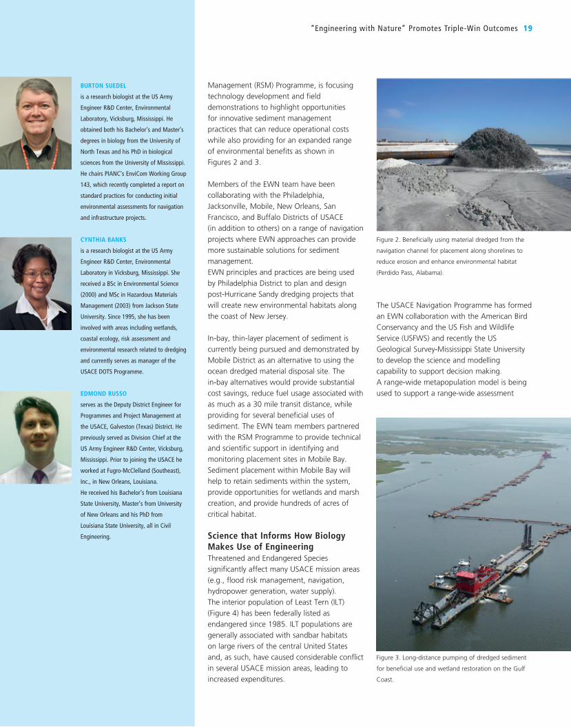
BURTON SUEDEL
is a research biologist at the US Army
Engineer R&D Center, Environmental
Laboratory, Vicksburg, Mississippi. He
obtained both his Bachelor’s and Master’s
degrees in biology from the University of
North Texas and his PhD in biological
sciences from the University of Mississippi.
He chairs PIANC’s EnviCom Working Group
143, which recently completed a report on
standard practices for conducting initial
environmental assessments for navigation
and infrastructure projects.
CYNTHIA BANKS
is a research biologist at the US Army
Engineer R&D Center, Environmental
Laboratory in Vicksburg, Mississippi. She
received a BSc in Environmental Science
(2000) and MSc in Hazardous Materials
Management (2003) from Jackson State
University. Since 1995, she has been
involved with areas including wetlands,
coastal ecology, risk assessment and
environmental research related to dredging
and currently serves as manager of the
USACE DOTS Programme.
EDMOND RUSSO
serves as the Deputy District Engineer for
Programmes and Project Management at
the USACE, Galveston (Texas) District. He
previously served as Division Chief at the
US Army Engineer R&D Center, Vicksburg,
Mississippi. Prior to joining the USACE he
worked at Fugro-McClelland (Southeast),
Inc., in New Orleans, Louisiana.
He received his Bachelor’s from Louisiana
State University, Master’s from University
of New Orleans and his PhD from
Louisiana State University, all in Civil
Engineering.
“Engineering with Nature” Promotes Triple-Win Outcomes 19
The USACE Navigation Programme has formed
an EWN collaboration with the American Bird
Conservancy and the US Fish and Wildlife
Service (USFWS) and recently the US
Geological Survey-Mississippi State University
to develop the science and modelling
capability to support decision making.
A range-wide metapopulation model is being
used to support a range-wide assessment
Management (RSM) Programme, is focusing
technology development and field
demonstrations to highlight opportunities
for innovative sediment management
practices that can reduce operational costs
while also providing for an expanded range
of environmental benefits as shown in
Figures 2 and 3.
Members of the EWN team have been
collaborating with the Philadelphia,
Jacksonville, Mobile, New Orleans, San
Francisco, and Buffalo Districts of USACE
(in addition to others) on a range of navigation
projects where EWN approaches can provide
more sustainable solutions for sediment
management.
EWN principles and practices are being used
by Philadelphia District to plan and design
post-Hurricane Sandy dredging projects that
will create new environmental habitats along
the coast of New Jersey.
In-bay, thin-layer placement of sediment is
currently being pursued and demonstrated by
Mobile District as an alternative to using the
ocean dredged material disposal site. The
in-bay alternatives would provide substantial
cost savings, reduce fuel usage associated with
as much as a 30 mile transit distance, while
providing for several beneficial uses of
sediment. The EWN team members partnered
with the RSM Programme to provide technical
and scientific support in identifying and
monitoring placement sites in Mobile Bay.
Sediment placement within Mobile Bay will
help to retain sediments within the system,
provide opportunities for wetlands and marsh
creation, and provide hundreds of acres of
critical habitat.
Science that Informs How Biology Makes Use of EngineeringThreatened and Endangered Species
significantly affect many USACE mission areas
(e.g., flood risk management, navigation,
hydropower generation, water supply).
The interior population of Least Tern (ILT)
(Figure 4) has been federally listed as
endangered since 1985. ILT populations are
generally associated with sandbar habitats
on large rivers of the central United States
and, as such, have caused considerable conflict
in several USACE mission areas, leading to
increased expenditures.
Figure 2. Beneficially using material dredged from the
navigation channel for placement along shorelines to
reduce erosion and enhance environmental habitat
(Perdido Pass, Alabama).
Figure 3. Long-distance pumping of dredged sediment
for beneficial use and wetland restoration on the Gulf
Coast.

multiple benefits associated with built
navigation infrastructure. Construction of an
innovative environmental breakwater for
Cleveland Harbor to support the Great Lakes
Restoration Initiative was recently awarded a
PIANC WwN Certificate of Recognition. The
Cleveland Harbor project will be recognised at
the 33rd PIANC World Congress in San
Francisco in June 2014.
Sustainable Management of Contaminated Sediment In 2009, ERDC team members collaborated
with the US Navy and the private sector in
developing and publishing a US Department of
Defense (DoD) technical guide on the use of
Monitored Natural Recovery for contaminated
sediment sites (www.serdp.org/Program-Areas/
Environmental-Restoration/Contaminated-
Sediments/ER-200622).
Development of the guidance was sponsored
by DoD’s Environmental Security Technology
Certification Programme to support clean-up
activities within the Department. The US Navy
estimates that its sediment cleanup liabilities
include $1 billion in future remediation costs.
The guidance document provides a science
and engineering framework for utilising
naturally occurring physical, chemical and
biological processes to accomplish risk
reduction at contaminated sediment sites.
The guidance illustrates opportunities for
applying EWN for sediment cleanup at
substantially lower costs – both in economic
and environmental terms – compared to
conventional methods that predominantly rely
upon sediment removal.
GIS Database of Projects Demonstrating EWN PracticesThe Engineering With Nature Project Mapping
Tool (EWN ProMap) is a geography-based data
viewer for communicating information about
projects that illustrate EWN opportunities.
The EWN ProMap can be accessed at
http://155.82.160.6/applications/opj/V013/
public/viewer.swf.
The EWN ProMap, shown in Figure 6, provides
project information on water resources
projects that illustrate key attributes of the
EWN approach:
1) Science and engineering are used to
produce operational efficiencies;
structures such as breakwaters in the Great
Lakes region. An ERDC-led project sponsored
by the Great Lakes Restoration Initiative is
being used to demonstrate opportunities to
expand the range of benefits that can be
provided by infrastructure projects. As shown
in Figure 5, during routine maintenance of
breakwaters in Cleveland Harbor in 2012 and
2013, design modifications were made to the
submerged toe blocks of the structure to
provide features that will create habitat
opportunities for Great Lakes fish and
invertebrates.
Existing breakwaters constructed in the Great
Lakes provide limited habitat for fish and
invertebrates, mostly in the form of small
refuge spaces between concrete or rock
sections, while the rest of the structure is
relatively inhospitable for most organisms
owing to the featureless nature of the blocks.
The Cleveland Harbor Green Breakwaters
Project is examining the opportunities to
create substantially more habitat surface on
the breakwater by modifying the shape and
surface texture of the constructed blocks using
textured liners or modified walls in the
concrete block forms.
Initial field observations indicated that grooved
and dimpled block surfaces had more early
colonisers than the unmodified blocks. In order
to evaluate the approach more broadly,
Ashtabula Harbor, which is along the southern
shore of Lake Erie at the mouth of the
Ashtabula River, has been identified as a
second project site. The Ashtabula project will
incorporate tern nesting blocks on top of the
breakwater.
The long-term implication from these projects
is that with consistent application of these
simple modifications during structural repairs,
there is tremendous potential to increase
(www.leasttern.org). In addition to providing
the scientific, ecological basis for evaluating
cost-efficient project designs and management
scenarios, the model will be used to provide
evidence for delisting ITL from the endangered
species list. Delisting of the ILT, through
collaborative data gathering, modelling, and
conservation planning, supported by research
and development investments, is expected to
dramatically reduce USACE project costs.
In addition, a US Army Engineer Research and
Development Center (ERDC) led project
sponsored by Department of Defense (DoD)
Strategic Environmental Research and
Development Programme has developed an
approach for evaluating alternative
management scenarios to address
environmental effects on Threatened and
Endangered coastal birds that will be caused
by sea-level rise at military installations.
The project integrated climate, land use and
ecosystem information into a tool set that
assesses vulnerabilities related to Threatened
and Endangered bird species at Eglin
Air Force Base.
The presence of these coastal birds currently
poses restrictions on land used for training.
The project team developed a series of
modelling and assessment tools to evaluate
alternative, long-term investment strategies
that would minimise the compounding
influence of sea-level rise and bird habitat
effects on installation land use and training.
The final project report can be found at
www.serdp.org/content/download/18101/
201737/file/RC-1699-FR.pdf.
Building Habitat into Navigation InfrastructureThe USACE has over 100 miles of navigation
20 Terra et Aqua | Number 135 | June 2014
Figure 4. Interior Least Tern has been federally listed as
endangered since 1985.
Figure 5. Habitat-enhanced toe block installation during
breakwater repair operations.

These structures are sustainable in that they
create and/or improve habitat for fish, macro-
invertebrates and other species in the river. In
addition, the structures utilise the river’s
energy to maintain navigable depths in the
main channel, improve current sets through
the navigation spans of several bridges, and
deposit sediment downstream of the chevrons
for increased environmental diversity in the
reach, which ultimately reduces dredging. The
St. Louis District’s projects embody the EWN
concept by demonstrating how cost-effective
engineering practices can enhance the habitat
value of navigation infrastructure.
In the late 1990s, as a part of a capital
dredging project on the Cape Fear River in
Wilmington, North Carolina, an offshore hard-
bottom reef was constructed using rock
dredged from the river. Standard practice
would have been to dispose of the rock in the
designated disposal site. However, members of
the project team in the Wilmington District
recognised the opportunity to create a
regionally rare form of coastal habitat in the
South-East Coast of the United States.
The project team collaborated with engineers
and biologists to design the offshore reef
called the Wilmington Offshore Fisheries
Enhancement Structure (WOFES). The reef’s
longest arm, known as Leg “A”, is
approximately one nautical mile in length and
sustainable fisheries by providing essential
habitat for juvenile fish, crabs, and shrimp.
Multiple benefits including recreation,
shoreline and storm protection, marsh
restoration and habitat creation are achieved
as a result of this project.
The St. Louis District has led the way for river
engineering with its use of chevrons that direct
flows to maintain the location of the navigation
channel while preserving the function of
secondary channels for habitat along the
Mississippi River as shown in Figure 8.
2) Making maximum use of natural processes;
3) Broadening the range of benefits provided
by the project; and
4) Using science-based collaborative processes.
The overall aim of EWN ProMap is to provide a
communication tool that allows users to
explore and share information relevant to
developing projects that implement EWN
principles and practices. Projects can be
viewed based upon infrastructure type (e.g.,
dredging project, breakwater, lock & dam) or
by their environmental or social benefits. Many
current and past USACE (and partner) projects
have incorporated EWN principles and
practices. Broadly communicating this portfolio
of projects within and external to USACE will
provide opportunities for expanding on these
successes.
Examples of projects included in the EWN
ProMap are Mobile District’s Deer Island
Restoration Project, St. Louis District’s use of
river chevrons, and Wilmington District’s
coastal reef constructed of rock dredged from
the Cape Fear River, North Carolina. The Deer
Island project aims to re-establish marshes
along the Mississippi coast. The completed
restoration is shown in Figure 7.
This project represents an EWN opportunity by
demonstrating the use of strategic placement
of sediment for beneficial use of dredged
material. The project approach maintains sand
in the littoral coastal system and contributes to
“Engineering with Nature” Promotes Triple-Win Outcomes 21
Figure 6. EWN ProMap Screen Capture. ProMap allows users to explore and share information relevant to developing
projects that implement EWN principles and practices.
Figure 7. Aerial view of Deer Island post-restoration with re-established marshes.

sedimentation, channel morphology, and
vegetative cover will be measured as a
function of berm morphology. The results will
be used to develop guidelines and best
practices in the design of berms intended to
speed accretion and channel formation in bay
restoration projects.
Realising a Triple Win in the Desert: Systems-level EWN on the Rio Grande (Albuquerque, New Mexico)Three recently completed system-level studies
on the Middle Rio Grande (MRG) used EWN to
achieve sustainable development of water
resources in the desert. These studies balanced
social, environmental, and economic
considerations using traditional benefit metrics
(i.e., habitat units) to support transparent
decision-making. The MRG projects will be
used to document the benefits, in the form of
ecosystem goods and services, which are being
produced.
Atchafalaya River Island Creation through Strategic Placement (Morgan City, Louisiana)This EWN Action project provides biological
and hydrological monitoring data to quantify
benefits and otherwise improve the
understanding of the maturation of beneficial
use of dredged material within the Atchafalaya
Basin. The project documents how a river
island was successfully created using dredged
material, taking advantage of the natural
hydrological processes inherent in the system.
project is applying advanced technologies for
measuring, predicting and promoting
mineralogical sediment processes in coastal
wetland environments in order to sustain these
features into the future. The tools and
technologies developed through this
collaboration support planning, engineering
and operations in coastal systems. This joint
effort represents a research partnership that
spans the Navigation, Ecosystem Restoration,
and Flood Risk Management business lines of
the USACE.
EWN ACTION PROJECTSThe multiple benefits gained through EWN
applications are ideal for field demonstrations.
Investments are being made in EWN Action
Projects in order to demonstrate EWN
principles and practices across a range of
applications. The current EWN Action Projects
and descriptions are listed below. Six of the
seven projects connect ERDC scientists and
engineers with technical staff in USACE
Districts to foster collaboration and
implementation of new practices. Additional
information related to these projects is
available at www.EngineeringWithNature.org.
Sediment Retention Engineering to Facilitate Wetland Development (San Francisco Bay, California)This EWN Action project is ongoing at two
restoration sites in San Francisco Bay where
evaluations of project performance, including
reduction in wave energy, circulation,
Leg “B” is 2,000 feet long (Figure 9). Fisheries
surveys performed after construction of the
structure have documented the environmental
benefits associated with the project, which has
served as the location for multiple fishing
tournaments since its construction.
EWN for Coastal ResilienceCoastal systems are a critical component of
the infrastructure of the United States.
The USACE recognises the need to encourage
and sustain the resilience of these coasts.
Engineering With Nature research scientists
created a research partnership in 2012 that
seeks to accomplish three goals:
1) Advance the efficiency of engineering and
operational practices involving dredging and
dredged material management;
2) Expand and extend environmental benefits
produced through sediment management;
and
3) Improve the resilience and sustainability of
coastal systems facing short- and long-term
uncertainties related to climate change and
other drivers.
The collaboration draws together scientists
and engineers from ERDC, US Fish and Wildlife
Service, US Geological Survey and other
organisations to develop capabilities to
characterise and manage coastal wetlands in
response to sediment and nutrient flux,
climate change and sea level rise, and
beneficial use of dredged sediments. The
22 Terra et Aqua | Number 135 | June 2014
Figure 9. Survey of the Wilmington Offshore Fisheries Enhancement Structure,
a constructed offshore reef.
Figure 8. Chevrons at Bolter’s Bar on the Mississippi River help maintain the location
of the navigation channel while preserving secondary channels for habitats.
REFERENCES
Bridges, Todd S. et al. (2013). “Engineering
with Nature for Sustainable Water Resources
Infrastructure”. Proceedings Coasts & Ports Conference, Sydney, Australia, September
2013.
PIANC (2011). PIANC Position Paper. Working
with Nature. www.pianc.org/downloads/
envicom/WwN%20Final%20position%20
paper%20January%202011.pdf (accessed 21
February 2014).
U.S. Army Corps of Engineers (USACE) (2011).
Department of the Army Corps of Engineers.
Sustainable Solutions to America’s Water
Resources Needs-Civil Works Strategic Plan
2011-2015. planning.usace.army.mil/toolbox/
library/Misc/Sustainable_Solutions-2011-15.pdf
(accessed 21 February 2014).
U.S. Army Corps of Engineers (USACE) (2012).
USACE “reinvigorates” Environmental
Operating Principles. www.usace.army.mil/
Media/NewsArchive/tabid/204/Article/3592/
usacereinvigorates-environmental-operating-
principles.aspx (accessed 21 February 2014).
U.S. Army Corps of Engineers (USACE) (2013).
USACE Campaign Plan. www.usace.army.mil/
Portals/2/docs/USACE%20Campaign%20
Plan%20FY13-18_FINAL_PAO.pdf (accessed
1 March 2014)
bird community. Historically, the common tern
nested in the area, but has not been recorded
locally for decades because of the lack of
suitable habitat.
Living Shoreline Creation through Beneficial Use of Dredged Material (Duluth, Minnesota)This EWN Action project will identify and
develop low-cost, shallow-water dredged
material placement methods, utilizing both
engineered and natural processes. The
methods will be used to maximise the habitat
value achieved by using the dredged material
to restore aquatic and wetland habitat. Finding
cost-effective approaches for material handling
that will produce the desired habitat is critical
for development of future shoreline habitat
restoration projects in the Great Lakes.
A Sustainable Design Manual for Engineering With Nature Using Native Plant CommunitiesThe Sustainable Design Manual describes how
to utilise plant communities within the built
environment and to create sustainable
landscapes that perform engineering
functions. The design manual is important
because it promotes native plant communities,
which in turn support native fauna. Many
plant communities exist on USACE lands and
will provide stability in designed landscape
elements that are part of USACE facilities and
landscapes throughout the US.
Project findings will help direct future dredged
material placement practices in the basin and
other riverine systems.
Portfolio Framework to Quantify Beneficial Use of Dredged Material (New Orleans, Louisiana and New England)This EWN Action Project is developing an
analytical approach for evaluating beneficial
use projects as a portfolio of opportunities
that must balance both risks and benefits.
Developing a balanced project portfolio
requires information about the array of project
risks (e.g., implementation, project
performance, and so on) as well as the array
of expected project benefits, including the
amount of enhancement as a function of the
material properties and the benefits achieved
from the project.
Ashtabula Breakwater Tern Nesting Habitat Demonstration Project (Ashtabula, Ohio)The Ashtabula breakwater tern nesting
demonstration project is creating and
evaluating simple, low cost modifications to
the concrete blocks used to repair the
breakwater that will provide habitat for birds.
The design includes incorporation of suitable
nesting substrate (gravel) and predator
deterrence features. If the demonstration is
successful, it will provide a means of returning
the common tern (Sterna hirundo) to the local
“Engineering with Nature” Promotes Triple-Win Outcomes 23
CONCLUSIONS
Solutions that beneficially integrate
engineering and natural systems can greatly
support sustainable development of
navigation infrastructure. “Engineering With
Nature” enables more sustainable delivery of
economic, social and environmental benefits
associated with infrastructure while directly
supporting USACE’s Civil Works strategic
planning goals and other directives. Such
directives encourage creating synergies
between sustainability and the execution of
projects and programmes.
Many past, current and planned projects in
the U.S. exemplify aspects of the EWN
approach by:
1) Making use of science and engineering
to generate operational efficiencies;
2) Maximising the productive use of natural
process;
3) Expanding the range of benefits provided
by projects; and
4) Applying science-based collaborative
approaches.
As indicated through the project
descriptions above, a wide variety of
projects illustrating the EWN approach in
marine coastal, riverine, and lake
environments are currently in place and
there are major opportunities for the USACE
to incorporate EWN principles into future
projects. In 2013, the EWN project team
received the USACE Chief of Engineers
Environmental Award in Natural Resources
Conservation. This achievement confirms
support in advancing the use of EWN within
current and future practice. It ensures that
EWN will continue to be pursued through
innovative demonstrations, communicating
about lessons learnt, focused research and
development, and active engagement and
collaboration with our partners and
stakeholders. Ultimately, EWN provides an
emerging and innovative path to more
sustainable projects.
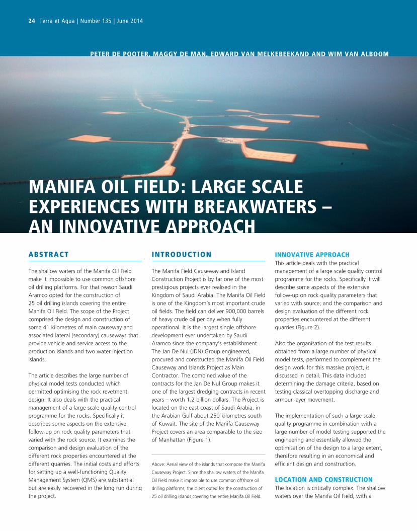
24 Terra et Aqua | Number 135 | June 2014
MANIFA OIL FIELD: LARGE SCALE EXPERIENCES WITH BREAKWATERS – AN INNOVATIVE APPROACH
PETER DE POOTER, MAGGY DE MAN, EDWARD VAN MELKEBEEKAND AND WIM VAN ALBOOM
ABSTRACT
The shallow waters of the Manifa Oil Field
make it impossible to use common offshore
oil drilling platforms. For that reason Saudi
Aramco opted for the construction of
25 oil drilling islands covering the entire
Manifa Oil Field. The scope of the Project
comprised the design and construction of
some 41 kilometres of main causeway and
associated lateral (secondary) causeways that
provide vehicle and service access to the
production islands and two water injection
islands.
The article describes the large number of
physical model tests conducted which
permitted optimising the rock revetment
design. It also deals with the practical
management of a large scale quality control
programme for the rocks. Specifically it
describes some aspects on the extensive
follow-up on rock quality parameters that
varied with the rock source. It examines the
comparison and design evaluation of the
different rock properties encountered at the
different quarries. The initial costs and efforts
for setting up a well-functioning Quality
Management System (QMS) are substantial
but are easily recovered in the long run during
the project.
INTRODUCTION
The Manifa Field Causeway and Island
Construction Project is by far one of the most
prestigious projects ever realised in the
Kingdom of Saudi Arabia. The Manifa Oil Field
is one of the Kingdom’s most important crude
oil fields. The field can deliver 900,000 barrels
of heavy crude oil per day when fully
operational. It is the largest single offshore
development ever undertaken by Saudi
Aramco since the company’s establishment.
The Jan De Nul (JDN) Group engineered,
procured and constructed the Manifa Oil Field
Causeway and Islands Project as Main
Contractor. The combined value of the
contracts for the Jan De Nul Group makes it
one of the largest dredging contracts in recent
years – worth 1.2 billion dollars. The Project is
located on the east coast of Saudi Arabia, in
the Arabian Gulf about 250 kilometres south
of Kuwait. The site of the Manifa Causeway
Project covers an area comparable to the size
of Manhattan (Figure 1).
INNOVATIVE APPROACHThis article deals with the practical
management of a large scale quality control
programme for the rocks. Specifically it will
describe some aspects of the extensive
follow-up on rock quality parameters that
varied with source; and the comparison and
design evaluation of the different rock
properties encountered at the different
quarries (Figure 2).
Also the organisation of the test results
obtained from a large number of physical
model tests, performed to complement the
design work for this massive project, is
discussed in detail. This data included
determining the damage criteria, based on
testing classical overtopping discharge and
armour layer movement.
The implementation of such a large scale
quality programme in combination with a
large number of model testing supported the
engineering and essentially allowed the
optimisation of the design to a large extent,
therefore resulting in an economical and
efficient design and construction.
LOCATION AND CONSTRUCTIONThe location is critically complex. The shallow
waters over the Manifa Oil Field, with a
Above: Aerial view of the islands that compose the Manifa
Causeway Project. Since the shallow waters of the Manifa
Oil Field make it impossible to use common offshore oil
drilling platforms, the client opted for the construction of
25 oil drilling islands covering the entire Manifa Oil Field.
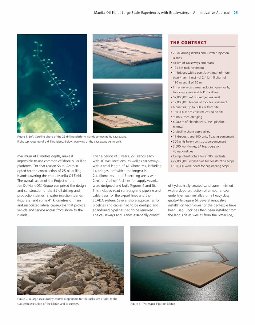
Over a period of 3 years, 27 islands each
with 10 well locations, as well as causeways
with a total length of 41 kilometres, including
14 bridges – of which the longest is
2.4 kilometres – and 3 berthing areas with
2 roll-on /roll-off facilities for supply vessels,
were designed and built (Figures 4 and 5).
This included road surfacing and pipeline and
cable trays for the export lines and the
SCADA system. Several shore approaches for
pipelines and cables had to be dredged and
abandoned pipelines had to be removed.
The causeways and islands essentially consist
maximum of 6 metres depth, make it
impossible to use common offshore oil drilling
platforms. For that reason Saudi Aramco
opted for the construction of 25 oil drilling
islands covering the entire Manifa Oil Field.
The overall scope of the Project of the
Jan De Nul (JDN) Group comprised the design
and construction of the 25 oil drilling and
production islands, 2 water injection islands
(Figure 3) and some 41 kilometres of main
and associated lateral causeways that provide
vehicle and service access from shore to the
islands.
of hydraulically created sand cores, finished
with a slope protection of armour and/or
underlayer rock installed on a heavy duty
geotextile (Figure 6). Several innovative
installation techniques for the geotextile have
been used. Rock has then been installed from
the land side as well as from the waterside,
Manifa Oil Field : Large Scale Experiences with Breakwaters – An Innovative Approach 25
THE CONTRACT
• 25 oil drilling islands and 2 water injection
islands
• 41 km of causeways and roads
• 121 km rock revetment
• 14 bridges with a cumulative span of more
than 4 km (1 main of 2.4 km, 5 short of
180 m and 8 of 90 m)
• 3 marine access areas including quay walls,
lay-down areas and RoRo facilities
• 52,000,000 m³ of dredged material
• 12,000,000 tonnes of rock for revetment
• 6 quarries, up to 600 km from site
• 150,000 m³ of concrete casted on site
• 9 km subsea dredging
• 6,000 m of abandoned subsea pipeline
removal
• 2 pipeline shore approaches
• 11 dredgers and 100 units floating equipment
• 300 units heavy construction equipment
• 3,000 workforces, 24 hrs. operation,
40 nationalities
• Camp infrastructure for 2,000 residents
• 22,000,000 work-hours for construction scope
• 100,000 work-hours for engineering scope
Figure 1. Left: Satellite photo of the 25 drilling platform islands connected by causeways.
Right top: close up of a drilling island; below: overview of the causeways being built.
Figure 2. A large scale quality control programme for the rocks was crucial to the
successful execution of the islands and causeways. Figure 3. Two water injection islands.
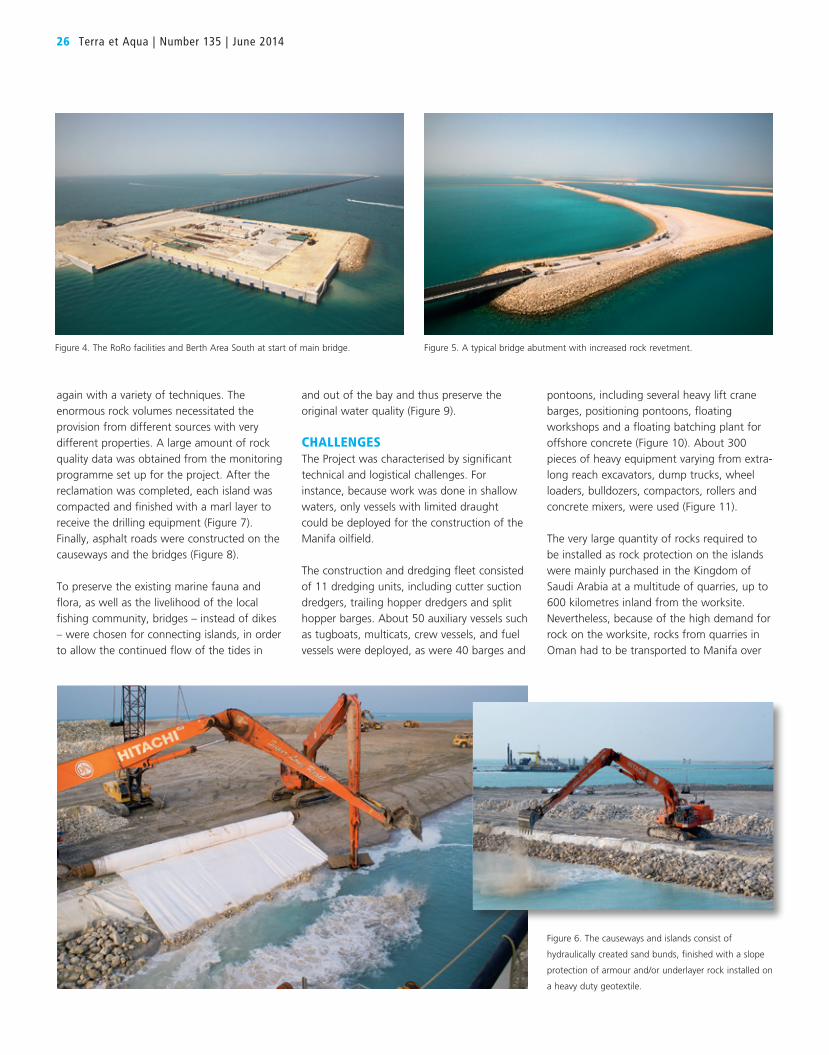
again with a variety of techniques. The
enormous rock volumes necessitated the
provision from different sources with very
different properties. A large amount of rock
quality data was obtained from the monitoring
programme set up for the project. After the
reclamation was completed, each island was
compacted and finished with a marl layer to
receive the drilling equipment (Figure 7).
Finally, asphalt roads were constructed on the
causeways and the bridges (Figure 8).
To preserve the existing marine fauna and
flora, as well as the livelihood of the local
fishing community, bridges – instead of dikes
– were chosen for connecting islands, in order
to allow the continued flow of the tides in
26 Terra et Aqua | Number 135 | June 2014
and out of the bay and thus preserve the
original water quality (Figure 9).
CHALLENGESThe Project was characterised by significant
technical and logistical challenges. For
instance, because work was done in shallow
waters, only vessels with limited draught
could be deployed for the construction of the
Manifa oilfield.
The construction and dredging fleet consisted
of 11 dredging units, including cutter suction
dredgers, trailing hopper dredgers and split
hopper barges. About 50 auxiliary vessels such
as tugboats, multicats, crew vessels, and fuel
vessels were deployed, as were 40 barges and
pontoons, including several heavy lift crane
barges, positioning pontoons, floating
workshops and a floating batching plant for
offshore concrete (Figure 10). About 300
pieces of heavy equipment varying from extra-
long reach excavators, dump trucks, wheel
loaders, bulldozers, compactors, rollers and
concrete mixers, were used (Figure 11).
The very large quantity of rocks required to
be installed as rock protection on the islands
were mainly purchased in the Kingdom of
Saudi Arabia at a multitude of quarries, up to
600 kilometres inland from the worksite.
Nevertheless, because of the high demand for
rock on the worksite, rocks from quarries in
Oman had to be transported to Manifa over
Figure 5. A typical bridge abutment with increased rock revetment.
Figure 6. The causeways and islands consist of
hydraulically created sand bunds, finished with a slope
protection of armour and/or underlayer rock installed on
a heavy duty geotextile.
Figure 4. The RoRo facilities and Berth Area South at start of main bridge.
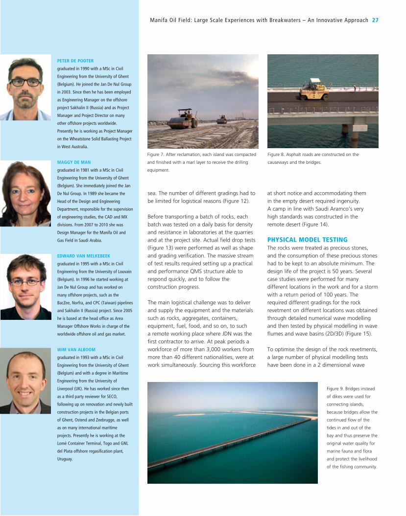
sea. The number of different gradings had to
be limited for logistical reasons (Figure 12).
Before transporting a batch of rocks, each
batch was tested on a daily basis for density
and resistance in laboratories at the quarries
and at the project site. Actual field drop tests
(Figure 13) were performed as well as shape
and grading verification. The massive stream
of test results required setting up a practical
and performance QMS structure able to
respond quickly, and to follow the
construction progress.
The main logistical challenge was to deliver
and supply the equipment and the materials
such as rocks, aggregates, containers,
equipment, fuel, food, and so on, to such
a remote working place where JDN was the
first contractor to arrive. At peak periods a
workforce of more than 3,000 workers from
more than 40 different nationalities, were at
work simultaneously. Sourcing this workforce
at short notice and accommodating them
in the empty desert required ingenuity.
A camp in line with Saudi Aramco’s very
high standards was constructed in the
remote desert (Figure 14).
PHYSICAL MODEL TESTINGThe rocks were treated as precious stones,
and the consumption of these precious stones
had to be kept to an absolute minimum. The
design life of the project is 50 years. Several
case studies were performed for many
different locations in the work and for a storm
with a return period of 100 years. The
required different gradings for the rock
revetment on different locations was obtained
through detailed numerical wave modelling
and then tested by physical modelling in wave
flumes and wave basins (2D/3D) (Figure 15).
To optimise the design of the rock revetments,
a large number of physical modelling tests
have been done in a 2 dimensional wave
Manifa Oil Field : Large Scale Experiences with Breakwaters – An Innovative Approach 27
PETER DE POOTER
graduated in 1990 with a MSc in Civil
Engineering from the University of Ghent
(Belgium). He joined the Jan De Nul Group
in 2003. Since then he has been employed
as Engineering Manager on the offshore
project Sakhalin II (Russia) and as Project
Manager and Project Director on many
other offshore projects worldwide.
Presently he is working as Project Manager
on the Wheatstone Solid Ballasting Project
in West Australia.
MAGGY DE MAN
graduated in 1981 with a MSc in Civil
Engineering from the University of Ghent
(Belgium). She immediately joined the Jan
De Nul Group. In 1989 she became the
Head of the Design and Engineering
Department, responsible for the supervision
of engineering studies, the CAD and MX
divisions. From 2007 to 2010 she was
Design Manager for the Manifa Oil and
Gas Field in Saudi Arabia.
EDWARD VAN MELKEBEEK
graduated in 1995 with a MSc in Civil
Engineering from the University of Louvain
(Belgium). In 1996 he started working at
Jan De Nul Group and has worked on
many offshore projects, such as the
BacZee, Norfra, and CPC (Taiwan) pipelines
and Sakhalin II (Russia) project. Since 2005
he is based at the head office as Area
Manager Offshore Works in charge of the
worldwide offshore oil and gas market.
WIM VAN ALBOOM
graduated in 1993 with a MSc in Civil
Engineering from the University of Ghent
(Belgium) and with a degree in Maritime
Engineering from the University of
Liverpool (UK). He has worked since then
as a third party reviewer for SECO,
following up on renovation and newly built
construction projects in the Belgian ports
of Ghent, Ostend and Zeebrugge, as well
as on many international maritime
projects. Presently he is working at the
Lomé Container Terminal, Togo and GNL
del Plata offshore regasification plant,
Uruguay.
Figure 8. Asphalt roads are constructed on the
causeways and the bridges.
Figure 9. Bridges instead
of dikes were used for
connecting islands,
because bridges allow the
continued flow of the
tides in and out of the
bay and thus preserve the
original water quality for
marine fauna and flora
and protect the livelihood
of the fishing community.
Figure 7. After reclamation, each island was compacted
and finished with a marl layer to receive the drilling
equipment.

particular shallow water conditions, where
waves are depth-limited and empirical
damage formulae fall outside of their
applicable ranges. The amount of model test
results made available in the project
constitutes an important database that may
well complement and expand the current
state of the art.
In a 3-Dimensional wave basin at DHI in
Denmark, the corner of the islands and bridge
head sections have been tested, to check the
stability of the gradings under a 3D wave
attack. Again, armour damage has been
investigated by expressing the number of
displaced zones relative to the total amount
of rock in a particular zone. In order to
understand the particular 3D situation in
combination with angled wave attack, due
distinction was made between different areas
on the slopes (hence the different colour
bands in Figure 18). The approach allowed
better localisation of problem areas and hence
directing the efforts towards where they were
needed. Starting from the extensive database
of the physical model results, a final task then
consisted in making sure that the design in
the real world was consistent with the model.
The numerically determined design wave
conditions over the vast project area have
been divided into areas of similar parameters
(grouping), which could then be assimilated
with one or more particular model test and
type of revetment design.
flume at the University of Ghent. Also at DHI
in Denmark and Sogreah in France additional
testing has been done. Several scales were
used in practice. Tests were performed by
gradually increasing the wave attack up until
and somewhat further than the design
conditions in order to allow a judgement on
the robustness of the design.
The size of the armour has been determined
in order to limit damage to allowable
percentages. Damage was hereby expressed
as the relative number of rocks that have
been moved during a design storm out of
their specific location on the revetment.
Extensive use was made of coloured scale
model armour in order to easily visualise the
evolution of damage. An example of the way
the armour damage could hence easily be
observed is given in Figure 16.
The heights of the crests have been
determined for an overtopping quantity of
2 l/m/sec. With respect to the overtopping
phenomena, a number of important
parameters have thoroughly been discussed
during the design phase. These include the
influence of the storm duration, the
correlation between high water levels and
design waves, the location where the
overtopping volume is measured, the width of
the crest, angled wave attack, the occurrence
probability of the overtopping criterion, scale
effects.
In particular cross sections, the breakwater
was topped by a wave retaining wall (Figure
17). Apart from measuring the overtopping
over the wall, the installation of pressure
transducers on the model wall allowed for
high frequency registration of wave induced
pressures. These important pressures were
compared to existing formulations available in
literature and could then be used to further
develop the strength design of the crest wall
element.
Every grading and every slope angle has been
tested. Also the toe stability has been
optimised by physical modelling. Physical
modelling proved to be helpful in some of the
28 Terra et Aqua | Number 135 | June 2014
Figure 11. Extra-long reach excavators, dump trucks,
wheel loaders, bulldozers, compactors, rollers and
concrete mixers at work.
Figure 10. Eleven dredgers as well as auxiliary vessels varying from tugboats, multicats, crew vessels, and fuel vessels and 40 barges and pontoons were deployed.
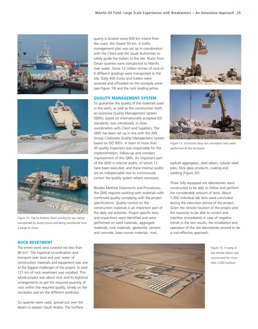
quarry is located some 600 km inland from
the coast, the closest 50 km. A traffic
management plan was set up in coordination
with the Client and the Saudi Authorities to
safely guide the trailers to the site. Rocks from
Oman quarries were transported to Manifa
over water. Some 12 million tonnes of rock of
6 different gradings were transported to the
site. Daily 400 trucks and trailers were
received and offloaded on the stockpile areas
(see Figure 19) and the rock loading jetties.
QUALITY MANAGEMENT SYSTEMTo guarantee the quality of the materials used
in the work, as well as the construction itself,
an extensive Quality Management System
(QMS), based on internationally accepted ISO
standards, was introduced, in close
coordination with Client and Suppliers. The
QMS has been set up in line with the JDN
Group Corporate Quality Management System
based on ISO 9001. A team of more than
30 quality inspectors was responsible for the
implementation, follow-up and constant
improvement of this QMS. An important part
of the QMS is internal audits, of which 13
have been executed, and these internal audits
are an indispensable tool to continuously
correct the quality system where necessary.
Besides Method Statements and Procedures,
the QMS requires working with materials with
confirmed quality complying with the project
specifications. Quality control on the
construction materials is an important part of
the daily site activities. Project specific tests
and inspections were identified and were
performed on sand materials, aggregate
materials, rock materials, geotextile, cement
and concrete, base course materials, marl,
asphalt aggregates, steel rebars, tubular steel
piles, fibre glass products, coating and
welding (Figure 20).
Three fully equipped site laboratories were
constructed to be able to follow and perform
the considerable amount of tests. About
7,000 individual lab tests were concluded
during the execution period of the project.
Given the remote location of the project and
the necessity to be able to correct and
interfere immediately in case of negative
trends in the test results, the installation and
operation of the site laboratories proved to be
a cost-effective approach.
Manifa Oil Field : Large Scale Experiences with Breakwaters – An Innovative Approach 29
ROCK REVETMENTThe entire work area covered not less than
80 km2. The logistical co-ordination and
transport over land and over water of
construction materials and equipment was one
of the biggest challenges of the project. In total
121 km of rock revetment was installed. This
whole project was about rock and its logistical
arrangements to get the required quantity of
rock within the required quality, timely on the
stockpiles and on the different worksites.
Six quarries were used, spread out over the
desert in eastern Saudi Arabia. The furthest
Figure 14. A camp in
the remote desert was
constructed for more
than 2,000 workers.
Figure 13. Successive drop test simulation tests were
performed at the stockyard.
Figure 12. Top to bottom: Rock arriving by sea, being
transported by dump trucks and being transferred from
a barge to shore.

30 Terra et Aqua | Number 135 | June 2014
needed in order to decide which combination
of batches is going to be needed to result in a
good moving average of the W50 for each
particular constructed area on site. It
appeared that due distinction was necessary
between the different rock suppliers, different
laboratories and the different origin and
nature of the rock. A similar procedure was
set up for the sand borrow areas and
reclamation areas, and use of geotextile.
OperationsIn operational phase, the quality management
programme was essentially built around the
acceptance of batches of 10,000 tonnes of
rock, as described in reference literature.
The Rock Manual (1st and 2nd editions)
was one of the main references adopted.
Acceptance of batches is therefore based
on a combination of laboratory tests for the
intrinsic properties of the rock (density, water
absorption, …) and on site tests for the
properties of the individual armour stones
location and finally the location where the
rock was used. A good stockpile management
and traceability from quarry up to installation
was implemented and maintained. Based on
the W50 of the batches in the quarry a good
stockpile management and traceability was
Traceability of materials is obviously required.
Near the stockpile area 3 weigh bridges were
operational, registering every incoming rock
load. An extensive document control allowed
tracing each batch of rock, based on the
quarry source, supplier, grading, stockpiling
Figure 17. Laboratory 2D wave flume testing – general views of the section. Figure 18. Laboratory 3D tests – corners of the islands.
Figure 16. Accumulation of armour damage under growing wave conditions.
Figure 15. Physical modelling in wave flumes and wave basins (2D/3D).
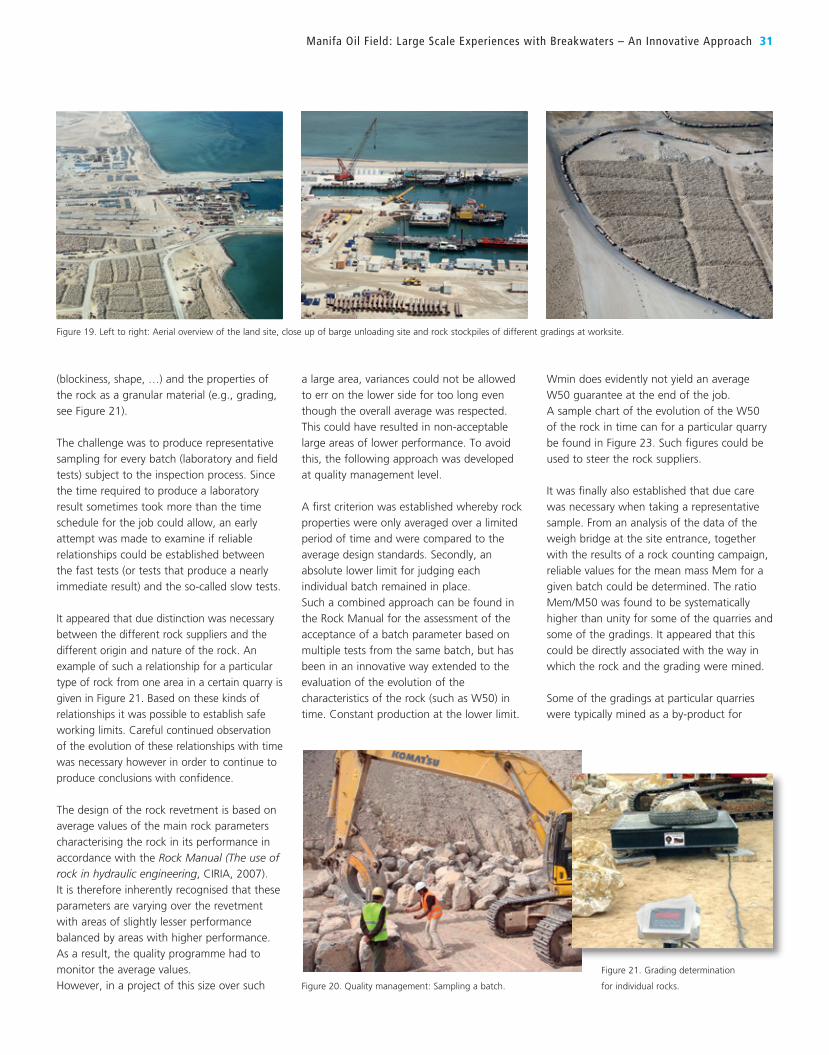
(blockiness, shape, …) and the properties of
the rock as a granular material (e.g., grading,
see Figure 21).
The challenge was to produce representative
sampling for every batch (laboratory and field
tests) subject to the inspection process. Since
the time required to produce a laboratory
result sometimes took more than the time
schedule for the job could allow, an early
attempt was made to examine if reliable
relationships could be established between
the fast tests (or tests that produce a nearly
immediate result) and the so-called slow tests.
It appeared that due distinction was necessary
between the different rock suppliers and the
different origin and nature of the rock. An
example of such a relationship for a particular
type of rock from one area in a certain quarry is
given in Figure 21. Based on these kinds of
relationships it was possible to establish safe
working limits. Careful continued observation
of the evolution of these relationships with time
was necessary however in order to continue to
produce conclusions with confidence.
The design of the rock revetment is based on
average values of the main rock parameters
characterising the rock in its performance in
accordance with the Rock Manual (The use of rock in hydraulic engineering, CIRIA, 2007).
It is therefore inherently recognised that these
parameters are varying over the revetment
with areas of slightly lesser performance
balanced by areas with higher performance.
As a result, the quality programme had to
monitor the average values.
However, in a project of this size over such
a large area, variances could not be allowed
to err on the lower side for too long even
though the overall average was respected.
This could have resulted in non-acceptable
large areas of lower performance. To avoid
this, the following approach was developed
at quality management level.
A first criterion was established whereby rock
properties were only averaged over a limited
period of time and were compared to the
average design standards. Secondly, an
absolute lower limit for judging each
individual batch remained in place.
Such a combined approach can be found in
the Rock Manual for the assessment of the
acceptance of a batch parameter based on
multiple tests from the same batch, but has
been in an innovative way extended to the
evaluation of the evolution of the
characteristics of the rock (such as W50) in
time. Constant production at the lower limit.
Wmin does evidently not yield an average
W50 guarantee at the end of the job.
A sample chart of the evolution of the W50
of the rock in time can for a particular quarry
be found in Figure 23. Such figures could be
used to steer the rock suppliers.
It was finally also established that due care
was necessary when taking a representative
sample. From an analysis of the data of the
weigh bridge at the site entrance, together
with the results of a rock counting campaign,
reliable values for the mean mass Mem for a
given batch could be determined. The ratio
Mem/M50 was found to be systematically
higher than unity for some of the quarries and
some of the gradings. It appeared that this
could be directly associated with the way in
which the rock and the grading were mined.
Some of the gradings at particular quarries
were typically mined as a by-product for
Manifa Oil Field : Large Scale Experiences with Breakwaters – An Innovative Approach 31
Figure 20. Quality management: Sampling a batch.
Figure 21. Grading determination
for individual rocks.
Figure 19. Left to right: Aerial overview of the land site, close up of barge unloading site and rock stockpiles of different gradings at worksite.
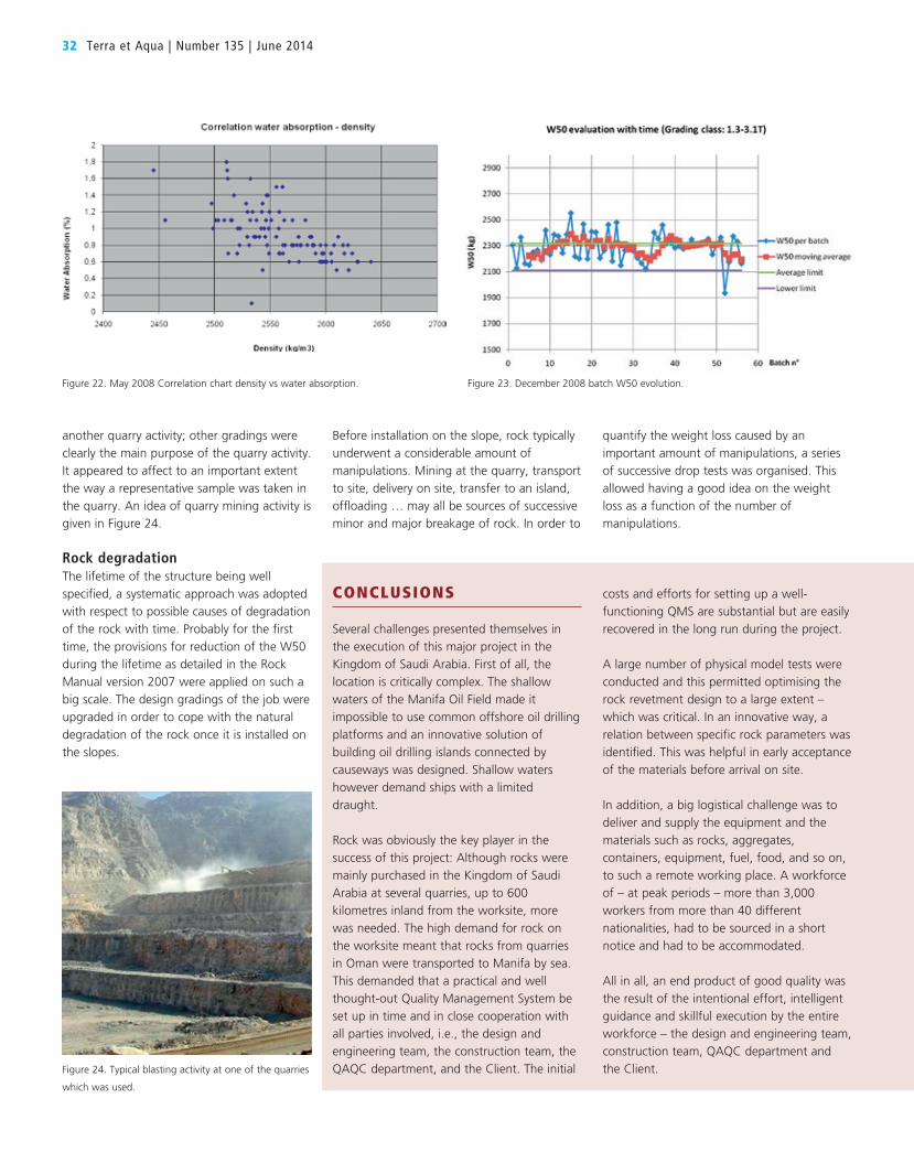
32 Terra et Aqua | Number 135 | June 2014
another quarry activity; other gradings were
clearly the main purpose of the quarry activity.
It appeared to affect to an important extent
the way a representative sample was taken in
the quarry. An idea of quarry mining activity is
given in Figure 24.
Rock degradationThe lifetime of the structure being well
specified, a systematic approach was adopted
with respect to possible causes of degradation
of the rock with time. Probably for the first
time, the provisions for reduction of the W50
during the lifetime as detailed in the Rock
Manual version 2007 were applied on such a
big scale. The design gradings of the job were
upgraded in order to cope with the natural
degradation of the rock once it is installed on
the slopes.
Before installation on the slope, rock typically
underwent a considerable amount of
manipulations. Mining at the quarry, transport
to site, delivery on site, transfer to an island,
offloading … may all be sources of successive
minor and major breakage of rock. In order to
quantify the weight loss caused by an
important amount of manipulations, a series
of successive drop tests was organised. This
allowed having a good idea on the weight
loss as a function of the number of
manipulations.
CONCLUSIONS
Several challenges presented themselves in
the execution of this major project in the
Kingdom of Saudi Arabia. First of all, the
location is critically complex. The shallow
waters of the Manifa Oil Field made it
impossible to use common offshore oil drilling
platforms and an innovative solution of
building oil drilling islands connected by
causeways was designed. Shallow waters
however demand ships with a limited
draught.
Rock was obviously the key player in the
success of this project: Although rocks were
mainly purchased in the Kingdom of Saudi
Arabia at several quarries, up to 600
kilometres inland from the worksite, more
was needed. The high demand for rock on
the worksite meant that rocks from quarries
in Oman were transported to Manifa by sea.
This demanded that a practical and well
thought-out Quality Management System be
set up in time and in close cooperation with
all parties involved, i.e., the design and
engineering team, the construction team, the
QAQC department, and the Client. The initial
costs and efforts for setting up a well-
functioning QMS are substantial but are easily
recovered in the long run during the project.
A large number of physical model tests were
conducted and this permitted optimising the
rock revetment design to a large extent –
which was critical. In an innovative way, a
relation between specific rock parameters was
identified. This was helpful in early acceptance
of the materials before arrival on site.
In addition, a big logistical challenge was to
deliver and supply the equipment and the
materials such as rocks, aggregates,
containers, equipment, fuel, food, and so on,
to such a remote working place. A workforce
of – at peak periods – more than 3,000
workers from more than 40 different
nationalities, had to be sourced in a short
notice and had to be accommodated.
All in all, an end product of good quality was
the result of the intentional effort, intelligent
guidance and skillful execution by the entire
workforce – the design and engineering team,
construction team, QAQC department and
the Client.Figure 24. Typical blasting activity at one of the quarries
which was used.
Figure 22. May 2008 Correlation chart density vs water absorption. Figure 23. December 2008 batch W50 evolution.
authority. Both a notification of the cause of the problem and a
suggested cure may be required. Kinlan provides case histories that
make this clear and in Chapters 6 and 7 he gives specifics and sample
wording about what needs to be included in a claim, including the
elements known as CEES (Cause, Effect, Entitlement and
Substantiation). Chapter 8 deals with establishing the costs of a claim,
which is not as easy as it sounds. And finally Chapter 9 addresses
“How to Avoid or Minimise Claims”. This is of course the point.
Avoidance is the aim. Dispute Review or Adjudication Boards exist
because something has gone wrong.
Still as Kinlan points out in Chapter 10, some things are not knowable
even for an experienced contractor and, in that case, it is to
everyone’s advantage if contracts are clear and a reasonable and
speedy conclusions to claims can be found.
Unforeseeable adverse conditions remain a risk factor and this concise
book gives the contractors and their clients a good guideline for
managing difficult circumstances.
Available from: Amazon.com or http://tinyurl.com/nyk4k3r
CONSTRUIR CON LA NATURALIZA(BUILDING WITH NATURE)BY HUIB DE VRIEND AND MARK VAN KONINGSVELDTRANSLATION BY ROBERTO VIDAL MARTIN AND JORIS VREDELINGSpanish translation (2014). ISBN 978 94-6228-234-6. 40 pages. Published by
EcoShape. Hardcover. Many full-colour illustrations.
EcoShape is a consortium of private sector partners, government
agencies and knowledge institutes who have joined together to use
their expertise to tackle the challenges of urbanisation, economic
development, sea-level rise and climate change with innovative
approaches. In 2012 EcoShape published a book highlighting its
work: The shift from building in nature to building with nature –
that means keeping nature in mind from the very start. This recently
released Spanish translation contains all the information of the
original and reaches out to the large number of Spanish speakers
worldwide, especially in South America, who are affected by major
port expansions and dredging projects.
For further information please see the review in English
in Terra nr 130:
http://www.iadc-dredging.com/ul/cms/terraetaqua/
document/3/5/7/357/357/1/terra-et-aqua-130-complete.pdf
BOOKS / PERIODICALS REVIEWEDADVERSE PHYSICAL CONDITIONS & THE EXPERIENCED CONTRACTOR BY DAVID KINLANPublished by Delft Academic Press, The Netherlands. 2014. Paperback. 118 pp. With colour illustrations. ISBN 97890-6562-327-0.
When it comes to planning and
executing a major dredging
project, innumerable people
participate: project engineers,
researchers, tender coordinators,
safety managers, legal advisors and onwards. When these experts are
in the process of designing and planning, one thing stands out: the
contract defining each parties’ responsibilities must be as clear and
comprehensive as possible and take into account as many risk factors
as possible. In that context, the question arises: what are foreseeable
conditions and what are not? How are risks to be accounted for? And
who is responsible if an unforeseen “adverse physical condition”
arises?
David Kinlan’s new book attempts to answer these questions. Kinlan
is a freelance Chartered Quantity Surveyor and Queensland Registered
Adjudicator with 25 years of experience in the marine infrastructure
industry; he worked for many years at Ballast Nedam Dredging as a
contracts manager and since then has been an independent
consultant. He has worked on many of iconic dredging projects and
his observations in this book are based not only on research by on
firsthand experiences.
Since encountering an adverse condition that has not been foreseen
can have deep financial consequences and impacts on the delivery
date of a project, owners (employers) and contractors alike have a
vested interest in getting the right balance between risk and reward.
In Chapter 1 the factors in the allocation of risk are examined and a
number of countries are used as examples. Chapter 2 emphasises the
importance of the site investigation and the necessity that all parties
understand what circumstances they may encounter before operations
start. Although site investigations can and are often conducted by
contractors, Kinlan suggests that the employer has a role in specifying
local conditions. After all it is the employer’s backyard. The role of the
FIDIC contract and the use of various models and need to identify
potential issues are also presented. In Chapter 3 the concept of
‘foreseeability’ as generally accepted in various countries (Australia,
the UK) is discussed and some practical examples are given.
Chapter 4 is devoted to defining ‘adverse conditions’, explaining
contract clauses on the subject and examining the FIDIC regulations
and US Army Corps of Engineers acquisition regulations. And Chapter
5 continues with the legal formalities of encountering adverse
conditions, such as giving prompt notification to the pertinent
Books / Periodicals Reviewed 33
34 Terra et Aqua | Number 135 | June 2014
NAVIGATION STRUCTURES: THEIR ROLE WITHIN FLOOD DEFENCE SYSTEMS – RESILIENCE AND PERFORMANCE UNDER OVERLOADING CONDITIONSBY INCOM WORKING GROUP 137€ 40.00. 43 pages. Illustrated.
Past examples of flood defence systems
indicate that some structural flood control
systems may have exacerbated – rather than reduced – the amount of
damage from flooding, for example, when levees create a false sense
of security that leads to over-development in floodplains.
This InCom Working Group 137 guidance offers suggestions for flood
defence systems (FDS) so that inland navigation can develop
environmentally friendly approaches in which accepted river training
methods, like straightening rivers, are reassessed. For example: Polders
are low-lying flood plains enclosed by embankments, separated from
the river and are used on the Rhine River to allow for floods to be
alleviated. Storing water by means of vegetation, soil, ground and
wetlands, all of which are capable of retaining water, should have
priority over swift water run-off. The report points out that an
efficient flood risk management system needs to be complemented
with integrated watershed management, retention zones, restricted
developments in flood plains, land use planning, awareness raising,
flood resistant construction, drainage and water storage improvement,
effective evacuation planning and other measures.
Also, the report accepts the inevitable: Flood defence structures may
fail at some point, whether because of degradation, overloading or
design error. Recommendations are thus offered for minimum system
performance and public safety aspects of navigation systems,
integrated with FDS. These ideas may help prevent the loss of human
life and limit catastrophic environmental hazards that endanger public
health, disrupt lifeline services or destroy critical infrastructure needed
for emergency response.
INITIAL ASSESSMENT OF ENVIRONMENTAL EFFECTS OF NAVIGATION AND INFRASTRUCTURE PROJECTSBY ENVICOM WORKING GROUP 143€ 50.00. 55 pages. Illustrated.
This EnviCom Working Group 143 report
provides guidance for conducting an initial
assessment of environmental effects of navigation and infrastructure
projects. It is largely a planning-based activity that establishes the
project scope and objectives; gathers existing information needed to
perform the assessment; develops the conceptual model and reaches
a conclusion about the level of risk and whether more assessment is
required. Projects related to navigation and infrastructure include but
are not limited to maintenance and new work dredging, port and
harbour development (e.g., terminals, berthing facilities, barge flotilla
areas and turning basins) and construction of waterways, locks,
canals, quays, breakwaters, jetties and groins.
The approach focuses on current environmental concerns and is
suitable as a first step in assessing potential effects on Special
Protected Areas (e.g., European Union Habitats Directive 92/43). It is
consistent with European Union Directive 2011/92/EU (dated
December 13, 2011) as well as with the risk assessment framework
for environmental concerns as developed in the United States (USEPA,
1998; NRC, 2009; ASTM, 2009) and in Germany (BfG, 2004).
The process identifies aspects of navigation and infrastructure projects
requiring investigation and highlights the need to investigate possible
alternatives early in the project definition phase, aiming for a more
holistic approach in which the project needs are harmonised with
environmental or ecological concerns (e.g., Working with Nature,
ecosystem-based management). This approach serves the needs of risk
assessors, decision makers and stakeholders and provides an
instrument to understand the strengths, weaknesses and limitations of
infrastructure projects with respect to the environment – focusing on
avoiding unacceptable impacts and creating win-win situations.
DESIGN OF LOCK GATES FOR SHIP COLLISIONBY INCOM WORKING GROUP 151€ 50.00. 56 pages. Illustrated.
Current practice for the design of lock gates
and approach structures is a relatively standard
activity for a suitably experienced engineering
company if the design requirements and the
load cases are clearly specified. Relevant, robust, reliable and effective
software is available to assess the strength (stress, deformation,
buckling, damage limitations, and so on) of lock gates and approach
structures even if extreme load cases must be considered. The design
aspects other than strength, such as opening and closing
arrangements, service life, water tightness, sensitivity to vibrations,
installation, maintenance, who pays for gate repairs (administration or
vessel owner), are the matter of the designer’s specialisation and
experience in hydraulic structures.
This InCom Working Group 151 report raises a number of questions
such as: What are the design issues to be considered in determining
the effects of ship collision on gate structures and approach works?
What are the mass and hull form of the vessel – which shapes cause
the most severe damage? What is the effect of added hydrodynamic
mass? What level of damage is acceptable? What are the
recommendations to prevent/minimise collision damage?
All three reports are available at www.pianc.org -> publications
http://www.pianc.org/technicalreportsbrowseall.php
• Email: [email protected]

SEMINARS / CONFERENCES / EVENTSWEDA DREDGING SUMMIT & EXPO 2014JUNE 15-18, 2014 FAIRMONT ROYAL YORK, TORONTO, ONTARIO, CANADA
In June 2014 the Western Dredging Association and Texas A&M will
hold its Annual Dredging Summit & Expo 2014 at the landmark
Fairmont Royal York Hotel in Toronto, Canada. With the theme,
“Expanding the Dredging World”, delegates will experience another
educational technical programme that will promote the exchange of
knowledge in fields related to dredging, navigation, marine
engineering and construction, as well has the enhancement of the
marine environment.
The Conference will begin with a pre-conference tour of Toronto,
a city that has a multi-cultural population of people from over
200 countries. An accompanying persons’ programme will also be
organised. Upon completion of the technical programme, post-
conference visits to a Niagara-on-the-Lake boat tour, Niagara Falls and
Cambridge Farmer’s Market will be available. A trip to Stratford that
reflects the prosperity and grandeur of Stratford’s Victorian Past are
also planned.
For further information contact:Larry Patella
WEDA Executive Director
• Email: [email protected]
ENVIRONMENTAL ASPECTS OF DREDGINGTWO-DAY TRAINING COURSEJUNE 18-19 2014 HOWBERY PARK, WALLINGFORD, OXFORDSHIRE, UK
This two-day training course – organised by HR Wallingford, the
Central Dredging Association (CEDA) and the International Association
of Dredging Companies (IADC) –covers the scope and importance
of the environmental aspects of dredging projects, the management
of dredged material and the typical legislative conditions and controls
imposed by international conventions and regional agencies.
In addition to presentations of the subjects, participants will be
challenged in case studies to apply the principals discussed.
The course, conducted by Nick Bray and Frans Uelman, provides
an overview of the environmental aspects of dredging, the latest
technology and equipment that apply to dredging and the
management of dredged material. It includes presentations and
workshops.
Day 1 - Wednesday 18 JuneIntroduction and frameworks
Projects and effects
Workshop on projects and effects
Dredging equipment
Workshop on environmental dredging technology
Day 2 - Thursday 19 JuneDredged material management
Impact and investigations
Workshop on an environmental project
Planning
Philosophies and the future
Who Should Attend?The training course is aimed at: consultants and contractors in
dredging related industries; professionals from different governmental
bodies, whether municipalities, district water boards, ports and
harbour authorities or central government.
Course InformationCost: £550 (+VAT) per delegate.
Hotel rooms at the Springs Hotel in North Stoke can be booked at
a discounted rate from between 17 to 19 June. Book directly and
mention code ‘HRWA 170614’. The course fees include dinner on
the evening of Wednesday 18 June at The Springs Hotel.
To register: http://tinyurl.com/qc9ya8w
the registration page of HR Wallingford (click on ‘Book now’).
For further information: http://tinyurl.com/qd96g8k
4TH INTERNATIONAL SYMPOSIUM ON SEDIMENT MANAGEMENTSEPTEMBER 17-19, 2014FERRARA, ITALY
The 4th International Symposium on Sediment Management (I2SM)
will be held in Ferrara, Italy, September 17-19, 2014, during the
RemTech Expo. It is being organised by Ferrara Fiere Congressi,
Politecnico di Milano - Department of Civil and Environmental
Engineering - Environmental Section and the École des Mines de
Douai. RemTech Expo 2014 is the most specialised event in Italy
dedicated to remediation technologies and territory requalification.
Companies, public administrations, associations, institutions,
professionals, university, industry, oil sector, real-estate and planning
sector. The aim of I2SM is to get together academics, professional
figures and public agencies involved in sediment issues to discuss the
state-of-the-art.
The conference will begin with a plenary session (morning of
September17) with invited speakers; the conference will continue in
2/3 parallel sessions on the different topics. There will be also two
special sessions, one of which on the management of sediments in
Seminars / Conferences / Events 35

dams and the other on policy and practice in the remediation of
contaminated sediments in different countries. About 150
contributions from 38 different countries have been accepted for oral
presentation or poster display.
The official language of I2SM 2014 is English. Simultaneous translation
(English to Italian) will be available for some sessions. On the day after
the end of the Symposium, Saturday, September 20, 2014, technical
visits to the Venice area are being scheduled, with reference to
sediment management issues (treatment and confinement) in the
Lagoon. Sediment treatment plants and sediment confinement areas
are to be visited by coach and by boat, respectively.
For general information about the Symposium and registration contact:• Email: [email protected]
For enquiries about the scientific programme contact: • Email: [email protected]
22ND INTERNATIONAL FEDERATION OF HYDROGRAPHIC SOCIETIES’ CONFERENCE AND EXHIBITIONOCTOBER 28-30 2014ABERDEEN, SCOTLAND
With its theme, Energy & Enterprise, the conference attracts a wide
international audience drawn from all sectors of the hydrographic
and related professions.
In addition to keynote addresses and paper presentations,
the conference features an introductory Student Presentation
Session for which there will be a prize of £500 for the best adjudged
contribution. Other agenda items include a 60-plus stand exhibition,
workshops, local technical visits and an IHO-led session and
stakeholder forum.
For further general information: • Email: [email protected]
IADC SEMINAR ON DREDGING & RECLAMATIONJUNE 23-27,2014DELFT, THE NETHERLANDS
In co-operation with UNESCO-IHE, Delft, the IADC is presenting its
renown seminar on dredging and reclamation. Aimed at (future)
decision makers and their advisors in governments, port and
harbour authorities, off-shore companies and other organisations
who have to execute dredging projects, the IADC has organised
the Seminar at numerous venues often in co-operation with local
technical universities. Since 1993 this week-long Seminar has been
successfully presented in Delft, Singapore, Dubai, Buenos Aires,
Abu Dhabi, Bahrain and Brazil. As is appropriate to a dynamic
industry, the Seminar programme is continually updated. In
addition to basic dredging methods, new equipment and state-of-
the-art techniques are explained.
To optimise the chances of the successful completion of a project,
contracting parties should, from the start, fully understand the
requirements of a dredging project. This five-day course strives to
provide an understanding through lectures by experts in the field
and workshops, partly conducted on-site in order to give the
“students” hands-on experience.
Highlights of the programmeDay 1: Why Dredging?
The Need for Dredging/Project Phasing
Day 2: What is Dredging?
Dredging Equipment/Survey Systems (includes a site visit)
Day 3: Production of various types of dredgers
(includes a visit to a dredging yard)
Day 4: Preparation of a Dredging Contract, Reclamation, Tender,
Cost Pricing
Day 5: Contracts
An important feature of the Seminars is a site visit to a dredging
project being executed in the given geographical area. This gives
the participants the opportunity to see dredging equipment in
action and to gain a better feeling of the magnitude of a dredging
operation.
Each participant receives a set of comprehensive proceedings with
an extensive reference list of relevant literature and, at the end of
the week, a Certificate of Achievement in recognition of the
completion of the coursework. Please note that full attendance is
required for obtaining the Certificate of Achievement.
CostsThe fee for the week-long seminar is € 2,250.- (inclusive VAT).
The fee includes all tuition, seminar proceedings, workshops and
a special participants’ dinner, but excludes travel costs and
accommodations. Assistance with finding hotel accommodation
can be given.
Other Upcoming IADC Seminars in 2014 • October 27 to October 31, Singapore (in co-operation with the
National University of Singapore).
For further information contact: Jurgen Dhollander, International Association of Dredging Companies
Tel: +31 70 352 3334
• Email: [email protected]://tinyurl.com/q7fjr4q
36 Terra et Aqua | Number 135 | June 2014
Seminars / Conferences / Events 37
CALL FOR PAPERSIAPH HAMBURG 201529TH WORLD PORTS CONFERENCEJUNE 1-5, 2015CONGRESS CENTER HAMBURG (CCH), GERMANY
The 29th IAPH World Ports Conference will take place under the
theme of “smartPORT Hamburg”. The specialised conference that
caters to an international audience will deal with the economic,
ecological and political challenges ports are facing in today’s world of
economic and climate change.
As the host of the conference the Port of Hamburg will demonstrate
how changing requirements can be met and the measures, including
IT-supported projects, that can be taken to achieve higher cost
effectiveness, improve safety and security, and generate a higher level
of sustainability. The following subjects are being addressed:
1. smartPORT logistics – challenges and possible solutionsTechnical innovations, land restructuring, expansion of the transport
route network and modern communication paths combined with high
data transparency are just some of the measures the Hamburg Port
Authority (HPA) is implementing to create the basis for economic
growth in the Port of Hamburg.
2. smartPORT energy – challenges and possible solutionsTo ensure a win-win scenario for both business and the environment,
innovative mobility concepts, renewable energy sources and the
interlinking of energy-generating plants and consumer plants to
promote the efficient use of resources are at the forefront of the
HPA’s approach. Innovative and viable energy supply strategies which
benefit business as well as the environment play an increasingly
important role in the competitiveness of a port.
3. Law and global trade – trends and challengesContractual choice of law and jurisdiction: Currently most national
legal systems play a subordinate role in international contractual
relations even if the parties are deeply anchored in traditional maritime
clusters with long-standing legal traditions and institutions. What are
the advantages of global technical standardisatio? Be it LNG supply,
shore power, IT processes or the measuring of emissions – ports can
benefit from standardisation in many aspects.
Liability in ports: Is the international maritime convention system
sufficient to protect ports in the event of shipping accidents and other
maritime incidents within ports? Do the currently ratified conventions
and the liability sums contained therein provide sufficient coverage?
4. Port financing and pricing in different countries – between theory and practice
Port financing is an issue in public-policy discussions: What
stakeholders are involved in port financing? What roles do private
business and politics play? When is action required at a regional and/
or national level or at an international level required? What long-term
and what project-related financing models have proven successful?
5. Cruise Shipping – Challenges and possible solutionsIn the past years the cruise industry has seen phenomenal growth,
and for many ports the cruise business has become an important
economic factor. However, rising passenger numbers and ever larger
cruise ships have delivered fresh challenges to ports and cities. As a
result, ports are increasingly investing in cruise facilities.
Requirements:You are active in the port industry, logistics or industrial sector, or
work with a port authority, in international politics or science and you
would like to hold a lecture of interest (in English) at the conference
working sessions on one of the following topics.
Your application:Deadline: June 15, 2014. Please send your application (max. 4 MB) by
e-mail to [email protected]. It should contain a lecture abstract
(max. 250 words) as well as detailed information (CV) about your
person (incl. photograph).
For further information:Mrs Sabine Stüben
Tel: +49 40 42847-2208
• Email: [email protected] Mr Christian Pieper
Tel: +49 40 42847-2622
• Email: [email protected]
21ST WORLD DREDGING CONGRESS & EXHIBITION (WODCON XXI)JUNE 13-17, 2016HYATT REGENCY HOTEL, MIAMI, FLORIDA, USA
WEDA is happy to announce that the 21st World Dredging Congress & Exhibition (WODCON XXI) will be held at the Hyatt
Regency Hotel in Miami, Florida, USA from June 13-17, 2016.
First Call for PapersInterested authors are invited to submit one page abstracts
(less than 400 words). The abstracts must contain a descriptive title,
author(s) contact information (name, company, address, phone,
email).
Deadline for abstracts is September 15, 2015. Abstracts are to be emailed to the chair of the respective regions
(CEDA, EADA, & WEDA). The Technical Papers Committee will review
all abstracts and notify authors of acceptance and provide final
manuscript instructions for production of the WODCON proceedings
on CD’s. Submission and acceptance of an abstract means that one or
more of the authors must register, attend the WODCON XXI, and give
the presentation in English. One full registration with payment must
be made when the draft manuscript is submitted.
38 Terra et Aqua | Number 135 | June 2014
Innovations in Dredging TopicsAbstracts presenting both practical applications as well as applied
research are encouraged. Topics may include but are not limited to:
Improving Dredge Safety; Innovative Equipment and Techniques; Dredging Research & Education; Budgeting & Cost Estimating; New Dredging Equipment; Dredging for Flood Control; Geotechnical Aspects of Dredging; Navigation Channel Design; Treatment of Dredged Sediments; Land Reclamation; Surveying & Mapping; Dredging for Beach Nourishment; Environmental Dredging & Capping; Deep Sea Mining/Dredging; and Beneficial Reuse of Dredged Sediments
Important Deadlines• Abstracts Deadline September 15, 2015
• Notification of Acceptance /Author Instructions October 15, 2015
• Draft Manuscripts January 15, 2016
• Reviewer Comments to Authors March 1, 2016
• Final Manuscripts April 15, 2016
World Dredging Congresses (WODCONs) are organised once every
three years by WODA, the World Organisation of Dredging
Associations. First organised in 1967 in New York and held
throughout the world since, this series of congresses has become
the most important event for dredging professionals worldwide.
WODCONs, the only worldwide events dedicated exclusively to
dredging and maritime construction, provide a unique platform
for researchers and practitioners from industry, academia and
governments to meet and discuss dredging.
Registration will be available at the beginning of 2016. Registration
fees, technical visits & social events and additional information will
be posted on the website (www.wodcon2016.org) in early 2016.
For further information:• Email: Western Dredging Association:
ICE COASTAL MANAGEMENT CONFERENCESEPTEMBER 7-9, 2015THE NETHERLANDS
The Institution of Civil Engineers (ICE) is a registered charity that
strives to promote and progress civil engineering. Founded in 1818
and granted royal charter in 1828, its aim is to “foster and promote
the art and science of civil engineering”. Now the ICE represents
nearly 80,000 members worldwide. ICE Conferences offer robust
forums for debate; attracting senior level speakers and delegates and
unbeatable opportunities to network, share knowledge and discuss
common challenges and solutions.
This eighth event in the ICE Coastal Management conference series be
held in September 2015 in the Netherlands. The conference will take
place in the week commencing 7 September, and will be held over
2 days, plus a 1 day technical visit. ICE’s Coastal Management
conferences are recognised for focus on current issues, research and
practical application. They are a notable forum for forthright
discussion, highlighting advances and solutions as well as identifying
key areas of debate.
The conference is seeking papers on top international coastal projects
that offer practical learning, innovative and integrated solutions.
To change mind-sets and encourage new ways of understanding and
managing our coasts. Papers are welcome on any topics that capture
these themes, and in particular;
• Changing society, changing coast
• Integrating coastal science engineering and planning
• Coastal development and adaptation
• Our ability to change the coast
• Emerging requirements challenges and solutions
• Learning from the past to apply to the future
• Understanding change and dealing with uncertainty
Abstracts can be submitted from 31 March to 31 July 2014. An abstract must be no more than 2000 words and written in English.
It should clearly and concisely outline the material being proposed for
presentation. Identify the subject area and the author’s perspective,
define if it is a case study or report of new research, and whether it
contains information about unusual methods or new techniques.
Confirm what the conclusions of the paper will be, highlighting their
importance. Submissions will be reviewed by the Organising
Committee, and authors notified in September 2014 whether their
abstract has been selected for the conference. Successful authors must
then submit a draft paper to be reviewed by the Technical Committee.
Registration for the conference will open in due course.
For sponsorship or exhibition opportunities contact:
Shivani Budhdev
Business Development Manager
Tel: +44 (0)20 7665 2215
• Email: [email protected]
To partner an ICE conference contact:
Claire Miller
Events Marketing Manager
Tel: +44 (0)20 7665 2298
• Email: [email protected]
For general enquiries contact:ICE Events Team
Tel: +44 (0)20 7665 2226
• Email: [email protected]
Institution of Civil Engineers
One Great George Street
Westminster, London SW1P 3AA, UK
www.ice.org.uk

Editor
Marsha R. Cohen
Editorial Advisory Committee
Robert de Bruin, Chair
René Kolman
Heleen Schellinck
Arno Schikker
Roberto Vidal Martin
Ann Wittemans
IADC Board of Directors
P. de Ridder, President
Y. Kakimoto, Vice President
C. van Meerbeeck, Treasurer
Th. Baartmans
P. Catteau
N. Haworth
P. Tison
P. Verheul
IADC Secretariat
René Kolman, Secretary General
Alexanderveld 84
2585 DB The Hague
Mailing address:
P.O. Box 80521
2508 GM The Hague
The Netherlands
T +31 (0)70 352 3334
F +31 (0)70 351 2654
I www.iadc-dredging.com
I www.terra-et-aqua.com
Please address enquiries to the editor.
Articles in Terra et Aqua do not necessarily
reflect the opinion of the IADC Board or
of individual members.
COVER
Building 41 km of causeways and 25 drilling islands at the Manifa Oil Field in
Saudi Arabia required huge quantities of rock. Amongst other innovative
techniques, hydraulically created sand bunds were finished by using extra-long
reach excavators from the land side to install a slope protection of a rock
underlayer installed on heavy duty geotextile (see page 24).
TERRA ETAQUA
Guidelines for Authors
Terra et Aqua is a quarterly publication of the International Association of Dredging Companies,
emphasising “maritime solutions for a changing world”. It covers the fields of civil, hydraulic
and mechanical engineering including the technical, economic and environmental aspects
of dredging. Developments in the state of the art of the industry and other topics from the
industry with actual news value will be highlighted.
• As Terra et Aqua is an English language journal, articles must be submitted in English.
• Contributions will be considered primarily from authors who represent the various
disciplines of the dredging industry or professions, which are associated with dredging.
• Students and young professionals are encouraged to submit articles based on their research.
• Articles should be approximately 10-12 A4s. Photographs, graphics and illustrations are
encouraged. Original photographs should be submitted, as these provide the best quality.
Digital photographs should be of the highest resolution.
• Articles should be original and should not have appeared in other magazines or publications.
An exception is made for the proceedings of conferences which have a limited reading public.
• In the case of articles that have previously appeared in conference proceedings, permission
to reprint in Terra et Aqua will be requested by the editor.
• Authors are requested to provide in the “Introduction” an insight into the economic,
social and/or environmental drivers behind the dredging project by the editor.
• An emphasis is placed on articles which highlight innovative techniques and applications.
• By submitting an article, authors grant the IADC permission to publish said article in both
the printed and digital versions of Terra et Aqua without limitations and remuneration.
• For the digital version, authors are requested to provide extra material such as additional
photos, links to reports from which articles have been excerpted or short videos.
These can be embedded in the digital version under the same provisions as above.
• The digital version will contain a link to the LinkedIn page of the author.
In case the author does not agree, please inform IADC ([email protected]).
• All articles will be reviewed by the Editorial Advisory Committee (EAC). Publication of an
article is subject to approval by the EAC and no article will be published without approval
of the EAC.
For further information or to subscribe free of charge,
visit our website at www.terra-et-aqua.com.
Download the new interactive digital Terra et Aqua.
MEMBERSHIP LIST IADC 2014Through their regional branches or through representatives, members of IADC operate directly at all locations worldwide
AFRICABKI Egypt for Marine Contracting Works S.A.E., Cairo, EgyptDredging and Reclamation Jan De Nul Ltd., Lagos, NigeriaDredging International Services Nigeria Ltd., Ikoyi Lagos, NigeriaNigerian Westminster Dredging and Marine Ltd., Lagos, NigeriaVan Oord Nigeria Ltd., Victoria Island, Nigeria
ASIABeijing Boskalis Dredging Technology Co. Ltd., Beijing, PR ChinaBoskalis Dredging India Pvt Ltd., Mumbai, IndiaBoskalis International (S) Pte. Ltd., SingaporeDredging International Asia Pacific (Pte) Ltd., SingaporeHyundai Engineering & Construction Co. Ltd., Seoul, KoreaInternational Seaport Dredging Private Ltd., New Delhi, IndiaJan De Nul Dredging India Pvt. Ltd., IndiaJan De Nul Singapore Pte. Ltd., SingaporeP.T. Boskalis International Indonesia, Jakarta, IndonesiaPenta-Ocean Construction Co. Ltd., Tokyo, JapanPT Van Oord Indonesia, Jakarta, IndonesiaToa Corporation, Tokyo, JapanVan Oord (Malaysia) Sdn Bhd, Selangor, MalaysiaVan Oord (Shanghai) Dredging Co. Ltd., Shanghai, PR ChinaVan Oord Dredging and Marine Contractors bv Hong Kong Branch, Hong Kong, PR ChinaVan Oord Dredging and Marine Contractors bv Korea Branch, Busan, Republic of KoreaVan Oord Dredging and Marine Contractors bv Philippines Branch, Manilla, PhilippinesVan Oord Dredging and Marine Contractors bv Singapore Branch, SingaporeVan Oord India Pte Ltd., Mumbai, IndiaVan Oord Thai Ltd., Bangkok, Thailand Zinkcon Marine Singapore Pte. Ltd., Singapore
AUSTRALIA + NEW ZEALANDBoskalis Australia Pty, Ltd., Sydney, AustraliaDredging International (Australia) Pty. Ltd., Brisbane, QLD, AustraliaJan De Nul Australia Ltd., AustraliaNZ Dredging & General Works Ltd., Maunganui, New ZealandVan Oord Australia Pty Ltd., Brisbane, QLD, AustraliaWA Shell Sands Pty Ltd., Perth, Australia
EUROPEAtlantique Dragage Sarl, St. Germain en Laye, FranceBaggermaatschappij Boskalis B.V., Papendrecht, NetherlandsBaggerwerken Decloedt & Zoon NV, Oostende, BelgiumBallast Ham Dredging, St. Petersburg, RussiaBaltic Marine Contractors SIA, Riga, LatviaBKW Dredging & Contracting Ltd., CyprusBoskalis International B.V., Papendrecht, NetherlandsBoskalis Italia Srl., Rome, ItalyBoskalis Nederland B.V., Rotterdam, NetherlandsBoskalis Offshore Subsea Contracting B.V., Papendrecht, NetherlandsBoskalis Sweden AB, Gothenburg, SwedenBoskalis Westminster Ltd., Fareham, UKBoskalis Westminster Middle East Ltd., Limassol, CyprusBoskalis Westminster Shipping BV, Papendrecht, NetherlandsBrewaba Wasserbaugesellschaft Bremen mbH, Bremen, GermanyBW Marine (Cyprus) Ltd., Limassol, CyprusDEME Building Materials NV (DBM), Zwijndrecht, BelgiumDragapor Dragagens de Portugal S.A., Alcochete, PortugalDravo SA, Italia, Amelia (TR), ItalyDravo SA, Lisbon, PortugalDravo SA, Madrid, SpainDredging and Contracting Rotterdam b.v., Bergen op Zoom, Netherlands
Dredging and Maritime Management s.a., Steinfort, LuxembourgDredging International (Luxembourg) SA, Luxembourg, LuxembourgDredging International (UK) Ltd., East Grinstead, UKDredging International N.V., Zwijndrecht, BelgiumHeinrich Hirdes G.m.b.H., Hamburg, GermanyIrish Dredging Company Ltd., Cork, IrelandJan De Nul (UK) Ltd., Ascot, UKJan De Nul n.v., Hofstade/Aalst, BelgiumMijnster Zand- en Grinthandel bv, Gorinchem, NetherlandsNordsee Nassbagger-und Tiefbau GmbH, Bremen, GermanyPaans Van Oord B.V., Gorinchem, NetherlandsRock Fall Company Ltd., Aberdeen, UKRohde Nielsen, Copenhagen, DenmarkSociedade Española de Dragados S.A., Madrid, SpainSocieta Italiana Dragaggi SpA ‘SIDRA’, Rome, ItalySociété de Dragage International ‘SDI’ SA, Lambersart, FranceSodraco International S.A.S., Lille, FranceSodranord SARL, Le Blanc-Mesnil Cédex, FranceTerramare Eesti OU, Tallinn, EstoniaTerramare Oy, Helsinki, FinlandTideway B.V., Breda, NetherlandsTOA (LUX) S.A., Luxembourg, LuxembourgVan Oord (Gibraltar) Ltd., GibraltarVan Oord ACZ Marine Contractors bv, Rotterdam, NetherlandsVan Oord Ireland Ltd., Dublin, IrelandVan Oord Middle East Ltd., Nicosia, CyprusVan Oord Nederland bv, Gorinchem, NetherlandsVan Oord nv, Rotterdam, NetherlandsVan Oord Offshore bv, Gorinchem, NetherlandsVan Oord UK Ltd., Newbury, UK
MIDDLE EASTBoskalis Westminster (Oman) LLC, Muscat, OmanBoskalis Westminster Al Rushaid Co. Ltd., Al Khobar, Saudi ArabiaBoskalis Westminster Middle East Ltd., Abu Dhabi, UAEBoskalis Westminster Middle East Ltd., Manama, BahrainGulf Cobla (Limited Liability Company), Dubai, UAEJan De Nul Dredging Ltd. (Dubai Branch), Dubai, UAEMiddle East Dredging Company (MEDCO), Doha, QatarNational Marine Dredging Company, Abu Dhabi, UAEVan Oord Gulf FZE, Dubai, UAE
THE AMERICASBoskalis International bv Sucural Argentina, Buenos Aires, ArgentinaBoskalis International Uruguay S.A., Montevideo, UruguayBoskalis Panama SA, Panama City, PanamaCompañía Sud Americana de Dragados S.A., Buenos Aires, ArgentinaDragabras Servicos de Dragagem Ltda., BrazilDragamex SA de CV, Mexcio City, MexicoDravensa C.A., Caracas, VenezuelaDredging International de Panama SA, PanamaDredging International Mexico SA de CV, Veracruz, MexicoJan De Nul do Brasil Dragagem Ltda., BrazilMexicana de Dragados S.A. de C.V., Mexico City, MexicoStuyvesant Dredging Company, Louisiana, USAVan Oord Colombia S.A.S., Bogota, ColombiaVan Oord Curaçao nv, Willemstad, CuraçaoVan Oord de México, S.A. de C.V., Mexico City, Mexico Van Oord Dragagens do Brasil Ltd., Rio de Janeiro, BrazilVan Oord Marine Contractors Canada Ltd., Ontario, Canada Westminster Dredging (Overseas) Ltd., Trinidad
Terra et Aqua is published quarterly by the IADC, The International Association
of Dredging Companies. The journal is available on request to individuals or
organisations with a professional interest in dredging and maritime infrastructure
projects including the development of ports and waterways, coastal protection,
land reclamation, offshore works, environmental remediation and habitat restoration.
The name Terra et Aqua is a registered trademark.
For a free subscription register at www.terra-et-aqua.com
© 2014 IADC, The Netherlands
All rights reserved. Electronic storage, reprinting or
abstracting of the contents is allowed for non-commercial
purposes with permission of the publisher.
ISSN 0376-6411
Typesetting and printing by ECC B.V. | Tuijtel B.V.,
Hardinxveld-Giessendam, The Netherlands.
carbon neutralnatureOffice.com | NL-215-669504
print production
Omslag nr 135_2014.indd 2 21-05-14 10:50
Number 135 | June 2014
TERRA ETAQUAMaritime Solutions for a Changing World
OLDIES BUT GOODIES AT MV250,000 years ago under the North Sea
ENGINEERING INNOVATIONS preserving habitats and our coasts
ROCK SOLIDhow to link causeways and islands
Omslag nr 135_2014.indd 1 21-05-14 10:50