oil and gas fields of the southern gulf coastal plains of
TRANSCRIPT

Scholars' Mine Scholars' Mine
Professional Degree Theses Student Theses and Dissertations
1930
Oil and gas fields of the southern gulf coastal plains of Texas Oil and gas fields of the southern gulf coastal plains of Texas
Phillip Francis Martyn
Follow this and additional works at: https://scholarsmine.mst.edu/professional_theses
Part of the Mining Engineering Commons
Department: Department:
Recommended Citation Recommended Citation Martyn, Phillip Francis, "Oil and gas fields of the southern gulf coastal plains of Texas" (1930). Professional Degree Theses. 253. https://scholarsmine.mst.edu/professional_theses/253
This Thesis - Open Access is brought to you for free and open access by Scholars' Mine. It has been accepted for inclusion in Professional Degree Theses by an authorized administrator of Scholars' Mine. This work is protected by U. S. Copyright Law. Unauthorized use including reproduction for redistribution requires the permission of the copyright holder. For more information, please contact [email protected].

OIL A}TD GAS FIELDS
OF THE
SOUTI-IER1\f GULF COASTAL PLAIN OF T:E.YuU3
BY
PHILLIP FRA-T\fC IS ~TYl~
A
THESIS
submitted to the Faculty or the
SCHOOL OF 1viI~JES AND 100ALLURGY OF THE U}JIVERSITY OF llLISSOURI
in partial iUl:rillmel1 t of the work .r,equired for the
Degree Of
~JGINEER OF MINES
Rol~a , ~\rlo.
~930
Approved by ------------------Prof«esor of Mining.

Intl"oduetion
COI:JTEIJTS
1
PART I.
(Oil and Gas Fields of the Southern GulfOoastal Plain or Texas.) 3.
Refugio Fi eld 5
Lucas Field 9
Cole - Bruni Field 12
w~lite Point Field 16
Saxet Fi aId 19
Simmons City Field 22
Kingsville Field 24
Edna Field 27
Mathis Fie2d 30
.Pettus Fie~d 32
Kauf~nfu! Field 35
Palo Blanco Field 37
~lree Rivers Field 40
Grubstake or Calliham ]!1ie1d 42
Crowther Fie~d 44

Government Wells Field
Aviators Field )
Mid Ojuelos Field )
Mirando City Field }
Schott Field )
Wolcott Field )
Andrews Field )
1vIirando Valley Field
Henne-Winch-Farris Field
Randado Field
Valdez Field
Kohler and Dinn Fields
Carolina - Texas Field
Reiser Field
J'ennings Field
Charco RedondQ Field
Agua Dulce Field
Oakville Field
Driscoll Field
Noleda or Piedras Pintas Dome
47
50
52
54
57
59
61
63
66
68
71
73
76
79
82

Palangana Dome
Falfurria s Dome
Minor Producing Areas:
Lowe Field )Roma Field )Alworth Field)ITursery Field )
85
87
90
PL-rtT II.
(Oil and Gas Fields of theSouthern. Gulf Coastal Plainof' Texas.)
General Territory Covered 92
Source o"f Oil and Gas 92
Factors In~luenoing the Accumulation ofOil and Gas in the Southern Coastal Plainof lrexas. 94
Sand Conditions 96
Distribution of Present Known Favorablearld Unravorable Reservoirs. 98
White Point Anticline 100
Reynosa Escarpment 101
Territory Not Considered Favorable 102
PART III.
(Oil and Gas Fields o~ the Southern Gul~ Coastal Plain ofTexas. )
Geology 104

Value of Information Derived From Well Logs 108
Comparison of Well Logs and Sections fromVarious Fields 110
Useful Field \Vork 113
Value o~ Paleontology in Correllation ofSections 114
Type Section from the Southern Gulf CoastalPlain 0 f I exas 116
Methods and Advantages of Geophysical Work 120
Torsion BalanceSeismograph~I~gnetometer
Gravitometer
Geological Map
))))

INTRODUCTION.
The purpose of this report is to furnish a general
outline or the oil and gas fields of the Southern Gulf
Coastal plain of Texas. To properly cover the subject;
the report is divided into three major parts, the first
part dealing with the present and past producing territory,
the second part dealing with the factors influencing the
producing territory and the third section relating to
geology and its ~ssooiated subjects covering the area as a
whole.
The ~1rst part deals exclusively with the produc
ing fields and sets forth the discovery, resume of oper
ations, structural geologioal teature~ and various hori
zons producing.
The second part attempts to segregate the terri
tory as oovered by the accompanying map, into two classes,.viz: territory ~avorable for the accumulation of oil and
gas, and territory not consl~ered favorable at the present
time. Part two deals also with factors influencing the
acoumulation in the area.
In the third section an attempt has been made to
discuss the geology of the whole area and covering in
general the kindred subjects such as pa1eontalogy and geo-
1.

physics. The type geological section, is here discussed
and described.
NOTE: In answer to some of the questions above mentioned,
many saientific arguments are involved. New discoveries
may completely change each opinion, but the author will
attempt, at the present time, to base his oonclusions on
his own experience and knowledge of the territory.
2.

PART 01'JE
OIL AND GAS FIELDS
OFT H E
SOUTHERN GULF COASTAL PLAIN OF TEXAS.

~e Southern Gulf Coast Plain oil and gas
rields, as covered by this report, comprises al~ the
present producing fields lying in th·at territory
South and Southwest of Lavaoa, Wharton and r~Iatagorda
Counties, Texas, and extending South and Southwest-
ward al.ong the Gl"ll:r of 1~ex1co to t,he Republic 01.' \
Mexico, bounded on the Northwest and West by the
approximate geologic contact or the Yegua and Cook
Mo~tain ~ormations.
This area co~rises twenty five counties,
namely: Jackson, Calhoun, DeWitt, Victoria, Karnes,- .
Bee, Goliad, Refugio, Aransas, Live Oak, If:Icrvfullen,
San Patrioio, I~ue.ces, 31m Wells, Duval, Webb, Kleberg,
Zapata, Jim rlogg, Brooks, Kenedy, Starr, !lidalgo,
Willacy and Cameron, tor a total area of more than
twenty six thousand tour hun~ed ~irty square miles.
Thirty. five major oil and gas fields have been
developed within this territory to t.:he present time,
not inolUding approximately ten tield$ of minor im
portance. The probabilities are that as many more
3.

wil~ be developed at a future date.
These tields~'are briefly covered by separate
chapters and since most of the fields have been ably
handled in various reports of Geological Societies,
the United States Geologioal Survey, and the State Geo
logical Survey, no detailed topographic or stru.ctural
oontour maps will be incorporated in this report.
The separate field descriptions, which follow,
br1e:fly. discuss the discovery, resume of drill.ing
operations, type of structure, age or productive sands
and total production tor each of the fields of this
Southern Texas Gulf' Coastal Plain area.
4.

REJroGIO commTEXAS
***

The Refugio 011 and Gas Field, located in the
central. portion of Refugio County, near the town of
the same name, was discovered during the raIl of 1919
when the Texas Gulf Oil and Gas Association, a small
stock company, completed their Heard lro.l, better
known as the Bessie Beryl Well, as a 1arge gas well
~rom a sand at 1900 ~eet.
Since that time and subsequent to the comple-
. t10n of the first 011 well. by the Texas Gas Company in
July 1928 on the.Clint Heard land, the field has grown
until 1t 1s now the largest oil and gas producer in
the Southern Gulf Coastal area.
During 1928 the rield produoed approximately
ninety eight thousand barrels of 011 and the total
production to April 1st t 1930 t has been mora than five
mi~ion barrels. The oil ranges in gravity from 28 to
35, dependent upon the depth of the sand since the Tar
ious sands p~oduce different gravity 011.
Commercial gas production from t~he field began
in September 1925 when the Ibus.ton Pipe Line Company
connected its main line into the fie1d. Since that
time the withc'1z'awals have been more tn.an seventy tiTe
billion cubic feet or gas and since the field is only
partially depleted, should produce a maximum of two
hundred billion cubic feet. The field, however, has
supplied gas for the towns of Refugio and Woodsboro
and for the many drilling wells, Which; production is
not included in the above ~igures.
Blowouts, c~ters and wild wells have been
common in the ~ield due to the high pres9ure in the
shallow sands above twenty five hundred feet and much
gas has been wasted through ti1is source.
The field has at least fifteen known produoing
oil or gas sands above the present depth of the deep
est well vlhich v1:as drill,ed to sixty five hundred. feet.
The deepest produoer of the Texas C~l~ Coast at the
present time, is the No.1 Rose Lambert, drilled by the
Union Producing Company to a depth of sixty f~ur hundre~
seventy five feet from where it is now producing.
As of April 1st, 1930, there were one hundred
seventeen producing oil wells with a daily average of
forty thousand barrels of oil for the field and more
t,:~:an fifty gas wells producing over fifty million oubic
:reet daily.
From. the surface geology of' the area, the Refugio

field is represented by a re-entrant or nose o~ the
Lissie Sands coming in from the Northwest and'protrud
iIlg t!uu;ugh t:he overlying Beaumont clays. This condi
tion merely shows the presenc~ of a local high, the
extent of which is not reflected in the surface forma
tions suf~ioient to map.
On the subsurface the Retugio Field represents
a large plunging anticlinal nose with the major axis
striking twenty degrees Northeast and Southwest and
with the steeper dip to the Northwest. The structure
of the deeper sands, seems to conform. to that of the
upper ones bu t spreads au t :tarther to the East and
wou].d represent a Sllifting of the axis Eastward with
depth. rrhis shifting to the East might be caused by
faulting, of which there is little ev~dence, but more
probably is due to the directional torce o~ the struc
ture making 1n:f~uence coming :from the Southeast or
East. Owing to the de~ta1c and lenticular nat~re of
the producing sands, it is impossible to co:rrelate
from sand to sand in t.he produolng wells, but based on
zones and zonal correlation, t,he i':le1d has a minimum
struc~al c10sure of one-hundred~twenty feat.
7.

The producing sands are or Miocene, Oligocene
and Eocene age, the more prolific gas produc t10n r.l eing
from the Miocene, while the oil is trom sands of Oligo
cene and Eocene age. The produoing zones are divided
about as f'oJ.lows:
FORMATIONOakvilleGueydan-FrioFaye:t.:t e"'d~ckson
'DEPTH AGE~OOO~3500' Miocene3500-6000 Oligoaene6000-6500 Eocene
8.'
PRODUCTIONGasOilOil

FIELD_..... -- ......
LIVE OAK COUNTY
TEXAS
*****

The Lucas Gas Field is located in Southeastern
Live Oak Oounty along the course ot the lfueces River
and is so named by its proximity to the station of
lJIount Lucas on the San .An.tonio, Uvalde and Gulf Ra.il
way.
The geology of the area was worked by Mr. A. S.
Henley during the summer of 1922 and in Deoember the
same year, the Heuaton Oil Oompany ofTexas, who owns
the whole field, began the dr111.1ng of t·he1r Cartwright
No.~. This well blew in wild for a large gas wel~
estimated as making fifty million cubic feet daily fran
a depth or e1ght-hUIidred"f1fty feet during the latter
part of cTanuary 1923, and blew wild for eight days but
was tinal~y capped, plugged and abandoned. Following
this, the same Company's Cartwright Wells Nos. 2 and 3
were dril~ed to a gas sand at 21qO teet, where they blew
out making a large volume o't gas, and were subsequently
plugged and abandoned.
Since the discovery of the field, thirty--two wells
9.

have bean drilled, of which twenty.-three have been compl.e
ted as gas producers of rrom twenty-tive to :rit.ty mil~1on
cubic teet openflow and with. a reservoir pressure of from
nine-hundred to one-thousand pounds. Five o:f the nine
non-productive wells have been of~ structure, the others
have been ~ost by blowouts, faulty casing or junked holes.
One deep wel~ has been dril~ed, the Dunning No.2, having
been carried to f1ve-thousand-one-hundred~thirty-rivefeet
depth, where it was lost with stuck drill stem.
Four gas sands have been developed in the field
between fifteen-hundred and tvtenty-two..-hundred teet depth,
wh1c·h are probabl.y Ivlidde Oligocene in age.
StructurallY, the rield represents a steep anti
cline, striking approximately twenty degrees Northeast
and Southwest wi th a structural nose extending out trom
the Southeast side of the anticline. In same respects,
the struotural features represent a quaquaversal fold with
one arm (the West side) missing. There is a minimum of one..
hundred-seventy-tive teet at closure to the West side of
the structure, wi th gas accumulation much farther down the
slope to the East than -to the West.
~o.

The Lucas field has produced appI()':ximately twenty
five or thirty billion cubic teet of gas rrom a producing
area of about thirty four hundred aores, and at the pres
ent time is only partially depleted.

WEBB A."Nl) DUVAL COUNTIES..---.- - -- ----''rEUS
*****

The Cola-Bruni Gas and Oil Field is located in
Southwestern Duval County, extending into Webb County
and centers just East of the town of Bruni, 1Vebb County.
The discovery well. of the field was the Cole Petroleum
Company's, Benavide I;Jo. 4, which was eomple ted in ~uly
1924 at a depth of seventeen-hundred feet, as a 1arge
gas wel~ of ab~t seventy million cubic feet openflow.
The wel~ bl.ew out while drilling, b~ew wild several
days and in attempting to put under contro1, the well
caught fire and burned about forty days but was :finally
extinguished and shut in by the Border Gas Company.
Subsequent deve1opment, which has been carried
on in a Vigorous but normal manner, has extended the
field until t.:he producing area 1~ approximately eight
miles l.ong and from one to three miles wide at tIs pres
ent time. ~h1s field, eanpr1sing all that productive
area near the town of- Bruni, is the largest gas field
and gas producer of the Southern Coastal Plain area.
Production is obtained from two sand hor1zons,
being the Cole sand and the Mirando ~and. The former,
12.

which is encountered near seventeen hundred reet, is
basal Oligocene in age, while the latter is near the
base of the Fayette (Eocene) formation at a depth
near twenty six hundred feet. Oil production in the
field has been disappointing, although six wells have
been completed in a slight synclinal fold on the East
side of tile structure ffild have produced a few thous
and, barrels of oil.
Gas and oil accumulation in the Cole-Bruni
F~eld, is caused by a combinat1on of sand lensing and
folding. Both productive sands, although not verti
cally below each other, lanse out in a distinct line
North twenty degrees East and Southwest and ar~ not
found Y1est of' this pos1tion. Where this le,nticular
sand is orossed by IJorthwest - Southeast trallsverse
rold1ng, as in this field, gas accumulation is found,
which is afforded by the closure agai.nst the sand
lense. The productive sands are much t~hicker on the
flanks and orr the fold than on the top, indicating
that some of the folding and movement took place prior
to the oamplete deposition of the sand.
],,3.

I.t is the author's: view that the sand condition
represents deposition along a very straight but oscillat
ing shore line, 'and it would be normal to s~uspect a thin
ning of the sand nearest the shore. An oscillating shore
line wou~di. also account for the position of the two sands,
one West of the other although on the same transverse
~old. This could be accounted tor by an uplift trom a
marine sea after a shale deposition with a change of
sedimentation influencing a sand deposit lensing out at
the shore line, and subsequently a submergence w:lLth a
second shale depos1t1on, sealing the lower sand on the
West. Following this,a second uplift o~ g~eater magni
tude with a sand deposition along a shore line farther
East and another submergence and sea~ing as above descri-
bed, with the transverse folding at a later geologic time.
The wells average about five-hundred pounds rock
pressure in tlle upper or 001e sand, and- approximately
seven-hundred pounds in the lower or Mirando sand, Vlh ich
is influenced by the hydrostatic water head.
~here are no surface indications of the structureit
and~has only been out~1n~d and dete~inad by dril~ing of
numerous wells.
14.

Total gas production as of danuary 1st, 1930,
has been more. than fifty bil1ion cubic feet and the
field ha.S only been ~.rtially depleted. Five gas pipe
11.nes make connections. to the field.
15.

SAN PATRICIO COm'ITY
TEXAS
****

The White Point Gas Field, locates at White's
Point, the high bluff on the J:Jorth side O:L !{ueces Bay,
was first drilled in 1904 by Randolph RObertson, whose
attention was drawn to the area by gas showings in
shallow water wells and by the presence of' native sul
phur on the surface. The field proper lies about five
miles Northwest of the City of Corpus Christi and just
~Torth across the bay :from the' Saxet Field, which may
possibly be an extension to the South.
The ear1iest wells, which were rather shallow,
report gas showings but the real discovery we11 was
drilled by the \1h1 te Point Development Company on the
Rachel lands and was lost as a blowout from a sand at
nineteen hundred reet during the year 1911. Following
this the :rield had a Vigorous development and about
twenty wells were drilled, of Which more than half
were lost by blowouts or improper drilling.
Following this development between the years
1911 and 1917, the field rested until the year 1925
16~

when the entry cr: gas pipe lines into the area wi th the
conourrent search tor gas reserves, brought about the
re-development in the area. Between the years 1926 to
1929, inclusive, approximately· twenty-five gas wells
were completed and two pipe lines were ·connected to· the
field.
The wells now completed are produoing from
several sands·, namely; 1900, 2100, 2300 and 25~O feet
and range from twenty to forty million cubic ~eet open
flow volume with reservoir pressures of from e1ght~hund
red to eleven-hundred pounds. The producing sands are
lenticular but sands encountered on the structure are
generally productive.
structurally the :Cield represents a broad anti...
cline striking ritteen to twenty ·degrees Northeast and
Southwest and with accumu1at~on in len.ticu1ar sands on
the anticlinal fold. On surface geological features,
the folding is suggested by abnormal drainage to the
North and Northeast, by uplifted r1v·er terraces ~ by
crystals of su1phur on the surface and by the presence o:r
high topography J.ocalJ.y. There is also noted sea shells

and oyster beds on top of the bluff, which would suggest
uplift.
The producing sands are of Pliocene and 1tlooene
age and probably be~ong to the Lagarto and Oakville
Formations. Total gas production as of January lst~
1930, has been abou,t ten billion cubic feet.
lio wel~s have yet been drilled sufficiently deep
to enCOullter the known productive Oligocene and Eocene
sands.
18.

NUECES CQUlrrY
*****

The Saxet Gas Field is· located on the South
side o~ the "Nueces B:ay, a few miles West of the 01ty of
Corpus Christi, in Eastern Nueces CoUnty, and a~th'ough
it is not cOIUlected by producing wells, it probably
represents a continuation of the Vlhite Point Field on
the North side o:r the Bay.
Prior to 1922, the Pioneer Oil Campany drilled
a wel.l on the John Dunn land to a depth of thirty-one
hundred 1'ee,t, reporting a heavy gas show at twenty-:tour
hundred f'eet but the discovery well of the field \fas
completed by the Saxet Oil Company when their Dunn No.1- "
was finished in December 1922, making considerable gas
and saltwater trom a sand at twenty-four-hundred and
:four teet.
Since discovery, sixteen wel~s have been drilled
in the field, of Which twelve have been completed as gas
wel~s of rrom ~enty to ~orty million cubic feet open
floW' with a reservoir pressure of a:pproximate~y eight
hundred pounds • 'the gas sands, however, are very
c10sely associated with sand carrying s~t water and
many wells have, by necessity, been plugged and aban
doned after completion.
Structura11y the field represents a very broad
anticline striking about eighteen degrees Northeast and
Southwest or about parallel to the strike of the forma
tions. The producing horizons are lenticular sands and
sandy shales in the basal Pliocene or upper Miocene
formations, and more probably the latter. There is no
surface geol,ogical, expression of the subsurface folding
other than a very slight topographic high of not, more
than ten feet.
Development has been Slow, and although discover
ed in 1922, it was not until the summer of 1929 that the
field was extended, and this when E. P. Zooh at al,
Baldwin No.1 was brought in as a gasser,about two miles
to the Southwest.
This field has supp1.1ed the towns of: Corpus
Christi, Ta:tt, Robs·town and Sinton wi th gas for a number
of years, and the t,otal production as of January 1st,
1930, has been about three and onehalf billion oubic
~eet. There has been no oil production and no very
deep drilling has been done.
20.

The author believes that systematic develop
ment and operation would here prove profitable,since
past work has been very carelessly handled.
21.

LIVE OAl\: COUNTY
TEXAS
*****

The Simm.ons Gas Field is the newest oil or gas
development in Live Oak County t Texas, and is located
near the Nueces River, abo1.t.t three miles West ot the
town of' Simmons City, in the Western part of the County.
During 1923 and ~924, while working in conjunc
tion with Dr. Thos. L. Bailey, Geo1og1st of the Univer~
sity of Texas, on the stratigraphy of the Gueydan Forma
tion, Nrr. H. Coquat of Three Riv'ers was attracted to
the possib111ty ot this area as an oil or gas territory
and began leas ing acreage. The structure was noted S1 d
mapped on sandstone beds ot the middle Oligocene or
middle Gueydan formation.
Ten wells have been drilled in the field proper,
or which two were completed during 1927 as gas wells of
about ten to fifteen m11~ion cubic teet capacity with
rook pressures o~ about :f'ive..hundred pounds. Subsequently
these wells were connected to the Southern Gas Company's
pipe line supplying San Antonio, but developed water
trouble during 1928 and were plugged and abandoned. The
22.

field has never \been economically important and due to
the early abandonment J by ne':cess1ty, o:r most of the
wells, the ~ield has had no development during the
past several months.
Based on s'urf'ace geology, the field represents
an anticlinal fold striking. North forty rive degrees
East and Southwest as ascertained by beds of the Guey
dan formation. Subsurface evidence indicates the same
cond1tion exists and possibly connected wit,·h oome minor
local faulting. Sufficient drilling has not been done
to thoroughly exploit the field.
Production is from sands in the basal part of
. the Fayette or Jackson formation at a depth of thirteen
hundred reet and only one well has, been drilled to the
Cook llJIountain :rormation. A smal~ oil show was encounter
ed in one of the shallow wells at thirteen hundred feet,
but there has been no oil produced from this field. The
total gas production as ot cTanuary 1st, 1930, has been
about two hundred million cubic feet with no wells pro
ducing at that time.
23.

KL.EBERG COUNTY
****.*.

As early as the oil discovery and excitement at
Sp1ndletop in 1903, with the subsequent search tor un
disoovered dames, attention was drawn to the present
s1 te of the Kingsville Field as a po.ss1ble salt dome,
owing to the fa1~ure of water tests in that area. The
first wel~, though not prOductive, was drilled to four~
teen-hundred feet, reporting gas at that depth, during
the year 1.917 by Ho:tl.eman at a1. FoUowing this, Mr.
Charles Flato, an associate of Holleman t s in the first
company, organized the Kleberg County Oil and Gas Comp
any, which drilled the discovery well of the Field,
Rosse No.I., during 1919. The well blew out at a depth
of' twenty-one-hundred-torty-three teet but was saved
and completed as a sma11 gas well, estimated twenty
million cubic teet openflow and original rock pressure
ot seven-hundred--:fifty pounds. 'rhis well brought about
the development of' the area and warranted the entry or
the Humble 0 il and Refining Company and other eom.pan1e~
into the Field.
The Kingsv11~e Field is loeated about seven miles
Southeast of the t;own o~ that name and near the junction
of San Farnado Creek and Ba:f'tins :Bay.
l~iore than forty we11s have been drilled in the'
area with productive.sands outlined at 2120, 2250,2400,
2930 and at 3600 :feet. These sands are of Pliocem·. and
Miocene age and during 1.929, the Humble Company dri1.led
a we11 to near 7000 teet on t~e structural high but to
no success.
As o-r January 1st, J.930, nine wells were producing
oil. for a total daily production of two.-hundred-fifty
barrels, and four wel~s were producing gas vii.1ch 'is sup...
plying Kingsville and surrounding towns. To tal produc
tion at that time had been approximately four-hundred
seventy-five-thousand barre1s of oil and figures on gas
wi thdrawals are not available J lJut there has never been
any large camn.erciaJ. gas production from the field.
~here is little, ir any, reflection of the struc~
ture in the sU.rface forma t ions and on subsurfaoe data
seams to outline :production in lenticular sands over a
very deep seated structure. It. is impossible to ·.correl..
late sands from wel~ to well in this t ield, which hinders
El. conception of' the structural. features. The:r ield, how-
25.

ever, roughly represents an anticlinal fold striking
app'roximate lJorth South.
There is no development in the area at the
present time, April 1st, 1930, and the f:ield is prob
ably on the decline though fUture d.eep drilling may
change its status.
26.

JACKSON COUNTY
TEXAS
*****

The Edna Gas Field is located near and surround
ing Alligator and Horseshoe lakes just West of the
Lavaca River, about five miles Northwest o~ the town of'
Edna, Jackson County.
During the rush leading. to discovery of many of
the salt domes of the Gulf Coast during the years 1912
to 1915, Mr. S. G. Druschel, a local banker of: Edna, was
attracted to the ~hapes o~ the lakes and surface topo
graphy of the area, which led him to suspect the pres
ence or a dome. In March 1916, Druschel, in partnership
with a Mr. Rodgers, started the first well to b'e drilled
in the field, which was completed after drilling to
thirteen hundred ten feet, as an artesian water well
from a sand at nine hundred fifty teet, making surficient
gas to heat and ~1ght several houses. A sample of the gas
was analyzed by the U•. S. Bureau of ,Mines and pronounced
petroleum gas.
Subsequently, through the efforts of Mr. Druschel,
the Jackson County Oil Syndicate was :formed and two deep
wel:Ls were started during May 1921. The first llell;
27.

D.ruschel I'Io. 1, reached a depth of twenty-six-hundred~
seventy- teet, blew out, sanded up a..nd was abandoned late
the same year.
Since the discovery of the deep sand, mora than
twenty wells have been drilled in the field wi th little
success. Most of the wells m. ve had good shows o~ gas
but have been improperl.y completed and only three are
now producing. Blowouts have been frequent and numer..
cus and when these have happened, the wells have not
been properJ.y plugged, permitting leakage from the deep
er sands into the shallow water sands.
Through the dri~l.ing 0 f the many wells, three gas
sands have been developed, being a-t twenty-siz-hundred
fifty feet, thirty-twa-hundred feet and th1rty-n1ne~hund
red feet in depth. Two-of these are now producing gas
into the Houston Gulf Gas Company's pipe line.,-
JUdging from -the na~e of the wel~s drilled in
the ,field, it is believed that the gas aocumulation has
been in ~Enticular sands of the Oligocene Formation wi tlJ.
a very smaU. amount of structural folding present. The
latter can be accounted ~ar by a very deep seated anti.
28.

clinal folding or possibly from a very deep salt dome~
The field, since the completion of the last
wells late in March ~930, has been produoing approxi
mately eight hundred thousand cubic feet of gas daily
into the pipe line with a total production to April
1st, 1930, of ap:proxi.mately three hundred fifty million
cubic feet of gas.
In view of th~ past development and the number
or dry abandoned wells, the Edna Field is practically
condemned for c~ercial production above four thous
and teet depth, but supsequent deep drilling may
develop a very large deep f,.ield. The present produc
ing sands are very close~y associated with sands oarry
ing salt water and since there is not a very definite
line of demarcation between the two, i t is doubtful if
these sands are extensively developed.
29.

MATHIS FIELD-_ ........ -- - ..... ----
SAI\f PATRICIO COUNTY
TEXAS
*****

The Mathis Gas Field was discovered in August
1924 by the Plateau Oil Compa~y when their Freeman llo.l
blew out and was lost from a sand at twenty-four-hundred
teet. The well blew wild for thirty-tour days with an
average openflow of approximately thirty million cubic
teet and a olosed in pressure of about eight-hundred
:forty pounds.
The Field is located in the W"estern part ot San
Patricio County, about five miles West of the town of'
Mathis and along the Nueces River. Development in the
area has been spasmodic and erratic since ten wells
have been drl1~ed wi th the completion or three of them
as commercial gas wel~s whioh have been connected to
the Southern Gas Company's pipe line. These wells have
produced a total of nine-hundred million cubic feet orgas, not including wastage from blowouts and wild wells
which would swell the total another billion eubie teet.
During 1929 the Magnolia Petroleum. Company
dril~ed a wel~ to a depth of f1tty-tive-hundred-twenty~
six teet, sligbt17 off the erest of the struoture to
30.

the East and abandoned it at that depth. A few small
shows were noted but not sufficient to warrant other
drilling. ~1s wel~ suggests that the f'ield is prob
ably of minor importance and practically depleted.
Based on subsurface correllation, since sur
face geological work is impossible, the Field repre
sents an antic~ine striking slightly Northeast and
Southwest With steeply dipping flanks. It 1s possi
ble however, that lenticular sands hold the gas w1th
the accumulation due to contact source beds. This
fact, however, is not substantiated by pressure decline
curves 0 f tp..~ wel~s, wh ich show a drop suddenly from
about five-hundred-fif~pounds to zero with the en
croachment of the hydrostatic water level.
The producing sand is of middle Oligocene age
and to the present time only the one sand has been
developed.
31.

BEE COUNTY
TEIAS .
*****

The Pettus Field located at and near the town
or Pettus, in Northeastern Bee County, has made new
oil history in Southwest Texas and has opened the fOirst
commercial pool in Bee Oounty.
Early during the je:ar 1929, Dr. H. E. Hewitt
encQuntered about two million cubic feet of gas with a
reservoir pressure of eleven hundred pounds in a sand
at twenty six hundred seventy eight ~eet depth, in his
wildcat well, the No.1 Ray. This well, however, went
to water shortly after completion and was abandoned.
Subsequently, the Moody-Seagraves interests
took over the Hewitt Tract, drilled several wells and
c anple·:ted the ir Ray 1~o2 :for a thirty million cubic
foot well, with .a rock pressure of eight hundred
pounds from a sand at twenty eight hundred ninety teet.
Their Ray No.3 well was dr11~ed just across the line
in Goliad County and was completed as a very small gas
well making about fifteen barrels of forty-two gravity
oil daily from a sand at tour thousand fifty four to
tour thousand sixty two feet. The latter well, however,
32.

was drilled below six-thousand feet before completing at
the above depth.
It was not until the latter part o~ cTanuary ~930,
though, that the first commercial oil well was finished.
The Houston Oil c·om.p~ny or Texas drilling on an Humble
Oil and Refining Company lease, brought in their
McKinney No.1 as a seven-hundred-fifty barrel oil well
from a sand at thirty-nine~hundred~t1fty~sevento thirty
nine-hUlldred-seventy-one root depth. The oil has a
, gravi ty 0 t' forty-two degrees Baume.
As of April 1st, ~930, there were three completed
oil wel~s in the :field with a daily average of about fif
teen hundred barrels, and three well.s are nearing the pay
horizon.
From the meagre information now known O:L the
Pettus If,"ield, i t presents a unique problem of oil aocumu
lation. The ·field may represen,t an anticlinal nose strik
ing Northeast, faulted on the Iior-thwest with the down
thrown side on the Southeast. The faulting may al.sa
assist the structure - in that there has probably been an
adjustment and folding of the strata subsequent to the
taulting, thereby: making a c~osed structure on the down
33.

thrown side. One well drilled on the North has checked
the subsurface top of th,e Jackson Formation high but
has proven non-productive. This ~ield and the Kauffman
Field in Goliad County (to the East) present similar
structural conditions. There- is no surface indication
of folding or ~aulting in the Pettus Fie1d, al1 informa
tion being based on subsurface stratigraphy.
The oil production is from a sand of the Upper
Yegua, Upper Glaiborne, or Eocene age, and is the first
prolific high gravity oil production from. this horizon
in the area. A raw fields in the Mirando City district
have produced a sma1.1 amount of oil from a sand of simi
lar age but were not o~ such high gravity. The gas
production, as outlined, is rrom the Oligocene.
A pipe :line connects the field to a loading rack
at the town ot Pettus but there had been no oil runs as
ot March 1st, 1930. The Magnolia Gas Line also has
oonnection~ to the Field, fac11i tat1ng a ready market
for the gas.
The surface formation is the Reynosa lime am.d
sands and makes surface geological dete~inations imposs
ible.
34.

FIELD--...---
GOLIAD COUNTY
TEXAS
*****

The Kauff'man Field is located in the Western
part of Goliad County, just South of the San Antonio
River.
~he original discovery well o~ the field was
completed early in December, 1929, when the F. P.
Zoch at al, Kauffman No.1 was completed as a small
gas well, o~ estilnated twenty million cubic feet open
flow, spraying gasoline, from a sand at forty one hun
dred fourteen to forty one hund:red thirty feet. The
field was discovered on geological work by Herschel
Cooper of San Antonio, Texas, who mapped a surface
fault striking North eighty degrees 'East just North of
the producing well.
~is field presents one of the most remarkable
cases of oil and gas accumulation in the Southern Gulf
Coastal Plain or Texas, since the production is on the
Southeast or downthrown side or a fault which is sea
led to the Northwest by an adjustment of tiie beds to
the faulting. The ~ault plane dips about seventy
35.

degrees to t-he South and the beds on the South, or down
thrown side ~ of the f'ault, apparently dip IJorthwest into
the ~ault plane, causing an antielinal structure or nose
just South of t he line 0 r faulting.
Only the one producer has been oompleted in the
field which now makes a:ppro:x:lmately three barrels of
gasoline daily as a fluid accumu1ation while blowing
the gas. A second well dril~ed abaut a mile to the
Northwest, has checked the subsurface structurally low
and is thought to be on the South and downthrown side o:f
the fault.
The ~ield is in the earliest stages of its develop
ment and little can be asoertained as to the probable
future. There has been no gas or oil withdrawals from
the .field as yet.
llie producing sand is of Yegua, Upper Claiborne
or Eocene age and is though t to be about one-hundred
firty feet stratigraphically lower than the oil producing
sand in the Pettus Fie~d to the West.
36.

BROOKS COUNTY
*****

The Palo Blanco Field, so named because of its
location on the ranch and original Mexican land grant
of the same name, is situated in the Northwestern eor
ner of Brooks County and represents the first success
~ul oil or gas development in the County.
The discovery of the field is directly attri
butable to the seismograph, since 1twas :t'irst noticed
by the possibility of an uplift based on a seismo~
logical reconnaissance of the area. TIle "shootingft
crew were operating for the Shell Petroleum Corpora
tion out of the Bauston orfice.
Subsequently a large block ot J2··ases were
secured al1.d the first wel~ was drilled by the Houston
Oil Company of Texas, the Lassiter No.1, Which was com
pleted as a large gas well spraying a very high gravity
oil resembling gaso1ine from a sand at forty one hund- .
red twelve to forty one hundred seventeen teet, in
September, 1929. This well, however, due to the high
gasoline content ot the gas, has since partially f111ed
37.

with fluid and is not producing gas at the present time.
A second well drilled South or the first well, has
developed a good gas sand at thirty eight hundred feet
alld a potential oil sand at forty two hundred feet. The
latter was tested and came in making two hundred barrels
of :rorty four gravi ty oil daily but soon went to Water
and has been drilled deeper, the present drilling depth
being below firty five hundred feet.
An analysi s of' tp.e gas :erom the Lass1tar No.1
well was made by Dr. A. ire Hartsook of the Chemioal
Engineering Department of Rice Institute and is as tol-
lows:
Oxygen 0-2Nitrogen N-2Methone CH-4Higher Hydrocarbons
.05 to
.62 to99.00 to
•19 to
.09 per cent
.83 per cent99.~O per cent
.12 per cent •
'rna c anputed spee1rio gravi ty of the above sample
was .560 but I'ield computations made at the well show an
average spec1~ic gravity or .66 and that the gas would
yield an average of .368 gallons of gasoline per thousand
cubic of gas.
Paleontological determinations from the cones and
samples :rrom the two wells drilled in this field, indi
cates a large uplift based on the top of the ~ac·kson
38.

Formation O~' Eocene age. The producing zones as are
now known, are probably all of Oligocene deposition.
Since the field is in its earliest stages of develop
ment, little can be ascertained as to the future of the
field, or its probable economic value.
~ere has been no commercial production from
the field as of 1nrch 1st, 1930.
39.

bill OAK COUNTY
TEXAS
*****-

The 'Ihree Rivers Gas field is located just
lTorthwest of the tovffi of Three Rivers, Liva Oak COUllty,
from which it gets its n~e, and near the junotion of
the l\fueces, Atascosa and Frio R,1vers.
The first wel~ was drilled by Glasco and Faulin,
a small stock company, and was completed during the sum
mer of 1925 as a small gas well of t'en million cubic
:feet openflow capacity, and a reservoir pressure above
three hundred pounds from a sand at six hundred sixty
two feet. This well, Tipps l'{o.l, blew out from the pro
ducing sand and was lost on account of water and bad
casing.
Approxtmately fifteen wells have been drilled in
the area following the gas discovery, of which only a
few were completed as commercial producers of from five
to twenty million cubic feet openflow. The reservoir
pressure was approximately three hundred pounds in the
six hundred fifty foo't sand a,nd near four hundred
pounds in the eight hundred sixty five foot sand. Dur
ing 1925 two wells were completed as small oil wells of

two to five barrels each of twenty gravity oil fram a
depth of eight hundred fifteen feet. These wells, how
ever, soon went to water and were abandoned.
Up until late in 1927 this field supplied gas
for the town or Three Rivers, the glass factory and
other industries, but sinoe that time there has been
no Withdrawals, and is practically depleted.
Total production has been about three billion
cubic :teet of gas and a very small amount of oil from
the three sands, which are Upper and Middle Fayette,
Eocene wA.ge.
The struoture of the field can be partially map
ped at the sur~aee in beds o~ the Gueydan or Oligocene
Formation. The subsurface represents a small anticline
striking approximately North forty five degrees East
and Southwest. Some minor faulting may be connected
with the field although there is' only slight evidence.
Only a few wells have be~n drilled below the shallow
producing depths and only one has been drilled to the
Cook Mountain Formation, which was reached at twenty
four hundred f'ee,t.
41.

CALLIHA1~---------
I~c:MULLEN COUNTY
TEXAS
*********.

The Grubstake or Calliham Oil and Gas Field,
located in Northeastern McMullen County just South of
the Frio River, near the town of Calliham, was dis
covered early in 1918 by the Grubst~ce Investment Comp
any when their No.1 Brown was completed as a gas well
from a depth 0 f e igh t hundred fifty feet, and estima
ted to have an openflow capacity of thirty million
oubic feet.
During the period or development of the field~
oil was discovered and an extensive development was in~
augurated. However, the field proved spotty and wells
soon depleted until now there is little, if any, act
ivi ty in the area other than daily pumping of wells.
In dU1~e 1926, the daily production reached a
maximum or about five hundred barrels from about fifty
producing, wells. The earliest wells drilled in theand
~ie~d were completed as gassers~in November 1922, the
Southern Natural Gas Company canpleted a twelve inch
line from th is field to the Ci ty of San An tonio. The
gas production ,was not sufficient to supply the demand
42.

and in 1926 the line was c an.nected to the Cole-Bruni
Field.
Structurally the f~eld represents an anticlinal
rold striking Northeast and Southwest with the product
ive horizon, being Fayette (Upper Eocene) age. Deep
wells have been drilled in the field proper but have
been of no sucoess.
It is doubtful if there wil~ be any development
in this rield in the ~ture since the gas is wholly
depleted and there is little oil production at the pres
ent time.
43.

CRO\VTIIER FIELD------.-- ~ ... ---
McMU'LLmICOUNTY
********~..
-r"
*

The Crowther 011 Field, located in Northeastern
McMUllen County, represents the oldest oil development
in the County, having been discovered in 1897 by a
local ranchman, a 1~. Van Meter, When he discovered
oil while drilling for water near his ranch house about
one mile South 0"£ the present town of Crowther. Short
ly thereafter, the Van Iv1eter Ranch was purchased by
Messrs. Crowther, et aI, who organized the King-Crowther
Oil Campany and began develop~nt or the property.
Prior to 1905, nineteen wells ware-drilled on the struc
ture, five of which were producers and one of which still
produces.
Subsequently, this f'1eld has been partially
developed by the Boston-Texas Oil Company in 1916, the
Plymouth Oil Company in 1917, the Possum Hills Oil Comp
any trom 1918 to 1922, the Ell10tt dones Company in 1923,
F. ;r. Darlillg et al from :L924 to -26, and by E. R. Marts
at a1 :trom 1927 to the present time. The latter Company
is now operating the property.
44.

The field has had a total or more than thirty
wells drilled since its discovery, of which seven now
produce a daily average or fifty to seventy five
barrels of fifteen gravity oil from a depth or five
hundred to six-hundred teet. Gas has been enoountered
in same o~ the shallower stratas and has been utilized
in operating lifting power for the pumping wells.
The production in this field has been depend
ent on salt water flooding of the oil sand from a
lower sand and none of the wells have :proven product
ive until this method was used. In most cases the oil
sand and salt water horizon is separated by only a
very thin strata o~ hard rock.
~e field proper has a general trend twenty
degrees Northeast and Southwest, appro:x:inla. tely parallel
ing th~ strike of' the formations. There is evidence for
believing that a normal fault upthrown on the Southeast,
has sealed the :producing sand. The surface formation is
UPI>er or Alidd.1e Fayette and the productive horizon is
Lower Fayette or Upper Yegua 1~ age.
45.

The Crowther Field has never been economically
important since the total production to date (March 1st,
1930), has not been 'greater than two-hundred-fifty
thousand barrels. No pipe line connections have been
made to the F ield.
TIle whole ot the production from this field has
been from the five-hundrea foot sand and no deep wells
have been drilled. Future deep production is possible.
46.

WELLS FIELD.------ .... _~--
DtrVAL COUNTY
TEXAS
*****

'Discovery of the Government Wells Oil Field,
located in the old Government Wells Ranch in the North
western part of Duval County about thirty-five miles
Northwest or the town of San Diego, is directly attri
butable to surface geological work by r~. R. F. School
field who mapped the area in 1925. The field takes
its name to the prox1mity to \Vater wells drill.ed by
the Government along a former main trave~ed wagon
trail.
Drilling was begun in the latter pa:~.rt ot' 1926
when H. B. Schlesinger, at al began their No.1 Hall in
Survey Seventy-Six. '. This well and tive subsequent
ones in the general area, were failures. The S and 0
Oil Com];Xa.ny (Schoolf'ield and Ot Bryne), however, comple
ted 1ts No. 1. Norton~ Survey IJo. Two-Hundred-F1fty, a
short distance West of these dry holes, in August, 1928,
as a twenty~f1ve-hundred barrel well in a sand at
twenty-three-hundred-f1:rty teet depth, a.nd was the dis-
covery wel~ of the Field.

During 1928 a~d 1929, more than sixty wells
were drilled of which for~-e1ght were producing oil
on danuary 1st, 1930 with a daily average production
of about forty barrels per well. Total production
~rom the ~ield since date or discovery to January 1st,
J.930, has been nearly six-hundred-thousand barrels.
The ail has a gravity ot: about twenty-one Baume.
Based on sur~ace geological mapping, the sub-
'surrace structure is noted by a re-entrant of the
:for~tiona, by a retarding of' the R.eynosa Esccarpment
to the Southeast and by Chalce10ny or ~uartzite veins
and masses, suggestive of faulting. The latter theory
is carried out by subsurface contouring which suggests
an anticlinal nose raulted and sealed on the West
side. The :rie1d strikes about North South with a pro~
ductive area now outlined, about one mile long and one
half' mile wide.
The productive horizon consists of two or more
sands separated by thin shale strata near the middle
of the Fayette or dackson (Upper Eocene) formation.
48.

The field ma.:t'ks a continuation of the l)rodtlctive trelld
to the Northeast in close proximity to the Reynosa
Escarpne,nt, a marked topographic feature of Southwestern
rnJ..exas.
One well has been dril~ed below five thousand
feet on the structure and has proven. unproductive. This,
however, does not condemn deeper possibilities.
49.

FIE L D-------
~ COUNTY
TEXAS
**********

The r~rando City, Schott, Wolcott, ~tld Ojuelos,
Aviator's and Andrews Fields represent one continuous
line or development from the town of Mirando City
Southward to the Webb-Zapata County line in Southeast
ern Webb County.
The Nurando City pool was opened in November
1921 by the Laredo Oil Co~any and subsequent operations
have opened the other pools as follows; Schott Oil Comp
any discovered the Schott pool in December 1921; avia
tors from Kelly Field, San Antonio, opened the Aviator'S
Pool in June 1922; Alonzo Junior Oil Produoers Company
completed their well for the discovery of the Mld-Ojuelos
Field; the Wolcott Pool was opened by J. W. Russell at al
in May ~923, and in March 1924 the Andrews Petroleum
Company co~leted their No. 1 well as a large gasser.
Although separated by field names, the six produc
ing areas are very o~osely connected to each other and in
some cases renresent actual extensions of the producing.a;:
area under d1~terent field names.
50.

Structurally, the rields represent accumulation
in a lenticular sand condition that is probably closely
connected to faulting and possibly some structural. fold
ing. The producing area is from onehalf to one mile in
widtll for a total le,ngth of more than twelve miles.
Total production rrom the six fields to January
1930 from date o~ discovery, has been more than ten
million-five-hundred-thousand barrels. The fields have
been thoroughly explored in the present producing sands,
which are Fayette and Yegua, of Eocene age, and the
fields are now on the decline. There has been many
deep wells drilled in this· area but nOlle have proven pr,o-
ductive.
There is no surface expression of the structural
c,ondition.
51.

F IE L D-_.~-~
ZAPATA COu:N'l"l
TEXAS
*****

During the year 1920, L. T". Harned, who had con
siderable experience in the oil industry and who had
drilled a number of water wells in the local district,
induced 1~. o. W. Killam to secure a block of leases on
land that now comprises the Mirando Valley Oil Field.
The first two tests were failures, though report
ing good oil showings, and it was not until the c"cmple
tion or the third test in April 1921, for an initial
production of one-hundred barrels, that the actual dis
covery of the field was made.
This field, located in Northeastern Zapata
County, is the original discovery oil field of the area,
and has assisted the vigorous developrre;nt in the Laredo
district the nine years just past.
Production is obtained in an ant1clina1 nose
striking North South in a sand at fifteen-hundred feet
which is middle or lower F"ayette, Upper Eocene in age.
Dev"elopment in this .field reached its maximum
during 1927 and the rield is now on the deoline and
52.

practical~y depleted in the known productive horizons.
}Iowever, du.ring 1929, the field produced more than
twenty seven thousand barrels of oil from seventeen
wells to swell the total production from discovery to
tTanllary 1930, to more than four hundred thousand
barrels. The oil averages about twe11ty one gravi ty.
A few dee~ wells have been drilled in the
field bU.t no deeper production has been obtained.
53.

Including:
KITZELMA11 ~ - ST • ···-ALBATI\JS and ALBERCAS FI:ELDS.
JIM HOGG, WEBB and ZAPATACOUlfrIES,
TEXAS.
******

The Henne-\Vinch..Farris Field is located in l'Jorth
western eorner o~ 31m Hogg County, partially overlapping
to both Yiebb and Zapata Counties, and was discovered by
a company of the same name upon the completion of their
No. 1 well as a large gasser of' sixty million cubic teet
openflow volume, in June 1924. The discovery oil well of
the field, however, was the No. 3 well ~hich came in for
an initial production of thirty-five-hundred barrels from
a depth of two-thousand feet, during November, t-he same
year.
The latter well is located on what has since
proven the center of the f-ield and a gradual extension
has been made both North and South until the present pro
ductive area is more than a half mile wide and eight miles
long. The oil productive area of this field has been
fairly well defined but the gas acreage has not as yet
been delimited.
Structurally, the field represents a faulted condi-
tion where a s11~ltly Northeast-So~thwest striking normal
54.

:rault, dipping to the kVest and with the upthrown side on
the East has sealed the structure. Gas is produced on
the structural high with oil along the flank to the East
ward down dip. The dip of the produc ing sand in this
rield and for a tew miles toward the East, is about one
hundred.-f'ifty feet per mile as compared to a normal dip
~or the district of about ninety feet per mile.
The productive .horizon of this f;ield is a sand
at two-thousand to twenty~one-hundredteet depth and 1s
Middle or Lower Fayette J Upper Eocene in age, correlating
with the productive sands or some of the .·fields farther
West.
During 1929 the .fielcl rapidly declined and only
produced a total of thirty-eight-thousand barrels from
the fi~ty-n1ne producing wells. The rield, however, has
produced more than two-mil11on,-eight-hundred-thousand
barrels since date of discovery to January, 1930.
A few deep wells :m va been drilled but have not
proven productive.
The K1tzelman.~ St. -.Albains and the Alberoas
Fields, although sometimes separated by field reports,
'55.

are really Northward and Northeastward extensions of
the Henne-Winch-Farris pool. Scructurally the three
fields are one and the same but produ.ct1on statistics
have been separated and give the Albercas Field a
total of one million six hundred thousand barrels of
oil production since discovery.. Combining the two oil
recovery figures would indicate that the field is one of
the largest of the Laredo District pools, or a gross
total production of four million fi~e hundred thousand
barrels of oil to January 1930.
56.

dD1 HOGG COUNTY
TEXAS
****.*

The Randado Field, located in West-central
Jim Rogg County near the town of the same name, was
discovered in September 1925, when the No. 2 well
drilled by Conway-O'Bryne-Minahan and Bailey was
completed ror an initial flow of about one-hundred
barrels daily of twenty-one gravity oil.
'Ihisf'ield m.s been one of the most produc
tive of the Laredo District and has produced, since
discovery, nearly three-million barrels of oil. The
field, however, is now on the decline and during
1929 produced only four-hundred-eighty-thousand
barrels from one-hundred-thirty-nine producing wells
on an average of about seven barrels per well per day.
Structural~y, the ~ield represents an East
West transverse fold, crossing a lenticular sand
condition similar to the Cole Field and has afforded
closure on the -North and South. This factor is the
primary one infl.uencing accumulation since many wells
have been drilled West of the ~t1eld and the producing
57.

sand does not continue Westward beyond the sand lensing
boundary.
The producing horizon at a depth near thirteen
hUlldred feet depth, correllates wi th the sand of the
Cole-Bruni Field and is basal Oligocene in age or very
near the top of the Eocene to~ation. Several tests
have been drilled to the ot.her known productive sands
of the Laredo District, being in the Fayette, Yegua and
Cook Mountain fonmations, but they have not proven pro
ductive in this field.
The subsurface structure is reflected in the
sur~ace geology by a large re-entrant within the Reynosa
Escarpment and by ~uartzite Masses, the latter suggest~
ing fill.ing in tensional cracks along the crest of the
folding. The surf'ace fb)rma t10n is basal Miocene or
upper Oligocene in age.
58.

WEBB COUNTY
TEXAS
*****

The Valdez Oil Field, s·:· cmetimes called the l\Tew
Cole-Druni Field, is located in Eastern Webb County,
abottt four miles West of' the Cole-Bruni Field and ail.gIlt
miles East of the Reynosa Escarpment.
'nlis .field was opened in 1927 and development
was prosecuted Vigorously during 1928, subsiding some
what during 1929. More than seventy wells have been
drilled in the field, of which f1.fty-f1ve were earnple
ted as oil wells and nine as commercial gas wells.
Oil production since date of discovery, has
totaled more tban a mill.ion barrels from statistics as
of ~anuary 1st, 1930. The field, however, is now on
the decline.
Structurally, the field represents a similar
condition as in the Cole-Bruni Field to the East, being
a lenticular sand deposited along an Eocene shore ~ine
crossed by a transverse fold or nose which has afforded
accumulation in the sand. Production ccmes from a sand
at twenty-three-hundred-fifty feet near the base of the
59.

Fayette, Upper Eocene, ~ormation.
During 1928 the productive area was extended
Northward by completed gas wells but no oil production
has been obtained in this direetion. Similiarly, the
f'~ aId has been extended 1Jortheastward .~y a gas well
producing from a sand at twenty-two-hundred-fifty reet
and probably a new producing horizon.
The field strikes North South with an 011 produc
tive area slightly more than a mile in J,a,ngth. !\To deep
wells have been drilled on the structure to date.
Original discovery or the field belongs to the
Cole Petroleum Company upon the completion ot their
No. 36 wall as a large gas well spraying oil in April,
1927.
60.

DUVAL COUNTY
TEXAS
*****

Owing to their close proximity to each other and
the similiarity of both to the same type structural feat
ures, the Dinn Gas Field and the Kohler Gas and Oil Field,
are being discussed together.
Both fields are looated in Southwestern Duval
County near the Western boundary of the C·ounty and just
North of and in the same structural trend as the Cole
Bruni Field.
The Dinn Field was opened in 1926, men the Simms
Oil Company completed their Dinn No.1. Since discovery,
approximately twelve gas wel~s have been completed with
estimated open flows of from fifteen to twenty-five mil
lion cubic teet and a reservoir pressure of five-hundred
pounds. Structural~y this pool is a small eastward plung
ing nose about eight miles basinward from the Reynosa
Escarpment and with a sim11iar lansing out and sealing of
the productive sand to the West as in the Cole-Bruni Field.
ib.e 1atter feature is probably the cause of the local
accumulation at seventeen-hundred-seventy feet, a sand of
basal Oligocene age.
In the Koh1er Field, just North ot the Dunn Field
6~.

whio,h was discovered in 1927. by' the Humble Oil and Refin
ing Company, a s1m11iar structural feature is present.
Gas and oil are produced from two sands at eighteen hund
red and twenty eight hundred :feet from sands ot the basal
Oligocene or Upper Fayette (Ebcene) and basal Fayette
(Eocene) age respectively. More than forty five wells
have been drilled, of which firteen are now gas wells and
thirteen are now producing oil. The field has only
recently had gas pipe line connections and there has not
been muoh gas. withdrawal, but has produced to .January 1st J
1930, more than seventy thousand barrels of oil.
As mentioned above, the structure of the !(ohler
pool .represents a lenticular sand crossed by a transverse
fold or nose and is dependent on the lensing out of the
sand to the West for closure of the structure in that '
direction.
N~1ther of the above fields have been exploited
for prob~ble deep production.
62.

WEBB COUNTY
TEXAS
*****
FIELD-.~-~-

The Carolina-Texas Field, named fran t,he small
company who discovered it, is located along the Reynosa
Esoarpment about eight miles I\Torth or Mirando City in
East-can~ral Webb County.
Gas was discovered in this field in a shallow
well during ~921 but the first commercial gas production
was from the Carolina-Texas Oil and Gas Trust f s, Barnsley
No. 1 which was completed Ma:r?:ch ~8th, 1922, from a sand
at two thousand feet, where it produced an openflow vol
ume of twenty five million cubic feet. Following dis
covery the field was partially developed and auring June
1926, the Associated Oil Company completed their No.2-A
Webster in Survey 684, flowing approximately eight hundred
barrels of thirty six gravity oil from a sand at twenty
six hundred feet. Oil, production in the field fell off
rapidly and subse'luent tests drilled on all sides of the
oil wel~ were railures with the exception or a well to the
West completed as a gas well. Since the first oil discarery,
one small pumper has been C aD.pleted in the three thousand
63.

foot sand, making forty five gravity oil, but has not
proven commercial.
Three sands are proven productive in the
Carolina-Texas Field; namely, 2000, 2600 and 3000 feet.
The first is equivalent to the lower sand in the Cole
Field and is basal Fayette or Eocene in age. The other
sands are though t to be Cook Mountain in age, al tll0Ugh
the 2600 foot sand may belong to the basal portion of
the Yegua. This field is one of the very few places
where the Cook Mountain formation has yielded commercial
produc tion.
structural~y, this field represents an anti
clinal fold, striking Northeast Southwest cut off on
the West by a normal fault. Xhis fault has a displace
ment of approximately two hundred feet, as determined by
well logs, and is downthro'WD. toward the Southeast. Sub
surrace oontouring indicates that the faulting is the
COlltrolling feature of the structure and that the Vvest
dip noted toward the faul t is due main~y to an adjust-
ment of the strata Eastward, coincident with the slipping
of -the :rault block down. The taul t plane dips about
64.

forty five degrees Southeastward and changes its oourse
near the ~Test central part of the field.
Total oil production from the field has been
approximately sixty five thousand barrels and it has
alsa produced approximately five billion cubic feet orgas. These figures are as of January 1st, 1930.
65.

WEBB COUNTY
TEXAS
*****

The first gas wells drilled in Webb County and
the first commercial production obtained, was by Frank
Reiser who was drilling on his ranch near the present
town of Reiser, on the Tex~Mex Railroad, in central
Webb County. Mr. Reiser was dr111,ing for water and
discovered gas in shallow sands between four hundred
and nine hundred :feet, during the year 1908.
Subsequently the Producers Oil Company, a sub
sidiary of The Texas Company, began development of the
area and oompletad twelva wells as gas producers trom
the shallow depth sands. T'h·e Border Gas Company then
made pipe line connections to the wells, whioh supplied
the City ot:La.redo,and townsenroute, tor a number or
years. At the present tirne the r1eld is practically
depleted and the abundance of high, pressure gas in
the surrounding area, has caused its almost complete
abandonment.
Struoturally the field represents a broad
gentle anticline striking North South which is only
66.

slightly indicated Qy surface features. The productive
sands are basal Fayette (Eocene) age and may possibly
extend into the Upper Yegua (Eocene). They correllate
on general subsurface work with the lower sand in the
Cole-Bruni Field. Well logs and records are not avail
able of the :rield due to the date of discovery, hence
a more detin1te idea of the structure is not possible.
Several deep tests have been drilled to the Cook
Mountain formation on the structure and oil shows have
been encountered but no commercial oil production has
yet been found.
There are no available figures on the past With
drawals of gas :trom this field but probable figures
place an estimate wel~ up in the billions of cubic feet.
67.

ZAPATA COUNTY
TEXAS
*****

The Jennings Gas Field looated in Northeastern
Zapata County, abou.t twenty one miles South of Mirando
City, was discovered in 1914 when J. D. Jennings drilled
a test water well on his ranch in that area. The well
reached a depth of fourteen hundred ten feet, where it
blew out and ran wild several days without casing in
the hole.
The Border Gas Company, a subsidiary of t~e
Producers Oil Company or The Texas Company, then began
operations in t:,he field and proceeded with development.
A rather large gas area was outlined and partly from
this source, the Border Gas Company has supplied the
border towns with natural gas during the past fifteen
years. During recent years however, the field has been
conneoted to the Rio Grande Valley Gas Company's pipe
line and now supplies gas to the towns and cities of
the Lower Rio Grande Valley.
StructurallY, the field represents an anticlinal
nose wi.th a trend and longer axis, nearly North .. South,
parallel to the strike. Early production from the
68.

field was obta med from the thirteen hundred or fourteen
hundred foot sand, which is basal Fayette or Eocene age.
Later developments, however, have outlined a sand at
nineteen hundred teet and many wells have been completed
from this horizon. The latter sand correllates with the
deeper sand of the Carolina - Texas Field which is
thought to be basal Yegua or Upper Cook ~~untain, Eocene
age.
A few good showings of oil and gas have been
found in sands near four thousand feet depth in some of
the deep wel~s drilled. These have not been defiI;li tely
assigned an age correllat1on but are though t to be fi'om
near the base 0 r the Claiborne group and probably ~!ount
Selman in oharacter.
Reoently a Southeastward extension to the Jen-
nings pool has developed an oil field known as the
Cuellar pool. At the close of 1929, twenty five wells
were producing oil with a total. daily production of
about fifteen hundred barrels. This extension has pro
duced more t han two hundred thirty thousand barrels of
oil at that date.
69.

Gas production trom the J'enni!lgs and Cuellar
pools has probably been well up in the billions of
cu.bic feet since both have been producing for sum. a
long time.
70.

ZAPATA COtThm
TEXAS
*****
The Charco-Redondo Oil Field, located in South
eastern Zapata County abou t twenty miles Southwest ot
Randado, has not proven very productive, although many
wells have been drilled.
As or cTanuary 1, 1930, a total of one hundred
sixty seven wells had been drilled to the shallow sand
horizon at one hundred sixty to one hundred seventy feet
and at that time one hundred twenty one wells were pro
ducing an average O:L one barrel of eighteen gravity 011
each per day. Total production trom date of discovery
to that time, has only been about eighty five thousand
barrels and the field is now on the decline.
Actual discovery, so far as is known, is not
attributable to'any special reason although it is
thought ranchmen drilling water wells deserve credit
for opening the field.
Struoturally the field represents a small anti-
cline striking North - South with the productive zones
at one hundred sixty and nine hundred seventy rive feet
71.

belonging to t he Fayette and Yegua formations ~espect-
ively. rrhe latter sand was discovered late during the
year 1928 and ha;..s never been thoroughly exploited as
to future possibilities because the discovery wells
produced gas.
Two comparatively deep wells have been drilled
on the structure to depths near two thousand feet and
were abandoned as dry holes.
This field is really or minor importance and
cannot be compared with the prolific production secured
in ,other rields of the Laredo district farther North.
72.

lWECES comm
TEXAS
****.*.

The Agua Dulce Field, located about four miles
Southeast of the tOWll of .Agua 'Dulce, trom Which it
takes its n~e, was discovered by the rirst well drill
ed in the area; namely, tIle .Grimm and Morris et al,
Garrett No.1, which was completed in August 1928, with
an estimated openflow of thirty five million cubic teet
of gas and a rock pressure or eight hundred sixty
pounds. The discovery well was located in the North
east corner' or Section I\Jo. 34, and the productive sand
is at two thousand sixteen to two thousand twenty three
f'eat depth.
Fifteen wells have been drilled in the area with
the completion of twelve or them as gas wells wi.th an
average of twenty rive million cubic feet open-flow
each and reservoir pressures of about eight hundred
ri~ty pounds. Dry holes have been drilled about two
miles to the North and Southeast, indicating the limits
of the field andsubsurrace data from the wellsdr111ed,
would suggest probable closer limits on the outline.
Discovery or the ~ield was attributable to the
?3.

subsurface contour work on shal~ow salt water sands, and
the deeper drilling indicates that the structure contin
ues approximately in shape with depth, being an anti
cline with the major axis, striking about 'ten degrees
:1Torthaast and' Southwest. Only about fifty feet. of clos
ure is noted on the two producing sands. at nineteen hund
red to two thousand teet depth, Which are probably Lower
Pliocene or Upper Miooene in age. The structure is not
reflecl1ed in the surface formations other than by a
slight topographic high in the area.
'!he gas from th,is fi~ld e~rries a high sulphur
content which necessitates working and treating of th.e
gas prior to delivery to 11,ipe line. ~e towns of Alice
and Agua Dulce are being supplied with gas from the
:r1eld by the Houston Iratural Gas Company, and during the
Fall o~ 1929, the 1~gnolia Gas Line made oonnections to
the wells butdne to the sulphur content, has found it
un-economical to handle.
No. deep wells have been drilled where structur-
ally high and it is quite :possib~e the future of the
field may develop many new productive sands.
74.

Tl..le total gas production as otA:pri~ 1st, 1930,
has been about four hundred fifty million cubic feet o~
gas.
75.
_LI_V_E~ ....C....OUNTY....' __, ...."
*****

The Oakville Gas Field represents one of the
newest shallow gas developments o~ Live Oak County~
Texas. ~~. Lloyd North, while doing geological
reconnaissance work tor The Texas Company in 1922,
was attracted to the possibilities of a structure in
the area and leasing was completed late during the
year 1922. The field ~1es about two miles Northeast
of the town of Oakville and on the Southeast side ot
Sulphur Creek.
TIle Texas Company commenced dr illing opera
tions in the field during 1924 and drilled four wells,
three ot which were shallow, before abandonment and
surrendering of lea.ses about Deoember 1st, 1925. The
field then lay dormant until 1927 when:Mr. H. Coqu.et
and associates (c.onnected with the Simmons Oil Company),
started taking leases and subsequently began drilling
operations. The latter canpany has completed five gas
wells in the area at depths near three hundred teet
with estimatedopenflows ot from three to five million
cubic teet 'each and reservoir pressures near eighty
pounds.
?6.

The Simmons Oil Company recently secured a
franchise for the city of 'Three Rivers and have comple
ted pipe line connections to the city Which, including
the glass fao~ory and other industires, consumes
approximately fifteen to aghteen million cubic teet
monthly.
The surface formation in the Oakville Field is
the Oakville sands of Miocene age,which is ap~rox
imately eighty to one hundred feet thiok though partial
ly eroded oft. The producing horizon is Oligooene in.
age and is probably from near the middle of that fonna~
tion.
There is exposed on Sulphur Creek j~s~ North
west or the fi~ld, al1. aragonite dik.s that strikes about
forty three to rorty seven degrees Northeast and South
west and dips about eighty seven ~egrees ~o the North
west. This dike probably represents atault with the
downthrown side on the Southeast and with a probable- - .
adjustment ot the st~ata subsequent t~ faulti~g, caus-
ing an anticlinal fold Southeast of the fault. The
told strikes North forty five d.egreesEast and SO'llth..
west and closure is atrorded by dip toward the fault
77.

plane and also by faulting. The surface formations are
not surriciently well bedded to afford surface mapping
o~ the structure.
Total' gas produotion to April 1st, 1930, has
been about two hundred million cubic feet from six
produoing wells.
78.

FIELD
DUV~ COln~
TnAP
**** ***
The Driscoll Oil and Gas Fiel~ is owne~ in tee
by the heirs of the late BobertDriscoll, who develop
ed and operated the field until the time ot his death
in 1929. The field proper is located in the central
portion ot the Driscoll Ranch, whioh comprises approxi-
mately sixty seven thousa.nd aores in the Southwestern
part 01 Duval County, six mil.es West of the town at·
Sweden on the Texas-Mexioan Railroad.
The early history of the Driscoll Fielcl par..
allels that of most O:L the t1eld$ in Southwest Texas,
in that it was discovered while drilling tor water tor
ranch purposes. Six' wells were drtlled to. a depth orabout t1ve hWldred feet, five being com.pleted as small
gas wells of two to f1ve million Q,ubic feet opell flow
with rock p~ess~es of about one hundred eighty to
an~. hundred eighty-six potUldeJ, from a sand at that
depth. These shallow we:L~s partia:J.ly outlined a s~~-,
surface at;,uoture wi th a f~at~ening of t~e strata. from
West to ~st and a steep dip to the East~

The ri.rst deep well was brought in in October
1927, when the Driscoll Fee No.7 was ~ompleted from
a sand at twenty four hundred rorty eight to twenty
four hundred sixty eight feet, as a large gas well .
with a spray of oil. This well was improp'erly cemen
ted and completed, however,. and was plugged and aban
done'd &1.. ortly thereafter on account of salt water.
~ubseq_uent to the deep sand discovery, nine
wells were drilled in the field proper, six ot which
were completed as la.rge gas wells and two of wh,ich
made oil wells. The gas wells have est imated open
flows of from thirty to seventy five million oubio
feet daily, with rock pressures of fram nine hundred
to twelve hundred pounds, and the original comple
tion or the two oil wells give a daily production.of
about two hundred fifty barrels each of twenty three
to twenty five gravity 011.
Four gas or oil produoing sands have been
de~eloped above three thousand" teet, the present
deepest well. These are the twenty eight hundred
ninety foot oil sand, and the five hundred foot,
twenty tour hundred toot and twenty nlne hundred
80.

fi~ty foot gas sands. The field is only partially out~
lined and. is limited only by dry holes on the East and
I\Iortheast. The :five hundred foot sand is :probably orOakville, Iuiocene age, the twenty tour hundred foot
sand is Oligocene, and the twenty eight hundred ninety
and twenty nine hundredfitty foot sands are thOUght to
be ~ackson or Eocene in age.
Struoturally, the Dri,sool~ Field. represents an
anticlinal nose pitching to the East and trapped on the. "
West by either lensing of ~e sands, faulting or fOld-
ing. Sinoe the producing' sands lie vert1call.y beneath
e~ch other, it is not thought that the cloeure is caused
by lenticular sands such as might be laid down along ~
oscillating shOl~e l~ne, but m.ore probably by some fold..., ..
1ng thereby sealing the struoture on the West~ The sub-
surraoe formations strike fifteen to tw~nty degrees
!~ortheast and Sou.thwest and dip about one htUldred teet
to the mile East.
The production fran. -t~,his tielcl as of :March 1st J
1930, has been about five hundred million cubic feet orgas and approX:1matel.y eighty six thousand b~rr~ls of
oil.
8~.

DUVAL COUNTY
TEiL.W
*******~fc:
*
D 0 M E

In one sense, Sou thwest Texas vies VI ith Penn
sylvania and the Drake well for the introduction of
the petroleum industry of the United States. The
same year that the Drake well was completed in Penn
sylvania, l859 , a shallow water well sixty teet deep
discovered oil on the present site of the Piedras
Pintas Dame, near the town o~ Noleda, in East central
Duval. County. The initial production was about eight
barrel~ or heavy asphalt base oil, and during the
Civil War and until the advent of b,~tt~r methods~ was
used to grease the wagon trains of the Southwest, as
torches tor camp purposes, and also for medicinal
purP°::l6S,
'Ella acme takes 1ts name from the presenoe of
numerous quartzite or chalcedony veins or dikes, whioh
~tter exposed to the weather, present..all the oo~ors
of the ra1nbow, hence the Bp'anieh name, Piedras Pintas,
meaning painted racks.
Following dlscoveryr,a1'ew aQ.ditionalwell~
were completed as small all wells, but it was not until
82.

after the Spindle '110];> ruSh, that the field bec·ame act
ive. Subsequently the field suff'ered several minor
booms with the development of much oap rock production,
and during the Fall ot 1926, flank production was dis
covered around the dome" The Huiiible Oil and Refining
Company's vValsh No. 4 Vias completed as a five thousand
barrel well from a depth of thirty six hundred feet.
A secoIld well was also completed and these two pro
duced more than one hundred fifty thousand barrels of
~ifty two degree gravity oil d~ing 1926 ~~d 192?, and~ . .."
is the total deep production to qate. Many other wells
have been drilled to deeper depths but have proven un-
:product1ve~
The early history of this dome ,is not available,
as many operators haye been act1ve.in.the r~~ld at one
time or other. The cap rook prOduction, vil1ch was never
large, reached its flush pr~duct1on ~bo~t 1915, from
wells less than one ~housand teet depth. A small retin
ery was built a~ the tield during 1919 and 1920, but
was never operated.
The Piedras P1ntas Salt Dome is oonsistent with
83.

other domes o-.r the Gulf Coast, b. eing a salt core about
one and onehalt miles in diameter, prot~uded through a
portion of the overlying sediments and formations and
overlain by a cap of gy--psum ,anr1ydrite or limerock.
The top of the salt lies at a depth of about thirteen
hundred fifty feet below the surface.
The salt dome is reflected at the surface by
higher topography locally ana by deflected stream. .
courses. Ivlany quartzite or ohalcedony dikes are pres
ent, as mentioned above, and are probably vein or fract
ure fillings in oracks oaused by the uplift of the salt
mass.
There is no activity in this field at the pres
ent tllne and the cap rock has been thoroughly explored
for the presence of sulphur by the Union Sulphur Comp.
any_
84.

PALAJ)JGANA DOI~E.....MW" ......... ---. .~ ..... """"rl.il" "'h"'~ ~ .....ae.:- ......... ..- ..-. .."...
DUVAL comm
********:i;~
*

Palangana Salt Dome, the name taken from Span
ish, meaning small bowl, from w11ich the dome takes
it's name by reason of its surface expression, was
discovered in 1916 by the Empire Gas and Fuel Company
by their Singer No. 1 well. The dome is located
about three miles North of the Piedras Pintas Dome in
East-centra~ Duval County.
Following discovery, the Simms Oil Company,
the National Oil Company and the Humble Oil and Ret1n-
ing Company, have been active in the area and have
drilled numerous dry holes; all of the wells drilled,
however, by t1\e above companies, have proven unproduot-, .
iva. The dome had been thoroughly tested tor both cap
rock and peripheral production b~t a well drilled in
1928 by the National Oil Company, while exploring tor
sulph~r, was' c~pleted for a ,sixty barre~ initial flow
o:f fourteen gravity oil. This one well produced approx
imately three thousand barrels total production and
surrolmd1ngtests were failures.
A well developed $]rata of' sulphur, has been dis-
85.

covered above the top of the dome at five hundred feet,
and at the present time is being mined by the Du~al
Texas Sulphur Company, who have about abandoned opera
tions.
Topogral)hically, tIle d.ome is represented by a
surface basin within an inward facing escarpment
except on the Southeast, where drainage has cut a chan
nel tllrough the l"ligher ridges. Struoturally, the dome
is similiar to the Piedras Pintas Dome and other domes
01' the Gulf Coast, being a salt plug intruded through
the overlying sediments, having a salt diameter or
about two miles.
Asid.e from tIle opeJ:ations of mining sulphur,
there is no activity at the present time although deep
er flank produc.t1on is probabl~.
86.

1?.~OOKS COU1\lTY
TnAS
**** ***

The Falfurrias Salt Dome, sometimes known as
tfLas Cue,vas tf, tfGyp IIil11t or "Loma Blanco tt , is loca-
ted about seven miles, Southeast of the town of
Fal:f'urrias, in J:IoJ.~theastern Brooks Gounty. This
dome presents a novel feature in that it is one of
the -few, domes where the cap rook is exposed at the
surface and the onLy one in which the gypsum. at the
cap rock can be st~died directly.
The dome proper, is expressed at the surface
by a roughly oircular hill. about one mile in diameter
and slightly elongated in a Northwest - Southeast
direction. The hill rises about eighty feet above
the Laguna Salada (Sour Lagoon or Lake), which
partially s~rrounds it and about fifty feet above the. -
general terrain l,evel.
Gyp H1l~ is comp<?~ed almO$t wholly of very
pure gypsum, WhichQccursas.~ong e~ongated crystals
with the ~onger axis nearly vertioal, in which the
cryst.al~ vary to .e~gJ;lt inohes in diameter and a1ght
~en inches in length. On ~~$ So~th slope ot the hill
87.

there is an open sink hole which leads into a cave
about ten feet in diameter.
Development and drilling operations have been
rather spasmodic in the area,beg~nning as early as
1911 .when the Producers Oil Company drilled three
viell.s on the Southwest slope of the hill. Since that
time, appro:x:imately twenty wells have been drilled
nea~ the 11~11 and no commercial produc.tion has been
obtained although ~umerous shows otoil and gas have
been reported. One well has been drilled below tour
thousand reet in depth.
As yet, the Falfurrias Dome has not been pro-
ven definitely to be a salt dome as the salt mass has
not been penetrated wi th t,he drill. However, based
on the purity of the gypsum mass, the size and shape
of the hill and the position ot the hill above the
general terrain level, Gyp Hill appears t 0 be a salt
dome cap. A tew years ,aso, however, a detailed seis-
mograph stud.y of. the hill was COlIlPleted and locations
based on the eeia~graph report,' which were thought to
be oft the edge ot t.he dOllle,encounte,red the gypsum
mass at depths less than three hunW:-ed teet. It is
88.,

quite possible that the gypsum hill represents a lenti
cular mass deposited, is a tormer lagoon, and since
it's uplift to a land body, has retarded erosion suffi
oient to remain as a local hill. The circular shape
and size of the mass, however, condemns this feature.
89.

AREAS----~-
LOWE FIELD
RO~lA FIELD
- MoMULLEN COUNTY
- STARR COUNTY
ALWORTH FIELD - JIM HOGG OOUNTY-' _...-..-_-
NURSERY FI:ELD - VICTORIA COUNTY
*****
A few areas of minor importance have been dis
covered in the Coastal Plain area or Southern Texas,
but these have not been of suffioient importance to
warrant handling in separate chapters. These minor
producing areas are here being grouped together.
LOWE FIELD
One ot the most interesting of these smaller
fields is the Lowe Field, located.in Central McMullen
County on the Lowe Ranch. Approximately six wells are
here producing an average or one barrel per well per
day of high content Icthyal oil from a depth of about
five hundred feet. ~e oil has a potential value of
from Fifty to Seventy-five Dollars per barrel as
medicinal purposes when marketable, but the demand is
not asgreat a~ the supply and the field "has not been
greatly developed during the long time that it has been
known.
RO.1fA FIELD
Near the town of Roma, in Southwestern Starr
County, a sma11 semi - p'roductive area has been out-
90.

lined. A rather large structure has here been mapped
by surface geology and subsequently outlined by core
drilling. Several shallow gas wells have been drill
ed, one be ing completed as a small oil well di.uring
1928. This area has a very good future.
ALWORTH FIELD
'Ihe .Alwor.th Field in Western dim Hogg County,
represents a minor extension of the produotive area at
Randado. The field has never beenaetive and repre
sents accumulation in a lenticular sand crossed by a
small transversal faul t, s1miliar to the Rtmdado
Field. The field has never been economically import
ant and few wells are now producing in the area.
NURSERY FIE:LD
During 1926, the Humble Oil and Refining C'omp-
any outlined a structure Southeast or East of Nursery,
in Northern Victoria County, by core drilling. This is
mapped on a shal~ow gas sand at six hundred feet,
reached by core drilling. During 1928, a deep well
was started, which has had several shows of oil and
gas and is now dr11~ing be~ow six thousand feet~
91.

PART TWO--- - "'- ~ - -.- -
OIL AND GAS FIELDS
o F THE
SOUTHERN GULF COASTAL PLAIN
OF TEXAS

NO.1.
GENERAL TERRITORY COVERED:
The territory dealt With in this report,
consists of ,all that land comprising twenty five
COUllties, an area of more than twenty-six-thous
sand -four..hundred-:fifty sq'uare miles, lying ad
jacent to the Gulf of Meixco in Southwestern
Texas J bounded on the Southwest and South by the
Republic of: Mexico, on the West and 1Jorthwest by
the approximate geologic boundary of the Yegua
Cook Mountain formations, and on the Northeast by
Lavaca, Wharton and Matagorda Counties, Texas.
The latter counties mark the approximate Western
limit and boundary ot the great geo-synclinal fold,
of wllich the City of Houston marks the approximate
center.
NO.2
SOUROE 'OF THE OIL AND GAS:
The writer is of the opinion that the oil
and gas produced in the more than thirty fields or
the Southern Gulf Coastal Plain, is indigenous to

the sands within which it is found or at least has had
its origin in the organic shales directly overlying
and underlying the sands. This tact is borne out by a
study ot the chemical analysis ot: the various oils pro
duced.
In the Laredo District, the various sand hori
zons, even though in different,f1elds, produce almost
the same type and gravity oil in the same respective
sands, while deeper sands will present a d1fterent grav
i ty oil. Likewise, the Yegua. sands of the Laredo Dis
trict, do not produce the same kind of oil as is pro
duced in the Yegua formation at the Pettus Field.
That 011 and gas will. migrate laterally, 1s a
drawn conclusion, but vertical migration, except
throu~ faults or fissures, in the area here discussed,
is not considered plausable in view of the above ~gu
ments presented. The organic theory or distillation of
animal and veg~able m.atter as the origin of the 01.1 and
gas, is accepted and the writer believes that the
gravity and kind of oil produced, is dependent entirely
upon the source beds above and below the productive
horizons.
93.

NO.3.
FACTO~S I11FLDENCI~JG THE ACCUMOLA.TIO~T OF THE OIL ANDGAS . IN TIlE SOUTHERN" COASTAL PLAIN OF TEXAS. .
Oil and gas are known to migrate upward
along the dip in porous strata and. this factor is
predominant among the fields of the district.
Structura11y, the Southern Guif Coastal plain of
Texas, represents a large geo~syneline dipping to
ward the Gulf' of Mexioo from every direotion. The
normal dip of the Eocene beds, the best markers of
the district; is about one hundred teet per mile.
Folding and derormat1on or the beds causing
structures, anticlines, domes, etc., increases the
dip or slope in every direotion from the central
highest point. Oil and gas in small quantities around
these highs, immediate~y starts upward migration due
to variations in capillary attraction, specific grav
ity, and other le~s important features. Since al~ of
the tormations , and more especially the sands, earry
salt \Yater, the oil and gas seek their higher level
due to specific gravity. In most every f.-1eld dis
covered to date, however, the original. reservoir
94.

pressure has been slightly in excess or hydrestatio
pressure caus'ed probably by the liquids seeking their
respective levels.
It has bean suggested that oil and gas fields
require a large gathering on generating area. The
author teels that this is untrue and that the local
aocumulation in any field, is dependent entirely on
the souroe beds and their aCQompanying percentage oranimal and vegetable matter that will parmit o.il dis
tillation. In this line it has been noted that where
the ~~rina Oligocene beds are missing, little oil is
found in the Oligocene sands axe'apt in the basal part.
For the above reason, it might be expected' to ·find
fie1ds v'ery close to each other, up or down .dip, de
pendent entirely upon subsur:f'ace oonditions.
95.

NO. 4
S.A.1'ID CONDITIONS:
Sand conditions undoubtedly playa great part
in the oil and gas accumulation off Southwestern Texas ,and more especially so in Laredo district ot ,this
area. In so:me or the fields folding has apparently
been much less than in some of the other fields, and
sand conditions have been responsible for a portion of
the acoumulation su~h as are suggested below.
In the White Point, Saxet and Kingsville Fields,
1 t is thought that the deformation has not been large
and that the accumulation has been dependent upon
lenticular'sands over1ying the folding. In the Laredo
district, especially the Cole~Brun1 and Randado Fields,
accumulation is assisted by a lensing out ot the sand
to the West along an Eocene and Oligocene shore line,
affording closure on the West tha t would not have been
so pronounoed except tor this feature.
Lenticular sands are suggested by the spotty
shallow gas production of the Refugio Field and the oil
96.

producing horizon here present at thirty seven hundred
feet Stlggests a past Oligocene delta and the depo
sition o~ crossbedded sands that dip at high angles,
separated by thin shale partings. The latter is sug
gested by the inconsistent correllation o~ the sands in
this field and more especially so, this producing sand
horizon.
Sand conditions in the Oligocene have also
assisted accumulation by their great thickness and the
consistency ot the sands to be deposited uniformly over
large areas.
,97.

l{O. 5
DISTRIBUTION OF PRESEI~ RlrOWN FAVORABLE A1\ID ~7AVORABLE RESERVOIRS:
~J!any attempts have been made to draw l.ines
along major folds and cross folds, with the hope of
being able to give some indication of territory
likely to contain other fields. }Io success ha.s been
had in this line as yet and i t is: the opinion that
this can only be worked in the ~ture.
Develop~.'nt in t:he area during the past, has
been cont~lgent on places where drilling operations
would economically reach the more productive known
sands of the Oligocene or Eocene. Where the product
ive horizons are excessively deep or too. shallow,
1.1ttle work has been done, since in the former case,
correllat1on of the beds are impossible and small
structures may never be noted by the subsurface data
derived from w11dcat wells. In the latter case
where the productive horizons ar~ shallow, corrella
tion is quite easy' and the productive sands are quite
easily reached by drilling operations, but in this

case, the sands have' not been so prolific and deeper
horizons have never been found.
It is believed by the author, that all of that
"territory lying East and Southeast of the Oligocene-
Eocene geologic contact, has possibilities tor produc
ing oil and gas and more especially along the lines of
folding, which are discussed below under separate head
ings.
36408
99.

NO.6
WHITE PODJT .A:NTICLINE:
The vVh1te Point anticline is suggested by a
general line of :fields from Refugio County to Kle
berg County. This comprises the Refugio, White POint,
Saxet and Kingsville Fields, which roughly are in a
straight line, paral.le1ing the Gulf of Mexico-.
From Government levels carried along the rail
roads of the area, there is noted a general higher I
topography along this 11ne- of supp,osed folding, than
either to the Northwest or Southeast.
The author believes that it is, quite possible
for many more productive areas to be opened up along
this struo~al trend.
100.

NO.7
REY1\fOSA ESCARPMENT:
It can be noted from the accompanying geo
logical map showing the oil and gas fields, that
there is a general trend of fields along and ad
jacent to the Reynosa Esoarpment, which is a dis
tinct geological teature of the area. In ligh t of
the promihence of this escarpment Southwest of the
Nueces River and trlle many fields of this area, 1t
is thought probable that the ~eature is accompanied
by sane general structural condition sucil as fo1.d
~ng or faulting. The area i$- marked by fields f:rom
the Alworth Pool in Western Jim Hogg County, for
more than a hundred miles, to ~he Pettus and Kauff
man :Lields in Northern Bee and G,01iad Counties.
Produotive areas are not yet as well known in this
Escarpment area Northeast from the Government Wells
Field, as they are Southwest trom tn-ra.
'101.

NO.8
TERRITORY NOT CONSIDERED FAVORABLE:
The author, in view of field work in the area
and the known development of the whole district West
and Northwest of the Oligocene Eocene geologic con
tact, considers all t,ha t territory as very unfavor
able ror the acoumulation of oil and gas. Numerous
surface structures have been mapped in the area here
mentioned and many dry holes have been drilled on the
surface expression ot the folding, but no proliric
production has been obtained.
lJhis unproductiveness is considered whol'ly as
a matter of paucity of produotive sands due entirely
to insuffie1ent source beds. T'he beds below the
Oligocene contain an abundance ot: mineral. matter,
principall.y ferruginous material and i t is~ the opin
ion or th.e wr11ier, that this toreign material has
hindered the distillation of t;he 011 or gas.
Produotive horizons are known to exist be
neath the territory here considered un~avora'bleJ but
102.

their depth is beyond the reach of present drilling
methods , and exploratory work at such depths, woul.d be
prohib1~ed by reason of costs.
103.

THREE----- ....
OIL AND GAS FIELDS
OF THE
SOUTHERN GULF COASTAL PLAIN
OF TEX,AS--'
************************
*~~***'l::**~
**

.GEOLOGY:
Surface geology, as it applies to plaLe table
work, mapping beds and dips, carrying elevations, etc.,
is 1npract1cal in most of the Southern Texas Coastal
Plain area_ Many ditr1cult1es are encountered when
Sll.ch work· is undertaken. The lack ot- fossil eVidence,
the paucity or true exposur93 o:r the subsurface forma
tions, the lack of good contour maps, the dense vege
tion, ~le nature of the formations to grade laterally
changing their lithologic character, and the scarcity
of roads and trails, affords many difficulties. Added
to this is the tact that subsurface beds as correllated
from well 1ogs, cannot be discriminated with reference
to comparison with the outcropping beds.
When the beds that are now exposed in the area,
were deposited in the sea, they lay practically hori
zonal but. since their deposition, the inland part <Je'
104.

the region paralleling the Gult of Mexico, has been
gradually uplifted until the beds now dip gently to
ward the coast in every part of the area. In tIle Rio
Grande Valley, tIle dip is sl ightly ~rorth 0 f East, in
the Laredo District, nearly due East, and in the area
near Bee County is Southeastward.
Since the deposition or the beds and the sub
sequent elevation, the streams have dissected and ero
ded the area, and the surface does not now correspond
with the suxface or the most recent bed but has bevel
ed each bed and now the oldest of the formations out
crops farther from the coast 1ine and the most recent
nearest to it. The dip of all the formations is not
the same since the .Eqcene beds dip about one hundred
feet per mile, and the Pliocene and Pleistoce beds
dip about thirty five to rifty feet per mile.
~Ie1ther has the deposi tion of the younger beds
been consistent with that of the older ones i,n lateral
extent, and ,there has been much overlapping. The
most noted example at this, is the Reynosa Line forma
tion of Upper Pliocene, which in some cases has over
lapped the Miocene and a portion or the Oligocene.
105.

This is probably due to ditt'erent1al tilting of the
beds permitting deposition at one point and not at
another.
Nearly all the beds above the Eocene, are
separated by unconrormities indicating uplift,
erosion and submergence prior to the deposition of
tIle younger bed. The beds below the top ot the
Eocene, however, were probably laid down in a reced
ing marine sea with only slight uplift. This is
suggested by the 0 onf'ormi ty of the beds, the thicken
ing of the formations down dip and the apparent
simi~iarity of the Eocene beds in their c~emical and
physica1 properties.
A large geosynclinal condition is suggested
with the axis striking East - West thro~~ Northern
Brooks and Kenedy Counties, and is confirmed by sub-
surface work.
The Reynosa Esearpment, a prominent feature
of the area, is thought to be purely an erosional
feature although it may possib~y be associated to
minor faulting and folding. Southwest of the Nueces
106.

River, the escarpment is more prominent than to the
Northeastward. This is due mostly to a lithologic
change to the Northeast, where the formation becomes
softer, permitting partial erosion and the escarp
ment is not so pronounced.
107.

l~O. 2
VALUE OF INFORMATION DERIVED FROM .\~ LOGS.
Wi th the exception or very local areas and in
the fields proper, little val-ue or information can be
ascertained from well logs of the distriot. If a
well is carefully cored and colors are noted on the
log, it is possible to ~iok the lithologic breaks
between some formations, more especially those that
have distinct color breaks, such as that oontaot be
tween the Ol,igocene light green clays and the under
lying black shales ot: the Fayette cr;- cTackson forma
tion or Eocene age. This oolor difference has been
most valuable since many of the productive fields lie
in such a position thattbe basal Oligocene or Eocene
sands are producing and this litho1og1c break is
noted.
The unconsolidated sediments _·that· are present
in this Southern Coastal Plain district, will not per
mit the use of cable too1s for drilling purposes;
hence all of the wells are drilled by rotary methods
108.

and fewer samples are obtained.
In the Laredo District, where many of the fields
are closely spaced, it has been possible, due to the
paucity of sands and the consistenoy of the producing
horizons - together with the uniform shale separations,
to correllate over a large area by carrying the interval
between sand bodies e1ther up or down the section. This
has assisted more development in that area since it is
possible to note minor changes in dip and strike.
Correllation of this nature, has not been possible in
the area farther Northwest from the Laredo District, due
to the rapid change in the charaoter of the sedins·nts
from one point to another.
109.

NO.3
CO]!PARISON OF WELL LOGS MID SECTI01>jS FRon!! VARIOUSFIELDS:
It is interesting to note here, a comparison of
the well logs and stratrigraphic sections from the var
ious parts of the Gul~ Coastal Plain.
Many of' the formations which have a narrow out
crop width and' rather thin section at their outcrop,
thicken down dip and sometimes change their lithologic
section. The most noted of these examples is the Olig
ocene, which has a normal outcrop th1okne,ss of from
six hundred to nine hundred feet, thickens to twenty
three' hundred feet in 'the Refugio Field and becomes
partly marine in that a distinot marine fauna or foram
inifera has there been found. Bearing out this idea,
it is interesting to note the thickness or the OligoceneI
at other known points which are as follows: Simmons City
Field nine hundred feet; Karne.~, .9ounty subsurface nine
hundred feet.;., Goliad County subsurface twelve hundred
feet; Laredo distriot fields seven hundred to twelve hun
dred feet; Nursery Field, Victoria County, eighteen hun
dred feet; Pettus Field, Bee County, .thirteen hundred
teet; and in the Lucas Field, Live Oak County, approxi~
110.

mately two thousand feet of Oligocene is present. The
near shore ~ields at Kingsville, White Point and Saxet,
have not yet been drilled sUfficiently deep to penetrate
the total thickness or the Oligocene.
Likew1se, the Fayette forma t ion or'! the Upper
Eocene, changes its characteristiosdown dip as borne
out by subsurface data. In the Laredo District, the
Fayette has a thiclcness ct: about eight hundred to one
thousand :reet but is not separable into pal-eontological
units. In the Palo Blanco Field, the thickness is
about sixteen hundred feet, in Goliad County about four
teen hundred feet, and in the Lucas Field a thickness
near seventeen hundred feet, separable into three zones,
namely: the upper unfossiliferous, the middle Hockley
ensis Zone and the lower Dibollens1s Zone.
The above rormations discussed, are the more
productive ones in this Southwest Texas area, and more
information has been gathered on' these ~lan on the other
less productive zones. Above the Ol.igocene ,the forma
tions are not separable on subsurrace, neither on lith~
ology nor paleontology, and little can be accomplished
by correl1ation of the Miocene or Pliocene beds.
111.

Based on drillers records, the Pliocene beds
are characteristically sands and shales, with sands
predominating. The Oligocene is distinctly shales
and clays, and the Eocene beds are sandy clays, sandy
shales and thin stratas of sand.
ll~.

l~O. 4
USEFUL FIELDWORK:
Plane table mapping of dips and formations, is
quite impossible in the area here desoribed, except in
rare cases such as the mapping of the Reynosa Escarp
ment and the mapping of the contacts of the lower con
:formable Eocene beds. Iiowever, mapping of' the struct
ure in the latter beds, would prove unwise since there
are no known prolific producing horizons within the
scope of drilling operations that would begin drilling
at such a point in the stratigraphic section.
Above the O~igocene - Eocene contact, most of
the forma tiona overlay each other unconformably and th.e
beds are not well stratified. ·Detail work on such beds
is impractical since a surface structure may prove to
be an uncon~ormity ~.d nonp~oductive.
Useful :f1~ld work can be done on the Pliocene, ..
Miocene and Oligocene ~ormations by mapping th.e general
ities or the contacts between the beds and the careful
noting ~f re-entrants or inliers within the younger
formations •. The latter type work, together with care
tu1 8ubsurtaee work, has proven the boon of the geolo-
1~3.
gist in the area, and has afforded a possibility for
more detailed work in the future.'
114.

NO.5
VALUE OF PALEOl\JTOLOGY I~T CORREIJ,ATION OF SECTIO~IS:
Paleonto1ogy righttu11y -belongs as an aid to
both surface and subsur:race geological Work. The
foraminifera and ~oss~ls, but microscopic and macro
scopic, noted in the f'ormat1ons here present, have
fqr general purposes been separated on the basis of
rormer work in the formations around the coastal
domes of East Texas. "These olassifications seem to
carry through the formations in Southwest Texas and
it has been possible to split some of the formations
into three or more zones such as the Fayette Which
consists of the upper portion carrying arenaceous
forams, the middle Texularia Hockleyensis zone and
the basal Textularia Dibollensis zone. These assist
a ready correllation from field to field, where pres
ent. and are a great aid to the geologist.
However t none or the formations above the
Eocene, carry distinct faunal characteristics except
in rare cases the Oligocene, and only by experimental
work with hee.vy mineral determinations" has any
attempt been made to break the formations apart,
114.

other than by lithology. Sufficient work has not yet
been done on the heavier minerals to determine if any
rel.iable separation can be made by this method.
The paleontologist, however, can, after a few
years experimental work with samples o~ known age,
suggest a possible age tor well cuttings and cares
that may be secured. This microscopic work is quite
valuable to the geologist working in the area.
115.
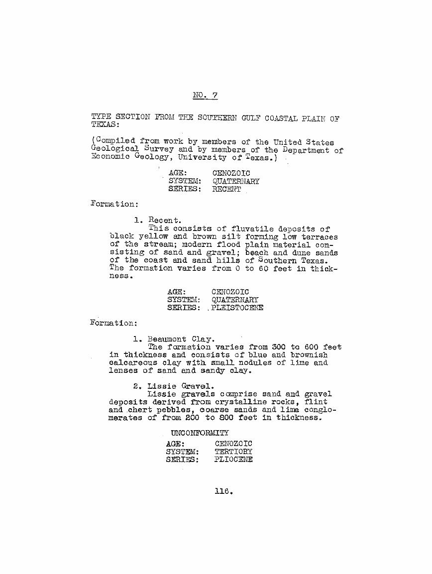
NO.7
TYPE SECTION FROl~ THE SOUTHEm~ GULF COASTAL PLAII'J OFTEXAS:
(Compiled from work by members of the United StatesGeological Survey and by members of the Department ofEconomic Geology, University ot Texas.)
Formation:
AGE.:SYSTID¥!:SERIES:
CENOZOICQUATERl{ARYRECm\lT
1. Recent.This consists of fluvatile deposits of
black yel~ow and brown silt forming low terracesof the stream; modern flood plain material consisting of sand and gravel; beach and dune sandsof the coast and sand hills of Southern Texas.The formation varies from 0 to 60 teet in thiokness.
AGE: CENOZOICSYSTEM:: QUATERNARYSERIES: .PLEISTOCENE
Formation:
1. Beaumont Clay.The formation varies from 300 to 600 feet
in thicknesS and consists of blue and brownishcalcareous o~ay with. small nodules of lime andlenses of sand and sandy olay.
2. Lissie Gravel.Lissie gravels c~rise sand and grave~
deposits derived from crystalline rocks, flintand .chert pebbles, eoarse sands and lime conglomerates of from 200 to soq teet in thickness.
. UNCONFORMITYAGE: C~roZOIC
SYSTEM: TERTIORYSERIES: PLIOCENE
116.

Formation:
1. Reynosa Formation.
The formation consists of from 500 tolOOO feet of limey - conglomerates, limestonesand sandstones, and pockets or lenses of pinklimey sandy clay~ The conglomeratis have amatrix of flint, jasper, quartz and limestonepebbles.
UNCOrITORMITY•
2. Legato Clay.The ~gato clays vary from 300 to 600
reet in thickness and comprise dark colored ormottled pink, .red and green Clays, with numerous lime nodul'es and stained heavily with mangQnese in pJ.aces. The sands are rose or r'osebrown i·n c·oler.
3. LaparaSand.
This ~ormation consists of interbeddedsand and clays of about 200 feet thickness.The sands a~e sharp and include pebbles of clayand Lime concretions; the clays are red, greenand pink and in some places a conflomerate ofclay pebbles is noted. Many fragments of Pliocene age fossil bones have been found in thisformation.
UNCONFORMITY.
AGE:SYSTEM:SERIES:
CENOZOICTERTIORYMIOCENE
Formation.
1. Oakville Sandstone.The Oakville formation comprises from
200 to 800 feet of volcanic aSh, tuff fragments,bentonite, clays and shales and a few
117.

sandstones, and beds of volcanic conglomerate.This rormation seems to be derived whollyfrom f'ormer volcanos.
2. ~io Clay.
bout 200 to 400 feet of the Frio isexposed in the Gulr Coastal Plain, consistingor green and pink compact clays wi tIl smalllime nodules, greenish-gray marls, concretionsof silicious limestones stained with mangoneseand beds of volcanic Ash.
AGE: CElfOZOICSYSTFJt1:·TERTIORYSERIES: EOCE1JEGROUP: cTACKSO~T
Formation:
1. Fayette Sands~one.
The Fayette comprises 400 to 800 feetof gray sands and sandstones, brown and chocolate colored clays, lignite clays and ligniteand beds of volcanic ash, kaolin like claysand :Luller's earth. TIle clays .are leaf bearing &~d the sandstones are fossiliferous.
For:ma.tion:
AGE:SYSTm1:SERIES:GROUP:
CENOZOICTERTIORYEOCENECLAIBORlIE
1. Yegua Formation.
This formation averaging between 400to 800 feet thick, comprises brown lea~ bearing lignitic clays, ctark green clays, yellowand dark sands, and lentioular beds of lignite.The olays oarry beds and plates of seleniteand gypsum. Marine fossils are abundant.
118.

2. Cook Mountain Formation.
The Cook nlfoulltain comprises beds ofgreen sand, iron ore, lignitic clays, iron stainedclays, farruginous sandstone and sands. T.heglauconitic sands and clays predominate, weathering to iron stained soil. About 500 to 800 feet isthe thickness of this member which contains numerous marine fossils and microscopic ~oraminifera.
3. ]J!ount Selman F·onnation.
Tn is member, having a thickness 0 f be':"tween 600 to 800 teet, consists of dark green,brown and yellow sands, thin seams of iron ore,lenses of ligni te and clay and beds and concretionsof limonite. The beds in general are highly ferru~ous, and arerrarely rossiliterous.
119.

NO.8
]irETHODS AND <ADVAtfl'AGES OF GEOPHYSICAL VlORK:
120.

gravity and likewise a component or the curvature of
tIle beds. In the area of this report, tIle Torsion Bal
ance has located two domes which have not yet been
proven by the drill. :Soth are in Victoria County.
The Seismograph applies a principle very old,
being ·that·"used to measure the effect of earth cp:akes.
In field practice, a charge of dYnamite is exploded
and by careful time and distance measuring devices,the
velocity o~ the seismic wave can be measured. In nor
mal sediments the velooity of the wave increases with
depth,and by careful measurement, small increases in
velocity can be noted. From an abundance of field
work, it has been round that this increase in seismic
wave speed, indicates uplift of lower bed~. Likewise,
Seismic waves passing tl~ough the salt mass ot: a salt
dome, is increased through the salt and the dome is
detected. In Southwest Texas the Seismograph has been
responsible for two domes in Jackson County and' the Palo
Blanco Field in Brooks County.
The' Magnetometer, on application of the age old
dip needle used to looate ore bodies, has not been
121

successful in this area. The instrument embodies a
magnetic fie~d pivoted on a horizontal axis and meas
ures the vertical lnagnetic intensity_ In North and
'.Vest Texas, this has been q.uite successful where tIle'
buried granite ridges, which have a h.1gh magnetio
ertect, have caused the structure. Arter reconnais
sance over an area, isagoms o:r eq.ual magnetic. effects
are dravr!l on the map. Dependent on the area where
work is completed, high or ~ow magnetic points may
indicate structures.
The Grav1tometer, devised by Dr. Blaokburn orSan Antonio, Texas, is an instrument used to· measure
the vertioal component of gravity. This instrument
is in its early stages of develol?~nt and insufficient
field work has not yet been done to warrant reoommen
dation. The principle is that the gravity effect
eithers1.ows or increases the speed or a. radiometer
which is operated by an e~ec.tr1c current to a. small
light bulb. This eleotrical current i.s controlled to
the milliampere, that the proportionate speed may be
constant. The grav1tometer has not as yet been $ucoess
tul in the area, but is thought to have a good future.
122

Of the four above mentioned instruments, the
Gravitometer and the ~~gnetometer are not considered
tavorable tor the area. The Seismograph has proven
the taster for reconnaissance work but is not as
acourate as the Torsion Balance for detail work. A
combina t10n of the two has proven the better :tor lV'ork
in the area using the seismograph for reconnaissance
'work and the Tors1qn Balance for detail work of the
discovered structural highs or dome~.
123.

INDEX
7390505063?l12
9827
948792
104Pocket
47120
42541
68352461
990
12030
120505052
- - 1104479
Agua Dulce Field - - - - - - - - - - - - -Alworth Field - - - - - - - - -Andrews Field - - '- - - - - - - - - - -Aviators Field - - - - - - -Carolina - Texas Field - - - - - -Charco Redondo Field - - - - - - - - - - - - Cole - Bruni Field - - - - - - - - - Comparison or Well Logs and Sections from
various rields - - - - - - -Crowther Field - - - - - - - - - -Driscoll Field - - - - - - - - - - - Distribution of Present Known Favorable and
Unfavorable Reservoirs - - - - -Edna Field - - - - - - - - - - - - - - - - - Faetors Influencing the AccUmulation of Oil
and Gas in the Southern Coastal Plain ofTexas - - - - - - - - - - - - - - - - - - -
Falfurrias Dome - - - - - - - - -General Territory Covered - - - - - -Geology - - - - - - - - - - - - -Geological Map - - - - - ~ - - - - - - Government Wells Field --Gravitometer - - - - - - - - - - - - - Grubstake or Calliham Field - - - -Henne-Winch-Farris Field - - Introduction - - -Jennings Field - - - - - - Kauffman Field - KingSVille Field -Kohler and Dinn FieldsLuoas Field - - - - - - - -Lowe Field - - - - -Magnetometer - - - - - - Mathis Field - - - - - -1,~tl10ds and Advantages of GeOpllYS ical Work - -Mid Ojuelos Field - -~irando City Field ~-Mirando Valley Field

Minor Producing Areas: - - - - - - - - - - 90( Lowe Field )( ROIna Field )( Alworth Field )( rJursery Field )
Noleda or Piedras Pintas Dome - - - - - - - - 82Nursery Field - - - - - -.- - - - - - - - - - 90Oakvil~e Field - - - - - - - - - - - - - 76Oil and Gas Fields or the Southern GulfCoastal. Plain of Texas - - - - - - - - - - - 3
Palo Blanco Field - - - - - - - ~ - - - - - - 37Palangana Dome - - - - - - - - - - - - - - - 85Pettus Field - - - - - - - - - - 32Randado -Field - - - - - - - 57Refugio Field - - - - - - - - - - - - - - - - 5Reiser Field - - - - - - - - - - - - - - 66Reynosa Escarpment - - - - - - - 101Roma Field - - - - - - - - - - - 90Sand Conditions - - - - - - - - - - - - - 96Saxet Field - - - - - - - - - - - - 19Seismograph - - - - - - - - - - - - 120Schott Field - - - - - - - - - - - - - - 50Simmons City Field - - - - - - - - - - - - - 22Source of Oil-and Gas - - - - - - - - - - - 92Territory Not Considered Favorable - - - 102Three Rivers Field - - - ~ - - - - - - - 40Torsion Balance - - - - - - - - - - - - - 120Type Section from the Southern Gulf Coastal
Plain of Texas - - - - - - - - - - - - - 116Useful Fieldqork - - - - - - - - - - - - 113Valdez Field ~ - - - - - - - - - - - - - - - 59Value of Information Derived from Well Logs - 108Value of Paleontology in Correllation orSections - - - - - - - - - - - - - - - - 114
White Point Field - - - - - - - - - - - - - - 16White Point Anticline - - - - - - - - - - - - 100Wolcott Field - - ~ - - - - - - - - - - - - - 50
********************************
*******