ohio river navigation charts - lrl.usace.army.mil€¦ · ohio river navigation charts united...
TRANSCRIPT

JUNE 2010
Ohio River Navigation ChartsCairo, Illinois to Foster, Kentucky
U.S. Army Corpsof EngineersLouisville District

UNITED STATES ARMY CORPS OF ENGINEERS – LOUISVILLE DISTRICT SHEET A
NAVIGATION CHARTS AND NOTICES Navigation charts for the OHIO RIVER, within the limits of the LOUISVILLE DISTRICT, are available on our website at http://www.lrl.usace.army.mil for viewing and printing. Spiral-bound books are also available for purchase on the U.S. Government Printing Office website: http://bookstore.gpo.gov . Notices to Navigation Interests, containing data on channel conditions and location of dredges, are issued as occasions demand. Request to be placed on the mailing list to receive these notices by writing to: U.S. Army Corps of Engineers Attn: CELRL-OP 600 Dr. Martin Luther King, Jr. Place Louisville, KY 40202-0059 Charts of the Ohio River are as follows: PITTSBURGH DISTRICT: Mile 000.0 – 127.2 HUNTINGTON DISTRICT: Mile 127.2 – 436.2 LOUISVILLE DISTRICT: Mile 436.2 – 981.0 MILE POINTS
Mile points are shown on the charts at one mile intervals beginning with Mile 0 at Pittsburgh, PA (The Point). BUOYS Buoys used to mark channels in the Mississippi River System conform to the standard lateral system of buoyage on the Western Rivers of the United States. Generally, the unlighted buoys in the Ohio River are equipped with radar reflectors. All buoys are equipped with reflective material. Buoys on the left descending side of the channel reflect red. Buoys on the right descending side of the channel reflect green. Buoys are set to mark maximum navigation channel available considering channel alignment, the prevailing river stage, and obstructions. Due to ever-changing environmental conditions, the location and number of buoys on-site do not necessarily coincide with these charts. The locations of printed buoys are approximate. Buoys should always be given as wide a berth in passing as possible consistent with the length and width of vessel or tow and the width of the bend or crossing.
Buoys should always be used with caution. They may be carried off position by high water, accumulation of drift, ice, or sunk by collision or other causes. When carried off position, destroyed, or removed to prevent loss, buoys are replaced at the earliest opportunity. Navigation lights and daybeacons are also shown in approximate locations. For additional information on lights, daymarks, daybeacons, and buoyage, see the U.S Coast Guard Light List, COMDTINST M16502, current edition. FEDERAL MOORING BUOYS Federal mooring buoys are for emergency use only, except where noted. These buoys shall not be used for recreational use or fleeting operations. Vessels using emergency buoys shall contact the nearest downstream lock upon mooring and again after departure. DAMS The height of the highest fixed points on the various parts of the locks and dams are shown in feet above the zero of the pass sill gage. Exceptions are noted on pages facing the page containing the dam to which they apply.

OHIO RIVER NAVIGATION CHARTS
UNITED STATES ARMY CORPS OF ENGINEERS – LOUISVILLE DISTRICT BACK SHEET A
PERMITS – JURISDICTION In the administration of laws enacted by Congress for the protection and preservation of navigation and the navigable waters of the United States, the U.S. Army Corps of Engineers exercises jurisdiction over the Ohio River and several of its tributary streams. Work or structures in, under, or over the Ohio River or any navigable tributary, between the limits of the ordinary high water lines on both banks of the stream require prior authorization. Inquiries regarding permits for such work or structures should be addressed to: District Engineer U.S. Army Engineer District, Louisville Attn: CELRL-OP-F 600 Dr. Martin Luther King, Jr. Place Louisville, KY 40202-0059 Inquiries may be made by telephone to: (502)315-6733 VERTICAL CLEARANCE Vertical clearances under bridges and aerial crossings are shown on back of charts preceding page showing respective features at project pool stage.
Existing clearances may be determined at open river stages, with reasonable accuracy, by method outlined in “EXAMPLE” below: EXAMPLE - CSX R.R. Bridge (Chart 41)
(All Clearances are in feet) RR Bridge Low Steel Elevation = 420.7 Evansville Gage “0” Elevation = 329.2 Current Gage Reading 43.0 Evansville “0” elevation 329.2 Water Surface elevation 372.2 RR Bridge Low Steel = 420.7 Water Surface el. = 372.2 Vertical Clearance = 48.5
(Normal Pool Clearance)
Elevation of Low Steel = 420.7 Evansville Gage Project Normal Pool Gage 12.8 = 342.0 Clearance at Normal Pool = 78.7
(Using 1937 HW Readings)
Elevation of Low Steel = 420.7
1937 High Water (H.W.) 53.75 Current Reading - 43.00
(Distance in feet below H.W.)= 10.75 CSX R.R. Bridge:
1937 H.W. Clearance + 39.30 Current Clearance = 50.05
1937 High Water (H.W.) Gage Reading GAGE READING
Meldahl Lower Gage 75.50 Broadway 80.00 Cincinnati, OH U.S.W.B. 79.99 Upper Gage 41.10 Markland Dam Lower Gage 76.10
Madison, IN 72.30 Upper Gage 52.15 McAlpine Dam Lower Gage 85.44 Upper Gage 34.00 Cannelton Dam Lower Gage 60.40 Upper Gage 40.00 Newburgh Dam Lower Gage 58.00
Evansville, IN 53.75 Mt. Vernon, IN 59.15
Upper Gage 46.50 John T. Myers Dam Lower Gage 64.50 Upper Gage 39.90 Smithland Dam Lower Gage 61.90
Paducah, KY 60.50 Dam 52 62.30 Dam 53 64.00 Cairo, IL 59.50

WARNING TO PLEASURE BOATERS AND FISHERMEN WHO NAVIGATE ON THE OHIO RIVER
BE DAM CONSCIOUS! UNITED STATES ARMY CORPS OF ENGINEERS – LOUISVILLE DISTRICT
WARNING - SHEET B
Areas immediately upstream and downstream of the navigation dams in the Louisville District have been designated Restricted Areas. See the Legend Sheet for symbols that mark Restricted Areas and Danger Areas. In recent years, there have been several boating accidents and fatalities as a result of vessels, particularly small fishing craft, operating too closely to navigation structures. Most of these accidents have occurred when boats approach too near the downstream side of a gated dam. Powerful reverse currents, commonly called backlash, draw boats in an upstream direction into the dam where there are capsized or smashed against the structure. Furthermore, an additional hazard exists in the vicinity of the lock discharge structures, which are located adjacent to the downstream river wall of the lock chamber. When the water in the locks is released during each locking operation, sudden turbulent boils are created which can capsize a boat venturing too near. This turbulence becomes more severe as the downstream pool falls to lower elevations. On the upstream side of the dam, there is a strong undertow created by the flow of water through the gated section of the dam. Boats approaching too closely from the upstream side are in danger of being lodged against the dam or capsized by the undertow. The nature of these river conditions emphasizes the serious danger to boaters and fishermen who operate their craft near either the upstream or downstream side of a dam. Vessel operators who enter these areas risk their lives and property and often preclude necessary gate operations of the locks and dams. Fishermen often fish in the tailwaters below the dam gates because the fishing is good. They must understand, however, that fishing from a boat in these waters can be fatal. To supplement the restricted areas, the remaining area downstream of each dam, extending to the end of the long wall has been established as a Danger Area. All boaters and fishermen are urged to wear Personal Floatation Devices (PFDs) within this area, since these waters are frequently turbulent. Vessel operators should also heed
the warning sirens which indicate that project personnel will be increasing flow from the dam or releasing water within the lock discharge areas. These sirens will be operated for a period of 30 seconds, after which, there will be a 3-minute delay prior to a release of water. Navigators should become fully aware of the Restricted and Danger Area boundaries prior to operating their craft within the vicinity of a lock and dam facility. The Restricted Areas are shown in the current publication of the U.S. Army Corps of Engineers, Louisville District, “Ohio River Navigation Charts; Cairo, IL to Foster, KY.” Navigators should also observe all warning signs or marker buoys located within the area of each locks and dam structure. The marker buoys are illustrated with reflective orange bands and waterway symbols, and black wording on a white background. Buoys with the words “KEEP OUT” have, as their symbol, a cross enclosed within a diamond. Buoys designated as “DANGER DAM” are denoted with a diamond symbol. The regulations pertaining to the Restricted Areas are contained within the U.S. Army Corps of Engineers’ “Regulations Prescribed by the Secretary of the Army for Ohio River, Mississippi River above Cairo, IL and their tributaries; Use, Administration, and Navigation” (Blue Book). These regulations are as follows: 33 CFR 207.300 “(s) Restricted Areas at Locks and Dams. All waters immediately above and below each dam, as posted by the respective District Engineers, are hereby designated as Restricted Areas. No vessel or other floating craft shall enter any such Restricted area at any time. The limits of the restricted areas at each dam will be determined by the responsible District Engineer and marked by signs and/or flashing red lights installed in conspicuous and appropriate places.” Lockmasters will enforce adherence to these regulations and, if required, solicit aid from local law enforcement officers. In the interest of public safety, please tell other boaters or fishermen about the dangers of boating near lock and dam structures.

REGULATIONS PRESCRIBED BY THE SECRETARY OF THE ARMY FOR THE OHIO RIVER ABOVE CAIRO, IL AND ITS TRIBUTARIES;
USE, ADMINISTRATION, AND NAVIGATION
UNITED STATES ARMY CORPS OF ENGINEERS – LOUISVILLE DISTRICT REGULATIONS - SHEET C
Section 7 of the River and Harbor Act of August 8, 1917 "That it shall be the duty of the Secretary of War to prescribe such regulations for the use, administration, and navigation of the navigable waters of the United States as in his judgment the public necessity may require for the protection of life and property, or of operations of the United States in channel improvement, covering all matters not specifically delegated by law to some other executive department. Such regulations shall be posted, in conspicuous and appropriate places, for the information of the public; and every person and every corporation which shall violate such regulations shall be deemed guilty of a misdemeanor and on conviction thereof in any district court of the United States within whose territorial jurisdiction such offense may have been committed, shall be punished by a fine not exceeding $500, or by imprisonment (in the case of a natural person) not exceeding six months, in the discretion of the court." In pursuance of the law above quoted, the following regulations were prescribed to govern the use, administration, and navigation of the Ohio River above Cairo, IL and its tributaries.
Use, Administration, and Navigation 207.300 Ohio River, above Cairo, IL, and their tributaries; use, administration, and navigation. a) Authority of Lockmasters The lockmaster shall be charged with the immediate control and management of the lock, and of the area set aside as the lock area, including the lock approach channels. He shall see that all laws, rules, and regulations for the use of the lock and lock area are duly complied with, to which end he is authorized to give all necessary orders and directions in accordance therewith, both to employees of the Government and to any and every person within the limits of the lock or lock area, whether navigating the lock or not. No one shall cause any movement of any vessel, boat, or other floating thing in the lock or approaches except by or under the direction of the lockmaster or his assistants. In the event of an emergency, the lockmaster may depart from these regulations as he deems necessary. The lockmasters shall also be charged with the control and management of federally constructed mooring facilities. b) Safety Rules for Vessels Using Navigation Locks
The following safety rules are hereby prescribed for vessels in the locking process, including the act of approaching or departing a lock: I) Tows with flammable or hazardous cargo barges, loaded or empty (i) Stripping barges or transferring cargo is prohibited. (ii) All hatches on barges used to transport flammable or hazardous materials shall be closed and latched, except those barges carrying a gas-free certificate. (iii) Spark-proof protective rubbing fenders ("possums") shall be used. II) All Vessels (i) Leaking vessels may be excluded from locks until they have been repaired to the satisfaction of the Lockmaster. (ii) Smoking, open flames, and chipping or other spark producing activities are prohibited on deck during the locking cycle.

REGULATIONS PRESCRIBED BY THE SECRETARY OF THE ARMY FOR THE OHIO RIVER ABOVE CAIRO, IL AND ITS TRIBUTARIES;
USE, ADMINISTRATION, AND NAVIGATION
UNITED STATES ARMY CORPS OF ENGINEERS – LOUISVILLE DISTRICT REGULATIONS – BACK SHEET C
(iii) Painting will not be permitted in the lock chamber during the locking cycle. (iv) Tow speeds shall be reduced to a rate of travel such that the tow can be stopped by checking should mechanical difficulties develop. Pilots should check with the individual lockmasters concerning prevailing conditions. It is also recommended that pilots check their ability to reverse their energies prior to beginning an approach. Engines shall not be turned off in the lock until the tow has stopped and been made fast. (v) U.S. Coast Guard Regulations require all vessels to have on board life saving devices for prevention of drowning. All crew members of vessels required to carry work vests (life jackets) shall wear them during a lockage, except those persons in an area enclosed with a handrail or other device which would reasonably preclude the possibility of falling overboard. All deckhands handling lines during locking procedures shall wear a life jacket. Vessels not required by Coast Guard Regulations to have work vests aboard shall have at least the prescribed life saving devices, located for ready access and use if needed. The lockmaster may refuse lockage to any vessel which fails to conform to the above.
c) Reporting of Navigation Incidents In furtherance of increased safety on waterways the following safety rules are hereby prescribed for all navigation interests: I) Any incident resulting in uncontrolled barges shall immediately be reported to the nearest lock. The report shall include information as to the number of loose barges, their cargo, and the time and location where they broke loose. The lockmaster or locks shall be kept informed of the progress being made in bringing the barges under control so that he can initiate whatever actions may be warranted. II) Whenever barges are temporarily moored at other than commercial terminals or established fleeting areas, and their breaking away could endanger a lock, the nearest lock shall be so notified, preferably the downstream lock. III) Sunken or sinking barges shall be reported to the nearest lock both downstream and upstream of the location in order that other traffic passing these points may be advised of the hazards. IV) In the event of an oil spill, notify the nearest lock downstream, specifying the time and location of the incident, type of oil, amount of spill,
and what recovery or controlling measures are being employed. V) Any other activity on the waterways that could conceivably endanger navigation or a navigation structure shall be reported to the nearest lock. VI) Whenever it is necessary to report an incident involving uncontrolled, sunken or sinking barges, the cargo in the barges shall be accurately identified. d) Precedence at Locks I) The vessel arriving first at a lock shall normally be first to lock through, but precedence shall be given to vessels belonging to the United States. Licensed commercial passenger vessels operating on a published schedule or regularly operating in the "for hire" trade shall have precedence over cargo tows and like craft. Commercial cargo tows shall have precedence over recreational craft, except as described in paragraph (f).

REGULATIONS PRESCRIBED BY THE SECRETARY OF THE ARMY FOR THE OHIO RIVER ABOVE CAIRO, IL AND ITS TRIBUTARIES;
USE, ADMINISTRATION, AND NAVIGATION
UNITED STATES ARMY CORPS OF ENGINEERS – LOUISVILLE DISTRICT REGULATIONS - SHEET D
II) Arrival posts or markers maybe established above and/ or below the locks. Vessels arriving at or opposite such posts or markers will be considered as having arrived at the locks within the meaning of this paragraph. Precedence may be established visually or by radio communication. The lockmaster may prescribe such departure from the normal order of precedence as in his judgment is warranted to achieve best lock utilization. e) Unnecessary Delay at Locks Masters and pilots must use every precaution to prevent unnecessary delay in entering or leaving locks. Vessels failing to enter locks with reasonable promptness when signaled to do so shall lose their turn. Rearranging or switching of barges in the locks or in approaches is prohibited unless approved or directed by the lockmaster. This is not meant to curtail "jackknifing" or set-overs where normally practiced. f) Lockage of Recreation Craft In order to fully utilize the capacity of the lock, the lockage of recreational craft shall be expedited by locking them through with commercial craft, provided that both parties agree
to joint use of the chamber. When recreational craft are locked simultaneously with commercial tows, the lockmaster will direct, whenever practicable, that the recreational craft enter the lock and depart while the tow is secured in the lock. Recreational craft will not be locked through with vessels carrying volatile cargoes or other substances likely to emit toxic or explosive vapors. If the lockage of recreational craft can not be accomplished within the time required for three other lockage of recreational craft shall be made. Recreational craft operators are advised that many locks have a pull chain located at each end of the lock which signals the lockmaster that lockage is desired. g) Simultaneous Lockage of Tows with Dangerous Cargoes Simultaneous lockage of other tows with tows carrying dangerous cargoes or containing flammable vapors normally will only be permitted when there is agreement between the lockmaster and both vessel masters that the simultaneous lockage can be executed safely. He shall make a separate decision each time such action seems safe and appropriate, provided:
I) The first vessel, or tow in, and the last vessel, or tow out, are secured before the other enters or leaves. II) Any vessel or tow carrying dangerous cargoes is not leaking. III) All masters involved have agreed to the joint use of the lock chamber. h) Stations While Awaiting Lockage Vessels awaiting their turn to lock shall remain sufficiently clear of the structure to allow unobstructed departure for the vessel leaving the lock. However, to the extent practicable under the prevailing conditions, vessels and tows shall position themselves so as to minimize approach time when signaled to do so. i) Stations While Awaiting Access Through Navigable Pass When navigable dams are up or are in the process of being raised or lowered, vessels desiring to use the pass shall wait outside the limits of the approach points unless authorized otherwise by the Lockmaster. j) Signals Signals from vessels shall ordinarily be by whistle; signals from locks to vessels shall be by whistle, another sound device, or visual means.

REGULATIONS PRESCRIBED BY THE SECRETARY OF THE ARMY FOR THE OHIO RIVER ABOVE CAIRO, IL AND ITS TRIBUTARIES;
USE, ADMINISTRATION, AND NAVIGATION
UNITED STATES ARMY CORPS OF ENGINEERS – LOUISVILLE DISTRICT REGULATIONS – BACK SHEET D
When a whistle is used, long blasts of the whistle shall not exceed 10 seconds and short blasts of the whistle shall not exceed 3 seconds. Where a lock is not provided with a sound or visual signal installation, the lockmaster will indicate by voice or by the wave of a hand when the vessels may enter or leave the lock. Vessels must approach the locks with caution and shall not enter nor leave the lock until signaled to do so by the lockmaster. The following lockage signals are prescribed: I) Sound Signals by Means of a Whistle These signals apply at either a single lock or twin locks. (i) Vessels desiring lockage shall on approaching a lock give the following signals at a distance of not more than one mile from the lock: (a) If a single lockage only is required: One long blast of the whistle followed by one short blast. (b) If a double lockage is required: One long blast of the whistle followed by two short blasts.
(ii) When the lock is ready for entrance, the lock will give the following signals: (a) One long blast of the whistle indicates permission to enter the lock chamber in the case of a single lock or to enter the landward chamber in the case of twin locks. (b) Two long blasts of the whistle indicates permission to enter the riverward chamber in the case of twin locks. (iii) Permission to leave the locks will be indicated by the following signals given by the lock: (a) One short blast of the whistle indicates permission to leave the lock chamber in the case of a single lock or to leave the landward chamber in the case of twin locks. (b) Two short blasts of the whistle indicates permission to leave the riverward chamber in the case of twin locks. (iv) Four or more short blasts of the lock whistle delivered in rapid succession will be used as a means of attracting attention, to indicate caution, and to signal danger. This signal will be used to attract the attention of the captain and crews of vessels using or approaching the lock or navigating in its vicinity
and to indicate that something unusual involving danger or requiring special caution is happening or is about to take place. When this signal is given by the lock, the captains and crew of vessels in the vicinity shall immediately become on the alert to determine the reason for the signal and shall take the necessary steps to cope with the situation. II) Lock Signal Lights At locks where density of traffic or other local conditions make it advisable, the sound signals from the lock will be supplemented by signal lights. Flashing lights (showing a one-second flash followed by a two-second eclipse) will be located on or near each end of the land wall to control use of a single lock or of the landward lock of double locks. In addition, at double locks, interrupted flashing lights (showing a one-second flash, a one-second eclipse and a one-second flash, followed by a three-second eclipse) will be located on or near each end of the intermediate wall to control use of the riverward lock. Navigation will be governed as follows:

REGULATIONS PRESCRIBED BY THE SECRETARY OF THE ARMY FOR THE OHIO RIVER ABOVE CAIRO, IL AND ITS TRIBUTARIES;
USE, ADMINISTRATION, AND NAVIGATION
UNITED STATES ARMY CORPS OF ENGINEERS – LOUISVILLE DISTRICT REGULATIONS - SHEET E
Red Light - Lock cannot be made ready immediately. Vessel shall stand clear. Amber Light - Lock is being made ready. Vessel may approach but under full control. Green Light - Lock is ready for entrance. Green and Amber Lights - Lock is ready for entrance but gates cannot be recessed completely. Vessel may enter under full control and with extreme caution. III) Radio Communication VHF-FM radios, operating in the FCC authorized Maritime Band, have been installed at all operational locks, (except those at Lock 3, Green River). Radio contact may be made by any vessel desiring passage. Commercial tows are especially requested to make contact at least one half hour before arrival in order that the pilot may be informed of current river and traffic conditions that may affect the safe passage of his tow. All locks monitor 156.8 MHz (Ch. 16) and 156.65 MHz (Ch. 13) and can work 156.65 MHz (Ch. 13) and 156.7 MHz (Ch. 14). Ch. 16 is the authorized call, reply and distress frequency, and locks are not permitted to work
on this frequency except in an emergency involving the risk of immediate loss of life or property. Vessels may call and work Ch. 13, without switching, but are cautioned that vessel to lock traffic must not interrupt or delay Bridge to Bridge traffic which has priority at all times. k) Rafts Rafts to be locked through shall be moored in such manner as not to obstruct the entrance of the lock, and if to be locked in sections, shall be brought to the lock as directed by the lockmaster. After passing the lock the sections shall be reassembled at such distance beyond the lock as not to interfere with other vessels. l) Entrance to and Exit from Locks In case two or more boats or tows are to enter for the same lockage, their order of entry shall be determined by the lockmaster. Except as directed by the lockmaster, no boat shall pass another in the lock. In no case will boats be permitted to enter or leave the locks until directed to do so by the lockmaster. The sides of all craft passing through any lock
shall be free from projections of any kind which might injure the lock walls. All vessels shall be provided with suitable fenders, and shall be used to protect the lock and guide walls until it has cleared the lock and guide walls. m) Mooring I) At Locks (i) All vessels when in the locks shall be moored as directed by the lockmaster. Vessels shall be moored with bow and stern lines leading in opposite directions to prevent the vessel from "running" in the lock. All vessels will have one additional line available on the head of the tow for emergency use. The pilothouse shall be attended by qualified personnel during the entire locking procedure. When the vessel is securely moored, the pilot shall not cause movement of the propellers except in emergency or unless directed by the lockmaster. Tying to lock ladders is strictly prohibited. (ii) Mooring of unattended or non-propelled vessels or small craft at the upper or lower channel approaches will not be permitted within 1200 feet of the lock.

REGULATIONS PRESCRIBED BY THE SECRETARY OF THE ARMY FOR THE OHIO RIVER ABOVE CAIRO, IL AND ITS TRIBUTARIES;
USE, ADMINISTRATION, AND NAVIGATION
UNITED STATES ARMY CORPS OF ENGINEERS – LOUISVILLE DISTRICT REGULATIONS – BACK SHEET E
II) Outside of Locks (i) No vessel or other craft shall regularly or permanently moor in any reach of a navigation channel. The approximate centerline of such channels is marked as the sailing line on Corps of Engineers navigation charts. Nor shall any floating craft, except in an emergency, moor in any narrow or hazardous section of the waterway. Furthermore, all vessels or other craft are prohibited from regularly or permanently mooring in any section of navigable waterways which are congested with commercial facilities or traffic unless it is moored at facilities approved by the Secretary of the Army or his authorized representative. The limits of the congested areas shall be marked on Corps of Engineers navigation charts. However, the District Engineer may authorize in writing exceptions to any of the above if, in his judgment, such mooring would not adversely affect navigation and anchorage. (ii) No vessel or other craft shall be moored to railroad tracks, to riverbanks in the vicinity of railroad tracks when such mooring threatens the safety of equipment
using tracks, to telephone poles or power poles, or to bridges or similar structures used by the public. (iii) Except in case of great emergency, no vessel or craft shall anchor over revetted banks of the river, and no floating plant other than launches and similar small craft shall land against banks protected by revetment except at regular commercial landings. In all cases, every precaution to avoid damage to the revetment works shall be exercised. The construction of log rafts along mattressed or paved banks or the tying up and landing of log rafts against such banks shall be performed in such a manner as to cause no damage to the mattress work or bank paving. Generally, mattress work extends out into the river 600 feet from the low water line. (iv) Any vessel utilizing a federally constructed mooring facility (e.g. cells, buoys, anchor rings) at the points designated on the current issue of the Corps navigation charts shall advise the lockmaster at the nearest lock that from point by the most expeditious means.
n) Draft of Vessels No vessel shall attempt to enter a lock unless its draft is at least three inches less than the least depth of water over the guard sills or over the gates sills if there be no guard sills. Information concerning controlling depth over sills can be obtained from the lockmaster at each lock or by inquiry at the office of the district engineer of the district in which the lock is located. o) Handling Machinery No one but employees of the United States shall move any lock machinery except as directed by the lockmaster. Tampering or meddling with the machinery or other parts of the lock is strictly forbidden. p) Refuse in Locks Placing or discharging refuse of any description into the lock, on lock walls or esplanade, canal or canal bank is prohibited. q) Damage to Locks or Other Work To avoid damage to plant and structures connected with the construction or repair of locks and dams, vessels passing structures in

REGULATIONS PRESCRIBED BY THE SECRETARY OF THE ARMY FOR THE OHIO RIVER ABOVE CAIRO, IL AND ITS TRIBUTARIES;
USE, ADMINISTRATION, AND NAVIGATION
UNITED STATES ARMY CORPS OF ENGINEERS – LOUISVILLE DISTRICT REGULATIONS - SHEET F
the process of construction or repair shall reduce their speed and navigate with special caution while in the vicinity of such work. The restrictions and admonitions contained in these regulations shall not affect the liability of the owners and operators of floating craft for any damage to locks or other structures caused by the operation such craft. r) Trespass on Lock Property Trespass on locks or dams or other United States property pertaining to the locks and dams is strictly prohibited except in those areas specifically permitted. Parties committing any injury to the locks and dams or to any part thereof will be responsible therefore. Any person committing a willful injury to any United States property will be prosecuted. No fishing will be permitted from lock walls, guide walls, or guard walls of any lock or from any dam, except in areas designated and posted by the responsible District Engineer as fishing areas. Personnel from commercial and recreational craft will be allowed on the lock structure for legitimate business
reasons; e.g., crew changes, emergency phone calls, etc. s) Restricted Areas at Locks and Dams All water immediately above and below each dam, as posted by the respective District Engineers, are hereby designated as restricted areas. No vessel or other floating craft shall enter any such restricted area at any time. The limits of the restricted areas at each dam will be determine by the responsible District Engineer and marked by signs and/or flashing red lights installed in conspicuous and appropriate places. t) Statistical Information I) Masters of vessels shall furnish to the lockmaster such statistics of passengers or cargo as may be requested. II) The owners or masters of vessels sunk in the navigable waters of the United States shall provide the appropriate District Engineer with a copy of the sunken vessel report furnished to the U.S. Coast Guard Marine Inspection Office in accordance with Code of Federal
Regulations Title 33 Subpart 64.10-1. u) Operations during High Water and Floods in Designated Vulnerable Areas Vessels operating on these waters during periods when river stages exceed the level of "ordinary high water," as designated on Corps of Engineers navigation charts, shall exercise reasonable care to minimize the effect of their bow waves and propeller washes on river banks; submerged or partially submerged structures or habitations; terrestrial growth such as trees and bushes; and manmade amenities that may be present. Vessels shall operate carefully when passing close to levees and other flood protection works, and shall observe minimum distances from banks which may be prescribe from time to time in Notices to Navigation Interests. Pilots should exercise particular care not to direct propeller wash at river banks, levees, revetments, structures or other appurtenances subject to damage from wave action.

REGULATIONS PRESCRIBED BY THE SECRETARY OF THE ARMY FOR THE OHIO RIVER ABOVE CAIRO, IL AND ITS TRIBUTARIES;
USE, ADMINISTRATION, AND NAVIGATION
UNITED STATES ARMY CORPS OF ENGINEERS – LOUISVILLE DISTRICT REGULATIONS – BACK SHEET F
v) Navigation Lights for Use at All Locks and Dams I) At locks at all fixed dams and at locks at all movable dams when the dams are up so that there is no navigable pass through the dam, the following navigation lights will be displayed during hours of darkness: (i) Three green lights visible through an arc of 360° arranged in a vertical line on the upstream end of the river (guard) wall unless the intermediate wall extends farther upstream. In the latter case, the lights will be placed on the upstream end of the intermediate wall. (ii) Two green lights visible through an arc of 360° arranged in a vertical line on the downstream end of the river (guard) wall unless the intermediate wall extends farther downstream. In the latter case, the lights will be placed on the downstream end of the intermediate wall. (iii) A single red light, visible through an arc of 360° on each end (upstream and downstream) of the land (guide) wall. II) At movable dams when the dam has been lowered or partly lowered so
that there is an unobstructed navigable pass through the dam, the navigation lights indicated in the following paragraphs will be displayed during hours of darkness until lock walls and weir piers are awash. (i) Three red lights visible through an arc of 360° arranged in a vertical line on the upstream end of the river (guard) wall. (ii) Two red lights visible through an arc of 360° arranged in a vertical line on the downstream end of the river (guard) wall. (iii) A single red light visible through an arc of 360° on each end (upstream and downstream) of the land (guide) wall. III) After lock walls and weir piers are awash they will be marked as prescribed in paragraph (x) below. IV) If one or more bear traps or weirs are open or partially open, and may cause a set in current conditions at the upper approach to the locks, this fact will be indicated by displaying a white circular disk 5 feet in diameter, on or near the light support on the upstream end of the land (guide) wall during the hours of daylight,
and will be indicated during hours of darkness by displaying a white (amber) light vertically under and 5 feet below the red light on the upstream end of the land (guide) wall. V) At Locks No. 1 and 2, Green River, when the locks are not in operation because of high river stages, a single red light visible through an arc of 360° will be displayed on each end (upstream and downstream) of the lock river (guard) wall at which time the lights referred to above will not be visible. w) Navigation Lights for Use at Locks and Dams on the Green River A single red light visible through an arc of 360° shall be displayed during hours of darkness at each end of the river wall or extending guard structures until these structures are awash.

REGULATIONS PRESCRIBED BY THE SECRETARY OF THE ARMY FOR THE OHIO RIVER ABOVE CAIRO, IL AND ITS TRIBUTARIES;
USE, ADMINISTRATION, AND NAVIGATION
UNITED STATES ARMY CORPS OF ENGINEERS – LOUISVILLE DISTRICT REGULATIONS - SHEET G
x) Buoys at Movable Dams I) Whenever the river (guard) wall of the lock and any portion of the dam are awash, and until covered by a depth, the limits of the navigable pass through the dam will be marked by buoys located at the upstream and downstream ends of the river (guard) wall, and by a single buoy over the end or ends of the portion or portions of the dam adjacent to the navigable pass over which project depth is not available. A red nun-type buoy will be used for such structures located on the left-hand side (facing downstream) of the river and a green can-type buoy for such structures located on the right-hand side. Buoys will be lighted, if practicable. II) Where powerhouses or other substantial structures projecting considerably above the level of the lock wall are located on the river (guard) wall, a single red light located on top of one of these structures maybe used instead of river wall buoys prescribed above until these structures are awash, after which they will be marked by a buoy of appropriate type and color (red nun or green can buoy) until
covered by a depth of water equal to the project depth. Buoys will be lighted, if practicable. y) Vessels to Carry Regulations A copy of these regulations shall be kept at all times on board each vessel regularly engaged in navigating the rivers to which these regulations apply. Copies may be obtained from any lock office or District Engineer’s office on request. Masters of such vessels are encouraged to have on board copies of the current edition of appropriate navigation charts.

EXTRACT FROM THE RIVER AND HARBOR ACT OF 1899
UNITED STATES ARMY CORPS OF ENGINEERS – LOUISVILLE DISTRICT RIVER AND HARBOR ACT - SHEET H
SECTION 15 That it shall not be lawful to tie up or anchor vessels or other craft in navigable channels in such a manner as to prevent or obstruct the passage of other vessels or craft; or to sink, or permit or cause to be sunk, vessels or other craft in navigable channels; or to float loose timber and logs, or to float what is known as sack rafts of timber and logs in streams or channels actually navigated by steamboats in such manner as to obstruct, impede, or endanger navigation. And whenever a vessel, raft, or other craft is wrecked and sunk in a navigable channel, it shall be the duty of the owner, lessee, or operator of such sunken craft to immediately mark it with a buoy or beacon during the day and a lighted lantern at night, and to maintain such marks until the sunken craft is removed or abandoned, and the neglect or failure of the said owner, lessee, or operator to do so shall be unlawful; and it shall be the duty of the owner, lessee, or operator of such sunken craft to commence the immediate removal of the same, and prosecute such removal diligently, and failure to do so shall be considered as an abandonment of such craft, and subject the same to removal by the United States as hereinafter provided for (30 St. 1152; 33 U.S.C. §409). SECTION 16 That every person and every corporation that shall violate, or that shall knowingly aid, abet, authorize, or instigate a violation of the provisions of sections thirteen, fourteen, and fifteen of this Act shall be guilty of a misdemeanor, and on conviction thereof shall be punished by a fine not exceeding twenty-five hundred dollars nor less than five hundred dollars, or by imprisonment (in the case of a natural person) for not less than thirty days nor more than one year, or by both such fine and imprisonment, in the discretion of the court, one-half of said fine to be paid to the person or persons giving information which shall lead to conviction (30 Stat. 1153; 33 U.S.C §411). And any and every master, pilot, and engineer, or person or persons acting in such capacity,
respectively, on board of any boat or vessel who shall knowingly engage in towing any scow, boat, or vessel loaded with any material specified in section thirteen of this Act to any point or place or deposit or discharge in any harbor or navigable water, elsewhere than within the limits defined and permitted by the Secretary of War, or who shall willfully injure or destroy any work of the United States contemplated in section fourteen of this Act, or who shall willfully obstruct the channel of any waterway in the manner contemplated in section fifteen of this Act, shall be deemed guilty of a violation of this Act, and shall upon conviction be punished as hereinbefore provided in this section, and shall also have his license revoked or suspended for a term to be fixed by the judge before whom tried and convicted. And any boat, vessel, scow, raft, or other craft used or employed in violating any of the provisions of sections thirteen, fourteen, and fifteen of this Act shall be liable for the pecuniary penalties specified in this section, and in addition thereto for the amount of the damages done by said boat, vessel, scow, raft, or other craft, which latter sum of the harbor or waterway in which the damage occurred, and said boat, vessel, scow, raft, or other craft may be proceeded against summarily by way of libel in any district court of the United States having jurisdiction thereof (30 Stat. 1153; 33 U.S.C. §412). SECTION 19 (a) That whenever the navigation of any river, lake, harbor, sound, bay, canal, or other navigable waters of the United States shall be obstructed or endangered by any sunken vessel, boat, watercraft, raft, or other similar obstruction, and such obstruction has existed for a longer period than thirty days, or whenever the abandonment of such obstruction can be legally established in a less space of time, the sunken vessel, boat, watercraft, raft, or other obstruction shall be subject to be broken up, removed, sold, or otherwise disposed of by the

EXTRACT FROM THE RIVER AND HARBOR ACT OF 1899
UNITED STATES ARMY CORPS OF ENGINEERS – LOUISVILLE DISTRICT RIVER AND HARBOR ACT – BACK SHEET H
Secretary of War at his discretion, without liability for any damage to the owners of the same; PROVIDED, That in his discretion, the Secretary of War may cause reasonable notice of such obstruction of not less than thirty days, unless the legal abandonment of the obstruction can be established in less time, to be given by publication, addressed “To whom it may concern”, in a newspaper published nearest to the locality of the obstruction, requiring the removal thereof; AND PROVIDED ALSO, That the Secretary of War may, in his discretion, at or after the time of giving such notice, cause sealed proposals to be solicited by public advertisement, giving reasonable notice of less than ten days, for the removal of such obstruction as soon as possible after the expiration of the above specified thirty days’ notice, in case it has not in the meantime been so removed, these proposals and contracts, at his discretion, to be conditioned that such vessel, boat, watercraft, raft, or other obstruction, and all cargo and property contained therein, shall become the property of the contractor, and the contract shall be awarded to the bidder making the proposition most advantageous to the United States; PROVIDED, That such bidder shall give satisfactory security to execute the work; PROVIDED FURTHER, That any money received from the sale of any such wreck, or from any contractor for the removal of wrecks, under this paragraph shall be covered into the Treasury of the United States (30 Stat. 1154; 33 U.S.C. §414). (b) The owner, lessee, or operator of such vessel, boat, watercraft, raft, or other obstruction as described in this section shall be liable to the United States for the cost of removal or destruction and disposal as described which exceeds the costs recovered under subsection (a). Any amount recovered from the owner, lessee, or operator of such vessel pursuant to this subsection to recover costs in excess of the proceeds from the sale or disposition of such vessel shall be deposited in the general fund of the Treasury of the United States.
SECTION 20
(a) That under emergency, in the case of any vessel, boat, watercraft, raft, or similar obstruction, sinking or grounding, or being unnecessarily delayed in any Government canal or lock, or in any navigable waters mentioned in section nineteen, in such manner as to stop, seriously interfere with, or specially endanger navigation, in the opinion of the Secretary of War, or any agent of the United States to whom the Secretary may delegate proper authority, the Secretary of War or any such agent shall have the right to take immediate possession of such boat, vessel, or other watercraft, or raft, so far as to remove or to destroy it and to clear immediately the canal, lock, or navigable waters aforesaid of the obstruction thereby caused, using his best judgment to prevent any unnecessary injury; and no one shall interfere with or prevent such removal or destruction; PROVIDED, That the officer or agent charged with the removal or destruction of an obstruction under this section may in his discretion give notice in writing to the owners of any such obstruction requiring them to remove it; AND PROVIDED FURTHER, That the expense of removing any such obstruction as aforesaid shall be a charge against such craft and cargo; and if the owners thereof fall or refuse to reimburse the United States for such expense within thirty days after notification, then the officer or agent aforesaid may sell the craft or cargo, or any part thereof that may not have been destroyed in removal, and the proceeds of such sale shall be covered into the Treasury of the United States (30 Stat. 1154; 33 U.S.C. §415).
(b) The owner, lessee, or operator of such vessel, boat, watercraft, raft, or other obstruction as described in this section shall be liable to the United States for the cost of removal or destruction and disposal as described which exceeds the costs recovered under subsection (a). Any amount recovered from the owner, lessee, or operator of such vessel pursuant to this subsection to recover costs in excess of the proceeds from the sale of disposition of such vessel shall be deposited in the general fund of the Treasury of the United States.
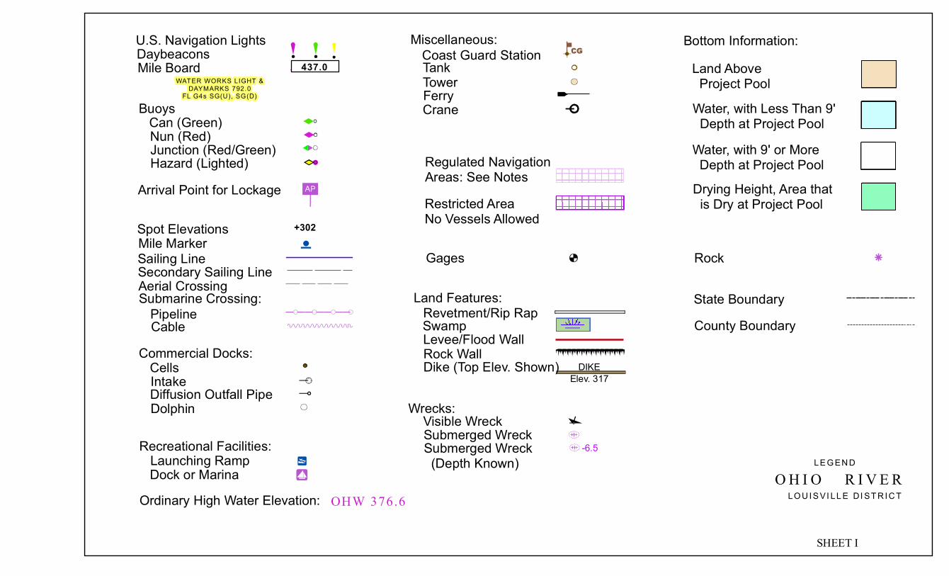
O H I O R I V E RLE G EN D
LO U I S VI LL E DI ST R I C T
SHEET I
WATER WORKS LIGHT &DAYMARKS 792.0
FL G4s SG(U), SG(D)
U.S. Navigation LightsDaybeaconsMile Board 437.0
BuoysCan (Green)Nun (Red)Junction (Red/Green)Hazard (Lighted)
Arrival Point for Lockage
Spot ElevationsSailing LineSecondary Sailing Line
+302
Aerial CrossingSubmarine Crossing:PipelineCable
Commercial Docks:CellsIntakeDiffusion Outfall PipeDolphin
Mile Marker
Recreational Facilities:Launching RampDock or Marina
Ordinary High Water Elevation: OHW 376.6
Miscellaneous:Coast Guard StationTankTowerFerryCrane
Regulated NavigationAreas: See NotesRestricted AreaNo Vessels Allowed
Gages
Land Features:Revetment/Rip RapSwampLevee/Flood WallRock Wall
Wrecks:Visible WreckSubmerged WreckSubmerged Wreck (Depth Known)
-6.5
Bottom Information:
Water, with Less Than 9' Depth at Project Pool
Land Above Project Pool
Water, with 9' or More Depth at Project PoolDrying Height, Area that is Dry at Project Pool
Rock
Dike (Top Elev. Shown) DIKEElev. 317
State BoundaryCounty Boundary

OHIO RIVER NAVIGATION CHARTS
UNITED STATES ARMY CORPS OF ENGINEERS – LOUISVILLE DISTRICT CHART INDEX - SHEET J

609
608
607
606
604
605
O H I O R I V E R
SC A LE : 1 " = 2 00 0 'RE V I S ED : J U N 20 10
CHART NO. 85
0 2,000 4,0001,000Feet
N E WA L B A N Y
PROJECT POOL CANNELTON DAM ELEV. 383.0
S A I L I N G
L I N E
I N D I A N AC L A R K C O U N T Y
S A I L I N G L I N E
S A N D I S L A N D
NOTE B:VESSEL TRAFFIC SERVICE LOU ISVILLE (VTSL)TH E VTSL AR EA CONSISTS OF THAT SEC TION OF THE OHIO R IVERBETWEEN McALPINE LOCKS (MILE 606.0 OHIO RIVER) AND TWELVEMILE ISLAN D (MILE 593.0 OHIO RIVER ) ONLY AT SUCH TIME WH ENTH E McALPINE UPPER POOL GAGE IS AT 13.0 FEET OR ABOVE.VESSEL TRAFFIC SERVICE LOU ISVILLE (VTSL) MAINTAINS ALISTEN ING GUARD ON CHANN EL 13 (156 .65 MHz) .
RESTRIC TED AREANOTE A: TITLE 33 CODE OF FEDERAL REGULATIONS, SECTION 162 .100OH IO RIVER AT LOUISVILLE, KY; REGULATED NAVIGATION AREA:(a ) TH E FOLLOWING IS A REGULATED NAVIGATION AREA: THE WATERS OF TH E OH IO RIVERFR OM CLAR K MEMORIAL BR IDGE AT MILE 603 .5, DOWNSTR EAM TOMcALPINE DAM AT MILE 604.4(b ) TH E GENERAL REGULATIONS GOVERN ING REGULATED NAVIGATION AREAS CONTAINED IN33 CFR PART 165, SUBPART B APPLY.(c ) N O VESSEL SHALL BE OPER ATED WITHIN THE REGU LATED NAVIGATION AREA AT ANY TIME WITH OUT PRIOR PERMISSION OF THE CAPTAIN OF PORT, LOUISVILLE, KY EXC EPT IN C ASE OF EMERGENCY AND FOR PASSAGE THR OU GH McALPINE LOC KS.
NOTE C :RESTRIC TED AREA: NO VESSELS ALLOWEDBELOW BRIDGE EXCEPT FOR PASSAGETH ROUGH McALPIN E LOCKS.
NOTE D :RESTRIC TED AREA: NO VESSELS ALLOWEDBELOW BRIDGE.
C L A R K S V I L L E
L O U I S V I L L E
2 4
5
6
12
SHERMAN MINTON BRIDGE (I-64)K & I RAILROAD BRIDGE
3 PORTLAND SHIPPINGPORT BRIDGE45
AERIAL POWER LINE V/C 129.8 ' @ P.P.AERIAL POWER LINES V/C 95.1 ' @ P.P.
6 L & I RAILROAD BRIDGE
ABC
JAYCEES BOAT RAMPNEW ALBANY BOAT CLUBGEORGE ROGERS CLARK PARK
D U.S. ARMY CORPS OF ENGINEERSLOUISVILLE REPAIR STATION
E ASHLAND OIL, INC.F INDIANA AMERICAN WATER CO.
INTAKE
1
A
B
D
C
E
F
64
64264
PROJECT POOL McALPINE DAM ELEV. 420 .0RESTRICTED AREA
(SEE NOTE D)
RESTRICTED AREA
(SEE NOTE C)
McALPINE DAM CREST ELEV. 423.0
FIXED WIER
L IGHTS(1) 3 AMBE R LIGHTS IN VE RTI CAL LINE(2) McALPINE VA NE DI KE LIGHT & DAYMARKS 604.3 FL G4s SG(U), S G(D)(3) CANAL HEAD LIGHT & DAYMARKS 604.3 FL(2) R5s TR(U) , TR(D)
PORTLAND CHANNEL
UPPER GATESRESTRICTED AREA
(SEE NOTES A, B, C, & D )
VANE DIKEELE V. 423.0
FALLSOF THE
OH IO
S H I P P I N G P O RT I S L A N D
VESSELS ARE REQUIRED TO REPORT 15 MINU TES PRIOR TOENTERIN G THE VTSL AREA. THIS R EPORT IS ALSO R EQUIREDOF VESSELS GETTING UND ERWAY WITH IN THE VTSL AREA.
85°49' W
85°48' W
85°48' W
85°47' W
85°47' W
85°46' W
85°45' W
38°17' N
38°17' N
38°15' N
85°50' W
85°45' W
38°16' N38°15' N
38°18' W
(1)(2)
(3)
MATCH LINE CHART 84
MATCH LINE CHART 86
LOWERGATES
McALPINE LOCKS AND DAMMILE 606.8
TELEPHONE (502) 774-3514MAXIMUM LOCKING STAGE
32.0 FEET UPPER GAGEUPPER GAGE OHW 420.0
LOWER GAGE OHW 409.5FOR LOCK INFORMATION USE
MARINE RADIO CHANNEL 13
3
K E N T U C K YJ E F F E R S O N C O U N T Y

1200+ 1000+ 800+ 600+ 400+ 200+ 0+
1200+ 1000+ 800+ 600+ 400+ 200+ 0+ +1200 +1000 +800 +600 +400 +200 +0
+1200 +1000 +800 +600 +400 +200 +0
1200+1000+800+600+400+200+0+
1200+1000+800+600+400+200+0+OHIO RIVER
LEGENDFloating mooring bitCheck postLadder
KENTUCKY
INDIANA
(PULL CHAIN FOR SMALL PLEASURE CRAFT)
PORTLAND SHIPPINGPORT BRIDGE (OHIO RIVER MILE 606.8)DOWNSTREAM VIEW
KENTUCKY SHIPPINGPORTISLAND
ELEVATION OF LOW STEELVERTICAL CLEARANCE AT POOL STAGEVERTICAL CLEARANCE - 1937 H.W.HORIZONTAL CLEARANCE
SOUTH LOCK( 110' x 1200' )
493.3373.33'33.18'
110.0'
NORTH LOCK( 110' x 1200' )
493.3373.33'33.18'
110.0'
NORTH LOCK110' x 1200'
SOUTH LOCK110' x 1200' McAlpine Locks
UPPER GAGE:ZERO ELEV.
ZERO ELEV.LOWER GAGE:
PROJECT POOL.
PROJECT POOL.
= 408.0= 12.0'
= 374.0= 9.0'
McAlpine LocksELEVATION LOOKING DOWNSTREAM
ELEVATION SHOWN IN FEET ABOVE ELEV. 408.0
-41.0' UPPER & LOWER SILLS
U.P. + 12.0' UPPER GAGE
110' 110' +35.0' TOP OF WALL
U.P. + 12.0' UPPER GAGE
ZERO UPPER GAGE
-6.0' EMERGENCY GATE SILL
-37.0' UPPER & LOWER SILLS
LAND
LOCK
1200
'
RIVE
R LO
CK 12
00'
OPER
ATIO
NS
BUILD
ING
ON M
AIN
WALL

604
603602 601
600
O H I O R I V E R
SC A LE : 1 " = 2 00 0 'RE V I S ED : J U N 20 10
CHART NO. 86
0 2,000 4,0001,000Feet
I N D I A N A C L A R K C O U N T Y
S A I L I N G L I N E
T O W H E A D I S L A N D
S O U T H F O R KB E A R G R A S S C R E E K
NOTE B:VESSEL TRAFFIC SERVICE LOU ISVILLE (VTSL)TH E VTSL AR EA CONSISTS OF THAT SEC TION OF THE OHIO R IVERBETWEEN McALPINE LOCKS (MILE 606.0 OHIO RIVER) AND TWELVEMILE ISLAN D (MILE 593.0 OHIO RIVER ) ONLY AT SUCH TIME WH ENTH E McALPINE UPPER POOL GAGE IS AT 13.0 FEET OR ABOVE.VESSEL TRAFFIC SERVICE LOU ISVILLE (VTSL) MAINTAINS ALISTEN ING GUARD ON CHANN EL 13 (156 .65 MHz) .
PROJECT DEPTH McALPINE POOL ELEV. 420 .0
RESTRIC TED AREANOTE A: TITLE 33 CODE OF FEDERAL REGULATIONS, SECTION 162 .100OH IO RIVER AT LOUISVILLE, KY; REGULATED NAVIGATION AREA:(a ) TH E FOLLOWING IS A REGULATED NAVIGATION AREA: THE WATERSOF THE OHIO RIVER FROM CLARK MEMOR IAL BRIDGE AT MILE 603.5 ,DOWNSTREAM TO McALPIN E DAM AT MILE 604 .4(b ) TH E GENERAL REGULATIONS GOVERN ING REGULATED NAVIGATION AREASCONTAINED IN 33 CFR PART 165, SU BPART B APPLY.(c ) N O VESSEL SHALL BE OPER ATED WITHIN THE REGU LATED NAVIGATION AREA ATANY TIME WITHOUT THE PERMISSION OF THE CAPTAIN OF PORT, LOUISVILLE, KYEXCEPT IN CASE OF EMERGENCY AND FOR PASSAGE THROUGH McALPINE LOCKS.
VESSELS ARE REQUIRED TO REPORT 15 MIN UTES PRIOR TOENTERIN G THE VTSL AREA. THIS REPORT IS ALSO REQUIR EDOF VESSELS GETTING UND ERWAY WITH IN THE VTSL AREA.
L O U I S V I L L E
C L A R K S V I L L E
L O U I S V I L L E
12
CLARK MEMORIAL HIGHWAY BRIDGE (US 31E)JFK MEMORIAL HIGHWAY BRIDGE ( I-65)
34
BIG FOUR RAILROAD BRIDGEAERIAL POWER LINES V/C 96.2 ' @ P.P.
K E N T U C K YJ E F F E R S O N C O U N T Y
RESTRICTED AREA(SEE NOTE A)
L IGHTS(1) McALPINE VA NE DI KE LIGHT & DAYMARKS 604.3 FL G4s SG(U), S G(D)(2) CANAL HEAD LIGHT & DAYMARKS 604.3 FL(2) R5s TR(U) , TR(D)
UPPER GATES
FALLSOF THE
OH IO
65
FG
L
A MARATHON / ASHLAND OILBC
COLGATE PALMOLIVE CO. INTAKEBUCKHEAD MOUNTAIN GRILL
DE
KINGFISH RESTAURANTCITY OF JEFFERSONVILLE RAMP
FG
JEFFBOAT, INC.KAYROUZ BOAT STORAGE
H LG&E INDUSTRIAL INTAKEIJ
BELLE OF LOUISVILLEJOE'S CRAB SHACKCOAST GUARD BOAT FACILITY
L LOUISVILLE HARBOR ASSOCIATION, INC.MN
NUGENT SAND CO.AMERICAN COMMERCIAL BARGE LINE
OP
AMERICAN COMMERCIAL BARGE LINEMARQUETTE TRANSPORTATION
QR
MARINE SALES & SERVICELOUISVILLE WATER CO.MUNICIPAL INTAKE
S KINGFISH RESTAURANT
M N O P R S
4
A
B
CD
E3H I
1
2
RESTRICTED AREA(SEE NOTE B)
85°45'
W
85°44'
W
85°44'
W
38°15' N
85°43'
W
85°42'
W
85°41'
W
38°15' N
38°17' N
38°18' N
85°42'
W
38°16' N
38°17' N38°18' N
85°43'
W
(1)(2)
OHW 422 .4
MATCH LINE CHART 87
MATCH LINE CHART 85
T
LOUISVILLE METRO POLICERIVER PATROL HEADQUARTERS(502) 574-2139MONITORS CH. 13 & 16
T
Q
K
K
J


600
599
598 597
596
K E N T U C K YO H I O R I V E R
SC A LE : 1 " = 2 00 0 'RE V I S ED : J U N 20 10
CHART NO. 87
0 2,000 4,0001,000Feet
J E F F E R S O N V I L L E
OHW 422 .5PROJECT POOL McALPINE DAM ELEV. 420 .0
J E F F E R S O N C O U N T Y
I N D I A N AC L A R K C O U N T Y
S A I L I N G L I N E
FEDERAL MOORING BUOYS
G O O S E C R E E K
H A R R O D S C R E E K
S I X M I L E I S L A N D ( K Y )
RESTRICTED AREA(SEE NOTES B)
NOTE B:VESSEL TRAFFIC SERVICE LOU ISVILLE (VTSL)TH E VTSL AR EA CONSISTS OF THAT SEC TION OF THE OHIO R IVERBETWEEN McALPINE LOCKS (MILE 606.0 OHIO RIVER) AND TWELVEMILE ISLAN D (MILE 593.0 OHIO RIVER ) ONLY AT SUCH TIME WH ENTH E McALPINE UPPER POOL GAGE IS AT 13.0 FEET OR ABOVE.VESSEL TRAFFIC SERVICE LOU ISVILLE (VTSL) MAINTAINS ALISTEN ING GUARD ON CHANN EL 13 (156 .65 MHz) .
VESSELS ARE REQUIRED TO REPORT 15 MIN UTES PRIOR TOENTERIN G THE VTSL AREA. THIS REPORT IS ALSO REQUIR EDOF VESSELS GETTING UND ERWAY WITH IN THE VTSL AREA.
A
B CD
E FG H
J
K
LM
N O
P
QR
ABC
DUFFY'S LANDINGWOOTEN RIVER SERVICECOAST GUARD AUXILIARY
DEF
DARLING RAMPADMIRALS ANCHOR MARINAEAGLE STEEL PRODUCTS
GHJ
PORT OF INDIANA -JEFFERSONVILLEMARINE BUILDERSRUBIYAT BOAT CLUB
KLM
COX'S PUBLIC PARK & RAMPLOUISVILLE BOAT CLUBK of C BOAT CLUB
NOP
JUNIPER BEACH DOCKLIMESTONE BAY MARINEMcBRIDE DRYDOCK
QR
CAPTAIN'S QUARTERS RIVERSIDE GRILLW/ CG PRINCESSCAPTAIN'S QUATERS MARINA
U T I C A
85°40' W85°41' W85°42' W
85°39' W85°38' W
38°17' N
38°20' N
85°40' W
85°41' W
85°42' W
85°39' W
85°38' W
38°17' N
38°18' N
38°18' N
38°19' N
38°19' N
38°20' N
MATCH LINE CHART 88
MATC
H LI
NE C
HART
86
OHW423 .4
SIX MILE ISLAND LIGHT &DAYMARKS 597.9
FL (2) R 5s TR(U), TR(D)

595594
593
592
K E N T U C K Y O H I O R I V E R
SC A LE : 1 " = 2 00 0 'RE V I S ED : J U N 20 10
CHART NO. 88
0 2,000 4,0001,000Feet
U T I C A
OHW 423 .5
PROJECT POOL McALPINE DAM ELEV. 420 .0
TWELVE MILE ISLAND UPPER LIGHT &DAYMARKS 591.8
FL G4s SG(U), SG(D)
TWELVE MILE ISLAND LIGHT &DAYMARKS 593.4
FL(2) R5s TR(U), TR(D)
J E F F E R S O N C O U N T Y
I N D I A N AC L A R K C O U N T Y
ABC
CLARK COUNTY CASTING & CONSERVATION CLUBCHARLESTOWN AMMUNITION DEPOTINDUTRIAL INTAKES (INACTIVE)CITY OF CHARLESTOWN MUNICIPAL INTAKE
DE
LOUISVILLE WATER COMPANY INTAKELOUISVILLE SAILING CLUB
S A I L I N G L I N E
J E N N Y L I N D R U N
NOTE B:VESSEL TRAFFIC SERVICE LOU ISVILLE (VTSL)TH E VTSL AR EA CONSISTS OF THAT SEC TION OF THE OHIO R IVERBETWEEN McALPINE LOCKS (MILE 606.0 OHIO RIVER) AND TWELVEMILE ISLAN D (MILE 593.0 OHIO RIVER ) ONLY AT SUCH TIME WH ENTH E McALPINE UPPER POOL GAGE IS AT 13.0 FEET OR ABOVE.VESSEL TRAFFIC SERVICE LOU ISVILLE (VTSL) MAINTAINS ALISTEN ING GUARD ON CHANN EL 13 (156 .65 MHz) .
VESSELS ARE REQUIRED TO REPORT 15 MIN UTES PRIOR TOENTERIN G THE VTSL AREA. THIS REPORT IS ALSO REQUIR EDOF VESSELS GETTING UND ERWAY WITH IN THE VTSL AREA.
RESTRICTED AREA(SEE NOTES B)
B AT T L E C R E E K
I N D I A N A A R S E N A L
L I T T L E B AT T L E C R E E K
F LOUISVILLE YACHT CLUB
A
B C
D E F
B
85°39' W
85°37' W85°36' W
38°20' N
85°38' W
85°38' W
85°40' W
85°37' W
38°21' N
38°21' N
38°22' N
38°23' N
38°24' N
85°40' W
K E N T U C K YO L D H A M C O U N T Y
MATC
H LI
NE C
HART
89
MATC
H LI
NE C
HART
87
T W E LV E M I L E I S L A N D ( K Y )
591

591
590
589 588
587
K E N T U C K Y
OHW 424 .6
PROJECT POOL McALPINE DAM ELEV. 420 .0
BEIGS LANDING LIGHT &DAYMARKS 587.8
FL G4s SG(U), SG(D)
O L D H A M C O U N T Y
I N D I A N AC L A R K C O U N T Y
ABC
MARTIN MARIETTA CO.HARVEY'S ON THE RIVERHARVEY'S ON THE RIVER YACHT CLUB
D TARTAN'S LANDING MARINA
S A I L I N G L I N E
TAY L O R C R E E K
L I T T L E H U C K L E B E R RYC R E E K
F O U R T E E N M I L EC R E E K
R O S E I S L A N D
A B CD
85°38' W85°37' W
85°36' W85°35' W
85°34' W
38°24' N
85°38' W
85°37' W
85°36' W
85°35' W
85°34' W
38°24' N
38°23' N
38°25' N
38°25' N
38°26' N
38°27' N
MATCH LINE CHART 90
MATCH LINE CHART 88
O H I O R I V E R
SC A LE : 1 " = 2 00 0 'RE V I S ED : J U N 20 10
CHART NO. 89
0 2,000 4,0001,000Feet

586
585
584 583
K E N T U C K Y
O H I O R I V E R
SC A LE : 1 " = 2 00 0 'RE V I S ED : J U N 20 10
CHART NO. 90
0 2,000 4,0001,000Feet
O L D H A M C O U N T Y
I N D I A N AC L A R K C O U N T Y
ABC
MULZER CRUSHED STONE INC.RIVERS EDGE MARINABUSHMAN DOCK
FEDERAL MOORING BUOYSFOR EMERGENCY USE
G R A S S Y F L AT S
L I T T L E R U S T Y G U T
B I G R U S T Y G U TO W E N C R E E K
B U L L C R E E K
TAY L O R C R E E K
A
B C
M O R R I S B R A N C H
85°35
' W
85°34
' W
85°34
' W
85°33
' W
85°33
' W
85°32
' W
85°32
' W
85°31
' W
85°31
' W
38°27' N
38°26' N
38°28' N
85°35
' W
85°30
' W
38°26' N
38°28' N
MATCH LINE CHART 91
MATCH LINE CHART 89
S A I L I N G L I N E

582
581
580 579
K E N T U C K Y
O H I O R I V E R
SC A LE : 1 " = 2 00 0 'RE V I S ED : J U N 20 10
CHART NO. 91
0 2,000 4,0001,000Feet
W E S T P O RT
OHW 427 .0PROJECT POOL McALPINE DAM ELEV. 420 .0
EIGHTEEN MILE ISLAND LIGHT &DAYMARKS 582.2
FL(2) R5s TR(U), TR(D)
FULTON LIGHT &DAYMARKS 579.1
FL G4s SG(U), SG(D)
O L D H A M C O U N T Y
I N D I A N AC L A R K C O U N T Y
A WESTPORT PUBLIC ACCESS
S A I L I N G L I N E
FEDERAL MOORING BUOYSFOR EMERGENCY USE
D U N B A R H O L L O W
E I G H T E E N M I L E I S L A N D ( K Y )
P H I L L I P SB R A N C H
E I G H T E E N M I L E C R E E K
524
85°30' W
85°28' W85°27' W
38°27' N
85°30' W
85°29' W
85°27' W
38°27' N
38°28' N
38°28' N
38°29' N
38°29' N
38°31' N
38°30' N
85°29' W
MATC
H LI
NE C
HART
92
MATCH LINE CHART 90
A
583

577
576 575
574
K E N T U C K Y
O H I O R I V E R
SC A LE : 1 " = 2 00 0 'RE V I S ED : J U N 20 10
CHART NO. 92
0 2,000 4,0001,000Feet
B E T H L E H E M
OHW 428 .4
PROJECT POOL McALPINE DAM ELEV. 420 .0
JOBSON LANDING LIGHT &DAYMARKS 575.7
FL(2) R5s TR(U), TR(D)
O L D H A M C O U N T Y
I N D I A N AC L A R K C O U N T Y
S A I L I N G L I N E
K N O BC R E E K
K E N T U C K YT R I M B L E C O U N T Y
B E L L SB R A N C H
C A M PC R E E K
M I D D L E C R E E K
BETHLEHEM REACH LIGHT &DAYMARKS 574.0
FL(2) R5s TR(U), TR(D)
85°26' W85°27' W
85°28' W
85°25' W85°24' W
38°30' N
38°33' N
85°26' W
85°27' W
85°25' W
85°24' W
38°30' N
38°31' N
38°31' N
38°32' N
38°32' N
38°33' N
38°34' N
MATCH LINE CHART 91
MATCH LINE CHART 93
578

573
572
571
570
K E N T U C K Y
O H I O R I V E R
SC A LE : 1 " = 2 00 0 'RE V I S ED : J U N 20 10
CHART NO. 93
0 2,000 4,0001,000Feet
OHW 429 .8
PROJECT POOL McALPINE DAM ELEV. 420 .0
T R I M B L E C O U N T Y
I N D I A N AJ E F F E R S O N C O U N T Y
AB
LOUISVILLE GAS & ELECTRIC CO.PUBLIC SERVICE INDIANA MARBLE HILL INTAKE ( INACTIVE)
S A I L I N G L I N E
B A R E B O N E C R E E K
I N D I A N AC L A R K C O U N T Y
W I S E S L A N D I N G
A
B
C O R N C R E E K
L I T T L ES A L U D A C R E E K
S Q U AW C R E E K
A
85°24' W
85°25' W
85°25' W
85°26' W
85°24' W
85°27' W
38°33
' N
38°34
' N
38°34
' N
38°35
' N
38°35
' N
38°36
' N
38°36
' N
85°27' WMATCH LINE CHART 94
MATCH LINE CHART 92
570

568
567
566
K E N T U C K Y
O H I O R I V E R
SC A LE : 1 " = 2 00 0 'RE V I S ED : J U N 20 10
CHART NO. 94
0 2,000 4,0001,000Feet
OHW 431 .4
PROJECT POOL McALPINE DAM ELEV. 420 .0
SPRING CREEK LIGHT &DAYMARKS 566.4
FL(2) R5s TR(U), TR(D)
T R I M B L E C O U N T Y
I N D I A N AJ E F F E R S O N C O U N T Y
S A I L I N G L I N E
S P R I N G C R E E K
FA R L E Y C R E E K
S A L U D A C R E E K
M A R I LY N C R E E K
PAY N E S H O L L O W
M O R E L A N D C R E E K
OHW430 .8
85°24' W
38°37
' N
85°26' W
85°27' W
85°25' W
85°28' W
38°37
' N
38°38
' N
38°38
' N
38°39
' N
38°39
' N
38°40
' N
38°40
' N
38°41
' N
MATC
H LI
NE C
HART
95
MATCH LINE CHART 93
569
565

565
564
563
562
561
560
K E N T U C K YO H I O R I V E R
SC A LE : 1 " = 2 00 0 'RE V I S ED : J U N 20 10
CHART NO. 95
0 2,000 4,0001,000Feet
OHW 432 .8
PROJECT POOL McALPINE DAM ELEV. 420 .0
CLIFTY CREEK LIGHT &DAYMARKS 561.4
FL G4s SG(U), SG(D)
T R I M B L E C O U N T Y
I N D I A N AJ E F F E R S O N C O U N T Y
23A
AERIAL POWER LINE V/C 96.0' @ P.P.AERIAL POWER LINE V/C 119.0' @ P.P.DOCK (INACTIVE)
B INDIANA-KENTUCKY POWER CORP.CLIFTY CREEK POWER PLANT &INDUSTRIAL INTAKE
S A I L I N G L I N E
PA G E C R E E K
COOPER BAR LIGHT &DAYMARKS 563.0
FL G4s SG(U), SG(D)
C O O PE R S B A R
C H A I N M I L L C R E E K
H A P P Y VA L L E Y C R E E KB I G C L I F T Y
C R E E K
G I L M O R E C R E E K
C O O P E R C R E E K
1 AERIAL POWER LINE V/C 127.0 ' @ P.P.
85°27'
W85°
28' W
85°29'
W
85°26'
W
85°26'
W
85°25'
W
38°41' N
85°27'
W
85°28'
W
85°25'
W
85°24'
W
38°41' N
38°42' N
38°42' N
38°44' N38°43' N
23
B
1
MATCH LINE CHART 94
MATCH LINE CHART 96
A


560
559
558
557
556
K E N T U C K Y O H I O R I V E R
SC A LE : 1 " = 2 00 0 'RE V I S ED : J U N 20 10
CHART NO. 96
0 2,000 4,0001,000Feet
U. S.W.B. GAGEREADS 16 .8 AT POOL S TAGE
ZERO ELEVATION 403 .2OHW 433 .5
M I LT O N
PROJECT POOL McALPINE DAM ELEV. 420 .0
BROADWAY HOLLOW LIGHT &DAYMARKS 559.0
FL(2) R5s TR(U), TR(D)T R I M B L E C O U N T Y
I N D I A N AJ E F F E R S O N C O U N T Y
BC
CONSOLIDATED GRAIN AND BARGERIVERCREST MARINE
EF
MADISON GRAIN (INACTIVE)MADISON LOOKOUT POINT
GH
THE WHARFMADISON PUBLIC ACCESS SITE
I MILTON PUBLIC ACCESS SITE
S A I L I N G L I N E
B I G C L I F T Y C R E E K
L O N E S O M E H O L L O W
C L I F T Y FA L L S S TAT E PA R K
L I T T L E C R O O K E D C R E E K
C R O O K E D C R E E K
E A G L EH O L L O W
T I B E R C R E E K
C A N I P C R E E KDIKEELEV. 408.0
56
36
1 MADISON HIGHWAY BRIDGE (US 421)A INDIANA - KENTUCKY POWER CORP.
CLIFTY CREEK POWER PLANT& INDUSTRIAL INTAKE
D CENTURY TERMINAL, INC. ( INACTIVE)
BC
EF
1
A
D
M A D I S O N
85°25' W
85°24' W
85°24' W
85°23' W
85°22' W
85°21' W
85°20' W
38°46' N
38°45' N
38°43' N
85°25' W
85°21' W38°45' N
38°44' N
38°46' N
38°43' N
85°23' W
MATCH LINE CHART 95
MATCH LINE CHART 97
HG
I

555
554553
552
K E N T U C K Y
O H I O R I V E R
SC A LE : 1 " = 2 00 0 'RE V I S ED : J U N 20 10
CHART NO. 97
0 2,000 4,0001,000Feet
OHW 434 .5
PROJECT POOL McALPINE DAM ELEV. 420 .0
HOAGLAND LIGHT &DAYMARKS 554.7
FL G4s SG(U), SG(D)
T R I M B L E C O U N T Y
I N D I A N AJ E F F E R S O N C O U N T Y
AB
EAGLE HOLLOW MARINANUGENT SAND CO.
S A I L I N G L I N EE A G L E
H O L L O W
K E N T U C K YC A R R O L L C O U N T Y
5656
36
36
M O N R O E H O L L O W C R E E K
B E E C A M P C R E E K
H A M P T O N C R E E K
B R O O K H O L L O W C R E E K
D E W E E S E C R E E K
85°20
' W
85°20
' W
85°19
' W85
°19' W
85°18
' W
85°18
' W
85°17
' W85
°17' W
85°16
' W
38°43' N
38°45' N
38°45' N
MATC
H LI
NE C
HART
96
MATC
H LI
NE C
HART
98BA

550
549
548
K E N T U C K Y O H I O R I V E R
SC A LE : 1 " = 2 00 0 'RE V I S ED : J U N 20 10
CHART NO. 98
0 2,000 4,0001,000Feet
OHW435 .7
PROJECT POOL McALPINE DAM ELEV. 420 .0
NOTCH LICK LIGHT &DAYMARKS 548.2
FL(2) R5s TR(U), TR(D)
BROOKSBURG LIGHT &DAYMARKS 550.9
FL G4s SG(U), SG(D)
C A R R O L L C O U N T Y
I N D I A N AJ E F F E R S O N C O U N T Y
AB
ADAM'S MARINEKELLY'S LANDING
S A I L I N G L I N E
L O S T F O R K C R E E K
I N D I A N AS W I T Z E R L A N D C O U N T Y
I N D I A N K E N T U C K YC R E E K
L O C U S T C R E E K
N O T C H L I C K
56
56
A
B
85°15' W
85°13' W85°12' W
38°45
' N
38°41
' N
85°14' W
85°14' W
85°15' W
85°16' W
85°13' W
85°12' W
38°45
' N
38°44
' N
38°43
' N
38°42
' N
38°42
' N
38°44
' N
38°43
' N
MATCH LINE CHART 99
MATCH LINE CHART 97
551
547

546
545544
543
K E N T U C K Y
O H I O R I V E R
SC A LE : 1 " = 2 00 0 'RE V I S ED : J U N 20 10
CHART NO. 99
0 2,000 4,0001,000Feet
C A R R O L LT O N
OHW437 .4
PROJECT POOL McALPINE DAM ELEV. 420 .0
C A R R O L L C O U N T Y
I N D I A N AS W I T Z E R L A N D C O U N T Y
1A
US 42 BRIDGE V/C 69.0' @ P.P.VALCO'S FOOD STORE DOCK
S A I L I N G L I N EK E N T U C K Y
R I V E R
L I T T L E K E N T U C K YR I V E R
P R E S T O N V I L L E
G R E E N VA L L E YC R E E K
L A M B
42
5642
36
36227
1
85°13
' W
85°12
' W
85°12
' W
85°11
' W
85°11
' W
85°10
' W
85°10
' W
85°9'
W
85°9'
W
85°8'
W
38°40' N
38°41' N
38°41' N
38°39' N 38°40' N
38°42' N
MATCH LINE CHART 100MATCH LINE CHART 98
A

543 542
541
540 539
K E N T U C K Y
O H I O R I V E R
SC A LE : 1 " = 2 00 0 'RE V I S ED : J U N 20 10
CHART NO. 100
0 2,000 4,0001,000Feet
OHW 439 .4
PROJECT POOL McALPINE DAM ELEV. 420 .0
CRAIGS BAR LOWER LIGHT &DAYMARKS 542.3
FL(2) R5s TR(U), TR(D)
VEVAY BAR LIGHT &DAYMARKS 538.4
FL G4s SG(U), SG(D)
C A R R O L L C O U N T Y
I N D I A N AS W I T Z E R L A N D C O U N T Y
ABC
LIBERTY HILL HAVENDOW CORNINGOGLE HAUS INN
S A I L I N G L I N E
C R A I G S B A R
56
56
42
42
V E VAY B A RA
B
C
129
85°8' W
85°7' W
85°7' W
85°6' W
85°6' W
85°5' W
85°5' W
85°4' W
38°41' N
38°42' N
38°44' N
85°8' W
85°9' W
85°4' W
38°43' N38°44' N
38°45' N
38°42' N
DIKEELEV. 416.0DIKE
ELEV. 416.0
D GALLATIN STEEL
D
MATC
H LI
NE C
HART
99
MATC
H LI
NE C
HART
101


538
537
536 535
534
K E N T U C K Y
O H I O R I V E R
SC A LE : 1 " = 2 00 0 'RE V I S ED : J U N 20 10
CHART NO. 101
0 2,000 4,0001,000Feet
OHW 441 .0PROJECT POOL McALPINE DAM ELEV. 420 .0
C A R R O L L C O U N T Y
I N D I A N AS W I T Z E R L A N D C O U N T Y 1
2A
AERIAL POWER LINE V/C 114.0' @ P.P.AERIAL POWER LINE V/C 120.0 ' @ P.P.VEVAY RIVERFRONT
S A I L I N G L I N EV E VAY T O W H E A D B A R
P L U M C R E E K
42
42
V E VAY
G H E N T
56
156
47
BCD
VEVAY PUBLIC ACCESS (CLOSED)GHENT POWER PLANT INDUSTRIAL INTAKEGHENT POWER PLANT
E GALLATIN STEEL
1
2A B
C DE
85°4' W
85°3' W
85°3' W
85°2' W
85°2' W
85°1' W
85°1' W
85°0' W
38°44' N
38°45' N
38°46' N
38°47' N
85°4' W
38°44' N
38°46' N38°47' N
85°5' W
K E N T U C K YG A L L AT I N C O U N T Y
MATCH LINE CHART 100
MATCH LINE CHART 102
FEDERAL MOORING BUOYSFOR EMERGENCY USE


534
530
531533
532
K E N T U C K Y O H I O R I V E R
SC A LE : 1 " = 2 00 0 'RE V I S ED : J U N 20 10
CHART NO. 102
0 2,000 4,0001,000Feet
OHW 356 .9
PROJECT POOL MAR KLAN DDAM ELEV. 455.0
MARKLAND UPPER LIGHT &DAYMARKS 530.9
FL(2) R5s TR(U), TR(D)
S A I L I N G L I N E
MARKLAND LIGHT &DAYMARKS 533.2
FL G4s SG(U), SG(D)
G A L L AT I N C O U N T Y
I N D I A N AS W I T Z E R L A N D C O U N T Y
S A I L I N G L I N E
MARKLAND LOCKS AND DAMMILE 531.5
TELEPHONE (859) 567-7661UPPER GAGE OHW 455.0LOWER GAGE OHW 442.3
FOR LOCK INFORMATION USEMARINE RADIO CHANNEL 13
DANGER AREA
FEDERALMOORING CELLS
NOTE: OLD LOCK AND DAM N O. 39 , M ILE 531 .7ALL STURCTU RES R EMOVED TO A DEPTH OF9.4 ' OR MORE BELOW NORMAL POOL
PROJECT POOL McALPINEDAM ELEV. 420.0
F L O R E N C E
M A R K L A N D
42
42C R A I G S C R E E K
D A NC R E E K
156
184
RESTR ICTEDAREA
12A
MARKLAND DAM HIGHWAY BRIDGEUS 42 BRIDGE V/C 20.1' @ P.P.CRAIGS CREEK PUBLIC ACCESS SITE
BCD
DAN'S MARINA & RESTAURANTPIER 99 MARINATURTLE CREEK HARBOR
E BELTERRA CASINO
1
A
E
85°0' W
85°0' W
84°59' W
84°59' W
84°58' W
84°58' W
84°57' W
84°57' W
84°56' W
38°48' N
38°47' N
38°46' N
38°48' N
MATCH LINE CHART 101
MATCH LINE CHART 103
2C
B
D

MILE LOCATION OWNER or OPERATOR TYPE of FREIGHT SHELTER MECHANICAL APPLIANCES RAIL CONNECTION REMARKS
511.0L Rabbit Hash, KY East Bend Plant Coal NONE Conveyor With Bucket Elevator NONE Eleven CellsCincinnati Gas & Electric Co.
514.0R Patriot, IN Hilltop Basic Resources Sand & Gravel NONE Conveyor NONE Ten Cells
535.2L Ghent, KY Gallatin Steel Coal NONE Covered Conveyor With Bucket Elevator CSX (12) Cells
535.8L Ghent, KY Ghent Plant Kentucky Utilities Co. Coal NONE Conveyor With Bucket Elevator NONE (14) Mooring Cells
541.5L Carrolton, KY Dow Corning Corp. Methanol Storage Tanks Pipelines NONE Two Cells
545.7L KENTUCKY RIVER
552.3L Milton, KY Nugent Sand Co. Sand & Gravel NONE Conveyor & Hopper NONE (10) Cells
558.5R Madison, IN Madison Grain Co. INACTIVE Three cells
558.8R Madison, IN Century Terminal Inc. INACTIVE Steel Deck wharf
559.1R Madison, IN Consolidated Grain & Barge Co. Petroleum Storage Loading Dock B&O RR
559.5R Madison, IN Clifty Cr Plant Indiana - Kentucky Coal NONE Covered Conveyor & Two Cranes Madison RR (35) CellsPower Corporation
572.0L Trimble Co., KY Trimble Co. Plant Coal NONE Two Conveyor With bucket Elevator NONE Sheet Pile Dock with (31) Cells For Coal UnloadingLouisville Gas & Electric Co.
586.4R Charleston, IN Mulzer crushed Stone Crushed Stone NONE Conveyor with Loading Chute NONE Nine Cells
590.0L Oldham Co., KY Martin Marietta INACTIVE Three Cells
595.9L Louisville, KY McBride Dry-dock Barge Repair NONE Dry-dock NONE Barge Fleeting & Seawall
596.3R Jeffersonville, IN Marine Builders, Inc. Ship Builder Warehouse Mobile crane NONE Fleeting & Tow Work
597.0R Jeffersonville, IN Indiana Port Commission Terminal Agricultural Products Storage & Silos Covered Conveyors & Crane CSX Three Mooring Cells & Dock With two Dolphins& Steel
A-5

MILE LOCATION OWNER or OPERATOR TYPE of FREIGHT SHELTER MECHANICAL APPLIANCES RAIL CONNECTION REMARKS
599.0R Jeffersonville, IN Wooten's River Service Marine & Subsistence Storage, Barges NONE NONE Gangplank to Accommodate Trucks From Shore to BargesSupply
601.0L Louisville, KY River Road Terminal Coal, Salt, Grain & Storage, Shelter Conveyor & Crane with Hopper NONEFertilizer & Silos
601.2L Louisville, KY American Commercial Terminals Scrap Steel Warehouse Conveyor & Loading Ramp CSX Scrap Steel loading & Unloading
601.3L Louisville, KY Louisiana Dock Co. Coal & Fuel Oil Storage Tanks Conveyor With Hopper CSX Coal Unloading, Fuel oil Loading & Unloading
601.7L Louisville, KY Nugent Sand Co. Stone, Gravel, Salt Storage Bins Conveyor With Hopper CSX Open yard Storage with 100,000 Yards Capacity& Sand
602.3R Jeffersonville, IN Jeffboat, Inc Shipyard Storage Tanks Floating Whirly Crane, Two Locomotive PA RR Builds & Repair Larger Type of Floating Plants& Warehouse Cranes, Launching Ways, Two Dry Docks,
Three Gantry Cranes, Stiff-leg Crane& a Derrick boat; Three Machine Shops
602.6L Louisville, KY Shell Oil Co. Gasoline & Oil Storage Tanks 1,750 Gallon Per Minute Pump on Dock Barge CSX Four Pipelines
602.8L Louisville, KY Riverway Louisville Terminal Coal Warehouse & Crane with Hopper & conveyor CSX Two DolphinsStorage Tanks Plus Overhead Crane
602.8L Louisville, KY Chevron USA, Inc. INACTIVE
602.9L Louisville, KY Missouri Portland Cement Cement Silos Covered Conveyor
603.0L Louisville, KY Ashland Asphalt Plant Asphalt Storage Tanks Five Electric Pumps On Float CSX
604.0R Jeffersonville, IN Ashland Oil Inc. Gasoline, Diesel Fuel Storage Tanks NONE PA RR Three Mooring Cells with Pipelines Extending Between& Kerosene River Docks & Tracks
606.7Isl Louisville, KY Louisville Repair Station NONE Warehouse Gantry Crane NONE U.S. Army Corps of Eng. Repair Fleet
609.4R New Albany, IN ITAPCO Petroleum Products Storage Tanks Pipelines On Floating Dock NONE
610.0R New Albany, IN Public Service Co. Coal NONE Conveyor with Hopper Southern RR Four Mooring Cells & Dock Barges w / ElectricIndiana, Inc. Winches For Moving Barges
A-6