ogc tc 31.3.09 wise perspective towards standards and interoperability ogc meeting, athens, 31 march...
TRANSCRIPT

OGC TC 31.3.09
WISE perspective towards standards and interoperability
OGC meeting, Athens, 31 March 2009
Stefan Jensen

OGC TC 31.3.09
Introductionthe WISE system

OGC TC 31.3.09
Key WISE working agreements Agreed and implemented in cooperation with DG
Environment, JRC, Eurostat and EEA Developing a distributed system by 2010 linking to the
member states Implementation plan until 2010 Bringing together SoE and compliance reporting Using Reportnet as tool for all this reporting Merging water related directives and the needed data
work (WFD, UWWT, Bathing, Nitrates, water statistics ...) Provide data and information to the public

OGC TC 31.3.09
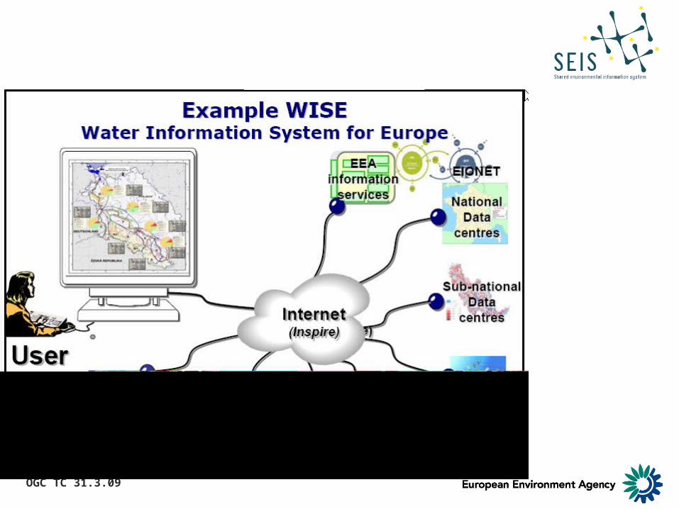
…linking water-related information in Europe
WISE…
OGC TC 31.3.09
OGC TC 31.3.09
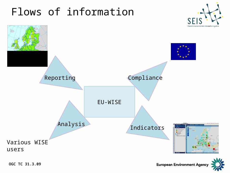
Flows of information
EU-WISE
Reporting
Indicators
Compliance
Analysis
Various WISE users

OGC TC 31.3.09
Twenty-six interactive thematic maps across subthemes available online
New themes
MarineUrban waste waterMonitoring networks
http://www.eea.europa.eu/themes/water/mapviewers

OGC TC 31.3.09
WISE distributed system
https://svn.eionet.europa.eu/projects/Reportnet/wiki/WiseDS)

OGC TC 31.3.09
Standardisation around WISE

OGC TC 31.3.09
WISE GIS guidance
Appendix 01: Elements of the WFD relevant to GISAppendix 02: WISE reporting arrangementsAppendix 03: Overview of maps available in the WISE map viewerAppendix 04: Status of ISO / CEN standards relevant for WISEAppendix 05: Table of GIS datasets and layers in WISEAppendix 06: Data dictionaryAppendix 07: Proposal for a European coding system for hydrological featuresAppendix 08: Testing the European coding system for hydrological features at selected rivers in the Danube River Basin District (available from March 2009)Appendix 09: Management of identifiers and codes – proposals and examplesAppendix 10: SDIGER proposal for detailed specifications for metadataAppendix 11: Implementation of the WISE metadata profile Appendix 12: Example of GML structure and encodingAppendix 13: Template for short GIS guidance for specific reportingAppendix 14: Glossary of terms
The main text of the document is available on EEA CIRCA at:http://eea.eionet.europa.eu/Public/irc/eionet-circle/eionet-telematics/library?l=/technical_developments/wise_technical_group/updated_2nd-edition/2nd-edition-25112008doc/_EN_1.0_&a=d

OGC TC 31.3.09
WISE data input process (all steps involve QA/QC)
Submission
Analysis/Scenarios
Acceptance
Data definition/requirements Step 1: WG D reporting sheets:
Compliance or SoE, voluntary (or through comitology)
Step 2: End-user tool, schema/DEM, XML/shape/GML, other tools (DD, glossary), help desk
Step 3: central holding area (CDR: MS individual submissions), management of access rights
Step 4: Automatic QA/QC checks in CDR + standardised manual checks if needed, feedback to data submitters
Step 5: Final data storage: EU-wide, quality-checked databases (e.g. Art.3, 5, 8 – WFD, BWD, SoE, NiD, UWWTD, etc) after EEA acceptance
Step 7a: Public or restricted viewing, map service, aggregation, statistics
Step 7c: Tools for SoE assessment, CCM2, management scenarios
Legal, political, Assessment, compliance
Step 7b: Tools for compliance assessment
QA
/QC
fee
db
ack
mec
han
ism
Production databases
EU Databases(Spatial) reference datasets
WISE viewer, GIS visualisation
Delivery database
Compliance-check databases DG ENV
Analytical databases JRC, EEA
Step 6: Purpose-oriented databases

OGC TC 31.3.09
WISE spatial reference elements
Large rivers>5000 km2
Main rivers>500 km2
MS working scale(or CCM2)
>10 to >100 km2
Hydrologicallevel
(object)
Aggregationlevel
(polygon)
EU level
National
RBD
Sub-unitsS
cale
-
+
Water
Bodies
Monitoring
StationsRBD/ Sub Unit

OGC TC 31.3.09
WISE conceptual model
OGC TC 31.3.09
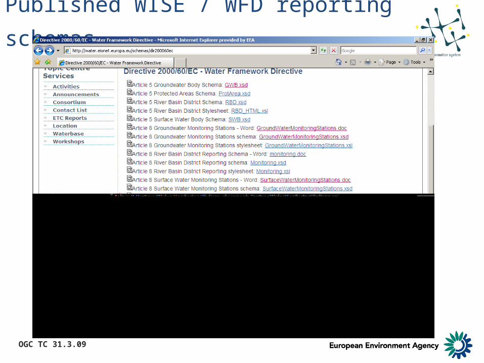
Published WISE / WFD reporting schemas
OGC TC 31.3.09
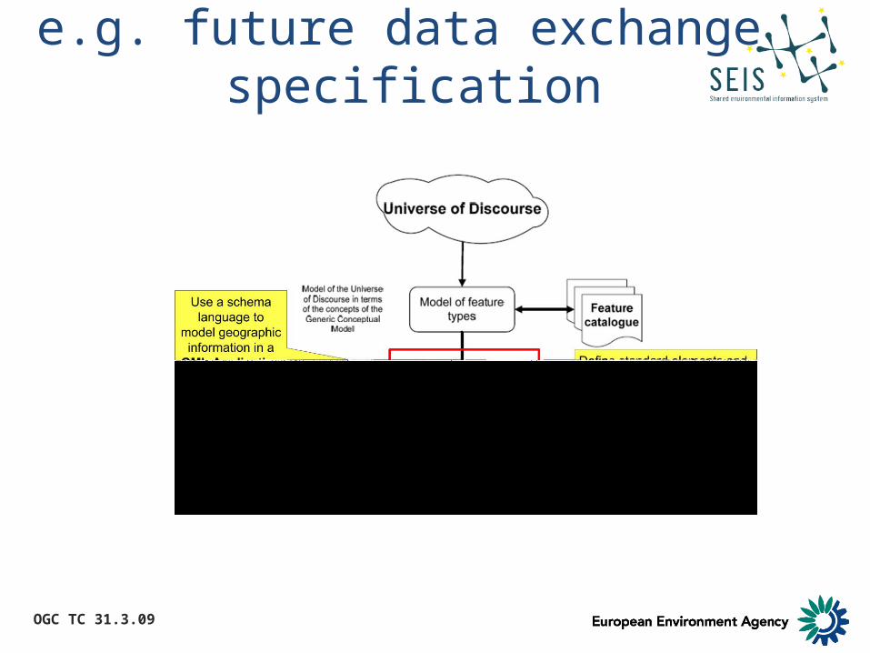
e.g. future data exchange specification
OGC TC 31.3.09
Integrating WISE with INSPIRE

OGC TC 31.3.09
WISE data specification
• WISE data specifation for Member States on how data should be held together
• Inspire compliant
• WISE Technical WG – Inspire Hydrography TWG Ispra January 2009
• Joint position
• WISE would extend the INSPIRE model

OGC TC 31.3.09
Approach
• Analyse the INSPIRE model• Collate and analyse relevant WISE documentation• Find common objects and identify areas for
extension• INSPIRE Hydrography Annex 1 of the Directive• Reporting Units Annex 3 – follow Inspire approach• Develop a final product of an INSPIRE-compliant
WISE logical model in UML• Comments to INSPIRE process

OGC TC 31.3.09
WISE-Inspire extension

OGC TC 31.3.09
Conceptual model

OGC TC 31.3.09
WFD Reporting schemas
• Administrative arrangements• Surface Water Bodies• Groundwater Bodies• Register of Protected areas• Surface Water and Groundwater
Methodologies which is divided into Surface Water Bodies and Groundwater Bodies
• River Basin Management Plans and Programmes of Measures
• There is a WFDCommon schema which provides common elements to the other schemas

OGC TC 31.3.09
Cross-schema linkages
... and more when relating other water related areas

OGC TC 31.3.09
INSPIRE WISE joint development approach
WISE GIS Guidance
Water Framework Reporting
Marine Stragegy Reporting
…
Reporting
+
ISO 191xx
Inspire Main body of IR
Annex Annex Annex Hydrography Sea regions …
ISO 191xx
Inspire Main body of IR
Annex Annex Annex Hydrography Sea regions …
Water Framework Reporting
Marine Stragegy Reporting
…
Reporting
OGC TC 31.3.09
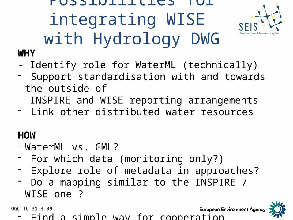
Possibilities for integrating WISE with Hydrology DWG
WHY- Identify role for WaterML (technically)- Support standardisation with and towards the outside of INSPIRE and WISE reporting arrangements- Link other distributed water resources
HOW- WaterML vs. GML?- For which data (monitoring only?)- Explore role of metadata in approaches? - Do a mapping similar to the INSPIRE / WISE one ?
- Find a simple way for cooperation

OGC TC 31.3.09
Thank you for your attention!
data viewer e.g. bathing water:http://www.eea.europa.eu/themes/water/status-and-monitoring/bathing-water-data-viewer
map viewer:http://www.eea.europa.eu/themes/water/mapviewers
Operational links into the WISE systemportal pages:http://water.europa.eu data centre:http://www.eea.europa.eu/themes/water
schemas:http://water.eionet.europa.eu/schemas/dr200060ec