offshore opportunity -2013 licence round · pdf fileoffshore opportunity --2013 licence...
TRANSCRIPT

OFFSHORE OPPORTUNITY - 2013 LICENCE ROUND
EXECUTIVE SUMMARY
On May 16th, 2013, the Canada-Newfoundland and Labrador Off-shore Petroleum Board (C-NLOPB) announced a Call for Bids for a parcel in the Flemish Pass Basin, northeast of the island of New-foundland, Eastern Canada. With substantial undiscovered resources estimated at some 6 billion barrels of oil and 60 trillion cubic feet of natural gas, the Newfoundland and Labrador offshore holds great petroleum potential. Land available in the 2013 Calls for Bids offers all explorers a variety of excellent opportunities for large discoveries. The Flemish Pass Basin is considered highly prospective for hydro-carbons, and represents part of the North Atlantic Mesozoic rift net-work. This network includes the Jeanne d’Arc Basin to the south and west and the Orphan basin to the north. Despite good modern seis-mic coverage, the basin remains very much underexplored with only six wells drilled in intermediate water depths since 2003. Three of these were discoveries. The closing date for this Call for Bids shall be a minimum of 120 days after completion of the Eastern New-foundland Strategic Environmental Assessment (2013). The closing date will be announced in a subsequent Notice to Bidders (www.cnlopb.nl.ca/news/nr20140520.shtml).
OVERVIEW
Located on Canada's East Coast, the Province of Newfoundland and Labrador, is Canada’s offshore oil producing region. Over the past seventeen years the province's four producing fields - Hibernia, Terra Nova, White Rose and North Amethyst - have produced in excess of 1.5 billion barrels of oil. Hebron, expected to be the province's fifth producing field, was sanctioned late in 2012 and is being designed with a gravity based structure with first oil planned for 2017. Further development is expected in the region as a Significant Discovery Li-cence was awarded in 2010 to Statoil for their Mizzen discovery in the Flemish Pass Basin. Statoil estimates the field contains between 100 and 200 million barrels of oil, expected to increase with further explo-ration drilling. This was followed up by additional discoveries in 2013 at Harpoon and Bay du Nord with the latter estimated at 300 to 600 million barrels recoverable. Land available in the 2013 Call for Bids offers all explorers a variety of excellent opportunities for more discov-eries.
KEY ATTRIBUTES
Call for Bids NL13-01 (Area “C”) in the Flemish Pass Basin comprises a large parcel totaling
657,644 acres or 2,661 km2 in water depths ranging from 390 to 1,200 m.
Competitive fiscal regime with very low political risk, proximity to both North American and
European markets. Open and transparent land management and bid processing system.
Winning bidder granted exploration rights on work commitment basis.
The closing date will be announced in a subsequent Notice to Bidders.
For more information, see http://www.cnlopb.nl.ca/pdfs/nl1301.pdf.
CALL FOR BIDS NL13-01, FLEMISH PASS BASIN, OFFSHORE NEWFOUNDLAND
LOCATION OF CALL FOR BIDS PARCEL NL13-01-01 IN THE FLEMISH PASS BASIN, OFFSHORE NEWFOUNDLAND, CANADA. NUMBERS SHOW THE ORDER OF DRILLING IN THE BASIN (ENACHESCU, 2014)
OFFSHORE OPPORTUNITY - 2013 LICENCE ROUND
GOVERNMENT OF NEWFOUNDLAND AND LABRADOR OFFSHORE OPPORTUNITY 2013 LICENCING ROUND FLEMISH PASS BASIN MAY 2014 P.1

ATLANTIC MARGIN BASINS REGIONAL GEOLOGY
The North Atlantic continental margins are occupied by a complicated network of sedimentary basins, subbasins and troughs formed by
extension during the breakup of Pangea and opening of the Atlantic Ocean during the Late Triassic to mid-Cretaceous. The Flemish Pass Basin represents such a Mesozoic extensional area developed over stretched Precambrian and Paleozoic basement on the North American Atlantic Margin.
Late Triassic to Early Jurassic rifting of Pangea created a chain of NE-SW oriented intracratonic basins extending from the Gulf of Mexi-
co to the Barents Sea. Oblique and perpendicular rift branches (e.g. Bay of Fundy, Orpheus Graben, Aquitaine Basin, Viking Graben, Labrador Sea and others) were also formed during this series of tectonic events. Detached in late Early Cretaceous and drifting west-ward during Atlantic opening, the Flemish Pass Basin was not subsequently affected by the Alpine inversion that influenced the late evolution of the European basins.
In Eastern Canada, the Tethys rift basin chain starts with the George’s Bank Basin offshore Nova Scotia, stretches through the Scotian
shelf and slope basins and subbasins, including the Laurentian Basin, and continues with the deepwater Carson Basin, also included in this Call for Bids cycle. The system extends northeastward with the shallow-water Grand Banks basins and the intermediate to deep water Flemish Pass and Orphan basins, and likely branches into the Labrador Sea.
The Flemish Pass Basin started as an intra-continental rift in the Triassic, then became an inland sea basin (confined basin) in the Ju-
rassic and evolved into a divergent margin (unconfined basin) at both northern and southern ends during Late Cretaceous and Tertiary. Since the Albian break-up of the Grand Banks from Ireland, the basin became directly opened to the newly born North Atlantic Ocean.
Certain basins are now situated within the continental plate (e.g. Jeanne d’Arc and Flemish Pass basins) while others occupy a diver-
gent margin position and extend all the way to the continent-ocean boundary (e.g. Laurentian, Carson basins).
FLEMISH PASS BASIN GEOLOGY
West of a continental fragment comprising the Flemish Cap-Beothuk Knoll lies a typical North-Atlantic Mesozoic rift basin partially sepa-rated to the west from the Jeanne d’Arc Basin by an intra-basinal high known as the Central Ridge. Modern seismic data also indicates that the Flemish Pass Basin is in structural continuity to the north with the East Orphan Basin. Most of the basin lies in the bathymetric low known as the Flemish Pass that is located between the Grand Banks and the Flemish Cap.
Grand Banks. The Flemish Pass Basin is separated from the prolific Jeanne d’Arc Basin by the adjacent Central Ridge, a faulted
intrabasinal high. The ridge has two subunits, the South and the North Central Ridge, separated by a transfer zone.
Flemish Cap. Toward the east, the basin is surrounded by a large shallow high, devoid of sediments, known as the Flemish Cap
which has been a local source for coarse sediments transported into the basin There is no hydrocarbon potential on the Flemish Cap, although its down faulted flank contains several unexplored structures and large sedimentary fans onlapping on places the eroded Precambrian basement.
REGIONAL GEOLOGY OF THE CANADIAN ATLANTIC MARGIN, SHOWING MAJOR BASINS AND TECTONIC EVOLUTION (AFTER C-NLOPB, GSC, ENACHESCU AND FAGAN, 2006)
GOVERNMENT OF NEWFOUNDLAND AND LABRADOR OFFSHORE OPPORTUNITY 2013 LICENCING ROUND FLEMISH PASS BASIN MAY 2014 P.2

FLEMISH PASS BASIN GEOLOGY CONTINUED
Newfoundland and Labrador’s offshore basins underwent successive extensional episodes during the northerly propagation of the Tethys, Atlantic and Labrador rifting stages. Four continental rifting phases occurred in the North Atlantic region:
1. Tethys rift phase during Late Triassic to Early Jurassic,
2. North Atlantic rift phase during Late Jurassic to Berriasian,
3. Labrador Sea rift phase during Berriasian to Albian, and
4. Greenland/Europe rift phase during Late Cretaceous-Eocene.
The Flemish Pass Basin was affected by these four stages of rifting, two stages of transtension (due to change of direction of extension)
and one stage of inversion (Late Cretaceous - Early Tertiary; non-plate related). A thinned continental crust underlies the basin that is bounded by shallow basement highs to the west, east and south that are in turn underlain by normally thick crust. No transitional or oce-anic crust was emplaced within the basin.
As a result of successive rifting, transtension, in-
version and thermal subsidence, a thick Late Trias-sic to Late Cretaceous sedimentary fill (more than 10 km in places) was deposited in the basin and numerous extensional and compression modified extensional structures were formed.
Compressional stress was generated by changes
in the direction of extension or strike-slip. Triassic salt is not as abundant in this basin. Salt pillows and detached salt may play a role in petroleum trap evolution in the Gabriel Subbasin and the south-western flank of the basin where it is in contact with the Central Ridge.
The structures are dissected by several genera-
tions of fault systems. Some of the faults show inversion and several flower structures created by strike-slip movement can be identified on seismic data. Major subsidence in Late Cretaceous and especially during Tertiary provides an undeformed, relatively thick (1 to 2.5 km) cover of fine grained sediments, protecting the deeper synrift structures.
The Flemish Pass Basin as has been described as
the ocean-ward member of a double failed rift sys-tem that includes the westerly Jeanne d’Arc Basin and the Central Ridge (Enachescu, 1987 and 1988). The double rift system is compartmentalized by major basement detachment faults, but the two basins and the ridge share a common evolution and arguably, comparable stratigraphy.
There was continuity of deposition during the Late
Triassic and Jurassic between the two basins, as the Central Ridge intra-basinal high, was still de-pressed and part of the same regional rift basin. There was communication of the Jurassic sea with the East Orphan and the conjugate Irish margin basins, being closer to the North Atlantic triple junction and rotation of Flemish Cap. The basin has suffered several changes in the direction of the extension vector resulting in transtension, flower structures and inversion of rotated blocks during the Cretaceous.
The Flemish Pass Basin has seen little regional
stratigraphic research that includes information from the latest wells. The Jeanne d’Arc Basin tec-tono-stratigraphic and tectonic charts published by various authors are used to describe the geody-namic evolution and depositional history of the Flemish Pass Basin.
LITHOSTRATIGRAPHY, TECTONICS, SUBSIDENCE AND PETROLEUM SYS-TEMS OF THE JEANNE D’ARC BASIN, OFTEN USED AS A GUIDE FOR THE FLEMISH PASS BASIN (AFTER C-NLOPB AND SINCLAIR, 1993)
GOVERNMENT OF NEWFOUNDLAND AND LABRADOR OFFSHORE OPPORTUNITY 2013 LICENCING ROUND FLEMISH PASS BASIN MAY 2014 P.3
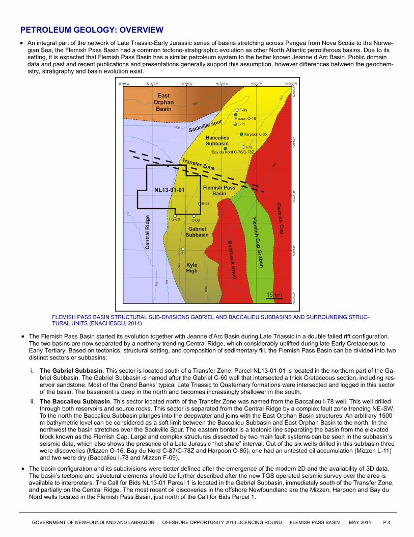
PETROLEUM GEOLOGY: OVERVIEW
An integral part of the network of Late Triassic-Early Jurassic series of basins stretching across Pangea from Nova Scotia to the Norwe-
gian Sea, the Flemish Pass Basin had a common tectono-stratigraphic evolution as other North Atlantic petroliferous basins. Due to its setting, it is expected that Flemish Pass Basin has a similar petroleum system to the better known Jeanne d’Arc Basin. Public domain data and past and recent publications and presentations generally support this assumption, however differences between the geochem-istry, stratigraphy and basin evolution exist.
The Flemish Pass Basin started its evolution together with Jeanne d’Arc Basin during Late Triassic in a double failed rift configuration.
The two basins are now separated by a northerly trending Central Ridge, which considerably uplifted during late Early Cretaceous to Early Tertiary. Based on tectonics, structural setting, and composition of sedimentary fill, the Flemish Pass Basin can be divided into two distinct sectors or subbasins:
i. The Gabriel Subbasin. This sector is located south of a Transfer Zone. Parcel NL13-01-01 is located in the northern part of the Ga-briel Subbasin. The Gabriel Subbasin is named after the Gabriel C-60 well that intersected a thick Cretaceous section, including res-ervoir sandstone. Most of the Grand Banks’ typical Late Triassic to Quaternary formations were intersected and logged in this sector of the basin. The basement is deep in the north and becomes increasingly shallower in the south.
ii. The Baccalieu Subbasin. This sector located north of the Transfer Zone was named from the Baccalieu I-78 well. This well drilled through both reservoirs and source rocks. This sector is separated from the Central Ridge by a complex fault zone trending NE-SW. To the north the Baccalieu Subbasin plunges into the deepwater and joins with the East Orphan Basin structures. An arbitrary 1500 m bathymetric level can be considered as a soft limit between the Baccalieu Subbasin and East Orphan Basin to the north. In the northwest the basin stretches over the Sackville Spur. The eastern border is a tectonic line separating the basin from the elevated block known as the Flemish Cap. Large and complex structures dissected by two main fault systems can be seen in the subbasin’s seismic data, which also shows the presence of a Late Jurassic “hot shale” interval. Out of the six wells drilled in this subbasin three were discoveries (Mizzen O-16, Bay du Nord C-87/C-78Z and Harpoon O-85), one had an untested oil accumulation (Mizzen L-11) and two were dry (Baccalieu I-78 and Mizzen F-09).
The basin configuration and its subdivisions were better defined after the emergence of the modern 2D and the availability of 3D data.
The basin’s tectonic and structural elements should be further described after the new TGS operated seismic survey over the area is available to interpreters. The Call for Bids NL13-01 Parcel 1 is located in the Gabriel Subbasin, immediately south of the Transfer Zone, and partially on the Central Ridge. The most recent oil discoveries in the offshore Newfoundland are the Mizzen, Harpoon and Bay du Nord wells located in the Flemish Pass Basin, just north of the Call for Bids Parcel 1.
FLEMISH PASS BASIN STRUCTURAL SUB-DIVISIONS GABRIEL AND BACCALIEU SUBBASINS AND SURROUNDING STRUC-TURAL UNITS (ENACHESCU, 2014)
GOVERNMENT OF NEWFOUNDLAND AND LABRADOR OFFSHORE OPPORTUNITY 2013 LICENCING ROUND FLEMISH PASS BASIN MAY 2014 P.4

PETROLEUM GEOLOGY: RESERVOIRS AND SEALS
In the Flemish Pass Basin excellent reservoirs have been drilled in the Tithonian, Kimmeridgian and Early Cretaceous formations. Res-
ervoir rocks in the Flemish Pass Basin are typically high porosity - high permeability sandstones. To date, no noteworthy Late Creta-ceous or Early Tertiary sandstone intervals have been encountered in the basin.
The only published positive test in the basin was obtained from a Tithonian sandstone in the Mizzen O-16 well, which flowed 600 m3/
day (3800 bobd) from the interval 3213-3224 m. A total of 26 m of pay was logged in this well. This reservoir was interpreted as a fine to medium grain sublitharenite of fluvial and marginal marine origin. There are several other distinct coarse clastic cycles in the Mizzen wells informally named Ti-1 to Ti-4, as units of Statoil’s informally-described Bodhrán Formation. The Ti-3 sandstone was also encoun-tered in the Mizzen L-11 where it had 5 m of oil pay on logs and in the F-09 well where it had water and traces of oil.
Seal rocks are not considered to be a major play risk in the Flemish Pass Basin. The section is replete with thick intraformational and
regional seal units. Seal issues are likely to be prospect-specific in nature.
PETROLEUM GEOLOGY: SOURCE ROCKS
Part of the network of Late Triassic-Early Jurassic chain of the basins stretching across North Atlantic continental margins, the Flem-ish Pass Basin had a common rift evolution as other North Atlantic petroliferous basins. The basin has experienced an early lacustrine age similar to other Atlantic margin basins (e.g. Scotian Basin) and an interior sea stage periods similar to the Jeanne D’Arc Basin, when significant thickness of oil potential source rocks were deposited in the basin.
The most significant source rock in the basin is most likely to be the Egret Member of the Rankin Formation of Kimmeridgian age or its equivalent. This unit is the prolific source rock interval that sourced all the current oil fields of the Jeanne d’Arc Basin. The Egret source rock is a marine-derived Type II organic shale with up to 9% (average 4.5%) Total Organic Carbon (TOC). Over 25 exploration wells have penetrated the Egret Member source in the Grand Banks and environs. The Egret shale, deposited in a semi-silled epeiric basin, is the most prolific marine source rock to date within the North American Atlantic rift system.
The predominant kerogen in the Egret Member unit is marine Type II and therefore oil-prone. At least six wells in the Flemish Pass-Central Ridge area have also encountered Egret sections containing Type I-II kerogens.
Other source rock intervals have been intersected in the Tithonian and Oxfordian shale successions. It was suggested that the Mizzen O-16 heavier field oil (22° API) in the northern Flemish Pass Basin was sourced from an immature to marginally mature source rock within the Tithonian sequence. The marine shales that separate the Tithonian reservoirs in the Mizzen oil field have 8 - 12% TOC. An earlier well on the structure, Mizzen L-11, drilled in 2003 encountered 5 m pay of light oil that may be generated from a mature source rock. Noteworthy, the Harpoon and Bay du Nord light oil finds have been announced as being contained in Jurassic reservoirs and it is presumed that they were generated by a Late Jurassic source rock.
Another possible source rock is the Turonian-Albian shale that showed rich marine organic content when drilled by IODP Leg 210, Sites 1276 and 1277, just east of the Flemish Cap. This interval may be mature in the deeper troughs of the basin.
In some areas a Paleozoic source rock (similar to Paleozoic sources in the adjacent Maritimes Basin) may also be a contributor to gas generation. Tertiary shales show some high TOC intervals, however there are yet unproven as source rocks.
SUMMARY OF WELL RESULTS, FLEMISH PASS BASIN AND ENVIRONS. COMPILATION FROM C-NLOPB DATA (ENACHESCU, 2014)
GOVERNMENT OF NEWFOUNDLAND AND LABRADOR OFFSHORE OPPORTUNITY 2013 LICENCING ROUND FLEMISH PASS BASIN MAY 2014 P.5

SEISMIC EXAMPLES
Uninterpreted and interpreted seismic lines from the Carson Ba-
sin. Dip line A-A’ (shown above) and strike line B-B’ (facing page) illustrate structural style and quality of 2D seismic data in the Gabriel Subbasin.
Deeply rooted faulting, large subsidence and erosion creating
structural, stratigraphic and combination traps.
Drape anticlines containing several Jurassic, Cretaceous and
Tertiary successions separated by unconformities.
Presence of a thick Late Jurassic sequence located within inter
-salt basins that may contain high-TOC, mature source inter-vals.
Leads indicated are large and, if closed in strike direction,
could contain significant volumes of hydrocarbons.
AFTER ENACHESCU, (2014)
AFTER ENACHESCU, (2014)
GOVERNMENT OF NEWFOUNDLAND AND LABRADOR OFFSHORE OPPORTUNITY 2013 LICENCING ROUND FLEMISH PASS BASIN MAY 2014 P.6
SEISMIC LINE SOURCE: TGS IN COLLABORATION WITH PGS
SEISMIC LINE SOURCE: TGS IN COLLABORATION WITH PGS

GOVERNMENT OF NEWFOUNDLAND AND LABRADOR OFFSHORE OPPORTUNITY 2013 LICENCING ROUND FLEMISH PASS BASIN MAY 2014 P.7
FLEMISH PASS BASIN HYDROCARBON POTENTIAL: SUMMARY
Active ELs exist both to the north and south and oil and gas discoveries were found to the north (Mizzen, Harpoon and Bay du Nord)
and south (South Tempest, North Dana, and White Rose) of the parcel. Moreover, Parcel 1 is located on a NW-SE trend that connects the Jeanne D’Arc Basin large oil fields and the new discoveries of the Flemish Pass Basin.
Parcel 1, located in the northwestern part of the Gabriel Subbasin, contains 285,864 hectares (706,385 acres) which is 122.6 times larg-
er than a GOM OCS tract (3 x 3 square miles). The parcel is situated east of Jeanne d’Arc Basin, within the Central Ridge and Flemish Pass Basin structural units, on the Grand Banks shelf and upper slope, and in the Flemish Pass bathymetric deep (maximum depth 1150 m).
The parcel comprises thick Mesozoic successions and contains large petroleum prospects and leads which are covered by a relatively
dense 2D seismic grid and partially by a 3D survey acquired in 2001 by WesternGeco on behalf of Chevron and its partners. More op-portunities exist in the unlicensed region east of the present Call for Bids parcel.
The public domain and multi-client 2D seismic coverage is very good for this parcel. Only a small portion in its southeastern part is cov-
ered by 3D data.
Multiple play types are conceptualized in the Flemish Pass Basin and specifically in Parcel 1, including large structural fault-bounded
closures, anticlines, structural/stratigraphic combination targets and deep prerift and syrift plays.
The proven significant discovery at Mizzen and the 2013 discoveries at Bay du Nord and Harpoon wells, have demonstrated the high oil
potential of the basin.
SEISMIC LINE SOURCE: TGS IN COLLABORATION WITH PGS
AFTER ENACHESCU, (2014)
AFTER ENACHESCU, (2014)
SEISMIC LINE SOURCE: TGS IN COLLABORATION WITH PGS

GOVERNMENT OF NEWFOUNDLAND AND LABRADOR OFFSHORE OPPORTUNITY 2013 LICENCING ROUND FLEMISH PASS BASIN MAY 2014 P.8
Additional information related to Call for Bids NL13-01 is included in the report: Enachescu (2014), available here: www.nr.gov.nl.ca/nr/invest/PetExOpFlemishNL1301.pdf
ADDITIONAL INFORMATION AND CONTACTS
Petroleum Development Section Department of Natural Resources Government of Newfoundland and Labrador 50 Elizabeth Avenue, PO Box 8700 St. John’s, NL, Canada A1B 4J6 www.nr.gov.nl.ca
Canada-Newfoundland and Labrador Offshore Petroleum Board 5th Floor, TD Place 140 Water Street St. John’s, NL, Canada A1C 6H6 www.cnlopb.nl.ca
MANDATE AND ROLES The C-NLOPB is mandated to apply the provisions of the Atlantic Accord and the Atlantic Accord Implementation Acts to all activities of operators in the Newfoundland and Labrador Offshore Area. Their role is to facilitate the exploration for and development of the hydrocarbon resources, including effective management of land tenure, in a manner that conforms to the statutory provisions set out in the Acts. As Offshore Regulator and administrator for the Call For Bids, the C-NLOPB are the primary contact for participation in this resource opportunity. They operate a registry to record exploration, significant discovery and production licences and information related to these interests for public review. They are also the curators of all geoscientific data pertaining to the Newfoundland and Labrador Offshore Area. The C-NLOPB has no active role in promotion of the Province’s hy-drocarbon resources. The Government of Newfoundland and Labrador, Department of Natural Resources, is responsible for providing mar-keting and promotional services to foster the exploration, development and production of the Province’s hydrocarbon resources internationally as well as promoting the maximization of fiscal and industrial benefits through the negotiation, development, administration and monitoring of petroleum project agreements and legislation.