offshore eastern algeria case study: 3d ... eastern algeria case study: 3d petroleum system...
TRANSCRIPT

OFFSHORE EASTERN ALGERIA CASE STUDY: 3D PETROLEUM
SYSTEM MODELLING AND HYDROCARBON OCCURRENCE
Dr Mohamed ARAB
Co-authors: François roure, Marina Rabineau, Arezki Lassal, Didier Granjeon, Rabah
Bracene and Jacques Déverchère.
04/04/2017 1

OUTLINES
INTRODUCTION
GEOLOGICAL SETTING
INTEGRATED BASIN MODELING PROCESS
3D CONCEPTUAL GEOLOGICAL MODEL • Stratigraphy, Structure and geological maps (from seismic)
PETROLEUM SYSTEM ELEMENTSSource rock, Reservoir and Seals
THERMAL AND PETROLEUM SYSTEM MODELING • Thermicity, pressure prediction, timing of HC generation/
charge and hydrocarbon accumulations
CONCLUSION & RECOMMANDATIONS

The eastern Algerian offshore, as a frontier basin, is becoming a well studied basin in terms of
exploration geology, thanks to a large volume of G&G data and integrated research projects (e.g.
SPIRAL) initiated between SONATRACH and international scientific research organisations.
Regarding the favorable geological indications and the existing analogs of Mio-Pliocene PS in W.
Mediterranean, numerical basin modeling has been conducted for the needs of hydrocarbon potential
prediction.
3D conceptual geological model is needed before basin modeling process, using geophysical and
geological field data.
INTRODUCTION

Mihoubi et al. 2014
Offshore Jijel
Zone of interest
Back-arc basin of Oligo-Miocene and PQ Deposits, inverted at Quaternary.
Faccena et al. (2004)
GEOLOGICAL SETTING

Stratigraphic units
Facies type(field data, Seismic and by analogy)
Stratigraphic modeling
Sequences Evolution ‘T/R events
Facies and subsidence maps
3D Geological model
Geodynamics(Basin evolution)
Thermal modeling
Heat flow model
3D Petroleum system modeling
Petroleum systems(SR, Reservoir and Seal)
Geochemical data (Source rocks)
Pressure, temperatures, hydrocarbon accumulation and
resources
Crustal acrchitecture
Basin architecture
Inp
ut
fro
m g
eolo
gica
l stu
die
s
Blo
ck B
uild
ing
3D
Bas
in
mo
del
ing
Ou
tpu
t
BASIN MODELING WORKFLOW, TEMIS-FLOW SOFTWARE (IFPEN)
(1)
(2)
(3)
(4)
(5)
(6)

04/04/2017 6
3D CONCEPTUAL GEOLOGICAL MODEL
Stratigraphy and basin structure
(Block Building)
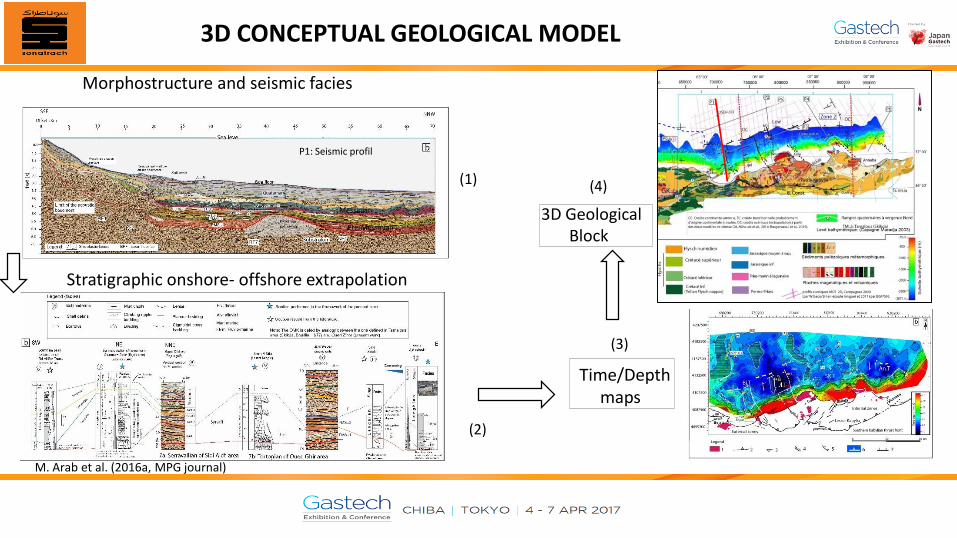
3D CONCEPTUAL GEOLOGICAL MODEL
Messinian
Pre-Messinian
P1: Seismic profil
Morphostructure and seismic facies
Off
sho
re d
eep
bas
in
Mar
gin
Cong.& Sand
Sandstone
Sandy shale
Shaly marl
Siliciclatis
Anhydrite
Salt
Marl
3D Geological Block
Time/Depthmaps
(2)
(3)
(4)
M. Arab et al. (2016a, MPG journal)
Stratigraphic onshore- offshore extrapolation
(1)

04/04/2017 8
PEROLEUM SYSTEM ELEMENTS

Geochemical data used for source rocks haracterization.
Identified Source rocks:Flysch shale (Cretaceous),Langhian shale and Burdigalian(Miocene).
The Messinian SR is defined by analogy.
Reservoirs (from onshoredomain):
Basal Langhien (within the TST and HST wedges.
PETROLEUM SYSTEM ELEMENTS (Reservoirs and source rocks)
Langhian reservoir, Littoral chanels,central margin.
Langhian reservoir(2), turbidites, central margin.
Langhian reservoir, (3) turbidites), central margin.
Langhian reservoir, (4) Shelf type,eastern margin.
Langhian reservoir(5) turbidites, eastern margin.
(1) (2) (3) (4) (5)
M. Arab , PhD. Thesis (2016)

SCHEMATIC REPRESENTATION OF THE PETROLEUM SYSTEM ELEMENTS
Possible source rocks Possible reservoirs,
Probable petroleum systems: Late Oligocene (R)/Burdigalian (SR); Burdigalian (SR)/Lower
Langhian (R), Langhian (SR)/ Late Serravallian (R), Langhian(SR)/Lower Messinian and Lower Messinian(SR)/Pliocene (R).
P3 section: interpreted from seismic
Potential trap
P3

04/04/2017 11
THERMAL AND PETROLEUM SYSTEM MODELING

THERMAL MODELLING RESULTS
The GG ranges from 50 to 70 °C/km, the surface HF= 65 to 85 mw/m² and the temp. varying from 100 to 200°C in the pre-salt series.
2D Temperatures
Thermal gradients
Surface heat flow
M. Arab et al. (2016b)

PRESSURE PREDICTION
Pressures at Lower Langhian (pre-salt layer) Vary from 7000 to 14000 psi (deep troughs)
M. Arab et al. (2016b)

(a) Oil generation period: 7 Ma- 0Ma,Gas generation at PQ period
(b) Occurring of gas accumulation (C1- C5) in the Serravallian reservoir (stratigraphic trap).
The MSC induced HC loss av. 6 Ma in the same reservoir.
TIMING OF HYDROCARBON GENERATION, 1D MODELING (VERTUAL WELL)
The rate of conversion to hydrocarbons is defined by a first-order rate equation known as the Arrhenius
equation. Kinetic parameters of the organic matter are involved in the cracking simulation.
M. Arab et al. (2016b)

3D HC MIGRATION, GAS AND OIL SATURATION,PROSPECTIVE ZONES FOR EXPLORATION
1st SCENARIO: SYSTEM WITH
CLOSED FAULTS
2nd SCENARIO: OPEN SYSTEM
Langhian playStructural traps
(Gas)
Serravallian playStratigraphic traps
(Oil)
Lower Messinian playSlope fans
(Oil)
The HC saturation maps are taken from 3D block.
M. Arab etal. (2016b)

2D PETROLEUM SYSTEM (PS) MODELLING RESULTSTHERMAL MATURITY OF THE SR, AND HYDROCARBON SATURATION WITHIN RESERVOIRS
(1) N-S Section of TR, indicating moderate to high thermal maturity of the main possible source rocks (Late Burdigalian, Late Langhian and Lower Messinian).
(2) 2D PS model: oil saturation in the OMK and Serravallian reservoir.
(3) Gas saturation in the OMK and Serravallianreservoir.
(4) Oil saturation in the OMK (Oligo-Miocene), Serravallian reservoir and Lower Messinian (at the upper margin).
(1)
(2)
(3)
(4)
In TemisFlow, whole hydrocarbon migration is governed by triphasic Darcy lawM. Arab et al. (2016b)

• THE THICKNESS (3000- +5000 M) OF THE SEDIMENTARY SERIES AND VARIETY OF FACIES ARE INDICATIONS OF PETROLEUM SYSTEMS
EFFICIENCY. • MESSINIAN (ANALOGY) AND LANGHIAN (LAB DATA) SOURCE ROCKS ARE THE MAIN SOURCE ROCKS WHICH MAY EXISTED IN THE DEEP
OFFSHORE BASIN.
• SEISMIC INTERPRETATION INDICATES EXISTENCE OF BOTH STRUCTURAL AND STRATIGRAPHIC TRAPS (REEFS, DSF AND CHANNELS).
• THE TIMING (7- 0 MY) OF OIL AND GAS GENERATION IS FAVORABLE FOR ENTRAPMENT IN STRUCTURAL AND STRATIGRAPHIC TRAPS .
• BASIN MODELING SHOWS HIGHER HEAT FLOW (70 TO 90 MW/M²) AND OVERPRESSURES IN THE PRE-SALT SERIES.
• PETROLEUM SYSTEM MODELING REVEALS HYDROCARBON CHARGE IN THE RAMP ANTICLINES ALONG THE UPPER MARGIN AND IN
STRATIGRAPHIC/STRUCTURAL TRAPS IN THE DEEP BASIN.
• THE AREAS EXTENDING BETWEEN 10-12 KM TO AVERAGE 65 KM (ZONE OF CONTINENTAL CRUST) ARE THE MOST PROLIFIC IN TERMS OF
HYDROCARBON ACCUMULATION.
• IN SUCH AN ACTIVE MARGIN, GEOHAZARDS STUDIES SHOULD BE UNDERTAKEN BEFORE ANY DRILLING ACTIVITY.
CONCLUSION

Algerian offshore
Thank You For Your Attention