of the upper androscoggin river watershed · ecological atlas of the upper androscoggin river...
TRANSCRIPT

Ecological Atlas of the
Upper AndroscogginRiver Watershed
Appalachian Mountain Club

Ecological Atlas of the
Upper Androscoggin RiverWatershed
Appalachian Mountain ClubJanuary 2003
Main
e
New
Ham
psh
ire
Cre
dits
Contributing authors:Doug Weihrauch (Alpine Ecosystems)Johan Erikson (Geology)Ken Kimball (Alpine Ecosystems, Dams,
Water Quality)
Map development: David Publicover
Data Development:David PublicoverCathy Poppenwimer
Graphic design: Kelly ShortCanterbury Communications
� Credits �
Copies of this Atlas are available on CD-ROM in AdobePDF format from the Appalachian Mountain Club.
Published by the Appalachian Mountain Club© 2003
Molly Docherty and Emily Pinkham of the MaineNatural Areas Program and Lionel Chute and SaraCairns of the New Hampshire Natural HeritageInventory provided valuable information on rare plantsand animals occurring in the upper Androscogginwatershed, as well as unpublished drafts of naturalcommunity classification and description manuals.
Mark Anderson and Greg Kehm of The NatureConservancy’s Eastern Conservation Science office inBoston, MA provided digital data on ecoregion bound-aries and TNC’s Ecological Land Units classification.
Barbara Barbieri of the Northern Forest HeritagePark provided access to the park’s collection of his-torical photographs.
Dave Thurlow, Joe Homer, Andy Cutko, EmilyPinkham, Sue Gawlor, Marcel Polak and Ken Kimballprovided valuable reviews of portions of the atlas.
Funding for this project was provided by grants to theAppalachian Mountain Club from the Doris DukeCharitable Foundation, the Richard King MellonFoundation, The Moriah Fund, the Surdna Foundation,the John Merck Fund, the Merck Family Fund, theJessie B. Cox Charitable Trust, the Ford Foundation,the Harold Whitworth Pierce Charitable Trust, andEnvironmental Systems Research Institute (ESRI).
The Appalachian Mountain Club thanks all those whoare working to ensure an ecologically, economically,and socially sustainable future for the upperAndroscoggin River watershed and its communities.
Acknowledgements
Primary authors:David Publicover
Doug Weihrauch (Land Use History)
Boston office:5 Joy Street
Boston MA 02108617-523-0636
New Hampshire offices:P.O. Box 298
Gorham, NH 03581603-466-2721
WWW. OUTDOORS.ORG

Map, Tables &
Figures
3
Tabl
e of
Con
tent
s
2
Introduction . . . . . . . . . . . . . . . . . . . . . . . . . . . . . . . . . . . . . . . . . . . . . . . . 6Land use history. . . . . . . . . . . . . . . . . . . . . . . . . . . . . . . . . . . . . . . . . . . . 10Climate . . . . . . . . . . . . . . . . . . . . . . . . . . . . . . . . . . . . . . . . . . . . . . . . . . 17Geology . . . . . . . . . . . . . . . . . . . . . . . . . . . . . . . . . . . . . . . . . . . . . . . . . . 20Topography . . . . . . . . . . . . . . . . . . . . . . . . . . . . . . . . . . . . . . . . . . . . . . . 25Soils . . . . . . . . . . . . . . . . . . . . . . . . . . . . . . . . . . . . . . . . . . . . . . . . . . . . . 29Ecological land classification . . . . . . . . . . . . . . . . . . . . . . . . . . . . . . . . . . . 33Forests . . . . . . . . . . . . . . . . . . . . . . . . . . . . . . . . . . . . . . . . . . . . . . . . . . . 37Wetlands . . . . . . . . . . . . . . . . . . . . . . . . . . . . . . . . . . . . . . . . . . . . . . . . . 43Natural communities . . . . . . . . . . . . . . . . . . . . . . . . . . . . . . . . . . . . . . . . 48Alpine ecosystems . . . . . . . . . . . . . . . . . . . . . . . . . . . . . . . . . . . . . . . . . . 52Rare plants . . . . . . . . . . . . . . . . . . . . . . . . . . . . . . . . . . . . . . . . . . . . . . . . 55Lakes and rivers . . . . . . . . . . . . . . . . . . . . . . . . . . . . . . . . . . . . . . . . . . . . 58Wildlife. . . . . . . . . . . . . . . . . . . . . . . . . . . . . . . . . . . . . . . . . . . . . . . . . . . 63Timber harvesting . . . . . . . . . . . . . . . . . . . . . . . . . . . . . . . . . . . . . . . . . . 68Shoreline development. . . . . . . . . . . . . . . . . . . . . . . . . . . . . . . . . . . . . . . 70Dams . . . . . . . . . . . . . . . . . . . . . . . . . . . . . . . . . . . . . . . . . . . . . . . . . . . . 72Water quality . . . . . . . . . . . . . . . . . . . . . . . . . . . . . . . . . . . . . . . . . . . . . . 74Land conservation . . . . . . . . . . . . . . . . . . . . . . . . . . . . . . . . . . . . . . . . . . 76Afterword . . . . . . . . . . . . . . . . . . . . . . . . . . . . . . . . . . . . . . . . . . . . . . . . 80Appendix A: . . . . . . . . . . . . . . . . . . . . . . . . . . . . . . . . . . . . . . . . . . . . . . . 82
Notes, sources & additional informationAppendix B . . . . . . . . . . . . . . . . . . . . . . . . . . . . . . . . . . . . . . . . . . . . . . . 86
List of tree speciesAppendix C . . . . . . . . . . . . . . . . . . . . . . . . . . . . . . . . . . . . . . . . . . . . . . . 87
Natural Heritage rarity ranking systemAppendix D . . . . . . . . . . . . . . . . . . . . . . . . . . . . . . . . . . . . . . . . . . . . . . . 88
List of wildlife species
List of MapsMap 1: Upper Androscoggin River watershed . . . . . . . . . . . . . . . . . . . . . . . . . . . . . . . . . . . . . . . . . 4–5Map 2: Major watersheds of New England . . . . . . . . . . . . . . . . . . . . . . . . . . . . . . . . . . . . . . . . . . . . . 7Map 3: Highways. . . . . . . . . . . . . . . . . . . . . . . . . . . . . . . . . . . . . . . . . . . . . . . . . . . . . . . . . . . . . . . . . 8Map 4: Population density . . . . . . . . . . . . . . . . . . . . . . . . . . . . . . . . . . . . . . . . . . . . . . . . . . . . . . . . . . 8Map 5: Land use . . . . . . . . . . . . . . . . . . . . . . . . . . . . . . . . . . . . . . . . . . . . . . . . . . . . . . . . . . . . . . . . . 9Map 6: Topography . . . . . . . . . . . . . . . . . . . . . . . . . . . . . . . . . . . . . . . . . . . . . . . . . . . . . . . . . . . . . . . 9Map 7: Historical development . . . . . . . . . . . . . . . . . . . . . . . . . . . . . . . . . . . . . . . . . . . . . . . . . . . . . 11Map 8: Locations of climate data . . . . . . . . . . . . . . . . . . . . . . . . . . . . . . . . . . . . . . . . . . . . . . . . . . . . 17Map 9: Precipitation . . . . . . . . . . . . . . . . . . . . . . . . . . . . . . . . . . . . . . . . . . . . . . . . . . . . . . . . . . . . . 18Map 10: Bedrock geology . . . . . . . . . . . . . . . . . . . . . . . . . . . . . . . . . . . . . . . . . . . . . . . . . . . . . . . . . . 21Map 11. Ordovician plutonic and volcanic rocks . . . . . . . . . . . . . . . . . . . . . . . . . . . . . . . . . . . . . . . . . 22Map 12: Devonian plutonic rocks . . . . . . . . . . . . . . . . . . . . . . . . . . . . . . . . . . . . . . . . . . . . . . . . . . . . 22Map 13: Glacifluvial deposits . . . . . . . . . . . . . . . . . . . . . . . . . . . . . . . . . . . . . . . . . . . . . . . . . . . . . . . . 24Map 14: Topography: Shaded relief with elevation zones. . . . . . . . . . . . . . . . . . . . . . . . . . . . . . . . . . . 27Map 15: Topography: Shaded relief with slope classes . . . . . . . . . . . . . . . . . . . . . . . . . . . . . . . . . . . . . 28Map 16: Major soil groups. . . . . . . . . . . . . . . . . . . . . . . . . . . . . . . . . . . . . . . . . . . . . . . . . . . . . . . . . . 30Map 17: Distribution of Spodosols in the United States . . . . . . . . . . . . . . . . . . . . . . . . . . . . . . . . . . . 32Map 18: Ecoregions: Domains . . . . . . . . . . . . . . . . . . . . . . . . . . . . . . . . . . . . . . . . . . . . . . . . . . . . . . . 33Map 19: Ecoregions: Warm Continental Divisions of the Humid Temperate Domain . . . . . . . . . . . . . 34Map 20: Ecoregions: Sections within the New England–Adirondack Province . . . . . . . . . . . . . . . . . . . 34Map 21: Ecoregions: Subsections within the White Mountains Section . . . . . . . . . . . . . . . . . . . . . . . . 35Map 22: Ecological Land Units. . . . . . . . . . . . . . . . . . . . . . . . . . . . . . . . . . . . . . . . . . . . . . . . . . . . . . . 36Map 23: Land use/land cover . . . . . . . . . . . . . . . . . . . . . . . . . . . . . . . . . . . . . . . . . . . . . . . . . . . . . . . 38Map 24: Wetlands . . . . . . . . . . . . . . . . . . . . . . . . . . . . . . . . . . . . . . . . . . . . . . . . . . . . . . . . . . . . . . . . 45Map 25: Wetland complex along the lower Webb River . . . . . . . . . . . . . . . . . . . . . . . . . . . . . . . . . . . 46Map 26: Wetlands in the Lake Umbagog National Wildlife Refuge . . . . . . . . . . . . . . . . . . . . . . . . . . . 47Map 27: Natural communities of the Presidential Range alpine zone. . . . . . . . . . . . . . . . . . . . . . . . . . 54Map 28: Class 1A and 1B lakes (Maine) and Class A and B rivers (Maine and New Hampshire). . . . . . 59Map 29: Lakes and rivers ranked as outstanding or significant in various resource
categories by state studies. . . . . . . . . . . . . . . . . . . . . . . . . . . . . . . . . . . . . . . . . . . . . . . . . . . 60Map 30: Sub-watersheds of the upper Androscoggin watershed . . . . . . . . . . . . . . . . . . . . . . . . . . . . . 62Map 31: Potential habitat for selected species in the Maine portion of the upper
Androscoggin River watershed . . . . . . . . . . . . . . . . . . . . . . . . . . . . . . . . . . . . . . . . . . . . 64–65Map 32: Historic and current range of the gray wolf . . . . . . . . . . . . . . . . . . . . . . . . . . . . . . . . . . . . . . 66Map 33: Shoreline development . . . . . . . . . . . . . . . . . . . . . . . . . . . . . . . . . . . . . . . . . . . . . . . . . . . . . 71Map 34: Major dams . . . . . . . . . . . . . . . . . . . . . . . . . . . . . . . . . . . . . . . . . . . . . . . . . . . . . . . . . . . . . . 73Map 35: Land conservation . . . . . . . . . . . . . . . . . . . . . . . . . . . . . . . . . . . . . . . . . . . . . . . . . . . . . . . . . 77
List of FiguresFig. 1: Mean monthly temperatures for selected towns . . . . . . . . . . . . . . . . . . . . . . . . . . . . . . . . . . 17Fig. 2: Distribution of annual precipitation . . . . . . . . . . . . . . . . . . . . . . . . . . . . . . . . . . . . . . . . . . . . 19
List of TablesTable 1: Geologic time . . . . . . . . . . . . . . . . . . . . . . . . . . . . . . . . . . . . . . . . . . . . . . . . . . . . . . . . . . . . 23Table 2: Peaks over 3500 feet elevation . . . . . . . . . . . . . . . . . . . . . . . . . . . . . . . . . . . . . . . . . . . . . . . 28Table 3: Volume of live trees . . . . . . . . . . . . . . . . . . . . . . . . . . . . . . . . . . . . . . . . . . . . . . . . . . . . . . . . 37Table 4: Land use/land cover . . . . . . . . . . . . . . . . . . . . . . . . . . . . . . . . . . . . . . . . . . . . . . . . . . . . . . . 37Table 5: Forest types . . . . . . . . . . . . . . . . . . . . . . . . . . . . . . . . . . . . . . . . . . . . . . . . . . . . . . . . . . . . . 39Table 6: Area of major wetland types . . . . . . . . . . . . . . . . . . . . . . . . . . . . . . . . . . . . . . . . . . . . . . . . . 44Table 7. Upland natural communities of the upper Androscoggin watershed . . . . . . . . . . . . . . . . . . . 50Table 8. Wetland communities of the upper Androscoggin watershed . . . . . . . . . . . . . . . . . . . . . . . . 51Table 9: Rare plant species . . . . . . . . . . . . . . . . . . . . . . . . . . . . . . . . . . . . . . . . . . . . . . . . . . . . . . 56–57Table 10. Largest lakes in the upper Androscoggin watershed . . . . . . . . . . . . . . . . . . . . . . . . . . . . . . . 58Table 11. Rare or special concern animals of the upper Androscoggin watershed . . . . . . . . . . . . . . . . . 67
Ecological Atlas of the Upper Androscoggin River Watershed Appalachian Mountain Club
� Table of Contents � � Maps, Tables & Figures �
Cover photo:Pontook Reservoir, upper Androscoggin River watershed,by Jerry & Marcy Monkman
Up
per
An
dro
sco
ggin
4
Ecological Atlas of the Upper Androscoggin River Watershed Appalachian Mountain Club
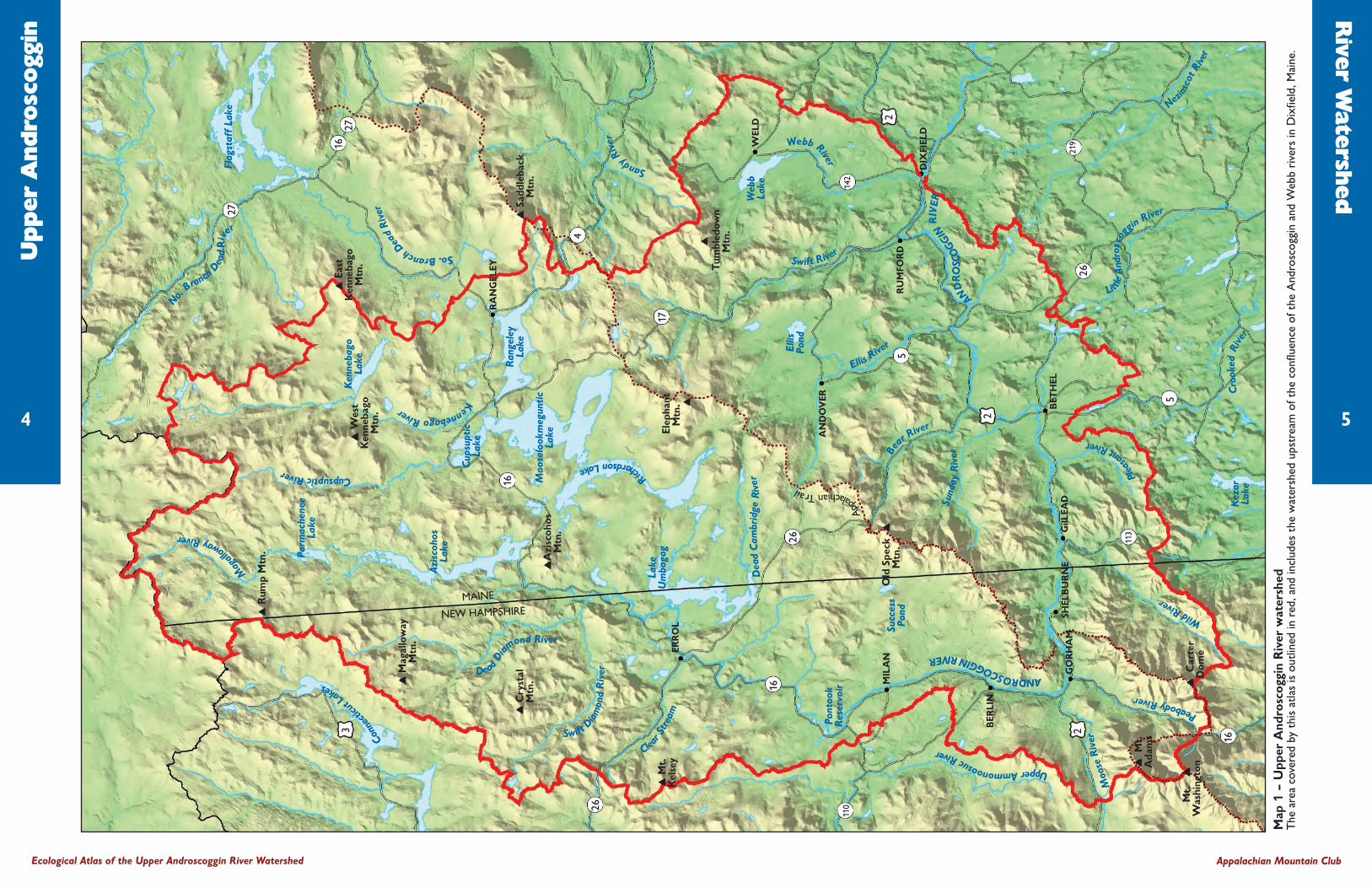
Map
1 –
Upp
er A
ndro
scog
gin
Riv
er w
ater
shed
The
area
cov
ered
by
this
atla
s is
out
lined
in r
ed, a
nd in
clud
es t
he w
ater
shed
ups
trea
m o
f the
con
fluen
ce o
f the
And
rosc
oggi
n an
d W
ebb
rive
rs in
Dix
field
, Mai
ne.
River W
atershed
5
Conn
ectic
utLakes
Mag
allowayRiver
�R
ump
Mtn
.
�M
agal
low
ayM
tn.
�C
ryst
alM
tn.
�A
zisc
ohos
Mtn
.
�M
t.K
else
y
�W
est
Ken
neba
goM
tn.
�Ea
stK
enne
bago
Mtn
.
�Sa
ddle
back
Mtn
.
�Tu
mbl
edow
nM
tn.
�
Old
Spe
ck �
Mtn
.
�M
t.A
dam
s
�C
arte
rD
ome
Mt.
�
Was
hing
ton
Parm
ache
nee
Lake
Azi
scoh
osLa
ke
Cup
supt
icLa
ke
Lake
Um
bago
g
Succ
ess
Pond
Pont
ook
Res
ervo
ir
Ran
gele
yLa
ke
Moo
selo
okm
egun
ticLa
ke
Ken
neba
goLa
ke
Flag
staf
f La
ke
CupsupticRiver
No.
Branch
Dead
Riv
er
So.BranchDead
Rive
r
MAINE
NEW HAMPSHIRE
3
26
16
4
25
2
26
5
219
113
142
17
26
2
16
16
110
27
2716
RA
NG
ELEY
WEL
D
RU
MFO
RD
BET
HEL
GiIL
EAD
SHEL
BU
RN
EG
OR
HA
M
BER
LIN
MIL
AN
AN
DO
VER
DIX
FIEL
D
ERR
OL
SandyRive
r
KennebagoRiver
DeadDiam
ond River
Swift
Diam
ond
Riv
er
Clear St
ream
Dea
dC
ambr
idge
Riv
er
Swift River
Web
bLa
ke
Ellis
Pond
EllisRive
r
Be
ar River
Sund
ayR
iver
AND
RO
SCO
GGINR
IVER
Nezins
cot R
iver
Little
And
rosc
oggin River
Cro
oked
Rive
rK
ezar
Lake
Moo
seR
iver
PeabodyRiver
WildRiver
Plea
santRiver
UpperAmmonoosucRiver
ANDROSCOGGINRIVER
App
alachianTrail
Webb River
RichardsonLake
Elep
hant
Mtn
.

Intr
oduc
tion
6
The Androscoggin is one of New England’sgreat rivers, draining an area of over 3,500 square milesin northern New Hampshire and western Maine (Maps1 and 2). Its watershed lies between the ConnecticutRiver watershed to the west and the Kennebec Riverwatershed to the east, with the smaller Saco andPresumpscot river watersheds lying to the south.
The water that f lows down the Androscogginbegins its journey on the south slopes of low mountainsalong the Canadian border. There, many miles from thenearest human settlement, rainfall and snowmelt collectinto small streams on the forested hillsides. Eventuallythey combine to form the northern tributaries of theriver—the Swift and Dead Diamond, Magalloway,Cupsuptic and Kennebago. These rivers eventually f lowinto the great lakes of the Rangeley Lakes chain—Rangeley, Mooselookmeguntic, Cupsuptic, Upper andLower Richardson, Aziscohos and Umbagog.
It is at Lake Umbagog, straddling the Maine/NewHampshire border, that the Androscoggin River itselfbegins. Leaving the marshy wetlands of this broad shal-low lake, it f lows south through the scenic 13 MileWoods, past the rural villages of Errol and Milan and thehistoric paper mill city of Berlin. Eventually it comes upagainst the great bulk of the White Mountains andmakes a sharp turn to the east toward the Maine border.Along this stretch it joins with other tributaries—theSunday, Bear, Ellis, Swift and Webb rivers from thenorth, and the Peabody, Wild and Pleasant rivers fromthe south. After passing Rumford, the second great millcity along its length, it resumes its southward course inthe vicinity of Jay. From this point onward it f lowsthrough a more heavily developed landscape, past thetwin cities of Auburn and Lewiston, eventually joiningwith the Kennebec in Merrymeeting Bay near the city ofBrunswick before entering the Atlantic Ocean.
This watershed, extending from the wild unpopu-lated forests of the north country to the bustling cities ofthe coast, represents the divide that characterizes muchof northern New England. It encompasses two distinctlydifferent landscapes, as can be seen by looking at severalcharacteristics (Maps 3 to 6, pages 8–9). In addition tothe differences shown on these maps, the forests them-selves change. As one moves into the more heavily set-tled southern part of the watershed, species such as redspruce, balsam fir, sugar maple, and white and yellowbirch become less dominant, while white pine, hemlock,red maple and red oak become more dominant. Lesscommon northern species such as white and blackspruce, tamarack and northern whitecedar disappear,while species such as white oak, hickory, eastern red-cedar and pitch pine appear.
The area covered by this Atlas is the wilder north-ern part of the watershed, including parts of CoosCounty in New Hampshire and Franklin and Oxfordcounties in Maine. It covers the watershed upstream ofthe conf luence of the Androscoggin and Webb rivers inDixfield, Maine1. This area encompasses over 2,300square miles—over twice the size of Rhode Island. Thisis the Great North Woods—a land of vast forests and
undeveloped lakes, where moose roam and loons call outacross misty waters. It is a land that echoes with theghosts of old logging camps and wild beasts such as wolf,mountain lion and lynx—an area rich in history andholding much promise for the future.
Ecological Atlas of the Upper Androscoggin River Watershed Appalachian Mountain Club
Androscoggin: The Abenaki Indians called it Amascogin, which means"fish coming in the spring." The seven Indian tribes that lived along the
Androscoggin River had over 60 names and meanings of the AndroscogginRiver; all 60 of them referred either to the vast fast-water stretches of river
or the large numbers of sea-run fish that were present there.
—From "Fishery Management in the Androscoggin River" by S.E. DeRoche, 1967.
7
Upper AndroscogginRiver watershed
St. John
Penobscot
Kennebec
Presumpscot
Saco
ME
NHVT
MA
CTRI
Con
nect
icut M
errimack
Lake
Cha
mpl
ain
Androscoggin
Map 2 – Major watersheds of New England The area covered by this atlas is outlined in red.
� Introduction �
1 The official U.S. Geological Survey delineation of the upperAndroscoggin watershed includes only the area upstream ofShelburne Dam (where the Appalachian Trail crosses theriver). The area between Shelburne Dam and the Webb River,draining the south side of the Mahoosuc/Elephant Mountainrange and the northeast part of the White Mountains, wasincluded because it shares many “north country” characteristicswith the area north of the Mahoosucs.Lakes, mountains and undeveloped forests define the landscape of the upper Androscoggin watershed
Ro
bert J. K
ozlo
w

Intr
od
uct
ion
8
Map 3 – HighwaysThe lower (southern) part of the watershed iscriss-crossed by an extensive network of roadsand highways connecting the cities and towns ofthe region. The upper (northern) part has farfewer highways, and large parts have no publicroads at all.
Map 4 – Population density:The lower watershed is much more heavily popu-lated. Large parts of the upper watershed have nopermanent population, and only the Berlin-Gorham area in New Hampshire and theRumford-Mexico area in Maine have populationdensities approaching that found throughoutmuch of the lower portion.
Map 5 – Land use:Large areas of forest in the lower watershed havebeen cleared for urban or residential developmentand agriculture. Most of the existing forest hasregrown from land previously used for agriculture,and is fragmented into small blocks by publicroads and settlements. In contrast, the over-whelming portion of the northern watershedremains in forest. Much of this land was nevercleared for agriculture, and extensive areas of for-est are broken only by private gravel loggingroads.
Map 6 – Topography:The shape of the land has had a strong influenceon the distribution of roads, population and landuse within the watershed. The upper watershed isa region of rugged mountains, steep slopes andnarrow valleys. The lower watershed, consistingof the gentler Appalachian foothills and the Gulfof Maine coastal plain, is much more suited towidespread agriculture, settlement and develop-ment.
Ecological Atlas of the Upper Androscoggin River Watershed Appalachian Mountain Club
9
Upper Andro watershedLower Andro watershedHighways
Upper Andro watershedLower Andro watershed
0–11–1010–2525–5050–250>500
Upper Andro watershedLower Andro watershed
Agriculture/grasslandDeveloped
Land use
Upper Andro watershedLower Andro watershed
People per square mile
New
Ham
pshire
Maine
New
Ham
pshire
Maine
New
Ham
pshire
Maine
New
Ham
pshire
Maine

Land
Use
His
tory
Native People(9,000 BC to 1600 AD)
Humans have been living on and using theland in the upper Androscoggin valley for thousands ofyears. Evidence of human activity in the region datesback at least 11,000 years, shortly after the most recentglaciers receded. Paleo-Indian artifacts collected from anencampment on the shore of present day Aziscohos Lakeare the oldest human relics found in all of New England.Various stone knives and projectile points from the siteindicate that these prehistoric humans hunted migratingcaribou from this location. Other archaeological sites dotthe region dating from around 10,000 years ago to themore recent past.
These paleo-Indians were the ancestors of the vari-ous Abenaki tribes of northern New England, includingthe Anasagunticooks, who inhabited the Androscogginvalley. Prior to the arrival of European settlers, each tribeoccupied a different river valley. Although there is evi-dence of some trade as well as hostilities between tribes,commerce was limited and warfare rare, as each tribemade use of the abundant resources of their valley. Thiswas especially true for the Anasagunticooks, who were
more isolated than most by the mountainous terrain bor-dering much of the Androscoggin watershed.
One of the most important resources to these peo-ple was the Androscoggin River itself. In addition toproviding abundant fish and other food supplies, travel-ing the river by birch-bark canoe was the preferred modeof transportation. The river acted as a highway betweenthe ocean, which provided a consistent food supply andmild winter climate, and upstream locations, which pro-vided hunting and fishing opportunities as well as fursand hides for clothing and shelter. Although theAnasagunticook generally led a seasonally nomadiclifestyle, there were permanent village locations along theriver (including Rumford Falls and near Bethel Hill) thatwere centers of fishing, agriculture, and commerce.Every summer, many Anasagunticooks migrated toCanton Point. This was reportedly the largest native vil-lage in New England and was the center of theAnasagunticook tribe. Although estimates are based onlimited information, prior to 1600 the population of theregional Abenaki nation was somewhere around 10,000,and the Anasagunticooks within the Androscoggin valleynumbered a few thousand.
Exploration(1600 to 1800)
While exploring the Maine coast in 1605 theFrench explorer Samuel de Champlain first mentionedthe Androscoggin when he wrote of two rivers (theKennebec and the yet unnamed Androscoggin) converg-ing in Merrymeeting Bay. Shortly thereafter, Englishpioneers began to settle coastal regions and lower sec-tions of the Androscoggin River. When a plague struckthe Anasagunticooks in 1615, they began to move upriver, abandoning their southern settlements and “sell-ing” the land to the English. Although English settle-ment was slow and conf licts rare along the AndroscogginRiver, there were strong tensions between the nativepeople and English throughout New England that erupt-ed into a regional war in 1675 (King Philip’s War). Thealternating cycle of peace and war over the next 50 years(collectively known as the Abenaki Wars) resulted inlarge losses on all sides. In the end, the Anasagunticooksand other Abenaki tribes moved to the upper reaches ofthe Androscoggin, before finally retreating to the St.Francis settlement in Canada.
English exploration and settlement of theAndroscoggin region continued throughout this period.Although settlement of the lower reaches of theAndroscoggin was well under way by 1750, explorationof the upper Androscoggin began much later. In additionto the steep mountains and unnavigable rapids and falls
Ecological Atlas of the Upper Androscoggin River Watershed Appalachian Mountain Club
Map 7 – Historical Development in the upper Androscoggin River watershed
10 11
Extensive logging in the upperwatershed begins in the 1850s.
Artifacts from the Vail Site indicatehuman presence from 11,000 years ago.
Pioneers settle Rangeleyregion from the Kennebec
watershed beginning in 1817.
Appalachian Trail construction begins in 1920s;designated National Scenic Trail in 1968.
Aziscohos Dam formsAziscohos Lake 1911.
Settlement migration continues upstream alongAndroscoggin River. Gilead settled 1774,
Shelburne 1780, Gorham 1803, Berlin 1824.
� Rangeley
Blueback Trout declaredextinct from Rangeley
Lakes in 1905.
Rumford Fallsdammed 1890.
Pioneers reach upperAndroscoggin Valley viaConnecticut River; Milansettled 1774, Errol 1806.
Lake Umbagog National WildlifeRefuge created in 1992.
First sawmill inBerlin built in 1826;paper mill in 1886.
First road overPinkham Notch built
around 1800.
Weeks Act of 1911 creates theWhite Mountain National Forest. Canton Point was the center
of the Anasagunticooks andthe largest native village in
New England.
Rumford settled 1776,Bethel 1768. Settlementof Upper AndroscogginValley intensifies afterRevolutionary War.
Railroad connecting Upper Androscoggin Valley withPortland, ME begun in 1847; reached Gorham in 1851.
Lower, Middleand Upper
Dames erectedabout 1855.
� Errol
� Milan
Rumford �
� Berlin
�
Bethel�
Gilead
�
Gorham
Maine
New
Ham
pshire
� Land Use History �
Early loggers at work
No
rthern
Fo
rest
Heri
tage
Par
k

Lan
d U
se H
isto
ry
12
of the main channel, which made access difficult, therough terrain made the area less desirable for farming.Unlike the nearby Connecticut and Kennebec rivers,which were largely settled by the 1760’s, settlementactivity in the upper Androscoggin watershed did notbuild until the 1780s. In search of raw materials, safetrade routes, and suitable settlement areas, these earlyexplorers and pioneers traveled by navigating the mainchannel and larger tributaries of the Androscoggin andusing marked trails established by the Anasagunticooks.By 1795, a map that included the northern headwaters ofthe Androscoggin valley was created.
Settlement(1760 to 1825)
Settlement and ownership of these lands was oftena complicated process. Initially, townships in the wildlands were granted by the Crown (or later a Governor)to an often-absentee landlord who was responsible forimproving and developing the granted area. Rather thando this task himself, the landowner would usually organ-ize a colony or divide the grant into lots and sell or givethe land to individuals or families. These pioneers werethen obligated to work the land as a condition of owner-ship. Land speculation played an important role, aslandowners made large amounts of land available inex-pensively or free, with the hope that their remaining landwould increase in value as the region was settled.
Early settlers were motivated to live in this wilder-ness by this promise of land ownership and new begin-nings. Increasing growth along the coastline and lowerAndroscoggin shorelines led settlers to explore the inte-rior region. At the end of the Revolutionary War, settle-ment of the Rumford-Bethel-Gilead area increased dra-matically, as veterans of the Patriot army were grantedland as payment for their service.
These pioneers cleared the forests along valley bot-toms to make room for agricultural fields and to produce
building materials for their homes. Although farmingwas difficult and limited, it played an important role inthe early settlement of Bethel, Gilead, and Shelburne. Inaddition to producing crops for personal use and fortrade or sale, early settlers hunted and trapped for foodand furs, raised sheep for wool, and cleared more forestto produce wood and potash.
As these towns were established, the early pioneersor their heirs continued to move upstream. Settlement ofGorham began in 1803. Berlin was one of the last areasin New Hampshire to be settled, and a permanent settle-ment was not established there until 1824.
Although most towns along the river were settledby pioneers migrating upstream, many of the towns fur-ther north along the Androscoggin had already been set-tled. Pioneers arriving from the Connecticut River val-ley to the west settled Milan in 1774 and Errol in 1806.The early settlers that arrived in the Rangeley regionbeginning in 1817 arrived from the Kennebec River tothe east.
Emerging Economiesand Populations(1800 – 1850)
Initially, the settlements throughout the upperAndroscoggin valley were self-sufficient and all activitywas geared towards producing locally needed goods. Thepioneer family had to be skilled in lumbering, carpentry,farming, weaving, and canning, among other tasks. Theoccasional peddler would travel through with items thatwere not available locally for sale or trade, but the fewprimitive roads made travel to or from outside marketsdifficult. This isolation limited local industry, althoughin Berlin (then known as Maynesborough Plantation), asmall potash camp and a lead mine sprang up as the townwas first settled.
The settlers quickly began to use the river’s powermore directly to settle the land. The first grist and saw
mills were constructed in Bethel in 1774; in Berlin asawmill was in place by 1826 and a grist mill by 1835.Unfortunately, the mills were subject to the strongfreshets that arrived with the snowmelt each spring.Between f lood and fire, a mill usually lasted only a fewyears before it had to be rebuilt. Despite these hardships,the settlements f lourished: Rumford was incorporated in1800 with a population of 252 and Gorham in 1836 with135 townspeople. Shelburne had grown to 400 by 1830,and Berlin had a population of 72 when it incorporatedin 1829.
In part, this growth was driven by a strong marketfor the tall straight white pines that grew along the valleybottoms of the Androscoggin River and its tributaries.Whenever the local mill owners had a surplus of logs,they were laboriously hauled to Portland. Soon, loggersand river drivers were recruited to the area from theKennebec and Penobscot regions to help meet theincreasing demand for timber. Although their numberswere usually not ref lected in official censuses, townswould periodically swell with these migratory workers,and populations began to shift from the settled pioneerfamily to the independent transient woodsman.
Getting the logs downstream to market was slow,difficult, and dangerous work. Trees located near theAndroscoggin were cut during the winter and skiddedby ox to a nearby frozen lake or river to await spring.The river drivers would ride downstream along with thelog rafts, making sure that the booms did not becomestuck on the shoreline or form logjams. Although theriver currents were swift and plentiful in the spring,water levels dropped rapidly in the summer and oftenstranded the driver’s payload. Oftentimes, it took fromtwo to four years to f loat logs to their final destination.To counter this problem, a dam was built at the outlet ofRangeley Lake in 1836 to moderate the f low of waterand extend the river drive further into the summer.
Early Industrial Growth(1850 – 1880)
Despite the creation of the Rangeley Lake log driv-ing dam, the journey to market was still a drawn-out andexpensive process. However, businessmen in Portland,Boston, and Bangor recognized the increasing market forlumber and the potential resources available in the upperAndroscoggin watershed. They purchased forestlands,secured water rights, and developed access to the area byextending the Atlantic and St. Lawrence Railway fromPortland to Montreal. The arrival of the railroad inGorham in 1851, and Berlin two years later, created rapidand dramatic changes throughout the upper valley.
With quick and efficient transport available, aseries of new log driving dams were quickly erected tobring the logs from the Rangeley Lakes region to Berlin.Dams were constructed on the Rapid River (no longerexists), at Lower Richardson Lake (Middle Dam),
Mooselookmeguntic Lake (Upper Dam), and belowLake Umbagog (near the present day Errol Dam). Theselarger dams markedly altered the f low of theAndroscoggin and raised the water levels ofMooselookmeguntic and the Richardson lakes by morethan five feet.
A dam of a different type was built downstream atBerlin Falls. Like the settlers who had set up mills at thislocation previously, the Winslow Company recognizedthe power that could be harnessed where theAndroscoggin narrowed right above the mighty falls.They bought the land along the shoreline, and immedi-ately built a new dam and modern sawmill at Berlin Fallsto collect, process, and ship the logs harvested from thevast region upstream.
With all this activity surrounding the construction,operation, and maintenance of the railroad, dams, andmills, Berlin became a boomtown practically overnight.With the infrastructure in place, logging along theRangeley Lakes and the Magalloway and Dead/SwiftDiamond rivers increased dramatically. Although its per-manent population reached a moderate 400 residents by1860, part-time residents doubled the actual number ofpeople in town.
However, these events had a very different effecton other towns along the Androscoggin. The railwayfrom Portland had come up the Little AndroscogginRiver, bypassing the towns of Shelburne, Gilead, Betheland Rumford. In addition, the completion of the BerlinFalls mill nearly eliminated downriver log drives and thesmall mill enterprises along the way. As people weretempted to abandon their marginal farms by the lure of
Ecological Atlas of the Upper Androscoggin River Watershed Appalachian Mountain Club
13
Log deck at the mouth of the Magalloway River, 1959
Aerial view of Milan in the upper Androscoggin River watershed, circa 1940
No
rthern
Fore
st Heritage
Park
No
rthern
Fore
st Heritage
Park

15
Lan
d U
se H
isto
ry
14
wage employment in Berlin, the populations of theseonce growing towns dropped quickly. As a result, someof these towns retain their rural character today.
Late Industrial Growth(1875 - 1900)
If it were not for developments in paper manufac-turing, the logging boom in the region might have beenshort lived. The narrow band of white pines along theriver corridors was being exhausted quickly. But shortlyafter the Civil War, an increasing national appetite forreading newspapers, now made from pulpwood ratherthan rags, created a new resource for the region. Spruceand fir trees needed for this new market were so abun-dant in the region that the first Maine ForestCommissioner’s report in 1896 recognized theAndroscoggin drainage as the most valuable spruce landin the Northeast.
Berlin was poised to take advantage of this newresource. A businessman named William WentworthBrown added to the lumber operation at Berlin Mills bybuilding or buying a number of pulp and paper millsbeginning in the 1880s. The first paper was produced in1886. By the turn of the century several major papercompanies were in operation, and Berlin was home tothree of the largest pulp and paper mills in the world.The Berlin Mills Company (which was not renamed theBrown Company until 1917) controlled three millionacres of timberland in New England and Quebec. Berlin
was incorporated as a city in 1897, and its populationgrew from 1,150 in 1880 to 9,000 by the turn of thecentury.
Around the same time, ownership and control ofthe Rangeley Lakes dams were consolidated under theUnion Water Power Company. The Middle and UpperDams were soon reconstructed, raising the water levelfurther and f looding out the “Narrows” that had been amiddle lake between Upper and Lower RichardsonLakes. Although the restructured dams increased head-water storage, water discharge was now primarily man-aged to augment low summer f lows for the textile indus-try in Lewiston, rather than to f loat logs.
Berlin was not the only area along theAndroscoggin to take advantage of the growing paperindustry. Although Rumford had missed the loggingboom of the 1850’s when the railroad bypassed the area,the pulpwood resources in the region could no longer beignored. Hugh Chisholm (who had already brought thepaper industry to Livermore downstream) capitalized onthe potential power at Rumford Falls and the largelyunlogged watersheds of the Bear, Ellis, and Swift rivers.He purchased forestlands, brought rail service to theregion, and dammed the powerful falls to form theOxford Paper Company. With this rapid development,the population of the town skyrocketed to more than5,000.
Growth in Tourism(1850 - present)
Although the logging and paper industry emergedas the dominant industry, it was not the only one tof lourish in the region. Tourism and recreation beganaround the same time as the budding timber industryand continues to expand today. Even prior to the arrivalof the railroad, a stage road from Andover to LowerRichardson Lake provided access to the extraordinaryfishing and hunting opportunities throughout theRangeley Lakes region. Brook trout weighing fivepounds and more were not uncommon and drewwealthy businessmen (known as “sports”) from as faraway as Boston, New York, and Philadelphia. Althoughnot as prized by the vacationing angler, blueback troutwere also abundant and an important local source of foodand income. They were caught in large quantities by netand marketed to Boston and New York.
The arrival of the railroad eased access to theRangeley Lakes and led to the establishment of manysporting camps along the shorelines. Although timber andother freight were the initial intended revenue source, therailroad companies quickly recognized the benefits ofhauling passengers as well. They actively promoted theregion as a tourist destination and helped to financehotels, steamboats and activities in the region. Sports andtheir families would arrive by train and spend a week or amonth at the lavish hotels or more remote camps.
As a hub and maintenance center for many of the
early rail lines, Gorham experienced a burst of growthduring this period as well. In addition to its proximity tobooming Berlin, it became a tourist destination as thegateway to the White Mountains. A number of restau-rants and hotels sprung up in and around Gorham,including the Glen House in the shadow of thePresidential Range. From the Glen House, touristscould take the Carriage Road all the way to the summitof Mt. Washington, the tallest peak in New England.Even at the summit, travelers could find shelter from theharsh alpine environment at the Tip Top House, whichwas built in 1853. Bethel also experienced a tourism-related boom at this time; its 1860 population of 2,523was larger than any other time in the town’s history.
Though the days of the grand hotels is long sincepast, the region has remained a major tourist destination,and hiking, skiing, hunting, fishing, snowmobiling, andwildlife viewing are an increasingly important part of theregional economy.
Overutilization(1875 – ?)
All of this recreational and industrial activity tookits toll on the land and local economies. Declines in fishpopulations were one of the first areas where these
effects were noticed. By 1880, the combination of damsand river contamination from timber, textile, andmunicipal waste had put an end to salmon migrationsalong the lower Androscoggin. But the previously pris-tine and productive waters of the upper Rangeley Lakeswere soon experiencing similar problems. Increased sedi-mentation and water temperatures from timber harvest-ing along spawning streams, along with unregulatedoverfishing and non-native salmon introductions, causedcrashes in the once abundant brook trout populations.Despite protections beginning in 1880, even the ubiqui-tous blueback trout was declared extinct in the region by1905. The loss of these fisheries, along with majorchanges in the public’s vacationing habits (such as theintroduction of the automobile), led to the demise ofmany of the luxury hotels and a drop in tourism in theregion that lasted through the Depression.
Downstream at Berlin and Rumford the growingpaper industry introduced new stresses to the riverecosystem. In addition to waste generated from logging,sawmills, and municipal sewer systems, developments inpulpwood processing now added sulfur to the list ofeff luents being dumped directly into the AndroscogginRiver. The amount and toxicity of waste was increasingand would soon test the limits of the Androscoggin. Logdrives, which continued through the 1950s, damagedriverbottoms and shorelines and added large amounts of
Ecological Atlas of the Upper Androscoggin River Watershed Appalachian Mountain Club
The Wilson Saw Mills in 1887
Driving logs was hard and dangerous work
No
rthern
Fo
rest
Heri
tage
Par
k
No
rthern
Fore
st Heritage
Park

Clim
ate
17
Lan
d U
se H
isto
ry
16
sediment and organic debris to the river.The growth and development of the paper industry
also had a direct effect on the surrounding land. Asdemand increased, timber extraction continued toexpand. Whereas the initial round of harvesting hadfocused on large trees (primarily pine and spruce) suit-able for sawing into lumber, smaller trees could be uti-lized for pulpwood. Eventually hardwood as well as soft-wood pulp was used for papermaking, increasing thedemands on the region’s forests.
The White Mountains were particularly hard hitduring this time. As the last area in the region to belogged, it contained large tracts of virgin spruce after thesupply on surrounding lands had been exhausted.Timber interests had acquired the lands from the state ofNew Hampshire and began to intensively log them inthe 1870s. A comprehensive railroad system was put inplace, which gave access to the remotest mountainsides.Within the Androscoggin watershed, the peak period oflogging railroad activity was from 1890 to 1910, withlines built up the Wild River valley and from Berlin toSuccess Pond (allowing access to the north slope of theMahoosuc Range). Trees were logged wherever theycould be reached and vast areas were clearcut. Aroundthe turn of the century devastating fires burned manycutover areas, leading to skies darkened by smoke andrivers choked with erosion from the barren slopes.Public concern that arose in the wake of these fires cre-ated the first conservation movement in the region.
Over time the fact that the forest was not limitlessbecame clear. The massive clearing of large areas is athing of the past. Social pressure, education and scientificadvances have led to significant improvements in howforestlands are managed. However, the globalization ofthe timber industry and the exposure of the region’sforests to an increasingly competitive marketplace areputting new pressures on both landowners and theforests they manage. The quality of timber managementacross the region is highly variable, and inappropriatepractices such as overharvesting, high-grading (harvest-ing only the best quality trees) and liquidation harvesting(stripping a tract of all merchantable timber without con-cern for future management) remain a concern. Whetherwe have truly left behind the era of overutilization andentered a new era of sustainable forest managementremains an issue of intense public debate.
Conservation(1900 – present)
In the first decade of the 20th century, the heavylogging and devastating fires in the White Mountains ledto criticism from the tourist industry, conservationgroups (including the Appalachian Mountain Club andthe newly-formed Society for the Protection of NewHampshire Forests) and even the textile industry (due toconcern about less reliable water f low). These groupsadvocated that the state buy back the high slopes and
other special areas, and that the private sector practiceresponsible forestry. Unfortunately, because of politicaland economic considerations, the state was unable to act,and the private timber interests had no incentive to stoplogging at this unsustainable rate. The need for federalaction became evident during a discussion regarding atract of land in the northern Presidential Range. Uponpurchase of the land, the Berlin Mills Company publiclyexpressed an interest in preserving the scenic character ofthe mountain range, but admitted that the area would belogged because they could not afford to do otherwise.
As a result of this public concern Congress passedthe Weeks Act in 1911, which created the WhiteMountain National Forest (and other National Foreststhroughout the east). Between 1914 and 1937 much ofthe land within the forest boundary was returned topublic ownership, with the purchase of smaller areascontinuing to the present. The forests have largelyregenerated, and today the forest encompasses about750,000 acres, with over 100,000 acres lying within theAndroscoggin watershed.
The waters of the Androscoggin River also beganto make a comeback in the early 1940s. For decades, theriver had increasingly become an open sewer, with hun-dreds of thousands of tons of industrial and municipalwaste dumped each year. The situation came to a head inLewiston, when the smell of sulfur became unbearableduring the particularly dry summer of 1941. As a resultof public pressure, the upstream paper mills were slowlypersuaded to take steps leading to the phase-out of sulfuremissions and other pollutants. Some of the solutionsimplemented on the Androscoggin were incorporatedinto the federal Clean Water Act of 1972. Over time,efforts to reduce industrial waste and treat municipalsewage have been extremely successful, and today theriver has recovered to the point where it is a valuableecological, scenic and recreational feature of the land-scape.
Over the last several decades, other conservationefforts have shaped the pattern of land ownership anduse in the watershed (see page 76). Today there isincreasing recognition that the ecological, social and eco-nomic future of the Androscoggin River watershed isintimately tied to how we treat the land. In 1999 theAndroscoggin River Watershed Council was formedwith the mission “to improve environmental quality andpromote healthy and prosperous communities in theAndroscoggin River Watershed.” Citizens, landownersand public officials searching for answers to the question“How do we use the land without degrading its value tofuture generations?” are pointing the way to the future.2
2 Information on the Androscoggin River Watershed Councilcan be found at http://www.andro-watershed.org.
The upper Androscoggin watershed has atemperate continental climate, characterized by warmsummers, cold winters, and a relatively even distributionof precipitation throughout the year. Both temperatureand precipitation vary across the region in response tolatitude, elevation, topography, and distance from theocean.
Patterns in temperature can be seen in records forthe towns of Lewiston and Bethel (Maine) and Errol andPittsburg (New Hampshire) (Map 8, Figure 1). As onemoves farther north, average monthly temperaturesdecline, with Pittsburg on average about 10°F colderthan Lewiston. The difference is most pronounced inthe winter—Lewiston is about 8°F warmer thanPittsburg in the summer but 12° warmer in the winter.Record highs range from about 100°F in the south to95°F in the north, and record lows from -35 to -45°F.
Part of this pattern is due to the effects of eleva-tion—on average temperature drops about 3°F withevery 1000 foot gain in elevation, and as one movesnorth in the watershed one is also gaining elevation.(Pittsburg and Errol are over 1000 feet higher in eleva-tion than Lewiston.) If all these towns were at the sameelevation, the change as one moves north would stilloccur but would be less pronounced.
The effect of elevation can be seen in temperaturedata from the summit of Mount Washington, at 6288feet the highest point in the northeastern United Statesand often described as having the world’s worst weather.Average temperatures on the summit are about 20°Flower than in the surrounding valleys in the summer and
Ecological Atlas of the Upper Androscoggin River Watershed Appalachian Mountain Club
0
10
20
30
40
50
60
70
80
Jan
Feb
Mar Apr
May Jun
Jul
Aug
Sep
Oct
Nov
Dec
Mea
n m
on
thly
tem
per
atu
re (o
F)
Lewiston
Bethel
Errol
Pittsburg
Mt. Washington
Map 8 – Locations of climate dataData from Lewiston and Bethel, Maine, and Errol andPittsburg, New Hampshire, (Figures 1 and 2) showhow climate varies across the upper Androscogginwatershed.
Figure 1 – Mean monthly temperatures (˚F) for selected towns
Mea
n m
onth
ly t
empe
ratu
re (
°F)
� Climate �
Pittsburg
Errol
Bethel
Lewiston
Upper Andro watershed
New
Ham
pshire
Maine

Clim
ate
18
10-15°F lower in the winter. The all-time record hightemperature on Mount Washington is only 72°F.
Precipitation also varies across the watershed (Map9) and is strongly inf luenced by elevation and topogra-phy. Most towns in the watershed receive 40 to 45 inch-es of precipitation a year. However, the amount of pre-cipitation increases with elevation. As moist air massesrise to pass over mountains they cool, reducing theamount of moisture the air can hold and leading to con-densation of moisture as rain and snow. The highest pre-cipitation in the watershed is at the summit of MountWashington—about 100 inches per year.
The driest part of the watershed is the valleystretching from Pontook Reservoir across the RangeleyLakes region. This valley is surrounded on all sides bymountains, which create a “rain shadow” effect.Precipitation arriving from any direction falls heavily onthe surrounding mountains, leaving less to fall on the
valley behind the mountains. The average precipitationin Errol is only 36 inches a year—about 8 inches per yearless than in either Bethel or Pittsburg.
The seasonal timing of precipitation also variesfrom south to north (Figure 2). Though there are nopronounced wet or dry seasons, in the southern part ofthe watershed late fall (October through December) isthe wettest part of the year, whereas in the north June,July and August are the wettest months.
Finally, the seasonal extremes in climate changefrom south to north. Differences between the warmestand coldest months, record high and low temperatures,and the proportion of precipitation falling in the wettestand driest months all increase as one moves north. Themountains stretching across the central part of the upperwatershed act as an abrupt boundary between continen-
tal and maritimeweather patterns,with a more con-tinental climateto the north anda more maritimeclimate closer tothe moderatinginf luence of theocean.
Ecological Atlas of the Upper Androscoggin River Watershed Appalachian Mountain Club
Map 9 – PrecipitationPrecipitation is highest on upper mountain slopes and lowest in the Rangeley Lakes region due to the “rain shadow”effect of surrounding mountains. (This map does not show actual precipitation, which is recorded only at a fewpoints in the watershed. It shows the results of a model that uses information on elevation, topography and weath-er patterns to predict the precipitation at any point. Actual precipitation data from recording stations is used to cal-ibrate the model to ensure that the predictions match the real data as closely as possible.)
19
0.0
2.0
4.0
6.0
8.0
10.0
12.0
14.0
Jan Feb Mar Apr May Jun Jul Aug Sep Oct Nov Dec
Per
cen
t o
f an
nu
al p
reci
pit
atio
n
LewistonPittsburg
Continental and maritime climates
Continental climates are those influenced primarily bycontinental air masses, and are generally characterized bywide seasonal fluctuations in temperature and precipitation(hot summers, cold winters and pronounced wet and dryseasons). In contrast, maritime climates are influenced pri-marily by oceanic air masses and have less pronouncedseasonal differences, with cooler summers and warmerwinters due to the mitigating effect of the ocean. NewEngland’s climate is considered continental since onaverage its weather moves from west to east following theflow of the jet stream. However, the proximity of theAtlantic Ocean does influence the region’s climate (espe-cially precipitation patterns), and it should more properlybe described as a mixed continental-maritime climate.
1998 ice storm damage
Figure 2 – Distribution of annual precipitation (percent per month)
Upper Andro watershed
33–3838–4242–4646–5050–6060–80>80
Precipitation (inches/year)
Rump Mtn.
Snow Mtn.
Spotted Mtn.
Deer Mtn.
Crystal Mtn.
Mt. Kelsey
Goose-Eye Mtn.
Carter DomeMt. Washington
Mt. Cabot
Puzzle Mtn.
Tumbledown Mtn.
Crocker Mtn.
�
�
�
� �
�
�
�
� �
�
�
�
New
Ham
pshire
Maine
David
Publico
ver

The upper Androscoggin watershed is anold and geologically complex landscape (Map 10).Though the rocks and mountains seem solid andunchanging, they are the result of dramatic events thattook place hundreds of millions of years ago. The landwe see today was shaped by the collision of continents,extensive volcanic activity, and the rise and subsequenterosion of two great mountain ranges.
Precambrian historyMore than 544 MYBP3
At the beginning of the Cambrian period the coastof the ancestral North American continent lay to thewest of its current location, near present day QuebecCity and Albany, New York. The Adirondacks, formedduring an earlier continental collision over a billion yearsago, were already an old range, worn down from hun-dreds of millions of years of erosion. New England layunder an ocean known as the “proto-Atlantic” or Iapetus(after the Greek god who was the father of Atlantis),which opened when the North American and Europeancontinental plates separated about 650 million years ago.
Precambrian rocks are rare in New England, pres-ent only in a few areas including parts of the Green andBerkshire mountains. In northwestern Maine lies suchan area of ancient rock—the Chain Lakes massif.Consisting primarily of gneiss (very durable rock formed
by extreme heat and pressure), the Chain Lakes massifextends from the upper Moose River into the northeast-ern corner of the Androscoggin watershed (the headwa-ters of the Kennebago River). These are the oldest rocksin Maine or New Hampshire—between 1 and 1.6 billionyears old. The formation is often described as “mysteri-ous” because its origins are not well understood. It isnow thought to have been an isolated small piece of con-tinental crust (a “microplate”), though it has even beensuggested that it represents the site of an ancient meteorimpact.
Cambrian period544 to 505 MYBP
At some point the movement of the continentschanged and Iapetus began to close. In the middle of theocean a subduction zone was created—a seam in theoceanic crust, where the western part of the ocean f loorsunk underneath the eastern part. The tremendous heatand pressure created along this subduction zone led to ahigh level of volcanic activity, and an island arc wasformed—a line of volcanic islands, similar to the present-day Aleutians. As Iapetus closed, this island arc waspushed toward the eastern edge of North America.
In the late Cambrian period, this island arc (knownas the Bronson Hill complex) collided with the ChainLakes massif in an event known as the Penobscottianorogeny. Deep ocean-f loor rocks caught in the vice ofthis collision are present as a band stretching from the
Ecological Atlas of the Upper Androscoggin River Watershed
21
Geo
logy
20
3Million years before present.
Map 10 — Bedrock geology Each group shown on this map is a consolidation of numerous individual geologic formations.
Appalachian Mountain Club
Upper Androscoggin watershed
Highways
Precambrian gneiss of the Chain Lakes Massif
Cambrian to early Ordovician period ocean-floor sedimentary and volcanic rocks metamorphosed during thePenobscottian orogeny (Hurricane Mountain, Jim Pond, Dead River and Aziscohos formations)
Ordovician period plutonic and volcanic rocks of the Bronson Hill island arc complex
Silurian-Devonian period sedimentary rocks of the Connecticut Valley-Gaspe trough metamorphosed during theAcadian orogeny (Frontenac and Ironbound Mountain formations)
Late Ordovician to Silurian period ocean floor sedimentary rocks deposited in Iapetus and metamorphosed duringthe Acadian orogeny (Sangerville, Rangeley, Perry Mountain, Smalls Falls, Madrid and Quimby formations)
Devonian period ocean floor sedimentary rocks deposited in Iapetus from an eastern source and metamorphosedduring the Acadian orogeny (primarily Seboomook, Carrabassett and Littleton formations)
Devonian period plutonic rocks intruded during the Acadian orogeny
Carboniferous period Sebago pluton
Mesozoic period plutonic rocks
Key to Map 10
� Geology �
New
Ham
pshire
Maine
See map key on opposite page

Ecological Atlas of the Upper Androscoggin River Watershed Appalachian Mountain Club
23
Geo
logy
22
13-Mile Woods section of the Androscoggin River,across Aziscohos Lake and the upper Magalloway Riverto the vicinity of Moosehead Lake.
Ordovician period505 to 440 MYBP—the Taconic orogeny
About 450 million years ago the Bronson Hillcomplex collided with North America, in the first oftwo great mountain-building events that would shapethe upper Androscoggin watershed. This event, knownas the Taconic orogeny, pushed ocean f loor sedimentaryrocks westward across the eastern margin of the NorthAmerican continent, creating the Taconic Mountainsalong the Vermont/New York border. The eroded coreof the Bronson Hill complex remains as a line of graniticplutons (pockets of molten rock that solidified under-ground) along the western New Hampshire border,across the northern White Mountains, and through theRangeley Lakes region to central and northeasternMaine (Map 11). At the end of the Ordovician period,this line marked the eastern shore of northern NewEngland. The largest of these Ordovician plutons is theJefferson Dome, extending from Bethlehem, NewHampshire across Jefferson, Randolph and Berlin to theMaine border north of the Mahoosucs. The large cliff onMount Forest west of Berlin is an exposure of JeffersonDome granite.
Silurian period440 to 410 MYBP
The Silurian period was relatively quiet, marked bythe erosion of the mountains built by the Taconic oroge-ny. Iapetus continued to close, but the zone of subduc-tion and volcanic activity shifted to the eastern side ofthe ocean. Sediments eroded from the Bronson Hillcomplex collected in deep layers in Iapetus, as well as inthe Connecticut Valley—Gaspe trough to the west.There are few plutonic rocks from this period, ref lectingthe lack of tectonic activity. By the end of the Silurian,the upper Androscoggin watershed had been reduced toa landscape of low relief, with much of it once againunder water.
Devonian period410 to 360 MYBP—the Acadian orogeny
During the early Devonian period the ever-nar-rowing Iapetus continued to fill with sediment, but thesource of these deposits shifted. Sediment was now com-ing from the east, from younger mountains along theedge of the approaching land mass on the other side ofIapetus. Rather than Europe proper, this land mass mayhave been a “microcontinent” known as Avalonia thatlay between the larger North American and Europeancontinental plates.
Map 12 — Devonian plutonic rocksThese bodies of magma pushed up underground duringthe Acadian orogeny about 360 to 400 million yearsago, when the European continental plate collided withNorth America.
Map 11 — Ordovician plutonic and volcanic rocksThese are the remnants of the Bronson Hill island arccomplex, which collided with the eastern shore ofNorth America during the Taconic orogeny about 450million years ago.
Over the course of the Devonian period the NorthAmerican and Avalonian/European continental platescame together in the second major event that shaped theregion’s landscape—the Acadian orogeny. Along withthe somewhat later Alleghanian orogeny (marking thecollision of Africa with North America south of NewEngland), this collision resulted in the rise of the mod-ern Appalachian Mountains. The rocks of the regionwere compressed, folded and thrust upward, with ridgesfollowing the northeast-southwest grain that marks theAppalachian landscape. The heat generated by the colli-sion led to the intrusion of large bodies of magma deep
underground. These Devonian-age plutons underliemuch of New Hampshire and central and DowneastMaine (Map 12), including the center of the upperAndroscoggin watershed from the Rangeley Lakesregion south to the Mahoosucs and Ellis Pond.
At the end of the Devonian period the rocks of thepresent day upper Androscoggin watershed were inplace, though they lay many miles underground. Theheat and pressure of the Acadian orogeny had causedtremendous deformation and metamorphism of the orig-inal rock forms. In the southwest portion of the water-shed the heat and pressure were the greatest, and the
Upper Andro watershedOrdovician plutonic rocks
Upper Andro watershedDevonian plutonic rocks
*Million years before present.This scale does not do justice to the relative length of the various periods. If the history of the earth is represented by a ruler10 feet long, then the beginning of the Cambrian period (marking the first major expansion of life on earth) would haveoccurred at about 8.8 feet. The Taconic and Acadian orogenies would have occurred at about 9 feet. The Mesozoic era (the“Age of Dinosaurs”) would have run from 9.4 to 9.9 feet, and the Pleistocene epoch (the “Ice Age”) would have begun at 9.996feet. The Holocene epoch (marking the rise of human civilization) would take up just the last 2 ten–thousandths of an inch, andthe period of European settlement in the upper Androscoggin just 6 one–millionths of an inch—about the diameter of a virus!
Era
Cenozoic
Mesozoic
Paleozoic
Period
Quaternary
Tertiary
Cretaceous
Jurassic
Triassic
Permian
Carboniferous
Devonian
Silurian
Ordovician
Cambrian
Epoch
Holocene
Pleistocene
Time(MYBP*).08–present
1.8–.08
65–1.8
145–65
213–145
248–213
286–248
360–286
410–360
440–410
505–440
544–505
4500–544
Major events
Rise of human civilization.Period of extensive continental glaciation.Evolution of modern humans.Mammals become dominant.
Evolution of modern flowering plants.Extinction of dinosaurs.Extensive plutonic intrusions in White Mountain region.Dinosaurs dominant.First birds.Evolution of dinosaurs.First mammals.Breakup of Pangaea creates modern Atlantic Ocean.
Formation of Pangaea.First coniferous trees.
Alleghanian orogeny builds southern Appalachian Mountains; intrusion of Sebago pluton.
Lush forests; formation of coal deposits.First reptiles.Acadian orogeny builds modern northern Appalachian Mountains;
massive plutonic intrusions.Evolution of seed plants and trees; first forests.First insects and amphibians.
Period of erosion; sediments deposited in Iapetus form many ofthe rocks of the upper Androscoggin watershed.
Evolution of modern fish and vascular plants.
Taconic orogeny.Plants and animals first appear on land.Penobscottian orogeny.Iapetus closing–formation of Bronson Hill volcanic island arc.Major evolutionary diversification (the “Cambrian explosion”) cre-
ates ancestors of most modern life forms.Evolution of multi-cellular animals.Formation of Adirondacks; opening of Iapetus.Algae and bacteria dominant.Development of oxygen-rich atmosphere.Evolution of photosynthesis.Origin of life.Formation of earth.
Table 1 — Geologic Time Scale
Precambrian time

sandstones and mudstones that had collected on thef loor of Iapetus were transformed into the highly resist-ant schists of the Presidential Range. Farther northmetamorphism was less extreme, and metasedimentaryrocks such as slate and phyllite were formed.
Late Paleozoic era to the Pleistocene epoch360 to 1.8 MYBP
The New England region remained geologicallyactive for another 250 million years, though much of thisactivity had limited effect on the upper Androscogginwatershed. The Alleghanian orogeny took place duringthe Carboniferous and Permian periods (360 to 248MYBP). The intrusion of the extensive Sebago pluton(stretching from Bethel south to Lake Sebago) may havebeen related to this collision.
At the end of the Paleozoic era all the land massesof earth were joined in a single supercontinent known asPangaea (Greek for “all lands”). Reptiles of the periodcould have walked from the Androscoggin watershed towhat is now southern Morocco. About 50 million yearslater, during the early Mesozoic era (248 to 65 MYBP),North America began separating from Europe andAfrica, leading to the formation of the modern AtlanticOcean. The line of separation lay east of the earliercoastlines, as part of Avalonia was left joined to NorthAmerica. During the middle Mesozoic era a new groupof plutons intruded to the west and south of theAndroscoggin. Though no plutons of this age lie withinthe upper watershed, today they make up the rocks ofthe Kilkenny region, much of the southern and westernWhite Mountains, and the Ossipee Mountains. For thelast 100 million years the New England region has beengeologically stable.
The major process shaping the upper Androscogginwatershed for the last 360 million years has been erosion.Wind, ice, rain, and gravity have removed miles of over-lying rock, reducing the great mountains formed duringthe Acadian orogeny to the mature ranges we see today.It was left to the glaciers of the Pleistocene epoch to putthe finishing touches on the regional landscape.
Pleistocene epoch1.8 MYBP to 8,000 years ago—the “Ice Age”
During the Pleistocene epoch, large glaciers cen-tered in eastern Canada expanded and retreated severaltimes across much of northern North America. The lastglacial episode, known as the Wisconsin glaciation,began about 25,000 years ago and reached its peak about18,000 years ago. At that time a sheet of ice thousands offeet thick covered all of New England, extending southto Long Island and Cape Cod. Eventually the climatewarmed and the glacier retreated, with the last of the icedisappearing from northern New England 10-12,000
years ago.The glacier did not form in place, but f lowed from
north to south. As it moved it acted like a giant sheet ofsandpaper, pulverizing the rock underneath it androunding off the rough edges of the landscape. Thematerial carried along underneath, within and on top ofthe ice was spread across the landscape, often beingdeposited many miles from its bedrock source. Thoughthe surficial deposits left behind by the glacier take manyforms, they fall into two basic types:
Till is pulverized rock that was smeared across thesurface of the landscape underneath the ice or droppedin place when the ice melted. It contains a heteroge-neous mix of material from finely ground clay and silt tosand and rock fragments. Till covers most of the uplandsof the region, but is thin or absent on mountaintops andridgelines and deeper on lower or convex slopes.
Glaciofluvial deposits (Map 13) are materials thatwere moved and deposited by f lowing water when theglacier melted. Because the f lowing water carried awaymuch of the finer material, these deposits tend to becoarser-textured sand and gravel. They are found prima-rily in valley bottoms and include alluvium (well-sortedsand, gravel and cobbles deposited along river beds, oftento depths of hundreds of feet) and kamic deposits (lesswell-sorted material deposited by water f lowing off themelting ice). The upper Androscoggin River watershed
is one of the most rugged landscapes in New England(Map 14, page 26). From an elevation of just over 400feet above sea level at the conf luence of theAndroscoggin and Webb rivers, the land rises over a ver-tical mile to the summit of Mount Washington, at 6288feet the highest point in the northeastern United States.
The watershed contains two mountainous regionsseparated by a valley that stretches from theBerlin/Milan/Errol, New Hampshire region across theRangeley Lakes, extending to Flagstaff and Mooseheadlakes. South of this valley lie the great ranges of theWhite Mountains (the Presidential, Carter–Moriah andCaribou–Speckled ranges), the Mahoosuc Range, andBemis and Elephant mountains. This range (sometimescalled the Longfellow Mountains) continues northeastacross the Saddleback–Sugarloaf and Barren–Chairback–Whitecap ranges before ending at Mount Katahdin. Tothe north lie the high peaks of northern Coos County(including Kelsey, Crystal, Magalloway and Rumpmountains) as well as the Kennebago Divide and MountSnow in northwestern Maine. These mountains (knownin Maine as the Boundary Mountains) continue alongthe Maine/Quebec border as far as Boundary BaldMountain north of Jackman.
Within (or along the boundary of) the watershedlie over 100 distinct peaks rising above 2700 feet in ele-vation, with 35 of these exceeding 3500 feet and 9 (allwithin the White Mountain National Forest) exceeding4000 feet (Table 2, page 28). Nearly seven percent of theland in the watershed (almost 100,000 acres) lies above2700 feet. Of all the watersheds in northern NewEngland, only the Pemigewasset River watershed, which
drains the heart of the White Mountains, has a greaterproportion of its area in high-elevation land.
The mountainous nature of the landscape is alsoref lected in the slope of the land (Map 15, page 27).Only about a third of the land in the watershed is rela-tively f lat (less than 10% slope4). Outside of theRangeley Lakes valley between the mountains, thelargest areas of f lat ground are in the valleys of the Ellisand Webb rivers. About seven and a half percent of thewatershed consists of steep ground (greater than 35%slope). The greatest extent of steep ground is not sur-prisingly in the Presidential and Mahoosuc Ranges,though steep slopes can be found on most of the water-shed’s mountains. Across Maine and New Hampshire,only the Pemigewasset watershed has less f lat groundand more steep slopes.
The shape of the landscape has profoundly affectedthe uses to which people have put the land. Because ofthe difficult access, the upper Androscoggin region wasone of the last places in New England to be settled (out-side of the very remote areas of northern Maine, whichhave never been settled). The steep ground (along withthe harsh climate and infertile soils) limited the amountof land available for agriculture and development, andthroughout its post-settlement history the primary usefor most of the land in the watershed has been timberharvesting.
4 Slope as measured in percent reflects the elevation gainacross a specified distance. A 10% slope means that the landrises 1 vertical foot for every 10 horizontal feet. A slope of100% is the same as 45 degrees (10 vertical feet for every 10horizontal feet).
Ecological Atlas of the Upper Androscoggin River Watershed Appalachian Mountain Club
Map 13 — Glacifluvial depositsThese deep deposits of sand and gravel were depositedabout 12,000 years ago in valley bottoms by waterfrom melting glaciers.
Topography
25
Geo
logy
24
Upper Andro watershedGlaciofluvial deposits
� Topography �
Richardson and Mooselookmeguntic lakes
Ken K
imbal
l

Ecological Atlas of the Upper Androscoggin River Watershed Appalachian Mountain Club
27
Top
ogr
aph
y
26
Map 14 — Topography: Shaded relief with elevation zones Map 15 — Topography: Shaded relief with slope classes
Upper Andro watershedHighways
<10001000–15001500–2700>2700
Elevation (feet)
Upper Andro watershedHighways
Flat (<10%)Sloping (10–25%)Moderate (25–35%)Steep (35–60%)Very steep (>60%)
Slope
Quebec
New
Ham
pshire
Maine
Quebec
New
Ham
pshire
Maine

Soils
29
Top
ogr
aph
y
28
Ecological Atlas of the Upper Androscoggin River Watershed Appalachian Mountain Club
Soils are one of the most basic featuresthat determine the character of a natural landscape. Theydetermine what plant communities will grow in an area(and by extension, what types of wildlife will be foundthere), as well as what uses humans can make of the land.
The types of soils found in any area are determinedby five factors:
• Time: Soils are dynamic systems that change overtime under the inf luence of climate and vegetation. Thesoils in the Androscoggin region (and all of NewEngland) are relatively young, dating back only 12,000years to the end of the glacial period. (In contrast, soilsoutside of recently glaciated regions may be well over amillion years old.)
• Parent material: This refers to the original mate-rial in which the soils developed. Almost all soils in theregion have glacial till or glaciof luvial deposits as parentmaterial. In some local areas the parent material may beyounger—for example, on landslide tracks or on riverf loodplains where sand and silt are regularly deposited.The type of parent material in which a soil develops isthe primary factor governing its texture and fertility.
• Climate: Climate determines the rate and type ofchemical and physical processes that break down (orweather) parent material. Minerals will dissolve faster inhot wet climates than in cold dry climates; freezing andthawing will physically break up rocks in the soil. Inaddition, climate determines what type of vegetation andmicroorganisms will grow in an area, which in turnaffects soil development.
• Topography: The shape of the land inf luencessoil in many ways, including how the original parentmaterial was deposited (thinner on ridgetops and upperslopes, deeper on lower slopes and in valley bottoms),whether the soil gains or loses material through erosion,and how water moves over and through the soil. Moistor poorly drained soils are often located in low areas anddepressions, whereas soils in sloping areas may be welldrained and drier.
• Living organisms: Soil inf luences what organ-isms can grow in an area, but these organisms in turnaffect the nature and development of soil in many ways.Plants and microorganisms are the primary source foradding organic matter and nitrogen (a critical plantnutrient) to soil. Plant roots and fungi (and the chemicalsthey secrete) promote the physical and chemical break-down of soil minerals. Earthworms, moles and other ani-mals tunnel through the soil, mixing the various layers.
These factors work together to create soils that varyin many important characteristics such as depth, drainage
and moisture-holding capacity, texture (sandy, silty,clayey, bouldery), and chemistry (acidity and the avail-ability of nutrients critical to plant growth).
Soils are classified according to a hierarchical sys-tem in much the same way as plants and animals, withbroad groups subdivided into increasingly detailed cate-gories. At the highest level, all soils around the world aregrouped into twelve orders. Of these, four are found inthe upper Androscoggin watershed. The great majorityof the region’s soils are Spodosols (see page 32). These arethe dominant soils of cool, humid forested regions. As ageneral rule they are coarse-textured, acidic, relativelyinfertile, and support primarily evergreen and uplandhardwood forests.
The region also includes smaller areas of threeother orders. Inceptisols and Entisols are soils that are lesswell developed, often because they are forming inyounger parent material. Many of these may developinto Spodosols over time. Histosols are soils made up pri-marily of organic matter. They include bog soils, wheredeep accumulations of partially decayed plant matter(peat) have collected in ponds or poorly drained depres-sions. They also include thin soils of high mountain areas(sometimes called “duff” soils), where the glacier leftbehind only bare bedrock. Over thousands of yearsdecaying plant matter (such as moss and evergreen nee-dles) has built up in a thin fragile layer over the bedrock.The vegetation has created its own soil—an example ofpulling oneself up by one’s bootstraps.
At the lowest level of classification is the soil series,equivalent to an individual plant or animal species. Soilseries are usually named for the town or geographic areain which they were first described. Soils maps developedby the U.S. Department of Agriculture NaturalResources Conservation Service include nearly 100 dif-ferent soil series in the upper Androscoggin watershed.These may be grouped into a few broad classes5 (Map 16,page 30):
Coarse-textured soils developed from granite, gneissand schist: These soils are found on hills, ridges andmountain slopes in the southern half of the watershed.They developed in deep deposits of till derived fromgranitic plutons and heavily metamorphosed rocks suchas schist and gneiss. They are generally well-drained,sandy in texture, and contain many rocks. Because of thenature of the parent material they are very acidic and
The significance of 2700 feetEcologists commonly use an elevation of 2700 feet
as a rough delineation of high-elevation ecosystems. It rep-resents the approximate lower limit of average cloudcover. Above this elevation, forests encounter a harsherclimate, with colder temperatures, shorter growing sea-sons, and greater exposure to damage from wind, snowand ice, as well as thinner, rockier, more acidic soils. As aresult of these conditions, the northern hardwood (beech-birch-maple) and mixed northern hardwood-spruce-firforests that are common at lower and middle elevations
give way to a true boreal forest composed of red spruce,balsam fir, white birch and mountain-ash. At even higherelevations (above about 4500 feet), conditions becomeeven more severe, and the boreal forest gives way to truealpine communities (see page 52). Because of the sensitivi-ty of these higher elevation ecosystems, an elevation of2700 feet is used by both the Coos County PlanningBoard and Maine’s Land Use Regulation Commission todelineate high elevation protection zones, were greaterlimitations on land use and development apply.
Peak name Elevation (ft.)Mount Washington* 6288Mount Adams* 5798Mount Jefferson* 5717Mount Madison 5363Carter Dome* 4832Middle Carter 4610Wildcat* 4422Old Speck 4180Mount Moriah 4049Snow* (Alder Stream Twp.) 3960Goose-Eye 3870Unnamed (Oxbow Twp.)* 3855East Kennebago (east peak)* 3825White Cap 3815Baldpate 3811Elephant 3774Snow (Upper Cupsuptic Twp.) 3756Stock Farm 3735
Peak name Elevation (ft.)Shelburne Moriah 3735West Kennebago 3705North Peak 3680Rump* 3647Kennebago Divide (south peak) 3645Cow Ridge* 3645Kennebago Divide (north peak) 3640East Kennebago (west peak) 3640Stub Hill 3607Old Blue 3600Bemis 3592North Baldface* 3591Mount Success 3590Boil* 3580Twin Mountains 3580Carlo 3562Jackson* 3535
Table 2: Peaks over 3500 feet elevation
*These peaks are on the watershed divide.
� Soils �
5 These groups hide much of the local variability found in theregion. Soils in any group will differ in characteristics such asdepth, texture and drainage. In addition, the areas as shown onthe map include soils from the other groups. More detailedmaps of the distribution of soil series can be found in the coun-ty-level soils surveys available from the Natural ResourcesConservation Service.
Ro
bert J. K
ozlo
w

Ecological Atlas of the Upper Androscoggin River Watershed Appalachian Mountain Club
31
Soils
30
Map 16 — Major soil groupsThe groups on this map show the dominant soils in different areas. However, each group is a consolidation of manyindividual soil types, including some that are more common in other groups.
infertile. This group contains the most well-developedSpodosols. The Skerry, Monadnock, Becket andHermon series are the most common soils in thisgroup6.
Loamy soils developed from a combination of schist,phyllite, granite and gneiss: These soils are also found onhills and mountain slopes. They developed in glacial tillderived from a mixture of rock types. In parent material,texture, drainage, acidity and fertility they are generallyintermediate between the granitic soils of the previousgroup and the slaty soils of the next group. TheDixfield, Lyman, Colonel, Tunbridge and Marlow seriesare the most common soils in this group.
Silty soils derived from slate, phyllite, quartzite,sandstone and limestone: These soils are found on hillsand plains in the northern part of the watershed. Becausethis area was located away from the main zone of pluton-ic and metamorphic activity of the Taconic and Acadianorogenies, the parent material was less heavily metamor-phosed. These soils contain less coarse-textured acidicmaterial (granite, schist and gneiss) and more fine-tex-
tured metasedimentary rocks such as slate and phyllite.The resulting soils are silty rather than sandy in texturewith fewer large rocks. However, because of their finertexture and the presence of dense till layers that werecompressed under the glacial ice, this group contains ahigher proportion of poorly drained soils than the previ-ous groups. The Monarda, Cabot, Telos, Howland,Plaisted and Monson series are the most common soilsin this group.
Variable soils of high mountains: These soils arefound on mountain slopes and ridges, primarily above2500 feet in elevation. Because of the complex mountaintopography they vary greatly in depth, with deeperdeposits on concave slopes and thinner deposits onridgelines, though for the most part they are welldrained. All are characterized by cold temperatures andsupport upper-elevation spruce-fir forests. TheSaddleback, Enchanted, Surplus and Sisk series are themost common soils in this group. This group also con-tains the Ricker series—a thin organic soil lying directlyon bedrock.
Soils developed in glaciof luvial and alluvial deposits:These soils are found in valley bottoms and developed indeep deposits of sand, gravel and silt deposited by glacialmeltwater and more recent f looding. Because these soilsare relatively f lat and easily worked, they were the pri-mary site for development and agriculture in the earlysettlement of this mountainous region. However, theirlow fertility and low moisture-holding capacity makesthem poorly suited for growing crops. The Adams andColton soils are characteristic of this group, though italso includes smaller areas of organic and wetland soilsthat developed in ponds and poorly drained areas.Key to Map 16 — Major soil groups
Upper Androscoggin watershed
Highways
Coarse-textured soils developed from granite,gneiss and schist (Skerry, Monadnock, Becket,and Hermon series, among others)
Loamy soils developed from a combination ofschist, phyllite, granite and gneiss (Dixfield,Lyman, Colonel, Tunbridge and Marlow series,among others)
Silty soils derived from slate, phyllite, quartzite,sandstone and limestone (Monarda, Cabot,Telos, Howland, Plaisted and Monson series,among others)
Variable soils of high mountains (Saddleback,Enchanted, Surplus, Sisk and Ricker series,among others)
Soils developed in glaciofluvial and alluvialdeposits (mostly deep sandy soils such asAdams, Colton and Croghan series but alsoincluding wetland and bog soils)
6 Detailed technical descriptions of these soil series can befound on the Natural Resources Conservation Service websiteat http://www.statlab.iastate.edu/cgi-bin/osd/osdname.cgi
New
Ham
pshire
Maine
See map key on opposite page

Ecological Atlas of the Upper Androscoggin River Watershed Appalachian Mountain Club
Ecological Land Classification
33
Soils
32“Ecological land classification” refers to
the process of dividing landscapes into different regionsbased on similarities in climate, topography, geology,soils, and dominant vegetation. These systems are animportant tool that allow ecologists and land managers tounderstand landscape patterns. They show what isunique about a particular region and what characteristicsare shared with other areas. They help predict how dif-ferent regions may respond to human management andnatural disturbances as well as larger stresses such as cli-mate change. They also allow us to understand whethernetworks of conservation lands include all the differenttypes of landscapes in a particular region—an importantstep in ensuring that all aspects of biological diversity areconserved.
Over the years many different systems have beendeveloped for classifying landscapes. Soil maps are onesuch system, as are maps showing dominant vegetation(such as long-established classification of the world’svegetation into biomes—evergreen forest, deciduous for-est, grassland, desert, tundra, etc.). However, morerecently-developed systems differ from these earlier sys-tems in two major ways. First, they attempt to integrateseveral characteristics of a landscape into the classifica-tion, rather than being focused on only one aspect suchas soil or vegetation. Second, they focus more on theunderlying physical characteristics of the landscape, usingthese to predict vegetation patterns, rather than havingvegetation be the basis for the classification.
EcoregionsThe ecoregional approach, developed primarily by
the U.S. Forest Service, is a hierarchical system thatdivides landscapes into a series of increasingly detailedclasses. At the upper levels climate is the most importantfactor, while at lower levels differences in topography,geology, soils and vegetation become increasingly impor-tant. The following maps show how the upperAndroscoggin watershed is classified under this system.
DomainThe highest level of classification is the Domain.
The entire world is divided into four domains based onbroad climatic patterns (Map 18). The upperAndroscoggin watershed, along with the entire easternUnited States, is part of the Humid Temperate Domain,characterized by large seasonal f luctuations in tempera-ture and sufficient rainfall to support forest vegetation.
DivisionDomains are divided into Divisions based on dif-
ferences in precipitation, temperature (especially wintertemperatures) and dominant soil order, all of whichinf luence the dominant vegetation. The upperAndroscoggin watershed is part of the WarmContinental Division, which is further divided intomountainous and non-mountainous regions (Map 19,page 34). In eastern North America this division corre-sponds closely with the region where Spodosols are the
Map 18 — Ecoregions: Domains
SpodosolsSpodosols are found throughout the world’s temper-
ate forested regions. However, in the United States theyare most prominent in northern New England and NewYork and the upper Great Lakes region (Map 17).
Spodosols develop through a process known as pod-zolization. The process begins with the buildup of deadplant material on the surface of the soil. Fine threads offungi grow throughout this layer, breaking down this mate-rial and contributing to the pool of organic material.However, in the cool humid climate that characterizesthese regions, this material does not fully decompose, butbuilds up as a layer (or horizon) of fine, black “greasy”material known as humus on top of the mineral parentmaterial (photo, horizon O).
Humus is very acidic, and as water moves downwardthrough it, complex acidic organic compounds are dis-solved and carried downward with the water. This acidicwater draining through the soil dissolves the minerals inthe upper part of the parent material and carries themdownward in the soil. It is primarily iron- and aluminum-based minerals such as mica and feldspar that are removed.However, quartz, which is more resistant to these acids,remains in place. This process creates a light gray quartz-rich horizon in the upper mineral soil (photo, horizon E7).
As the water drains farther into the soil, it reaches apoint where the dissolved organic and iron- and aluminum-based molecules are no longer soluble. At this point theyprecipitate (come out of solution) and collect in a series ofdistinctly-colored horizons below the E horizon (photo,horizon B). Darker brown horizons are layers where organ-ic matter has accumulated, whereas bright red and orangelayers are zones of iron and aluminum accumulation.
The sequence of horizons created by podzolization
gives well-developed Spodosols perhaps the most dramaticand photogenic profile of any soil type. Spodosols are mostwell-developed in coarse-textured parent material (especial-ly granite) that has a high proportion of quartz and lowamounts of calcium and magnesium (which help to neutral-ize the soil’s acidity). While they can be found under anytype of forest, they are most strongly developed in areasdominated by evergreen trees (pine, spruce and hemlock).The needles of evergreen trees are more resistant todecomposition than deciduous leaves, and their presencepromotes the buildup of humus and increases soil acidity.Under some evergreen forests, the O horizon may be overa foot thick, giving the ground in these areas its soft andspongy feel.
Map 17 —Distribution ofSpodosols inthe UnitedStatesThe cool humidclimate andcoarse-texturedacidic parentmaterials ofnorthern NewEngland are idealconditions for thedevelopment ofSpodosols.
7 “E” is short for eluviation, which refers to the process ofdissolving and leaching of material from this horizon.
1–33%34–66%67–100%
Percent of area
Humid TemperateHumid TropicalDryPolar
Domains
O
E
B
� Ecological Land Classification �
USD
A N
atural R
eso
urce
s Co
nse
rvation Se
rvice

35
dominant soil type (see Map 17). Even at this upper levelof classification the differences between the northernand southern parts of the watershed (described in theIntroduction) are clear. The northern watershed is partof the Warm Continental Mountains Division (whichincludes the northern Appalachians, Adirondacks andCatskills), while the warmer, f latter southern watershedis part of the Warm Continental Division.
ProvinceDivisions are divided into Provinces based prima-
rily on the dominant natural vegetation. The WarmContinental Mountains Division in the eastern UnitedStates is not subdivided at the province level; the entirearea is part of the New England–Adirondack Province(also known as the Mixed Forest-Coniferous Forest-Tundra Province).
SectionIn the eastern United States, the Warm
Continental Mountains Division/New England-
Adirondack Province is divided into five Sections (Map20), which recognizes differences in topography andbedrock geology. The upper Androscoggin River water-shed is part of the White Mountains Section, whichstretches from central New Hampshire and northeasternVermont along the Longfellow and Boundary Mountainsto northwestern Maine.
SubsectionAt the next level the White Mountains Section is
divided into seven Subsections, four of which occur inthe upper Androscoggin watershed (Map 21).Classification at this level is based on localized differ-ences in bedrock geology, soils and topography. Forexample, the White Mountains subsection encompassesthe rugged topography and granitic soils of this highpeaks region, whereas the Connecticut Lakes Subsectionref lects the finer-textured soils of the northern part ofthe watershed (see Map 16).
There are additional levels in the ecoregional classi-fication system below the Subsection level. These lowerlevels are the most relevant to individual land managers
Ecological Atlas of the Upper Androscoggin River Watershed Appalachian Mountain Club
Eco
logi
cal L
and
Cla
ssif
icat
ion
34
Map 20 — Ecoregions: Sections within the NewEngland–Adirondack Province
Map 19 —- Ecoregions: Warm ContinentalDivisions of the Humid Temperate Domain
but have not been widely mapped. Landtype Associationsdelineating topographic differences (valleys, hills andlower slopes, upper mountain slopes, etc.) have beenmapped in New Hampshire but not Maine. Landtypes,which represent areas of tens to hundreds of acres withsimilar topography, soils and vegetation, have only beenmapped on the White Mountain National Forest.
Ecological Land UnitsEcological Land Units (or ELUs) is a system of land
classification developed by The Nature Conservancy.ELUs are designed to help ecologists understand thediversity of the physical landscape (especially as it affectsthe distribution of plant communities) at both broad andlocal levels, and to help conservation planners under-stand how well systems of conservation lands representthe full range of landscape conditions.
Unlike the ecoregional systems, ELUs are not ahierarchical classification—that is, the system does notsubdivide broad groups into progressively smaller classes.Instead, it classifies every point on the landscape accord-ing to three physical characteristics that strongly inf lu-ence what types of plant communities may be foundthere—elevation, bedrock geology, and topography. Forthe northern Appalachians region, these three character-istics were broken down into several groups:• Elevation was broken into five zones: less than 800
feet, 800 to 1700 feet, 1700 to 2500 feet, 2500 to 4000feet, and greater than 4000 feet.
• Bedrock geology was broken into seven groups (suchas acidic granitic, acidic metasedimentary, or calcareous8
metasedimentary) based on how each inf luences thetexture and fertility of soils derived from them.
• Topography was broken into seventeen classes basedon slope, topographic position (ridgetop, sideslope,valley, etc.) and aspect. Flat areas also included infor-mation on whether they were wet or dry or whetherthey contained deep sediments.
When combined, these three variables create 595possible combinations, though not every combinationactually occurs on the landscape. The upperAndroscoggin watershed includes 329 of these combina-tions, though these may be combined into a few largergroups to simplify presentation (Map 22, page 36). Themost common ELU is north-facing slopes on acidic sed-imentary bedrock between 1700 and 2500 feet in eleva-tion, which makes up about 7.5% of the landscape. Intotal, dry f lats and sideslopes with acidic bedrock makeup about 70% of the upper watershed.
Of more interest are ELUs that represent less com-mon parts of the landscape. ELUs underlain by calcium-rich bedrock make up less than 1.5% of the upper water-
shed, and ultramafic bedrock (with high levels of iron andmagnesium but little calcium) less than one-quarter ofone percent. Both of these bedrock types are known tosupport rare plants. Lands above 4000 feet (less than0.5% of the area) are where alpine communities may befound, and calcareous wet f lats (less than 0.25% of thearea) may contain northern whitecedar swamps or cir-cumneutral fens (see Table 8, page 51).
This information is helping ecologists developmore efficient ways of conserving the region’s biodiver-sity. It allows networks of conservation lands to bedesigned so that they encompass all aspects of a land-scape’s diversity while avoiding unnecessary duplication.It also allows ecologists to conduct field surveys of largeareas more efficiently by identifying those parts of thelandscape that are most likely to contain rare plants oruncommon vegetation types.
Map 21 — Ecoregions: Subsections within theWhite Mountains Section
Warm Continental MountainsWarm Continental
Divisions
Upper Andro watershed
White MountainsNew England PiedmontGreen-Taconic-Berkshire MountainsAdirondack HighlandsCatskill Mountains
Sections
Upper Andro watershed
White MountainsConnecticut LakesWestern Maine FoothillsMahoosuc-Rangeley Lakes
Subsections
8 Calcareous refers to rocks that contain high levels of calcium.Soils derived from these rocks will be less acidic and more fertilethan soils derived from acidic bedrock such as granite.
NY
CT
MA
VTNH
ME
RI
New
Ham
pshire
Maine

Along with the mountainous topography,extensive forests are perhaps the most prominent charac-teristic of the upper Androscoggin landscape. Theseforests are the ecological, economic and culturallifeblood of the region. Though timber harvesting haschanged the structure and composition of these forests,areas converted to other uses (such as pastures andtowns) occupy but a few percent of the land.
About 33 different species of trees occur in theupper watershed (Appendix B). However, data fromstatewide inventories conducted every 10 to 15 years bythe U.S. Forest Service show that six species—redspruce, balsam fir, sugar and red maple, and yellow andwhite birch—make up about three-quarters of the tim-ber volume in the upper watershed (Table 3). Whitepine, hemlock and red oak, which are a major part of theforests in the lower watershed, make up a much smallerpart of these northern forests.
There are many ways to classify and map vegetation(which includes not only forests but also wetlands and
alpine areas, which are described later). At the most basiclevel are land cover maps that divide the landscape into afew basic classes such as evergreen forest, deciduous for-est, wetlands, and grasslands. These types of maps mayinclude information on areas converted to other uses(such as agriculture and developed areas), and are oftenreferred to as land use/land cover maps. The U.S.Geological Survey has used satellite imagery to developthis type of map for the entire United States, which isvery useful for showing the basic character of large land-scapes. Based on this data, about 90% of the upperAndroscoggin watershed is forested, with a little morethan 2% in developed or agricultural use (Map 23, page38; Table 4). There is a relatively even mix of deciduous,mixed and evergreen forests (see Why are some trees ever-green? on page 40).
Forest type maps are developed by foresters and landmanagers, usually from aerial photos. They show the dif-ferent types of forest stands in ways that are relevant toforest management, and usually include information onspecies composition, size or height of trees, and densityor crown closure. Forest types ref lect the current condi-tion of the forest and will change as the forest changes.For example, if a 50-foot-tall spruce-fir stand is clearcut,the forest type will change (perhaps to 5-foot-tall whitebirch) to ref lect the new condition. Because these typesof maps are usually developed for particular landowners,they are not available for larger areas that encompassmany ownerships. However, the periodic inventoriesconducted by the U.S. Forest Service give some indica-tion of the distribution of general forest types in theregion (Table 5, Page 39).
Another type of classification system, known asnatural communities, is described on page 48.
Appalachian Mountain Club
Forests
37Table 3 — Volume of Live Treespercent of total
Species Franklin CoosCounty, County,
ME NH(1995) (1997)
SoftwoodsRed spruce 12 13White spruce 2 2Black spruce 1 <0.5Balsam fir 18 17Eastern hemlock 4 2Eastern white pine 3 3Northern white-cedar 3 1Tamarack <0.5 <0.5Total softwoods 42 38
HardwoodsSugar maple 11 20Red maple 13 8Yellow birch 9 13White birch 11 9American beech 4 4Quaking aspen 3 4Northern red oak 1 <0.5White ash 3 1Black cherry <0.5 1Other hardwoods 3 2Total hardwoods 58 62
Table 4 — Land use/land cover percent of total area
Deciduous forest 36.3Mixed forest 27.9Evergreen forest 23.9Transitional forest1 1.7Woody wetlands 2.5Herbaceous wetlands 0.8Barren 0.2Agriculture 1.7Developed 0.5Water 4.5
Ecological Atlas of the Upper Androscoggin River Watershed
Eco
logi
cal L
and
Cla
ssif
icat
ion
36
Upper Andro watershedHighways Dry flats and gentle slopes with acidic granitic bedrockSideslopes with acidic granitic bedrockDry flats and gentle slopes with acidicmetasedimentary bedrockSideslopes with acidic metasedimentary bedrockDry flats and slopes with calcareous ormoderately calcareous bedrock
Dry flats and gentle slopes with ultramafic,mafic or intermediate granitic bedrockSideslopes with ultramafic, mafic orintermediate granitic bedrockCoves, draws and benchesSlope crests and ridgetopsSteep slopes and cliffsDeep sedimentsWet flatsOpen water
Map 22 —EcologicalLandUnits
1 Lands covered by shrubs or young trees, primarily recentclearcuts or abandoned agricultural lands.
� Forests �

Despite the differences in classification schemes,the common forests of the upper Androscoggin water-shed fall into three major groups:
Northern hardwood (or beech-birch-maple) forests:These forests are dominated by a combination of
sugar maple, beech and yellow birch. White birch andred maple may also be present, especially in more heavilydisturbed areas. Softwoods (hemlock, white pine or redspruce, but rarely balsam fir) may be present as a minorcomponent. They are generally found on lower or mid-dle slopes on better soils, primarily moist fine-texturedtills.
Spruce-fir forests:These forests are dominated by a combination of
red spruce and balsam fir. They are found on sites thatare too cold, dry, wet or infertile to support extensivegrowth of hardwood species. They are dominant above2700’, where they include heartleaf white birch andmountain-ash. At middle elevations they are primarilyfound on rocky knobs and ridges with thin dry soils. Invalley bottoms they are found on a variety of coarse-tex-tured, nutrient-poor, acidic soils. Other softwoods(including white pine, hemlock, tamarack, northernwhitecedar and white spruce) as well as yellow and whitebirch and occasionally red maple may be present, butrarely sugar maple or beech.
Mixed hardwood-softwood forests:This is a very broad type, and may include any of
the major species of the region in various combinationsdepending on the site, from spruce-fir forest with a sig-nificant amount of yellow birch or red maple, to north-ern hardwood forests mixed with spruce, fir, hemlock orwhite pine. They are generally found on middle and
lower slopes on soils that are intermediate between thebetter hardwood soils and the poorer softwood-dominat-ed soils.
Sometimes birch-aspen is included as a fourth cate-gory. However, this early successional type is inherentlytemporary (see Disturbance, succession and old growth, page41). Any of the three broad groups may become domi-nated by white birch or aspen following a large distur-bance (such as a clearcut or severe fire). However, thesespecies are shade-intolerant and relatively short-lived,and they will eventually be replaced by the longer-livedand more shade-tolerant species characteristic of a partic-ular site.
The information presented above ref lects the cur-rent composition of the forest. However, almost everyacre of the watershed’s forests has been affected by mul-tiple cycles of timber harvesting over the past 150 years.For much of this period harvesting has selectivelyfavored the removal of softwood trees, especially spruceand pine. This pattern, combined with the natural pat-terns of succession following disturbance, has convertedmany softwood stands to mixed stands and many mixedstands to hardwood stands. It is likely that early settlersencountered a forest with more spruce, pine and hem-lock, and less maple, beech and aspen, than is found intoday’s forests. Today one can find many stands wherethe mature overstory is primarily hardwood trees, butspruce and fir are plentiful in the regenerating understo-ry. In the absence of human manipulation, natural suc-cession will increase the amount of softwood in theregion’s forests.
Ecological Atlas of the Upper Androscoggin River Watershed Appalachian Mountain Club
Map 23 — Land use/land coverOnly about 2% of the land area of the Upper Androscoggin watershed is in development or agricultural use.
39
Fore
sts
38
Table 5. Forest typespercent of total forested area
Franklin CoosCounty County
ME NHForest Types (1995) (1997)
Northern hardwoods1 49 63Spruce/fir 30 24Aspen/birch 17 10White/red pine 1 1Oak 2 1Elm/ash/red maple 1 1
1 The classification of forest types used by the U.S. ForestService in these inventories does not distinguish “mixedforests.” However, most forests shown as “Mixed forest”on Map 23 would be included in the “Northern hard-wood” type.
Upper Andro watershedHighways
Deciduous forestMixed forestEvergreen forestTransitional forestWoody wetlandHerbaceous wetlandBarrenAgricultureUrban/residentialWater
Land use/land cover
Mature spruce-fir forest
David
Publico
ver

Why are some trees evergreen?One obvious feature of the region’s forests is the
mixture of evergreen trees (such as spruce, fir, pine andhemlock) and deciduous trees (such as maple, beech,birch and oak), often in the same small area. If an engi-neer were to design a “biological solar energy collector”(that is, a leaf), they would design something that lookedlike a maple leaf—thin and f lat. They certainly wouldn’tdesign something like a spruce needle. What is the valueof evergreen needles, that seem so poorly designed fortheir major function of collecting sunlight?
These two growth forms represent different strate-gies that trees have evolved to deal with their environ-ment. Deciduous leaves do have higher rates of photo-synthesis per unit weight than evergreen needles.However, because they only live for a few months thereis little reason for a tree to put energy or nutrients intomaking them tough. Thus they have a higher risk ofbeing lost to late frosts, insects or drought. They are inessence a “junk bond” strategy—high returns whentimes are good, but with a high risk of poor return ortotal loss when times are bad.
Evergreen needles are more expensive for a tree toconstruct, since energy and nutrients have to go into fea-tures such as thick coatings, “antifreeze” to survive win-ters, and complex chemicals to ward off damage frominsects or fungi. (It is these chemicals that give manyevergreen needles their pungent smell.) However, thesefeatures, as well as their more compact shape, make thembetter able to withstand environmental stresses andensure their survival for several years. They are a “savingsbond” strategy—not f lashy, with but more assurance of asteady return in both good and bad times.
Among the stresses that evergreen needles are ableto deal with are:
Short growing seasons: Above a certain elevation(about 2700’ in our area) or where cold air collects invalley bottoms, summer is too short for deciduous treesto complete their annual cycle, and late frost presents ahigh risk of killing newly-emerging leaves. Evergreenneedles are able to start photosynthesizing as soon astemperatures are warm enough and continue as late asconditions remain favorable.
Drought: The thick waxy surface of evergreen nee-dles reduces the loss of moisture through the leaf surface.In addition, their compact and closely bunched shapemaintains a layer of still air around leaf surfaces, thusreducing the drying effect of wind. This allows them tosurvive dry periods that would damage or kill deciduousleaves and resume photosynthesis when conditionsimprove.
Nutrient-poor soils: In more fertile soils, deciduoustrees are able to absorb sufficient nutrients (such asnitrogen and calcium) to grow a new crop of leaves eachyear. However, if nutrients are scarce (as is the case inmany of the acidic granitic soils of the region), a tree canmaximize its growth by retaining foliage (and the nutri-ents used to grow it) for several years. This is somewhatanalogous to the difference between a rich society(where resources are plentiful and possessions are thrownout and replaced on a regular basis) and a poor society(where resources are scarce and possessions are held ontoand used for as long as possible because they are difficultto replace).
In combination, these factors lead to the domi-nance of deciduous trees on better sites—warmer lowerslopes with moist fertile soils. While softwood specieswould also thrive on these sites, the greater productivityof deciduous trees allows them to outcompete the ever-green species. On poorer sites, evergreen species are ableto survive conditions that deciduous species cannot.
However, across much of the region, conditions are suchthat there is no distinct advantage for either evergreen ordeciduous trees and the forest contains a mixture of bothtypes.
Disturbance, succession and old growth
The forests of our region are dynamic. While thebroad patterns are determined by topography, soil andclimate, the composition and structure of any individualarea is constantly changing in response to natural andhuman disturbance and forest growth.
Disturbance is any impact on a forest that kills ordamages trees and opens up growing space for othertrees. The primary human disturbance in the upperAndroscoggin watershed has been timber harvesting,with agricultural clearing and abandonment also impor-tant in some areas. The primary natural disturbance isweather—wind, ice and snow. Insects and disease alsoplay a role, sometimes (as with spruce budworm) a sig-nificant one. Though human-caused fires have had amajor impact in some areas, large natural fires are veryrare.
In general, the more severe a disturbance is, the lessfrequent it is. Storms that topple trees individually or insmall groups are very common. Larger events, such assevere windstorms, ice storms (such as the one inJanuary 1998) or insect epidemics, that create openingsof many acres or damage forests across large areas, occuron average every few decades to a century or more. Very
severe events such as hurricanes or large fires are veryinfrequent, occurring only every few centuries. In con-trast, timber harvesting has followed a different pattern,creating disturbances that are much more frequent thannatural disturbances of similar scale and intensity.
While the effects of disturbance are immediate andobvious, the growth of the forest leads to slower changes.However, anyone who observes a patch of forest formore than a few years can see the changes that are takingplace. Existing trees get bigger, and new trees grow up inthe spaces created by disturbance. The process of forest
Ecological Atlas of the Upper Androscoggin River Watershed Appalachian Mountain Club
41
Fore
sts
40
A note on terms
People use a variety of terms to describe the two major types of trees in our region - “hardwood” versus “softwood”, for example.There are actually four sets of terms that are used:
Pine, spruce, Maple, birch,fir, hemlock, etc. beech, oak, etc.
Evergreen Deciduous Refers to whether trees keep their leaves over the winter.
Softwood Hardwood Originated by loggers based on the density of wood.
Needleleaf Broadleaf Based on leaf shape.
Conifer Angiosperm A botanical term referring to whether the tree producesseed in a cone or a true flower.
Though for our region these terms are often used interchangeably, there are exceptions where the categories do not correspond. The most notable is tamarack—a deciduous needleleaf conifer. Many understory shrubs (such as rhododendron) are evergreen broadleafangiosperm, as is the live oak of the southeastern United States. Gingko (native to China but planted as an ornamental) is a deciduousbroadleaf conifer. In tropical and dry forest regions of the world the correspondence between these terms breaks down completely.
Strong winds can topple mature trees; old growth sugar maple (inset)
Early successional stand
Bru
ce C
lendennin
g
David
Publico
ver p
hoto
s

development over time is known as succession. While theprocess can be complex, one of the most important fac-tors governing succession is the tolerance of differenttree species to shade. While every species will grow bestin full sunlight, they differ greatly in their ability to sur-vive in the shade of other trees.
Some species, primarily white birch and aspen, arevery shade-intolerant. They require full sunlight to growand do not survive in shade. They are fast-growing,short-lived and produce large quantities of seeds thatneed to find newly-disturbed areas to become estab-lished. These are known as early-successional species, sincethey will dominate the early stages of forest developmentfollowing a major disturbance. White pine is also shade-intolerant, but less so than white birch or aspen (andunlike these species, it is very long-lived).
At the other end of the scale are species that areshade-tolerant—sugar maple, beech, red spruce and hem-lock. They tend to be slower-growing but long-lived.These species can reproduce under dense canopies ofmature trees and survive for long periods as understorytrees. (A 50-year-old hemlock may be only one inch indiameter and six feet tall.) Balsam fir is also shade-toler-ant (but less so than the other species), though it isshort-lived. Red maple, oak and yellow birch are inter-mediate in shade tolerance.
The development of forests will also be inf luencedby the type of disturbances that affect them, as well asthe different ways trees reproduce. Disturbances that cre-ate small openings, or remove only parts of the overstory,will favor the regeneration of more shade-tolerantspecies, whereas disturbances that create large openings
will promote regeneration of shade-intolerant species.Some species (such as white and yellow birch, white pineand aspen), need bare mineral soil to be exposed for theirseeds to germinate. Red maple can sprout from livestumps and may grow vigorously following a timber har-vest. Shade-tolerant species may establish dense under-stories of seedlings; if these seedlings survive the distur-bance they may have enough of a head start to competewith faster-growing shade-intolerant species even inareas of full sunlight.
In the absence of major disturbance, succession willlead to the gradual replacement of less shade-tolerant andshorter-lived trees by more shade-tolerant, longer-livedspecies. Over a period of several centuries, a late-succes-sional or old-growth forest will develop. In our regionthese forests are dominated by sugar maple, beech, yel-low birch, hemlock, spruce and white pine, which canreach ages of 300-400 years and diameters of 3 to 5 feet.Less shade-tolerant species will be present in lesser quan-tities, growing in small openings created by small-scaledisturbance or the death of older trees. These forests willtend to have complex multi-aged structures with trees ofall sizes, as well as large accumulations of dead wood.Though detailed information on the pre-European set-tlement forest is scarce, it is likely that half or more ofthe region’s forests would have been in this late-succes-sional condition at the time of settlement.
Unlike earlier years, when old-growth forests wereconsidered “biological deserts”, they are now recognizedas rich and vibrant ecosystems—perhaps the most bio-logically diverse part of the successional sequence.However, these forests have been almost totally eliminat-
ed from the eastern United States.Within the upper Androscogginwatershed, only a few remnantpatches are known, most only afew acres in size. One of thelargest is a 30-acre red spruce for-est on the upper slopes of ElephantMountain. Larger areas of high-elevation spruce-fir forest in theWhite Mountains may haveescaped harvesting, but in thesesubalpine forests trees do not reachthe age or size usually associatedwith old growth.
Restoring a component ofold-growth forest to the region’slandscape is one of the major goalsof ecologists, and is a primary rea-son for establishing ecologicalreserves and other natural areas.While an early-successional forestcan be created in a matter ofhours, only time can create old-growth.
Wetlands are places where saturation withwater for at least part of the year is the dominant factorcontrolling soil development and the nature of plant andanimal communities. They are transitional habitatsbetween drier upland forests and lakes, rivers andstreams. Most wetlands are found in f lat valley-bottomareas where the water table lies near the surface or soilsare subject to seasonal f looding. However, they may alsobe found in upland areas along the margins of streamsand ponds, in shallow basins, in areas where groundwateremerges at the surface (seeps), where dense soil horizonsrestrict drainage, or where beaver dams have createdtemporary ponds.
Wetlands are among the most ecologically impor-tant components of a landscape. They maintain waterquality by filtering sediment and pollutants from upslopeareas. They regulate streamflow by acting as sponges,absorbing water at periods of high f low and slowlyreleasing it throughout the year. They provide importanthabitat for a wide range of wildlife species, and contain adisproportionate number of rare plants and unusual nat-ural communities. In the heavily forested landscape ofthe upper Androscoggin watershed, even small wetlandsof a few acres make a significant contribution to main-taining the diversity of plants and animals.
There are many different types of wetlands andmany different ways to define them based on hydrology,soil characteristics, or vegetation. Detailed classificationof wetland types can be very complex, and the following
is only a very general description. Wetlands may begrouped into a few broad types:
PeatlandsPeatlands are wetlands where vegetation is rooted
in deep deposits of partially decomposed organic matter(peat). They usually form in ponds and wet basins suchas kettlehole ponds (see Bog Succession, page 46). Bogs arevery acidic (pH <4.0) peatlands dominated by sphagnummosses and generally isolated from streamflow orgroundwater. Fens are less acidic peatlands containing amixture of sphagnum mosses and sedges. They have ahigher level of available plant nutrients due to greatercontact with groundwater. The distinction between bogsand fens is fuzzy; there are few true bogs in our regionand most areas that people might call bogs are moreproperly considered acidic fens. In addition to sphagnumand sedge, acidic peatlands commonly contain evergreenshrubs and trees including black spruce, tamarack,leatherleaf, sheep laurel and Labrador tea, as well asunique plants such as pitcher plant and sundew thatobtain nutrients by catching and dissolving insects intheir leaves. Less acidic fens may contain a wider varietyof herbaceous and woody species, while the least acidic,most nutrient-rich fens (called calcareous or circumneutralfens) may contain northern whitecedar, as well as beingprime sites for rare plants.
Ecological Atlas of the Upper Androscoggin River Watershed Appalachian Mountain Club
Wetlands
43
Fore
sts
42
� Wetlands �
Softwood regeneration under a hardwood canopy
Marsh, Kennebago River
Dav
id P
ublic
ove
r
Dav
id P
ublic
ove
r

Swamps and MarshesSwamps and marshes are wetlands in which plants are
rooted in mineral soil, though some swamps accumulatea thick layer of woody peat and can be considered peat-lands. They may be found in basins, on poorly drainedf lats or river f loodplains, or around the edges of pondsand streams. Swamps are dominated by woody vegeta-tion, and may be broken into forested swamps and shrubswamps. Evergreen forested swamps are dominated byblack and red spruce, balsam fir and tamarack, withnorthern whitecedar common in less acidic swamps. Thedominant species of northern deciduous forested swampsis red maple, with white and yellow birch, elm, and blackash common associates. On low river terraces subject tofrequent f looding silver maple is an important species.Deciduous shrub swamps commonly contain speckledalder, sweet gale and meadowsweet.
Marshes are dominated by grasses and sedges, usu-ally growing in mineral soil or muck (a fine-texturedmixture of mineral and organic soil) that remains saturat-ed for most of the year. Cat-tail marshes are a well-known example, though these are relatively uncommonin the upper Androscoggin watershed. Areas of shallowwater containing emerging or f loating plants such asarrowhead, pickerelweed and pond lily (known as aquaticbeds) are another type of marsh.
The most comprehensive mapping of wetlands hasbeen done by the U.S. Fish and Wildlife Service as partof the National Wetlands Inventory (NWI) program.This system classifies wetlands according to broad typeswithout reference to species composition, and it does notspecifically identify peatlands. The NWI has mappedabout 54,000 acres of wetlands in the upperAndroscoggin watershed, or about 3.6% of the area(Map 24, Table 6). By comparison, the entire state ofNew Hampshire is about 3.1% wetland, whereas Maine
is about 9.7% wetland. The most common wetland types are evergreen
forested swamps (primarily spruce-fir swamps, thoughalso including northern whitecedar swamps and blackspruce-tamarack bogs) and deciduous shrub swamps(usually dominated by alder, sweet gale and/or mead-owsweet), which together make up nearly three-quartersof the wetland acreage. Deciduous forested swamps (pri-marily red maple swamps), evergreen shrub swamps(acidic bogs and fens) and marshes (primarily sedgemeadows) are present in lesser amounts. Marshes are ofparticular interest, as they provide open grassy habitatthat is critical for many wildlife species (including pied-billed grebe, American bittern, northern harrier, sedgeand marsh wrens, muskrat, mink and moose).
Ecological Atlas of the Upper Androscoggin River Watershed Appalachian Mountain Club
45
Wet
lan
ds
44
Table 6. Area of major wetland types withinthe upper Androscoggin watershed.
Wetland Type Area Percent of Percent of(acres) wetland watershed
area areaMarsh 3,800 7.0 0.2
SwampsDeciduous shrub 15,140 27.9 1.0Evergreen shrub 2,050 3.8 0.1Deciduous forested 5,730 10.6 0.4Evergreen forested 25,220 46.5 1.7
Unconsolidated1 2,260 4.2 0.2
Total 54,200 3.6Map 24 — Wetlands The most extensive wetlands are found along larger rivers, though small wetlands can be found along most streamsin the watershed.1 Loose deposits of silt, sand and gravel in riverbeds and
along lakeshores without well-developed vegetation.
Upper Andro watershed
Shrub swamps and marshesForested wetlands
Major wetland types
Harper’s Meadow, Lake Umbagog National Wildlife Refuge
New
Ham
pshire
Maine
Ken K
imball

47
Appalachian Mountain Club
Except for the steep slopes of the White Mountainsand other high peaks, wetlands are scattered throughoutthe watershed. The great majority of wetlands are smallpatches of less than five acres, mostly spruce-fir swampsand deciduous shrub swamp/meadows (often created bybeaver activity). Nearly every major stream in the water-shed has these small wetlands along parts of its length.Larger wetland “complexes” (mixtures of several differ-ent types) may be found along slow-moving, meanderingrivers with wide low f loodplains, including the lowerMagalloway, Cupsuptic, Kennebago, Ellis and Webbrivers (Map 25). The most extensive and diverse wet-lands lie around Lake Umbagog—the primary reason thearea was designated a National Wildlife Refuge in 1992(Map 26). Nearly 10% of the wetlands in the upperwatershed lie within the refuge boundary. One large areaknown as Harper’s Meadow, an extensive area of peat-land and f loating bog on the northwest side of the lake,has been designated a National Natural Landmark inrecognition of its importance.
Ecological Atlas of the Upper Androscoggin River Watershed
Wet
lan
ds
46
Bog SuccessionA classic type of acidic peatland found in cold,
humid northern climates is the “kettlehole bog”. Theseform in small ponds created when glaciof luvial sedimentscollected around detached blocks of melting glacial ice.Over thousands of years these ponds have undergone asuccessional process that converts the pond into a peat-land.
In the early stages, a f loating mat of vegetation, com-posed primarily of sphagnum, sedge, cotton-grass andshort evergreen shrubs, advances out over the edges of thepond (A). As this “f loating bog” advances, decomposingorganic matter (peat) collects in the pond, and tallershrubs and stunted trees (black spruce and tamarack)advance out on to the thicker parts of the mat (B). Thewater in the pond becomes very dark and acidic (“tannic”)from dissolved organic matter. Eventually the mat closesover the open water and the basin completely fills withpeat (C). In the final stages the peatland will succeed to aforested bog dominated by black spruce and tamarack.
Map 25 — Wetland complex along the lowerWebb River
Map 26 — Wetlands in the Lake Umbagog National Wildlife RefugeNearly 10% of the wetlands within the upper Androscoggin watershed are found within the refuge boundary.The extensive wetlands around the confluence of the Androscoggin and Magalloway Rivers (Harper’sMeadow) are among the most critical wildlife habitat areas in the region.
A
B
C
MarshDeciduous shrubEvergreen shrubDeciduous forestEvergreen forest
Wetland types
0 0.5 1.0 1.5
Carthage
HalfmoonPond
Webb
River
Route
142
miles
Lake Umbagog NWR boundary
MarshDeciduous shrub swampEvergreen shrub swampDeciduous forested swampEvergreen forested swampTamarack swamp
Wetland types
0 1 2 3 4
miles
SturtevantPond
Mag
allo
way
Rive
r
Harper’sMeadow
LakeUmbagog
Androscoggin River
Rapid River Pond inthe River
LowerR
ichardson Lake
B Pond
C PondDead Cambridge River
New
Ham
pshire
Maine

49
Nat
ural
Com
mun
ities
48
The classification of vegetation intonatural communities is a system that is particularly relevantfor the understanding and conservation of biologicaldiversity. The New Hampshire Natural HeritageInventory (the state agency responsible for maintaininginformation on the state’s biodiversity) defines naturalcommunities as “recurring assemblages of species foundin particular physical environments”. The equivalentagency in Maine, the Natural Areas Program, definesthem as “an assemblage of interacting plants and animalsand their common environment, in which the effects ofrecent human intervention are minimal”.
Understanding the nature and distribution of natu-ral communities allows ecologists and land managers tounderstand what parts of a landscape are less commonand make better decisions regarding the management ofecological systems. In addition, many rare plants or ani-mals are associated with particular natural communities,allowing field surveys and conservation actions to befocused more efficiently.
The classification of natural communities differsfrom forest types in several important ways. It is moredetailed and better captures the full variability of the nat-ural environment. It includes consideration of the fullrange of vegetation and the associated physical environ-ment, not just the most obvious characteristics of thedominant vegetation. Finally, most community types arenot based on the current condition of the vegetation, buton the mature vegetation that would exist in an area inthe absence of human manipulation. (However, a fewcommunity types represent younger or transitional vege-tation stages that typically follow natural disturbance suchas fire.) Classification of natural communities is basedprimarily on examination of areas that have remained rel-atively unaffected by human activity (such as remnants ofold-growth forest)—one reason the identification andprotection of such areas is a high priority for ecologists.
Both the New Hampshire Natural HeritageInventory (NHNHI) and the Maine Natural AreasProgram (MNAP) have classified the natural communi-ties in their states. The two systems are somewhat differ-ent; while many communities are described and classi-fied similarly, the correspondence is not exact. Somecommunities are distinct and easily recognized, whileothers grade continuously into one another. Decidingwhere to draw the lines requires both scientific analysisand human judgment, and there is no one right way todo it.9
Maine’s system recognizes 97 different naturalcommunities—49 upland types and 48 wetland types.New Hampshire’s system recognizes 178 communities—52 upland and 126 wetland. The larger number of com-munities in New Hampshire does not ref lect a higherlevel of diversity in that state, but rather the delineationof a greater number of more narrowly-defined commu-nities. The same area that the Maine system may classifyas a single broad community may be made up of severaldifferent communities under the New Hampshire sys-tem.
Communities occur at different scales on the land-scape. Matrix communities are the most common wide-ly-distributed types that cover the majority of the land-scape. Large patch communities are associated with moreparticular environmental conditions and cover fairly largebut discrete areas of the landscape, typically between 50and 1000 acres. Small patch communities typically occurin patches of 50 acres or less under very particular envi-ronmental conditions. Many of the rarest communitiesoccur as these small patches.
Communities (as well as plant and animal species)are ranked according to their rarity in the individualstates10:
S1 Critically imperiled because of extremerarity or vulnerability to extinction
S2 Imperiled because of rarity or vulnerabilityto decline
S3 RareS4 Apparently secureS5 Demonstrably secure
Ecological Atlas of the Upper Androscoggin River Watershed
Communities and species are also given globalranks; many are globally common but rare in a particularstate, usually because they are at the edge of their geo-graphical range. (Because a globally consistent classifica-tion system for natural communities is still being devel-oped, only well-recognized communities have beenassigned G ranks.) Communities ranked S1 through S3are of high conservation priority, those ranked S4 and S5of lower priority. However, because many of these com-mon communities have been highly altered by humanuse, high quality or “exemplary” examples (areas that arestill in a relatively natural condition) are also a priorityfor conservation. Many very common communities areranked S4 rather than S5 because few exemplary exam-ples have been protected.
Mapping of natural communities across broad areasis rarely undertaken, both because of the large amount offieldwork required, and because human alteration ofmany areas has made identification of the underlyingnatural community difficult if not impossible. Ecologistsundertaking field surveys will generally focus on identi-fying and mapping only those communities that are rareor exemplary.
Of the 49 upland communities described byMNAP, about 29 are known from, or are likely to befound in, the upper Androscoggin watershed. Most ofthese are forests and woodlands (Table 7, page 50),though they also include open areas such as cliffs andalpine communities. Of NHNHI’s 52 upland communi-ties, about 35 may occur in the upper Androscogginwatershed. As can be seen, the rarer types are mostlysmall patch communities.
Of the 48 wetland communities described byMNAP, about 26 may be found in the upperAndroscoggin watershed (Table 8, page 51). All wetlandsare large or small patch types that exist in the broadermatrix of forest communities. Because Maine containsextensive areas of wetlands, most of these communitiesare relatively common. Because NHNHI’s delineation ofwetlands is far more complex they are not includedhere.11 However, more wetland communities would beranked as rare in New Hampshire—the state has fewerwetlands overall, and contains less calcium-rich bedrockthat supports enriched wetlands such as northern white-cedar swamps and circumneutral fens. In addition, NewHampshire’s classification identifies more narrowly-defined wetland types that are known from only a fewlocations, whereas these types would be included withinmore broadly defined and common communities inMaine.
One important part of the landscape has receivedmuch less attention—aquatic communities. Lakes, rivers,ponds and streams can be as variable as upland and wet-land communities, from steep rocky headwater streamsto broad meandering rivers, from acidic bog ponds tolarge lakes supporting many species of fish. Ecologists areworking to develop classification systems of aquatic nat-ural communities in order to better understand theirdiversity.
11 Readers seeking more information about the classification ofwetland communities in New Hampshire should see AppendixA.
Cove ForestsUncommon natural communities occur in the most extreme parts of the envi-
ronment—areas that are too wet, dry or cold to support widely-distributed communi-ties. Cove forests (known as the Maple-Basswood-Ash community in Maine and RichMesic Forests in New Hampshire) occur in a different type of extreme—very fertilesites. These forests are dominated by sugar maple and white ash, two species thatrequire relatively good soils. (Basswood is also characteristic of this community but isuncommon in the north woods.) While this community may be widespread in otherareas with more fertile soils (such as the limestone belt of western Vermont), in theacidic soils of the upper Androscoggin watershed it is limited to small concave pock-ets at the base of slopes or in gentle draws. In these areas, erosion of material fromupslope has formed deep, fine-textured, moist, nutrient-rich, less acidic soils.
Sugar maple and ash are found across the landscape, and if one looks only atthe trees this community can easily be overlooked. What sets it apart is the understo-ry vegetation. The moist, fertile soils support many uncommon and even rare plants—maidenhair fern, Dutchman’s breeches, red and white baneberry, blue cohosh, squir-rel corn, ginseng, large yellow lady’s-slipper and Goldie’s fern (our largest fern, reach-ing a height of up to four feet).
While most uncommon forest communities are too dry, rocky or wet to sup-port regular timber management, cove forests are very productive and well-suited to the growth of high quality timber. Veryfew examples of this community have been left untouched by harvesting. Because of its potential to support rare plants,both the Maine Natural Areas Program and the New Hampshire Natural Heritage Inventory have been working to educateforest landowners and managers about its importance so they can better identify cove forests and either reserve them fromharvesting or manage them with a light touch that maintains mature tree cover and protects understory vegetation.
Appalachian Mountain Club
� Natural Communities �
9The U.S. Geological Survey is leading an effort to develop aconsistent vegetation classification system for the entire coun-try. Information on this program (known as the NationalVegetation Classification Standard) may be found athttp://biology.usgs.gov/npsveg/nvcs.html.
10 See Appendix C for a more detailed description of this rank-ing system.
Leatherleaf boggy fen, Goodwin Pond
Maidenhair fern
David
Publico
ver
David
Publico
ver

Nat
ura
l Co
mm
un
itie
s
50
Appalachian Mountain ClubEcological Atlas of the Upper Androscoggin River Watershed
Maine community types New Hampshire community types Description Forested swamps and peatlands
Table 8 — Wetland communities of the upper Androscoggin watershed (MNAP classification)
51
Dominated by black or red spruce with few heath shrubs but a lush carpet of cinnamonfern; found on saturated mineral soils on flat areas along stream channels.
Dominated by northern whitecedar with few heath shrubs but well-developed herb layer;found in poorly drained basins on mineral soil with a shallow to deep layer of woody peat.Less acidic conditions provide suitable habitat for many rare plants.
Northern whitecedar and red spruce with few heath shrubs but well-developed herb layer;found on gentle slopes on mineral soil saturated with groundwater seepage.
Short, open-canopy forest of northern whitecedar, possibly mixed with black spruce ortamarack; found in less acidic, more nutrient-rich deep peatland basins.
Short, open-canopy forest of black spruce and tamarack; found in very acidic deep peatlandbasins; a later stage in kettlehole bog succession.
Park-like forests dominated by silver maple with dense groundcover of ferns; found onsandy or silty soils of low flat floodplains subject to annual flooding.
Dominated by sugar maple and other hardwoods; found on sandy or silty soils of flat ter-races along large rivers subject to periodic (but not annual) flooding.
Dominated by black or green ash and yellow birch; found on shallow slopes on mineral soilsaturated by groundwater seepage.
Red maple-dominated peatlands are found in less acidic conditions in small basins or at theedge of larger peatlands; more common southward.
Red maple mixed with other hardwoods or softwoods (but not black spruce or tamarack);on saturated mineral soils; more common southward.
Dominated by a mixture of sweet gale, leatherleaf and/or meadowsweet; usually foundnext to open water in peatland basins or beaver flowages.
Similar in many ways to Sweetgale Mixed Shrub Fen but with sedges more dominant than shrubs.
The common “alder swamp” found in many wet basin areas such as behind beaver dams;usually on mineral soil but occasionally on peat.
Dominated by taller shrubs mixed with heath shrubs and other peatland vegetation; foundaround the edge of peat-filled basins near the peatland-upland boundary.
These four communities make up the classic “peat bog” vegetation. The differences incomposition are related to differences in hydrology, acidity, and available nutrients. BogMoss Lawn is found in the wettest parts of bogs (pools and pond margins), whereas SheepLaurel Dwarf Shrub Bog is found in the most acidic nutrient-poor areas with little ground-water contact.
A rare type found in peatland basins influenced by more calcium-rich groundwater; in theUAW known only from the Lake Umbagog National Wildlife Refuge.
These high-elevation bogs form in small bedrock depressions; in the UAW found primarilyin the Mahoosuc Range.
A broadly defined community that can include a wide variety of shrubs, herbs and grasses;not strongly acidic; found on saturated mineral soils and often associated with beaver activity.
An easily recognized community dominated by cattail and deciduous shrubs; found on semi-permanently flooded mineral soil; more common southward.
Dominated by dense hummocky tufts of tussock sedge; found on mineral or organic soilsin broad flat basins with standing water throughout the growing season.
These communities are composed of emergent or floating vegetation rooted in mineral soilor muck in quiet shallow water along the shores of lakes, ponds and streams. They areimportant habitat for many wildlife species including turtles, frogs, dragonflies, wading birds(such as great blue heron) and waterfowl.
Spruce - Fir - Broom-mossForest (S4)
Spruce - NorthernHardwoods Forest (S4)
Beech - Birch - Maple Forest(S4)
Spruce - Fir - MountainSorrel - FeathermossForest (S4)
Fir - Heartleaved BirchSubalpine Forest (S3)
White Pine - Mixed ConiferForest (S4)
Red Oak - NorthernHardwoods - White PineForest (S4)
Oak - Pine Forest (S4)
Aspen - Birch Woodland/Forest Complex (S5)
Hemlock Forest (S4)
Maple - Basswood - AshForest (S3)
Red Pine - White PineForest (S3)
Red Pine Woodland (S3)
Red Spruce - Mixed ConiferWoodland (S4)
Spruce Talus Woodland (S4)
Jack Pine Woodland (S3)
Oak - Pine Woodland (S4)
Birch - Oak Talus Woodland(S3)
Ironwood - Oak - AshWoodland (S2S3)
Boreal Circumneutral OpenOutcrop (S2)
Acidic Cliff – Gorge (S4)
Lowland spruce - fir forest (S2S3)
Northern hardwood spruce - fir forest (S4)Hemlock - spruce - northern hardwood
forest (S3S4)Hemlock - beech – northern hardwood
forest (S4)
Sugar maple - beech - yellow birch forest (S5)Beech forest (S4?)Semi-rich mesic sugar maple–beech forest (S3S4)
High elevation montane spruce - fir forest(S4)
High elevation balsam fir forest (S3S4)
Hemlock - beech - oak - pine forest (S5)
Dry red oak - white pine/heath/bracken fernforest (S3S4)
Hemlock forest (S4)Low hemlock - hardwood cinnamon fern for-
est (S4?)
Rich mesic forest (S3)
Red pine - white pine - balsam fir forest (S3)Red pine forest/woodland (S2)
Red spruce/heath/cinquefoil rocky ridge(S3S4)
Spruce - birch/mountain maple talus forest/woodland (S3)
Boreal lichen talus barren (S3?)Subalpine cold-air talus woodland/barren (S1)
Jack pine rocky ridge woodland (S1)
Red oak-pine/heath rocky ridge woodland(S2S3)
Red oak - black birch/marginal wood ferntalus forest/woodland (S3S4)
Temperate lichen talus barren (S1S2?)
Rich red oak - sugar maple/ironwood taluswoodland/forest (S2)
Cliff seep (S3S4), circumneutral variant
Cliff seep (S3S4), acidic variant
Spruce - Fir Cinnamon Fern Forest (S4)
Northern Whitecedar Swamp (S4)
Cedar - Spruce Seepage Forest (S3)
Northern Whitecedar Woodland Fen (S4)
Spruce - Tamarack Wooded Bog (S4)
Silver Maple Floodplain Forest (S3)
Hardwood River Terrace Forest (S2)
Hardwood Seepage Forest (S3)
Red Maple Wooded Fen (S4)
Red Maple - Sensitive Fern Swamp (S4)
Sweetgale Mixed Shrub Fen (S4)
Mixed Tall Sedge Fen (S4)
Alder Shrub Thicket (S5)
Mountain Holly - Alder Woodland Fen (S4)
Sheep Laurel Dwarf Shrub Bog (S4)Leatherleaf Boggy Fen (S4)Sedge - Leatherleaf Fen Lawn (S5)Bog Moss Lawn (S4)
Shrubby Cinquefoil - SedgeCircumneutral Fen (S2)
Cotton-grass - Heath Alpine Bog (S2)
Mixed Graminoid Shrub Marsh (S5)
Cattail Marsh (S5)
Tussock Sedge Meadow (S3)
Pickerelweed - Macrophyte Aquatic Bed (S5)
Water-lily - Macrophyte Aquatic Bed (S5)
Pipewort - Water Lobelia Aquatic Bed (S5)
Shrub swamps and peatlands
Marshes
Table 7 — Upland natural communities of the upper Androscoggin watershed1
These are the widely distributed common forest types of low andmiddle elevations as described on page 37 and 39, though NewHampshire recognizes several variations beyond the three majortypes.
These are the evergreen forest communities of upper elevationmountain slopes and ridges. The Fir-Heartleaved Birch SubalpineForest generally lies above 2700’ and gradually transitions intoKrummholz above 4000’.
These mixed forests contain both white pine and northern hard-woods. Found on well-drained soils of lower slopes and flats;more common southward.
Forest on well-drained soils dominated by white pine and red oakwith few northern hardwoods; found primarily at low elevationsin the southernmost part of the UAW.
Maine recognizes this early-successional stage of many foresttypes as a distinct community when it results from natural fire.
Hemlock forests are found on cool acidic soils on lower slopesand in ravines, often as a band along streams. More common inthe southern part of the UAW.
Often called “cove forest”(see page 49), this community is foundon deep fertile soils that collect on concave lower slopes. It is ofparticular interest because many rare plant species are found onthese nutrient-rich soils.
Forests and woodlands dominated by red pine are found on thin,dry soils of ridges and upper slopes at low to middle elevations.Fire may be necessary to maintain these communities.
Open forests found on rocky ridges at middle elevations dominat-ed by red spruce and heath shrubs (such as lowbush blueberry).
Sparse forests of red spruce and white birch growing in very thinacidic soil among boulders that collect at the base of cliffs at mid-dle and upper elevations (talus). The lichen talus barren commu-nity recognized by New Hampshire consists of lichen-coveredboulders with little or no vegetation.
Similar to red pine and spruce woodlands but dominated by jackpine. In the UAW known only from the eastern shore of LakeUmbagog; fire-dependent.
Dominated by red oak and white pine, this woodland communityis found on warmer dry ridges in the southernmost part of theUAW.
Dominated by red oak and white and yellow birch; found onwarmer acidic talus slopes in the southernmost part of the UAW.
This community is found on dry ridges in the southernmost partof the watershed on bedrock that is less acidic than thatsupporting other woodland communities.
Sparsely vegetated rock faces on calcareous bedrock.
Sparsely vegetated rock faces on acidic bedrock.
Small Patch Communities
Large Patch Communities
Matrix Communities
1 Uplandalpine com-munities aredescribed onpage 52

The upper Androscoggin watershed containsone of the rarest and most unique ecosystems in the east-ern United States—the alpine zone. Found at the upperelevations of the region’s highest mountains (generallyabove 4000 feet), alpine plants are adapted to the chal-lenges of short growing seasons, thin soils, and frequentwinter exposure to freezing clouds, heavy icing, and thesandpapering effect of blowing snow. This alpine zonehas more in common with arctic areas a thousand milesnorth than it does with the forests just a thousand feetbelow. These higher mountains today are islands in a seaof forest, the last remnants of the arctic vegetation thatonce blanketed the entire region after the glaciers reced-ed more than 10,000 years ago.
There are only about 13 square miles of true alpinearea in the entire eastern United States. The largest area(about 4.5 square miles) is found on the PresidentialRange within the White Mountains, with another 2.9square miles on Mount Katahdin. Smaller areas exist onother high peaks across the northeast, including theMahoosuc and Franconia ranges in the White Mountain
region, Sugarloaf and Saddleback mountains in Maine,Mount Mansfield in Vermont, and Mounts Marcy andAlgonquin in the Adirondacks. About 40% of thePresidential Range alpine zone (the eastern side of thenorthern Presidentials above the Great Gulf) lies withinthe Androscoggin River watershed.
Alpine communities are characterized by low-growing long-lived perennial plants that have evolvedadaptations to the harsh conditions of high-elevationenvironments. The alpine habitat is a mix of veryexposed areas and microhabitats protected from the fre-quent strong winds. Not surprisingly, these differentmicrohabitats each have a set of plants specialized best tosurvive in them. Growing behind the shelter of bouldersor in small depressions helps some species. Others grow-ing on more exposed ridges, where the snow blows offand frequent freeze/thaw cycles churn the soil, havedeeper tap roots. Many alpine plants have small toughleaves and compact growth forms that allow them towithstand the affects of high winds, blowing snow andlow temperatures. Some alpine species (such as blackspruce, Labrador tea, sheep laurel and rhodora) are alsofound in acidic bogs at low elevations, and the sameadaptations allow them to survive in both of theseextreme environments. However, many other alpinespecies are found nowhere else in the region.
While it may seem that low temperatures are themost important factor in determining the distribution ofalpine zones, they are just one of the climatic inf luencesthat affect these areas. In fact, if temperature were theonly factor, many alpine areas would be covered by sub-alpine forest. Equally important are high winds and theabrasive affect of blowing snow and ice, which can killany parts of plants extending above the protective wintersnow cover.
Alpine ecosystems may be particularly sensitive tothe effects of changing climate, making them useful indi-cators of the effects of such changes on the environment.While species of lower elevations can potentially migratenorth as the climate warms, species on mountains canonly migrate to higher elevations, and may eventuallydisappear when they can move no higher. But the effectsof changing climate are still unclear. For example, if awarming climate leads to warmer but wetter winters,more icing on upper mountain slopes could occur.Under this scenario the treeline (the upper limit ofupright tree growth) could actually migrate downslope.
In order to establish baseline information on thecurrent distribution of alpine communities, theAppalachian Mountain Club has been mapping thesecommunities for alpine zones across the northeast. Thesemaps will allow ecologists in future decades to determinewhether significant changes in treeline and the distribu-tion of alpine communities have occurred.
The mapping distinguishes seven alpine communi-
Ecological Atlas of the Upper Androscoggin River Watershed
53
Alp
ine
Ecos
yste
ms
52
� Alpine Ecosystems �
Alpine zone, Presidential Range
ties in the Presidential Range (Map 2712), which general-ly correspond to communities delineated by the NewHampshire Natural Heritage Inventory. As can be seenfrom the S-ranks13, all of these communities are consid-ered rare. The mapped communities include:
Krummholz: German for “crooked wood”,krummholz is a transitional community between theupright trees of the subalpine forest below and the truealpine zone above. It is dominated by black spruce, bal-sam fir and heart-leaved white birch, and may includeshrub and herbaceous species found in lower elevationspruce-fir forests. This community is generally foundalong the lower margin of the alpine zone, but can alsobe found as small patches in protected areas at higher ele-vations. (New Hampshire Natural Heritage Inventorycommunities: Black spruce and balsam fir krummholz[S2S3]; Labrador tea-heath krummholz [S1S2]; Rhodora-sheeplaurel-Labrador tea boreal heath woodland [S?]; Labrador tea-heath snowbank [S?])
Birch-Alder: Along with krummholz, this is atransitional community between the subalpine forest andtrue alpine communities. It is dominated by heart-leavedwhite birch and mountain alder. It is an early-succession-al community found in steep bowls that are frequentlydisturbed by avalanches or rockslides. (No NHNHIequivalent.)
Heath shrub-rush: This community is quite vari-able but is dominated by dwarf heath shrubs such asalpine bilberry, mountain cranberry, and Labrador tea aswell as highland rush and three-toothed cinquefoil. It isthe most common of the true alpine communities andcan be found in all but the most extreme environments.(NHNHI communities: Dwarf heath/graminoid meadows[S2]; Bilberry-crowberry dwarf shrubland [S1S2])
Cushion-tussock: One of the most visually inter-esting communities, it is dominated by plants growing inlow dense mats including diapensia, alpine azalea andLapland rosebay. These cushion plants produce some ofthe most fantastic f loral displays early in the growing sea-son. This community is generally found in exposed areassuch as at the tops of domes or ridgelines. (NHNHIcommunity: Diapensia-dwarf heath shrubland [S1])
Herbaceous snowbank: One of the rarer alpinecommunities, it is found in areas where snow cover per-sists into the summer. It is a wetland community charac-terized by herbaceous plants such as ferns, lilies, andgrasses. Many of the species in this community are usu-ally found at lower elevations and would not normally beable to survive in the alpine climate, but because they donot emerge until after the snowbank melts (sometimes aslate as July), they are protected from the otherwise
killing early-summer frosts. These late-lying snowbanksare generally found at higher elevations in areas that areprotected from the blowing winter winds, such as lee-ward headwalls of ravines. (NHNHI community: Alpineherbaceous snowbank [S1])
Sedge meadow: Bigelow sedge is the primarycomponent of this community, and in some places itforms a nearly pure lawn. This community tends togrow on f lat, poorly drained areas, and is found only atthe highest elevations. Because of its overall rarity andhigh elevation habitat, it is likely to be the communitymost susceptible to climate change. (NHNHI communi-ty: Bigelow sedge meadow [S?])
Fellfield: These are the sometimes-vast boulderfields found above treeline. Although they are oftenoverlooked from the perspective of vegetation, the boul-der surfaces support extensive lichen mats and variousplants grow in the spaces between the rocks. (NHNHIcommunity: Boreal lichen talus barren [S3?])
The alpine zone also contains small patches of wet-land communities that occur where water collects inbedrock depressions or where seepage from snowmelt orgroundwater maintains wet conditions. These includealpine bog communities containing sphagnum moss aswell as wet streambanks containing herbaceous and heathshrub species. In addition, NHNHI describes one addi-tional community not found in the Presidentials. Sheeplaurel-heath/krummholz (S1) is found in the less extremealpine environments of the Mahoosuc, Carter-Moriahand Baldface ranges. Unlike the thin dry soils of otherkrummholz communities, this one has deeper organicsoils and occurs primarily on f latter ridges that may alsocontain alpine bogs.
12 The areas shown on the map indicate the most commoncommunity in an area; all of these areas actually contain a mix-ture of communities, though the individual patches are toosmall to map.
13 See Appendix C for an explanation of S-ranks.
Heath shrub-rush community
Ro
bert
J. K
ozlo
wD
oug W
eih
rauch

Alp
ine
Eco
syst
ems
54
Based on recently compiled lists, there are1,532 plant species native to New Hampshire and 1,432species native to Maine. These numbers are not exact;additional species are occasionally found and changes inplant classification can combine or separate species. Inaddition, both states have hundreds of species that havebeen introduced to the region from other places.Because the two states have similar soils and climatemost species on these lists will be found in both states.
About one-quarter of the native plant species ineach state are considered rare. The New HampshireNatural Heritage Inventory lists 387 rare species, and theMaine Natural Areas Program lists 373. Species may berare for a number of reasons. They may be common inother places but at the edge of their geographical rangein northern New England. They may occupy extreme orunusual habitats, or exist primarily in areas that havebeen heavily altered by human use. Some species (such asmany of those found in alpine areas) are rare becausethey occupy a geographically limited area, but withinthat area they may be relatively abundant. Others may beat risk because their essential habitat has disappeared(such as those found along the banks and f loodplains oflarge rivers, many of which have been dammed or devel-oped).
Both the New Hampshire Natural HeritageInventory and the Maine Natural Areas Program main-tain databases of known locations of rare plants. A totalof 114 plant species considered rare in either Maine orNew Hampshire have been recorded from the upperAndroscoggin watershed (Table 9, next page). For NewHampshire, 68 species have been found since 1982, withanother 27 known from older records. Thirty-three rarespecies have been recorded in the Maine part of theupper watershed since 1982; information on olderrecords was not available. Over half of these species areconsidered rare in both states, whereas others are consid-ered rare in one state but are relatively common in theother. A few are rare in one state but not known tooccur in the other.
Two types of habitats account for most of thespecies shown in Table 9. Over one-third are alpinespecies. All of these are found in the Presidential Range,with a smaller number also found in the Mahoosucs.Because of New Hampshire’s more extensive and diversealpine habitat, many of these species are ranked as rarerin Maine than New Hampshire. Nearly another third areknown from calcium-rich habitats—rich woods, calcare-ous cliffs, and circumneutral fens and swamps. Many ofthese are considered rarer in New Hampshire becausethat state contains less calcareous bedrock. The remain-der of the rare species are found primarily in wet areas,though a few are found on dry ridges and cliffs.
Our knowledge of the distribution of rare plants isvery incomplete. Some areas (such as the alpine zone)
have been extensively surveyed, but large areas havenever been thoroughly searched. Much more informa-tion is available for public lands than for private lands.Often, additional searching indicates that plants thatwere thought to be rare are more common than previ-ously believed.
Many known rare plant locations are on publiclands. However, many others are on private lands, andmany additional sites may also be present on privatelands. Though state laws create no obligations on privatelandowners or land managers, their willing cooperationhas been and will continue to be a very important factorin maintaining the region’s botanical diversity.
Appalachian Mountain Club
Rare Plants
55
� Rare Plants �
Showy yellow lady’s-slipper
Map 27 — Natural communities of the Presidential Range alpine zone The 4.5 square miles above treeline is the largest alpine zone in the United States east of the Rocky Mountains.
Androscoggin watershed boundaryTreeline1000’ contoursCog RailwayMount Washington Auto Road
KrummholzBirch–AlderHeath Shrub–RushCushion–TussockSedge MeadowHerbaceous SnowbankFellfieldCliffRoads–BuildingsWater
Alpine natural communities
0.5 0 0.5
miles
Mt. Madison
Mt. Adams
Mt. Jefferson
Mt. Washington
Mt. Monroe
Mt. Franklin
Mt. Eisenhower�
�
�
�
�
�
�
GreatGulf
Ecological Atlas of the Upper Androscoggin River Watershed
Ro
n P
aula
3000
ft.
4000
ft.
4000ft.

56 57
Appalachian Mountain Club
Scientific name1 Common Name # of sites2 Rank3 Status4 HabitatNH ME G NH ME NH ME
Adiantum aleuticum Aleutian maidenhair fern 1 G5? x S1 E Ultramafic rocky summitsAgrostis (borealis) (mertensii) Boreal bentgrass 0/4 1 G5 S3 S2 T AlpineAllium tricoccum Wild leek 1 G5 c S3 SC Rich woodsArctostaphylos alpina Alpine bearberry 0/1 G5 S1 S1 T T Alpine(Arenaria groenlandica) (Minuarta groenlandica) Mountain sandwort 6 G5 c S3 SC Alpine/subalpine bare rock and gravelArnica lanceolata Arnica 1/1 G3 S1 S2 T T Alpine(Aster crenifolius var arcuans) Leafy-bracted aster 0/1 G5T4T5 SH c E Moist thickets, meadows and shores
(Symphiotrichium novi-belgii?)Betula glandulosa Dwarf birch 0/1 G5 S1 S1 T E AlpineBetula minor Small birch 1/2 G3G4Q S1S2 S1 E AlpineCalamagrostis pickeringii Pickering's reed bent-grass 2/0 G4 S2S3 S1 T T Acidic peatlands and wet shoresCalamagrostis stricta var inexpansa Neglected reed bent-grass 0/1 G5T5 SU S1 E E Rocky shorelines and outcropsCallitriche heterophylla Water-starwort 1 G5 c S3 Shallow water and wet shoresCampanula uliginosa Greater marsh-bellflower 0/1 G5 S1 c Wet meadows and shores(Camptosorus rhizophyllus) Walking-fern spleenwort 0/1 G5 S1 SX E PE Moist calcareous cliffs
(Asplenium rhizophyllum)Cardamine bellidifolia Alpine bitter-cress 1/3 G5 S1 S1 E E AlpineCarex atratiformis Black sedge 1 G5 S1 S2 SC Calcareous mountain seeps and river
banksCarex baileyi Bailey's sedge 0/1 G4 S1S2 S1? T SC Wooded swampsCarex bigelowii Bigelow's sedge 3/2 3 G5 S3 S2 SC AlpineCarex capillaris Hair-like (capillary) sedge 0/1 1 G5 S1 S1S2 T T Calcareous wet habitatsCarex capitata ssp arctogena Head-like sedge 0/1 G5T4? S1 x T Acidic rocky or gravelly soilCarex chordorrhiza Creeping sedge 1/0 G5 S1 c PeatlandsCarex diandra Lesser panicled sedge 1/0 G5 S1 c E Calcareous peatlands and meadowsCarex eburnea Ebony sedge 1 G5 S1 S1 E E Calcareous cliffs and rivershoresCarex exilis Meagre sedge 1/0 G5 S1 c T PeatlandsCarex livida Livid sedge 1/0 1 G5T5 S1 S2 SC Calcareous peatlandsCarex norvegica Intermediate sedge 1 G5T5? x S1 E Calcareous cliffsCarex sparganioides Bur-reed sedge 1 G5 S1 S1 E E Rich woodsCarex tenuiflora Sparse-flowered sedge 1 G5 x S2 SC Calcareous peatlandsCarex umbellata Hidden sedge 0/3 G5 SU c E Dry woods and clearingsCarex Wiegandii Wiegand's sedge 1 G3 S1S2 S3 T SC Forested peatlands(Cassiope hypnoides) (Harrimanella hypnoides) Moss bell-heather 1/2 G5 S2 S1 T T AlpineCastilleja septentrionalis Pale painted-cup 1/2 G5 S1 S3 T SC AlpineClematis occidentalis Purple clematis 1 G5T5 c S2 SC Calcareous rocky slopes and open woodsCoeloglossum viride ssp bracteatum Green-bracted orchis 1/0 G5T5 S3 c Rich woods and meadowsCynoglossum (boreale) Hound's-tongue; 0/1 1 G5T4 S1 S1 E E Rich woods
(virginianum var boreale) northern wild comfreyCypripedium arietinum Ram's-head lady's-slipper 0/1 G3 S1 S1 E E Damp or mossy woods or bogsCypripedium parviflorum Small yellow lady's-slipper 0/1 G5 S1 c E Moist woods, fens and wet shoresCypripedium pubescens Large yellow lady's-slipper 0/1 G5 S2 c T Rich woods(Deschampsia atropurpurea) Mountain hairgrass 1/0 G5 S2 SH PE Alpine
(Vahlodea atropurpurea)Diapensia lapponica Lapland diapensia 4/3 5 G5 S3 S2 T SC AlpineDicentra canadensis Squirrel-corn 3 G5 S2S3 S1 T T Rich woodsDraba (lanceolata) (cana) Lance-leaved draba 1/0 G3G5 S1 S1 E E Calcareous cliffs and slopesDryopteris filix-mas Male fern 1 G5 x S1 E Calcareous ledges and rocky woodsDryopteris fragrans Fragrant fern 3/3 2 G5 S1 S2 T SC Calcareous cliffs and rocky slopesDryopteris goldiana Goldie's fern 2/1 4 G4 S2 S2 T SC Rich woodsEleocharis (pauciflora var fernaldii) (quinqueflora) Few-flowered spike-rush 1/0 G5T?Q S1 S1 E E Calcareous shores and fensEmpetrum (atropurpureum) Purple crowberry 6/3 G5 S2 c T Alpine
(eamesii ssp atropurpureum)Epilobium ciliatum Ciliated willow-herb 1/4 G5 S2 c T Wet rocks and springy areasEpilobium hornemannii Hornemann willow-herb 4/4 G5 S2 S1 T E AlpineEquisetum palustre Marsh horsetail 0/1 G5 S1 c T Swamps, meadows and streambanksEquisetum pratense Meadow horsetail 0/1 G5 S2 c T Moist woodsEquisetum variegatum Variegated horsetail 0/1 G5 S2 c SC Damp (often calcarous) shores and bogsEuphrasia oakesii Oakes' eyebright 0/1 G4 S1 S1 E E AlpineFestuca (rubra var prolifera) (prolifera) Proliferous fescue; 1/0 G5T4 S1 S1 E E Alpine
arctic red fescue
Galium kamtschaticum Boreal bedstraw 1/0 G4 S2 S2 SC Rich cool woods and streamsidesGeocaulon lividum Northern comandra 1/3 4 G5 S2 S2 T SC Alpine or peatlandsGeranium carolinianum var confertiflorum Carolina cranesbill 1/0 G5T5 SH c E Rocky woods and dry fieldsGeum peckii Mountain avens 4/1 G2 S2 x T Alpine(Gnaphalium supinum) (Omalotheca supinum) Mountain cudweed 0/1 G5 S1 S1 E E AlpineHackelia deflexa var americana Beggar's-lice 0/1 G5TU S1 S1 E E Rich bluffs and rocky woodsHieracium robinsonii Robinson's hawkweed 1/0 G2 S1 SH E PE Rich bluffs and rocky woods
Ecological Atlas of the Upper Androscoggin River Watershed
Scientific name1 Common Name # of sites2 Rank3 Status4 HabitatNH ME G NH ME NH ME
Hierochloe alpina Alpine sweet grass 2/2 2 G5 S2 S1 T AlpineHippuris vulgaris Common mare's-tail 1/1 G5 S3 S3 T SC Quiet waterHuperzia appalachiana Appalachian fir clubmoss 2 G4G5 c S2 SC Damp rocks and barrens
at high elevationsImpatiens pallida Pale jewel-weed 10 G5 c S2 SC Rich wet woodsJuncus stygius var americanus Moor rush 1/0 G5T5 S1 S2 SC Calcareous peatlandsLiparis loeselii Loesel's twayblade 0/1 G5 S2 c T Bogs and damp woodsListera auriculata Auricled twayblade 2/2 G3 S1 S1 E T Alluvial banks and alder swampsListera convallarioides Lily-leaved twayblade 2/0 G5 S2 c T Moist woods, swamps and fensListera cordata Heart-leaved twayblade 1/4 G5 S2 c T Moist woods and bogsLittorella uniflora American shore-grass 1 G5 x S2 SC Shallow water and wet shoresLoiseleuria procumbens Alpine azalea 1/0 G5 S2 S1 T T AlpineLuzula confusa Northern woodrush 0/1 G5 S1 S1 E T AlpineLuzula spicata Spiked woodrush 1/4 G5 S3 S1 T T AlpineMalaxis unifolia Green adder's-mouth 0/7 G5 S2 c T Open woods, swamps and bogsMikania scandens Climbing hempweed 1/0 G5 S2 SH T PE Thickets, swamps and streambanksMyriophyllum farwellii Farwell's milfoil 0/1 G5 SH c T Ponds and slow streamsOsmorhiza (chilensis) (berteroi) Mountain sweet-cicely 0/6 G5 SH c E T Rich woodsOxyria digyna Mountain sorrel 1/0 G5 S1 x T AlpinePanax quinquefolius Ginseng 0/1 4 G3G4 S2 S2 T E Rich woodsParonychia argyrocoma var albimontana Silverling 5 G4T3Q S3 S1 T T Bare rock and gravel of mountain tops
and riverbanksPetasites frigidus var palmatus Sweet coltsfoot 0/1 G5T5 S1 c E Moist meadows and swampsPhleum alpinum Alpine timothy 1/0 G5 S2 S1 T T AlpinePhyllodoce caerulea Mountain-heath 2/0 G5 S2 S1 T T AlpinePinus banksiana Jack pine 2/1 G5 S1S2 c T Rocky shores and ledgesPoa fernaldiana Wavy bluegrass 0/4 G5?T3 S2S3 S1 E E AlpinePoa glauca White bluegrass 0/3 G5 S2S3 SH T SC Dry calcareous rocky or gravelly areasPoa pratensis ssp alpigena Alpine meadow grass 0/1 G5T5 SH x E Alpine(Polygonum viviparum) (Persicaria vivipara) Viviparous knotweed; 1/1 G5 S1 S1 T E Alpine
alpine bistort
Potamogeton confervoides Alga-like pondweed 1 G4 c S3 SC Cold acidic pondsPotamogeton nodosus Knotty pondweed 0/1 G5 S2 c Streams and pondsPrenanthes boottii Boott's rattlesnake-root 2/0 G2 S1 S1 T E AlpinePrenanthes serpentaria Gall-of-the-earth 0/1 G5 SH x Dry woods and barrensPyrola asarifolia Pink wintergreen 2/2 G5 S2 c E SC Rich cold woodsRhododendron lapponicum Lapland rosebay 2/0 G5 S2 S1 T AlpineRubus chamaemorus Baked apple-berry; cloudberry 2/0 G5 S1S2 c E AlpineSagittaria cuneata Wapato 0/3 G5 SH c T Shallow water and muddy shoresSalix herbacea Dwarf willow 1/1 G5 S1S2 S1 T T AlpineSalix pellita Satin willow 0/4 G5 S1 c T Damp thickets and wet shoresSalix planifolia Tea-leaved willow 2/0 G5 S2 S1 T T AlpineSalix uva-ursi Bearberry willow 3/0 G5 S2S3 S1 T AlpineSaxifraga rivularis Alpine brook saxifrage 0/1 G5? S1 x E AlpineSenecio pauperculus Dwarf ragwort 0/1 G5 S2 c T Rocky streambanks;
ledges and meadowsSilene acaulis var exscapa Moss campion 1/2 G5T5 S1 SX T PE AlpineSolidago calcicola Rock goldenrod 0/2 G4G5Q SH HYB PE Calcareous cliffsSolidago (cutleri) (multiradiata) Cutler's goldenrod 2/0 1 G5T4 S3 S2 T T AlpineSparganium androcladum Branching bur-reed 0/1 G4G5 SH c Muddy shores and shallow waterSpiranthes casei Case's lady's-tresses 0/1 G4 S1 x E Dry bluffs and sandy placesVaccinium boreale Alpine blueberry 4/1 2 G4 S3 S1S2 T AlpineVeronica wormskjoldii Alpine speedwell 1/0 G4G5 S1 S1 E E AlpineViola canadensis Tall white violet; Canada violet 1 G5 c S1 E Rich woodsViola nephrophylla Kidney-leaved violet 0/1 G5 S2 c T Calcareous fens and ledgesViola palustris Alpine marsh violet 0/1 G5 S2 S1 T E AlpineWoodsia glabella Smooth woodsia 1/1 1 G5 S1 S1 E T Calcareous cliffs
Table 9 — Rare plants known from the upper Androscoggin watershed
Footnotes1 Because of revisions to botanical nomenclature, some species are referred to by different names in New Hampshire and Maine. In these cases, the first entry is the name usedin New Hampshire and the second the name used in Maine.2 For New Hampshire, the first number represents records more than 20 years old; the second number represents sites where the plant has been confirmed to be present since1982. For Maine, all records are less than 20 years old.3 See Appendix C for a full explanation of global and state ranks. An entry of “x” indicates that the species is not known from that state; an entry of “c” indicates that it ispresent in the state but not considered rare (though it may be uncommon).4 Legal status of the plant in the state: E – Endangered, T – Threatened, SC – Special Concern (rare but not currently listed as Threatened or Endangered), PE – PossiblyExtirpated (not documented in the state within the last 20 years). There are no plant species listed as Threatened or Endangered by the federal government known from theupper Androscoggin watershed.

Lakes and rivers join with the mountainsand forests to shape the ecological, economic and cultur-al landscape of the upper Androscoggin watershed. Fewareas in the eastern United States possess the combina-tion of large lakes and high mountains that are found inthis region.
For thousands of years these waters have supportedthe lives of the people who lived here. For native peoplethey served as the primary transportation routes, as wellas supplying much of their food. For early settlers theyalso provided food and travel routes, as well as waterpower for early mills. As the towns grew the lakes andrivers provided a means to transport logs and generateelectricity, as well as an attraction for the growing touristindustry. For much of human history they also providedthe primary source of drinking water. In addition, lakesand rivers are critical to the survival of many species ofwildlife. Unfortunately, over time they also came toserve as the primary means of disposing of industrial andhuman wastes. However, with the success of pollutioncontrol efforts over recent decades, the region’s watershave once again become an invaluable source of scenicbeauty, recreational opportunity and wildlife habitat.
The most obvious aquatic features of the region arethe Androscoggin River itself and the large lakes of theRangeley Lakes chain. However, within the upperAndroscoggin watershed lie over 100 “great ponds”(lakes over 10 acres in size), nearly 450 miles of namedrivers, and about 3,000 of miles of mapped perennial andintermittent streams. Fourteen lakes exceed 500 acres insize (Table 10). Rivers range from the Androscoggin,
which f lows about 90 miles from Lake Umbagog toDixfield, Maine (about half its total length of 177 miles),to the Rangeley River, extending barely one milebetween Rangeley and Mooselookmeguntic lakes.
With two exceptions, the lakes of the region arenatural features, though they have been significantlyexpanded by damming. The construction of dams in the1800s raised the levels of the Rangeley Lakes betweenfour and nine feet, joining the previously separate Upperand Lower Richardson lakes and Mooselookmegunticand Cupsuptic lakes, and expanding the size of Lake
Umbagog nearly fivefold. The only true reservoirs in theregion are Aziscohos Lake (which did not exist until thenarrow Magalloway River valley was dammed in 1911)and Pontook Reservoir (created when the first dam atthat site was built in 1909).
During the 1980s the states conducted assessmentsof their lakes and rivers to better understand the impor-tant resource values associated with them. Maine evalu-ated both lakes and rivers; New Hampshire assessedrivers but not lakes. The purpose of these projects was toguide state planning agencies in making decisions aboutthe use and management of the region’s waters. Theevaluations took similar (though not identical) approach-es, rating the significance of lakes and rivers in a range ofresource categories—areas such as fisheries, scenic quali-ty, wildlife habitat, historic and cultural values, andrecreational opportunities. The rankings in the individ-ual categories were then combined into a single overallrating showing the composite value of each river andlake.
Class A rivers14 and Class 1A lakes are the “gems”of the landscape, with high value for many resources. InMaine, only 5% or the river and stream miles and only7% of the lakes received this rating. With the exceptionof Lake Umbagog, the large lakes of the Rangeley Lakeschain were all rated Class 1A (Map 28). Umbagog wasrated 1B only because many of the most important fea-tures (such as extensive wetlands) lie on the NewHampshire side of the lake and were not considered inthe Maine lakes study; if it lay entirely in Maine it cer-tainly would have been rated 1A as well.
The Swift Diamond, Dead Diamond,Androscoggin and Magalloway rivers in NewHampshire, and the Kennebago River in Maine were allrated Class A or B. The rivers in New Hampshire arenot necessarily of higher value—the results indicate thedifferences between the rivers studies in the two states.The value of the Androscoggin River does not changesimply because it crosses a state border. However, riverswere evaluated relative to other rivers in each state.Because more of New Hampshire’s rivers have beenaffected by human activity, the wilder rivers of the northcountry are especially valuable to that state.
Even if rivers and lakes did not rank at the top ofthe list for overall value, many are important in particularcategories. Map 29 (page 60) shows rivers and lakes con-sidered outstanding or significant for fisheries, ecologicalor wildlife habitat values, scenic or recreational values, orundeveloped character (rivers only). Of particular noteare the Dead Diamond and Swift Diamond rivers, whichwere rated outstanding in several categories. They lie ina watershed that is almost totally undeveloped and repre-sent the most natural river system in the state.
Watersheds A watershed is an area of the landscape in which all
water drains to a common point. The upperAndroscoggin watershed as defined for this atlas includesall lands from which water drains to the AndroscogginRiver at its conf luence with the Webb River in Dixfield,Maine. However, every watershed is made up of manysmaller watersheds; those of small headwater streams maybe only a few tens of acres in size. At a larger scale, allrivers draining into the Atlantic Ocean between Cape Codand the Bay of Fundy are considered part of the Gulf ofMaine watershed. Understanding the extent of the water-shed of a particular water body is important for makingwell-informed land use decisions. Any activity that altersthe f low of water in a watershed, or which creates sedi-ment or pollution, has the potential to impact the watersdraining that watershed.
The upper Androscoggin watershed may be divid-ed into over 20 sub-watersheds (Map 30, page 62). Someof these are quite large—the Magalloway River drainsnearly 300 square miles, whereas the Pleasant Riverdrains just 25 square miles. Also, these subunits showonly drainage directly into the named feature. The fullwatershed of any lake or river includes all upstreamwatersheds as well—the full watershed ofMooselookmeguntic Lake, for example, also includes
Ecological Atlas of the Upper Androscoggin River Watershed Appalachian Mountain Club
Map 28 — Class 1A and 1B lakes (Maine) andClass A and B rivers (Maine and New Hampshire)These represent the features with the highest overallresource value as rated by state studies.
Lake
s &
Riv
ers
58 59
14 The ratings assigned by the state rivers studies should not beconfused with water quality rankings, which use similar letterdesignations.
Upper Andro watershed1A lakes/A rivers1B lakes/B rivers
� Lakes & Rivers �
Table 10. Largest lakes in the upperAndroscoggin watershed
Name Size (acres)Mooselookmeguntic Lake 14,100Lake Umbagog 7,850Aziscohos Lake 6,700Rangeley Lake 6,000Upper Richardson Lake 4,200Lower Richardson Lake 2,900Cupsuptic Lake 2,200Webb (Weld) Lake 2,200Kennebago Lake 1,700Ellis (Roxbury) Pond 920Parmachenee Lake 910Beaver Mountain Lake 540Sturtevant Pond 520Pond in the River 510
More than 100 lakes and ponds are found throughout the upper watershed
Bru
ce C
lendennin
g

the watersheds of Rangeley Lake and the Cupsuptic andKennebago rivers.
Riparian AreasRiparian areas are transitional zones along the shores
of streams, rivers and lakes—places that inf luence, andare inf luenced by, the presence of open water. They arean especially important part of the landscape. Riparianareas (and the wetlands that are often part of them) areused by over 90% of the region’s wildlife species. Inaddition to serving as travel corridors (much as they didfor native people and early settlers), they are the primaryhabitat for species such as belted kingfisher, mink andotter. They protect aquatic habitats by stabilizing banks,filtering sediment and pollutants from upslope areas, andshading streams. Leaves and insects falling from over-hanging vegetation is an important part of the food chainof small streams and rivers, and larger logs create poolsand ripples. Large trees in these areas are the primarynesting sites for bald eagles, osprey, heron, wood ducksand mergansers. Many rare plants are associated withstreamside wetlands and forests. In addition, they are criti-cal scenic areas—the places most obvious to fishermen,canoers, and other recreational users of lakes and rivers.
There are many ways to define riparian areas. Basedon vegetation, they can range from narrow bands of alderbrush a few feet wide to extensive f loodplain forest andwetland complexes. Along smaller streams there may beno distinctive riparian vegetation outside of the streamchannel itself. Riparian areas can also be defined by func-tion they serve. A single tree height may be all that isneeded to shade a stream, and water quality can be pro-tected by buffers 50 to 100 feet wide, but wildlife habitatassociated with larger lakes and rivers can extend hun-dreds of yards into adjacent upland forests.
Riparian areas along the region’s major rivers haverecovered from the damage caused by the pounding ofmillions of logs during the days of the river drives. Todayforesters and land managers are increasingly recognizingthe need to better protect these ecologically critical areas.Some are going beyond state regulations designed to pro-tect only water quality, and are delineating broader ripar-ian “special management” zones in which harvesting usesa lighter touch to maintain mature forests and protecttheir full range of values.
FishingFish have always been an important part of the
Androscoggin landscape—the name itself refers to theabundance of fish in the river. They formed an importantpart of the diet of native people and early settlers, andwere one of the early attractions bringing tourists to thearea. Anecdotal records from the 1800s show that it wascommon for fisherman to catch dozens of brook andblueback trout a day, some exceeding 10 pounds.
Fishing is still an important recreational use of theupper Androscoggin region. However, fish populations
have changed dramatically, and the fishery has declineddramatically from its historical abundance. Bluebacktrout were declared extinct from the Rangeley Lakes in1905, the victim of overfishing and competition fromintroduced species. Fluctuating lake and river levelscaused by dam operations altered aquatic habitat andblocked passage to tributary streams used for spawning bybrook trout. Numerous species have been introduced tothe region’s waters, often by fishermen or state agenciesseeking to establish new opportunities for fishing.
Today, of the 30 or so species of fish found in theupper Androscoggin watershed, over one-quarter areexotic species, including many of the most importantgame species. Landlocked salmon were introduced to theRangeley Lakes in 1875 and were the primary gamespecies by the early 1900s. Rainbow and brown trout,smallmouth bass, and rainbow smelt are species that werenot native to Maine and New Hampshire but which havebeen introduced to the region’s waters. Lake trout, yel-low perch and alewife are native to other parts of bothstates but have been introduced into the Rangeley Lakes.
As with many other aspects of the region’s ecologi-cal systems, fish populations are now governed as muchby human decisions as by natural processes. Populationlevels of many species are controlled by fishing regula-tions and stocking, and dam operations determine thequality of important components of aquatic habitat.
Ecological Atlas of the Upper Androscoggin River Watershed Appalachian Mountain Club
61
Lak
es &
Riv
ers
60
Map 29 — Lakes and rivers ranked asoutstanding or significant in various resourcecategories by state studies
Upper Androscoggin watershed
Lakes and rivers rated outstanding
Lakes and rivers rated significant
A) Inlandfisheries
C) Scenic/recreationalvalue
B) Ecological/wildlife value
D) Undevelopedcharacter(rivers only)
Magalloway River
Bru
ce C
lendennin
g

When people are asked what they most valueabout nature, wildlife is often at the top of this list. Formost people, wildlife means large charismatic animalssuch as bear, moose and eagle. For others it means gamespecies—deer or grouse. However, in the broader sense,wildlife includes all types of animals, from large mam-mals to the most obscure insect.
About 287 species of terrestrial vertebrates (mam-mals, birds, reptiles and amphibians) are found in Maineor New Hampshire15. Of these, about 232 may poten-tially be found in the upper Androscoggin watershed(Appendix D)—16 amphibians, 10 reptiles, 51 mammals,and 155 birds. About three-quarters of these are relative-ly common. However, nearly 60 are at least somewhatrare—either listed as Threatened or Endangered by stateor federal wildlife agencies, or ranked as S1, S2 or S3 ortracked as a species of special concern by state naturalheritage programs16 (Table 11, page 67). A few (such aslynx and golden eagle) are rarely seen in the area.Undoubtedly the most geographically restricted is theAmerican pipit, a species common in the arctic but inour region found only on the uppermost slopes ofMount Washington and Mount Katahdin.
Each species has its own niche or set of habitat con-ditions that it needs to survive. Many common speciesare generalists that use a wide range of habitats. Others aremore habitat-specific, requiring particular forest types orage classes, certain types of wetlands, the presence ofopen water, particular features such a large trees withcavities, or the presence of particular food sources.
Researchers at the University of Maine, workingwith the U.S. Fish and Wildlife Service’s Gap AnalysisProgram, have developed potential habitat maps for allspecies in the state based on detailed land cover maps andinformation on each species’ geographical range. (Similarmaps have been developed for New Hampshire, but theyare much more general in their delineation of potentialhabitat). These maps give an indication of where particu-lar species may be found, though whether a species isactually found in a particular area will depend on localconditions (such as forest age class, the presence of suit-able nest trees, etc.). A few examples are presentedhere17:
Black bear (Map 31a) - a true generalist using awide variety of habitats throughout the region. Themaps for many other species show a similar pattern, but
within these broad habitats their needs may be quite spe-cific. For example, wood frogs breed only in vernal pools(small depressions in the forest that hold water only inthe early summer), and brown creeper constructs its nestunder loose f laps of bark on recently dead trees.
Milk snake (Map 31b) - a habitat generalist that isat the northern edge of its range in the upperAndroscoggin watershed.
Boreal chickadee (Map 31c) - a softwood forestspecialist at the southern limit of its range.
Beaver (Map 31d) - a riparian specialist foundalong streams and lakeshores. Many species (includingmink, river otter, wood duck and merganser) have simi-lar distributions.
Red-winged blackbird (Map 31e) - though com-mon and widespread, this bird is found only in non-forested areas such as marshes, shrub swamps and grass-lands.
White-winged crossbill (Map 31f) - a softwoodforest specialist; both the white-winged and the lesscommon red crossbill feed only on the seeds of conifer-ous trees such as spruce and pine. Their populations mayrise and fall dramatically with the availability of this foodsource.
Palm warbler (Map 31g) - despite its name, thishabitat specialist is one of the northernmost warblers,breeding in shrubby northern bogs.
Bicknell’s thrush (Map 31h) - one of our mosthabitat-limited species, found only in stunted high-ele-
Ecological Atlas of the Upper Androscoggin River Watershed Appalachian Mountain Club
Map 30 — Sub-watersheds of the upper Androscoggin watershedRed arrows show where water flows out of each subwatershed.
15 This includes only species that breed here; dozens of otherbirds are winter residents or commonly seen during spring andfall migration.
16 See Appendix C for an explanations of S-ranks.
17 See Appendix A for sources of more detailed information onall of the region’s wildlife species.
Wildlife
63
Lak
es &
Riv
ers
62
Continued on page 67
Upper Androscoggin watershed
Subwatershed boundaries
MagallowayRiver
CupsupticRiver
KennebagoRiver
RangeleyLake
RichardsonLakeLake
Umbagog
UpperAndroscoggin
Tributaries
DeadCambridge
River
EllisRiver
BearRiver
SundayRiver
PleasantRiverWild
RiverPeabodyRiver
MooseRiver
Middle Androscoggin Tributaries
WebbRiver
SwiftRiver
DeadDiamond &
SwiftDiamond
Rivers
Mooselookm
eguntic
Lake
� Wildlife �
Young moose
New
Ham
pshire
Maine
Bru
ce C
lendennin
g

65
Wild
life
64
Appalachian Mountain ClubEcological Atlas of the Upper Androscoggin River Watershed
Map 31 — Potential habitat for selectedspecies in the Maine portion of the upperAndroscoggin River watershed
A) Black bear B) Milk snake E) Red-winged blackbird F) White-winged crossbill
G) Palm warbler H) Bicknell’s thrushD) BeaverC) Boreal chickadee
Upper Androscoggin watershedPotential habitat (Maine only)
NH ME NH ME NH MENH ME
NH ME NH MENH MENH ME

67
Appalachian Mountain ClubEcological Atlas of the Upper Androscoggin River Watershed
Wild
life
66RANK1 LEGAL STATUS2
Species NH ME G NH ME Fed.
MammalsEastern small-footed myotis S1 S1 G3 ENorthern long-eared myotis S3 S4 G4Eastern pipistrelle SU SU G5Rock vole S4 S3 G5Woodland vole S4 S1 G5Northern bog lemming SH S1 G5 T CPine marten S2 S5 G5 TCanada lynx S1 S2 G5 E TGray wolf SX SX G4 EEastern cougar SH SUSX G4 E
BirdsCommon loon S3 S4 G5 TPied-billed grebe S1 S4 G5 EAmerican bittern S3 S3 G4Great blue heron (rookery) S4 S4 G5Green-winged teal S3 S5 G5Blue-winged teal S3 S4 G5Ring-necked duck S3 S5 G5Common goldeneye S3 S5 G5Red-breasted merganser NP S2 G5Osprey S2 S4S5 G5 TBald eagle S1 S4 G4 E E TGolden eagle SH S1 G4 E ENorthern harrier S2 S3 G5 ECooper’s hawk S2 S3 G4 TNorthern goshawk S4 S3 G4Red-shouldered hawk S4 S3 G5Merlin S3 S2 G4Peregrine falcon S1 S1 G4 E E ESpruce grouse S3S4 S5 G5Virginia rail S4 S4 G5
RANK1 LEGAL STATUS2
Species NH ME G NH ME Fed.
Birds (continued)Sora S3 S3 G5Long-eared owl SU SU G5Common nighthawk S2 S4 G5 TWhip-poor-will S3 S4 G5 WThree-toed woodpecker S1 S3 G5 TBlack-backed woodpecker S3S4 S4 G5Horned lark S3 S3S4 G5Cliff swallow S5 S5 G5 WGray jay S3S4 S5 G5Tufted titmouse S5 S3 G5Blue-gray gnatcatcher S4 S2 G5Eastern bluebird S4 S3 G5Bicknell’s thrush S2S3 S4 G5Brown thrasher S3 S5 G5American (water) pipit S1 S1 G5 EYellow-throated vireo S4 S3 G5Philadelphia vireo S3 S4 G5Tennessee warbler S3 S5 G5Cape May warbler S3 S5 G5Palm warbler S3 S4 G5Wilson’s warbler S3 S4 G5Field sparrow S3 S5 G5Vesper sparrow S2S3 S3 G5Eastern meadowlark S3 S4 G5Rusty blackbird S2 S5 G5
Reptiles and AmphibiansSpring salamander S4 S3 G5Northern leopard frog S3 S3 G5Wood turtle S3 S4 G4Eastern ribbon snake S5 S3 G5
vation spruce-fir forests.In pre-settlement times the distribution of species
was mostly under the control of natural forces, thoughnative people did affect habitat in some areas. Over thelast two centuries, however, human activities havereplaced natural disturbances as the primary force shap-ing wildlife habitat. The extensive clearing of land foragriculture caused a decline in forest species and a largeincrease in species using grasslands and shrubby habitats(though this had less affect on the upper Androscogginwatershed than areas farther south). Unregulated huntingand trapping greatly reduced the numbers of deer,moose, bear, beaver, marten and other species.Development along rivers and lakes has reduced theavailability of critical riparian habitat. Timber harvestingreduced the amount of old forest and increased habitatfor species using younger or more open forests.
In many ways, prospects for the region’s wildlifehave improved. The regrowth of abandoned agriculturalland has allowed many forest-based species to recover (tothe point where maintaining sufficient open habitat is a
concern in some areas). “Wildlife management” nowmeans more than providing deer for hunters. Forestersand land managers realize that the future of the region’swildlife is in their hands. Sustainable forest managementnow focuses less on maintaining the f low of timber andmore on the condition of the forest, to ensure that thefull range of habitat conditions are being maintained.The establishment of wilderness areas and ecologicalreserves over time will allow the restoration of oldgrowth forest habitat that is favored by many species.
The upper Androscoggin watershed and other largeundeveloped forest areas are especially important to theregion’s wildlife. Many areas to the south have been soheavily developed that wildlife is limited to species thatcan co-exist with humans in a fragmented landscape.The extensive forests of northern New England areamong the few places in the east where large landscapescan be managed in a way that maintains all nativespecies.
Table 11 — Rare or special concern animals of the upper Androscoggin watershed
Three large mammal species that were oncewidespread across northern New England have beenextirpated from the region:
The eastern timber wolf (a subspecies of the graywolf) was considered a threat by early settlers andactive persecution eliminated it from New England bythe mid-1800s. Though they are well-established inthe upper Great Lakes states, the closest population tothe upper Androscoggin watershed lies north of theSt. Lawrence River in Quebec. The U.S. Fish andWildlife Service has identified large areas of Maine(extending into northern New Hampshire) as suitablehabitat, and wolves could become re-established here,though the St. Lawrence River valley presents a con-siderable obstacle to their migration. Whether wolvesshould be actively re-introduced has been a subject ofconsiderable (and often contentious) public debate.
The eastern cougar (also known as the cata-mount or mountain lion) was also eliminated by hunt-ing and trapping by the late 1800s. Though the speciesoriginally extended as far south as Tennessee, its cur-rent status in the east is unknown. Occasional sight-
ings give a hint that they may be present in low num-bers, but there is little evidence of a permanent breed-ing population.
Woodland caribou once ranged across the north-ern United States and were an important part of thediet of native people of the region. Over-huntingeliminated them from the region by the early 1900s.Today the closest population is in Quebec’s GaspePeninsula. An attempt to reintroduce the species tocentral Maine in the 1980s was unsuccessful.
Wolves and cougar played a critical ecologicalrole in the region. Their function as large carnivoreshas only partially been filled by black bear, bobcat,lynx and coyote, all of which feed primarily on smalleranimals. As long as large areas of northern NewEngland remain as relatively remote, contiguous,undeveloped forest, their return to the area (througheither natural recolonization or active re-introduction)will remain a possibility. The limiting factor is not thecondition of the habitat, but the increasing humanpresence in the region, and our willingness to sharethe land with these magnificent creatures.
Ghosts of the Past
1 See Appendix C for an explanation of S-ranks. Ranks for birds refer to breeding status. NP - not known to be present. 2 E - Endangered; T - Threatened; C - Candidate for listing; W - Special Concern.
Historic rangeRange in 1974
Map 32 — Historic and current range of the gray wolf

For two hundred years timber harvestinghas shaped the landscape of the upper Androscogginwatershed. While the impacts of development and dam-building are more intense, timber harvesting affects moreof the watershed than any other use.
The technology of harvesting has changed consid-erably since the early years. Crosscut saws and hand axes,horse skidding and river drives were the norm until theGreat Depression of the 1930s. Around the time ofWorld War II, chainsaws replaced axes, motorized skid-ders replaced horses, and hauling by truck replaced theriver drives. (The last long-log drive on theAndroscoggin took place in 1937, though driving ofpulpwood continued until 1963.) Today a network oflogging roads reaches into every corner of the forest.Even chainsaws are disappearing, as more and more har-vesting is done with mechanized harvesting machines.
Over the same period the philosophy of land man-agement has also changed. To early settlers, the forestwas something to be cleared for other uses. The earlytimber barons gave no thought to sustainability—theold-growth forests were a resource to be mined, andwhen the timber was gone they simply moved on toother areas. Even as land came into long-term ownershipof paper companies and families, the forests were nottruly managed—they were simply allowed to regrowuntil the trees were once again large enough to harvest.
Following the boom years from the mid-1800s tothe early 1900s, harvesting in the region declined as the
forests were depleted and the Great Depression reduceddemand for wood products. However, with the econom-ic boom that followed World War II harvesting in thematuring forests of the region picked up. Foresters beganto apply principles of silviculture that were first intro-duced into this country from Germany in the early1990s, and timber was increasingly managed as a crop.“Logging” had become “forest management”, thoughthe focus was first and foremost on timber, and “sustain-ability” meant sustaining the f low of wood products.However, despite the theoretical goal of creating a sus-tainable even f low of timber, harvesting continued to bedriven primarily by economic demand and the conditionof the forest.
The last half century has seen a continuing trend ofboth increasing timber volume and increasing harvestlevels. The region may now be at a turning point, whereharvests have finally caught up to growth. Data fromperiodic inventories conducted by the U.S. ForestService show that across northern New Hampshire andwestern Maine18, total timber volume increased nearly20% between the early 1970s and the early 1980s (con-tinuing a decades-long trend), but changed little betweenthe early 1980s and the mid 1990s. Harvesting of soft-woods has been particularly heavy. Across Coos andFranklin counties, the volume of red spruce and balsamfir growing stock19 declined by about one-third over thelast inventory period. While some of the heavy harvest-ing of balsam fir was salvage of tree killed by spruce bud-worm, the epidemic had run its course by the mid-1980s. Harvest of red spruce (which is less affected bybudworm) was also very heavy. Much of the heavy har-vest of spruce and fir during this period was due to theregional shortage of softwood timber created by the epi-demic. While the volume of hardwoods increased some-what, the total volume of growing stock declined nearly10% over this period, showing the rapid changes in theforest that timber harvesting can cause.
Today the management of the region’s forests isbeing driven by two opposing forces. On the one hand,forestry is making the transition from managing timberto truly managing forests. “Sustainability” means morethan just maintaining the f low of wood—it means main-taining all aspects of the forest ecosystem. This change isbeing driven by both an increasing public concern aboutthe ecological impacts of timber harvesting and increasedscientific understanding of forest ecology. Foresters and
land managers now realize their job includes more thangrowing trees—it means identifying and protecting eco-logically sensitive areas and ensuring that the full range ofbiological diversity is being conserved. Ecologically-minded foresters are turning to a more “naturalistic”style of management, using natural patterns of distur-bance as guide to harvesting, with the goal of maintain-ing a forest that more closely resembles the compositionand structure of the natural forest. There is little question that the practice of forestryhas improved considerably over thepast 20 years.
On the other hand, commercialforest landowners are now part of aglobal economy. In this highly com-petitive environment, the corporationsand investor groups that own about60% of the upper watershed are understrong pressure to meet the financialexpectations of shareholders. Advancesin harvesting and wood processingtechnology are allowing trees to beharvested at ever-younger ages. Froma purely economic perspective, there islittle incentive to grow large trees ormaintain mature, high volume standsof timber, though these are criticalcomponents of a healthy forest ecosys-tem.
The inf luence of these twoopposing forces will to a large degreedetermine the future of the region’sforests. It remains to be seen whether
an appropriate balance can be struck between the “eco-nomically rational” and the “ecologically sustainable”—whether the region has left behind the boom and bustcycles and entered a period of true economic and eco-logical sustainability, or whether economic forces willcontinue to push the region toward another round ofoverharvesting and depletion.
Ecological Atlas of the Upper Androscoggin River Watershed Appalachian Mountain Club
69
Tim
ber
Har
vest
ing
68
“The first cut was for long logs, fifty-
six feet in length. The next was for spruce,
fir, and pine with a minimum stump diame-
ter of fourteen inches, breast high. Then it
was cut for four-foot pulpwood of spruce,
fir, and poplar, at a nine-inch stump diame-
ter. The next cutting was for old-growth
maple and yellow and white birch for fur-
niture making, at a stump diameter of over
twelve inches. Finally all species of hard-
wood and softwood with a stump diame-
ter of eight inches or over were cut for
four-foot pulpwood.”
—Robert E. Pike in Tall Trees, Tough Men (1967), describing
the progression of logging on Dartmouth’s Second College
Grant between 1887 and 1937.
� Timber Harvesting �
18 Carroll, Grafton and Coos counties in New Hampshire andFranklin and Oxford counties in Maine.
19 Trees large than 5” in diameter at breast height suitable foruse as sawtimber or pulpwood.
Timber harvesting
Shelterwood harvest
Clearcut
David
Publico
ver
Bru
ce C
lendennin
gBru
ce C
lendennin
g

Shor
elin
e D
evel
opm
ent
70
Appalachian Mountain Club
71
Compared to other areas in the easternUnited States, the upper Androscoggin watershed is awild place. However, even though the region remainsheavily forested, with only a few percent of the land con-verted to other uses, the impacts of development arewidespread. One area that has been most affected is landnear river and lake shorelines. Valley bottoms are the pri-mary sites for the construction of cities, towns, highwaysand logging roads. Lakeshores are prime sites for thedevelopment of recreational camps and vacation homes.
This development has affected the region’s ecosys-tems in many ways. Construction of roads and structureseliminates or degrades riparian wildlife habitat and travelcorridors. Logging roads are the primary source of sedi-ment to streams and rivers (though this can be controlledwith proper construction), and runoff from highways,town and fields can contribute a wide range of pollu-tants. Development may also degrade the scenic qualityof these areas if not designed with consideration for sce-nic values.
To illustrate the extent of this development, theshorelines of major rivers and lakes were grouped intofour classes (Map 3320):
Developed: shorelines within 1/4 mile of developed townsand cities, agricultural lands or clusters of buildings.
Natural/highway: shorelines surrounded by natural vegeta-tion but with a state or federal highway within 1/4mile.
Natural/roaded: shorelines surrounded by natural vegeta-tion but with a secondary public road or improved pri-vate logging road within 1/4 mile.
Natural: shorelines without roads or development within1/4 mile.
Most of the length of the Androscoggin Riverdownstream of Milan, New Hampshire was considereddeveloped. This is not surprising, as this has been theprimary location of human settlement for two centuries.Most of the tributaries downstream of Bethel, Maine, aswell as Rangeley Lake and the eastern shore ofMooselookmeguntic Lake, have also been developed toone degree or another. Most of the other rivers in theupper watershed are paralleled by a logging road. Themost extensive areas of undeveloped shoreline are alongportions of Kennebago, Mooselookmeguntic,Richardson, Umbagog and Aziscohos lakes.
The map overemphasizes the level of riverbankdevelopment in a couple of ways. First, the two sides ofrivers were not considered separately—if one side was
developed or roaded that entire segment was considereddeveloped or roaded. Many rivers have roads or develop-ment along only one side; if the two banks were consid-ered separately many would fall into less developed cate-gories than shown here. Second, even along theAndroscoggin itself, much of the shoreline shown asdeveloped contains low-density rural settlements orfields separated from the river by a forested buffer. Inthese areas the actual shoreline zone is relatively undevel-oped. Heavily developed areas of the AndroscogginRiver are limited to places where the river passesthrough city or town centers such as Berlin/Gorham,Bethel and Rumford/Mexico.
Ecological Atlas of the Upper Androscoggin River Watershed
© 2002 D
elorme (w
ww
.delorme.com
);©
2001 CN
ES, Licensed by SPOT Im
age Corp.
Map 33 — Shoreline developmentHistorically most development in the upper watershed has been located close to rivers and lakeshores, and fewshorelines do not have roads in close proximity. However, even on the Androscoggin itself, much of this develop-ment consists of low-intensity rural uses (fields and small settlements), with the river corridor itself retaining a semi-natural character.
20 See Appendix A for details about how this information wasdeveloped.
Upper Androscoggin watershed
NaturalNatural/RoadedNatural/HighwayDeveloped
Shoreline development
� Shoreline Development �
Satellite image showing shoreline developmentaround Bald Mountain. Oquossoc, Maine is inupper center, Rangeley Lake to the right, andMooselookmeguntic Lake to the left.
New
Ham
pshire
Maine

reduces the deposition of nutrient-rich sediments inf loodplain areas; instead these sediments settle out in stillwaters impounded behind the dams.
Recently, dams like the Edwards Dam on theKennebec River have been removed because the envi-ronmental and economic costs of maintaining them weregreater than the benefits they provided. For the foresee-able future the major dams of the Androscoggin water-shed will be part of the landscape. However, the lakesand rivers used as a free power source by the dam ownersare a publicly-owned resource, and therefore most damsin the region must operate under licenses granted by theFederal Energy Regulatory Commission (FERC). Manyof the original licenses were granted over a half centuryago, and most large dams in the watershed have eitherrecently been re-licensed or are in the re-licensing
process. Today the granting of these licenses must con-sider recreational uses, fish and wildlife habitat, and aes-thetics along with power generation. Dam operators maybe required to install fish passageways or allow sufficientf lows to maintain aquatic habitat. For example, opera-tion of the Errol dam must keep the water level in LakeUmbagog from f luctuating during the loon breedingseason. While these actions do not eliminate the impactscreated by dams, they are helping to mitigate some of themost damaging effects.
Appalachian Mountain Club
73Building dams was one of the earliest ways
in which settlers to the Androscoggin region exertedtheir inf luence over the natural landscape. The first damat the outlet of Rangeley Lake was built in 1836, andover the next 75 years the large lakes and theAndroscoggin River itself were brought under humancontrol. Today the Androscoggin River is consideredone of the most highly regulated rivers in the UnitedStates, its f low controlled by water released from theheadwater storage reservoirs—the man-made AziscohosLake and the natural but expanded Richardson,Mooselookmeguntic and Umbagog lakes.
Water leaving Big Island Pond at the head of theKennebago River will pass over or through 17 dams bythe time it leaves Rumford (Map 34), with another 12between Rumford and Merrymeeting Bay. Other damslie at the outlets of Kennebago, Rangeley and Aziscohoslakes. The headwater storage dams have f looded over11,000 acres, and about 45% of the AndroscogginRiver’s length has been converted to slow-movingimpoundments.
The dams have provided a wide range of benefits.For over a century they enabled the driving of logs, theylimit damage from devastating f loods, and they provideelectric power for paper mills and towns. The totalhydroelectric generating capacity in the upper watershedis about 100 megawatts, or about 2.5 to 3% of the totalelectrical demand on an average summer day acrossMaine and New Hampshire.
However, the construction of dams also severely
affects aquatic and riparian ecosystems. They block themovement of resident and migratory fish, and theimpounded waters can f lood out spawning habitat, trappollutants and heat up the water causing the loss ofessential dissolved oxygen. These dams change the natu-ral patterns of river f lows and lake levels, which mayaffect both spawning fish and breeding waterfowl.Runoff from spring rains and snowmelt, and increasedrunoff in the fall when transpiration by trees stops, iscaptured in the reservoirs, reducing natural spring andfall riverf lows by 20 to 46%. During the naturally lowf low periods of late summer and the cold of winter, thereservoirs release their stored water, increasing the natu-ral riverf low by 28 to 54%. The result is an unnaturalyear-round steady-state f low in the Androscoggin River.To maintain this f low, reservoir levels can f luctuate dra-matically—up to 45 feet on Aziscohos Lake.
Water diverted through side channels or penstocksto power electric turbines can leave the natural riverbedwith minimal water or nearly dry. The Pontook Dam,for example, diverts water out of the natural riverbed forover two miles. By controlling f looding, the dams havealso altered the composition of riparian wetlands anddiminished f loodplain forests. Today’s riverside wetlandshave lost species dependent on periodic f looding andgained aquatic bed wetlands in the riverine impound-ments. Conversely, the large drawdowns in the headwa-ter storage reservoirs have diminished wetland diversity;these areas are now dominated by facultative wetlandspecies that can survive dewatering. Flood control also
Ecological Atlas of the Upper Androscoggin River Watershed
Dam
s
72
Map 34 — Major damsThe Androscogginis one of the mosthighly regulatedrivers in theUnited States,with its flow con-trolled by releasesfrom the largestorage reservoirsin the RangeleyLakes chain.
Upper Androscoggin watershedDams
Highly regulatedDammed; unregulatedFree-flowing
Flow Status
� Dams �
Pontook dam on the upper Androscoggin River
Ken K
imball
New
Ham
pshire
Maine

As late as 1970, the Androscoggin wasconsidered one of the most polluted rivers in the UnitedStates. Described as “too thick to paddle, to thin toplow,” it was a well-landscaped sewer that darkened thepaint on nearby buildings and threatened the health ofanyone unlucky enough to fall into it.
As manufacturing and industry evolved in the late1880s, the river was used not only as a log transportationsystem and as a source of power, but also to dispose ofindustrial and domestic sewage. Most destructive was theintroduction of the sulphite pulping process in thepapermaking business and the subsequent discharge ofuntreated wastewater. During the river driving days,thousands of pulp logs also sank to become embedded inthe riverbed. The construction of dams resulted in theimpoundment of water, increasing the water temperatureand lowering oxygen levels in the water, reducing theriver’s ability to decompose organic waste. The cumula-tive impact of the dams and waste discharges came at theexpense of aquatic life, including elimination by the1880s of the Atlantic salmon that had migrated annuallyas far upstream as the Rumford Falls in Maine. Peoplewere also were affected by the odor of “rotten eggs”emanating from the river. In contrast, the river upstreamof Berlin, New Hampshire remained quite clean and haslong been a haven for fishermen, canoers, and campers.
Many of the nation’s rivers suffered similar fatesuntil the passage of the federal Clean Water Act of 1972that put an end to untreated point source pollution. Thiswas paralleled by the infusion of millions of federal dol-lars to subsidize the construction of municipal waste-water treatment plants. Today all of the major industrialdischarges are treated and there are four municipalwastewater treatment plants in the upper watershed (atBerlin, Gorham, Bethel and Rumford/Mexico). Manyold-timers have a difficult time accepting how clean theriver is today. The river once again supports fish, baldeagles and osprey and much of it is clean enough forswimming and boating. However, some outstandingwater quality issues still remain, including:
Dioxin: Dioxins are a family of chemicals that have awide range of adverse effects on human health. Theprimary source in our region is dioxin created as abyproduct of chlorine-based pulp and paper bleach-ing. Though changes in papermaking processes atthe Berlin and Rumford mills have greatly reduced(and will eventually eliminate) dioxin releases to theriver, dioxin levels in fish remain a concern, andboth Maine and New Hampshire recommendagainst eating any fish caught in the river fromBerlin to Merrymeeting Bay.
Mercury: Mercury is a toxic metal that is especiallydangerous for pregnant women and young children.
It does not break down but accumulates in the envi-ronment. Though some mercury is naturally pres-ent, the primary sources are coal-burning powerplants and municipal trash incinerators. BecauseMaine and New Hampshire lie downwind of mostmajor mercury sources, the levels of mercury in theregion’s lakes and rivers are among the highest inNorth America. Both states maintain advisoriesapplicable to all lakes and rivers recommending lim-ited consumption of fish due to high mercury levels.Unfortunately the headwater reservoirs and lakes,whose levels are manipulated to store water fordownstream use, may be acting as traps for this mer-cury and providing the right conditions for bacteriato convert inorganic mercury to the much moretoxic form of methyl mercury that accumulates as itmoves up the food chain. Loons on Aziscohos Lakeand Lake Umbagog have been found to have veryhigh levels of mercury.
“Non-point source” pollution: Pollution that doesnot arise from a single source (such as a factory orsewer pipe), but rather comes from sources broadlydispersed across the landscape, can be difficult tocontrol. In undeveloped areas the major concern issediment, which comes primarily from unpaved
roads, particularly logging and skid roads. Whileproper road construction and maintenance can min-imize erosion of sediment to streams, heavy rains orblockage of drainage structures can occasionallycause “washouts”, leading to large inputs of sedi-ment. In agricultural areas below Bethel, movementof bacteria, sediment, fertilizer and pesticides torivers and lakes is a concern, and in developed areasroad salt, bacteria, heavy metals, toxic chemicalssuch as oil and cleaning f luids, and trash can all betransported to nearby waters. Today non-pointsource pollution is the nation’s largest water qualityproblem and the upper Androscoggin is not exemptfrom it.
Both New Hampshire and Maine have classifiedrivers based on desired water quality and allowable uses.New Hampshire has two classes (A and B) that apply toboth lakes and rivers. Maine has four classes (AA, A, Band C) that apply to rivers and one (GPA) that applies toall lakes and ponds. The higher the classification, themore stringent are the water quality goals and standards.Maine’s Class AA rivers are considered outstanding nat-ural resources where the goal is to maintain water qualityparameters at natural levels, whereas Class C allows thegreatest degree of change to water quality. Discharge oftreated wastewater is prohibited in New HampshireClass A and Maine Class AA waters but allowed for allother classes. However, the goal for all classes in bothstates is to maintain water that is swimmable, fishable,suitable for drinking after treatment, and which supportsaquatic life. The states have implemented water quality
monitoring programs and are taking steps to ensure thatwater quality meets the standards that have been set.
In New Hampshire, most waters (with the excep-tion of public drinking water supplies) are Class B. InMaine, the Cupsuptic, Kennebago, Rapid and Bearrivers are Class AA, the Androscoggin River (betweenthe New Hampshire border and Rumford) and thelower portion of the Swift River are Class B, and theAndroscoggin River downstream of Rumford is Class C.All other rivers in Maine’s upper Androscoggin water-shed are Class A.
States also maintain lists of “water-qualityimpaired” rivers and lakes. Most waters that have beenassessed are not impaired and meet the desired goals ofbeing swimmable and fishable. The exceptions are themercury advisory that applies to all lakes and rivers, andthe dioxin advisory on the Androscoggin River down-stream of Berlin. In addition, both Aziscohos andRichardson lakes are considered impaired due to habitatconcerns. However, this is not related to water qualitybut the large f luctuations in lake levels that result fromoperation of the dams.
Ecological Atlas of the Upper Androscoggin River Watershed Appalachian Mountain Club
75
Wat
er Q
ualit
y
74
� Water Quality �
Beaver pond in the upper Androscoggin River watershed
Great blue heron
Simo
n H
ennin
Bru
ce C
lendennin
g

Land conservation means different thingsto different people. At the most basic level it meansensuring that forests remain forests, so that they can con-tinue to provide traditional uses such as timber manage-ment, wildlife habitat, and recreation. For some it meansa stronger level of protection, up to permanent designa-tion as wilderness or ecological reserve that allows thearea to be restored to a relatively natural condition.
The land conservation movement in the UnitedStates arose in the late 19th century—the time of TeddyRoosevelt, John Muir and Gifford Pinchot. Their effortsled to the establishment of the National Forest andNational Park systems. The movement reached NewEngland with the establishment of the White MountainNational Forest in the early 1900s, when people began torecognize that unconstrained logging was damagingplaces that people valued for other reasons. More recent-ly, the effects of undesired change throughout the regionhave become evident. Where once shoreline develop-ment meant rustic camps owned by local residents, year-round vacation homes now dot many lakeshores.Woodlots owned by families for many decades have beensold to pay the costs of retirement, college tuition, med-ical bills or estate taxes; many of these lots have had the
timber liquidated and the land subdivided for develop-ment. Over the past three decades, state and federal agen-cies and private organizations such as The NatureConservancy and the Society for the Protection of NewHampshire Forests have protected many places with highscenic, recreational or ecological value.
For many years the primary tool of land protectionwas outright purchase. However, over the last 30 yearsthe use of conservation easements has become common.An easement is a legal arrangement under which alandowner retains ownership of the land as well as certainrights (such as the ability to harvest timber), but sells ordonates other rights (such as the right to subdivide ordevelop the land) to a conservation agency or organiza-tion. Easements are permanent and stay with the landeven if the original owner sells it. They are primarilyintended to limit development, but may include otherprovisions as well (such as a requirement to allow publicrecreational access, or limitations on how timber man-agement may be done). Easements are a valuable tool forkeeping forest land in private ownership but preventingits conversion to other uses.
Today about one-quarter of the upperAndroscoggin watershed is under some form of conser-vation protection (Map 35), including over 200,000 acresowned by public agencies or private conservation groupsand about 165,000 acres covered by conservation ease-ment. These include:
White Mountain National Forest - established in1911, the forest today encompasses nearly 750,000acres, including about 103,000 in the Androscogginwatershed. The land is managed for a range of usesincluding timber harvesting, wilderness, recreation andwildlife habitat.
Appalachian Trail - though construction of the trailwas begun in the 1920s, it was not designated aNational Scenic Trail until 1968. Much of the trail inthe watershed lies on larger public land units, with therest protected by a narrow corridor owned by theNational Park Service.
Maine Bureau of Parks and Lands - in the 1970s and1980s, the consolidation of “public reserve”21 landsthroughout Maine led to the creation of the MahoosucUnit (27,253 acres) and the Richardson Unit (22,208acres).
21 These were small lots reserved for public use when town-ships were first surveyed in the 1800s. It was intended thatthey would serve as town commons and sites for schools andchurches when these areas were settled. However, many ofthese townships were never settled, and the lots remained asforgotten and undesignated pieces held in common ownershipwith other landowners until rediscovered and consolidated intoa few larger public tracts.
Ecological Atlas of the Upper Androscoggin River Watershed Appalachian Mountain Club
Map 35 — Land ConservationToday about 25% of the land in the upper Androscoggin watershed has some form of conservation protection.
77
Land
Con
serv
atio
n
76
Upper Androscoggin watershedAppalachian Trail
Federal landsState or town landsPrivate conservation landsConservation easementNatural areas
Conservation lands
Connecticut LakesHeadwaters
PingreeForest
Partnership(PFP)
MBPLRichardson
Unit
MBPLBigelowPreserve
Mount BlueState Park
PFP
PFP
Lake Umbagog
NWR
MBPL Mahoosuc Unit/Grafton Notch State
Park
White MountainNational ForestGreat Gulf
Wilderness
Pond ofSafety
WMNF
NashStreamStateForest
Presidential-Dry River
Wilderness
Caribou/Speckled Mountain
Wilderness
RedingtonBase
(US Navy)
� Land Conservation �
Lake Umbagog National Wildlife Refuge
Mar
ny A
shburn
e
New
Ham
pshire
Maine

Lake Umbagog National Wildlife Refuge - Therefuge was designated in 1992 to protect the criticalwetlands and wildlife habitats around the lake. To datenearly 19,000 acres within the refuge boundary havebeen conserved.
Rangeley Lakes Heritage Trust - since 1991 thisnon-profit land trust has conserved over 10,000 acresand 20 miles of shoreline in the Rangeley Lakesregion. These lands are now protected by a combina-tion of public ownership, RLHT ownership, and con-servation easements.
Pingree Forest Partnership - in 2001 the non-profitNew England Forestry Foundation purchased a con-servation easement that will prohibit future develop-ment on over 750,000 acres of land owned by Maine’sPingree family, including over 110,000 acres in theupper Androscoggin watershed.
Pond of Safety - in 2001 the Trust for Public Landhelped protect over 12,000 acres along the dividebetween the Androscoggin and Connecticut riverwatersheds in Randolph, New Hampshire. About2,000 acres were added to the White MountainNational Forest, and over 10,000 acres were purchasedby the town for management as a town forest.
Connecticut Lakes Headwaters - in 2002International Paper sold 171,000 acres in northernNew Hampshire (the state’s largest private ownership)to the non-profit Trust for Public Land. TPL will re-
sell 25,000 acres in the Connecticut Lakes region tothe state, and re-sell 146,000 acres covered by a con-servation easement (including over 46,000 acres in theAndroscoggin watershed) to a private timberland man-agement company.
Land conservation efforts are continuing across theregion. While the threats faced by the north country areless severe than in more rapidly-growing areas to thesouth, the region is not immune to change. Improvedroad access is making remote areas more attractive topeople seeking refuge from the hectic pace of urban life.Economic pressures are increasing on both large andsmall forestland owners, creating incentives for overhar-vesting or subdivision. Today local citizens and officials,public agencies, land trusts, landowners and conservationorganizations are working to shape a landscape thatmaintains the ecological, economic and social values ofthe region’s forests and waters. The region has theopportunity for land conservation at a scale (and a price)that is now out of the reach of more heavily developedareas. Land purchases by public agencies and non-profitorganizations are helping protect the most ecologically,recreationally and scenically significant areas, and conser-vation easements are maintaining large areas of openspace and ensuring that timber management takes along-term sustainable approach.
Wilderness and Ecological ReservesWell-managed timberlands provide many values
besides wood products, including habitat for mostwildlife species and opportunities for many types ofrecreation. However, there are some values that are bestprovided by lands that are left alone—places where natu-ral forces rather than human manipulations shape thelandscape. Wilderness and ecological reserve are terms used todescribe land permanently set aside as natural areas.These lands allow for the restoration of the complex old-growth forest habitat that is favored by many species.They provide the opportunity for scientific study of theworkings of natural ecosystems, as well as a comparisonfor studying the effects of human management. Theyprovide opportunities for backcountry recreation and forthe types of education and spiritual renewal that can onlybe provided by natural areas. They serve as an “ecologicalinsurance policy,” ensuring that unappreciated aspects ofbiodiversity are not lost through ignorance. In addition,visitors attracted to these natural areas are an importantpart of the region’s tourist economy.
Several areas within the upper Androscoggin water-shed have been designated as various types of naturalarea. These lands generally allow low-impact recreationaluse (such as hiking, hunting and fishing) but prohibittimber harvesting, road construction, or motorized trav-el.22 They include the Great Gulf and Caribou/SpeckledMountain Wilderness Areas on the White MountainNational Forest, Maine’s Grafton Notch and Mount BlueState Parks, an ecological reserve established on MBPL’sMahoosuc Unit, a “forever wild” easement held by theRangeley Lakes Heritage Trust on a tract along the lowerKennebago River, and the Appalachian Trail corridor(though this is primarily a scenic buffer). These areastotal around 43,000 acres, or about 3% of the land area ofthe upper watershed, and none is larger than 12,000acres. Other areas (including large parts of the WhiteMountain National Forest) are also managed as naturalarea without being officially designated as such, thoughin total these amount to no more than another 5% of theupper watershed.
Establishing a comprehensive system of ecologicalreserves that encompass the full diversity of the region’slandscape is a goal of both ecologists and resource man-agement agencies in Maine and New Hampshire.Determining the extent and distribution of reserve areas,and striking the appropriate balance between reserves andmanaged timberlands, is one of the most significant issuesfacing conservation planners.
22 Some of these areas (such as state parks) may contain roadsopen for public use, and some may allow snowmobile use onestablished trails.
Ecological Atlas of the Upper Androscoggin River Watershed Appalachian Mountain Club
79
Lan
d C
on
serv
atio
n
78
13 Mile Woods along the Androscoggin River is protected from development
Old growth has been almost totally eliminated inthe East. Establishment of wilderness areas andecological reserves will allow old stands like theone shown here to be restored to the landscape.
Ken K
imball
Bru
ce C
lendennin
g

From the wetlands of Lake Umbagog to thealpine areas of the Presidential Range, from the unpopu-lated headwaters of the Magalloway River to the historicmill towns of Berlin and Rumford, the upperAndroscoggin River watershed is a special place. It hasabsorbed the worst that uncontrolled human use can doto it—the massive liquidation of its vast old-growthforests, the thoughtless pollution of the AndroscogginRiver—and now stands at the brink of a new era.
The landscape of the upper watershed can bethought of as five distinct regions, each with its own eco-logical and cultural character. At the head of the water-shed lie the northern tributaries—the Swift Diamond,Dead Diamond, Magalloway, Cupsuptic and Kennebagorivers. It is an area of long winters, low mountains, andslaty soils, where northern species such as white spruce,balsam poplar and boreal chickadee drop south fromCanada. Almost entirely unpopulated, this part of thewatershed is controlled by five large landowners.
Below that lie the large lakes—Rangeley,Mooselookmeguntic, Cupsuptic, Richardson, Aziscohosand Umbagog—lying in a broad valley underlain byeroded granitic plutons. For 150 years loggers and
tourists have shared this landscape. Here lie the north-ernmost settlements in the watershed—Rangeley,Oquossoc, Wilson’s Mills, Wentworth’s Location, andErrol.
Next comes the most rugged part of the water-shed—the high peaks of the White Mountains and theMahoosuc Range, stretching to the northeast acrossBemis and Elephant Mountains to Saddleback andbeyond. Traversed by the Appalachian Trail, this is a landof steep slopes, tough rock, and thin acidic soils.
South of these mountains lies the foothills region ofthe middle Androscoggin valley, stretching from Bethelto Dixfield. This is a transition zone between the north-ern and southern parts of the Androscoggin watershed.Many species more common to the south reach thenorthern limit of their range in this part of the water-shed. Here settlement and agriculture have been morewidespread, and it is the only part of the upper watershedwhere most of the land lies in organized towns.
Finally there is the Androscoggin River itself, for10,000 years the focus of human activity in the region.Even today, of the approximately 40,000 people who callthe upper watershed their home, perhaps 85% live with-
in a few miles of the river.The upper watershed is in some ways a land of con-
tradictions. On the one hand, this is a relatively wild andnatural landscape. Human settlements cover but a fewpercent of the land, and its vast forests still support mostwildlife species native to the region. On the other hand,it is a landscape that is thoroughly dominated by humans.The large lakes and the Androscoggin River have beentamed by dams, their levels and f lows determined moreby human decisions than by natural patterns of rain andsnowmelt. Populations of deer, moose, bear and othergame species are controlled by wildlife managers. Thelargest carnivores—wolf, cougar and lynx—as well ascaribou and blueback trout were long ago eliminatedfrom the region. A network of logging roads reaches intothe remotest corners of the watershed. And the foreststhemselves have been changed. They are much youngerand less complex than those encountered by the first set-tlers, with a greater proportion of hardwoods and early-successional species. The large trees that were once com-mon (the two foot diameter spruce, the three foot diame-ter maple, birch and hemlock, the four foot diameterwhite pine) have been almost totally eliminated. Todaythe age, structure and composition of the region’s forestsare to a large degree determined by the decisions offoresters and landowners.
Larger forces beyond the control of local residentsare also shaping the landscape. The ever-growing humanpopulation and the globalization of the economy are put-ting previously unknown pressures on landowners, localcommunities and the natural landscape. Deposition ofacidic compounds in precipitation (sulfate from theburning of coal, nitrate from automobile exhausts) hasdepleted the soil of essential calcium and reduced thecold tolerance of spruce at high elevations. But the mostsignificant impacts may come from changes in the globalclimate caused primarily by burning fossil fuels. Thesewill affect the region in ways that scientists are just begin-ning to understand. Over the next century it is likely thatred spruce, sugar maple and other northern species willdecline across the region, replaced by species of warmerclimates such as pine, oak and hickory. Cold-water fishspecies such as brook trout will also suffer as the climatewarms.
There is much to celebrate in the region. There is agrowing awareness that both economic prosperity andthe quality of life in the upper Androscoggin watershedare intimately tied to the health and sustainable manage-ment of the natural landscape. The Androscoggin Riverhas recovered from the damage caused by log driving andpollution. The management of the region’s forests andthe operation of the region’s dams are taking a moreenvironmentally sensitive approach. Action is being takento conserve open space and undeveloped shorelines forboth ecological and economic reasons, and recent conser-vation projects have protected large areas of the upperwatershed. The establishment of wilderness areas andecological reserves will over time allow old-growthforests to be restored to parts of the landscape.
Just as the current landscape has been shaped bydecisions made over the past two hundred years, so deci-sions being made today will shape the landscape that citi-zens inhabit a century from now. In 1787, as he emergedfrom the Constitutional Convention, Benjamin Franklinwas asked what the convention had given the Americanpeople. “A republic, if you can keep it”, he replied.Much the same could be said about the upperAndroscoggin River watershed. We have been given aproductive and beautiful landscape—if we can keep it.
Ecological Atlas of the Upper Androscoggin River Watershed Appalachian Mountain Club
81
Aft
erw
ord
80
� Afterword �
The sun sets on Lake Umbagog National Wildlife Refuge
Alpine flowers bloom in the Presidential Range
David
Publico
ver
Ro
bert J. K
ozlo
w

83
Appalachian Mountain Club
IntroductionThe delineation of the upper Androscoggin River water-
shed was based on 1:24,000 scale digital watershed data
obtained from the Maine Office of Geographic Information
Systems (MEGIS) and the University of New Hampshire
Complex Systems Research Institute GRANIT database
(GRANIT). The lower Androscoggin River watershed and
the watersheds shown in Map 2 were derived from U.S.
Geological Survey (USGS) 1:2,000,000 scale digital hydro-
logic unit data obtained from the USGS National Atlas web-
site (http://nationalatlas.gov).
Base data appearing in Map 1 and many subsequent
maps, including lakes, rivers, state and town boundaries, and
highways, were derived from USGS 1:100,000 scale Digital
Line Graph data. Selection of features to include in the maps
was made by AMC.
Topographic representation (Maps 1 and 6) was
derived from U.S. Geological Survey 30-meter resolution
Digital Elevation Model data.
Major roads (Map 3) shows all roads coded as “high-
ways” in USGS 1:100,000 DLG data.
Population density (Map 4) was derived from U.S.
Census Bureau 2000 census data.
Land use (Map 5) was derived from U.S. Environmental
Protection Agency Multi-Resolution Land Characteristics
(MRLC) data (http://www.epa.gov/mrlc/).
Land Use HistoryInformation on land use history was derived from a
wide variety of sources. However, the three main sources
were:
• Jones, Page Helms. 1975. Evolution of a Valley: the
Androscoggin Story. Phoenix Publishing, Canaan, NH.
(A fairly complete historical treatment of entire region,
with emphasis on river industrial pollution and clean-up.)
• Wight, D.B. 1967. The Androscoggin River Valley:
Gateway to the White Mountains. Charles E. Tuttle Co.,
Inc. Rutland, VT. (A thorough treatment of early settle-
ment history.)
• Shirrefs, Herbert P. 1995. The Richardson Lakes: Jewels
in the Rangeley Chain. Bethel Historical Society, Bethel,
ME. (A thorough historical account of Richardson Lake
area with emphasis on recreation/tourism history.)
ClimateMonthly temperature and precipitation data for
Lewiston, Bethel, Errol and Pittsburg was obtained from the
web site of The Weather Channel: (http://www.
weather.com/weather/climatology/monthly/[enter zip
code]). This data is interpolated from records for official
weather stations maintained by the National Climatic Data
Center. Complete data from NCDC for these towns were
not available, however, the available data closely matches
that obtained from The Weather Channel.
Precipitation data (Map 9) was derived from state-level
precipitation model data obtained from the U.S. Natural
Resources Conservation Service Climate Maps and Digital
Data website (http://www.ftw.nrcs.usda.gov/prism/prism-
data.html).
GeologyBedrock geology was derived from digital bedrock geol-
ogy data for Maine and New Hampshire obtained from
MEGIS and GRANIT. Assignment of geological formations to
the broad classes shown in Maps 10, 11 and 12 was based
on the interpretation of this data and other information by
AMC.
Delineation of glaciofluvial deposits (Map 13) was based
on U.S. Natural Resources Conservation Service State Soil
Geographic Database (STATSGO) data. This map shows
major soils groups that developed in glaciofluvial sediments.
The description of the geologic history of the upper
Androscoggin River watershed was developed from a wide
range of sources. However, the primary sources were:
• Campbell, D.W. 1998. Roadside Geology of Maine.
Mountain Press Publishing Company, Missoula, MT.
• Van Diver, Bradford B. 1987. Roadside Geology of
Vermont and New Hampshire. Mountain Press
Publishing Company, Missoula, MT.
• Stearn, Colin W., Robert L. Carroll and Thomas H.
Clark. 1979. Geologic Evolution of North America. John
Wiley & Sons, New York, NY.
• Marvinney, Robert G. and Woodrow B. Thompson.
2000. A Geologic History of Maine. Maine Department
of Conservation, Geologic Survey website
(http://www.state.me.us/doc/nrimc/pubedinf/fact-
sht/ bedrock/megeol.htm)
TopographyTopographic information (including elevation, slope and
shaded relief) was derived from U.S. Geological Survey 30-
meter resolution Digital Elevation Model data. Slope was
developed using ArcView Spatial Analyst slope calculation
function.
SoilsInformation on soils in the region was derived from U.S.
Natural Resources Conservation Service State Soil
Geographic Database (STATSGO) data. Assignment of soil
mapping units to the broad groups shown in Map 16 was
based on soil type keys available on the Natural Resource
Conservation Service web sites for Maine and New
Hampshire.
The STATSGO data show soils mapped at a very broad
level. More detailed soils maps may be found in Natural
Resource Conservation Service county-level soil surveys.
Surveys for Coos County, NH and Franklin and Oxford
Counties, ME are currently being updated. To check on the
availability of these surveys, and for additional information
on soils, contact the NRCS county offices or visit the NRCS
state web sites:
New Hampshire: http://www.nh.nrcs.usda.gov/Soil_
Data/index.htm
Maine: http://me.nh.nrcs.usda.gov/ maine%20
soil%20survey.htm
Ecological Atlas of the Upper Androscoggin River Watershed
82
Ecological Land ClassificationDigital data on ecoregions at the Division, Domain and
Section level was obtained from the U.S. Forest Service
Ecoregions web site (http://www.fs.fed.us/institute/ecol-
ink.html). Detailed descriptions of the ecoregional units to
the Section level can be found at http://www.fs.fed.us/insti-
tute/ecoregions/ecoreg1_home.html.
Ecoregion data at the Subsection level and Ecological
Land Unit data was provided by The Nature Conservancy’s
Eastern Conservation Science office in Boston, MA.
Grouping of ELUs as shown on Map 22 represents AMC’s
consolidation of a larger number of ELU groups developed
by TNC.
ForestsThe list of tree species shown in Appendix C was
derived from species range maps in the following sources:
• Fowells, H.A. 1965. Silvics of Forest Trees of the United
States. U.S. Department of Agriculture Agriculture
Handbook No. 271. Washington, D.C.
• Preston, Richard J. Jr. 1976. North American Trees, 3rd
edition. MIT Press, Cambridge, MA.
Information on the distribution of species (Table 3) and
forest types (Table 5) was derived from periodic statewide
forest inventories conducted by the U.S. Forest Service
Forest Inventory and Analysis Program. Much of this infor-
mation is available in the following publications:
• Frieswyk, Thomas S. and Richard H. Widmann. 2000.
Forest Statistics for New Hampshire: 1983 and 1997.
Resource Bulletin NE-146. U.S.D.A. Forest Service,
Northeast Forest Experiment Station, Newtown
Square, PA.
• Frieswyk, Thomas S. and Anne M. Malley. 1985. Forest
Statistics for New Hampshire: 1973 and 1983.
Resource Bulletin NE-88. U.S.D.A. Forest Service,
Broomall, PA.
• Griffin, Douglas M. and Carol L. Alerich. 1996. Forest
Statistics for Maine, 1995. Resource Bulletin NE-135.
U.S.D.A. Forest Service, Northeast Forest Experiment
Station, Radnor, PA.
• Powell, Douglas S and David R. Dickson. 1984. Forest
Statistics for Maine: 1971 and 1982. Resource Bulletin
NE-81. U.S.D.A. Forest Service, Broomall, PA.
Some information was derived from customized tables
developed using the on-line FIA information retrieval system
at http://www.ncrs.fs.fed.us/4801/fiadb/index.htm
Information on land cover (Map 23 and Table 4) was
derived from U.S. Environmental Protection Agency Multi-
Resolution Land Characteristics (MRLC) data
(http://www.epa.gov/mrlc/).
WetlandsInformation on the distribution of wetlands was derived
from digital wetlands data obtained from the U.S. Fish and
Wildlife Service National Wetlands Inventory program
(http://www.nwi.fws.gov/).
Natural CommunitiesThe primary sources of information on natural commu-
nities are the state agencies charged with maintaining infor-
mation on the states’ biodiversity:
Maine Natural Areas Program (MNAP):
http://www.state.me.us/doc/nrimc/mnap/home.htm
New Hampshire Natural Heritage Inventory (NHNHI):
http://www.nhdfl.org/formgt/nhiweb/
Information on natural communities was derived from
natural community guides under development by MNAP and
NHNHI that were provided to AMC in draft form:
• Gawlor, Susan C. Natural Community Keys and Profiles
(December 2001 draft). Maine Natural Areas Program,
Augusta, ME.
• Sperduto, Daniel D. Natural Communities of New
Hampshire: A Guide and Classification (November
2000 draft). New Hampshire Natural Heritage
Inventory, Concord, NH.
and from four publications currently available on the
NHNHI website (http://www.nhdfl.org/formgt/nhiweb/
reports.htm):
• Sperduto, Daniel D. and Katherine F. Crowley. 2001.
Overview of Natural Communities in New Hampshire.
• Sperduto, Daniel D. and Katherine F. Crowley. 2001.
Key to Upland Forest Communities in New Hampshire.
• Sperduto, Daniel D. 2000. A Classification of Wetland
Natural Communities in New Hampshire.
• Nichols, William F., Joann M. Hoy and Daniel D.
Sperduto. 2001. Open Riparian Communities and
Riparian Complexes in New Hampshire.
Alpine EcosystemsNatural communities of the alpine zone of the
Presidential Range were mapped by AMC researchers in the
mid-1990s. Information on this project can be found in the
paper “Alpine Vegetation Communities and the Alpine-
Treeline Ecotone Boundary in New England as Biomonitors
for Climate Change” available from AMC or at
http://www.wilderness.net/pubs/science1999/Volume3/
Kimball_3-13.pdf.
More general information on the alpine zone can be
found in:
• Slack, Nancy G. and Allison W. Bell. 1995. Field Guide
to the New England Alpine Summits. Appalachian
Mountain Club, Boston, MA.
Rare PlantsInformation on the total number of plants in Maine and
New Hampshire was taken from:
• Gawlor, Susan C., John J. Albright, Peter D. Vickery and
Frances C. Smith. 1996. Biological Diversity in Maine.
Maine Natural Areas Program, Augusta, ME.
• Vascular Plants of New Hampshire. List available from
NHNHI at http://www.nhdfl.org/formgt/
nhiweb/Documents/ w_flora.pdf.
Information on all rare plants in Maine and New
Note
s, S
ourc
es
& A
dditio
nal
Info
rmat
ion
Ap
pen
dix
A

Hampshire was taken from:
• NHNHI Plant Tracking List: http://www.nhdfl.org/
formgt/nhiweb/Documents/w_plantT.pdf.
• Maine’s Rare, Threatened and Endangered Plants:
http://www.state.me.us/doc/nrimc/mnap/fact-
sheets/snameindex.htm (detailed fact sheets for many
of the plants on the list are available through this link).
Lists of all records of rare plants known from the
upper Androscoggin River watershed were provided to
AMC by NHNHI and MNAP.
Lakes and RiversRepresentation of lakes and rivers was derived from
USGS 1:100,000 scale Digital Line Graph data. Selection of
features to include in the maps was made by AMC.
Information on the ratings of rivers was taken from the
following studies.
• Maine Rivers Study. Maine Department of
Conservation, Augusta, ME, 1982.
• New Hampshire River Protection and Energy
Development Project Final Report. New England Rivers
Center, Boston, MA, 1983.
The two studies took similar but not identical
approaches, and the ratings of the rivers in the two states
should not be considered fully equivalent. New Hampshire
did not assign letter rankings; rivers shown as “Class A”
(Map 28) were those listed in the “highest composite river
resource values” category. For individual resource rankings
of New Hampshire rivers (Map 29), those given a rating of
“4” (highest significance) were considered “outstanding”, and
those given a rating of “2” (high significance) were consid-
ered “significant”. Those given a rating of “1” (significant) are
not shown; by excluding these the overall depiction of river
values is more comparable to the standards used in the
Maine study.
Information on Maine lakes was taken from databases
for the the Maine Wildlands Lakes Assessment and the
Maine Lakes Study provided to AMC by the Maine Land
Use Regulation Commission and the Maine State Planning
Office, as well as the following source:
• Maine’s Finest Lakes: The Results of the Maine Lakes
Study. Maine State Planning Office, Augusta, ME, 1989.
Delineation of watersheds (Map 30) was based on
1:24,000 scale digital watershed data obtained from MEGIS
and GRANIT.
Information on fish was derived from the list of wildlife
species occurring in New Hampshire obtained from New
Hampshire Fish and Game Department web site
(http://wildlife.state.nh.us/Wildlife/Nongame/species_list.
htm) and the following sources:
• Gawlor, Susan C., John J. Albright, Peter D. Vickery and
Frances C. Smith. 1996. Biological Diversity in Maine.
Maine Natural Areas Program, Augusta, ME.
• Scarola, John F. 1973. Freshwater Fishes of New
Hampshire. New Hampshire Fish and Game
Department, Concord, NH.
• Draft Application for Original License and Draft
Environmental Assessment for the Upper and Middle
Dams Storage Project. Union Water Power Company,
Lewiston, ME, 1999.
• Perry, John H. 1997. Historic Fisheries Timeline for the
Upper and Middle Dams Storage Project. Prepared for
Union Water Power Company by E/Pro Engineering
and Environmental Consulting.
WildlifeInformation on wildlife species occurring in Maine and
New Hampshire was derived from the list of wildlife species
occurring in New Hampshire obtained from New
Hampshire Fish and Game Department web site
(http://wildlife.state.nh.us/Wildlife/Nongame/species_list.
htm) and the following source:
• Gawlor, Susan C., John J. Albright, Peter D. Vickery and
Frances C. Smith. 1996. Biological Diversity in Maine.
Maine Natural Areas Program, Augusta, ME.
The list of wildlife species occurring in the upper
Androscoggin River watershed (Appendix D) and the indi-
vidual species range maps (Map 31) were developed using
potential habitat maps developed by the Cooperative Fish
and Wildlife Research Units at the University of Maine and
the University of Vermont as part of the USGS National
Gap Analysis Program (http://www.gap.uidaho.edu/
default.htm).
Information about rare, threatened and endangered
wildlife species (Table 11) was developed from the following
sources:
1) List of endangered and threatened wildlife in New
Hampshire obtained from the New Hampshire Fish and
Game Department web site (http://wildlife.state.nh.us/
Wildlife/Nongame/endangered_list.htm).
2) New Hampshire Animal Tracking List (November
2000 version) obtained from NHNHI.
3) List of endangered and threatened wildlife in Maine
obtained from the Maine Department of Inland Fisheries
and Wildlife web site (http://www.state.me.us/ifw/
wildlife/endangered/spplist.htm)
4) Gawlor et al. Biological Diversity in Maine.
Information on the range of gray wolf (Map 32) was
obtained from the U.S. Fish and Wildlife Service’s Midwest
Region web site (http://midwest.fws.gov/wolf/learn/
range.htm)
The best source of comprehensive information about
the region’s wildlife is:
• DeGraaf, Richard M. and Mariko Yamasaki. 2001. New
England Wildlife: Habitat, Natural History and
Distribution. University Press of New England,
Hanover, NH.
Timber harvestingInformation in this section was derived from a wide
range of sources. Data on recent growth and harvesting
patterns was obtained from U.S. Forest Service Forest
Inventory and Analysis data (see Forests, above).
Descriptions of the historical development of the tim-
ber industry may be found in:
• Rolde, Neil. 2001. The Interrupted Forest: A History
of Maine’s Wildlands. Tilbury House Publishers,
Gardiner, ME.
• Pike, Robert E. 1967. Tall Trees, Tough Men. W.W.
Norton & Company, New York, NY.
• Irland, Lloyd C. 1999. The Northeast’s Changing
Forest. Harvard University Press, Petersham, MA.
Many books have recently been published on emerging
concepts of sustainable forestry. The most relevant for this
region are:
• Good Forestry in the Granite State: Recommended
Voluntary Forest Management Practices for New
Hampshire. New Hampshire Division of Forests and
Lands and the Society for the Protection of New
Hampshire Forests, Concord, NH, 1997.
• Biodiversity in the Forests of Maine: Guidelines for
Land Management. University of Maine Cooperative
Extension Bulletin No. 7147, Orono, ME, 1999.
• Forestry for the Future. Northern Forest Alliance,
Montpelier, VT, 1999.
Shoreline DevelopmentThe delineation of shoreline development (Map 33)
was developed by AMC by reference to several sources,
including US EPA MRLC data (see Forests, above), USGS
1:100,000 Digital Line Graph roads data, USGS 1:24,000
quad maps, and road atlases published by Delorme,
Yarmouth, ME.
Developed shorelines: Areas shown as being developed
or in agricultural use in the MRLC data were buffered by1/4 mile. Any shoreline falling within these buffered zones
was labeled as developed. Additional development was iden-
tified by searching for clusters of buildings shown on USGS
1:24000 quad maps. Any shorelines within 1/4 mile of
these clusters were also labeled as developed. (Isolated sin-
gle structures were not considered.)
Natural/highway, Natural/roaded and Natural shore-
lines: Any shoreline not labelled as developed was consid-
ered to be bordered by natural vegetation. Highways and
improved roads were selected from USGS 1:100,000 DLG
roads data. This data was compared with more up-to-date
road atlases published by Delorme and corrected as neces-
sary. Highways were buffered by 1/4 mile and all undevel-
oped shorelines falling within thes buffered zones were
labelled Natural/highway. Natural/roaded shorelines were
similarly identified by buffering improved roads by 1/4mile. All remaining shorelines were considered Natural.
Shoreline segments in any category less than 1/4 mile
long were not retained as separate segments but were com-
bined with adjacent segments.
DamsInformation on the location of dams in the upper
Androscoggin river watershed (Map 34) was developed
from several sources, including USGS 1:100,000 Digital Line
Graph hydrology data; Delorme Atlases for Maine and New
Hampshire; “Hydropower Projects in Maine” (Maine
Department of Environmental Protection, June 2000); and
numerous documents filed with the Federal Energy
Regulatory Commission related to licensing applications for
various projects within the region.
Water QualityInformation on the water quality classification of
Maine’s rivers and lakes was obtained from The Maine
Department of Environmental Protection Bureau of Land
and Water Quality (see http://www.state.me.us/dep/
blwq/class.htm; click on the link for “The Blue Book” for a
summary document on Maine standards).
Information on water quality in New Hampshire was
obtained from the New Hampshire Department of
Environmental Services Watershed Management Bureau
2000 Section 305(b) water quality report (see http://
www.des.state.nh.us/wmb/wqsac/).
Land ConservationDelineation of conservation lands (Map 35) in Maine
and New Hampshire was based on digital conservation
lands data obtained from MEGIS and GRANIT. Delineation
of recent conservation projects (including Pingree Forest
Partnership, Connecticut Lakes Headwaters, Pond of Safety,
and Lake Umbagog National Wildlife Refuge) was devel-
oped by AMC based on maps supplied by project partners.
Purchase boundaries of the White Mountain National
Forest and the Lake Umbagog National Wildlife Refuge
were provided by the U.S. Forest Service and the U.S. Fish
and Wildlife Service. Digital data showing wilderness areas
on the White Mountain National Forest was provided by
the U.S. Forest Service. Digital data showing the MBPL
Mahoosuc Unit ecological reserve was provided by Maine
Natural Areas Program.
Ecological Atlas of the Upper Androscoggin River Watershed Appalachian Mountain Club
8584
Note
s, S
ourc
es
& A
dditio
nal
Info
rmat
ion
Ap
pen
dix
A
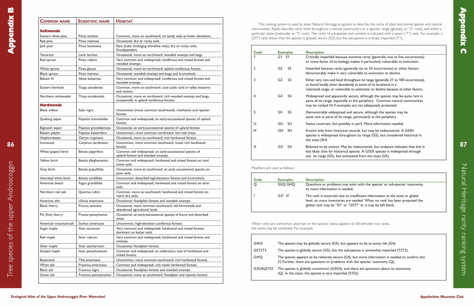
COMMON NAME SCIENTIFIC NAME HABITAT
SoftwoodsEastern white pine Pinus strobus Common, more so southward; on sandy soils at lower elevations.Red pine Pinus resinosa Occasional; dry or rocky soilsJack pine Pinus banksiana Rare (Lake Umbagog shoreline only); dry or rocky soils;
fire-dependent.Tamarack Larix laricina Occasional, more so northward; wooded swamps and bogs.Red spruce Picea rubens Very common and widespread; coniferous and mixed forests and
wooded swamps.White spruce Picea glauca Occasional, more so northward; upland coniferous forests.Black spruce Picea mariana Occasional; wooded swamps and bogs and krummholz.Balsam fir Abies balsamea Very common and widespread; coniferous and mixed forests and
wooded swamps. Eastern hemlock Tsuga canadensis Common, more so southward; cool acidic soils in valley bottoms
and ravines.Northern whitecedar Thuja occidentalis Occasional, more so northward; rich wooded swamps and bogs,
occasionally in upland coniferous forests.HardwoodsBlack willow Salix nigra Uncommon (more common southward); riverbanks and riparian
forests.Quaking aspen Populus tremuloides Common and widespread; an early-successional species of upland
forests.Bigtooth aspen Populus grandidentata Occasional; an early-successional species of upland forests.Balsam poplar Populus balsamifera Uncommon, more common northward; low wet areas.Hophornbeam Ostrya virginiana Occasional, more so southward; rich hardwood forests.Ironwood Carpinus caroliniana Uncommon, more common southward; moist rich hardwood
forests.White (paper) birch Betula papyrifera Common and widespread; an early-successional species of
upland forests and wooded swamps.Yellow birch Betula alleghaniensis Common and widespread; hardwood and mixed forests on cool
moist soils.Gray birch Betula populifolia Occasional, more so southward; an early successional species on
poor soils.Heartleaf white birch Betula cordifolia Uncommon; disturbed high-elevation forests and krummholz.American beech Fagus grandifolia Common and widespread; hardwood and mixed forests on drier
soils.Northern red oak Quercus rubra Common, more so southward; hardwood and mixed forests on
warm dry soils.American elm Ulmus americana Occasional; floodplain forests and wooded swamps.Black cherry Prunus serotina Occasional, more common southward; old farmsteads and
abandoned agricultural lands.Pin (fire) cherry Prunus pensylvanica Occasional; an early-successional species of burns and disturbed
areas.American mountain-ash Sorbus americana Uncommon; high-elevation coniferous forests.Sugar maple Acer saccarum Very common and widespread; hardwood and mixed forests;
dominant on better soils.Red maple Acer rubrum Very common and widespread; hardwood and mixed forests and
swamps.Silver maple Acer saccharinum Occasional; floodplain forests.Striped maple Acer pensylvanicum Common and widespread; an understory tree of hardwood and
mixed forests.Basswood Tilia americana Uncommon, more common southward; rich hardwood forests.White ash Fraxinus americana Common and widespread; rich moist hardwood forests.Black ash Fraxinus nigra Occasional; floodplain forests and wooded swamps.Green ash Fraxinus pennsylvanica Occasional, more so southward; floodplain and riparian forests.
This ranking system is used by state Natural Heritage programs to describe the rarity of plant and animal species and natural
communities. Ranks describe rarity both throughout a natural community's or a species’ range (globally, or "G" rank) and within a
particular state (statewide, or "S" rank). The rarity of sub-species and varieties is indicated with a taxon ("T") rank. For example, a
G5T1 rank shows that the species is globally secure (G5) but the sub-species is critically imperiled (T1).
Modifiers are used as follows:
When ranks are somewhat uncertain or the species' status appears to fall between two ranks,
the ranks may be combined. For example:
Ecological Atlas of the Upper Androscoggin River Watershed Appalachian Mountain Club
86
Tre
e s
peci
es
of
the u
pper
Andro
sco
ggin
A
pp
end
ix B
87
Natu
ral Heritage rarity ran
kin
g systemA
pp
end
ix C
Code Examples Description1 G1 S1 Critically imperiled because extreme rarity (generally one to five occurrences)
or some factor of its biology makes it particularly vulnerable to extinction.
2 G2 S2 Imperiled because rarity (generally six to 20 occurrences) or other factorsdemonstrably make it very vulnerable to extinction or decline.
3 G3 S3 Either very rare and local throughout its range (generally 21 to 100 occurrences),or found locally (even abundantly at some of its locations) in a restricted range, or vulnerable to extinction or decline because of other factors.
4 G4 S4 Widespread and apparently secure, although the species may be quite rare inparts of its range, especially at the periphery. Common natural communities may be ranked S4 if examples are not adequately protected.
5 G5 S5 Demonstrably widespread and secure, although the species may bequite rare in parts of its range, particularly at the periphery.
U GU SU Status uncertain, but possibly in peril. More information needed.
H GH SH Known only from historical records, but may be rediscovered. A G5SH species is widespread throughout its range (G5), but considered historical inthe state (SH).
X GX SX Believed to be extinct. May be rediscovered, but evidence indicates that this isless likely than for historical species. A G5SX species is widespread throughout its range (G5), but extirpated from the state (SX).
Code Examples DescriptionQ G5Q GHQ Questions or problems may exist with the species' or sub-species' taxonomy,
so more information is needed.
? G3? 3? The rank is uncertain due to insufficient information at the state or globallevel, so more inventories are needed. When no rank has been proposed theglobal rank may be "G?" or "G5T?" or it may be left blank.
G4G5 The species may be globally secure (G5), but appears to be at some risk (G4).
G5T2T3 The species is globally secure (G5), but the sub-species is somewhat imperiled (T2T3).
G4?Q The species appears to be relatively secure (G4), but more information is needed to confirm this(?) Further, there are questions or problems with the species' taxonomy (Q).
G3G4QS1S2 The species is globally uncommon (G3G4), and there are questions about its taxonomy (Q). In the state, the species is very imperiled (S1S2).

COMMON NAME SCIENTIFIC NAME
AmphibiansBlue-spotted salamander Ambystoma lateraleSpotted salamander Ambystoma maculatumEastern newt Notophthalmus viridescensDusky salamander Desmognathus fuscusNorthern two-lined Eurycea bislineata
salamanderSpring salamander Gyrinophilus porphyriticusRedback salamander Plethodon cinereusAmerican toad Bufo americanusGray treefrog Hyla versicolorSpring peeper Pseudacris cruciferBullfrog Rana catesbeianaGreen frog Rana clamitansPickerel frog Rana palustrisNorthern leopard frog Rana pipiensMink frog Rana septentrionalisWood frog Rana sylvatica
ReptilesSnapping turtle Chelydra serpentinaPainted turtle Chrysemys pictaWood turtle Clemmys insculptaRingneck snake Diadophis punctatusMilk snake Lampropeltis triangulumNorthern water snake Nerodia sipedonSmooth green snake Liochlorophis vernalisRedbelly snake Storeria occipitomaculataEastern ribbon snake Thamnophis sauritusCommon garter snake Thamnophis sirtalis
Birds (breeding only)Common loon Gavia immerPied-billed grebe Podilymbus podicepsAmerican bittern Botaurus lentiginosusGreat blue heron Ardea herodiasGreen heron Butorides virescensCanada goose Branta canadensisWood duck Aix sponsaGreen-winged teal Anas creccaMallard Anas platyrhynchosAmerican black duck Anas rubripesBlue-winged teal Anas discorsRing-necked duck Aythya collarisCommon goldeneye Bucephala clangulaHooded merganser Lophodytes cucullatusCommon merganser Mergus merganserRed-breasted merganser Mergus serratorOsprey Pandion haliaetusBald eagle Haliaeetus leucocephalusGolden eagle Aquila chrysaetosNorthern harrier Circus cyaneusSharp-shinned hawk Accipiter striatusCooper’s hawk Accipiter cooperiiNorthern goshawk Accipiter gentilisRed-shouldered hawk Buteo lineatusBroad-winged hawk Buteo platypterusRed-tailed hawk Buteo jamaicensisAmerican kestrel Falco sparveriusMerlin Falco columbariusPeregrine falcon Falco peregrinusSpruce grouse Falcipennis canadensisRuffed grouse Bonasa umbellusVirginia rail Rallus limicola
COMMON NAME SCIENTIFIC NAME
Birds (continued)Sora Porzana carolinaKilldeer Charadrius vociferusSpotted sandpiper Actitis maculariaCommon snipe Gallinago gallinagoAmerican woodcock Scolopax minorHerring gull Larus argentatusBlack tern Chlidonias nigerMourning dove Zenaida macrouraBlack-billed cuckoo Coccyzus erythropthalmusYellow-billed cuckoo Coccyzus americanusGreat horned owl Bubo virginianusBarred owl Strix variaLong-eared owl Asio otusNorthern saw-whet owl Aegolius acadicusCommon nighthawl Chordeiles minorWhip-poor-will Caprimulgus vociferusChimney swift Chaetura pelagicaRuby-throated Archilochus colubris
hummingbirdBelted kingfisher Ceryle alcyonYellow-bellied sapsucker Sphyrapicus variusDowny woodpecker Picoides pubescensHairy woodpecker Picoides villosusThree-toed woodpecker Picoides tridactylusBlack-backed woodpecker Picoides arcticusNorthern flicker Colaptes auratusPileated woodpecker Dryocopus pileatusOlive-sided flycathcer Contopus cooperiEastern wood-pewee Contopus virensYellow-bellied flycatcher Empidonax flaviventrisAlder flycatcher Empidonax alnorumWillow flycatcher Empidonax trailliiLeast flycatcher Empidonax minimusEastern phoebe Sayornis phoebeGreat crested flycatcher Myiarchus crinitusEastern kingbird Tyrannus tyrannusHorned lark Eremophila alpestrisTree swallow Tachycineta bicolorNorthern rough- Stelgidopteryx serripennis
winged swallowBank swallow Riparia ripariaCliff swallow Petrochelidon pyrrhonotaBarn swallow Hirundo rusticaGray jay Perisoreus canadensisBlue jay Cyanocitta cristataAmerican crow Corvus brachyrhynchosCommon raven Corvus coraxBlack-capped chickadee Poecile atricapillusBoreal chickadee Poecile hudsonicusTufted titmouse Baeolophus bicolorRed-breasted nuthatch Sitta canadensisWhite-breasted nuthatch Sitta carolinensisBrown creeper Certhia americanaHouse wren Troglodytes aedonWinter wren Troglodytes troglodytesGolden-crowned kinglet Regulus satrapaRuby-crowned kinglet Regulus calendulaBlue-gray gnatcatcher Polioptila caeruleaEastern bluebird Sialia sialisVeery Catharus fuscescensBicknell’s thrush Catharus bicknelliSwainson’s thrush Catharus ustulatusHermint thrush Catharus guttatus
Ecological Atlas of the Upper Androscoggin River Watershed
88
Wild
life s
peci
es
of
the u
pper
Andro
sco
ggin
Ap
pen
dix
D
Appalachian Mountain Club
89
COMMON NAME SCIENTIFIC NAME
Birds (continued)Wood thrush Hylocichla mustelinaAmerican robin Turdus migratoriusGray catbird Dumetella carolinensisNorthern mockingbird Mimus polyglottosBrown thrasher Toxostoma rufumAmerican pipit Anthus rubescensCedar waxwing Bombycilla cedrorumBlue-headed vireo Vireo solitariusYellow-throated vireo Vireo flavifronsWarbling vireo Vireo gilvusPhiladelphia vireo Vireo philadelphicusRed-eyed vireo Vireo olivaceusTennessee warbler Vermivora peregrinaNashville warbler Vermivora ruficapillaNorthern parula Parula americanaYellow warbler Dendroica petechiaChestnut-sided warbler Dendroica pensylvanicaMagnolia warbler Dendroica magnoliaCape May warbler Dendroica tigrinaBlack-throated Dendroica caerulescens
blue warblerYellow-rumped warbler Dendroica coronataBlack-throated Dendroica virens
green warblerBlackburnian warbler Dendroica fuscaPine warbler Dendroica pinusPalm warbler Dendroica palmarumBay-breasted warbler Dendroica castaneaBlackpoll warbler Dendroica striataBlack-and-white-warbler Mniotilta variaAmerican redstart Setophaga ruticillaOvenbird Seiurus aurocapillusNorthern waterthrush Seiurus noveboracensisMourning warbler Oporornis philadelphiaCommon yellowthroat Geothlypis trichasWilson’s warbler Wilsonia pusillaCanada warbler Wilsonia canadensisScarlet tanager Piranga olivaceaNorthern cardinal Cardinalis cardinalisRose-breasted grosbeak Pheucticus ludovicianusIndigo bunting Passerina cyaneaEastern towhee Pipilo erythrophthalmusChipping sparrow Spizella passerinaField sparrow Spizella pusillaVesper sparrow Pooecetes gramineusSavannah sparrow Passerculus sandwichensisSong sparrow Melospiza melodiaLincoln’s sparrow Melospiza lincolniiSwamp sparrow Melospiza georgianaWhite-throated sparrow Zonotrichia albicollisDark-eyed junco Junco hyemalisBobolink Dolichonyx oryzivorusRed-winged blackbird Agelaius phoeniceusEastern meadowlark Sturnella magnaRusty blackbird Euphagus carolinusCommon grackle Quiscalus quisculaBrown-headed cowbird Molothrus aterBaltimore oriole Icterus galbulaPurple finch Carpodacus purpureusRed crossbill Loxia curvirostraWhite-winged crossbill Loxia leucopteraPine siskin Carduelis pinusAmerican goldfinch Carduelis tristis
COMMON NAME SCIENTIFIC NAME
Birds (continued)Evening grosbeak Coccothraustes vespertinus
MammalsMasked shrew Sorex cinereusWater shrew Sorex palustrisSmoky shrew Sorex fumeusLong-tailed shrew Sorex disparPygmy shrew Sorex hoyiNorthern short- Blarina brevicauda
tailed shrewStar-nosed mole Condylura cristataHairy-tailed mole Parascalops breweriLittle brown myotis Myotis lucifugusNorthern myotis Myotis septentrionalisEastern small- Myotis leibii
footed myotisSilver-haired bat Lasionycteris noctivagansEastern pipistrelle Pipistrellus subflavusBig brown bat Eptesicus fuscusEastern red bat Lasiurus borealisHoary bat Lasiurus cinereusSnowshoe hare Lepus americanusEastern chipmunk Tamias striatusWoodchuck Marmota monaxEastern gray squirrel Sciurus carolinensisRed squireel Tamiasciurus hudsonicusNorthern flying squirrel Glaucomys sabrinusAmerican beaver Castor canadensisDeer mouse Peromyscus maniculatusWhite-footed mouse Peromyscus leucopusSouthern red-backed vole Clethrionomys gapperiMeadow vole Microtus pennsylvanicusRock vole Microtus chrotorrhinusWoodland vole Microtus pinetorumMuskrat Ondatra zibethicusSouthern bog lemming Synaptomys cooperiNorthern bog lemming Synaptomys borealisMeadow jumping mouse Zapus hudsoniusWoodland jumping mouse Napaeozapus insignisCommon porcupine Erethizon dorsatumCoyote Canis latransRed fox Vulpes vulpesCommon gray fox Urocyon cinereoargenteusBlack bear Ursus americanusCommon raccoon Procyon lotorAmerican marten Martes americanaFisher Martes pennantiErmine Mustela ermineaLong-tailed weasel Mustela frenataMink Mustela visonStriped skunk Mephitis mephitisNorthern river otter Lutra canadensisLynx Lynx canadensisBobcat Lynx rufusWhite-tailed deer Odocoileus virginianusMoose Alces alces

Published by the Appalachian Mountain ClubWWW.OUTDOORS.ORG
Boston office:5 Joy Street
Boston MA 02108617-523-0636
New Hampshire offices:P.O. Box 298
Gorham, NH 03581603-466-2721