ocpm turcot yards louise chênevert, november 14,...
TRANSCRIPT

OCPM Transformation of the TURCOT YARDS – The New NATURE PARK Project
Brief by Louise Chênevert, November 14, 2018
I would like to say that I am pleased with the work the City of Montreal has done in preparation for this consultation as I read through many of the documents provided on the OCPM web site. I can see that much research has been done. I am in agreement with most of the statements made and visions proposed in the:
• TRANSFORMATION OF THE TURCOT YARDS – 10 things to know about the new nature –park project, Montreal, August 2018.
• A new nature-park in the Turcot yards – enhancement of the Saint-Jacques Escarpment Ecoterritory Public Consultation – Information Session September 25, 2018.
I wish to commend the present Valérie Plante administration for keeping the promises; to create a Nature Park in the Turcot yards as well as the commitment for the Dalle Parc Bridge.
SAINT PIERRE RIVER & OTTER LAKE WATERSHED As the founder of the Ballade de la Rivière St Pierre River Ride see my facebook page https://www.facebook.com/Balade-de-la-Rivi%C3%A8re-st-Pierre-River-Ride-235288763669216/. Our mission and Goals are on the ‘ABOUT’ page and annexed to this brief (see annex 1). They are more than a ride but an educational program which can take on many other forms as presentations and bus tours and supporting other groups with the same visions. My greatest purpose in this project is to ‘Daylight’ the St Pierre River everywhere it is possible and to bring it back to the ‘Surface’ of our collective consciousness as it was the catalyst for the founding of the City of Montreal and the Country which became Canada It was the center of First Nation’s trade routes for over 5 thousand years. It was central to the fur trade and the Régime Français de la Nouvelle France, and when it was channelled into the Lachine Canal it again served to be the center of the Industrialisation, growth and trade of the our Country. It has undergone three eras always maintaining its central focus of trade. This vocation should be central in its 3rd phase. A watershed is ALL the land where rivers and wetlands flow through and into a greater body of water. The St Pierre River originated on the western flank of Mount Royal, flowed westward through what is now the City of Cote st Luc, down to Lachine, then it follows along the southern base of the St Jacques escarpment as it widened to form Otter Lake, which was 7 kilometres long and 1 kilometre wide, and then joined the St Lawrence River at Pointe a Calière. The site chosen for the colony by Samuel de Champlain, later established by Paul de Chomedey, Sieur de Maisonneuve and Jeanne Mance.

Recommendation: The St Pierre also had tributaries (see historical map) going westward into Lachine, southward into Parc Angrignon and Verdun, thus its watershed is ALL lands west of Mount Royal and lands from the shores of Old Lachine eastward to Old Montreal. This includes the City of Cote St Luc, Montreal West and Boroughs of CDN-NDG, Lachine, LaSalle, Verdun and the Sud-Ouest. Therefore, linking all the green territories which are in these municipalities;
• the present day Parcs of; Mount Royal and Angrignon • future proposed Parks of; Meadowbrook (where it surfaces for approximately
200 meters), Falaise st Jacques, la Bande Verte and Parc Nature de la Cour Turcot
with green and blue corridors is essential to encourage an increase of biodiversity especially if the St Pierre river’s hydrology can be the source of connectivity. * I strongly encourage engineering studies to make this possible.
Linking these PARKS would not only link these communities through geography would have historical, health and environmental benefits as well as greater accessibility for residents.

TURCOT YARDS NATURE PARK AQUATIC ZONE HYDROLOGY: There has been a keen interest to include water features in the park plans. I fully support this. Although, water is a pleasant feature it must be more than that. It needs to be ‘ALIVE’ so it can nourish the plants and wildlife. Recommendations: Contrary to the recommendations of the ‘Bande Verte’ consultations where the plans included pumps and filtration systems to keep the water clean. I feel that this method is very costly and unnatural. I would prefer a marsh-like basin which would acts as natural filter where the bulk of the work would be done by the vegetation. Creating something more like the lake in Parc Angrignon would be more suitable for a Nature Park. It would not only be ecologically effective and but pleasing as well.
I would like the water feature to be in a single unique pond in the authentic shape of the OTTER Lake (perhaps 50% of the original scale) to serve as a living commemoration of its heritage, which is also mentioned on page 13 of the September 25th presentation. Inadvisable choices: Avoiding making concrete container ponds as Mont Royal’s Beaver Lake and the lake in Parc Lafontaine. I disagree with the suggestion of fountains as a decorative feature. BIODIVERSITY: Biodiversity on the island of Montréal has sustained great losses over the centuries. Like most cities the forests were cleared for agriculture in at the beginning of the colony. The island had over 40 canoe navigable rivers (see Annex 2.1&2.2) and dozens of lakes. Many were drained and placed in sewers. The biodiversity at the time of Champlain’s visit was extremely rich and superabundant. The City being an island is surrounded by water and smaller islands each encircled by marshes and wetlands. Varied aquatic habitats are the source of all life. The St Laurence Valley is an area which has had the greatest biodiversity in Province of Quebec known as le ‘domaine bio-climatique érabliere a caryer cordiforme’ which is the zone having sustained the most losses and harbours the greatest number of threatened and endangered species (see annex 3.1 &3.2) :

The loss of this biodiversity was exacerbated especially when the large waterways projects where undertaken; Lachine canal in 1825, the Aquaduct 1852, the St Lawrence Seaway in 1959 where the soil which was removed was used as landfill wetlands in places like the extinct Goose village and the shore lines from Verdun, LaSalle and Lachine. So creating this Nature Park in the Turcot yards is wonderful news. In reality it is very small compared to the great loses the zone has incurred over the past three centuries, yet greatly needed and appreciated. * Thus, I believe we must make the greatest effort to maximise the area’s naturalisation. Recommendations: To increase the 75% ratio of the area to as close to 100% as possible knowing that there will be bike paths and ramps and other access infrastructure to account for. FIELD ZONE A field is an ecosystem of sun loving plants, ground nesting birds and is prime rodent and snake habitat. It may attract rare endangered insect eating birds and bats. It may be used as hunting territory by raptors which may chose to nest in forest of the escarpment if there is a nearby food source to raise their young. Pollinators: Many have expressed the importance of pollinators and wish that part of the Field Zones be landscaped with nectar producing flowers to benefit these insects. As a previous beekeeper and Monarch butterfly breeder, I fully agree. Yet, I wish that the emphasis be on indigenous species as mason bees and the endangered bumble bee, genus Bombus. Although there has been a steady increase in the interest in honeybees being part of urban agriculture, we have to remember that these insects are foreign, mostly originating from the European continent and interfere in the foraging needs of local pollinators. Recommendations: Have an inventory done of all honeybee hives in a radius of 5-10 kilometres of the Turcot yards before authorising honey bee hives in the plans. Inadvisable: Seeing that the field habitat is rarity in the urban landscape it should be treated as such. The paths through this sensitive zone should be few and human activities limited. It is neither be a playing nor a sport field.

FOREST ZONE Birds: Migrating birds have used the island and the St Lawrence for millennia as an essential stop over point to rest and feed before continuing on their journey. Habitat as well as food source loss is enormous/ astronomical. Restoring this is critical and should be a primary concern. The Turcot yards being in the center is an ideal area to re-establish.
Trees: As a ‘Tree Walk’ leader and course and teacher of courses as ‘Montreal’s Indigenous Urban Trees’ https://courses.thomasmore.qc.ca/fall-2018-montreals-indigenous-urban-trees/ Over the years I have noticed an increase of foreign species being planted in parks. Variety has been used as a landscaping tool rather than a forestry plan. Some municipalities are opting in diversification as an insurance policy against future invaders. I disagree with this practice. If colonies of indigenous trees are planted together they create stronger defence against diseases. Which is the method practiced of Les Amis de la Montagne. I have participated in their ‘Programme d’intendance du Mont Royal’ https://www.lemontroyal.qc.ca/fr/activite/programme-d-intendance-estival-du-mont-royal Working along side I have come to understand their serious problems with invasive plant species and the arduous tasks it is to eliminate them. For example, Buckthorn, Neprun Cathartic, takes at least 5 years. They work on many zones at once but there are many more. They are systematically culling them and replacing them with hardy Indigenous species. Our native species are on a decline and need to be spread back over their original territory. The urban wildlife depends on them for their food supply (seed & berries) especially migrating birds when they stop over. Forests & Urban Agriculture: As a Certified Permaculture Designer PDC, I feel that urban landscaping must be more than decorative it should sustain urban wildlife as well as urban dwellers. As the space may not be large enough for community gardens and may not be feasible if one wishes to attract wildlife. One innovative solution is creating ‘Food Forests’ which are orchards of fruit, nut and other comestible trees. The Municipality has just created such a space see attached articles:
Sainte-Anne-de-Bellevue bike path users can snack on the go thanks to
public 'food forest' CBC News · Posted: Oct 19, 2018 10:34 PM ET |: October
20
https://www.cbc.ca/news/canada/montreal/sainte-anne-de-bellevue-food-forest-bike-path-1.4869996

SADB fights food insecurity with a food forest project By Ross Conroy The Suburban Oct 31, 2018 http://www.thesuburban.com/news/west_island_news/sadb-fights-food-insecurity- with-a-food-forest-project/article_dce7022c-94e1-596b-92b5-9b0fa1bb78bd.html
FALAISE ST JACQUES Restoration Time Line: As we, the local environmentalists, have recently discovered the St Jacques escarpment is not in the plans of this present consultation, I am requesting a timeline from the City of the procedural stages which are required to ensure its protection and enhance its viability as a healthy ecosystem. From short term to long term: immediate - 1 – 3 – 5 – 10 - 25 years. This would greatly relieve the doubt and uncertainty of all those concerned. Here are some concern which would need to be addressed with suggested time lines: Immediate - winter 2018-19: The cessation of following harmful practices done by property owners in the commercial zone of St Jacques Street:
• The pushing of snow over the top of the escarpment which not only damages trees, the practice makes them fall over killing otherwise healthy trees. The loss of mature trees weakens the stability of the escarpment.
• The dumping of garbage and automotive fluids Short term: through notices, fines, cameras or other means. Medium to long term: the placement of fences, barriers or walls
Short term: Assessment of the invasive species & create an elimination program as done by Les Amis de la Montagne (see Trees above) Medium term: Assessment of the stability of the slope and methods of its restoration Long term: Re- naturalisation with indigenous species. Recommendations: The slope instability due to the erosion creates a safety hazard as well as for the fragility of the ecosystem I believe that aside from the ‘Dalle Parc’ bridge and ‘Bande Verte’ accesses, I propose that the Falaise St Jacques should be a protected as a ‘Reserve’ for birds and ‘off limits’ for human activity.

The DALLE PARC Bridge TECHNICAL PREFERENCES Connections: I would prefer that the bike link begins from the de Maisonneuve bike path at the Grand Boulevard bike and pedestrian overpass https://www.google.ca/maps/@45.4643327,-73.6198826,108a,35y,39.53t/data=!3m1!1e3 It now needs renovations. Making it wider with more comfortable slopes will make it safer. Then proceed westward on Rue Sylvia Smith to Madisson and enters the Falaise St Jacques down the old paved road and onto the Dalle Park Bridge midway down the slope. See the bike over pass which connects Ste Anne de Bellevue with Ile Perrot: https://www.google.ca/maps/@45.4041019,-73.9548036,196a,35y,326.76h/data=!3m1!1e3 This one is well used and pleasant to ride except for one switchback which is tight. I am not in favour of a connection with Cavendish as I don’t believe the tunnel is wide enough to accommodate a bike path when there is a necessary sidewalk in place. Specifications & Features: As an avid cyclist I would recommend that there be 2 separate lanes each 5 meters wide; one for northbound and one for southbound. The pedestrian walkway must be separate from the bicycle paths for safety reasons. The bridge width should be a minimum of 30 meters wide. The access ramps should be curved to allow for a fluid decent and accent creating a pleasure to ride. The curved lines would be a pleasing view seen from a distance. The bridge and the ramp should have high barriers for safety but also to act as wind shields. There should be protected openings so visitors have panoramic views. There could be a ‘lookout’ area to view the Falaise St Jacque to the north and the Turcot Nature Park to the south. The bridge itself should be horizontal and wide enough to accommodate natural vegetation to encourage wildlife to use. A separate section away from the public would be my recommendation. The choices should be indigenous to the zone and be wind and drought tolerant.

The bridge being a green park it should have seating areas.
NATURE PARK
This consultation is named “The New NATURE PARK Project”. So what is a “Nature Park”? The definition: Montréal’s nature parks are genuine environmental treasures, offering outdoor lovers a chance to exit the concrete jungle without stepping foot off the island… each park has its own special character and allure, as well as a face that changes with the seasons. https://habitermontreal.com/en/montreals-nature-parks DIMENSIONS: Taken from The Presentation overview of September 25th state a few dimensions: On page 5; The areal views of the Saint-Jacques Ecoterritory are deceptive the area appears extremely large. On page 9; the whole area is 43 hectares and the Nature Park would of 30 hectares which I calculate to be 69.76% and not 75%. And since the paths and accesses are not considered part of that figure, the total green area would be even lower. On page 11; the proposed area for the Nature Park be 30 ha is compared to other parks Table 1: Municipal Park comparisons Park Turcot 30 ha Parc Nature Ile de la Visitation 32 ha Parc Lafontaine 34 ha Parc Jarry 35 ha In this table the proposed Turcot Park appears to be comparable in size to the other parks listed. Note it is the first in the ascending order and thus is the smallest one of the comparables. These are municipal parks except one. It should be compared to Nature Parks:

Table 2: Nature & Grand Parc comparisons x-c ski Snow shoe walk TOTAL Parc Nature Turcot 30 ha Golf Meadowbrook 57 ha GM ‘Bottom 9’ Lachine sector 23 ha GM ‘Top 9’ st Luc sector 34 ha Grand Parc Angrignon 97 ha 10.4 km 2.7 km ? 13.1 + kms Parc Nature Bois de Liesse 159 ha 17 km 9.6 km 4 km 30.6 kms Parc Nature Mont Royal 200 ha 16.2 km 3 km 8.3 km 27.5 kms Morgan Arboretum forested reserve
245 ha 14.6 km 7 km 3 km 24.6 + kms
Parc Nature Cap st Jacques 316 ha 28 km 5 km 7 km 40 kms In this table, the proposed Turcot Park is first in the ascending order and it is even more proportionally smaller in size when compared to Nature Parks. Therefore, even if it were brought up to the maximum of 43 ha it would be a fraction of the size of the other Nature Parks listed. It is equivalent to the ‘Top 9’ sector of Golf Meadowbrook of 34 ha. I can walk around the ‘bottom 9’ sector of 23 ha in an hour. (one kilometre up and down). If the purpose is to increase the quality of life and access to nature for its residents, the area must feel large and appealing, where users would want to come back and spend long hours. Any one who practices walking, snow shoeing, cross country skiing and cycling for exercise through our present Nature Parks will find the proposed park area unchallenging and unsatisfactory as it is only 2 km long. Although the Turcot project is large and necessary when compared to other Nature Parks it is relatively small. Logistically, if many activities are compressed in this all ready small area the goals of a place to de-stress will be lost.
LESS is MORE !
Observations made from these calculations support the arguments of the need for this Park to connect the other surrounding green spaces so that users have a continuous and fulfilling experience. Facilities: As the area is small, I feel that any visitor center should be built outside the area. There could be one on St Jacques Street and Madison in the buildings now owned by CDN-NDG borough. There could be an other along the new Notre Dame Boulevard. Any toilets in the Nature Park could be composting type. Note: Cap St Jacques Nature Park has ‘Toilettes sèches extérieures’ at the beach and so does Le Musée de Lachine.

INADVISABLE CHOICES / FEATURES which I do not want:
I understand that groups have expressed an interest in certain sporting facilities. I recognise the need to hear all the voices of the community. I question the OCPM having provided scale size sport field in their workshops thus offering false hopes to the participants. Yet, if the Turcot yards are to be part of the 10% increase of green space based on the Schéma d’Aménagement of 2015. Then, the most natural landscaping should be prioritised. Environmentalist have been advocating for this for decades. This goal should not be compromised. The area is also part of the ‘Saint Jacques Escarpement ECO-Territory’ and is part of the ‘Policy on the Protection and Enhancement of natural Habitats’ thus the focus and mission is to renaturalise and rewild the area as much as possible to increase healthy habitat to encourage its use by wildlife. This being said, I discourage any vision of the area to be used for activities which could be done in a commercial or industrial zones. Thus, I do no not want any unnatural materials and items to be included in the plans such as;
- Concrete & asphalt - Parking - Water fountains - Dirt bike & Fat bikes - Astroturf
There have been parking lots proposed to access the ‘Bande Verte’. There has been real estate areas on St Jacques Street reserved for future use as ‘Visitor centers’ and parking. There are many brown fields such as unused parking lots or industrial areas in this zone which can be transformed for the use of sport fields and recreational activities. Especially if the future plans are to green the top of the Falaise. With some research areas in the South West borough could be found and repurposed for such uses. Especially as Notre Dame is to become a green boulevard perhaps these wishes could be placed there with closer access to public transit. Also, there are areas along the Lachine Canal which may be suitable for sporting activities. Since, Parks Canada is presently doing renovations and are partners in these consultations.

City ENTRANCE
Our City’s main symbol is the CROSS on Mount Royal. It speaks of the Christian roots of the French founders of Ville Marie. There was indigenous presence prior to European contact as well as collaborations throughout the evolution of the City and the Country. I agree with GÉRARD BEAUDET and his cosigners who wrote LA CHANCE DE CRÉER UNE ESPLANADE AÉRIENNE EMBLÉMATIQUE . La Presse 3 février 2018 http://plus.lapresse.ca/screens/85107f66-4f16-468c-ad1e-6c0ed2f47f05__7C___0.html
INDIGENOUS CULTURE & HISTORY Indigenous culture was acknowledged by several groups. Some suggested information panels and perhaps some sculptures. I agree this would enhance the visitor knowledge of the First Nations presence in the area. Some thing which seems to be overlooked is that maps and artefacts speak of the past which are culturally important, yet there is a large population of Indigenous people presently living in the City. We need to do more than acknowledge their past but also their contributions not through token pieces. I envision a ‘Living’ presence. Mayor Denis Coderre launched ‘Le 375e de Montréal sera l’année de la réconciliation et du rapprochement avec les peuples autochtones’. As well as changed the flag and coats of arms for their inclusion. See the following articles:
Montréal, métropole de la réconciliation - La Ville de Montréal pose un nouveau jalon dans le processus historique de réconciliation avec les peuples autochtones Juin 21, 2018, 12:00 ET https://www.newswire.ca/fr/news-releases/montreal-metropole-de-la-reconciliation---la-ville-de-montreal-pose-un-nouveau-jalon-dans-le-processus-historique-de-reconciliation-avec-les-peuples-autochtones-686163061.html
La Ville de Montréal pose un nouveau jalon dans le processus historique de réconciliation avec les peuples autochtones 21 juin 2018 http://ville.montreal.qc.ca/portal/page?_pageid=5798,42657625&_dad=portal&_schema=PORTAL&id=30288

Réconciliation avec les Peuples autochtones : La Ville de Montréal dévoile ses nouvelles armoiries et son nouveau drapeau 13 septembre 2017 http://ville.montreal.qc.ca/portal/page?_pageid=5798,42657625&_dad=portal&_schema=PORTAL&id=29175 According to our Constitution Act, 1982 Aboriginal and treaty rights - they should be consulted. Since the OCPM – L'Office de consultation publique de Montréal was mandated for the City of Montreal for the citizen’s voice. I believe that the indigenous residents of the City should have been consulted. I witnessed Mayor Valérie Plante, speak of the First Native elders at the Press Conference at Terry Fox Park on National Aboriginal Day, June 21st , 2018 New Montreal Dalle Parc and bicycle bridge a go By: John Symon June 21, 2018
http://mtltimes.ca/Montreal/news/montreal-dalle-parc-and-bicycle-bridge-a-go/
In the spring of 2017, I had a vision. I spent over a year doing research, creating a scale model and a power point which I presented to interested parties. I have consulted numerous First Nation artists and culturally active members of the urban community as well as those living on reserves off island. I have garnered their support for my concept. I will not share the details of my concepts at this time as it is not public. Request: * I request that provisions be made by the City of Montreal and the OCPM to invite them to share their voices and visions. Louise Chênevert, B.F.A, B.Ed, PDC Founder of the Ballade de la Rivière St Pierre River Ride [email protected] Member of:
• Sauvons la Falaise • Steering committee of Les Amis du Parc Meadowbrook
Supporter of:
• Green Coalition Verte • Sauvons l’Anse a l’Orme • TechnoparcOiseaux

ANNEX 1
Ballade de la Rivière St Pierre River Ride see my facebook page https://www.facebook.com/Balade-de-la-Rivi%C3%A8re-st-Pierre-River-Ride-235288763669216/
ABOUT
Mission : Enhance the hydrology legacy of the Island of Montreal.We use the longest island river as a way to link the natural green spaces of Mount Royal, Meadowbrook and the St Jacques escarpment. The Ride : Travelling by bicycle is an innovated approach to understanding the island’s geography by creating an immersive experience. During the ride we travel through time and space discovering the importance of water to the First Nation people’s survival, navigation and trade, as well as sustain the biodiversity of faunic and floric life. We look at the historical role of the river in the establishment of the City as well as the Country through the fur trade. Followed by the industrial age where Otter Lake was drained into the Lachine Canal and the St Pierre River was buried in sewers. We discuss the legacy of putting rivers in sewers and the engineering nightmare we have inherited. The large infrastructure projects of the past centuries have changed the landscape of the island and fragmented green spaces. Along our journey we stimulate discussions on the environmental impacts and the present day dilemmas. Goals: To create a team of professionals as cartographers, urban planners, engineers, ecologists and educators. To envision innovative and integrated solutions to include water in our urban environment through 'Daylighting' rivers thus by enhancing the value of green spaces, increasing biodiversity and creating wildlife corridors. • To improve storm water management by creating blue alley and garden projects to avoid
future flooding.
• To create connection for pedestrians and cyclists.
• To reduce heat islands thus improving the overall well being of citizens by creating healthy urban communities.

ANNEX 2.1: Montreal Island Waterways
ANNEX 2.2: Montreal Island Waterways
Montreal ordered to bury or divert last remnant of St-Pierre River MARIAN SCOTT, MONTREAL GAZETTE Updated: July 10, 2018 https://montrealgazette.com/news/local-news/last-remnant-of-st-pierre-river-could-be-buried

ANNEX 3.1: BIODIVERSITY
http://www.greencoalitionverte.ca/parc/PPEAM%20cartes.htm
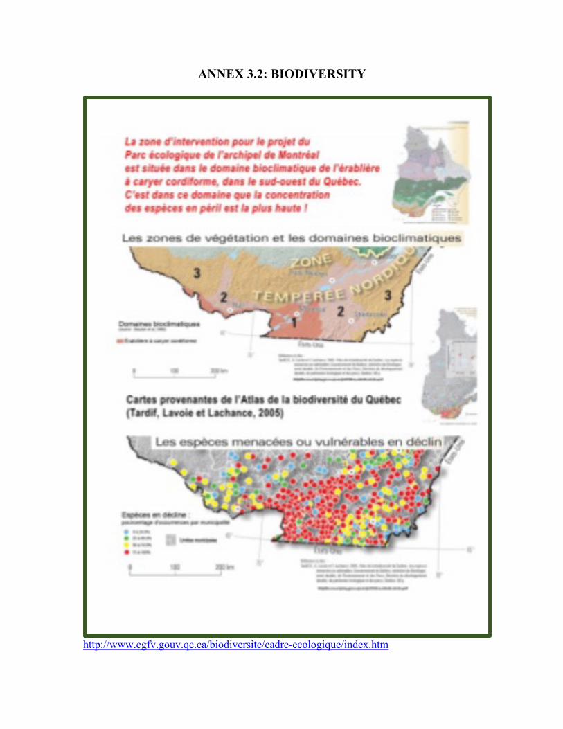
ANNEX 3.2: BIODIVERSITY
http://www.cgfv.gouv.qc.ca/biodiversite/cadre-ecologique/index.htm