oceanwaves wamos ii - wave and current monitoring system
TRANSCRIPT

Real-TIMe DecISION SuppORT
oceanwavesWaMOS® II - Wave aNd cuRReNt MONItORINGSySteM

MaxIMIzeOPeRatIONalWINdOWSWaMoS® II is a proven radar-based wave and surface current monitoring system developed by OceanWaveS gmbH. In comparison to conventional wave rider buoys and current profiling devices that generate single point measurements, WaMoS® II offers the advantages of presenting this information for a broad area, and in a richer context.
WaMoS® II’s measurements are constantly refreshed while a vessel is underway, providing real time data relevant to the local operational area as compared to conditions reported at a closest available point of reference. High definition images of wave fields combined with numerical data and intuitive graphical reporting keep the operator well informed in assessing environmental risk and identifying safe operational windows.
as a complement to an existing sensor or as a primary system, WaMoS® II provides higher fidelity information with comparable accuracy, at lower lifecycle costs.
pROveN accuRacy & RelIabIlITy Inindustry-sponsoredtrials,datacomparisonsbetweenWaMoS®IIandwaveriderbuoyshaveindependentlyverifieditsaccuracyaswellastheadditionalvalueprovidedinmonitoringafull360°range.WaMoS®IIispresentlysupportingoperationaldecisionmakingapplicationsincluding:offshoreconstruction,diversupport,safehelideckoperations,andnavigationinextremecurrentandseastates.Long-termdeploymentsonseveralunmanned,remotecoastalinstallationsmonitoringwaveactionandcoastalerosionattesttoitsreliability.
NeW SIGMa S6 cONNect
Anewweb-enabledinterfaceallowsexternalsystemssuchasGoogleEarthProandGISplatformstointerfacewiththesigmaS6WaMoS®IISystemtodisplayradarimaging,wave,surfacecurrentandHRCinformation.
WaMOS® II eaRNS INteRNatIONal RecOGNItION
OceanWaveSandWaMoS®IIhavealargeanddiversereferencelist.AstheacceptanceofX-bandradarasawaveandcurrentmeasuringdevicegainsinternationalreferenceandcitation,thereferencelistofapplicationsofWaMoS®IIcontinuestogrow.InstallationsofWaMoS®IIarefoundaroundtheworld.ApartiallistofinstallationsitesincludesNorway,Denmark,Germany,Thailand,China,CanadaandtheUSA.
FIg:3–Acorresponding2Dfrequency-directionspectrumindicatingtwowavesystems,onecomingfromtheNorth-North-WestandonefromtheWest.
FIg:2–1DFrequencyspectrumgraphshowingtwoclearenergypeaksfromtwowavesystems.
FIg:1–ThreemonthtimeseriesdatacomparingwaveheightmeasurementsobtainedbyWaMoS®IIandawaveriderbuoy.
Wave aND SuRFace cuRReNT paRaMeTeRS
WaMoS®IImeasuresanddisplaysalltheessentialwavefieldparametersincludingsignificantwaveheight(Hs),Peakwaveperiod(Tp),Peakwavelength(λp)Peakwavedirection(θp)aswellassurfacecurrentspeed(U )andsurfacecurrentdirection(θU).
peRFORMaNce aND OpeRaTINg RaNge
TheoperatingrangeofWaMoS®IIextendsto4.0kmdependingonX-Bandradartypeandinstallationgeometry.Theaveragerangeforvessel-basedinstallationsisapproximately3.0km.Requiringaminimumwindspeedof3m/sandaminimumwaveheightof0.5m–0.75m,thesystemeasilydetectswavelengthsfrom15m–600mandcoversperiodsfrom3sec–18sec.
Sea STaTe alaRMINg
Seastatealarmscanbesettotriggerforthreedifferentconditions:
• whensignificantwaveheightexceedsaspecifiedvalue;
• ifpeakwavelengthsfalloutsideaspecifiedrange;or
• iftheencounteranglebetweenthewavesystemandtheship’scoursemovesoutsideaspecifiedrange.
DaTa SHaRINg aND RecORDINg
Advancedrecordingcapabilityenablesoperatorstoreviewandconfirmconditionsintheeventofanincidentorregulatoryenquiry.WaMoS®IIcanbeexportedforintegrationinotherdatabase,meteorologicalandenvironmentalsystems.ItcanalsoprovideNMEAoutputtoconninganddecisionsupportsystems.
HIgH ReSOluTION cuRReNT aND baTHyMeTRy IMagINg
Thisoptionalfunctionalitydisplayshighresolutioncurrent(HRC)fordeepandshallowwaters,bathymetricmeasurementsareavailableforwaterdepthsto30m.SurfacecurrentandbathymetrymapsaregeneratedinagridstructurebytheHRCsoftware.
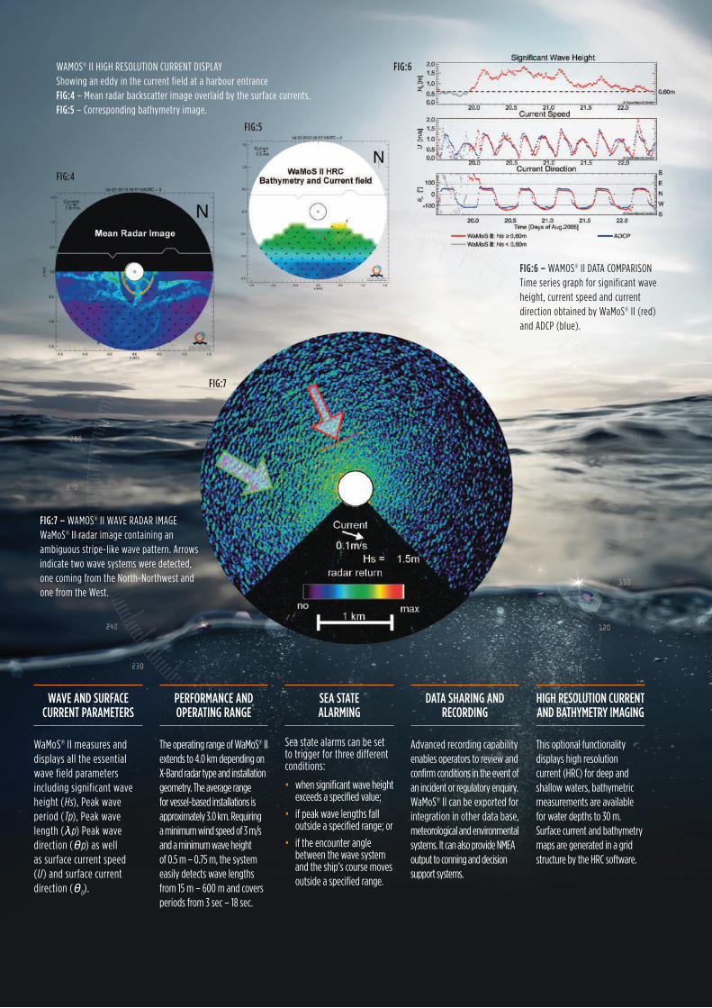
FIg:7
WAMOS®IIHIGHRESOLUTIONCURRENTDISPLAyShowinganeddyinthecurrentfieldataharbourentranceFIg:4–Meanradarbackscatterimageoverlaidbythesurfacecurrents.FIg:5–Correspondingbathymetryimage.
FIg:5
FIg:4
FIg:6
FIg:7 – WAMOS®IIWAVERADARIMAGEWaMoS®IIradarimagecontaininganambiguousstripe-likewavepattern.Arrowsindicatetwowavesystemsweredetected,onecomingfromtheNorth-NorthwestandonefromtheWest.
FIg:6 – WAMOS®IIDATACOMPARISONTimeseriesgraphforsignificantwaveheight,currentspeedandcurrentdirectionobtainedbyWaMoS®II(red)andADCP(blue).

sigma S6 WaMoS® II connects to most commercially available marine radars, enabling customers to extract additional value and effectiveness from their existing assets. Should it be required, Rutter provides the option of supplying a dedicated high performance radar as an input sensor. It is now possible to combine WaMoS® II with Rutter Inc. sigma S6 Oil Spill Detection, SeaFusion Data Integration, Ice Navigator™ and Small Target Surveillance systems.
OceaNWaveS Wave aND cuRReNT MONITORINg SySTeMS
Features and Options:
• HighResolutionCurrent(HRC)
• WaveandCurrentAnalysisandWaveSpectra(WaMoS)
• ScreenRecording-ScreenShots(.jpg&.png)andMovieFiles(.avi)
• MultipleRemoteClients
• AverageSurfaceCurrent
• ShallowWaterBathymetry
• SeaStateAlarms(3)
• FixedSites
• MovingVessels
• sigmaS6Connect
Note:WaMoS®IIacceptsstandardserial/networkinputsfromnavigationalinstruments(NMEA0183)including:AIS,windanemometer,echosounder,speedlog,GPS,andgyrocompass.
Informationaboutendusertraining,productsupport,productcombinations,performancemodelling,productreferencesandreliabilitymeasurescanbeprovidedbye-mailingyourrequesttoinfo@oceanwaves.de
OceanWaveS GmbH is an authorized representative of Rutter Inc.
OceanWaveSGmbHHansekontorVordemBardowickerTore6bD-21339LüneburgGermanyTel: +49-4131-69958-0Fax: +49-4131-69958-29E-Mail:[email protected]
www.oceanwaves.de
PRactIcal aNdveRSatIle SOlutIONS