oceanographic studies hydrographic studies ... - bentos.cl
TRANSCRIPT

Oceanographic Studies
Hydrographic Studies
Marine Geophysical Studies
Marine Positioning
Submarine Cables
Cartography and Data Analyses
Environmental Studies
Certified by:
Member of:

1. Table of Contents
2. Introduction
3. Oceanographic Studies
4. Hydrographic Studies
5. Marine Geophysical Studies
6. Marine Positioning
7. Submarine Cables
8. Cartography and Data Analyses
9. Environmental Studies
10. Clients
12. Companies We Represent
13. Company Data

BENTOS, founded in Santiago, Chile, in 1994 is the leader
in marine exploration work in Latin America in fields such
as: oceanography, hydrography, submarine
cables/pipelines, inspections by ROV and technical
diving.
Our clients include Chilean and foreign companies
related with the mining industry, engineering and
construction, conventional and renewable energy,
telecommunications, port operations, dredging, gas and
oil, desalination of sea water, submarine pipelines and
cables and governmental agencies and defense
institutions.
Our organization is focused on offering solutions that
incorporate the greatest amount of added value possible.
For this purpose, we have implemented a quality
management system and have obtained ISO 9001:2008
certification.
We value and are proud of the people who work on our
team, which has a wide diversity of professionals drawn
from disciplines such as: geodesics, coastal engineering,
marine biology, oceanography, hydrography, geographic
information system (GIS), cartography and geophysics, all
seconded by support and administration professionals
and technicians. In addition to the extensive knowledge
we already possess, we have in place a policy of ongoing
training to keep us up to date in connection with the fast
moving technological progress and developments that
characterize our field of endeavor.

ADCP wave measurements in Panama.
ADCP retrieved from the marine floor.
Oceanographic buoy anchoring
Typical projects:
• Current studies
• Tide studies
• Wave climate
• Analysis of tides and sea currents
• Sediment transport
• Dispersion in the water body
• Winds
•
Tide gauge.
At BENTOS we have and operate a
wide range of oceanographic
instruments of kinds customarily used
on coastal engineering projects (wave,
wind, tide, current and dispersion
sensors), and we also operate special
systems such as deep water and
variable monitoring systems in real
time for port operations.
Since data obtained in the field are
essential for the preparation of the
design basis for any maritime project,
our policy is that the data must be
acquired, processed and analyzed by
experienced professionals. To support
the efforts of these professionals, we
have acquired specific software for
the analysis of oceanographic data
and have additionally developed
numerical analysis information
technology routines that enable an
adequate integration of the variables
to be achieved.
Onboard tool box safety meeting.
Trawl fishing resistant anchoring
structure.

To determine depths, BENTOS has several singlebeam and multibeam
systems with related sensors to rely on.
Work of this kind is required for various purposes, e.g., for the preparation of precision drawings to guarantee navigation safety, bathymetric surveying for the design of a marine terminal, definition of a submarine cable route, installation of submarine structures, location of lost items and others. Although the usual business area of BENTOS is work at sea, we also offer solutions for lakes, reservoirs and rivers.
High-resolution multibeam bathymetric surveying.
Multibeam bathymetric surveying down to 3000m depth.
Installation of instruments inside the vessel cabin.
Multibeam transducer system.
Typical projects:
• Precision bathymetry for ports and new navigation routes
• Determination of navigable bottom in areas with sediment
• Exploratory bathymetry
• Dredging volume calculation and control
• Studies of dams, lakes and mine tailings management facilities
• Location of shipwrecks
• Submarine cable and pipeline routing
Acoustic inspection of Valparaíso berthing sites.

Piston corer sediment sampling.
The performance of seismic profiles in
combination with marine soil sampling
makes it possible to characterize the nature
of marine soil and stratigraphy. This
information is useful for defining the design
of geotechnical sampling to evaluate sand
banks and to define routes for buried
pipelines and cables, among other items of
work.
Seismic profiling, when combined with
magnetometry, side scan sonar and other
geophysical techniques is also used to locate
submerged pipelines and cables and/or
remains of shipwrecks, shipping cargo and
possible victims.
Typical projects:
• Submarine cable and pipeline route feasibility
• Location of buried structures (beneath marine
sediment)
• Support for geotechnical design work for dredging,
pile driving, installation of gabions, riprap and
breakwaters
• Determination of the nature of the bottom for
anchoring large vessels and the support of jack-up
type platforms.
• Localization of wreckage items (vessels, aircraft,
torpedoes, etc.)
Side scan sonar (SSS).
Boomer for marine seismic surveying.
SeaSphy Marine Magnetics magnetometer.
Marine floor scanning by SSS system.

We provide precise positioning in real time for ships, ferries, platforms
and other floating and submarine structures (divers, ROVs).
Usually, the projects that require positioning involve heavy equipment,
specialized personnel and high operating costs. At BENTOS, we
understand the importance of performing work well, safely, reliably and
without delays.
Amazon River gas pipeline.
Topographic surveying.
Platform positioning in the Chacao Channel.
L1/L2 geodesic GPS.
Multibeam echosounder used to find the
remains of the Casa 212 aircraft lost in
the sea in 2011 at Isla Juan Fernández Island.
Typical projects:
• Construction support
• Dredge positioning
• Platform positioning
• Installation of pipelines and cables
• Monitoring of vessels in real time
• ROV positioning
• Search and recovery of shipwreck remains

Mobilization and adaptation of a Chilean vessel for installation duty.
BENTOS has participated in submarine cable
projects from the project start on up through
installation and repair work. Because of this, we
understand the importance of defining a good
route and then obtaining permits such as marine
concessions and other requirements associated
with safety in navigation. Prior to the installation
process, the customs clearance process is carried
out for equipment and cables, followed by the
inland transportation of cable reels and the
search for support or installation vessels.
Thereafter, we have the capability to support
installation work or to perform such work directly
ourselves.
Typical projects:
• Preparation of desk top study (DTS)
surveys.
• Permits and concessions.
• Search and adaptation of support
and installation vessels.
• Telecommunications and power
cable support and installation work.
• Repair work.
Post-installation remediation work.
FO cable installation, Patagonia, Chile.
Submarine cable installation,
Robinson Crusoe Island.
FO cable repair work, Robinson Crusoe
Island.

We operate using AutoCAD, ESRI and ArcGIS. In addition, we
use specific tools for the handling and visualization of
hydrographic data, such as CARIS and Fledermaus, along with
geophysical data tools such as SonarWiz5 and Coda Seismic+.
Hypack Hysweep
Fledermaus
ArcGis
Typical projects:
• Visualization in 3D
• Maps and drawings prepared by CAD
• Cut and fill calculations
• DTS for cables and pipelines
• Analysis in GIS
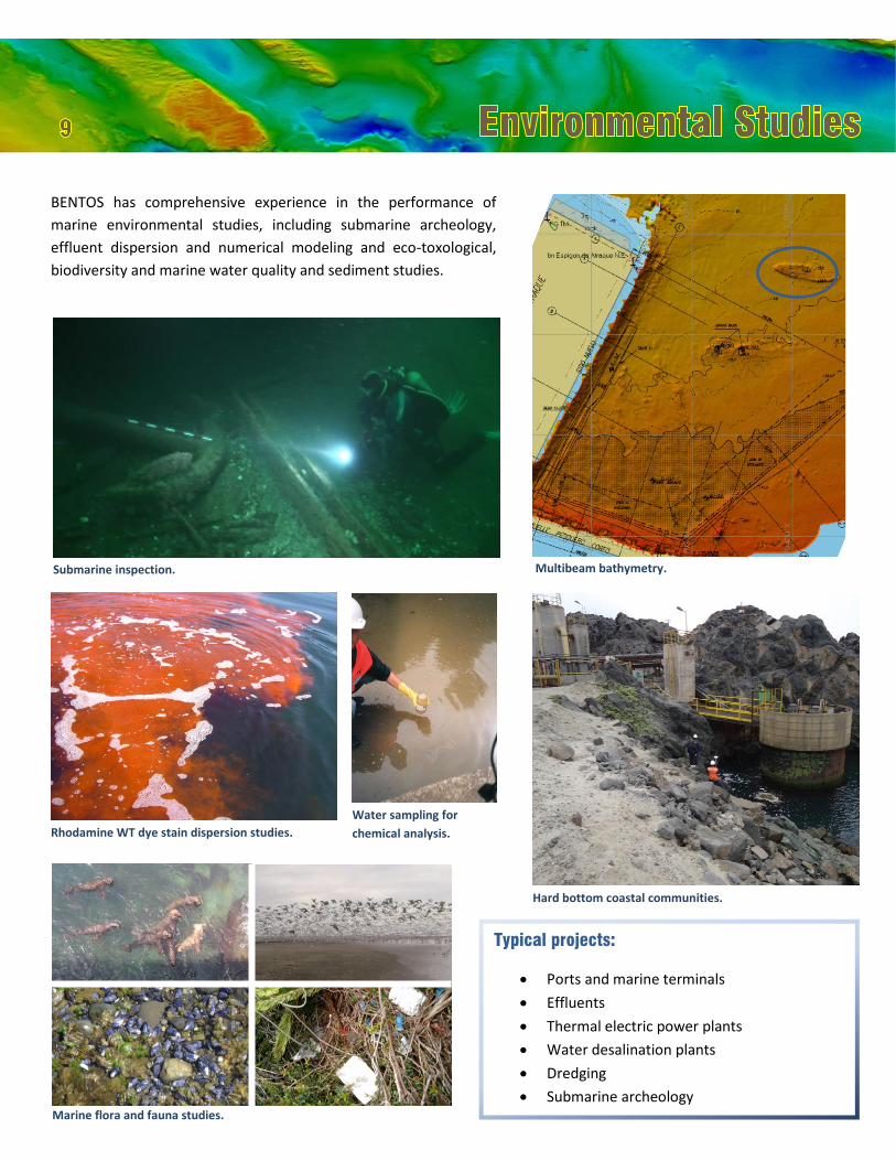
Water sampling for
chemical analysis.
Submarine inspection.
BENTOS has comprehensive experience in the performance of
marine environmental studies, including submarine archeology,
effluent dispersion and numerical modeling and eco-toxological,
biodiversity and marine water quality and sediment studies.
Typical projects:
• Ports and marine terminals
• Effluents
• Thermal electric power plants
• Water desalination plants
• Dredging
• Submarine archeology
Marine flora and fauna studies.
Rhodamine WT dye stain dispersion studies.
Hard bottom coastal communities.
Multibeam bathymetry.

ACADEMICS
PONTIFICIA UNIVERSIDAD CATÓLICA DE CHILE
UNIVERSIDAD AUSTRAL DE CHILE
UNIVERSIDAD DE CHILE DEPTO. GEOFÍSICA
UNIVERSIDAD DE CONCEPCIÓN
UNIVERSIDAD GENT (BÉLGICA)
ENGINEERING AND CONSTRUCTION
CADE IDEPE INGENIERÍA Y DESARROLLO DE PROYECTOS
LTDA.
CH2M HILL CHILE LTDA. CONSORCIO ICUATRO-COWI, INGENIERÍA CUATRO LTDA.
GEOVENOR EXPLORA SpA SK ECOLOGÍA S.A.
EMPRESA CONSTRUCTORA BELFI
GASATACAMA CHILE S.A. CONSORCIO PUENTE CHACAO S.A
GOLDER ASSOCIATES S.A. JAN DE NUL GROUP
MWH AMERICAS INC. CHILE LTDA.
PETRUS CONSULTORES GEOTÉCNICOS LTDA.
PLANAL SERVICIOS DE INGENIERÍA
INGENIEROS CONSULTORES AUSENCO SANDWELL
PORTS
ANTOFAGASTA TERMINAL INTERNACIONAL S.A.
COMPAÑÍA PORTUARIA MEJILLONES S.A. (Puerto
Angamos)
COMPAÑÍA PUERTO CORONEL S.A.
EMPRESA PORTUARIA ANTOFAGASTA
EMPRESA PORTUARIA SAN ANTONIO (EPSA)
IQUIQUE TERMINAL INTERNACIONAL S.A.
TERMINAL PUERTO DE ARICA S.A.
TERMINAL INTERNACIONAL DEL SUR S.A.
TRABAJOS MARÍTIMOS S.A.

OTHERS
ABASTIBLE
BPZ ENERGY INC.,
CELULOSA ARAUCO Y CONSTITUCIÓN S.A.
CLEDIRSA
EMPRESA NACIONAL DEL PETRÓLEO
FUNDACIÓN CHILE INSTITUTO DE FOMENTO PESQUERO
SUBSECRETARÍA DE PESCA Y ACUICULTURA
SUBMARINE CABLES
CENTRALES HIDROELECTRICAS DE AYSÉN S.A.
COMISIÓN CHILENA DE ENERGÍA NUCLEAR
L-3 MARIPRO NORDDEUTSCHE SEEKABELWERKE GmbH NSW
COMPREHENSIVE NUCLEAR -TEST- BAN TREATY
ORGANIZATION
SAESA TELEFÓNICA DEL SUR TRANSELEC S.A. SUBSECRETARÍA DE TELECOMUNICACIONES
MINING
COMPAÑÍA CONTRACTUAL MINERA CANDELARIA
MINERA ARATIRI COMPAÑÍA MINERA DEL PACÍFICO S.A.
COMPAÑÍA MINERA TECK QUEBRADA BLANCA S.A.
FREEPORT-McMORAN COPPER & GOLD INC.
MINERA LOS PELAMBRES (ANTOFAGASTA MINERALS)
SOUTHERN PERÚ COPPER CORPORATION


Company Data
BENTOS_Servicios y Equipos Marinos Ltda.
Address:
Caupolicán 9400, Oficina 16, Quilicura.
Santiago, Chile
Telephone:
(+56) 9 9419 9963 / (+56) 9 9319 4659
Postal Code:
CP 8710100
E-mail:
Web Page:
www.bentos.cl
Company building
Meeting room
Vessel
s
Store room
Printer and plotter room
Offices
13