ocean & coastal management - netto.ufpel.edu.brintegrated_coastal_zone_management... ·...
TRANSCRIPT

lable at ScienceDirect
Ocean & Coastal Management 54 (2011) 277e289
Contents lists avai
Ocean & Coastal Management
journal homepage: www.elsevier .com/locate/ocecoaman
Integrated coastal zone management at Marina di Carrara Harbor: sedimentmanagement and policy making
S. Cappucci a,*, D. Scarcella b,c, L. Rossi b, A. Taramelli b
a ENEA, Via Anguillarese, 301, 00123 Rome, Italyb ISPRA, Via di Casalotti, 300, 00166 Roma, ItalycUniversità degli Studi di Roma Tre, via della Vasca Navale, 84, 00148 Rome, Italy
a r t i c l e i n f o
Article history:Available online 21 December 2010
* Corresponding author. Tel.: þ39 06 30483415; faxE-mail address: [email protected] (S. Cappu
0964-5691/$ e see front matter � 2010 Elsevier Ltd.doi:10.1016/j.ocecoaman.2010.12.006
a b s t r a c t
Sediment management is becoming a critical issue around the world, particularly where the develop-ment of Harbor facilities, the conservation of coastal environments and needs of tourism compete forsustainable use of sediment resources. In order to apply an Integrated Coastal Zone Management policy,new approaches for management of the dredged harbor material need to be considered by the scientificcommunity and local stakeholders. The information contained in the Italian Ministry of the EnvironmentActs related to dredging of Carrara Harbor determined the sediment volume dredged between 1993 and2008 (849,500 m3) and allows us to estimate an average rate of material dredged from the harbor mouth(10,000e13,000 m3/yr). Different management options were chosen by the authorities based on thecontamination level of dredged sediment: nourishment (344,500 m3), offshore dumping (305,000 m3),disposal in landfill (10,000 m3) or in Confined Disposal Facilities (215,000 m3). The present study’s goal isto determine the sedimentary budget of the Apuo-Versilian coast and to use the result to guidea compensation strategy to reduce the sediment deficit caused by the disposal of sediments out of thesand-sharing system. In particular, the present study provides a detailed reference frame that can lead toadopt a compensation strategy to balance the eroding evolutionary trend of the coastline adjacent toshallow water dredging areas. The procedure described in the paper is a policy initiative based onscientific results and could provide a model for other jurisdictions developing their own sedimentquantitative estimation within an ICZM approach and a sustainable development of sedimentaryresource’s management.
� 2010 Elsevier Ltd. All rights reserved.
1. Introduction
The management of sediments in coastal areas suffering oferosion requires special attention (Apitz et al., 2005a,b; Veloso-Gomes and Taveira-Pinto, 2003; Xue, 1999). Because of the highcomplexity of both coastal system’s evolution and sedimentmanaging, several studies carried out in recent years (Apitz et al.,2006; Borja, 2005; Ducrotoy and Elliott, 1997; Elliott et al., 1999)have highlighted a new economical, physical, ecological and socialapproach. In particular, the policy of sediment management isdivided into two main categories: construction or navigationaldredging characterized by a removal of large volumes of sediment(economically driven); hot spot or environmental cleanup ofcontaminated sediments characterized by smaller volumes ofsediment (socially driven) (Apitz et al., 2006). In this framework,
: þ39 06 30483028.cci).
All rights reserved.
the planning of extensive dredging and disposal operation ismoving forward in several areas where the harbor and inletdeepening and maintenance exacerbate beach erosion (Montague,2008). Many harbors are characterized by bathymetric constrictionat their mouth that influences sediment exchange with the coastalsystem (Buynevich and FitzGerald, 2003). The net exchange of bed-load and suspended solids affects conditions along the axis of theharbor mouth (De Ruig, 1998; Van Rijn, 1986; PIANC, 2008), as wellas the sediment budget on adjoining coast (Rózyñski et al., 2005;Veloso-Gomes and Taveira-Pinto, 2003). Harbor inlet deepeningfrequently leads to a capture of the littoral sand drift (Finkl, 2004;GESA, 2006; Taylor Engineering, 2001; Vittori et al., 2005).Together with the diversion of eroded sand into ebb shoals adjacentto jetties, this sand deficit contributes to increased beach erosion(Dyer and Huntley, 1999). Furthermore, offshore and onshoredisposal of material dredged from harbor basin could result ina large net loss from the sand-sharing system (Pachecoa et al.,2007; Seabergh and Kraus, 2003). In the presence of coastalstructures, sediment bypasses will not restore this deficit because

Fig. 1. Location map of the study area. Scaled view of the Apuo-Versilian cell (fromRiver Magra mouth to the Viareggio Harbor in the South).
S. Cappucci et al. / Ocean & Coastal Management 54 (2011) 277e289278
they simply relocate sand within the system (Montague, 2008; U.S.Army Corps of Engineers, 2002).
Quantification of the volume of sediment dredged in the harborarea as a mean of determining the anthropomorphic evolution ofthe seafloor has become fundamental in the framework of insti-tutional activities and scientific research (Anfuso and Martìnez delPozzo, 2005; Frodsøe and Deigaard, 1992; GESA, 2007; Van Rijnet al., 2005; Walstra et al., 1999, 2002; Xue, 1999). A regionalunderstanding of littoral cell boundaries and sand budgets withinthose cells is important in coastal engineering management inorder to find a solution to the erosion problem, particularly whenboth dredging and offshore or onshore disposal play key role(Garcia et al., 2000; Kraus and Horikawa, 1990; Rosati and Kraus,1999). Thus, environmental interest among the scientific commu-nity has been focused on the dredged sediments (Apitz et al., 2006;Burroughs, 2005; Pellegrini et al., 2002) by groups of stakeholders(De Ruig and Roeland, 1997; GESA, 2006, 2007, 2008; EuropeanSediment Network, 2010; Slob and Gerrits, 2007) because manyhuman activities (fisheries, maritime transportation and develop-ment of infrastructure along the coast) may significantly influencecoastline evolution. In terms of sustainable development, thedifferent actions implying a change of extension of the emergedbeaches should consider the economic value of the coast and thedemand of sand necessary to contrast coastal erosion (Houston,1995, 1996, 2008). Through the analysis of the information con-tained in the ItalianMinistry of the Environment and Port AuthorityActs related to Carrara Harbor dredging authorizations from 1993to 2008, the proposed research approach allows a better under-standing of the average annual dredging volume and a classifica-tions of the different management options chosen by theAuthorities.
The approach is a valuable instrument for approximating littoraldrift rates at specific locations within littoral cells, as well aschanges in these rates over time due to human impacts on thesediment budget. The paper is organized as follows. The intro-duction to the study area is followed by the methodology used tocollect information on sediment properties and management andto create a geodatabase in ARCGIS�. Results are presented in fourdifferent subparagraph: (a) sediment properties and distribution(b) contamination level of sediments recently characterized withinthe National Programme of Land Reclamation (c) history ofdredged-and-fill operation between 1993 and 2008 and (d) calcu-lation of sand deficit from the sand-sharing system. The discussionis then presented with the following subparagraph: (a) history ofsediment management and quantification of infilling process (b)restrictions on sediment management due to contamination (c)factors influencing sediment, port and coastal management in thestudied area and (d) compensation strategy suggested by theAuthors as a policy initiative to guarantee the sustainable devel-opment of harbor traffic and tourism. The compensation strategyhas been imposed to mitigate the negative consequences of sedi-ment dumping (or their disposal on land) on coastal erosion. Due tothe multi-dimensional environmental issues that need to beresolved, we strongly believe that such strategy will reduceconflicts between stakeholders and guarantee a sustainableeconomic development in the area. The described methodologyrepresent a benchmark against which other jurisdictions, with theirown sediment quantitative estimation, could develop a sedimen-tary resources management based on scientific principles.
2. The study area
The Apuo-Versilian coast of northwest Italy lies along a physio-graphic unit of about 50 km located between the mouth of theMagra River to the north and a rocky outcrop in the south, near
Livorno (Cavazza, 1977; Cortemiglia, 1977). The entire physio-graphic unit, where Viareggio Harbor was built in 1606 and Marinadi Carrara Harbor in 1924 (Fig.1), is characterized by sandy beaches.
The prevailing winds in the area blow from the west and thesouthwest during spring and summer, while in autumn and winter,northenortheast winds progressively increase in frequency (Melitoet al., 2006).
The maximum tidal variations are of the order of 0.3 m, so thatwave-induced currents can be considered the only driving forcesfor harbor sedimentation. In order to understand wave dynamicswithin the harbor and the resonance phenomena, a monitoringnetwork was installed by the Port Authority of Carrara in 2005. Adirectional accelerometric buoy (model Datawell DirectionalWaverider MKIII), anchored at a depth of 13.5 m, at about 600 mfrom the harbor inlet, measures wave with periods between 1.6 sand 30 s since November 2005. Wave climate is almost mono-directional and all the incoming relevant waves come from 220 to240�N, as a result of the geographical fetch distribution (Fig. 2), asswell are sheltered by the Corsica and Elba islands to the South andby Ligurian and Tuscan coast to the North and East.
Along the northern part of the coast, where Carrara Harbor islocated, the net transport is southward directed, whereas along thesouthern section, net transport is northward directed. The localsediment drift reverse point is located nearby Forte dei Marmi(Pranzini, 2004; WL j Delft Hydraulics, 2006).
The Apuo-Versilian coast suffered of intense erosion (Ciprianiet al., 2001; Pranzini, 2004; Pranzini and Rossi, 1995) influenced

Fig. 2. Annual wave climate and geographical fetch on Carrara coast.
S. Cappucci et al. / Ocean & Coastal Management 54 (2011) 277e289 279
by human impact due to the Carrara harbor, construction ofgroynes field and the controlled Magra river mouth (Aminti et al.,1999, 2002; Cappucci et al., 2008). The factors influencing themorphological evolution of the coastal system have been investi-gated at the scale of river basins (Cappucci et al., 2005; Rinaldi andDapporto, 2005; Rinaldi and Simoncini, 2006) and physiographicunits (Pranzini, 2004; WL j Delft Hydraulics, 2006), estimatingsediment volume trapped by dams (Onori et al., 2006; Piegay andRinaldi, 2006) as well as considering the sediment managementwithin the harbor (Cappucci et al., 2006). Since its construction,Carrara Harbor had a strong influence on the morphodynamicevolutional patterns along the coast (Fig. 3.), with sedimentaccretion updrift and a very high erosion rate downdrift (Amintiet al., 1999, 2002; Cipriani et al., 2001; Pranzini and Rossi, 1995;WL j Delft Hydraulics, 2006).
Fig. 3. Bathymetry (2004) of the submerged beach
Through time, different types of emerged and submergedgroynes and barriers have been built, transforming one of the mostbeautiful Italian sandy beaches into a natural 1:1 scale laboratorywhere the severe erosion was shifted southward, fixing theshoreline for about 7.5 km downdrift.
The Magra is the major river transporting sand to the coastthrough erosion of the Macigno Oligocene sandstone formationwhich influence the composition of sediment on the continentalshelf: quartz (40%), feldspar and mica (<40%) and carbonates (20%)(AA.VV, 1997; Cipriani et al., 2001; Gandolfi and Paganelli, 1975).
Changes to significant sediment supply or loss to this coastal cellcan be attributed (a) to the decrease of rivers sediment load and (b)to human activities (Cavazza, 1977; Rinaldi and Surian, 2005; WL jDelft Hydraulics, 2006). A shoreline analysis of the Versilian coast(WL j Delft Hydraulics, 2006) has found that Magra River is themain sediment’s source, with a discharge of 70,000e130,000 m3/y,reduced to 30,000 m3/y nowadays, due mainly to the excavation ofaggregates necessary for the construction of motorways in the1970s. Cappucci et al. (2008) indicate that over the last decades thesediment input from Magra River, has varied from a minimum of34,900 m3/y upto 68,500 m3/y. Despite different estimation ofsediment input from the Magra River, it is estimated that theerosion process will significantly reduce the extension of theemerged beaches by 2035 if this trend continue and no nourish-ment is carried out (WL j Delft Hydraulics, 2006). Therefore, anysediment management strategy which increase the sediment inputand reduce the sediment output from the sand-sharing systemwillmitigate the erosion in the future.
3. Methods and data
One of the aims of the study is to understand how the differentsediment management options adopted along the Apuo-Versiliancoast by the Italian authorities have influenced the overall sedi-ment balance in the last 17 years. In particular, we approximate, thelittoral drift rates over time due to human impacts highlighting theimportance of integrating in the same dataset dredging volume and
around the Carrara Harbor to 10 m of depth.

S. Cappucci et al. / Ocean & Coastal Management 54 (2011) 277e289280
areas, management option and sediment characteristics. Therefore,the following assumptions have been made:
� in the time interval 1993e2008 variations of wave climate, sealevel and natural littoral drift have not been considered and thedredged volume is the overall movedmaterial (sediment input,transfer and output) in the time interval. Different destinationsof dredged material have contributed to either a sedimenttransfer or output from the coastal system.
� sediment transfer is the amount of dredged material placedbetween the shoreline and the closure depth for shorefacenourishment.
� sediment output is the volume of dredged material lost fromthe coastal system for offshore dumping beyond the closuredepth, or placed within a Confined Disposal Facility (CDF),or into a landfill. The concentration threshold for somecontaminants adopted to support these decisions are pre-sented in Table 1 and later argued in the discussion.
Table 1Threshold values of contaminants in relation to the present sediment managementwithin the Contaminated Site of National relevance of Carrara, according to thepresent legislation. First column: general value for quality standard of coastal waterbodies (Decree of the Ministry of environment n.56 of 14th April ’09); Secondcolumn: threshold levels for contamination, above which suitable reclamationmeasures have to be carried out, up to full removal of sediments from the waterbody. These values are site-specific and determined on the basis of Probable EffectLevel (PEL) related to toxicity, persistance, bioaccumulating potential, naturalbackground (Long et al., 1995). Third column: 90% of the concentration thresholdsfor contaminants within industrial areas (Italian Law 471/1999, confirmed by L. 152/2006). Since 1999 such values have been used to authorize the disposal ofcontaminated sediments into CDF. Fourth column: concentration thresholds fordangerous waste. Since 2008 such values have been used to authorize the disposal ofcontaminated sediments into specific landfill. See Discussion for further details.
Contaminants Qualitystandards(mg/kg ss)
Interventionvalues Carrara(mg/kg ss)
Soil criteria(industrialareas)(mg/kg ss)
Limit fordangerouswaste(mg/kg ss)
As 12 42 45 �1000Cd 0.3 0.8 13.5 �1000Cr 50 250 720 �1000Hg 0.3 0.8 4.5 �500 org
�1000 inorgNi 30 200 450 �10,000Pb 30 105 900 �5000Cu 65 540 �25,0000Zn 192 1350 �1000
(chromate)�50,000(chloride)�10,0000(sulfate)
TBT 0.005 0.07 0 �2500Benzo(a)pyrene 0.03 0.76 9 �100Anthracene 0.045 0.245 0Fluoranthene 0.11 1.5 0Naphtalene 0.035 0.39 0 �10,000P
PAH 0.8 4 90Aldrin 0.0002 0.005 0.09 �10000Alpha-HCH 0.0002 0.001 0.09 �10,000Beta-HCH 0.0002 0.001 0.45 �10,000Gamma-HCH 0.0002 0.001 0.45 �30,000DDT 0.001 0.005 0.09 �1000DDD 0.0008 0.005 0.09 �10,000DDE 0.0018 0.005 0.09 �10,000HCB 0.0004 0.005 4.5 �1000Dieldrin 0.0002 0.005 0.09 �1000P
PCDD/FþPCB(TEQ)
0.00009 �0.01
PCB 0.008 0.19 4.5 �50Nourishment Confined disposal facilities Landfill
� the closure depth, that in the coastal engineering time frame istaken as the boundary of the sand-sharing system (Dean andDarlimple, 1991), has been calculated with Hallermeier’s(1981) formula:
dc ¼ 2:28H12 � 68:5H212
gT2
pwhere dc [m] is the closure depth; H12 [m] is the average waveheight not exceeding for more than 12 h a year; g [m/s2] is thegravity acceleration; Tp [s] is the peak period associated to H12.These parameters have been calculated considering the 3-hourlydata from the Port Authority buoy for the years 2006 and 2007.
Based on the above assumptions, the complexity of sedimentdynamics and the long lasting conflicts among local authorities inthe area (port authority, versus municipalities and tourist opera-tors), a simple and straightforward method was implemented infive steps (Fig. 4):
(1) Two sediment grain size datasets were considered in order toquantify the granulometric fraction that contributes to thesedimentary balance of the coastal cell. The first one, providedby “Regione Toscana”, includes the granulometric characteris-tics of the sediments outside the harbor basin for the period1997e1998. More than 200 superficial sediment samples werecollected with a lightweight Van-Veen� grab from submergedbeach at the depth of 0, 2, 4, 6 and 8 m along transectsperpendicular to the shoreline, with 500 m offset (Gao andCollins, 1992). Grain size distribution was then interpreted inorder to apply the Gao & Collins model and produce the finalsedimentological maps (Pranzini, 2004).
The second one includes the characteristics of the samplescollected on the survey by the Marina di Carrara Port Authority in2005, as prescribed by the Ministry of Environment (ICRAM, 2004)in order to authorize the remediation of contaminated hot spots.Topmost 10 cm superficial sediment was sub-sampled from 67vibro-cores. Most of them were located within Carrara Harbor andthis dataset has been considered to estimate the abundance of sand,silt and clay fraction and contamination of seafloor (ICRAM, 2004).
(2) A research has been carried out in the archives of the Ministryof Environment e Life Quality and Nature Protection Direc-torates e in order to collect the authorization decrees con-cerning the dredging activities of the Carrara Harbor area. Asummary of the most relevant information contained in eachauthorization decree is presented as a result of the presentstudy (Section 4.2), as it is not possible to submit copy oforiginal documentation (in Italian).
(3) As an authorization does not imply the effective realization ofthe intervention, all available documents certifying the end ofthe dredging as well as bathymetric surveys carried out beforeand after the interventions have been considered. Through theanalysis of these documents the overall sediment volumesactuallymanaged between 1993 and 2008 have been calculated,using the approach recently proposed by Montague (2008)where dredging and beach nourishment databases are used toreveal sand disposal dynamics and to calculate sediment deficit.
(4) A geodatabase was implemented in ARCGIS� to elaborate andspatially analyse the available official information within thesame datum (WGS 84 UTM zone 32). All information wereanalysed by using the scientific principle reported within theassumption, to distinguish the volume of sediment transferredor removed from the coast.

Fig. 4. Visualization of different steps carried out during the research activities.
S. Cappucci et al. / Ocean & Coastal Management 54 (2011) 277e289 281
(5) Finally, a policy initiative based on scientific and sustainabledevelopment principles was developed to support the Ministryof Environment.
4. Results
The integrated dataset has been used to examine the cumulativeeffect of the dredging activities on the sand-sharing system in orderto quantify the volume of sediment of each component.
4.1. Sedimentological evidence of infill process
As a first result, the two sediment grain size dataset highlightthe sedimentological evidence of the infilling process at the harborinlet (Figs. 4 and 5).
The sediment analyses carried out in 2005 on 67 stations showthat the topmost 10 cm of sediment has a sandy fraction of 90% byweight, with a minimum of 40% inside the harbor (Fig. 5). The otherdataset (Fig. 6), referring to previous sampling campaigns carriedout by Regione Toscana, shows that superficial (about 20 cm)offshore sediments are finer and the average grain size distributionshows that finer particles bypass the Carrara Harbor under theeffect of the longshore (NW to SE) drift (Fig. 6). This suggests thatthe final budget loss estimation includes silt and clay fractions thatdo not contribute considerably to the sedimentary balance of sandybeaches, because their deposition in shallow water is negligible.
4.2. Contamination level
The 2005 campaign also evaluated the contamination of thesediment through chemical and ecotoxicological analysis in the 67stations (Fig. 7). At Carrara Harbor, as in every contaminated sites ofnational relevance, the Ministry of Environment established site-specific threshold levels for contamination, above which suitable
reclamationmeasures have to be carried out (Intervention values inTable 1).
The contamination thresholds corresponding to suitable sedi-mentmanagement options have been updated through years. It hasto be noted that from 2008 the disposal in the CDF is allowed evenfor sediments exceeding the threshold concentrations values forindustrial soils, under prescribed condition for the impermeablefacilities (K-coefficient< 10�7 cm/s for at least 1 m of sedimentthickness at the bottom and all around the structure) and includinga risk analysis to allows the future use of the completed CDF (ItalianLaw n. 296/2006 art. 1, comma 996). The analysis of the sedimentcores shows that the spatial distribution of contaminated sedi-ments exceeding the intervention values within the ContaminatedSite of Carrara is mainly related to the presence of Hg, Pb and DDT inthe top most 100 cm within the Harbor basin and inlet (Fig. 7).
4.3. Time history of dredge-and-fill operations
The dredging operations and the consequent destinations of thesediments to be dredged in the Carrara Harbor area were autho-rized with 10 decrees by the Ministry of Environment and 2 addi-tional projects by local administrations in 2000 and 2006. Details ofthe document’s contents, chronologically sorted, are described asfollow and represented in Fig. 8 and Table 2.
4.3.1. 1993The decree 780/ARS/DI/AC/DR of 02 July 1993 authorized the
Genio Civile per le OpereMarittime di Genova to dump offshore thecapital dredging material of the Carrara Harbor. The sedimentdumping authorization, upto a volume of 780,000 m3, was valid fora period of 22months. The dumping area, located 29 km offshore ata depth of 50 m, was about 1 km in diameter and was centered atthe geographic coordinates: 43�53’N 09�44’E (Fig. 8a). A bathy-metric survey carried out at the end of the dredging operationrevealed that only 305,321 m3 of sediments were removed from the

Fig. 5. This figure shows the sand (1) and silt (2) content of surficial sediments. Around the harbor area the sand content varies from a minimum of 40% (inside the harbor) toa maximum of 90% (downdrift) with an average value of 70%.
S. Cappucci et al. / Ocean & Coastal Management 54 (2011) 277e289282
harbor basin (file n. 3050/MS Genio Civile per le OpereMarittime diGenova).
4.3.2. 1995The decree 2151/ARS/DI/AC/DR of 01 March 1995 authorized the
Genio Civile per le Opere Marittime di Genova to dredge and dumpsediment from the Carrara Harbor in two different areas. Sedimentdredged nearby the harbor quays was dumped in the same offshore
Fig. 6. This figure highlights the mean grain size of sediments in four different classes, show
area authorized by previous decree (780/ARS/DI/AC/DR in 1993). Atthe end of the project the Genio Civile per le Opere Marittime diGenova (file n. 3050/MS) stated that 85,956 m3 were dredged fromthe central part of the harbor and the entire volume was dumpedfor shoreface nourishment at a depth of 5e7 m on the submergedbeach of Marina di Massa, downdrift the Carrara Harbor, in order toreplenish the coastal area that was affected by strong erosion(Fig. 8b).
ing that the area around the Carrara Harbor is characterized by fine sand (>0.062 mm).

Fig. 7. Spatial distribution of contaminants revealed after characterization carried out by Port Authority of Carrara Harbor in 2005. Gray areas indicates concentration above theintervention values for (a) Hg within level 0e50 cm; (b) Pb within level 0e50 cm; (c) DDT within level 0e50 cm; (d) within level 50e100 cm.
S. Cappucci et al. / Ocean & Coastal Management 54 (2011) 277e289 283
4.3.3. 1997The decree 5334/ARS/DI/AC/DR of 17 January 1997 authorized
the Genio Civile per le Opere Marittime di Genova to dredge about100,000 m3 of sediments from an unspecified “harbor area” inorder to perform a shoreface nourishment. The dumping area waslocated in front of Marina di Massa beach, at a depth of 5e7 m(Fig. 8c). Such operation was confirmed afterwards by the decree5519/ARS/DI/AC/DR of 27 February 1997.
4.3.4. 1999In 1999, 101,500 m3 of sediment were dredged within the
harbor at different steps and were all dumped along the coast forshoreface nourishment.
The decree 11491/ARS/DI/AC/DR of 17 May 1999 authorized thePort Authority of Marina di Carrara to dredge 66.500 m3 of sedi-ments from the harbor and its navigation channel, in areas iden-tified in Fig. 8d. The dumping area was located between FrigidoRiver and Marina dei Ronchi (Fig. 8d). A second decree, ref. 12208/ARS/DI/AC/DR of 13 December 1999, authorized the Port Authorityof Marina di Carrara to dredge 35,000 m3 of sediments from theharbor (Fig. 8d). The dumping area is the same as indicated in theprevious decree.
4.3.5. 2000The decree 12800/RIBO/DI/AC/DR of 25 May 2000 authorized
the Port Authority of Marina di Carrara to dredge 12,000 m3 ofsediments from a specific area located inside the harbor (Fig. 8e).Such material was used for shoreface nourishment, dumped in thesame area indicated in the decrees of 1999 and for filling of theBuscaiol quay, located in the northeast part of the basin.
In addition, other 190,000 m3 were dredged from inside theharbor and disposed into the Confined Disposal Facility (CDF) called“Piazzale Città di Massa” realized by the Port Authority to increasethe available surface for handling and stocking goods (Fig. 8f). Nodecree is available for this operation as this project was notauthorized by the Ministry of Environment, but only by localadministration of Massa Carrara.
4.3.6. 2001The decree 47/02 of 10 April 2001 authorized the Nuovi Cantieri
Apuania S.p.A. to dredge and dump 2000 m3 of sediment from theseafloor in front of their working area in order to launch a ship.Sediment was deposited close to the Buscaiol’s quay and thentransferred in the “Piazzale Città di Massa” CDF (Fig. 8g).
4.3.7. 2002The decree 340/3/02 of 12 September 2002 authorized the Port
Authority of Marina di Carrara to dump 10,000 m3 of sediments dueto an emergency dredging action to re-establish the operationaldepth. Such sediments were dredged from the harbor inlet anddumped for shoreface nourishment in an area between the Car-rione and Lavello rivers (Figs. 6 and 8H).
4.3.8. 2004The Port Authority of Marina di Carrara required an emergency
approval to dredge the harbor inlet to guarantee the operationaldepth for allowing the entrance of ships having a draft of more than10 m. The decree DEC/DPN/1719 of 24 September 2004, authorizedthe Port Authority to dump 10,000 m3 of sediment dredged fromthe topmost 0.4 m within the navigation channel. Such sedimentsshould have been dumped at a depth of 16.5 m in an area of 0.3Nautical Miles in diameter and centered at 43�58’30"N 10�01’30"E,but the Provincia di Massa Carrara (file no. DD/8685/2004 of 27September 2004) authorized to dump sediment in a different area(Fig. 8i), already indicated by the decree DEC/340/3/02 of 12September 2002, in order to carry out a shoreface nourishment.
4.3.9. 2006The Port Authority of Marina di Carrara required another
emergency approval in order to dredge 10,000 m3 from the inlet(Fig. 8l).
Given the contamination of the sediment (Fig. 7), the onlypossible management, according to the recent national legislation(D.gls.471/99 and L. 152/06), has been the disposal of dredged sedi-ments into an onshore landfill (file N. 2106/06 of 07 March 2006).
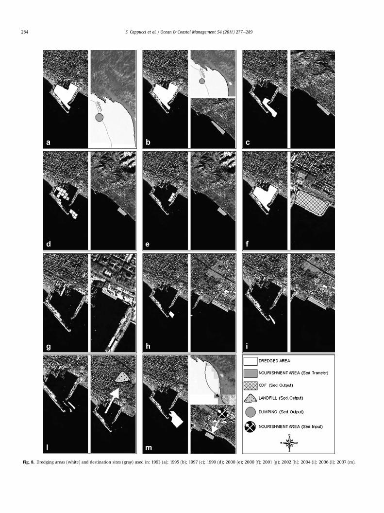
Fig. 8. Dredging areas (white) and destination sites (gray) used in: 1993 (a); 1995 (b); 1997 (c); 1999 (d); 2000 (e); 2000 (f); 2001 (g); 2002 (h); 2004 (i); 2006 (l); 2007 (m).
S. Cappucci et al. / Ocean & Coastal Management 54 (2011) 277e289284

Table 2References, years, dredging and destinations volumes. Please note: only in 2007 the sediment output of 25,000 m3 has been compensated by a shoreline nourishment of thesame volume.
Reference Year Dredged volume (m3) Destination (m3)
Sediment transfer and input Sediment output
Basin Inlet Shoreface nourishment Offshore dumping CDF Landfill
Dec. 780 1993 305,000 305,000Dec. 2151 1995 86,000 86,000Dec. 5334 1997 100,000 100,000Dec. 11491 1999 66,500 66,500Dec. 12208 1999 35,000 e 35,000Dec. 12800 2000 12,000 e 12,000CDF project 2000 188,000 188,000Dec. 47/02 2001 2000 e 2000Dec. 340 2002 e 10,000 10,000Dec. 1719 2004 e 10,000 10,000File 2106/06 2006 e 10,000 10,000Dec. 4010 2007 e 25,000 25,000 25,000Total 849,500 344,500 305,000 215,000 10,000
Fig. 9. Schematic diagram showing a summary of the sediment management whichhas occurred at the Carrara Harbor. Note that the sum of sediment input, sedimenttransfer and sediment output (869,500 m3) is greater than the sediment dredgedbetween 1993 and 2008 (849,500 m3), because the ministry of Environment hasrecently required the Port Authority of Marina di Carrara to balance the transfer ofsediment (25,000 m3) from the navigation channel to the CdF with a beach nourish-ment project of the same volume.
S. Cappucci et al. / Ocean & Coastal Management 54 (2011) 277e289 285
4.3.10. 2007In the most recent decree (file N. 4010 of 18 October 2007) the
Ministry of the Environment authorized dredging of 25,000 m3
from the inlet. Due to the presence of an irregular, but diffusecontamination in the dredged material (Fig. 7), the entire volumewas disposed in the CDF of the Livorno Harbor.
The same volume of well-matched uncontaminated sand wastaken from an upland quarry and dumped for shoreface nourish-ment in the area indicated by the 2004 decree between Carrioneand Lavello rivers (Figs. 6 and 8M).
4.4. Calculations pertaining to the sand deficit
The authorization documents, the chronology and the volumesof dredging interventions inside the harbor basin and at the harborinlet are summarized in Table 2.
From this data, it can be demonstrated that, from 1993 to 2008,the dredging of 1.300,500 m3 of sediments has been authorized.However, the volume that has been dredged, on the basis of thedredging works documents, is 850,500 m3 (Table 2), for an averagevalue of 56.7 m3/y, considering the 1993e1995 capital dredging.
The dredged material has been managed in four different ways:(1) shallow water disposal for shoreface nourishment; (2) offshoredumping; (3) filling of Confined Disposal Facilities and (4) place-ment in onshore landfill.
Only option 1 is considered as a sediment transfer within thesand-sharing system, because the dumping was carried out withinthe estimated closure depth, which in the present study is calcu-lated at about 7.7 m. This value is the minimum value estimatedalso by De Filippi et al. (2008) for the same physiographic unit atthe Magra river mouth, while the same authors estimate a maxi-mum depth of about 14 m.
The need for frequent dredging is strictly related to the filling ofthe harbor inlet (Fig. 8) as in the last years the phenomenonwas soprevalent to not allow the entrance of ships having a draft of morethan 10 m.
Options 2, 3, and 4 are considered as sediment outputs because,once dredged and put in Confined Disposal Facilities, or dumped29 km offshore, sediments can definitely be considered subtractedto the sedimentary budget of the littoral cell.
The volumes corresponding to the different managementoptions are summarized in Fig. 9.
Most dredged material was placed outside the coastal sand-sharing system: the authorized volume for dredging and offshoredumping is nearly 300,000 m3, while the volume designated to fill
in the CDF is 215,000 m3 (190,000 m3 to the CDF named “PiazzaleCittà di Massa” and 25,000 m3 to the CDF of Livorno).
The calculated deficit due to disposal of dredged sedimentoutside the sand-sharing systemduring the studyperiod is shown inFig. 10. The large-volume interventions, carried out in 1993e1995and 2000, hadn’t been replaced completely by later nourishments.This is clear from the sub-parallel trends of the cumulative curvesshown in Fig. 10.
5. Discussion
The created databases provide a record of dredging and sedi-ment placement activities over the last 17 years. It is completeenough to examine both the different management options as wellas the cumulative effect on the sand-sharing system. In particular,the integrated database considers both local and national managedauthorization (including specific ones done for beach nourishment

0
100,000
200,000
300,000
400,000
500,000
600,000
700,000
800,000
900,000
1993 1995 1997 1999 2000 2001 2002 2004 2006 2007year
m3
sediment deficitdredged materialnourishment
Fig. 10. The sedimentary deficit caused by the recent dredging of the harbor inlet to a depth of 10 m and delivery of the sediment to a CDF. Also shown are records of dredgedmaterial transferred annually during the last century via dredging activities associated with harbor and channel construction and maintenance as well as beach nourishment.
S. Cappucci et al. / Ocean & Coastal Management 54 (2011) 277e289286
or harbor and inlet deepening combination). The results provedifferent solutions that usually lay hidden by the different datasource, due to the fact that national and local Administration havedifferent database related to their specific institutional responsi-bilities, and highlights that the filling of CDF, an increasingmanagement option in Italy (and Europe), is contributing to thedeficit of sediment budget along Apuo-Versilian Coast, due to thepresence of contamination’s hot spots.
5.1. History of sediment management and quantification of infillingprocess
In the reference period, through the estimation of dredgedvolumes and relative management options, the sediment lossesfrom the littoral was calculated.
The last four dredging interventions out of 12 were carried outonly at the harbor inlet, suggesting that, if the harbor inlet trappedthe whole longshore sediment transport around the CarraraHarbor, it could be estimated at 10,000 m3/y. This result has beenconfirmed by the estimates of Port Authority of Marina di Carrara,which indicate dredging rate, at the harbor inlet, from a minimumof 5000 m3/y to a maximum of 25,000 m3/y, with an average valueof about 13,000 m3/y (Contini et al., pers. comm., 2006).
Such findings are necessary to aid planning harbor layout vari-ations compatibly with sedimentary circulation (Van Rijn, 1991)and suggest that the methodology adopted in the present studyform the basis for the Authorities that need to plan both overallshoreline management and harbor development.
5.2. Restriction on sediment management due to contamination
Given the volumes handled to maintain the size (width anddepth) required for channel access, two issues has to be considered:(i) the recent restrictions indicated by new legislation (Italian Law471/1999, confirmed by L. 152/2006 and L. 296/2006 art. 1, comma996) that will reduce the chances of beneficial sediment’s use and(ii) an high cost of chemical, physical and ecotoxicological charac-terization that leads to a longer time to complete dredging inter-ventions. Based on these issues and on the spatial distribution ofcontaminants inside the Carrara Harbor, the inlet-dredged sedi-ments are often subtracted from the littoral sedimentary budget,contributing to coastal erosion. This scenario will be even worse inthe future for the following reasons.
Given the contamination level of the sediment, dredged mate-rial can be managed as waste and the management options, avail-able under current and rapidly evolving legislation, are the filling ofa CDF (in this case the CDF of Carrara e in 2000 e and LivornoHarbor e in 2007 e which is 57 km to the south) or a landfill (file2106 of 2006 and n. 4010 of 2007; Fig. 8l and m). The decisionalprocess of these two management strategies was set in a first lawframe only in 1999 (First National Program on Land Reclamation).As a result, in the disposal authorizations, and not only at theCarrara Harbor, offshore dumping is a solution that is no longerfavored because many Port Authorities are expanding existinglayouts and allocating contaminated sediments into CDF that areused for different purposes once completed (i.e., handling orstorage areas). In this way, both cleanup interventions andenlargement of existing infrastructures are allowed. Since 2006,due to contamination recently explored in Carrara according to theReclamation Program, sediment dredged from the basin and theinlet cannot be used for beach nourishment and sometimes theycannot even be disposed into a CDF (file N. 2106/06 of 07 March2006). To mitigate negative consequences of such restrictions andguarantee the economic development of harbor activities as well ascoastal conservation and tourisms, a scientifically based manage-ment approach need to be adopted.
5.3. Factors influencing sediment management in Carrara
In general, seafloor sediments inside harbor basins can repre-sent a “potential resource” that can be exploited, following thedirectives of the environmental laws in force, even for nourishment(the most feasible management option). This option is particularlyrecommended when the downdrift coast has sediment deficit andthe shoreline retreat is exposing people to a higher risk of flood orwhen natural habitats, like coastal dunes, are suffering severedamage. Therefore, instead of exploiting offshore sand pits, thesediments dredged from harbor basins, compatibly with theirphysical, chemical, biological and toxicological characteristics(Pellegrini et al., 2002; European Sediment Network, 2010), cancontribute to re-establish the sedimentary balance within eachlittoral cell (Pranzini, 2004).
For example if the sediment dumped offshore after the capitaldredging carried out in 1993 (300,000 m3) was used to nourish thedowndrift beaches, their erosion rate could have been significantlyreduced. Basically, it can be stated that nourishment management

S. Cappucci et al. / Ocean & Coastal Management 54 (2011) 277e289 287
options in Carrara must be considered the most favorable to reducethe impact of sediment output even if, in the last four years, it wasnot considered due to restrictions imposed by the recent NationalProgram of Land Reclamation.
Unfortunately, the excavation of the accreting, “uncontami-nated”, updrift beach, no matter if it is created by material thatcould not reach the downdrift side, is another option that canhardly be considered because the physiographic unit or the littoralcell does not correspond with the administrative limits of differentlocal stakeholders. This is mainly due to the disagreeing localAuthorities that have not been able trough time to dredged sedi-ment updrift before they spilled over the inlet of Carrara Harborand get contaminated by hot spot. The emergency conditionscaused by reduced draft at the entrance of the Harbor does notallow safe navigation and impose to apply emergency actionwithout a long term management scheme.
Another factor influencing the sedimentmanagement in Carrarais the economic value placed on beaches (in Italy it ranges from800 V/m2 to 2500 V/m2; according to NOMISMA, pers. comm.),which creates strong local interest in the short term evolution ofthe shoreline (Fischer, 1990; Landry et al., 2003; Pendleton andKildow, 2006). Therefore, bottomeup decision making processcontrasts with the long term and large scale management of littoralsediments within the physiographic units.
Based on our interpretation, we can state that a solution thatwould allow sediment to completely bypass the Carrara Harborwould be the best option, as it would lead towards an equilibriumcondition where no operational dredging would be required tomaintain the inlet depth, but changing the present harbor layoutextending the breakwaters offshore and streamline the inlet, asseen in some Danish harbors (Broker et al., 2007), would implya massive enlargement of the harbor structures. The state-of-the-art design criteria should include the analysis of the influence thata coastal structure can have on the littoral drift, studying if and howthe coastal sediments could bypass the structures (Soulsby, 1997;Van Rijn, 1991; Van Rijn et al., 2005) but the design of a new Car-rara Harbor’s layout, able to mitigate local conflict, is still anunresolved issue that is beyond the aim of the present study.
5.4. Policy making and future development for the compensationstrategy and nourishment
Due to the reluctance of the local authorities to set a long termstrategy to dredge updrift uncontaminated sediments, the Ministryof Environment in 2007, based on our findings, adopted thecompensation strategy as a topedown approach to nourishdowndirft beaches exposed to erosion every time that dredging ofsediment around the port leads to a sediment output from thesand-sharing system. Many factors and restrictions influencingsediment management in the study area, where co-governancebetween central and local authorities is not successful lead thetopedown approach adopted by Ministry of Environment to be aneffective policy making tomitigate coastal erosion even it is appliedfor small dredging operation (<50,000e100,000 m3). In fact,according to WL Delft Hydraulics (2006), it is estimated that a sandnourishment requirement of about 30,000 m3/y is necessary until2035 in order to maintain the overall 2005 shoreline positiondowndrift of the existing coastal protection scheme.
Anyway, a compensation strategy imposing downdrift nour-ishment when dredging generates sediment output has to befurther investigated as the long term as well as large scalesustainability of such criteria require further understanding.
Estimation of the sand volume available offshore and inland,cost/benefit analysis of characterization and transport (includingCO2 emissions related to the transfer of sediment) are some of the
topics under investigation by the authors. One of themain concernsis the applicability of such a compensation criterion in cases ofcapital dredging, particularly in cases where large scale (hundredsof thousand of m3 of sediments) are involved. Will it be possible forthe Port Authorities to find and buy suitable sand from sites closeby? How long it will take to complete the required nourishment forcompensation? Will it be possible to negotiate access to areasrequired for nourishment with the local authorities and otherstakeholders? Should planning management have a bottom-up ora topedown approach?
In terms of Integrated Coastal Zone Management these issuesare particularly important because they allow sustainable devel-opment of coastal infrastructures and tourism and these principlesare in line with EU recommendations, Barcelona Convention andthe recent legislative proposals presented to the Europeancommunity by the partners of the programme Beachmed-e (2010).
We can argue that the planning of long term strategy in sedi-ment management can be viable only under a well defined lawframe (i.e., the Law tool proposed by Beachmed-e partners to theEuropean Community). In fact, there is no law that regulates theeligibility criteria for marine sediment dredging and management.This is dramatically evident for nourishment intervention: even if itis obvious that sediment characteristics varies from site to site bothchemically and physically, the authorities still do not have a deci-sion making tool to regulate nourishment interventions and oftentechnicians are called to assume responsibilities for the legislator.There have been some cases in Italy in which, to avoid legal prob-lems, the technicians have given too restrictive limitations (evenabout the sand color) for nourishment material characteristics. Theregulatory Authority wasn’t able to find such materials at anaffordable cost to the community; therefore, the necessary nour-ishment has not been carried out. This is partially due to restric-tions imposed by the National Program of Land Reclamation (likeothers) that are not easily accepted by the regional authorities thatare in charge of authorization procedure for beach protection andrestoration.
In summary, we believe that implementation of a clear andsimple law is essential to avoid that divergences of Authorities onLand and Marine Spatial Planning could affect technical andscientific issues of coastal management. That is to say that what isrequired to make the downdrift compensation nourishmentstrategy a winning option is the definition of the normative framereference for sediment management that considers all the scientificactivities and knowledge of marine geologist (sedimentaryresources), biologists and ecologists (environmental restrictionsand impact of human activities), coastal engineers (hard and softdefense strategies) and the policies on the use of the sea (local andnational authorities).
6. Conclusion
A comprehensive study, including bibliographic research, data-base implementation and GIS elaboration was carried out in orderto quantify the impact of dredging on the sediment budget of theMarina di Carrara littoral cell considering the authorizations forsediment management and the sedimentary characteristics ina specific period (1993e2008). The method used in the presentstudy is straightforward, but the results are extremely useful toquantify the annual sedimentation rate at the harbor inlet and toestimate the sediment deficit due to the disposal of sediment out ofthe sand-sharing system.
The Carrara Harbor will always need periodic dredging in orderto maintain the inlet depth at 10e12 m, considering that thenatural equilibrium depth of the harbor inlet would be about 7 m,a value close to the minimum estimated closure depth.

S. Cappucci et al. / Ocean & Coastal Management 54 (2011) 277e289288
In Italy the Port Authorities were established in 1994 (Law 84),but the Port Authority of Marina di Carrara has been charged withseabed maintenance and dredging only since 1999. Starting fromthe year 2000, the introduced nourishment option made possibleto reduce the impacts of dredging required tomaintain the depth ofthe navigation channel of the Carrara Harbor to ensure safety ofnavigation (�10.5 m). But dredged sediments have been only par-tially used for downdrift nourishment, with a rate of 21,300 m3/y.In the year 1993, the capital dredging and consequent offshoredumping and then, in the year 2000, the disposal into the CDFamplified the sediment deficit.
Starting from 2006, the application of strict limitations on reuseof sediment within contaminated sites of National Interest madethe community think about the risk of worsening erosion.
Based on the method presented herein, an effort to reduce theimpact of the sediment loss within the Versilian Coast was made bythe 2007 authorization of the Italian Ministry of Environment. Itincludes an important obligation: the 25,000 m3 of sedimentdredged at the harbor inlet has to be “compensated” by downdriftnourishment of the same (or higher) volume. Even though thevolume nourished in 2008 (25,000 m3) did not totally equate theoverall sediment deficit of about 520,000 m3 accumulated in 17years of not sighted sediment management, the schedule of nour-ishment planned to meet the compensation criteria is expected toimprove, or at least to balance the eroding evolutionary trend of thedowndrift beaches. The 2007 compensation criteria represent aninnovative policy initiative, based on scientific results that could beapplied by other jurisdiction.
Acknowledgements
The present work was developed in the framework of theMarina di Carrara technical committee, established by the ItalianMinistry of Environment. Acknowledgements go to the Marina diCarrara Port Authority for the monitoring and wave buoy data andto Regione Toscana for the granulometric data. Special thanks go tothe anonymous reviewers for their useful suggestions thatimproved the paper. Thanks also to Prof. Andrea Rinaldo, PietroColonna, Stefano Corsini for suggestions and interest through it alland Rose Anne Weissel for much needed advice and especially forher help in the English language. We are also grateful to CristianMugnai, Daniela Calarco and Valentina Modesti for their genuinesupport with data collection and data entry.
References
AA.VV, 1997. Atlante Delle Spiagge Italiane: Dinamismo, Tendenza Evolutiva, OpereUmane, vol. 108. C.N.R.eM.U.R.S.T., SELCA, Tavole.
Aminti, P., Cammelli, C., Pelliccia, F., Pranzini, E., 2002. Beach response toa submerged groin field (Marina dei Ronchi, Italy). In: Ozhan, E. (Ed.),Proceedings of the International MedCoast Workshop on Beaches of theMediterranean and the Black Sea, Kusadasi, Turcia, pp, 71e82.
Aminti, P., Iannotta, P., Pranzini, E., 1999. Morfodinamica di un sistema costierointensamente protetto: il litorale di Marina di Massa. In: Atti della Conv. Lincei,vol. 154, pp. 263e270.
Anfuso, G., Martìnez del Pozzo, J.A., 2005. Towards management of coastal erosionproblems and human structure impacts using GIS tools: case study in RagusaProvince, Southern Sicily, Italy. Environmental Geology 48, 646e659.
Apitz, S.E., Brils, J., Marcomini, A., Critto, A., Agostini, P., Micheletti, C., Pippa, R.,Scanferla, P., Zuin, S., Làmczos, T., Dercovà, K., Kocàn, A., Petrìk, J., Hocko, P.,Kusnir, P., 2006. Approaches and frameworks for managing contaminatedsedimentsea European perspective. Assessment and Remediation of Contami-nated Sediments, 5e82.
Apitz, S.E., Carlon, C., Oen, A., White, S., 2005a. Strategic frameworks for managingsediment risk at the basin and site-specific scale. Sediment Risk Managementand Communication.
Apitz, S.E., Elliot, M., Fountain, M., Galloway, T., 2005b. European environmentalmanagement: moving to an ecosystem approach. Integrated EnvironmentalAssessment and Management 2, 80e85.
BEACHMED-e. [Online] Available from: http://www.beachmed.it (accessed onFebruary 2010).
Borja, A., 2005. The European Water Framework Directive: a challenge for near-shore, coastal and continental shelf research. Continental Shelf Research 25,1768e1783.
Broker, I., Zyserman, J., Madsen, E.O., Mangor, K., Jensen, J., 2007. Morphologicalmodelling: a tool for optimisation of coastal structures. Journal of CoastalResearch 23, 1148e1158.
Burroughs, R., 2005. Institutional change in the Port of New York. Maritime Policyand Management 32, 315e328.
Buynevich, I.V., FitzGerald, D.M., 2003. Textural and compositional characterizationof recent sediments along a paraglacial estuarine coastline, Maine, USA. Estu-arine, Coastal and Shelf Science 56, 139e153.
Cappucci, S., Colonna, P., Paoletti, A., Rinaldo, A., Zanovello, G., 2005. Prime osser-vazioni sul trasporto solido dei corsi d’acqua di competenza delle Autorità diBacino del Magra, della Toscana Nord e del Serchio e proposte per la riattiva-zione ai fini della gestione della fascia costiera apuo-versiliese. Relazionetecnica redatta da ICRAM e Ministero dell’Ambiente e della Tutela del Territorionell’ambito delle attività del Tavolo Tecnico istituito per affrontare i problemidel porto di Marina di Carrara (TTMC-TSF-01.05-Luglio), pp. 70.
Cappucci, S., Lisi, I., Modesti, V., Scarcella, D., Corsini, S., Del Gizzo, M., Colonna, P.,2008. Stima del trasporto solido del Fiume Magra. In: Proceedings of theNational Conference: "Coste: Prevenire, Programmare, Pianificare", 15e18 May,Maratea, pp. 305e315.
Cappucci, S., Scarcella, D., Ausili, A., Rossi, L., Mugnai, C., Calarco, D., 2006. Monitor-aggio indiretto finalizzato al calcolo del volume dei sedimenti marini movi-mentato nell’intorno del porto di Carrara nell’ambito delle attività di dragaggioportuale. In: Proceedings of the Symposium "Il monitoraggio Costiero Medi-terraneo: Problematiche e Tecniche di Misura" Sassari, 4e6 October, pp. 45e55.
Cavazza, S., 1977. I criteri di stima dell’apporto terrigeno alla foce dei corsi d’acqua e ilcaso del fiume Magra. In: Unpaginated Proceedings of the Conference Convegnodi Studi per il Riequilibrio della Costa fra il Fiume Magra e Marina di Massa.
Cipriani, L.E., Ferri, S., Iannotta, P., Paolieri, F., Pranzini, E., 2001. Morfologia edinamica dei sedimenti del litorale della Toscana settentrionale. Studi Costieri4, 119e156.
Cortemiglia, G.C. 1977. Caratteri generali della situazione evolutiva del litorale diMarina di Massa in riferimento ad eventuali provvedimenti ed interventi disalvaguardia e di stabilizzazione. In: Proceedings of the Conference Riequilibriodella costa fra il fiume Magra e Marina di Massa, pp. 21e29.
Dean, R.G., Darlimple, R.A., 1991. Water wave mechanics for engineers and scien-tists. World Scientific Press, Singapore, pp. 353.
De Filippi, G.L., Duchini, E., Pranzini, E., 2008. Closure depth estimation along theTuscan coast aimed at short and long term coastal monitoring. In: Pranzini, E.,Wetzel, L. (Eds.), Beach Erosion Monitoring, Results From BEACHMED-e/Optimal Project. Nuova Grafica Fiorentina, pp. 33e48.
De Ruig, J.H.M., 1998. Coastline management in the Netherlands: human use versusnatural dynamics. Journal of Coastal Conservation 4, 127e134.
De Ruig, J.H.M., Roeland, H., 1997. Developments in Dutch coastline management:conclusions from the second governmental coastal report. Journal of CoastalConservation 3, 203e210.
Ducrotoy, J.-P., Elliott, M., 1997. Interrelations between science and policymaking:the North Sea example. Marine Pollution Bulletin 34, 686e701.
Dyer, K.R., Huntley, D.A., 1999. The origin, classification and modelling of sand banksand ridges. Continental Shelf Research 19, 1285e1330.
Elliott, M., Fernandes, T., Jonge, V.D., 1999. The impact of recent European Directiveson estuarine and coastal science and management. Aquatic Ecology 33,PP311ePP321.
European Sediment Network. [Online] Available at: <http://www.sednet.org/index.htm>, (access February 2010).
Finkl, C.W., 2004. Leaky valves in littoral sediment budgets: loss of nearshore sandto deep offshore zones via chutes in barrier reef systems, southeast coast ofFlorida, USA. Journal of Coastal Research 20, 605e611.
Fischer, D.W., 1990. Public policy aspects of beach erosion control. American Journalof Economics and Sociology 49, 185e197.
Frodsøe, J., Deigaard, R., 1992. Mechanics of coastal sediment transport. AdvancesSeries on Ocean Engineering 3, 392.
Gandolfi, G., Paganelli, L., 1975. Il litorale pisano-versiliese (Area campione AltoTirreno), Composizione, provenienza e dispersione delle sabbie. Bollettino dellaSocietà Geologica Italiana 94, 1273e1295.
Gao, S., Collins, M., 1992. Net sediment transport patterns inferred from grain sizetrends, basedupondefinitionof transportvector. SedimentaryGeology81, 47e60.
Garcia, G.M., Pollard, J., Rodriguez, R.D., 2000. Origins, management, andmeasurement of stress on the coast of southern Spain. Coastal Management 28,215e234.
GESA Gestion des Stocks Sableux interceptes par le ouverages cotiers et fluviaux,2006. Recuperation du Transport Solide, Cahier Technique étendu de Phase A,pp. 123.
GESA Gestion des Stocks Sableux interceptes par le ouverages cotiers et fluviaux,2007. Recuperation du Transport Solide. Cahier Technique étendu de Phase B,pp. 134.
GESA Gestion des Stocks Sableux interceptes par le ouverages cotiers et fluviaux,2008. Recuperation du Transport Solide, Cahier Technique étendu de Phase C,pp. 218.
Hallermeier, R.J., 1981. A profile zonation for seasonal sand beaches from waveclimate. Coastal Engineering 4, 253e277.

S. Cappucci et al. / Ocean & Coastal Management 54 (2011) 277e289 289
Houston, J.R.,1995. The economic value of beaches. TheCERCular, Coastal EngineeringResearch Center, Waterways Experiment Station, vol. CERC-95-4, pp. 1e4.
Houston, J.R., 1996. International tourism & U.S. beaches. Shore and Beach 64, 3e4.Houston, J.R., 2008. The economic value of beachesd2008 update. Shore and Beach
76, 22e26.ICRAM, 2004. Piano di Caratterizzazione Ambientale dell’Area marino costiera
prospiciente il sito di interesse nazionale di Massa e Carrara. Open file ReportCII-Pr-TO-MC-02.05, 67 pp.
Kraus, N.C., Horikawa, K., 1990. Nearshore sediment transport. In: LeMehautè, B.,Hanes, D.M. (Eds.), The Sea, Ocean Engineering Science, vol. 9b. John Wiley &Sons, New York, pp. 775e814.
Landry, C.E., Keeler, A.G., Kreisel, W., 2003. An economic evaluation of beach erosionmanagement alternatives. Marine Resource Economics 18, 105e127.
Long, E.R., MacDonald, D.D., Smith, S.L., Calder, F.D., 1995. Incidence of adversebiological effects within ranges of chemical concentrations in marine andestuarine sediments. Environmental Management 19, 81e97.
Melito, I., Cuomo, G., Bellotti, G., Franco, L., 2006. Field measurements of harborresonance at Marina di Carrara. In: Proceedings of 30th International Confer-ence on Coastal Engineering, ICCE 2006, San Diego, California, USA, pp.1280e1292.
Montague, C.L., 2008. Recovering the sand deficit from a century of dredging andjetties along Florida’s Atlantic coast: a reevaluation of beach nourishment as anessential tool for ecological conservation. Journal of Coastal Research 24,899e916.
Onori, F., Grauso, S., Regina, P., Pasanisi, F., Tebano, C., Felici, F., Marcinò, M.A., 2006.Erosion and sediment supply capacity in two watersheds of Sicily (SouthernItaly): a comparison from reservoir sedimentation data. Geologia Tecnica edAmbientale 3e4/06, 47e60.
Pachecoa, A., Carrascoa, A.R., Vila-Concejoa, A., Ferreirab, Ó., Dias, J.A., 2007.A coastal management program for channels located in backbarrier systems.Ocean and Coastal Management 50, 119e143.
Pellegrini, D., Onorati, F., Virno Lamberti, C., Merico, G., Gabellini, M., Ausili, A.,2002. Aspetti tecnico-scientifici per la salvaguardia ambientale nelle attività dimovimentazione dei fondali marini: dragaggi portuali. Quaderno ICRAM n.1.
Pendleton, L., Kildow, J., 2006. The non-market value of California’s beaches. Shoreand Beach (Journal of the American Shore and Beach Preservation Association)74, 34e37.
PIANC, 2008. Minimising harbor siltation. World Association for WaterborneTransport Infrastructure, Report n�102, pp. 55.
Piegay, H., Rinaldi, M., 2006. Gestione sostenibile dei sedimenti in fiumi ghiaiosiincisi in Francia. In: Proceedings of the Workshop: Nuovi approcci per laComprensione dei Processi Fluviali e la Gestione dei Sedimenti. Applicazioni nelBacino del Magra, Sarzana, Autorità di Bacino del Fiume Magra, pp. 59e80.
Pranzini, E., 2004. Caratteristiche Morfologiche e Sedimentologiche di una zona diconvergenza del trasporto litoraneo (Versilia, Toscana). Studi Costieri 8,135e149.
Pranzini, E., Rossi, L., 1995. A new Bruun-Rule-based model: an application to theTuscany coast, Italy. In: Proceedings of the Second International Conference onthe Mediterranean Coastal Environment, MEDCOAST, October 24e27, Taragona,Spain.
Rinaldi, M., Dapporto, S., 2005. Monitoraggio e analisi dei processi di arretramento edei meccanismi di instabilità di sponde fluviali. In: Brunelli, M., Farabollini, P.
(Eds.), Dinamica Fluviale, Atti Giornate di Studio Sulla Dinamica Fluviale,Grottammare, June 2002. Ordine dei Geologi Marche, pp. 165e201.
Rinaldi, M., Simoncini, C., 2006. Studio Geomorfologico del Fiume Magra e delFiume Vara finalizzato alla Gestione dei Sedimenti e Della Fascia di Mobi-lità. Atti Giornate di Studio "Nuovi Approcci per la Comprensione deiProcessi Fluviali e la Gestione dei Sedimenti, Applicazioni nel bacino delMagra." Sarzana, October 2006. Autorità di Bacino del Fiume Magra.93e109.
Rinaldi, M., Surian, N., 2005. Variazioni morfologiche ed instabilità di alvei fluviali:metodi ed attuali conoscenze sui fiumi italiani. In: Brunelli, M., Farabollini, P.(Eds.), Dinamica Fluviale, Atti Giornate di Studio sulla Dinamica Fluviale,Grottammare, June 2002. Ordine dei Geologi Marche, pp. 203e238.
Rosati, J.D., Kraus, N.C., 1999. Sediment budget analysis system (SBAS), coastal andhydraulics engineering. Technical note CHETN-IV-20, U.S. Army EngineerResearch and Development Center, Vicksburg, MS.
Rózyñski, G., Pruszak, Z., Szmytkiewicz, M., 2005. Coastal protection and associatedimpactsdenvironment friendly approach. In: Zimmermann, C., et al. (Eds.),Environmentally Friendly Coastal Protection, pp. 129e145.
Seabergh, W.C., Kraus, N.C., 2003. Progress in management of sediment bypassingat coastal inlets: natural bypassing, weir jetties, jetty spurs, and engineeringaids in design. Coastal Engineering Journal 45, 533e563.
Slob, A., Gerrits, L., 2007. The dynamics of sedimentary systems and the whimsi-cality of policy processes. Journal of Soils and Sediments 7, 277e284.
Soulsby, R., 1997. Dynamics of Marine Sands. Thomas Telford Publications. 242.Taylor Engineering, 2001. Coastal and Inlet Process Evaluation, Fort Pierce Inlet and
Adjacent Beaches, Ft. Pierce, Florida: County of St. Lucie, Report C 027, 2001, pp.215.
U.S. Army Corps of Engineers, 2002. Coastal Engineering Manual, EM 1110-2-1100.Van Rijn, L., 1986. Sedimentation of dredged channels by currents and waves.
Journal of Waterway, Port, Coastal and Ocean Engineering 112, 541e559.Van Rijn, L., 1991. Sediment transport in combined waves and currents. In:
Soulsby, R.L., Bettes, R. (Eds.), Proceedings of Euromech 262, Sand Transport inRivers, Estuaries and the Sea. Balkema.
Van Rijn, L., Soulsby, R., Hoekstra, P., Davies, A.G., 2005. Sand Transport andMorphology of Offshore Marine Pits. Process Knowledge and Guidelines forCoastal Management. Sandpit Book, The Netherlands, pp. 123.
Veloso-Gomes, F., Taveira-Pinto, F., 2003. Portuguese coastal zones and the newcoastal management plans. Journal of Coastal Conservation 9, 25e34.
Vittori, G., Bloundeaux, P., Besio, G., 2005. Morphological modelling of sand waves,sand banks and shallow pits using stability analysis models. In: Sandpit Book.AT1-AT, The Netherlands, p. 9.
Walstra, D.J.R., Van Rijn, L.C., Hoogewoning, S.E., Aarninkhof, S.G.J., 1999. Modellingof sedimentation of dredged trenches and channels under the combined actionof tidal currents and waves. Coastal Sediments.
Walstra, D.J.R., Van Rijn, L.C., Van Helvert, M.A.G., 2002. Morphology of pits chan-nels and trenches part II: model verification of Delft 3D with PUTMOR dataset.WL Delft Hydraulics Report Z3223, pp. 25.
WL j Delft Hydraulics, 2006. Carrara coastal study volume 3: coastline evolutionstudyddraft report, pp. 211.
Xue, C., 1999. Coastal sedimentation, erosion and management on the north coast ofKosrae, Federated States of Micronesia. Journal of Coastal Research 15,927e935.