nz transport agency requiring authority · mackays to peka peka expressway proposal ... 5 i have...
TRANSCRIPT
Statement of evidence of Gavin Alexander (Ground Settlement) for the
NZ Transport Agency
Dated: 3 September 2012
REFERENCE: John Hassan ([email protected])
Suzanne Janissen ([email protected])
Before a Board of Inquiry
MacKays to Peka Peka Expressway Proposal
under: the Resource Management Act 1991
in the matter of: Notice of requirement for designation and resource
consent applications by the NZ Transport Agency for the
MacKays to Peka Peka Expressway Proposal
applicant: NZ Transport Agency
Requiring Authority
Chapman TrippT: +644499 5999F: +644472 7111
10 Customhouse QuayPO Box 993, Wellington 6140NewZealand
www.chapmantripp.comAuckland, Wellington,Christchurch
CHAPMAN~TR/PP~
1
042590992/2258990.8
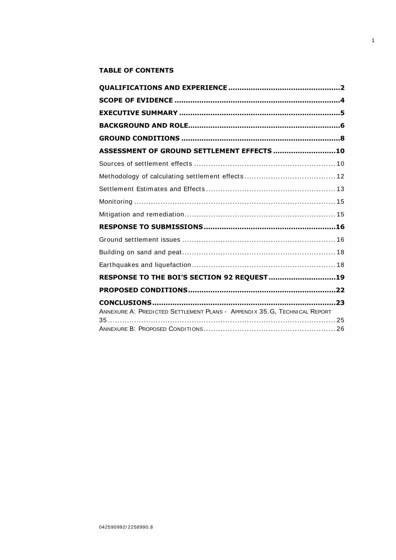
TABLE OF CONTENTS
QUALIFICATIONS AND EXPERIENCE ..................................................2
SCOPE OF EVIDENCE ..........................................................................4
EXECUTIVE SUMMARY ........................................................................5
BACKGROUND AND ROLE....................................................................6
GROUND CONDITIONS .......................................................................8
ASSESSMENT OF GROUND SETTLEMENT EFFECTS ............................10
Sources of settlement effects ........................................................... 10
Methodology of calculating settlement effects ...................................... 12
Settlement Estimates and Effects ...................................................... 13
Monitoring .................................................................................... 15
Mitigation and remediation ............................................................... 15
RESPONSE TO SUBMISSIONS ...........................................................16
Ground settlement issues ................................................................ 16
Building on sand and peat ................................................................ 18
Earthquakes and liquefaction ............................................................ 18
RESPONSE TO THE BOI’S SECTION 92 REQUEST ..............................19
PROPOSED CONDITIONS ..................................................................22
CONCLUSIONS ..................................................................................23
ANNEXURE A: PREDICTED SETTLEMENT PLANS - APPENDIX 35.G, TECHNICAL REPORT
35 ............................................................................................... 25
ANNEXURE B: PROPOSED CONDITIONS ....................................................... 26
2
042590992/2258990.8
STATEMENT OF EVIDENCE OF GAVIN ALEXANDER FOR THE NZ
TRANSPORT AGENCY
QUALIFICATIONS AND EXPERIENCE
1 My full name is Gavin John Alexander. I am a Technical Director in
Beca Infrastructure Limited‟s (Beca) Geotechnical Group based in
Auckland.
2 I have the following qualifications and experience relevant to the
evidence I shall give:
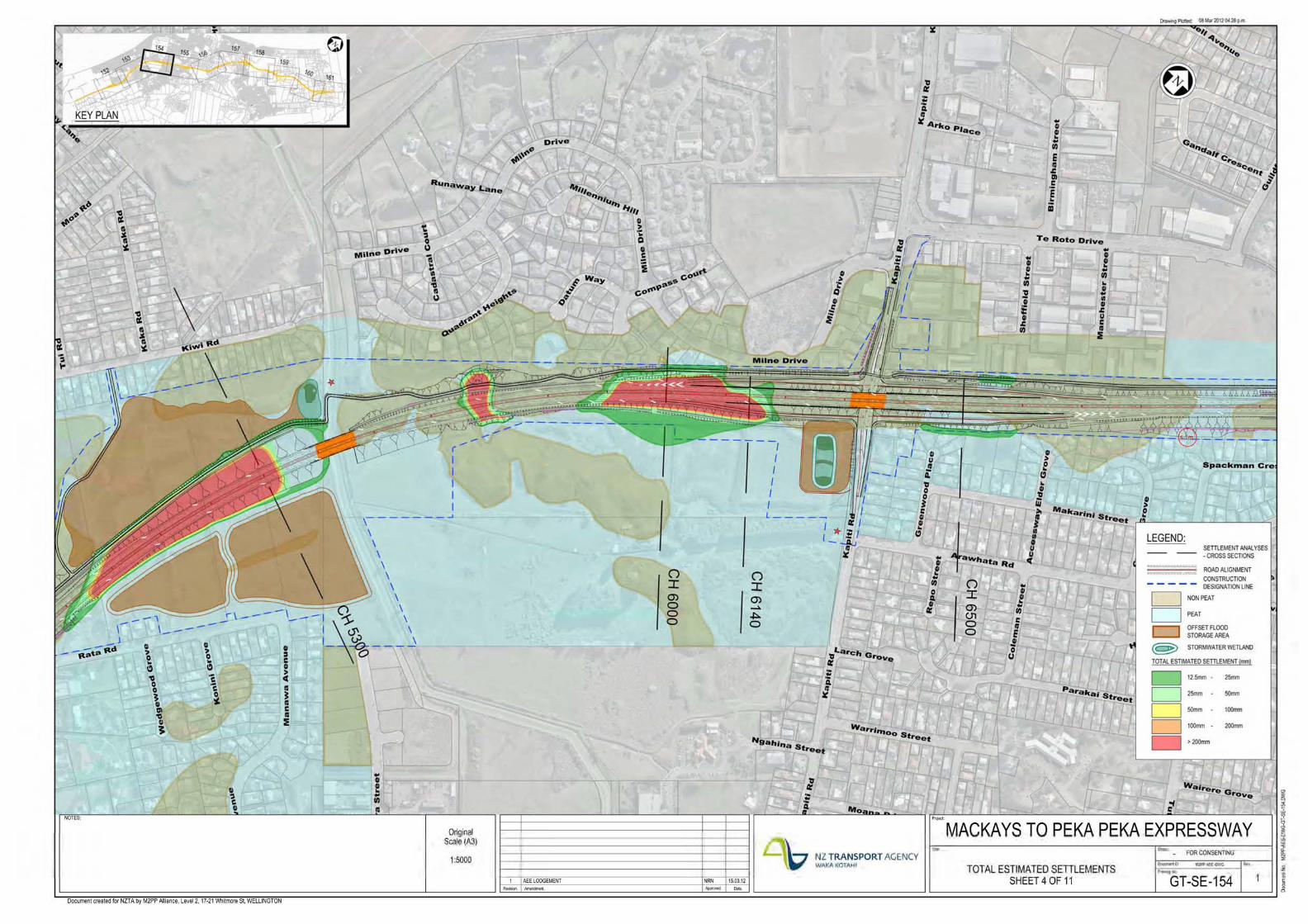
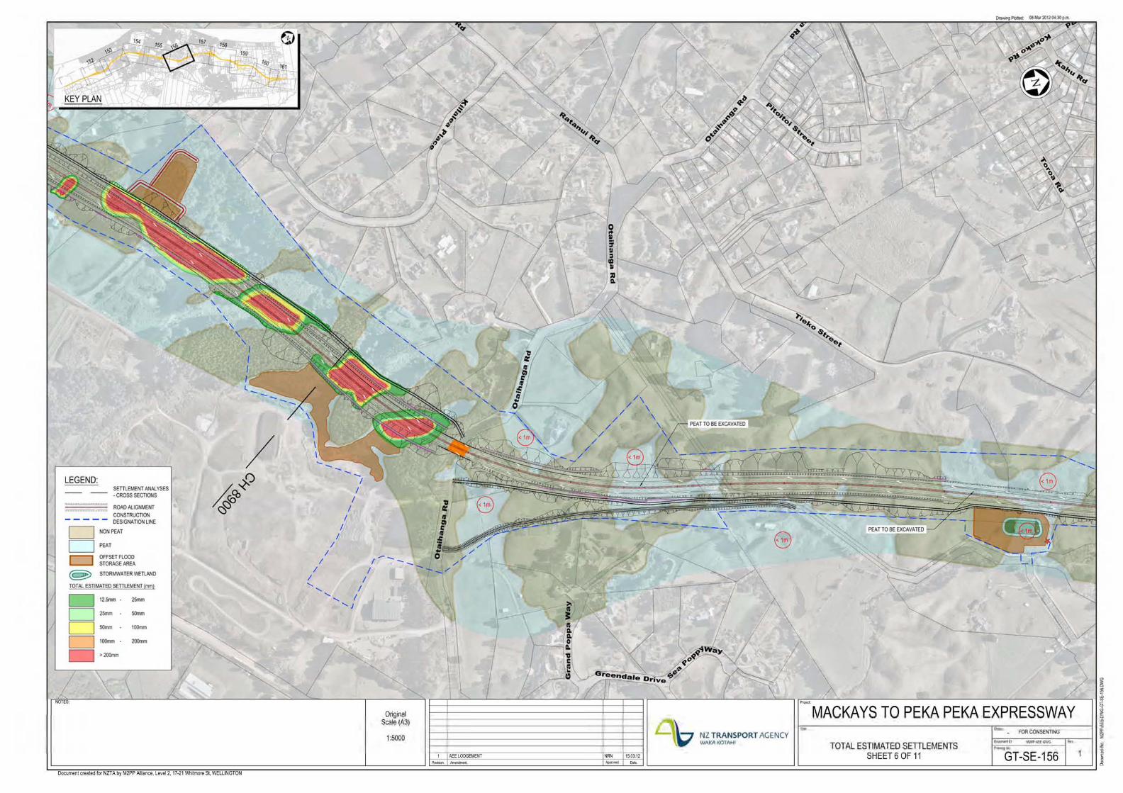
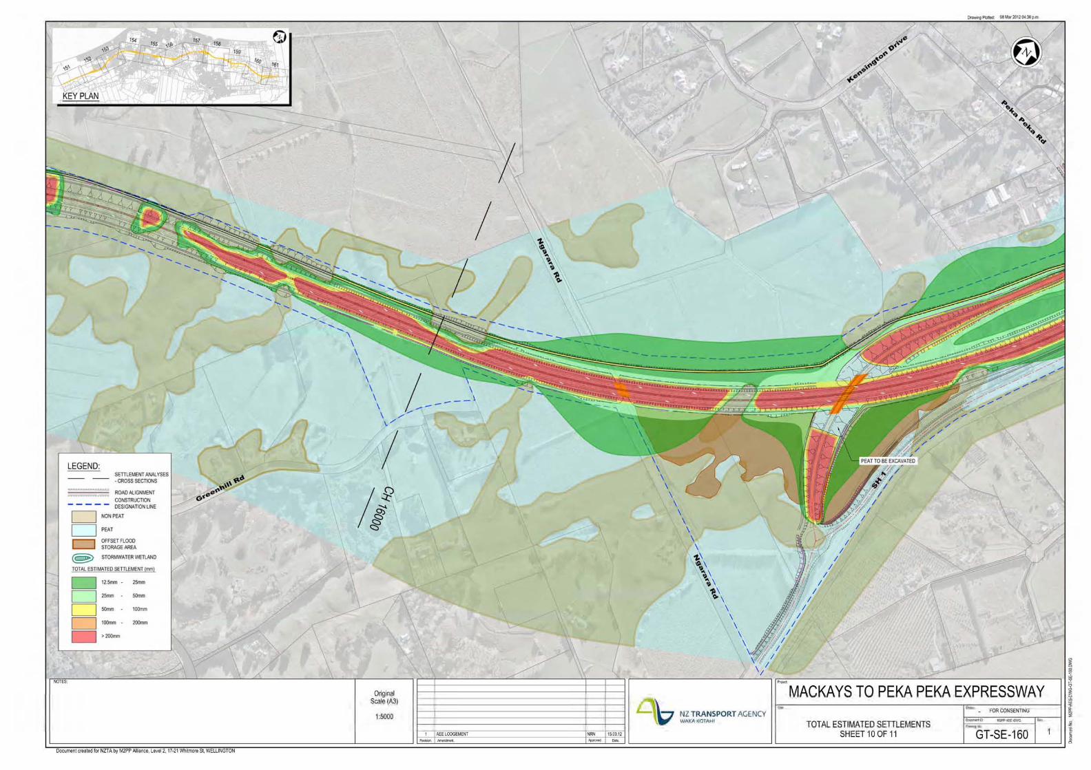
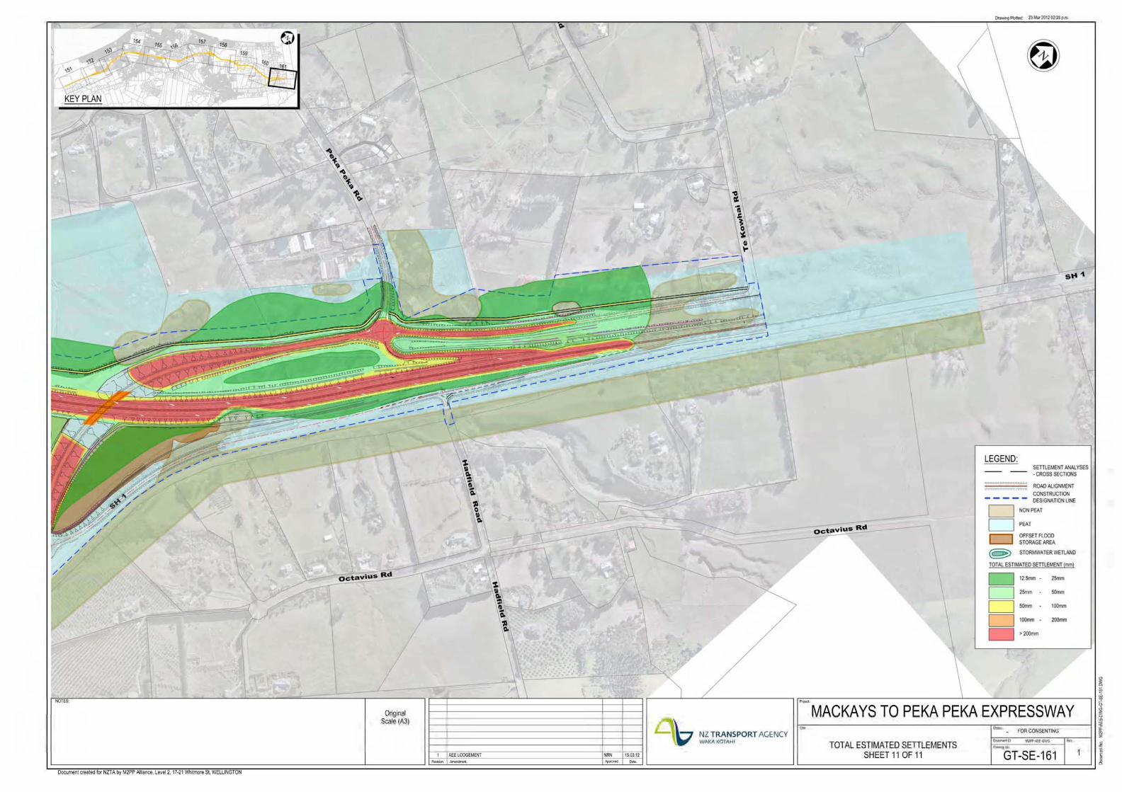
2.1 I hold a Bachelor of Civil Engineering from the University of
Auckland (1986) and a Masters Degree in Soil Mechanics and
Engineering Seismology from Imperial College, University of
London (1991).
2.2 I am a New Zealand Chartered Professional Engineer, a Fellow
of the Institution of Professional Engineers of New Zealand,
and a Member of the New Zealand Geotechnical, Structural
Engineering and Large Dam Societies. I am currently an
elected member of the Management Committee of the
New Zealand Geotechnical Society, and hold the role of Vice-
Chair.
2.3 I have 30 years‟ experience in geotechnical and civil
engineering, and over the past 26 years I have provided
geotechnical advice on a wide variety of civil, commercial,
industrial, and land development projects in many parts of
New Zealand, and in Australia and further afield.
2.4 Projects I have provided advice on include the Tauranga
Eastern Link highway (TEL), the Ngaruawahia Section of the
Waikato Expressway (Ngaruawahia), and the recent Board of
Inquiry hearing on the Waterview Connection Project
(Waterview).
2.5 The TEL project comprises a new four lane highway some
23 km in length with seven bridges and some three million
cubic metres of earthworks. I was the lead geotechnical
engineer for the early stages of that project, and reviewed
the geotechnical work of my colleagues as it developed and
was consented. TEL is currently being designed and built by a
consortium of constructors and designers, and I continue to
review the work of my colleagues as they fulfil Beca‟s role as
advisor to the NZ Transport Agency (NZTA). From a
geotechnical perspective, it has many similarities to the
Mackays to Peka Peka Expressway (the Project), in that it
requires the construction of a multi-lane highway through
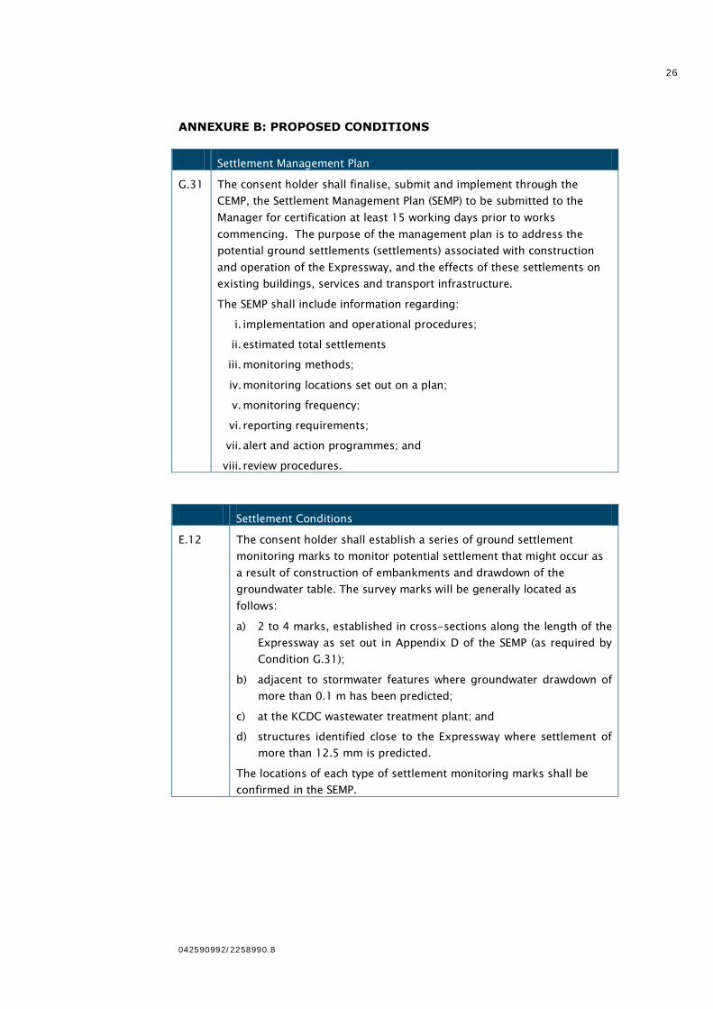
sand dunes and over peat lands, and involves the careful

3
042590992/2258990.8
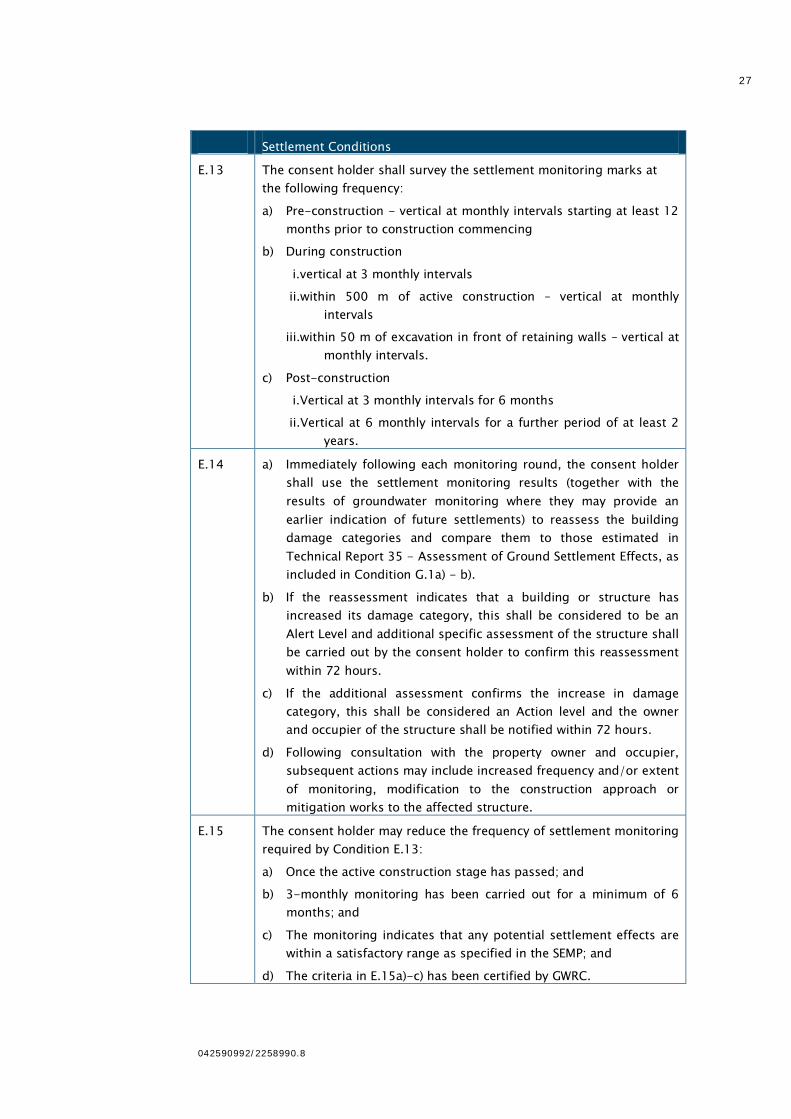
consideration of ground settlement, liquefaction potential and
the seismic performance of relatively high embankments at
bridges.
2.6 The Ngaruawahia project comprises 12 km of new four lane
expressway, with six bridges and some 1.2 million cubic
metres of earthworks, and is located in the northern Waikato.
It is currently being constructed by a design-build team, with
Beca providing geotechnical design. I am the geotechnical
reviewer for that project. It includes the construction of a
multi-lane highway over peat lands and, as for TEL, involves
the careful consideration of ground settlement, liquefaction
potential and the seismic performance of relatively high
embankments at bridges.
2.7 Both of these projects are, therefore, directly relevant to the
Mackays to Peka Peka Project.
2.8 My role on Waterview was focussed on the ground settlement
effects from tunnel and retaining wall construction. It involved
the estimation of the quantum of ground settlement resulting
from the project and assessment of the effects of that
settlement on houses, other structures and buried and
surface infrastructure. I have adopted the same assessment
methodologies used on Waterview for the current Project.
2.9 I led the drafting of the proposed settlement effects
management plan and the ground settlement conditions for
Waterview, and participated in expert conferencing to develop
an agreed set of conditions for consideration by the Board of
Inquiry (BOI).
2.10 I am currently the reviewer for ground settlement related
assessments and monitoring for the Well Connected Alliance
which is designing and constructing the Waterview Connection
project.
3 My evidence is given in support of the Notice of Requirement (NoR)
and applications for resource consent lodged with the Environmental
Protection Authority (EPA) by the NZTA for the construction,
maintenance and operation of the Project.
4 I am familiar with the area that the Project covers and the State
Highway and local roading network in the vicinity of the Project.
5 I have directed and reviewed all geotechnical aspects of the design
and the ground settlement effects assessment for this Project since
mid-2010. In the course of my involvement, I have worked closely
with my colleagues, particularly Ms Ann Williams, who has
undertaken groundwater modelling.

4
042590992/2258990.8
6 I am the reviewer of the Assessment of Ground Settlement Effects
Technical Report and of the Geotechnical Interpretive Report1 which
form part of the Assessment of Environmental Effects (AEE) lodged
in support of the Project.
7 My evidence covers the assessment of potential ground settlement
associated with the construction and operation of the Project, and
the potential effects of these settlements on existing buildings,
services and infrastructure. It describes the monitoring regime
proposed, together with potential mitigation measures for ground
settlement effects (if any).
8 I have read the Code of Conduct for Expert Witnesses as contained
in the Environment Court Consolidated Practice Note (2011), and I
agree to comply with it as if this Inquiry were before the
Environment Court. My qualifications as an expert are set out
above. I confirm that the issues addressed in this brief of evidence
are within my area of expertise. I have not omitted to consider
material facts known to me that might alter or detract from the
opinions expressed.
SCOPE OF EVIDENCE2
9 My evidence will deal with the following:
9.1 Executive summary;
9.2 Background and role;
9.3 A brief description of the existing ground conditions (which
are discussed more fully in the evidence of Ms Ann Williams);
9.4 Assessment of ground settlement effects;
9.5 Response to submissions;
9.6 Response to the BOI‟s section 92 request;
9.7 Proposed conditions; and
9.8 Conclusions.
1 Technical Reports 35 and 36 respectively.
2 I have reviewed the section 149G Key Issues Reports prepared by Greater
Wellington Regional Council and Kãpiti Coast District Council. There are no
issues raised that relate to ground settlement or that otherwise require a response from me.

5
042590992/2258990.8
EXECUTIVE SUMMARY
10 My evidence addresses the potential ground settlement effects
resulting from construction and operation of the proposed
Expressway. It also discusses the general ground conditions and
key geotechnical considerations that have been identified for the
proposed Expressway.
11 There are four predicted sources of settlement associated with
construction and operation of the Expressway, of which the first two
listed below are by far the most significant:
11.1 Ground consolidation due to the construction of road
embankments. This consolidation occurs beneath and for a
small distance beyond the embankments where they are
constructed on peat.
11.2 Ground consolidation due to lowering of the groundwater as a
result of excavation. This is also confined to peat soils. It is
time dependant and will extend for a greater distance beyond
the earthworks footprint. Permanent lowering of the
groundwater level in peat may also result in drying induced
volume change settlement.
11.3 Mechanical settlement of the ground due to movement of
retaining walls. This is much more localised and of
considerably smaller magnitude than consolidation
settlement.
11.4 Mechanical settlement of the ground due to vibration. This is
expected to only result from construction activities which are
intended to densify the adjacent soil. It is, therefore,
extremely localised and the effects are built out by
subsequent construction.
12 Field and laboratory investigations have been carried out to
characterise the soils at the Project site. These investigations have
included a trial embankment to investigate the settlement behaviour
of the peat soils that underly a significant portion of the site and in
which the most significant settlement is expected to occur.
13 Numerical analysis of settlement has been undertaken for each of
the potential sources identified, and these have been combined
where appropriate to determine total settlement contours. The
largest component of settlement results from embankment loading
and as a result has little effect on surrounding properties or
infrastructure. Settlement arising from groundwater drawdown in
peat soils is more extensive, but the magnitude is typically small
because of the limited groundwater change expected.
6
042590992/2258990.8
14 The effects on buildings have been assessed following the approach
that was adopted for the Waterview Connection project. Applying
this approach, the assessment concluded that there will be
negligible setlement effects on all buildings from the construction
and operation of the Expressway. Similarly low effects are predicted
on buried services that are not proposed to be relocated as part of
the project, and on rail infrastructure. Road surfaces that are
affected by the Project will be remediated by resurfacing.
15 Monitoring is proposed to confirm the predicted settlement and the
predicted effect of that settlement. While the current assessment
indicates that mitigation of settlement effects is not required, there
are mitigation measures that can be implemented if required. These
include changing the construction methodology in areas of peat to
reduce the extent of dewatering, and the installation of groundwater
recharge trenches.3
16 I have reviewed submissions lodged on the Project relevant to my
area of expertise. Nothing raised in those submissions causes me to
depart from the conclusions reached in my technical assessment of
the Project.
BACKGROUND AND ROLE
17 The NZTA selected an alliance comprising Fletcher Construction,
Higgins Group, and Beca Infrastructure, together with several
support organisations (the Alliance) in mid-2010 to design and
construct the Project.
18 I have directed and reviewed all geotechnical aspects of the Project
since the inception of the Alliance. That has included participation in
workshops to develop the initial concepts, contribution to the multi-
criteria analysis of the various options, and direct discussion with
inter-related disciplines, in particular with Ms Ann Williams on
groundwater and Mr James Whitlock on vibration.
19 A team of engineers and engineering geologists from Beca
undertook the current geotechnical investigations and prepared the
Geotechnical Interpretive Report (Technical Report 36) and the
Assessment of Ground Settlement Effects (Technical Report 35).
That team consisted of:
19.1 Ms Lucy Coe – Associate, Geotechnical Engineering;
19.2 Ms Jennifer Bradshaw – Engineering Geologist;
19.3 Mr Aidan Thorp – Geotechnical Engineer; and
3 Further examples are provided in Technical Report 35, Section 7.2.
7
042590992/2258990.8
19.4 Mr Jamil Khan – Associate, Structural Engineering.
20 My role was to guide development of the assessment methodology
and to peer review the Technical Reports.
21 Assessment of ground settlement requires consideration of the
magnitude of ground movements resulting from groundwater
changes and from the direct loading of compressible soils (known as
consolidation settlement) and of movement resulting directly from
excavation (known as mechanical settlement).
22 For this Project, the settlement of by far the greatest magnitude
(and hence interest) arise from the preloading of peat4 (by the
proposed embankments) and from long term groundwater lowering
within adjoining peat lands resulting from permanent excavation,
typically for some of the proposed stormwater wetlands and offset
flood storage areas. The settlement occurs predominantly within the
underlying and surrounding peat. Settlement within the underlying
sand is much (typically several orders of magnitude) less than that
occuring within the peat, so has not been separately considered.
23 Embankment loading related settlement is largely confined to the
land beneath and extending a short distance away from the fill area.
As a result, it has little effect on adjoining property or services. It is
only an issue when considering earthworks volumes.
24 Groundwater lowering of peat by the formation of permanent ponds
or offset storage areas with outlets below the existing groundwater
level results in more widespread effects, albeit of smaller magnitude
than the settlement arising from embankment loading.
Consequently, the Assessment of Groundwater Effects Report
(Technical Report 21) is of fundamental importance to the
assessment of settlement. My team has used the groundwater
changes from that report (as discussed in the evidence of Ms Ann
Williams) to calculate consolidation settlement resulting from
groundwater lowering.
25 Ground settlement effects comprise not just the amount of surface
movement but, more importantly, the effects of that movement on
buildings and infrastructure. Those assessments were made by my
civil and structural engineering colleagues at Beca and on the
Alliance and have been reviewed by me.
4 Peat typically comprises unconsolidated black or dark brown soil consisting
largely of slightly decomposed or undecomposed vegetable matter that has accumulated in a waterlogged environment. The level of decomposition varies
along the Project site. For the purpose of this assessment, fully decomposed
(termed amorphous) peat and organic rich sandy soils have also been treated as peat.
8
042590992/2258990.8
26 The Assessment of Ground Settlement Effects Report which
addresses each of these issues was lodged with the EPA on 20 April
2012 as part of the overall AEE (specifically, Volume 2 Chapter 26,
and Volume 3, Technical Report 35).
27 The proposed approach for monitoring and, if required, mitigation of
settlement effects associated with the Project is included in Section
7 of that Report. This has informed the Settlement Effects
Management Plan (SEMP) (contained in Construction Environmental
Management Plan (CEMP) Appendix J, Volume 4), which describes
the proposed settlement monitoring and mitigation measures in
detail.
28 Technical Report 35 was informed by, and relies upon other
technical reports lodged with the EPA in support of the Project,
those reports being primarily:
28.1 Assessment of Groundwater Effects (Technical Report 21);
and
28.2 Geotechnical Interpretive Report (Technical Report 36).
GROUND CONDITIONS
29 An assessment of the geotechnical and geological conditions for the
Project is presented in Technical Report 36, the Geotechnical
Interpretive Report, and forms part of the Assessment of
Environmental Effects Report. Technical Report 36 is based on the
results of earlier geotechnical investigations by others and on more
recent investigations carried out by the Project team in 2010 and
2011. The extent and location of all investigation work is shown on
plans contained in Technical Report 36.5
30 A description of the existing geology is provided by Ms Ann
Williams in her evidence and hence this section of my evidence
presents a summary of the relevant geotechnical aspects of the
Project.6
31 The proposed Expressway corridor traverses sand dunes, swamp
deposits, and alluvium, underlain by a thick sequence of older
marine and alluvial sand and gravel deposits, with greywacke
bedrock at depth.
5 Appendix 36.A of Technical Report 36.
6 This is further detailed in Section 3 (Existing environment) of Technical Report 35.

9
042590992/2258990.8
32 The key geotechnical considerations that have been identified for
the proposed Expressway are:
32.1 The presence of peat deposits across the site, and associated
embankment settlements and stability;
32.2 The high seismic hazard and known active faults;
32.3 The presence of relatively loose to medium dense saturated
sand deposits with the potential to liquefy during moderate to
significant design seismic events;
32.4 The potential for liquefaction induced slope instability and
settlement; and
32.5 Founding conditions for bridge structures comprising alluvial
deposits to depth, predominately interbedded dense sands
and gravels.
33 These considerations have been responded to and are reflected in
the Project‟s scheme design (through avoidance and mitigation).
34 Peat deposits are present along the route in the low lying inter-
dunal depressions. The peat is very soft, with a high water content
and compressibility. These deposits are typically 0.5 m to 4.0 m
thick, but are up to 6m thick in some locations.
35 The presence of peat deposits presents constraints to the design of
embankments due to the relatively large and ongoing settlement
that occurs when these soils are loaded. Such settlement can affect
the smoothness of the road surface and cause rainwater to pond, as
well as affecting underlying and adjacent services and adjacent
structures and properties.
36 Groundwater level lowering in peat deposits can also lead to ground
surface settlement. These groundwater changes, and the resulting
settlement, can extend some distance beyond the footprint of the
Project.
37 The relatively weak peat deposits can also affect the stability of
higher embankments, in particular during the construction stage
and during or following a seismic event.
38 The alignment is located in an area of high seismicity and the
Alliance has completed a site-specific seismic hazard assessment to
refine the seismic hazard.7 My analyses indicate that, where
saturated, the loose to medium dense sands present on the site are
susceptible to liquefaction during a moderate or significant
7 Technical Report 36, Section 3.6.
10
042590992/2258990.8
earthquake event. Liquefaction is expected to result in settlement,
slope instability and horizontal movements of dunes and
embankments.8
ASSESSMENT OF GROUND SETTLEMENT EFFECTS
39 In this section of my evidence, I will briefly describe the key points
of Technical Report 35.
40 The Report presents the results of the assessment of potential
ground settlement associated with the construction and operation of
the proposed Expressway, and the expected effects of that
settlement on existing buildings, services and transport
infrastructure.9
41 In the Report, the sources of settlement are detailed and the
magnitude of settlement calculated to assess the settlement effects
including the effects on buildings, services and infrastructure.10 A
monitoring regime and potential mitigation measures are also
provided in the Report.11
42 The Report, and the accompanying SEMP, focuses predominantly on
the damage potential arising from settlement (i.e. the effects),
rather than the quantum of settlement itself.
Sources of settlement effects
43 There are four predicted sources of settlement associated with the
construction and operation of the proposed Expressway, as
described below:
44 Consolidation of the ground due to the construction of
embankments.12 Such settlement occurs beneath and for a small
distance beyond the embankments where they are constructed on
peat. As a result, it primarily affects the completed highway
pavement, roadside drainage and furniture, and any services buried
within the underlying peat. Consolidation settlement is time
dependent and is directly related to the embankment height and to
the nature, thickness and permeability of the peat. Most of this
movement will occur during construction, with ongoing secondary
compression (creep) settlement continuing at a reducing rate
through operation. The magnitude and rate of this settlement
greatly affects construction planning and earthworks volumes, but
8 Technical Report 36, Section 3.7.
9 Technical Report 35, Sections 5 and 6.
10 Technical Report 35, Section 5.
11 Technical Report 35, Section 7.
12 Technical Report 35, Section 5.1.
11
042590992/2258990.8
has little effect on buildings and infrastructure beyond the Project
footprint due to its localised extent.
45 Consolidation of the ground due to lowering of the groundwater:13
Lowering of the groundwater level will occur as a result of
excavation, which may be either temporary (e.g. short term
undercutting to remove peat from beneath the embankment
footprint or in other areas) or long term around some of the
excavated stormwater wetlands and offset flood storage areas.
Consolidation settlement is time dependent, and will extend beyond
the earthworks footprint. Consequently, it has the potential to affect
buildings and infrastructure beyond the Project footprint, particularly
where the groundwater changes are essentially permanent.
46 Permanent lowering of the groundwater level will potentially result
in drying induced volume change settlement. The change in
moisture content is expected to be relatively small as a result of
infiltration recharge. The groundwater drawdown beyond the Project
footprint is modest, and complete drying is not expected to occur.
Consequently, the drying induced volume change is expected to be
relatively small in comparison with the settlements resulting from
consolidation due to the groundwater lowering.
47 There is one potential exception to this, around Offset Flood Storage
Area 2, where permanent groundwater lowering is proposed and
more extensive drawdown has been predicted.14 I will return to this
later in my evidence.
48 I acknowledge that there are uncertainties involved in the prediction
of settlement of peat and other organic rich soils. Many of these
have been identified in the BOI‟s section 92 request,15 which I
respond to below. I accept that it is not practical to precisely define
the distribution of likely ground settlement resulting from the
Project. As a result, in my assessment, I have adopted a
conservative approach to assessing the extent and quantum of
settlement that is likely to occur, and have based my assessment of
the resulting effects on buildings and infrastructure on that
conservative assessment.
49 Consequently, I consider that my assessment presents an upper
bound to the likely ground settlement effects of the Project.
Monitoring of settlement and of effects on buildings and
infrastructure will be used to confirm the effects are no worse than
this assessment, and mitigation measures are available in the event
that the effects are greater than has been predicted.
13 Technical Report 35, Section 5.2.
14 Technical Report 21, Figure F8b.
15 Section 92 request dated 9 August 2012.
12
042590992/2258990.8
50 Mechanical settlement of the ground due to the movement of
retaining walls:16 Lateral movement of embedded retaining walls (as
the ground is excavated in front of them) results in localised
settlement of the ground above. These settlements occur relatively
quickly, during and immediately following wall construction. I expect
them to be of small magnitude and of localised extent when
compared to the settlement resulting from embankment loading.
51 Mechanical settlement of the ground due to vibration17: Vibration is
used in construction to densify sandy or gravelly soils. This
densification results in immediate settlement of the ground surface
extremely close to the vibration source. Vibration resulting from
general construction operations, and from traffic on the completed
Expressway, is not expected to generate sufficiently high shear
stresses to cause ground settlement. Consequently, vibration
induced settlement is confined to the construction footprint and is
essentially “built out” by the construction operation.
Methodology of calculating settlement effects
52 The methods used for calculating settlement and assessing the
subsequent effects are detailed in Section 4 (Methodology) of
Technical Report 35.
53 The extent of ground settlement resulting from the Project has been
determined by combining, as applicable, the settlement caused by
the various sources described above. Plans showing the area of
expected effects are provided in Appendix 35.G to Technical
Report 35 and are attached to my evidence as Annexure A.
54 The consolidation settlement from the two primary sources (new
road embankment and groundwater lowering) have been analysed
separately, at a number of cross-sections along the length of the
proposed Expressway.18 The same cross-sections have been used
for each set of analyses. The settlement profiles have then been
combined to assess the total predicted consolidation settlement. The
cross-sections have been selected to be representative of the
varying peat thicknesses and peat treatment methodologies for the
new road embankment. In addition, the cross-sections cover the
new stormwater wetlands and offset flood storage areas that may
result in lowering of the groundwater level.19
55 Mechanical settlements will occur as a result of construction of the
new retaining walls and from construction vibrations. These
settlements are significantly smaller, in both magnitude and extent,
16 Technical Report 35, Section 5.3.
17 Technical Report 35, Section 4.6.
18 The embankment and groundwater drawdown settlement methodologies are
presented respectively in Sections 4.3 and 4.4 of Technical Report 35.
19 As identified in Technical Report 21, Volume 3.
13
042590992/2258990.8
than the consolidation settlements. They have been considered
independently and then incorporated into the total settlement
assessment as applicable.20
56 The groundwater consolidation settlement is based on worst case
drawdowns, conservatively ignoring time effects and the likelihood
of recharge before temporary drawdown resulting from peat
undercut and backfill (which will occur on the same day in any
particular area of embankment construction) has time to fully
develop. Mechanical settlement develops almost immediately as
construction proceeds. As a result, it has a single critical stage,
which is the long term.
57 The effects on buildings were assessed using an internationally
accepted method.21 This method was also used to assess the effects
for the Waterview Connection project in Auckland, and remains the
most commonly used and recommended method in international
references. The method determines the curvature and horizontal
strain in a building and plots these values against criteria to assess
the likely effect on a structure. The classification of potential effects
(Damage Category) is then determined. The method has been
derived for unreinforced masonry buildings, so can be considered
conservative for timber framed and reinforced concrete buildings.22
58 The assessment considered a “generic” residential building and also
looked at 15 specific commercial and industrial buildings that were
identified as being close to the potential area of settlement, as well
as the KCDC Waste Water Treatment Plant and the Waikanae
Christian Holiday Camp („El Rancho‟).
59 The effects on local services and transport infrastructure were
assessed by calculating the predicted change in their gradient as a
result of any differential settlement and then determining whether
that change can be tolerated by each item being assessed.23
Settlement Estimates and Effects
60 The consolidation settlement arising from construction of the new
road embankment governs the settlement below the proposed
Expressway footprint. The predicted settlement away from the
proposed Expressway is predominately from groundwater drawdown
settlement due to construction of those stormwater ponds, wetlands
20 The method for assessing the new retaining wall settlements and the vibration
assessment of settlements are presented in Sections 4.5 and 4.6 respectively of Technical Report 35.
21 Burland, J.B. (1997), “Assessment of risk of damage to buildings due to tunnelling and excavation”, Earthquake Geotechnical Engineering, Ishihara (ed),
Balkema, Rotterdam.
22 This is discussed in Section 4.8.1 of Technical Report 35.
23 This is discussed in Sections 4.8.2 and 4.8.3 of Technical Report 35.
14
042590992/2258990.8
and offset flood storage areas alongside the proposed Expressway
which result in groundwater lowering. Within the 10m immediately
adjacent to the proposed Expressway footprint, settlement results
from a combination of these two sources.24
61 Plans showing the extent and magnitude of expected settlement are
provided in Appendix 35.G to Technical Report 35 (and attached as
Annexure A to my evidence).
62 The effects assessment predicts that there will be negligible effects
on all buildings from the construction and operation of the
Expressway. The predicted damage from this category is defined as
no more than “hairline cracks” less than 0.1mm wide.25
63 This classification includes the specifically assessed commercial and
industrial buildings, Kāpiti Coast District Council Waste Water
Treatment Plant and the Waikanae Christian Holiday Camp. I note
that there is no predicted settlement arising from the Project within
the extent of the Camp.26
64 The assessment predicts negligible settlement effects on those
services not proposed to be relocated.27
65 Where the proposed Expressway crosses existing roads, the physical
construction works will include modification and re-surfacing of the
local road at those crossings. The settlement effects will be
remediated as part of the resurfacing of these roads. The effects on
rail infrastructure are assessed to be low, and any re-levelling, if
required, will be agreed with KiwiRail.28
66 Construction of Offset Flood Storage Area 2 is expected to result in
groundwater lowering for some distance beyond the Project
footprint, as noted earlier in my evidence. Groundwater lowering of
0.6m has been modelled in the immediate vicinity of this wetland.29
The resulting settlements have been calculated based on a
groundwater level at 0.5m depth below the ground surface. Eight
hand auger bores have been put down in the potentially affected
area as part of a recent stage of geotechnical investigations, which
followed completion of Technical Report 35. Those bores indicated a
lesser plan extent of peat than had been assumed in our
assessments. They also identified late autumn (May) groundwater
24 This can be seen on cross sections showing total settlements and the two
component parts presented in Appendix F of Technical Report 35.
25 Technical Report 35, Section 4.8.1, Table 10.
26 Technical Report 35, Sections 6.2.2 to 6.2.5.
27 Technical Report 35, Section 6.3.
28 Technical Report 35, Section 6.4.
29 Technical Report 21, Figure F8b, and Section 5.2.4 of Technical Report 35.
15
042590992/2258990.8
levels at between 1.2m and 1.4m depth below the ground surface.
The groundwater model was calibrated to an average groundwater
level close to the surface beneath Rata Road.30 Consequently, the
predicted groundwater drawdown remains within the current
seasonal range, and additional drying related settlement is not
expected. As a result, I expect that groundwater lowering will not
extend as far beyond the Project as has been modelled,31 and that it
will not produce additional drying induced volume change
settlement.
Monitoring
67 Monitoring of actual ground settlements and the resulting effects will
be undertaken to confirm the estimated settlements and the
predicted effects of those settlements. The proposed monitoring is
described in detail in Technical Report 35 and the SEMP.32 It
comprises vertical monitoring of survey marks, condition
assessments of specified buildings and specific monitoring of
retaining walls and services.
68 Monitoring of groundwater levels and their changes can provide an
early warning of potential consolidation settlements. Groundwater
monitoring thus forms part of the overall settlement mitigation
monitoring strategy proposed for the Project.33
69 The frequency of monitoring will depend on the vulnerability of the
object being monitored and its proximity to the active construction
area, the stage of construction and the results of previous
monitoring.
Mitigation and remediation
70 The current assessment indicates that mitigation is not required
from settlement effects. However, Technical Report 35 does present
mitigation measures available that could be implemented to cover
the unlikely scenario of greater than predicted damage occurring.34
71 The Report sets out contingency measures for road embankment
settlement, groundwater drawdown settlement, and retaining wall
settlement. Building mitigation available includes repair of any non-
structural defects once settlement is substantially complete (ie when
the rate of movement is sufficiently low that repair is worthwhile)
and the immediate repair of any issues that are structural or will
affect the weather tightness of a building.
30 Technical Report 21, Section F3.2.
31 Technical Report 21, Figure F8b.
32 Section 7 of Technical Report 35, and Section 3.2 of the SEMP (see CEMP,
Appendix J, Volume 4).
33 Refer Groundwater (Level) Management Plan (CEMP, Appendix I, Volume 4).
34 Section 7.2 of Technical Report 35.

16
042590992/2258990.8
72 Services mitigation available depends on the type of service and its
construction, but includes temporary or permanent diversion, repair
or replacement. Road and rail could be remediated, if necessary, by
relatively minor surface reconstruction methods.
RESPONSE TO SUBMISSIONS
73 I have read all of the submissions lodged on the Project that raise
ground settlement or issues relevant to my expertise in geotechnical
engineering. Submitters have raised a number of ground settlement
concerns. A larger number of submitters identify the potential
challenges that the peat and sand at the site pose for earthworks,
performance during earthquakes, and liquefaction potential. In this
section of my evidence, I will firstly address the submissions that
are directly related to ground settlement effects. I will then turn to
the broader geotechnical concerns that have been raised.
74 Neither the Greater Wellington Regional Council nor the Kāpiti Coast
District Council has raised concerns or issues in their respective
submissions in relation to ground settlement or other geotechnical
matters. Accordingly, I do not refer to their submissions here.
Ground settlement issues
75 D and D Waterson, 16 Rata Rd, Raumati35 – express concerns that
they may begin experiencing problems with their property including
the foundations of their house as a result of nearby peat removal,
filling and groundwater changes. The estimated settlements
resulting in this area are shown in Technical Report 3536 and on
Sheet 3 of Annexure A. This property is located well beyond the
Project footprint, and beyond the modelled extent of measurable
groundwater drawdown.37 Consequently, it is not expected to
experience settlement resulting from fill loading or groundwater
changes.
76 B Harrison, 106 Leinster Ave, Raumati South38 – expresses concerns
regarding land subsidence due to the water table being changed, as
well as potential damage to his house. The potential for such
subsidence, and the expected distribution of the resulting ground
settlement effects, is addressed in Technical Report 35. The
estimated settlements resulting in this area are shown in Technical
Report 3539 and on Sheet 2 of Annexure A. This property is located
beyond the Project footprint, and beyond the extent of measurable
groundwater drawdown. Consequently it is not expected to
35 Submitter 26.
36 Appendix G, Sheet 3 of 11.
37 Technical Report 21, Figure F8b.
38 Submitter 323.
39 Appendix G, Sheet 2 of 11.
17
042590992/2258990.8
experience settlement resulting from fill loading or groundwater
changes.
77 A Laing, 169B Te Moana Rd, Waikanae40 – expresses concerns that
increased stormwater runoff will exacerbate subsidence on her
property that is underlain by peat deposits. It is not appropriate for
me to comment on the potential for stormwater runoff from the
Project affecting this property. I would, however, expect subsidence
to result from groundwater lowering rather than raising, and for
increased runoff to raise rather than lower groundwater levels.
Consequently, this concern is, in my opinion, unwarranted.
78 R Mackay, 14 Gavin Rd, Raumati Beach41 – states that settlement
may have a negative impact on homes near the Expressway. This
concern is the reason that considerable effort has been put into
modelling the ground settlement effects, as summarised in
Technical Report 35. As I state in paragraph 62 above, my effects
assessment predicts that there will be negligible effects on all
buildings from the construction and operation of the Expressway.
79 Paraparaumu/Raumati Community Board42 – identifies the potential
for adverse effects on ground stability of properties west of Rata
Road as a result of earthworks for Offset Flood Storage Area 2. The
Community Board requests continuous monitoring of groundwater
levels in this area before, during, and for 3 years after construction.
Ground settlement in this area has been specifically assessed43 and
is predicted to be less than 12.5mm. I have discussed the potential
for drying induced settlement in paragraph 66 above. Consequently,
I do not expect adverse ground stability effects to occur as a result
of the Project earthworks in this area. While monitoring of
groundwater changes is an important part of managing settlement
effects, as I discuss in paragraph 68 above, changes are progressive
and gradual, so in my view continuous monitoring is not warranted.
I expect periodic water level monitoring, as has been proposed by
Ms Williams, to be adequate to provide advance warning of
potential ground settlement.
80 Save Kãpiti Inc44 – identifies that the proposal will result in
drawdown of groundwater level and cause ground settlement over
an area extending well beyond the footprint of the designation. It
also identifies considerable uncertainty over the magnitude of
settlements and consequent adverse effects. While I share this
view, I consider that the settlement effects have been
40 Submitter 337.
41 Submitter 404.
42 Submitter 501.
43 Technical Report 35, Section 5.2.4.
44 Submitter 505.
18
042590992/2258990.8
comprehensively modelled, as summarised in Technical Reports 21
and 35. The residual uncertainty is managed by the proposed
ground settlement and building condition monitoring programme,
which is described in the proposed Ground Settlement Conditions in
Annexure B.
81 Highway Occupants Group45 – identifies the absence of geotechnical
testing undertaken between chainage 3000 and 3700, immediately
north of Leinster Avenue, and suggests that this lack of technical
information undermines the assessment of effects. I do not agree.
The ground settlement effects have been assessed based on
contours of peat thickness46 derived from nearby subsurface data
and interpretation of the surface topography. Six hand auger bores
have been put down along this portion of the alignment as part of a
recent stage of geotechnical investigations, which followed
completion of Technical Report 35. Those investigations have
identified peat thicknesses close to (within 0.5m) the values used
for the assessment.47 I consider that the difference in ground
settlement effects will be small and that the current assessment
remains reasonable at this stage.
Building on sand and peat
82 Many submitters refer to the building of this Project on sand and
peat as carrying great risks and being expensive.48 I have discussed
these issues earlier in my evidence (paragraphs 32 to 37 above). I
can confirm that these issues have been carefully assessed and
quantified in the course of the geotechnical investigations and
design for the Project, and are, in my view, appropriately reflected
in the designs that have been developed to date and which form the
basis of the assessments of effects.
Earthquakes and liquefaction
83 Many submitters draw attention to the high earthquake hazard in
this part of New Zealand, to the high groundwater level, and to the
consequent potential for liquefaction of loose sandy soils.49 I note
45 Submitter 542.
46 Technical Report 35, Appendix B.
47 Namely the contours of peat thickness in Technical Report 35 Appendix B Sheets 2 and 3, which cover this area.
48 Submitters include C & M Dearden (261), D & D Waterson (267), Religious Society of Friends (330), C & I Baxter (422), B & J Inge (429), S Madden (459),
R. Love (470), Smart Transport Network (484), G Allen (523), L Allen (524), J Short & G Schwass (531), M Ellis (534), S Arnold (567), D Connal (616), D & S
Simmons (648), J Nisbet (649), D Peters (693), and J Svendsen (733).
49 Submitters include D Hawken (072), K Hare (150), T & A Davies (184), B
Tennyson (191), L Taylor (210), C & M Dearden (261), D & D Waterson (267), R Marshall (279), M Burton (299), L Pomare (309), Religious Society of Friends
(330), H Hopkirk (336), J Downie (346), C Keno (357), C & I Baxter (422), B & J Inge (429), S Madden (459), K Pomare (465), W & D Lattey (466), R. Love
(470), Smart Transport Network (484), D Kieboom (494), K Allan (502), S
Edbrooke (517), G Allen (523), L Allen (524), J Short & G Schwass (531), M Ellis (534), S Arnold (567), R Starke (589), S Heppenstall (598), K Nauta & D Jones
19
042590992/2258990.8
that these issues have been previously identified and discussed in
the Geotechnical Interpretive Report,50 and I have discussed them in
paragraphs 32, 33 and 38 above. I can confirm that these issues
have been carefully assessed and quantified in the course of the
geotechnical investigations and design development, and are, in my
view, appropriately reflected in the designs that have been
developed and which form the basis of the assessments of effects.
The seismic design standards for this Project are considerably higher
than would commonly be adopted for a new building, and result in
extensive mitigation of the liquefaction risk in the vicinity of new
structures and specific measures to limit earthquake induced
displacement of the higher embankments.
RESPONSE TO THE BOI’S SECTION 92 REQUEST
84 I have reviewed the section 92 RMA request made by the BOI (by
letter dated 7 August 2012) and in this section of my evidence I will
address matters identified in Appendix One relating to peat
settlement. I have reproduced the matters raised and respond to
each item in turn below.
85 The request asks for further comment on the following items in
relation to ground settlement effects:
85.1 The assessment of peat properties and the subsequent
effects of ground settlement. Including the long term
effects of loading and dewatering to confirm
predictions used. The derivation of peat properties is
described in the Geotechnical Interpretive Report.51 Those
properties have been developed from field and laboratory test
results from historic and current geotechnical investigations in
the area, along with interpretation of field trials and
construction records.52 These parameters have been used to
calculate settlement resulting from embankment loading and
due to groundwater drawdown (dewatering), as has been
presented in the Assessment of Ground Settlement Effects53
and as I have summarised above. As I have stated in
paragraphs 48 and 49 above, there are many uncertainties
involved in the prediction of settlement on peat. As a result, I
have made a conservative assessment, and have proposed a
(600), D Connal (616), A Cherrill (630), D & S Simmons (648), A Soncodi (652),
N Beechey (663), E Hinkley (673), M O‟Sullivan (675), R & M Starke (690), D Peters (693), M & J Harris (713), R Snyders (720), S Woods (723), and J
Svendsen (733).
50 Technical Report 36 at Sections 3.4 to 3.7, and Section 5.2.
51 Technical Report 36, Section 6.3.
52 As identified in Table 5, p.20, Technical Report 36.
53 Technical Report 35.
20
042590992/2258990.8
monitoring programme54 to confirm the predictions and that
the effects are no worse than has been assessed.
85.2 Possible further mechanisms that led to settlement of
peat or the timeframes under which ongoing
settlement may take place. In particular:
(a) The susceptibility of organic matter in the peat to
biological oxidation. Oxidation is recognised as one
of the components of peat land subsidence resulting
from drainage.55 While I am not aware of any studies in
New Zealand, subsidence resulting from oxidation of
peat has been found in the Netherlands to contribute
around 50% of the total subsidence arising from
drainage.56 As I have discussed in paragraph 66 above,
extensive permanent groundwater drainage modelled
to result from the Project is largely confined to the area
around Offset Flood Storage Area 2. The predicted
groundwater drawdown at this location remains within
the current seasonal range, and oxidation and
additional drying related settlement is not expected.
(b) Likely proportion of shrinkage induced volume
change on changing water contents. This aspect
has not been specifically studied, as groundwater
changes beyond the Project are limited in extent, and
the moisture content of the peat is expected to remain
high as a result of infiltration recharge.57
(c) Design parameters for secondary consolidation.
The trial embankment constructed as part of this
Project continues to be monitored and will ultimately
provide useful data on secondary consolidation.
Monitoring and analysis for the nearby Mackays
Crossing Project58 indicates secondary consolidation of
peat over a 10 year period to comprise around 10% of
the total settlement arising from the highest part of
that embankment. As a result, secondary consolidation
54 Paragraphs 67 to 69 above.
55 With the others being shrinkage due to withdrawal of moisture from surface layers by evapotranspiration, and consolidation/compression (as I have assessed
in Technical Report 35), refer Schothorst, C.J. 1977. Subsidence of low moor peat soils in the Western Netherlands. Institute for Land and Water Management
Research, Wageningen. Technical Bulletin No. 102, referenced in Andriesse, J.P. (1988), Nature and management of tropical peat soils, FAO Soils Bulletin 59.
56 Andriesse, J.P. (1988), Nature and management of tropical peat soils, FAO Soils Bulletin 59
57 Technical Report 35, Section 4.4.3 and Technical Report 36, Section 6.3.
58 Palmer, S.J. (2010), An embankment on peat. Mackays crossing road over rail bridge, Wellington, NZ, in Geologically Active, Taylor and Francis Group, London
21
042590992/2258990.8
has not been separately assessed at this stage.59 It is
considered to lie within the accuracy of the current
settlement assessments.
(d) Proportion of peat with Cv higher or lower than
the adopted typical proposed value. Fifteen
consolidation tests have been carried out on samples of
peat. From these, the Coefficient of Consolidation, Cv,
over a low stress range representative of groundwater
drawdown effects ranges from 0.75 to 62 m2/yr.
Neglecting the largest value (to avoid a single large
value skewing the data), the numerical average Cv
from these samples is 9 m2/yr. The coefficient of
consolidation has also been derived from the
monitoring of two trial embankments, and a design
value of 3.0 m2/yr has been adopted.60 Three of the
test results (20%) are less than this design value over
a low stress range, and the remainder are higher. A
small Cv results in a longer time for consolidation, so it
follows that, in most cases, primary consolidation
settlement will occur more rapidly than has been
predicted.
(e) Drill hole logs and laboratory test data. Field
investigation locations are shown on plans contained in
the Geotechnical Interpretive Report.61 Subsurface and
laboratory test data has been obtained from a number
of sources, which are referenced in the Geotechnical
Interpretive Report.62 A Factual Geotechnical Report
has been prepared which contains the results of the
Phase 1 investigations undertaken specifically for this
Project.63 All of this data has been used to build up the
geotechnical model for the Project area, which forms
the basis of the assessment of effects.
(f) Spatial distribution of the various types/grades
of peat. The nature of the peat across the Project is
described in general in the Geotechnical Interpretive
Report.64 Contours of inferred peat thickness are
presented in that report.65 The degree of
59 Technical Report 36, Section 6.3.
60 Technical Report 36, Table 6.
61 Ibid, Appendix 36.A.
62 Ibid, Section 8.
63 M2PP-AEE-RPT-GT-GE-090 (2011): MacKays to Peka Peka Expressway Alliance:
Phase 1 Investigation – Factual Geotechnical Report.
64 Technical Report 36, Section 6.3.
65 Ibid, Appendix 36.B.

22
042590992/2258990.8
decomposition, from undecomposed fibrous peat to
completely decomposed amorphous peat, has been
assessed in the course of recent investigations using
the widely adopted methodology of von Post,66 and is
presented on the bore and pit logs.
(g) The secondary and tertiary (creep) consolidation
that will take place. As I have discussed under (c)
above, secondary consolidation is assessed to form
only a small component of settlement beyond the
Project, so has not been separately considered. I
expect these aspects of settlement of peat to be more
closely addressed in the course of detailed design, as
they have greater bearing on the design of the
embankments themselves to achieve particular long
term settlement performance.
(h) The annual rate of settlement and duration of
settlement. The trial embankment undertaken for this
Project provides useful field scale guidance on the rate
and duration of settlement that will occur as a result of
embankment loading. The trial suggests that the
majority of primary consolidation occurs relatively
quickly (within 1-2 months of completion of loading).
(i) The sensitivity of settlement predictions to
variations in the parameters adopted in the
analysis. The sensitivity of calculated settlement to
various input parameters has been checked in the
course of assessing the ground settlement effects.67
The analyses showed little sensitivity to the selected
parameters for peat thicknesses of up to 1.5m. At
greater peat thickness, the calculated settlement
becomes more sensitive to the pre-existing building
load, with heavier buildings proving more sensitive to
groundwater level changes than lighter ones.
PROPOSED CONDITIONS
86 In the documentation lodged with the AEE, the NZTA included a set
of Proposed Resource Consent Conditions.68 This included proposed
ground settlement conditions G.31 and E.12 to E.23 which are
attached to my evidence as Annexure B.
66 Farrell, E.R. (2012), Organics/peat soils, Chapter 35 of ICE Manual of
Geotechnical Engineering, Institution of Civil Engineers, Table 35.3.
67 Technical Report 35, Section 4.4.3.
68 AEE, Chapter 33.

23
042590992/2258990.8
87 Condition G.31 requires a SEMP to be finalised and submitted for
certification before works commence.
88 A draft SEMP has been prepared and is included as Appendix J of
the Proposed CEMP. The purpose of the SEMP is to address potential
ground settlement associated with construction and operation of the
Expressway, and the effects of that settlement on existing buildings,
services and transport infrastructure. That draft will be updated,
finalised and certified by the GWRC before works commence.
89 The process for managing and mitigating settlement effects is set
out in the draft SEMP, and follows the following steps (items in
brackets refer to the relevant Proposed Conditions):
89.1 Identify susceptible buildings, services and other
infrastructure (E.17).
89.2 Estimate settlements and resulting effects, and establish
trigger levels, to form the basis of monitoring (Technical
Report 35, updated as required following BOI decision and
detailed design).
89.3 Establish current conditions by pre-construction monitoring
(E.12, E.13) and condition assessments (E.18, E.19, E.23).
89.4 Monitor (E.13, E.20, E.23) and report (E.16, E.22),
responding to any alerts (E.14).
89.5 Mitigate as required during construction, by modifying the
construction approach or by implementing interim repairs
(E.14, E.23).
89.6 Undertake a post construction condition assessment and
repair as required (E.21, E.23).
90 I consider that these Proposed Conditions set out an appropriate
process for addressing ground settlement effects.
CONCLUSIONS
91 The ground settlement effects arising from the Project are
predominantly seated in the underlying and adjacent peat soils.
They result directly from loading of those soils, and from
groundwater changes that may occur in them. Settlement arising
from groundwater changes is of greatest interest beyond the
immediate Project footprint.
92 The extent of peat beneath and adjacent to the Project has been
assessed using geotechnical data from the current and earlier
investigations in the area. Settlement parameters for the peat have
24
042590992/2258990.8
been derived from published data, from laboratory test results and
from the results of a trial embankment built for this project.
Groundwater changes have been adopted from the studies
undertaken by my colleagues as part of the Assessment of
Groundwater Effects.69
93 The settlement effects on buildings have been assessed and indicate
that there will be negligible settlement effects on all buildings from
the construction and operation of the Expressway. Similarly low
effects are predicted on buried services that are not proposed to be
relocated as part of the project, and on rail infrastructure. Road
pavements that are affected by the Project will be remediated by
resurfacing.
94 Monitoring is proposed to confirm the predicted settlement and the
predicted effect of that settlement. While the current assessment
indicates that mitigation of settlement effects is not required, there
are mitigation measures that can be implemented if necessary.
95 I therefore consider that the effects of the Project on ground
settlement will be no more than minor and can be effectively
managed by mitigation measures and consent conditions, should
monitoring indicate settlement that is greater than anticipated.
______________________
Gavin Alexander
3 September 2012
69 Technical Report 21.

25
042590992/2258990.8
ANNEXURE A: PREDICTED SETTLEMENT PLANS -
APPENDIX 35.G, TECHNICAL REPORT 35

RAUMATISOUTH
RAUMATI
PARAPARAUMU
r-------lI II II INDICATES SHEETS NOT USED I
I IL J
Drawing Plotted: 08 Mar 2012 04:21 p.m.
MACKAYS TO PEKA PEKA EXPRESSWAYNOTES:
Document created for NZTA by M2PP All',anee, Level 2, 17-21 Whitmore St, WELLINGTON
OriginalScal@(A3)
NTS
1 AEELODGEMENTRevision Amendment
NRN
Awro""15.03.12
Date.
NZ TRANSPORT AGENCYWAt<A KOTAHI
Project::
TOTAL ESTIMATED SETILEMENTSSHEET INDEX
• FOR CONSENTING""
~_~ """''''''CWG,
GT-SE-150,\"

O",wing _ (Ill Mar 21112 04:22 p.m,
--- --- --- ---------=-:.--------- -- --
I
I / JI 1-I I
f ( I
I I
---,IIIII
-----
'"-
PEATTO BE EXCAVATED
' --- -- ---
//
//
- .(I,,II
,------J__I I ---II----------------
----
LEGEND:
KEY PLAN
SETILEMENT ANAl.YSES• CROSS SECTIONS
ROAD ALIG MENTCONSTRUCTION
- - - - - DESIGNATION LINE
c=J NONPEAT
c=J PEAT
OFFSET FLOODSTORAGE AREA
(g> STORMWATERWETLAND
TOTAl. ESTIMATED SEffiEMENT (mml
c=J 12,5mm· 25mm
c=J 25mm SOmm
c=J SOmm - l00mm
c=J l00mm· 200mm
>200rnm
NOTES: Project::
MACKAYS TO PEKA PEKA EXPRESSWAYOriginalScale (A3)
1:5000
1 AEELOOGEMENTRevision Amendment
NRN 15.03.12Date
NZ TRANSPORT AGENCYWAKA KOTAHI TOTAL ESTIMATED SETILEMENTS
SHEET 2 OF 11
• 'FOR CONSENTING'"
GT-SE-152Documenl crealed for NZTA by M2PP Alliance, Level 2, 17-21 Whitmore St, WELLINGTON

25mm 50mm
50mm l00nvn
100mm 200rml
• 'FOR CONSENTING'"
SEmEMENT ANAl.YSES- CROSS SECTIONS
----------- ,.ROAD AliGNMENTCONSTRUCTION
- - - - - DESIGNATIONUNE
c=J NONPEAT
CJ PEAT
OFFSET flOODSTORAGE AREA
(§> STORtdWATER WETlAND
TOTAL ESTIMATED SETTLEMENT (mm)
12.5Im1 - 25mm
LEGEND:
MACKAYS TO PEKA PEKA EXPRESSWAYProject::
NZ TRANSPORT AGENCYWAKA KOTAHI
OriginalScal@(A3)
1:5000
IIII
-------J
OFFSET STORAGEAREAOB
\
/.-_- /{ -. /
I /L- ./
NOTES:
IIr-----I
I I II__ ~--__ I
----~ ~---~
TOTAL ESTIMATED SETILEMENTSR,''''' ~~~~~:EMENT NRN 15.03.12 SHEET 3 OF 11 GT-SE-153 ~
L.:::::~;;;;;;~~~ffi~~~~~mrWti~~limmm~======================::::::==========~=~==========================~Aw=ro..,~=o,,=, ~==========================~~============~;;~~==============~==;;;;;~~;;;d====:!J ~Document created for NZTA by M2PP Alliance, Level 2, 17-21 Whitmore St, WELLINGTON
,\"
SETTlEMENT ANALYSES• CROSS SECTIONS
Spackman Cre
25mm 50mm
50mm l00mm
12,5mm· 25mm
100mm 200mm
~ Ialrere G
rove
• 'FOR CONSENTING'"
GT-SE-154
PEAT
OFFSET FLOODSTORAGE AREA
§> STORMWATER WETlAND
TOTAL ESTIMATED SETILEMENT (mm)
ROAD ALIGNMENTCONSTRUCTION
- - - - - DESIGNATION LINE
NON PEAT
LEGEND:
----------------
Te Roto Drive
;e..w
!IIGI.cUcI
TOTAL ESTIMATED SETILEMENTSSHEET 4 OF 11
MACKAYS TO PEKA PEKA EXPRESSWAYNZ TRANSPORT AGENCYWAKA KOTAHI
():c0)....."J::..o
I
Date
15.03.12NRN
----r-jl//L _
AEE LODGEMENTRevision Amendment
OriginalScal@(A3)
1:5000
r
NOTES:
Document created for NZTA by M2PP Alliance, Level 2, 17-21 Whitmore St, WELLINGTON

/KAPATI COAST DISTRICT COUNCILWASTEWATER TREATMENT PLANT
GT-SE-155
PEKA PEKA EXPRESSWAYFOR CONSEta~lr
TOTAL ESTIMATED SETILEMENTSSHEET 5 OF 11
NZ TRANSPORT AGENCYWAKAKOTAHI
Date
NRNAmendment
AEE LODGEMENTRevision
OriginalScal@(A3)
1:5000
Whitmore SI WELLINGTONd f NZTA by M2PP Alliance, Level 2, 17-21 ,Document create or
,\"• ,OR CONSENTINt>
GT-SE-156
---------....
TOTAL ESTIMATED SETILEMENTSSHEET 60F 11
MACKAYS TO PEKA PEKA EXPRESSWAYNZ TRANSPORT AGENCYWAKA KOTAHI
Date
15.03.12NRNAEE LODGEMENTRevision Amendment
OriginalScal@(A3)
1:5000
--//
//
//
/ // /
/ 0 /// r-------- ........ - // / -_// /" /
" /'J
25mm 5()nvn
12.5rr<n - 25rr<n
PEAT
SEffiEMENT ANAlYSES- CROSS SECTIONS
OFFSET FLOODSTORAGE AREA
§> STORMWATER WETlAND
TOTAl ESTIMATED SEmEMENT (mm)
ROAD AliGNMENTCONSTRUCTION
- - - - - DESIGNATION LINE
NON PEAT
LEGEND:
Document created for NZTA by M2PP Alliance, Level 2, 17-21 Whitmore St, WELLINGTON

MACKAYS TO PEKA PEKA EXPRESSWAY
,\"
ZOOmm
25mm 5()mm
50mm l00mm
12.5nvn - 25mm
smlEMENT ANAlYSES• CROSS SECTiONS
• 'FOR CONSENTING'"
GT-SE-157
PEAT
OFFSET FlOOOSTORAGE AREA
<§> STORMWATERWETlAND
TOTAl ESTIMATED SEffiEMENT (mm)
CJCJ
ROAD AliGNMENTCONSTRUCTION
- - - - - OESIGNATIONLINE
NON PEAT
TOTAL ESTIMATED SETILEMENTSSHEET 7 OF 11
NZ TRANSPORT AGENCYWAKA KOTAHI
Date
15.03.12NRNRevision Amendment
/'
AEE LODGEMENT
/'f4",.,// 'i'q
//
/-----_ ....... , /'",/
OriginalScal@(A3)
1:5000
------
/
NOTES:
Document created for NZTA by M2PP Alliance, Level 2, 17-21 Whitmore St, WELLINGTON

,\"
GT-SE-158
ROAD ALIGNMENTCONSTRUCTION
- - - - DESIGNATION LINE
NON PEAT
SETTLEMENT ANALYSES. CROSS SECTIONS
CJCJ PEAT
OFFSET FLOODSTORAGE AREA
(g> STORMWATER WETI.AND
TOTAL ESTIMATED SETTLEMENT Imml
CJ 12.Smm· 25mm
CJ 25mm 50rnm
CJ 50rnm • 10llmm
CJ 100mm· 200mm
c=J>200mrn
LEGEND:
TOTAL ESTIMATED SETILEMENTSSHEET 80F 11
MACKAYS TO PEKA PEKA EXPRESSWAY• "FOR CONSENTING""
(0
//
\\..
. SI WELLINGTONI d for NZTA by M2PP Alliance, Level 2, 17-21 Whitmore ,Document crea e

,\"FOR CONSEN~lr
GT-SE-159
-. ..... ..... ..... .....--- --.
TOTAL ESTIMATED SETILEMENTSSHEET 9 OF 11
MACKAYS TO PEKA PEKA EXPRESSWAYProject::
NZ TRANSPORT AGENCYWAKA KOTAHI
Date
15.03.12
-
NRN
.....(1' .....:r. .....
\\
/
PEAT TO BE EXCAVATED
----
CUT OUT SAND DUNES AND REBUILDWITH PEAT. REFERCV-SW·125
Amendment
AEE LODGEMENTRevision
OriginalScal@(A3)
1:5000
SETILEMENT ANALYSES• CROSS SECTIONS
ROAD ALIG MENTCONSTRUCnON----- DESIGNATION LINE
r=J ON PEAT
r=J PEAT
OFFSET FLOOOSTORAGE AREA
(g> STORMWATER WETLAND
TOTAL ESTIMATED SETTlEMENT (mm)
CJ 12.5mm • 25"""
r=J 25""" SOmm
r=J SOmm 100mm
CJ 100""" 200mm
> 200nvn
LEGEND:
Document created for NZTA by M2PP Alliance, Level 2, 17·21 Whitmore St, WELLINGTON
/e
• ,OR CONSENTING"
MACKAYS TO PEKA PEKA EXPRESSWAYProject::
\\\\\\\\\\\.,.\\\
\~t \
\\
\\
------- ------
!
/
OriginalScal@(A3)
1:5000
,/'
25rr.n SOmm
SETILEMENT ANAlYSES- CROSS SECTIONS
l00rr.n 200mm
SOrr.n l00mm
> 200nwn
ROAD AlIG MENT_ _ _ _ _ CONSTRUCnON
DESIGNATION LINE
c=J ON PEAT
c=J PEAT
OFFSET FLOOOSTORAGE AREA.
§> STORMWATERWETLAND
TOTAl ESTIMATED SETTlEMENT (mm)
12.5mm - 25rr.n
LEGEND:
NOTES:
~- NZ TRANSPORT AGENCY~~ WAt<A KOTAHI
L..:~~~~~1i,~:;m~~;::r.;~:mTWt~~:W§TImffi5ir============::h=====::!J~gA~EE~LgOD~GE~M~EN~T~~~~~~~~~~~~~NR~N~~15~'03~'12~==============lL===T~O~T~A~L~E:S~T~I~M~A~T~E~D~S~E~n~LE:M:E~N~T:S===l~-J~~~~"~""'~"":'E~<HIG~'~l'\"~=~D
R""" Am,",mool. '-ro"" SHEET 10 OF 11 GT-SE-160 o;~~acument created for NZTA by M2PP Alliance, Level 2, 17-21 Whitmore St, WELLINGTON ~ D,I.' ~
,\"
SEITlEMENT ANAlYSES• CROSS SECTIONS
ROAD AliGNMENTCONSTRUCTIONDESIGNATION LINE
NON PEAT
• ,OR CONSEl'lTlNG"
GT-SE-161
TOTAL ESTIMATED SEffiEMENT (mm)
12.5rrwn • 25mm
CJ 25mm 50mm
CJ 50mm l00rrwn
CJ l00mm 200rnm
>200rnm
PEAT
OFFSET FlOODSTORAGE AREA
§> STORMWATERWETLAND
CJCJ\
\\
\\\
LEGEND:
\\\\
\\\\\\\
\
TOTAL ESTIMATED SETILEMENTSSHEET 11 OF 11
octaViUS Rd-----
MACKAYS TO PEKA PEKA EXPRESSWAYProject::
\
\
NZ TRANSPORT AGENCYWAt<A KOTAHI
Date
15.03.12NRNAmendment
AEE LODGEMENTRevision
OriginalScal@(A3)
NOTES:
Document created for NZTA by M2PP Alliance, Level 2, 17-21 Whitmore St, WELLINGTON
26
042590992/2258990.8
ANNEXURE B: PROPOSED CONDITIONS
Settlement Management Plan
G.31 The consent holder shall finalise, submit and implement through the
CEMP, the Settlement Management Plan (SEMP) to be submitted to the
Manager for certification at least 15 working days prior to works
commencing. The purpose of the management plan is to address the
potential ground settlements (settlements) associated with construction
and operation of the Expressway, and the effects of these settlements on
existing buildings, services and transport infrastructure.
The SEMP shall include information regarding:
i. implementation and operational procedures;
ii. estimated total settlements
iii. monitoring methods;
iv. monitoring locations set out on a plan;
v. monitoring frequency;
vi. reporting requirements;
vii. alert and action programmes; and
viii. review procedures.
Settlement Conditions
E.12 The consent holder shall establish a series of ground settlement
monitoring marks to monitor potential settlement that might occur as
a result of construction of embankments and drawdown of the
groundwater table. The survey marks will be generally located as
follows:
a) 2 to 4 marks, established in cross-sections along the length of the
Expressway as set out in Appendix D of the SEMP (as required by
Condition G.31);
b) adjacent to stormwater features where groundwater drawdown of
more than 0.1 m has been predicted;
c) at the KCDC wastewater treatment plant; and
d) structures identified close to the Expressway where settlement of
more than 12.5 mm is predicted.
The locations of each type of settlement monitoring marks shall be
confirmed in the SEMP.
27
042590992/2258990.8
Settlement Conditions
E.13 The consent holder shall survey the settlement monitoring marks at
the following frequency:
a) Pre-construction - vertical at monthly intervals starting at least 12
months prior to construction commencing
b) During construction
i.vertical at 3 monthly intervals
ii.within 500 m of active construction – vertical at monthly
intervals
iii.within 50 m of excavation in front of retaining walls – vertical at
monthly intervals.
c) Post-construction
i.Vertical at 3 monthly intervals for 6 months
ii.Vertical at 6 monthly intervals for a further period of at least 2
years.
E.14 a) Immediately following each monitoring round, the consent holder
shall use the settlement monitoring results (together with the
results of groundwater monitoring where they may provide an
earlier indication of future settlements) to reassess the building
damage categories and compare them to those estimated in
Technical Report 35 - Assessment of Ground Settlement Effects, as
included in Condition G.1a) - b).
b) If the reassessment indicates that a building or structure has
increased its damage category, this shall be considered to be an
Alert Level and additional specific assessment of the structure shall
be carried out by the consent holder to confirm this reassessment
within 72 hours.
c) If the additional assessment confirms the increase in damage
category, this shall be considered an Action level and the owner
and occupier of the structure shall be notified within 72 hours.
d) Following consultation with the property owner and occupier,
subsequent actions may include increased frequency and/or extent
of monitoring, modification to the construction approach or
mitigation works to the affected structure.
E.15 The consent holder may reduce the frequency of settlement monitoring
required by Condition E.13:
a) Once the active construction stage has passed; and
b) 3-monthly monitoring has been carried out for a minimum of 6
months; and
c) The monitoring indicates that any potential settlement effects are
within a satisfactory range as specified in the SEMP; and
d) The criteria in E.15a)-c) has been certified by GWRC.
28
042590992/2258990.8
Settlement Conditions
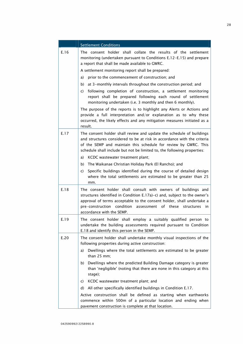
E.16 The consent holder shall collate the results of the settlement
monitoring (undertaken pursuant to Conditions E.12-E.15) and prepare
a report that shall be made available to GWRC.
A settlement monitoring report shall be prepared:
a) prior to the commencement of construction; and
b) at 3-monthly intervals throughout the construction period; and
c) following completion of construction, a settlement monitoring
report shall be prepared following each round of settlement
monitoring undertaken (i.e. 3 monthly and then 6 monthly).
The purpose of the reports is to highlight any Alerts or Actions and
provide a full interpretation and/or explanation as to why these
occurred, the likely effects and any mitigation measures initiated as a
result.
E.17 The consent holder shall review and update the schedule of buildings
and structures considered to be at risk in accordance with the criteria
of the SEMP and maintain this schedule for review by GWRC. This
schedule shall include but not be limited to, the following properties:
a) KCDC wastewater treatment plant;
b) The Waikanae Christian Holiday Park (El Rancho); and
c) Specific buildings identified during the course of detailed design
where the total settlements are estimated to be greater than 25
mm.
E.18 The consent holder shall consult with owners of buildings and
structures identified in Condition E.17a)-c) and, subject to the owner’s
approval of terms acceptable to the consent holder, shall undertake a
pre-construction condition assessment of these structures in
accordance with the SEMP.
E.19 The consent holder shall employ a suitably qualified person to
undertake the building assessments required pursuant to Condition
E.18 and identify this person in the SEMP.
E.20 The consent holder shall undertake monthly visual inspections of the
following properties during active construction:
a) Dwellings where the total settlements are estimated to be greater
than 25 mm;
b) Dwellings where the predicted Building Damage category is greater
than ‘negligible’ (noting that there are none in this category at this
stage);
c) KCDC wastewater treatment plant; and
d) All other specifically identified buildings in Condition E.17.
Active construction shall be defined as starting when earthworks
commence within 500m of a particular location and ending when
pavement construction is complete at that location.
29
042590992/2258990.8
Settlement Conditions
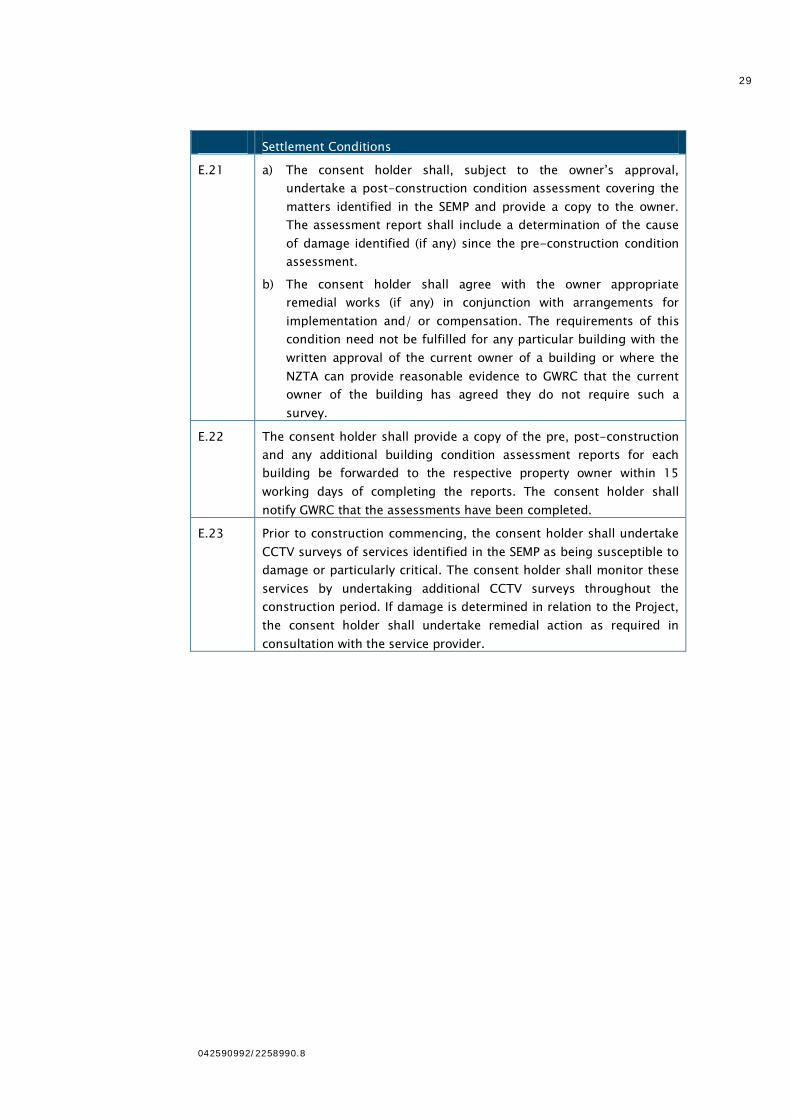
E.21 a) The consent holder shall, subject to the owner’s approval,
undertake a post-construction condition assessment covering the
matters identified in the SEMP and provide a copy to the owner.
The assessment report shall include a determination of the cause
of damage identified (if any) since the pre-construction condition
assessment.
b) The consent holder shall agree with the owner appropriate
remedial works (if any) in conjunction with arrangements for
implementation and/ or compensation. The requirements of this
condition need not be fulfilled for any particular building with the
written approval of the current owner of a building or where the
NZTA can provide reasonable evidence to GWRC that the current
owner of the building has agreed they do not require such a
survey.
E.22 The consent holder shall provide a copy of the pre, post-construction
and any additional building condition assessment reports for each
building be forwarded to the respective property owner within 15
working days of completing the reports. The consent holder shall
notify GWRC that the assessments have been completed.
E.23 Prior to construction commencing, the consent holder shall undertake
CCTV surveys of services identified in the SEMP as being susceptible to
damage or particularly critical. The consent holder shall monitor these
services by undertaking additional CCTV surveys throughout the
construction period. If damage is determined in relation to the Project,
the consent holder shall undertake remedial action as required in
consultation with the service provider.