notice of adopted change to a 10/02/2014 umatilla …
TRANSCRIPT

Date:
Jurisdiction:
Local file no.:
DLCD file no.:
10/02/2014
Umatilla County
P-111-14, T-14-056,
004-14
The Department of Land Conservation and Development (DLCD) received the attached notice of adopted amendment to a comprehensive plan or land use regulation on 09/29/2014. A copy of the adopted amendment is available for review at the DLCD office in Salem and the local government office.
Notice of the proposed amendment was submitted to DLCD 36 days prior to the first evidentiary hearing.
Appeal Procedures
Eligibility to appeal this amendment is governed by ORS 197.612, ORS 197.620, and ORS 197.830. Under ORS 197.830(9), a notice of intent to appeal a land use decision to LUBA must be filed no later than 21 days after the date the decision sought to be reviewed became final. If you have questions about the date the decision became final, please contact the jurisdiction that adopted the amendment.
A notice of intent to appeal must be served upon the local government and others who received written notice of the final decision from the local government. The notice of intent to appeal must be served and filed in the form and manner prescribed by LUBA, (OAR chapter 661, division 10).
If the amendment is not appealed, it will be deemed acknowledged as set forth in ORS 197.625(1)(a). Please call LUBA at 503-373-1265, if you have questions about appeal procedures.
If you have questions about this notice, please contact DLCD’s Plan Amendment Specialist at 503-934-0017 or [email protected]
DLCD Contact
NOTICE OF ADOPTED CHANGE TO ACOMPREHENSIVE PLAN OR LAND USE REGULATION

http://www.oregon.gov/LCD/Pages/forms.aspx -1- Form updated November 1, 2013
DLCD FORM 2 NOTICE OF ADOPTED CHANGE FOR DLCD USE TO A COMPREHENSIVE PLAN OR File No.: 004-14 LAND USE REGULATION Received: 9/29/2014 Local governments are required to send notice of an adopted change to a comprehensive plan or land use regulation no more than 20 days after the adoption. (See OAR 660-018-0040). The rules require that the notice include a completed copy of this form. This notice form is not for submittal of a completed periodic review task or a plan amendment reviewed in the manner of periodic review. Use Form 4 for an adopted urban growth boundary including over 50 acres by a city with a population greater than 2,500 within the UGB or an urban growth boundary amendment over 100 acres adopted by a metropolitan service district. Use Form 5 for an adopted urban reserve designation, or amendment to add over 50 acres, by a city with a population greater than 2,500 within the UGB. Use Form 6 with submittal of an adopted periodic review task. Jurisdiction: Umatilla County Local file no.: P-111-14; Z-303-14; T-14-056 Date of adoption: 9/17/2014 Date sent: 9/29/2014
Was Notice of a Proposed Change (Form 1) submitted to DLCD? Yes: Date (use the date of last revision if a revised Form 1was submitted): July 24, 2014 No
Is the adopted change different from what was described in the Notice of Proposed Change? Yes No If yes, describe how the adoption differs from the proposal:
The IAMP is the same as what was described in the notice of proposed change.
Local contact (name and title): Tamra Mabbott Phone: 541-278-6246 E-mail: [email protected] Street address: 216 SE 4th Street City: Pendleton Zip: 97801- PLEASE COMPLETE ALL OF THE FOLLOWING SECTIONS THAT APPLY
For a change to comprehensive plan text: Identify the sections of the plan that were added or amended and which statewide planning goals those sections implement, if any:
Interchange Area Management Plan for the I-82 and Lamb Road Interchange of the Umatilla Army Depot; Text amendment to implement the plan amendment.
For a change to a comprehensive plan map: Identify the former and new map designations and the area affected:
Change from to acres. A goal exception was required for this change. Change from to acres. A goal exception was required for this change. Change from to acres. A goal exception was required for this change. Change from to acres. A goal exception was required for this change.
Location of affected property (T, R, Sec., TL and address): 4N 27; 4N 27 25; 4N 27 25A; 4N 28C; 4N 28 30
The subject property is entirely within an urban growth boundary
The subject property is partially within an urban growth boundary

http://www.oregon.gov/LCD/Pages/forms.aspx -2- Form updated November 1, 2013
If the comprehensive plan map change is a UGB amendment including less than 50 acres and/or by a city with a population less than 2,500 in the urban area, indicate the number of acres of the former rural plan designation, by type, included in the boundary.
Exclusive Farm Use – Acres: Non-resource – Acres: Forest – Acres: Marginal Lands – Acres: Rural Residential – Acres: Natural Resource/Coastal/Open Space – Acres: Rural Commercial or Industrial – Acres: Other: – Acres:
If the comprehensive plan map change is an urban reserve amendment including less than 50 acres, or establishment or amendment of an urban reserve by a city with a population less than 2,500 in the urban area, indicate the number of acres, by plan designation, included in the boundary.
Exclusive Farm Use – Acres: Non-resource – Acres: Forest – Acres: Marginal Lands – Acres: Rural Residential – Acres: Natural Resource/Coastal/Open Space – Acres: Rural Commercial or Industrial – Acres: Other: – Acres:
For a change to the text of an ordinance or code: Identify the sections of the ordinance or code that were added or amended by title and number:
UCDO 152.018 and 152.019 For a change to a zoning map: Identify the former and new base zone designations and the area affected:
Change from to Acres: Change from to Acres: Change from to Acres: Change from to Acres: Identify additions to or removal from an overlay zone designation and the area affected:
Overlay zone designation: Acres added: Acres removed:
Location of affected property (T, R, Sec., TL and address): 4N 27 List affected state or federal agencies, local governments and special districts: Oregon National Guard; Morrow County Planning; ODOT; Port of Umatilla; County Public Works, Westland Irrigation District; City of Hermiston; city of Umatilla; CTUIR Identify supplemental information that is included because it may be useful to inform DLCD or members of the public of the effect of the actual change that has been submitted with this Notice of Adopted Change, if any. If the submittal, including supplementary materials, exceeds 100 pages, include a summary of the amendment briefly describing its purpose and requirements.
Attached to this submittal is the Board Ordinance 2014-09 which includes the plan and code language and the IAMP.

THE BOARD OF COMMISSIONERS OF UMATILLA COUNTY
\ HILLA COUN"J"Y RECORDS
STATE OF OREGON
.:'·:.:-, .....
'~: ')
In the Matter of Amending ) Comprehensive Plan and ) ORDINANCE NO. 2014-09 Development Code to Approve ) and Incorporate I-82/Lamb Road ) Interchange Area Management ) Plan )
WHEREAS the Board of Commissioners has adopted a Comprehensive Plan for Umatilla County, and has ordained Ordinance No. 83-04, adopting the County Land Development Ordinance, codified in Chapter 152 of the Umatilla County Code of Ordinances;
WHEREAS pursuant to Chapter 660, Division 12, of the Oregon Administrative Rules, and specifically OAR 660-12-0045, Umatilla County, as part of its Comprehensive Plan, adopted by Ordinance No. 2002-03, a Transportation System Plan for Umatilla County {"TSP); and
WHEREAS the TSP is transportation facilities future facilities for the
to guide the management of existing and the design and the implementation of next 20 years; and
WHEREAS pursuant to OAR 734-051-0155, an interchange area management plan is to be developed with the ·redesign of an interchange to govern planning and future development within the management area, and be consistent with local plans and codes; and
WHEREAS the I-82/Lamb Road Interchange Area Management .Plan is proposed to identify and to address infrastructure, access and land use regulations associated with the transition of the Umatilla Army Chemical Depot from a facility that historically has stored/shipped military supplies and disposed of chemical weapons to a fac'ility that will accommodate Oregon National Guard operations , environmental preservation and new economic development; and
WHEREAS the county is proposing to amends its TSP to add the I-82/Lamb Road Interchange Area Management Plan, and to amend its Comprehensive Plan and Development Code to support and implement the IAMP; and
WHEREAS the Umatilla County Planning Commission held a public hearing regarding the proposed amendments on August 28, 2014, and
ORDINANCE NO. 2014-09 - Page 1 of 6

forwarded the proposed amendments to the Board of Commissioners with a recommendation for adoption; and
WHEREAS the Board of Commissions held a public hearing on September 17, 2014, to consider the proposed amendments, and voted to approve the I-82/Lamb Road Interchange Area Management Plan and to approve the amendments to the Comprehensive Plan and Land Development Ordinance.
NOW, THEREFORE the Board of Commissioners of Umatilla County ordains the following:
1. The I-82/Lamb Road Interchange Area Management Plan is accepted and adopted, and the Umatilla County Transportation System Plan and the Umatilla County Comprehensive Plan are amended to include the I-82/Lamb Road Interchange Area Transportation Plan as Appendix G to the Umatilla County Transportation System Plan. A copy of the I-82/Lamb Road Interchange Area Transportation Plan is attached to this ordinance and incorporated by this reference.
2 . The Umatilla County Comprehensive Plan, Chapter 15, Transportation, is amended to add the following:
Finding 31
Policy 31
An Interchange Area Management Study and Plan was completed for the Interstate 82/Lamb Road interchange.
The function of the I-82/Lamb Road interchange is to provide primary access for future reuse/development on the Umatilla Army Chemical Depot (UMCD) site and to continue to accommodate traffic growth within the larger interchange management study area and region. As the internal road system develops to serve UMCD reuse/development, this interchange will also provide secondary access to training and operational activities performed by the Oregon National Guard on the former UMCD site. Traffic operations at the interchange will need to accommodate both large and small military vehicles.
3. Adoption of the following to amend the County Land Development Ordinance, codified in Chapter 152 of the Umatilla County Code of Ordinances (Strikethrough text is deleted;
ORDINANCE NO. 2014-09 - Page 2 of 6

\.'
Underlined/Italicized text is added) :
§ 152.018 ACCESS MANAGEMENT AND STREET CONNECTIVITY
(A) The intent of this code is to manage access
(B) This section shall apply to all arterials and collectors within the County and to all properties that abut these roadways.
(C) This section is adopted to implement the access management policies of the County as set forth in the Transportation System Plan.
(D) Proposed access within the I-82/US 730 Interchange Management Area Plan (lAMP) Management Area, shall be consistent with Section 7, Access Management Plan, of the IAMP. Proposed access within an lnterchan~e Area Mana~ement Plan (lAMP) will be consistent with this section and the Access Mana~ement Plan of the applicable lAMP. Where conflicts between code requirements and the applicable lAMP Access Mana~ement Plan exist, the lAMP Access Mana~ement Plan will ~overn.
§152.019 TRAFFIC IMPACT ANALYSIS
(A) Purpose: The purpose of this section of the code is to implement Section 660-012-0045 (2) (e) of the State Transportation Planning Rule that requires the County to adopt a process to apply conditions to specified land use proposals in order to minimize adverse impacts to and protect transportation facilities. This section establishes the standards for when a proposal must be reviewed for potential traffic impacts; when a Traffic Impact Analysis must be submitted with an application in order to determine whether conditions are needed to
ORDINANCE NO. 2014-09 - Page 3 of 6
minimize impacts to and protecttransportation facilities; what must be in a Traffic Impact analysis; and who is qualified to prepare the analysis.
(B) Applicability: A Traffic Impact Analysis shall be required to be submitted to the County with a land use application, when the one or more of the following actions apply:
(1) A change in plan amendment designation; or
(2) The proposal is projected to cause one or more of the following effects, which can be determined by field counts, site observation, traffic impact analysis or study, field measurements, crash history, Institute of Transportation Engineers Trip Generation manual; and information and studies provided by the local reviewing jurisdiction and/or ODOT:
(a) An increase in site traffic volume generation by 250 Average Daily Trips (ADT) or more (or as required by the County Engineer). The latest edition of the Trip Generation manual, published by the Institute of Transportation Engineers (ITE) shall be used as standards by which to gauge average daily vehicle trips; or
(b) An increase in use of adjacent streets by vehicles exceeding the 20,000 pound ·gross vehicle weights by 10 vehicles or more per day; or
(c) The location of the access driveway does not meet minimum intersection sight distance requirements, or is located where vehicles entering or leaving the property are restricted, or vehicles queue or hesitate, creating a safety hazard; or

(d) A change in internal traffic patterns that may cause safety problems, such as back up onto the highway or traffic crashes in the approach area; or
(e) Any development proposed within the Umatilla Army Chemical Depot boundary of the 1-82/Lamb Road or 1-84/Army Depot Access Road Interchan~e Area Management Plan (lAMP) Management Area prior to the completion of near-term improvements projects (Projects A and B) identified in the 1-82/Lamb Road lAMP.· or
fil For development within the I-82/US 730 Interchange Area Management Plan (lAMP) Management Area, the location of the access driveway is inconsistent with the Access Management Plan in Section 7 of the lAMP.
(C) Traffic Impact Analysis Requirements
(1) Preparation. A Traffic Impact Analysis shall be prepared by a professional engineer. The Traffic Impact Analysis will be paid for by the applicant.
(2) Transportation Planning Rule Compliance as provided in§ 152.751
(3) Pre-filing Conference. The applicant will meet with the Umatilla County Public Works Director and Planning Director prior to submitting an application that requires a Traffic Impact Analysis. The County has the discretion to determine the required elements of the TIA and the level of analysis expected. The County shall also consult the Oregon Department of Transportation (ODOT) on analysis requirements when the site of the proposal is adjacent to or otherwise affects a State roadway.
(4) For development proposed within the
Umatilla Army Chemical Depot boundary of the 1-82/Lamb Road or 1-84/Army Depot Access Road Interchange Area Mana~ement Plan (lAMP) Management Area prior to the construction and completion of near-term improvements projects (Projects A and B) identified in the 1-82/Lamb Road lAMP. the followin~ additional submittal requirements may be required:
(a) An analysis of typical avera~e daily vehicle trips using the latest edition of the Trip Generation Manual, published by the Institute ofTransportation Engineers {IT E) or other data source deemed acceptable by the Countj; en~ineer.·
(b) A truck and personal passen~er vehicle mode split analysis:
(c) An analysis that shows the traffic conditions ofthe project at fit!! buildout and occupancv. assumin~ the back~round traffic conditions at the year of expected project completion.·
(d) Findings related to the impacts of the proposed development and the need for Projects A and B to mitigate those impacts.
Once Projects A and B have been completed. this Section 4 will no lon~er apply to new development.
(D) Approval Criteria: When a Traffic Impact Analysis is required, approval of the proposal requires satisfaction of the following criteria:
(1) Traffic Impact Analysis was prepared by an Oregon Registered Professional Engineer qualified to perform traffic engineering analysis;
(2) If the proposed action shall cause a
ORDINANCE NO. 2014-09 - Page 4 of 6

I j
significant effect pursuant to the Transportation Planning Rule, or other traffic hazard or negative impact to a transportation facility, the Traffic Impact Analysis shall include mitigation measures that meet the County's 'Level-of-Service and/or Volume/Capacity standards and are satisfaCtory to the County Engineer, and ODOT when applicable; and
(3) The proposed site design and traffic and circulation design and facilities, for all transportation modes, including any mitigation measures, are designed to:
(a) Have the least negative impact on all applicable transportation facilities;
(b) Accommodate and encourage non-motor vehicular modes of transportation to the extent practicable;
(c) Make the most efficient use of land and public facilities as practicable;
(d) Provide the most direct, safe and convenient routes practicable between on-site destinations, and between on-site and off-site destinations; and
(e) Otherwise comply with applicable requirements ofthe Umatilla County Code.
(E) Conditions of Approval: The County may deny, approve, or approve a proposal with appropriate conditions.
(1) Where the existing transportation system is shown to be impacted by the proposed action, dedication of land for streets, transit facilities, sidewalks, bikeways, paths, or accessways may be required to ensure that the transportation system is adequate to handle the additional burden caused by the proposed action.
(2) Where the existing transportation system is shown to be impacted by the proposed action, improvements such as paving, curbing, installation or contribution to traffic signals, construction of sidewalks, bikeways, accessways, paths, or streets that serve the proposed action may be required.
FURTHER by unanimous vote of those present, the Board of Commissioners deems this Ordinance necessary for the immediate preservation of public peace, health, and safety; therefore, it is adjudged and decreed that an emergency does exist in the case of this Ordinance and it shall be in full force and effect from and after its adoption.
DATED this 17th day of September, 2014.
UMATILLA COUNTY BOARD OF COMMISSIONERS
ORDINANCE NO. 2014-09 - Page 5 of 6

/ George L. M'tirdock, Commissioner""""
ATTEST: OFFICE OF COUNTY RECORDS
Records Off cer
---~·,,
\.,; :~
ORDINANCE NO. 2014-09 Page 6 of 6


G
--- ---- -------
1-82/Lamb Road Interchange Area
Management Plan
Umatilla County, Oregoh
August 2014

I-82/Lamb Road Interchange Area
Management Plan
Umatilla County, Oregon
Draft
July 2014

I-82/Lamb Road
Interchange Area Management Plan
Umatilla County, Oregon
Prepared For:
UMADRA Umatilla County
Dr. Donald Chance Tamra Mabbott
P.O. Box 200 216 SE 4th St
Boardman, OR 97818 Pendleton, OR 97801
(541) 481-3693 (541) 278-6246
Prepared By:
Kittelson & Associates, Inc. Angelo Planning Group Anderson Perry & Associates, Inc.
610 SW Alder, Suite 700 921 SW Washington Street, Suite 468 1901 N Fir / P.O. Box 1107
Portland, OR 97205 Portland, OR 97205 La Grande, Oregon 97850
(503) 228-5230 (503) 227-3664 (541) 963-8309
Mason, Bruce, & Girard, Inc.
707 SW Washington Street, Suite 1300
Portland, OR 97205
(503) 224-3445
Project No. 13848.00
July 2014

I-82/Lamb Road IAMP July 2014
Preface
ii Kittelson & Associates, Inc.
TABLE OF CONTENTS
Executive Summary ................................................................................................................................ 2
I-82/Lamb Road Interchange Area Management Plan .......................................................................... 7
Introduction / Background .......................................................................................................................................................... 7
I-82/Lamb Road Interchange Improvement Plans ..................................................................................................................... 11
Interchange Access Management Plan ..................................................................................................................................... 17
Implementation Plan ........................................................................................................................... 20
Introduction............................................................................................................................................................................... 20
Plan Elements ............................................................................................................................................................................ 20
Adoption Elements .................................................................................................................................................................... 21
Monitoring Elements ................................................................................................................................................................. 22
Development Review ................................................................................................................................................................ 23
Oregon Department of Transportation / UMaTILLA County Coordination ............................................................................... 26
OAR and OHP Compliance ................................................................................................................... 29
OAR Compliance ........................................................................................................................................................................ 29
Oregon Highway Plan Compliance ............................................................................................................................................ 30

I-82/Lamb Road IAMP July 2014
Preface
iii Kittelson & Associates, Inc.
LIST OF FIGURES
Figure 1: Interchange Management Study Area (IMSA) ...................................................................... 10
Figure 2: I-82/Lamb Road Interchange Improvement Projects ........................................................... 15
Figure 3: I-82/Lamb Road Interchange Improvement Vision .............................................................. 16
Figure 4: I-82/Lamb Road Interchange Access Management Plan ...................................................... 18
LIST OF TABLES
Table 1 - I-82/Lamb Road Interchange Transportation Improvement Plan ........................................ 12
Table 6 – I-82/Lamb Road IAMP OAR Compliance .............................................................................. 29

I-82/Lamb Road IAMP July 2014
Preface
iv Kittelson & Associates, Inc.
PREFACE
The development of this plan was guided by the Steering Committee and Technical / Public Advisory
Committee (TPAC). The members of these groups are identified below, along with members of the
consultant team. The Steering Committee members were also members of the TPAC, who collectively
were responsible for reviewing all work products and guiding the planning work. They devoted a
substantial amount of time and effort to the development of the I-82/Lamb Road IAMP and their
participation was instrumental in the final recommendations that are presented herein.
Steering Committee
Dr. Donald Chance Tamra Mabbott Carla McLane Teresa Penninger
UMADRA Umatilla County Morrow County ODOT
Stephanie Seamans
CTUIR
Technical Advisory Committee (TAC)
Bob Nairns Tom Fellows Aaron Palmquist
Morrow County Umatilla County City of Irrigon
Debbie Pedro Todd Longgood Stan Hutchison
Hermiston Chamber Hale Farms/Riverpoint Farms Oregon National Guard
Herb Stahl Lisa Mittelsdorf Kim Puzey
Stanfield HB Farm Port of Morrow Port of Umatilla
Joanne Manson Bruce Bearchum II Patty Perry
Oregon Military Department CTUIR CTUIR
Consultant Team
Kittelson & Associates, Inc. Angelo Planning Group Anderson Perry & Associates, Inc.
Matt Hughart, AICP Frank Angelo Andy Lindsey, P.E.
Marc Butorac, P.E., P.T.O.E. Darci Rudzinski, AICP Rod McKee, P.E.
Pat Marnell
Mason, Bruce, & Girard
Stuart Meyers
Kate Parker

Section 1
Executive Summary
I-82/Lamb Road IAMP July 2014
Executive Summary
2 Kittelson & Associates, Inc.
EXECUTIVE SUMMARY
The I-82/Lamb Road Interchange Area Management Plan (IAMP) was prepared to identify and address
infrastructure, access, and land use regulations associated with the transition of the Umatilla Army
Chemical Depot (UMCD) from a facility that has historically stored/shipped military supplies and
disposed of chemical weapons to a facility that will accommodate Oregon National Guard operations,
environmental preservation, and new economic development.
The executive summary provides an overview of the project elements that were developed through a
collaborative effort of the Project Team, Umatilla Army Depot Reuse Authority, Technical/Public
Advisory Committee, Umatilla County, Oregon Department of Transportation (ODOT), and local
stakeholders. The following table and figures summarize the identified improvement projects.
Additional details are provided herein.
With the identification of near- and long-term infrastructure improvements, a number of policies,
ordinances, and other provisions have been developed for adoption into the Umatilla County
Transportation System Plan, Comprehensive Plan, and development review ordinances to support and
implement the IAMP. The IAMP will also be adopted by the Oregon Transportation Commission as an
amendment to the Oregon Highway Plan.
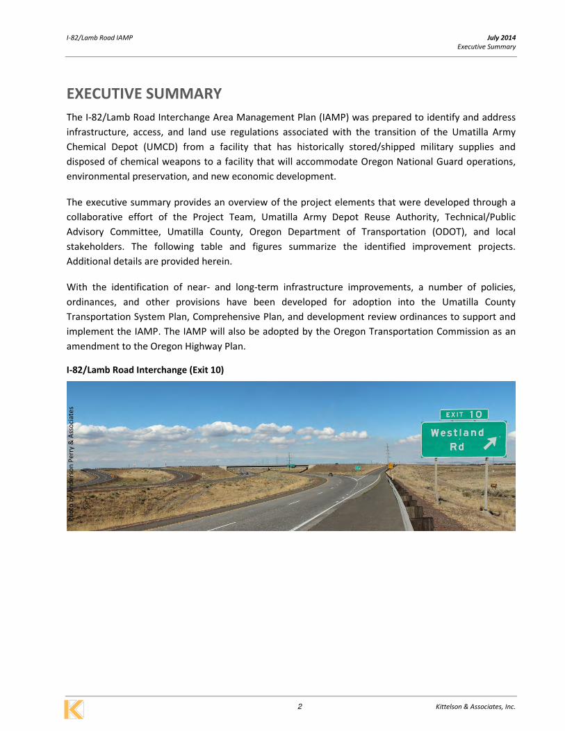
I-82/Lamb Road Interchange (Exit 10)
Ph
oto
by
An
de
rso
n P
err
y &
Ass
oci
ate
s

I-82/Lamb Road IAMP July 2014
Executive Summary
3 Kittelson & Associates, Inc.
Executive Summary - I-82/Lamb Road Interchange Area Improvement Summary
Fig E1.
Project
Label
Near-Term Improvement
Description Implementation Need/Trigger for Improvement
Estimated
Planning-
Level Cost1
Potential
Funding
Sources
A
Construct a new interchange
access road that connects
the interchange to future
UMCD site uses.
• Safety: Accommodate large trucks
• Operations: Improve access efficiency to the interchange, meeting
ODOT interchange access spacing standards.
• Trigger: When determined by future traffic studies that the existing
interchange access road can no longer operationally or geometrically
support the development’s anticipated vehicular/truck profile.
$0.5M SDC, PDF,
GF
B Remove the existing
interchange access road.
• Trigger: Following construction of the new interchange access road
(Project A). $<50k SDC, PDF,
GF
Fig. E1
Project
Label
Longer-Term Improvement
Description Implementation Need/Trigger for Improvement
Estimated
Planning-
Level Cost
Potential
Funding
Sources
C
Lengthen, realign, and
widen the I-82 northbound
off-ramp, providing two
approach lanes at the
interchange ramp terminal
with Lamb Road.
• Safety: Increase vehicle/truck queuing, upgrade ramp to current
design standard.
• Operations: Eliminate ramp skew angle, increase long-term ramp
terminal capacity.
• Trigger: When determined by future traffic studies or as part of
future capital improvements.
$0.6M SDC, STIP,
PDF, GF
D
Lengthen, realign, and
widen the I-82 southbound
off-ramp, providing two
approach lanes at the
interchange ramp terminal
with Lamb Road.
• Safety: Increase vehicle/truck queuing, upgrade ramp to current
design standard.
• Operations: Eliminate ramp skew angle, increase long-term ramp
terminal capacity, position ramp for potential long-term inclusion of a
looping on-ramp.
• Trigger: When determined by future traffic studies or as part of
future capital improvements.
$2.5M SDC, STIP,
PDF, GF
E
Signalize the I-82/Lamb
Road Southbound Ramp
Terminal.
• Safety: Eliminate the need for motorists to take unacceptable gaps.
• Operations: Signalization is required to accommodate additional
long-term traffic volume increases.
• Trigger: When signal warrants are met through future traffic studies.
$0.4M SDC, STIP,
PDF, GF
F Improve/Realign the I-82
northbound on-ramp.
• Safety: Upgrade ramp to current design standards
• Operations: Eliminate ramp skew angle
• Trigger: When determined by future traffic studies or as part of
future capital improvements.
$0.4M SDC, STIP,
PDF, GF
G Realign the I-82 southbound
on-ramp. • Trigger: In conjunction with Project D. $0.3M
SDC, STIP,
PDF, GF
Fig. E2
Project
Label Vision Project Description Implementation Need/Trigger for Improvement
Estimated
Planning-
Level Cost
Potential
Funding
Sources
H
Construct a new
southbound looping PARCLO
A on-ramp.
• Safety: Improve on-ramp merge/acceleration distance.
• Operations: Increase long-term ramp terminal capacity.
• Trigger: When determined by future traffic studies or as part of
future capital improvements, but not before construction of Project
D.
$3.3M SDC, STIP,
PDF, GF
I Remove existing
southbound on-ramp.
• Trigger: Following construction of the looping PARCLO A on-ramp
(Project H). <$50k SDC, STIP,
PDF, GF
SDC – Transportation System Development Charge
STIP – State Transportation Improvement Project
PDF – Private Development Funds
GF – Other Grant Funds 1 – Planning level costs are in 2014 dollars. Construction costs only, does not include right-of-way costs.

; J i1
i l I $!
i t ~
J
I I J I ~
J
ACCESS ROAD TO EXTEND A MINIMUM OF 1/4 MILE WEST
NOTE: LINEWORK PROVIDED BY ANDERSON PERRY AND ASSOCIATES 7fl014
ALL LINE WORK IS · • PRELIMINARY AND FOR
PLANING USE ONLY
JIJ/y20f4
1 ~ PRELIMINARYRoAowAYALIGNMENT 1-82/Lamb Road lAMP I x x x REMovE sTRuCTuRE' ROADwAY 1m prove ment Plan
Figure
El 1- ® IMPRovEMENT(sEETABLE 1 FoR umatilla county, Oregon DESCRIPTION & COST ESTIMATE}
~L_~==~=====-----------------------~ ~KITTELSON & ASSOCIATES, INC, ~ 1'"AIII.PORTATION .N.IIII···IN.IPL.ANNIN.

.. f J i1
i l I i t ~
J
I I J I ~
J
ACCESS ROAD TO EXTEND A MINIMUM OF 1/4 MILE WEST
NOTE: LINEWORK PROVIDED BY ANDERSON PERRY AND ASSOCIATES 7fl014
ALL LINE WORK IS · • PRELIMINARY AND FOR
PLANING USE ONLY
JIJ/y20f4
1 ~ PRELIMINARY RoADWAY ALIGNMENT 1-82/Lamb Road Future I x x x REMovE sTRuCTuRE' ROADwAY Development Options
Figure
E2 1- ® IMPRovEMENT(sEETABLE 1 FoR umatilla county, Oregon DESCRIPTION & COST ESTIMATE}
~L_~==~=====-----------------------~ ~KITTELSON & ASSOCIATES, INC, ~ 1'"AIII.PORTATION .N.IIII···IN.IPL.ANNIN.

Section 2 I-82/Lamb Road Interchange Area Management Plan

I-82/Lamb Road IAMP July 2014
I-82/Lamb Road Interchange Area Management Plan
7 Kittelson & Associates, Inc.
I-82/LAMB ROAD INTERCHANGE AREA MANAGEMENT PLAN
INTRODUCTION / BACKGROUND
The Umatilla Army Chemical Depot (UMCD) is formally being decommissioned and prepared for
reuse/redevelopment. The Umatilla Chemical Depot Reuse Authority (UMADRA - sometimes referred to
as the “LRA” and undergoing a name change to the “Columbia Development Authority”) is chartered
with administering the transition of the UMCD and is leading the planning process. Following the
completion of a Redevelopment Plan in 2010, reuse/redevelopment of the UMCD has been targeted to
accommodate a new 7,500 acre Oregon National Guard training base, a 5,678 acre habitat refuge, and
approximately 3,000 acres of industrial/warehouse development.
With the transition and reconfiguration of land uses on the UMCD site, it is recognized that
transportation patterns and traffic demands will change. Some of these changes will impact the existing
I-82/Lamb Road interchange. In accordance with Oregon Administrative Rule 734-051, an Interchange
Area Management Plan (IAMP) has been prepared to identify and address future transportation
infrastructure needs, access, and land use regulations at this interchange. The remainder of this section
contains the planning context, specific interchange infrastructure projects, and access management
plan for the IAMP.
Conditions Statement
The I-82/Lamb Road interchange was constructed
in 1986 for several reasons, one of which was to
provide a secondary point of access to the UMCD
site. This secondary point of access became the
primary construction and workforce access to the
industrial chemical weapons incineration facility
that was constructed and recently
decommissioned on the site. Outside of these
historical UMCD functions, the I-82/Lamb Road
interchange has also served adjacent and
regional land uses including the Westland Road
Exception Area and the City of Hermiston via the
Lamb Road/Westland Road corridor.
From the perspective of the UMCD site, the I-
82/Lamb Road interchange was designed and
constructed at a time in which the primary use of
the UMCD was to store/ship military supplies and
in more recent years, dispose of chemical
Exhibit 1 - I-82/Lamb Road Interchange

I-82/Lamb Road IAMP July 2014
I-82/Lamb Road Interchange Area Management Plan
8 Kittelson & Associates, Inc.
weapons. During this later period, the interchange was utilized by upwards of 1,400 employees and
significant heavy truck traffic associated with construction and operation of the Demil Incinerator
Complex utilized to dispose of chemical weapons. With these UMCD uses no longer in operation and a
future vision that includes a change in military uses (Oregon National Guard), environmental
preservation, and economic development, the I-82/Lamb Road interchange infrastructure will be
utilized over time in a manner that is substantially different from historical patterns and as a result, will
require phased modification.
Purpose and Intent Statement
The purpose of the I-82/Lamb Road IAMP is to develop a plan that focuses on the interchange and the
access road that currently serves the UMCD site. The intent of the plan is to develop land use
management strategies for the reuse/redevelopment of the UMCD, identify interchange infrastructure
improvements needed to support future reuse/redevelopment, create an access management plan for
the interchange access road/crossroad, and develop funding mechanisms to construct the necessary
infrastructure improvements.
Goals / Objectives
The IAMP is intended to protect the function of the I-82/Lamb Road interchange for the next 20 years
while accounting for changes in land use and traffic patterns brought about by reuse/redevelopment of
the UMCD and continued growth in the regional study area. As stated in Policy 3C of the Oregon
Highway Plan, “it is the policy of the State of Oregon to plan for and manage grade-separated
interchange areas to ensure safe and efficient operation between connecting roadways.” To this end,
working collaboratively with the Technical/Public Advisory Committee (TPAC) and public, the
Goals/Objectives of the IAMP are to:
1. Protect the long-term function, operation, and safety of the I-82/Lamb Road interchange.
2. Identify opportunities for enhanced roadway connectivity within the UMCD site that would
provide public roadway connections between the I-84/Army Depot Access Road and I-
82/Lamb Road interchanges.
3. Manage the allowed land uses within the vicinity of the interchanges to provide for future
economic growth over the next 20 years.
4. Identify current accesses along the interchange crossroads and develop a phased access
management plan for the crossroads based on a detailed and collaborative process
involving Umatilla County and local property owners. The access management plan will be
based on key principles that balance highway mobility and safety against:
a. The findings of County TSPs and land use plans; and
b. Local economic development objectives for properties that require access to the
state highway.
5. Identify opportunities for freight-based multi-modal accessibility to/from future
redevelopment of the UMCD site.
I-82/Lamb Road IAMP July 2014
I-82/Lamb Road Interchange Area Management Plan
9 Kittelson & Associates, Inc.
6. Collaborate throughout the planning process with design professionals, jurisdictional
representatives, developers, local property owners, and the general public, including
protected populations as established by federal and state regulations and policies.
7. Comply with the intent of Statewide Planning Goals, including Goal 1: Public Involvement,
Goal 2: Land Use Planning, Goal 5: Natural Resources, Goal 6: Air, Water and Land Resources
Quality, Goal 7: Areas Subject to Natural hazards, Goal 8: Recreation Needs, Goal 9:
Economic Development, Goal 12: Transportation, and Goal 14: Urban Growth Boundaries.
8. Identify phased implementation strategies for identified near- and long-term interchange
infrastructure and interchange crossroad improvements.
9. Identify interchange infrastructure funding mechanisms that could be applied to future
reuse/redevelopment of the UMCD and other land uses within the Interchange
Management Study Area.
10. Develop implementation policies and regulations to be adopted into the Umatilla County
Comprehensive Plan, Transportation System Plan, and zoning ordinances, as appropriate.
Interchange Management Study Area (IMSA)
The I-82/Lamb Road IAMP was prepared in conjunction with IAMPs for two other interchanges: I-
84/Army Depot Access Road and I-84/Paterson Ferry Road. All three interchanges will be affected to
some degree by future redevelopment of the UMCD site. Within the context of the IAMP planning
process, the Interchange Management Study Area (IMSA) defines the extent of the detailed land use
and infrastructure study area. The IAMPs will focus specifically on the freeway interchanges that serve
the UMCD and surrounding land uses. At a minimum, the IMSA includes properties, as well as all access
points located within ½ mile of the freeway interchange as defined by the State of Oregon’s IAMP
Guidelines. In order to capture the overarching land use related impacts of the reuse/redevelopment
of the UMCD as well as growth potential of immediately surrounding uses, the IMSA includes the
following areas:
� The entire UMCD site
� Westland Road Exception Area – area east of I-82 and north of I-84
� Industrial zoned land located north of the Paterson Ferry Road interchange
The Interchange Management Study Area (IMSA) map is shown in Figure 1.

I-82 / Lamb Road Interchange Managment Plan July 2014
¯
Figure
1
H:\p
rojfile
\13
84
8 -
Um
atilla S
uba
rea P
lan
an
d C
om
bin
ed I
AM
P\g
is\1
384
8_
Fig
01.m
xd -
pm
arn
ell -
1
0:5
2 A
M 7
/14/2
01
4
Coordinate System: NAD 1983 HARN StatePlane Oregon North FIPS 3601 Feet Intl
Data Source: Delete if there isn't one.
Interchange Management Study AreaMorrow / Umatilla Counties
01,0002,0003,0004,0005,0006,0007,0008,0009,00010,00011,00012,00013,00014,00015,000 Feet
Wes
tland R
d
Bridge Rd
Umatilla Army DepotW
alk
er R
d
Bloom Rd
Co
tto
nw
oo
d B
en
d R
d
Colo
nel Jo
rdan
Rd
I-84 / Army DepotInterchange
I-82 / Lamb RdInterchange
§̈¦82
§̈¦84
Quick Rd
St
Cr
Ln
Co
un
ty L
ine
Rd
Ag
ne
w R
d
Des
ert
Rd
Livestock Rd
Land Use Study Area
Operations/Access Study Area
Umatilla Army Depot
County Boundary
Umatilla Army Depot
Wes
tland
Rd
Bridge Rd
Po
we
rlin
e R
d
Div
isio
n S
t
Pa
ters
on F
err
y R
d
Po
lelin
e R
d
I-84 / Paterson Ferry RdInterchange
£¤730
§̈¦82
§̈¦84

I-82/Lamb Road IAMP July 2014
I-82/Lamb Road Interchange Area Management Plan
11 Kittelson & Associates, Inc.
I-82/LAMB ROAD INTERCHANGE IMPROVEMENT PLANS
A comprehensive transportation improvement plan for the I-82/Lamb Road interchange was developed
based on concept screening and evaluations outlined in the Technical Appendix to the IAMP. This plan
includes the development of a new interchange access road to serve future reuse of the UMCD site,
modifications to the interchange on- and off-ramps, and modifications to the interchange ramp
terminals. Each transportation improvement project is described in detail below, illustrated in Figures 2
and 3, and summarized in Table 1.
Near-Term Improvements
Constructed in 1986, the I-82/Lamb Road interchange is structurally sound and adequately supports
existing traffic conditions. However, the current configuration includes an existing UMCD interchange
access road that is inadequate to safely accommodate intensified levels of development-driven
vehicular and heavy truck traffic. Therefore, the following near-term improvements have been
identified to address this existing deficiency.
Project A. New Interchange Access Road (Near-Term)
The existing UMCD interchange access road is geometrically limited in its ability to safely and efficiently
support future anticipated traffic conditions and vehicle truck types anticipated by reuse of the UMCD
site beyond some minor early-phase development. In recognition of this limiting feature of the
interchange, Project A includes the construction of a new interchange access road serving the west side
of the I-82/Lamb Road interchange. The new access road will connect to the interchange at a more
traditional 90 degree angle, include two 12 foot travel lanes, and be to the maximum extent practical, a
¼-mile in length1 before connecting to a future reuse-oriented internal circulation network. This
improvement would need to be constructed when it is determined (through the local Umatilla County
development review process) that the existing interchange access road cannot operationally or
geometrically support future vehicular/truck profiles associated with new reuse development.
Project B. Remove Existing Interchange Access Road (Near-Term)
Project B includes the removal of the existing UMCD access road. Removal would occur following
construction of Project A.
1 The minimum ¼-mile roadway length meets the ODOT interchange access management standards.

I-82/Lamb Road IAMP July 2014
I-82/Lamb Road Interchange Area Management Plan
12 Kittelson & Associates, Inc.
Table 1 - I-82/Lamb Road Interchange Transportation Improvement Plan
Fig 2.
Project
Label
Near-Term Improvement
Description Implementation Need/Trigger for Improvement
Estimated
Planning-
Level Cost1
Potential
Funding
Sources
A
Construct a new interchange
access road that connects
the interchange to future
UMCD site uses.
• Safety: Accommodate large trucks
• Operations: Improve access efficiency to the interchange, meeting
ODOT interchange access spacing standards.
• Trigger: When determined by future traffic studies that the existing
interchange access road can no longer operationally or geometrically
support the development’s anticipated vehicular/truck profile.
$0.5M SDC, PDF,
GF
B Remove the existing
interchange access road.
• Trigger: Following construction of the new interchange access road
(Project A). $<50K SDC, PDF,
GF
Fig. 2
Project
Label
Longer-Term Improvement
Description Implementation Need/Trigger for Improvement
Estimated
Planning-
Level Cost
Potential
Funding
Sources
C
Lengthen, realign, and
widen the I-82 northbound
off-ramp, providing two
approach lanes at the
interchange ramp terminal
with Lamb Road.
• Safety: Increase vehicle/truck queuing, upgrade ramp to current
design standard.
• Operations: Eliminate ramp skew angle, increase long-term ramp
terminal capacity.
• Trigger: When determined by future traffic studies or as part of
future capital improvements.
$0.6M SDC, STIP,
PDF, GF
D
Lengthen, realign, and
widen the I-82 southbound
off-ramp, providing two
approach lanes at the
interchange ramp terminal
with Lamb Road.
• Safety: Increase vehicle/truck queuing, upgrade ramp to current
design standard.
• Operations: Eliminate ramp skew angle, increase long-term ramp
terminal capacity, position ramp for potential long-term inclusion of a
looping on-ramp.
• Trigger: When determined by future traffic studies or as part of
future capital improvements.
$2.5M SDC, STIP,
PDF, GF
E
Signalize the I-82/Lamb
Road Southbound Ramp
Terminal.
• Safety: Eliminate the need for motorists to take unacceptable gaps.
• Operations: Signalization is required to accommodate additional
long-term traffic volume increases.
• Trigger: When signal warrants are met through future traffic studies.
$0.4M SDC, STIP,
PDF, GF
F Improve/Realign the I-82
northbound on-ramp.
• Safety: Upgrade ramp to current design standards
• Operations: Eliminate ramp skew angle
• Trigger: When determined by future traffic studies or as part of
future capital improvements.
$0.4M SDC, STIP,
PDF, GF
G Realign the I-82 southbound
on-ramp. • Trigger: In conjunction with Project D. $0.3M
SDC, STIP,
PDF, GF
Fig. 3
Project
Label Vision Project Description Implementation Need/Trigger for Improvement
Estimated
Planning-
Level Cost
Potential
Funding
Sources
H
Construct a new
southbound looping PARCLO
A on-ramp.
• Safety: Improve on-ramp merge/acceleration distance.
• Operations: Increase long-term ramp terminal capacity.
• Trigger: When determined by future traffic studies or as part of
future capital improvements, but not before construction of Project
D.
$3.3M SDC, STIP,
PDF, GF
I Remove existing
southbound on-ramp.
• Trigger: Following construction of the looping PARCLO A on-ramp
(Project H). $<50k SDC, STIP,
PDF, GF
SDC – Transportation System Development Charge
STIP – State Transportation Improvement Project
PDF – Private Development Funds
GF – Other Grant Funds 1 – Planning level costs are in 2014 dollars. Construction costs only, does not include right-of-way costs.
I-82/Lamb Road IAMP July 2014
I-82/Lamb Road Interchange Area Management Plan
13 Kittelson & Associates, Inc.
Longer-Term Improvements
Beyond the construction of the new interchange access road (Project A), the existing I-82/Lamb Road
interchange ramps and supporting infrastructure can continue to serve existing and future regional
traffic growth. However, it is recognized that this growth coupled with the potential future traffic
growth generated by the reuse development on the UMCD site larger IMSA will necessitate the
following longer-term interchange improvements.
Project C. Improve I-82 Northbound Off-Ramp (Longer-Term)
The I-82/Lamb Road interchange was designed and constructed under older design standards for rural
applications. As a result, the I-82 northbound off-ramp has characteristics such as a large skew angle at
the ramp terminal and limited geometrics that cannot safely and efficiently support the intensified
vehicular/truck volumes envisioned to be generated by reuse of the UMCD site. In addition, the single-
lane ramp terminal approach lacks adequate long-term capacity and queue storage length to
accommodate changing traffic profiles. Project C would lengthen and realign the off-ramp to better
accommodate projected long-term demand and widen the approach to Lamb Road to provide a
separate through/left-turn lane. In addition, the project sets the stage for a potential long-term
construction of a PARCLO A looping on-ramp (see Vision Project H). These improvements would be
constructed when future development-driven traffic studies determine that they are needed for safety
and/or operations reasons.
Project D. Improve I-82 Southbound Off-Ramp (Longer-Term)
The I-82/Lamb Road interchange was designed and constructed under older design standards for rural
applications. As a result, the I-82 southbound off-ramp has characteristics such as a large skew angle at
the ramp terminal that cannot safely and efficiently support the intensified vehicular/truck volumes
envisioned to be generated by reuse of the UMCD site. Project D would lengthen and realign the off-
ramp to better accommodate projected long-term demand and widen the approach to Lamb Road to
provide a separate left-turn lane. The ultimate alignment of this off-ramp would be positioned to
accommodate the potential construction of a looping southbound on-ramp at some point in the longer-
term future (see Project H). These improvements would be constructed when future development-driven
traffic studies determine that they are needed for safety and/or operations reasons.
Project E. Signalize the I-82/Lamb Road Southbound Ramp Terminal (Longer-Term)
Signalization is anticipated to be needed to accommodate anticipated traffic growth at the interchange
ramp terminal. Signalization would be needed when signal warrants are met, but not before Project D is
constructed.

I-82/Lamb Road IAMP July 2014
I-82/Lamb Road Interchange Area Management Plan
14 Kittelson & Associates, Inc.
Project F. Improve/Realign the I-82 Northbound On-Ramp (Longer-Term)
The existing I-82 northbound on-ramp has a large skew angle that cannot safely and efficiently
accommodate the intensified vehicular/truck volumes envisioned to be generated by reuse of the
UMCD site. Project F would realign the on-ramp to eliminate the skew angle. This improvement would
be constructed is conjunction with Project C or when determined to be needed for safety or operations
reasons.
Project G. Realign the I-82 Southbound On-Ramp (Longer-Term)
Project G would involve the realignment of the existing southbound on-ramp to accommodate a
realigned southbound off-ramp (Project D). This improvement would be constructed in conjunction with
Project D.
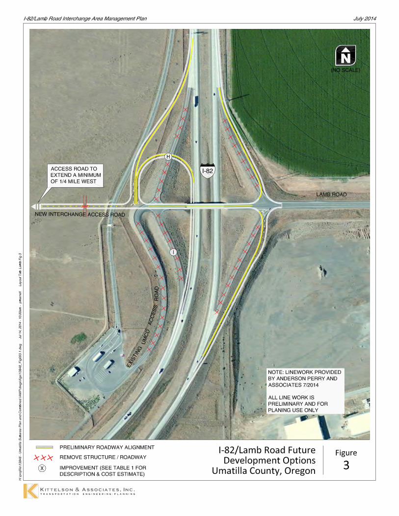
Vision Projects
The traffic forecasting and operations analysis has determined that the existing diamond interchange
form (with improvements A-G noted above) is sufficient for accommodating the 20-year travel forecast
estimates. However, it is recognized that the potential exists for unanticipated levels of future growth
(additional economic redevelopment on the UMCD site, expanded Oregon National Guard operations
beyond existing long-term plans, etc.) that could necessitate improvements beyond the 20-year
planning horizon of the IAMP. As such, several “vision projects” have been identified so that they can
be memorialized and their potential need can be monitored over the life of the IAMP.
Project H. Looping PARCLO A Southbound On-Ramp Alternative (Vision Project)
The operations analysis has determined that the existing diamond interchange form (with
improvements A-G noted above) is sufficient for accommodating the 20-year travel forecast estimates.
However, in the event of unanticipated growth scenarios, Project H would include the construction of a
southbound PARCLO A looping on-ramp to provide additional longer-term capacity for the interchange
ramp terminal. With the realignment of the southbound off-ramp (Project D), the construction of this
looping on-ramp could occur with minimal impacts to other identified interchange improvements. This
improvement would be constructed when determined to be needed for safety or operations reasons, but
must be either associated with or following the construction of Project D.
Project I. Remove Existing Southbound On-Ramp (Vision Project)
Project I includes the removal of the existing/modified southbound on-ramp. Removal would occur
following construction of Project H.

; J i1
i l I $!
i t ~
J
I I J I ~
J
ACCESS ROAD TO EXTEND A MINIMUM OF 1/4 MILE WEST
NOTE: LINEWORK PROVIDED BY ANDERSON PERRY AND ASSOCIATES 7fl014
ALL LINE WORK IS · • PRELIMINARY AND FOR
PLANING USE ONLY
JIJ/y20f4
1 ~ PRELIMINARYRoAowAYALIGNMENT 1-82/Lamb Road lAMP I x x x REMovE sTRuCTuRE' ROADwAY 1m prove ment Plan
Figure
2 1- ® IMPRovEMENT(sEETABLE 1 FoR umatilla county, Oregon DESCRIPTION & COST ESTIMATE}
~L_~==~=====-----------------------~ ~KITTELSON & ASSOCIATES, INC, ~ 1'"AIII.PORTATION .N.IIII···IN.IPL.ANNIN.
.. f J i1
i l I i t ~
J
I I J I ~
J
ACCESS ROAD TO EXTEND A MINIMUM OF 1/4 MILE WEST
NOTE: LINEWORK PROVIDED BY ANDERSON PERRY AND ASSOCIATES 7fl014
ALL LINE WORK IS · • PRELIMINARY AND FOR
PLANING USE ONLY
JIJ/y20f4
1 ~ PRELIMINARY RoADWAY ALIGNMENT 1-82/Lamb Road Future I x x x REMovE sTRuCTuRE' ROADwAY Development Options
Figure
3 1- ® IMPRovEMENT(sEETABLE 1 FoR umatilla county, Oregon DESCRIPTION & COST ESTIMATE}
~L_~==~=====-----------------------~ ~KITTELSON & ASSOCIATES, INC, ~ 1'"AIII.PORTATION .N.IIII···IN.IPL.ANNIN.

I-82/Lamb Road IAMP July 2014
I-82/Lamb Road Interchange Area Management Plan
17 Kittelson & Associates, Inc.
INTERCHANGE ACCESS MANAGEMENT PLAN
Access locations within the I-82/Lamb Road interchange area were evaluated based on ODOT’s Division
51 Access Management standards and an assessment of traffic operations and safety as described in
Action 3C.3 of the Oregon Highway Plan. Accordingly, the Access Management Plan (AMP) will preserve
the operational integrity and safety of the interchange and primary roadways serving it, while
maintaining viable access to all parcels in the IMSA. The AMP contains a plan for actions to be taken on
the new interchange access roadway. An AMP is identified for near- and long-term timeframes. The
overall AMP is illustrated in Figure 4.
Interchange Access Spacing
Under ODOT’s current access management policy, the Oregon Highway Plan stipulates that the desired
distance between an interchange ramp terminal and the first full approach (public or private) on the
crossroad should be a minimum of 1,320 feet (¼-mile). The first right-in/right-out access should be a
minimum of 750 feet from the ramp terminal. Given that the new interchange access road (Project A)
will likely be constructed to a minimum length of ¼-mile after ODOT review, the I-82/Lamb Road access
management plan identifies this roadway as an access controlled facility. Specifically, the plan calls for
ODOT to secure access control along both sides of this new roadway between the southbound ramp
terminal and the first point of public/private access (likely to be constructed a minimum length of ¼
mile from the terminal).
ODOT has already secured access control along Lamb Road east of the interchange.
UMCD Local Circulation
As part of a separate planning effort, a local circulation network will be planned to accommodate reuse
and new development on the UMCD site in the vicinity of the I-82/Lamb Road interchange. The extent
of this network will be planned and developed at a later date and in conjunction with future
development opportunities. As such, specific roadway alignments and locations of local roadway
intersections will be subject to future land use decisions. However, for the purposes of the IAMP, the
local circulation plan will recognize the new I-82/Lamb Road interchange access road (Project A) as an
access controlled roadway with the first full point of access likely to be located a minimum length of ¼
from the southbound ramp terminal.

' I tl
i t ~
J
I I J I ~
J I '
I I
ACCESS CONTROL TO BE ACQUIRED A MINIMUM OF 1/4 MILE WEST OF THE 1-82/SB RAMP TERMINAL
liiiiiiiiiiiiii PRELIMINARY ROADWAY ALIGNMENT )( )( )( REMOVE STRUCTURE I ROADWAY
- EXISTING ACCESS CONTROL (TO REMAIN)
- ACQUIRE ACCESS CONTROL
NOTE: LINEWORK PROVIDED BY ANDERSON PERRY AND ASSOCIATES 7fl014
ALL LINE WORK IS · • PRELIMINARY AND FOR
PLANING USE ONLY
1-82/Lamb Road Interchange Access Plan
Umatilla County, Oregon
Figure
4 ~--------------------------------------------------------------------------~
~KITTELSON & ASSOCIATES, INC, ~ 1'"AIII.PORTATION .N.IIII···IN.IPL.ANNIN.

Section 3 Implementation Plan

I-82/Lamb Road IAMP July 2014
Implementation Plan
20 Kittelson & Associates, Inc.
IMPLEMENTATION PLAN
INTRODUCTION
ODOT and Umatilla County will need to adopt elements of the I-82/Lamb Road IAMP specific to the
individual jurisdiction/agency. Since the IAMP involves both State and local government authority,
some policies will guide ODOT actions and others will guide Umatilla County decisions. The Oregon
Administrative Rule [(OAR 734-051-0155(2)] states that ODOT will work with local governments on any
amendments to local comprehensive plans and transportation system plans and local land use and
subdivision codes to ensure the proposed IAMP is consistent with the local plan and codes, prior to
adoption by the Oregon Transportation Commission (OTC).
It is expected that the IAMP will be made part of the Umatilla County Comprehensive Plan by including
it as an amendment to its Transportation System Plans (TSP). This amendment process will require
notification and public hearings pursuant to the local legislative process. Umatilla County can adopt the
I-82/Lamb Road IAMP document in its entirety or by reference to theexisting TSP, can prepare an
ordinance that more specifically identifies what parts of the IAMPs are being adopted locally and how
local plans and ordinances are being modified, and/or can issue a statement that local plans and
ordinances are consistent with the recommendations of the IAMP.
ODOT Region 5 will prepare findings to support adoption of the I-82/Lamb Road IAMP on the State’s
behalf, and the Oregon Transportation Commission (OTC) will deliberate and adopt the final documents
as a facility plan and amendments to the Oregon Highway Plan (OHP). The following is a summary of
the proposed actions to implement the IAMP.
PLAN ELEMENTS
Interchange Function and Policy Definition
Umatilla County should adopt a clear definition of the I-82/Lamb Road Interchange function into its
comprehensive plan and TSP to provide policy direction for management of the interchange area and
achieve the objectives and goals of this IAMP. This will help to ensure consistency between future
policy decisions and the interchange’s intended function.
The following function and policy definition was developed for the I-82/Lamb Road Interchange:
“The function of the I-82/Lamb Road interchange is to provide primary access for future
reuse/development on the UMCD site and continue to accommodate traffic growth within the
larger IMSA and region. As the internal road system develops to serve UMCD
reuse/development, this interchange will also provide secondary access to training and
operational activities performed by the Oregon National Guard on the former Umatilla Army

I-82/Lamb Road IAMP July 2014
Implementation Plan
21 Kittelson & Associates, Inc.
Chemical Depot site. Traffic operations at the interchange will need to accommodate both large
and small military vehicles.”
Interchange Area Management Plan (IAMP) Management Area
Umatilla County is the land use regulatory authority for the Interchange Management Study Area
(IMSA). To ensure the continued operation and safety integrity of the interchange, Umatilla County
should adopt an I-82/Lamb Road IAMP Management Area. Future development and land use actions
within the IAMP Management Area will be monitored to ensure that volume-to-capacity ratios do not
exceed the adopted Oregon Highway Plan mobility standards at the ramp terminals. This can be
accomplished through Development Review guidelines included within the proposed amendments to
the County’s Zoning and Subdivision Ordinances as described in the following sections.
ADOPTION ELEMENTS
Implementation of the I-82/Lamb Road IAMP will occur at several levels of government. Consistent with
OAR 734- 051, Umatilla County will adopt legislative amendments to its transportation system plan and
comprehensive plan to incorporate elements of the I-82/Lamb Road IAMP. In addition, new land use
ordinances or amendments to existing ordinances or resolutions may be required to ensure that the
access management, land use management, and coordination elements of the IAMP are achieved. This
adoption process will include Planning Commission/County Commission hearings at the County level.
Following successful adoption at the County level, the IAMP will be presented to the Oregon
Transportation Commission (OTC) for its review and adoption. This should occur prior to transportation
improvements as described in this IAMP being constructed.
To implement the I-82/Lamb Road IAMP, the following actions shall occur:
ODOT:
� The IAMP shall be adopted by the Oregon Transportation Commission as part of the Oregon
Highway Plan.
Umatilla County:
� Will amend the Transportation System Plan to incorporate the I-82 / Lamb Road interchange
function and policy definition and recommended transportation improvements. The IAMP
shall serve as the long range comprehensive management plan for providing the
transportation facilities that are specifically addressed in this plan, as well as the Access
Management Plan and the planned local street network for the area.

I-82/Lamb Road IAMP July 2014
Implementation Plan
22 Kittelson & Associates, Inc.
� Will amend the Comprehensive Plan Map and Zoning Map to include an Interchange
Management Area to identify where compliance with the I-82 / Lamb Road IAMP will be a
condition of future development approval.
� Will amend the Development Code to require that development and redevelopment
proposals within the Interchange Management Area show consistency with the IAMP and to
allow the County to require improvements as a condition of approval. Amendments will
ensure that proposals for new development within the UMCD and larger IMSA will be
reviewed to determine if a need for different interchange improvement phases is triggered.
Amendments to the following sections are recommended:
� Section 152.018 Access Management and Street Connectivity
� Section 152.019 Traffic Impact Analysis
� Consider adoption of a Supplemental Transportation System Development Charge (SDC) to
finance specific improvements to the I-82 / Lamb Road interchange;
� Work with ODOT to identify and pursue funding for all I-82/Lamb Road interchange projects
identified in this IAMP.
MONITORING ELEMENTS
The purpose of the IAMP is to ensure that capacity at the interchange is preserved for its intended
function. While a long-range plan, the IAMP needs to remain dynamic and responsive to development
and changes to the adopted land use and transportation plans and may need to be periodically
reviewed and updated. To accomplish this goal, a monitoring program is included that identifies triggers
for reviewing the IAMP and assessing how development approval within the IAMP Management Area
will be reviewed and coordinated.
IAMP Review Triggers
Periodically, the implementation program shall be evaluated by ODOT and Umatilla County to ensure it
is accomplishing the goals and objectives of the IAMP. Events that may trigger an IAMP review include:
� Plan map and zone changes that have a “significant affect” pursuant to the Transportation
Planning Rule (OAR 660-012-0060) and impact the I-82/Lamb Road Interchange, or that are
located within the IAMP Management Area.
� Proposed development that generates expected traffic volume at the I-82/Lamb Road ramp
terminals that exceed the adopted mobility targets.
In addition to the established triggers for IAMP review, either agency may request a formal review of
the IAMP at any time if, in their determination, specific land use or transportation changes warrant a
review of the underlying assumptions and/or recommendations within the IAMP. If the participants in
the IAMP review agree that, once the impacts of the “trigger” that necessitated the review are

I-82/Lamb Road IAMP July 2014
Implementation Plan
23 Kittelson & Associates, Inc.
examined, an IAMP amendment is not warranted, a recommendation of “no action” may be
documented and submitted in the form of a letter to the Umatilla County Commission and the Oregon
Transportation Commission.
If the findings and conclusions from the IAMP review demonstrate the need for an update to the plan,
review participants will initiate an IAMP update process. Initial steps in updating the IAMP will include
scoping the planning process, identifying funding, and outlining a schedule for plan completion. Once
completed, IAMP updates will be required to be legislatively adopted as an amendment to the Umatilla
County Transportation System Plan, requiring a Umatilla County public hearing, as an amendment to
the Umatilla County Transportation System Plan and adoption by the Oregon Transportation
Commission as an update to the Oregon Highway Plan.
DEVELOPMENT REVIEW
The following outlines the transportation requirements for development and zone change applications
within the I-82/Lamb Road Interchange Management Area and describes how Umatilla County will
coordinate with ODOT.
Local Requirements
Umatilla County currently requires that proposed development comply with access management and
traffic impact analysis requirements pursuant to the adopted Development Code. Umatilla County will
amend the Development Code to require that development and redevelopment proposals within the
Interchange Management Area show consistency with the IAMP Access Management Plan (AMP) and
allow the County to recommend improvements as a condition of approval. Code amendments will
ensure that all proposals for new development within the Umatilla County Depot Industrial Zone-
portion of the Depot site area will be reviewed to determine if a need for different interchange
improvement phasing is triggered or additional improvements are needed to support the proposal.
Amendments to the following sections are recommended:
� Section 152.018 Access Management and Street Connectivity
� Section 152.019 Traffic Impact Analysis
Section 152.018 will include the following provision:
Proposed access within an Interchange Area Management Plan (IAMP) will be consistent with
this section and the Access Management Plan of the applicable IAMP. Where conflicts between
code requirements and the applicable IAMP Access Management Plan exist, the IAMP Access
Management Plan will govern.
In recognition that the I-82/Lamb Road interchange may have the ability to accommodate some level of
development within the UMCD boundary prior to full implementation of the identified near-term
interchange improvement projects (Projects A and B in the IAMP), special Traffic Impact Analysis (TIA)

I-82/Lamb Road IAMP July 2014
Implementation Plan
24 Kittelson & Associates, Inc.
provisions will be amended in the County’s TIA requirements (§152.019.B.2). These requirements will
be specific to all future development located within the UMCD boundary of the larger IMSA. The entire
TIA requirements with these new special provisions are included below with the new language
underlined.
§ 152.019 TRAFFIC IMPACT STUDY.
(A) Purpose: The purpose of this section of the code is to implement Section 660-012-0045 (2) (e) of the
State Transportation Planning Rule that requires the County to adopt a process to apply conditions to
specified land use proposals in order to minimize adverse impacts to and protect transportation
facilities. This section establishes the standards for when a proposal must be reviewed for potential
traffic impacts; when a Traffic Impact Analysis must be submitted with an application in order to
determine whether conditions are needed to minimize impacts to and protect transportation facilities;
what must be in a Traffic Impact Analysis; and who is qualified to prepare the analysis.
(B) Applicability: A Traffic Impact Analysis shall be required to be submitted to the County with a land
use application, apply:
(1) A change in plan amendment designation; or
(2) The proposal is projected to cause one or more of the following effects, which can be
determined by field counts, site observation, traffic impact analysis or study, field measurements,
crash history, Institute of Transportation Engineers Trip Generation manual; and information and
studies provided by the local reviewing jurisdiction and/or ODOT:
(a) An increase in site traffic volume generation by 250 Average Daily Trips (ADT) or more (or as
required by the County Engineer). The latest edition of the Trip Generation manual, published by
the Institute of Transportation Engineers (ITE) shall be used as standards by which to gauge
average daily vehicle trips; or
(b) An increase in use of adjacent streets by vehicles exceeding the 10,000 pound gross vehicle
weights by 20 vehicles or more per day; or
(c) The location of the access driveway does not meet minimum intersection sight distance
requirements, or is located where vehicles entering or leaving the property are restricted, or
vehicles queue or hesitate, creating a safety hazard; or
(d) A change in internal traffic patterns that may cause safety problems, such as back up onto the
highway or traffic crashes in the approach area; or
(e) Any development proposed within the UMCD boundary of the I-84/Lamb Road or I-84/Army
Depot Access Road Interchange Area Management Plan (IAMP) Management Area prior to the
completion of near-term improvements projects (Projects A and B) identified in the I-82/Lamb
Road IAMP; or

I-82/Lamb Road IAMP July 2014
Implementation Plan
25 Kittelson & Associates, Inc.
(e) (f) For development within the I-82/US 730 Interchange Area Management Plan (IAMP)
Management Area, the location of the access driveway is inconsistent with the Access
Management Plan in Section 7 of the IAMP.
(C) Traffic Impact Analysis Requirements
(1) Preparation. A Traffic Impact Analysis shall be prepared by a professional engineer. The Traffic
Impact Analysis will be paid for by the applicant.
(2) Transportation Planning Rule Compliance as provided in § 152.751.
(3) Pre-filing Conference. The applicant will meet with the Umatilla County Public Works Director
and Planning Director prior to submitting an application that requires a Traffic Impact Analysis. The
County has the discretion to determine the required elements of the TIA and the level of analysis
expected. The County shall also consult the Oregon Department of Transportation (ODOT) on
analysis requirements when the site of the proposal is adjacent to or otherwise affects a State
roadway.
(4) For development proposed within the UMCD boundary of the I-84/Lamb Road or I-84/Army
Depot Access Road Interchange Area Management Plan (IAMP) Management Area prior to the
construction and completion of near-term improvements projects (Projects A and B) identified in
the I-82/Lamb Road IAMP, the following additional submittal requirements may be required:
(a) An analysis of typical average daily vehicle trips using the latest edition of the Trip Generation
Manual, published by the Institute of Transportation Engineers (ITE) or other data source
deemed acceptable by the County Engineer.
(b) A truck and personal passenger vehicle mode split analysis.
(c) An analysis that shows the traffic conditions of the project at full buildout and occupancy,
assuming the background traffic conditions at the year of expected project completion.
(d) Findings related to the impacts of the proposed development and the need for Projects A and
B to mitigate those impacts.
Once Projects A and B have been completed, section (4) will no longer apply to new development.
(D) Approval Criteria: When a Traffic Impact Analysis is required; approval of the proposal requires
satisfaction of the following criteria:
(1) Traffic Impact Analysis was prepared by an Oregon Registered Professional Engineer qualified to
perform traffic engineering analysis;
(2) If the proposed action shall cause a significant effect pursuant to the Transportation Planning
Rule, or other traffic hazard or negative impact to a transportation facility, the Traffic Impact
I-82/Lamb Road IAMP July 2014
Implementation Plan
26 Kittelson & Associates, Inc.
Analysis shall include mitigation measures that meet the County’s Level-of-Service and/or
Volume/Capacity standards and are satisfactory to the County Engineer, and ODOT when
applicable; and
(3) The proposed site design and traffic and circulation design and facilities, for all transportation
modes, including any mitigation measures, are designed to:
(a) Have the least negative impact on all applicable transportation facilities;
(b) Accommodate and encourage non-motor vehicular modes of transportation to the extent
practicable;
(c) Make the most efficient use of land and public facilities as practicable;
(d) Provide the most direct, safe and convenient routes practicable between on-site destinations,
and between on-site and off-site destinations; and
(e) Otherwise comply with applicable requirements of the Umatilla County Code.
(E) Conditions of Approval: The County may deny, approve, or approve a proposal with appropriate
conditions.
(1) Where the existing transportation system is shown to be impacted by the proposed action,
dedication of land for streets, transit facilities, sidewalks, bikeways, paths, or accessways may be
required to ensure that the transportation system is adequate to handle the additional burden
caused by the proposed action.
(2) Where the existing transportation system is shown to be impacted by the proposed action,
improvements such as paving, curbing, installation or contribution to traffic signals, construction of
sidewalks, bikeways, accessways, paths, or streets that serve the proposed action may be required.
OREGON DEPARTMENT OF TRANSPORTATION / UMATILLA COUNTY
COORDINATION
Following adoption of the I-82/Lamb Road IAMP, ODOT and Umatilla County will need to coordinate
future development activities on the UMCD site. The following describes steps both ODOT and Umatilla
County will take when reviewing development proposals that may impact the I-82/Lamb Road
interchange. Umatilla County shall provide notice to the Oregon Department of Transportation (ODOT)
on TIA studies when the site of the proposal is adjacent to or otherwise affects a State highway.

I-82/Lamb Road IAMP July 2014
Implementation Plan
27 Kittelson & Associates, Inc.
� Umatilla County shall consult the Oregon Department of Transportation (ODOT) on TIA
requirements when the site of the proposal is adjacent to or otherwise affects a State
highway.
� Umatilla County shall provide written notification to ODOT once a quasi-judicial or
legislative land use application within the IAMP Management Area is deemed complete.
� ODOT shall have at least 20 days, measured from the date notice to agencies was mailed, to
provide written comments to the County. If ODOT does not provide written comments
during this 20-day period, the County staff report will be issued without consideration of
ODOT comments.
� The County shall invite ODOT to participate in a pre-filing conference for applications within
an Interchange Management Area Plan Management Area or within a ¼ mile of any ODOT
facility. Notice of actions requiring a public hearing shall be provided to ODOT at least
twenty days prior to the date of the hearing.

Section 4 OAR & OHP Compliance

I-82/Lamb Road IAMP July 2014
OAR and OHP Compliance
29 Kittelson & Associates, Inc.
OAR AND OHP COMPLIANCE
The following section discusses the Oregon Administrative Rule (OAR) and Oregon Highway Plan (OHP)
policy-based compliance issues that pertain to the development of the I-82/Lamb Road IAMP.
OAR COMPLIANCE
The I-82/Lamb Road IAMP was developed in collaboration with UMADRA, Umatilla County, and ODOT
and was developed in accordance with the guidelines set forth in the State of Oregon’s Administrative
Rules for Interchange Access Management Planning and Interchange Area Management Planning. Table
6 identifies the required planning elements from OAR 734-051 and documents how the IAMP satisfies
the requirements.
Table 2 – I-82/Lamb Road IAMP OAR Compliance
OAR 734-0051-0155 Requirement How OAR is Addressed
Document
Reference
Should be developed no later than the time
the interchange is being developed or
redeveloped
-7010(7)(a)
This plan was developed to effectively plan for future development and
traffic growth that could occur within the interchange area. Future
improvements will be needed to safely accommodate forecast increases
in vehicular and truck demand.
IAMP
Technical Appendix
“G”
Should identify opportunities to improve
operations and safety in conjunction with
roadway projects and property development
or redevelopment and adopt strategies and
development standards to capture those
opportunities
-7010(7)(b)
The access management, transportation improvement plan, and
Interchange Management Area elements identified in this plan will result
in operational, safety, and capacity improvements.
IAMP
Section 2
Should include short, medium, and long-term
actions to improve operations and safety in
the interchange area
-7010(7)(c)
The IAMP includes a phasing plan for the transportation system
improvements presented within the plan. These improvements address
the near term needs identified by the existing conditions analysis as well
as long-term demand needs that are expected to occur beyond the 20-
year horizon period. In addition, near-term improvement projects are
included in the plan to address access road deficiencies to the
interchange.
IAMP
Section 2
Should consider current and future traffic
volumes and flows, roadway geometry,
traffic control devices, current and planned
land uses and zoning, and the location of all
current and planned approaches
-7010(7)(d)
A full analysis of existing and forecast operational and geometric
conditions was conducted for this planning effort. The future volumes
were developed based on approved zoning and comprehensive plan
designations.
IAMP
Technical
Appendices
“D”, “E”, & “G”
Should provide adequate assurance of the
safe operation of the facility through the
design traffic forecast period, typically 20
years
-7010(7)(e)
Specific improvements are included in the plan to address safety
concerns through improved geometric alignment and access spacing.
IAMP
Section 2
Should consider existing and proposed uses
of all property in the interchange area
consistent with its comprehensive plan
designations and zoning
A thorough analysis of surrounding land uses and land use potential was
performed based on the current and approved comprehensive plan
designations and zoning.
IAMP
Technical
Appendices
“D”, “E”, & “G”

I-82/Lamb Road IAMP July 2014
OAR and OHP Compliance
30 Kittelson & Associates, Inc.
OAR 734-0051-0155 Requirement How OAR is Addressed
Document
Reference
-7010(7)(f)
Is consistent with any applicable Access
Management Plan, corridor plan or other
facility plan adopted by the Oregon
Transportation Commission
-7010(7)(g)
The access management plan included in the IAMP is consistent with the
OHP.
IAMP
Section 2
Includes polices, provisions and standards
from local comprehensive plans,
transportation system plans, and land use
and subdivision codes that are relied upon
for consistency and that are relied upon to
implement the Interchange Area
Management Plan.
-7010(7)(h)
The implementation plan included in this IAMP documents the required
amendments to local plans needed to adopt the IAMP. In addition, the
implementation section outlines monitoring elements for the purpose of
directing future land use action within the IAMP study area.
IAMP
Section 3
OREGON HIGHWAY PLAN COMPLIANCE
The I-82/Lamb Road IAMP was developed in accordance with the policies set forth in the OHP. The
following identifies the OHP Policies that pertain to the I-82/Lamb Road IAMP and how the IAMP
satisfies the requirements.
Policy 1A: State Highway Classification System. The state highway classification system includes five
classifications: Interstate, Statewide, Regional, District, and Local Interest Roads. In addition, there are
four special purpose categories that overlay the basic classifications: special land use areas, statewide
freight route, scenic byways, and lifeline routes.
Within the Interchange Management Study Area (IMSA), there are two ODOT highways. I-84 is an
Interstate Highway designated as an Expressway. I-82 is an Interstate Highway also designated as an
Expressway.
How Addressed: The I-82/Lamb Road IAMP recognized the respective functions of each
highway. Access standards, traffic control, and geometric considerations were informed by the
applicable highway designation. The preferred concept includes modification to the interstate
ramps to better accommodate future traffic volumes and truck types.
Policy 1B: Land Use and Transportation. This policy recognizes the role of both the State and local
governments related to the state highway system and calls for a coordinated approach to land use and
transportation planning.
How Addressed: The IAMP was developed through a cooperative planning effort between
UMADRA, Umatilla County, and ODOT. The IAMP will be implemented by Umatilla County
through the IAMP Management Area that will require coordinated agency review on all future
development or land use actions within the Area.

I-82/Lamb Road IAMP July 2014
OAR and OHP Compliance
31 Kittelson & Associates, Inc.
Policy 1C: State Highway Freight System. This policy recognizes the need for the efficient movement of
freight through the state. I-84 and I-82 are designated Freight Routes.
How Addressed: The transportation projects included in the plan were developed considering
freight mobility needs, particularly at the NB and SB ramp terminals and new interchange access
road.
Policy 1F: Highway Mobility Standards Access Management Policy. This policy addresses state highway
performance expectations, providing guidance for managing access and traffic control systems related
to interchanges.
How Addressed: The I-82/Lamb Road IAMP demonstrates that the interchange and surrounding
transportation system will be able to meet ODOT mobility targets through the 20-year horizon.
Policy 1G: Major Improvements. This policy requires maintaining performance and improving safety by
improving efficiency and management before adding capacity.
How Addressed: The I-82/Lamb Road IAMP focuses on improving the geometry of the existing
interchange to improve efficiency and safety, adding capacity only where needed.
Policy 2B: Off-System Improvements. This policy recognizes that the state may provide financial
assistance to local jurisdictions to make improvements to local transportation systems if the
improvements would provide a cost-effective means of improving the operations of the state highway
system.
How Addressed: The transportation system was considered as a whole with improvements to
the state and local system equally considered.
Policy 2F: Traffic Safety. This policy emphasizes the state’s efforts to improve safety of all uses of the
highway system. Action 2F.4 addresses the development and implementation of the Safety
Management System to target resources to sites with the most significant safety issues.
How Addressed: The new interchange access road will be reconstructed to eliminate existing
geometric deficiencies. In addition, the access management plan was developed to ensure the
long-term safety of the interchange area.
Policy 3A: Classification and Spacing Standards. This policy addresses the location, spacing, and type of
road and street intersections and approach roads on state highways. The adopted standards can be
found in Appendix C of the Oregon Highway Plan.
How Addressed: See Policy 3C below.
Policy 3C: Interchange Access Management Areas. This policy addresses management of grade-
separated interchange areas to ensure safe and efficient operation between connecting roadways.
Action items include developing interchange area management plans to protect the function of the

I-82/Lamb Road IAMP July 2014
OAR and OHP Compliance
32 Kittelson & Associates, Inc.
interchange to provide safe and efficient operations between connecting roadways and to minimize the
need for major improvements of existing interchanges. The local jurisdiction’s role in access
management is stated in Policy 3C as follows: “necessary supporting improvements, such as road
networks, channelization, medians and access control in the interchange management area must be
identified in the local comprehensive plan and committed with an identified funding source, or must be
in place (Action 3C.2).”
Access management standards are detailed in Policy 3C and include the distance required between an
interchange and approaches and intersections. The most stringent standards apply in interchange
areas.
How Addressed: The I-82/Lamb Road IAMP includes an access management plan that improves
access spacing over existing conditions.
Policy 3D: Deviations. This policy establishes general policies and procedures for deviations from
adopted access management standards and policies.
How Addressed: Deviations to the OHP access spacing standards are required, as described in
Section 2 of the OR 66 Green Springs Highway IAMP. The access management element
describes the need for future deviations at the time of construction.
Policy 4A: Efficiency of Freight Movement. This policy emphasizes the need to maintain and improve
the efficiency of freight movement on the state highway system. All highways within the study area are
designated truck routes.
How Addressed: The transportation improvements included in the IAMP plan improves traffic
operations and safety for all vehicles, including freight vehicles.
Policy 5B: Scenic Resources. This policy applies to all state highways and commits the State to using
best management practices to protect and enhance scenic resources in all phases of highway project
planning, development, construction, and maintenance.
How Addressed: This policy was considered as part of the plan development.
