north nenana oil and gas exploration...
TRANSCRIPT

April 29, 2015
NORTH NENANA OIL AND GAS EXPLORATION LICENSE
Written Finding of the Director

Recommended citation:
ADNR (Alaska Department of Natural Resources). 2015. North Nenana oil and gas exploration license. Written finding of the director. April 29, 2015.
Questions or comments about this final finding should be directed to: Alaska Department of Natural Resources Division of Oil and Gas 550 W. 7th Ave., Suite 1100 Anchorage, AK 99501-3560 Phone 907-269-8800
Division of Oil and Gas Contributors:
Andrew deValpine Rosie Nethercott Joseph Rolfzen Jonathan Schick Anne Weaver Lori Yares
The Alaska Department of Natural Resources (ADNR) administers all programs and activities free from discrimination based on race, color, national origin, age, sex, religion, marital status, pregnancy, parenthood, or disability. The department administers all programs and activities in compliance with Title VI of the Civil Rights Act of 1964, Section 504 of the Rehabilitation Act of 1973, Title II of the Americans with Disabilities Act (ADA) of 1990, the Age Discrimination Act of 1975, and Title IX of the Education Amendments of 1972. If you believe you have been discriminated against in any program, activity, or facility please write:
ADNR ADA Coordinator, P.O. Box 111000, Juneau AK 99811-1000 The department’s ADA Coordinator can be reached via phone at the following numbers:
(VOICE) 907-465-2400, (Statewide Telecommunication Device for the Deaf) 1-800-770-8973, or (FAX) 907-465-3886
For information on alternative formats and questions on this publication, please contact: ADNR, Division of Oil and Gas, 550 W. 7th Ave., Suite 1100, Anchorage, AK 99501-3560 Phone 907-269-8800.

NORTH NENANA
OIL AND GAS EXPLORATION LICENSE
Written Finding of the Director
Prepared by: Alaska Department of Natural Resources
Division of Oil and Gas
April 29, 2015

List of Abbreviations Agencies Other ADCRA Alaska Division of Community and
Regional Affairs 2-D 2-Dimensional
ADEED Alaska Department of Education and Early Development
3-D 3-Dimensional
ADF&G Alaska Department of Fish and Game AAC Alaska Administrative Code ADGGS Alaska Division of Geological &
Geophysical Surveys ACIAC Alaska Climate Impact
Assessment Commission AOGCC Alaska Oil and Gas Conservation
Commission ACRC Alaska Climate Research
Center BLM Bureau of Land Management ANCSA Alaska Native Claims
Settlement Act BOEMRE Bureau of Ocean Energy Management,
Regulation and Enforcement ARRT Alaska Regional Response
Team CF Alaska Department of Fish & Game,
Division of Commercial Fisheries AS Alaska Statute
COE U.S. Army Corp of Engineers AVO Alaska Volcano Observatory DCCED Alaska Department of Commerce,
Community, and Economic Development C-plan Oil Discharge Prevention and
Contingency Plan DEC Department of Environmental
Conservation DRR Dismantlement, Removal, and
Remediation DMLW Division of Mining, Land and Water ERD Extended Reach Drilling DNR Department of Natural Resources FOSC Federal On-Scene Coordinator DO&G Division of Oil and Gas FLIR Forward-Looking InfraRed DOLWD Department of Labor and Workforce
Development FY Fiscal Year
DOT&PF Department of Transportation and Public Facilities
GMU Game Management Unit
EPA Environmental Protection Agency ICS Incident Command System GAO U.S. Government Accountability Office ILI In-Line inspection Habitat Alaska Department of Fish & Game,
Division of Habitat IR Infrared
MMS Minerals Management Service LNG Liquefied Natural Gas NMFS National Marine Fisheries Service LOSC Local On-Scene Coordinator NOAA National Oceanic and Atmospheric
Administration MWD Measurements While Drilling
NPDES National Pollutant Discharge Elimination System
MCH Mulchatna
NPS National Park Service NAP Northern Alaska Peninsula NRHP National Register of Historic Places NGL Natural Gas Liquid OHA Office of History and Archaeology NGO Non-Government Organization PHMSA Pipeline and Hazardous Materials Safety
Administration OCS Outer Continental Shelf
PSIO Petroleum Systems Integrity Office PERP Prevention and Emergency Response Program
SF Alaska Department of Fish & Game, Division of Sport Fish
RRO Risk Reduction Options
SPCO State Pipeline Coordinator’s Office SAP Southern Alaska Peninsula USCB U.S. Census Bureau SOSC State On-Scene Coordinator USFWS U.S. Fish and Wildlife Service SWAMC Southwest Alaska Municipal
Conference USGS United States Geological Survey UIC Underground Injection Control

List of Abbreviations Measurements in inches ft. feet mi miles sq. mi square mile mm millimeters m meters km kilometers lb. pounds gal gallons bbl. barrel(s) (42 gallons) % percent o degrees F Fahrenheit C Celsius MMSTB Million Stock Tank Barrels BCF Billion Cubic Feet

Table of Contents
Table of Contents Page
Executive Summary ...............................................................................................................................i A. Director’s Decisions ................................................................... ..................................................i B. Exploration Licensing ................................................................. ..................................................i C. Description of the Exploration License Area .............................. .................................................ii D. Habitat, Fish, and Wildlife .......................................................... .................................................ii E. Current and Projected Uses ......................................................... .................................................ii F. Oil and Gas in the License Area .................................................. .................................................ii G. Governmental Powers to Regulate Oil and Gas ......................... .................................................iiH. Reasonably Foreseeable Cumulative Effects of Licensing and Subsequent Activity.................iiI. Mitigation Measures ..................................................................... ................................................iii
Chapter One: Director’s Finding and Decision ..................................................................................1-1 A. Director’s Written Finding ....................................................................................................... 1-1 B. Disposal Phase Decision .......................................................................................................... 1-3
Chapter Two: Introduction ................................................................................................................ 2-1 A. Authority .................................................................................................................................. 2-1 B. Exploration Licensing .............................................................................................................. 2-1 C. Process ..................................................................................................................................... 2-2 D. Written Finding ........................................................................................................................ 2-3
1. Matters Considered and Discussed ....................................................................................... 2-32. Scope of Review ................................................................................................................... 2-43. Phased Review ...................................................................................................................... 2-5
Chapter Three: Description of the License Area ............................................................................... 3-1 A. Property Description ................................................................................................................ 3-1 B. Land and Mineral Ownership .................................................................................................. 3-4 C. Local Communities .................................................................................................................. 3-4
1. Minto .................................................................................................................................... 3-42. Fairbanks .............................................................................................................................. 3-43. Nenana .................................................................................................................................. 3-54. Livengood ............................................................................................................................. 3-55. Ester ...................................................................................................................................... 3-56. Fox ........................................................................................................................................ 3-57. Manley Hot Springs ...............................................................................................................3-5
D. Historic and Cultural Resources .............................................................................................. 3-6 E. Climate ..................................................................................................................................... 3-7 F. Geologic Hazards ..................................................................................................................... 3-8
1. Earthquakes and Faulting ..................................................................................................... 3-82. Permafrost and Frozen Ground Phenomena ......................................................................... 3-83. Flooding ................................................................................................................................ 3-94. Mitigation Measures ............................................................................................................. 3-9
G. References .............................................................................................................................. 3-10
Chapter Four: Habitats, Fish and Wildlife ........................................................................................ 4-1 A. Habitats .....................................................................................................................................4-1
1. Designated Habitat Areas ..................................................................................................... 4-2B. Fish and Wildlife Populations ...................................................................................................4-2
North Nenana Oil and Gas Exploration License: Director’s Written Finding

Table of Contents
1. Fish ........................................................................................................................................ 4-3a. Salmon .............................................................................................................................. 4-3
i. Chinook (king) Salmon ................................................................................................. 4-3ii. Chum (dog) Salmon ..................................................................................................... 4-3iii. Coho (silver) Salmon .................................................................................................. 4-4
b. Other Fish Species ............................................................................................................ 4-4i. Arctic Grayling ............................................................................................................. 4-4ii. Northern Pike ............................................................................................................... 4-4iii. Burbot ......................................................................................................................... 4-5iv. Whitefish ..................................................................................................................... 4-5v. Sheefish ........................................................................................................................ 4-5
vi. Other Species ...............................................................................................................4-52. Birds .............................................................................................................................. 4-5
a. Trumpeter Swan ................................................................................................................ 4-6b. Eskimo Curlew ................................................................................................................. 4-6c. White-fronted Geese .........................................................................................................4-7
3. Mammals ....................................................................................................................... 4-7a. Black and Brown Bear ...................................................................................................... 4-7b. Caribou .............................................................................................................................. 4-7c. Moose ................................................................................................................................4-9d. Wolf ..................................................................................................................................4-9e. Furbearers ..........................................................................................................................4-9
C. References ...............................................................................................................................4-10
Chapter Five: Current and Projected Uses .........................................................................................5-1 A. Uses and Value of Wildlife, Fish, and Plants .......................................................................... 5-1
1. Subsistence ............................................................................................................................5-1a. Fish .................................................................................................................................... 5-1b. Wildlife and Plants ............................................................................................................ 5-2
2. Sport Fishing ......................................................................................................................... 5-33. Sport Hunting ........................................................................................................................ 5-54. Commercial Fishing .............................................................................................................. 5-75. Recreation and Tourism ........................................................................................................ 5-86. Forestry .................................................................................................................................. 5-97. Oil, Gas, and Mining ............................................................................................................. 5-9
B. References ............................................................................................................................... 5-10
Chapter Six: Oil and Gas Exploration, Development and Production, and Transportation...............6-1 A. Geology ....................................................................................................................................6-1 B. Exploration History ...................................................................................................................6-2 C. Petroleum Potential ...................................................................................................................6-3 D. Stages of Oil and Gas Resource Development ........................................................................6-5
1. Disposal .................................................................................................................................6-52. Exploration ........................................................................................................................... 6-5
a. Geophysical Exploration .................................................................................................. 6-5b. Drilling Exploration ......................................................................................................... 6-6
3. Development and Production ............................................................................................... 6-64. Subsurface Oil and Gas Storage ........................................................................................... 6-75. Transportation ...................................................................................................................... 6-7
E. Likely Methods of Transportation ........................................................................................... 6-7
North Nenana Oil and Gas Exploration License: Director’s Written Finding

Table of Contents
1. Pipelines ............................................................................................................................... 6-72. Marine Terminals ................................................................................................................. 6-83. Tank Vessels ..........................................................................................................................6-84. Trucks ................................................................................................................................... 6-85. Summary............................................................................................................................... 6-9
F. Oil Spill Risk, Prevention, and Response ................................................................................. 6-9 1. Risk ....................................................................................................................................... 6-92. Prevention ............................................................................................................................. 6-93. Response ............................................................................................................................. 6-10
G. References……………………………………………………….………………………… 6-12
Chapter Seven: Governmental Powers to Regulate Oil and Gas ..................................................... .7-1 A. Department of Natural Resources (DNR) .................................................................................7-1
1. Plan of Operations Approval (DO&G) ..................................................................................7-12. Geophysical Exploration Permit (DO&G) ............................................................................ 7-13. Pipeline Rights-of-way ..........................................................................................................7-24. Alaska Petroleum Systems Integrity Office (PSIO) ............................................................. 7-25. Temporary Water Use Authorization (DMLW) ....................................................................7-36. Permit and Certificate to Appropriate Water (DMLW) ....................................................... 7-37. Land Use Permits (DMLW) ..................................................................................................7-38. Material Sale Contract (DMLW) ...........................................................................................7-49. Office of History and Archaeology (OHA) ........................................................................... 7-4
B. Department of Environmental Conservation (DEC) .................................................................7-5 1. Interference with Salmon Spawning Permits ........................................................................7-52. Air Quality Permits ................................................................................................................7-5
a. Title I (NSR) Construction Permits ...................................................................................7-6b. Title V Operations Permits............................................................................................... 7-6c. Other Requirements ........................................................................................................... 7-6
3. Solid Waste Disposal Permit .................................................................................................7-74. Wastewater Disposal Permit .................................................................................................. 7-75. APDES Discharge Permits and Certification ....................................................................... 7-76. Industry Oil Discharge Prevention and Contingency Plans .................................................. 7-7
C. Alaska Department of Fish and Game (ADF&G) .................................................................... 7-8 1. Fish Habitat Permit ................................................................................................................7-82. Hazing Permit ........................................................................................................................7-83. Special Area Permit ...............................................................................................................7-8
D. Alaska Oil and Gas Conservation Commission (AOGCC) ..................................................... 7-9 1. Permit to Drill ........................................................................................................................ 7-92. Underground Injection Control Program (UIC) ....................................................................7-93. Annular Disposal of Drilling Waste ......................................................................................7-94. Disposal Injection Orders ......................................................................................................7-95. Area Injection Orders ............................................................................................................7-9
E. Department of Labor and Workforce Development (DOLWD) ............................................ 7-10 F. Environmental Protection Agency (EPA) ...............................................................................7-10
1. Air Quality Permits ............................................................................................................. 7-102. Hazardous Waste (RCRA) Permits .................................................................................... 7-103. NPDES Discharge Permit ....................................................................................................7-104. Underground Injection Control (UIC) Class I and II Injection Wel Permits.......................7-10
North Nenana Oil and Gas Exploration License: Director’s Written Finding
G. U.S. Army Corps of Engineers (COE) .................................................................................. 7-111. Section 10 and Section 404 Permits ................................................................................... 7-11

Table of Contents
H. Pipeline and Hazardous Materials Safety Administration (PHMSA)....................................7-11 I. Fish and Wildlife Service (USFWS) ....................................................................................... 7-11 J. U.S. Coast Guard .................................................................................................................... 7-12 K. Regulations of Oil Spill Prevention and Response ................................................................ 7-12 L. Alaska National Interest Lands Conservation Act (ANILCA) Title VIII. Section 811..........7-12M. Native Allotments ..................................................................................................................7-12N. References……………………………………………………………………………….......7-13
Chapter Eight: Reasonably Foreseeable Effects of Licensing and Subsequent Activity.................. 8-1 A. Terrestrial and Freshwater Habitats ......................................................................................... 8-1
1. Potential Activities and CumulativeEffects ........ ..........................................................................................8-12. Mitigation Measures and Other Regulatory Protections ......................................................8-2
B. Fish........................................................................................................................................... 8-31. Potential Activities and Cumulative Effects .......................................................................... 8-3
a. Effects of Seismic Surveys, Construction, Discharges, and Other Activities onFish................................................................................................................................. 8-3
2. Mitigation Measures and Other RegulatoryProtections .......................................................8-3C. Birds and Terrestrial Wildlife ..................................................................................................8-4
1. Potential Activities and Cumulative Effects .........................................................................8-4a. Effects of Seismic Surveys, Construction, Discharges, and Other Activities on
Birds................................................................................................................................8-4 b. Effects of Seismic Surveys, Construction, and Other Activities on Terrestrial
Wildlife ........................................................................................................................... 8-5 i. Caribou...........................................................................................................................8-5ii. Black and Brown Bears ................................................................................................8-5iii. Moose..........................................................................................................................8-6iv. Furbearers....................................................................................................................8-6
2. Mitigation Measures and Other Regulatory Protections ......................................................8-6D. Air Quality ............................................................................................................................... 8-6
1. Potential Activities and Cumulative Effects .........................................................................8-62. Mitigation Measures and Other Regulatory Protections.......................................................8-8
E. Subsistence Uses ...................................................................................................................... 8-8 1. Potential Activities and Cumulative Effects ........................................................................ 8-82. Mitigation Measures and Other Regulatory Protections .................................................... 8-10
F. Commercial Fishing and Sport Fishing and Hunting ............................................................. 8-10 1. Potential Activities and Cumulative Effects ....................................................................... 8-102. Mitigation Measures and Other Regulatory Protections..................................................... 8-10
G. Historic and Cultural Resources .............................................................................................8-11 1. Potential Activities and Cumulative Effects .........................................................................8-112. Mitigation Measures and Other Regulatory Protections.....................................................8-11
H. Fiscal Effects on the State, Affected Municipalities, and Communities ...............................8-11 1. Fiscal Effects on the State...................................................................................................8-112. Fiscal Effects on Affected Municipalities and Communities..............................................8-12
I. Effects of Oil and Gas on Affected Municipalities and Communities....................................8-12 1. Oil and Gas Industry Expenditures and Employment ........................................................ 8-122. Energy Needs of Local Communities..................................................................................8-13
North Nenana Oil and Gas Exploration License: Director’s Written Finding
3. Access ..................................................................................................................................8-134. Recreation and Tourism ......................................................................................................8-145. Mitigation Measures and Other Regulatory Protections .................................................... 8-14
J. References………………………………………………………………………………..…..8-15

Table of Contents
Chapter Nine: Mitigation Measures .................................................................................................. 9-1 A. Facilities and Operations ......................................................................................................... 9-1 B. Fish and Wildlife Habitat ......................................................................................................... 9-1 C. Subsistence, Commercial and Sport Harvest Activities ...........................................................9-1 D. Fuel and Hazardous Substances ............................................................................................... 9-2 E. Access ...................................................................................................................................... 9-2 F. Definitions.............................................................................................................................. 9-2
Appendix A: Summary of Comments and Responses ..................................................................... A-1 A. Comments Received ................................................................................................................A-1
1. ADF&G Division of Habitat ............................................................................................... A-1Appendix B: License Agreement and attachments............................................................................ B-1 Appendix C: Sample Lease...............................................................................................................C-1
List of TablesTable Page Table 2.1 Locations of topics required by AS 38.05.035(g)(1)(B)................................................2-4 Table 4.1 Common names of fish and wildlife found within the Minto Flats State Game
Refuge ........................................................................................................................... 4-2 Table 5.1 Estimated subsistence harvest in Minto, 2012. ............................................................. 5-2 Table 5.2 Historical data from moose hunts within the Minto Flats Management Area .............. 5-2 Table 5.3 Peak sport fish run timing in the Tanana area .............................................................. 5-4 Table 5.4 Tanana River drainage sport fish harvest estimates in number of fish, 2008-2012 ...... 5-4 Table 5.5 Economic impact of sport fishing in Alaska, 2006 and 2011............................................5-5 Table 5.6 Minto Flats Management Area moose harvest numbers, 2004-2009 ............................ 5-5 Table 5.7 Black bear harvest in GMU 20B, 2005-2010 ................................................................ 5-6 Table 5.8 Furbearer species reported harvested in GMU 20B, 2008-2013 ................................... 5-6 Table 5.9 Average price paid for raw furs .................................................................................... 5-7 Table 5.10 Estimated commercial harvest from the Yukon River Fisheries Management Area
subdistricts 6-A and 6-B 2001-2011……………………………………………….....5-8
Table of Figures
Figure Page Figure 3.1 Location and Boundaries of North Nenana Exploration License Area.........................3-2 Figure 3.2 North Nenana Exploration License Area General Land Status.....................................3-3Figure 6.1 Geologic and isostatic gravity map .............................................................................. 6-1 Figure 6.2 Geologic ages of formations in the Nenana Basin ........................................................6-2 Figure 6.3 Isostatic gravity map…………………………………………….....……….................6-4
North Nenana Oil and Gas Exploration License: Director’s Written Finding
List of Maps
Map Page Map 4.1 Alaska Caribou Herds .......................................................................................................... 4-8

Executive Summary
Table of Contents Page
Executive Summary .................................................................................................................................................. i A. Director’s Decisions ......................................................................................................................................... i B. Exploration Licensing ...................................................................................................................................... i C. Description of the Exploration License Area ..................................................................................................... ii D. Habitat, Fish, and Wildlife ............................................................................................................................... ii E. Current and Projected Uses .............................................................................................................................. ii F. Oil and Gas in the License Area ........................................................................................................................ ii G. Governmental Powers to Regulate Oil and Gas.................................................................................................. ii H. Reasonably Foreseeable Cumulative Effects of Licensing and Subsequent Activity .............................................. ii I. Mitigation Measures ........................................................................................................................................ iii
North Nenana Oil and Gas Exploration License: Director’s Written Finding


Executive Summary
Executive Summary The director of the Division of Oil and Gas (DO&G), through delegation from the commissioner, determines whether issuing an oil and gas exploration license serves the state’s best interest (AS 38.05.133(f)). This document presents the director’s written finding for the disposal of an oil and gas exploration license in the North Nenana license area, located approximately 35 miles west of Fairbanks and within the Minto Flats State Game Refuge. All relevant facts and issues within the scope of review that were known or made known to the director were reviewed. The director limited the scope of the finding to the disposal phase of oil and gas activities and the reasonably foreseeable significant effects of issuing an exploration license (AS 38.05.133(f); AS 38.05.035(e)(1)(A); and AS 38.05.035(e)(1)(C)(ii) and (iii)). The content of the best interest findings is specified in AS 38.05.035(e), and matters that must be considered and discussed are found in AS 38.05.035(g) and AS 38.05.133(f).
A. Director’s Decisions After weighing the facts and issues known at this time, considering applicable laws and regulations, and balancing the potential positive and negative effects given the mitigation measures and other regulatory protections, the director finds the potential benefits of issuing an exploration license outweighs the possible negative effects. The director finds that issuing an oil and gas exploration license to the licensee is in the best interests of the state of Alaska. The full director’s decision can be found in Chapter One.
B. Exploration Licensing The intent of oil and gas licensing is to encourage exploration in areas far from existing infrastructure, with relatively low or unknown hydrocarbon potential, and where there is a higher investment risk to the operator. An exploration license will give the licensee the exclusive right to explore for oil and gas without the initial expense of leasing bonuses. Through exploration licensing, the state receives valuable subsurface geologic information and, should development occur, revenue through royalties and taxes. Additionally, any reserves discovered could provide a source of energy for local consumption. Exploration licensing is discussed in further detail in Chapter Two. Oil and gas activities proceed in stages. The activities of each stage may be dependent on the completion or initiation of the preceding stage, but may also occur simultaneously, before, after, or even during disposal and development and production. While the state holds oil and gas lease sales in established petroleum provinces, like areas of Upper Cook Inlet and the North Slope, an exploration license is the method to initiate oil and gas exploration in other areas of the state. The exploration license disposal is a first step in the process of developing the state’s oil and gas resources, subsequent to the director’s affirmative written finding. An exploration license grants the licensee the exclusive right to explore for oil and gas and, provided the licensee meets certain conditions, to then convert all or a portion of the license to an oil and gas lease. An oil and gas lease grants to the lessee the exclusive right to drill for, extract, remove, clean, process, and dispose of oil and gas. However, a plan of operations, subject to all applicable regulatory authorities and permits, must be approved before any operations may be undertaken on or in the licensed or leased area. With an exploration license, the licensee may gather information about the area’s petroleum potential. This process may include examining surface geology, performing environmental assessments, conducting geophysical surveys, and drilling exploratory wells. If converted to an oil and gas lease, further exploration may occur. During development and production, operators evaluate
North Nenana Oil and Gas Exploration License: Director’s Written Finding i

Executive Summary
the results of exploratory drilling, develop plans to bring the discovery into production, and bring oil or gas to the surface and prepare it for transport. Additional information regarding exploration licensing can be found in Chapter Six.
C. Description of the Exploration License Area The exploration license area is approximately 35 miles west of Fairbanks and lies within the Minto Flats State Game Refuge. Only free and unencumbered state owned subsurface mineral estates are included in the oil and gas license. Additional information about the area and these communities is found in Chapter Three.
D. Habitat, Fish, and Wildlife The license area includes terrestrial and freshwater habitats. Freshwater and anadromous fishes may be found in the area’s waters. The license area is seasonally inhabited by migratory birds. Terrestrial mammals inhabiting the area include caribou, moose, brown and black bears, and furbearers. Additional information on species and habitats of the study area is found in Chapter Four.
E. Current and Projected Uses Commercial guiding, fishing, hunting, trapping, and recreation are the major land uses in the license area. Traditional subsistence hunting, trapping, and fishing also occur within the license area. The license area is located in the Minto Flats State Game Refuge which is one of the most popular waterfowl hunting areas. This is due in part to its close proximity to Fairbanks. These uses are discussed in more detail in Chapter Five.
F. Oil and Gas in the License Area DNR has determined that the exploration license area has low to moderate potential for discovery of conventional and unconventional natural gas. The potential for conventional and unconventional oil is also considered low. The most likely method of transportation is by pipeline. Petroleum potential, exploration, conversion of the license to a lease, development and production, and transportation are discussed in more detail in Chapter Six.
G. Governmental Powers to Regulate Oil and Gas Oil and gas activities, including exploration, are subject to numerous federal, state, and local laws and regulations with which the licensee is obligated to comply. These government agencies have broad authority to regulate and condition activities related to oil and gas. Agencies include the Alaska Departments of Natural Resources, Environmental Conservation, and Fish and Game; the Alaska Oil and Gas Conservation Commission; the U.S. Environmental Protection Agency; the U.S. Army Corp of Engineers; the National Marine Fisheries Service, and the U.S. Fish and Wildlife Service. Many of the regulatory and statutory authorities are discussed in Chapter Seven.
H. Reasonably Foreseeable Effects of Licensing and Subsequent Activity Most potentially negative effects on fish and wildlife species, habitats, subsistence, and their uses; on local uses, residents, and property owners; and on local communities may be mitigated through mitigation measures imposed on the exploration license. These measures are listed in Chapter Nine.
North Nenana Oil and Gas Exploration License: Director’s Written Finding ii

Executive Summary
These provisions, along with other laws and regulations, apply to the license, and to a subsequent lease, if the license is converted to a lease. Potential oil and gas activities that could have cumulative effects on the area’s habitats and fish and wildlife populations include seismic surveys, construction of support facilities, drilling and production, and transportation activities. Some potential cumulative effects of these activities include physical disturbances that could alter the landscape, lakes, rivers, and wetlands; habitat change; behavior changes of fish, wildlife and birds; drawdowns and contamination of groundwater; and contamination of terrestrial or freshwater habitats from discharges from well drilling and production, gas blowouts, or spills of hazardous substances. If unregulated, oil and gas activities could potentially affect local landowners and surface users, habitats, fish and wildlife, air quality, subsistence, viewshed, recreational, and sport, and commercial uses. Local residents’ use of the area requires access to it. Any activity, facility, or structure that restricts access could have an adverse impact on local residents, especially if private property is involved. However, access to the area may not be restricted, except immediately around facilities such as drill sites, buildings, and other related structures. Increased access could benefit recreational and visitor uses by increasing the area available for those uses. Oil and gas development could result in increased access to recreation, mining, hunting, and fishing areas due to construction of new access routes and roads. This could make it easier for users, but could also increase competition between user groups. Other potential benefits from oil and gas development include a potential increase in wage earning opportunities to supplement subsistence activities. Measures included in this written finding, along with laws and regulations imposed by state and federal agencies, are expected to mitigate these potential effects. Oil and gas activities may also have effects, including fiscal, on communities. Positive potential effects are job creation, a small initial contribution to state revenues, and the potential of local use of oil and gas to lower energy costs. If local and Alaska residents and contractors are hired for work performed in the licensed area, to the extent they are available and qualified, the multiplier effect may benefit local and state economies. More information about potential effects is found in Chapter Eight.
I. Mitigation Measures Mitigation measures address protection of private property; water quality and aquifers; air quality; facilities and operations; habitat, fish, and wildlife; subsistence, commercial, and sport harvest activities; management of fuels, hazardous substances, and wastes; potential spills of hazardous substances; and access. Mitigation measures are found in Chapter Nine.
North Nenana Oil and Gas Exploration License: Director’s Written Finding
iii


Chapter One: Director’s Final Findings and Decision
Table of Contents Page
Chapter One: Director’s Final Findings and Decision ....................................................................... 1-1 A. Director’s Written Finding ........................................................................................................ 1-1 B. Disposal Phase Decision ........................................................................................................... 1-3
North Nenana Oil and Gas Exploration License: Director’s Written Finding
i


Chapter One: Director’s Findings and Decision
Chapter One: Director’s Final Findings and Decision This is the director’s decision under AS 38.05.133(f) that, after considering the matters required by AS 38.05.035(e) and (g), disposing of a state interest by issuing an exploration license to Rocky Riley for the license area is in the best interests of the state. Issuing the license gives the licensee the exclusive right to explore for deposits of oil and gas subject to the terms of the license (AS 38.05.132(b)(1)). If the licensee accepts the license and meets the work commitment obligations described in the license (Appendix B), they may request a conversion of the license to a lease. All relevant facts and issues within the scope of review that were known or made known to the director were reviewed. The director established the scope of the administrative review and finding to the reasonably foreseeable significant effects of the uses proposed to be authorized by the disposal (AS 38.05.035(e)(1)(A)). Conditions for phasing are met under AS 38.05.035(e)(1)(C).
A. Director’s Written Finding In making this finding, the director considered and discussed facts and public comments received during review that address the matters required by AS 38.05.035(g). The discussion of these matters is set out in the accompanying chapters of this written finding. Based on consideration and discussion of the information contained herein, the director finds:
• The Alaska constitution directs the state “to encourage ... the development of its resources by making them available for maximum use consistent with the public interest" (Alaska Constitution, art. VIII §§1, 2).
• The people of Alaska have an interest in developing the state's oil and gas resources and maximizing the economic and physical recovery of those resources…(AS 38.05.180(a)).
• The intent of the oil and gas licensing program (AS 38.05.131 —.134) is to encourage exploration in areas far from existing infrastructure, with relatively low or unknown hydrocarbon potential, and where there is a higher investment risk to the operator.
• On April 30, 2013, the Division of Oil and Gas (DO&G) received a timely Exploration License Application from Mr. Riley.
• On May 30, 2013, DO&G published a notice of intent to evaluate the proposal, request for comments on exploration licenses in the area, and request for competing proposals. Responses were due by July 1, 2013. Competing proposals were due by July 29, 2013.
• DO&G did not receive any competing proposals or comments from the public in the allotted time.
• On May 30, 2013, DO&G requested agency information on proposed oil and gas exploration in the area. Information submissions were due by July 29, 2013.
• DO&G received one response to the request for agency information on July 29, 2013 from the Alaska Department of Fish and Game, Division of Habitat.
• AS 38.05.133(f) requires a written finding addressing all matters set out in AS 38.05.035(e) and (g) after considering proposals and public comment on the proposals.
North Nenana Oil and Gas Exploration License: Director’s Written Finding
1-1

Chapter One: Director’s Findings and Decision
• AS 38.05.035(e)(1)(A) allows the director to establish the scope of the administrative review on which the director’s determination is based, and the scope of the written finding supporting that determination.
• AS 38.05.035(e)(1)(B) allows the director to limit the scope to a review of applicable statutes and regulation, facts, and issues material to the determination, and known or available to the director during the administrative review.
• AS 38.05.035(e)(1)(C) allows the director to limit a written finding to the disposal phase, which is the issuance of an exploration license, and oil and gas leases if the license is converted.
• Under AS 38.05.035(h) the director may not be required to speculate about possible future effects subject to future permitting that cannot reasonably be determined until the project or proposed use for which a written finding is required is more specifically defined.
• Oil and gas activities conducted under an exploration license or oil and gas lease are subject to laws and regulations.
• Potential effects of activities subsequent to licensing can be both positive and negative.
• Fish and wildlife species that could be affected by the license are salmon, various species of water fowl, black bear, brown bear, and moose. Salmon are more sensitive to blasting than groundfish and salmon eggs are extremely sensitive to the shock caused by blasting. Mitigation measures include and address disturbance avoidance, seismic activities, and siting of facilities.
• Several other important subsistence, sport, personal use, and commercial uses of fish and wildlife could be affected by the license as well. Northern pike are the most common fish taken for subsistence and are important to local users for over 100 years. An ADF&G permit program was established in 1993 and is required within the Tolovana Subsistence Northern Pike Fishery. Mitigation measures address harvest interference avoidance, public access, road construction, and oil spill prevention.
• Discharges of oil, gas, and hazardous substances into the land, water, and air can harm habitats and fish and wildlife populations. Improved design, construction, operating techniques, proper handling, storage, spill prevention measures, and disposal of such substances can mitigate impacts.
• Increased use of the area for oil and gas activities could affect subsistence uses. However, potential negative effects may be outweighed by potential positive effects such as higher incomes that offset equipment costs and other subsistence activities. Roads and transportation corridors may also lead to increased access for hunting, fishing, and trapping, which could have both negative and positive effects.
• Communities near the exploration license area such as Minto, Fairbanks, Nenana, and Ester could benefit through economic opportunity such as state and local government spending of oil and gas revenues, and lower fuel prices if oil or gas is discovered in paying quantities.
• Most potentially negative effects of oil and gas activities on fish and wildlife species, habitats, and their uses; on local uses, residents, and property owners; and on local communities, if not adequately addressed by federal or state law, may be mitigated through measures imposed on the exploration license and subsequent lease activities.
North Nenana Oil and Gas Exploration License: Director’s Written Finding
1-2

Chapter One: Director's Findings and Decision
• The director has enough information to decide whether to approve the exploration phase because the application included specifics about the types of activities that will likely occur during exploration. DNR possesses a body of knowledge covering oil and gas activities in Alaska and around the world which demonstrates the potential cumulative effects that could occur in the license area as a result of subsequent activity.
B. Disposal Phase Decision The director has weighed the facts and issues known at this time and has set out findings. The director considered applicable laws and regulations and balanced the potential positive and negative effects given the mitigation measures and other regulatory protections. Therefore the director finds that the potential benefits of issuing the exploration license outweighs the potential negative effects, and that the North Nenana Oil and Gas Exploration License issuance will best serve the interests of the state of Alaska.
The state is sufficiently empowered through constitutional, statutory, and regulatory regimes, the exploration license, and plans of operations to ensure that the licensee conducts their activities safely and in a manner that protects the environment and maintains opportunities for existing and anticipated uses.
A person is eligible to file a request for consideration and any subsequent appeal to the Superior Court only if the person has meaningfully participated in this process by submitting written comment during the request for comment period. If the commissioner does not act on a request for reconsideration within 30 days after issuance of this finding, the request for reconsideration is considered denied and this finding becomes a final administrative order and decision on the 31st day after issuance for the purposes of an appeal to Superior Court.
Date
North Nenana Oil and Gas Exploration License: Director's Written Finding
1-3


Chapter Two: Introduction Table of Contents
Page Chapter Two: Introduction ................................................................................................................. 2-1
A. Authority ................................................................................................................................... 2-1 B. Exploration Licensing ............................................................................................................... 2-1 C. Process ...................................................................................................................................... 2-2 D. Written Finding ......................................................................................................................... 2-3
1. Matters Considered and Discussed ........................................................................................ 2-3 2. Scope of Review .................................................................................................................... 2-4 3. Phased Review ....................................................................................................................... 2-5
List of Tables Table Page Table 2.1 Locations of topics required by AS 38.05.035(g)(1)(B) ............................................... 2-4
North Nenana Oil and Gas Exploration License: Director’s Written Finding
i


Chapter Two: Introduction
Chapter Two: Introduction The Alaska Department of Natural Resources (DNR), Division of Oil and Gas (DO&G) is offering an oil and gas exploration license to Mr. Rocky Riley.
The exploration license area is approximately 25,294 acres within the Minto Flats State Game Refuge (MFSGR). The license area consists of state-owned, unencumbered land within T. 2-3 N., R. 8 W., Fairbanks Meridian. Only free and unencumbered state-owned subsurface mineral estates are included in the oil and gas license. The exploration license grants the licensee the exclusive right to explore for oil and gas, and could subsequently be converted to a lease. A more detailed description of the license area is found in Chapter Three.
A. Authority The Alaska Constitution provides that the state’s policy is “to encourage…the development of its resources by making them available for maximum use consistent with the public interest” and that the “legislature shall provide for the utilization, development, and conservation of all natural resources belonging to the State…for the maximum benefit of its people” (Alaska Constitution, article VIII, §1 and 2). To comply with this provision, the legislature enacted Title 38 of the Alaska statutes and directed DNR to implement the statutes.
The legislature found the people of Alaska have an interest in the development of the state’s oil and gas resources to maximize the economic and physical recovery of those resources; maximize competition among parties seeking to explore and develop the resources; and maximize use of Alaska’s human resources in the development of the resources (AS 38.05.180(a)(1)).
AS 38.05.180(a)(2) further states it is in the state’s best interest to encourage an assessment of its oil and gas resources, allow the maximum flexibility in the methods of issuing leases, and to offer acreage for oil and gas leases or for gas only leases.
B. Exploration Licensing Exploration licensing supplements the state’s conventional oil and gas leasing program by targeting areas outside known oil and gas provinces (the North Slope, Beaufort Sea, upper Cook Inlet, and Alaska Peninsula).1 The licensing program encourages exploration in areas far from existing infrastructure, with relatively low or unknown hydrocarbon potential, and where there is a higher investment risk to the operator. Lease sales held in some of these higher-risk areas have attracted little participation because of the bonus money one has to pay to win the lease. Exploration licensing gives the licensee the exclusive right to explore for oil and gas without this initial expense. Through exploration licensing, the state will receive subsurface geologic information about these regions and, should development occur, additional revenue through royalties and taxes.
1 However, there are lands where the exploration licensing program does not apply. AS 38.05.131 states oil and gas exploration licenses statutes (AS 38.05.132 –.134) do not apply to land:
1) north of the Umiat baseline, and 2) in the vicinity of Cook Inlet that is within the area bounded by
A) the north boundary of Township 17 North, Seward Meridian; B) the Seward Meridian; C) the south boundary of Township 7 South, Seward Meridian; and D) the west boundary of Range 19 West, Seward Meridian.
North Nenana Oil and Gas Exploration License: Director’s Written Finding
2-1
Chapter Two: Introduction
The licensing process begins in one of two ways:
1. Annually each April applicants may submit to the commissioner a proposal for exploratory activity within an area they have specified; or
2. The commissioner can request proposals anytime to explore areas determined to be subject to the provisions of AS 38.05.132.
Any proposal received by the commissioner must designate how much money the applicant will spend on exploration (the work commitment), the amount of acreage desired, and the term (duration) of the license. An exploration license may range from 10,000 to 500,000 acres, and may have a term of up to 10 years. The proposal need not describe the type of exploration activity, although direct exploration expenditures must meet the requirements of AS 38.05.132(f)(1). However, before any exploration activity may occur, the proposed activity must first go through the required authorization processes.
Within 30 days of receiving a proposal for an exploration license, the commissioner must either reject it in a written decision or give public notice of DNR's intent to evaluate the acceptability of the proposal. The commissioner must also solicit comments and request competing proposals (AS 38.05.133(d)). If the commissioner decides to evaluate the acceptability of a proposal, DO&G develops a written finding determining whether issuing a license is in the state's best interests. DO&G must consider all comments received during the comment period (AS 38.05.133(f)).
Among other requirements set out in AS 38.05.035(e) and (g), the written finding sets the term of the license which may be different than what the applicant proposed. If there are no competing proposals, the finding must also identify the prospective licensee. If competing proposals are submitted and the finding concludes that issuing an exploration license is in the state’s best interests, the successful licensee will be determined by a sealed bid process. The successful bidder is the prospective licensee who submits the highest bid in terms of the minimum work commitment dollar amount (AS 38.05.133(h)).
The licensee must pay a one-time $1.00 per acre license fee, and must annually post a bond equal to the work commitment, less the cumulative expended, divided by the years of the remaining license term. There are no additional charges during the term of the license. Upon fulfilling the work commitment, the bond is released; if the work commitment is not fulfilled, the bond is forfeited to the state.
By the fourth anniversary of the exploration license, if the licensee has not completed at least 25% of the total work commitment, the license will be terminated, and the remainder of the security will be forfeited to the state. If the licensee has completed less than 50% of the total work commitment, 25% of the licensed area would be relinquished, with an additional 10% relinquished each successive year until half of the original acreage has been relinquished.
Once the work commitment has been met and if the licensee requests, the commissioner will convert all or a portion of the remaining license area to a standard oil and gas lease. Therefore, this written finding contemplates that the exploration license may be converted to a lease.
C. Process In April 2013, DO&G received a request for an oil and gas exploration license in the North Nenana region in Minto Flats State Game Refuge. On May 30, 2013, DO&G issued a "Notice of Intent to Evaluate" this proposal (AS 38.05.133(d)), and requested comments and competing proposals. To ensure confidentiality under AS 38.05.035(a)(8), DO&G did not identify the name of the applicant, and identified the area as larger than the area sought in the proposal. No public comments were received in the allotted 30-day comment period.
At the same time, additional proposals were solicited (AS 38.05.133(d)). DO&G did not receive any competing exploration license proposals. Because DO&G did not receive a competing proposal, it
North Nenana Oil and Gas Exploration License: Director’s Written Finding
2-2

Chapter Two: Introduction
must identify the prospective licensee in this written finding (AS 38.05.133(f)). Mr. Rocky Riley of Tolovana Construction Company is the prospective licensee.
Following an evaluation of the exploration proposal, DO&G began developing its written finding. On May 30, 2013, DO&G issued a Request for Agency Information to state and federal agencies, local governments, and interested parties. The request asked for publicly available substantial information and data about the area's property ownership, people, economy, current uses, subsistence, historic and cultural resources, fish and wildlife, habitats, other natural resource values, and reasonably foreseeable effects of exploration on the area (AS 38.05.035 (g)). Recipients were given until July 29, 2013, to respond. Agency comments were received from the Alaska Department of Fish and Game, Division of Habitat, about the proposed exploration license and license area. DNR’s responses to the comments are included in Appendix A.
After issuing the written finding, an eligible individual or organization may request the commissioner to reconsider in accordance with AS 38.05.035(i). The request must be filed within 20 days after publication of the written finding. To file a request for reconsideration, an eligible person must have "meaningfully participated" in the administrative review process and must be affected2 in some way by the finding. “Meaningfully participated" means that the person (1) timely submitted written comment during a public comment period; or (2) presented oral testimony at a public hearing if one was held (AS 38.05.035(i)). The request for reconsideration must specify the basis on which the finding is challenged.
An eligible person may appeal to the superior court only if the person had already requested reconsideration by the agency, and only those points raised in that request for reconsideration may be appealed (AS 38.05.035(l)). By requiring a party to exhaust the administrative review and reconsideration process before appealing to the superior court, the agency has full opportunity to review, analyze, and respond to the appealed concerns before litigation. For the purposes of review, the eligible person appealing must state and prove the defect alleged to exist within the written finding (AS 38.05.035(m)).
D. Written Finding Alaska statutes 38.05.035 and 38.05.131- .134 govern the issuance of exploration licenses and address public notice requirements. Under AS 38.05.035(e), DNR may not dispose of state land, resources, property, or interests, unless the director first determines in a written finding that a disposal will serve the state’s best interests. Because it is understood that the issuance of the proposed exploration license is a disposal and for ease of reading, the proposed exploration license area will be called the “license area” throughout the director’s written finding. Also, the exploration license may be converted to a lease with no other written findings required. Therefore, it should be understood that any language referring to “licenses” or “licensing” in this written finding, also refer to any subsequent leases.
1. Matters Considered and Discussed AS 38.05.133(f) describes what the written finding must address, including all matters set out in AS 38.05.035(e) and (g) (except for 38.05.035(g)(1)(B)(xi)). For ease of reading, this document does not necessarily follow the order as found in AS 38.05.035(g)(1)(B) (Table 2.1).
2 Alaska case law defines "a person affected by a decision" as someone who has a personal stake in the results of the decision. Sisters of Providence v. Dept. of Health & Social Services, 648 P. 2d 970, 974 (Alaska 1982).
North Nenana Oil and Gas Exploration License: Director’s Written Finding
2-3

Chapter Two: Introduction
Table 2.1 Locations of topics required by AS 38.05.035(g)(1)(B).
AS 38.05.035(g)(1)(B) subsection number Description Location in this document
i Property descriptions and locations Chapter Three
ii Petroleum potential Chapter Six
iii Fish, wildlife, and habitat Chapter Four
iv Current and projected uses; uses and value of fish and wildlife
Chapter Five
v Governmental powers Chapter Seven
vi Reasonably foreseeable effects on subsistence; fish, wildlife, and habitat and their uses; and historic and cultural resources
Chapter Eight
vii Mitigation measures Chapter Nine
viii Oil or gas transportation Chapter Six
ix Reasonably foreseeable fiscal effects Chapter Eight
x Reasonably foreseeable effects on municipalities and communities
Chapter Eight
2. Scope of Review The scope of this administrative review and finding addresses only reasonably foreseeable, significant effects of the uses proposed to be authorized by the disposal (AS 38.05.035(e)(1)(A)). The director does not speculate about possible future effects that are subject to AS 38.05.035(h).
The director interprets “reasonably foreseeable” to mean there must be:
• some cause/result connection between the exploration license issuance and the effect to be evaluated;
• a reasonable probability that the effect will occur as a result of the exploration license issuance; and
• the effect will occur within a predictable time after the exploration license issuance.
A reasonably foreseeable effect must also be "significant." The director interprets “significant” to mean a known and noticeable impact on or within a reasonable proximity to the license area.
Public input assists in providing an inclusive body of information for a finding. Information provided by agencies and the public assists the director in:
• determining which facts and issues are material to the decision of whether to issue an exploration license;
• determining the reasonably foreseeable, significant effects of licensing and subsequent leasing that arise from those material facts and issues; and
• determining if issuing an exploration license for the area will serve the state’s best interests.
North Nenana Oil and Gas Exploration License: Director’s Written Finding
2-4

Chapter Two: Introduction
3. Phased Review Phased review is appropriate for exploration licensing. Although the licensee may have proposed specific activities in its application, specifics of when, where, how, or what kind of development or production might ultimately occur as the result of an exploration license are unknown at this time. Therefore, the legislature provided for phased review “to allow for consideration of those issues when sufficient data are available upon which to make reasoned decisions” (Ch. 38, § 1(11), SLA 1994).
Under (AS 38.05.035€(1)(C), the director may, if the project for which the proposed disposal is sought is a multi-phased development, limit the scope of an administrative review and finding for the proposed disposal to the applicable statutes and regulations, facts, and issues that pertain solely to the disposal phase of the project under the following conditions:
(i) the only uses to be authorized by the disposal are part of that phase;
(ii) the disposal is a disposal of oil and gas, or of gas only, and, before the next phase of the project may proceed, public notice and the opportunity to comment are provided under regulations adopted by the department;
(iii) the department’s approval is required before the next phase may proceed; and
(iv) the department describes its reasons for a decision to phase.
The exploration license satisfies these requirements for phased review.
Condition (i) is met because this written finding authorizes the issuance of an exploration license, which is the full extent of the disposal phase. The license gives the successful licensee, subject to the provisions of the license, the exclusive right to conduct geological and geophysical exploration for oil and gas within the licensed area. If the license terms are met, and the licensee requests the license be converted to a lease, the licensee (lessee at conversion) will have the exclusive right to drill for, extract, remove, clean, process, and dispose of any oil, gas, or associated substances they may find on those lands converted to a lease. The license itself does not, however, give the licensee authority to proceed with any of those activities. The licensee must first obtain the necessary approvals.
Condition (ii) is met because the license is for oil and gas, and DNR provided public notice and the opportunity to comment when it issued a "Notice of Intent to Evaluate" this proposal (AS 38.05.133(d)), and requested comments on May 30, 2013.
Condition (iii) is met because DNR’s approval is required before the next phase may proceed.
Condition (iv) is met by this discussion of the reasons to phase.
North Nenana Oil and Gas Exploration License: Director’s Written Finding
2-5


Chapter Three: Description of the License Area
Table of Contents Page
Chapter Three: Description of the License Area ................................................................................ 3-1 A. Property Description ................................................................................................................. 3-1 B. Land and Mineral Ownership ................................................................................................... 3-4 C. Local Communities ................................................................................................................... 3-4
1. Minto ..................................................................................................................................... 3-4 2. Fairbanks ............................................................................................................................... 3-4 3. Nenana ................................................................................................................................... 3-5 4. Livengood .............................................................................................................................. 3-5 5. Ester ....................................................................................................................................... 3-5 6. Fox ......................................................................................................................................... 3-5 7. Manley Hot Springs ............................................................................................................... 3-5
D. Historic and Cultural Resources ............................................................................................... 3-6 E. Climate ...................................................................................................................................... 3-7 F. Geologic Hazards ...................................................................................................................... 3-8
1. Earthquakes and Faulting ...................................................................................................... 3-8 2. Permafrost and Frozen Ground Phenomena .......................................................................... 3-8 3. Flooding ................................................................................................................................. 3-9 4. Mitigation Measures .............................................................................................................. 3-9
G. References ............................................................................................................................... 3-10
Table of Figures
Figure Page Figure 3.1 Location and Boundaries of North Nenana Exploration License Area ........................... 3-2 Figure 3.2 North Nenana Exploration License Area General Land Status ....................................... 3-3
North Nenana Oil and Gas Exploration License: Director’s Written Finding
i


Chapter Three: Description of the License Area
Chapter Three: Description of the License Area AS 38.05.035(g)(1)(B)(i) requires that the Director consider and discuss the property descriptions and locations of the license area. The following overview includes information material to the determination of whether the exploration license will best serve the state’s interest (AS 38.05.035(e)(1)(B)(iii)). It is not intended to be all inclusive.
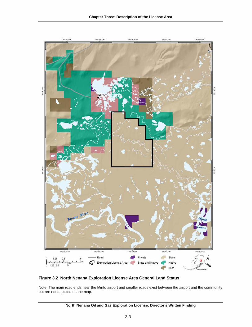
A. Property Description The North Nenana exploration license area consists of approximately 25,294 acres approximately 35 miles west of Fairbanks and within the MFSGR. The exploration license area consists of state-owned, unencumbered land within T. 2-3 N., R. 8 W, Fairbanks Meridian. The entire license area contains State owned land and waters. It is not located within a specific borough, but is situated just to the west of the boundary of the Fairbanks North Star Borough (Figures 3.1 and 3.2).
The MFSGR encompasses approximately 500,000 acres between the communities of Minto and Nenana. The refuge was established by the Alaska Legislature in 1988 to ensure the protection and enhancement of habitat, the conservation of fish and wildlife, and to guarantee the continuation of hunting, fishing, trapping and other compatible public uses within the Minto Flats area (ADF&G 1992). The land is jointly managed by the Alaska Department of Fish and Game (ADF&G) and the Alaska Department of Natural Resources (DNR). The village of Minto is located approximately 5 miles north of the northern extent of the license area.
The primary access route to the license area is by the Elliot Highway, a 118 mile overland road from Fairbanks to the village of Minto. However, Minto lies north of the license area. Winter ice roads and helicopter travel may be the most reliable means of access to the license area due to the lack of established roads or trails and the vast wetlands that comprise the region. Alternatively, access to the license area can be gained by river transport by way of the Tanana River and continuing upstream on the Tolovana River and then the Chatanika River. This route is suited only for small jet boat traffic and will not support large vessel traffic. There is also a state-owned 3,400-foot gravel airstrip in the village of Minto (ADCRA 2014f).
North Nenana Oil and Gas Exploration License: Director’s Written Finding
3-1

Chapter Three: Description of the License Area
Figure 3.1 North Nenana Exploration License Area
North Nenana Oil and Gas Exploration License: Director’s Written Finding
3-2
Chapter Three: Description of the License Area
Figure 3.2 North Nenana Exploration License Area General Land Status
Note: The main road ends near the Minto airport and smaller roads exist between the airport and the community but are not depicted on the map.
North Nenana Oil and Gas Exploration License: Director’s Written Finding
3-3

Chapter Three: Description of the License Area
B. Land and Mineral Ownership The Alaska Statehood Act granted to the State of Alaska the right to select from the federal public domain 102.5 million acres of land to serve as an economic base for the new state. The act also granted to Alaska the right to all minerals underlying these selections and specifically required the state to retain this mineral interest when conveying its interests in the land (AS 38.05.125). Therefore, when state land is conveyed to an individual citizen, local government, or other entity, state law requires that the deed reserve the mineral rights for the state. Furthermore, state law reserves to the state the right to reasonable access to the surface for purposes of exploring for, developing and producing the reserved mineral. Surface owners are entitled to damages under AS 38.05.130, but may not deny reasonable access. Mineral closing orders, which are commonly associated with surface land disposal, do not apply to oil and gas leasing.
The Alaska Native Claims Settlement Act (ANCSA), passed by Congress in 1971, also granted newly created regional Native corporations the right to select and obtain from the federal domain, the land and mineral estates within the regional Native corporation boundaries. It also allowed Native village corporations and individual Alaskan Natives to receive land estate interests. However, overlapping selections created conflicts and delays in conveying the land from the federal government, and some selected lands have yet to be conveyed.
C. Local Communities There are no communities within the license area. The license area is located to the west of the boundary of the Fairbanks North Star Borough. The village of Minto, located approximately 5 miles north of the license area’s northern boundary, is the closest community to the license area. Fairbanks is located approximately 50 miles to the southeast of the license area.
1. Minto The Native Village of Minto (Minto) is located on the west bank of the Tolovana River on an 11 mile spur road off of the Elliot Highway. Minto is in the western-most portion of the traditional Tanana Athabascan territory, and most of the residents are Tanana Athabascans. Minto had a population of 214 in 2013 (ADCRA 2014f). It is an unincorporated Census Designated Place (CDP) and in 2012 had 108 employed residents. About 40% of the employed residents were employed in the private sector, 57% were employed in local government, and 3% by state government. The primary industries include leisure and hospitality, educational and health services, and trade, transportation, and utilities (DOLWD 2014f).
The estimated per capita income for Minto was $12,383, median household income was $30,179, and the median family income was $38,750 in 2013. Approximately 20% of the population was considered below poverty level. Several families have seasonal hunting and fishing camps and trapping areas on the Tanana River and Goldstream Creek. Minto is a dry community meaning that the sale and importation of alcohol is prohibited. Minto is associated with the Regional Corporation Doyon Limited and the Seth-De-Ya-Ah Village Corporation (ADCRA 2014f).
2. Fairbanks Fairbanks is a Home Rule City in the Fairbanks North Star Borough with an estimated population of 32,204 in 2013. It is located on the banks of the Chena River in the Tanana Valley approximately 358 road miles or 260 air miles north of Anchorage. Fairbanks comprises 32.4 square miles of land and 0.8 square miles of water. The city of Fairbanks grew during the Pedro Dome gold rush as it served as a steamboat landing on the Chena River. The population of the area increased as Fairbanks became the hub for interior Alaska and with the addition of the court, government offices, and a jail (ADCRA 2014b).
North Nenana Oil and Gas Exploration License: Director’s Written Finding
3-4

Chapter Three: Description of the License Area
Approximately 83% of the employed residents were employed in the private sector, 9% were employed by state government agencies, and 8% were employed by local government in 2013. The primary industries are trade, transportation and utilities, educational and health services, and leisure and hospitality (DOLWD 2014b). The per capita income for Fairbanks was $27,646, median household income was $54,572, and the median family income was $60,493 in 2013 (ADCRA 2014b).
3. Nenana Nenana is located along the south bank of the Tanana River, 55 road miles south of Fairbanks on the George Parks Highway. It is a Home Rule city in the Yukon-Koyukuk Census Area with an estimated population of 399 in 2013 (ADCRA 2014g). Approximately 64% of employed residents were employed in the private sector, 3% were employed by state government, and 33% were employed by local government in 2013. The primary industries are leisure and hospitality, trade, transportation and utilities, and educational and health services (DOLWD 2014g). In 2013, the estimated per capita income was $27,815, median household income was $59,583, and median family income was $61,923. About 20% of the population was considered below poverty level. The Nenana Native Association is the federally recognized tribe in the Nenana community (ADCRA 2014g).
4. Livengood Livengood is an unincorporated town located 50 miles northwest of Fairbanks on the Dalton Highway. It is in the Yukon-Koyukuk Census Area and had a population of 14 in 2013 (ADCRA 2014d). Approximately 63% of employed residents were employed in the private sector, 38% were employed by state government, and none were employed by local government in 2013. The primary industries are natural resource and mining and professional and business services (DOLWD 2014d). In 2013, per capita income was $29,863, median household income was $51,500 and median family income was $35,000 (ADCRA 2014d).
5. Ester Ester is an unincorporated town in the Fairbanks North Star Borough located 8.5 miles west of Fairbanks on the George Parks Highway with an estimated population of 2,605 in 2013 (ADCRA 2014a). Approximately 63% of employed residents were employed in the private sector, 24% were employed by state government, and 13% were employed by local government in 2013. The primary industries are leisure and hospitality, trade, transportation and utilities, and educational and health services (DOLWD 2014a). In 2013, per capita income was $33,668, median household income was $80,102 and median family income was $104,385. About 18% of the population was considered below poverty level (ADCRA 2014a).
6. Fox Fox is an unincorporated town in the Fairbanks North Star Borough 10 miles northeast of Fairbanks, at the junction of the Steese and Elliot highways with an estimated population of 470 in 2013 (ADCRA 2014c). Approximately 89% of employed residents were employed in the private sector, 9% were employed by state government, and 3% were employed by local government in 2013. The primary industries are trade, transportation, and utilities, construction, leisure and hospitality, and natural resources and mining (DOLWD 2014c). In 2013 per capita income was $34,873, median household income was $71,541, and median family income was $71,657. About 22% of the population was considered below poverty level (ADCRA 2014c).
7. Manley Hot Springs Manley Hot Springs is an unincorporated town 160 road miles west of Fairbanks and about five miles north of the Tanana River with an estimated population of 127 in 2013 (ADCRA 2014e). Approximately 46% of employed residents were employed in the private sector, 7% were employed by
North Nenana Oil and Gas Exploration License: Director’s Written Finding
3-5
Chapter Three: Description of the License Area
state government, and 47% were employed by local government. The primary industries are construction, trade, transportation, and utilities, and educational and health services (DOLWD 2014e). In 2013, per capita income was $25,682, median household income was $31,750, and median family income was $32,350. About 40% of the population was considered below poverty level. The Manley Hot Springs Village is the federally recognized tribe in the town (ADCRA 2014e).
D. Historic and Cultural Resources The National Historic Preservation Act of 1966 created the State Historic Preservation Office (SHPO). The Alaska Office of History and Archaeology (OHA) carries out the responsibilities of the SHPO (OHA 2014). Historic and cultural resources can include a range of sites, deposits, structures, ruins, buildings, graves, artifacts, fossils, and objects of antiquity which provide information pertaining to the historical or prehistoric culture of people in the state, as well as to the natural history of the state. A lead agency is required to review the project and consult with the appropriate parties under either Section 106 of the NHPA (for Federal undertakings) or the Alaska Historic Preservation Act (for State undertakings) to assess the potential for effects to significant cultural resources.
Prehistoric occupation in the region dates to 8500 BCE (Andrews 1977). Historically, small family bands seasonally roamed the watersheds. Site types ranged from winter settlements to hunting and fishing camps, and to other temporary-use locations with specific resources, such as moose and caribou ranges and berry patches (Anchorage Museum 2014; ANHC 2014).
People began to settle in semi-permanent villages near trading posts and markets for fur and fish. The fish wheel came in to use in the early 1900s, which allowed people to move from their fish weirs in clear streams like the Tolovana to the muddier water of the lower Tanana River. Dog teams came to the region and, with them, the need for large quantities of dried fish for feed. Dog teams also allowed for wider ranges for trapping (Olson 1981).
Prospectors discovered gold in the early 1900s, bringing large numbers of outsiders to the region. Ester and Fox began as mining camps in 1905. Ester Gold Camp was established in 1936 and grew out of borough land lotteries after statehood (ADCRA 2014a). Manley Hot Springs began in 1902 as a homestead and vegetable farm. The area became known as Baker Hot Springs, a service and supply point for miners in the Eureka and Tofty mining districts. By 1920, mining was in decline and only 29 people lived there (ADCRA 2014e). Initially, the mining boom did not substantially affect the land around Minto. Later though, runoff from operations along the Chatanika and Little Goldstream entered the Minto Flats, polluting streams and lakes and affecting fishing and trapping (Olson 1981).
The Alaska Railroad transportation link between Fairbanks and Seward was started in 1915 and completed in 1923. During the construction years, the settlement at Nenana grew and attracted Alaska Natives from around the Interior and became a center for river freighting (Olson 1981). Influenza came to Nenana in 1920; Minto people weathered it without much mortality, and afterwards their village grew while Nenana declined. When erosion threatened the village of Old Minto, the people relocated to the current site in 1971 (Olson 1981).
The Middle Tanana region has high potential for finding the earliest traces of humans on the North American continent. Sites further up river at Broken Mammoth, Swan Point and Mead site have buried deposits more than 10,000 years old representing the Paleoarctic tradition, the earliest cultural tradition in the North American Arctic. Semi-permanent historic settlements near the license area have been identified on the Tanana River near Old Minto, at the mouth of the Tolovana River; at Nenana, and on the Wood and Chena rivers (Andrews 1977).
The Minto area has 25 identified prehistoric and historic sites and the Nenana area has 22 sites. They are mainly old camps, old village sites and cemeteries, and caribou and moose fences used to herd animals. They are predominantly located on the Minto Flats and along the Tanana River; over half of
North Nenana Oil and Gas Exploration License: Director’s Written Finding
3-6

Chapter Three: Description of the License Area
the sites are on state-selected lands. Several sites date as far back as 8500 BCE. Lakes about 15 miles up the Tolovana River have yielded prehistoric and historic material. There are 36 identified prehistoric sites at Livengood, mostly on knolls and hills (Andrews 1977).
Artifacts recovered on state land belong to the state and are curated in state facilities. These artifacts can be loaned to groups who have appropriate curation and exhibit facilities (AS 41.35.020(b)).
E. Climate The region of the license area is characterized by a continental or interior Alaskan climate with large temperature variance. The average daily maximum temperature in July is 70°F and higher and the average daily minimum temperatures stay below 0°F for most of January. Periods of -40°F with strong wind chill factors are common during the winter. The region receives 12 inches of annual precipitation, with 50 inches of snowfall (ADCRA 2014f).
Temperature and precipitation records from 1949 to 1998 show annual and seasonal mean temperature increases throughout Alaska (Stafford 2000). The average temperature increase in Alaska from 1949 to 2009 was 3.0°F, although the temperature changes varied greatly across the state. Most of the change occurred in winter and spring months and the least amount in fall (ACRC 2014). Global surface temperatures have increased about 0.9°F since the late 19th century. The increase per decade was 0.09°F for the past century, and was about 0.29°F per decade during the past 30 years, roughly from 1976 to 2006 (NCDC 2012).
At northern latitudes, potential effects of climate change may include rising temperatures, melting glaciers, and a reduction in seasonal sea ice cover resulting in increased storm effects and higher coastal erosion rates, increased permafrost melting, shifting vegetation zones, increased fires, insect outbreaks, changing animal migration paths, and changing subsistence patterns. Climate changes and associated geologic hazards may threaten and negatively impact Alaskans and other users of the Arctic (DGGS 2014).
In 2006, the Alaska Climate Impact Assessment Commission (ACIAC) was formed to assess the effects of climate change on citizens, resources, economy, and assets of the State of Alaska (ACIAC 2008). In September 2007, Administrative Order 238 was signed, creating the Climate Sub-Cabinet. Members of the sub-cabinet represent DEC, ADF&G, DNR, Alaska Department of Transportation (DOT), Department of Commerce, Community and Economic Development (DCCED), University of Alaska, and the Office of the Governor. The sub-cabinet was tasked with developing an Alaska Climate Change Strategy, providing assessments and recommendations for adaptation, mitigation, and for defining research needs to assist Alaskans with the impacts of climate change. The strategy serves as a guide for responding to climate change, identifying immediate priorities, long-term strategies, and including recommendations for saving energy and reducing greenhouse gas emissions (Alaska Climate Sub-Cabinet 2009).
In April 2008, the Governor’s sub-cabinet released its report of recommended actions including emergency planning and training, erosion control, and village relocation planning (IAW 2008). In 2009-2010, the ACIAC released two draft and two final reports written by the Climate Change Advisory Groups. The Adaptation Advisory Group’s report discussed how to address present and future impacts on infrastructure, human health, and ecosystems. Current impacts are those associated with village relocation in Western Alaska, though climate change affects all of the state. The Mitigation Advisory Group focused on preparing recommendations to be included in a strategy to mitigate greenhouse gas emissions in Alaska. One section of their report looks at the oil and gas industry. The Mitigation Advisory Group’s recommendations may be beneficial to possible future development (ACIAC 2012).
North Nenana Oil and Gas Exploration License: Director’s Written Finding
3-7

Chapter Three: Description of the License Area
F. Geologic Hazards There are three major categories of geophysical hazards within the license area, including earthquakes and faulting; permafrost and frozen ground phenomena; flooding; and fires. These geologic hazards could impose constraints to exploration, development and production, and transportation activities.
1. Earthquakes and Faulting In the southern part of Alaska, the Pacific Plate subducts underneath the North American Plate. The stress from this convergence is transmitted hundreds of miles, causing shear deformation and broadly distributed shallow crustal earthquakes in the interior region.
There are large strike-slip fault systems in the interior, including the Denali fault to the south of the license area and the Kaltag and Tintina faults to the north (AEIC 2006a). The Denali fault is an active fault about 93 miles south of Fairbanks (Plafker et al. 1977). Large-scale fault systems are capable of generating large earthquakes, as demonstrated by the magnitude 7.9 Denali fault earthquake in 2002 which ruptured over 211 miles, and caused offsets of up to 26 feet (Haeussler et al. 2004). The area between these large fault systems, including the license area, is where most Interior Alaska earthquakes occur. The Minto Flats seismic zone is one of three major north-northeast trending zones that comprise this area (AEIC 2006a). The seismicity in the area is fairly shallow, concentrated below the ground surface but above 18 miles depth (AEIC 2006b). The land around the Minto Flats is a mosaic of tectonic terranes bounded by faults, so there are multiple planes of weakness (instead of a few well delineated source zones) where plate convergence stress can be released as earthquakes (Pulpan 1988).
The Minto Fault zone is seismically active, however it is unclear if it is capable of producing surface rupturing earthquakes. It is important to note that there are also other mapped faults in and around the license area, including the Beaver Creek and Tolovana Faults (Pulpan 1986). With the exception of the 1912 and 2002 earthquakes along the Denali fault, no surface faulting has been observed in any other seismic events occurring within Interior Alaska (Doser 2011). Since 1990, Alaska has had an average of six M 6.0 – 7.0 earthquakes per year (ASHSC 2014). Between 1904 and 1968, of the 10 earthquakes above M 6.0 in the Nenana area, four were not related to any known faults (Pulpan 1988).
The 1995 Minto Flats (M 6.0) and 1968 Rampart (M 6.5) earthquakes are the most significant events recorded in the region. The Minto Flats event occurred at five miles depth at the northern end of the Minto Flats seismic zone, about 20 miles southeast of Minto (Ratchkovski and Hansen 2002). Scientists estimate that the license area has a 2% probability of exceeding 0.4%g (earthquake-generated peak ground acceleration) during a 50-year period (Wesson et al. 2007).
Another potential hazard in the license area due to seismic activity is liquefaction, or the transformation of loose granular sediment to a liquefied state. This can lead to ground failure due to the inability to support overlying material, large cracks in the ground, and sand and silt flowing from those cracks. Liquefaction is most likely to occur when sediments are saturated, so it is common along streams and ponds, which are numerous in the license area. Liquefaction risk would be especially high if an earthquake coincided with a high water table due to spring snowmelt or heavy rain. Documented liquefaction due to earthquakes has occurred in central Interior Alaska, and significant liquefaction effects can extend far away from the seismic source. For example, a magnitude 7.2 earthquake 43 miles southwest of Fairbanks in 1947 caused liquefaction-related cracked river bars on the Tolovana River as far north as Livengood (Combellick 1984; USGS 2014a).
2. Permafrost and Frozen Ground Phenomena Permafrost is a geologic phenomenon that may pose hazards to oil and gas operations. Permafrost thawing can be initiated by both natural (forest fire, flooding, and erosion) and anthropogenic ground
North Nenana Oil and Gas Exploration License: Director’s Written Finding
3-8

Chapter Three: Description of the License Area
disturbances (Richter-Menge et al. 2006). This thawing can lead to ground instability and subsidence, increased erosion, changes in the hydrologic regime and vegetation, and potentially damaged infrastructure (Alaska Regional Assessment Group 1999). Permafrost temperatures in Alaska have increased since the 1960s. Discontinuous permafrost regions, such as the license area, are at greater risk of thaw settlement than other parts of Alaska. Interior Alaska is recognized as one of the areas of the state with the greatest current thaw subsidence risk (Hong et al. 2014).
Ground ice volume in the top 16 feet of the ground in the license area is mainly moderate, or 10 to 40% and open system pingos (conical, ice-cored mounds) are documented in the area (Jorgenson et al. 2008).
3. Flooding The license area includes extensive wetlands fed by several streams that abruptly change gradient from the surrounding highlands before draining into the Tanana River, and some areas of Minto Flats have experienced persistent flooding (ADF&G 1992). Two main flooding mechanisms that can occur are excessive rainfall and ice jam flooding. Heavy rainfall can cause stream levels to rise to the point of overflowing their banks. Ice jam flooding, which is common during the spring in Alaska, is caused when ice moving downstream is caught on an obstruction. This can create flooding upstream due to water backing up behind the ice dam, as well as flash flooding downstream when the ice floats, moves, or melts and the blockage breaks. Compounding the problem, river ice breakup and snowmelt commonly occur around the same time, so there is already excess water in the channels (NWS 2014).
4. Mitigation Measures Several geologic hazards exist in the license area that could pose potential risks to exploration activities and are discussed above.
The risks from earthquake damage can be mitigated by siting facilities away from potentially active faults and unstable areas, and by designing them to meet or exceed national standards and International Building Code seismic specifications for Alaska.
Before developing any kind of infrastructure it is important to determine if permafrost is present. Potential hazards may be mitigated by incorporating careful evaluation, proper engineering, or avoidance of susceptible areas. Stream icings may also be a problem, but are highly localized hazards and may be mitigated by careful evaluation and avoidance of susceptible areas.
Because geologic hazards could affect and damage oil and gas infrastructure, measures in this finding, regulations imposed by state, federal, and local regulations, in addition to design and construction standards, are expected to mitigate those hazards. Mitigation measures in this finding address siting of facilities and design and construction of pipelines. A complete listing of mitigation measures is found in Chapter Nine.
North Nenana Oil and Gas Exploration License: Director’s Written Finding
3-9

Chapter Three: Description of the License Area
G. References ACIAC (Alaska Climate Impact Assessment Commission). 2008. Final report to the legislature.
Representative Ralph Samuels, Chairman, and Representative Reggie Joule, Vice-Chairman. March 17, 2008. http://www.housemajority.org/coms/cli/cli_finalreport_20080301.pdf (Accessed June 24, 2014).
ACIAC (Alaska Climate Impact Assessment Commission). 2012. Mitigation Advisory Group Final
Report. Alaska State Legislature's Joint Alaska Climate Impact Assessment Commission. http://www.climatechange.alaska.gov/aag/aag.htm (Accessed June 24, 2014).
ACRC (Alaska Climate Research Center). 2014. Temperature change in Alaska. Geophysical
Institute, University of Alaska Fairbanks. http://climate.gi.alaska.edu/ClimTrends/Change/TempChange.html (Accessed February 2014).
ADCRA (Alaska Divisionof Community and Regional Affairs). 2014a.
Ester. http://commerce.alaska.gov/cra/DCRAExternal/Community/Details/45bec8c0-07d5-4f40-ab4f-48db122799e1 (Accessed June 12, 2014).
ADCRA (Alaska Divisionof Community and Regional Affairs). 2014b.
Fairbanks. http://commerce.alaska.gov/cra/DCRAExternal/Community/Details/c9d4609d-cf63-4dde-a353-338b12d79046 (Accessed June 12, 2014).
ADCRA (Alaska Divisionof Community and Regional Affairs). 2014c.
Fox. http://commerce.alaska.gov/cra/DCRAExternal/Community/Details/70fb7521-5f1f-492a-881e-d639371d6108 (Accessed June 12, 2014).
ADCRA (Alaska Divisionof Community and Regional Affairs). 2014d.
Livengood. http://commerce.alaska.gov/cra/DCRAExternal/Community/Details/39be1361-9069-408f-8ed2-1eae1a70c1c4 (Accessed June 12, 2014).
ADCRA (Alaska Divisionof Community and Regional Affairs). 2014e. Manley Hot
Springs. http://commerce.alaska.gov/cra/DCRAExternal/Community/Details/e4ebbff7-5056-4ce9-919e-ee2f6101052b (Accessed June 12, 2014).
ADCRA (Alaska Division of Community and Regional Affairs). 2014f.
Minto. http://commerce.alaska.gov/cra/DCRAExternal/Community/Details/55f08896-dfaa-41c2-a407-442fbcb3c093(Accessed June 12, 2014).
ADCRA (Alaska Division of Community and Regional Affairs). 2014g.
Nenana. http://commerce.alaska.gov/cra/DCRAExternal/Community/Details/f8109851-d2f7-4c51-bcd7-b8538003d22d (Accessed June 12, 2014).
ADF&G (Alaska Department of Fish and Game). 1992. Minto flats state game refuge management
plan. http://www.adfg.alaska.gov/index.cfm?adfg=mintoflats.managementplan (Accessed June 23, 2014).
AEIC (Alaska Earthquake Information Center). 2006a. Interior Alaska
seismicity. http://www.aeic.alaska.edu/maps/regional_seismicity_interior.html (Accessed June 23, 2014).
North Nenana Oil and Gas Exploration License: Director’s Written Finding
3-10

Chapter Three: Description of the License Area
AEIC (Alaska Earthquake Information Center). 2006b. Interior 3-D depth
plots. http://www.aeic.alaska.edu/maps/depth_fairbanks_map.html (Accessed June 24, 2014). Alaska Climate Sub-Cabinet. 2009. Governor's Climate Change Sub-Cabinet Assessment, December
15, 2009. Alaska Climate Change Sub-cabinet. http://www.climatechange.alaska.gov/docs/Hartig_COP-15_11Dec09.pdf (Accessed June 24, 2014).
Alaska Regional Assessment Group. 1999. The potential consequences of climate variability and
change Alaska. U.S. Global Change Research. Center for Global Change and Arctic Systems Research. University of Alaska Fairbanks. http://www.besis.uaf.edu/regional-report/regional-report.html (Accessed June 25, 2014).
Anchorage Museum. 2014. Athabascan Indian history and culture.
https://www.anchoragemuseum.org/galleries/alaska_gallery/athabascan.aspx (Accessed June 25, 2014).
Andrews, Elizabeth F. 1977. Report on the cultural resources of the Doyon region, central Alaska:
Volumes I and II. Fairbanks, AK: University of Alaska, Cooperative park studies unit. http://core.tdar.org/document/109684 (Accessed June 23, 2014).
ANHC (Alaska Native Heritage Center). 2014. Cultures of Alaska.
Athabascan. http://www.alaskanative.net/en/main-nav/education-and-programs/cultures-of-alaska/athabascan/ (Accessed June 25, 2014).
ASHSC (Alaska Seismic Hazards Safety Commission). 2014. Alaska earthquake
statistics. http://seismic.alaska.gov/seismic_hazards_earthquake_risk.html (Accessed June 24, 2014).
Combellick, R.A., 1984. Potential for earthquake induced liquefaction in the Fairbanks-Nenana area: Alaska Division of Geological & Geophysical Surveys Report of Investigation 84-5, 10 p., 1 sheet, scale 1:250,000. http://www.dggs.alaska.gov/pubs/id/2364 (Accessed June 24, 2014).
DGGS (Alaska Division of Geological and Geophysical Surveys). 2014. Guide to geologic hazards in Alaska. Maps and Publications. http://www.dggs.dnr.state.ak.us/sections/engineering/geohazards/ (Accessed February 2014).
DOLWD (Alaska Department of Labor and Workforce Development). 2014a. Alaska Labor Statistics. Ester. http://live.laborstats.alaska.gov/alari/details.cfm?yr=2013&dst=01&dst=03&dst=04&dst=06&dst=07&r=3&b=8&p=91(Accessed September 12, 2014).
DOLWD (Alaska Department of Labor and Workforce Development). 2014b. Alaska Labor Statistics. Fairbanks. http://live.laborstats.alaska.gov/alari/details.cfm?yr=2013&dst=01&dst=03&dst=04&dst=06&dst=12&dst=09&dst=11&dst=07&r=3&b=8&p=95(Accessed June 12, 2014).
DOLWD (Alaska Department of Labor and Workforce Development). 2014c. Alaska Labor Statistics. Fox.
North Nenana Oil and Gas Exploration License: Director’s Written Finding
3-11

Chapter Three: Description of the License Area
http://live.laborstats.alaska.gov/alari/details.cfm?yr=2013&dst=01&dst=03&dst=04&dst=06&dst=07&r=3&b=8&p=105(Accessed September 12, 2014).
DOLWD (Alaska Department of Labor and Workforce Development). 2014d. Alaska Labor Statistics. Livengood. http://live.laborstats.alaska.gov/alari/details.cfm?yr=2013&dst=01&dst=03&dst=04&dst=06&dst=07&r=3&b=29&p=185 (Accessed September 12, 2014).
DOLWD (Alaska Department of Labor and Workforce Development). 2014e. Alaska Labor Statistics. Manley Hot Springs. http://live.laborstats.alaska.gov/alari/details.cfm?yr=2013&dst=01&dst=03&dst=04&dst=06&dst=07&r=3&b=29&p=190 (Accessed September 12, 2014).
DOLWD (Alaska Department of Labor and Workforce Development). 2014f. Alaska Labor Statistics. Minto. http://live.laborstats.alaska.gov/alari/details.cfm?yr=2013&dst=01&dst=03&dst=04&dst=06&dst=07&r=3&b=29&p=202 (Accessed September 12, 2014).
DOLWD (Alaska Department of Labor and Workforce Development). 2014g. Alaska Labor Statistics. Nenana. http://live.laborstats.alaska.gov/alari/details.cfm?yr=2013&dst=01&dst=03&dst=04&dst=06&dst=12&dst=09&dst=11&dst=07&r=3&b=29&p=216 (Accessed September 12, 2014).
Doser, D. I. 2011. Seismological studies of the Central Denali-Northern Foothills fold and thrust belt – Fairbanks region. Final technical report. http://earthquake.usgs.gov/research/external/reports/G11AP20030.pdf (Accessed June 24, 2014).
Haeussler, P.J. 2009. Surface rupture map of the 2002 M7.9 Denali fault earthquake, Alaska; digital data: U.S. Geological Survey data series 442 http://pubs.usgs.gov/ds/422/ (Accessed June 24, 2014).
Hong, E., Perkins, R., and S. Trainor. 2014. Thaw settlement hazard of permafrost related to climate warming in Alaska. Arctic 67(1): 93-103. http://arctic.synergiesprairies.ca/arctic/index.php/arctic/article/view/4368 (Accessed June 24, 2014)
IAW (Immediate Action Workgroup). 2008. Recommendations report to the Governor's Subcabinet on climate change. Final report from the Immediate Action Workgroup, April 17, 2008. http://www.climatechange.alaska.gov/docs/iaw_rpt_17apr08.pdf (Accessed June 24, 2014).
Jorgenson, T., Yoshikawa, K., Kanevskiy, M., Shur, Y., Romanovsky, V., Marchenko, S., Grosse, G., Brown, J., and Jones, B., 2008. Permafrost characteristics of Alaska: Ninth International Conference on Permafrost, June 29-July 3, 2008, Fairbanks, Alaska. http://permafrost.gi.alaska.edu/sites/default/files/AlaskaPermafrostMap_Back_Jun2008_Jorgenson_etal_2008.pdf (Accessed June 24, 2014).
NCDC (National Climate Data Center). 2012. State of the Climate - CEOS Climate Diagnostics: Global In Situ Temperature Anaomalies and Trends. 1958-2011. http://idn.ceos.org/climdiag/Metadata.do?Portal=climatediagnostics&KeywordPath=%7C%5BFreetext%3D%27global+in+situ+temperature+anomalies+and+trends+%27%5D&EntryId=NCDC_GlobalTemperatureAnomalies_Trends_2008&MetadataView=Text&MetadataType=0&lbnode=mdlb4 (Accessed June 25, 2014).
NWS (National Weather Service). 2014. Flood hazards. http://www.nws.noaa.gov/floodsafety/hazards.shtml (Accessed June 24, 2014).
North Nenana Oil and Gas Exploration License: Director’s Written Finding
3-12

Chapter Three: Description of the License Area
OHA (Office of History and Archaeology). 2014. History and archaeology. http://dnr.alaska.gov/parks/oha-temp/index.htm (Accessed June 25, 2014).
Olson, Wallace M. 1981. Minto history. In J. Helm and W. Sturtevant, editors. Handbook of North American Indians, Vol. 6. Subarctic. Smithsonian Institution.
Plafker, G., Hudson, T., and Richter, D.H., 1977, Preliminary observations on late Cenozoic displacements along the Totschunda and Denali fault system, in Blean, K.M., ed., The United States Geological Survey in Alaska: Accomplishments during 1976: U.S. Geological Survey Circular 751-B, p. B67-B69.
Pulpan, H., 1986, Seismic-hazard analysis of the Nenana Agricultural Development Area, central Alaska: Alaska Division of Geological & Geophysical Surveys Public Data File 86-78, 33 p. http://137.229.113.30/webpubs/dggs/pdf/text/pdf1986_078.pdf (Accessed June 24, 2014).
Pulpan, H., 1988, Seismic-hazard analysis of the Nenana agricultural development area, central Alaska: Alaska Division of Geological Geophysical Surveys Report of Investigations 88-1, 29 p. http://137.229.113.30/webpubs/dggs/ri/text/ri1988_001.pdf (Accessed June 24, 2014).
Ratchkovski, N.A. and R.A. Hansen. 2002. New constraints on tectonics of interior Alaska: Earthquake locations, source mechanisms, and stress regime. Bulletin of the Seismological Society of America 92(3): 998-1014.http://bssa.geoscienceworld.org/content/92/3/998.abstract (Accessed June 24, 2014).
Richter-Menge, et al. 2006. State of the Arctic Report. NOAA OAR Special Report, NOAA/OAR/PMEL, Seattle, WA, 36 pp. http://www.arctic.noaa.gov/soa2006/ (Accessed June 25, 2014).
Stafford, J. M., G. Wendler, and J. Curtis. 2000. Temperature and precipitation of Alaska: 50 year trend analysis. Theoretical and Applied Climatology 67:33-44.
USGS (United States Geological Survey). 2014a. Earthquake hazards program. Historic earthquakes. Wood river. http://earthquake.usgs.gov/earthquakes/states/events/1947_10_16.php (Accessed June 24, 2014).
Wesson, Robert L., Boyd, Oliver S., Mueller, Charles S., Bufe, Charles G., Frankel, Arthur D., Petersen, Mark D. 2007. Revision of time-Independent probabilistic seismic hazard maps for Alaska: U.S. Geological Survey Open-File Report 2007-1043. http://pubs.usgs.gov/of/2007/1043/pdf/of07-1043_508.pdf (Accessed June 24, 2014).
North Nenana Oil and Gas Exploration License: Director’s Written Finding
3-13


Chapter Four: Habitats, Fish, and Wildlife
Table of Contents Page
Chapter Four: Habitats, Fish and Wildlife ......................................................................................................... 4-1 A. Habitats .................................................................................................................................................... 4-1
1. Designated Habitat Areas..................................................................................................................... 4-2 B. Fish and Wildlife Populations .................................................................................................................. 4-2
1. Fish ....................................................................................................................................................... 4-3 a. Salmon ............................................................................................................................................. 4-3
i. Chinook (king) Salmon ............................................................................................................... 4-3 ii. Chum (dog) Salmon ................................................................................................................... 4-3 iii. Coho (silver) Salmon ................................................................................................................ 4-4
b. Other Fish Species .......................................................................................................................... 4-4 i. Arctic Grayling ........................................................................................................................... 4-4 ii. Northern Pike ............................................................................................................................. 4-4 iii. Burbot ....................................................................................................................................... 4-5 iv. Whitefish ................................................................................................................................... 4-5 v. Sheefish ...................................................................................................................................... 4-5 vi. Other Species ............................................................................................................................ 4-5
2. Birds ..................................................................................................................................................... 4-5 a. Trumpeter Swan .............................................................................................................................. 4-6 b. Eskimo Curlew ................................................................................................................................ 4-6 c. White-fronted Geese ....................................................................................................................... 4-7
3. Mammals .............................................................................................................................................. 4-7 a. Black and Brown Bear .................................................................................................................... 4-7 b. Caribou ............................................................................................................................................ 4-7 c. Moose .............................................................................................................................................. 4-9 d. Wolf ................................................................................................................................................ 4-9 e. Furbearers ........................................................................................................................................ 4-9
C. References .............................................................................................................................................. 4-10
List of Tables Table Page Table 4.1 Common names of fish and wildlife found within the Minto Flats State Game Refuge .................. 4-2
List of Maps
Map Page Map 4.1 Alaska Caribou Herds ......................................................................................................................... 4-8
___________________________________________________________________________________________________________
North Nenana Oil and Gas Exploration License: Written Finding of the Director i


Chapter Four: Habitats, Fish, and Wildlife
Chapter Four: Habitats, Fish and Wildlife This chapter considers and discusses the license area’s habitats and fish and wildlife populations, as required by AS 38.05.035(g)(iii). This chapter is not intended to be an exhaustive examination of all habitats and fish and wildlife species of the area, but rather, the director has limited the scope of the administrative review and finding to considering and discussing those that have important subsistence, recreational, or commercial value and that are material to the determination of whether the exploration license will best serve the interests of the state (AS 38.05.035(e)(1)(B)). A. Habitats The landforms, vegetation types, and streams and wetlands of the license area provide habitat for fish, birds, and wildlife. Some of the fish and wildlife of particular importance are salmon, black and brown bears, caribou, moose, wolves, and several furbearer species such as beavers and lynx. The license area contains important habitat for ducks, trumpeter swans, white-fronted geese, and numerous other bird species.
The license area lies within the Interior Forested Lowlands and Uplands ecological region as defined by the Environmental Protection Agency (EPA) (EPA 2013). The forests of this ecoregion are dominated by spruce and hardwood species (Gallant et al. 1995). There are also narrow bands of coniferous and deciduous forests in riparian areas (ADF&G 1992). The terrain consists of rolling lowlands, dissected plateaus, and rounded low to high hills (Gallant et al. 1995).
Freshwater habitats in the license area include a number of large and long streams originating in the adjacent glaciated Alaska Range and Kuskokwim Mountains. Shorter streams originate within the Interior Forested Lowlands and Uplands ecoregion. Lakes are not considered a predominant landscape feature, although some thaw and oxbow lakes do occur (Gallant et al. 1995; Wiken et al. 2011). There are a number of anadromous fish streams throughout the license area used by Chinook, chum, and coho salmon (ADF&G 2006). These water bodies are the Tolovana and Chatanika rivers and the Swanneck Slough (Johnson and Daigneault 2013). The license area lies within the Alaska Department of Fish and Game’s (ADF&G’s) Tanana River Management Area. This management area includes the Tanana River drainage, the second largest tributary of the Yukon River. The Tanana River is a large glacier-fed drainage formed by the confluence of the Chisana and Nabesna rivers near Tok and the Alaska-Canada border. The Tanana River supports a variety of indigenous and introduced fish populations (Brase and Baker 2014).
The license area has extensive wetlands, referred to as Minto Flats, fed by the Tatalina, Chatanika, and Tolovana rivers, along with Goldstream and Washington creeks, all of which drain into the Tanana River. The water courses feeding the Flats abruptly change gradient from the surrounding highlands, so the area is a settling basin of alluvial silt and gravel deposits crossed by meandering streams. The proximity of complimentary vegetation types, with a mosaic of ponds, oxbows, streams, and various wetlands provides excellent habitat for many wildlife populations (ADF&G 1992). Tall scrub communities are dominated by willows and alders, while low scrub communities consist of open stands of willow, birch, alder, or mixes of these species (Gallant et al. 1995).
Wildfires are frequent throughout this region due to low annual precipitation, high summer temperatures, low relative humidity, lightning storms, and trees with branches low to the ground. Fire season lasts from June through the beginning of August. Recent burn areas are initially dominated by fireweed, followed by willows and then either quaking aspen or paper birch stands, depending on the characteristics of that specific area within the ecoregion (Gallant et al. 1995). Wildfires are an important natural process that recycles nutrients and help maintain variety in plant and animal communities (ADF&G 1992).
___________________________________________________________________________________________________________ North Nenana Oil and Gas Exploration License: Written Finding of the Director
4-1
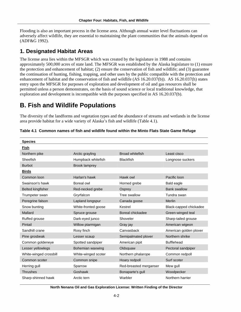
Chapter Four: Habitats, Fish, and Wildlife Flooding is also an important process in the license area. Although annual water level fluctuations can adversely affect wildlife, they are essential to maintaining the plant communities that the animals depend on (ADF&G 1992).
1. Designated Habitat Areas The license area lies within the MFSGR which was created by the legislature in 1988 and contains approximately 500,000 acres of state land. The MFSGR was established by the Alaska legislature to (1) ensure the protection and enhancement of habitat; (2) ensure the conservation of fish and wildlife; and (3) guarantee the continuation of hunting, fishing, trapping, and other uses by the public compatible with the protection and enhancement of habitat and the conservation of fish and wildlife (AS 16.20.037(b)). AS 16.20.037(h) states entry upon the MFSGR for purposes of exploration and development of oil and gas resources shall be permitted unless a person demonstrates, on the basis of sound science or local traditional knowledge, that exploration and development is incompatible with the purposes specified in AS 16.20.037(b). B. Fish and Wildlife Populations The diversity of the landforms and vegetation types and the abundance of streams and wetlands in the license area provide habitat for a wide variety of Alaska’s fish and wildlife (Table 4.1). Table 4.1 Common names of fish and wildlife found within the Minto Flats State Game Refuge
Species Fish
Northern pike Arctic grayling Broad whitefish Least cisco
Sheefish Humpback whitefish Blackfish Longnose suckers
Burbot Brook lamprey Birds
Common loon Harlan's hawk Hawk owl Pacific loon
Swainson's hawk Boreal owl Horned grebe Bald eagle
Belted kingfisher Red-necked grebe Osprey Bank swallow
Trumpeter swan Gryrfalcon Tree swallow Tundra swan
Peregrine falson Lapland longspur Canada goose Merlin
Snow bunting White-fronted goose Kestrel Black-capped chickadee
Mallard Spruce grouse Boreal chickadee Green-winged teal
Ruffed grouse Dark-eyed junco Shoveler Sharp-tailed grouse
Pintail Willow ptarmigan Gray jay American wigeon
Sandhill crane Rosy finch Canvasback American golden plover
Pine grosbeak Lesser scaup Semipalmated plover Northern shrike
Common goldeneye Spotted sandpiper American pipit Bufflehead
Lesser yellowlegs Bohemian waxwing Oldsquaw Pectoral sandpiper
White-winged crossbill White-winged scoter Northern phalarope Common redpoll
Common scoter Common snipe Hoary redpoll Surf scoter
Herring gull Sparrow Red-breasted merganser Mew gull
Thrushes Goshawk Bonaparte's gull Woodpecker
Sharp-shinned hawk Arctic tern Warbler Northern harrier ___________________________________________________________________________________________________________
North Nenana Oil and Gas Exploration License: Written Finding of the Director
4-2

Chapter Four: Habitats, Fish, and Wildlife
Great horned owl Rough-legged hawk Short-eared owl Red-tailed hawk
Great gray owl Mammals
Black bear Brown bear Moose Wolf
Coyote Red fox River otter Wolverine
Marten Mink Lynx Beaver
Muskrat Snowshoe hare Red squirrel
Source: ADF&G 1992
1. Fish Headwater streams within the license area are important spawning areas for a number of anadromous fish species, including Chinook (king), chum (dog), and coho (silver) salmon. Anadromous fish water bodies in the license area include the Swanneck Slough, the Tolovana River, and the Chatanika River. These water bodies provide spawning, rearing, and overwintering sites for both anadromous and resident fish. Lakes and rivers provide habitats for northern pike, whitefish, burbot, and sheefish. Arctic grayling are usually found in smaller streams (ADF&G 1992; ADF&G 2006).
a. Salmon Within the license area, Chinook, chum, and coho salmon spawn in the Swanneck Slough and the Tolovana and Chatanika rivers (ADF&G 1992). i. Chinook (king) Salmon Spawning populations of Chinook salmon are found throughout the streams and rivers within the license area.
After hatching and emerging from the gravel, juvenile Chinook salmon feed on plankton and insects while in freshwater. They spend nearly one year in freshwater until they migrate to the ocean the following spring as smolts. Chinook salmon spend from one to five years feeding in the ocean before returning to freshwater to spawn. Their diet consists of plankton, insects, amphipods, and fish (ADF&G 2014h).
The Chatanika River Chinook salmon population was assessed sporadically from a counting tower from 1998 to 2005. In 2004, 2,444 Chinook salmon were counted in the Chatanika River. However, due to consistently high annual water conditions which resulted in poor viewing conditions, the counting tower project was discontinued in 2005. From 2011 through 2013, all Tanana River tributaries were restricted by emergency order to Chinook salmon catch and release only because downriver indicators suggested the Chinook salmon run was weak (Brase and Baker 2014). ii. Chum (dog) Salmon There are two distinct subsets of chum salmon based on spawning run-timing: summer chum and fall chum. Chum salmon spend the majority of their lives feeding in saltwater, then upon maturation return to spawn in their natal streams and then die. The juvenile salmon that hatch far upriver begin feeding on insect larvae while migrating to the sea. They spend three to four years at sea, where they feed on copepods, tunicates, mollusks, and a variety of fish (ADF&G 2014h). Chum salmon migrate through the MFSGR to spawning areas in the Chatanika River and other Tolovana tributaries (ADF&G 1992, 2014h). In June 2014, the Tanana River sonar project began counting the passage
___________________________________________________________________________________________________________ North Nenana Oil and Gas Exploration License: Written Finding of the Director
4-3

Chapter Four: Habitats, Fish, and Wildlife of salmon and other species. That year, the total count came to 170,725 summer chum salmon and 76,835 fall chum salmon (ADF&G 2014u).
iii. Coho (silver) Salmon Coho salmon migrate to spawn in small spring-fed streams just south of the license area, such as the Richardson Clearwater River, Providence Creek, and Blue Creek. Currently, stock status is not available for coho in the license area but their population in Alaska is considered healthy. The Richardson Clearwater River coho salmon escapement estimate from the 2008-2012 five year average was 502 salmon (Brase and Baker 2014). Coho salmon deposit eggs that are fertilized with sperm. The eggs develop during the winter and then hatch in early spring. Embryos remain in the gravel feeding on their egg yolk until they emerge in May or June. Some juveniles leave freshwater to rear in estuarine ponds and then migrate back to freshwater in the fall. They overwinter in off-channel habitats. Coho salmon spend several years in streams and lakes before migrating to the ocean as smolt. They spend six to eighteen months at sea before returning to freshwater to spawn. Coho salmon eat aquatic insects, eggs deposited by adult salmon, fish, and squid. The major predators of salmon are marine mammals, land mammals, and birds (ADF&G 2014h).
b. Other Fish Species Within the license area, the lower Chatanika River provides habitats for several other fish species including Arctic grayling, northern pike, burbot, whitefish, and sheefish.
i. Arctic Grayling Arctic grayling are freshwater fish with the largest natural range of any sport fish and are found across nearly the entire state of Alaska. Most stocks throughout Alaska are healthy and isolated from potential negative effects such as fishing, mining, agriculture, and forestry (ADF&G 2014h). In 2007, 2,539 Arctic grayling were counted in the Chatanika River (Brase and Baker 2014). Some grayling migrate to spawn, feed, and overwinter while others remain in a short section of a stream for their entire lives. Arctic grayling of all ages can be found throughout a stream. Adults tend to live in the cooler upper sections of the river and stream systems, sub-adults occupy the middle, while juveniles prefer the warmer lower reaches. Migratory Arctic grayling move upstream in the spring to spawn and then migrate to summer feeding areas immediately afterward (ADF&G 2014h). During the winter, Arctic grayling seek the deep reaches on lower clear rivers and can tolerate low oxygen regimes (Reynolds 1997). Their main food source is insects, but they will also eat smaller fish, voles, and shrews (ADF&G 2014h).
ii. Northern Pike Northern pike are common in many smaller lakes and in sloughs and tributaries of the Tanana River (Brase and Baker 2014). There is an abundance of northern pike habitat in the Minto Flats area. The Tolovana River, Chatanika River, lower Tatalina River, and the Minto Flats itself provide spawning, rearing, and some overwintering habitat. Counts of Northern pike declined in the Chatanika River during the mid-1980s due to a winter fishery. Because of this, harvest restrictions were imposed in the late 1980s (ADF&G 1992). Northern pike population assessments have been performed every three to five years in the Minto Lakes area (a group of large interconnected usually shallow, heavily vegetated lakes in the eastern Minto Flats) from 1987 through 2008. The 2008 estimate was significantly less than estimates from 2003 or 1997 (Brase and Baker 2014). Northern pike spawn in the spring of each year, soon after the ice goes out. Eggs are deposited in the grassy margins of a lake shore, slow-moving stream, or slough. They overwinter in the deep, slow waters of large rivers such as Goldstream Creek and the Chatanika, lower Tolovana, and Tanana rivers (ADF&G 1992, 2014h). Their spawning and overwintering areas tend to be short distances apart. Juvenile northern pike feed on small crustaceans, and insects, and smaller fish when they reach 50 mm in length. Adults feed on other fish (whitefish, burbot, smaller northern pike, and juvenile salmon), voles, shrews, and small waterfowl (ADF&G 2014h).
___________________________________________________________________________________________________________ North Nenana Oil and Gas Exploration License: Written Finding of the Director
4-4

Chapter Four: Habitats, Fish, and Wildlife iii. Burbot Burbot are found in the deep lakes, flooded ponds, and gravel pits of the Tanana River Management Area. Burbot populations dramatically declined in the early 1980s due to unsustainable rates of sport fishing. Bag limits have been decreased and certain burbot fisheries have been closed until further notice in an attempt to recover the population (Brase and Baker 2014). Burbot spawn under the ice from February through March. They do not build nests for their eggs, but are broadcast spawners. Eggs settle to the bottom and hatch in about 30 days. Burbot become sexually mature at about age six or seven and can spawn multiple times. They grow slowly, but have a long lifespan, up to 24 years. Young burbot feed on invertebrates and insects. By age five or six, their diet is primarily fish (ADF&G 2014h).
iv. Whitefish The Chatanika River provides habitat for a large spawning population of whitefish, primarily humpback and least cisco species (Brase and Baker 2014). The Minto Flats area has rearing and feeding habitat for both species of whitefish, with a combined total of over 100,000 fish spawning in the Chatanika River just upstream of the Minto Flats State Game Refuge (ADF&G 1992). Humpback whitefish and least cisco whitefish migrate up the Chatanika River in late summer and fall in order to spawn in the middle section of the river over gravel substrates (Brase and Baker 2014; Brown 2006). They appear to have long migrations which include moving downriver to undefined overwintering sites that may be outside the Minto Flats wetlands complex. They have also been observed moving into the Minto Lakes just after breakup in the spring, where they feed during the summer months before migrating upriver to spawn (Brase and Baker 2014). Eggs hatch in the spring, and larvae are carried downstream by the rapidly flowing water. Humpback whitefish mature in four to five years and then prepare to spawn. Spawning takes place every other year or less in upstream sites (Brown 2006). Whitefish are bottom feeders that eat snails, bivalves and other mollusks, and aquatic insect larvae (ADF&G 2014h).
v. Sheefish Sheefish are primarily present at the confluences of streams and in other deep waters within the license area (ADF&G 1992). They spawn every two or more years during late September to early October in shallow tributaries. Sheefish hatch sometime in early spring before the winter ice breaks up. Hatchlings are carried downstream and young fish end up in backwater eddies along rivers, off-channel lakes, and estuary regions at river mouths. Many sheefish will migrate upriver to the mouths of major tributaries to feed on juvenile fish or to return to where they were hatched to spawn. Juvenile sheefish feed on insects, and when they mature their food source is almost exclusively other fish (ADF&G 2014h).
vi. Other Species The license area also contains habitat for a number of other fish species, including longnose suckers, lake chub, and Alaska blackfish. Longnose suckers and lakechub seasonally inhabit most waterbodies connected to rivers and streams. Alaska blackfish are present in smaller, landlocked lakes within the license area (ADF&G 1992).
2. Birds The Minto Flats area is a high quality waterfowl habitat. This area provides habitat for high densities of duck, trumpeter swan, and white-fronted geese nesting sites and is an important staging site for their spring and fall migrations (ADF&G 1992; DMLW 2014; Groves 2012). The Minto Flats State Game Refuge also provides nesting areas for several duck species. The refuge yields 150,000 or more ducks annually, with breeding populations averaging 213 ducks per square mile (ADF&G 2014f). The area is especially important for mallards, pintails, and canvasbacks. Other duck species present in high densities in the refuge include wigeon, shoveler, and scaup (ADF&G 1992).
___________________________________________________________________________________________________________ North Nenana Oil and Gas Exploration License: Written Finding of the Director
4-5

Chapter Four: Habitats, Fish, and Wildlife Loss of habitat may affect waterfowl in the exploration license area. In 2005, Walker and others published a study that investigated nest survival of the lesser and greater scaup, and other common duck species at Minto Flats State Game Refuge. Nests were searched for daily from 1989-1993 and again from 2002-2003. Analysis of the information gathered showed that nest survival varied between years, was comparable to nest survival of ducks in other North American regions, and was probably related to predation risk and water levels. The low amount of nest survival is believed to have limited reproduction. For most years, predation was the main reason for low nest survival. In some years, flooding superseded predator destruction of the nests (Walker et al. 2005). Habitat management aimed at maintaining existing habitat was recommended to be the most effective strategy to support scaup populations in the Minto Flats (Walker et al. 2005). Several other bird species commonly found in the mixed-conifer forests of the license area, include Smith’s longspurs, gray jays, boreal chickadees, northern flickers, red-tailed hawks, and boreal owls (ADF&G 2006).
a. Trumpeter Swan The Minto Flats State Game Refuge has one of the largest trumpeter swan breeding populations in all of North America (ADF&G 2014f). The total North American population of trumpeter swans reached a record high during the most recent survey taken in 2010. In 2010, the total number of trumpeter swans in the Alaskan flock was 25,347 swans. This was a 7% increase from the 2005 survey. The Alaskan flock may be approaching its carrying capacity in some parts of its range. However, growth rates remained high in areas where substantial amounts of previously unoccupied habitat were available (Groves 2012). In 1990, the United States Fish and Wildlife Service (USFWS) estimated the Minto Flats trumpeter swan breeding population to be 2,500 (ADF&G 1992). Trumpeter swans mate for life and begin breeding during their third, fourth, or fifth year of life. Nesting begins in early spring, typically in an undisturbed marsh near a small lake. Cygnets hatch after a 30-35 day incubation period, and they fledge after 11-15 weeks. Both the male and female swans guard the nest during this critical time. Trumpeter swans eat foliage, seeds, and tubers of various marsh plants during the summer, and they feed on crops and seeds from agricultural fields on their wintering grounds in the Lower 48 States (ADF&G 2014b).
b. Eskimo Curlew The Eskimo curlew, a medium sized shorebird, is on both the state and federal endangered lists. However, there is no designated critical habitat for the Eskimo curlew. The ADF&G is responsible for maintaining and determining a list of endangered species in Alaska. The state considers a species endangered when the Commissioner of ADF&G determines the species population has decreased to such an extent as to indicate its continued existence is threatened (ADF&G 2014n). On the federal level, under the Endangered Species Act, a species is listed as endangered if it is in danger of extinction throughout all or a significant portion of its range. It is listed as threatened if it is likely to become an endangered species within the foreseeable future. Listing a species makes it illegal to harass, harm, pursue, hunt, shoot, wound, kill, trap, capture, or collect animals (NOAA 2013). It is highly possible that the Eskimo curlew is already extinct (ADF&G 2014n). The last documented sighting was in Texas in 1962, and there were a number of undocumented sightings up until 1996. The Eskimo curlew was known to migrate to the dry tundra areas of Alaska and Canada to nest in early May. Eggs hatched in late June and early July, and chicks fledged shortly after. They left their breeding grounds in August to spend the winters in the grasslands of South America, from southern Brazil and Uruguay to Argentina. They fed on insect eggs, berries, insects, and crustaceans (ADF&G 2014b).
___________________________________________________________________________________________________________ North Nenana Oil and Gas Exploration License: Written Finding of the Director
4-6
Chapter Four: Habitats, Fish, and Wildlife c. White-fronted Geese White-fronted geese within the license area are part of the midcontinent population, which includes over 300,000 birds (ADF&G 2014b). White-fronted geese migrate through the central United States to their wintering grounds in Texas and Mexico each fall. They return to Alaska in the spring, where they nest in habitats near water. Parents and young geese form a strong family unit and remain together until the following breeding season. White-fronted geese begin their migration back to their wintering grounds in early to mid-September (ADF&G 2014b). They feed on seeds, grain, grasses, sedges, and berries (CornellLab of Ornithology 2014, citing to Bellrose 1976 and Ely et al. 1994).
3. Mammals ADF&G manages wildlife resources through game management units (GMUs). The North Nenana license area lies within ADF&G’s GMU 20B. This subunit consists of drainages into the north bank of the Tanana River from and including Hot Springs Slough upstream to and including the Banner Creek drainage (ADF&G 2014i). Numerous terrestrial mammals inhabit the license area. Several species of particular importance, due to their subsistence and recreational uses, include black and brown bears, caribou, moose, wolves, and several furbearer species (ADF&G 2006).
a. Black and Brown Bear Black bears are common and widespread in the Minto Flats area (ADF&G 1992). In 2011, there were an estimated 750 to 1,200 black bears in GMU 20B (Hollis 2011). Black bears are found along rivers and lakes during the spring and summer and in upland areas during the fall. They take advantage of the varied vegetation types and abundant prey especially in riparian and wetlands areas (ADF&G 1992). Black bears hibernate in the winter for seven to eight months. They make their dens in a variety of locations ranging from sea level to alpine regions. Mating takes place during the months of June and July, and cubs are born in dens usually in January or February. Black bears breed every two to three years and commonly give birth to two cubs at a time (ADF&G 2014l). Black bears have a varied diet comprised of green vegetation, small mammals, newborn moose and caribou, salmon, berries, ants, grubs, and insects (ADF&G 2008). Other bears, usually brown, are the predators of black bears (ADF&G 2014l). Brown bears are present in low numbers in the Minto Flats area (ADF&G 1992). GMU 20B has a moderate habitat for brown bears, compared to the mountainous portions of Units 20A and 20C, and supports a low density population (Young 2011). Brown bears move to dens in the winter when food is scarce and remain there for up to eight months. The mating season occurs in the spring and females give birth in their dens in January and February. Females and cubs remain in their dens the longest and families remain together for two to three years. Females are known to be extremely protective of their young (ADF&G 2014l). Female offspring remain within or adjacent to their maternal home range while male offspring emigrate to farther ranges (Young 2011). Brown bears are omnivores that eat berries, newborn caribou and moose calves, salmon, and a variety of types of vegetation. They will enter human camps in search of food, garbage, and domesticated animals. Their only predator is other brown bears (ADF&G 2014l).
b. Caribou Two caribou herds have ranges that overlap with portions of GMU 20B and the license area. These are the Fortymile caribou herd (FCH) and the White Mountains caribou herd (Map 4.1). As a herd animal, caribou must keep moving to find adequate food sources. Caribou make seasonal migrations to calving and wintering grounds. Larger herds may migrate up to 400 miles between summer and winter ranges while smaller herds may not migrate at all. Their routes may change depending on weather conditions or food availability. The summer diet of caribou includes willow leaves, sedges, flowering tundra plants, and mushrooms. They feed on lichens, dried sedges, and small shrubs in the fall and winter (ADF&G 2014l). ___________________________________________________________________________________________________________
North Nenana Oil and Gas Exploration License: Written Finding of the Director
4-7

Chapter Four: Habitats, Fish, and Wildlife The FCH herd’s population was estimated at 51,675 caribou in June 2010. Good calf recruitment, mild winter conditions, and good winter survival allowed the population to increase an estimated 10% during regulatory year (RY) 2009 (Gross 2011) The White Mountains caribou herd population was estimated to be between 529-605 caribou in June 2009. In 2009, the herd minimum count decreased by 22% after 15% increases in 2007 and 2008. This herd has been observed spending the winters along the Upper Tolovana River near the license area (Seaton 2011). Caribou calving takes place in mid to late May in Interior Alaska. Females in good health may breed at 16 months old, but most females do not breed until they are 28 months old. Most adult cows give birth to one calf per year. After calving, caribou gather into large post calving aggregations to avoid predators and insects such as mosquitoes and warble flies. Wolves, brown bears, and golden eagles are predators of newborn calves.
Source: ADF&G 2014r
Map 4.1 Alaska Caribou Herds
___________________________________________________________________________________________________________ North Nenana Oil and Gas Exploration License: Written Finding of the Director
4-8

Chapter Four: Habitats, Fish, and Wildlife c. Moose The Minto Flats area supports resident moose populations year-round and provides excellent summer foraging opportunities and calving habitat (ADF&G 1992). In a 2003 survey, the Minto Flats Management Area had the highest utilization of preferred moose browse species in Interior Alaska (Seaton 2010, citing to Young 2004). The calf to cow ratio in western GMU 20B (which includes the license area) is higher than that in eastern GMU 20B due to lower predation rates. In 2008, the GMU 20B population was estimated at 18,000, or 2.0 moose per square mile (Seaton 2010). Moose calve from mid-May through early June. Most moose make seasonal movements, from a few miles to 60 miles, among calving, rutting, and wintering areas. They feed on willow, birch, and shrub leaves and on pond vegetation (ADF&G 2014l).
d. Wolf In the years 2008-2010, the estimated density of wolves in GMU 20 was 18-22 wolves per 1000 square miles. No density estimate was available for GMU 20B specifically. Wolf densities are highly dependent on prey availability, but wolf control and harvest occasionally reduce their numbers in the management area (Young 2012.) Wolves are adaptable animals and can live in a variety of habitats. They are found in nearly all of their historic range except for urban areas. Wolves usually live in packs of six to seven animals. They are highly territorial, and there are only occasional overlaps in the ranges of neighboring packs. In general, one female from the pack has a litter of about seven pups a year. Wolves have a high birth rate, but they rarely become abundant because they also have a high mortality rate. Predation by other wolves, hunting, trapping, disease, and malnutrition all limit the wolf population. Wolves’ primary food source is moose and/or caribou. They will also supplement their diet with Dall sheep, squirrels, snowshoe hares, beaver, birds, and fish (ADF&G 2014l).
e. Furbearers The Minto Flats supports healthy populations of beaver, muskrat, river otter, coyote, lynx, wolverine, red fox, weasels, and mink (ADF&G 2014f). Smaller mammals in the license area include red squirrels, northern bog lemmings, and yellow-cheeked voles (ADF&G 2006). Most furbearer species are challenging to study because of their secretive behaviors. Population trends and estimates usually come from harvest data, trapper questionnaires, and research conducted over the last 35 years in Interior Alaska (Hollis 2010). The beaver density within GMU 20 exceeded the management goal in the most recent reporting period (July 1, 2006 – June 30, 2009) (Hollis 2010). Beavers are considered common and abundant throughout their range in Alaska. They are found in forested areas and live near and within freshwater. Beavers construct dams to secure dens used for food storage, rearing, and shelter. Litters are born from late April to June, and young stay with their family for about two years. Beavers feed on aquatic plants, roots, grasses, and bark (ADF&G 2014l). The lynx population is dependent on prey availability and tends to follow a 10-year population cycle. Snowshoe hare, the primary food source of lynx, undergo an eight- to eleven-year cycle of abundance that precedes the cycle of lynx abundance. The lynx population within GMU 20 was expected to peak in 2009 or 2010 (Hollis 2010). Breeding season takes place during March and early April. Two to four kittens are born after a 63-day gestation period in shelters such as a spruce felled by wind, a rock ledge, or a log jam. Kitten survival is highly dependent on prey, particularly snowshoe hare, availability. Kittens remain with their mother until late winter, usually around the time the next breeding season begins. When snowshoe hares are scarce, lynx will regularly prey on grouse, ptarmigan, squirrels, small rodents. They are also known to prey on caribou, Dall sheep, and foxes (ADF&G 2014l). ___________________________________________________________________________________________________________
North Nenana Oil and Gas Exploration License: Written Finding of the Director
4-9

Chapter Four: Habitats, Fish, and Wildlife
C. References ADF&G (Alaska Department of Fish and Game). 1992. Minto flats state game refuge management plan.
http://www.adfg.alaska.gov/index.cfm?adfg=mintoflats.managementplan (Accessed June 23, 2014). ADF&G (Alaska Department of Fish and Game). 2006. Our Wealth Maintained: A Strategy for Conserving
Alaska’s Diverse Wildlife and Fish Resources. Alaska Department of Fish and Game, Juneau, AK. http://www.adfg.alaska.gov/static/species/wildlife_action_plan/cwcs_full_document.pdf (Accessed May 30, 2014).
ADF&G (Alaska Department of Fish and Game). 2008. ADF&G wildlife notebook series (with 1999 and 2003
updates for some species). http://www.adfg.alaska.gov/index.cfm?adfg=educators.notebookseries (Accessed May 30, 2014).
ADF&G (Alaska Department of Fish and Game). 2014b.Birds.
http://www.adfg.alaska.gov/index.cfm?adfg=animals.listbirds (Accessed March 24, 2014). ADF&G (Alaska Department of Fish and Game). 2014f. Conservation areas: Minto Flats – State Game
Refuge. http://www.adfg.alaska.gov/index.cfm?adfg=mintoflats.main (Accessed March 24, 2014). ADF&G (Alaska Department of Fish and Game). 2014h. Fish.
http://www.adfg.alaska.gov/index.cfm?adfg=animals.listfish (Accessed March 21, 2014). ADF&G (Alaska Department of Fish and Game). 2014i. Game management units (GMU) information: Unit
20. http://www.adfg.alaska.gov/index.cfm?adfg=huntingmaps.gmuinfo&gmu=20 (Accessed March 20, 2014).
ADF&G (Alaska Department of Fish and Game). 2014l. Mammals.
http://www.adfg.alaska.gov/index.cfm?adfg=animals.listmammals (Accessed March 25, 2014). ADF&G (Alaska Department of Fish and Game). 2014n. State of Alaska special status species.
http://www.adfg.alaska.gov/index.cfm?adfg=specialstatus.main (Accessed March 24, 2014). ADF&G (Alaska Department of Fish and Game). 2014r Map of 32 caribou herds in Alaska.
http://www.adfg.alaska.gov/static/species/speciesinfo/caribou/images/caribou_herds.jpg (Accessed July 16, 2014).
ADF&G (Alaska Department of Fish and Game). 2014u. Fall 2014 Season summary. Arctic, Yukon,
Kuskokwim. http://www.adfg.alaska.gov/static/fishing/pdfs/fishsummaries/salmon_summary_ayk_2014.pdf (Accessed January 22, 2015).
Brase, A. L. J. and B. Baker. 2014. Fishery management report for recreational fisheries in the Tanana River
management area, 2012. Alaska Department of Fish and Game, Fishery Management Report No, 14-14, Anchorage, AK. http://www.adfg.alaska.gov/FedAidPDFs/FMR14-14.pdf. (Accessed May 30, 2014).
Brown, R. J. 2006. Humpback whitefish Coregonus pidschian of the Upper Tanana River drainage. United
States Fish and Wildlife Service, Alaska Fisheries Technical Report Number 90, Fairbanks, AK. http://www.fws.gov/alaska/fisheries/fish/Technical_Reports/t_2006_90.pdf (Accessed May 30, 2014).
___________________________________________________________________________________________________________ North Nenana Oil and Gas Exploration License: Written Finding of the Director
4-10

Chapter Four: Habitats, Fish, and Wildlife CornellLab of Ornithology. 2014. All about birds: Greater white-fronted goose.
http://www.allaboutbirds.org/guide/greater_white-fronted_goose/lifehistory (Accessed March 28, 2014).
DMLW (Division of Mining, Land, and Water). 2014. Yukon Tanana Area Plan.
http://dnr.alaska.gov/mlw/planning/areaplans/ytap/pdf/ytap_2014_web/ytap_2014_complete.pdf (Accessed July 2, 2014).
EPA (Environmental Protection Agency). 2013. Western Ecology Division: Ecoregions of North America.
http://www.epa.gov/wed/pages/ecoregions/na_eco.htm#Downloads (Accessed February 24, 2014). Gallant, A. L., E. F. Binnian, J. M. Omernik, and M. B. Shasby. 1995. Ecoregions of Alaska. U.S. Department
of the Interior, U.S. Geological Survey Professional Paper 1567. Washington. http://pubs.usgs.gov/pp/1567/report.pdf (Accessed June 2, 2014).
Gross, J. A. 2011. Units 20B, 20C, 20D, 20E, and 25C caribou. Pages 143-170 [In] P. Harper, editor. Caribou
management report of survey and inventory activities 1 July 2008 – 30 June 2010. Alaska Department of Fish and Game. Project 3.0. Juneau, AK, USA http://www.adfg.alaska.gov/static/home/library/pdfs/wildlife/mgt_rpts/11_caribou.pdf (Accessed June 2, 2014).
Groves, D.J. 2012. The 2010 North American Trumpeter Swan Survey. U.S. Fish and Wildlife Service,
Division of Migratory Bird Management, Juneau, AK. http://www.trumpeterswansociety.org/docs/North%20American%20TRUS%20Survey%202010%20Rept.pdf (Accessed June 2, 2014).
Hollis, A. L. 2010. Units 20A, 20B, 20C, and 20F furbearer. Pages 255-273 [In] P. Harper, editor. Furbearer
management report of survey and inventory activities 1 July 2006-30 June 2009, Alaska Department of Fish and Game. Project 7.0. Juneau, Alaska. http://www.adfg.alaska.gov/static/home/library/pdfs/wildlife/mgt_rpts/10_fur.pdf (Accessed June 2, 2014).
Hollis, A. L. 2011. Units 20A, 20B, 20C, and 20F black bear. Pages 225-239 [In] P. Harper, editor. Black bear
management report of survey and inventory activities 1 July 2004-30 June 2007, Alaska Department of Fish and Game. Project 17.0. Juneau, Alaska. http://www.adfg.alaska.gov/static/home/library/pdfs/wildlife/mgt_rpts/11_blb.pdf (Accessed June 2, 2014).
Johnson, J. and M. Daigneault. 2013. Catalog of waters important for spawning, rearing, or migration of
anadromous fished – Interior region. Alaska Department of Fish and Game, Division of Sport Fish and Habitat. Special Publication No. 13-07. Anchorage, AK. http://www.adfg.alaska.gov/sf/SARR/AWC/index.cfm?ADFG=main.home (Accessed June 2, 2014).
Marks, D. and Fischer, J. 2012. Alaska midcontinent greater white-fronted geese – Project updates, 2010-2011
field seasons. United State Fish and Wildlife Service, Migratory Bird Management, Waterfowl Management Branch, Anchorage, AK. http://www.fws.gov/alaska/mbsp/mbm/waterfowl/surveys/pdf/ak_gwfg_projects.pdf (Accessed March 25, 2014).
___________________________________________________________________________________________________________ North Nenana Oil and Gas Exploration License: Written Finding of the Director
4-11

Chapter Four: Habitats, Fish, and Wildlife NOAA (National Oceanic and Atmospheric Administration). 2013. The Endangered Species Act – Protecting
marine resources. National Oceanic and Atmospheric Administration, National Marine Fisheries Service. http://www.nmfs.noaa.gov/pr/pdfs/esa_factsheet.pdf (Accessed January 29, 2014).
Reynolds, J. B. 1997. Ecology of overwintering fishes in Alaskan freshwaters. Pages 281- 302 in
Alexaner M. Milner and Wark W. Oswood, editor. Freshwaters of Alaska: Ecological Syntheses. Springer-Verlag, Inc., New York, NY. http://link.springer.com/chapter/10.1007/978-1-4612-0677-4_11# (Accessed June 2, 2014).
Seaton, C.T. 2010. Unit 20B moose. Pages 345-365 [In] P. Harper, editor. Moose management report of
survey and inventory activities 1 July 2007-30 June 2009 Alaska Department of Fish and Game. Project 1.0. Juneau, Alaska. http://www.adfg.alaska.gov/static/home/library/pdfs/wildlife/mgt_rpts/10_moose.pdf
Seaton, C. T. 2011. Units 25C, 20B, and 20F caribou. Pages 271-282 [In] P. Harper, editor. Caribou
management report of survey and inventory activities 1 July 2008-30 June 2010. Alaska Department of Fish and Game. Project 3.0 Juneau, AK. http://www.adfg.alaska.gov/static/home/library/pdfs/wildlife/mgt_rpts/11_caribou.pdf (Accessed June 2, 2014).
Wiken, E., J. N. Francisco, and G. Griffith. 2011. North American terrestrial ecoregions – Level III.
Commission for the Environmental Cooperation, Montreal, Canada. http://www3.cec.org/islandora/en/item/10415-north-american-terrestrial-ecoregionslevel-iii-en.pdf (Accessed June 2, 2014).
Young, D. D., Jr. 2011. Units 20A, 20B, 20C, 20F, and 25C brown bear. Pages 213-229 [In] P. Harper, editor.
Brown bear management report of survey and inventory activities 1 July 2008 – 30 June 2010. Alaska Department of Fish and Game. Project 4.0. Juneau, AK. http://www.adfg.alaska.gov/static/home/library/pdfs/wildlife/mgt_rpts/11_brbear.pdf (Accessed June 2, 2014).
Young, D.D. 2012. Units 20A, 20B, 20C, 20F, and 25C wolf. Pages 159-176 [In] P. Harper, editor. Wolf
management report of survey and inventory activities 1 July 2008-30 June 2011. Alaska Department of Fish and Game. Species Management Report ADF&G/DWC/SMR-20102-4. Juneau. http://www.adfg.alaska.gov/static/home/library/pdfs/wildlife/mgt_rpts/12_wolf.pdf (Accessed June 2, 2014).
___________________________________________________________________________________________________________ North Nenana Oil and Gas Exploration License: Written Finding of the Director
4-12

Chapter Five: Current and Projected Uses
Table of Contents
Page Chapter Five: Current and Projected Uses ................................................................................................. 5-1
A. Uses and Value of Wildlife, Fish, and Plants ................................................................................... 5-1 1. Subsistence and Personal Use ...................................................................................................... 5-1
a. Fish .......................................................................................................................................... 5-1 b. Wildlife and Plants .................................................................................................................. 5-2
2. Sport Fishing ................................................................................................................................ 5-3 3. Sport Hunting ............................................................................................................................... 5-5 4. Commercial Fishing ..................................................................................................................... 5-7 5. Recreation and Tourism ............................................................................................................... 5-8 6. Forestry ........................................................................................................................................ 5-9 7. Oil, Gas, and Mining .................................................................................................................... 5-9
B. References ...................................................................................................................................... 5-10
List of Tables Table Page Table 5.1 Estimated subsistence harvest in Minto, 2012. ..................................................................... 5-2 Table 5.2 Historical data from moose hunts within the Minto Flats Management Area ...................... 5-2 Table 5.3 Peak sport fish run timing in the Tanana area ....................................................................... 5-4 Table 5.4 Tanana River drainage sport fish harvest estimates in number of fish, 2008-2012 .............. 5-4 Table 5.5 Economic impact of sport fishing in Alaska, 2006 and 2011. ............................................... 5-5 Table 5.6 Minto Flats Management Area moose harvest numbers, 2004-2009.................................... 5-5 Table 5.7 Black bear harvest in GMU 20B, 2005-2010 ....................................................................... 5-6 Table 5.8 Furbearer species reported harvested in GMU 20B, 2008-2013 ........................................... 5-6 Table 5.9 Average price paid for raw furs ............................................................................................ 5-7 Table 5.10 Estimated commercial harvest from the Yukon River Fisheries Management Area
subdistricts 6-A and 6-B 2001-2011 ..................................................................................... 5-8
North Nenana Oil and Gas Exploration License: Director’s Written Finding i


Chapter Five: Current and Projected Uses
Chapter Five: Current and Projected Uses This chapter considers and discusses the current and projected uses in the license area, including uses and value of fish and wildlife as required by AS 38.05.035(g)(iv). The land and waters included in and near the license area provide habitat for a variety of fish and wildlife as described in Chapter Four. The license area also provides a variety of uses such as subsistence, sport, and commercial harvest activities. In addition, the area is used for forestry, and mineral and oil and gas exploration. These and other current and projected uses are considered and discussed below. The following information is not intended to be all inclusive, but to provide an overview of the current and projected uses.
A. Uses and Value of Wildlife, Fish, and Plants
ADF&G manages wildlife resources through game management units (GMUs). ADF&G compiles and analyzes harvest and biological information, enabling the establishment of ecologically sound population-based fishing, hunting, and trapping regulations. This information may also be used to promote conservation strategies and recovery actions (ADF&G 2014i).
1. Subsistence and Personal Use
The state, through the Boards of Fisheries and Game, manages subsistence resources on all state-owned lands and waters in Alaska. Residents from the Minto, Nenana, Middle Nenana River, and Fairbanks areas use the license area and surrounding regions for subsistence fish, wildlife, and plant harvests (ADF&G 2014f). Alaska law defines subsistence as “noncommercial, customary and traditional uses” of fish or game for a variety of purposes. AS 16.05.258 requires that subsistence uses be consistent with sustained yield. Table 5.1 lists some of the common subsistence resources in the Minto area and the estimated pounds harvested during the most recent reporting year, 2012. Under 5 AAC 77, Alaska residents are allowed the “taking, fishing for, or possession of finfish, shellfish, or other fishery resources” for personal use and not for sale or barter. Personal use is allowed when that taking does not jeopardize the sustained yield of a resource. Residents must also have a valid resident sport fishing license to participate in personal use fisheries (ADF&G 2014q). a. Fish
The license area is within fishery management subdistricts 6-A and 6-B within the Yukon River Fisheries Management Area. Subsistence, personal use, and commercial fisheries occur throughout the management area. A permit is required for subsistence fishing within these subdistricts. In 2013, District 6 waters were open for two 42-hour subsistence salmon fishing periods per week all summer season (Newland and Estensen 2013). From 2001 to 2010, an average of 47 subsistence permit holders reported annual average harvests of 1,291 Chinook, 1,348 summer chum, 11,233 fall chum, and 8,340 coho salmon. There are a number of non-salmon subsistence fisheries within the license area, including whitefish, sheefish, burbot, northern pike, longnose suckers, and Arctic grayling (Estensen et al. 2013). Another fishery within the license area requiring a permit is the Tolovana Winter Subsistence Northern Pike Fishery (ADF&G 2014p). The subsistence northern pike fishery has been important to the people of Minto for over 100 years (Andrews 1989). This permit program was established in 1993. In 2011, 100 northern pike were reported to have been harvested in the Tolovana River Pike Subdistrict 6B (Estensen et al. 2013).
North Nenana Oil and Gas Exploration License: Director’s Written Finding
5-1

Chapter Five: Current and Projected Uses
Fishers can also be issued permits for the Chatanika Personal Use Whitefish Spear Fishery (ADF&G 2014q). The whitefish spear fishing season is open during this time from late September to late October, with an annual limit of 10 whitefish per household. A limited number of permits are issued (100-200) on a first come, first served basis, to sustain the harvest levels of the fishery (ADF&G 2014c). Table 5.1 Estimated subsistence harvest in Minto, 2012.
Resources Estimated Harvest (lbs) Mammals Moose 14,919 Black Bear 231 Beaver 298 Hare 56 Porcupine 0 Muskrat 17 Fish Chinook 3,544 Chum 7,460 Coho 4,457 Northern pike 1,528 Humpback Whitefish 399 Sheefish 613 Burbot 80 Unknown Whitefish 244 Broad Whitefish 684 Round Whitefish 20 Least Cisco 18 Bering Cisco 0 Sucker 27 Blackfish 40
Source: ADF&G 2014e
b. Wildlife and Plants
Moose and black bear are the most commonly hunted big game species in the license area which is located entirely in GMU 20. This unit has been subdivided further into subunits GMU 20A through GMU 20F (ADF&G 1992). The Minto Flats Management Area (MFMA) is located within a portion of GMU 20B, In regulatory year 1990, the Board of Game began issuing Tier II permits for subsistence moose hunting in GMU 20B. In 2004, the area’s Tier II moose hunts were changed to registration moose hunts. Table 5.2 displays some of the historical harvest information for these hunts. In 1985, ADF&G’s Board of Game determined the MFMA could only sustain a subsistence moose hunt and established a “Tier II” season for subsistence hunters. Federal subsistence seasons have also been held on the federal lands in Minto Flats (ADF&G 1992). There were 56 general drawing moose hunts within GMU 20B in 2012 (ADF&G 2014g). Table 5.2 Historical data from moose hunts within the Minto Flats Management Area
Hunt Number Regulatory Year Permits Issued Harvest
RM775 2004-2005 50 36
2005-2006 50 33
2006-2007 101 64
2007-2008 100 63
2008-2009 120 84
North Nenana Oil and Gas Exploration License: Director’s Written Finding
5-2

Chapter Five: Current and Projected Uses
RM785 2004-2005 60 27
2005-2006 65 31
2006-2007 92 40
2007-2008 97 44
2008-2009 91 56
Source: Seaton 2010 Rural residents of GMU 20 are allowed to hunt for black bears year-round on both state and federal lands within the MFMA (Hollis 2011; DOI 2012). Black bears are also harvested for subsistence use within the license area. In 2004, 374 pounds were harvested in the Minto area (ADF&G 2014e). The range of the Fortymile Caribou Herd (FCH) overlaps GMU 20B. The FCH is another source of subsistence harvest near the license area. During the late 1970s and 1980s, Alaska’s hunting regulations of this herd were tailored to benefit subsistence hunters and prevent harvest from limiting heard growth. Harvest was further restricted in the early 1990s. Increased competition due to reduced quotas and complex regulations led to the formation of a Fortymile Caribou Herd Management Team and eventual Harvest Plan. Hunting permits for the FCH are jointly managed by the state and federal governments (Gross 2011). The license area includes excellent waterfowl hunting sites. Waterfowl have been a historically important subsistence resource to the residents of Minto and the surrounding areas (ADF&G 1992). For example, white fronted geese are an important resource for subsistence users (Marks and Fischer 2012). The Alaska Migratory Bird Co-Management Council manages subsistence hunting of migratory birds within Alaska. The council includes members from U.S. Fish and Wildlife Service, ADF&G, and regional Alaska Native entities. The license area falls within management sub region 9D, Tanana Villages sub region. The highest bird and egg harvests are reported with ducks, followed by geese, grouse, and ptarmigans. In 2010, a total of 11,496 ducks, 2,056 geese, 177 grouse, and 125 ptarmigans were harvested for subsistence use within the Tanana Villages subregion (Naves 2012). Plants are also harvested for subsistence use in and around the village of Minto. In 2012, the most recent reporting year, an estimated 1,633 pounds of vegetation (plants, greens, and mushrooms) were reported, along with approximately 3,085 pounds of berries (ADF&G 2014e).
2. Sport Fishing
Populations of salmon and other fish species are important to sport fisheries in the license area. State sport fishing licenses are generally required, which brings in revenue of $24 per annual license for residents and $145 for non-residents. In addition to a fishing license, anglers fishing for Chinook salmon must also purchase a Chinook salmon stamp at an additional cost of $10 for residents and $100 for non-residents (ADF&G 2014k). The license area is within the Tanana River Management Area (TRMA) of the Interior sport fishing regulatory area designated by ADF&G (ADF&G 2014o). The majority of sport fish harvested in the Yukon River area occurs in the tributaries of the Tanana River drainage (Estensen et al. 2013). Sport fishing opportunities are available year-round in the TRMA. The TRMA contains a wide variety of fishing opportunities including Arctic grayling and coho salmon fisheries. Minto Flats is known for its northern pike fishery and the Chatanika River is a popular site to fish for Arctic grayling, Chinook salmon, northern pike, and sheefish (ADF&G 2014o). Table 5.3 shows the peak sport fish run timing for certain species in the Tanana area including the community of Minto. The main sport fishing window is from June to September, but opportunities extend
North Nenana Oil and Gas Exploration License: Director’s Written Finding
5-3

Chapter Five: Current and Projected Uses
from May through November. Northern pike and burbot are not listed in Table 5.3 because they are present at stable numbers throughout the year and do not have a peak run time (ADF&G 2014m). Table 5.4 displays the number of fish harvested from the Chatanika River and Minto Flats for sport fish uses from 2008-2012. Table 5.3 Peak sport fish run timing in the Tanana area including Minto Flats
Species May June July August September October November
Chinook Salmon X
Coho Salmon
X Chum Salmon X X
Dolly Varden
X X X X Sheefish X X X X
Arctic Grayling
X X X X Whitefish X X X X X X
Source: ADF&G 2014m Table 5.4 Tanana River drainage sport fish harvest estimates in number of fish, 2008-2012
Year Anglers Days
Fished Chum
salmon Arctic
grayling Whitefish Sheefish Northern
pike Chinook salmon
Dolly Varden Burbot
Chatanika River 2008 2,008 1,966 0 989 71 14 116 30 0 0
2009 2,083 1,897 0 208 52 23 161 0 0 0
2010 2,306 2,438 0 774 367 67 25 16 44 0
2011 1,886 1,796 0 616 34 0 26 0 0 0
2012 2,253 3,199 42 291 285 0 31 0 0 0 Minto Flats
2008 663 887 0 0 0 0 258 0 0 0
2009 971 2,984 53 90 17 0 765 0 0 15
2010 954 1,424 0 30 51 18 569 0 0 37
2011 668 1,460 0 28 0 16 396 0 0 0
2012 600 964 0 0 0 7 303 0 0 0
Source: ADF&G 2014a Summer access to the Minto Flats is by boat or floatplane only. Boats can be launched into the Chatanika River from the Murphy Dome Road Extension 25 miles west of Fairbanks or into the Tolovana River at the Village of Minto off the Elliott Highway. Air taxi service is available from Fairbanks (ADF&G 2014o).
North Nenana Oil and Gas Exploration License: Director’s Written Finding
5-4

Chapter Five: Current and Projected Uses
Current economic estimates for sport fishing specific to the license area are unavailable. However, in 2011, through the multiplier or ripple effect, statewide fishing in Alaska generated $639 million in total expenditures, $359 million in salaries and wages, 9,992 jobs, and over $1 billion into the statewide economy as a result of sport fishing in Alaska (USFWS 2012; Southwick Associates 2013). All categories increased since 2006, except jobs (Table 5.5). It should be noted that these estimates, which use data from the U.S. Fish and Wildlife Service’s National Survey of Fishing, Hunting and Wildlife-Associated Recreation, may underestimate the total economic impact of sport fishing in Alaska. The data does not include expenditures made outside Alaska, for example, fishing equipment purchased in another state and used for fishing in Alaska (Southwick Associates et al. 2008).
Table 5.5 Economic impact of sport fishing in Alaska, 2006 and 2011.
Year Retail Sales Multiplier Effect Wages and Salaries Jobs 2006 $530,165,682 $800,921,744 $252,957,398 8,465 2011 $718,452,401 $1,073,716,980 $358,679,292 9,992 Sources: Southwick Associates 2008, 2013
3. Sport Hunting
Sport hunting is also an important part of the culture and economy of the Minto Flats area. Revenue from sales of licenses, tags, and permits funds ADF&G’s research and management of wildlife (ADF&G 2014j). Hunting guide services are available in and around the license area, and also contribute to the local economy. In 2014, 62 large game hunting guides were licensed within GMU 20 (DCED 2014). Waterfowl, moose, black bears, and some furbearer species are most commonly hunted in and around the license area (DMLW 2014b). The Minto Flats area is a popular waterfowl hunting area because of high concentrations of waterfowl and its close proximity to Fairbanks (ADF&G 1992; Petrula 2002). In GMU 20, migratory birds that are available for hunting are ducks, geese, common snipes, and sandhill cranes. Hunting season for these birds is open from September 1 – December 16 (ADF&G 2013a). Spring and fall hunting mainly takes place along the Tolovana, Tatalina, and Chatanika rivers and Goldstream Creek. Hunting sites are accessed by riverboat or canoe (ADF&G 1992). Alaska Administrative Code 5 AAC 92.113 identifies GMU 20B as an important area to provide high levels of moose harvest for human consumption. The Minto Flats Management Area has general and registration moose hunts, and there is no open season for non-Alaskan residents (Seaton 2010). Table 5.6 shows the general and registration moose hunt reported harvest numbers for regulatory years 2004-2009. Table 5.6 Minto Flats Management Area moose harvest, 2004-2009
Regulatory Year General Hunt - Unit 20 Residents
General Hunt- Alaskans living outside of Unit 20
RM775 - fall registration hunt
RM785- winter registration hung Total
2004-2005 28 8 36 27 99
2005-2006 28 10 33 31 102
2006-2007 33 11 64 40 148
2007-2008 43 8 63 44 158
2008-2009 45 11 84 56 196
Source: Seaton 2010
North Nenana Oil and Gas Exploration License: Director’s Written Finding
5-5

Chapter Five: Current and Projected Uses
Black bear hunting is open year-round in GMU 20, with a bag limit of three bears. During regulatory years 2007-2009, 82% of harvested black bears in GMU 20 were taken by Alaska residents, and 77% were taken by GMU 20 residents (Hollis 2011). Table 5.7 displays the black bear harvest in GMU 20B during regulatory years 2005-2010. Table 5.7 Black bear harvest in GMU 20B, 2005-2010
Regulatory Year Number Harvested
2005-2006 120
2006-2007 141
2007-2008 126
2008-2009 151
2009-2010 129
Source: Hollis 2011 Fur trapping has been periodically important to Minto’s economy, and the Minto Flats Management Area is used for furbearer trapping and marketing of pelts (ADF&G 1992). Additionally, one of the reasons the MFSGR was established was to guarantee the continuation of trapping (DMLW 2014b). Marten was the most important species individuals were trying to catch in the Interior, followed by lynx and wolf. Sixty-eight percent of trappers in the Interior reported selling their furs instead of keeping them (ADF&G 2013c). The harvests for all furbearer species in GMU 20B during regulatory years 2008-2013 are listed in Table 5.8. The average prices paid for raw furs are listed in Table 5.9. Table 5.8 Furbearer species reported harvested in GMU 20B, 2008-2013
Regulatory Year Beaver Coyote Ermine Lynx Marten Mink Muskrat Red
Fox Squirrel Otter Wolf Wolverine
2008-2009 178 22 64 258 494 66 1 116 80 21 44 5
2010-2011 87 20 15 155 297 44 2 58 31 5 18 3
2011-2012 149 19 43 47 495 25 18 45 9 8 42 2
2012-2013 85 17 59 62 159 6 13 25 23 3 16 3
Note: No report issued for year 2009-2010 Sources: ADF&G 2010, 2012, 2013b, and 2013c
North Nenana Oil and Gas Exploration License: Director’s Written Finding
5-6

Chapter Five: Current and Projected Uses
Table 5.9 Average price paid for raw furs
Species 2008-2009 2009-2010 2010-2011 2011-2012 2012-2013 Top Price 2012-2013
Beaver $ 20.11 $ 12.83 $ 17.82 $ 32.56 $ 32.56 $ 200.00
Coyote $ 24.33 $ 36.13 $ 52.90 $ 65.99 $ 76.27 $ 1,400.00
Fox $ 21.42 $ 26.22 $ 33.55 $ 52.82 $ 59.97 $ 340.00
Lynx $ 94.53 $ 127.50 $ 149.64 $ 179.78 $ 205.11 $ 1,050.00
Marten $ 41.68 $ 32.92 $ 51.07 $ 108.78 $ 143.81 $ 1,300.00
Mink $ 10.18 $ 12.62 $ 16.78 $ 22.83 $ 27.90 $ 184.00
Muskrat $ 3.19 $ 7.73 $ 7.55 $ 9.97 $ 12.53 $ 54.00
River Otter $ 33.11 $ 43.65 $ 58.84 $ 86.76 $ 100.75 $ 330.00
Squirrel $ 1.20 $ 1.50 $ 1.06 $ 0.97 $ 0.74 $ 1.30
Weasel $ 3.49 $ 3.77 $ 3.49 $ 3.57 $ 3.43 $ 31.00
Wolf $ 144.90 $ 98.69 $ 150.67 $ 245.29 $ 215.84 $ 1,600.00
Wolverine $ 234.00 $ 227.80 $ 273.50 $ 269.95 $ 271.35 $ 550.00
Source: ADF&G 2013c 4. Commercial Fishing
The license area is located within subdistricts 6-A and 6-B of the Yukon River Fisheries Management Area, part of the Arctic-Yukon-Kuskokwim commercial fishing regulatory area. Chinook and summer and fall chum salmon are the most important fish species to the Yukon River area. Chinook salmon have been in a prolonged period of low productivity causing hardships for the residents that rely on this resource. Chum salmon returns have been erratic since 1993, with some very poor returns. Because of this, commercial and subsistence fishing restrictions have been placed on both of these species. The state and federal government have funded research to determine the cause of the low returns. Coho salmon while commercially fished is of minor importance (ADF&G 2014d). Between 2008 and 2011, no Chinook salmon were commercially harvested in district Y-6. Table 5.10 shows the number of summer chum, fall chum, and coho salmon harvested in the Yukon River Fisheries Management Area subdistricts 6-A and 6-B from 2001 to 2011 (Estensen et al. 2013).
North Nenana Oil and Gas Exploration License: Director’s Written Finding
5-7

Chapter Five: Current and Projected Uses
Table 5.10 Estimated commercial harvest from the Yukon River Fisheries Management Area
subdistricts 6-A and 6-B 2001-2011
Year Summer Chum a Fall Chum a Coho a
2001 — b — b — b
2002 2,711 — b — b
2003 3,953 3,778 14,984
2004 2,447 3,450 18,649
2005 5,404 49,637 21,778
2006 37,758 23,353 11,137
2007 10,627 15,572 1,368
2008 1,194 5,105 2,408
2009 5,569 1,893 742
2010 5,466 1,735 1,700
2011 4,964 9,267 6,784
Source: Estensen et al. 2013 a Harvest reported in numbers of fish
b No commercial fishing occurred There are also opportunities for commercial harvests of non-salmon fish in and around the license area, including whitefish, sheefish, burbot, northern pike, Arctic lamprey, and blackfish. Most of these fisheries are issued limited or experimental permits for short periods of time during the year. The commercial harvest of non-salmon fisheries has increased with the decline in salmon runs. Whitefish are the only non-salmon fish to be commercially harvested within the license area. However, in 2011, 148 pounds of whitefish in district Y-6 were harvested incidentally to the commercial salmon harvest (Estensen et al. 2013).
5. Recreation and Tourism
The license area offers year-round outdoor recreational activities and opportunities valuable to residents and visitors to the area. Abundant rivers, streams, lakes, valleys, and trails are used for hiking, wildlife viewing, fishing, hunting, sightseeing, cross-country skiing, snowmobiling, rafting, boating, camping, and other private and commercial recreational activities. Numerous historic trails and the Tolovana hot springs are some of the most important recreational resources in and around the license area (DMLW 2014b). Three agencies manage the recreational resources within the license area: the Alaska Division of Parks and Recreation (DOP&OR); the Alaska Department of Transportation and Public Facilities (DOT&PF); and the Bureau of Land Management (BLM). The license area is located within portions of the Minto Flats State Game Refuge. The Alaska Visitor Statistics Program is a statewide visitor study that examines visitor volume and surveys. The most recent study was performed in 2011 and analyzed data from the summer season of 2011, May – September. The license area was not specifically addressed in the study; rather the Interior region of Alaska was examined as a whole. The average length of stay of visitors to Interior Alaska was
North Nenana Oil and Gas Exploration License: Director’s Written Finding
5-8

Chapter Five: Current and Projected Uses
12 nights. This was much longer than the state-wide average of 9.2 nights. Wildlife viewing, train, and hiking/nature walks were more popular among Interior visitors than the total visitor market (McDowell Group 2012). 6. Forestry
Alaska has three forest regions as defined by the Alaska Forest Resources and Practices Act. The Interior Forest Region (Region III) encompasses the license area and consists of spruce/hardwood trees and makes up about 85% of all of Alaska (DOF 2010). The license area is included in the Yukon Tanana Area plan which has the potential to be one of Interior Alaska’s major timber supply resources (DMLW 2014b). The license area is within portions of Tanana Valley State Forest. There are a number of areas designated for timber sales near the license area and laid out in the Division of Forestry’s Five Year Schedule of Timber Sales. Timber sales have never been held within the license area specifically. The closest sale, called Dunbar’s End Birch East Resale, was about 15 miles southeast of the license area and was held in December 2013 (DOF 2013). 7. Oil, Gas, and Mining
The license area is located within the Eastern Interior Region as defined in Alaska’s Mineral Industry 2012, Special Report 68. In 2012, this region showed the highest development expenditures with 20 projects reporting development activity. Roughly 80 miles northeast of the license area is the Fort Knox Mine, where gold is extracted (Athey et al. 2013). Placer gold reserves in the Tolovana Mining District are some of the largest in North America (DMLW 2014b).
There has been limited oil and gas exploration near the license area. There have been a total of five wells drilled within the Tanana Basin, with the first well being drilled around 1920. The closest, and most recently drilled, well is about 30 miles south of the license area and was drilled in 2009. Chapter Six provides a detailed description of the history of oil and gas exploration in the area.
North Nenana Oil and Gas Exploration License: Director’s Written Finding
5-9

Chapter Five: Current and Projected Uses
B. References
ADF&G (Alaska Department of Fish and Game). 1992. Minto flats state game refuge management plan. http://www.adfg.alaska.gov/index.cfm?adfg=mintoflats.managementplan (Accessed June 23, 2014).
ADF&G (Alaska Department of Fish and Game). 2010. Statewide Annual Report 1 July 2008 – 30 June
2009: Trapper Questionnaire. Division of Wildlife Conservation, Juneau, AK. http://www.adfg.alaska.gov/static/hunting/trapping/pdfs/trap2009.pdf
ADF&G (Alaska Department of Fish and Game). 2012. Trapper Questionnaire Statewide Annual
Report, 1 July 2010–30 June 2011. Wildlife Management Report ADF&G/DWC/WMR-2012-2. Alaska Department of Fish and Game, Juneau AK.
ADF&G (Alaska Department of Fish and Game). 2013a. 2013-2014 Migratory bird hunting regulations
summary. http://www.adfg.alaska.gov/static/regulations/wildliferegulations/pdfs/waterfowl.pdf (Accessed April 15, 2014).
ADF&G (Alaska Department of Fish and Game). 2013b. Statewide Annual Report: 1 July 2011 – 30 June
2012: Trapper Questionnaire. Division of Wildlife Conservation, Juneau, AK. http://www.adfg.alaska.gov/static/hunting/trapping/pdfs/trap2012.pdf
ADF&G (Alaska Department of Fish and Game). 2013c. Statewide Annual Report: 1 July 2012 – 30 June
2013: Trapper Questionnaire. Division of Wildlife Conservation, Juneau, AK. http://www.adfg.alaska.gov/static/hunting/trapping/pdfs/trap2013.pdf
ADF&G (Alaska Department of Fish and Game). 2014a. Alaska Sport Fishing Survey: Survey Area
U. http://www.adfg.alaska.gov/sf/sportfishingsurvey/index.cfm?ADFG=area.home (Accessed March 24, 2014).
ADF&G (Alaska Department of Fish and Game). 2014c. Chatanika Personal Use Whitefish Spear
Fishery. http://www.adfg.alaska.gov/index.cfm?adfg=PersonalUsebyAreaInteriorChatanika.main (Accessed March 26, 2014).
ADF&G (Alaska Department of Fish and Game). 2014d. Commercial fisheries overview: Yukon
management area. http://www.adfg.alaska.gov/index.cfm?adfg=commercialbyareayukon.main (Accessed April 8, 2014).
ADF&G (Alaska Department of Fish and Game). 2014e. Community Subsistence Information System:
Harvest by Community. http://www.adfg.alaska.gov/sb/CSIS/index.cfm?ADFG=harvInfo.harvestCommSelComm (Accessed March 24, 2014).
ADF&G (Alaska Department of Fish and Game). 2014f. Conservation areas: Minto Flats – State Game
Refuge. http://www.adfg.alaska.gov/index.cfm?adfg=mintoflats.main (Accessed April 9, 2014). ADF&G (Alaska Department of Fish and Game). 2014g. Drawing/tier II summary
statistics. https://secure.wildlife.alaska.gov/index.cfm?fuseaction=harvest.dt2reportform (Accessed April 14, 2014).
North Nenana Oil and Gas Exploration License: Director’s Written Finding
5-10

Chapter Five: Current and Projected Uses
ADF&G (Alaska Department of Fish and Game). 2014i. Game management units (GMU) information: Unit 20. http://www.adfg.alaska.gov/index.cfm?adfg=huntingmaps.gmuinfo&gmu=20 (Accessed March 20, 2014).
ADF&G (Alaska Department of Fish and Game). 2014j. Hunting: Introduction to Alaska big game
hunting. http://www.adfg.alaska.gov/index.cfm?adfg=hunting.biggameintro (Accessed April 22, 2014).
ADF&G (Alaska Department of Fish and Game). 2014k. License prices: Resident fishing and hunting
licenses. http://www.adfg.alaska.gov/index.cfm?adfg=license.prices (Accessed April 7, 2014). ADF&G (Alaska Department of Fish and Game). 2014m. Sport fishing: Sport fish run
timing. http://www.adfg.alaska.gov/index.cfm?adfg=fishingsportfishinginforuntiming.main (Accessed April 25, 2014).
ADF&G (Alaska Department of Fish and Game). 2014o. Subsistence and personal use fishing licenses &
permits. http://www.adfg.alaska.gov/index.cfm?adfg=ByAreaInteriorTanana.fishingInfo (Accessed July 9, 2014).
ADF&G (Alaska Department of Fish and Game). 2014p. Subsistence and personal use fishing permits.
Interior and Northern Alaska subsistence fisheries that require a permit. http://www.adfg.alaska.gov/index.cfm?adfg=residentfishing.interiorsubsistence (Accessed July 10, 2014).
ADF&G (Alaska Department of Fish and Game). 2014q. Subsistence and personal use fishing permits.
Interior Alaska personal use fisheries. http://www.adfg.alaska.gov/index.cfm?adfg=residentfishing.interiorpersonaluse (Accessed July 10, 2014).
Andrews, E. F. 1989. A low-profile subsistence fishery: Pike fishing in Minto Flats, Alaska. Arctic
Institute of North America. Arctic 42(4):357-361 http://pubs.aina.ucalgary.ca/arctic/Arctic42-4-357.pdf (Accessed July 2, 2014).
Athey, J. E., L. A. Harbo, P. S. Lasley, and L. K. Freeman. 2013. Alaska’s Mineral Industry 2012. Alaska
Department of Natural Resources, Division of Geological and Geophysical Surveys in cooperation with Alaska Department of Commerce, Community, and Economic Development, Special Report 68. Fairbanks, AK. http://137.229.113.30/webpubs/dggs/sr/text/sr068.pdf (Accessed July 10, 2014).
DCCED (Department of Commerce, Community, and Economic Development). 2014. Big game guides
and transporters. http://www.dced.state.ak.us/occ/apps/GuiUseReg.cfm (Accessed April 21, 2014).
DMLW (Division of Mining, Land, and Water). 2014b. Yukon Tanana Area
Plan. http://dnr.alaska.gov/mlw/planning/areaplans/ytap/pdf/ytap_2014_web/ytap_2014_complete.pdf (Accessed July 2, 2014).
DOF (Division of Forestry). 2010. Statewide assessment of forest resources. Anchorage,
Alaska. http://forestry.alaska.gov/pdfs/2010AlaskaStatewideAssessment.pdf (Accessed April 9, 2014).
North Nenana Oil and Gas Exploration License: Director’s Written Finding
5-11

Chapter Five: Current and Projected Uses
DOF (Division of Forestry). 2013. Timber sale prospectus. http://forestry.alaska.gov/pdfs/fbkstimber/2013_Timber_Sales_Prospectus.pdf (Accessed April 9, 2014.
DOI (Department of the Interior). 2012. 2012/2014 Federal subsistence wildlife regulations: Unit
20/Hunting: Fairbanks-Central Tanana. Anchorage, AK. http://www.doi.gov/subsistence/regulation/wildlife/upload/Unit20.pdf (Accessed April 21, 2014).
Estensen, J. L., S. J. Hayes, B. M. Borba, S. N. Schmidt, D. L. Green, D. M. Jallen, E. J. Newland, and A.
C. Weise. 2013. Annual management report Yukon and northern areas 2011. Alaska Department of Fish and Game, Fishery Management Report No. 13-52, Anchorage, AK. http://www.adfg.alaska.gov/FedAidpdfs/FMR13-52.
Gross, J. A. 2011. Units 20B, 20C, 20D, 20E, and 25C caribou. Pages 143-170 [In] P. Harper, editor.
Caribou management report of survey and inventory activities 1 July 2008 – 30 June 2010. Alaska Department of Fish and Game. Project 3.0. Juneau, AK, USA http://www.adfg.alaska.gov/static/home/library/pdfs/wildlife/mgt_rpts/11_caribou.pdf (Accessed June 2, 2014).
Hollis, A.L. 2011. Units 20A, 20B, 20C, and 20F black bear. Pages 225-239 [In]P. Harper, editor. Black
bear management report of survey and inventory activities 1 July 2007-30 June 2010. Alaska Department of Fish and Game. Project 17.0. Juneau, Alaska. http://www.adfg.alaska.gov/static/home/library/pdfs/wildlife/mgt_rpts/11_blb.pdf (Accessed July 10, 2014).
Marks, D. and Fischer, J. 2012. Alaska midcontinent greater white-fronted geese – Project updates, 2010-
2011 field seasons. United State Fish and Wildlife Service, Migratory Bird Management, Waterfowl Management Branch, Anchorage, AK. http://www.fws.gov/alaska/mbsp/mbm/waterfowl/surveys/pdf/ak_gwfg_projects.pdf (Accessed March 25, 2014).
McDowell Group. 2012. Alaska visitor statistics program VI: Summer 2011. Alaska Department of
Commerce, Community, & Economic Development, Division of Economic Development. http://commerce.alaska.gov/dnn/Portals/6/pub/TourismResearch/AVSP/2011and2012/Summer/02%202011AVSP-FullReport.pdf (Accessed April 9, 2014).
Naves, L. C. 2012. Alaska migratory bird subsistence harvest estimates, 2010. Alaska Department of Fish
and Game, Division of Subsistence. Alaska Migratory Bird Co-Management Council, Technical Paper No. 376, Anchorage, AK http://www.adfg.alaska.gov/techpap/TP%20376.pdf (Accessed July 10, 2014.
Newland, E.J. and J.L. Estensen. 2013. 2013 Yukon Area subsistence, personal use, and commercial
salmon fisheries outlook and management strategies. Alaska Department of Fish and Game, Regional Information Report 3A13-03, Anchorage. http://www.adfg.alaska.gov/fedaidpdfs/rir.3a.2013.03.pdf
Petrula, M. J. 2002. Preliminary findings for waterfowl resources on Minto Flats, Alaska. Alaska
Department of Fish and Game, Division of Wildlife Conservation, Waterfowl Program. Anchorage, AK.
North Nenana Oil and Gas Exploration License: Director’s Written Finding
5-12

Chapter Five: Current and Projected Uses
Seaton, C. T. 2010. Unit 20B moose. Pages 345-365 [In] P. Harper, editor. Moose management report of survey and inventory activities 1 July 2007-30 June 2009 Alaska Department of Fish and Game. Project 1.0. Juneau, AK. http://www.adfg.alaska.gov/static/home/library/pdfs/wildlife/mgt_rpts/10_moose.pdf (Accessed July 8, 2014).
Southwick Associates. 2008. Sportfishing in America: An economic engine and conservation powerhouse. Revised January 2008. Produced in American Sportfishing Association with funding from the Multistate Conservation Grant Program. Alexandria, VA. http://www.igfa.org/images/uploads/files/Sportfishing%20in%20America%20Rev_%207%2008.pdf (Accessed July 7, 2014).
Southwick Associates. 2013. Sportfishing in America: An economic force for conservation. Produced for
the American Sportfishing Association (ASA) under a U.S. Fish and Wildlife Services (USFWS) Sport Fish Restoration grant (F12AO00137, VA M-26-R) awarded by the Association of Fish and Wildlife Agencies (AFWA). Alexandria, VA. http://static.fishhabitat.org/sites/default/files/www/2011_ASASportfishing_in_America_Report_January_2013.pdf (Accessed July 8, 2014).
Southwick Associates Inc., W.J. Romberg, A.E. Bingham, G.B. Jennings, and R.A. Clark. 2008.
Economic impacts and contributions of sportfishing in Alaska, 2007. Alaska Department of Fish and Game, Professional Paper No. 08-01, Anchorage, AK. http://www.adfg.alaska.gov/FedAidpdfs/PP08-01.pdf (Accessed July 7, 2014).
USFWS (United States Fish and Wildlife Service). 2012. 2011 National survey of fishing, hunting, and
wildlife-associated recreation state overview. http://digitalmedia.fws.gov/cdm/ref/collection/document/id/858 (Accessed August 28, 2013).
North Nenana Oil and Gas Exploration License: Director’s Written Finding
5-13


Chapter Six: Oil and Gas Exploration, Development and Production, and Transportation
Table of Contents Page
Chapter Six: Oil and Gas Exploration, Development and Production, and Transportation ............... 6-1 A. Geology .................................................................................................................................... 6-1 B. Exploration History ................................................................................................................... 6-2 C. Petroleum Potential ................................................................................................................... 6-3 D. Stages of Oil and Gas Resource Development ......................................................................... 6-5
1. Disposal ................................................................................................................................. 6-5 2. Exploration ............................................................................................................................ 6-5
a. Geophysical Exploration ................................................................................................... 6-5 b. Drilling Exploration .......................................................................................................... 6-6
3. Development and Production ................................................................................................ 6-6 4. Subsurface Oil and Gas Storage ............................................................................................ 6-7 5. Transportation ....................................................................................................................... 6-7
E. Likely Methods of Transportation ............................................................................................ 6-7 1. Pipelines ................................................................................................................................ 6-7 2. Marine Terminals .................................................................................................................. 6-8 3. Tank Vessels ......................................................................................................................... 6-8 4. Trucks .................................................................................................................................... 6-8 5. Summary ............................................................................................................................... 6-9
F. Oil Spill Risk, Prevention, and Response .................................................................................. 6-9 1. Risk........................................................................................................................................ 6-9 2. Prevention .............................................................................................................................. 6-9 3. Response .............................................................................................................................. 6-10
G. References .............................................................................................................................. 6-12
List of Figures Figure Page Figure 6.1 Geologic and isostatic gravity map .............................................................................. 6-1 Figure 6.2 Geologic ages of formations in the Nenana Basin ........................................................ 6-2 Figure 6.3 Isostatic gravity map ..................................................................................................... 6-4
North Nenana Oil and Gas Exploration License: Director’s Written Finding
i


North Nenana Oil and Gas Exploration License: Director’s Written Finding
6-1
Chapter Six: Oil and Gas Exploration, Development and Production, and Transportation
Note: Geology is grouped by lithotectonic terranes.
Chapter Six: Oil and Gas Exploration, Development and Production, and Transportation A. Geology The exploration license area is located on the northern margin of the Nenana Basin. The Tanana River and its tributaries drain north-northwest from the Alaska Range and provide alluvium to the basin. Surface deposits consist of glacial, river, marsh, swamp, peat bog, and lake deposits.
The Nenana Basin is a northeast-southwest trending, asymmetrical basin defined by a major gravity low (Frost et al. 2002) (Figure 6.1). The U.S. Geological Survey (USGS) reported on this significant low gravity anomaly in 1961.
Figure 6.1 Geologic and isostatic gravity map Source: Modified from Frost et al. (2002)
Key - Geology Qs Surficial Deposits (Quaternary)
Manley Terrane KJcs Clastic sedimentary rocks
(Cretaceous – Late Jurassic)White Mountains, Wickersham, and Yukon-Tenana Terranes, undivided
Mafic igneous rocks ( )
Trm Globe unit (Mississippian) Mg Tolovana Limestone (Middle Devonian to Early Silurian)
DSt
Fossil Creek Volcanics (Late to Early Ordovician)
Of
Wickersham unit Grit (Late Proterozoic)
Zwg
Gravity contours – Contour interval 5 milligals. Hachured contours show areas of relatively lower gravity. “x” indicates a control point.
x 20
Approximate edge of gravity low

Chapter Six: Oil and Gas Exploration, Development and Production, and Transportation
Figure 6.2 Geologic ages of formations in the Nenana Basin
Bouguer gravity maps consistently place the lowest gravity contours south of the license area along the eastern margin of the basin approximately 12 miles north of the town of Nenana. The basin is filled with non-marine sediments that may range in thickness from 25,000 feet to possibly 30,000 feet (Van Kooten et al. 2012). Non-marine strata include fluvial, floodplain, and lake deposited sediments of the Eocene to Miocene aged Usibelli Group. These are overlain by conglomerates and sands of the Pliocene to latest Miocene Nenana Gravel (Figure 6.2).
The exploration license area is bisected by the Beaver Creek thrust fault, a splay-fault trending east-northeast associated with a transition of the Tintina fault zone (Figure 6.1). Adjacent to the south or up-thrown side of the fault, Mesozoic to Proterozoic outcrops of metamorphic sedimentary and volcanic rocks have been mapped by the USGS. Between uplifted metamorphic rocks, the exploration license area is covered with Quaternary sediments.
B. Exploration History The Nenana Basin is considered prospective for hydrocarbons and has been an exploration target for several oil companies including Union Oil of California and Atlantic Richfield. Most recently, activity has been conducted by Rampart Energy and Doyon, Ltd., and their partners. In 1962, Union drilled the Nenana #1 well to a total measured depth of 3,062 feet. In 1984, Atlantic Richfield drilled the Totek Hills #1 well to a total measured depth of 3,590 feet. Both wells were drilled along the flanks of the southern part of the Nenana Basin, and both bottomed in metamorphic rocks. Gas associated with coal beds were encountered in both wells but no oil shows were reported (Frost et al. 2002). Both wells were plugged and abandoned.
During the 1990s and 2000s the USGS conducted petroleum resource assessments of the area. Updated and digitally processed gravity data, field mapping and sampling for thermal maturity and organic richness of potential source rocks enhanced our understanding of this area.
Rampart Energy drilled the Nunivak #1 well in a thicker portion of the Nenana basin in 2009. This well is located approximately 31 miles south of the southern boundary of the license area. The well reached a total measured depth of 11,136 feet. The well never reached metamorphic basement rocks and bottomed within non-marine sediments of Late Paleocene age. This stratigraphy had not been encountered in the previously drilled wells. The age date places these non-marine, fine grained, coal bearing rocks in the age equivalent Cantwell formation (Van Kooten et al. 2012). Nunivak #1 cuttings samples were analyzed for organic richness and thermal maturity. These samples indicated good oil and gas source rocks are present in some coals and micritic or fine-grained, carbonate cemented
Source: Modified from Wartes et al. (2013)
North Nenana Oil and Gas Exploration License: Director’s Written Finding
6-2
Figure 6.2 Geologic ages of formations in the Nenana Basin

Chapter Six: Oil and Gas Exploration, Development and Production, and Transportation
claystones. Samples from Nunivak #1 were predominantly immature for hydrocarbon generation based on thermal maturation studies (Van Kooten et al. 2012). In 2013, Doyon Ltd. and partners drilled the Nunivak #2 and #2 ST (side track) wells but those remain confidential.
C. Petroleum Potential In order to accumulate thermally generated hydrocarbons a petroleum system must be present. A petroleum system consists of three major components in conjunction with a critically timed burial history. Those components are:
1) a source rock rich in algal and lipid compounds to generate oil, and cellulose or humiccompounds to generate gas; for a source to be effective, it must undergo sufficient burialheating to convert these organic precursors to oil and gas, generating fluid pressures that expelthem out of the source rock unit;
2) a reservoir rock with porosity and permeability to contain the hydrocarbon and allow it to flowto wells; and
3) a sealed trapping configuration, either structural, stratigraphic, or a combination of both, topromote the accumulation of hydrocarbons in the reservoir after migration from the source,and to prevent their escape.
Public information on the Nunivak #1 well confirms outcrop studies by USGS that some coals and lake-deposited claystones in the Usibelli Group are potential sources of thermally generated gas and oil. In addition, coals, coaly shales, and some micritic claystones in strata that is age equivalent to the Late Paleocene Cantwell formation are capable of generating oil and/or gas (Van Kooten et al. 2012).
The occurrence of potential source rocks such as coals and lake-deposited sediments can be anticipated in the license area based on outcrop and well samples. In addition, the presence of reservoir rock such as sandstone, conglomerates, and silty sandstones may be anticipated based on outcrop and the three Nenana basin well penetrations that are publically available.
The thickness of accumulated sediments and therefore the burial history needed to generate hydrocarbons in the license area are unknown. Isostatic gravity compilations by USGS (2002) and most recent surface gravity data compiled by Van Kooten et al. (2012) indicate a continuous gravity low extends northward to the southern margin of the license area (Figure 6.3).
North Nenana Oil and Gas Exploration License: Director’s Written Finding
6-3
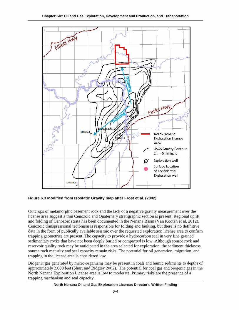
Chapter Six: Oil and Gas Exploration, Development and Production, and Transportation
Outcrops of metamorphic basement rock and the lack of a negative gravity measurement over the license area suggest a thin Cenozoic and Quaternary stratigraphic section is present. Regional uplift and folding of Cenozoic strata has been documented in the Nenana Basin (Van Kooten et al. 2012). Cenozoic transpressional tectonism is responsible for folding and faulting, but there is no definitive data in the form of publically available seismic over the requested exploration license area to confirm trapping geometries are present. The capacity to provide a hydrocarbon seal in very fine grained sedimentary rocks that have not been deeply buried or compacted is low. Although source rock and reservoir quality rock may be anticipated in the area selected for exploration, the sediment thickness, source rock maturity and seal capacity remain risks. The potential for oil generation, migration, and trapping in the license area is considered low.
Biogenic gas generated by micro-organisms may be present in coals and humic sediments to depths of approximately 2,000 feet (Shurr and Ridgley 2002). The potential for coal gas and biogenic gas in the North Nenana Exploration License area is low to moderate. Primary risks are the presence of a trapping mechanism and seal capacity.
Figure 6.3 Modified from Isostatic Gravity map after Frost et al. (2002)
North Nenana Oil and Gas Exploration License: Director’s Written Finding
6-4

Chapter Six: Oil and Gas Exploration, Development and Production, and Transportation
D. Stages of Oil and Gas Resource Development The entire process of locating oil and gas and bringing it to market can be separated into stages: disposal (licensing and leasing), exploration, development and production, and transportation. These stages may occur simultaneously on any part of a license or lease. Whether exploration and eventual development will occur in the license area depends on several factors, such as the subsurface geology of the area, a company’s worldwide exploration strategy, the projected price of oil and gas and their market demand, and other economic, environmental and logistical factors. Geology dictates the extent of exploration.
1. DisposalOil and gas lease sales are a first step in developing the state’s oil and gas resources. Annually, DO&G prepares and presents a 5-year program of oil and gas lease sales to the legislature. DO&G also conducts annual competitive areawide lease sales, offering for lease all available state acreage within five areas. A lease sale area is divided into tracts, and interested parties that qualify may bid on one or more tracts.
Exploration licensing also supplements the state's areawide oil and gas leasing program by targeting areas outside of known oil and gas provinces. The intent of licensing is to encourage exploration in areas far from existing infrastructure, with relatively low or unknown hydrocarbon potential, where there is a higher investment risk to the operator. Because bonus payments are required to win a lease, lease sales held in some of these higher-risk areas tend to attract little participation. Exploration licensing gives an interested party the exclusive right to conduct oil and gas exploration without this initial expense. Through exploration licensing, the state receives valuable subsurface geologic information on these regions and, should development occur, additional revenue through royalties and taxes (AS 38.05.131-134).
2. ExplorationOil and gas resource exploration begins with gathering information about the petroleum potential of an area by examining surface geology, researching data from existing wells, performing environmental assessments, conducting geophysical surveys, and drilling exploratory wells. The surface analysis includes the study of surface topography or the natural surface features, and near-surface structures revealed by examining and mapping nearby exposed rock layers. Geophysical surveys, primarily seismic, help reveal the characteristics of the subsurface geology. Geophysical exploration and exploration drilling are likely activities that could result in potential effects to the sale area.
Seismic exploration and related activities do not require a disposal decision, lease, or approval of the exploration phase, but do require the appropriate authorizations. For example, seismic exploration would require a land use permit issued by DNR. Exploration can also happen at any time. Activities associated with exploration can occur simultaneously, before, after, or even during disposal and development and production. Exploratory drilling, on the other hand, would occur after disposal and require a plan of operations and DO&G approval before a lessee began any on-the-ground work. In the meantime, other operations such as production activities may have already been approved and may be occurring on another part of the lease or unit.
a. Geophysical ExplorationSeismic surveys are the most common type of geophysical exploration. Energy is emitted at the survey location into the subsurface and reflected seismic waves are recorded at the surface geophones and/or hydrophones (vibration-sensitive devices). Different rock layers beneath the surface have different velocities and densities. This results in a unique seismic profile that can be analyzed by geophysicists
North Nenana Oil and Gas Exploration License: Director’s Written Finding
6-5

Chapter Six: Oil and Gas Exploration, Development and Production, and Transportation
to interpret subsurface structures and petroleum potential. Advancements in seismic sensors and recording systems technology have resulted in higher definition and greater productivity. In addition, it is anticipated this will create greater efficiency in exploration with fewer effects on the environment (New Developments in Upstream Oil and Gas Technologies 2011).
Additional geophysical techniques can be used to gather information specifically about very near surface geology, usually to identify drilling hazards. They include high-resolution shallow seismic, side-scan sonar, fathometer recordings and shallow coring programs. High-resolution shallow seismic surveys are specifically designed to image the bottom of a water body and very shallow geology. They employ a lower energy seismic source and a shorter cable than surveys targeting deeper oil and gas potential.
b. Drilling ExplorationExploratory drilling often occurs after seismic surveys are conducted, and review of the seismic and geologic data indicates possible oil and gas prospects. Drilling is the only way to learn whether a prospect contains commercial quantities of oil or gas, and helps determine whether to proceed with development. Drilling operations collect well logs, core samples, cuttings, and a variety of other data. A well log is compiled by lowering measuring instruments in a well bore and taking measurements at various depths. Well logs can also be recorded while drilling. Cores may be cut at various intervals so that geologists and engineers can examine the sequences of rock that are being drilled.
One way to take readings is through Measurements While Drilling (MWD) technology. Tools at the end of the drilling apparatus may include gyroscopes, magnetometers, and accelerometers. These provide real-time drilling information such as wellbore position, drillbit information, directional data, and borehole inclination and azimuth during drilling. These data are transmitted to the surface through pulses through the mud column and electromagnetic telemetry. Data are decoded at the surface and transmitted to an offsite location. This allows drilling engineers to make important decisions while drilling (Rigzone 2015).
3. Development and ProductionDuring development, operators evaluate the results of exploratory drilling and develop plans to bring the discovery into production. Production operations bring well fluids to the surface and prepare them for transport to the processing plant or refinery. The fluids undergo operations to purify, measure, test, and transport. Pumping, storage, handling, and processing are typical production processes (Van Dyke 1997). The final project parameters will depend on the surface location, size, depth, and geology of a specific commercial discovery.
After exploration wells have been drilled, a process called extended reach drilling (ERD) may be used during production (New Developments in Upstream Oil and Gas Technologies 2011). ERD not only reduces wellsite footprints and minimizes environmental effects, but also improves reservoir drainage at the least cost (Schlumberger 2013).
Production facilities contain oil and gas production equipment located within their boundaries (EPA 2015). On the well site, these may include processing facilities to remove some of the water produced with the petroleum, water and sewage treatment equipment, power generators, drilling rigs, and support buildings and housing for workers. Support facilities may include a production facility to receive and treat or transport the oil and gas to markets, refineries, or for shipment to other processing facilities in the lower 48 states and elsewhere. Other support facilities may include a supply base and transportation system for cement, mud, water, food, and other necessary items.
North Nenana Oil and Gas Exploration License: Director’s Written Finding
6-6

Chapter Six: Oil and Gas Exploration, Development and Production, and Transportation
4. Subsurface Oil and Gas Storage Under AS 38.05.180(u), the Commissioner of DNR may authorize the subsurface storage of oil or gas to avoid waste or to promote conservation of natural resources. In Alaska, depleted reservoirs with established well control data are preferred storage zones. By memorandum dated September 2, 2004, the Commissioner approved a supplement to Department Order 003 and delegated the authority to authorize subsurface storage of oil or gas to the Division of Oil and Gas Director.
Subsurface storage of gas increases reliability of gas delivery to all sources of demand. The need for gas storage also depends upon access to transportation, pipeline infrastructure, existing production infrastructure, gas production sources, and delivery points. A subsurface storage authorization allows the storage of gas and associated substances in the portions of the gas storage formation, subject to the terms and applicable statutes and regulations, including mitigation measures and advisories incorporated by reference into the authorization. It does not matter whether the gas is produced from state land, so long as storage occurs in land leased or subject to lease under AS 38.05.180.
5. Transportation Transportation is also a stage of oil and gas resource development. See the next section for further discussion.
E. Likely Methods of Transportation AS 38.05.035(g)(1)(B)(iii) requires the director to consider and discuss the method or methods most likely to be used to transport oil or gas from an area, and the advantages, disadvantages, and relative risks of each. Because natural gas is more likely to be encountered in commercial quantities than oil in the license area, transportation of gas from the area would probably involve the construction of a pipeline transmission system. Strategies used to transport potential oil and gas resources depend on many factors, most of which are unique to an individual discovery. The location and nature of oil and gas deposits determine the type and extent of facilities necessary to develop and transport the resource. DNR and other state, federal and local agencies review the specific transportation system when it is actually proposed. Modern oil and gas transportation systems may consist of pipelines, marine terminals with offshore loading platforms, trucks, and tank vessels. The location and nature of oil or gas deposits determine the type and extent of facilities needed to develop and transport the resource. Due to the limited road system in the license area, the most likely method of transportation will include pipelines. Truck transportation may also be an option
If the license is eventually converted to leases, no oil or gas will be transported from the area until the lessee has obtained the necessary permits and authorizations from federal, state, and local governments. The state has broad authority to withhold, restrict, and condition its approval of transportation facilities. In addition, the federal and local governments may have jurisdiction over various aspects of any transportation alternative. A general overview of the likely transportation methods is discussed below.
1. Pipelines One method of transporting oil and gas is by pipeline. Onshore pipelines may be buried or unburied. Buried pipelines, over which the ground is normally reseeded, are advantageous because they do not pose an obstacle to wildlife or result in scenic degradation. However, buried pipelines are more expensive to install and to maintain than unburied pipelines. This is especially true in regards to inspection, repair and maintenance. Spills may result from pipeline leaks in either buried or unburied
North Nenana Oil and Gas Exploration License: Director’s Written Finding
6-7

Chapter Six: Oil and Gas Exploration, Development and Production, and Transportation
pipelines, and leak detection systems play a primary role in reducing discharges of oil from either system. Elevated pipelines offer more ways to monitor the pipeline such as ground inspection, visual air inspections, and ground-based infrared and airborne forward-looking infrared surveys. In-Line Inspection can be used for both aboveground and belowground crossings, but is the only practical method for belowground installations (SPCO 2011).
2. Marine Terminals If oil or gas must be transported across marine waters by tanker, a marine terminal is necessary. Crude oil terminal facilities generally store quantities of oil equivalent to several large tanker loads. Therefore, a disadvantage of transporting oil or gas by tanker is the possibility for a very large spill at these facilities. A strong earthquake or other natural disaster could damage the facilities and initiate a large spill. The risk of explosion or sabotage at the facilities also exists. Accidental ballast discharge or loading or unloading accidents could also cause a spill. However, environmental risks have been minimized through improved design, construction, operating techniques and spill prevention measures.
The fixed location of loading facilities at marine terminals improves spill response and contingency planning. With constant staffing, leaks are easier to detect than with some pipelines. For example, the Valdez Marine Terminal is staffed 24 hours a day and its oil response crews are trained to conduct land and water response operations. Even though a spill from a tanker is the responsibility of the tanker owner, Alyeska Pipeline Service Company provides initial response. Spill prevention measures include (APSC 2015):
• training; • extensive inspection programs; • monitoring of transfer operations; • facility security programs; • use of proper valves and overfill alarms; • secondary and tertiary containment systems around the tanks; and • drug and alcohol testing of personnel.
3. Tank Vessels Deep water ports are required for tanker operations. The biggest disadvantage for tankers is the potential for a large oil spill, although in recent years spills from pipelines outnumber those from tankers (Etkin 2009). More recently, data indicate tanker spillage continues to decline despite an overall increase in oil trading (ITOPF 2012; Anderson et al. 2012).
Tankers are also used to transport natural gas. Liquefied natural gas (LNG) is methane that has been cooled to an extremely cold temperature (-260° F/ -162.2° C), where it becomes liquid. At standard atmospheric conditions, methane is a vapor. LNG is stored and transported exclusively at cryogenic temperatures, so it is maintained in a liquid state, facilitating storage and transportation. LNG should not be confused with Natural Gas liquid (NGL) or liquefied petroleum gas (LPG), which are transported at near ambient temperature.
4. Trucks Trucks are a likely method of oil and gas transportation. Between 2011 and 2012 trucks moving oil to refineries within the United States and Canada has increased by 38% (IER 2013).
The federal government is the major source for transportation funding in Alaska. The Alaska DOT&PF is responsible for prioritizing, arranging, and administering the majority of capital projects. The State of Alaska pays for maintenance and operations for State roadways, but does not dedicate
North Nenana Oil and Gas Exploration License: Director’s Written Finding
6-8

Chapter Six: Oil and Gas Exploration, Development and Production, and Transportation
revenue to transportation purposes. The Alaska legislature maintains a large degree of control over State transportation programs and priorities. DOT&PF projects and programs must compete each year with other social and infrastructure needs for money from the General Fund (DOT&PF 2004).
5. Summary The mode of transportation from a discovery will be an important factor in determining whether or not a discovery can be economically produced. The more expensive a given transportation option, the larger a discovery will have to be for economic viability. Oil and gas produced from the license area would likely be transported by a system of gathering lines, processing facilities, trucking or marine terminal, and tankers. If resources are discovered and developed, more detailed transportation options, such as exact routes, locations, and size of facilities, would need to be evaluated.
F. Oil Spill Risk, Prevention, and Response 1. Risk Any time crude oil or petroleum products are handled there is a risk that a spill might occur. Oil spills associated with the exploration, development and production, storage, and transportation of crude oil may occur from well blowouts or pipeline or tanker accidents. Petroleum activities may also generate chronic low volume spills involving fuels and other petroleum products associated with normal operation of drilling rigs, vessels and other facilities for gathering, processing, loading, and storing of crude oil. Spills may also be associated with the transportation of refined products to provide fuel for generators, marine vessels and other vehicles used in exploration and development activities.
Although there is a risk spills will result from exploration, production, storage, and transportation of oil and gas, these risks can be mitigated through prevention and response plans, DEC administers and enforces laws and regulations related to oil spill prevention and cleanup contingency plans. To ensure that a contingency plan is not required for a well, DEC requires AOGCC to make a determination that the exploration wells will not penetrate a formation capable of flowing oil to the ground surface (AS 46.04.050; AS 31.05.030(l)). If that determination cannot be made, the licensee is required to have an approved oil discharge prevention and contingency plan (C-Plan) and determination of financial responsibility prior to commencing operations.
2. Prevention A well blowout can take place when high pressure gas is encountered in the well and sufficient precautions, such as increasing the weight of the drilling mud, are not effective. The result is that gas or mud is suddenly and violently expelled from the well bore, followed by uncontrolled flow from the well. Blowout preventers, which immediately close off the open well to prevent or minimize any discharges, are required for all drilling and work-over rigs and are routinely inspected by AOGCC (AS 46.04.030). Blowout preventers greatly reduce the risk of a gas release. If a release occurs, however, the released gas will dissipate unless it is ignited by a spark. Ignition could result in a violent explosion. Each well has a blowout prevention program developed before the well is drilled. Operators review bottom-hole pressure data from existing wells in the area and seismic data to learn what pressures might be expected in the well to be drilled. Engineers use this information to design a drilling mud program with sufficient hydrostatic head to overbalance the formation pressures from surface to the total depth of the well. They also design the casing strings to prevent various formation conditions from affecting well control performance.
If pipelines are used in the development of the license area, operators would follow the appropriate American Petroleum Institute recommended practices. They would inspect the pipelines regularly to
North Nenana Oil and Gas Exploration License: Director’s Written Finding
6-9

Chapter Six: Oil and Gas Exploration, Development and Production, and Transportation
determine if any damage was occurring and would perform regular maintenance. Preventive maintenance includes installing improved cathodic protection, using corrosion inhibitors, and continuing regular visual inspections. An integrity management plan is a documented and systematic approach to ensure the long-term integrity of an asset and a process for assessing and mitigating risks in an effort to reduce the likelihood and consequences of incidents. Basic requirements for an integrity management plan include periodic integrity assessment of pipelines. Integrity assessments are performed by in-line inspection (also referred to as “smart pigging”), hydrostatic pressure testing, or direct assessment. Through these assessment methods, potentially injurious pipeline defects that could eventually weaken the pipe, or even cause it to fail, are identified early and can be repaired. This significantly improves the pipe’s integrity.
They also include development and implementation of a set of safety management and analytical processes collectively referred to as an integrity management program. The purpose of the program is to assure pipeline operators have systematic, rigorous, and documented processes in place.
3. Response Response plans in relation to the license area are included in the Alaska Federal/State Preparedness Plan for Response to Oil and Hazardous Substance Discharges/Releases (Unified Plan) and the Interior Subarea Contingency Plan (DEC 2010b, 2000).
A Unified Command structure of the Incident Command System is the basis for government response and organization in the State of Alaska. The Unified Command brings together the Federal On-Scene Coordinator, the State On-Scene Coordinator, and the Responsible Party’s Incident Commander into one governing unit. If an immediate threat still exists to the health and safety of the local populace the Local On-Scene Coordinator will also be brought in (DEC 2010b, 2000).
Response objectives include (DEC 2010b, 2000):
• ensure safety of responders and the public • stop the source of the spill • deploy equipment to contain and recover the spilled product • protect sensitive areas (environmental, cultural, and human use) • track the extent of the spill and identify impacted areas • cleanup contaminated areas and properly dispose of wastes • notify and update the public • provide avenues for community involvement where appropriate
The federal and state response guidelines include the following action priorities and strategies (DEC 2010b, 2000):
• safety of life • safety of vessel, facility and cargo • control sources of discharge • limit spread of pollution • mitigate effects of pollution
North Nenana Oil and Gas Exploration License: Director’s Written Finding
6-10

Chapter Six: Oil and Gas Exploration, Development and Production, and Transportation
DEC, Division of Spill Prevention and Response is responsible for ensuring facilities prevent spills and take proper response actions when spills occur. One of its programs is the Prevention and Emergency Response Program. Its mission statement is as follows (DEC 2011):
Protect public safety, public health and the environment by preventing and mitigating the effects of oil and hazardous substance releases and ensuring their cleanup through government planning and rapid response.
Because of statutory requirements, the State of Alaska implemented the following Response Objectives (DEC 2010b, 2000, 2011):
• safety—ensure the safety of all persons involved in a response or exposed to the immediate effects of the incident
• public health—ensure the protection of public health from the direct or indirect effects of contaminated drinking water, air or food
• environment—ensure the protection of the environment, including natural and cultural resources, from the direct or indirect effects of contamination
• cleanup—ensure adequate containment, control, cleanup and disposal by the responsible party, or take over the response when cleanup is judged inadequate
• restoration—ensure the assessment of damages from contamination and the restoration of property, natural resources and the environment
• cost recovery—ensure the recovery of costs and penalties for reimbursement to the Oil and Hazardous Substance Release Prevention and Response Fund for use in Future emergency response actions.
North Nenana Oil and Gas Exploration License: Director’s Written Finding
6-11

Chapter Six: Oil and Gas Exploration, Development and Production, and Transportation
G. References Anderson, Cheryl McMahon, Melinda Mayes, and Robert LaBelle. 2012. Update of Occurrence Rates
for Offshore Oil Spills. OCS report. BOEM 2012-069. BSEE 2012-069. http://www.boem.gov/uploadedFiles/BOEM/Environmental_Stewardship/Environmental_Assessment/Oil_Spill_Modeling/AndersonMayesLabelle2012.pdf (Accessed July 15, 2014).
AOGCC (Alaska Oil and Gas Conservation Commission). 2014. Well History Files On-line database. http://aogweb.state.ak.us/WebLink8/Browse.aspx?dbid=0 (Accessed July 15, 2014).
APSC (Alyeska Pipeline Service Company). 2015. Safety and Environment. Oil Spill Prevention, Response and Preparedness. http://www.alyeska-pipe.com/SafetyEnvironment/PreventionAndResponse (Accessed July 15, 2014).
Bradley, D.C., T.M. Kusky, P.J. Haeussler, S.M. Karl, and D.T. Donley. 1999. Geologic map of the Seldovia quadrangle, south-central Alaska: U.S. Geological Survey Open File Report 99-18, 1 sheet, scale 1:250,000. http://pubs.usgs.gov/of/1999/of99-018/ (Accessed January 29, 2015).
Calderwood, K.W., and Fackler, W.C. 1972. Proposed stratigraphic nomenclature for Kenai Group, Cook Inlet basin, Alaska: American Association of Petroleum Geologists Bulletin, v. 56, p. 739-754. http://ngmdb.usgs.gov/Prodesc/proddesc_88259.htm (Accessed
July 15, 2014). C-Core. 2008. Design Options for Offshore Pipelines in the US Beaufort and Chukchi Seas. US
Department of the Interior, Minerals Management Service. Report R-07-078-519v2.0. http://www.bsee.gov/uploadedFiles/BSEE/Research_and_Training/Technology_Assessment_and_Research/tarprojects/500-599/577AA.pdf (Accessed July 15, 2014).
DEC (Alaska Department of Environmental Conservation). 2000. Spill prevention and response. Interior Alaska subarea contingency plan. Change One, April 2007. http://dec.alaska.gov/spar/perp/plans/scp_int.htm (Accessed July 15, 2014).
DEC (Alaska Department of Environmental Conservation). 2010b. Spill prevention and response. Alaska Federal/State preparedness plan for response to oil and hazardous substance discharges/releases (Unified Plan). Change 3 (January 2010). http://www.dec.alaska.gov/spar/perp/plans/uc.htm (Accessed July 15, 2014).
DEC (Alaska Department of Environmental Conservation). 2011. Overview of the Prevention and Emergency Response Program. http://dec.alaska.gov/spar/perp/docs/perp.pdf (Accessed July 15, 2014).
DOT&PF (Department of Transportation and Public Facilities). 2004. Southwest Alaska Transportation Plan. Revised edition, September 2004. http://www.dowlhkm.com/projects/SWAKTP/new_website/docs/swatp%202004.pdf (Accessed January 27, 2014).
EPA (Environmental Protection Agency). 2015. Outdoor air-Industry, business, and home: Oil and natural gas production-Additional information. What are oil and natural gas production facilities. http://www.epa.gov/oaqps001/community/details/oil-gas_addl_info.html (Accessed January 29, 2015).
North Nenana Oil and Gas Exploration License: Director’s Written Finding
6-12

Chapter Six: Oil and Gas Exploration, Development and Production, and Transportation
Etkin, D. S. 2009. Analysis of U.S. Oil Spillage. API Publication 356, Washington, D.C. http://www.api.org/environment-health-and-safety/clean-water/oil-spill-prevention-and-response/~/media/93371edfb94c4b4d9c6bbc766f0c4a40.ashx (Accessed July 15, 2014).
Frost, Gina, M., D.F. Barnes, and R.G. Stanley. 2002. Geologic and isostatic gravity map of the Nenana Basin area, Central Alaska. U.S. Geological Survey. Geologic Investigation Series I-2543, 16p. http://pubs.usgs.gov/imap/i2543/ (Accessed July 15, 2014).
Furchtgott-Roth, Diana. 2013. Pipelines are safest for transportation of oil and gas. Manhattan Institute for Policy Research. Issue brief. No. 23 June 2013. http://www.manhattan-institute.org/html/ib_23.htm (Accessed August 19, 2014).
Institute for Energy Research (IER). 2013. Oil shipments by rail, truck, and barge up substantially. http://www.instituteforenergyresearch.org/2013/09/09/oil-shipments-by-rail-truck-and-barge-up-substantially/ (Accessed August 19, 2014).
ITOPF (International Tanker Owners Pollution Federation Limited). 2012. Oil Tanker Spill Statistics 2013. http://www.itopf.com/knowledge-resources/data-statistics/statistics/ (Accessed July 15, 2014).
New Developments in Upstream Oil and Gas Technologies: Hearing before the Committee on Energy and Natural Resources, United States Senate. 112th Cong. 2011. http://www.gpo.gov/fdsys/pkg/CHRG-112shrg67090/pdf/CHRG-112shrg67090.pdf (Accessed August 19, 2014).
Rigzone. 2015. Training. How it works. How does measurement-while-drilling (MWD) work? http://www.rigzone.com/training/insight.asp?insight_id=296&c_id=1 (Accessed January 29, 2015).
Schlumberger. 2014. Services and Products. Drilling services. Drilling applications. Extended-Reach Drilling (ERD). http://www.slb.com/services/drilling/specialty_drilling_applications/extended_reach_drilling.aspx (Accessed August 19, 2014).
Shurr, George, W. and J. L. Ridgley. 2002. Unconventional shallow biogenic gas systems. AAPG Bulletin. v.86, No. 11, p. 1939-1969. http://pubs.er.usgs.gov/publication/70024183 (Accessed July 16, 2014).
SPCO (State Pipeline Coordinator’s Office). 2011. Personal communication from Louis Kozisek, Chief Engineer, SPCO to Mike Thompson, State Pipeline Coordinator, SPCO. Memo Re: Opinion on Aboveground vs. HDD Pipeline Crossing for the Nigliq Channel. April 12, 2011. http://dnr.alaska.gov/commis/pco/documents/louis_cd5_paper.pdf (Accessed February 13, 2013).
Van Dyke, K. 1997. Fundamentals of petroleum, fourth edition. University of Texas, Petroleum Extension Service, Austin, TX. http://www.abebooks.com/9780886981624/Fundamentals-Petroleum-Dyke-Kate-088698162X/plp (Accessed August 19, 2014).
North Nenana Oil and Gas Exploration License: Director’s Written Finding
6-13

Chapter Six: Oil and Gas Exploration, Development and Production, and Transportation
Van Kooten, Gerald, K., Richter, Michael, and Zippi, Pierre, A. 2012. Alaska’s interior rift basins: A new frontier for discovery; in Oil & Gas Journal 1/9/2012, 18p. http://doyonoil.com/Content/pdfs/OGJ-Doyon.pdf (Accessed July 16, 2014).
Wartes, M. A., R.J. Gillis, T. M. Herriott, R.G. Stanley, K.P. Helmold, C.S. Peterson, and J. A.
Benowitz. 2013. Summary of 2012 Reconnaissance Field Studies Related to the Petroleum Geology of the Nenana Basin, Interior Alaska Division of Geological and Geophysical Surveys, Preliminary Investigative Report 2013-2. http://www.dggs.alaska.gov/pubs/id/24880 (Accessed July 16, 2014).
North Nenana Oil and Gas Exploration License: Director’s Written Finding
6-14

Chapter Seven: Governmental Powers to Regulate Oil and Gas
Table of Contents Page
Chapter Seven: Governmental Powers to Regulate Oil and Gas ....................................................... 7-1 A. Department of Natural Resources (DNR) ................................................................................. 7-1
1. Plan of Operations Approval (DO&G) .................................................................................. 7-12. Geophysical Exploration Permit (DO&G) ............................................................................ 7-13. Pipeline Rights-of-way .......................................................................................................... 7-24. Alaska Petroleum Systems Integrity Office (PSIO) .............................................................. 7-25. Temporary Water Use Authorization (DMLW) .................................................................... 7-36. Permit and Certificate to Appropriate Water (DMLW) ........................................................ 7-37. Land Use Permits (DMLW) .................................................................................................. 7-38. Material Sale Contract (DMLW) ........................................................................................... 7-49. Office of History and Archaeology (OHA) ........................................................................... 7-4
B. Department of Environmental Conservation (DEC) ................................................................. 7-5 1. Interference with Salmon Spawning Permits ........................................................................ 7-52. Air Quality Permits ................................................................................................................ 7-5
a. Title I (NSR) Construction Permits ................................................................................... 7-6b. Title V Operations Permits................................................................................................ 7-6c. Other Requirements ........................................................................................................... 7-6
3. Solid Waste Disposal Permit ................................................................................................. 7-74. Wastewater Disposal Permit .................................................................................................. 7-75. APDES Discharge Permits and Certification ........................................................................ 7-76. Industry Oil Discharge Prevention and Contingency Plans .................................................. 7-7
C. Alaska Department of Fish and Game (ADF&G) ..................................................................... 7-8 1. Fish Habitat Permit ................................................................................................................ 7-82. Public Safety Permit .............................................................................................................. 7-83. Special Area Permit ............................................................................................................... 7-8
D. Alaska Oil and Gas Conservation Commission (AOGCC) ...................................................... 7-9 1. Permit to Drill ........................................................................................................................ 7-92. Underground Injection Control Program (UIC) .................................................................... 7-93. Annular Disposal of Drilling Waste ...................................................................................... 7-94. Disposal Injection Orders ...................................................................................................... 7-95. Area Injection Orders ............................................................................................................ 7-9
E. Department of Labor and Workforce Development (DOLWD) ............................................. 7-10 F. Environmental Protection Agency (EPA) ............................................................................... 7-10
1. Air Quality Permits .............................................................................................................. 7-102. Hazardous Waste (RCRA) Permits ..................................................................................... 7-103. NPDES Discharge Permit .................................................................................................... 7-104. Underground Injection Control (UIC) Class I and II Injection Well Permits ..................... 7-10
G. U.S. Army Corps of Engineers (COE).................................................................................... 7-11 1. Section 10 and Section 404 Permits .................................................................................... 7-11
H. Pipeline and Hazardous Materials Safety Administration (PHMSA) .................................... 7-11 I. Fish and Wildlife Service (USFWS) ....................................................................................... 7-11 J. U.S. Coast Guard...................................................................................................................... 7-12
North Nenana Oil and Gas Exploration License: Director’s Written Finding
i

K. Regulations of Oil Spill Prevention and Response ................................................................. 7-12 L. Alaska National Interest Lands Conservation Act (ANILCA) Title VIII. Section 811 .......... 7-12 M. Native Allotments .................................................................................................................. 7-12 N. References .............................................................................................................................. 7-13
North Nenana Oil and Gas Exploration License: Director’s Written Finding
ii
Chapter Seven: Governmental Powers to Regulate Oil and Gas
Chapter Seven: Governmental Powers to Regulate Oil and Gas AS 38.05.035(g)(1)(B)(v) requires the director to consider and discuss the governmental powers to regulate the exploration, development and production, and transportation of oil and gas or gas only. All exploration license and subsequent lease activities (exploration, development and production, and transportation) are subject to federal, state, and local laws, regulations, ordinances, and policies on the effective date. Licenses and leases are subject to all future laws and regulations in effect after the effective date of the licenses or leases to the full extent constitutionally permissible and are affected by any changes to the responsibilities of oversight agencies.
An exploration license grants the licensee the right to explore, but does not allow it to do any physical work on the land itself. Should exploration, development and production, or transportation proceed and prove successful, foreseeable consequences include building new facilities and infrastructure, and extracting, removing, cleaning, processing and disposing of oil, gas, and associated substances.
This chapter is not a comprehensive description of all of the laws and regulations that may apply to such activities. Rather, it provides a broad overview of the laws and regulations that pertain to oil and gas exploration and development. Actual requirements and processes, terms, and conditions may vary. Regulatory agencies may have different roles in the oversight and regulation of oil and gas activities; although some agencies may have overlapping authorities. The licensee is responsible for knowing and complying with applicable laws, regulations, policies and ordinances.
State of Alaska A. Department of Natural Resources (DNR) DNR has several agencies that approve, oversee, or coordinate activities related to oil and gas.
1. Plan of Operations Approval (DO&G)Operations undertaken on or in the licensed or leased area are regulated under 11 AAC 83.158, 11 AAC 83.346, and the lease. They require the licensee to prepare plans of operations that must be approved by DO&G before the licensee begins work. Each plan of operations is site-specific and is tailored to the proposed activity. DO&G may make field inspections to monitor and assess compliance.
When it considers a plan of operations, DO&G may require stipulations in addition to the mitigation measures developed through the written finding (11 AAC 83.158(e), 11 AAC 83.346(e)). These additional stipulations address site-specific concerns directly associated with the proposed operations. The stipulations are attached to the plan of operations approval and are binding on the licensee. The license also requires the licensee keep the license area open for inspection by authorized state officials. DNR, DEC, ADF&G, and AOGCC may monitor field activities for compliance with each agency’s terms.
2. Geophysical Exploration Permit (DO&G)The geophysical exploration permit is a land use permit issued by DO&G under 11 AAC 96.010. Seismic surveys related to oil and gas are the most common activity authorized by this permit. Submission of seismic exploration and stratigraphic test data to the state is a permit condition (11 AAC 96.210). Under AS 38.05.035(a)(8)(C), geological and geophysical data are held confidential. If the seismic survey is part of an exploration well program, the permit is reviewed as part of the exploration
North Nenana Oil and Gas Exploration License: Director’s Written Finding
7-1

Chapter Seven: Governmental Powers to Regulate Oil and Gas
well permit package. The application must contain the following information in sufficient detail to allow evaluation of the planned activities’ effects on the land:
(1) … a map at a sufficient scale showing the general location of all activities and routes of travel of all equipment for which a permit is required;
(2) a description of the proposed activity, any associated structures, and the type of equipment that will be used (11 AAC 96.030(a)).
DO&G may require security depending on the applicant’s history of compliance and potential risk to the state (11 AAC 96.060).
A geophysical exploration permit is usually issued for a single survey season, but may be extended. If the permit is extended, the director may modify existing terms or add new ones. A permit remains in effect for the term issued, unless revoked sooner. A permit is revocable effective immediately for cause for (1) a violation of a permit provision or (2) a violation of 11 AAC 96. A permit is revocable at will if DO&G determines that revocation is in the state's interest. DO&G will give 30 days’ notice before revoking a permit at will (11 AAC 96.040(a)).
3. Pipeline Rights-of-wayThe State Pipeline Coordinator’s Office (SPCO) administers the Alaska Right-of-Way Leasing Act process (AS 38.35.010). Most oil and gas transportation facilities within the license area or beyond its boundaries must be authorized by SPCO. As prescribed by AS 38.35.010, SPCO issues leases on state land for pipeline rights-of-way (SPCO 2014).
4. Alaska Petroleum Systems Integrity Office (PSIO)The PSIO is the lead state agency for oversight of facilities, equipment, and infrastructure for the sustained production and transportation of oil and natural gas resources in the state. The PSIO was established in 2007 by executive order of the governor to:
(1) ensure that oil and gas infrastructure is designed and maintained in a safe and environmentally sound manner in compliance with state law;
(2) minimize economic impacts of unplanned interruptions in oil and gas production to the ongoing functions of state government;
(3) avoid premature abandonment of oil and gas infrastructure and waste of state resources; and
(4) ensure efficient and effective oversight of oil and gas industry practices by utilizing existing state government structures and processes to the maximum extent possible.
Through designated agency liaisons, PSIO leads interagency efforts to evaluate industry system integrity performance. Designated agencies, to the extent authorized by state regulations, require oil and gas producers and operators to provide comprehensive descriptions of current practices of quality control, quality assurance, monitoring, and inspection used to ensure the integrity and reliability of oil and natural gas facilities, equipment, infrastructure and activities.
The goal of PSIO is to provide a comprehensive and cost-effective approach to statewide oil and gas oversight activities, and to address any gaps in oversight. PSIO is tasked with ensuring that overarching quality management programs are in place and followed, both within industry and involved state agencies. PSIO makes recommendations to the commissioner of DNR regarding gaps, findings and issues that address the reliability and system integrity of oil and gas infrastructure (PSIO 2014).
Additionally, the PSIO Coordinator makes recommendations to the DNR commissioner regarding enforcement actions by DNR and cases to be referred to other state, local, or federal agencies for appropriate civil or criminal penalties available under the law (PSIO 2007).
North Nenana Oil and Gas Exploration License: Director’s Written Finding
7-2
Chapter Seven: Governmental Powers to Regulate Oil and Gas
5. Temporary Water Use Authorization (Division of Mining Land and Water (DMLW))
Exploration activities may require a temporary water use authorization. DMLW administers temporary water use authorizations as required under 11 AAC 93.035 before (1) the temporary use of a significant amount of water, (2) if the use continues for less than five consecutive years, and (3) the water applied for is not otherwise appropriated (DMLW 2014a). The volume of water to be used and permitted depends upon whether it is for consumption or non-consumptive uses, and the duration of use. The authorization may be extended one time for good cause for a period of time not to exceed five years.
The authorization is subject to conditions, including suspension or termination, considered necessary to protect the water rights of other persons or the public interest. Information on lake bathymetry, fish presence, and fish species may be required when winter water withdrawal is proposed to calculate the appropriate withdrawal limits.
6. Permit and Certificate to Appropriate Water (DMLW) Industrial or commercial water use requires a Permit to Appropriate Water under 11 AAC 93.120. The permit is issued for a period of time consistent with the public interest and adequate to finish construction and establish full use of water. The maximum time period for this permit is five years, unless the applicant proves or the commissioner independently determines that a longer period is required. The commissioner may issue a permit subject to terms, conditions, restrictions, and limitations necessary to protect the rights of others, and the public interest. Under 11 AAC 93.120(e), permits are subject to conditions to protect fish and wildlife habitat, recreation, navigation, sanitation or water quality, prior appropriators, or any other purpose the department determines is in the public interest.
A Certificate of Appropriation will be issued under 11 AAC 93.130 if the permit holder:
(1) submits a statement of beneficial use stating that the means necessary for the taking of water have been developed and the permit holder is beneficially using the quantity of water to be certified, along with the required fee; and
(2) has substantially complied with all permit conditions.
7. Land Use Permits (DMLW) DMLW issues land use permits and may require them for oil and gas activities unless the activities are approved under a plan of operations. Land use permits can be issued for periods up to five years depending on the activity.
In accordance with 11 AAC 96.025, generally allowed uses listed in 11 AAC 96.020 are subject to the following conditions:
(1) activities employing wheeled or tracked vehicles must be conducted in a manner that minimizes surface damage;
(2) vehicles must use existing roads and trails whenever possible;
(3) activities must be conducted in a manner that minimizes
(a) disturbance of vegetation, soil stability, or drainage systems;
(b) changing the character of, polluting, or introducing silt and sediment into streams, lakes, ponds, water holes, seeps, and marshes; and
North Nenana Oil and Gas Exploration License: Director’s Written Finding
7-3

Chapter Seven: Governmental Powers to Regulate Oil and Gas
(c) disturbance of fish and wildlife resources;
(4) cuts, fills, and other activities causing a disturbance listed in (3)(A) - (C) of this section must be repaired immediately, and corrective action must be undertaken as may be required by the department;
(5) trails and campsites must be kept clean; garbage and foreign debris must be removed; combustibles may be burned on site unless the department has closed the area to fires during the fire season;
(6) survey monuments, witness corners, reference monuments, mining location posts, homestead entry corner posts, and bearing trees must be protected against destruction, obliteration, and damage; any damaged or obliterated markers must be reestablished as required by the department under AS 34.65.020 and AS 34.65.040;
(7) every reasonable effort must be made to prevent, control, and suppress any fire in the operating area; uncontrolled fires must be immediately reported;
(8) holes, pits, and excavations must be repaired as soon as possible; holes, pits, and excavations necessary to verify discovery on prospecting sites, mining claims, or mining leasehold locations may be left open but must be maintained in a manner that protects public safety; and
(9) on lands subject to a mineral or land estate property interest, entry by a person other than the holder of a property interest, or the holder’s authorized representative, must be made in a manner that prevents unnecessary or unreasonable interference with the rights of the holder of the property interest.
8. Material Sale Contract (DMLW) If the operator proposes to use state-owned gravel or other materials for construction of pads and roads, DMLW requires a material sale contract (11 AAC 71). The contract must include, at a minimum, a description of the sale area; the volume of material to be removed from the sale area; the method of removal of the material; the bonds and deposits required of the purchaser; and the purchaser’s liability under the contract. The material sale contract must also include the purchaser’s site-specific operating requirements.
The contract must state the material that will be extracted. A contract may be extended before its expiration if the DMLW director determines the delay in completing the contract is due to unforeseen events beyond the purchaser’s control, or the extension is in the state’s best interests.
In connection with a material sale, the DMLW director may require the purchaser to provide a performance bond that guarantees performance of the terms of the contract. If required, the bond amount will be based on the total value of the sale. The performance bond must remain in effect for the duration of the contract unless released in writing by the DMLW director.
9. Office of History and Archaeology (OHA) OHA does the work of the State Historic Preservation Office (SHPO) (OHA 2014a). OHA follows the state’s Historic Preservation Plan in maintaining the Alaska Heritage Resources Survey (AHRS), an inventory of all reported historic and prehistoric sites within the state. This inventory includes objects, structures, buildings, sites, districts, and travel ways, with a general provision that they are over 50 years old. The fundamental use of the AHRS is to protect cultural resource sites from unwanted destruction (OHA 2014b). Before beginning a project, information regarding important cultural and historic sites should be obtained by contacting the OHA. The AHRS data sets are “restricted access documents” and specific site location data should not appear in final reports or distributed to others.
AS 41.35.010 declares it is the policy of the state to preserve and protect the historic, prehistoric, and archeological resources of Alaska from loss, desecration, and destruction so that the scientific,
North Nenana Oil and Gas Exploration License: Director’s Written Finding
7-4

Chapter Seven: Governmental Powers to Regulate Oil and Gas
historic, and cultural heritage embodied in these resources may pass undiminished to future generations. Further, the historic, prehistoric, and archeological resources of the state are properly the subject of concerted and coordinated efforts exercised on behalf of the general welfare of the public in order that these resources may be located, preserved, studied, exhibited, and evaluated.
It is unlawful for a person to appropriate, excavate, remove, injure, or destroy, without a permit from the Commissioner, any historic, prehistoric, or archaeological resources of the state (AS 41.35.200(a)).
A person may be charged with criminal mischief in the third degree if a person knowingly:
(A) defaces, damages, or desecrates a cemetery or the contents of a cemetery or a tomb, grave or memorial regardless of whether the tomb, grave, or memorial is in a cemetery or whether the cemetery, tomb, grave, or memorial appears to be abandoned, lost, or neglected; and
(B) removes human remains or associated burial artifacts from a cemetery, tomb, grave, or memorial regardless of whether the cemetery, tomb, grave, or memorial appears to be abandoned, lost, or neglected (AS 11.46.482(a)(3)).
A person who is convicted of violating a provision of AS 41.35.010 –.240 is guilty of a class A misdemeanor. In addition to other penalties and remedies provided by law, a person who violates these provisions is subject to a maximum civil penalty of $100,000 for each violation.
B. Department of Environmental Conservation (DEC) The DEC has statutory responsibility to conserve, improve, and protect Alaska’s natural resources and environment, by controlling air, land, and water pollution, and oil spill prevention and response. DEC implements and coordinates several federal regulatory programs in addition to state laws (DEC 2014e).
1. Interference with Salmon Spawning Permits DEC is responsible for granting or denying permits for activities that interfere with salmon spawning streams and waters. If a person plans to obstruct, divert, or pollute waters of the state utilized by salmon in the propagation of the species, they must first apply for and obtain a permit before beginning any activities (AS 16.10.010).
Permits may be granted if DEC finds the purpose of the permit is to develop power, obtain water for civic, domestic, irrigation, manufacturing, mining, or other purposes with the intent to develop the state’s natural resources. The applicant may also be required to construct and maintain adequate fish ladders, fishways, or other means by which fish may pass over, around, or through the dam, obstruction, or diversion in the pursuit of spawning.
2. Air Quality Permits DEC administers the federal Clean Air Act (42 USC 85 §§7401-7761q) and the state’s air quality program under a federally-approved State Implementation Plan (AS 46.14; 18 AAC 50). Through this plan, federal requirements of the Clean Air Act are met including National Ambient Air Quality Standards (NAAQS), New Source Review (NSR), New Source Performance Standards (NSPS), National Emission Standards for Hazardous Air Pollutants (NESHAP), and Prevention of Significant Deterioration (PSD). Additionally, DEC monitors air quality and compliance.
The NAAQS set limits on pollutants considered harmful to public health and the environment. Limits have been defined for principal pollutants, or criteria pollutants: carbon monoxide, lead, nitrogen dioxide, particulate matter (PM10), particulate matter (PM2.5), ozone, and sulfur dioxide. NSR, a permitting program required for new construction projects, ensures that air quality is not degraded by the new project, and that large new or modified industrial sources will be as clean as possible (EPA
North Nenana Oil and Gas Exploration License: Director’s Written Finding
7-5
Chapter Seven: Governmental Powers to Regulate Oil and Gas
2014e). NSPS are intended to promote use of the best air pollution control technologies available, and it accounts for the cost of technology and any other non-air quality, health, and environmental impact and energy requirements (EPA 2014d). NESHAPs are set for air pollutants that are not covered by NAAQS, but that may be harmful (EPA 2014c). The standards are categorized by type of source, and require the maximum degree of reduction in emissions that is achievable, as determined by the EPA.
The two primary types of permits issued to meet these requirements are Title I Construction Permits and Title V Operation Permits (DEC 2014a). Permits specify what activities are allowed, what emission limits must be met, and may specify how the facility must be operated. Permits may contain monitoring, recordkeeping, and reporting requirements to ensure that the applicant meets the permit requirements (DEC 2014a).
a. Title I (NSR) Construction Permits Title I permits incorporate air quality requirements for the PSD as well as other requirements of the Clean Air Act. This permit must be obtained before onsite construction can begin. Title I permits are required for projects that are new major sources for pollutants, or major modifications at existing sources. PSD requires installation of the "Best Available Control Technology (BACT)"; an air quality analysis; an additional impacts analysis; and public involvement (EPA 2014g).
The permitting process includes a pre-application meeting between the applicant and DEC, several DEC reviews, a Technical Analysis Report, and a 30-day public comment period, after which DEC may issue a final permit. The final permit includes a final Technical Analysis Report and response to comments. The process for a Title I process can take up to 3 years, depending on the amount of meteorological data collection required.
b. Title V Operations Permits The federal Clean Air Act gives EPA authority to limit emissions from point sources (EPA 2014f). EPA regulations require facilities that emit certain pollutants or hazardous substances to obtain a permit to operate the facility, known as a Title V permit. In Alaska, DEC is responsible for issuing Title V permits and making compliance inspections (AS 46.14; 18 AAC 50; DEC 2012a). The permit establishes limits on the type and amount of emissions allowed, requirements for pollution control devices and prevention activities, and monitoring and record keeping requirements (DEC 2014a).
Operators have one year after beginning operations to submit their completed Title V permit application. Operations can continue while DEC processes the application. However, significant revisions to an existing permitted facility cannot be made until DEC approves the permit revision. Processing time for permit revisions can take up to six months. Title V permits and revisions can be processed concurrently with Title I permits.
c. Other Requirements DEC also operates ambient air quality monitoring networks under the provisions of the Prevention of Significant Deterioration Program to assess compliance with the NAAQS for: carbon monoxide, particulates, nitrogen dioxide, sulfur oxide, and lead; assesses ambient air quality for ambient air toxics level; provides technical assistance in developing monitoring plans for air monitoring projects; and issues air advisories to inform the public of hazardous air conditions (DEC 2014a).
Operators in Alaska are required to minimize the volume of gas released, burned, or permitted to escape into the air (20 AAC 25.235(c)). Operators must report monthly to AOGCC any flaring event lasting over an hour. AOGCC investigates these incidents to determine if there was unnecessary waste (AOGCC 2004).
North Nenana Oil and Gas Exploration License: Director’s Written Finding
7-6

Chapter Seven: Governmental Powers to Regulate Oil and Gas
3. Solid Waste Disposal Permit DEC regulates solid waste storage, treatment, transportation, and disposal under 18 AAC 60. EPA administers the Resource Conservation and Recovery Act (RCRA) relating to hazardous wastes and UIC Class I injection wells. A different state agency, the AOGCC, regulates UIC Class II oil and gas waste management wells.
DEC requires a comprehensive disposal plan for all solid waste disposal facilities it regulates. Solid waste disposal permit applications are reviewed for compliance with air and water quality standards, wastewater disposal, and drinking water standards, and their consistency with the Alaska Historic Preservation Act before approval.
Non-drilling related solid waste must be disposed of in an approved municipal solid waste landfill (MSWLF). MSWLFs are regulated under 18 AAC 60.300 – .398. All other solid waste (except for hazardous materials) must be disposed of in an approved monofill (18 AAC 60.400 – .495).
Drilling waste disposal is specifically regulated under 18 AAC 60.430. Design and monitoring requirements for drilling waste disposal facilities are identified in 18 AAC 60.430(c) and (d).
All produced waters must be reinjected down well or treated to meet Alaska Water Quality Standards before discharge.
Hazardous substances to be disposed of have a separate permitting and review process by both DEC under 18 AAC 62 and 63 and the EPA.
4. Wastewater Disposal Permit Domestic graywater must be disposed of properly at the surface and requires a wastewater disposal permit (18 AAC 72). Monitoring records must be available for inspection, and a written report may be required upon completion of operations.
5. APDES Discharge Permits and Certification DEC administers the Alaska Pollution Discharge Elimination System (APDES) program. This program regulates discharges of pollutants into U.S. waters by “point sources,” such as industrial and municipal facilities. Permits are designed to maximize treatment and minimize harmful effects of discharges.
APDES covers a broad range of pollutants, which are defined as “any type of industrial, municipal, and agricultural waste discharged into water” (18 AAC 83.990).
There are two basic types of APDES permits: general permits and individual permits. General permits cover multiple facilities that are similar. Individual permits are issued for a defined time period, not exceeding five years, and the facility must reapply for the permit before it expires.
6. Industry Oil Discharge Prevention and Contingency Plans DEC regulates spill prevention and response under AS 46.04.030 (DEC 2014f). ADF&G and DNR support DEC in these efforts by providing expertise and information. Contingency plans (C-plans) must be filed with DEC before beginning operations. DNR reviews and comments to DEC regarding the adequacy of these C-plans (DEC 2014b).
C-plans for exploration facilities must include a description of methods for responding to and controlling blowouts, the location and identification of oil spill cleanup equipment, the location and availability of suitable drilling equipment, and an operations plan to mobilize and drill a relief well. Holders of approved plans are required to have sufficient oil discharge containment, storage, transfer, cleanup equipment, personnel, and resources to meet the response planning standards for the particular
North Nenana Oil and Gas Exploration License: Director’s Written Finding
7-7
Chapter Seven: Governmental Powers to Regulate Oil and Gas
type of facility, pipeline, tank vessel, or oil barge (AS 46.04.030(k)). If development and production follow, additional contingency plans must be filed for each facility before activity commences.
Discharges of oil or hazardous substances must be reported to DEC recording the volume released, whether the release is to land or to water, and whether the release has been contained by a secondary containment or structure. The discharge must be cleaned up to DEC’s satisfaction. DEC will modify proposed cleanup techniques or require additional cleanup techniques for the site as DEC determines to be necessary to protect human health, safety, and welfare, and the environment (18 AAC 75.335(d)).
C-plans must describe existing and proposed means of oil discharge detection, including surveillance schedules, leak detection, observation wells, monitoring systems, and spill-detection instrumentation (AS 46.04.030; 18 AAC 75.425(e)(2)(E)). C-plans must include: a Response Action Plan, a Prevention Plan, and Supplemental Information to support the response plan, including a Best Available Technology Section (18 AAC 75.425). Operators must also provide proof of financial ability to respond to damages (AS 46.04.040).
C. Alaska Department of Fish and Game (ADF&G) ADF&G has statutory responsibility to protect, maintain, and improve the fish, game, and aquatic plant resources of the state, and manage their use and development in the interest of the economy and general well-being of the people of the state (AS 16.05.020(2)), consistent with the sustained yield principle. To implement this mission, the ADF&G examines potential exploration and development projects to evaluate the potential effects to fish and wildlife, their habitat, and human use of fish and wildlife resources.
1. Fish Habitat PermitUnder AS 16.05.841, a fish habitat permit is required to ensure that any stream frequented by any fish is not obstructed in a way that would block fish passage. Under AS 16.05.871(b) a fish habitat permit is required before performing any work that would affect a cataloged anadromous fish water body, including operating vehicles or equipment in the stream bed, or using, diverting, obstructing, polluting or changing the natural flow or bed of an anadromous river, lake or stream. ADF&G requires submission of plans and specifications for proposed actions and measures for the proper protection of fish and game.
2. Public Safety PermitA permit to haze birds and mammals, and to lethally take animals of those species that present an imminent threat to safety of people, may be issued for public safety or spill response.
3. Special Area PermitAny land or water use activities in an ADF&G special area that may impact fish, wildlife, habitats, or existing public use may require a special area permit (AS 16.20.060, 5 AAC 95.420). Special areas are legislatively designated refuges, sanctuaries, or critical habitat areas.
Special Area Permits will be required for exploration and development activities that alter or potentially alter fish or wildlife habitat. Among some of the issues the ADF&G will examine during review of the exploration plan and potentially any development plan for the North Nenana Exploration License Area would include seismic exploration activities: the type, extent and timing; trail clearing and use as it relates to wetland degradation or increased access; summer and winter water withdrawal; winter ice bridge crossings of fish-bearing waterbodies; methods of construction of pipelines across fish-bearing waterbodies; adequacy of elevated pipeline heights to ensure passage of moose; minimization of human-bear interactions through the preparation of a human-bear interaction plan; gravel mining for exploration and development activities; and construction of permanent roads.
North Nenana Oil and Gas Exploration License: Director’s Written Finding
7-8

Chapter Seven: Governmental Powers to Regulate Oil and Gas
D. Alaska Oil and Gas Conservation Commission (AOGCC) The Alaska Oil and Gas Conservation Act, AS 31.05, created the Alaska Oil and Gas Conservation Commission (AOGCC). AOGCC was established to prevent waste, protect correlative rights, improve ultimate recovery, and protect underground freshwater.
Among its other duties, AOGCC issues permits and orders, and administers the Underground Injection Control (UIC) Program for the State of Alaska, as the delegated authority of the federal Safe Drinking Water Act.
1. Permit to Drill A permit to drill from AOGCC is often the last step in the overall approval process, and usually occurs after all of the other concerned agencies have given their approval. The application must be accompanied by the items set out in 20 AAC 25.005(c). AOGCC will notify the applicant if there are any deficiencies in the application. The operator will either supplement the original application with revised or additional information, or, in the event that substantive changes are needed, resubmit the entire application (AOGCC 2014).
2. Underground Injection Control Program (UIC) The AOGCC regulates Class II wells in Alaska through a Memorandum of Understanding with the EPA. The goal of the UIC program is to protect underground sources of drinking water from contamination by oil and gas (Class II) injection activities. The three types of Class II wells include oilfield waste disposal wells, enhanced oil recovery (EOR) wells, and hydrocarbon storage wells. AOGCC reviews and takes appropriate action on proposals for the underground disposal of Class II oil field wastes (20 AAC 25.252). Before receiving an approval, an operator must demonstrate that injected fluids will not move into freshwater sources. Disposal or storage wells must be cased and the casing cemented in a manner that will isolate the disposal or storage zone and protect oil, gas, and freshwater sources (AOGCC 2014).
Once approved, liquid waste from drilling operations may be injected through a dedicated tubing string into the approved subsurface zone. The pumping of drilling wastes through the annular space of a well is an operation incidental to drilling of the well, and is not a disposal operation subject to regulation as a Class II well.
3. Annular Disposal of Drilling Waste An AOGCC permit is required if waste fluid is to be injected into a well annulus. The material must be muds and cuttings incidental to the drilling of a well. AOGCC considers the volume, depth, and other physical and chemical characteristics of the formation designated to receive the waste. Annular disposal is not permitted into water bearing zones where dissolved solids or salinity concentrations fall below predetermined threshold limits. Waste not generated from a hydrocarbon reservoir cannot be injected into a reservoir (AOGCC 2014)
4. Disposal Injection Orders Operators may apply for disposal injection orders to dispose of waste in individual wells. After the public review process and AOGCC analysis, an order may be issued that approves the proposed disposal project (AOGCC 2014).
5. Area Injection Orders Injection orders may be issued on an area basis rather than for individual wells in areas where greater activity is anticipated. The area injection orders describe, evaluate, and approve subsurface injection on an area wide basis for enhanced oil recovery and disposal purposes (AOGCC 2014).
North Nenana Oil and Gas Exploration License: Director’s Written Finding
7-9

Chapter Seven: Governmental Powers to Regulate Oil and Gas
E. Department of Labor and Workforce Development (DOLWD)
The Alaska Department of Labor and Workforce Development (DOLWD) administers the Alaska Employment Security Act under AS 23.30 and 8 AAC 85.
DOLWD also administers some delegated authorities of the Occupational Safety and Health Administration (OSHA), PL-91-596, 1970. Section 18 of the law, State Jurisdiction and State Plans, allows states to obtain approval to assume responsibility for development and enforcement of federal occupational safety and health standards. DOLWD has obtained approval from OSHA for administration of some of the federal OSHA standards (OSHA 2014; DOLWD 2014h).
Federal F. Environmental Protection Agency (EPA) The U.S. Environmental Protection Agency (EPA) implements, administers, or oversees programs and federal environmental regulations. These programs, some of which are delegated to the states, safeguard the air, land, and water.
1. Air Quality Permits DEC administers the federal Clean Air Act and the air quality program for the State of Alaska under a federally-approved State Implementation Plan (see Section B2) (EPA 2014a).
2. Hazardous Waste (RCRA) Permits The federal Resource Conservation and Recovery Act (RCRA) regulates the management of solid waste, hazardous waste, and underground storage tanks holding petroleum products or certain chemicals. Regulations set the parameters for transporting, storing, and disposing of hazardous wastes and for designing and operating treatment, storage, and disposal facilities safely. Regulations are enforced through inspections, monitoring of waste handlers, taking legal action for noncompliance, and providing compliance incentives and assistance (EPA 2014b).
Some states may receive authorization to administer parts of the program, which requires the state standards be at least as strict as federal standards. EPA administers the RCRA program in Alaska.
3. NPDES Discharge Permit DEC administers this EPA program, now titled APDES (see Section B). Permits specify the type and amount of pollutant, and include monitoring and reporting requirements, so that discharges do not harm water quality and human health.
4. Underground Injection Control (UIC) Class I and II Injection Well Permits
EPA regulates injection wells used to dispose of fluid pumped into the well. Authorized as part of the federal Safe Drinking Water Act of 1974, EPA’s Underground Injection Control (UIC) program protects underground sources of drinking water from being contaminated by the waste injected in the wells. Injection wells are categorized into five classes; Classes I and II are most common in the oil and gas industry. EPA administers the program for Class I wells in Alaska, and authority for Class II oil and gas wells has been delegated to AOGCC (see Section D.).
All injections falling into Class I must be authorized through EPA’s UIC Class I program. Class I wells must operate under a permit that is valid for up to 10 years. Permits stipulate requirements such as
North Nenana Oil and Gas Exploration License: Director’s Written Finding
7-10

Chapter Seven: Governmental Powers to Regulate Oil and Gas
siting, construction, operation, monitoring and testing, reporting and record keeping, and closure. Requirements differ for wells depending on whether they accept hazardous or non-hazardous wastes.
G. U.S. Army Corps of Engineers (COE) 1. Section 10 and Section 404 Permits The COE has regulatory authority over construction, excavation, or deposition of materials in, over, or under navigable waters of the United States, or any work which would affect the course, location, condition, or capacity of those waters (Rivers and Harbors Acts of 1890 [superseded] and 1899 [33 USC 401, et seq.; Section 10 [33 USC 403; COE 2014). Section 10 permits cover oil and gas activities, including exploration drilling from jack-up drill rigs and installation of production platforms.
Section 404 of the Clean Water Act regulates discharge of dredged and fill material into United States waters and wetlands. This program is administered by COE, which is authorized to issue Section 404 permits for discharging dredge and fill materials.
Permits issued for specific projects are the basic type of permit issued. General permits (including programmatic, nationwide, and regional general permits) authorize activities that are minor and will result in minimal individual and cumulative adverse effects. General permits carry a standard set of stipulations and mitigation measures. Letters of permission, another type of project authorization, are used when the proposed project will not have significant individual or cumulative environmental impact, and appreciable opposition is not expected (COE 2014).
Section 404 and Section 10 permits follow a similar three-step review process: pre-application consultation (for major projects), formal project review, and decision making.
In making a final decision on whether to issue a permit, COE considers conservation, economics, aesthetics, wetlands, cultural values, navigation, fish and wildlife values, water supply, water quality, and other factors judged important to the needs and welfare of the people (COE 2014).
The process for letters of permission is shorter. In this situation, the proposal is coordinated with fish and wildlife agencies and adjacent property owners who might be affected by the project, but the public is not notified (COE 2014).
DEC reviews Section 404 and 10 permit applications for compliance with Alaska water quality standards. If the applications comply, DEC approves the permit.
Permits may also be reviewed by other agencies, such as USFWS and NMFS, to ensure compliance with the Endangered Species Act, the National Environmental Policy Act, and Essential Fish Habitat Provisions of the Magnuson-Stevens Act.
H. Pipeline and Hazardous Materials Safety Administration (PHMSA)
The Federal Office of Pipeline Safety (OPS) in the Pipeline and Hazardous Materials Safety Administration (PHMSA), an agency of the U.S. Department of Transportation, regulates movement of hazardous materials by pipeline (PHMSA 2014a). Federal PHMSA inspectors review technical issues on hazardous liquid pipelines in Alaska (PHMSA 2014b). The 2006, PIPES Act requires hazardous liquid pipeline operators to develop integrity management programs for transmission pipelines.
I. Fish and Wildlife Service (USFWS) USFWS is a part of the Department of the Interior and dedicated to the conservation of natural resources. It has management authority for migratory birds, threatened and endangered species, the
North Nenana Oil and Gas Exploration License: Director’s Written Finding
7-11
Chapter Seven: Governmental Powers to Regulate Oil and Gas
national wildlife refuge system, and on lands under their jurisdiction, landscape conservation and aquatic resources (USFWS 2014b). USFWS issues permits related to migratory birds and endangered species, with the goal of managing risks and benefits of projects by using best available science and expertise. Permits may authorize activities consistent with conservation, protection and enhancement of wildlife, plants, and their habitats (USFWS 2014a).
J. U.S. Coast Guard The U.S. Coast Guard has authority to regulate oil pollution under 33 CFR §§153-157 in waters of the United States and to make a determination of a hazard to navigation under 33 CFR §64.31.
K. Regulations of Oil Spill Prevention and Response Section 105 of the Comprehensive Environmental Response, Compensation, and Liability Act of 1980 (CERCLA) (42 USC §9605), and §311(c)(2) of the Clean Water Act, as amended (33 USC §1321(c)(2)) require environmental protection from oil spills. CERCLA and the Clean Water Act require a National Oil and Hazardous Substances Pollution Contingency Plan (40 CFR §300; 33 USC §1321(d)). Under these regulations, the violator must plan to prevent and immediately respond to oil and hazardous substance spills and be financially liable for any spill cleanup. If the pre-designated Federal On-Scene Coordinator (FOSC) determines that the response is neither timely nor adequate, the federal government will respond to the spill, and then seek to recover cleanup costs from the responsible party.
The Oil Pollution Act of 1990 (OPA 1990) requires the development of facility and tank vessel response plans and an area-level planning and coordination structure to coordinate federal, regional, and local government planning efforts with the industry. OPA 1990 amended the Clean Water Act (§311(j)(4); 33 USC §1231(j)) and established regional citizen advisory councils (RCACs) and area contingency plans as the main parts of the national response planning structure.
The Alaska Regional Response Team (ARRT) is an advisory board to the FOSC. It provides processes for participation by federal, state and local governmental agencies to participate in response to pollution incidents (DEC 2010a). The Unified Plan is the area contingency plan for Alaska. Since Alaska is so large and geographically diverse, the federal agencies have found it necessary to prepare subarea contingency plans.
L. Alaska National Interest Lands Conservation Act (ANILCA) Title VIII. Section 811
ANILCA ensures that rural residents engaged in subsistence uses shall have reasonable access to subsistence resources on public land.
M. Native Allotments Licensees must comply with applicable federal law concerning Native allotments. Activities proposed in a plan of operations must not unreasonably diminish the use and enjoyment of lands within a Native allotment. Before entering lands subject to a pending or approved Native allotment, licensees must contact the Bureau of Indian Affairs (BIA) and the Bureau of Land Management (BLM) and obtain approval to enter.
North Nenana Oil and Gas Exploration License: Director’s Written Finding
7-12

Chapter Seven: Governmental Powers to Regulate Oil and Gas
N. References AOGCC (Alaska Oil and Gas Conservation Commission). 2004. 2004 annual report. Gas disposition.
February 17, 2006 update. http://www.aogcc.alaska.gov/annual/2004/2004_Gas_Disposition_Final.pdf (Accessed August 19, 2014).
AOGCC (Alaska Oil and Gas Conservation Commission). 2014. AOGCC Oversight and Surveillance. http://doa.alaska.gov/ogc/functions/OvrSurvIndex.html#PTD (Accessed March 28, 2014).
COE (U.S. Army Corps of Engineers). 2014. Regulatory program overview and permits. Alaska District. http://www.poa.usace.army.mil/Missions/Regulatory.aspx (Accessed August 19, 2014).
DEC (Alaska Department of Environmental Conservation). 2010a. Alaska Regional Response Team (ARRT) Charter. http://www.akrrt.org/Archives/ARRT-Final-Charter-27Jan10-w-enclosures.pdf (Accessed August 19, 2014).
DEC (Department of Environmental Conservation). 2014a. Air permits program. Air Permits Program. http://www.dec.state.ak.us/air/ap/permit.htm (Accessed August 19, 2014).
DEC (Department of Environmental Conservation). 2014b. Division of Spill Prevention and Response. DEC SPAR. http://www.dec.state.ak.us/spar/index.htm (Accessed August 19, 2014).
DEC (Department of Environmental Conservation). 2014e. Office of the Commissioner Department Policy. Office of the Commissioner. http://www.dec.alaska.gov/commish/index.htm#commish_bio (Accessed August 19, 2014).
DEC (Department of Environmental Conservation). 2014f. Oil discharge prevention and contingency plan contents 18 AAC 75.425. http://www.dec.alaska.gov/commish/regulations/index.htm (Accessed August 19, 2014).
DMLW (Division of Mining, Land and Water). 2014a. Water Rights in Alaska. http://dnr.alaska.gov/mlw/water/wrfact.cfm (Accessed August 19, 2014).
DOLWD (Alaska Department of Labor and Workforce Development). 2014h. Alaska Employment Security Act AS 23.05. http://labor.alaska.gov/esd/ (Accessed August 19, 2014).
EPA (Environmental Protection Agency). 2014a. Air permit agencies - Alaska. Region 10 EPA Air Program. http://yosemite.epa.gov/R10/AIRPAGE.NSF/Permits/airpermits+AK (Accessed August 19, 2014).
EPA (Environmental Protection Agency). 2014b. Managing Hazardous Waste (RCRA). Region 10 EPA Waste & Chemical Management Program. http://yosemite.epa.gov/r10/owcm.nsf/7468f0692f73df9a88256500005d62e8/1a9900b8c988454b8825675f00775776?opendocument#overview (Accessed August 19, 2014).
EPA (Environmental Protection Agency). 2014c. National emission standards for hazardous air pollutants (NESHAP). Technology Transfer Network, Air Toxics Website. http://www.epa.gov/ttn/atw/mactfnlalph.html (Accessed August 19, 2014).
EPA (Environmental Protection Agency). 2014d. New source performance standards. Region 7 Air Program. http://www.epa.gov/region7/air/nsps/nsps.htm (Accessed August 19, 2014).
EPA (Environmental Protection Agency). 2014e. New Source Review (NSR). New Source Review. http://www.epa.gov/nsr/index.html (Accessed August 19, 2014).
North Nenana Oil and Gas Exploration License: Director’s Written Finding
7-13

Chapter Seven: Governmental Powers to Regulate Oil and Gas
EPA (Environmental Protection Agency). 2014f. Plain English guide to the Clean Air Act. Office of Air Quality Planning and Standards, Publication No. EPA-456/K-07-001. http://www.epa.gov/air/caa/peg/ (Accessed August 19, 2014).
EPA (Environmental Protection Agency). 2014g. Prevention of significant deterioration (PSD) basic information. http://www.epa.gov/nsr/psd.html (Accessed August 19, 2014).
OHA (Office of History and Archaeology) 2014a. Alaska Office of History and Archaeology and State Historic Preservation Office. http://dnr.alaska.gov/parks/oha/ (Accessed August 19, 2014).
OHA (Office of History and Archaeology). 2014b. Alaska Heritage Resources Survey-General Overview. http://dnr.alaska.gov/parks/oha/ahrs/ahrs.htm (Accessed August 19, 2014).
OSHA (Occupational Safety & Health Administration). 2014. Occupational Safety & Health Administration 1970, PL 91-596, December 29, 1970. http://www.osha.gov/pls/oshaweb/owasrch.search_form?p_doc_type=OSHACT&p_toc_level=0&p_keyvalue= (Accessed August 19, 2014).
PHMSA (Pipeline and Hazardous Materials Safety Administration). 2014a. Pipeline and Hazardous Materials Safety Administration - About Us. U.S. Department of Transportation. http://www.phmsa.dot.gov/pipeline/about (Accessed August 19, 2014).
PHMSA (Pipeline and Hazardous Materials Safety Administration). 2014b. PHMSA and pipelines FAQs. U.S. Department of Transportation. http://www.phmsa.dot.gov/portal/site/PHMSA/menuitem.7c371785a639f2e55cf2031050248a0c/?vgnextoid=daa52186536b8210VgnVCM1000001ecb7898RCRD (Accessed August 19, 2014).
PSIO (Petroleum Systems Integrity Office). 2007. Administrative Order No. 234. http://www.gov.state.ak.us/admin-orders/234.html (Accessed March 1, 2014).
PSIO (Petroleum Systems Integrity Office). 2014. Mission. http://dnr.alaska.gov/commis/pco/psio.html (Accessed March 1, 2014).
SPCO (State Pipeline Coordinator's Office). 2014. State Pipeline Coordinator's Office. About the SPCO. http://dnr.alaska.gov/commis/pco/aboutus.htm (Accessed August 19, 2014).
USFWS (U.S. Fish and Wildlife Service). 2014a. U.S. Fish & Wildlife Service, Alaska Region: Leaving a lasting legacy, permits as a conservation tool. http://www.fws.gov/permits/legacyfs.pdf (Accessed August 19, 2014).
USFWS (U.S. Fish and Wildlife Service). 2014b. U.S. Fish & Wildlife Service, Alaska Region: Management in Action. http://alaska.fws.gov/mission.htm (Accessed August 19, 2014).
North Nenana Oil and Gas Exploration License: Director’s Written Finding
7-14

Chapter Eight: Reasonably Foreseeable Effects of Licensing and Subsequent Activity
Table of Contents
Page Chapter Eight: Reasonably Foreseeable Effects of Licensing and Subsequent Activity ................... 8-1
A. Terrestrial and Freshwater Habitats .......................................................................................... 8-1 1. Potential Activities and Cumulative Effects .......................................................................... 8-1 2. Mitigation Measures and Other Regulatory Protections ....................................................... 8-2
B. Fish ............................................................................................................................................ 8-3 1. Potential Activities and Cumulative Effects .......................................................................... 8-3
a. Effects of Seismic Surveys, Construction, Discharges, and Other Activities on Fish .................................................................................................................................. 8-3
2. Mitigation Measures and Other Regulatory Protections ....................................................... 8-3 C. Birds and Terrestrial Wildlife ................................................................................................... 8-4
1. Potential Activities and Cumulative Effects .......................................................................... 8-4 a. Effects of Seismic Surveys, Construction, Discharges, and Other Activities on
Birds ................................................................................................................................. 8-4 b. Effects of Seismic Surveys, Construction, and Other Activities on Terrestrial
Wildlife ............................................................................................................................ 8-5 i. Caribou ........................................................................................................................... 8-5 ii. Black and Brown Bears ................................................................................................ 8-5 iii. Moose .......................................................................................................................... 8-6 iv. Furbearers..................................................................................................................... 8-6
2. Mitigation Measures and Other Regulatory Protections ....................................................... 8-6 D. Air Quality ................................................................................................................................ 8-6
1. Potential Activities and Cumulative Effects .......................................................................... 8-6 2. Mitigation Measures and Other Regulatory Protections ....................................................... 8-8
E. Subsistence Uses ....................................................................................................................... 8-8 1. Potential Activities and Cumulative Effects .......................................................................... 8-8 2. Mitigation Measures and Other Regulatory Protections ..................................................... 8-10
F. Commercial Fishing and Sport Fishing and Hunting .............................................................. 8-10 1. Potential Activities and Cumulative Effects ........................................................................ 8-10 2. Mitigation Measures and Other Regulatory Protections ..................................................... 8-10
G. Historic and Cultural Resources ............................................................................................. 8-11 1. Potential Activities and Cumulative Effects ........................................................................ 8-11 2. Mitigation Measures and Other Regulatory Protections ..................................................... 8-11
H. Fiscal Effects on the State, Affected Municipalities, and Communities................................. 8-11 1. Fiscal Effects on the State ................................................................................................... 8-11 2. Fiscal Effects on Affected Municipalities and Communities .............................................. 8-12
I. Effects of Oil and Gas on Affected Municipalities and Communities ..................................... 8-12 1. Oil and Gas Industry Expenditures and Employment ......................................................... 8-12 2. Energy Needs of Local Communities .................................................................................. 8-13
North Nenana Oil and Gas Exploration License: Director’s Written Finding
i

Chapter Eight: Reasonably Foreseeable Effects of Licensing and Subsequent Activity
3. Access .................................................................................................................................. 8-13 4. Recreation and Tourism ...................................................................................................... 8-14 5. Mitigation Measures and Other Regulatory Protections ..................................................... 8-14
J. References ................................................................................................................................ 8-15
North Nenana Oil and Gas Exploration License: Director’s Written Finding
ii

Chapter Eight: Reasonably Foreseeable Effects of Licensing and Subsequent Activity
Chapter Eight: Reasonably Foreseeable Effects of Licensing and Subsequent Activity This chapter considers and discusses reasonably foreseeable effects that the license and subsequent activities could have on habitats, fish and wildlife populations, and their uses of the license area, and potential effects on historic and cultural resources, fiscal effects, and effects on local communities as required by AS 38.05.035(g)(1)(B)(vi), (ix), (x).
The director has limited the scope to considering and discussing those effects on the important subsistence, sport, and commercial species, and uses of the license area described in Chapters Four and Five (AS 38.05.035(e)(1)(B)). The director has limited the administrative review for this exploration license to the disposal phaseand has limited the scope of review to significant effects as explained in Chapter Two. Although the license issuance itself is not expected to have any effects other than to provide initial revenue to the state, DNR possesses a body of knowledge covering oil and gas activities in Alaska and elsewhere that demonstrates the potential cumulative effects that could occur in the license area as a result of subsequent activity. As a result, these effects are considered and discussed below, as required by AS 38.05.035(g). Also included in the scope of review are concerns raised in public comments on the license application (AS 38.05.035(g)(1)(A). In addition to being addressed in this chapter, specific comments are provided in Appendix A.
Alaska statutes specify that speculation about possible future effects is not required (AS 38.05.035(h)). However, a large body of research on the effects of oil and gas exploration, development, and transportation is available to the director, much of which is applicable to the license area. In particular, many studies are available on the effects of oil and gas development for arctic and northern habitats, fish, and wildlife, as well as concerning industrial development in boreal forests of Canada. Although the license area may differ from these areas in some respects, the license area shares much in common with these environments, thus much of this body of knowledge is applicable to the license area.
A. Terrestrial and Freshwater Habitats 1. Potential Activities and Cumulative Effects Oil and gas activities related to exploration and development may impact or alter landscapes and habitats. These activities include seismic surveys; environmental and other studies; excavation of gravel material sites; construction and use of support facilities such as gravel pads, staging areas, roads, airstrips, pipelines, and housing; transportation of machinery and labor to the site; and construction of drill sites and ongoing production activities. More often trucks are becoming a popular mode of transportation. However, transporting oil and gas by pipeline is safer than trucks on roadways when measured by incidents, injuries, and fatalities (Furchtgott-Roth 2013).
Construction, blasting, dredging, seismic operations, vegetation clearing, and boat traffic may all affect terrestrial and freshwater habitats. More specifically, the building and maintenance of roads, trails, highways, and railways may result in direct loss of habitat, degradation of habitat quality, degradation of water quality, habitat fragmentation, and reduced access to vital wildlife habitats. Fish and wildlife may avoid these areas and experience increased exploitation by humans. Further, fish and wildlife populations may experience splitting and isolation along with a disruption in their social structure and the processes that maintain regional populations (ADF&G 2006 citing Jackson 2000). Further, roads and other travel conduits may allow invasive species to displace native species through unintended species introduction. Plant seeds may hitchhike on animals, people, or vehicles just as
North Nenana Oil and Gas Exploration License: Director’s Written Finding
8-1

Chapter Eight: Reasonably Foreseeable Effects of Licensing and Subsequent Activity
easily as nonindigenous freshwater mussels may be brought in on a tourist’s waders (ADF&G 2006). Unsanctioned, illegal, and unintentional introductions of aquatic organisms may also be facilitated by public road access to water bodies (Trombulak and Frissell 2000).
In addition, waters produced and discharged during oil and gas production activities may contain toxic levels of heavy metals, radioactive particles, and brine, and persist for longer periods of time. When these production waters are discharged to land they can be more devastating to plants and animals than crude oil (Bromley 1985). Heavy metals associated with the maintenance and use of roads may be introduced into the environment harming habitats and wildlife alike (Trombulak and Frissell 2000). Leaky underground storage containers are another potential source of contamination to ground water. They may contribute to surface water contamination, impair subsistence, sport, and commercial harvests, and result in significant economic losses (DEC 2014c).
Because freshwater and terrestrial environments are so interdependent, fish and wildlife may contact spilled oil on the water’s surface, in water columns, and on or along shorelines, or marshes. The number and type of species affected depends on several variables. Some of these include: location and size of spill, characteristics of oil, weather, prevailing currents and water conditions, types of habitat affected, and time of year the spill occurs (ADF&G 2006).
Sensitive use areas and habitats are especially important to wildlife. Depending on the species, time of year, and location of disturbance, wildlife populations will differ greatly in their sensitivity to an activity (MoE 2009).
2. Mitigation Measures and Other Regulatory Protections Although oil and gas activities subsequent to licensing and exploration could potentially have cumulative effects on terrestrial and freshwater habitats, measures in this best interest finding, along with regulations imposed by other state, federal, and local agencies, are expected to mitigate those potential effects.
For example, administration of the federal Clean Water Act (32 USC § § 1251-1376) and state water quality statutes (18AAC75, AS 46.03, AS 46.15) are expected to mitigate potential effects. Therefore, additional DO&G mitigation measures specifically addressing water quality are not included in the finding; water quality regulations are under DEC’s jurisdiction.
In addition, standard DNR land use permit conditions serve to protect habitat and water quality from potential negative effects of facility construction and operation. Work areas must be kept clean. Trash, survey markers, and other debris that may accumulate in camps or along seismic lines and travel routes that are not recovered during the initial cleanup must be picked up and properly disposed of. All solid wastes, including incinerator residue, must be backhauled to a solid waste disposal site approved by DEC.
Mitigation measures included in this best interest finding address habitat loss avoidance, protection of wetland, riparian, and aquatic habitats, and restrictions on other important habitats. A complete listing of mitigation measures is found in Chapter Nine.
North Nenana Oil and Gas Exploration License: Director’s Written Finding
8-2

Chapter Eight: Reasonably Foreseeable Effects of Licensing and Subsequent Activity
B. Fish 1. Potential Activities and Cumulative Effects a. Effects of Seismic Surveys, Construction, Discharges, and Other Activities
on Fish Fish can be adversely affected by oil and gas exploration, development and production, and transportation in a variety of ways. Among these are seismic testing, blasting, spills, noise, loss or degradation of habitat such as stream blockages.
Seismic testing affect fish differently depending on the type of methods used. Non-explosive testing techniques such as water or air guns are commonly used in marine environments and tend to be used in open water. This technique is less harmful to fish than using explosives, especially if the explosives are used in shallow water. Explosives in shallow water are generally lethal to nearby fish. If over-pressure from terrestrial seismic explosions occurs in or near lakes and streams, it too can kill fish. The degree of damage to fish depends upon a number of variables such as distance from the point of detonation and sized and life stage of the fish (Wright and Hopky 1998). Blasting can occur during construction projects, the removal of navigation hazards, excavation, and trenching activities for pipelines. High explosives used in blasting in and out of the water can harm fish. Blasts occurring in the water usually have the greater impact. The major cause of death and injury to fish from blasting, results from ruptured swim bladders (Kolden and Animone-Martin 2013).
Salmon eggs are extremely sensitive to the shock caused from blasting. Eggs exposed to shock or movements are especially vulnerable from around the fifth day after fertilization until the yolk plug is closed. After that, the embryos become more tolerant to shock (Kolden and Aimone-Martin 2013). Blasting criteria have been developed by ADF&G and are available upon request. The location of known fish bearing waters can be obtained from the Division of Habitat.
All types of channel blockage can affect fish. The severity of the impact depends on the fish species and time of year. Between the 1930s and 1981, upstream dredging and hydraulic mining operations inundated Goldstream Creek and the Chatanika and Tolovana rivers with sediment. The increased sedimentation on the Minto Flats, especially from Goldstream Creek, changed deep, clean tree-lined lakes into shallow oxygen deprived ponds with grass and shrubs on the shore. However, abundant summer daylight helps limit oxygen depletion in the ponds, allowing several fish species to utilize the area (ADF&G 1992).
2. Mitigation Measures and Other Regulatory Protections Although oil and gas activities subsequent to licensing could potentially have cumulative effects on fish, measures in this best interest finding, along with regulations imposed by other state, federal, and local agencies, are expected to mitigate those potential effects.
For example, because of the potential effects discussed above, effluents discharged by the oil and gas industry into fresh surface waters within the license area and within state boundaries, are regulated through the state’s APDES program (see Chapter Seven, Section B5). This program ensures that state and federal clean water quality standards are maintained by requiring a permit to discharge wastes into the state’s waters (DEC 2014d).
A complete listing of mitigation measures and other regulatory protections is found in Chapter Nine.
North Nenana Oil and Gas Exploration License: Director’s Written Finding
8-3

Chapter Eight: Reasonably Foreseeable Effects of Licensing and Subsequent Activity
C. Birds and Terrestrial Wildlife 1. Potential Activities and Cumulative Effects a. Effects of Seismic Surveys, Construction, Discharges, and Other Activities
on Birds As stated in Chapter Four, the Minto Flats area includes quality waterfowl habitat in Alaska and is host to hundreds of thousands of nesting and migrating birds. The license area supports a diverse array of birds including waterfowl, raptors, and landbirds. They may be adversely affected in various ways from oil and gas activities. Some of these include displacement, increased predation, oil spills, loss of habitat, and disturbance.
Seismic surveys may create noise disturbance. Potential effects on wildlife, particularly birds and their habitat have been studied for several species, locations, and aircraft used to conduct surveys, but the studies produced varying results. Behavioral effects have been fairly well described, but the larger ecological context issues, and the potential for drawing conclusions regarding the effects on populations, has not been well developed (Wyle 2008).
For example, in a 4-year study, Ward et al. (1999) observed the effects of aircraft overflights on Pacific brant and Canada geese in Izembek Lagoon, located on the west side of the Alaska Peninsula. The findings showed that 75% of the Pacific brant and 9% of the Canada geese flew in response to overflights. The Pacific brant were more reactive to helicopter rotary wing aircraft (51%) and louder aircraft (49%), as compared to fixed-wing (33%) and low-noise aircraft (40%). The Canada geese were more reactive to helicopter rotary wing aircraft (41%) and louder aircraft (43%), as compared to fixed-wing (20%) and low-noise aircraft (31%). The greatest response was to flights at intermediate altitudes of about 1000 to 2300 ft. Lateral distance from the birds was also a critical factor in determining the amount of disturbance to the birds (Ward et al. 1999). Although this study provides a great deal of behavioral detail, it shows that because responses to aircraft are influenced by many variables, it is difficult to generalize responses to noise disturbance across species (Wyle 2008).
Similarly, in a 1980’s study, black brant in the Alaska Peninsula were exposed to jets and propeller aircraft, helicopters, gunshots, people, boats, and various raptors. Jets accounted for 65% of all the disturbances. However, human, eagle, and boat disturbances caused a greater percentage of brant to take flight than did the jets (Ward and Stehn 1989).
Based on previous research, it is believed that transportation infrastructure such as roads, railroads, and airstrips would have a negative influence on trumpeter swan wetland occupancy in the Minto Flats State Game Refuge. In addition, a study conducted by Schmidt et al. (2009) analyzed swan’s habitat preferences in five areas throughout the state of Alaska. They found the negative effects of actively used transportation infrastructure in four of the five areas supported the findings of past studies (Schmidt et al. 2009). Trumpeter swan nesting areas are also at risk from disturbances such as the siting of permanent facilities, including roads, material sites, storage areas, and other forms of permanent structures (DMLW 2014).
If oil and gas facilities are built in or near the proposed exploration license area, human built structures can provide nesting and denning habitats for species that prey on eggs and nestlings. Even with strict policies that discourage lax garbage handling and feeding of wildlife, predatory species may not be deterred. This could result in displacement of migratory birds from feeding areas along with a reduction of the reproductive success of prey species. This could be especially significant for at-risk species such as colony-nesting birds (ADF&G 2006 citing Truett et al. 1997).
North Nenana Oil and Gas Exploration License: Director’s Written Finding
8-4

Chapter Eight: Reasonably Foreseeable Effects of Licensing and Subsequent Activity
Birds are particularly vulnerable to oil spills. If birds become coated with oil, their feathers lose insulating qualities resulting in death by exposure or drowning. If they try to clean their feathers, they may ingest the oil and in turn die from its toxic effects. Many times, the damage to a bird colony from oil spills is seen in the reduction of reproductive output. Also, if the eggs become contaminated, less may hatch and those that do may result in a larger number of deformities leading to mortality (EVOSTC 2010).
b. Effects of Seismic Surveys, Construction, and Other Activities on Terrestrial Wildlife
Terrestrial mammals found in or near the license area include caribou, black and brown bears, moose, and various furbearers. They may experience effects related to oil and gas activities. The types and severity of potential adverse effects experienced by mammals vary across the state and by season. For most species, these effects would be most harmful during the short summer breeding season (ADF&G 2006).
i. Caribou The National Research Council identified the incremental expansion of industrial structures and activity as a particular concern for caribou (NRC 2003). Research has shown that caribou, especially cows and calf pairs in the weeks following birth, avoid or are less likely to cross infrastructure, such as roads and pipelines (ADF&G 2006 citing Nellemann and Cameron 1998; Griffith et al. 2002). However, more recent analysis suggests that calving and adult caribou distribution is not strongly influenced by the presence of the Milne Point Road on the Alaska’s North Slope (Noel et al. 2004).
Extensive research on caribou response to development has shown that for many situations it is possible to design facilities so that caribou movements are not significantly impeded. For example, in the Kuparuk development area on Alaska’s North Slope, elevating pipelines and separating pipelines from roads with traffic has allowed caribou to easily move through the oil field (Cronin et al. 1994; Noel et al. 2004).
Other research has shown that caribou are attracted to oil field infrastructure for insect relief (Ballard et al. 2000; Murphy and Lawhead 2000). Joly et al. (2006) support that oil development on Alaska’s North Slope has not adversely affected caribou. Noel et al. (2006) conducted further research to determine if the Badami pipeline changed caribou use of riparian habitats for river crossings where pipeline is buried. The researchers surmised that if the elevated pipelines altered caribou movement and delay to coastal access, the caribou would be more likely to cross the pipeline in the riparian zones. Results supported the conclusion that pipelines greater than or equal to 4ft. 11in. above the tundra did not cause changes in caribou riparian habitat use. However, effects to individual animals may or may not represent impacts to the overall herd population, and those impacts may be positive or negative.
Caribou responses to low flying aircraft range from none to violent escape. Their reactions depend on their distance from human activity; speed of approaching aircraft; altitude of aircraft; frequency of the disturbance; sex, age, and physical condition of the animals; size of caribou group; and season, terrain, and weather. One negative effect of caribou running and avoiding aircraft is increased expenditure of energy. During harsh winter conditions, caribou may not be able to eat enough to counteract this calorie expenditure (Wyle 2008).
ii. Black and Brown Bears Incidental observations of brown bears exposed to fixed wing aircraft and helicopters in northern regions showed they had the greatest response of any animals observed (Wyle 2008). Brown bears may also be affected by seismic activity. Radio-collared bears, while in their dens, were affected by seismic activities taking place within 1.2 mi of their dens. This was demonstrated by increased heart
North Nenana Oil and Gas Exploration License: Director’s Written Finding
8-5

Chapter Eight: Reasonably Foreseeable Effects of Licensing and Subsequent Activity
rate and greater movement within the den. However, no negative effect, such as den abandonment, was documented (Reynolds et al. 1986).
Additionally, human activity may cause bears to avoid an area and can eventually displace the bears. A study conducted in British Columbia and Montana found that bears used areas within 100 m of roads significantly less than areas further away from the roads. This behavior didn’t appear to have an effect on the overall population (McLellan and Schakleton 1988).
Of greater concern is the potential for increased bear-human interactions and potential high numbers of non-hunting bear deaths resulting from those interactions (Suring and Del Frate 2002). For example, bears may become habituated to humans and their food and trash. Food conditioned bears become more aggressive, putting people at greater risk and the bear may need to be killed (DP&OR 2014). In 2001, five brown bears were shot in the Prudhoe Bay fields (NRC 2003).
iii. Moose Transportation systems, such as roads, by their nature increase the risk that wildlife, mainly species that are hunted or trapped may be overexploited (ADF&G 2006). Moose are in danger of not only overexploitation, but death by moose-vehicle collisions. This is especially true where human population and vehicle traffic continues to grow. Land clearing activities associated with road construction is responsible for an increase in moose browse, thus attracting moose to roadways (ADF&G 2014l).
iv. Furbearers Furbearers such as foxes readily habituate to human activity which can lead to human-animal encounters, foxes using human structures, and an attraction to human food sources. Where fox to human contact is common, foxes show little fear and can thrive close to humans though they prefer wild settings. Foxes experience periodic rabies outbreaks where population densities are high, such as development areas, and this adds risks to human health (ADF&G 2014l). Wolves may also become habituated to people, often as a result of food conditioning, leading to close range and prolonged human-wolf encounters. In some cases, this may lead to wolves behaving aggressively toward humans (McNay 2002).
2. Mitigation Measures and Other Regulatory Protections Although oil and gas activities subsequent to leasing could potentially have cumulative effects on birds and wildlife, measures in this best interest finding, along with regulations imposed by other state, federal, and local agencies, are expected to mitigate those potential effects. Some mitigation measures included in this best interest finding address free passage and movement of wildlife protect birds, caribou, moose, and brown bears. Other measures and regulatory protections address siting of facilities, pipelines, and oil spill prevention. A complete listing of mitigation measures is found in Chapter Nine.
D. Air Quality 1. Potential Activities and Cumulative Effects Oil and gas exploration, development and production, and transportation activities may produce emissions that have the potential to affect air quality. These emissions come from processes and equipment in the oil and gas industry that prepare the gas for sale and assist in moving it through pipelines (EPA 2012). Degradation of air quality may be caused by the following equipment and activities (BOEMRE 2011; EPA 2012).
North Nenana Oil and Gas Exploration License: Director’s Written Finding
8-6

Chapter Eight: Reasonably Foreseeable Effects of Licensing and Subsequent Activity
• Rig engines, camp generator engines, steam generators, waste oil burners, hot-air heaters, and incinerators used during drilling operations
• Engines, turbines and heaters used for production, fluids, and heat processing and transport
• Aircraft, supply boats, personnel carriers, mobile support modules, as well as intermittent operations such as mud processing and well testing
• Blowouts and evaporation and burning of spilled oil
• Installation of pipelines and utility lines, excavation and transportation of gravel, mobilization and demobilization of drill rigs, and during construction of gravel pads, roads, and support facilities.
Potential effects of reduced air quality include possible damage to vegetation, acidification of nearby areas, and atmospheric visibility impacts (NRC 2003).
Greenhouse gas (GHG) emissions may contribute to reduced air quality. DEC analyzed GHG emissions for Alaska and found that the industries with the highest greenhouse gas emission estimates are Alaska’s oil and gas companies and the energy utilities providing power to Alaskan households (DEC 2008). There are significant uncertainties associated with estimates of Alaska’s greenhouse gas emissions from the oil and gas sector as there are no regulatory requirements to track carbon dioxide or methane emissions.
Alaska’s emissions account for 0.7% of all U.S. emissions. Of the 52 million metric tons of carbon dioxide equivalent emissions generated in Alaska, 15 million metric tons of carbon dioxide equivalent are related to the oil and gas industry (AMAG 2009). The Alaskan overall oil and natural gas industry historical trend projection for emissions was an estimated 3.0 million metric tons of greenhouse gases statewide in 2005, contributing about 6 % of the state’s total greenhouse gas emissions (Roe et al. 2007). This is a projected decrease from 1990 and 2000, and continued decreases are expected through 2020. These estimates are for fugitive emissions, including methane and carbon dioxide released from leakage and venting at oil and gas fields, processing facilities, and pipelines. Estimates of emissions resulting from fuel combustion are only available for residential, commercial, and all industries combined, and are not available for the oil and gas industry separately (Roe et al. 2007).
In 2008, improvements were made to the Alaska Greenhouse Gas Emission Inventory. DEC broke down 2005 GHG emissions data by source category and refined it. By applying these refinements with the 2007 Center for Climate Strategies updates, it was estimated that Title V oil and gas sources contributed to 29% of GHG emissions in Alaska. In 2008, using the same data, DEC estimated oil and gas development sources were responsible for 73% GHG emissions of all Title V sources (see Table 8.1). In other words, industries in Alaska combusting, refining, storing, and transporting fuel had the highest GHG emission estimates (DEC 2008).
However, in 2005, according to the EPA’s Energy CO2 Emissions by state, emissions from the combustion of fuel in Alaska were about the same as Connecticut, Nevada, and North Dakota. And Alaska’s fuel combustion emissions were about half of Washington’s emissions even though Washington had 10 times the population of Alaska (DEC 2008).
North Nenana Oil and Gas Exploration License: Director’s Written Finding
8-7

Chapter Eight: Reasonably Foreseeable Effects of Licensing and Subsequent Activity
Table 8.1 Title V GHG Emissions & Percentages by ADEC Source Category
ADEC Source Category Total GHG Emissions
(MMtCO2e) % Total Title V GHG
Emissions
Electricity Production 2.18 11%
Military 0.97 5%
Mining 0.0171 1%
Municipal 0.0122 1%
Oil & Gas 15.26 73%
Other 1.76 8%
Seafood 0.16 1%
Totals 20.63 100%
Notes: Million Metric Tons of CO2 equivalents (MMtCO2e). Source: (DEC 2008)
2. Mitigation Measures and Other Regulatory Protections Administration of the federal Clean Air Act (42 USC § § 7401-7671) and state air quality statutes (18 AAC 50, AS 46.03, AS 46.14) are expected to mitigate potential effects. Therefore, additional DO&G mitigation measures are not included in the finding; air quality regulations are under DEC’s jurisdiction.
Operators in Alaska are required to minimize the volume of gas released, burned, or permitted to escape into the air (20 AAC 23.235(c)). Operators must report monthly to AOGCC any flaring event lasting over an hour. AOGCC investigates these incidents to determine if there was unnecessary waste (AOGCC 2004). Additional information about air quality regulations and permits is found in Chapter Seven, Section B2.
E. Subsistence Uses 1. Potential Activities and Cumulative Effects Subsistence uses of the license area depend on the area’s fish, wildlife, and habitats. Therefore, potential cumulative effects from oil and gas exploration, development and production, and transportation on the area’s fish, wildlife, and habitats could also affect subsistence uses. Potential cumulative effects to fish, wildlife, and habitats are discussed in the preceding sections. Other potential effects on subsistence uses are discussed below.
Oil and gas exploration, development and production, and transportation may have potential effects on subsistence fishing and hunting. Activities that could have potential effects on subsistence uses of the
1 Totals were taken directly from the source document. It appears 0.017 is a transcription error when cross checked against the source document’s Table 2. An extra 0 was added. DEC was contacted February 2014. The error was confirmed and changes will be made to the source document.
2 Totals were taken directly from the source document. It appears 0.012 is a transcription error when cross checked against the source document’s Table 2. An extra 0 was added. DEC was contacted February 2014. The error was confirmed and changes will be made to the source document.
North Nenana Oil and Gas Exploration License: Director’s Written Finding
8-8

Chapter Eight: Reasonably Foreseeable Effects of Licensing and Subsequent Activity
license area include seismic surveys, discharges from well drilling and production, construction of roads and support facilities, and ongoing disturbances from production activities such as pipeline activities, vehicle, boat, and aircraft traffic. Potential effects on subsistence uses may also include: increased or decreased access to hunting and fishing areas; concerns about safety of subsistence foods; and increased competition for nearby subsistence resources (EVOSTC 2010). If access to areas is restricted, subsistence users may have to travel greater distances and spend more time away from home in order to harvest resources.
On the other hand, roads and transportation corridors built by industry during exploration and development could lead to increased access to hunting, fishing, and trapping areas and increased hunting pressure. Access to both public use and subsistence areas may become easier and faster, but it may also lead to more competition between users groups for resources. In Unit 20B, the demand for moose hunting opportunities is high. Extensive road systems and trails provide overland access, while numerous waterways provide boat access (Seaton 2010). A reduction in fish and wildlife populations could lead to reductions in harvest success rates. If fewer resources are available, game managers could restrict both subsistence and non-subsistence hunting and fishing (ADF&G 2014l, 2014s, 2014t).
Oil and gas development may potentially benefit a subsistence lifestyle by providing a potential increase in wage earning opportunities to supplement subsistence activities. Historically though, few Alaska Natives are employed in the oil and gas industry (NRC 2003). For example, on Alaska’s North Slope, Alaska Natives living in the area hold a disproportionately lower number of the jobs there (DOLWD 2009).
Some reports suggest that traditionally, cash employment has subsidized and acted more as a means to an end for rural Alaskans to maintain their subsistence based lifestyles regardless of whether employment is in the oil and gas industry or some other area (Lowe 2007). This would work best if scheduled works hours or job duration do not interfere with the seasonal nature of subsistence.
Contrary to earlier research that predicted a decline in young people’s participation in subsistence activities as Alaskans integrated into a cash economy, newer studies have found that “higher levels of household cash income were directly correlated with peoples’ commitment to, and their returns from, natural resource harvesting” (EDAW/AECOM 2007 citing to Kruse 1986). For example, young men in Inupiaq communities balance wage employment with seasonal subsistence activities as much as the older generation, even when there are large numbers of high paying job opportunities (EDAW/AECOM 2007 citing to Kleinfeld et al. 1983). The availability of time-saving technologies, such as ATVs, snow machines, and outboard motors, has counter-balanced decreased availability of time, and “cash derived from wage employment did not replace subsistence but underwrote it” (EDAW/AECOM 2007 citing to Lonner 1986). Other reports, however, suggest participation in a cash economy would limit subsistence harvesting and create a loss of opportunity to participate in secondary subsistence activities such as annual ceremonies and celebrations that include sharing portions of the harvest with the community. For example, after a successful whale harvest, portions of each whale are saved for celebrations at Nalukataq, Thanksgiving, Christmas, and various potlucks (EDAW/AECOM 2007 citing Ahmaogak 2000). So, although the oil and gas industry has the potential to provide jobs and income to subsistence users, work in the oil and gas industry may reduce the time available for subsistence activities (EDAW/AECOM 2007).
Major oil spills may negatively impact subsistence resources. For example, studies undertaken since the 1989 Exxon Valdez oil spill suggest decreases in resource availability and accessibility, and increased concerns about food safety. After the oil spill, subsistence harvests declined, diversity of
North Nenana Oil and Gas Exploration License: Director’s Written Finding
8-9

Chapter Eight: Reasonably Foreseeable Effects of Licensing and Subsequent Activity
uses shrank, fewer people participated in subsistence activities, and there was a disruption in the transmission of skills and values to young people (Fall 2006).
By 2003, harvest levels had generally increased in many communities, but harvest survey results were varied. In general they were higher than pre-spill levels in some areas and lower in others (Fall 2006). In a 2004 survey of spill area communities, 83% of respondents felt their “traditional way of life” had been injured by the spill and 74% felt recovery had not occurred. Harvest levels from villages in the spill area compare to other Alaskan communities but many subsistence resources have still not recovered from the spill. Because many subsistence resources affected by the spill are not yet healthy, productive, and existing at pre-spill levels, subsistence in areas affected by the Exxon Valdez spill was considered to still be recovering as of 2014 (EVOSTC 2014).
It should be noted that publicly available, quantitative, controlled studies that document cumulative effects of an oil spill on subsistence land or in freshwater are lacking. There is limited information available on whether spatial redistribution of a species, such as caribou, affects subsistence harvest and the time required for a successful hunt (NRC 2003).
2. Mitigation Measures and Other Regulatory Protections Oil and gas activities subsequent to licensing and exploration could potentially affect subsistence uses, primarily as secondary effects from effects on habitat, fish, and wildlife. Measures in the best interest finding, along with regulations imposed by other state, federal and local agencies, are expected to mitigate those potential effects. DO&G mitigation measures address harvest interference avoidance, public access, road construction, and oil spill prevention. A complete listing of mitigation measures is found in Chapter Nine.
F. Commercial Fishing and Sport Fishing and Hunting 1. Potential Activities and Cumulative Effects In addition to subsistence uses, other important uses of fish and wildlife populations in and around the license area include commercial fishing and sport fishing and hunting. Potential activities that could have cumulative effects include seismic surveys, discharges from well drilling and production, construction of road and support facilities, and ongoing disturbances from production activities such as pipeline activities, vehicle, boat, and aircraft traffic. In addition, gas blowouts and oil spills could potentially occur during development and production. Therefore, potential cumulative effects from oil and gas activities on the area’s terrestrial and freshwater habitats and fish and wildlife populations could also affect commercial fishing and sport fishing and hunting uses. Potential effects to the area’s habitats and fish and wildlife populations are discussed in the preceding sections.
2. Mitigation Measures and Other Regulatory Protections Oil and gas activities could potentially have cumulative effects on uses of wildlife and fish populations, such as commercial fishing, sport and hunting, primarily as a result of secondary effects from effects on habitats, wildlife or fish. Mitigation measures in this best interest finding, along with regulations imposed by other state, federal and local agencies, are expected to mitigate those potential effects. DO&G mitigation measures address access and harvest interference avoidance. A complete listing of mitigation measures is found in Chapter Nine.
North Nenana Oil and Gas Exploration License: Director’s Written Finding
8-10

Chapter Eight: Reasonably Foreseeable Effects of Licensing and Subsequent Activity
G. Historic and Cultural Resources 1. Potential Activities and Cumulative Effects Historic and cultural resources could potentially be impacted if development occurs. These Impacts and disturbances could be associated with installation and operation of oil and gas facilities, including drill pads, roads, airstrips, pipelines, processing facilities, and any other ground disturbing activities. Damage to archaeological sites may include: direct breakage of cultural objects; damage to vegetation and the thermal regime, leading to erosion and deterioration of organic sites; shifting or mixing of components in sites resulting in loss of association between objects’ and damage or destruction of archeological or historic sites by oil spill cleanup crews collecting artifacts (Chin 2010; Striegel 2011).
Spills can have an indirect effect on archaeological sites by contaminating organic material, which would eliminate the possibility of using carbon C-14 dating methods (USFWS 1986). The detrimental effects of cleanup activity on these resources are minor because the work plan for cleanup is constantly reviewed, and cleanup techniques are changed as needed to protect archaeological and cultural resources (Bittner 1996).
For example, historic and cultural resources may be encountered during field-based activities, and these resources could be affected by accidents such as an oil spill. Following the Exxon Valdez oil spill, 24 archaeological sites experienced adverse effects including oiling of the sites, disturbance by clean-up activities, and looting and vandalism. Monitoring of the sites over a seven-year period indicated that vandalism continued to be a minor problem, and that although some sites were initially badly damaged by oiling, residual oil does not appear to be contaminating known sites, and sites are now considered to be recovered (EVOSTC 2010).
2. Mitigation Measures and Other Regulatory Protections Historic and cultural resources can be affected by oil and gas activities. Various mitigation measures used to protect archaeological sites during spill cleanups include avoidance (preferred), site consultation and inspection, onsite monitoring, site mapping, artifact collection, and cultural resource awareness programs (Bittner 1996). Measures in this best interest finding, along with regulations imposed by other state, federal, and local agencies, are expected to mitigate those potential effects.
Because historic and cultural resources are irreplaceable, caution is necessary in order to not disturb or impact them. AS 41.35.200 addresses unlawful acts concerning cultural and historical resources. It prohibits the appropriation, excavation, removal, injury or destruction of any state-owned cultural site. In addition, all field based response workers are required to adhere to historic properties protection policies that reinforce these statutory requirements, and to immediately report any historic property that they see or encounter (AHRS 2014). A complete listing of mitigation measures is found in Chapter Nine.
H. Fiscal Effects on the State, Affected Municipalities, and Communities
1. Fiscal Effects on the State Alaska’s economy depends heavily on revenues related to oil and gas production and government spending resulting from those revenues. The related revenue sources include bonus payments, rentals, royalties, production taxes, income taxes, and oil and gas property taxes. In FY 2015 (through December 2014) the state received approximately $950 million from these sources (DO&G 2015). Oil revenue contributes over 88% of all unrestricted revenue to the state. Such revenues finance the state’s education funding, operating budget, and capital budget. State revenues are sensitive to oil prices and
North Nenana Oil and Gas Exploration License: Director’s Written Finding
8-11

Chapter Eight: Reasonably Foreseeable Effects of Licensing and Subsequent Activity
oil production. In FY 2014, total oil revenue to the state was $5.4 billion. The Alaska Department of Revenue (DOR) forecasts FY 2015 oil revenue at $2.6 billion and the forecast for FY 2016 is $2.2 billion (DOR 2014).
If a discovery is made, this project will contribute to state revenues. The level of that contribution is unknown, dynamic, and will depend on many factors. In comparison to the state’s total revenue from oil and gas activities, revenue from this exploration license is expected to be small. However, even relatively small discoveries can contribute to the energy needs of a village or community, and could relieve the state of providing energy subsidies to some extent. The exploration license may provide other long-term contributions to the state’s fiscal wellbeing. Exploration licensing supplements the state’s long-standing conventional oil and gas leasing program for areas such as the North Slope and Cook Inlet, by targeting areas outside known oil and gas provinces. The intent of licensing is to encourage exploration in areas far from existing infrastructure, with relatively low or unknown hydrocarbon potential, where there is a higher investment risk to the operator. Through exploration licensing, the state receives valuable subsurface geologic information on these regions regardless of whether revenue is ever generated. Further, because the upfront capital for obtaining an exploration license is generally less than for obtaining leases, new, smaller companies may be encouraged to begin operating in Alaska. And, even relatively small successes can spur additional activity and investment in exploring and developing Alaska’s oil and gas resources.
2. Fiscal Effects on Affected Municipalities and Communities Local communities and municipalities in the license area may benefit directly from oil and gas activities through property taxes. For example, in 2013, the Municipality of Anchorage collected $3.5 million in oil and gas property taxes; the Fairbanks North Star Borough collected $9.1 million; the Kenai Borough collected $7.8 million; and the North Slope Borough collected $347.5 million. In FY 2013, $405 million in taxes was paid to the state and then distributed to local governments in which the property was located. This made up 25% of all local tax revenue collected in Alaska (McDowell Group 2014).
Alaska’s petroleum industry also has significant indirect impacts on local communities through state and local government spending of oil and gas revenues. Money was spent on capital projects, support of basic government operations (including payroll for state government employees), revenue sharing and municipal assistance, education funding, and Permanent Fund dividends. Furthermore, the total economic effect of any spending, including state government spending and salaries paid to private oil and gas industry employees, is always greater than the direct effect. When money is re-spent in the economy, its original value multiplies (McDowell Group 2014).
I. Effects of Oil and Gas on Affected Municipalities and Communities
1. Oil and Gas Industry Expenditures and Employment Licensing and exploration may create new employment opportunities in the oil and gas, service, transportation, utilities, and retail sectors of the local economy. Short-term job opportunities could arise during the exploration phase. The long-term benefits of licensing and exploration on the license area and nearby communities will depend on the subsequent production of commercial quantities of oil and gas.
The oil and gas industry directly spent $780 million in payroll in 2013. Including all direct, indirect, and induced employment and wages, the oil and gas industry spends just under $3.45 billion in annual payroll to Alaska residents. Overall, this spending generated 51,000 jobs. For each dollar earned by
North Nenana Oil and Gas Exploration License: Director’s Written Finding
8-12

Chapter Eight: Reasonably Foreseeable Effects of Licensing and Subsequent Activity
employees through direct pay, a total of eight payroll dollars are generated in Alaska. The oil and gas industry also accounts for 20% of private sector jobs and 27% of all private sector payrolls. In 2010, the oil and gas industry had the highest average wage in Alaska. An average of 12,752 workers earned $1.52 billion in total annual payroll, about $9,951 a month (McDowell Group 2012).
An economic analysis study described the economic benefits to the State of Alaska and local communities if Alaska’s Outer Continental Shelf (OCS) were to be developed. Scenarios for the Beaufort and Chukchi Seas and the North Aleutian Basin were presented regarding potential exploration, development, production, employment, population, revenue, and fiscal effects. Although developed for a different area of Alaska, the analysis may provide some indication of these effects in the license area. In the North Aleutian OCS development scenario, employment was predicted to be highest in 2018 when discoveries were expected to be developed and facility construction is underway. During production employment usually declines. Although most of the direct jobs may be located in local areas, most would be taken by workers living in urban areas and commuting to the sites. Local population growth was still predicted resulting from employment of local residents in direct and support jobs (Northern Economics 2009).
Another example of how a community has benefitted from oil and gas activities can be found for Anchorage. Anchorage is the primary headquarters for Alaska’s oil and gas industry. In 2013, 3,600 workers were employed by the oil and gas industry in Anchorage, an increase of 300 jobs from 2012. In 2013, a total of $443 million was spent on payroll for 2,300 direct oil and gas jobs in Anchorage. Another 25,900 jobs in Anchorage are considered to be connected to the oil and gas industry. This includes indirect jobs that provide services to oil and gas firms, and jobs and wages related to oil and gas workers spending their wages in Anchorage. In total, these indirect and induced jobs accounted for $1.4 billion in annual wages (McDowell Group 2014).
Statewide, in 2012, the number of nonresident oil and gas industry workers rose 0.5%. Wages for nonresident workers increased by 9.1% to $540 million while those for residents increased by 6% to $1.2 billion. Oil and gas extraction is generally a high-wage industry for both residents and nonresidents, but nonresidents earned more in 2012. By comparison, the seafood processing industry employed the greatest number of nonresidents (DOLWD 2014).
2. Energy Needs of Local Communities A substantial natural gas discovery may be beneficial to residents living near the exploration license area. Affordable energy is still a major focus for interior Alaska’s rural communities. Rural communities rely mainly on fuel oil to generate electricity, thus causing them to often have the most expensive electricity costs. In 2011, prices in Alaska ranged from about 30 cents to more than $1.00 per kilowatt-hour (AEA 2012; Fay et al. 2013). As of January 2014, a gallon of heating fuel cost $5.00 in Minto (ADCRA 2014f).
The high expense of fuel oil has motivated communities to pursue alternative and more affordable energy sources. For example, the Tanana Chiefs Conference (TCC), in their Strategies for Our Future report, includes a goal for their villages to be the “most energy efficient and energy independent communities in the State of Alaska through increasing utilization of more affordable energy sources and conservation” (TCC 2013). One such source is wind power which is being used in a growing number of rural communities (Fay et al. 2013).
3. Access Communities and surface estate owners in or near the area adjacent to exploration activities could be affected. For example, use of transportation systems could increase, such as air charter services, airstrips, or roads, for transportation of personnel or construction equipment. Roads could be constructed to provide access to more remote areas. Other effects include disturbance due to increased
North Nenana Oil and Gas Exploration License: Director’s Written Finding
8-13

Chapter Eight: Reasonably Foreseeable Effects of Licensing and Subsequent Activity
air traffic, machinery noise, and loss of privacy due to the presence of project workers. The extent of these effects depends on the size of exploration projects and the proximity of facilities, and utility, pipeline, and transportation corridors to the affected community (NRC 2003). Some portions of the area could be developed from existing roads or access routes; however, much of the acreage is remote from existing infrastructure. Some use of existing roads and trails may occur during exploration license activities.
4. Recreation and Tourism Recreation and tourism are important to the culture and economies of communities near the license area. They are closely tied to fish and wildlife populations and the habitats that support them through activities such as fishing, hunting, wildlife viewing, hiking, camping, boating, and other outdoor activities (Travel Alaska 2015). Therefore, effects from oil and gas activities on fish, wildlife, and their habitats could affect recreation and tourism. Possible effects from oil and gas activities on fish and wildlife populations and habitats are discussed in the preceding sections. Other potential effects on recreation and tourism are discussed below.
Oil and gas activities could decrease an area’s visual quality and attraction to tourists. Excess turbidity and sedimentation in an area’s waters can decrease recreation value (USGS 2014b). It could likewise restrict local access to an area. For example, after the Exxon Valdez oil spill, access to visibly oiled areas was limited to recreational users such as kayakers. Some unoiled areas were used more heavily because activities were displaced from the oiled areas. Because some species had not completely recovered from the spill and oil remained in some localized areas, recreation and tourism were considered to be recovering, but not yet recovered as of 2010 (EVOSTC 2010). Alternatively, oil and gas activities could result in increased access to recreational areas due to the construction of new roads.
5. Mitigation Measures and Other Regulatory Protections Although oil and gas activities subsequent to licensing could potentially have effects on boroughs and communities near the license area, measures in this best interest finding, along with regulations imposed by other state, federal and local agencies, are expected to mitigate potentially negative effects. Positive effects are expected on local governments and economies, employment, personal income, energy costs, and opportunities for industrial development. Mitigation measures address protection of streams, siting of facilities, public access, harvest interference avoidance, road construction, navigable waters, and oil spill prevention. A complete listing of mitigation measures is found in Chapter Nine.
North Nenana Oil and Gas Exploration License: Director’s Written Finding
8-14

Chapter Eight: Reasonably Foreseeable Effects of Licensing and Subsequent Activity
J. References ADCRA (Alaska Division of Community and Regional Affairs). 2014f.
Minto. http://commerce.alaska.gov/cra/DCRAExternal/Community/Details/55f08896-dfaa-41c2-a407-442fbcb3c093 (Accessed September 2, 2014).
ADF&G (Alaska Department of Fish and Game). 2006. Our wealth maintained: A strategy for conserving Alaska's diverse wildlife and fish resources. Alaska Department of Fish and Game, Juneau. http://www.adfg.alaska.gov/static/species/wildlife_action_plan/cwcs_full_document.pdf (Accessed August 25, 2014).
ADF&G (Alaska Department of Fish and Game). 2014l. Mammals. http://www.adfg.alaska.gov/index.cfm?adfg=animals.listmammals (Accessed August 25, 2014).
ADF&G (Alaska Department of Fish and Game). 2014s. Yukon River management area. http://www.adfg.alaska.gov/index.cfm?adfg=ByAreaSubsistenceYukon.fishingInfo (Accessed August 28, 2014).
ADF&G (Alaska Department of Fish and Game). 2014t. Subsistence in Alaska. Definition,
responsibilities, and management. http://www.adfg.alaska.gov/index.cfm?adfg=subsistence.definition (Accessed August 28, 2014).
AEA (Alaska Energy Authority). 2012. Report to
Alaskans. http://www.akenergyauthority.org/pdf%20files/2012aeareporttoalaskans.pdf (Accessed September 2, 2014).
AHRS (Alaska Heritage Resources Survey). 2012. Alaska Heritage Resources Survey – general
overview. Office of History and Archaeology. http://dnr.alaska.gov/parks/oha/ahrs/ahrs.htm (Accessed August 25, 2014).
AMAG (Alaska Mitigation Advisory Group). 2009 Alaska Climate Change Strategy’s Mitigation
Advisory Group Final Report: Greenhouse Gas Inventory and Forecast and Policy Recommendations Addressing Greenhouse Gas Reduction in Alaska. (Chapter 6). http://www.climatechange.alaska.gov/mit/O97F21945.pdf (Accessed August 25, 2014).
AOGCC (Alaska Oil and Gas Conservation Commission). 2004. 2004 annual report. Gas disposition.
February 17, 2006 update. http://doa.alaska.gov/ogc/annual/2004/2004annindex.html (Accessed August 25, 2014).
Ballard, W. B., M. A. Cronin and H. A. Whitlaw. 2000. Caribou and oil fields. Pages 85-104 in Joe C.
Truett and Stephen R. Johnson, editor. The natural history of an Arctic oil field: Development and the biota. Academic Press, San Diego, CA. http://www.sciencedirect.com/science/book/9780127012353 (Accessed August 25, 2014).
Bittner, J. E. 1996. Cultural resources and the Exxon Valdez oil spill: An overview. American
Fisheries Society Symposium 18:814-818. http://dnr.alaska.gov/parks/oha/oilspill/bittner1996.pdf (Accessed August 25, 2014).
North Nenana Oil and Gas Exploration License: Director’s Written Finding
8-15

Chapter Eight: Reasonably Foreseeable Effects of Licensing and Subsequent Activity
BOEMRE (Bureau of Ocean Energy Management Regulation and Enforcement). 2011. Chukchi Sea planning area oil and gas lease sale 193 final supplemental EIS. Volume I. Alaska OCS Region. http://www.boem.gov/About-BOEM/BOEM-Regions/Alaska-Region/Environment/Environmental-Analysis/OCS-EIS/EA-BOEMRE-2011-041.aspx (Accessed August 29, 2014).
Bromley, Marianne 1985. Wildlife management implications of petroleum exploration and
development in wildland environments. Gen. Tech. Rep. INT-191. Ogden, UT: USDA For. Serv., Intermountain Research Station 42p.
Chin, Carol. 2010. Protecting historic structures from oil contamination. National Center for
Preservation Technology and Training. http://ncptt.nps.gov/blog/protecting-historic-structures-from-oil-contamination/comment-page-1/ (Accessed August 28, 2014).
Cronin, M. A., W. B. Ballard, J. Truett and R. Pollard. 1994. Mitigation of the effects of oil field
development and transportation corridors on caribou. Final Report to the Alaska Caribou Steering Committee, Prepared by LGL, Alaska Research Associates, Inc., Anchorage. July.
DEC (Department of Environmental Conservation). 2008. DRAFT Summary Report of Improvements
to the Alaska Greenhouse Gas Emission Inventory. January 2008. http://www.climatechange.alaska.gov/doc-links.htm#ghge (Accessed August 25, 2014).
DEC (Department of Environmental Conservation). 2014c. Division of spill prevention and response.
Frequently asked questions. http://dec.alaska.gov/spar/faq.htm (Accessed August 27, 2014). DEC (Department of Environmental Conservation). 2014d. Division of Water. Frequently asked
questions. http://dec.alaska.gov/water/npdes/APDESFAQs.htm (Accessed February 13, 2014).
DMLW (Division of Mining, Land, and Water). 2014. Yukon Tanana Area
Plan. http://dnr.alaska.gov/mlw/planning/areaplans/ytap/pdf/ytap_2014_web/ytap_2014_complete.pdf (Accessed August 27, 2014).
DO&G (Alaska Division of Oil & Gas). 2014. . Distribution of funds received from oil and gas
leases. http://dog.dnr.alaska.gov/index.htm (Accessed August 28, 2014). DOLWD (Department of Labor and Workforce Development). 2009. AGIA (Alaska Gasline
Inducement Act). Training strategic plan. A call to action. Updated 2009. http://labor.alaska.gov/AGIA_teams/docs-combined/agiaweb.pdf (Accessed August 25, 2014).
DOLWD (Department of Labor and Workforce Development). 2014. Residency status of Alaska’s
workers: 2012. Alaska Department of Labor and Workforce Development. Research and Analysis Section. http://labor.alaska.gov/research/reshire/NONRES.pdf (Accessed August 29, 2014).
North Nenana Oil and Gas Exploration License: Director’s Written Finding
8-16

Chapter Eight: Reasonably Foreseeable Effects of Licensing and Subsequent Activity
DOR (Alaska Department of Revenue). 2014. Tax Division. Fallrevenue forecast. http://dor.alaska.gov/Portals/5/Docs/PressReleases/RSB%20Fall%202014%20highres%20page.pdf (Accessed February 12, 2015).
DP&OR (Division of Parks & Outdoor Recreation). 2014. Bears and you. http://dnr.alaska.gov/parks/safety/bears.htm (Accessed August 25, 2014).
EDAW/AECOM. 2008. Quantitative description of potential impacts of OCS activitites on bowhead
whale hunting activities in the Beaufort Sea. MMS OCS Study # 2007-062. http://www.boem.gov/BOEM-Newsroom/Library/Publications/2007/2007_062.aspx (Accessed August 28, 2014).
EPA (Environmental Protection Agency). 2012. Overview of final amendments to air regulations for
the oil and natural gas industry. Fact sheet. http://www.epa.gov/airquality/oilandgas/pdfs/20120417fs.pdf (Accessed August 28, 2014).
EVOSTC (Exxon Valdez Oil Spill Trustee Council). 2014. 2014 Update on injured resources and
services. Exxon Valdez Oil Spill Restoration Plan, Anchorage. November 2014. http://www.evostc.state.ak.us/static/PDFs/2014IRSUpdate.pdf (Accessed February 12, 2015).
Fall, J. A., editor. 2006. Update of the status of subsistence uses in Exxon Valdez oil spill area
communities. Exxon Valdez Oil Spill Restoration Project Final Report. (Restoration Project 040471), Alaska Department of Fish and Game, Division of Subsistence, Anchorage, Alaska. http://www.arlis.org/docs/vol1/71394463/71394463.pdf (Accessed August 25, 2014).
Fay, G., A. V. Melendez, C. West. 2013. Alaska energy statistics
1960-2011. http://iser.uaa.alaska.edu/Publications/2012_11-AlaskaEnergyStatisticsCY2011PreliminarySummary.pdf (Accessed September 2, 2014).
Griffith, B., D.C. Douglas, N.E. Walsh, D.D. Young, T.R. McCabe, D.E. Russell, R.G. White, R.D.
Cameron, and K.R. Whitten. 2002. The Porcupine Caribou her. In: D.C. Douglas, P. Reynolds, and E.B. Rhode, editors. Arctic Refuge coastal plain terrestrial wildlife research summaries. USGS, Biological Resources Division, Biological Science Report USGS?BRD/BSR-2002-0001. p. 8-37. http://alaska.usgs.gov/BSR-2002/pdf/usgs-brd-bsr-2002-0001-sec01.pdf (Accessed August 25, 2014).
Joly, K., C. Nellemann and I. Vistnes. 2006. A reevaluation of caribou distribution near an oilfield
road on Alaska's North Slope. Wildlife Society Bulletin Volume 34(3):866-869. http://www.jstor.org/pss/3784720 (Accessed August 25, 2014).
Kolden, K. D. , and C. Aimone-Martin. 2013. Blasting effects on salmonids. Final report June 2013 (IHP-13-051). Prepared for the Alaska Department of Fish and Game, Division of Habitat, Douglas, AK. http://www.adfg.alaska.gov/static/home/library/pdfs/habitat/blasting_report.pdf (Accessed August 25, 2014).
Lowe, Maria. 2007. Socioeconomic review of Alaska’s Bristol Bay Region. Institute of Social and Economic Research. Anchorage, AK. Prepared for North Star
North Nenana Oil and Gas Exploration License: Director’s Written Finding
8-17

Chapter Eight: Reasonably Foreseeable Effects of Licensing and Subsequent Activity
Group. http://pebblescience.org/pdfs/2012-August/bb-socio-review-FOR-WEB.pdf (Accessed August 25, 2014).
McDowell Group. 2012. Oil and gas industry employment on Alaska’s North Slope. Revised final report. January 2012, Juneau, Anchorage, AK. Prepared for Senate Finance Committee Alaska State Legislature. http://www.mcdowellgroup.net/pdf/publications/NorthSlope_JobsReport.pdf (Accessed August 28, 2014).
McDowell Group. 2014. The role of the oil and gas industry in Alaska’s economy. Prepared for the Alaska Oil and Gas Association. May 2014. http://www.aoga.org/sites/default/files/news/aoga_final_report_5_28_14_0.pdf (Accessed August 28, 2014).
McLellan, B. N. and D. M. Shackleton. 1988. Grizzly bears and resource-extraction industries: effects of roads on behaviour, habitat use and demography. Journal of Applied Ecology 25:451-460. http://www.jstor.org/discover/10.2307/2403836?uid=371688931&uid=3739512&uid=2129&uid=2&uid=70&uid=3&uid=67&uid=18653824&uid=62&uid=3739256&sid=21102689227357 (Accessed August 25, 2014).
McNay, Mark E. 2002. A case history of wolf-human encounters in Alaska and Canada. Alaska Department of Fish and Game Wildlife Technical Bulletin 13. http://www.adfg.alaska.gov/static/home/library/pdfs/wildlife/research_pdfs/techb13_full.pdf (Accessed August 28, 2014).
MoE (Ministry of Environment). 2009. Peace Region Technical Report. Peace region least-risk timing windows: biological rationale. http://www.env.gov.bc.ca/esd/distdata/Peace_Region_Wildlife_Values/Industrial_Sectors/Best_Management_Practices/MoE%20Timing%20Windows%20Rationale%20Final.pdf (Accessed March 2, 2015).
Murphy, S. M. and B. E. Lawhead. 2000. Caribou. Pages 59-84 in Joe C. Truett and Stephen R. Johnson, editor. The natural history of an Arctic oil field: Development and the biota. Academic Press, San Diego, CA. http://www.sciencedirect.com/science/book/9780127012353 (Accessed August 25, 2014).
Noel, L. E., K. R. Parker and M. A. Cronin 2004. Caribou distribution near an oilfield road on Alaska's North Slope, 1978-2001. Wildlife Society Bulletin 32(3):757-771. http://www.uaf.edu/files/snre/Publications/Cronin/14%20Noel%20et%20al%202004%20WSB%20MPU%20caribou.pdf (Accessed August 28, 2014).
Noel, Lynn E., Matthew K. Butcher, Matthew A. Cronin, and Bill Streever. 2006. Assessment of effects of an oil pipeline on caribou, Rangifer tarandus granti, use of riparian habitats in arctic Alaska, 2001-2003. Canadian Field-Naturalis 120(3): 325-330. http://journals.sfu.ca/cfn/index.php/cfn/article/viewFile/323/323 (Accessed February 11, 2015).
Northern Economics. 2009. In association with Institute of Social and Economic Research, University of Alaska Anchorage. Economic analysis of future offshore oil and gas development: Beaufort Sea, Chukchi Sea, and North Aleutian Basin. Prepared for Shell Exploration and Production. http://www.iser.uaa.alaska.edu/Publications/Econ_Analysis_Offshore_O&GDevpt.pdf (Accessed August 25, 2014).
North Nenana Oil and Gas Exploration License: Director’s Written Finding
8-18

Chapter Eight: Reasonably Foreseeable Effects of Licensing and Subsequent Activity
NRC (National Research Council). 2003. Cumulative environmental effects of oil and gas activities on Alaska’s North Slope. The National Academics Press, Washington, DC. http://www.geobotany.org/library/pubs/OriansG2003_CumEffects_full.pdf (Accessed February 11, 2015).
Reynolds, P. E., H. V. Reynolds and E. H. Follmann. 1986. Responses of grizzly bears to seismic surveys in northern Alaska. International Conference on Bear Research and Management 6. http://www.bearbiology.com/fileadmin/tpl/Downloads/URSUS/Vol_6/Reynolds_Reynolds_Follmann_Vol_6.pdf (Accessed August 25, 2014).
Roe, S., R. Strait, A. Bailie, H. Lindquist and A. Jamison. 2007. Alaska greenhouse gas inventory and reference case projections, 1990-2020. Prepared by the Center for Climate Strategies for the Alaska Department of Environmental Conservation. http://www.dec.state.ak.us/air/doc/AK-GHG-EI-2007.pdf (Accessed August 25, 2014).
Schmidt, J. H., M. S. Lindberg, D. S. Johnson, and J. A. Schmutz. 2009. Environmental and human influences on trumpeter swan habitat occupancy in Alaska. The Condor. Cooper Ornithological Society 11(2): 226-275 http://www.bioone.org/doi/full/10.1525/cond.2009.080102 (Accessed April 11, 2014).
Seaton, C. T. 2010. Unit 20B moose. Pages 345—365 in P. Harper, editor. Moose management report of survey and inventory activities 1 July 2007—30 June 2009. Alaska Department of Fish and Game. Project 1.0. Juneau, Alaska.
Striegel, Mary. 2011. Protecting archaeological objects from crude oil. National Center for Preservation Technology and Training. http://ncptt.nps.gov/blog/protecting-archeological-objects-from-crude-oil/ (Accessed August 28, 2014).
Suring, L. H. and G. Del Frate. 2002. Spatial analysis of locations of brown bears killed in defense of life or property on the Kenai Peninsula, Alaska, USA. Ursus 13:237-245. http://www.bearbiology.com/fileadmin/tpl/Downloads/URSUS/Vol_13/Suring_13.pdf (Accessed August 25, 2014).
TCC (Tanana Chiefs Conference). 2013. Strategies for our future. http://www.tananachiefs.org/wp-content/uploads/2012/07/strategystatements2013.pdf (Accessed September 2, 2014).
Travel Alaska. 2015. Official State of Alaska vacation and travel information. Regions. Interior. https://www.travelalaska.com/Destinations/Regions.aspx (Accessed February 13, 2015).
Trombulak, Stephen C. and Frissell, Christoper A. 2000. Review of ecological effects of roads on terrestrial and aquatic communities. Conservation Biology. Vol. 14, No. 1, February 2000. Pgs. 18-30. http://ulpeis.anl.gov/documents/dpeis/references/pdfs/Trombulak_and_Frissell_2000.pdf (Accessed February 2, 2015).
USFWS (U.S. Fish and Wildlife Service). 1986. Final report baseline study of fish wildlife, and their habitats: Arctic National Wildlife Refuge Coastal Plain Resource Assessment, Section 1002C, Alaska National Interest Lands Conservation Act, Vol I and II. U.S. Department of the Interior, U.S. Fish and Wildlife Service, Region7.
North Nenana Oil and Gas Exploration License: Director’s Written Finding
8-19

Chapter Eight: Reasonably Foreseeable Effects of Licensing and Subsequent Activity
USGS (U.S. Geological Survey). 2014b. The effects of urbanization on water quality: Erosion and sedimentation. http://ga.water.usgs.gov/edu/urbansed.html (Accessed August 25, 2014).
Walker, J., M. S. Lindberg, M. C. MacCluskie, M. J. Petrula, and J. S. Sedinger. 2005. Nest Survival of
scaup and other ducks in the boreal forest of Alaska. Journal of Wildlife Management. 69(2):582-591. http://onlinelibrary.wiley.com/doi/10.2193/0022-541X(2005)069[0582:NSOSAO]2.0.CO;2/pdf (Accessed August 29, 2014).
Ward, D. H., and R. A. Stehn. 1989. Response of brant and other geese to aircraft disturbances at Izembek Lagoon, Alaska. Final Report of U.S. Fish and Wildlife Service. Alaska Fish and Wildlife Research Center to the Minerals Management Service, Outer Continental Shelf Region. Intra-agency agreement 14-12-0001-30332. 193 pp. http://www.data.boem.gov/PI/PDFImages/ESPIS/0/944.pdf (Accessed February 3, 2015).
Ward, D. H., R. A. Stehn, W. P. Erickson and D. V. Derksen. 1999. Response of fall-staging brant and Canada geese to aircraft overflights in southwestern Alaska. Journal of Wildlife Management 63(1):373-381. http://www.shepway.gov.uk/webapp/lydd-airport/Proofs%20and%20Inquiry%20docs/RSPB/John%20Day/RSPB-4-C/App%20IV%20-%20References/Appendix%20IV%20Tab%2022%20Ward%20DH%20et%20al%20(1999)%20Brant%20and%20Canada%20Gee.pdf (Accessed August 25, 2014).
Wright, D.G., and G.E. Hopky. 1998. Guidelines for the use of explosives in or near Canadian fisheries waters. Can. Tech. Rep. Fish. Aquat. Sci. 2107: iv + 34p. (Accessed February 3, 2015).
Wyle. 2008. Wyle reports. Final-Noise basics and the effect of aviation noise on the
environment. http://www.wyle.com/PDFs/archive/NoiseBasicsNoiseEffects.pdf (Accessed August 25, 2014).
North Nenana Oil and Gas Exploration License: Director’s Written Finding
8-20

Chapter Nine: Mitigation Measures
Table of Contents Page
Chapter Nine: Mitigation Measures ................................................................................................... 9-1 A. Facilities and Operations .......................................................................................................... 9-1 B. Fish and Wildlife Habitat .......................................................................................................... 9-1 C. Subsistence, Commercial, Sport, and Personal Use Harvest Activities .................................... 9-1 D. Fuel and Hazardous Substances ................................................................................................ 9-2 E. Access ....................................................................................................................................... 9-2 F. Definitions ................................................................................................................................. 9-2
North Nenana Oil and Gas Exploration License: Director’s Written Finding
i


Chapter Nine: Mitigation Measures
Chapter Nine: Mitigation Measures To ensure that this license is in the state’s best interest (AS 38.05.035(e)), operations will be conditioned by mitigation measures which will be attached to the license and any future leases issued and are binding on the licensee and lessee. These measures were developed to mitigate potential effects of license-related or lease-related activities, considering all information made known to the director. Additional measures may be imposed when the licensee or lessee submits a proposed plan of operations (11 AAC 83.158(e) and 83.346(e)). The director may consult with local government organizations and other agencies in implementing the mitigation measures below. Licensees and lessees are subject to applicable local, state, and federal laws and regulations, as amended.
The director may grant exceptions to these mitigation measures. Exceptions will only be granted upon a showing by the licensee that compliance with the mitigation measure is not practicable and that the licensee will undertake an equal or better alternative to satisfy the intent of the mitigation measure. Requests and justifications for exceptions must be included in the plan of operations application as specified by the application instructions, and decisions of whether to grant exceptions will be made during the plan of operations review.
A. Facilities and Operations 1. To ensure system integrity, oil and gas facilities, including pipelines, must be designed using
industry-accepted engineering codes and standards. Technical submittals to the Division that reflect the “practice of engineering”, as defined by AS 08.48.341, must be sealed by a professional engineer registered in the state of Alaska.
2. The siting of facilities, other than docks, roads, utility or pipeline corridors, is prohibited within 500 feet of all fish bearing waterbodies. Road and pipeline crossings must be aligned perpendicular or near perpendicular to watercourses.
3. Exploration activities must utilize existing road systems, where practicable. New facilities must use measures to mitigate surface disturbance. In areas with above ground placement, pipelines must be designed, sited, and constructed to allow for the free movement of wildlife. Gravel pads must be designed to facilitate the containment and cleanup of spilled fluids.
B. Fish and Wildlife Habitat 4. The Director, in consultation with ADF&G, will impose seasonal restrictions on activities
located in, or requiring travel through or overflight of, important moose, caribou calving and wintering areas, and swan nesting sites during the approval process of a plan of operations.
C. Subsistence, Commercial, Sport, and Personal Use Harvest Activities
5. License or lease-related use may be restricted if necessary to prevent unreasonable conflicts with fish and wildlife harvest activities.
North Nenana Oil and Gas Exploration License: Director’s Written Finding
9-1

Chapter Nine: Mitigation Measures
D. Fuel and Hazardous Substances 6. During fuel or hazardous substance transfer, secondary containment or a surface liner must be
placed under all container or vehicle fuel tank inlet and outlet points, hose connections, and hose ends. Appropriate spill response equipment, sufficient to respond to a spill of up to five gallons, must be on hand during any transfer or handling of fuel or hazardous substances.
7. Vehicle refueling will not occur within the annual floodplain, except as addressed and approved in the plan of operations. This measure does not apply to water-borne vessels.
8. New solid waste disposal sites, other than for drilling waste, will not be approved or located on state property for exploration.
E. Access 9. Public access to, or use of, the license area may not be restricted except within the immediate
vicinity of drill sites, buildings, and other related structures. Areas of restricted access must be identified in the plan of operations.
F. Definitions Facilities – Any structure, equipment, or improvement to the surface, whether temporary or permanent, including, but not limited to, roads, pads, pits, pipelines, power lines, generators, utilities, airstrips, wells, compressors, drill rigs, camps and buildings.
Hazardous substance – As defined under 42 USC 9601-9675 (Comprehensive Environmental Response, Compensation, and Liability Act of 1980).
Plan of operation – A license or lease plan of operations under 11 AAC 83.158 and a unit plan of operations under 11 AAC 83.346.
Practicable – Feasible in light of overall project purposes after considering cost, existing technology, and logistics of compliance with the mitigation measure.
Temporary – No more than 24 months.
North Nenana Oil and Gas Exploration License: Director’s Written Finding
9-2

Appendix A: Summary of Comments and Responses
Table of Contents Page
Appendix A: Summary of Comments and Responses ...................................................................... A-1 A. Comments Received ................................................................................................................ A-1
1. ADF&G Division of Habitat ................................................................................................ A-1
North Nenana Oil and Gas Exploration License: Director’s Written Finding i


Appendix A: Summary of Comments and Responses
Appendix A. Summary of Comments and Responses A. Comments Received AS 38.05.035(e)(7)(B) requires that final written findings include a summary of agency and public comments, if any, and the department’s responses to those comments. This appendix summarizes comments received in response to the May 30, 2013 Request for Agency Information and the department’s responses.
1. ADF&G Division of HabitatAnchorage, AK, July 29, 2013, William Morris, Regional Supervisor
Comment summary: The Alaska Department of Fish and Game, Division of Habitat (ADF&G) provided comments and recommendations regarding new and updated fish and wildlife resource information, current and projected uses, and mitigation measures. ADF&G recommended that all exploration activities off the existing road and trail system be limited to the winter period when frozen waterbodies and adequate snow cover can minimize long term negative effects from such activities. ADF&G also requested that all seismic exploration activities be helicopter supported or use other measures to minimize surface disturbance and that no production facilities or structures be located within the Minto Flats State Game Refuge core area. Other ADF&G recommendations and mitigation measures discuss the siting of facilities, protection of habitat and wildlife, public access, subsistence, and dismantlement, removal, and rehabilitation.
DNR response: Information provided by ADF&G was reviewed and considered. Relevant information was incorporated into Chapter Four, Habitat, Fish and Wildlife; Chapter Five, Current and Projected Uses; Chapter Seven, Governmental Powers; Chapter Eight, Foreseeable Effects; and Chapter Nine, Mitigation Measures.
The other mitigation measure requests are not included. Dismantlement, removal, and rehabilitation and blocking access to or along navigable and public waters are already covered under state and federal law. Surface occupancy of the license area is allowed under AS 16.20.037(h). As stated in Chapter Seven, Governmental Powers, licensees and lessees are responsible for knowing and complying with all applicable state, federal, and local laws, regulations, policies, and ordinances.
In addition to existing laws and regulations applicable to oil and gas activities, the state’s standard oil and gas lease contract requires that leases are subject to all applicable state and federal statutes and regulations in effect on the effective date of the lease. Leases are subject to all future laws and regulations in effect after the effective date of the leases to the full extent constitutionally permissible and are affected by any changes to the responsibilities of oversight agencies.
ADF&G’s request regarding human-bear interaction plans will not be included because such requirements are in the purview of ADF&G.
North Nenana Oil and Gas Exploration License: Director’s Written Finding
A-1

Appendix B: Exploration License
Oil and Gas Exploration License Form #DOG 2013-09 EL
STATE OF ALASKA
DEPARTMENT OF NATURAL RESOURCES
North Nenana Basin Exploration License ADL 392535
THIS OIL AND GAS EXPLORATION LICENSE is issued by the State of Alaska, Department of Natural Resources (“the state” or “the department”) to Rocky Riley (“the licensee”) whether one or more, whose address for purposes of notification is set out in Paragraph 18. In consideration of the nonrefundable Oil and Gas exploration license fee, work commitment, and performance bond, and subject to the provisions of this exploration license (“license”), including the attached schedules, and by reference, incorporated into this license, the state and the licensee agree as follows.
1. GRANT. (a) Subject to the provisions contained in this license, the state grants to the licensee the exclusive right to explore for Oil and Gas on the state lands described in Schedule 1 (“licensed land”), unless this license is terminated in whole or part under the provisions of this license or applicable statutes and regulations.
(b) This license may be converted to one or more Oil and Gas Leases under the provisions of AS 38.05.134 and 11 AAC 82.978. (c) If the state’s ownership interest in the Oil and Gas in the licensed land is less than an entire and undivided interest, the grant under this license is effective only as to the state's interest in that Oil and Gas. (d) The state makes no representations or warranties, express or implied, as to title, or access to, or quiet enjoyment of, the licensed land. The state is not liable to the licensee for any deficiency in title to the licensed land, nor is the licensee or any successor in interest to the licensee entitled to any refund due to deficiency in title for work commitments or other expenditures made under this license. 2. RESERVED RIGHTS. (a) The state, for itself and others, reserves all rights not expressly granted to the licensee. These reserved rights include, but are not limited to:
(1) the right to dispose of to others the surface of the licensed land subject to the license, and the right to authorize others by grant, lease, or permit, subject to the license;
(2) the right to explore for Oil or Gas by geological or geophysical means including the drilling of shallow core holes or stratigraphic tests to a depth of not more than 1,000 feet;
(3) the right to explore for, develop, and remove natural resources other than Oil or Gas on or from the licensed land;
(4) the right to non-exclusive easements and rights-of-way for any lawful purpose, including shafts and tunnels necessary or appropriate for working of the licensed land or other land for natural resources other than Oil or Gas;
(5) the right to well sites and well bores of wells drilled from or through the licensed land to explore for or produce Oil, Gas, and Associated Substances in and from other land; and
(6) the right to undertake any other purpose authorized by law and not inconsistent with the rights under the license. (b) Reserved rights may be exercised by the state, or by any person or entity acting under authority of the state, in any manner that does not unreasonably interfere with or endanger the licensee’s operations under this license.
Page 1 of 11
North Nenana Oil and Gas Exploration License: Director’s Written Finding B-1

Appendix B: Exploration License
3. TERM. This license is issued for a term of 5 years from the Effective Date.
4. WORK COMMITMENT. This license is conditioned upon the performance of a work commitment, as required under AS 38.05.132, of $500,000.00. Failure of the licensee to timely meet this work commitment will result in the relinquishment, removal, or deletion of the licensed land, termination of this license, and forfeiture of the bond under the provisions of AS 38.05.132 and 11 AAC 82.903—11AAC82.990.
5. GEOLOGIC AND GEOPHYSICAL DATA. (a) On or before each Anniversary Date of the Effective Date of this license, the licensee shall submit to the department all geologic and geophysical data, as defined in 11 AAC 82.990, in accordance with 11 AAC 82.981 and 11 AAC 82.984.
6. DATA SUBMITTAL. (a) The licensee shall submit to the state, at the Department of Natural Resources,
Division of Oil & Gas (Division), all geological, geophysical, and engineering data obtained from the license within 30 days following completion, abandonment, or suspension of each well, pilot hole, and plugged back well bore. The licensee shall also submit to the Division, on behalf of the state, data acquired subsequent to completion, abandonment, or suspension of each well, pilot hole, and plugged back well bore within 30 days following acquisition of those data. The Division, on behalf of the state, may waive receipt of operational data from some development, service, or injection wells, and will inform the operator of the waiver in writing prior to data submittal. Data shall be submitted according to the instructions set out in Attachment 1. Submission of data under this paragraph does not affect any statutory or regulatory obligation to submit data or other information to the state or any of its agencies. (b) Any data submitted to the state, at the Department of Natural Resources, Division of Oil & Gas will be available at all times for use by the state and its agents, and will be held confidential as provided in AS 38.05.035(a)(8) and its applicable regulations. In accordance with AS 38.05.035(a)(8)(C), in order for geological, geophysical, and engineering data to be held confidential, the licensee must request confidentiality at the time of submission and mark the data “CONFIDENTIAL” in compliance with applicable regulations.
7. BONDING. (a) On or before the Effective Date of this license the licensee shall post, and during the term
of this license the licensee shall maintain, a performance bond or other security in accordance with AS 38.05.132 and 11 AAC 82.945. The form to be used for bond calculations is incorporated as Schedule 2 to this license.
8. FORCE MAJEURE. (a) If by the fourth anniversary of this license the state determines that the licensee has been prevented by Force Majeure from performing an act that would maintain this license, the Effective Date of this license will be extended by adding the time lost as result of the Force Majeure.
(b) If Force Majeure occurs after the fourth anniversary and before the expiration of the term of this license, the term of this license will be extended by adding the period of time lost as a result of the Force Majeure.
9. AUDIT. The commissioner will, in the commissioner’s discretion, audit expenditures as set out in 11 AAC 82.960. The licensee shall keep and have in its possession books and records showing all expenditures regarding the licensee’s direct exploration expenditures, reports, data, or other information relevant to the drilling of an Oil and Gas exploration well or the gathering of geologic or geophysical data, whether or not that information is confidential. The licensee shall permit the state or its agents to examine these books and records at all reasonable times. Upon request by the state, the licensee's books and records must be made available to the state at the state office designated by the state. These books and records must employ methods and techniques that will ensure the most accurate figures reasonably available. The licensee shall use generally accepted accounting procedures consistently applied.
10. PLAN OF OPERATIONS. Before operations may be undertaken on the licensed land, the licensee shall comply with the applicable statutes and regulations in effect on the date the proposed activity is scheduled to commence, including the provisions of AS 38.05.130 and 11 AAC 82.951. 11. INSPECTION. The licensee shall keep open at all reasonable times, for inspection by any duly authorized representative of the State of Alaska, the licensed land, all wells, improvements, machinery, and fixtures on the licensed land, and all reports and records relative to operations and surveys or investigations on or with regard to the licensed land or under this license. Upon request, the licensee shall furnish the State of Alaska with copies of and extracts from any such reports and records. 12. ASSIGNMENT. This license, or an interest in this license, may be assigned or otherwise transferred in accordance with 11 AAC 82.966, 11 AAC 82.969, and 11 AAC 82.972. 13. SURRENDER. The licensee may, at any time, file with the state a written surrender of rights under the provisions of 11 AAC 82.957.
Page 2 of 11
North Nenana Oil and Gas Exploration License: Director’s Written Finding B-2

Appendix B: Exploration License
14. TERMINATION. The commissioner will, in the commissioner’s discretion, terminate this license under the provisions of 11 AAC 82.975 for the licensee’s failure to comply with any of its provisions, applicable statutes, regulations, or stipulations.
15. RIGHTS UPON SURRENDER OR TERMINATION. (a) Upon the surrender or termination as to all or any portion of the licensed land, the state will direct the licensee in writing and the licensee will have the right at any time within a period of one year after the surrender or termination, or any extension of that period as the state may grant, to remove from the licensed land or portion of the licensed land all machinery, equipment, tools, and materials. Upon the expiration of that period or extension of that period and at the option of the state, any machinery, equipment, tools, and materials that the licensee has not removed from the licensed land or portion of the licensed land become the property of the state or may be removed by the state at the licensee’s expense. At the option of the state, all improvements such as roads, pads, and wells must either be abandoned and the sites rehabilitated by the licensee to the satisfaction of the state, or be left intact and the licensee absolved of all further responsibility as to their maintenance, repair, and eventual abandonment and rehabilitation. Subject to the above conditions, the licensee shall deliver the licensed land or those portions of the licensed land in good condition. (b) The state may require such financial assurances as the commissioner determines necessary to ensure the licensee’s ability to meet its obligation under this paragraph. If at any time the commissioner determines that existing financial assurances are insufficient to satisfactorily guarantee the performance of all the licensee’s obligations under this paragraph, the commissioner may require the delivery of such substitute or supplemental financial assurances as the commissioner determines necessary. 16. DAMAGES AND INDEMNIFICATION. (a) The licensee shall indemnify the state for, and hold it harmless from, any claim, including claims for loss or damage to property or injury to any person caused by or resulting from any act or omission committed under this license by or on behalf of the licensee. The licensee is not responsible to the state under this subparagraph for any loss, damage, or injury caused by or resulting from the sole negligence of the state. (b) The licensee expressly waives any defense to an action for breach of a provision of this license or for damages resulting from an oil spill, well blow-out, or other harm to the environment that is based on an act or omission committed by an independent contractor in the licensee’s employ. The licensee expressly agrees to assume responsibility for all actions of its independent contractors. 17. AUTHORIZED REPRESENTATIVES. The Director of the Division of Oil and Gas, Department of Natural Resources, State of Alaska, and the person executing this license on behalf of the licensee will be authorized representatives for their respective principals for the purposes of administering this license. The state or the licensee may change the designation of its authorized representative or the address to which notices to that representative are to be sent by a notice given in accordance with Paragraph 18 below. When activities under a plan of operations are underway, the licensee shall also designate, by notice under Paragraph 18 below, by name, job title, and address, an agent who will be present in the state during all license activities. 18. NOTICES; PROTEST. (a) Any notices required or permitted under this license must be by electronic media producing a permanent record or in writing and must be given personally or by registered or certified mail, return receipt requested, addressed as follows: TO THE STATE:
DIRECTOR, DIVISION OF OIL AND GAS DEPARTMENT OF NATURAL RESOURCES 550 WEST 7TH AVENUE, SUITE 1100
ANCHORAGE, ALASKA 99501-3563
TO THE LICENSEE: HEATHER HEINEKEN 519 12th AVE FAIRBANKS, AK 99701
Page 3 of 11
North Nenana Oil and Gas Exploration License: Director’s Written Finding B-3

Appendix B: Exploration License
(b) Any notice given under this paragraph will be effective when delivered to the above authorized representative.
19. APPEALS. The licensee shall appeal decisions of the commissioner related to this license in accordancewith 11 AAC 82.963.
20. STATUTES AND REGULATIONS. This license is subject to all applicable state and federal statutes andregulations in effect on the Effective Date of this license, and to all statutes and regulations placed in effect after the Effective Date of this license. A reference to a statute or regulation in this license includes any future change in that statute or regulation whether by amendment, repeal and replacement, or other means. This license does not limit the power of the State of Alaska or the United States of America to enact and enforce legislation or to promulgate and enforce regulations affecting, directly or indirectly, the activities of the licensee or its agents in connection with this license or the value of the interest held under this license. In case of conflicting provisions, statutes and regulations take precedence over this license.
21. INTERPRETATION. This license is to be interpreted in accordance with the rules applicable to theinterpretation of contracts made in the State of Alaska. The paragraph headings are not part of this license and are inserted only for convenience. The state and the licensee expressly agree that the law of the State of Alaska will apply in any judicial proceeding affecting this license.
22. WAIVER OF CONDITIONS. The state reserves the right to waive any breach of a provision of this license,but any waiver extends only to the particular breach waived and does not limit the rights of the state with respect to any future breach; nor will the waiver of a particular breach prevent cancellation of this license for any other cause or for the same cause occurring at another time. Notwithstanding the foregoing, the state will not be deemed to have waived a provision of this license unless it does so in writing.
23. SEVERABILITY. If it is finally determined in any judicial proceeding that any provision of this license isinvalid, the state and the licensee may jointly agree by a written amendment to this license that, in consideration of the provisions in that written amendment, the invalid portion will be treated as severed from this license and that the remainder of this license, as amended, will remain in effect.
24. NONDISCRIMINATION. The licensee and the licensee's contractors and subcontractors may notdiscriminate against any employee or applicant because of race, religion, marital status, change in marital status, pregnancy, parenthood, physical handicap, color, sex, age, or national origin as set out in AS 18.80.220. The licensee and its contractors and subcontractors shall, on beginning any operations under this license, post in a conspicuous place notices setting out this nondiscrimination provision.
25. DEFINITIONS. To the extent that the words and phrases used in this license are defined in 11 AAC82.990, those definitions will apply to this license. With respect to all other words and phrases used in this license, they will be interpreted in accordance with AS. 01.10.040. However, the following words have the following meanings unless the context unavoidably requires otherwise.
(1) "Anniversary Date" means the date in each successive calendar year following the Effective Date that is the same as the Effective Date.
(2) "Associated Substances" means all substances except helium produced as an incident of production of Oil or Gas by ordinary production methods and not defined in this license as Oil or Gas;
(3) "Effective Date" means the first day of the month following the date on which the exploration license or, if an extension is granted, the extension was signed on behalf of the state or, upon written request, on the first day of the month in which it was signed on behalf of the state.
(4) "Force Majeure" means war, riots, acts of God, unusually severe weather, or any other cause beyond the licensee's reasonable ability to foresee or control and includes operational failure of existing transportation facilities and delays caused by judicial decisions or lack of them.
(5) "Gas" means all natural gas (except helium gas) and all other hydrocarbons produced that are not defined in this license as Oil;
(6) "Oil" means crude petroleum oil and other hydrocarbons, regardless of gravity, that are produced in liquid form by ordinary production methods, including liquid hydrocarbons known as distillate or condensate recovered by separation from Gas other than at a Gas processing plant.
Page 4 of 11
North Nenana Oil and Gas Exploration License: Director’s Written FindingB-4


Appendix B: Exploration License
26. EFFECTIVE DATE. This license takes effect on
BY SIGNING THIS LICENSE, the state and the licensee agree to be bound by its provisions.
STATE OF ALASKA
By: ______________________________________
Director, Division of Oil and Gas
STATE OF ALASKA ) ) ss.
Third Judicial District )
On , before me appeared W. C. Barron of the Division of Oil and Gas of the State of Alaska, Department of Natural Resources, and who executed this license and acknowledged voluntarily signing it on behalf of the State of Alaska as lessor.
____________________________________________ Notary public in and for the State of Alaska My commission expires _________________________
LICENSEE: ______________________________________
Signature: _______________________________________
Printed Name/Title: ________________________________
INSERT NOTARY ACKNOWLEDGMENT OF LICENSEE'S SIGNATURE HERE
Page 5 of 11
North Nenana Oil and Gas Exploration License: Director’s Written FindingB-5

Appendix B: Exploration License
SCHEDULE 1 Legal Description
North Nenana Basin Exploration License ADL 392535
Legal Description: Tract: 1
T. 2 N., R. 8 W., Tract A, Fairbanks Meridian, Alaska. Section 1, Unsurveyed, All, including the beds of the Chatanika River and unnamed lake, 640.00 acres; Section 2, Unsurveyed, All, 640.00 acres; Section 3, Unsurveyed, All, 640.00 acres; Section 10, Unsurveyed, All, including the bed of the unnamed lake, 640.00 acres; Section 11, Unsurveyed, All, 640.00 acres; Section 12, Unsurveyed, All, including the bed of the unnamed lake, 640.00 acres; This Tract (1) contains 3,840.00 acres, more or less.
Legal Description: Tract: 2
T. 2 N., R. 8 W., Tract A, Fairbanks Meridian, Alaska. Section 4, Unsurveyed, All, 640.00 acres; Section 5, Unsurveyed, All, including the bed of the unnamed lake, 640.00 acres; Section 6, Unsurveyed, All, 616.00 acres; Section 7, Unsurveyed, All, 618.00 acres; Section 8, Unsurveyed, All, 640.00 acres; Section 9, Unsurveyed, All, including the bed of the unnamed lake, 640.00 acres; This Tract (2) contains 3,794.00 acres, more or less.
Legal Description: Tract: 3
T. 3 N., R. 8 W., Tract A, Fairbanks Meridian, Alaska. Section 10, Unsurveyed, All, 640.00 acres; Section 14, Unsurveyed, All, 640.00 acres; Section 15, Unsurveyed, All, including the bed of the unnamed lake, 640.00 acres; This Tract (3) contains 1,920.00 acres, more or less.
Page 6 of 11
North Nenana Oil and Gas Exploration License: Director’s Written Finding B-6

Appendix B: Exploration License
Legal Description: Tract: 4
T. 3 N., R. 8 W., Tract A, Fairbanks Meridian, Alaska. Section 7, Unsurveyed, All, 9.00 acres; Section 8, Unsurveyed, All, 245.00 acres; Section 9, Unsurveyed, All, 505.00 acres; Section 16, Unsurveyed, All, 640.00 acres; Section 17, Unsurveyed, All, 585.00 acres; Section 18, Unsurveyed, All, 80.00 acres;
T. 3 N., R. 8 W., Tract B, Fairbanks Meridian, Alaska. Section 5, Unsurveyed, All, excluding the bed of the unnamed lake, 601.00 acres; Section 6, Unsurveyed, All, excluding the bed of the unnamed lake, 569.00 acres; Section 7, Unsurveyed, All, including the bed of the Tatalina River, 597.00 acres; Section 8, Unsurveyed, All, including the bed of the Tatalina River, 395.00 acres; Section 9, Unsurveyed, All, including the bed of the Tatalina River, 135.00 acres; Section 17, Unsurveyed, All, including the bed of the Tatalina River, 55.00 acres; Section 18, Unsurveyed, All, including the bed of the Tatalina River, 528.00 acres; This Tract (4) contains 4,944.00 acres, more or less.
Legal Description: Tract: 5
T. 3 N., R. 8 W., Tract A, Fairbanks Meridian, Alaska. Section 19, Unsurveyed, All, 212.00 acres; Section 20, Unsurveyed, All, 513.00 acres; Section 21, Unsurveyed, All, 640.00 acres; Section 28, Unsurveyed, All, 105.00 acres; Section 29, Unsurveyed, All, 54.00 acres;
T. 3 N., R. 8 W., Tract B, Fairbanks Meridian, Alaska. Section 19, Unsurveyed, All, including the bed of the Tatalina River, 23.00 acres;
T. 3 N., R. 8 W., Tract C, Fairbanks Meridian, Alaska. Section 19, Unsurveyed, All, including the bed of the Chatanika River, 375.00 acres; Section 20, Unsurveyed, All, including the bed of the Chatanika River, 127.00 acres; Section 28, Unsurveyed, All, including the bed of the Chatanika River, 534.00 acres; Section 29, Unsurveyed, All, including the bed of the Chatanika River, 586.00 acres; Section 30, Unsurveyed, All, 613.00 acres; Section 31, Unsurveyed, All, 614.00 acres; Section 32, Unsurveyed, All, including the bed of the unnamed lake, 640.00 acres; Section 33, Unsurveyed, All, including the bed of the unnamed lake, 640.00 acres; This Tract (5) contains 5,676.00 acres, more or less.
Page 7 of 11
North Nenana Oil and Gas Exploration License: Director’s Written Finding B-7

Appendix B: Exploration License
Legal Description: Tract: 6
T. 3 N., R. 8 W., Tract A, Fairbanks Meridian, Alaska. Section 22, Unsurveyed, All, 640.00 acres; Section 23, Unsurveyed, All, 640.00 acres; Section 25, Unsurveyed, All, 640.00 acres; Section 26, Unsurveyed, All, 463.00 acres; Section 27, Unsurveyed, All, 200.00 acres; Section 35, Unsurveyed, All, 34.00 acres; Section 36, Unsurveyed, All, 376.00 acres;
T. 3 N., R. 8 W., Tract C, Fairbanks Meridian, Alaska. Section 26, Unsurveyed, All, including the bed of the Chatanika River, 177.00 acres; Section 27, Unsurveyed, All, including the bed of the Chatanika River, 440.00 acres; Section 34, Unsurveyed, All, 640.00 acres; Section 35, Unsurveyed, All, including the bed of the Chatanika River, 606.00 acres; Section 36, Unsurveyed, All, including the bed of the Chatanika River, 264.00 acres; This Tract (6) contains 5,120.00 acres, more or less.
Aggregating 25,294.00 acres, more or less.
Page 8 of 11
North Nenana Oil and Gas Exploration License: Director’s Written Finding B-8

Appendix B: Exploration License
SCHEDULE 2
Annual Bonding Calculation
(This schedule must be updated and submitted annually to the Division of Oil & Gas)
1. Enter Beginning Work Commitment $ _____________________
2. Enter Cumulative Direct Exploration Expenditures $ _____________________
3.
Line 1 Minus Line 2 Balance of Remaining Work Commitment $ _____________________
4 Enter # of Years Remaining in Term of License ________
5
Line 3 Divided by Line 4 Annual Bond Due $ _____________________
Page 9 of 11
North Nenana Oil and Gas Exploration License: Director’s Written Finding B-9

Appendix B: Exploration License
Attachment 1. Alaska Department of Natural Resources, Division of Oil & Gas Submittal of Well Data Required by DNR License
Data shall be submitted to the Division in a digital format, generally in PDF. For spreadsheets, include the original Excel document. For images such as maps or charts, include a high-resolution TIFF or JPEG. For logs, see formats specified below, but include a graphical image file of the logs as a PDF or TIFF in addition to the final merged data file of the log curves. Data may be submitted on CD, DVD or USB mass storage device (include any necessary cables). Required data shall include any and all of the following:
1. A copy of the well completion report (AOGCC Form 10-407) for each well bore. 2. Daily drilling reports or a summary report of daily drilling. 3. Latitudinal and longitudinal coordinates for each well, pilot hole, and plugged back well bore with completed
surface and bottom hole locations. Coordinates can be based upon either the NAD 83 or NAD 27 geodetic datum as long as the datum used is clearly specified.
4. Directional survey for each well, pilot hole, and plugged back well bore. 5. A list of all logs run and the depth interval covered for each well, pilot hole, and plugged back well bore. 6. A list of formations and other geologic markers encountered and the measured depths (MD) and true vertical
depths (TVD) of each, for each well, pilot hole, and plugged back well bore. 7. Summary of cored intervals (conventional and sidewall), including depth, formation name, lithology, presence
of oil, gas, gas hydrates, and water, porosity, fractures and apparent dips; indicate “none” on completion report or in an attachment if no cores were taken.
8. Core reports including lab analyses of lithology, porosity, permeability (vertical and horizontal, air and liquid), density, capillary pressure, and fluid saturation, if available.
9. Conventional and sidewall core photos (plain light and ultraviolet), if applicable. 10. Identified formation names and corresponding depths for oil, gas, and gas hydrate shows. Indicate “none” on
the completion report or in an attachment if no shows were observed. 11. Identified depth zones of abnormal pressure. Indicate “none” on the completion report or in an attachment if
none were observed. 12. A synopsis or summary of testing and all fluid recovery efforts, including production tests (IP), drill stem tests
(DST), wireline formation tests (i.e. repeat formation tests (RFT) and modular dynamics tests (MDT)), and any other production and formation testing data; the summary should include test date, time, depth, formation name, method of operation, recovered fluid type(s) and amount(s), fluid rate, gas-oil ratio (GOR), oil gravity, pressure, and choke size, when available. If no tests were undertaken, indicate “none” where appropriate on the completion report or in an attachment, if tests were undertaken but failed to recover fluids indicate “no recovery”.
13. Pressure build-up and fluid PVT analyses, if applicable. 14. Open flow potential test reports and report attachments to AOGCC Forms 10-421. 15. Well test procedures, field chronologies, and field data; including details necessary for evaluation (intervals
open to test; volumes of oil, gas, water, mud, and other borehole substances; API gravity; gas density; wellhead and down hole pressure; and formation and wellhead temperature).
16. Geochemical and formation fluid analyses and reports, if applicable. 17. Down hole and surface fluid sampling procedures, field chronologies, raw data, and laboratory test results for
all water and hydrocarbon-bearing zones (oil, gas, gas hydrates) sampled; including details sufficient to fully evaluate quality of sample data.
18. Permit to drill (AOGCC form 10-401) and the survey as-built of the well location. 19. LAS Version 2, TAP, TIF, LIS and DLIS (if available) files of final merged open-and cased-hole log data,
including specialty logs (such as Schlumberger’s cyberlook, formation microscanners and dipmeter logs), measured-while-drilling (MWD) and logged-while-drilling (LWD) logs. Include a graphical image file of the 2-inch MD & TVD logs as a PDF or TIFF in addition to the log data file.
20. LAS Version 2 of final composite mudlog or lithology log curves. Include a graphical image file of the final 2-inch MD & TVD logs, with lithology display, oil, gas, and gas hydrate show indicators, mud properties, and cuttings descriptions and report as a PDF or TIFF in addition to the log data file.
21. Clear, legible files of all well data and reports including, but not limited to, paleontology, palynology, petrography (including point-count analyses), X-ray diffraction analyses, SEM micrographs, thermal maturity, vitrinite reflectance, total organic carbon, RockEval pyrolysis, geochronology, fission track analyses, fluid inclusion analyses, Mercury injection capillary pressure analyses, chemical analyses (EPMA, XRF, ICP, etc.),
Page 10 of 11
North Nenana Oil and Gas Exploration License: Director’s Written Finding B-10
Appendix B: Exploration License
isotope analyses, water chemistry, burial and temperature history analyses, strain analyses, acoustic analyses, gas hydrate analyses and well pressure and temperature survey analyses.
22. Final reports of velocity, checkshot or VSP surveys (an ASCII format digital version of the above data shall also be submitted), including seismic profile data in SEG-Y format. Indicate “none” in your response to this request if no velocity, checkshot or VSP surveys were undertaken. Submission of velocity, checkshot, and VSP surveys is always required by DNR under the operator surface-use permit obligations.
23. All coalbed core, gas, and water quality reports including lab analyses of core lithology, coal rank, vitrinite reflectance, maceral composition, total organic carbon, ash, sulfur and BTU content, moisture content, cleating, adsorption/desorption data, residual gas measurements, porosity and permeability analyses, core photos, if available.
24. Any other geoscience- and engineering-related data sets from the well(s). Please note: Physical samples of well cuttings or cores specified in 20 AAC 25.071(b)(2) and 20 AAC 25.071(b)(4) should be sent to AOGCC, not to the Division. All material should be either hand-carried by bonded courier or mailed by registered mail to:
Resource Evaluation Section Alaska Department of Natural Resources, Division of Oil & Gas 550 West 7th Avenue, Suite 1100 Anchorage, AK 99501-3510 Email: [email protected]
Page 11 of 11
North Nenana Oil and Gas Exploration License: Director’s Written Finding B-11


Appendix C: Sample Lease
Oil and Gas Conversion Lease Form #DOG 201309 CL
STATE OF ALASKA
DEPARTMENT OF NATURAL RESOURCES
Oil and Gas Exploration License Conversion Lease ADL No.
THIS LEASE is entered into , between the State of Alaska, "the state," and
"the lessee," whether one or more, whose sole address for purposes of notification is under Paragraph 25. In consideration of the cash payment made by the lessee to the state, which payment includes the first year's rental and any required cash bonus, and subject to the provisions of this lease, including applicable stipulation(s) and mitigating measures attached to this lease and by this reference incorporated in this lease, the state and the lessee agree as follows: 1. GRANT. (a) Subject to the provisions in this lease, the state grants and leases to the lessee, without warranty, the exclusive right to drill for, extract, remove, clean, process, and dispose of oil, gas, and associated substances in or under the following described tract of land:
containing approximately acres, more or less (referred to in this lease as the "leased area"); the nonexclusive right to conduct within the leased area geological and geophysical exploration for oil, gas, and associated substances; and the nonexclusive right to install pipelines and build structures on the leased area to find, produce, save, store, treat, process, transport, take care of, and market all oil, gas, and associated substances and to house and board employees in its operations on the leased area. The rights granted by this lease are to be exercised in a manner which will not unreasonably interfere with the rights of any permittee, lessee or grantee of the state consistent with the principle of reasonable concurrent uses as set out in Article VIII, Section 8 of the Alaska Constitution. (b) For the purposes of this lease, the leased area contains the legal subdivisions as shown on the attached plat marked Exhibit A. (c) If the leased area is described by protracted legal subdivisions and, after the effective date of this lease, the leased area is surveyed under the public land rectangular system, the boundaries of the leased area are those established by that survey, when approved, subject, however, to the provisions of applicable regulations relating to those surveys. If for any reason the leased area includes more acreage than the maximum permitted under applicable law (including the "rule of approximation" authorized in AS 38.05.145 and defined in AS 38.05.965
Page 1 of 13
North Nenana Oil and Gas Exploration License: Director’s Written Finding
C-1
Appendix C: Sample Lease
(18)), this lease is not void and the acreage included in the leased area must be reduced to the permitted maximum. If the state determines that the leased area exceeds the permitted acreage and notifies the lessee in writing of the amount of acreage that must be eliminated, the lessee has 60 days after that notice to surrender one or more legal subdivisions included in the leased area comprising at least the amount of acreage that must be eliminated. Any subdivision surrendered must be located on the perimeter of the leased area as originally described. If a surrender is not filed within 60 days, the state may terminate this lease as to the acreage that must be eliminated by mailing notice of the termination to the lessee describing the subdivision eliminated. (d) If the State of Alaska's ownership interest in the oil, gas, and associated substances in the leased area is less than an entire and undivided interest, the grant under this lease is effective only as to the state's interest in that oil, gas, and associated substances, and the royalties and rentals provided in this lease must be paid to the state in the proportion that the state's interest bears to the entire undivided fee. (e) The state makes no representations or warranties, express or implied, as to title, or access to, or quiet enjoyment of, the leased area. The state is not liable to the lessee for any deficiency in title to the leased area, nor is the lessee or any successor in interest to the lessee entitled to any refund due to deficiency in title for any rentals, bonuses, or royalties paid under this lease. 2. RESERVED RIGHTS. (a) The state, for itself and others, reserves all rights not expressly granted to the lessee by this lease. These reserved rights include, but are not limited to: (1) the right to explore for oil, gas, and associated substances by geological and geophysical means; (2) the right to explore for, develop, and remove natural resources other than oil, gas, and associated substances on or from the leased area; (3) the right to establish or grant easements and rights-of-way for any lawful purpose, including without limitation for shafts and tunnels necessary or appropriate for the working of the leased area or other lands for natural resources other than oil, gas, and associated substances; (4) the right to dispose of land within the leased area for well sites and well bores of wells drilled from or through the leased area to explore for or produce oil, gas, and associated substances in and from lands not within the leased area; and (5) the right otherwise to manage and dispose of the surface of the leased area or interests in that land by grant, lease, permit, or otherwise to third parties. (b) The rights reserved may be exercised by the state, or by any other person or entity acting under authority of the state, in any manner that does not unreasonably interfere with or endanger the lessee's operations under this lease. 3. TERM. This lease is issued for an initial primary term of years from the effective date of this lease. The term may be extended as provided in Paragraph 4 below. 4. EXTENSION. (a) This lease will be extended automatically if and for so long as oil or gas is produced in paying quantities from the leased area. (b) This lease will be extended automatically if it is committed to a unit agreement approved or prescribed by the state, and will remain in effect for so long as it remains committed to that unit agreement. (c) (1) If the drilling of a well whose bottom hole location is in the leased area has commenced as of the date on which the lease otherwise would expire and is continued with reasonable diligence, this lease will continue in effect until 90 days after cessation of that drilling and for so long as oil or gas is produced in paying quantities from the leased area. (2) If oil or gas in paying quantities is produced from the leased area, and if that production ceases at any time, this lease will not terminate if drilling or reworking operations are commenced on the leased area within sixty days after cessation of production and are prosecuted with reasonable diligence; if those drilling or reworking operations result in the production of oil or gas, this lease will remain in effect for so long as oil or gas is produced in paying quantities from the leased area. (d) If the lease is not automatically extended under subsections (a) – (c) above, the state may approve a one-time extension of the primary term of the lease upon written application by the lessee if the state finds that the extension is in the best interest of the state. A lessee requesting a one-time extension must send the request to the state at least 180 days before the expiration date of the primary term of the lease. The length of the primary term of the lease combined with the term of the one-time extension may not exceed a total of 10 years. The state shall consider the funds expended by the lessee to explore and develop the lease, the types of work completed by or on behalf of the lessee, and any other relevant information in deciding whether to extend the lease. The state may condition a lease extension on posting of a performance bond by the lessee, meeting a minimum work commitment,
Page 2 of 13
North Nenana Oil and Gas Exploration License: Director’s Written Finding
C-2

Appendix C: Sample Lease
or both. The work commitment, if required, must be expressed in terms of money to be spent or type and amount of work to be performed. (e) If there is a well capable of producing oil or gas in paying quantities on the leased area, this lease will not expire because the lessee fails to produce that oil or gas unless the state gives notice to the lessee, allowing a reasonable time, which will not be less than six months after notice, to place the well into production, and the lessee fails to do so. If production is established within the time allowed, this lease is extended only for so long as oil or gas is produced in paying quantities from the leased area. (f) If the state directs or approves in writing a suspension of all operations on or production from the leased area (except for a suspension necessitated by the lessee's negligence), or if a suspension of all operations on or production from the leased area has been ordered under federal, state, or local law, the lessee's obligation to comply with any express or implied provision of this lease requiring operations or production will be suspended, but not voided, and the lessee shall not be liable for damages for failure to comply with that provision. If the suspension occurs before the expiration of the primary term, the primary term will be extended at the end of the period of the suspension by adding the period of time lost under the primary term because of the suspension. If the suspension occurs during an extension of the primary term under this paragraph, upon removal of that suspension, the lessee will have a reasonable time, which will not be less than six months after notice that the suspension has been removed, to resume operations or production. For the purposes of this subparagraph, any suspension of operations or production specifically required or imposed as a term of sale or by any stipulation made a part of this lease will not be considered a suspension ordered by law. (g) If the state determines that the lessee has been prevented by force majeure, after efforts made in good faith, from performing any act that would extend the lease beyond the primary term, this lease will not expire during the period of force majeure. If the force majeure occurs before the expiration of the primary term, the primary term will be extended at the end of the period of force majeure by adding the period of time lost under the primary term because of the force majeure. If the force majeure occurs during an extension of the primary term under this paragraph, this lease will not expire during the period of force majeure plus a reasonable time after that period, which will not be less than 60 days, for the lessee to resume operations or production. (h) Nothing in subparagraphs (f) or (g) suspends the obligation to pay royalties or other production or profit-based payments to the state from operations on the leased area that are not affected by any suspension or force majeure, or suspends the obligation to pay rentals. 5. RENTALS. (a) The lessee shall pay annual rental to the state of $3.00 per acre or fraction of an acre, provided that the state may increase the annual rental rate as provided by law upon extension of this lease beyond the primary term. (b) Annual rental paid in advance is a credit on the royalty or net profit share due under this lease for that year. (c) The lessee shall pay the annual rental to the State of Alaska (or any depository designated by the state with at least 60 days’ notice to the lessee) in advance, on or before the annual anniversary date of this lease. The state is not required to give notice that rentals are due by billing the lessee. If the state's (or depository's) office is not open for business on the annual anniversary date of this lease, the time for payment is extended to include the next day on which that office is open for business. If the annual rental is not paid timely, this lease automatically terminates as to both parties at 11:59 p.m., Alaska Standard Time, on the date by which the rental payment was to have been made. 6. RECORDS. The lessee shall keep and have in its possession books and records showing the development and production (including records of development and production expenses) and disposition (including records of sale prices, volumes, and purchasers) of all oil, gas, and associated substances produced from the leased area. The lessee shall permit the State of Alaska or its agents to examine these books and records at all reasonable times. Upon request by the state, the lessee's books and records shall be made available to the state at the state office designated by the state. These books and records of development, production, and disposition must employ methods and techniques that will ensure the most accurate figures reasonably available without requiring the lessee to provide separate tankage or meters for each well. The lessee shall use generally accepted accounting procedures consistently applied. 7. APPORTIONMENT OF ROYALTY FROM APPROVED UNIT. The landowners' royalty share of the unit production allocated to each separately owned tract shall be regarded as royalty to be distributed to and among, or the proceeds of it paid to, the landowners, free and clear of all unit expense and free of any lien for it. Under this provision, the state's royalty share of any unit production allocated to the leased area will be regarded as royalty to be
Page 3 of 13
North Nenana Oil and Gas Exploration License: Director’s Written Finding
C-3

Appendix C: Sample Lease
distributed to, or the proceeds of it paid to, the state, free and clear of all unit expenses (and any portion of those expenses incurred away from the unit area), including, but not limited to, expenses for separating, cleaning, dehydration, gathering, saltwater disposal, and preparing oil, gas, or associated substances for transportation off the unit area, and free of any lien for them. 8. PAYMENTS. All payments to the State of Alaska under this lease must be made payable to the state in the manner directed by the state, and unless otherwise specified, must be tendered to the state at:
DEPARTMENT OF NATURAL RESOURCES 550 WEST 7TH AVENUE, SUITE 1410 ANCHORAGE, ALASKA 99501-3561
ATTENTION: FINANCIAL SERVICES SECTION or in person at either of the Department’s Public Information Centers located at
550 W. 7th Ave., Suite 1260 3700 Airport Way Anchorage, Alaska Fairbanks, Alaska
or to any depository designated by the state with at least 60 days’ notice to the lessee. 9. PLAN OF OPERATIONS. (a) Except as provided in (b) of this section, a plan of operations for all or part of the leased area must be approved by the commissioner before any operations may be undertaken on or in the leased area.
(b) A plan of operations is not required for: (1) activities that would not require a land use permit; or (2) operations undertaken under an approved unit plan of operations.
(c) Before undertaking operations on or in the leased area, the lessee shall provide for full payment of all damages sustained by the owner of the surface estate as well as by the surface owner’s lessees and permittees, by reason of entering the land. (d) An application for approval of a plan of operations must contain sufficient information, based on data reasonably available at the time the plan is submitted for approval, for the commissioner to determine the surface use requirements and impacts directly associated with the proposed operations. An application must include statements and maps or drawings setting out the following: (1) the sequence and schedule of the operations to be conducted on or in the leased area, including the date operations are proposed to begin and their proposed duration; (2) projected use requirements directly associated with the proposed operations, including the location and design of well sites, material sites, water supplies, solid waste sites, buildings, roads, utilities, airstrips, and all other facilities and equipment necessary to conduct the proposed operations; (3) plans for rehabilitation of the affected leased area after completion of operations or phases of those operations; and (4) a description of operating procedures designed to prevent or minimize adverse effects on other natural resources and other uses of the leased area and adjacent areas, including fish and wildlife habitats, historic and archeological sites, and public use areas. (e) In approving a lease plan of operations or an amendment of a plan, the commissioner will require amendments that the commissioner determines necessary to protect the state's interest. The commissioner will not require an amendment that would be inconsistent with the terms of sale under which the lease was obtained, or with the terms of the lease itself, or which would deprive the lessee of reasonable use of the leasehold interest. (f) The lessee may, with the approval of the commissioner, amend an approved plan of operations. (g) Upon completion of operations, the lessee shall inspect the area of operations and submit a report indicating the completion date of operations and stating any noncompliance of which the lessee knows, or should reasonably know, with requirements imposed as a condition of approval of the plan. 10. PLAN OF DEVELOPMENT. (a) Except as provided in subparagraph (d) below, within 12 months after completion of a well capable of producing oil, gas, or associated substances in paying quantities, the lessee shall file two copies of an application for approval by the state of an initial plan of development that must describe the lessee's
Page 4 of 13
North Nenana Oil and Gas Exploration License: Director’s Written Finding
C-4

Appendix C: Sample Lease
plans for developing the leased area. No development of the leased area may occur until a plan of development has been approved by the state. (b) The plan of development must be revised, updated, and submitted to the state for approval annually before or on the anniversary date of the previously approved plan. If no changes from an approved plan are contemplated for the following year, a statement to that effect must be filed for approval in lieu of the required revision and update. (c) The lessee may, with the approval of the state, subsequently modify an approved plan of development. (d) If the leased area is included in an approved unit, the lessee will not be required to submit a separate lease plan of development for unit activities. 11. DATA SUBMITTAL. (a) The lessee shall submit to the state, at the Department of Natural Resources, Division of Oil & Gas (Division), all geological, geophysical, and engineering data obtained from the lease within 30 days following completion, abandonment, or suspension of each well, pilot hole, and plugged back well bore. The lessee shall also submit to the Division, on behalf of the state, data acquired subsequent to completion, abandonment, or suspension of each well, pilot hole, and plugged back well bore within 30 days following acquisition of those data. The Division, on behalf of the state, may waive receipt of operational data from some development, service, or injection wells, and will inform the operator of the waiver in writing prior to data submittal. Data shall be submitted according to the instructions set out in Attachment 1. Submission of data under this paragraph does not affect any statutory or regulatory obligation to submit data or other information to the state or any of its agencies. (b) Any data submitted to the state, at the Department of Natural Resources, Division of Oil & Gas will be available at all times for use by the state and its agents, and will be held confidential as provided in AS 38.05.035(a)(8) and its applicable regulations. In accordance with AS 38.05.035(a)(8)(C), in order for geological, geophysical, and engineering data to be held confidential, the lessee must request confidentiality at the time of submission and mark the data “CONFIDENTIAL” in compliance with applicable regulations.
12. DIRECTIONAL DRILLING. This lease may be maintained in effect by directional wells whose bottom hole location is on the leased area but that are drilled from locations on other lands not covered by this lease. In those circumstances, drilling will be considered to have commenced on the leased area when actual drilling is commenced on those other lands for the purpose of directionally drilling into the leased area. Production of oil or gas from the leased area through any directional well surfaced on those other lands, or drilling or reworking of that directional well, will be considered production or drilling or reworking operations on the leased area for all purposes of this lease. Nothing contained in this paragraph is intended or will be construed as granting to the lessee any interest, license, easement, or other right in or with respect to those lands in addition to any interest, license, easement, or other right that the lessee may have lawfully acquired from the state or from others. 13. DILIGENCE AND PREVENTION OF WASTE. (a) The lessee shall exercise reasonable diligence in drilling, producing, and operating wells on the leased area unless consent to suspend operations temporarily is granted by the state. (b) Upon discovery of oil or gas on the leased area in quantities that would appear to a reasonable and prudent operator to be sufficient to recover ordinary costs of drilling, completing, and producing an additional well in the same geologic structure at another location with a reasonable profit to the operator, the lessee must drill those wells as a reasonable and prudent operator would drill, having due regard for the interest of the state as well as the interest of the lessee. (c) The lessee shall perform all operations under this lease in a good and workmanlike manner in accordance with the methods and practices set out in the approved plan of operations and plan of development, with due regard for the prevention of waste of oil, gas, and associated substances and the entrance of water to the oil and gas-bearing sands or strata to the destruction or injury of those sands or strata, and to the preservation and conservation of the property for future productive operations. The lessee shall carry out at the lessee's expense all orders and requirements of the State of Alaska relative to the prevention of waste and to the preservation of the leased area. If the lessee fails to carry out these orders, the state will have the right, together with any other available legal recourse, to enter the leased area to repair damage or prevent waste at the lessee's expense.
(d) The lessee shall securely plug in an approved manner any well before abandoning it. 14. OFFSET WELLS. The lessee shall drill such wells as a reasonable and prudent operator would drill to protect the state from loss by reason of drainage resulting from production on other land. Without limiting the
Page 5 of 13
North Nenana Oil and Gas Exploration License: Director’s Written Finding
C-5

Appendix C: Sample Lease
generality of the foregoing sentence, if oil or gas is produced in a well on other land not owned by the State of Alaska or on which the State of Alaska receives a lower rate of royalty than under this lease, and that well is within 500 feet in the case of an oil well or 1,500 feet in the case of a gas well of lands then subject to this lease, and that well produces oil or gas for a period of 30 consecutive days in quantities that would appear to a reasonable and prudent operator to be sufficient to recover ordinary costs of drilling, completing, and producing an additional well in the same geological structure at an offset location with a reasonable profit to the operator, and if, after notice to the lessee and an opportunity to be heard, the state finds that production from that well is draining lands then subject to this lease, the lessee shall within 30 days after written demand by the state begin in good faith and diligently prosecute drilling operations for an offset well on the leased area. In lieu of drilling any well required by this paragraph, the lessee may, with the state's consent, compensate the state in full each month for the estimated loss of royalty through drainage in the amount determined by the state. 15. UNITIZATION. (a) The lessee may unite with others, jointly or separately, in collectively adopting and operating under a cooperative or unit agreement for the exploration, development, or operation of the pool, field, or like area or part of the pool, field, or like area that includes or underlies the leased area or any part of the leased area whenever the state determines and certifies that the cooperative or unit agreement is in the public interest. (b) The lessee agrees, within six months after demand by the state, to subscribe to a reasonable cooperative or unit agreement that will adequately protect all parties in interest, including the state. The state reserves the right to prescribe such an agreement. (c) With the consent of the lessee, and if the leased area is committed to a unit agreement approved by the state, the state may establish, alter, change, or revoke drilling, producing, and royalty requirements of this lease as the state determines necessary or proper to secure the proper protection of the public interest. (d) Except as otherwise provided in this subparagraph, where only a portion of the leased area is committed to a unit agreement approved or prescribed by the state, that commitment constitutes a severance of this lease as to the unitized and nonunitized portions of the leased area. The portion of the leased area not committed to the unit will be treated as a separate and distinct lease having the same effective date and term as this lease and may be maintained only in accordance with the terms and conditions of this lease, statutes, and regulations. Any portion of the leased area not committed to the unit agreement will not be affected by the unitization or pooling of any other portion of the leased area, by operations in the unit, or by suspension approved or ordered for the unit. If the leased area has a well certified, under 11 AAC 83.361, as capable of production in paying quantities as defined in 11 AAC 83.395(4) on it before commitment to a unit agreement, this lease will not be severed. If any portion of this lease is included in a participating area formed under a unit agreement, the entire leased area will remain committed to the unit and this lease will not be severed. 16. INSPECTION. The lessee shall keep open at all reasonable times, for inspection by any duly authorized representative of the State of Alaska, the leased area, all wells, improvements, machinery, and fixtures on the leased area, and all reports and records relative to operations and surveys or investigations on or with regard to the leased area or under this lease. Upon request, the lessee shall furnish the State of Alaska with copies of and extracts from any such reports and records. 17. SUSPENSION. The state may from time to time direct or approve in writing suspension of production or other operations under this lease. 18. ASSIGNMENT, PARTITION, AND CONVERSION. This lease, or an interest in this lease, may, with the approval of the state, be assigned, subleased, or otherwise transferred to any person or persons qualified to hold a lease. No assignment, sublease, or other transfer of an interest in this lease, including assignments of working or royalty interests and operating agreements and subleases, will be binding upon the state unless approved by the state. The lessee shall remain liable for all obligations under this lease accruing prior to the approval by the state of any assignment, sublease, or other transfer of an interest in this lease. All provisions of this lease will extend to and be binding upon the heirs, administrators, successors, and assigns of the state and the lessee. Applications for approval of an assignment, sublease, or other transfer must comply with all applicable regulations and must be filed within 90 days after the date of final execution of the instrument of transfer. The state will approve a transfer of an undivided interest in this lease unless the transfer would adversely affect the interests of Alaska or the application does not comply with applicable regulations. The state will disapprove a transfer of a divided interest in this lease if the transfer covers only a portion of the lease or a separate and distinct zone or geological horizon unless the lessee demonstrates that the proposed transfer of a divided interest is reasonably necessary to accomplish exploration or
Page 6 of 13
North Nenana Oil and Gas Exploration License: Director’s Written Finding
C-6

Appendix C: Sample Lease
development of the lease, the lease is committed to an approved unit agreement, the lease is allocated production within an approved participating area, or the lease has a well capable of production in paying quantities. The state will make a written finding stating the reasons for disapproval of a transfer of a divided interest. Where an assignment, sublease, or other transfer is made of all or a part of the lessee's interest in a portion of the leased area, this lease may, at the option of the state or upon request of the transferee and with the approval of the state, be severed, and a separate and distinct lease will be issued to the transferee having the same effective date and terms as this lease. 19. SURRENDER. The lessee at any time may file with the state a written surrender of all rights under this lease or any portion of the leased area comprising one or more legal subdivisions or, with the consent of the state, any separate and distinct zone or geological horizon underlying the leased area or one or more legal subdivisions of the leased area. That surrender will be effective as of the date of filing, subject to the continued obligations of the lessee and its surety to make payment of all accrued royalties and to place all wells and surface facilities on the surrendered land or in the surrendered zones or horizons in condition satisfactory to the state for suspension or abandonment. After that, the lessee will be released from all obligations under this lease with respect to the surrendered lands, zones, or horizons. 20. DEFAULT AND TERMINATION; CANCELLATION. (a) The failure of the lessee to perform timely its obligations under this lease, or the failure of the lessee otherwise to abide by all express and implied provisions of this lease, is a default of the lessee's obligations under this lease. Whenever the lessee fails to comply with any of the provisions of this lease (other than a provision which, by its terms, provides for automatic termination), and fails within 60 days after written notice of that default to begin and diligently prosecute operations to remedy that default, the state may terminate this lease if at the time of termination there is no well on the leased area capable of producing oil or gas in paying quantities. If there is a well on the leased area capable of producing oil or gas in paying quantities, this lease may be terminated by an appropriate judicial proceeding. In the event of any termination under this subparagraph, the lessee shall have the right to retain under this lease any and all drilling or producing wells for which no default exists, together with a parcel of land surrounding each well or wells and rights-of-way through the leased area that are reasonably necessary to enable the lessee to drill, operate, and transport oil or gas from the retained well or wells. (b) The state may cancel this lease at any time if the state determines, after the lessee has been given notice and a reasonable opportunity to be heard, that: (1) continued operations pursuant to this lease probably will cause serious harm or damage to biological resources, to property, to mineral resources, or to the environment (including the human environment); (2) the threat of harm or damage will not disappear or decrease to an acceptable extent within a reasonable period of time; and (3) the advantages of cancellation outweigh the advantages of continuing this lease in effect. Any cancellation under this subparagraph will not occur unless and until operations under this lease have been under suspension or temporary prohibition by the state, with due extension of the term of this lease, continuously for a period of five years or for a lesser period upon request of the lessee. (c) Any cancellation under subparagraph (b) will entitle the lessee to receive compensation as the lessee demonstrates to the state is equal to the lesser of: (1) the value of the cancelled rights as of the date of cancellation, with due consideration being given to both anticipated revenues from this lease and anticipated costs, including costs of compliance with all applicable regulations and stipulations, liability for clean-up costs or damages, or both, in the case of an oil spill, and all other costs reasonably anticipated under this lease; or (2) the excess, if any, over the lessee's revenues from this lease (plus interest on the excess from the date of receipt to date of reimbursement) of all consideration paid for this lease and all direct expenditures made by the lessee after the effective date of this lease and in connection with exploration or development, or both, under this lease, plus interest on that consideration and those expenditures from the date of payment to the date of reimbursement. 21. RIGHTS UPON TERMINATION. (a) Upon the expiration or earlier termination of this lease as to all or any portion of the leased area, the lessee will be directed in writing by the state and will have the right at any time within a period of one year after the termination, or any extension of that period as may be granted by the state, to
Page 7 of 13
North Nenana Oil and Gas Exploration License: Director’s Written Finding
C-7

Appendix C: Sample Lease
remove from the leased area or portion of the leased area all machinery, equipment, tools, and materials. Upon the expiration of that period or extension of that period and at the option of the state, any machinery, equipment, tools, and materials that the lessee has not removed from the leased area or portion of the leased area become the property of the state or may be removed by the state at the lessee's expense. At the option of the state, all improvements such as roads, pads, and wells must either be abandoned and the sites rehabilitated by the lessee to the satisfaction of the state, or be left intact and the lessee absolved of all further responsibility as to their maintenance, repair, and eventual abandonment and rehabilitation. Subject to the above conditions, the lessee shall deliver up the leased area or those portions of the leased area in good condition. (b) The state may require such financial assurances as the commissioner determines necessary to ensure the lessee’s ability to meet its obligation under this paragraph. If at any time the commissioner determines that existing financial assurances are insufficient to satisfactorily guarantee the performance of all the lessee’s obligations under this paragraph, the commissioner may require the delivery of such substitute or supplemental financial assurances as the commissioner determines necessary. 22. DAMAGES AND INDEMNIFICATION. (a) No rights under the AS 38.05.125 reservation may be exercised by the lessee until the lessee has provided to pay the owner of the land, his lessees and permittees, upon which the AS 38.05.125 reserved rights are sought to be exercised, full payment for all damage sustained by the owner by reason of entering the land. If the owner for any reason does not settle the damages, the lessee may enter the land after posting a surety bond determined by the state, after notice and an opportunity to be heard, to be sufficient as to form, amount, and security to secure to the owner, his lessees and permittees, payment for damages, and may institute legal proceedings in a court of competent jurisdiction where the land is located to determine the damages which the owner of the land may suffer. The lessee agrees to pay for any damages that may become payable under AS 38.05.130 and to indemnify the state and hold it harmless from and against any claims, demands, liabilities, and expenses arising from or in connection with such damages. The furnishing of a bond in compliance with this paragraph will be regarded by the state as sufficient provision for the payment of all damages that may become payable under AS 38.05.130 by virtue of this lease. (b) The lessee shall indemnify the state for, and hold it harmless from, any claim, including claims for loss or damage to property or injury to any person caused by or resulting from any act or omission committed under this lease by or on behalf of the lessee. The lessee is not responsible to the state under this subparagraph for any loss, damage, or injury caused by or resulting from the sole negligence of the state. (c) The lessee expressly waives any defense to an action for breach of a provision of this lease or for damages resulting from an oil spill or other harm to the environment that is based on an act or omission committed by an independent contractor in the lessee's employ. The lessee expressly agrees to assume responsibility for all actions of its independent contractors. 23. BONDS. (a) If required by the state, the lessee shall furnish a bond prior to the issuance of this lease in an amount equal to at least $5 per acre or fraction of an acre contained in the leased area, but no less than $10,000, and must maintain that bond as long as required by the state. (b) The lessee may, in lieu of the bond required under (a) above, furnish and maintain a statewide bond in accordance with applicable regulations. (c) The state may, after notice to the lessee and a reasonable opportunity to be heard, require a bond in a reasonable amount greater than the amount specified in (a) above where a greater amount is justified by the nature of the surface and its uses and the degree of risk involved in the types of operations being or to be carried out under this lease. A statewide bond will not satisfy any requirement of a bond imposed under this subparagraph, but will be considered by the state in determining the need for and the amount of any additional bond under this subparagraph. (d) If the leased area is committed in whole or in part to a cooperative or unit agreement approved or prescribed by the state, and the unit operator furnishes a statewide bond, the lessee need not maintain any bond with respect to the portion of the leased area committed to the cooperative or unit agreement. 24. AUTHORIZED REPRESENTATIVES. The Director of the Division of Oil and Gas, Department of Natural Resources, State of Alaska, and the person executing this lease on behalf of the lessee shall be authorized representatives for their respective principals for the purposes of administering this lease. The state or the lessee may change the designation of its authorized representative or the address to which notices to that representative are to be sent by a notice given in accordance with Paragraph 25 below. Where activities pursuant to a plan of
Page 8 of 13
North Nenana Oil and Gas Exploration License: Director’s Written Finding
C-8

Appendix C: Sample Lease
operations are underway, the lessee shall also designate, pursuant to a notice under Paragraph 25 below, by name, job title, and address, an agent who will be present in the state during all lease activities. 25. NOTICES; PROTEST. (a) Any notices required or permitted under this lease must be by electronic media producing a permanent record or in writing and must be given personally or by registered or certified mail, return receipt requested, addressed as follows: TO THE STATE:
DIRECTOR, DIVISION OF OIL AND GAS DEPARTMENT OF NATURAL RESOURCES
550 WEST 7TH AVENUE, SUITE 1100 ANCHORAGE, ALASKA 99501-3563
TO THE LESSEE: (b) Any notice given under this paragraph will be effective when delivered to the above authorized representative. (c) A lessee who wishes to protest the amount of money due the state under the lease or any action of the state regarding a provision of this lease must file a written protest with the Division of Oil and Gas within 30 days after the mailing date of the state's notice or bill. A lessee who fails to file a protest within the required time waives any further right to protest. The state will establish the administrative appeal procedure to be followed and will inform the lessee of the procedure no later than 30 days after the filing of the written protest. 26. STATUTES AND REGULATIONS. This lease is subject to all applicable state and federal statutes and regulations in effect on the effective date of this lease, and insofar as is constitutionally permissible, to all statutes and regulations placed in effect after the effective date of this lease. A reference to a statute or regulation in this lease includes any change in that statute or regulation whether by amendment, repeal and replacement, or other means. This lease does not limit the power of the State of Alaska or the United States of America to enact and enforce legislation or to promulgate and enforce regulations affecting, directly or indirectly, the activities of the lessee or its agents in connection with this lease or the value of the interest held under this lease. In case of conflicting provisions, statutes and regulations take precedence over this lease. 27. INTERPRETATION. This lease is to be interpreted in accordance with the rules applicable to the interpretation of contracts made in the State of Alaska. The paragraph headings are not part of this lease and are inserted only for convenience. The state and the lessee expressly agree that the law of the State of Alaska will apply in any judicial proceeding affecting this lease. 28. INTEREST IN REAL PROPERTY. It is the intention of the parties that the rights granted to the lessee by this lease constitute an interest in real property in the leased area. 29. WAIVER OF CONDITIONS. The state reserves the right to waive any breach of a provision of this lease, but any such waiver extends only to the particular breach so waived and does not limit the rights of the state with respect to any future breach; nor will the waiver of a particular breach prevent cancellation of this lease for any other cause or for the same cause occurring at another time. Notwithstanding the foregoing, the state will not be deemed to have waived a provision of this lease unless it does so in writing.
Page 9 of 13
North Nenana Oil and Gas Exploration License: Director’s Written Finding
C-9

Appendix C: Sample Lease
30. SEVERABILITY. If it is finally determined in any judicial proceeding that any provision of this lease is invalid, the state and the lessee may jointly agree by a written amendment to this lease that, in consideration of the provisions in that written amendment, the invalid portion will be treated as severed from this lease and that the remainder of this lease, as amended, will remain in effect. 31. LOCAL HIRE. The lessee is encouraged to hire and employ local and Alaska residents and companies, to the extent they are available and qualified, for work performed on the leased area. Lessees shall submit, with the plans of operations, a proposal detailing the means by which the lessee will comply with this measure. The lessee is encouraged, in formulating this proposal, to coordinate with employment services offered by the State of Alaska and local communities and to recruit employees from local communities. 32. CONDITIONAL LEASE. If all or a part of the leased area is land that has been selected by the state under laws of the United States granting lands to the state, but the land has not been patented to the state by the United States, then this lease is a conditional lease as provided by law until the patent becomes effective. If for any reason the selection is not finally approved, or the patent does not become effective, any rental, royalty, or other production or profit-based payments made to the state under this lease will not be refunded. 33. NONDISCRIMINATION. The lessee and the lessee's contractors and subcontractors may not discriminate against any employee or applicant because of race, religion, marital status, change in marital status, pregnancy, parenthood, physical handicap, color, sex, age, or national origin as set out in AS 18.80.220. The lessee and its contractors and subcontractors must, on beginning any operations under this lease, post in a conspicuous place notices setting out this nondiscrimination provision. 34. DEFINITIONS. All words and phrases used in this lease are to be interpreted where possible in the manner required in respect to the interpretation of statutes by AS 01.10.040. However, the following words have the following meanings unless the context unavoidably requires otherwise: (1) "oil" means crude petroleum oil and other hydrocarbons, regardless of gravity, that are produced in liquid form by ordinary production methods, including liquid hydrocarbons known as distillate or condensate recovered by separation from gas other than at a gas processing plant; (2) "gas" means all natural gas (except helium gas) and all other hydrocarbons produced that are not defined in this lease as oil; (3) "associated substances" means all substances except helium produced as an incident of production of oil or gas by ordinary production methods and not defined in this lease as oil or gas; (4) "drilling" means the act of boring a hole to reach a proposed bottom hole location through which oil or gas may be produced if encountered in paying quantities, and includes redrilling, sidetracking, deepening, or other means necessary to reach the proposed bottom hole location, testing, logging, plugging, and other operations necessary and incidental to the actual boring of the hole; (5) "reworking operations" means all operations designed to secure, restore, or improve production through some use of a hole previously drilled, including, but not limited to, mechanical or chemical treatment of any horizon, plugging back to test higher strata, etc.; (6) "paying quantities" means production in quantities sufficient to yield a return in excess of operating costs, even though drilling and equipment costs may never be repaid and the undertaking considered as a whole may ultimately result in a loss; and (7) "force majeure" means war, riots, acts of God, unusually severe weather, or any other cause beyond the lessee's reasonable ability to foresee or control and includes operational failure of existing transportation facilities and delays caused by judicial decisions or lack of them. 35. ROYALTY ON PRODUCTION. Except for oil, gas, and associated substances used on the leased area for development and production or unavoidably lost, the lessee shall pay to the state as a royalty percent in amount or value of the oil, gas, and associated substances saved, removed, or sold from the leased area and of the gas from the leased area used on the leased area for extraction of natural gasoline or other products. 36. VALUE. (a) For the purposes of computing royalties due under this lease, the value of royalty oil, gas, or associated substances shall not be less than the highest of: (1) the field price received by the lessee for the oil, gas, or associated substances;
Page 10 of 13
North Nenana Oil and Gas Exploration License: Director’s Written Finding
C-10

Appendix C: Sample Lease
(2) the volume-weighted average of the three highest field prices received by other producers in the same field or area for oil of like grade and gravity, gas of like kind and quality, or associated substances of like kind and quality at the time the oil, gas, or associated substances are sold or removed from the leased or unit area or the gas is delivered to an extraction plant if that plant is located on the leased or unit area; if there are less than three prices reported by other producers, the volume-weighted average will be calculated using the lesser number of prices received by other producers in the field or area; (3) the lessee's posted price in the field or area for the oil, gas, or associated substances; or (4) the volume-weighted average of the three highest posted prices in the same field or area of the other producers in the same field or area for oil of like grade and gravity, gas of like kind and quality, or associated substances of like kind and quality at the time the oil, gas, or associated substances are sold or removed from the leased or unit area or the gas is delivered to an extraction plant if that plant is located on the leased or unit area; if there are less than three prices posted by other producers, the volume-weighted average will be calculated using the lesser number of prices posted by other producers in the field or area. (b) If oil, gas, or associated substances are sold away from the leased or unit area, the term "field price" in subparagraph (a) above will be the cash value of all consideration received by the lessee or other producer from the purchaser of the oil, gas, or associated substances, less the lessee’s actual and reasonable costs of transportation away from the leased or unit area to the point of sale. The "actual and reasonable costs of transportation" for marine transportation are as defined in 11 AAC 83.229(a), (b)(2), and (c) – (l). (c) In the event the lessee does not sell in an arm's-length transaction the oil, gas, or associated substances, the term "field price" in subparagraphs (a) and (b) above will mean the price the lessee would expect to receive for the oil, gas, or associated substances if the lessee did sell the oil, gas, or associated substances in an arm's-length transaction, minus reasonable costs of transportation away from the leased or unit area to the point of sale or other disposition. The lessee must determine this price in a consistent and logical manner using information available to the lessee and report that price to the state. (d) The state may establish minimum values for the purposes of computing royalties on oil, gas, or associated substances obtained from this lease, with consideration being given to the price actually received by the lessee, to the price or prices paid in the same field or area for production of like quality, to posted prices, to prices received by the lessee and/or other producers from sales occurring away from the leased area, and/or to other relevant matters. In establishing minimum values, the state may use, but is not limited to, the methodology for determining "prevailing value" as defined in 11 AAC 83.227. Each minimum value determination will be made only after the lessee has been given notice and a reasonable opportunity to be heard. Under this provision, it is expressly agreed that the minimum value of royalty oil, gas, or associated substances under this lease may not necessarily equal, and may exceed, the price of the oil, gas, or associated substances. 37. ROYALTY IN VALUE. Except to the extent that the state elects to receive all or a portion of its royalty in kind as provided in Paragraph 38 below, the lessee shall pay to the state that value of all royalty oil, gas, and associated substances as determined under Paragraph 36 above. Royalty paid in value will be free and clear of all lease expenses (and any portion of those expenses that is incurred away from the leased area), including, but not limited to, expenses for separating, cleaning, dehydration, gathering, saltwater disposal, and preparing the oil, gas, or associated substances for transportation off the leased area. All royalty that may become payable in money to the State of Alaska must be paid on or before the last federal banking day of the calendar month following the month in which the oil, gas, or associated substances are produced. The amount of all royalty in value payments which are not paid when due under this lease or the amount which is subsequently determined to be due to the state or the lessee as the result of a redetermination will bear interest from the last federal banking day of the calendar month following the month in which the oil, gas, or associated substances were produced, until the obligation is paid in full. Interest shall accrue at the rate provided in AS 38.05.135(d) or as may later be amended. Royalty payments must be accompanied by such information relating to valuation of royalty as the state may require which may include, but is not limited to, run tickets, evidence of sales, shipments, and amounts of gross oil, gas, and associated substances produced. 38. ROYALTY IN KIND. (a) At the state's option, which may be exercised from time to time upon not less than 50 days' notice to the lessee, the lessee shall deliver all or a portion of the state's royalty oil, gas, or associated substances produced from the leased area in kind. Delivery will be on the leased area, unit area, or at a place mutually agreed to by the state and the lessee, and must be delivered to the State of Alaska or to any individual, firm, or corporation designated by the state.
Page 11 of 13
North Nenana Oil and Gas Exploration License: Director’s Written Finding
C-11

Appendix C: Sample Lease
(b) Royalty oil, gas, or associated substances delivered in kind must be delivered in good and merchantable condition, of pipeline quality, and free and clear of all lease expenses (and any portion of those expenses incurred away from the leased area), including, but not limited to, expenses for separating, cleaning, dehydration, gathering, saltwater disposal, and preparing the oil, gas, or associated substances for transportation off the leased area. (c) After having given notice of its intention to take, or after having taken its royalty oil, gas, or associated substances in kind, the state, at its option, may elect to receive a different portion or none of its royalty in kind. If, under federal regulations, the taking of royalty oil, gas, or associated substances in value by the state creates a supplier-purchaser relationship, the lessee hereby waives its right to continue to receive royalty oil, gas, or associated substances under that relationship, and further agrees that it will require any purchasers of the royalty oil, gas, or associated substances likewise to waive any supplier-purchaser rights. (d) The lessee shall furnish storage for royalty oil, gas, and associated substances produced from the leased or unit area to the same extent that the lessee provides storage for the lessee's share of oil, gas, and associated substances. The lessee shall not be liable for the loss or destruction of stored royalty oil, gas and associated substances from causes beyond the lessee's ability to control. (e) If a state royalty purchaser refuses or for any reason fails to take delivery of oil, gas, or associated substances, or in an emergency, and with as much notice to the lessee as is practical or reasonable under the circumstances, the state may elect without penalty to underlift for up to six months all or a portion of the state's royalty on oil, gas, or associated substances produced from the leased or unit area and taken in kind. The state's right to underlift is limited to the portion of royalty oil, gas, or associated substances that the royalty purchaser refused or failed to take delivery of, or the portion necessary to meet the emergency condition. Underlifted oil, gas, or associated substances may be recovered by the state at a daily rate not to exceed 100 percent of its royalty interest share of daily production at the time of the underlift recovery. 39. REDUCTION OF ROYALTY. Lessee may request a reduction of royalty in accordance with the applicable statutes and regulations in effect on the date of application for the reduction. 40. EFFECTIVE DATE. This lease takes effect on . BY SIGNING THIS LEASE, the state as lessor and the lessee agree to be bound by its provisions. STATE OF ALASKA By: _______________________________________ Director, Division of Oil and Gas STATE OF ALASKA ) ) ss. Third Judicial District ) On , before me appeared _____________________________ of the Division of Oil and Gas of the State of Alaska, Department of Natural Resources, and who executed this lease and acknowledged voluntarily signing it on behalf of the State of Alaska as lessor. ____________________________________________ Notary public in and for the State of Alaska My commission expires _______________
Page 12 of 13
North Nenana Oil and Gas Exploration License: Director’s Written Finding
C-12

Appendix C: Sample Lease
LESSEE: _______________________________________
Signature: _______________________________________
Printed Name/Title: ________________________________
INSERT NOTARY ACKNOWLEDGMENT OF LESSEE'S SIGNATURE HERE.
LESSEE: _______________________________________
Signature: _______________________________________
Printed Name/Title: ________________________________
INSERT NOTARY ACKNOWLEDGMENT OF LESSEE'S SIGNATURE HERE.
Page 13 of 13
North Nenana Oil and Gas Exploration License: Director’s Written FindingC-13