north hertfordshire green belt review - bygrave · 4.2 nhdc proposed policy ... sites against green...
TRANSCRIPT

North Hertfordshire Green Belt Review
July 2016
North Hertfordshire Local Plan 2011 - 2031 Evidence Base Report

North Hertfordshire Green Belt Review July 2016
2

North Hertfordshire Green Belt Review July 2016
3
Contents
1. Background and Approach to the Review………………………………….
PART ONE: ASSESSMENT OF THE CURRENT GREEN BELT, VILLAGES IN THE GREEN BELT AND POTENTIAL DEVELOPMENT SITES IN THE GREEN BELT
2. Strategic Review of the Green Belt…………………………………...…………..
2.1 Background to Review 2.2 Role and purpose of Green Belt 2.3 The National Planning Policy Framework (NPPF) 2.4 Methodology 2.5 Assessment - existing Green Belt 2.6 Checking the unrestricted sprawl of large built-up areas 2.7 Preventing neighbouring towns merging into one another 2.8 Safeguarding the countryside from encroachment 2.9 Preserving the setting and special character of Historic Towns 2.10 Overall contribution to Green Belt purposes
3. Refined Review of the Green Belt……………………………………………..….
4. Analysis of Villages in the Green Belt…………………………………………...
4.1 Purpose and Method of Appraisal 4.2 NHDC Proposed Policy Context 4.3 Analysis of Contribution to the Green Belt
5. Analysis of Potential Development Sites in the Green Belt………………….
5.1 Introduction 5.2 Methodology - potential development sites 5.3 Assessment of Potential Development Sites
PART TWO: ASSESSMENT OF POTENTIAL ADDITIONS TO THE GREEN BELT
6. Assessment of Countryside beyond the Green Belt…………………………..
6.1 Introduction 6.2 Role and purpose of Green Belt 6.3 Methodology – potential Green Belt areas 6.4 Site Visits 6.5 Assessment against Green Belt purposes 6.6 Checking the unrestricted sprawl of large built-up areas 6.7 Preventing neighbouring towns merging into one another 6.8 Assisting in safeguarding the countryside from encroachment 6.9 Preserving the setting and special character of Historic Towns 6.10 Conclusions on Potential Areas for Inclusion 6.11 Village Analysis
Tables and Figures
Table 2.1: The Green Belt Review Process Table 2.2: Green Belt Assessment Criteria Table 2.3: Assessment Criteria Table 2.4: Strategic Assessment of the Existing Green Belt
5 9 33
67 99 127

North Hertfordshire Green Belt Review July 2016
4
Table 3.1: Assessment of Contribution to Green Belt Purposes of the Parcels and Sub-Parcels Table 4.1: Summary Assessment of Contribution to Green Belt Purposes and Potential for Insetting Table 5.1: Summary of Approach to Assessing Potential Development Sites Table 5.2: Site Assessment Criteria Table 5.3: Assessment of Potential Development Sites by Green Belt Purpose Table 6.1: Overall Methodology for Assessing Countryside Beyond the Green Belt Table 6.2: Assessment of Green Belt Table 6.3: Assessment score Table 6.4: Overall assessment for each parcel Table 6.5: Assessment of Potential Additions to the Green Belt Table 6.6: Overview of Key Results Table 6.7: Summary Assessment of the Potential Contribution of Villages to an Extended Green Belt Figure 2.1: The Metropolitan Green Belt Figure 2.2: The Green Belt in North Hertfordshire Figure 2.3: Green Belt Review study areas Figure 2.4: Contribution to checking the unrestricted sprawl of large built-up areas Figure 2.5: Contribution to Preventing Neighbouring Towns Merging into one Another Figure 2.6: Contribution to Safeguarding the Countryside from Encroachment Figure 2.7: Contribution to Preserving the Setting and Character of Historic Towns Figure 2.8: Overall contribution to Green Belt purposes Figure 3.1: Sub-parcels for Review Figure 3.2: Contribution to checking the unrestricted sprawl of large built-up areas Figure 3.3: Contribution to Preventing Neighbouring Towns Merging Figure 3.4: Contribution to Safeguarding the Countryside from Encroachment Figure 3.5: Contribution to Preserving the Setting and Character of Historic Towns Figure 3.6: Overall contribution to Green Belt purposes Figure 4.1: Villages in the Green Belt Assessed for Potential Insetting Figure 5.1: Potential Development Sites Considered in the Green Belt Review Figure 6.1: Study area for land with potential for inclusion in the Green Belt Figure 6.2: Checking the unrestricted sprawl of large built-up areas Figure 6.3: Preventing neighbouring towns merging into one another Figure 6.4: Assisting in Safeguarding the Countryside from Encroachment Figure 6.5: Contribution to preserving the setting and special character of historic towns Figure 6.6: Overall Contribution to Green Belt purposes

North Hertfordshire Green Belt Review July 2016
5
1. Background and Approach to the Review1. The document brings together in one place Green Belt Review documents previously
consulted upon1 and incorporates amendments made in light of those consultations. TheGreen Belt Review was carried out in 2013/14 to assess the contribution of Green Beltland within North Hertfordshire to the functions of Green Belt as set out in paragraph 80 ofthe National Planning Policy Framework (NPPF). The Review tests proposed developmentsites against Green Belt purposes and also considers the case for designating additionalGreen Belt. The Green Belt Review forms part of the evidence base in support of the NorthHertfordshire Local Plan.
2. The opportunity has been taken in this document to clarify and to add material whereappropriate. This relates principally to a refined assessment using smaller scale parcelswhich provides more detailed context for the evaluation of proposed sites, and anassessment of the potential for insetting villages within the Green Belt in response to therequirements of the NPPF.
3. There is no nationally specified methodology for undertaking a Green Belt Review and thatused in this Review draws on studies undertaken across the country. It is intended to bean objective study which will sit alongside others as part of the Local Plan evidence baseas a whole. As such the document needs to read in conjunction with those studies whichcollectively inform the spatial strategy and site selection process, All the evidence basestudies are available at: www.north-herts.gov.uk/localplan
4. The document has been produced with the assistance of Amec Foster Wheeler.
5. The Green Belt review is split into two parts:
Part 1 is a strategic level review of the current Green Belt and a more detailedassessment of potential development sites; and
Part 2 is an assessment of countryside beyond the Green Belt which couldhave the potential to be designated as Green Belt
1 Green Belt Review (November 2014) Part 1: Assessment of current Green Belt and Potential Development Sites in the Green Belt and Part 2: Assessment of countryside beyond the Green Belt

North Hertfordshire Green Belt Review July 2016
6

North Hertfordshire Green Belt Review July 2016
7
PART ONE: ASSESSMENT OF THE CURRENT GREEN BELT,
VILLAGES IN THE GREEN BELT AND POTENTIAL DEVELOPMENT SITES IN THE GREEN BELT

North Hertfordshire Green Belt Review July 2016
8

North Hertfordshire Green Belt Review July 2016
9
2. Strategic Review of the Green Belt in North Hertfordshire
2.1 Background to Review 1. North Hertfordshire District Council is preparing a new Local Plan. The Green Belt review
will inform the emerging Local Plan and provide background evidence to support the land allocations, guide policy formation, assist in the discussions on development pressures with other authorities, identify any potential changes to the Green Belt boundary and aid rationalisation of the Green Belt area in North Hertfordshire.
2. The last time the Green Belt in North Hertfordshire was reviewed was in 1992 when the
Planning Inspector ruled that any changes should be in conformity to the prevailing County Structure Plan. The Structure Plan was replaced by the East of England Regional Spatial Strategy which itself was revoked in 2013. Without a regional or county plan changes to the Green Belt are now the responsibility of the Local Authority.
3. This is an appropriate time to undertake a Green Belt review in order to inform and
manage, in a positive way, changes that are taking place. There are growing development pressures within the district, this coupled with limited brownfield sites or sites within North Hertfordshire settlement boundaries available for development means that areas within the Green Belt are potentially needed to accommodate new housing and related development.
4. Green Belt reviews recently undertaken by neighbouring authorities have been assessed
in order to aid consistency and understanding across reviews of the Green Belt in Hertfordshire and adjoining areas, these include:
Review of the Green Belt around Stevenage: Part 1 – Survey against Green Belt Purposes (February 2013)
East Herts District-Wide Green Belt Review – Part 1 (September 2013) and Parts 2 – 6 (December 2013)
Dacorum/St Albans/Welwyn Hatfield – Independent Green Belt Review – Part 1 (October 2013) and Part 2 Sites and Boundaries Study.
Luton – draft Green Belt Review (2013)
5. There are two areas of non-Green Belt in the district, the area to the east of Baldock and the area between the two bands of Green Belt around Luton and around Stevenage/Hitchin. Only the non Green Belt area in the western part of the district was assessed in detail. Consideration was given to the eastern part but there is only one town, Royston, and scattered villages, which are isolated in the sense that development pressures and sustainable development would have a lower impact and land is less likely to contribute to Green Belt objectives in the way that it might closer to the other three towns in the district
6. It should be noted that in this assessment, for Green Belt Review purposes, Baldock, Letchworth and Hitchin are classed as historic towns. For Green Belt Review purposes only, Knebworth has been defined as a town, based on its population of around 4,500 and its range of facilities including a railway station.
2.2 Role and purpose of Green Belt
7. The NPPF (para 80) sets out five purposes to Green Belt
To check the unrestricted sprawl of large built-up areas;

North Hertfordshire Green Belt Review July 2016
10
To prevent neighbouring towns merging into one another;
To assist in safeguarding the countryside from encroachment;
To preserve the setting and special character of historic towns; and
To assist in urban regeneration by encouraging the recycling of derelict and other urban land
8. The current designated area of Green Belt in North Hertfordshire is 14,247ha out of a total district area of 37,537ha (approx 38%). The Green Belt coverage for Hertfordshire as a whole is approximately 90,000ha out of a total area for the County of 164,300ha (approx. 55%).
9. The London Metropolitan Green Belt has been progressively extended since a first phase of designation in 1954. Hertfordshire County Council initially designated the south of the county as Green Belt as part of the Hertfordshire County Development Plan published in 1951 and approved in 1958. The first review of the County Development Plan, published in 1964 and approved in 1971, extended the Green Belt to the north of the county along the A1(M) corridor (Figure 2.1).
Figure 2.1: The Metropolitan Green Belt
source: CPRE (http://www.cpre.org.uk/resources/housing-and-planning/green-belts/item/1957-green-belts-in-england-key-facts)
10. The Hertfordshire County Structure Plan in 1979 approved in principle the designation of
a Green Belt as part of the Metropolitan Green Belt about 12-15 miles deep with limited extensions along the main radial transport corridors. This included the area of Metropolitan Green Belt that extends into North Hertfordshire District surrounding Stevenage, Hitchin, Letchworth Garden City and Baldock.

North Hertfordshire Green Belt Review July 2016
11
11. The Hertfordshire County Structure Plan Alterations Number 1 in 1984 approved the
principle of a Green Belt in Hertfordshire to the east of Luton to link with the Green Belt approved in the Bedfordshire County Structure Plan.
12. The Strategic Plan for the South East presented the regional arguments for Green Belt
policy in particular how London's influence had extended since the Metropolitan Green Belt was first defined and how the resultant development pressures in Hertfordshire could only be met at the expense of Hertfordshire's environment unless positive policies were available to divert them to growth areas elsewhere.
13. These piecemeal extensions of the Green Belt in Hertfordshire have resulted in the two
separate areas of Green Belt that currently exist within North Hertfordshire district (Figure 2.2).

North Hertfordshire Green Belt Review July 2016
12
Figure 2.2: The Green Belt in North Hertfordshire

North Hertfordshire Green Belt Review July 2016
13
2.3 The National Planning Policy Framework (NPPF) 14. As set out in the NPPF, the essential characteristics of Green Belts are their openness
and their permanence. 15. The NPPF states that Green Belt boundaries should only be altered in exceptional
circumstances, through the preparation or review of the Local Plan. At that time, authorities should consider the Green Belt boundaries having regard to their intended permanence in the long term, so that they are capable of enduring beyond the plan in the long term. (paragraph 83)
16. The NPPF goes on to state in paragraph 84 that when drawing up or reviewing Green Belt
boundaries local planning authorities should take account of the need to promote sustainable patterns of development. They should consider the consequences for sustainable development of channelling development towards urban areas inside the Green Belt boundary, towards towns and villages inset within the Green Belt or towards locations beyond the outer Green Belt boundary. It is therefore important to consider the sustainability implications of reviewing the Green Belt for growth around urban areas compared with directing growth to locations beyond the Green Belt.
17. The levels of growth required in North Herts and lack of suitable brownfield sites or sites
within settlement areas will mean that it is not possible to accommodate all the needs in sustainable locations outside of the Green Belt. This is set out in more detail in the Sustainability Appraisal of the Preferred Options Local Plan2.
2.4 Methodology 18. The strategic assessment of the existing Green Belt followed a staged approach as set
out in Table 2.1. Table 2.1: The Green Belt Review Process
Strategic assessment
Explanation
Review of recent Green Belt studies
Consider neighbouring authority Green Belt reviews to ensure consistency in approach.
Desktop study to identify scope of review of Green Belt land
Define parcels of land within the North Hertfordshire Green Belt based on topography; physical characteristics; roads; railway lines; etc to form a basis for assessment.
Assessment against Green Belt principles
Assess parcels against four of the five Green Belt purposes. (Note that the fifth purpose has not been considered as the other four purposes are all deemed to contribute to urban regeneration).
Site visits Check appropriateness of land parcels and existing boundaries and assessment.
Conclusion Bring together the assessments for each of the four purposes to provide an overall evaluation of the contribution of the parcels to the Green Belt.
2 SA/SEA of the North Hertfordshire Local Plan Preferred Options (CAG Consulting, November 2014)

North Hertfordshire Green Belt Review July 2016
14
19. There have been a number of Green Belt Reviews undertaken in adjoining areas, Stevenage, East Hertfordshire, Luton, Central Bedfordshire and a joint review for Dacorum/St Albans/Welwyn Hatfield.
20. The most relevant to this study is the Stevenage review which partly overlaps with this review. The Stevenage study also assessed four areas not currently Green Belt for their possible designation as Green Belt “either to make the Green Belt more coherent through the use of strong boundaries or to compensate for potential removal of areas”. One of these areas is in North Hertfordshire adjoining the A1(M). The recommendation in the Stevenage study for the area in North Hertfordshire states that “the argument for designation rests on the reinforcement of the outer boundary of the Green Belt to the west. Whether designation should fill in the whole of the land between Stevenage and Luton up to the A505 or just part of this land would need to be subject to a separate study to find appropriate boundaries”. This question is addressed in this Review.

North Hertfordshire Green Belt Review July 2016
15
Figure 2.3: Green Belt Review study areas

North Hertfordshire Green Belt Review July 2016
16
2.4.1 Desktop Study to identify scope of the review
1. The current area of Green Belt within North Hertfordshire is in two separate parts. The eastern section wraps around the three settlements of Hitchin, Letchworth and Baldock and then follows the A1(M) corridor south along the western edge of Stevenage and envelopes the settlements of Knebworth and Codicote. The western section adjoins the eastern edge of Luton and follows the western boundary of the district southwards towards Kimpton.
2. These two parts are separated by a narrow belt of land, approximately 3km wide, which
runs from the district boundary in the south, between Blackmore End and Ayot St. Lawrence, to the district boundary in the north. This area of non-Green Belt land covers a number of small settlements including Whitwell, Preston, Offley and Pirton. The depth of the Green Belt in North Hertfordshire ranges from less than 1km around Hitchin, Letchworth and Stevenage, to up to 4km around parts of Luton.
3. Although not joined together the two parts of Green Belt in North Hertfordshire are
contiguous with the Green Belt in East Hertfordshire, Stevenage, Welwyn Hatfield, St Albans, Luton and Central Bedfordshire.
4. The Green Belt outer boundary follows a range of features including roads, and field
boundaries. The inner boundary generally follows the edge of settlements. 5. The Green Belt was sub-divided into 22 parcels for analysis. The boundaries of the
parcels are defined by roads, other clearly visible physical features in the landscape and the existing Green Belt boundary. These 22 areas were each assessed against the first four of the five purposes of Green Belt.
6. Within the Green Belt there are a number of settlements. The largest of these are the
excluded settlements of Codicote, Ickleford, Kimpton, Knebworth and Little Wymondley. Development within these settlement boundaries may be possible without impacting on Green Belt.
2.4.2 Site Visits
7. All Green Belt parcels were visited in order to help determine how they perform against Green Belt purposes and to check the quality of the boundaries of the parcels.
2.4.3 Assessment against Green Belt principles
8. In the absence of detailed guidance the following methodology based on good practice from other similar reviews has been used. To help assess the Green Belt against the purposes more detailed criteria were developed as shown in Table 2.2.
Table 2.2: Green Belt Assessment Criteria
Green Belt Purpose Criteria used in Assessment
To check the unrestricted sprawl of large built-up areas
What role does the land play in preventing the spread of development outwards from larger settlements?
To prevent neighbouring towns merging into one another
What role does the land play in maintaining the separation of towns?
To assist in safeguarding the countryside from encroachment
Are there already urbanising influences? Does a strong boundary exist to contain development?

North Hertfordshire Green Belt Review July 2016
17
Green Belt Purpose Criteria used in Assessment
To preserve the setting and special character of historic towns
Is there a link with or views to the historic parts? What relationship or connection does the land have with the character of the town?
To assist in urban regeneration by encouraging the recycling of derelict and other urban land
Re-use of previously developed land is achieved consistently through the application of Green Belt policy. Therefore no assessment is made against this criterion.
9. Each parcel was assessed in relation to the contribution they make to the individual Green
Belt purposes as shown in Table 2.3.
Table 2.3: Assessment Criteria
Assessment Colour
Land making a limited contribution to Green Belt purposes. 1. Light green
Land making a moderate contribution to Green Belt purposes. 2. Mid green
Land making a significant contribution to Green Belt purposes. 3. Dark green

North Hertfordshire Green Belt Review July 2016
18
2.5 Assessment - existing Green Belt 10. Table 2.4 sets out the assessment of the existing Green Belt by purposes, and provides an overall evaluation of their contribution based on
these purposes. Key: Contribution to Green Belt purposes
1 = Land making a limited contribution to Green Belt purpose(s)
2 = Land making a moderate contribution to Green Belt purpose(s)
3 = Land making a significant contribution to Green Belt purpose(s)
Table 2.4: Strategic Assessment of the Existing Green Belt
Parcel Check unrestricted sprawl of large built-up areas
Prevent merging of neighbouring towns
Safeguard countryside from encroachment
Preserve setting and special character of historic towns
Overall evaluation and contribution to Green Belt purposes
1 Lilley 2 - Helps to contain Luton, being part of the arc of Green Belt to the north of the town.
1 - Not near any towns to prevent merger.
2 - Prevents encroachment into the accessible countryside.
1 - No historic towns in this area.
A mainly rural area to north east of Luton which is vulnerable to encroachment from Luton situated to the south west, although the A505 acts as a barrier to this.
Overall makes contribution, reinforcing the wider arc of Green Belt to the north of Luton.
2 Lilley Bottom
3 - This area is particularly important in preventing sprawl from Luton
1 - Although located in the gap between Luton and Hitchin plays limited role in
3 - Prevents encroachment into the countryside from Luton
1 - No historic towns in this area.
Plays an Important in restricting growth of Luton eastwards into Lilley Bottom valley and protecting the setting of the

North Hertfordshire Green Belt Review July 2016
19
Parcel Check unrestricted sprawl of large built-up areas
Prevent merging of neighbouring towns
Safeguard countryside from encroachment
Preserve setting and special character of historic towns
Overall evaluation and contribution to Green Belt purposes
eastwards into North Hertfordshire.
preventing merging due to the distance between the towns.
immediately to the west.
villages of Cockernhoe and Breachwood Green.
Overall the parcel makes a contribution to Green Belt purposes.
3 Peters Green 2 – Adjacent to Luton Airport to the west, although set apart from the residential edge of Luton.
1 - Not near any towns, only Kimpton village to the south
2 - Prevents encroachment into the accessible countryside. Helps to retain the rural setting of Kimpton to the south.
1 - No historic towns in this area.
Much of the parcel is relatively remote (though still accessible) countryside, and as such is sensitive to encroachment through incremental change.
Overall the parcel makes a contribution to Green Belt purposes.
4 Porters End 1 – Not within the vicinity of a large built up area, although Blackmore End is immediately to the south east.
1 – Not in the vicinity of towns.
2 - Prevents encroachment into accessible countryside. Helps to retain the rural setting of Kimpton to the north.
1 - No historic towns in this area.
Much of the parcel is relatively remote (though still accessible) countryside, and as such is sensitive to encroachment through incremental change.
Overall the parcel makes a contribution to Green Belt purposes.
5 Codicote 1 – Unrelated to a large built-up area.
1 – Not between towns.
2 - Prevents encroachment into accessible countryside. Helps to retain the rural setting of Codicote.
1 - No historic towns in this area.
This parcel is part of the accessible wider countryside to the west of the A1(M).
Overall the parcel makes a contribution to Green Belt purposes.

North Hertfordshire Green Belt Review July 2016
20
Parcel Check unrestricted sprawl of large built-up areas
Prevent merging of neighbouring towns
Safeguard countryside from encroachment
Preserve setting and special character of historic towns
Overall evaluation and contribution to Green Belt purposes
6 Pottersheath 3 - Restricts the growth of Oaklands.
3 - Ensures separation of neighbouring settlements of Welwyn, Oaklands and Pottersheath.
3 - Plays important role in safeguarding the countryside, with evidence of urbanisation.
1 - No historic towns in this area.
Performs an important function separating the urban areas of Welwyn, Oaklands and Pottersheath.
Overall makes a significant contribution to Green Belt purposes.
7 Old Knebworth
1 - Limited contribution to restricting the sprawl of Stevenage.
1 - Limited contribution given location to the west of the A1(M).
2 - Protects accessible countryside from encroachment and maintains rural setting of Old Knebworth and parkland.
1 - No historic towns in this area.
This is part of the accessible wider countryside to the west of the A1(M) and includes Knebworth House parkland and gardens.
Overall the parcel makes a contribution to Green Belt purposes.
8 Knebworth 3 - Plays an important role in preventing sprawl along the A1(M) corridor to south of Stevenage.
3 - Plays an important role in preventing merging of Stevenage, Knebworth and Welwyn Garden City and the small settlements in between.
3 - Provides a link with the wider countryside to the east and west.
1 - Provides a setting for Knebworth but not to any historic towns.
There are Some visual links to Stevenage in the north and the land is part of the green wedge between Welwyn Garden City and Stevenage.
Overall makes a significant contribution to Green Belt purposes.
9 Langley 3 - Significant contribution to preventing the expansion of Stevenage although
1 - Northern part contributes to preventing the merging of
3 – A narrow band of Green Belt whose western boundary is B656 and eastern boundary is A1(M) which protects the
1 - No historic towns in this area.
Part of the wider countryside to the west of Stevenage. Limited visibility due to landform but some views out from higher ground adjoining Stevenage.

North Hertfordshire Green Belt Review July 2016
21
Parcel Check unrestricted sprawl of large built-up areas
Prevent merging of neighbouring towns
Safeguard countryside from encroachment
Preserve setting and special character of historic towns
Overall evaluation and contribution to Green Belt purposes
on the west side of the A1(M).
Stevenage and Hitchin.
countryside in this location.
Overall makes a moderate contribution to Green Belt purposes.
10 Little Wymondley
3 - Plays a significant part in the prevention of sprawl from Hitchin to the north west.
3 - Plays a significant part in the preventing Hitchin and Stevenage merging.
2 - This parcel is more urbanised then the neighbouring countryside due to the amount of transport routes, small settlements and urban fringe land use.
2 - Has some contribution to the setting of Hitchin. However no direct visual link with the historic core.
Has a close relationship with the north-west edge of Stevenage and the southern edge of Hitchin. Links the buffer between Letchworth/Hitchin to the wider countryside to the west.
Overall makes a significant contribution to Green Belt purposes.
11 Gosmore 3 - Significant contribution to preventing sprawl from Hitchin to the north east.
1 - Limited contribution towards preventing merging between Hitchin & Stevenage and Hitchin and Luton.
3 - Prevents expansion of and contributes to setting of Gosmore and Charlton.
3 - Important for the setting of Hitchin through links into The Priory and its parkland and then to Hitchin town centre.
Part of the wider countryside between Hitchin and Luton.
Overall makes a significant contribution overall to Green Belt purposes preventing the expansion of Hitchin south westwards into open countryside.
12 Oughtonhead
3 - Significant contribution in preventing sprawl from Hitchin to the east.
1 - Limited contribution as on the western edge of Hitchin.
3 - Abuts the Chilterns AONB and is significant in safeguarding the countryside.
3 - Important in the setting of Hitchin due to strong visual relationship with the historic core of the town.
Forms part of the setting to Chilterns AONB and has a close relationship to the western edge of Hitchin providing a link to the wider countryside.
Overall makes a significant contribution to Green Belt purposes.

North Hertfordshire Green Belt Review July 2016
22
Parcel Check unrestricted sprawl of large built-up areas
Prevent merging of neighbouring towns
Safeguard countryside from encroachment
Preserve setting and special character of historic towns
Overall evaluation and contribution to Green Belt purposes
13 Ickleford 3 - Plays significant role in preventing sprawl northward sprawl of Hitchin.
1 - Plays no role in preventing merger of neighbouring towns.
2 - Prevents encroachment into accessible countryside.
2 - Contributes to the setting of Hitchin. However no direct visual link with the historic core.
Links to the wider countryside to the north of Hitchin and into Bedfordshire.
Overall makes a moderate contribution to Green Belt purposes.
14 Willian 3 - Creates a strong green wedge between Hitchin and Letchworth as well as strengthening the role of the adjoining Green Belt around Stevenage preventing sprawl.
3 - Plays a significant role in preventing the merger of Hitchin and Letchworth
3 - Although some urbanising influences, there are strong urban boundaries to Hitchin and Letchworth.
3 - Important in the setting of Hitchin due to strong visual relationship with the historic core of the town.
Plays an important role as key green wedge between Hitchin and Letchworth and in the setting to them.
Overall makes a significant contribution to Green Belt purposes.
15 Jack’s Hill 3 - Plays an important role in restricting growth northwards from Stevenage and strengthens the role of the adjoining Green Belt.
3 - Contributes to the wider area which prevents merging of Hitchin with Stevenage and Letchworth and Baldock.
3 - Prevents the encroachment of Stevenage into the open countryside.
1 - Limited contribution to setting of an historic town.
A wedge of open countryside between Stevenage and Letchworth/Baldock and part of a link from the countryside reaching in towards Stevenage.
Overall makes a significant contribution to Green Belt purposes.
16 Warren’s Green
3 - Serves to contain further growth of Stevenage to the north east.
1 - Plays no role in preventing merger of neighbouring towns.
2 – Contributes to limiting development in relatively accessible countryside.
1 – No contribution to setting of historic towns.
Borders the urban area of north east Stevenage around Great Ashby. Part of the countryside area between Stevenage and Baldock/Letchworth to the North.

North Hertfordshire Green Belt Review July 2016
23
Parcel Check unrestricted sprawl of large built-up areas
Prevent merging of neighbouring towns
Safeguard countryside from encroachment
Preserve setting and special character of historic towns
Overall evaluation and contribution to Green Belt purposes
Overall makes a moderate contribution to Green Belt purposes.
17 Weston 1 - Functions as part of the wider Green Belt as not immediately adjacent to any large settlement.
1 - As part of wider Green Belt between Stevenage and Weston and Baldock
2 - Some contribution as accessible from Stevenage and Letchworth.
1 – No contribution to the setting of historic towns.
Comprising principally open countryside and set apart from major settlements.
Makes an overall limited contribution to Green Belt purposes
18 Baldock Gap
3 - Significant green wedge separating Letchworth and Baldock.
3 - Prevents the complete merging of Letchworth and Baldock.
3 - Provides green space between Letchworth and Baldock although A1(M) cuts through the area.
3 - Contributes to the setting of Letchworth and Baldock.
Important parcel on all purposes due to location between Letchworth and Baldock.
Overall makes significant contribution to Green Belt purposes.
19 Weston Hills 2 - On eastern side of A505 Baldock bypass reinforcing Green Belt immediately east of Letchworth and Baldock.
2 – Makes a contribution to the broader separation of Baldock and Stevenage.
2 - Some contribution to protecting the accessible countryside in this location.
2 – Forms part of the easterly setting of Baldock.
Part of the wider open countryside between Stevenage and Letchworth/Baldock.
Overall makes a contribution to Green Belt purposes.
20 Baldock East
2 – Bounded by the A505 Baldock bypass and makes a contribution to restricting sprawl.
1 - Limited contribution as on the eastern side of Baldock between the settlement edge and the A505 bypass.
2 - Has a peri-urban character due to proximity to edge of Baldock and the bypass.
3 - Contributes to the setting of Baldock.
Narrow band of Green Belt between eastern edge of Baldock and the A505 bypass.
Overall makes a moderate contribution to Green Belt purposes.

North Hertfordshire Green Belt Review July 2016
24
Parcel Check unrestricted sprawl of large built-up areas
Prevent merging of neighbouring towns
Safeguard countryside from encroachment
Preserve setting and special character of historic towns
Overall evaluation and contribution to Green Belt purposes
21 Bygrave 3 - On northern side of Baldock making a significant contribution to restricting sprawl.
1 - Limited contribution as on the northern side of Baldock
3 - Contains the northern edge of Baldock and prevents urbanising influences.
2 - Forms part of the setting of historic Baldock. Contribution to this purpose is more limited due to the existing employment area and railway line.
Predominantly rural character linking into the wider countryside north of Baldock.
Overall makes a moderate contribution to Green Belt purposes.
22 Radwell
3 – Makes a Significant Contribution to preventing the sprawl of Letchworth to the north.
2 – Contributes to the separation of Letchworth and Stotfold which is beyond the Green Belt, and to the separation of Letchworth and Baldock.
3 – A strong urban edge helps to contain development.
1 - Forms part of countryside between Letchworth and Stotfold in Bedfordshire. Performs a more limited function due to landform resulting in limited views of any historic towns.
Predominantly rural character forming a green wedge between Letchworth and Stotfold.
Overall makes a significant contribution to Green Belt purposes.

North Hertfordshire Green Belt Review July 2016
25
2.6 Checking the unrestricted sprawl of large built-up areas
11. Checking unrestricted sprawl of large built-up areas is a component of areas adjoining the three major settlements in North Hertfordshire. This explains the significant contribution scores for all areas surrounding the settlements of Hitchin, Letchworth, Baldock and Knebworth.
Figure 2.4: Contribution to checking the unrestricted sprawl of large built-up areas

North Hertfordshire Green Belt Review July 2016
26
12. Land adjoining Stevenage and Luton in North Hertfordshire, also makes a significant contribution to this purpose, based on the proximity to existing settlements and the potential for development. Stevenage and Luton are the largest urban centres that impact directly on the Green Belt in North Hertfordshire. Although Stevenage is partly contained along its western boundary by the A1(M) it does have potential links across the motorway that could result in development on the western side of the carriageway. Already an area of land has been removed from the Green Belt within Stevenage Borough and there is potential for further loss if development pressures result in west of Stevenage being a considered sustainable location. The settlement edge along Luton’s eastern boundary is well defined but only by the built edge.
2.7 Preventing neighbouring towns merging into one another 13. The three towns of Hitchin, Letchworth and Baldock are surrounded by Green Belt.
Although they are three separate settlements they have a close relationship in the way they function. The Green Belt acts as a green wedge between them ensuring that they maintain their separate identities and there is access to open space.
Figure 2.5: Contribution to Preventing Neighbouring Towns Merging into one Another

North Hertfordshire Green Belt Review July 2016
27
14. The Green Belt to the north, north-west and south of Stevenage performs a significant function in maintaining the separation of Stevenage and Hitchin; Stevenage and Letchworth and Stevenage and Knebworth. A small section to the west of Oaklands performs a significant function in maintaining the separation of Welwyn, Oaklands, Knebworth and Stevenage. The Green Belt to the east of Luton currently performs a limited function in terms of the preventing the merger of towns given the distance between Luton, Hitchin and Stevenage.
2.8 Safeguarding the countryside from encroachment 15. All parcels assessed perform either a significant role or make a contribution to the
objective of safeguarding the countryside from encroachment. This is principally due to the proximity of these areas to existing towns and villages and the influence (actual and potential) of urbanising elements on the countryside.
Figure 2.6: Contribution to Safeguarding the Countryside from Encroachment

North Hertfordshire Green Belt Review July 2016
28
16. Urbanisation can be subtle and is often incremental, reflected in the accumulation of a number of small changes. This is often clearest on the fringes of main urban areas where minor development can combine with land use change to compromise the open character of the land. Typically, however and as result of the application of the Green Belt policy, there is a clear division between the built edges of the urban areas and the open countryside. The relationship between settlements within the Green Belt (some of which have been inset) is more complex.
2.9 Preserving the setting and special character of Historic Towns 17. Green Belt is particularly important for the setting of the two historic towns of Hitchin and
Baldock. In particular, there are views south from Baldock High Street to Weston Hills creating a visual connection with the Green Belt. The views into Baldock, particularly of St Mary’s Church spire from the Bygrave area to the north east are important but less significant due to separation by the railway line, the B656 and the industrial area.
Figure 2.7: Contribution to Preserving the Setting and Character of Historic Towns

North Hertfordshire Green Belt Review July 2016
29
18. For Hitchin, the views west along the A505 Hitchin Road from the top of the slope on the edge of Letchworth show Hitchin nestling in the river valley with the hills providing a backdrop to the town. Priory Park and the grounds of Hitchin Priory in south west Hitchin create a strong link between the town centre core and the wider countryside.
19. Letchworth Garden City has a relatively strong relationship with the surrounding
countryside, particularly to the south where there is a clearer connection to the original footprint of the town.
20. For Hitchin, the views west along the A505 Hitchin Road from the top of the slope on the
edge of Letchworth show Hitchin nestling in the river valley with the hills providing a backdrop to the town. Priory Park and the grounds of Hitchin Priory in south west Hitchin create a strong link between the town centre core and the wider countryside.
21. Letchworth Garden City has a relatively strong relationship with the surrounding
countryside, particularly to the south where there is a clearer connection to the original footprint of the town.
2.10 Overall contribution to Green Belt purposes
22. Figure 8 shows that that different parts of the North Hertfordshire Green Belt contribute differently to its overall function. The settlements of Hitchin, Letchworth, Baldock and Knebworth and the villages have retained their separate identity through the designation of the surrounding Green Belt. The land around Hitchin, Letchworth and Baldock fulfils many of the key purposes of Green Belt, explaining their significant contribution.
23. Land around Stevenage and Luton is under pressure from sprawl and in addition the
countryside is being safeguarded from encroachment, explaining the mid-range scores and the partial contribution in these areas. Many other areas, whilst protecting the countryside from encroachment generally, make a more limited contribution in other respects.

North Hertfordshire Green Belt Review July 2016
30
Figure 2.8: Overall contribution to Green Belt purposes

North Hertfordshire Green Belt Review July 2016
31
2.11 Conclusions – the existing Green Belt
24. The principal features of the Green Belt within North Hertfordshire are:
A strategic role as part of the Metropolitan Green Belt to the north of London, helping to shape the growth of the conurbation and the towns within it.
A sub-regional role in separating the towns of Stevenage and Hitchin, Hitchin and Letchworth, and Letchworth and Baldock, as well as Knebworth and Welwyn to the south.
A sub-regional role in protecting the countryside from the sprawl of built-up areas both to the east and west of the District.
A sub-regional role in providing a transition to open countryside between Stevenage/Hitchin and Luton and to the north of the A505.
A local role in protecting the setting of the historic towns of Hitchin, Letchworth and Baldock.
A local role in protecting the countryside from encroachment and the setting of villages within that countryside.
25. The areas which contribute most to the purposes of Green Belt are those around the periphery of, and between, the existing settlements of Hitchin, Letchworth and Baldock, as well as in the south of the district around Stevenage, Knebworth and Welwyn. This conclusion is not surprising given that these are the principal urban areas of the District. An additional factor in this assessment is the historic nature of the three North Hertfordshire towns located within the Green Belt and their proximity to one another, resulting in increased sensitivity to development. A similar relationship occurs in the comparatively narrow area of Green Belt between Knebworth and Stevenage.
26. The assessment of the Green Belt within the District against the purposes set out in the NPPF has identified relatively few areas of land which make a limited contribution and no areas which have no contribution. This reflects the strategic role of the Green Belt as part of the Metropolitan Green Belt in helping to contain the sprawl of Greater London through preventing the merger of towns and the urbanisation of the countryside generally. The more localised role of the Green Belt in helping to maintain the settlement pattern of the District (being three main settlements and an array of villages of hamlets) has also been effective, reflecting the role of Green Belt policy in systematically implementing development restraint which would be more difficult to achieve through policies limiting development in the ‘open countryside’.

North Hertfordshire Green Belt Review July 2016
32

North Hertfordshire Green Belt Review July 2016
33
3. Refined Review of the Green Belt in North Hertfordshire
1. In order to help provide a more detailed context for the evaluation of proposed development sites and the Green Belt more generally, a refined assessment of the strategic parcels has been undertaken.
2. Each of the 22 parcels of land in the current Green Belt was subdivided into sub-parcels to provide a finer grained assessment for the consideration of proposed development sites and to assist consistency with neighbouring assessments. Each sub-parcel (Figure 3.1) was assessed in the same way as the original larger parcel and assigned a score depending on the degree to which it met each of the Green Belt purposes. An overall assessment of the contribution of the sub-parcels to Green Belt purposes was then made (Table 3.1).
Figure 3.1: Sub-parcels for Review

North Hertfordshire Green Belt Review July 2016
34
3.1 Green Belt Review Assessment Matrix – existing Green Belt sub-parcels Key: Contribution to Green Belt purposes
1 = Land making a limited contribution to Green Belt purpose(s)
2 = Land making a moderate contribution to Green Belt purpose(s)
3 = Land making a significant contribution to Green Belt purpose(s)
Table 3.1: Assessment of Existing Green Belt Parcels and Sub Parcels
Sector Check unrestricted sprawl of large built-up areas
Prevent merging of neighbouring towns
Safeguard countryside from encroachment
Preserve setting and special character of historic towns
Overall evaluation and contribution to Green Belt purposes
1 Lilley 2 - Helps to contain Luton, being part of the arc of Green Belt to the north of the town.
1 - Not near any towns to prevent merger.
2 - Prevents encroachment into the accessible countryside.
1 - No historic towns in this area.
A mainly rural area to north east of Luton which is vulnerable to encroachment from Luton situated to the south west, although the A505 acts as a barrier to this.
Overall makes contribution, reinforcing the wider arc of Green Belt to the north of Luton.
1a Northern boundary defined by district boundary and southern boundary by Barton Road / Hitchin Road.
1 – This parcel plays no role in restricting sprawl due to its location.
1 – Not located near any towns.
2 - Prevents encroachment into the accessible countryside.
1 – No relationship with historic towns.
Links into the wider Metropolitan Green Belt covering adjoining districts. Covers the village of Hexton with adjoining woodland blocks. Falls within LCA 218 Pirton Lowlands. South-east corner lies within Chilterns AONB.

North Hertfordshire Green Belt Review July 2016
35
Sector Check unrestricted sprawl of large built-up areas
Prevent merging of neighbouring towns
Safeguard countryside from encroachment
Preserve setting and special character of historic towns
Overall evaluation and contribution to Green Belt purposes
Limited Contribution
1b East of Lilley Road between Hitchin Road and Icknield Way Trail.
1 - This parcel plays no role in restricting sprawl due to its location.
1 – Not located near any towns.
2 - Prevents encroachment into the accessible countryside.
1 – No relationship with historic towns.
Contains Lilley to the east. Links into the wider Metropolitan Green Belt covering adjoining districts. Contains Claypit Plantation. Lies within the Chilterns AONB.
Moderate Contribution
1c West of Lilley Road between Barton Road and Icknield Way Trail.
1 - This parcel plays no role in restricting sprawl due to its location.
1 – Not located near any towns.
2 - Prevents encroachment into the accessible countryside.
1 – No relationship with historic towns.
Contains Lilley to the west. Lies within the Chilterns AONB.
Moderate Contribution
1d West of Hexton Road, between Icknield Way Trail and A505.
2 – Southern corner of this parcel abuts the northern settlement edge of Luton.
1 – Not located near any towns.
2 - Prevents encroachment into the accessible countryside.
1 – No relationship with historic towns.
Links into the wider Metropolitan Green Belt covering adjoining districts. Includes part of Lilley village. Lies within the Chilterns AONB.
Moderate Contribution
1e East of Hexton Road between Icknield Way Trail and A505.
1 - This parcel plays no role in restricting sprawl due to its location.
1 – Not located near any towns.
2 - Prevents encroachment into the accessible countryside.
1 – No relationship with historic towns.
Includes part of Lilley village. Lies within the Chilterns AONB.
Moderate Contribution
2 Lilley Bottom
3 - This area is particularly important in preventing sprawl from Luton eastwards into North Hertfordshire.
1 - Although located in the gap between Luton and Hitchin plays limited role in preventing merging due to the distance between the towns.
3 - Prevents encroachment into the countryside from Luton immediately to the west.
1 - No historic towns in this area.
Plays an Important in restricting growth of Luton eastwards into Lilley Bottom valley and protecting the setting of the villages of Cockernhoe and Breachwood Green.
Overall makes a moderate contribution as much of the parcel

North Hertfordshire Green Belt Review July 2016
36
Sector Check unrestricted sprawl of large built-up areas
Prevent merging of neighbouring towns
Safeguard countryside from encroachment
Preserve setting and special character of historic towns
Overall evaluation and contribution to Green Belt purposes
is relatively remote (though still accessible) countryside.
2a Land immediately to east of settlement edge of Luton, south of the A505, west of Lilley Bottom and north of the byway.
3 – Parcel is important in containing the eastern settlement edge of Luton.
1 - Plays no role in preventing merger of neighbouring towns.
3 - Prevents encroachment into the countryside from Luton immediately to the west.
1 – No relationship with historic towns.
Contains Putteridge Bury and Putteridge park. Historic park and gardens. Abuts southern boundary of Chilterns ANOB.
Significant Contribution
2b South of A505, east of Lilley Bottom, north of Luton White Hill and west of byway.
1 – This parcel plays no role in preventing sprawl but adjoins 2a which plays a significant role.
1 - Plays no role in preventing merger of neighbouring towns.
2 - Prevents encroachment into the accessible countryside.
1 – No relationship with historic towns.
Abuts southern boundary of Chilterns ANOB. Supports the wider Green Belt in this location.
Moderate Contribution
2c Area bordering Luton’s eastern boundary between Stoney Lane in south and Putteridge Road in north and Brick Kiln Road in east.
3 – Parcel is important in containing the eastern settlement edge of Luton.
1 - Plays no role in preventing merger of neighbouring towns.
3 - Prevents encroachment into the countryside from Luton immediately to the west.
1 – No relationship with historic towns.
Plateau area covering Cockernhoe village. Abuts built edge of Luton.
Significant Contribution
2d Area west of Lilley Bottom, between Stoney Lane in south, byway in north and Brick Kiln Lane to west.
3 – Parcel is important along with adjoining parcel 2c in containing the eastern
1 - Plays no role in preventing merger of neighbouring towns.
3 - Prevents encroachment into the countryside from Luton immediately to the west.
1 – No relationship with historic towns.
Plateau and scarp slope area includes small blocks of woodland. Tranquil area despite proximity to Luton Airport. Abuts built edge of Luton.
Significant Contribution

North Hertfordshire Green Belt Review July 2016
37
Sector Check unrestricted sprawl of large built-up areas
Prevent merging of neighbouring towns
Safeguard countryside from encroachment
Preserve setting and special character of historic towns
Overall evaluation and contribution to Green Belt purposes
settlement edge of Luton.
2e Land east of Lilley Bottom between Luton White hill and Stoney Lane. Borders Westbury wood to east.
1 – This parcel plays no role in preventing sprawl.
1 - Plays no role in preventing merger of neighbouring towns.
2 - Prevents encroachment into the accessible countryside.
1 – No relationship with historic towns.
Scarp slope valley side east side of Lilley Bottom. Tranquil area despite proximity to Luton Airport. Supports the wider Green Belt in this location. Moderate Contribution
2f West Lilley Bottom Road between Stoney lane in north and Darley Road in south.
3 – Parcel is important along with adjoing parcels 2c and 2h in containing the eastern settlement edge of Luton.
1 - Plays no role in preventing merger of neighbouring towns.
2 - Prevents encroachment into the accessible countryside.
1 – No relationship with historic towns.
Plateau area and west side of valley. Tranquil area despite proximity to Luton Airport. Supports the wider Green Belt in this location.
Moderate Contribution
2g East of Lilley Bottom Road, south of Stoney Lane, north of Church Road and west of Whitehall Road.
1 – This parcel plays no role in preventing sprawl.
1 - Plays no role in preventing merger of neighbouring towns.
2 - Prevents encroachment into the accessible countryside.
1 – No relationship with historic towns.
Tranquil area despite proximity to Luton Airport. Supports the wider Green Belt in this location.
Moderate Contribution
2h Land at eastern end of Luton Airport runway, west of Lilley Bottom Road between Darley Road in north and
3 – Parcel is important in containing the sprawl of Luton and the airport development.
1 - Plays no role in preventing merger of neighbouring towns.
2 - Prevents encroachment into the accessible countryside.
1 – No relationship with historic towns.
Covers Breachwood Green village. Supports the wider Green Belt in this location.
Moderate Contribution
North Hertfordshire Green Belt Review July 2016
38
Sector Check unrestricted sprawl of large built-up areas
Prevent merging of neighbouring towns
Safeguard countryside from encroachment
Preserve setting and special character of historic towns
Overall evaluation and contribution to Green Belt purposes
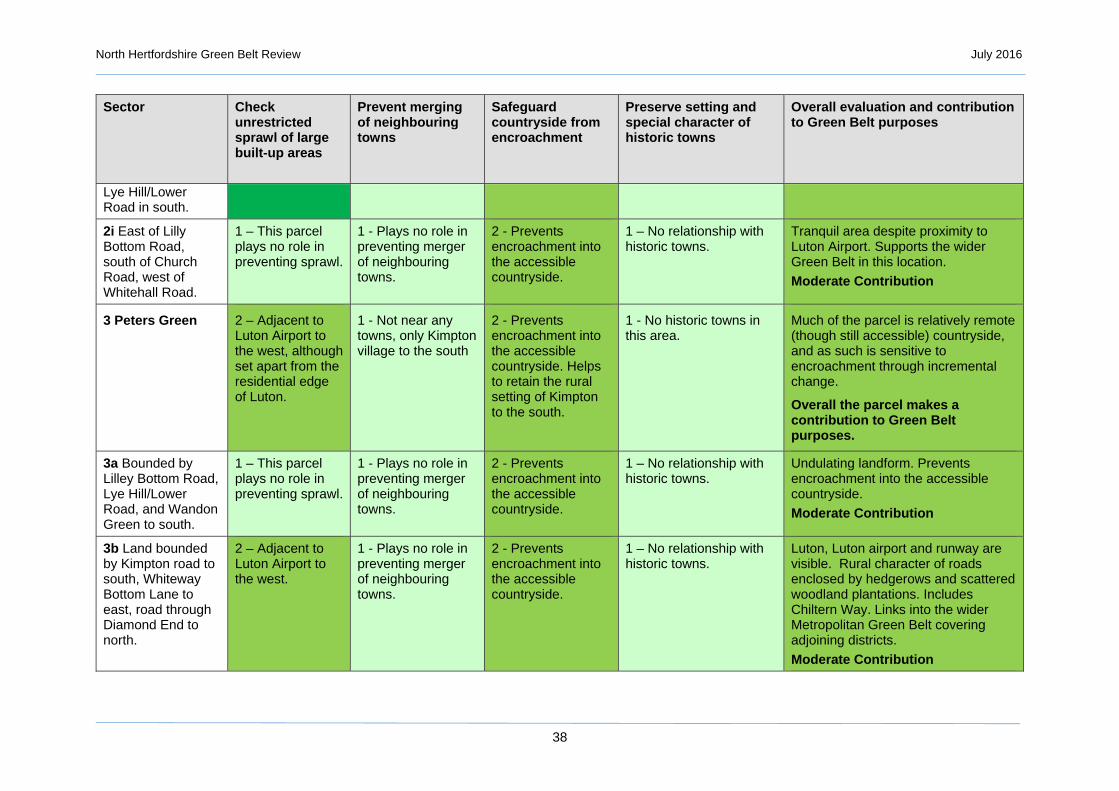
Lye Hill/Lower Road in south.
2i East of Lilly Bottom Road, south of Church Road, west of Whitehall Road.
1 – This parcel plays no role in preventing sprawl.
1 - Plays no role in preventing merger of neighbouring towns.
2 - Prevents encroachment into the accessible countryside.
1 – No relationship with historic towns.
Tranquil area despite proximity to Luton Airport. Supports the wider Green Belt in this location.
Moderate Contribution
3 Peters Green 2 – Adjacent to Luton Airport to the west, although set apart from the residential edge of Luton.
1 - Not near any towns, only Kimpton village to the south
2 - Prevents encroachment into the accessible countryside. Helps to retain the rural setting of Kimpton to the south.
1 - No historic towns in this area.
Much of the parcel is relatively remote (though still accessible) countryside, and as such is sensitive to encroachment through incremental change.
Overall the parcel makes a contribution to Green Belt purposes.
3a Bounded by Lilley Bottom Road, Lye Hill/Lower Road, and Wandon Green to south.
1 – This parcel plays no role in preventing sprawl.
1 - Plays no role in preventing merger of neighbouring towns.
2 - Prevents encroachment into the accessible countryside.
1 – No relationship with historic towns.
Undulating landform. Prevents encroachment into the accessible countryside.
Moderate Contribution
3b Land bounded by Kimpton road to south, Whiteway Bottom Lane to east, road through Diamond End to north.
2 – Adjacent to Luton Airport to the west.
1 - Plays no role in preventing merger of neighbouring towns.
2 - Prevents encroachment into the accessible countryside.
1 – No relationship with historic towns.
Luton, Luton airport and runway are visible. Rural character of roads enclosed by hedgerows and scattered woodland plantations. Includes Chiltern Way. Links into the wider Metropolitan Green Belt covering adjoining districts.
Moderate Contribution

North Hertfordshire Green Belt Review July 2016
39
Sector Check unrestricted sprawl of large built-up areas
Prevent merging of neighbouring towns
Safeguard countryside from encroachment
Preserve setting and special character of historic towns
Overall evaluation and contribution to Green Belt purposes
3c Land to east of Whiteway Bottom Lane, Bendish in the north, abuts northern edge of Kimpton with eastern boundary a mix of footpaths.
1 – This parcel plays no role in preventing sprawl.
1 - Plays no role in preventing merger of neighbouring towns.
2 – Prevents encroachment into the accessible countryside. Helps to retain the rural setting of Kimpton to the south.
1 – No relationship with historic towns.
Includes Chiltern Way. Prevents encroachment into the accessible countryside. Helps to retain the rural setting of Kimpton to the south.
Moderate Contribution
3d Land bounded by Kimpton Bottom to south, Kimpton Road to north and district boundary to west.
1 – This parcel plays no role in preventing sprawl.
1 - Plays no role in preventing merger of neighbouring towns.
2 – Prevents encroachment into the accessible countryside.
1 – No relationship with historic towns.
Links into the wider Metropolitan Green Belt covering adjoining districts.
Moderate Contribution
4 Porters End 1 – Not within the vicinity of a large built up area, although Blackmore End is immediately to the south east.
1 – Not in the vicinity of towns.
2 - Prevents encroachment into accessible countryside. Helps to retain the rural setting of Kimpton to the north.
1 - No historic towns in this area.
Much of the parcel is relatively remote (though still accessible) countryside, and as such is sensitive to encroachment through incremental change.
Overall the parcel makes a contribution to Green Belt purposes.
4 Land to south of Kimpton bounded by Kimpton Bottom to north, district boundary and Blackmore End to south and Hall
1 - No major settlements that may sprawl.
1 – No neighbouring towns but has maintained the separation of Blackmore End and Kimpton.
2 - Prevents encroachment of Kimpton and Blackmore End
1 - No historic towns in this area.
Links into the wider Metropolitan Green Belt covering adjoining districts.
Moderate Contribution

North Hertfordshire Green Belt Review July 2016
40
Sector Check unrestricted sprawl of large built-up areas
Prevent merging of neighbouring towns
Safeguard countryside from encroachment
Preserve setting and special character of historic towns
Overall evaluation and contribution to Green Belt purposes
Lane and Kimpton settlement to east.
5 Codicote 1 – Unrelated to a large built-up area.
1 – Not between towns.
2 - Prevents encroachment into accessible countryside. Helps to retain the rural setting of Codicote.
1 - No historic towns in this area.
This parcel is part of the accessible wider countryside to the west of the A1(M).
Overall the parcel makes a contribution to Green Belt purposes.
5a Land south of Codicote bounded by district boundary to south, Whitwell Road to north and Kimpton Mill to west.
2 – Locally helps to contain the growth of Codicote
2 – Locally contributes to the separation of neighbouring settlements of Codicote and Welwyn.
3 - Retains rural setting of Codicote.
1 – No relationship with historic towns.
Mimram Valley to south and west of Codicote. Links into the wider Metropolitan Green Belt covering adjoining districts.
Moderate Contribution
5b Land to north of Codicote bounded by district boundary to east, and Drivers End Lane/Sally Deards Lane to the north and High Heath farm to west.
2 – Locally helps to contain the growth of Codicote
2 – Locally contributes to the separation of neighbouring settlements of Codicote and Potters Heath.
3 - Retains rural setting of Codicote.
1 – No relationship with historic towns.
Plateau to the north and east of Codicote. Links into the wider Metropolitan Green Belt covering adjoining districts.
Moderate Contribution
6 Pottersheath 3 - Restricts the growth of Oaklands.
3 - Ensures separation of neighbouring settlements of
3 - Plays important role in safeguarding the countryside,
1 - No historic towns in this area.
Performs an important function separating the urban areas of Welwyn, Oaklands and Pottersheath.

North Hertfordshire Green Belt Review July 2016
41
Sector Check unrestricted sprawl of large built-up areas
Prevent merging of neighbouring towns
Safeguard countryside from encroachment
Preserve setting and special character of historic towns
Overall evaluation and contribution to Green Belt purposes
Welwyn, Oaklands and Pottersheath.
with evidence of urbanisation.
Overall makes a significant contribution to Green Belt purposes.
6 Area bounded to the east by district boundary.
3 – Restricts sprawl of Oaklands.
3 – Ensures separation of neighbouring settlements of Welwyn, Oaklands and Pottersheath.
3 - Plays important role in safeguarding the countryside, with evidence of urbanisation.
1 – No historic towns in this area.
Peri-urban area between Pottersheath and Oaklands. Links into the wider Metropolitan Green Belt covering adjoining districts.
Significant Contribution
7 Old Knebworth 1 - Limited contribution to restricting the sprawl of Stevenage.
1 - Limited contribution given location to the west of the A1(M).
2 - Protects accessible countryside from encroachment and maintains rural setting of Old Knebworth and parkland.
1 - No historic towns in this area.
This is part of the accessible wider countryside to the west of the A1(M) and includes Knebworth House parkland and gardens.
Overall the parcel makes a contribution to Green Belt purposes.
7a Land on west side of A1(M), bounded by Newton Woods to north and Park Lane/ Hitchin Road to south.
1 – Plays no role in restricting sprawl of Stevenage due to intervening A1(M) but adjoins parcel 8a which plays a significant role.
1 – No role in this location.
2 – Protects accessible countryside from encroachment.
1 – No relationship with historic towns.
Includes Old Knebworth village; Knebworth House; and Knebworth Park registered historic park and gardens. Protects accessible countryside from encroachment.
Moderate Contribution
7b Land to west of A1(M) bounded by Park Lane/ Hitchin Road to north,
1 – Plays no role in restricting sprawl of Stevenage.
1 – No role in this location.
2 – Protects accessible countryside from encroachment.
1 – No relationship with historic towns.
Includes The Node. Links into the wider Metropolitan Green Belt covering adjoining districts. Protects

North Hertfordshire Green Belt Review July 2016
42
Sector Check unrestricted sprawl of large built-up areas
Prevent merging of neighbouring towns
Safeguard countryside from encroachment
Preserve setting and special character of historic towns
Overall evaluation and contribution to Green Belt purposes
Three Houses Lane to west and Drivers End Lane/Sally Deards Lane to the south .
accessible countryside from encroachment.
Moderate Contribution
8 Knebworth 3 - Plays an important role in preventing sprawl along the A1(M) corridor to south of Stevenage.
3 - Plays an important role in preventing merging of Stevenage, Knebworth and Welwyn Garden City and the small settlements in between.
3 - Provides a link with the wider countryside to the east and west.
1 - Provides a setting for Knebworth but not to any historic towns.
There are Some visual links to Stevenage in the north and the land is part of the green wedge between Welwyn Garden City and Stevenage.
Overall makes a significant contribution to Green Belt purposes.
8a Land between A1(M) and ECML railway abuts northern edge of Knebworth and research centre to north.
3 - Plays an important role in preventing sprawl along the A1(M) corridor to south of Stevenage.
3 - Plays an important role in preventing merging of Stevenage with Knebworth.
3 – Part of the arc of open countryside to the south west of Stevenage.
1 – No relationship with historic towns.
Together with parcel 8b performs separation function between Stevenage and Knebworth. Setting to Knebworth, influenced by proximity to busy trunk road A1(M) and the east coast mainline railway. Contains Knebworth golf course.
Significant Contribution
8b land between ECML and local railway line and Watton Road abuts north-east edge of Knebworth.
3 - Plays an important role in preventing sprawl of Stevenage southwards.
3 - Plays an important role in preventing merging of Stevenage with Knebworth.
3 – Protects countryside between Knebworth and Stevenage.
1 – No relationship with historic towns.
Together with parcel 8a performs separation function between Stevenage and Knebworth. Setting to Knebworth bounded by east coast mainline railway to west and suburban railway line to east. Links into the wider Metropolitan Green Belt covering adjoining districts.
North Hertfordshire Green Belt Review July 2016
43
Sector Check unrestricted sprawl of large built-up areas
Prevent merging of neighbouring towns
Safeguard countryside from encroachment
Preserve setting and special character of historic towns
Overall evaluation and contribution to Green Belt purposes
Significant Contribution
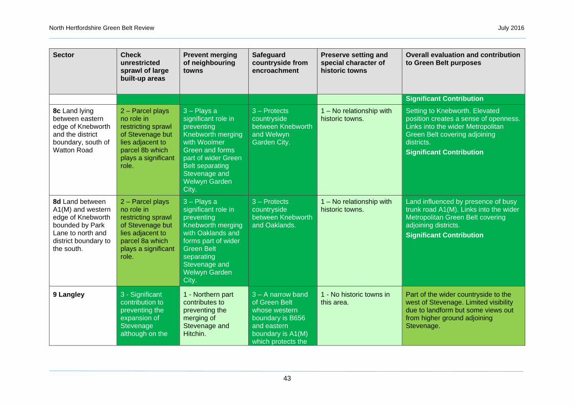
8c Land lying between eastern edge of Knebworth and the district boundary, south of Watton Road
2 – Parcel plays no role in restricting sprawl of Stevenage but lies adjacent to parcel 8b which plays a significant role.
3 – Plays a significant role in preventing Knebworth merging with Woolmer Green and forms part of wider Green Belt separating Stevenage and Welwyn Garden City.
3 – Protects countryside between Knebworth and Welwyn Garden City.
1 – No relationship with historic towns.
Setting to Knebworth. Elevated position creates a sense of openness. Links into the wider Metropolitan Green Belt covering adjoining districts.
Significant Contribution
8d Land between A1(M) and western edge of Knebworth bounded by Park Lane to north and district boundary to the south.
2 – Parcel plays no role in restricting sprawl of Stevenage but lies adjacent to parcel 8a which plays a significant role.
3 – Plays a significant role in preventing Knebworth merging with Oaklands and forms part of wider Green Belt separating Stevenage and Welwyn Garden City.
3 – Protects countryside between Knebworth and Oaklands.
1 – No relationship with historic towns.
Land influenced by presence of busy trunk road A1(M). Links into the wider Metropolitan Green Belt covering adjoining districts.
Significant Contribution
9 Langley 3 - Significant contribution to preventing the expansion of Stevenage although on the
1 - Northern part contributes to preventing the merging of Stevenage and Hitchin.
3 – A narrow band of Green Belt whose western boundary is B656 and eastern boundary is A1(M) which protects the
1 - No historic towns in this area.
Part of the wider countryside to the west of Stevenage. Limited visibility due to landform but some views out from higher ground adjoining Stevenage.

North Hertfordshire Green Belt Review July 2016
44
Sector Check unrestricted sprawl of large built-up areas
Prevent merging of neighbouring towns
Safeguard countryside from encroachment
Preserve setting and special character of historic towns
Overall evaluation and contribution to Green Belt purposes
west side of the A1(M).
countryside in this location.
Overall makes a moderate contribution to Green Belt purposes.
9a Area to east of B656 London Road, north of White Lane and south of Little Almshoe.
2 – Contributes to adjoining parcels 9b 9d and 10a which play a significant role in preventing sprawl of Stevenage westwards.
1 – Plays no direct role in preventing merging of towns.
2 – Contributes to the role that adjoining parcels play.
1 – No relationship with historic towns.
B656 forms a strong western boundary. Part of eastern side of Langley valley. Along with parcels 9b and 9c prevents encroachment of the countryside.
Moderate Contribution
9b Land south of Stevenage Road west to Almshoe Bury and south to bridleway.
3 – Part of narrow band of Green Belt preventing expansion of Stevenage westwards.
2 - Parcel of land in gap between Stevenage and Hitchin.
2 – Part of the wider countryside to the west of Stevenage.
1 – No relationship with historic towns.
Extensive open landscape. Rural character in spite of proximity to urban influences of Stevenage and the A1(M). Hertfordshire Way crosses through area.
Moderate Contribution
9c Land to east of A1(M) extending south to Dyes Lane, north to Lower Titmore Green and west to bridleway.
3 - Prevents westward expansion of Stevenage and contains development south of Todd’s Green.
2 – Parcel of land in gap between Stevenage and Hitchin.
3 – Part of wider Green Belt helping to prevent encroachment into countryside to west.
1 – No relationship with historic towns.
Exposed, gently undulating plateau landscape with open views away from Stevenage in the southern part and rolling chalk landscape in the northern part. Urban influence of A1(M) and Stevenage. Weak western boundary.
Moderate Contribution
9d Area lying between Kitching Lane in east and B656 to west, extending to Dyes
3 – Prevents westward expansion of Stevenage
1 – Plays no direct role in preventing merging of towns.
3 - Narrow band of Green Belt which protects the wider
1 – No relationship with historic towns.
Open landscape. B656 forms a strong western boundary. Part of eastern side of Langley valley. Urbanising

North Hertfordshire Green Belt Review July 2016
45
Sector Check unrestricted sprawl of large built-up areas
Prevent merging of neighbouring towns
Safeguard countryside from encroachment
Preserve setting and special character of historic towns
Overall evaluation and contribution to Green Belt purposes
Lane in south and White Lane in north.
together with parcel 9e.
countryside to the west.
influences include airfield and scrapyard at Rush Green.
Moderate Contribution
9e Area lying between A1(M) to east and B656 to west extending to southern boundary of newton Woods and north to Dyes Lane.
3 – Prevents westward expansion of Stevenage together with parcel 9d.
1 – Plays no direct role in preventing merging of towns.
3 - Narrow band of Green Belt which protects the countryside and links into the wider open space to the west.
.
1 – No relationship with historic towns.
B656 forms a strong western boundary. Part of eastern side of Langley valley. Contains village of Langley and woodland cover much of which is designated as an SSSI. Knebworth Woods/ Burleigh Grove/ Watery Grove SSSI.
Moderate Contribution
10 Little Wymondley
3 - Plays a significant part in the prevention of sprawl from Hitchin to the north west.
3 - Plays a significant part in the preventing Hitchin and Stevenage merging.
2 - This parcel is more urbanised then the neighbouring countryside due to the amount of transport routes, small settlements and urban fringe land use.
2 - Has some contribution to the setting of Hitchin. However no direct visual link with the historic core.
Has a close relationship with the north-west edge of Stevenage and the southern edge of Hitchin. Links the buffer between Letchworth/Hitchin to the wider countryside to the west.
Overall makes a significant contribution to Green Belt purposes.
10a Abuts the southern edge of Hitchin bounded by London Road and A602 Stevenage Road.
3 – Plays important role in preventing expansion of Hitchin southwards.
3 – Plays a critical role in preventing Hitchin and Stevenage merging.
2 – Protects countryside in gap between Hitchin and Stevenage.
1 – No direct link with historic core of Hitchin.
Contains St Ippolyts village. Urbanising influences include Wymondley Transforming station. Well defined boundaries. Ippolyts Brook runs through the area.
Significant Contribution

North Hertfordshire Green Belt Review July 2016
46
Sector Check unrestricted sprawl of large built-up areas
Prevent merging of neighbouring towns
Safeguard countryside from encroachment
Preserve setting and special character of historic towns
Overall evaluation and contribution to Green Belt purposes
10b Abuts the southern edge of Hitchin bounded by A602 Stevenage Road, Arch Road and Hitchin Road.
3 – Plays important role in preventing expansion of Hitchin southwards.
3 – Plays a critical role in preventing Hitchin and Stevenage merging.
2 – Protects countryside in gap between Hitchin and Stevenage.
1 – No direct link with historic core of Hitchin.
Urban influences include the Wymondley bypass and the east coast mainline railway. School playing fields on edge of Hitchin. Ippolyts Brook runs along the northern boundary.
Significant Contribution
10c North side of east coast mainline railway, bounded by northern edge of Stevenage, A1(M) and Graveley Road.
3 – Plays important role in preventing expansion of Stevenage northwards into gap between Hitchin, Letchworth and Stevenage.
3 – Plays a critical role in preventing Hitchin and Stevenage merging.
2 – Protects countryside in gap between Hitchin and Stevenage.
1 – No relationship with historic towns.
Setting to Little Wymondley village and includes part of Great Wymondley. Forms critical part of the gap between Stevenage, Hitchin and Letchworth and along with 15c and 15b contains expansion of Stevenage northwards and encroachment of countryside.
Significant Contribution
10d Area to the north of A602 Wymondley bypass, between Stevenage edge, east coast mainline railway and Arch Road.
3 - Plays a significant part in the prevention of urban sprawl to north west of Stevenage.
3 – Plays a critical role in preventing Hitchin and Stevenage merging.
2 – Protects countryside in gap between Hitchin and Stevenage.
1 – No relationship with historic towns.
Setting to Little Wymondley village. Urban influences include the Wymondley bypass and the east coast mainline railway. Along with other parcels in section 10 plays important role in the relatively narrow gap between Hitchin and Stevenage.
Significant Contribution
10e South of A602 Wymondley bypass bounded by Blakemore End
3 - Plays a significant part in the prevention of urban sprawl to
3 – Plays a critical role in preventing
2 - Protects countryside in gap
1 – No relationship with historic towns.
Contains Todd’s Green village. Prevents sprawl of Stevenage westwards. Some urbanising

North Hertfordshire Green Belt Review July 2016
47
Sector Check unrestricted sprawl of large built-up areas
Prevent merging of neighbouring towns
Safeguard countryside from encroachment
Preserve setting and special character of historic towns
Overall evaluation and contribution to Green Belt purposes
Road, Stevenage Road and Stevenage and Todd’s Green.
north west of Stevenage.
Hitchin and Stevenage merging.
between Hitchin and Stevenage.
influences include major roads of A1(M) and Wymondley bypass.
Significant Contribution
11 Gosmore 3 - Significant contribution to preventing sprawl from Hitchin to the north east.
1 - Limited contribution towards preventing merging between Hitchin & Stevenage and Hitchin and Luton.
3 - Prevents expansion of and contributes to setting of Gosmore and Charlton.
3 - Important for the setting of Hitchin through links into The Priory and its parkland and then to Hitchin town centre.
Part of the wider countryside between Hitchin and Luton.
Overall makes a significant contribution overall to Green Belt purposes preventing the expansion of Hitchin south westwards into open countryside.
11a Abuts the south-west edge of Hitchin south of A505 Offley Road bounded by Hoar’s Lane and Charlton Road.
3 - Plays an important role in preventing expansion of Hitchin westwards.
1 - Plays no role in preventing merger of neighbouring towns.
2 – Prevents encroachment and contributes to setting of Charlton.
2 – Contributes towards the historic settling of Hitchin.
Contains part of Charlton village. Includes Chiltern Way long distance footpath.
Significant Contribution
11b Abuts the south-west edge of Hitchin bounded by Charlton Road, Maydencroft Lane and Gosmore Road.
3 - Plays an important role in preventing expansion of Hitchin westwards.
1 - Plays no role in preventing merger of neighbouring towns.
2 – Prevents encroachment and contributes to setting of Charlton.
3 - Plays a significant role in the historic setting of Hitchin.
Contains Priory Park and part of Charlton village.
Significant Contribution
11c Area to south-west of Gosmore bounded by Maydencroft Lane,
2 – Contributes to preventing expansion of
1 - Plays no role in preventing merger of neighbouring towns.
2 – Prevents encroachment and contributes to setting of Gosmore.
3 - Plays a significant role in the setting of Hitchin.
Bisected by pylons.
Significant Contribution

North Hertfordshire Green Belt Review July 2016
48
Sector Check unrestricted sprawl of large built-up areas
Prevent merging of neighbouring towns
Safeguard countryside from encroachment
Preserve setting and special character of historic towns
Overall evaluation and contribution to Green Belt purposes
Temple Close and Preston Road.
Hitchin along with 11a 11b and 11d.
11d Abuts the southern edge of Hitchin bounded by London Road, and road opposite Little Almshoe farm.
3 - Plays important role in preventing expansion of Hitchin southwards.
1 - Plays no role in preventing merger of neighbouring towns.
2 – Prevents encroachment and contributes to setting of Gosmore.
1 – No direct link with historic core of Hitchin.
Covers village of Gosmore defined by B656 London Road to east. Bisected by pylons.
Significant Contribution
12 Oughtonhead 3 - Significant contribution in preventing sprawl from Hitchin to the east.
1 - Limited contribution as on the western edge of Hitchin.
3 - Abuts the Chilterns AONB and is significant in safeguarding the countryside.
3 - Important in the setting of Hitchin due to strong visual relationship with the historic core of the town.
Forms part of the setting to Chilterns AONB and has a close relationship to the western edge of Hitchin providing a link to the wider countryside.
Overall makes a significant contribution to Green Belt purposes.
12a Abuts the northern edge of Hitchin and eastern edge of Ickleford bounded by A600 Bedford Road, Hambridge Way and Mill Way.
3 - Plays important role in preventing expansion of Hitchin northwards.
1 - Plays no role in preventing merger of neighbouring towns.
3 – Plays a significant role in safeguarding the countryside.
1 – No direct link with historic core of Hitchin.
River Oughton flows through.
Significant Contribution
12b Area abuts western edge of Hitchin bounded by Icknield Way, Hitchin Road and
3 - Plays important role in preventing expansion of Hitchin westwards
1 - Plays no role in preventing merger of neighbouring towns.
3 - Abuts Chilterns AONB and is significant in safeguarding the countryside.
1 – No direct link with historic core of Hitchin.
Covers Oughtonhead Common Nature Reserve. Borders eastern boundary of Chilterns AONB.
Significant Contribution

North Hertfordshire Green Belt Review July 2016
49
Sector Check unrestricted sprawl of large built-up areas
Prevent merging of neighbouring towns
Safeguard countryside from encroachment
Preserve setting and special character of historic towns
Overall evaluation and contribution to Green Belt purposes
Oughtonhead Lane.
towards the Chilterns AONB.
12c Abuts western edge of Hitchin bounded by Oughtonhead Lane, Hitchin Road and Pirton Road.
3 - Plays important role in preventing expansion of Hitchin westwards towards the Chilterns AONB.
1 - Plays no role in preventing merger of neighbouring towns.
3 - Abuts Chilterns AONB and is significant in safeguarding the countryside.
2 – Contributes towards the historic settling of Hitchin.
Borders eastern boundary of Chilterns AONB.
Significant Contribution
12d Abuts western edge of Hitchin bounded by Pirton Road, Carters Lane and A505 Offley Road.
3 - Plays important role in preventing expansion of Hitchin westwards towards the Chilterns AONB.
1 - Plays no role in preventing merger of neighbouring towns.
3 - Abuts Chilterns AONB and is significant in safeguarding the countryside.
2 – Contributes towards the historic settling of Hitchin.
Abuts eastern boundary of Chilterns AONB.
Significant Contribution
13 Ickleford 3 - Plays significant role in preventing sprawl northward sprawl of Hitchin.
1 - Plays no role in preventing merger of neighbouring towns.
2 - Prevents encroachment into accessible countryside.
2 - Contributes to the setting of Hitchin. However no direct visual link with the historic core.
Links to the wider countryside to the north of Hitchin and into Bedfordshire.
Overall makes a moderate contribution to Green Belt purposes.
13a Area between A600 Bedford Road and district boundary along River Hiz bounded by Snailswell Lane and tributary of River Hiz.
1 – Plays limited role but adjoins 13b and 13c which play a significant role in preventing sprawl northwards out of Hitchin.
1 - Plays no role in preventing merger of neighbouring towns.
2 – Contributes to the role that parcels 13b and 13c play in preventing encroachment of the wider courtside to the north of Hitchin.
1 – No direct link with historic core of Hitchin.
Links to the wider countryside to the north of Hitchin and into Bedfordshire. Moderate Contribution

North Hertfordshire Green Belt Review July 2016
50
Sector Check unrestricted sprawl of large built-up areas
Prevent merging of neighbouring towns
Safeguard countryside from encroachment
Preserve setting and special character of historic towns
Overall evaluation and contribution to Green Belt purposes
13b Abuts the northern edge of Ickleford between A600 Bedford Road and Snailswell Lane.
3 - Plays significant role in preventing sprawl northwards out of Hitchin.
1 - Plays no role in preventing merger of neighbouring towns.
2 - Prevents encroachment into the wider open countryside to the north of Hitchin.
1 – No direct link with historic core of Hitchin.
Links to the wider countryside to the north of Hitchin and into Bedfordshire. Moderate Contribution.
13c Area lies between northern edge of Hitchin and southern edge of Ickleford bounded by A600 Bedford Road and east coast railway line.
3 - Plays significant role in preventing sprawl northwards out of Hitchin.
3 - Separates the settlements of Ickleford and Hitchin.
2– Prevents encroachment into the gap between Hitchin and Ickleford.
1 – No direct link with historic core of Hitchin.
Lies between southern edge of Ickleford and northern edge of Hitchin. River Oughton flows through it.
Significant Contribution.
14 Willian 3 - Creates a strong green wedge between Hitchin and Letchworth as well as strengthening the role of the adjoining Green Belt around Stevenage preventing sprawl.
3 - Plays a significant role in preventing the merger of Hitchin and Letchworth
3 - Although some urbanising influences, there are strong urban boundaries to Hitchin and Letchworth.
3 - Important in the setting of Hitchin due to strong visual relationship with the historic core of the town.
Plays an important role as key green wedge between Hitchin and Letchworth and in the setting to them.
Overall makes a significant contribution to Green Belt purposes.
14a Area between east coast railway line, Icknield Way
2 – Help prevents expansion of
2 – Helps to keep the settlements of
3 – Protects countryside in the narrow gap
2 – No direct link with historic core of Hitchin or
Icknield Way Trail runs along the southern boundary. Cemetery. Key

North Hertfordshire Green Belt Review July 2016
51
Sector Check unrestricted sprawl of large built-up areas
Prevent merging of neighbouring towns
Safeguard countryside from encroachment
Preserve setting and special character of historic towns
Overall evaluation and contribution to Green Belt purposes
Trail, western settlement edge of Letchworth and the district boundary.
Letchworth towards Hitchin.
Letchworth and Hitchin separate.
between Hitchin and Letchworth.
Letchworth, but part of context.
separation function between Hitchin and Letchworth.
Significant Contribution
14b Area bounded by settlement eastern edges of Hitchin and Letchworth lying between Icknield Way Trail and local railway line.
3 – Prevents expansion of Hitchin and Letchworth into narrow gap between them.
3 – Plays critical role in separating Hitchin and Letchworth.
3 – Protects countryside in the narrow gap between Hitchin and Letchworth.
3 - Important in the setting of Hitchin due to strong visual relationship with the historic core of the town.
Hitchin curve railway line. Key separation function between Hitchin and Letchworth.
Significant Contribution
14c Area bounded by settlement edges of Hitchin and Letchworth between local railway line and A505.
3 – Prevents expansion of Hitchin and Letchworth into narrow gap between them.
3 – Plays critical role in separating Hitchin and Letchworth.
3 – Protects countryside in the narrow gap between Hitchin and Letchworth.
3 - Important in the setting of Hitchin due to strong visual relationship with the historic core of the town.
Includes school playing fields. Nursery. Key separation function between Hitchin and Letchworth.
Significant Contribution
14d Area bounded by settlement edges of Hitchin and Letchworth between A505 and Willian Road.
3 – Prevents expansion of Hitchin and Letchworth into narrow gap between them.
3 – Plays critical role in separating Hitchin and Letchworth.
3 – Protects countryside in the narrow gap between Hitchin and Letchworth.
3 - Important in the setting of Hitchin due to strong visual relationship with the historic core of the town.
Includes Hotel and Letchworth Golf course. Key separation function between Hitchin and Letchworth.
Significant Contribution
14e Abuts the eastern edge of Hitchin bounded by Willian Road,
3 – Prevents southwards expansion of Hitchin into gap between
3 – Plays critical role in separating Hitchin, Letchworth and Stevenage.
3 – Protects countryside in the gap between Hitchin, Letchworth and Stevenage.
3 - Important in the setting of Hitchin due to strong visual relationship with the historic core of the town.
Important for the setting of Hitchin. Visual and physical link with spur along River Purwell. Key separation function between Hitchin and Letchworth.

North Hertfordshire Green Belt Review July 2016
52
Sector Check unrestricted sprawl of large built-up areas
Prevent merging of neighbouring towns
Safeguard countryside from encroachment
Preserve setting and special character of historic towns
Overall evaluation and contribution to Green Belt purposes
Wymondley Road and Hitchin Road.
Stevenage, Letchworth and Hitchin.
Significant Contribution
14f Abuts the southern edge of Letchworth, bounded by A1(M), Graveley Lane and Wymondley Road.
3 – Prevents southwards expansion of Letchworth into gap between Stevenage, Letchworth and Hitchin.
3 – Plays critical role in separating Letchworth and Stevenage.
3 – Protects countryside in the gap between Hitchin, Letchworth and Stevenage.
2 – part of the southern context of Letchworth
Rolling arable landscape with large fields. Context for Willian village and includes part of Great Wymondley. Sustrans cycle route and The Hertfordshire Way crosses area. A1(M) forms strong eastern boundary.
Significant Contribution
15 Jack’s Hill 3 - Plays an important role in restricting growth northwards from Stevenage and strengthens the role of the adjoining Green Belt.
3 - Contributes to the wider area which prevents merging of Hitchin with Stevenage and Letchworth and Baldock.
3 - Prevents the encroachment of Stevenage into the open countryside.
1 - Limited contribution to setting of an historic town.
A wedge of open countryside between Stevenage and Letchworth/Baldock and part of a link from the countryside reaching in towards Stevenage.
Overall makes a significant contribution to Green Belt purposes.
15a Area lies to east of A1(M) bounded by Hitchin Road and Bridleway.
2 – Part of the land that restricts expansion of Stevenage northwards and Letchworth southwards.
3 – Plays important role in separating Stevenage and Letchworth/Baldock.
2 – Protects countryside in the gap between Letchworth/Baldock and Stevenage.
1 – No historic towns in the immediate vicinity
Parcel plays a critical role in the gap between Stevenage, Hitchin and Letchworth separated from their urban edges by adjoining parcels. Comprises open landscape including Chesfield Downs golf course. A1(M) forms a strong western boundary.
Significant Contribution

North Hertfordshire Green Belt Review July 2016
53
Sector Check unrestricted sprawl of large built-up areas
Prevent merging of neighbouring towns
Safeguard countryside from encroachment
Preserve setting and special character of historic towns
Overall evaluation and contribution to Green Belt purposes
15b Area to north of Stevenage lying between Church Lane, Friends Lane and bridleway.
3 – Prevents extension of Stevenage northwards.
3 – Plays important role in separating Stevenage and Letchworth/Baldock.
3 – Protects countryside in the gap between Letchworth/Baldock and Stevenage.
1 – No historic towns in the immediate vicinity
Plateau landscape with winding lanes, hedgerows and woodland blocks. Contributes with parcels 15c and 16 to prevent northward expansion of Stevenage and encroachment into the countryside.
Significant Contribution.
15c Abuts northern settlement edge of Stevenage between A1(M) and Church Lane.
3 – Prevents expansion of Stevenage northwards.
3 – Plays important role in separating Stevenage and Letchworth/Baldock.
3 - Protects countryside in the gap between Letchworth/Baldock and Stevenage.
1 – No historic towns in the immediate vicinity
Context for Graveley village and parkland landscape of Chesfield Park. Visual link with northern settlement edge of Stevenage. Links into Green Belt within Stevenage borough. Contains sprawl along B197. Important part of gap separating Stevenage, Hitchin and Letchworth.
Significant Contribution
16 Warren’s Green
3 - Serves to contain further growth of Stevenage to the north east.
1 - Plays no role in preventing merger of neighbouring towns.
2 – Contributes to limiting development in relatively accessible countryside.
1 – No contribution to setting of historic towns.
Borders the urban area of north east Stevenage around Great Ashby. Part of the countryside area between Stevenage and Baldock/Letchworth to the North.
Overall makes a moderate contribution to Green Belt purposes.
16 Warren’s Green Area abuts north-east edge of Stevenage bounded by
3 - Serves to contain further growth of Stevenage to the north east.
1 - Plays no role in preventing merger of neighbouring towns; locally protects identity of
2 - Prevents development in the countryside and preserves its rural character.
1 – No historic towns in the immediate vicinity
Land abuts north-east Stevenage settlement edge contains woodland blocks and arable fields. Links into the wider Metropolitan Green Belt along the eastern side of Stevenage.

North Hertfordshire Green Belt Review July 2016
54
Sector Check unrestricted sprawl of large built-up areas
Prevent merging of neighbouring towns
Safeguard countryside from encroachment
Preserve setting and special character of historic towns
Overall evaluation and contribution to Green Belt purposes
Warrensgreen Lane and the district boundary.
Stevenage with villages of Warren’s Green, Halls Green and Weston.
Prevents development in the countryside and preserves its rural character. Pylons cross the southern edge.
Moderate Contribution
17 Weston 1 - Functions as part of the wider Green Belt as not immediately adjacent to any large settlement.
1 - As part of wider Green Belt between Stevenage and Weston and Baldock
2 - Some contribution as accessible from Stevenage and Letchworth.
1 – No contribution to the setting of historic towns.
Makes an overall limited contribution to Green Belt purposes
17a Land north of Clothall Road bounded by Warren Road and Kingswoodbury Tributary.
1 – No direct contribution.
1 - Plays no role in preventing merger of neighbouring towns.
2 - Some contribution as accessible from Stevenage and Letchworth.
1 – No historic towns in the immediate vicinity
Eastern edge of metropolitan Green Belt in North Herts. Predominantly agriculture. Includes Clothall Bury.
Moderate Contribution
17b Bounded by Fore Street, Clothall Road, Maiden Street and eastern edge of Green Belt
1 – No direct contribution.
1 - Plays no role in preventing merger of neighbouring towns.
2 – Contributes to the role that parcels adjacent to Stevenage and Baldock make.
1 – No historic towns in the immediate vicinity
Eastern edge of metropolitan Green Belt in North Herts. Covers part of Clothall and part of Weston villages.
Moderate Contribution
17c Area bordered by Maiden Street, Warrensgreen Lane, Friends Green and Bridleway.
1 – No direct contribution.
1 - Plays no role in preventing merger of neighbouring towns.
2 – Contributes to the role that parcels adjacent to Stevenage make.
1 – No historic towns in the immediate vicinity
Parcel of land on the eastern edge of the Green Belt land which complements parcel 15b and 16 in safeguarding countryside from encroachment. Covers part of Weston village includes Weston Park and

North Hertfordshire Green Belt Review July 2016
55
Sector Check unrestricted sprawl of large built-up areas
Prevent merging of neighbouring towns
Safeguard countryside from encroachment
Preserve setting and special character of historic towns
Overall evaluation and contribution to Green Belt purposes
retains a parkland character. Pylons cut across the land.
Moderate Contribution
18 Baldock Gap 3 - Significant green wedge separating Letchworth and Baldock.
3 - Prevents the complete merging of Letchworth and Baldock.
3 - Provides green space between Letchworth and Baldock although A1(M) cuts through the area.
3 - Contributes to the setting of Letchworth and Baldock.
Important parcel on all purposes due to location between Letchworth and Baldock.
Overall makes significant contribution to Green Belt purposes.
18a Wedge between settlement edges of Letchworth and Baldock.
3 - Significant green wedge separating Letchworth and Baldock.
3 - Prevents the complete merging of Letchworth and Baldock.
1 – not part of open countryside
3 - Contributes to the setting of Letchworth and Baldock.
Includes the A1(M) motorway. Urban influence.
Significant Contribution
18b Abuts southern edge of Letchworth and Baldock bounded by A505 and Baldock Lane.
3 - Significant green wedge separating Letchworth and Baldock.
3 - Prevents the complete merging of Letchworth and Baldock.
2 – Part of and supports wider open countryside to the south east.
3 - Contributes to the setting of Letchworth and Baldock.
Urban influence and major transport routes of A1(M) and Baldock bypass. Pylons.
Significant Contribution
19 Weston Hills 2 - On eastern side of A505 Baldock bypass reinforcing Green Belt immediately east of Letchworth and Baldock.
2 – Makes a contribution to the broader separation of Baldock and Stevenage.
2 - Some contribution to protecting the accessible countryside in this location.
2 – Forms part of the easterly setting of Baldock.
Part of the wider open countryside between Stevenage and Letchworth/Baldock.
Overall makes a contribution to Green Belt purposes.

North Hertfordshire Green Belt Review July 2016
56
Sector Check unrestricted sprawl of large built-up areas
Prevent merging of neighbouring towns
Safeguard countryside from encroachment
Preserve setting and special character of historic towns
Overall evaluation and contribution to Green Belt purposes
19a Area south of A505 Baldock bypass between Wallington Road and Bygrave Lodge farm.
1 – Makes no contribution in this location.
1 - Plays no role in preventing merger of neighbouring towns.
2 – Protects the open countryside to the south east of Baldock.
2 – Part of the wider eastern setting of Baldock.
Anaerobic digestion facility located in northern part adjoining A505 dual carriageway.
Moderate Contribution
19b Land south of A505 Baldock bypass between Clothall Road and Wallington Road.
2 – Supports the containment of Baldock to the north west.
1 - Plays no role in preventing merger of neighbouring towns.
2 – Protects the open countryside to the south east of Baldock.
2 –Part of the wider eastern setting of Baldock.
Supports Green Belt to the west of the A505.
Moderate Contribution
19c Land south of A505 Baldock bypass between hatch Lane and Clothall Road and Fore Street.
2 – Supports the containment of Baldock to the north west.
2 – Makes a contribution to the broader separation of Baldock and Stevenage.
2 – Protects the open countryside to the south east of Baldock.
2 – Part of the wider eastern setting of Baldock.
Supports Green Belt to the west of the A505.
Moderate Contribution
19d Area lying between the A505, Hitchin Road, Hatch Lane and the western edge of Weston.
2 – Supports the containment of Letchworth to the west.
2 – Makes a contribution to the broader separation of Baldock and Stevenage.
2 – Protects the open countryside to the south east of Baldock.
2 – Part of the wider eastern setting of Letchworth
Supports Green Belt to the west of the A505.
Moderate Contribution
20 Baldock East 2 – Bounded by the A505 Baldock bypass and makes a
1 - Limited contribution as on the eastern side of Baldock between the settlement edge
2 - Has a peri-urban character due to proximity to edge of Baldock and the bypass.
3 - Contributes to the setting of Baldock.
Narrow band of Green Belt between eastern edge of Baldock and the A505 bypass.

North Hertfordshire Green Belt Review July 2016
57
Sector Check unrestricted sprawl of large built-up areas
Prevent merging of neighbouring towns
Safeguard countryside from encroachment
Preserve setting and special character of historic towns
Overall evaluation and contribution to Green Belt purposes
contribution to restricting sprawl.
and the A505 bypass.
Overall makes a moderate contribution to Green Belt purposes.
20a Strip of land between south-east edge of Baldock and Baldock bypass, north of Clothall Road A507.
2 – Prevents the eastward growth of Baldock, but bounded by A505.
1 - Limited contribution as on the eastern side of Baldock.
2 - Contributes to the setting of Baldock.
3 - Contributes to the setting of Baldock.
Contains north east Baldock but is strongly contained by the A505.
Moderate Contribution
20b Strip of land between south-east edge of Baldock and Baldock by-pass, south of Clothall Road A507 and north of Chalk Hills.
2 – Prevents the south eastward growth of Baldock, but bounded by A505.
1 - Limited contribution as on the eastern side of Baldock.
2 - Contributes to the setting of Baldock.
3 - Contributes to the setting of Baldock.
Contains north east Baldock but is strongly contained by the A505.
Moderate Contribution
21 Bygrave 3 - On northern side of Baldock making a significant contribution to restricting sprawl.
1 - Limited contribution as on the northern side of Baldock
3 - Contains the northern edge of Baldock and prevents urbanising influences.
2 - Forms part of the setting of historic Baldock. Contribution to this purpose is more limited due to the existing employment area and railway line.
Predominantly rural character linking into the wider countryside north of Baldock.
Overall makes a moderate contribution to Green Belt purposes.
21a East side of A1(M) between Newnham Road in
1 – Limited contribution in this location
1 - Plays no role in preventing merger
2 – Part of wider countryside to the north of Baldock
1 – Limited contribution in this location
Supports Green Belt to the south.
Moderate Contribution.

North Hertfordshire Green Belt Review July 2016
58
Sector Check unrestricted sprawl of large built-up areas
Prevent merging of neighbouring towns
Safeguard countryside from encroachment
Preserve setting and special character of historic towns
Overall evaluation and contribution to Green Belt purposes
north and local footpath to south.
of neighbouring towns.
21b East side of A1(M) between local footpath and local track extending towards Bygrave.
2 – Supports parcels immediately to the south
1 - Plays no role in preventing merger of neighbouring towns.
2 – Part of wider countryside to the north of Baldock
1 – Limited contribution in this location
Supports Green Belt to the south.
Moderate Contribution.
21c Abuts northern edge of Baldock between A1(M) and A505 south of Norton Mill Lane.
3 - On northern side of Baldock making a significant contribution to restricting sprawl.
3 – Part of the wedge of countryside which helps to separate Baldock and Letchworth.
3 – Prevents urbanising influences immediately to the north of Baldock
2 – Contributes to the setting of Baldock immediately to the south.
Contains Ivel Springs. Contains part of the northern edge of Baldock.
Significant Contribution
21d Abuts northern edge of Baldock and Bygrave Road.
3 - On northern side of Baldock making a significant contribution to restricting sprawl.
1 - Plays no role in preventing merger of neighbouring towns.
3 – Prevents urbanising influences immediately to the north of Baldock
2 – Contributes to the setting of Baldock immediately to the south.
Contains part of the northern edge of Baldock.
Significant Contribution
21e Bounded by railway line to south and Bygrave Road to north.
3 - On northern side of Baldock making a significant contribution to restricting sprawl.
1 - Plays no role in preventing merger of neighbouring towns.
3 – Prevents urbanising influences immediately to the north of Baldock
2 – Contributes to the setting of Baldock immediately to the south.
Includes the settlement of Bygrave. Open landscape contributing to the northerly context of Baldock.
Significant Contribution
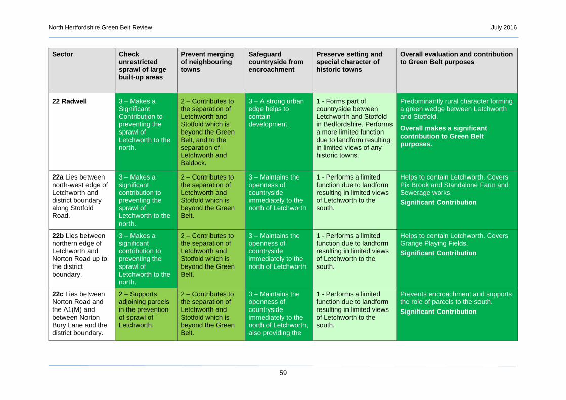
North Hertfordshire Green Belt Review July 2016
59
Sector Check unrestricted sprawl of large built-up areas
Prevent merging of neighbouring towns
Safeguard countryside from encroachment
Preserve setting and special character of historic towns
Overall evaluation and contribution to Green Belt purposes
22 Radwell
3 – Makes a Significant Contribution to preventing the sprawl of Letchworth to the north.
2 – Contributes to the separation of Letchworth and Stotfold which is beyond the Green Belt, and to the separation of Letchworth and Baldock.
3 – A strong urban edge helps to contain development.
1 - Forms part of countryside between Letchworth and Stotfold in Bedfordshire. Performs a more limited function due to landform resulting in limited views of any historic towns.
Predominantly rural character forming a green wedge between Letchworth and Stotfold.
Overall makes a significant contribution to Green Belt purposes.
22a Lies between north-west edge of Letchworth and district boundary along Stotfold Road.
3 – Makes a significant contribution to preventing the sprawl of Letchworth to the north.
2 – Contributes to the separation of Letchworth and Stotfold which is beyond the Green Belt.
3 – Maintains the openness of countryside immediately to the north of Letchworth
1 - Performs a limited function due to landform resulting in limited views of Letchworth to the south.
Helps to contain Letchworth. Covers Pix Brook and Standalone Farm and Sewerage works.
Significant Contribution
22b Lies between northern edge of Letchworth and Norton Road up to the district boundary.
3 – Makes a significant contribution to preventing the sprawl of Letchworth to the north.
2 – Contributes to the separation of Letchworth and Stotfold which is beyond the Green Belt.
3 – Maintains the openness of countryside immediately to the north of Letchworth
1 - Performs a limited function due to landform resulting in limited views of Letchworth to the south.
Helps to contain Letchworth. Covers Grange Playing Fields.
Significant Contribution
22c Lies between Norton Road and the A1(M) and between Norton Bury Lane and the district boundary.
2 – Supports adjoining parcels in the prevention of sprawl of Letchworth.
2 – Contributes to the separation of Letchworth and Stotfold which is beyond the Green Belt.
3 – Maintains the openness of countryside immediately to the north of Letchworth, also providing the
1 - Performs a limited function due to landform resulting in limited views of Letchworth to the south.
Prevents encroachment and supports the role of parcels to the south.
Significant Contribution

North Hertfordshire Green Belt Review July 2016
60
Sector Check unrestricted sprawl of large built-up areas
Prevent merging of neighbouring towns
Safeguard countryside from encroachment
Preserve setting and special character of historic towns
Overall evaluation and contribution to Green Belt purposes
setting for Radwell village.
22d Lies between the A1(M), Norton Bury Lane, Norton Road and north-eastern edge of Letchworth.
3 – Makes a significant contribution to preventing the sprawl of Letchworth to the north.
3 – Part of the wedge of countryside which helps to separate Baldock and Letchworth.
3 – Maintains the openness of countryside immediately to the north of Letchworth
2 – Part of the setting for Letchworth to the south.
Covers Norton Bury. Helps to contain Letchworth and separate Letchworth from Baldock.
Significant Contribution

North Hertfordshire Green Belt Review July 2016
61
Figure 3.2: Contribution to checking the unrestricted sprawl of large built-up areas

North Hertfordshire Green Belt Review July 2016
62
Figure 3.3: Contribution to Preventing Neighbouring Towns Merging

North Hertfordshire Green Belt Review July 2016
63
Figure 3.4: Contribution to Safeguarding the Countryside from Encroachment

North Hertfordshire Green Belt Review July 2016
64
Figure 3.5: Contribution to Preserving the Setting and Character of Historic Towns

North Hertfordshire Green Belt Review July 2016
65
3. The overall judgement of the contribution of the sub-parcels to Green Belt purposes is illustrated in Figure 3.6. The sub-parcels considered to make the most significant contribution are those around the periphery of and between the existing settlements of Hitchin, Letchworth and Baldock, those in south of the district around Stevenage, Knebworth and Welwyn, and those on the eastern fringes of Luton. This conclusion is not surprising given that these are the principal urban areas of the district. An additional factor in this judgement is the historic nature of the three North Hertfordshire towns located within the Green Belt and their proximity to one another resulting in increased sensitivity to development within those Green Belt areas. A similar relationship occurs in the comparatively narrow area of Green Belt between Knebworth and Stevenage.
Figure 3.6: Overall Contribution to Green Belt purposes

North Hertfordshire Green Belt Review July 2016
66

North Hertfordshire Green Belt Review July 2016
67
4. Analysis of Villages in the Green Belt
4.1 Purpose and Method of Appraisal
1. As part of the review of the Green Belt across North Hertfordshire, the NPPF requiresthat there is consideration of settlements set within the Green Belt and whether thedesignation can be removed or the village boundary amended to allow appropriategrowth, specifically:
“If it is necessary to prevent development in a village primarily because of the important contribution which the open character of the village makes to the openness of the Green Belt, the village should be included in the Green Belt. If, however, the character of the village needs to be protected for other reasons, other means should be used, such as conservation area or normal development management policies, and the village should be excluded from the Green Belt” (NPPF para 86).
2. There are three possible outcomes associated with the judgement of insetting:
An Inset Settlement where the settlement is excluded from the Green Belt andGreen Belt policies do not apply to development within the settlement.
A Washed-over Settlement where settlements are ‘washed over’ by the GreenBelt and Green Belt policies apply within them in order to protect the openness ofthe Green Belt in that location. Similar exceptions to constraints on developmentapply as within the Green Belt as a whole, although limited infilling may bepermitted within the built-up area, as long as it preserves the openness of theGreen Belt and does not conflict with the purposes of including the settlement inGreen Belt in the first place.
A Washed-over Settlement with an Infill Boundary where settlements have an infillboundary drawn around their main built-up area where allowing limiteddevelopment which would still be expected to preserve the openness of the GreenBelt and not conflict with the purposes of including the village in Green Belt in thefirst place.
3. Policy in the NPPF does not preclude the definition of a village envelope, even if a villageremains washed over by the Green Belt, which would allow for limited infilling, therebycomplying with para 89(5) which allows for “limited infilling in villages, and limitedaffordable housing for local community needs under policies set out in the Local Plan.”
3. The NPPF does not define openness, leaving it to interpretation where it is generallytaken to mean generally (but not exclusively) an absence of built development. Given thatbuilt development is often an integral part of the character of the countryside, in relationto particular areas the degree of openness is an overall judgement which needs to stemfrom the consideration of a number of factors which include, in the case of villages,matters such as their general character, scale and density, setting within and interactionwith the wider landscape.
4. The analysis of village character and relationship with the Green Belt takes a similarapproach to the assessment of the parcels of the wider Green Belt. The criteria used forassessment are finer grained in their detail and with a specific focus on the relationshipof built development with its context, as follows:
General character – location and overall setting, topography, settlement form,building type/age, overall sensitivity, sense of identity/unity/cohesion, key focalpoints, Conservation Area(s).

North Hertfordshire Green Belt Review July 2016
68
Density and layout of buildings – degree of spaciousness/enclosure, opportunities for infill, existing village boundary.
Presence and character of open space – location and relationship with settlement.
Interface with the surrounding landscape – settlement depth, rear garden character, glimpsed/panoramic views to the wider landscape, connectivity with landscape context.
4.2 NHDC Proposed Policy Context
5. The proposed settlement hierarchy for North Hertfordshire is summarised in Box 4.1, which includes a number of villages within the Green Belt, some of which already been inset within the Green Belt (Knebworth, Codicote, Kimpton, Little Wymondley, Ickleford and Oaklands). The proposal to inset certain villages previously was based primarily on a settlement hierarchy based on level of facilities present).
Box 4.1: Proposed NHDC Settlement Hierarchy1
Policy SP2: Settlement hierarchy
The majority of the district’s development will be located within or adjoining the following towns: Baldock; Hitchin; Letchworth Garden City; Royston; Stevenage (including Great Ashby) These settlements are (substantively) located outside of North Hertfordshire’s administrative area, but the urban areas adjoin, or already lie partially within, the District.; and Luton
General development will also be allowed within the defined settlement boundaries of the Category A villages of:
Ashwell; Barkway; Barley; Breachwood Green; Cockernhoe; Codicote; Graveley; Hexton;
Ickleford; Kimpton; Knebworth; Little Wymondley; Lower Stondon1; Oaklands1; Offley; Pirton;
Preston; Reed; Sandon; St Ippolyts; Therfield; Weston; and Whitwell.
Infilling development which does not extend the built core of the village will be allowed in the Category B villages of:
Blackmore End; Great Wymondley; Hinxworth; Holwell;
Kelshall; Lilley; Newnham;
Old Knebworth; Rushden; Wallington; and Willian.
Only limited affordable housing and facilities for local community needs will be allowed in the Category C settlements of:
Bygrave; Caldecote;
Clothall; Langley; Nuthampstead;
Peters Green; and Radwell
1 NHDC (December 2014) Local Plan Preferred Options

North Hertfordshire Green Belt Review July 2016
69
6. In order to ensure compatibility of the proposed settlement hierarchy with Green Beltpolicy, the following villages (Figure 4.1) are appraised for their contribution to the GreenBelt and thereby the case for their potential insetting. These are villages identified asCategory A in the proposed hierarchy (Breachwood Green, Graveley, St Ippolyts,Weston) and villages identified as Category B but where it was considered a 'built core'might be reasonably identified (Blackmore End, Clothall, Great Wymondley, Lilley, OldKnebworth, Peters Green, Willian). Other villages where it was not considered there wasa clear built core / a presumption that 'washed over' status will remain are not reviewed(Radwell, Bygrave, Langley and all other settlements / hamlets excluded from thesettlement hierarchy).
Figure 4.1: Villages in the Green Belt Assessed for Potential Insetting
Willian
Great Wymondley
Old Knebworth
Peters Green
Lilley
Clothall
Blackmore End
Weston
Breachwood Green
St Ippolyts
Graveley

North Hertfordshire Green Belt Review July 2016
70
4.3 Analysis of Contribution to the Green Belt
7. Judgements made on the contribution of the village and its immediate setting to GreenBelt purposes uses a similar three-colour grading:
SC Significant Contribution
The village and its immediate setting are integral to (a) Green Belt purpose(s) and exclusion would cause unacceptable harm.
C Contribution The village and its immediate setting are important (a) Green Belt purpose(s) and exclusion is likely to cause harm.
LC Limited Contribution
The village and its immediate setting make a modest, if any, contribution to (a) Green Belt purpose(s) and exclusion is unlikely to cause harm.
Table 4.1: Summary Assessment of Contribution to Green Belt Purposes and Potential for Insetting
Settlement Character and Relationship with the Green Belt S
pra
wl
Mer
ger
En
cro
ach
men
t
His
tori
c T
ow
ns
Reg
ener
atio
n
Ove
rall Analysis and
Recommendation
Clothall A fragmented settlement, characterised by small clusters of buildings (of various eras) and a strong connection with the open countryside on all sides through glimpsed views. As such the village is an integral part of the openness of the Green Belt in this location.
LC LC C LC LC C
The open character of the village and its strongly rural aspect mean that it is very sensitive to change, as is the relatively remote Green Belt in which it sits.
Do not inset
Great Wymondley
A nucleated village centred on the church and the village green with open fragmented development extending along four arms. The centre of the village is a Conservation Area and development is of a diverse character, largely one property deep, many set within irregular plots. There are glimpsed views of the open countryside beyond the village which is clearly integral to its containing landscape.
C SC C C LC SC
The open character of the village and its open aspect mean that it is very sensitive to change which would in turn affect the broader character of this land which sits directly in the narrow gap between Hitchin and Stevenage.
Do not inset
Peters Green A small street village centred on a green, set within an extensive
LC LC C LC LC C The size and open character of the village and its
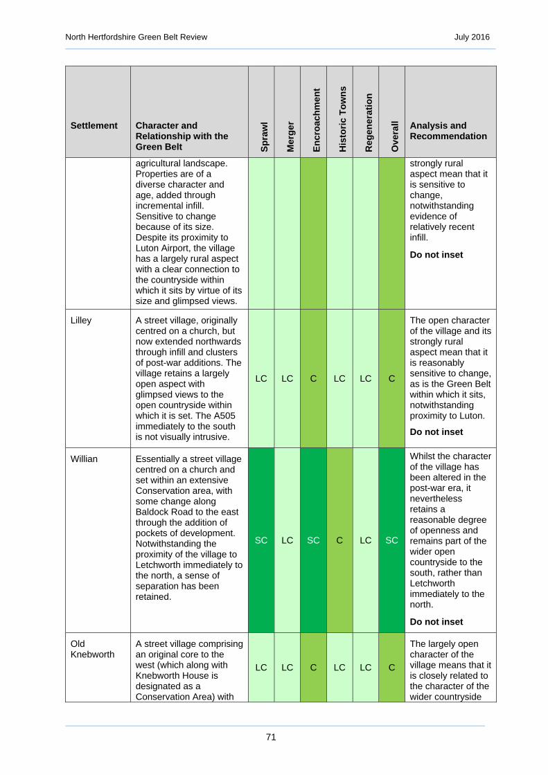
North Hertfordshire Green Belt Review July 2016
71
Settlement Character and Relationship with the Green Belt S
pra
wl
Mer
ger
En
cro
ach
men
t
His
tori
c T
ow
ns
Reg
ener
atio
n
Ove
rall Analysis and
Recommendation
agricultural landscape. Properties are of a diverse character and age, added through incremental infill. Sensitive to change because of its size. Despite its proximity to Luton Airport, the village has a largely rural aspect with a clear connection to the countryside within which it sits by virtue of its size and glimpsed views.
strongly rural aspect mean that it is sensitive to change, notwithstanding evidence of relatively recent infill.
Do not inset
Lilley A street village, originally centred on a church, but now extended northwards through infill and clusters of post-war additions. The village retains a largely open aspect with glimpsed views to the open countryside within which it is set. The A505 immediately to the south is not visually intrusive.
LC LC C LC LC C
The open character of the village and its strongly rural aspect mean that it is reasonably sensitive to change, as is the Green Belt within which it sits, notwithstanding proximity to Luton.
Do not inset
Willian Essentially a street village centred on a church and set within an extensive Conservation area, with some change along Baldock Road to the east through the addition of pockets of development. Notwithstanding the proximity of the village to Letchworth immediately to the north, a sense of separation has been retained.
SC LC SC C LC SC
Whilst the character of the village has been altered in the post-war era, it nevertheless retains a reasonable degree of openness and remains part of the wider open countryside to the south, rather than Letchworth immediately to the north.
Do not inset
Old Knebworth
A street village comprising an original core to the west (which along with Knebworth House is designated as a Conservation Area) with
LC LC C LC LC C
The largely open character of the village means that it is closely related to the character of the wider countryside

North Hertfordshire Green Belt Review July 2016
72
Settlement Character and Relationship with the Green Belt S
pra
wl
Mer
ger
En
cro
ach
men
t
His
tori
c T
ow
ns
Reg
ener
atio
n
Ove
rall Analysis and
Recommendation
some recent infill, and a post-war extension along Park Lane to the west. The village has an open character throughout, and infill has been sensitively incorporated into the settlement footprint, helping to retain a distinctive character. Opportunities for infill appear to have been taken.
within which it sits. Any significant change in the built extent of the village would encroach into open countryside and historic parkland immediately to the north.
Do not inset
Blackmore End
A relatively dense development of largely1960s and later detached dwellings (of various sizes) built on the site of a country house and estate. The cohesion of the development rests in its relatively high density and modern housing styles. As such, this is not a village per se but a large housing estate, with no services or focal point.
LC LC LC LC LC LC
Although situated within the Green Belt there is no immediate connection in respect of openness or contribution to its character. The separate identity means that there is no clear reason for keeping the development washed over by Green Belt.
Inset
Breachwood Green
Essentially a street village which has grown incrementally from its original core along Chapel Road/Heath Road to substantial post-war development centred on Oxford Road, with various elements of infill scattered throughout. There is a significant variety of building footprints, generally of a medium density, reflecting post-ward infill of various scales. Complex surrounding field pattern offers further opportunities for ‘infill’, although the
LC LC C LC LC C
There are some dense clusters of development, although as a whole the village retains a largely open character with a reasonably strong connection to the countryside within which it is set. This reflects an incremental development pattern which has resulted in a complex edge to the settlement, with many properties
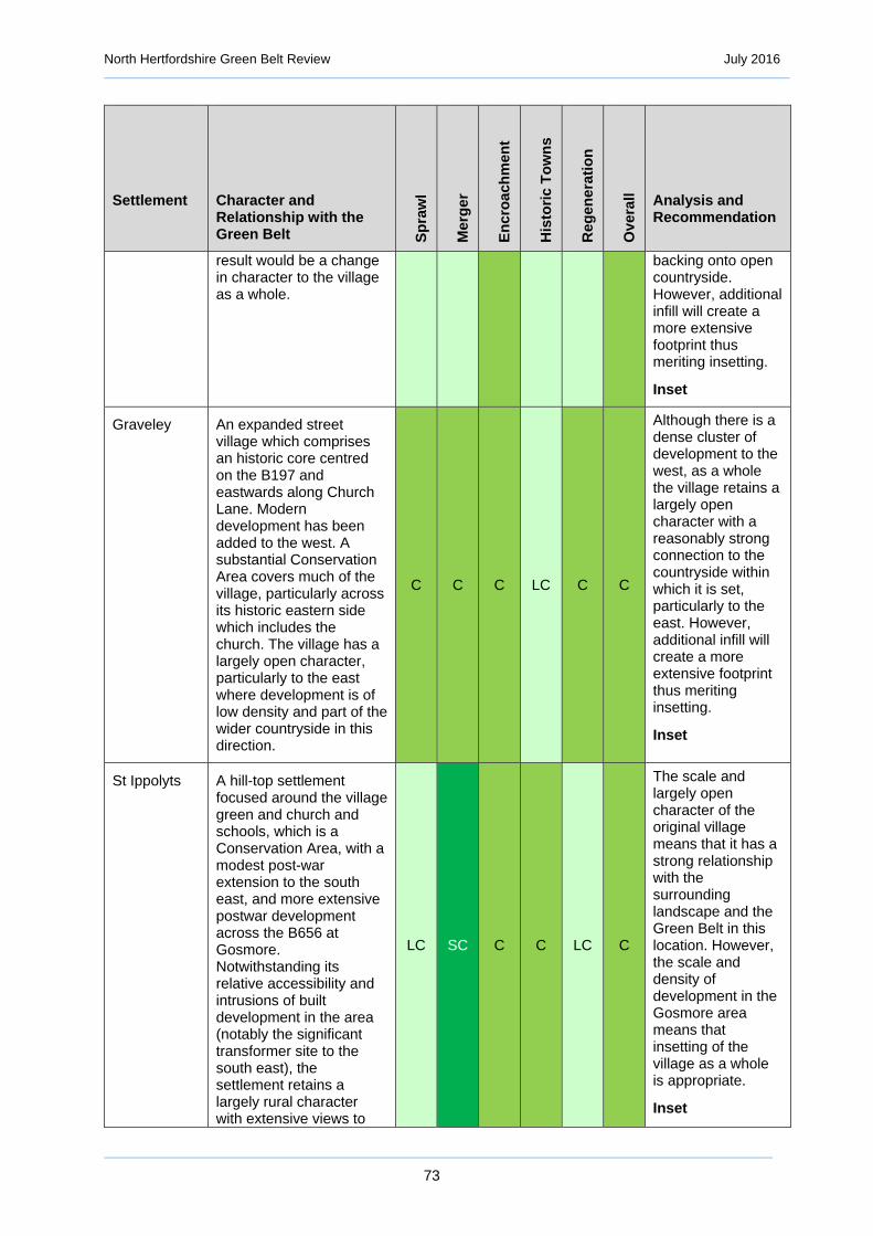
North Hertfordshire Green Belt Review July 2016
73
Settlement Character and Relationship with the Green Belt S
pra
wl
Mer
ger
En
cro
ach
men
t
His
tori
c T
ow
ns
Reg
ener
atio
n
Ove
rall Analysis and
Recommendation
result would be a change in character to the village as a whole.
backing onto open countryside. However, additional infill will create a more extensive footprint thus meriting insetting.
Inset
Graveley An expanded street village which comprises an historic core centred on the B197 and eastwards along Church Lane. Modern development has been added to the west. A substantial Conservation Area covers much of the village, particularly across its historic eastern side which includes the church. The village has a largely open character, particularly to the east where development is of low density and part of the wider countryside in this direction.
C C C LC C C
Although there is a dense cluster of development to the west, as a whole the village retains a largely open character with a reasonably strong connection to the countryside within which it is set, particularly to the east. However, additional infill will create a more extensive footprint thus meriting insetting.
Inset
St Ippolyts A hill-top settlement focused around the village green and church and schools, which is a Conservation Area, with a modest post-war extension to the south east, and more extensive postwar development across the B656 at Gosmore. Notwithstanding its relative accessibility and intrusions of built development in the area (notably the significant transformer site to the south east), the settlement retains a largely rural character with extensive views to
LC SC C C LC C
The scale and largely open character of the original village means that it has a strong relationship with the surrounding landscape and the Green Belt in this location. However, the scale and density of development in the Gosmore area means that insetting of the village as a whole is appropriate.
Inset

North Hertfordshire Green Belt Review July 2016
74
Settlement Character and Relationship with the Green Belt S
pra
wl
Mer
ger
En
cro
ach
men
t
His
tori
c T
ow
ns
Reg
ener
atio
n
Ove
rall Analysis and
Recommendation
the east and west. The relationship of the western part of the village at Gosmore to the open countryside is less strong.
Weston A much expanded street village which is set within open countryside. Built form is complex, reflecting the evolution of the village, with a significant variety of sizes, densities and eras of construction. A Conservation Area covers the original street village. There has been large amounts of infill, both towards the heart of the village and along its periphery. The scale and density of the village means that significant parts have no immediate physical or visual connection with the surrounding countryside, notwithstanding retention of a broad village character.
LC LC C LC LC LC
The extent and character of post-war infill development has created a village of significant scale relative to its relatively remote location. Whilst there is fragmented development on its periphery which retains a reasonably strong connection with the wider countryside, many areas of the village are of a relatively dense character and have no immediate connection with the surrounding countryside.
Inset

North Hertfordshire Green Belt Review July 2016
75
4.4 Village-by-Village Analysis
4.4.1 Clothall
Table 4.3: Clothall - Analysis of Character
Criteria Assessment
General character – location and overall setting, topography, settlement form, building type/age, overall sensitivity, sense of identity/unity/cohesion, key focal points, Conservation Area(s).
A small village set within open countryside of mixed farming on generally rising land from north east to south west. Fragmented clusters and single dwellings of various eras are characteristic, with glimpsed views of the surrounding countryside. There is no clear focal point for the village, although the church and surrounding buildings form an important cluster of development. There are no services within the village.
Density and layout of buildings – degree of spaciousness/enclosure, opportunities for infill within existing village boundary.
Very spacious feel with gardens backing onto open countryside. There are potential opportunities for very modest infilling without compromising overall character.
Presence and character of open space – location and relationship with settlement.
No formal areas of open space apart from the churchyard.
Interface with the surrounding landscape – settlement depth, rear garden character, glimpsed/panoramic views to the wider landscape, connectivity with landscape context.
A high degree of connection with the surrounding countryside, with the village forming an important part of the cultural landscape of this area.
Table 4.4: Clothall = Analysis of Contribution to Green Belt Purposes
Green Belt Purpose Degree of Contribution
Assessment
To check the unrestricted sprawl of large built-up areas
Limited Contribution
The village is set within open countryside away from a large built up area.
To prevent neighbouring towns from merging
Limited Contribution
The village is set within open countryside and not between towns.
©2016 Blom. ©Getmapping plc

North Hertfordshire Green Belt Review July 2016
76
Green Belt Purpose Degree of Contribution
Assessment
To assist in safeguarding the countryside from encroachment
Contribution The fragmented, open character of the village means that it is closely related to the character of the wider countryside within which it sits. Any significant change in the built extent of the village would encroach into open countryside.
To preserve the setting and special character of historic towns
Limited Contribution
The village is set within open countryside and not directly related to an historic town.
To assist in urban regeneration by encouraging the recycling of derelict and other urban land.
Limited Contribution
The village is set within open countryside and not directly related to an urban area.
Overall assessment and recommendation
Contribution The open character of the village and its strongly rural aspect mean that it is very sensitive to change, as is the relatively remote Green Belt within which it sits.
Do not inset
4.4.2 Great Wymondley
Table 4.5: Great Wymondley - Analysis of Character
Criteria Assessment
General character – location and overall setting, topography, settlement form, building type/age, overall sensitivity, sense of identity/unity/cohesion, key focal points, Conservation Area(s).
A nucleated village centred on the church and the village green with open fragmented development extending along four arms. The village is entirely covered by a Conservation Area and development is of a diverse and attractive character, largely one property deep, many set within irregular plots. There are glimpsed views of the open countryside beyond the village which is clearly integral to its containing landscape.
©2016 Blom. ©Getmapping plc

North Hertfordshire Green Belt Review July 2016
77
Criteria Assessment
Density and layout of buildings – degree of spaciousness/enclosure, opportunities for infill within existing village boundary.
Spacious feel with gardens backing onto open countryside. There are potential opportunities for very modest infilling without compromising overall character.
Presence and character of open space – location and relationship with settlement.
The village is centred on the church and village green.
Interface with the surrounding landscape – settlement depth, rear garden character, glimpsed/panoramic views to the wider landscape, connectivity with landscape context.
There is a high degree of connection with the surrounding countryside, with the village forming an important part of the cultural landscape of this area.
Great Wymondley Conservation Area

North Hertfordshire Green Belt Review July 2016
78
Table 4.6: Great Wymondley - Analysis of Contribution to Green Belt Purposes
Green Belt Purpose Degree of Contribution
Assessment
To check the unrestricted sprawl of large built-up areas
Contribution The village is set within the narrow gap between Stevenage and Hitchin, and the setting of the village is part of the land which contains the built edge of Hitchin.
To prevent neighbouring towns from merging
Significant Contribution
The village is set within the narrow gap between Stevenage and Hitchin and is a significant part of the remaining open countryside between them.
To assist in safeguarding the countryside from encroachment
Contribution The open character of the village, albeit with a strong focal point in the church, means that it is closely related to the character of the wider countryside within which it sits. Any significant change in the built extent of the village would encroach into open countryside.
To preserve the setting and special character of historic towns
Contribution The location of the village provides an indirect context for Hitchin, the built edge of which lies 1km to the north west.
To assist in urban regeneration by encouraging the recycling of derelict and other urban land.
Limited Contribution
The village is set within open countryside and not directly related to an urban area.
Overall assessment and recommendation
Significant Contribution
The open character of the village and its open aspect mean that it is very sensitive to change which would in turn affect the broader character of this land which sits directly in the narrow gap between Hitchin and Stevenage.
Do not inset
4.4.3 Peters Green
©2016 Blom. ©Getmapping plc

North Hertfordshire Green Belt Review July 2016
79
Table 4.7: Peters Green - Analysis of Character
Criteria Assessment
General character – location and overall setting, topography, settlement form, building type/age, overall sensitivity, sense of identity/unity/cohesion, key focal points, Conservation Area(s).
A small street village centred on a green, set within an extensive agricultural landscape. Properties are of a diverse character and age, added through incremental infill. Sensitive to change because of its size.
Density and layout of buildings – degree of spaciousness/enclosure, opportunities for infill within existing village boundary.
The scale of the village with properties typically only one deep off the arms of the village.
Presence and character of open space – location and relationship with settlement.
Village centred on the Green. No other formal open space.
Interface with the surrounding landscape – settlement depth, rear garden character, glimpsed/panoramic views to the wider landscape, connectivity with landscape context.
Despite its proximity to Luton Airport, the village has a largely rural aspect with a clear connection to the countryside within which it sits by virtue of its size and glimpsed views.
Table 4.8: Peters Green - Analysis of Contribution to Green Belt Purposes
Green Belt Purpose Degree of Contribution
Assessment
To check the unrestricted sprawl of large built-up areas
Limited Contribution
The village is set within open countryside away from a large built up area.
To prevent neighbouring towns from merging
Limited Contribution
The village is set within open countryside and not between towns.
To assist in safeguarding the countryside from encroachment
Contribution The size and largely open character of the village means that it is closely related to the character of the wider countryside within which it sits. Any significant change in the built extent of the village would encroach into open countryside.
To preserve the setting and special character of historic towns
Limited Contribution
The village is set within open countryside and not directly related to an historic town.
To assist in urban regeneration by encouraging the recycling of derelict and other urban land.
Limited Contribution
The village is set within open countryside and not directly related to an urban area.
Overall assessment and recommendation
Contribution The size and open character of the village and its strongly rural aspect mean that it is sensitive to change, notwithstanding evidence of relatively recent infill.
Do not inset

North Hertfordshire Green Belt Review July 2016
80
4.4.4 Lilley
Table 4.9: Lilley - Analysis of Character
Criteria Assessment
General character – location and overall setting, topography, settlement form, building type/age, overall sensitivity, sense of identity/unity/cohesion, key focal points, Conservation Area(s).
A street village, originally centred on a church which is the focus of the Conservation Area, but now extended northwards through infill and clusters of post-war additions. The village retains a largely open aspect with glimpsed views to the open countryside within which it is set. The A505 immediately to the south is not visually intrusive.
Density and layout of buildings – degree of spaciousness/enclosure, opportunities for infill within existing village boundary.
Of varying character, the original street village centred on the church contrasting with clusters of post-war development to the north.
Presence and character of open space – location and relationship with settlement.
No evidence of formal open space apart from the churchyard.
Interface with the surrounding landscape – settlement depth, rear garden character, glimpsed/panoramic views to the wider landscape, connectivity with landscape context.
Largely, but not exclusively one property deep with glimpsed views to the wider countryside.
©2016 Blom. ©Getmapping plc

North Hertfordshire Green Belt Review July 2016
81
Table 4.10: Lilley - Analysis of Contribution to Green Belt Purposes
Green Belt Purpose Degree of Contribution
Assessment
To check the unrestricted sprawl of large built-up areas
Limited Contribution
The village is set within open countryside away from a large built up area.
To prevent neighbouring towns from merging
Limited Contribution
The village is set within open countryside and not between towns.
To assist in safeguarding the countryside from encroachment
Contribution The largely open character of the village means that it is closely related to the wider countryside within which it sits. Any significant change in the built extent of the village would encroach into open countryside.
To preserve the setting and special character of historic towns
Limited Contribution
The village is set within open countryside and not directly related to an historic town.
To assist in urban regeneration by encouraging
Limited Contribution
The village is set within open countryside and not directly related to an urban area.
Lilley Conservation Area

North Hertfordshire Green Belt Review July 2016
82
Green Belt Purpose Degree of Contribution
Assessment
the recycling of derelict and other urban land.
Overall assessment and recommendation
Contribution The open character of the village and its strongly rural aspect mean that it is reasonably sensitive to change, as is the Green Belt within which it sits, notwithstanding proximity to Luton.
Do not inset
4.4.5 Willian
Table 4.11: Willian - Analysis of Character
Criteria Assessment
General character – location and overall setting, topography, settlement form, building type/age, overall sensitivity, sense of identity/unity/cohesion, key focal points, Conservation Area(s).
Essentially a street village centred on a church and set within an extensive Conservation area, with some change along Baldock Road to the east through the addition of pockets of development. Notwithstanding the proximity of the village to Letchworth immediately to the north, a sense of separation has been retained.
Density and layout of buildings – degree of spaciousness/enclosure, opportunities for infill within existing village boundary.
The village has an open character, with several properties set within large grounds and glimpsed views to the wider countryside to the south.
Presence and character of open space – location and relationship with settlement.
No formal open space apart from the churchyard.
©2016 Blom. ©Getmapping plc

North Hertfordshire Green Belt Review July 2016
83
Interface with the surrounding landscape – settlement depth, rear garden character, glimpsed/panoramic views to the wider landscape, connectivity with landscape context.
The village retains a strong connection to the wider countryside to the south, less so to the north where there is a minimal gap between the village and edge of Letchworth.
Table 4.12: Willian - Analysis of Contribution to Green Belt Purposes
Green Belt Purpose Degree of Contribution
Assessment
To check the unrestricted sprawl of large built-up areas
Significant Contribution
The village is effectively the southern boundary of Letchworth which has largely been built out to meet Willian, and is contained by it in this location.
To prevent neighbouring towns from merging
Limited Contribution
The village is not set between towns.
To assist in safeguarding the countryside from encroachment
Significant Contribution
The fragmented, open character of the village means that it is closely related to the character of the wider countryside within which it sits. Any significant
Willian Conservation Area

North Hertfordshire Green Belt Review July 2016
84
Green Belt Purpose Degree of Contribution
Assessment
change in the built extent of the village would encroach into open countryside.
To preserve the setting and special character of historic towns
Contribution The village forms part of the southerly context for Letchworth although there is no visual connection with the Conservation Area.
To assist in urban regeneration by encouraging the recycling of derelict and other urban land.
Limited Contribution
The village is not directly related to an urban area with regeneration opportunities.
Overall assessment and recommendation
Significant Contribution
Whilst the character of the village has been altered in the post-war era, it nevertheless retains a reasonable degree of openness and remains part of the wider open countryside to the south, rather than Letchworth immediately to the north.
Do not inset
4.4.6 Old Knebworth
Table 4.13: Old Knebworth - Analysis of Character
Criteria Assessment
General character – location and overall setting, topography, settlement form, building type/age, overall sensitivity, sense of identity/unity/cohesion, key focal points, Conservation Area(s).
A street village comprising an original core to the west (which along with Knebworth House is designated as a Conservation Area) with some recent infill, and a post-war extension along Park Lane to the west.
Density and layout of buildings – degree of spaciousness/enclosure, opportunities for infill within existing village boundary.
The village has an open character throughout, and infill has been sensitively incorporated into the settlement footprint, helping to retain a distinctive character. Opportunities for infill appear to have been taken.
©2016 Blom. ©Getmapping plc

North Hertfordshire Green Belt Review July 2016
85
Presence and character of open space – location and relationship with settlement.
Small village green only.
Interface with the surrounding landscape – settlement depth, rear garden character, glimpsed/panoramic views to the wider landscape, connectivity with landscape context.
Built form is typically one property deep, with some denser clusters, but which retain a strong visual connection with the open countryside/parkland setting of the village. Throughout the village there are a variety of glimpsed and longer distance views to open countryside.

North Hertfordshire Green Belt Review July 2016
86
Table 4.14: Old Knebworth - Analysis of Contribution to Green Belt Purposes
Green Belt Purpose Degree of Contribution
Assessment
To check the unrestricted sprawl of large built-up areas
Limited Contribution
The village is set within open countryside away from a large built up area.
To prevent neighbouring towns from merging
Limited Contribution
The village is set within open countryside and not between towns.
To assist in safeguarding the countryside from encroachment
Contribution The largely open character of the village means that it is closely related to the character of the wider countryside within which it sits. Any significant change in the built extent of the village would encroach into open countryside and historic parkland immediately to the north.
To preserve the setting and special character of historic towns
Limited Contribution
The village is set within open countryside and not directly related to an historic town. The village has a large Conservation Area which extends to cover Knebworth House to the north.
To assist in urban regeneration by encouraging the recycling of derelict and other urban land.
Limited Contribution
The village is set within open countryside and not directly related to an urban area.
Overall assessment and recommendation
Contribution The open character of the village and its strongly rural aspect mean that it is sensitive to change.
Do not inset
4.4.7 Blackmore End
Table 4.15: Blackmore End - Analysis of Character
Criteria Assessment ©2016 Blom. ©Getmapping plc

North Hertfordshire Green Belt Review July 2016
87
General character – location and overall setting, topography, settlement form, building type/age, overall sensitivity, sense of identity/unity/cohesion, key focal points, Conservation Area(s).
A relatively dense development of largely1960s and later detached dwellings (of various sizes) built on the site of a country house and estate. The cohesion of the development rests in its relatively high density and modern housing styles. As such, this is not a village per se but a large housing estate, with no services or focal point.
Density and layout of buildings – degree of spaciousness/enclosure, opportunities for infill within existing village boundary.
A variety of property styles but typically detached dwellings with large front and rear gardens creating a spacious character.
Presence and character of open space – location and relationship with settlement.
No open space present.
Interface with the surrounding landscape – settlement depth, rear garden character, glimpsed/panoramic views to the wider landscape, connectivity with landscape context.
Limited connection with the wider countryside once inside the estate, with relatively dense development, garden fences and vegetation blocking any views the wider landscape.
Table 4.16: Blackmore End - Analysis of Contribution to Green Belt Purposes
Green Belt Purpose Degree of Contribution
Assessment
To check the unrestricted sprawl of large built-up areas
Limited Contribution
The village is set within open countryside away from a large built up area.
To prevent neighbouring towns from merging
Limited Contribution
The village is set within open countryside and not between towns.
To assist in safeguarding the countryside from encroachment
Limited Contribution
The scale, spatial cohesion and built character of the development means that there is no contribution to safeguarding the countryside from encroachment through protecting openness for example.
To preserve the setting and special character of historic towns
Limited Contribution
The village is set within open countryside and not directly related to an historic town.
To assist in urban regeneration by encouraging the recycling of derelict and other urban land.
Limited Contribution
The village is set within open countryside and not directly related to an urban area.
Overall assessment and recommendation
Limited Contribution
Although situated within the Green Belt there is no immediate connection in respect of openness or contribution to its character. The separate identity means that there is no clear reason for keeping the development washed over by Green Belt.
Inset

North Hertfordshire Green Belt Review July 2016
88
4.4.8 Breachwood Green
Table 4.17: Breachwood Green - Analysis of Character
Criteria Assessment
General character – location and overall setting, topography, settlement form, building type/age, overall sensitivity, sense of identity/unity/cohesion, key focal points, Conservation Area(s).
Essentially a street village which has grown incrementally from its original core along Chapel Road/Heath Road to substantial post-war development centred on Oxford Road, with various elements of infill scattered throughout.
Density and layout of buildings – degree of spaciousness/enclosure, opportunities for infill within existing village boundary.
There is a significant variety of building footprints, generally of a medium density, reflecting post-ward infill of various scales. He complex surrounding field pattern offers further opportunities for ‘infill’, although the result would be a change in character to the village as a whole.
Presence and character of open space – location and relationship with settlement.
Significant playing field off Chapel Road.
Interface with the surrounding landscape – settlement depth, rear garden character, glimpsed/panoramic views to the wider landscape, connectivity with landscape context.
The variety of development footprints across the settlement offers various glimpsed and more extensive views across open countryside, thereby retaining a strong connection with the landscape context.
©2016 Blom. ©Getmapping plc

North Hertfordshire Green Belt Review July 2016
89
Table 4.18: Breachwood Green - Analysis of Contribution to Green Belt Purposes
Green Belt Purpose Degree of Contribution
Assessment
To check the unrestricted sprawl of large built-up areas
Limited Contribution
The village is set within open countryside away from a large built up area.
To prevent neighbouring towns from merging
Limited Contribution
The village is set within open countryside and not between towns.
To assist in safeguarding the countryside from encroachment
Contribution The largely open character of the village means that it has a strong visual connection with the wider countryside within which it sits. Further significant incremental development would encroach into open countryside.
To preserve the setting and special character of historic towns
Limited Contribution
The village is set within open countryside and not directly related to an historic town.
To assist in urban regeneration by encouraging the recycling of derelict and other urban land.
Limited Contribution
The village is set within open countryside and not directly related to an urban area.
Proposed Settlement Boundary

North Hertfordshire Green Belt Review July 2016
90
Green Belt Purpose Degree of Contribution
Assessment
Overall assessment and recommendation
Contribution There are some dense clusters of development, although as a whole the village retains a largely open character with a reasonably strong connection to the countryside within which it is set. This reflects an incremental development pattern which has resulted in a complex edge to the settlement, with many properties backing onto open countryside. However, additional infill will create a more extensive footprint thus meriting insetting.
Inset
4.4.9 Graveley
Table 4.19: Graveley - Analysis of Character
Criteria Assessment
General character – location and overall setting, topography, settlement form, building type/age, overall sensitivity, sense of identity/unity/cohesion, key focal points, Conservation Area(s).
An expanded street village which comprises an historic core centred on the B197 and eastwards along Church Lane. Modern development has been added to the west. A substantial Conservation Area covers much of the village, particularly across its historic eastern side which includes the church.
Density and layout of buildings – degree of spaciousness/enclosure, opportunities for infill within existing village boundary.
The village has a largely open character, particularly to the east where development is of low density and part of the wider countryside in this direction. New development to the west is of relatively high density but has been integrated into the landform such that a reasonable connection with the wider countryside is retained (notwithstanding the presence of the A1(M) to the west).
Presence and character of open space – location and relationship with settlement.
No formal open space.
©2016 Blom. ©Getmapping plc