north clydesdale forests - scotland.forestry.gov.uk · restocking* woodend moss deforestation...
TRANSCRIPT

Approval date: ***
Plan Reference No: ****
Plan Approval Date: *****
Plan Expiry Date: ******
North Clydesdale Forests
Land Management Plan Scottish Lowlands Forest District

2 | North Clydesdale Forests LMP | S. Towers | Sep 2017
CSM 6 Appendix 1b FOREST ENTERPRISE - Application for Land Management Plan Approvals in Scotland
Forest Enterprise - Property
Forest District: Scottish Lowlands
Woodland or property name: North Clydesdale Forests (Heathland/Woodmuir/Kingshill/West Forth/The Mosses
Nearest town, village or locality: Forth
OS Grid reference: NS 965 566; NS 965 588; NS 873 539; NS 939 531; NS 971 480
Local Authority district/unitary Authority: South Lanarkshire, North Lanarkshire & West Lothian
Areas for approval Conifer Broadleaf
Clear felling 344 -
Selective felling
Restocking* Woodend Moss Deforestation approved in previous plan 266 57
New planting (complete appendix 4) 9.3 13
1. I apply for Land Management Plan approval*/amendment approval* for the property described above and in the enclosed Land Management Plan. 2. * I apply for an opinion under the terms of the Environmental Impact Assessment (Forestry) (Scotland) Regulations 1999 for afforestation* /deforestation*/ roads*/ quarries* as detailed in my application. 3. I confirm that the initial scoping of the plan was carried out with FC staff on 4. I confirm that the proposals contained in this plan comply with the UK Forestry Standard. 5. I confirm that the scoping, carried out and documented in the Consultation Record attached, incorporated those stakeholders which the FC agreed must be included. 6. I confirm that consultation and scoping has been carried out with all relevant stakeholders over the content of the design plan. Consideration of all issues raised by stakeholders has been included in the process of plan preparation and the outcome recorded on the attached consultation record. I confirm that we have informed all stakeholders about the extent to which we have been able to address their concerns and, where it has not been possible to fully address their concerns we have reminded them of the opportunity to make further comment during the public consultation process. 7. I undertake to obtain any permission(s) necessary for the implementation of the approved Plan. Signed …………………………………… Signed…………………………………… Forest District Manager Conservator District …Scottish Lowlands………..… Conservancy……Central……………… Date …………………………………… Date of Approval………………………………… *delete as appropriate Date approval ends………………………………
02/10/2015

3 | North Clydesdale Forests LMP | S. Towers | Sep 2017
CSM 6 Appendix 4
FOREST ENTERPRISE - Application for Approval of Woodland Creation
1. Forest Enterprise – Property
Forest District: Scottish Lowlands Forest District
Woodland or property name: North Clydesdale Forests (West Forth)
Nearest town, village or locality: Forth
OS Grid reference: NS 939 531
Local Authority district/unitary Authority: South Lanarkshire
2. Proposed areas to nearest tenth of a hectare
New Planting 22.3
Natural Colonisation -
Open Ground -
Total 22.3
3. Special areas and protected land
Designation Area Name or Number Comments
n/a n/a n/a
4. Proposal details of woodland creation
Area Name or number Gross Area (Ha)
P Year Spp Area (Ha)
Open Ground (Ha)
Comments
Lowland mixed deciduous woodland 9.4 2020 SY, CAR, ASP, POK
9.4 -
Conifer 9.3 2020 SS 9.3 -
Low growing woody shrub 1.9 2020 HAZ, WEM, ROW, HAW
1.9 -
Native wet woodland 1.7 2020 GWL, PBI, CAR 1.7 -
I apply for authority to create woodland as above and as shown on the attached map. I undertake to obtain the necessary permissions from the appropriate statutory body before commencing work under any approval which is granted. Signed …………………………………… Signed……………………………………………… Forest District Manager Conservator District …………………………………… Conservancy………………………………………. Date …………………………………… Approval Date……………………………………. Date approval ends ………………………………..

4 | North Clydesdale Forests LMP | S. Towers | Sep 2017
Environmental Impact Assessment Determination Enquiry Form
Complete this form to find out if you need consent, from the Forestry Commission
(under the EIA Regulations 1999), to carry out your proposed work.
Section 1 Proposed work
Please put a cross in the box to indicate the type of work you are proposing to carry out.
Give the area in hectares and where appropriate the percentage of conifers and
broadleaves.
Proposed
work cross
Area in
hectares
%
Conifer
%
broadleaves
Proposed
work cross
Area
in ha
Afforestation X 22.3 42 58 Forest
roads x 0.5
Deforestation Forest
quarry
Location and District
North Clydesdale Forests (West Forth); Forth,
South Lanarkshire – Scottish Lowlands Forest
District
Please attach map(s) showing the boundary of the proposed work and also give details of the
operations.
Section 2 Property details
Property Name North Clydesdale Forests (West Forth)
Grid Reference (e.g.
AB 123/789 NS 939 531
Local Authority South Lanarkshire
Nearest Town Forth
Section 3 Applicant’s category (please put a cross in one box)
PE Personal occupier PU Public ownership X
BU Business occupier OT Other
VO Voluntary organisation CT Crofting tenant

5 | North Clydesdale Forests LMP | S. Towers | Sep 2017
Section 4 Applicant’s type (please put a cross in one box)
LS Lessee OW Owner X
TE Tenant TR Trust
Section 5 your agent or woodland manager’s details
Title Mr Initials R Surname Clamp
Organisation Forestry Commission Scotland – Scottish Lowlands Forest District
Address Five Sisters House
Five Sisters Business Park
West Calder Postcode EH55 8PN
Tel No 0300 067 6725 Mobile 07801 213 304
Fax - e-mail [email protected]
Is this the address for correspondence? yes X No
Section 6 Applicant’s details
Title Mr Initials S Surname Towers
Organisation Forestry Commission Scotland – Scottish Lowlands Forest District
Address Five Sisters House
Five Sisters Business Park
West Calder Postcode EH55 8PN
Tel No 0300 067 6765 Mobile 07867 353 108
Fax - e-mail [email protected]
Is this the address for correspondence? yes X No

6 | North Clydesdale Forests LMP | S. Towers | Sep 2017
Section 7 Sensitive Areas: Give the area of the proposal that is covered by any of the
following designations
Sensitive Area as listed in "Schedule 2" of the 1999 EIA Regulations Area
(ha)
Area in
hectares
a. Sites of Special Scientific Interest (SSSI) or Proposed Sites of Special
Scientific Interest (PSSSI) N/A
b. SSSI's with a Nature Conservation Order (Section 29 of the Wildlife
and Countryside Act 1981) N/A
c. National Park (NP) N/A

7 | North Clydesdale Forests LMP | S. Towers | Sep 2017
Contents
Summary of proposals ....................................................................................... 8
1.0 Introduction ................................................................................................ 9
1.1 Setting & Context ...................................................................................... 9
1.2 Site Histories .......................................................................................... 10
2.0 Analysis of previous plans ........................................................................... 12
3.0 Background information .............................................................................. 15
3.1 Physical site factors ................................................................................. 15
3.2 The existing forest .................................................................................. 17
3.3 Landscape & Land use ............................................................................. 23
3.4 Biodiversity & Environment ....................................................................... 26
3.5 Heritage ................................................................................................ 28
3.6 Community & Recreation .......................................................................... 29
4.0 Analysis & Concept .................................................................................... 31
5.0 Management Proposals ............................................................................... 32
5.1 Forest Stand Management ........................................................................ 32
5.2 Future species and habitats ...................................................................... 34
5.3 Prescriptions .......................................................................................... 37
5.4 Biodiversity & Environment ....................................................................... 39
5.5 Heritage ................................................................................................ 41
5.6 Community & Recreation .......................................................................... 43
5.7 Critical Success Factors ............................................................................ 43
Version History
Version Date Comments
1.0 02/08/2017 Initial Draft
1.1 14/09/2017 Minor changes after district staff feedback
1.2 03/11/2018 Update to 3.5 & 5.5 from WoSAS comment

8 | North Clydesdale Forests LMP | S. Towers | Sep 2017
Summary of proposals The ‘North Clydesdale Forests’ comprise the forest blocks of Heathland,
Woodmuir, Kingshill, West Forth & The Mosses. With the exception of West
Forth these blocks have served as significant productive forests within Scottish
Lowlands Forest District, producing large volumes of standard quality timber. The
intention is to maintain this function whilst continuing to diversify the structural and
biological diversity of the blocks. Recent tree health concerns over various pines
and larch species have necessitated a revaluation of further planned species
diversification for these blocks supporting the continued judicious use of Sitka
Spruce both as a pure crop and in mixture with Lodgepole pine.
The proportion of native broadleaves within the forest will be increased and the
move, initiated in previous plans, to create semi natural Forest Habitat Networks
along the riparian corridors continues. Improvement to forest edges along roadside
corridors will also continue to progress as part of this plan.
The primary objectives for the plan areas are to continue the sustainable production
of timber, enhance native woodland habitat networks and to develop and maintain
high quality access and recreation infrastructure.
Woodland changes
Species Breakdown 2017 2027 2037
Primary species: Sitka spruce 47% 37% 36%
Secondary species: other conifers 15% 13% 12%
Broadleaves 6% 8% 9%
Open, Successional, Felled, Other 32% 42% 43%
Total Plan Area: 2,205 Ha
Key Proposals
Planned Operations 2017-2027
Felling 344 Ha
Thinning 31 Ha
Restock 284 Ha
Woodland Creation 22.3 Ha
Habitat Restoration 45 Ha
Road Construction 788 m

9 | North Clydesdale Forests LMP | S. Towers | Sep 2017
1.0 Introduction 1.1 Setting & Context
The ‘North Clydesdale Forests’ comprise the forest blocks of Heathland, Woodmuir,
Kingshill, West Forth & The Mosses. The majority of the forests are situated within
South Lanarkshire local authority area however approx. 64 Ha of Kingshill lies
within North Lanarkshire and Woodmuir is situated in West Lothian.
• Heathland (1178 Ha) lies both east and west of the A706 just north of the
village of Forth.
• Woodmuir (366 Ha) lies north and south of the A704 and abuts Heathland to
the south.
• Kingshill (360 Ha) lies south of the village of Allanton off the A71.
• West Forth (95 Ha) lies to the east and west of the A706 south of Forth.
• The Mosses (206 Ha) are located north of the village of Carnwath off the
B7016.
The forests lie within the upland setting of the central plateau and primarily
function to produce large volumes of cellulose from typical commercial conifer
species.
See Map 1 Location & Map 2 Context
The current land matrix is as follows:
Table 1 – Current Forest Blocks land usage
Area (Ha)
Land use\Site Heathland Woodmuir Kingshill West Forth The Mosses
Forest 810 271 273 47 93
Felled 141 48
Open 145 85 74 43 63
Archaeology 27 1
Other 55 9 13 5 2

10 | North Clydesdale Forests LMP | S. Towers | Sep 2017
Figure 1 – North Clydesdale Forests Current Land Usage
1.2 Site Histories Heathland
The forest we see today at Heathland is comprised of various former agricultural or
opencast mine holdings purchased between 1968 and 2014 with the majority of the
area planted with commercial conifer during the 1970’s and 1980’s. Since the early
2000’s patch clear-fells have been carried out beginning a process of forest
restructuring and diversification which is still on-going. There was further expansion
of the forest in the early 2000’s after restoration of the former opencast coal area
at Mountainblaw around the millennia using sewage filter cake. This process was
mirrored to the south-east at Horberry where FES originally leased and created
woodland on behalf of the opencast mining operators later acquiring the site
outright in 2014. This plan will replace the previous Forest Design Plan (FC Ref:
032/04/06) which has had extended approval from 9th March 2015 and will now
incorporate Horberry which was not included within the current plan.
Woodmuir
Woodmuir was acquired for the NFE in 1959 and first planted in the 1960’s and
subsequently almost entirely all harvested and restocked through the 1990’s and
early 2000’s. During the 1990’s a significant area of ground, generally stretching
through the middle of the site south of the A704, began to be opencast mined for
coal. The operators subsequently went bankrupt, leaving the site unrestored. In
2004 a partnership between FEC & Digit utilised sewage filter cake to restore this
area after filling and reshaping. The restored area was then planted with a range of
conifer and broadleaf species with the opportunity also taken to create permanent

11 | North Clydesdale Forests LMP | S. Towers | Sep 2017
access routes and a large wildlife pond. This plan will replace the previous Forest
Design Plan (FC Ref: 035713002) which has 10 year approval until 13th May 2019.
Kingshill
Kingshill was purchased in 1961 and the forest established through the 1960’s &
70’s. The process of harvesting and restocking the forest to restructure and
diversify began in the late 1990’s into the 2000’s and continues today. In 2005 nine
turbines were constructed within the forest which form part of the wider Blacklaw
wind farm. This plan will replace the previous Forest Design Plan (FC Ref:
032/03/03) which has had extended approval from 17th December 2013.
West Forth
West Forth became part of the NFE in 1994 with the forest predominantly
established in 1995. In 2004, the Coal Authority were granted a 25 year lease in
order to implement a scheme to remove iron and other pollutants from water
coming out of the former deep coal mines via a burn within the site and into the
Mouse Water was created. This comprises a settlement lagoon and reed bed system
resulting in clean water reaching the river. The scheme achieved an Environmental
Commendation for Civil Engineering from the Saltire Society in 2006. This plan will
replace the previous Forest Design Plan (FC Ref: 032/08/06) which has 10 year
approval until 24th February 2018.
The Mosses
The Mosses were purchased in 1956 with the Blackgate Moss forest established in
the mid 1950’s although after a fire destroyed part of it some was replanted in the
1980’s. The forest at Carnwath Moss was established over the late 1960’s and early
1970’s and the forest at Woodend Moss was established in 1970. In 2015 most of
Carnwath Moss was harvested or mulched in order to restore the lowland raised
bog the forest was planted on. About half of Blackgate Moss was also harvested in
the same period although this will be restocked with native wet woodland species.
Woodend Moss is also due to be cleared for bog restoration in the next few years.
This plan will replace the previous Forest Design Plan (FC Ref: 032/08/14) which
has 10 year approval until 26th March 2018.

12 | North Clydesdale Forests LMP | S. Towers | Sep 2017
2.0 Analysis of previous plans
Table 2 – Progress on previous LMP objectives
Site Objective Proposed management
actions
Progress to date
1 - Little/No progress
2 – Some progress
3 – Progress as per LMP
Heathland To enhance the value of
the area to wildlife by
increasing age and
species diversity and
developing a Forest
Habitat Network (FHN)
based on the
watercourse corridors.
Felling and restocking will be
timed to ensure that a variety of
age classes is dispersed
throughout the area
Creation of robust wind firm
boundaries at the replanting
stage will enable further
restructuring initiatives to be
taken in subsequent rotations
3
To improve the
recreation value of the
forest and preserve
features of
archaeological interest.
Seek funding to remove trees
from around the built remains, to
provide interpretation and
improve access
3
To improve the external
and internal views of the
forest.
3
To protect water quality
and the physical
integrity of streams.
Native broadleaf trees and shrubs
will be concentrated along the
principal watercourses as a FHN,
providing linkages also to some of
the unplanted open ground
surrounding the forest.
2
Woodmuir Maintain and increase
conifer productivity
using improved planting
stock where possible.
In the plan period an average of
1500 tonnes/annum will be
produced.
3
Continue reducing
landscape impact by
redesign of edge
planting.
Continue restructuring of forest. 3

13 | North Clydesdale Forests LMP | S. Towers | Sep 2017
Maintain clean access
points at existing car
parks and trails.
- 3
Provide links to places
of interest as resources
permit.
We hope to work with
communities at Breich and Forth
to encourage greater activity,
with potential for a link between
Woodmuir and Heathland to the
south.
2
Protect newly
designated Ancient
monument and other
historic features.
Any work required is agreed with
Historic Environment Scotland in
a management plan reviewed
every 5 years. This plan includes
annual recorded inspections. Tree
planting will be kept back at least
20m from other historic features.
3
Continue development
of diverse forest
structure for long
distance views and
improvements along
transport corridors.
Continue restructuring of forest. 3
Continue improvements
along main
watercourses and
around wildlife ponds
created at opencast
restoration.
Felling and restocking of coupe
22 will make a significant addition
to the FHN. In coupes 11 & 27
clear spruce regen and enrich
with more broadleaves.
2
Kingshill Sustainable timber
production
- 3
Conservation of heritage
and focusing of
resources on LBAP
priorities
Restocking designed to protected
the archaeological remains
around Bentyhillocks
3
Increase the area of
broadleaves
Along the valley of the Auchter
Water there is a significant
increase in broadleaf planting.
There are some areas with
significant natural regeneration of
2

14 | North Clydesdale Forests LMP | S. Towers | Sep 2017
broadleaves, which it is expected
will spread further into the
productive forest, as well as
along the watercourse area.
Age diversification Larger coupes will been
subdivided at restocking to allow
further restructuring in the next
rotation. Short-rotation forestry
on areas out with the ‘footprint’
of the turbine requires felling of
crops >13.5m top height within
~200m of each turbine.
3
Increase in linked
accesses to surrounding
ground
Connections to adjacent forest
and other areas outside the forest
will be built as part of the
windfarm construction. Providing
and signing links in longer
distance routes will be actively
considered in partnership with all
interested parties
2
West Forth To enhance the benefits
for wildlife by managing
the open space to
diversify vegetation
The wildflower meadow,
established in 2006, continues to
be managed by mowing and
removal of cut vegetation.
3
To improve the
recreation value of the
forest
Existing surfaced tracks will be
maintained and funding sought to
upgrade others if demand
supports this need.
3
To maintain a supply of
timber for the Scottish
wood-using industry
Thinning may be an option in the
forest, despite some difficulties
with access across rides and
wayleaves
3
To protect water quality
and the physical
integrity of streams
- 3
To improve the external
and internal views of the
forest
- 3

15 | North Clydesdale Forests LMP | S. Towers | Sep 2017
The Mosses In the ten years covered
by this Plan, there is no
work proposed which
would require Approval.
3 - Since the inception
of this plan FES’s
Strategy for Lowland
Raised Bogs and
Intermediate Bogs has
been published and we
successfully amended
the FDP to allow us to
fell all of Carnwath and
Woodend Mosses for
bog restoration as well
as part of Blackgate
Moss to transition to
native wet woodland.
The Carnwath &
Blackgate operations
took place in 2015 with
Woodend due in the
next few years.
3.0 Background information
3.1 Physical site factors
3.1.1 Soils & landform
Heathland, Woodmuir, Kingshill & West Forth sit on predominantly alkaline
limestone associated bedrock formations which also featured coal seams at
Heathland, Woodmuir and West Forth accounting for their previous mining
histories. The Mosses lie predominantly over basic volcanic rock. The superficial
geology has been influenced by glaciation with deposits of till spread across most of
the sites. Peat is also widespread found in large areas of Heathland, Woodmuir,
Kingshill and The Mosses. The underlying geology and landform have produced
generally poor soils which therefore limit the number of species suited to grow well
across these sites. The areas of peat are generally characterised by a matrix of
poor unflushed raised and blanket bogs as well as areas of flushed basin and
blanket bog. The till deposits are generally characterised by peaty and typical
surface-water gleys. Better quality brown earths are scarce as are areas of man-
made and skeletal soils. In some cases, along various watercourses, valley complex
soils have also developed. In areas where surface mining previously occurred
(Heathland and Woodmuir) these were restored using sewage cake, with varying

16 | North Clydesdale Forests LMP | S. Towers | Sep 2017
degrees of success with some areas, particularly in Heathland, being mainly
compacted rock spoil. Generally, across the sites, the soils are wet and poor in
nutrients. Elevation rises from approximately 194m above sea level (asl) at
Kingshill to ~ 360m asl at Heathland.
See Map 3a - Soils
3.1.2 Current climate & exposure
The climate across the sites ranges from ‘Warm’ and ‘Moist’ to ‘Cool’ and ‘Wet’ with
the vast majority of the forest lying at the latter end of that spectrum.
See Map 3b - Climate
Detailed Aspect Method Scoring (DAMS) is a measure of windiness of a site using
the angle to the horizon in the eight compass points, weighted towards the
prevailing wind direction. Scores range from 0-24: The higher the score the greater
the exposure, with scores below 13 regarded as sheltered and above 22 as too high
for commercial forestry. DAMS on the site range from moderately exposed 15 –
severely exposed 19, with scores generally increasing with elevation. The majority
of the plan area is a highly exposed 17.
The predominant climate and exposure across the forest also limit the choice of
species suited to the conditions. Cumulatively the soils, climate and exposure limit
the choice of tree species suitable for continued productive conifer crops.
3.1.3 Future climate
Climate data projections for 2050 and 2080 have been used to predict the
anticipated future climate, which is expected to have warmer and drier summers,
but with an increase in the frequency and severity of winter storms. Although this
suggests that the range of suitable species may expand to accommodate more
demanding species, and that the growing season may extend, it may also indicate
an increased risk of drought which may, in future rotations, limit the site suitability
of species which are currently suitable.
3.1.4 Hydrology
Various small burns run though or adjacent to the sites feeding larger systems such
as the Rivers Clyde and Almond. Table 3 below lists the various watercourses found
at each site.

17 | North Clydesdale Forests LMP | S. Towers | Sep 2017
Table 3 – Watercourses
Heathland Woodmuir Kingshill West Forth The Mosses
Mouse Water
(Dippool Water to
Clyde)
Woodmuir Burn Auchter Water Mouse Water
(Dippool Water to
Clyde)
Dippool Water
Mosshat Burn
(Dippool Water to
Clyde)
Longford Burn Garrion Burn Abbey Burn
Wormlaw Burn Paddy’s River
Punce Linn
(Harwood Water to
Forth)
In addition to the watercourses the disused waterbody of Lambcatch Reservoir is
located within Heathland forest however it is not within the National Forest Estate
ownership but rather is owned by the local authority.
Further to the watercourses and waterbodies the sites are collectively situated on
the ‘Lanark’, ‘Stirling & Falkirk’ and ‘Clydesdale’ bedrock and localised sand and
gravel aquifers which also have associated Groundwater Drinking Water Directives.
Heathland, Kingshill, West Forth also influence the ‘Lower Clyde including Mouse
Water and Auchter Water’ Sensitive Areas River Urban waste water Treatment
Directive. The hydrology also collectively impact on the River Clyde and River
Almond Salmonid Waters Fresh Water Fish Directive.
3.2 The existing forest
3.2.1 Species, age structure & yield class
Table 4 below shows the species make-up of the individual forests with Figure X
further illustrating the collective species composition of the North Clydesdale
Forests. Both the table and figure show that the forests are predominantly conifer
(~91%) of which Sitka spruce constitutes ~74%.
See Map 3c - Existing Forest Stock

18 | North Clydesdale Forests LMP | S. Towers | Sep 2017
Table 4 – Current Forest Blocks Species by Area
Site - Area (Ha)
Species\Site Heathland Woodmuir Kingshill West Forth The Mosses
Sitka spruce 574 166 201 28 42
Norway spruce 15 18 8
Larches 108 24 23 3
Lodgepole pine 43 16 6 39
Scots pine 12 16 16 0 1
Other conifers 3 0 1
Broadleaves 56 32 18 16 11
Figure 2 – Current North Clydesdale Forests Species Composition
Figure 3a below illustrates that the general picture across the forests collectively is
much of the forest is predominantly made up of mature crops which should rightly
be felled during the life of this plan. This is no surprise given the relatively even
aged nature of the forests, generally planted during the 1970’s and 1980’s, and
presents a challenge to diversify the age structure and thus avoiding creating a
similar problem at the end of the next rotation. Figures 3b-3f further illustrate how
the structures vary in each individual forest and also highlight in the establishment
columns some of the restructuring work that has already occurred.

19 | North Clydesdale Forests LMP | S. Towers | Sep 2017
Figure 3a – Current North Clydesdale Forests Age Structure
Figure 3b – Current Heathland Age Structure

20 | North Clydesdale Forests LMP | S. Towers | Sep 2017
Figure 3c – Current Woodmuir Age Structure
Figure 3d – Current Kingshill Age Structure

21 | North Clydesdale Forests LMP | S. Towers | Sep 2017
Figure 3e – Current West Forth Age Structure
Figure 3f – Current Mosses Age Structure
Yield classes for Sitka spruce range from 6 – 24 across the sites with the majority
of the crops being around YC 14. Much of the first rotation crop will have benefitted
from fertilizer application and therefore with fertilizer application no longer
generally practiced we can expect a general reduction in yield class of the 2nd
rotation crops by 2-4 grades. We can mitigate against this reduction somewhat by
22 | North Clydesdale Forests LMP | S. Towers | Sep 2017
the use of improved stock and the use of nurse crops such as Alaskan Lodgepole
pine.
3.2.2 Renewable energy - Wind
Kingshill has 9 wind turbines within its area which form part of a wider turbine
network which makes up the Blacklaw Windfarm. As part of the lease agreement
with the developer, Scottish Power Renewables (formerly CRE Energy), the district
has an obligation to maintain the trees within an agreed area under a short rotation
forestry regime, felling trees before they reach an average height of 12m for wind
flow.
3.2.3 Operational access
Currently each of the forest blocks is served by one or more forest roads. The
current network has generally been adequate however further enhancements will
be required to access certain areas needing felled in the next 10 years.
3.2.4 Low Impact Silviculture Systems (LISS) potential
With the generally highly exposed nature of the sites along with the poor, wet soils
the sites are not deemed as suitable for LISS.
3.2.5 Pathogens
3.2.5.1 Dothistroma Needle Blight (DNB)
DNB (also known as Red Band Needle Blight because of the colourful symptoms it
shows on pine) causes premature needle defoliation, resulting in loss of yield and,
in severe cases, tree death. Recent surveys have shown outbreaks of DNB across
Scottish Lowlands Forest District and within Heathland it is present on both mature
and thicket stage crops with the latter also true at Woodmuir.
3.2.5.2 Pytophthora ramorum (P. ramorum)
P. ramorum is a fungus-like pathogen of plants that is causing extensive damage
and mortality to trees and other plants in parts of the United Kingdom. Larch in
particularly is extremely vulnerable, and high infection and mortality levels are
currently causing significant issues in Galloway Forest District. Several isolated
instances of P. ramorum have been detected within Scottish Lowlands Forest
District forest blocks at the time of writing, although these were isolated trees
rather than large-scale infections. Despite the forests described in this plan falling
within Risk Zone 3, deemed the zone of lowest risk, one of the district infections
was discovered in Heathland Forest and resulted in a Statutory Plant Health Notice

23 | North Clydesdale Forests LMP | S. Towers | Sep 2017
to remove all other larch within both the affected stand as well as a 250m buffer
surrounding the affected stand.
3.2.5.3 Chalara fraxinea (Ash dieback)
Ash dieback is a serious disease of ash trees caused by a fungus, resulting in leaf
loss, crown dieback and, potentially, tree death. The young ash stands established
around the turn of the century have been confirmed as infected with Chalara. No
cases of Chalara have been confirmed at any of the plan sites however ash is
present as a component in various areas and therefore the potential for infection is
there.
3.3 Landscape & Land use
3.3.1 Landscape character
The sites are situated within four landscape character areas described in the 1998
‘The Lothians’, and 1999 ‘Glasgow and Clyde Valley’ Landscape Character
Assessments, key elements of which are reproduced below:

24 | North Clydesdale Forests LMP | S. Towers | Sep 2017
Table 5 – Landscape character assessment Glasgow & Clyde Valley LCA The Lothians LCA
Landscape Type Plateau Moorlands Plateau Farmland Rolling Farmland Upland Fringes
Key characteristics
and features
Distinctive upland character created by the
combination of elevation, exposure, smooth
plateau landform, moorland vegetation and
predominant lack of modern development
These areas share a sense of apparent
naturalness and remoteness which contrasts with
the farmed and settled lowlands.
Extensive, gently undulating landform
Dominance of pastoral farming but with
some mosses surviving
Limited and declining tree cover
Visually prominent settlements and
activities such as mineral working
The rural character of the Plateau Farmland
has suffered as tree cover has declined and
the visual influence of settlement, transport
infrastructure and mineral workings has
increased.
Distinctive undulating landform created
by fluvio-glacial action.
Dominance of pastoral farming, varying
in productivity according to elevation and
exposure.
Importance of woodland in structuring
the landscape and providing shelter for
agriculture and rural settlement.
Along the northern margins of the upland
areas lies a fringe of transitional
landscapes. These are differentiated from
the true uplands by a more productive
range of land cover types including
improved grassland, together with arable
land, particularly in the east, and
coniferous woodland, particularly in the
west.
Relevant landscape
guidelines
Encourage the management of existing
coniferous plantations in the plateau Moorlands
with the aim of developing more natural shapes
and achieving more varied age and species
composition.
Discourage significant expansion of existing
conifer plantations in order that the balance
between planted and unplanted land remains
broadly constant.
Where new planting does occur, encourage
designs which reflect and articulate local
variations in topography and avoid the obscuring
of local features such as burns, gullies, walls or
archaeological sites.
Encourage forest developments to retain broad
open space corridors which respect areas of
historic occupation and cultivation where these
occur.
Encourage the regeneration or expansion of
broadleaf woodland and scrub along burnsides
and in gullies creating a closer integration of
Bring existing field boundary trees and
farm woodlands into positive management
with the objective of prolonging the life of
existing specimens and bringing forward
replacement in the longer term
Consider the scope for additional woodland
planting around settlements, along
transport corridors and on the periphery of
other visually prominent land uses and
activities with the objective of reducing
these features’ impact on the wider
landscape.
In the area near Carstairs, the aim
should be to conserve and allow the
regeneration of semi-natural stands of
birch and Scots pine; there may be
opportunities to encourage the growth of
new woodlands on unwooded hillocks or
in the form of woodland belts linking
existing woods
Commercial plantations should be
designed carefully to ensure that they do
not undermine or obscure the small scale
nature of local topography; where this
type of forestry does occur, the aim
should be to encourage planting patterns
which retain a significant proportion of
open land which make use of organic
shapes and outlines and which avoid
geometric edges and boundaries.
Increase woodland cover in accordance
with Central Scotland Forest Strategy
targets, through sensitivity designed and
located planting, and keeping visual
balance between openness and enclosure
under regular review;
Reinforce robustness and integrity of
distinctive field boundary features:
treelines, hedgerows and shelterbelts;
Alleviate visual impact of existing large-
scale coniferous plantations through
restructuring;
Conserve diversity of open habitats on less
productive ground including wetland and
heather moorland;
Proposed new road route (Fastlink) will
require very careful siting and design in
sensitive, open landscape.

25 | North Clydesdale Forests LMP | S. Towers | Sep 2017
lowland woodland and the moorland landscape.
Support new woodland planting where
appropriate to provide screening around land
uses such as mineral extraction and along the
principle transport corridors.

26 | North Clydesdale Forests LMP | S. Towers | Sep 2017
3.3.2 Visibility
Due to the topography of the land the forests are generally only viewed at the small
to medium scale, either from transport corridors or nearby settlements. Views along
transport corridors are generally fleeting; however, where the forests line public
roads for a significant distance, these views can be more sustained. Some redesign
has previously occurred along forest edges/public road borders, moving away from
darker coniferous species and their tunnel effect toward a more varied and diverse
edge. Such edges generally combine diffuse broadleaved shrubs and trees with
judicious open space. Even so, certain roadside edges would still benefit from
further restructuring.
3.3.3 Neighbouring land use
The surrounding land use predominantly consists of a matrix of upland plateau
moor/farm land. Within this is the prominent settlement of Forth, various mineral
workings, peat cutting areas, Black Law & Leven Seat windfarms as well as other
neighbouring commercial forestry blocks. The most notable forest blocks include:
‘Longford & Sandys Wood’ located to the east of Woodmuir with ‘Pate’s Hill West’ to
the east again of that and ‘Muldron Forest’ which lies between the west of
Heathland and north-east of Kingshill.
3.4 Biodiversity & Environment
3.4.1 Priority Habitat Types
PHT’s are protected under the UK Biodiversity Action Plan, and FES policy is to
protect, enhance and expand these habitats where appropriate. There are a broad
range of open space and woodland types within the plan area, a number of which
are present across the sites. The most significant UK and Local Biodiversity Action
Plan habitats include Blanket Bog, widespread at Heathland and also found at The
Mosses although significantly mostly found under productive conifer plantation;
Lowland Raised Bog, prevalent at The Mosses; Wet Woodland and Fen, also
found at The Mosses; Reedbeds, found at Holmesdyke, West Forth and Rivers
and Burns such as The Mousewater, Wormlaw Burn, Mosshat Burn, Punce Linn and
other minor watercourses at Heathland.
The process of restoring Carnwath Moss Lowland Raised Bog has already begun
with the removal of the trees at Carnwath in 2015 both by conventional harvesting
machinery and tree mulching.

27 | North Clydesdale Forests LMP | S. Towers | Sep 2017
3.4.2 Ancient Woodland
Wilsontown Glen at Heathland has remnants of existing Ancient Semi-Natural
Woodland, which are well preserved and contain Aspen. Woodmuir also had a belt
of ancient woodland through the central portion of the forest north of the A704
which at some point was felled and planted with non-native trees i.e. it’s a
Plantation on Ancient Woodland Site (PAWS) of Scots pine and mixed broadleaves
which is now in the process of being restored.
3.4.3 Important Species
A variety of important species have been observed across the various sites and
recorded in our Conservation layer with various sites used by some also recorded.
Examples of significant species include:
Long Eared Owl, Northern Goshawk, Merlin, Eurasian Sparrowhawk, Eurasian
Jackdaw, Pine Marten, European Water Vole, European Otter, Smooth & Palmate
Newts, Common Lizard, Small pearl-bordered fritillary and Common blue
butterflies.
3.4.4 Wildlife (Deer Management)
The North Clydesdale Forests have healthy populations of Roe deer which are
maintained by the culling of, around 170 each year across the sites by way of a
deer management contract.
3.4.5 Non Native Invasive Species
Woodmuir has seen the intrusion of Himalayan balsam (Impatiens glandulifera)
most likely due to the fly-tipping of gardening/landscaping residue. This species is a
threat to native flora and habitats as it is aggressive and forms dense stands that
exclude other plants. If left unchecked Himalayan balsam could pose a risk of
colonising substantial areas to the detriment of native flora and fauna.
Woodmuir & Kingshill both support Grey squirrel (Sciurus carolinensis) which in
high numbers are extremely destructive in woodlands, stripping bark from the main
stem and branches of trees over late spring and summer. Oak, Scots pine and
Norway spruce are species within these sites which are particularly vulnerable to
stem breakage caused by bark stripping.
American Mink (Neovison vison) have previously been observed at Heathland.
Initially the population developed from animals escaping from fur farms, and
throughout the second half of the twentieth century it spread through most of
28 | North Clydesdale Forests LMP | S. Towers | Sep 2017
mainland UK. There is substantial evidence that mink have detrimental impacts on
native fauna including nesting inland waterfowl and aquatic mammals especially
water voles. Mink may also account for a large proportion of salmonid mortality in
some river systems.
3.5 Heritage
FES maintains extensive archaeological records for the NFE within our heritage
database. Important historic environment features are surveyed, recorded, mapped
and monitored by SLFD to ensure and demonstrate Forestry Commission Scotland
compliance with the UK Forestry Standard. This ensures that undiscovered historic
environment features are mapped and recorded prior to forestry management
operations and ensures the continued comprehensive protection of the known
archaeological resource. In the case of this plan area, whilst not identifying what
each feature is, the Key Features Opportunities and Constraints Maps (4a (i-
v)) show the various heritage feature locations within each block. There are a high
number of features within the plan area most of which are unscheduled and
generally already afforested. The sub-sections below provide further detail of those
features which have been the focus of any intervention during the previous plan
period.
3.5.1 Scheduled Monuments
Heathland – The Wilsontown Ironworks Scheduled Monument has an annual
inspection as part of the district’s Scheduled Monument Management Plan agreed
with Historic Environment Scotland.
Woodmuir – The district have removed trees from the Woodmuir Coke Ovens
Scheduled Monument when it was scheduled and continue to inspect annually and
manage the vegetation.
The Mosses – in 2014/15 the district cleared the trees from within the impact zone
and beyond of the Couthally Castle Ruin Scheduled Monument.
3.5.2 Non-scheduled Archaeology
Heathland – The district have used historic aerial photography to capture and
record several bell bit features which are out-with the scheduled monument area.
The district has upgraded part of the Bye Law Hill Tramway feature. The Thirlstane
stone cairn feature was the subject of the ‘Dig It’ archaeological project in 2015 to
‘excavate, record, investigate and restore’ the feature. A War Memorial is managed
by a local community group who have created a seated area with planter.

29 | North Clydesdale Forests LMP | S. Towers | Sep 2017
Kingshill – For the second rotation of the forest the district have left the former
Bentyhillocks farm steading unplanted with the feature surveyed and recorded in
2015.
West Forth – The district worked with the Coal Authority to preserve as part of the
reed-bed scheme the 18th Century underground stone outflow feature ‘Holmesyke
level’
3.6 Community & Recreation Heathland
The main recreational focus for Heathland is the Wilsontown Ironworks scheduled
monument and Wilsontown Glen which both fall within 1 km of Forth and therefore
qualify them as Woodlands In and Around Towns (WIAT). Recreation facilities here
consist of a car park, a network of surfaced and unsurfaced way-marked trails and
interpretation focused on the industrial heritage and biodiversity of the sites. Visitor
counters have been installed, and visitor numbers are estimated at between 12,000
and 15,000 per year. Recreation here is mainly focused on dog walking or visiting
the scheduled monument.
Regular maintenance work on the site consists of mowing the grass paths and
surfaced path edges, maintaining the interpretation and way-markers, and carrying
out repairs on the car park. Facilities and trees are inspected following OGB42
guidelines.
The Horberry area of Heathland is currently under a permission allowing a local
community group (WATIF – Woolford, Auchengray, Tarbrax Improvement
Foundation) to carry out minor access improvements to increase community use of
this area of the site.
The remainder of Heathland has little CVS involvement, apart from the regular
clearing of fly-tipping at forest road entrances, and maintenance of barriers.
Woodmuir
The only recreation provision at Woodmuir is a car park off the A704. Informal
access is taken from here along the forest roads, and also into the south block from
the forest road entrances. Visitor numbers are low.
The forest road entrances attract frequent fly-tipping. Recent work to clear the
entrances of vegetation to improve sightlines and visibility from the road has been
successful in reducing the frequency of fly-tipping incidents.
30 | North Clydesdale Forests LMP | S. Towers | Sep 2017
West Forth
This WIAT woodland attracts an estimated 4000 visitors per year. There are a
number of way-marked trails throughout the site. Access is generally taken from
Forth. Recreation here mainly takes the form of dog walking. There is also a small
lay-by allowing access from an unclassified road at the east side of the site next to
the settlement lagoon and reed bed system.
Recent work at West Forth has included the upgrading of a footpath loop (Rab’s
Path) with regular maintenance including the regular mowing of footpaths.
Education work has and continues to be carried out with local schools, making use
of the forest where possible.
Kingshill & The Mosses
There is no recreation provision at these sites, although a number of designated
core paths run through Kingshill. Both sites are targets for fly-tipping and low-level
anti-social behaviour.
31 | North Clydesdale Forests LMP | S. Towers | Sep 2017
4.0 Analysis & Concept Through survey work and research, a broad range of factors have been identified
which are potentially relevant to the future makeup and management of the land.
These have been analysed in order to better understand the way these interact,
and to draw out the most important features and trends.
See Maps 4a (i-v) Key Feature Opportunities & Constraints
This analysis was used to develop an initial design concept highlighting general
themes and outlining key considerations and activities which are likely to be most
relevant during the plan period, and which formed the basis for the initial
consultation with both the general public and key stakeholders.
See Maps 4b (i-v) Initial Design Concept

32 | North Clydesdale Forests LMP | S. Towers | Sep 2017
5.0 Management Proposals 5.1 Forest Stand Management
All proposals have been designed in accordance with sound silvicultural and
environmental principles, falling within the framework outlined by the UK Forestry
Standard, the UK Woodland Assurance Scheme, FC Bulletin 112 Creating New
Native Woodlands, FC Bulletin 115 Alternative Silvicultural Systems, FC Bulletin
124 Ecological Site Classification for Forestry and the current FC edition of Forest &
Water Guidelines.
Patch clear-felling remains the most appropriate silvicultural system for the
majority of the forests and it is the intention to move toward generally smaller
coupe sizes in future in order to facilitate the further restructuring of the blocks and
allow for more structurally and biologically diverse forests as well as imparting
greater flexibility for future management options.
See Maps 5a (i-v) Management
5.1.1 Clear felling
Patch clear felling will continue be the most appropriate management approach for
the majority of the forests which are predominantly productive conifer. While
generally coupe fell years are based on the optimal rotation lengths to reach
Maximum Mean Annual Increment various coupes are proposed for both early
felling; such as the areas of Short Rotation Forestry around wind turbines, and
others for retention; enhancing biological and structural diversity. It should also be
noted that another important consideration was smoothing the current general
peak in harvestable timber volume which was inevitable from these even aged
forests; this has to be considered both at the block and district level.
During the 10 years of the plan period, a total of 344 ha, with a projected volume
of 143,085 m3, are designated for clear felling (see Table 6 & Figure 4 below).
Table 6 – Projected Felling Phase Volumes by Block
Felling
Phase
Heathland
Est Vol (m3)
Woodmuir
Est Vol (m3)
Kingshill
Est Vol (m3)
West Forth
Est Vol (m3)
The Mosses
Est Vol (m3)
Overall
Volume (m3)
1 (2018-2022) 84,452 9,316 2,260 96,028
2 (2023-2027) 45,320 1,738 47,058
3 (2028-2032) 34,598 9,665 8,831 53,095
4 (2033-2037) 15,756 4,991 14,277 14,342 49,366
5 (2038-2042) 13,071 8,640 21,712
6 (2043-2047) 12,768 30,999 7,696 51,463
7 (2048-2052) 8,076 17,477 12,087 37,640

33 | North Clydesdale Forests LMP | S. Towers | Sep 2017
Figure 4 – Projected Felling Phase Volumes
5.1.2 Thinning
FCS policy generally assumes that all productive crops will be thinned, unless:
Thinning is likely to significantly increase the risk of windblow;
Operations are likely to require an unacceptably large investment in relation to
the potential benefits due to access or market considerations;
Thinning is unlikely to improve poorly stocked or poor quality crops.
SLFD policy is not to thin crops on areas with a DAMS score greater that 15; In the
case of the North Clydesdale Forest blocks, as described in section 3.1.2, most of
the forests are ‘highly exposed’ which means thinning operations would likely
significantly increase the risk of windthrow. Not only this but as the soils are
predominantly wet and soft, thinning operations would likely lead to significant
ground damage and therefore thinning should not be prescribed in these blocks for
future rotations; having said that there was a first thinning intervention carried out
in the 20 year old conifer crops at West Forth in 2015 and the crop remains stable
and undamaged by wind. We envisage further thinning of these crops on a 5 year
cycle until they are felled; this is expected to produce around 1000m3 of timber at
each intervention. A decision on whether or not to thin future rotations at West
Forth will be made in future plans.

34 | North Clydesdale Forests LMP | S. Towers | Sep 2017
All thinning decisions will be guided by Operational Guidance Booklet 9 - Managing
Thinning, and the current SLFD Thinning Plan.
5.1.3 Low Impact Silvicultural Systems (LISS)
As mentioned in the previous section these sites are not best suited for thinning as
the intended benefits of enhanced crop stability, increased tree volume and
improved regenerative potential would be negated by the risks to the crop from
windthrow and therefore not conducive for management through Alternative to
Clearfell methods such as LISS or Continuous Cover Forestry (CCF). However for
the small areas of broadleaves e.g. West Forth it may be beneficial to lightly thin
some crops for aesthetic benefit as well as to improve individual tree stability rather
than promoting any other silvicultural benefit.
5.1.4 Minimum Intervention and Natural Reserves
For various areas of the forests biodiversity will be the primary objective and we
are prepared to commit such areas of land to minimum intervention management
or leave as natural reserves. Natural reserves include existing mature mixed
woodland whilst Minimum Intervention areas tend to be mixed broadleaves and
areas of conifer forest, originally intended for commercial purposes, either planted
on areas of deep peat or on poorly restored ground which has led to very poor or
checked growth. In appropriate areas similar crops have been identified for removal
in order to restore the underlying bog habitat however several areas unsuitable for
restoration will be managed as peat edge woodland habitat. This minimum
intervention classification need not apply in perpetuity and should future economics
allow, these areas may be reviewed and revaluated for alternative management in
future plans.
5.1.5 Operational Access
During the life of this plan operations are only proposed in Heathland, Kingshill, and
The Mosses. For the areas affected generally the current road network will be
adequate however there will need to be ~ 250m of new road created at Kingshill to
access coupe 20 and two spur roads totalling ~540m off the existing road network
at Heathland to access coupe 45.
5.2 Future species and habitats Taking into account all the survey and analysis information, and the objectives set
out in the brief, a mix of productive conifer, semi-natural broadleaved woodlands
are proposed, along with areas of open ground.
The woodlands will be matched to the soils and ground vegetation, using the
guidelines set out in the Forestry Commission’s Ecological Site Classification (ESC)
Bulletin 124, which uses climatic zone, exposure, soil moisture, and soil nutrient
levels to inform the type of woodland most suited to particular areas within the site.

35 | North Clydesdale Forests LMP | S. Towers | Sep 2017
5.2.1 Proposed Restock Species
While it is important to recognise the challenges posed to forestry in the future
from predicted climate change and the increasingly diverse range of pests and
diseases afflicting a range of tree species; the soils, climate and topography of the
sites within this particular plan area limit opportunity to significantly diversify the
species make-up of the forests.
For the most part this plan proposes continued use of Sitka spruce as the
predominant productive conifer species with increased use of Lodgepole pine as a
nursing mixture. This plan does however propose to improve the habitat network
links chiefly through the development of semi-natural woodland along the riparian
corridors, most notably along the Mouse Water and Wormlaw Burn at Heathland.
These forest habitat networks will be comprised of a matrix of native broadleaves
and open space. Further use of mixed broadleaved planting with open space will be
employed where forest edges follow public road corridors.
Despite the species limitations faced, this plan continues to build on work of
previous plans to diversify the forests’ age structure. This is achieved, where
appropriate, by reducing the size of existing coupes and, when restocking,
designing in more wind firm edges to increase the stability of neighbouring coupes
and therefore allow for a greater range of options for future management decisions.
See Maps 5b (i-v) – Future Species & Habitats
Table 7 – Proposed Restock Species
Species Gross area (ha) % Net area (ha)
Sitka spruce 179 8% 156
Lodgepole pine/other conifer 87 4% 76
W4 Birch Woodland associated species 57 3% 40
W9 Upland mixed broadleaved woodland
associated species - -
5.2.2 Woodland Creation
This plan proposes some small scale new planting at West Forth on selected areas
of currently open space amongst areas of existing woodland. This additional
woodland area will provide an improved woodland experience for visitors, bringing
the woodland closer to the path network, with the additional benefit of enhancing
visual, structural and biological diversity.

36 | North Clydesdale Forests LMP | S. Towers | Sep 2017
5.2.2.1 Planting prescriptions
The proposed woodland will be made up of distinct woodland categories:
• Lowland mixed deciduous woodland
• Conifer
• Native wet woodland
• Low growing woody shrub
The indicative species, areas, densities and spacing for each category are listed in
Table 7 below (also see Map 5b iii – West Forth Future Species and Habitats).
Table 8 – West Forth Woodland Creation Figures
Woodland Category Indicative Species Density
(Stems/Ha) Spacing
(m) Area (Ha)
Lowland mixed deciduous woodland Sycamore, Common alder, Aspen, Pedunculate oak, Wild cherry
3000 1.8 x 1.8 9.4
Conifer Sitka spruce 2500 2.0 x 2.0 9.3
Low growing woody shrub Hazel, Wych elm, Elder, Rowan, Hawthorn, Blackthorn, Dog rose, Guelder rose
1100 3.0 x 3.0 1.9
Native wet woodland Goat Willow, Grey Willow, Downy birch, Common alder
1100 3.0 x 3.0 1.7
5.2.2.2 Ground preparation
Deep forestry ploughing will not be permitted as a method of ground preparation to
avoid sediment run-off and erosion. Shallow agricultural ploughing should not be
used on slopes over 9%. Site sensitive ground preparation methods such as hand
screefing and continuous mounding on slopes over 9%, will be adopted.
With regards drainage, appropriate methods will be employed in accordance with
the most recent edition of the Forests & Water Guidelines in areas of commercial
crop and no drainage methods will be employed in areas of native wet woodland as
these species depend on moist or waterlogged soils.
5.2.2.3 Crop protection
It is likely that the proposed areas of new broadleaved planting will be largely
protected using tree guards with the new conifer planting left unguarded and reliant
on the existing onsite deer management.

37 | North Clydesdale Forests LMP | S. Towers | Sep 2017
5.3 Prescriptions
5.3.1 Productive Conifers
The primary function of these forests is generally to produce high volumes of
softwood timber of relatively standard quality, predominantly providing for the
small roundwood and woodfuel market rather than the saw-log market.
As such and as per the SLFD restocking strategy a reduced management input will
generally be employed; meaning:
lower cost or alternative ground prep methods
restocking at average initial density of 2,700 stems/ha to achieve a final
density of between 2,250 and 2,500 stems/ha with an emphasis on achieving
overall stocking
top-up spraying may be employed based on evidence from the Hylobius
Management Support System.
a restricted SDA process to ensure that the objectives that are set for the
site are being met and to inform any future management
Sitka spruce will continue to form the primary component of the productive conifer
as it is well suited to the site with generally higher yield classes. Sitka will be
planted pure where the soils are better but on the poorer deep peat areas it will be
planted in intimate mixture with Lodgepole pine where the pine will act as a nurse.
Although Scots pine and larch were planted in various areas previously, due to the
threat posed by (respectively) DNB and P. ramorum detailed in section 3.2.5, there
will be no further restocking carried out using these species.
5.3.2 Semi-natural woodland
Various areas of the sites are potentially suitable to support Native woodland types
(as classified in FC Bulletin 112 Creating New Native Woodlands), the woodland
types, locations and species are listed in Table 9 below:
Table 9 – Native Woodland Types
Woodland Type Location Species
W4 (Birch woodland) Poorest ground, typically around
bogs and also along riparian
corridors.
Downy birch, Goat willow,
Common alder
W9 (Upland mixed broadleaved
woodland)
On more fertile soils. A wide range of broadleaved
species including Oak, Birch,
Rowan, Alder, Aspen, Gean,
Holly, Hazel and shrubs.

38 | North Clydesdale Forests LMP | S. Towers | Sep 2017
Riparian areas will generally be lower density W4 woodland incorporating around
30% of open space. Elsewhere, a more diverse range of native woodland types may
be planted according to local conditions. It may also be expected that a conifer
component will develop in these areas through natural regeneration; this can be
accepted however should be managed to ensure it remains a minor component.
5.3.3 Mixed woodland
Along transport corridors and along visible forest edges a diffuse matrix of non-
productive low density broadleaves and open space will be developed. Given its
tolerance of exposure and roadside conditions Sycamore may feature in this matrix
on areas of mineral soil. If a conifer component develops in these areas through
natural regeneration; this can be accepted however it should be managed to ensure
it remains a minor component. The district landscape architect will provide a more
detailed planting design for roadside restocking to coincide with the work plan
process.
In terms of management input the areas intended as semi-natural and mixed
woodland along with designed open space will be managed as per the SLFD
restocking strategy using minimal intervention with no/limited ground preparation.
Restocking will be at low densities according to site objectives with no SDA process
and with low future management input.
5.3.4 Open ground
Our management of open ground for biodiversity will include the surveying and
monitoring of natural tree regeneration at the recently deforested Carnwath Moss
LRB and any necessary scrub cutting required. At Woodend Moss we will remove
any trees not already felled by standard methods to restore the underlying LRB as
per the previous approved LMP. We will also continue to annually mow the wild
flower meadow area at West Forth. Other areas of ground managed as open for
heritage conservation are detailed in section 5.5.
5.3.5 Remediation of restored former opencast coal mines
Some areas of Heathland which were formerly open cast coal mines and were
restored in the past have not been successful in creating a medium suitable for
commercial tree growth. Such areas may be revisited in future, depending on
discussions with potential restoration partners, with a view to doing some further
remedial restoration to improve the soil condition in order to successfully establish
viable commercial crops. Depending on timescales this may require future
amendments of this plan in order to allow coupes containing failing crops to be
felled early to allow for this soils remediation.

39 | North Clydesdale Forests LMP | S. Towers | Sep 2017
5.3.6 Water
All operations will follow best practice as detailed in the current Forest and Water
Guidelines. Timber extraction will normally avoid crossing burns or main drains,
but, where necessary, each crossing point will be piped or bridged. Branches will be
kept out of watercourses and trees will generally be felled away from the
watercourses.
5.4 Biodiversity & Environment
5.4.1 Habitat Management
The various woodland and open priority habitats as well as the species they support
will continue to be conserved and developed as per the management detailed in the
previous section.
5.4.2 Ancient Woodland
5.4.2.1 PAWS
A PAWS survey to monitor the condition of the ancient semi natural woodland at
Wilsontown Glen will be carried out
Scrub cutting at Woodmuir PAWS area to remove Sitka spruce regeneration and in
addition encouraging Aspen suckering in order to further establish this native
broadleaf species.
5.4.2.2 Deadwood
The aim is to use natural processes by retaining dead, windblown or snapped stems
or those created during previous operations. Deadwood can be trees or limbs in the
early stage of decomposition, e.g. veterans or dying individual trees. These should
be retained wherever possible to create an even mix of standing, fallen or stacked
deadwood.
Deadwood will be concentrated in areas where it will provide the highest ecological
benefit, such as;
• Riparian and wet woodland areas
• Natural reserves and long-term retentions
• Ancient semi-natural woodland
• Areas of significant existing deadwood
40 | North Clydesdale Forests LMP | S. Towers | Sep 2017
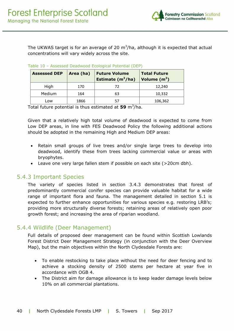
The UKWAS target is for an average of 20 m3/ha, although it is expected that actual
concentrations will vary widely across the site.
Table 10 – Assessed Deadwood Ecological Potential (DEP)
Assessed DEP Area (ha) Future Volume
Estimate (m3/ha)
Total Future
Volume (m3)
High 170 72 12,240
Medium 164 63 10,332
Low 1866 57 106,362
Total future potential is thus estimated at 59 m3/ha.
Given that a relatively high total volume of deadwood is expected to come from
Low DEP areas, in line with FES Deadwood Policy the following additional actions
should be adopted in the remaining High and Medium DEP areas:
Retain small groups of live trees and/or single large trees to develop into
deadwood, identify these from trees lacking commercial value or areas with
bryophytes.
Leave one very large fallen stem if possible on each site (>20cm dbh).
5.4.3 Important Species
The variety of species listed in section 3.4.3 demonstrates that forest of
predominantly commercial conifer species can provide valuable habitat for a wide
range of important flora and fauna. The management detailed in section 5.1 is
expected to further enhance opportunities for various species e.g. restoring LRB’s;
providing more structurally diverse forests; retaining areas of relatively open poor
growth forest; and increasing the area of riparian woodland.
5.4.4 Wildlife (Deer Management)
Full details of proposed deer management can be found within Scottish Lowlands
Forest District Deer Management Strategy (in conjunction with the Deer Overview
Map), but the main objectives within the North Clydesdale Forests are:
To enable restocking to take place without the need for deer fencing and to
achieve a stocking density of 2500 stems per hectare at year five in
accordance with OGB 4.
The District aim for damage allowance is to keep leader damage levels below
10% on all commercial plantations.

41 | North Clydesdale Forests LMP | S. Towers | Sep 2017
Ensure all Biological resources on the National Forest Estate remain in
favourable condition (as per SNH guidelines).
To maintain a sustainable deer population.
5.4.5 Non Native Invasive Species
Himalayan balsam (Impatiens glandulifera) - An eradication programme is in
place within affected sites across the district in accordance with the District
Invasive Non-Native Species Plan 2014-2019. This will continue with a foliar
spraying regime at Woodmuir to eradicate the balsam.
Grey squirrel (Sciurus carolinensis) - As Woodmuir is not within a Red squirrel
(Sciurus vulgaris) stronghold they are not deemed a threat to this species here and
therefore this is not a driver for controlling them. Furthermore the tree species with
the potential to be affected by grey squirrel form only a minor component of the
forest so likewise this also is not a driver to introduce Grey squirrel control.
American mink (Neovison vison) – Despite the potential threat to water vole at
Heathland their population seems to be thriving. It is suspected that suitable
riparian habitat where wet fen like conditions provide various small dry refuges for
the water vole protect them from the mink. This plan will see the enhancement of
such riparian areas along the main watercourses which in turn should benefit water
vole. To effectively control mink in the area would require collaboration with
neighbouring landowners and partners under a targeted local project which at
present has not been established. FES remains open to any future discussions with
appropriate partners to tackle this issue.
5.5 Heritage
The forest design illustrated in the Future Species and Habitats Maps (5b (i-v))
considered the various heritage features, many currently hidden under trees such
as historic tramways, and our future management intends to gradually reveal many
of these more and more going forward providing enhanced context to them and
also improving our ability to access and manage these features in the future.
Appropriate buffers have been applied by our Environment & Heritage Forester to
all the different features across the sites which are recorded within our heritage
database. This is done in accordance with the guidance provided in the Forests and
Historic Environment guidelines (2011), the FCS policy document: Scotland’s
Woodlands and the Historic Environment (2008) and the supporting FES Historic
Environment Planning Guidelines. Features generally have buffers ranging from 5-
10 metres depending on their nature but these can be wider or even have no
buffer. Such constraints are identified and surveyed by Forest District staff prior to

42 | North Clydesdale Forests LMP | S. Towers | Sep 2017
any work being undertaken in order to ensure that upstanding historic environment
features can be marked and avoided. For operations, work prescriptions protect
relevant historic environment features apportioning appropriate buffers clear from
ground disturbing operations and planting. Opportunities to enhance the setting of
important sites are considered on a case-by-case basis.
The following sub-sections provide further detail as to some features which will see
specific management or work on them during the life of this plan.
5.5.1 Scheduled Monuments
Heathland
The district will continue to manage and promote the Wilsontown Ironworks
Scheduled Monument in accordance with the Historic Environment Scotland-
approved Management Plan including scrub cutting, rose bay willow herb treatment
and using sheep to manage the vegetation. In addition to this we will also collate
new information as it is revealed and give two talks to heritage groups each year.
Woodmuir
SLFD will continue to control vegetation on the Woodmuir Coke Ovens Scheduled
Monument in accordance with the Historic Environment Scotland-approved
Management Plan.
The Mosses
The fence protecting the Couthally Castle scheduled monument (which is just off
NFE ground) will be re-aligned to the NFE boundary.
5.5.2 Non-scheduled Archaeology
Heathland
The district have been in communication with the Coal Authority who are keen to
make safe the ‘Climpy mine and tramway’ feature however care needs to be taken
that the feature is not damaged in the process.
There is also the potential to carry out some masonry repair work to the ‘Store Brig’
at Wilsontown
Woodmuir
A heritage volunteer has offered to produce a survey of the ‘Rashiehill Muir’ former
steading which will hopefully provide added context to the feature and further
inform our future management of it.

43 | North Clydesdale Forests LMP | S. Towers | Sep 2017
5.6 Community & Recreation
FES district staff will continue to liaise with local communities to promote and
encourage use of the sites and Community Rangers will continue to seek
opportunities to develop new and forge existing links with schools, community and
user groups to increase awareness and enjoyment of the sites. FES will continue to
maintain and, where appropriate, improve trails and paths particularly at
Wilsontown and West Forth.
5.7 Critical Success Factors
The success of this plan will be based on whether the objectives set out in the
Management Plan Brief (see Appendix IV) are achieved. The table which forms
Appendix V details how each objective will be appraised, where and when each
objective will be monitored; by who and where it will be recorded. This will enable
an evaluation of success as part of the mid and end of plan reviews.