north bay, ontario assessment report on
TRANSCRIPT

•42CMSE860G 2.7451 ODLUM 010
TECK EXPLORATIONS LIMITED
NORTH BAY, ONTARIO
ASSESSMENT REPORT
ON DIGHEM ANOMALY 3190ADTniCKiiAMD TOWNSHIPDAYOHESSARAH AREA
FOR PEZAMERICA RESOURCES CORPORATION
by
K. Thorsen
REPORT NO. 979NB
1984-11-20
N.T.S. 42CX10,15
Q. ?4sy

tt INTRODDCTIOM
Geophysical surveys were completed over DIGHEM anomaly
3190A on claims SSM665610, SSM665615 and SSM665616.
LOCATION AND ACCESS
The claims are located approximately 15 miles north of
White River. Access is via helicopter from a base in White
River or by fixed wing aircraft to Dayohessarah Lake. The
grid is approximately 1/2 mile west of the lake.
GEOLOGY
The claims are underlain by northwesterly trending
intermediate to mafic volcanics.
TOPOGRAPHY
The area is relatively flat with a maximum of 25 metres
oL" relief. Outcrop covers approximately 5 to 1(^ of the
area.

- 2 -
METHOD OP SURVEY
Two shoot back lines were run over the area of the
DIGHEM anomaly. When the conductor was located a base line
was cut along the axis and cross lines cut at 200 foot
intervals perpendicular to the axis. An, attempt was made
to trace the anomaly by the vertical loop method and all
lines were read with a magnetometer.
Magnetic readings were corrected for diurnal change by
establishing a base station and checking-in hourly or less.
RESULTS
The anomaly was located on two shootback lines but was
only picked up on one line using the vertical loop mode.
The magnetics are erratic but relatively stable in the
vicinity of the axes.
RECOMMENDATIONS
As some mystery surrounds this conductor, a Pulse EM
survey should be done as an attempt to sort it out.
- 3 -
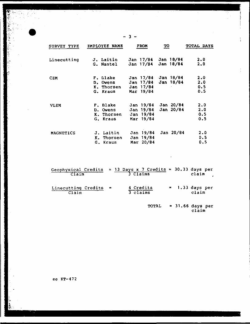
SURVEY TYPE EMPLOYEE NAME
Linecutting
GEM
VLEM
MAGNETICS
J. Laitin G. Nantel
F. BlakeD. OwensK. ThorsenG. Kraus
P. BlakeD. OwensK. ThorsenG. Rraus
J. Laitin K. Thorsen G. Kraus
FROM
Jan 17/84 Jan 17/84
TO
Jan 18/84 Jan 18/84
TOTAL DAYS
2.0 2.0
Jan 17/84 Jan 18/84 Jan 17/84 Jan 18/84 Jan 17/84 Mar 19/84
Jan 19/84 Jan 20/84 Jan 19/84 Jan 20/84 Jan 19/84 Mar 19/84
Jan 19/84 Jan 19/84 Mar 20/84
Jan 20/84
2.0 2.0 0.5 0.5
2.0 2.0 0.5 0.5
2.0 0.5 0.5
Geophysical Credits Claim
Linecutting Credits Claim
= 13 Days x 7 Credits Claims
4 Credits 3 claims
TOTAL
30.33 days per claim
1. 33 days per claim
31.66 days per claim
ee KT-472

f GEOPHYSICS LEGEND
MAGNtTTOMETER SURVEY (MAG) SEIF-POTENTIAL SURVEY (SP)•t.IMO
HI*
•4*
WSrKUMCNT Opcrsltr a
• M
tM
MA* A/bltfl
tit*UK
INSTRUMENT i
NORTH a EAST lias
o-
SOUTH ftwcsr lias
ELECTROMAGNETIC SURVEY
BROADSIDE
IfOIO til.
r /OJO Hi l r HO Hi. • *J Trt^tm,tlff fvtlfitA
x;^;:^'~*, 6/rff**'** tffftttt^'""' -r^'-E? ^ Ti-Lt'oo*1 —~. .-^! * —— * :r~"s--.-~ ,'7\
-•O, X/-V" t'tmm ttfiiit
1NS1AUWINT
.P.E.M,
\
\,x (•il 1.1.
MSTKUUtNT
Cgll Sip.f rt^wtflcv
FIXED TRANSMITTER SHpOTBACK (Hon/oMol ftCo-Atiol}
uoniM al*SI 111.15
SOUTH aWtSI THIS
f }0!OHl
j II JO Hi
' *^ '^'^-j yr/tf*/ Irtitrt*
v\..^:^l- *,,.,, r,,,.,,,,,*^^. ;^* \ rf*/*// tftrtfit
IKSlRUUCNf Optiotor i
.JO*
IHSTRUUCNIOMialci ( Ctll 5.t i
LOW FREQUENCY (VX F.)
(JOR1H B [•SI t 111 J,
SOUTH K WIST ULIS
40"
M A '* I0'•^•VA' \
finn Pin
OfltAtor Ti.- Stolie
MoxMinJHE.M )• to*/.
^•.| rf
\l\\ . iKf^••^^
INSTNUUIMT Or*f*i*f i C*il li* i
tt - Mf l NIC

voeie
iiC
SSM6636I6
SSM66S6IO
T W P
SSM6696I6
SSM661609
CHONE C.C M UNIT
, OwtNi
MVIMO OATI
T* c k Eiplorallon* Llmittd
PEZAMERICA RESOURCES CORPORATIONOPERATION PEZAMERICA
OAYOHESSARAH AREA , ONTARIO
ELECTROMAGNETIC SURVEY
tar. .i..-. 3I90A

Y06IS
V*-V-•^
R—i—e t—ft T W P
SSM66S6I6 SSM6636I6
SSM6656IO
SSM665609
O'* t'"
WtTIWUfNT i CRONE C.C M UNITBLAKC, Owens
cm
T*ck Exploration* Limited
PEZAMERICA RESOURCES CORPORATIONOPERATION PEZAMERICA
OAYOHESSARAH AREA , ONTARIO
ELECTROMAGNETIC SURVEY

10611
i -R——l—C—K——t—-A——N—D T W P
SSM6656I6 SSM66S6I6
O*1
SSM665609
SSM6656IO
i____i
•HTBUMCKI - SCINTHtX MF-I UAONt TOUf T C ft
J. IAITIN
MVIUD OATI
Ttck Eiplorotloni LimiUd
PEZAMERICA RESOURCES CORPORATIONOPERATION PEZAMERICA
OAYOHESSARAH AREA . ONTARIO
MAGNETOMETER SURVEY

ano
Ministry of Natural Resources
GEOPHYSICAL - GEOLOGICAL - GEOCHEMICAL TECHNICAL DATA STATEMENT
FUe.
1413 3190A
TO BE ATTACHED AS AN APPENDIX TO TECHNICAL REPORTFACTS SHOWN HERE NEED NOT BE REPEATED IN REPORT
TECHNICAL REPORT MUST CONTAIN INTERPRETATION, CONCLUSIONS ETC.
Type of Sur
Township o
Claim Hold*
Survey Com
Author of I
Address of j Covering DJ
Total Miles
SPECIAL
vey(s) beopnysica
r Area StHcklond
i . vtn ot nay;
Township c^lii-wM?r(s) PezameHca Resources Corporation
pany Teck Explorations Limited.eport K. Thorsen .\.ithnr 2189 Algooquln Ave, North Bay, Ont P1B4Z3
ites of Survi
of Line Cut
.y Jan 17/84 to Mar 20/84(linecuttbtf to office)
6,350 ft
PROVISIONSCREDITS REQUESTED
ENTER 40 days (includes line cutting) for first survey.
ENTER 20 days for each additional survey using same grid.
A1RBORNF
Magnetome
DATR. NC
Res. Geol.
: CREDITSirr
)V 20/84
Previous SurveysFile No. Type
(Special provi
Llectromagt(enter d
SIP.NA
DAYS . . . per claim.Geophysical
-Electromagnetic 24.7
M^onr^nm^'".,. '
— parlinrrKtrif
-^.K.-r
nrolopiral ,
Ororhfmira!
lion credit] do not apply to airborne turveyi)
irtir Rarlinrn^trirlayi per claim) sj
T, ,, ,WW^Author of Report or Agent
Qualification* cJ ' Sb\^
Date Claim Holder
MINING CLAIMS TRAVERSED List numerically
SSM 665610(prefix) (number)
SSM 665615
SSM 665616
TOTAL CI. AIMS 3
837 (0/70)

GEOPHYSICAL TECHNICAL DATA
f GROUND SURVEYS - If more than one survey, specify data for each type of survey
Number of Station, CEM 30, VLEH 74, Hag 108
Station interval 50 or TOO ft———-——— ..r.. , i" - 9n0Profile .raU l ~ W——————————————————————
.Number of Readings CEH 60. VLEM 148. Mao
.Line spacing___200 ft_____________
Contour interval TOO gammas
Instrument. Sclntrex MF-1Accuracy - Scale constant -10 gammasDiurnal correction method Base StationBase Station check-in interval (h™.™) Hourly Or less———— Base Station location and value 10+00. 9+OOW. 500 gammas
U
ZC
8
Instrument.
Coil
Method:
CEMHorizontal and Vertical
400 and 200 ft±1 '
QQ Fixed transmitter 3Q.Q and Ift30 Hz
83 Shoot back d In line CD Parallel line
Parameters mM ...,.H(specify V.L.F. tution)
Various parameters of secondary field
InstrumentScale constant
Corrections made.
^ Base station value nnd location .
Elevation accuracy.
InstrumentMethod CD Time Domain l l Frequency Domain
^
t*
1Si HJ f^5
Param""* — On time-Off lime
— Drlay tim^ .
— Integration time ,,Pnwpr
El'ctrodr arrayElectrode spacing - ———————————————————Typr "f r]rrtrnAf
Frequency
Range

si-
l lT(s,M V
6KOJ.4 ^66063 . c S6|^,
*s- i SSM T SSM ~!~SSM~
/ 3 A
5SV l SSV iSSM
PROJECTED
.SSM
iSiMr V , SIMsssr t i
ss- . ssM1.l'665613
,6636I\ l
SS- l SSM"
. ^J^^rit ^ SS^731 - ' is*. 'ssJ~~T*SM- r
.6*5603 1663.0*^ ^ 1 t^TaTi l
F S5" SS., ^~SSM SSM ss- SSM
SSM-J l ' S 3 5
O^iM 7HP
- 5 M
SSM
/"s *^0 Of/l/NS
-??-^5/
SS" SSn,SSM ' SSM
,̂ S65 JO3 . 6oJ JO* 6S3JIT ISM " " ^SM
J *V- SSM SSU . ,,w . S ,M
' 6633 VJ ^SS9Ol7--'^r-ss^'-^^-^-W-^-^^SSU S w S'M
'639C46
r- ^-'' i*.B , ' |**3t30 ^643*31
. - - - - - . T "4. ^ J ^ i6 4IJ7 S6 4 ,; 5 l ' ! W }SSM ( s, M i 4SSU SSI^ , ir- -^-T- r -.- - ---r--.
i i ""— ii*4l3? '464ljiii6JIJO '64tt __ _
•-x.East
KwinkwagaLake
X-,
^u- 1- r,j * V'-: -- - -t i - - ^i".-j',**'" *"***J6Si36*.^ '4,"4 - -c"" ^"^ S^ ' "-^/-Sl-^V-- 15M rv 1 66*.^.,64, I5 . ^ , ** ^30 '66 3* Z,, y -*" '
^L.U...yj .fc^CP'™ ^ I '-3.3*.'.6^33 ^/-o s,- , ^fnra-sw.^-^-^^-^-r — ̂
^o LINE
^14^-

.' l',"... -.TW* 1 .a^-:**-**V"P****-K-
^^i- f^:'
iftw ^ ̂ :-^V,^^*Z,*s*m.'ZSZlgJ
' ^-'- - -.-""-7^1 { '•lfi**rPJTf'7*" * ' **, " - - '.'.' t"^.'/ 3
SC9IMTREX
FLUXGATE MAGNETOMETER
Ihe MF-2 is a completely new concept in vertical force fluxgate magnetometers. These instruments, which are designed for f.ast and accurate mineral ground surveys, are orientation independent, self levelling and require no tripod. The MF-2 combines the electronics and sensor in one compact 3Vj Ib. package. An external dry cell battery pack is provided as standard power source for the instrument. As an-option, recharge able batteries may be provided and housed direct ly in the instrument.With the latest I.C. and F.E.T. circuitry and high precision components, a temperature stability bet ter than 1 gamma per "C is .standard (with .25 gamma on special order) over a range of —40 0 to -f 40*C.The instrument has a built-in hemisphere polarity switch providing two overlapping ranges. For the Northern hemisphere the full range is + 80.000 lo —20,000 gammas, and reversible for the Southern hemisphere.A calibrated feedback system can be provided which makes it possible to determine the total vertical component strength.Measuring resolution, on the 100 gamma scale (optional) is 0.5 gamma, and on the 1000 gamma scale is 5 gammas.The Scintrex MF series of magnetometers have been In use for many years in varied applications, e.g. ground reconnaissance, base station recording and monitoring, study of magnetic properties of rocks, observatory monitoring and recording of both vertical and horizontal components. A high Impedance recorder outlet Is standard.OPTIONAL 8) MF-2G
Tho MF-2G Fluxgate Magnetometer has the
same electronics and specifications as the MF-2, but the sensor is detached and enclosed In a small cylindrical tube which permits it to be oriented and tilted in any desired direction. A 25 foot cable connects the sensor to the Instrument housing. This version is particu larly suitable for the study of the magnetic properties of rocks, and the measurement of magnetic field components of any orientation, etc
b) MF-2GSThe MF-2GS Magnetometer has the same electronics and specifications as toe MF-2 but has two sensors, the enclosed self-levelling sensor of the MF-2 as well as the detached geoprobe of the MF-2G, either one of which can be employed at any one time. Thus, this Instrument can be employed as the standard MF-2 and for the determination of the magnetic properties of rocks, etc.
c) MF-2-100100 gammas and 300 gammas full scale ranges are added to the standard MF-2 and its options.
A'""
i

k SPECIFICATIONS OFy*S5
rf
''
'''
-
l
i '
.'l
-j
'l
;V
i•i
' jF
^
EssSuiSSa rLUAUAit mfMODEL MF-2
Standard: IMF-2)
Optional: (MF-2- 100)
Meter:
Resolution:
Operating Temperature:
Temperature Coefficient:
Noise Level:
Bucking Adjustments: (Latitude)
Recording Output:
Electrlc.il Response:
Connector:
Bfitteries:
Consumption:
Dimensions:
Weights:
Battery Charger:
SMgg;jgm.iMamiLMjJiiu-iaii*iii
RANGES SENSITIVITYPlus or minus
t .000 gammas f.sc. 20 nammm/dlv. 3.000 gammas f.sc, 50 nnmmas/iliv.
10.000 gammas f.cc. 2CO gammnj/div. 30.000 (ioniums f.sc. 500 gammas/div.
100.000 gnmmas f.sc. 2000 gammas/div.
100 gammas f.sc. 2 gar.imas/div. 300 gammas f.sc. 5 gammas/div.
Tout-band suspension 100 gamma scale 2.1' long — 50 div. 300 gamma scale 1. 9" long — 60 div.All scale ranges ±0.5'* of full scnlo.
— 10"C to -flO'C — 40'F to 4- 100T
Less than 1 gamma per "C C*"1 gamma/'f]
Less than 1 gamma P-P
—20.000 to 480.000 gammas 9 steps of 10.000 gammas plus fine control of 0-10.000 gammas by ten turn potentiometer. Reversible for southern hemisphere.
Standard — for high impedance recorder ^ t megohm) Optional — (or low impedance recorderDC lo 3 cps (3dU down! on mo^t scnr.ilivu ii'itge with meter in circuit. D.C. to 20 cps with meter network shorted lor recording purposes.
Cannon KO2-16-10SN lor pluq Cannon KO3-I6-IO-PN end cover KO6-I6-H
Standard — bjttcry pack (16 dry ceil batteries) Optional — internal J x 6V - 1 amp hr. Soolnd lead acid re chargeable. Cenfnlab OC 6101. Recharge time 8 hrs
60 milllamperes — GCOtOI batteries iire rated for 16 hours continuous use.6'. "x 2'. 'x 10" Instrument 161 mm x 71 mm x 254 mm
Stnndiird 3 Ib. 12 oz. — 1.7 kg Optional 5 Ib. 6 oz. — 2.5 kg (with rechargeable batteries)6"x2"."x2"i" 155 mm x 64 mm x 64 mm HOV-220V 50/60 Hi supply or 28-42V DC. supply. Automatic charge rale and cutoff preset for Ccnlrnlab CC6101 batteries.
0
l-f
j!
d\rr SCIIMTREX LUSTED
01470
i l
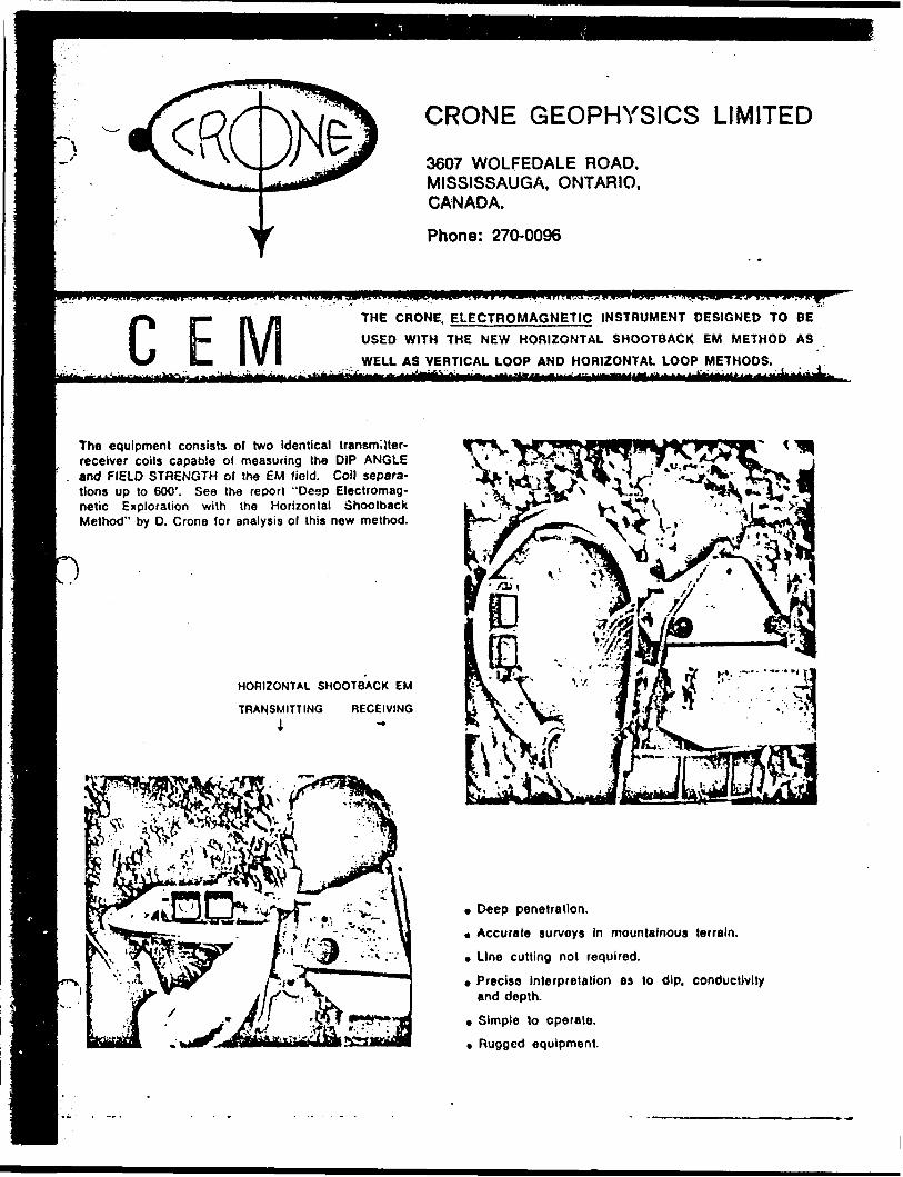
r\CRONE GEOPHYSICS LIMITED
3607 WOLFEDALE ROAD, MISSISSAUGA, ONTARIO, CANADA.
Phone: 270-0096
C THE CRONE. ELECTROMAGNETIC INSTRUMENT DESIGNED TO BE USED WITH THE NEW HORIZONTAL SHOOT8ACK EM METHOD AS
WELL AS VERTICAL LOOP AND HORIZONTAL LOOP METHODS.
The equipment consists of two identical transmitter- receiver coils capable of measuring the DIP ANGLE and FIELD STRENGTH of the EM field. Coil separa tions up to 600'. See the report "Deep Electromag netic Exploration with the Horizontal ohootback Method" by D. Crone for analysis of this new method.
HORIZONTAL SHOOTBACK EM
TRANSMITTING RECEIVING A
* Deep penetration.
* Accurate surveys In mountainous terrain.
* Line cutting not required.
* Precise Interpretation as to dip, conductivity and depth.
. Simple to operate.
. Rugged equipment.

SPECIFICATION OF THE GEM INSTRUMENTJ
This unit is composed of two identical coils both capable of receiving and trans mitting at 3 fixed frequencies. Ali circuiting is housed within the coils. The batteries are mounted in an insulated box on a magnesium packboard.
* coil diameter 22", weight per coil 8.3 Ibs.
* standard frequencies 390, 1830, 5010 Hz (others available).
* Inclinometer range 200", accuracy ± Vi ".
* receiver gain control — 10 turns, linear calibrated pot.
* dip angle determined by visual minimum on Field Strength meter.
* Field Strength read directly on a meter and controlled by gain control pot.
o packboard and battery box weight each 7.0 Ibs.
. battery — 6 volt lantern type — Eveready 731, Burgess TW-1.
* weight per battery 3.0 'bs.
. 1 to 3 batteries may be used connected in series.
n range for 100"Xo Field Strength and ± 1" null all frequencies, 6 volts — 400', 12 volts — 500', 18 volts — 600*.
e shipped in two wooden boxes weight 50 Ibs. each.

42CHSE8686 2.7451 ODLUM 300
Mining Lands Section
Control Sheet
File No J.
TYPE OF SORVEY GEOPHYSICAL
GEOLOGICAL
GEOCHEMICAL
EXPENDITURE
MINING LANDS COMMENTS:
o
Signature of Assessor
Date

l——
plaf'O
Mimslryot Rupert of Work
Sees (Geophysical. Geological. ,Geochemical and Exp'.-fvJ't'.ires) 3190A
J--|^\Tho Mining Act
p* O' Survey (t)
[eophyskal (EM ft MAG)_ImTHolderisS"~"
lezamerica Resources Corporation
Imtruclions: — Pl*3K" fypSor print. *— If number o' mining claims traversed
exci'ils ipoci on this form, attach a list.Not-i: - Only diyi credit! calculaicd in Ihe
"E*c s '-.J-tur*j" sect en mjy be entertdin in* "E "pi1 '":!. Days C'." columns.
— Do not un shjoVd i 1 ?.'! uslow.jTov.r;,-,y O' Am j ~ " "
'kkland Twp o"kt-C4.M.
n Director's Licence No.
T1363
09 Granvi'le Street, Vancouver, British Columbia, V7Y 1C6^ _ ^^DaTTol Surveylfr'om 8T to!"" " "" Ifota'i Miles" o'f iine~CuT~
-WtJ-Wt.UWjJ^ iQiLL'W.L.—^so.IL-Company
E xp 1 o r a 11 on s L i m i t ed -———(and Address of Author (of Gio-Technlcd rtport)
L Thorsen, 2189 Algonquin Avenue, North Bay, Ontario, RIB 4Z3•jits Requested per Each Claim in Columns at right___ Mining Claims Traversed (List in numen'cal
belli Provisions
|For first survey:Enter 40 days. (This includes line cur ing)
|For each additional survey: ling the same grid:
Enter 20 days (for each)
i Days
omplete reverse side and enter total(s) here
B'no Crtdiii
ate: Special provisions credits do not apply to Airborne Scr'.tys.
ocophyiica!
- Elf ctroniBgriet
- Mtgnetomeier
- Radiomttric
- Othtr
Oeochcrntcal
Gfophytical
- Magnalornar
Days per Claim
Dayi ptr Claim
Otochtmical
EUctroniagneiic
MagntlomtKr
Radiomttric
On y i pa'Claim
enditures (excludes power stripping)l of Work Performed
(formed on Claimd)
alion of Expenditure Days Crediti
l Total EMpendlluresTotal
Days Credits
I'UCIions'otal Days C/edits may ba apportlonad at the claim holder's
:hOice). Enter number of days credits por claim tolnciad o columns at right,______ ________/'J ^^^^
Mining ClaimPrefix
SSM
Ft '
\.f.i.t ! Vi '
Number
.6656JQ.—5.656.15..^
665616
6AUI.T RIMil',, lR -E-c-n
•A.M. ..... . ..
IS
Expand. Days Cr.
—————— -
" M Annr.v,T 'VI
V'ib'84
j...-.P./.!.
r
Mining CI* i mPrefix
r t
ir-
y* ; '",,
Number
—————— .... —————
-- ——— ————— --
..- ——— - ———————
i
ttr-j-.™—'™
-—— ---^n
Expend. Days Cr.
——————
. ——————
. —————
-O--
tl numbff of minfnp * covered by (hif
' t of vork.
ept. 28/84
_____ f± Office Use OnlyTotal Oayt Cr.
tification Verifying Report of Work
J Da to Approved ai Recorded
h*f*by c*rlily that l have g personal and intimate knowledge ol the lacit set forth in the Report ol Work an )r witnessed tame during and/or after its completion and Ihn annexed lepori is true.
W (rid Postal Addrcx of Ptrson
.^Thorsen, 2189 ^A l ao.ngu in Ayenuej Jjor;t h^ Bay, On t ario^ljlj\,23^
m______M j__,___L -S.?P tt-ifl/si^

Assessment Work Breakdown
If
;.-;V Man Days are based on eight (8) hour Technical or Line-cutting days. Technical Jays include work performed by '*--'' consultants, draftsmen, etc..
- ..-
^vp.o ,.U 'vtv ^ an^ Linecuttiny
•' ; Technics! Technical Cio, . Ume-cutting No. o* Days P*' - . Dsyi C'Bdiu Dtft Total Ciedin Cljirm CUim
/5" X 7 = s&ZS" * 4 ^^T7 -- | 3 j r: 10-3/3 /J

f'-:14-.:
December 21. 1984 Files: 2.7445-2.7472
PezaneHca Resources Corporation 609 Sranvllle Straat Vancouver, B.C. V7Y 1C6
Dear Sirs:
RE: Geophysical (Electromagnetic, Magnetometer) anj Geochemical Surveys submitted on Mining Claims 1n Bayfield, Cooper, Gourley, Hambleton, Qdlum, Strickland and Tedder Townships
In order to complete your submissions for assessment credit, please provide:
1. The VLEM plan, 1n duplicate, for the report on Dlghem Anomaly 2100D, our file 2.7446.
2. The geochemical plan, 1n duplicate, for the report on Dlghen Anomaly 2100C-2160B, our file 2.7466.
3. Signature of the author of the technical report, K. Thorsen, on each copy of the front pages of the reports. (Copies are enclosed, In duplicate).
Please forward the above Information to this office quoting files 2.7445 through 2.7472.
For further Information, pUase contact Doug I sherwood at (416)965-4888.
Yours sincerely,
S.E. YundtDirectorLand Management Branch
Whitney Block, Room 6643 Queen's Park Toronto, Ontario K7A 1U3Phone:(416)965-4888
D. Isherwood:oc
cc: Mining Recorder Tlmlns, OntarioMining RecorderSiult Ste. Marie, Ontario
cc: K. Thorsenc/o Teck Explorations Halted2189 Algonquln Avenue North Bay, Ontario fil 4Z3