non-technical summary variation no 2
TRANSCRIPT
Includes Ordnance Survey Ireland data reproduced under OSi Licence Number 2009/07CCMA/Galway County Council. Unauthorised reproduction infringes Ordnance Survey Ireland and Government of Ireland copyright. © Ordnance Survey Ireland
SEA ENVIRONMENTAL REPORT - APPENDIX II
NON-TECHNICAL SUMMARY
FOR
VARIATION NO. 2 (B) TO THE
GALWAY COUNTY DEVELOPMENT PLAN 2015-2021
GAELTACHT PLAN
(INCLUDING SETTLEMENTS OF AN CHEATHRÚ RUA,
AN SPIDÉAL AND BAILE CHLÁIR)
for: Galway County Council Áras an Chontae
Prospect Hill
Galway
by: CAAS Ltd.
1st Floor
24-26 Ormond Quay Upper
Dublin 7
JUNE 2018
SEA Environmental Report Appendix II – Non-Technical Summary
CAAS for Galway County Council i
Section 1 Introduction and Terms of Reference ..................................................... 1
Section 2 Variation 2 (b) ......................................................................................... 2
Section 3 The Environmental Baseline ................................................................... 4
3.1 Introduction ..................................................................................................................... 4 3.2 Likely Evolution of the Environment in the Absence of the Variation ...................................... 4 3.3 Biodiversity and Flora and Fauna ....................................................................................... 4 3.4 Population and Human Health ........................................................................................... 7 3.5 Soil ................................................................................................................................. 7 3.6 Water .............................................................................................................................. 8 3.7 Air and Climatic Factors .................................................................................................. 10 3.8 Material Assets ............................................................................................................... 10 3.9 Cultural Heritage ............................................................................................................ 11 3.10 Landscape ..................................................................................................................... 12 3.11 Appropriate Assessment .................................................................................................. 17 3.12 Strategic Flood Risk Assessment ...................................................................................... 17 3.13 Strategic Environmental Objectives .................................................................................. 17
Section 4 Summary of Description and Evaluation of Alternatives ...................... 18
4.1 Introduction ................................................................................................................... 18 4.2 Alternative 1: Even Development ..................................................................................... 18 4.3 Alternative 2: Sporadic Development ................................................................................ 18 4.4 Alternative 3: Haphazard Development ............................................................................ 19 4.5 Summary of Assessment of Alternatives ........................................................................... 23 4.6 The Selected Alternative for the Variation ......................................................................... 26
Section 5 Summary of Effects arising from Variation 2 (b) .................................. 30
Section 6 Mitigation and Monitoring Measures .................................................... 33
6.1 Mitigation ...................................................................................................................... 33 6.2 Monitoring ..................................................................................................................... 33
Table of Contents
SEA Environmental Report Appendix II – Non-Technical Summary
CAAS for Galway County Council 1
Section 1 Introduction and Terms of Reference
This is the Non-Technical Summary of the Strategic Environmental Assessment (SEA) Environmental Report for Variation 2 (b) to the Galway County Development Plan 2015-2021. The purpose of the Environmental Report is to comply with SEA legislation and provide a clear understanding of the likely environmental consequences of decisions regarding the adoption and implementation of the Variation. What is an SEA? SEA is a systematic process of predicting and evaluating the likely environmental effects of implementing a proposed plan, or other strategic action, in order to ensure that these effects are appropriately addressed at the earliest appropriate stage of decision-making on a par with economic, social and other considerations. Why is it needed? The SEA has been carried out in order to comply with the provisions of the SEA Regulations as amended and in order to contribute towards environmental management and sustainable development. The output of the process is an Environmental Report which should be read in conjunction with Variation 2 (b). How does it work? Relevant aspects of the current state of the environment are assembled and presented to the team who prepared the Variation. This helped them to devise a Variation in a way in which helps to protect whatever is sensitive in the environment. To decide how best to make a Variation that helps to protect the environment as much as possible, the Council examined different alternatives for the Variation. This helped to highlight where conflicts could occur and facilitated the development of mitigation measures which will help to avoid/reduce adverse environmental effects. What is included in the Environmental Report which accompanies Variation 2 (b)? The Environmental Report contains the following information:
o A description of the relevant aspects of the current state of the environment; o A description and assessment of alternatives; o An assessment of Variation provisions; and, o Mitigation measures which set out to aid compliance with important environmental protection
legislation - e.g. the Water Framework Directive, the Habitats Directive - and which will help to avoid/reduce the adverse environmental effects of implementing the Variation.
What happens at the end of the process? On finalisation of the Variation, an SEA Statement is prepared and made available. The SEA Statement includes information on how environmental considerations have been integrated into the Variation and why the preferred alternative was chosen for the Variation.

SEA Environmental Report Appendix II – Non-Technical Summary
CAAS for Galway County Council 2
Section 2 Variation 2 (b)
The purpose of Variation 2 (b) to the Galway County Development Plan 2015-2021 is to include the Gaeltacht LAP (including settlement zonings for An Cheathrú Rua, An Spidéal and Baile Chláir). This Variation, in conjunction with the County Development Plan, will inform and manage the future development of the Gaeltacht area. The Galway Gaeltacht covers extensive parts of County Galway. It stretches from Baile Chláir, to the east of the city to Cloch na Ron in west Connemara, a distance of c. 100km and from Oileán Árann northwards to Duiche Sheoigheach which borders County Mayo. The Gaeltacht area also spans townlands that are within Galway City boundary. The Gaeltacht Local Area Plan was adopted in 2008 and was amended and extended in 2013. The current Gaeltacht LAP consists of the plan context, strategy, overview of the Districts and settlement plans for An Cheathrú Rua and An Spidéal. Baile Chláir is in the Gaeltacht, considering the previous plan Local Area Plan for Baile Chláir has now expired, it is prudent that Baile Chláir should be incorporated into the Gaeltacht Plan. There are a number of other settlements in the Gaeltacht that have their own Local Area Plan, Maigh Cuillin has a plan in situ until 2019 and Bearna forms part of Variation No. 2 (a) and will sit alongside the Gaeltacht Plan, Variation No. 2 (b). The Strategic Vision of the Gaeltacht Plan is as follows: The Gaeltacht area is a unique and a special place and it is important that it retains that distinctive cultural heritage and natural beauty which is of National significance through the principles of sustainable development, whilst meeting the needs and aspirations of both the residents’ and visitors alike. Achieving the objectives of the Galway County Development Plan in order to sustain and develop the local economy and improve the quality of life for local residents. This strategic vision is informed by the following guiding principles that will enable the overall vision to be achieved:
Promote a sustainable level of development that is appropriate to the character, heritage, amenity and strategic role of the Gaeltacht area including the settlements of An Cheathrú Rua, An Spidéal and Baile Chláir in order for these areas to develop;
Support an appropriate level of services and infrastructure to support existing and future growth and sustainable development in a manner that protects and is complementary to the environment, heritage, character and amenities of the Gaeltacht villages;
Promote and support the Blue Flag, Green Coast FLAG and other related initiatives; To adhere to the aims of the Government’s “20-Year Strategy for the Irish Language 2010 –
2030” including the preservation and promotion of Irish in the Gaeltacht, conserving and protecting the heritage, culture and richness of the language as well as strengthening the position of the Irish Language in the home, workplace and community;
Promote a strong sense of community spirit, civic pride, local identity and social inclusiveness, and promoting the status of the Irish language in the area and its contribution to the linguistic heritage of An Gaeltacht;
Provide for the consolidation and coherent growth of settlements and rural areas within Galway Gaeltacht;
Provide for the improvement of community and sporting infrastructure programmes within the Galway Gaeltacht;
Provide a high quality movement network for pedestrians, cyclists and vehicles with priority for public transport within the Galway Gaeltacht;
Improve the transport network access to Oileán Árann in terms of air and sea routes; Protect and conserve the rich built and natural heritage of the Galway Gaeltacht; Develop the cultural, historic and tourism potential of the area in a sustainable manner; and It is recognised that some of the strongest Gaeltacht area as regards the daily use of the
Irish language are now imperilled by economic and social decline as indicated in the Census and social and economic reports. This Plan supports the development of a sufficient level of services and infrastructure to ensure the economic and social viability of Gaeltacht communities and recognise the threats to more peripheral geographic areas.

SEA Environmental Report Appendix II – Non-Technical Summary
CAAS for Galway County Council 3
In addition, Variation 2(b) sits within a hierarchy of strategic actions such as plans and programmes, including the following:
EU Green Infrastructure Strategy UN Kyoto Protocol (2ND Kyoto Period), the Second European Climate Change Programme (ECCP II), Paris climate
conference (COP21) 2015 EU 2020 climate and energy package Habitats Directive (92/43/EEC) Birds Directive (2009/147/EC) European Union Biodiversity Strategy to 2020 The Clean Air for Europe Directive (2008/50/EC) Fourth Daughter Directive (2004/107/EC) Noise Directive 2002/49/EC Floods Directive (2007/60/EC) Water Framework Directive (2000/60/EC) Groundwater Directive (2006/118/EC) Drinking Water Directive (98/83/EC) Urban Waste Water Treatment Directive (91/271/EEC) Environmental Liability Directive (2004/35/EC) SEA Directive (2001/42/EC) EIA Directive (2011/92/EU as amended by 2014/52/EU) Infrastructure and Capital Investment 2012-16: Medium Term Exchequer Framework Smarter Travel Initiative 2012-2016 Smarter Travel – A Sustainable Transport Future – A New Transport Policy For Ireland 2009-2020 (2009) Ireland’s First National Cycle Policy Framework (2009) Scoping Study for a National Cycle Network (NCN) Strategic Framework for Integrated Land use and Transport (SFILT) – Department of Transport, Tourism and Sport National Climate Change Strategy 2007 – 2012 (2007) Climate Action and Low Carbon Development Act 2015 Delivering a Sustainable Energy Future for Ireland – The Energy Policy Framework 2007 – 2020 (2007) The National Climate Change Adaptation Framework National Renewable Energy Action Plan National Energy Efficiency Action Plan for Ireland 2007-2020 (2007) Sustainable Development – A Strategy for Ireland (1997) Wildlife Act of 1976 and Wildlife (Amendment) Act, 2000 Actions for Biodiversity 2011-2016 Ireland’s National Biodiversity Plan, 2011 (Draft National Biodiversity Action Plan
2017 - 2021) The Planning System and Flood Risk Management – Guidelines for Planning Authorities (2009) European Communities (Water Policy) Regulations of 2003 (SI 722 of 2003) European Communities (Water Policy) Regulations of 2003 (SI 350 of 2014) European Communities Environmental Objectives (Surface waters) Regulations of 2009 (SI 272 of 2009) European Communities Environmental Objectives (Groundwater) Regulations of 2010 (SI 9 of 2010) Water Pollution Acts 1977 to 1990 European Communities (Urban Waste Water Treatment) Regulations 2001 (S.I. No. 254/2001) Water Services Act 2007, Water Services (Amendment) Act 2012, Water Services Act 2013 Irish Water’s Water Services Strategic Plan 2015 and associated Proposed Capital Investment Plan 2014-2016 National Spatial Strategy 2002-2020 (2002) to be replaced by the upcoming National Planning Framework Grid25 Implementation Programme National Landscape Strategy 2015 National Rural Development Programme 2014-2020 National Forestry Programme 2014-2020 National Peatlands Strategy National Hazardous Waste Management Plan (EPA) 2014-2020 River Basin Management Plans and associated Programmes of Measures; River Basin Management Plans - including
the Western River Basin Management Plan - are currently being replaced by a National Plan Regional Planning Guidelines for the West; Regional Planning Guidelines will be replaced by Regional Economic and
Spatial Strategies after 2017 Freshwater Pearl Mussel Sub-Basin Management Plans Management Plans for European Sites Outputs from the Western Catchment Flood Risk Assessment and Management Programme Connacht-Ulster Regional Waste Management Plan County Development Plans including the Galway County Development Plan 2015-2021 (as varied) Proposed Variation No. 2 (a) to the Galway County Development Plan 2015-2021 Local Area Plans (including those for Athenry, Clifden, Craughwell, Gort, Loughrea, Maigh Cuilinn, Oranmore,
Oughterard, Portumna and Tuam) Local Economic and Community Plan for County Galway Groundwater Protection Scheme for County Galway Galway County Heritage & Biodiversity Plan 2017-2022

SEA Environmental Report Appendix II – Non-Technical Summary
CAAS for Galway County Council 4
Section 3 The Environmental Baseline
3.1 Introduction
Reflecting the specifications in the SEA Directive, the relevant aspects of the current state of the environment for the following environmental components are summarised in this section: biodiversity and flora and fauna, population and human health, soil, water, air and climatic factors, material assets, cultural heritage including architectural and archaeological heritage, landscape and the interrelationship between the above factors.
3.2 Likely Evolution of the Environment in the Absence of the Variation
Variation 2 (b) has been prepared to further contribute towards the framework for proper planning and sustainable development that is already provided for by the County Development Plan. The current Gaeltacht Plan which includes land use zoning for An Cheathrú Rua and An Spidéal will expire in 2018. There is currently no land use zoning for Baile Chláir. In the absence of the Variation, new developments would be examined against the existing provisions included within the County Development Plan. This situation – and associated likely evolution of the environment – most closely equates with alternative number three that has been identified and considered as part of the Strategic Environmental Assessment (see Section 4).
3.3 Biodiversity and Flora and Fauna
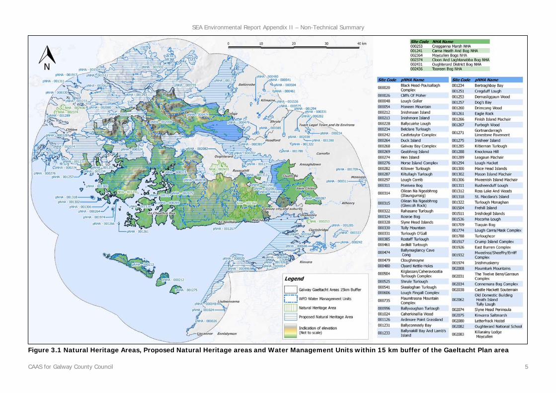
There are various highly sensitive and designated areas within Gaeltacht Plan area on account of the species and habitats which they contain. Such areas include the Kilkieran Bay and Islands cSAC (located to the north-west of An Cheathrú Rua), Connemara Bog Complex cSAC (adjacent to An Spidéal) and Moycullen Bogs NHA (located to the north of An Spidéal). Also present is the main channel of the River Corrib (adjacent to the Gaeltacht Plan area) and the connecting Lough Corrib, which is designated and protected as a Salmonid Water. Natural Heritage Areas, Proposed Natural Heritage areas and Water Management Units within 15 km buffer of the Gaeltacht Plan area are mapped and listed on Figure 3.1. Freshwater Pearl Mussel Sensitive Areas, Shellfish Areas, Nature Reserves and Water Management Units within 15 km buffer of the Gaeltacht Plan area are also mapped on Figure 3.2. Previous changes in land uses arising from human development have resulted in a loss of biodiversity and flora and fauna however legislative objectives governing biodiversity and fauna were not identified as being conflicted with. Both Variation 2(b) and the existing County Development Plan include robust measures to facilitate contributions towards the protection and management of biodiversity and flora and fauna.
SEA Environmental Report Appendix II – Non-Technical Summary
CAAS for Galway County Council 5
Figure 3.1 Natural Heritage Areas, Proposed Natural Heritage areas and Water Management Units within 15 km buffer of the Gaeltacht Plan area

SEA Environmental Report Appendix II – Non-Technical Summary
CAAS for Galway County Council 6
Figure 3.2 Freshwater Pearl Mussel Sensitive Areas, Shellfish Areas, Nature Reserves and Water Management Units
SEA Environmental Report Appendix II – Non-Technical Summary
CAAS for Galway County Council 7
3.4 Population and Human Health
The impact of implementing Variation 2 (b) on population and human health is influenced by the impacts which the Variation will have upon environmental vectors. Environmental vectors are environmental components, such as air, water or soil, through which contaminants or pollutants, which have the potential to cause harm, can be transported so that they come into contact with human beings. Population and human health has the potential to interact with issues including the following:
Developmental and recreational pressure on habitats and landscapes; Increase in demand for waste water treatment at the municipal level; Increase in demand for water supply water quality (see Section 3.6); and Flood risk (in flood sensitive areas) (see Section 3.6).
The larger Gaeltacht towns and villages near Galway City have experienced significant pressure for development i.e. Baile Chláir, Bearna, Maigh Cuilinn, and An Spidéal. Their population has grown by approximately 50 per cent between 1996 and 2006. Census 2016 population figures were recorded in the electoral divisions as following: Baile Chláir 2,124 persons; An Cheathrú Rua 2,472 persons; An Spidéal 1,443 persons. There is historic and predictive evidence of flooding in various locations within County Galway. Some waterbodies within the County are at risk of not meeting the Water Framework Directive’s objective of good water quality. There are various water services needs in County Galway, including at An Cheathrú Rua and An Spidéal, which are expected to be addressed over the coming years. Emission limits for discharges to air, soil and water are set with regards to internationally recognised exposure limit values. These are generally set to be many times the safe exposure limit - in order to provide protection. In the event that a plan or programme began to have adverse health effects on surrounding populations it is likely that it would have been identified as being in breach of such emission standards at a very early stage - and long before the manifestation of any adverse health effects in the population.
3.5 Soil
Peat soils are often indicative of areas that are the most sensitive to development due ecological sensitivities and impeded drainage issues. Peat soils occur to the north-east and north-west of An Spidéal and to the north-east and south of An Cheathrú Rua. The greatest health risk from radiation in Ireland is caused by radon. The presence of radon gas, a naturally occurring radioactive gas that originates from the decay of uranium in rocks and soils, occurs across the country. Exposure to radon for long periods or at high concentrations can lead to lung cancer. It is estimated that less than 1 % of homes in An Spidéal, between 1% and 5% in in An Cheathrú Rua and over 20% in Baile Chláir are above the Reference Level. These levels are relatively normal in comparison to those experienced elsewhere within the country. The Government's Building Regulations require that all new homes in High Radon Areas are installed with a radon barrier. As is the case with other urban and semi-urban areas across the country, there is potential for contamination at sites within County Galway, especially where land uses occurred in the past in the absence of environmental protection legislation. The Waste Facility (Carrowbrowne Landfill Site) is located to the south west of Baile Chláir. The EPA Site Visit report (April 2017) indicated that the landfill may be impacting on groundwater and surface water in the vicinity of the site. The report listed a number of non-compliance issues and actions to be taken to improve the environmental performance to ensure compliance. Coastal erosion has resulted in the loss of soil and rock along certain stretches of the Gaeltacht shore in the past and has the potential to result in further losses in the future.
SEA Environmental Report Appendix II – Non-Technical Summary
CAAS for Galway County Council 8
3.6 Water
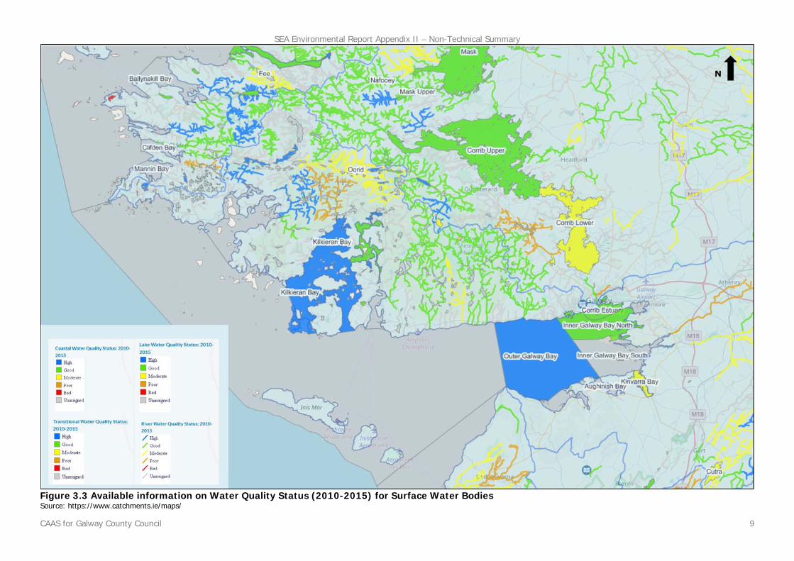
Since 2000, Water Management in the EU has been directed by the Water Framework Directive 2000/60/EC (WFD). The WFD requires that all Member States implement the necessary measures to prevent deterioration of the status of all waters - surface, ground, estuarine and coastal - and protect, enhance and restore all waters with the aim of achieving good status. All public bodies are required to coordinate their policies and operations so as to maintain the good status of water bodies which are currently unpolluted and improve polluted water bodies to good status. The WFD is implemented at River Basin Districts (RBD) level. An RBD is an area of land that is drained by a large river or number of rivers and the adjacent estuarine/coastal areas. For the first cycle of River Basin Management Plans were prepared for 8 RBDs on the island of Ireland. Following a review of the first cycle of RBMPs, the Department of Communications, Climate Action and Environment determined that, in the interest of efficiency, there will be a single national approach to the development of RBMPs for the second cycle and that the Eastern, South Eastern, South Western, Western and Shannon River Basin Districts will be merged to form one national River Basin District. In relation to the North Western and Neagh Bann International River Basin Districts, a single administrative area will be established in the South for the purpose of coordinating water management with authorities in Northern Ireland. There is a data gap relating to WFD surface water status data for certain waterbodies and these are identified as unassigned1 when it comes to WFD status 2010-2015. Water quality status for surface water bodies across the Gaeltacht area is indicated on Figure 3.3. Most surface water bodies within or adjacent to the Gaeltacht area are identified as being of high or good status. The Lower Loch Corrib is identified as being of moderate status as are a number of rivers and lakes. For groundwater bodies, the approach to classification is different from that for surface water. For each body of groundwater, both the chemical status and the quantitative must be determined. Both have to be classed as either good or poor. The WFD sets out a series of criteria that must be met for a body to be classed as good chemical and quantitative status. The WFD status (2010-2015) of all groundwater underlying the Gaeltacht (including An Cheathrú Rua, An Spidéal and Baile Chláir) and surrounding areas is generally identified as being good, meeting the objectives of the WFD. However, an area underlying a Waste Facility to the south west of Baile Chláir is identified as being of poor status. An area close to Oranmore is also identified as being of poor status. The Geological Survey of Ireland (GSI) rates the rocks, or aquifers, that contain groundwater according to both their vulnerability to pollution and their productivity. Most aquifers underlying An Cheathrú Rua, Baile Chláir and An Spidéal are identified as having extreme or extreme (rock near surface) vulnerability. With respect to productivity, the aquifer underlying Baile Chláir is regionally important, while aquifers underlying An Cheathrú Rua and An Spidéal are identified as poor aquifers. The WFD requires that Registers of Protected Areas (RPAs) are compiled for a number of water bodies or part of water bodies which must have extra controls on their quality by virtue of how their waters are used by people and by wildlife. There are number of entries to the RPAs within Gaeltacht area (including groundwater, Lake Corrib, River Corrib and Lake Loughaunnillan). The most significant source of flood risk within the Gaeltacht Plan area is from fluvial (from rivers/streams) and coastal sources, however; there are other sources of flooding present including those from pluvial (from rainwater) and surface drainage systems. A Strategic Flood Risk Assessment (SFRA) has been undertaken for the settlements within the Gaeltacht Plan that are provided with land use zoning - An Cheathrú Rua, An Spidéal and Baile Chláir. The SFRA has facilitated the integration of flood risk management considerations into both the land use zoning and written provisions contained within the Gaeltacht Plan.
1 Ecological status is not assigned and the term unassigned status applies in respect of these waterbodies.
SEA Environmental Report Appendix II – Non-Technical Summary
CAAS for Galway County Council 9
Figure 3.3 Available information on Water Quality Status (2010-2015) for Surface Water Bodies Source: https://www.catchments.ie/maps/

SEA Environmental Report Appendix II – Non-Technical Summary
CAAS for Galway County Council 10
3.7 Air and Climatic Factors
The key issue involving the assessment of the effects of implementing Variation 2 (b) on climatic factors relates to greenhouse gas emissions arising from transport. Interactions are also present with flooding and these are covered in greater detail in the Strategic Flood Risk Assessment that also accompanies the Variation. The Variation contributes towards improvements in sustainable mobility, thereby facilitating reductions in and limiting increases of greenhouse gas emissions. Such emissions would occur otherwise with higher levels of motorised transport and associated traffic. This is particularly relevant through the accommodation of new development, including consolidation, within each of the settlements that are provided with land use zoning by the Variation. Land-use planning contributes to what number and what extent of journeys occur. By addressing journey time through land use planning and providing more sustainable modes and levels of mobility, noise and other emissions to air and energy use can be minimised. Furthermore, by concentrating populations, greenfield development – and its associated impacts – can be minimised and the cost of service provision can be reduced. The EPA 2017 publication Ireland’s Greenhouse Gas Emission Projections 2016-2035 provides an assessment of Ireland’s progress towards achieving its emission reduction targets set down under the EU Effort Sharing Decision (Decision No 406/2009/EC) for the years 2013-2020 and a longer term assessment based on current projections. The first National Mitigation Plan 2017, prepared by the Department of Communications, Climate Action and Environment, represents an initial step to set Ireland on a pathway to achieve the level of decarbonisation required. In order to protect human health, vegetation and ecosystems, EU Directives set down air quality standards in Ireland and the other Member States for a wide variety of pollutants. National Ambient Air Quality Network and measures the levels of a number of atmospheric pollutants at locations across the country. The current air quality at the monitoring sites within the Gaeltacht area is identified by the EPA as being good 2.
3.8 Material Assets
Since January 2014, Irish Water is the State body responsible for the delivery, integration and implementation of strategic water and waste water projects and infrastructural improvements. Galway County Council no longer has a direct role in this area, however the Council works with Irish Water to help to ensure that the land use plans and water services investment plans align. The upgrading of infrastructure will contribute towards compliance with the Water Framework Directive, EU Urban Waste Water Treatment Directive and Drinking Water Regulations and will help to protect human health and maintain the quality of surface and ground waters. The EPA’s 2017 report ‘Urban Waste Water Treatment in 2016’ identified that:
Waste water treatment at 50 of Ireland’s 185 large urban areas did not meet relevant standards and improvements are needed at 148 urban areas;
Raw sewage is released into the environment from 44 urban areas; and Significant capital investment to upgrade deficient waste water treatment systems is required
to comply with EU standards, improve water quality, and prevent pollution of rivers, lakes and bathing water and to protect shellfish and pearl mussel habitats.
The EPA’s report lists An Cheathrú Rua and An Spidéal as priority areas where improvements are required to resolve environmental priorities. A Sewage Scheme has been completed for Baile Chláir in 2016 (there is currently adequate capacity in the wastewater infrastructure). 2 17/08/2017 (http://www.epa.ie/air/quality/)

SEA Environmental Report Appendix II – Non-Technical Summary
CAAS for Galway County Council 11
Drinking water must be clean and wholesome. That means it must meet the relevant water quality standards and must not contain any other substance or micro-organism in concentrations or numbers that constitute a potential danger to human health. The EPA publishes their results in annual reports which are supported by Remedial Action Lists (RALs). The RAL identifies water supplies which are not in compliance with the Regulations mentioned above. The current RAL (Q1 of 2018) lists two water supply schemes in County Galway (Ballinasloe and Williamstown water supplies) for elevated levels of THMs above the standard in the Drinking Water Regulations. Drinking water supply schemes in An Spidéal, An Cheathrú Rua and Baile Chláir are not listed on the current RAL. An Cheathrú Rua’s water supply has adequate capacity in the short term. The Galway Regional Water Supply Scheme will extend Galway City supply to An Cheathrú Rua in the future. The source of the water supply to An Spidéal is Both Loiscithe Lough. The water scheme provides a good quality supply to the village and an extensive surrounding area and currently has adequate capacity. It is planned that extensive water distribution network rehabilitation on the water scheme is undertaken. There is currently adequate capacity in the drinking water infrastructure in Baile Chláir. For the purposes of waste management planning, Ireland is now divided into three regions: Southern, Eastern-Midlands and Connacht-Ulster. Waste management plans for the three regions came into force in 2015. Galway is subject to the Connacht Ulster Waste Management Plan 2015-2021.
3.9 Cultural Heritage
Archaeology is the study of past societies through the material remains left by those societies and the evidence of their environment. Archaeological sites and monuments vary greatly in form and date; examples include earthworks of different types and periods, (e.g. early historic ringforts and prehistoric burial mounds), megalithic tombs from the Prehistoric period, medieval buildings, urban archaeological deposits and underwater features. Archaeological heritage is protected under the National Monuments Acts (1930-2004), Natural Cultural Institutions Act 1997 and the Planning Acts. A recorded monument is a monument included in the list and marked on the map which comprises the RMP set out county by county under Section 12 of the National Monuments (Amendment) Act, 1994 by the Archaeological Survey of Ireland. The definition includes Zones of Archaeological Potential in towns and all other monuments of archaeological interest which have so far been identified by the Government. Archaeological heritage in the Gaeltacht includes ancient field systems, megalithic tombs, standing stones, ringforts, children’s burial grounds and clochans. There are hundreds of archaeological monuments located across the Gaeltacht area. There are no known archaeological monuments within An Cheathrú Rua. Monuments in the surrounding area are mapped on Figure 3.4. Monuments within and surrounding An Spidéal and associated zones of notification, where available, are identified on Figure 3.5. There are a various entries to RMP in Baile Chláir including Baile Chláir Abbey which is a National Monument in State Care. This monument has multiple other monuments associated with it – see Figure 3.6. Architectural heritage in the Gaeltacht includes estate houses, castles and vernacular traditional buildings such as shops and houses. The term architectural heritage is defined in the Architectural Heritage (National Inventory) and Historic Monuments Act 1999 as meaning all: structures and buildings together with their settings and attendant grounds, fixtures and fittings; groups of structures and buildings; and, sites which are of technical, historical, archaeological, artistic, cultural, scientific, social, or technical interest. Part IV of the Planning and Development Act requires every development plan to include a Record of Protected Structures (RPS). A ‘protected structure’ is a structure or a specific feature of the structure as may be specified that a Planning Authority considers to be of special interest from an architectural, historical, archaeological, artistic, cultural, scientific, social or technical point of view.
SEA Environmental Report Appendix II – Non-Technical Summary
CAAS for Galway County Council 12
There are hundreds of entries to the Record of Protected Structures located across the Gaeltacht area. There are three entries to the RPS located within the centre of An Cheathrú Rua as identified on Figure 3.4. There are various entries to the RPS located within An Spidéal as identified on Figure 3.5. There are three entries to the RPS located within the town of Baile Chláir as identified on Figure 3.6. In addition to entries to the RPS, there are hundreds of entries to the National Inventory of Architectural Heritage (NIAH) across the Gaeltacht. The NIAH is a State initiative under the administration of the Department of Arts, Heritage and the Gaeltacht and was established on a statutory basis under the provisions of the Architectural Heritage (National Inventory) and Historic Monuments (Miscellaneous Provisions) Act 1999.
3.10 Landscape
Landscapes are areas which are perceived by people and are made up of a number of layers: landform, which results from geological and geomorphological history; landcover, which includes vegetation, water, human settlements, and; human values which are a result of historical, cultural, religious and other understandings and interactions with landform and landcover. The Landscape Character Assessment for County Galway (2003) identifies Landscape Character Areas, classifies landscapes in Galway according to their sensitivity (their ability to accommodate change or intervention without suffering unacceptable effects to character and values) and values and identifies focal points/views. The following five sensitivity classes were established by the Landscape Character Assessment:
Class 1 – Low sensitivity; Class 2 – Moderate sensitivity; Class 3 – High sensitivity; Class 4 – Special; and, Class 5 – Unique
A map of the landscape sensitivity for the entire County is provided on Figure 3.7.
The landscape at An Cheathrú Rua is generally classified as being of High Sensitivity (Class 3) with some coastal areas identified as being of Special Sensitivity (Class 4). There are no focal points/views located within or adjacent to An Cheathrú Rua. The landscape at An Spidéal is generally classified as being of High Sensitivity (Class 3) along the coast and within the village. Areas to the north of the village are classified as being of Moderate Sensitivity (Class 2). One focal point/view (‘No. 77 View of the Catholic Church and High Tower’) is located at An Spidéal. The landscape at and surrounding Baile Chláir is classified as being of Low Sensitivity (Class 1). One focal point/view (‘No. 35 Church and Cemetery Ruins in Baile Chláir’) is located in Baile Chláir.

SEA Environmental Report Appendix II – Non-Technical Summary
CAAS for Galway County Council 13
Figure 3.4 An Cheathrú Rua Cultural Heritage – Archaeological and Architectural Designations

SEA Environmental Report Appendix II – Non-Technical Summary
CAAS for Galway County Council 14
Figure 3.5 An Spidéal Cultural Heritage – Archaeological and Architectural Designation

SEA Environmental Report Appendix II – Non-Technical Summary
CAAS for Galway County Council 15
Figure 3.6 Baile Chláir Cultural Heritage – Archaeological and Architectural Designation

SEA Environmental Report Appendix II – Non-Technical Summary
CAAS for Galway County Council 16
Figure 3.7 Landscape Sensitivity County Galway

SEA Environmental Report Appendix II – Non-Technical Summary
CAAS for Galway County Council 17
3.11 Appropriate Assessment
A Stage 2 Appropriate Assessment (AA) has been undertaken alongside the preparation of Variation 2 (b). The requirement for AA is provided under the EU Habitats Directive (Directive 1992/43/EEC). The preparation of the Variation, SEA and AA has taken place concurrently and the findings of the AA have informed both the Variation and the SEA. All recommendations made by the AA were integrated into the Variation.
3.12 Strategic Flood Risk Assessment
A Strategic Flood Risk Assessment (SFRA) has been undertaken alongside the preparation of Variation 2 (b). The requirement for SFRA is provided under ‘The Planning System and Flood Risk Management Guidelines for Planning Authorities’ (DEHLG and OPW, 2009). The preparation of the Variation, SEA and SFRA has taken place concurrently and the findings of the SFRA have informed both the Variation and the SEA. The SFRA has facilitated the integration of flood risk management considerations into the Variation.
3.13 Strategic Environmental Objectives
Strategic Environmental Objectives (SEOs) are methodological measures developed from policies which generally govern environmental protection objectives established at international, Community or Member State level e.g. the environmental protection objectives of various European Directives which have been transposed into Irish law and which are required to be implemented. SEOs used in the assessment are as follows: Table 3.1 Strategic Environmental Objectives
Environmental Component
Strategic Environmental Objective(s)
Biodiversity, Flora and Fauna
B1: To ensure compliance with the Habitats and Birds Directives with regard to the protection of European Sites and Annexed habitats and species3 B2: To ensure compliance with Article 10 of the Habitats Directive with regard to the management of features of the landscape which - by virtue of their linear and continuous structure or their function act as stepping stones (designated or not) - are of major importance for wild fauna and flora and essential for the migration, dispersal and genetic exchange of wild species B3: To avoid significant impacts on relevant habitats, species, environmental features or other sustaining resources in designated sites including Wildlife Sites and to ensure compliance with the Wildlife Acts 1976-2010 with regard to the protection of species listed on Schedule 5 of the principal Act B4: To sustain existing sustainable rural management practices - and the communities who support them - to ensure the continuation of long established managed landscapes and the flora and fauna that they contain
Population & Human Health
PHH1: To protect populations and human health from exposure to incompatible landuses
Soil S1: To avoid damage to the hydrogeological and ecological function of the soil resource in County Galway Water W1: To maintain and improve, where possible, the quality and status of surface waters
W2: To prevent pollution and contamination of ground water W3: To comply as appropriate with the provisions of the Planning System and Flood Risk Management: Guidelines for Planning Authorities (DEHLG and OPW, 2009)
Material Assets
M1: To serve new development with adequate and appropriate waste water treatment M2: To serve new development with adequate drinking water that is both wholesome and clean M3: To reduce waste volumes, minimise waste to landfill and increase recycling and reuse.
Air & Climatic Factors
C1: To reduce travel related emissions to air and to encourage modal change from car to more sustainable forms of transport
Cultural Heritage
CH1: To protect archaeological heritage including entries to the Record of Monuments and Places and/or their context CH2: To protect architectural heritage including entries to the Record of Protected Structures and Architectural Conservation Areas and their context
Landscape
L1: To avoid significant adverse impacts on the landscape - especially with regard to the County’s landscapes which are most valuable and most sensitive to change and protected focal points and views.
3 ‘Annexed habitats and species’ are those listed on EU Habitats Directive Annex I, II & IV and EU Birds Directive Annex I

SEA Environmental Report Appendix II – Non-Technical Summary
CAAS for Galway County Council 18
Section 4 Summary of Description and Evaluation of Alternatives
4.1 Introduction
As per the requirements of the SEA Directive, the SEA considered reasonable alternatives, which are capable of being implemented for Variation 2 (b), taking into account the objectives and the geographical scope of the Plan (as varied). Available alternatives are limited by the scope of the Variation. Focus is given to the land use zoning provisions relating to three settlements - An Cheathrú Rua, An Spidéal and Baile Chláir - that is provided for by the Variation. Galway County Council in preparing Variation 2 (b) developed three alternatives for each of the settlements in An Cheathrú Rua, An Spidéal and Baile Chláir as follows:
4.2 Alternative 1: Even Development
Achieving the population targets: All three settlements to reach the population targets by 2021, resulting in balanced orderly development and implementation of the core strategy as contained in Chapter 2 of the Galway County Development Plan 2015-2021;
The infrastructure required to be in place to achieve the growth targets is already in place; Residential Development to take place on R1 lands in the lifetime of the Gaeltacht Plan,
unless a comprehensive justification is provided for alternative residential lands; Community development facilities to be developed in tandem with the targeted growth of the
settlements; Village Centre developments would be developed in a planned and coordinated manner; Opportunity sites identified with clear design and proposed uses identified; Open Space and Recreational Lands would be preserved.
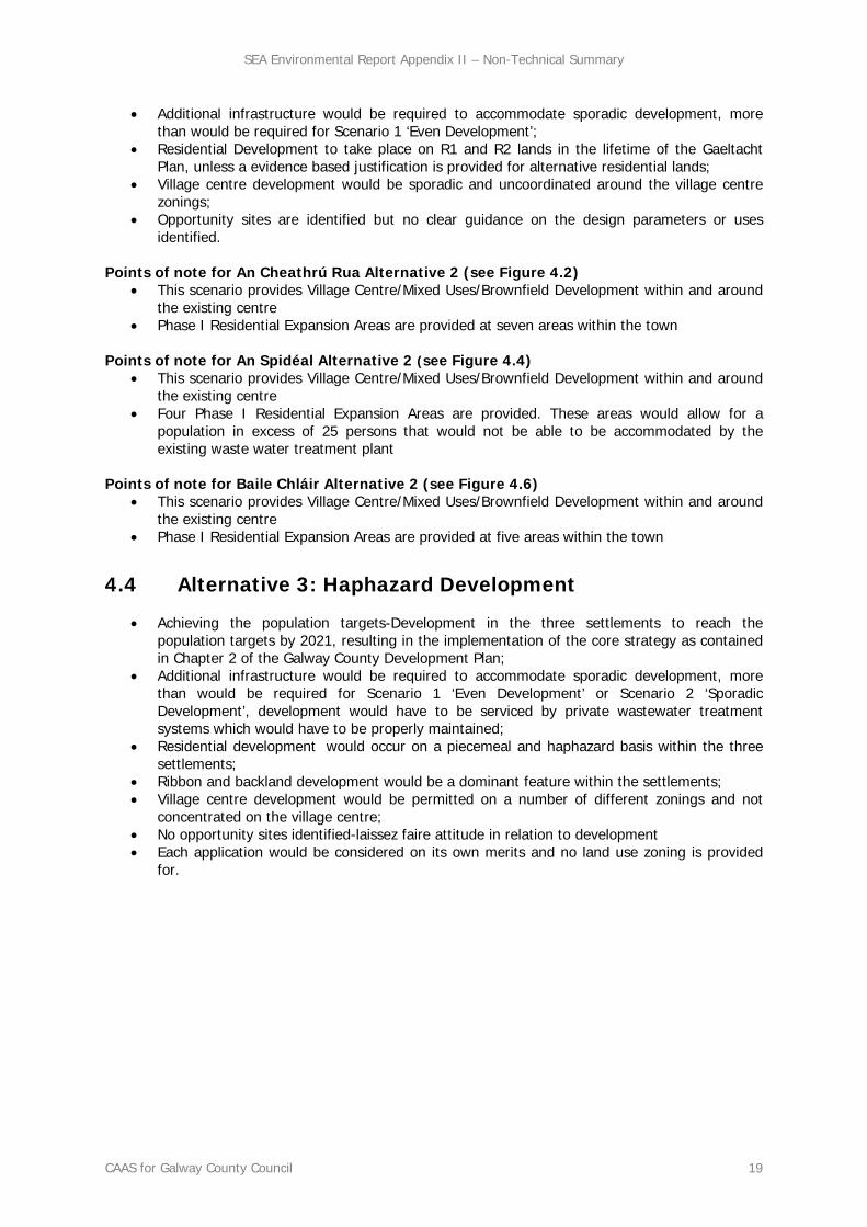
Points of note for An Cheathrú Rua Alternative 1 (see Figure 4.1)
This scenario provides Village Centre/Mixed Uses/Brownfield Development within and around the existing centre
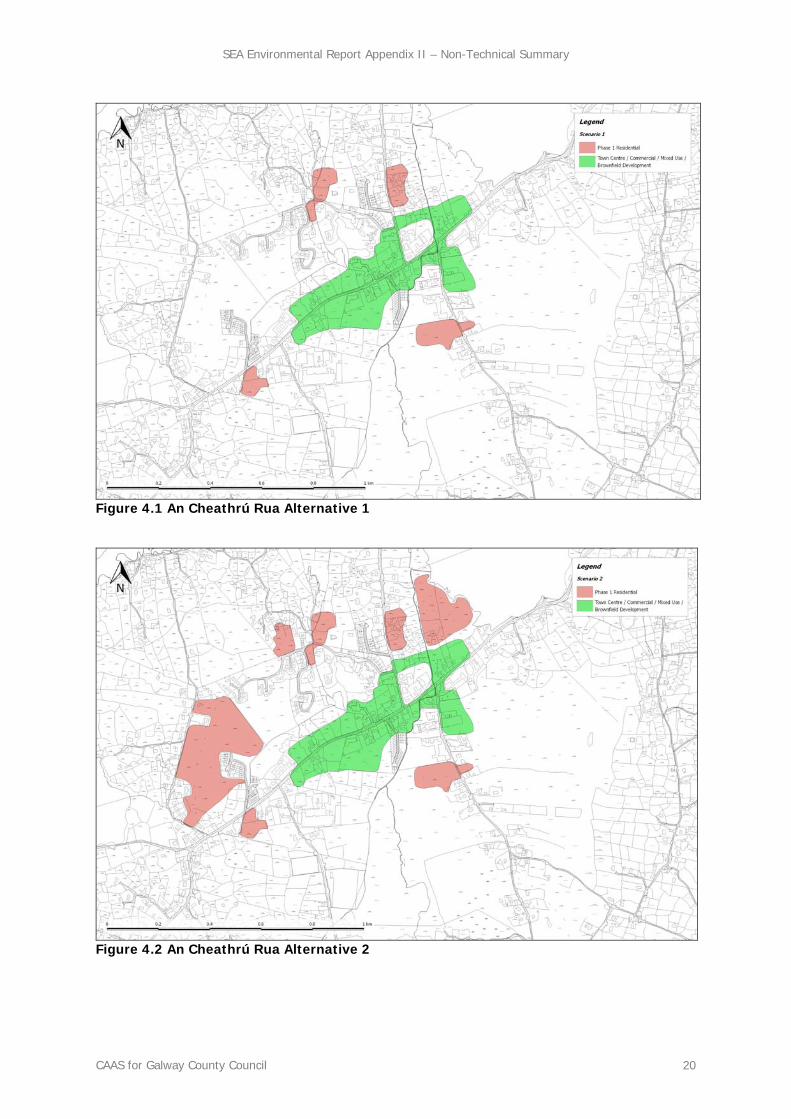
Phase I Residential Expansion Areas are provided at four areas within the town Points of note for An Spidéal Alternative 1 (see Figure 4.3)
This scenario provides Village Centre/Mixed Uses/Brownfield Development within and around the existing centre
Two Phase I Residential Expansion Areas are provided – both to the north along Baile Árd. These areas would allow for an additional population of 25 persons that would be able to be accommodated by the existing waste water treatment plant
Points of note for Baile Chláir Scenario 1 (see Figure 4.5)
This scenario provides Village Centre/Mixed Uses/Brownfield Development within and around the existing centre
Phase I Residential Expansion Areas are provided at three areas within the town
4.3 Alternative 2: Sporadic Development
Achieving the population targets: All three settlements to reach the population targets by 2021, resulting in the implementation of the core strategy as contained in Chapter 2 of the Galway County Development Plan 2015-2021;
SEA Environmental Report Appendix II – Non-Technical Summary
CAAS for Galway County Council 19
Additional infrastructure would be required to accommodate sporadic development, more than would be required for Scenario 1 ‘Even Development’;
Residential Development to take place on R1 and R2 lands in the lifetime of the Gaeltacht Plan, unless a evidence based justification is provided for alternative residential lands;
Village centre development would be sporadic and uncoordinated around the village centre zonings;
Opportunity sites are identified but no clear guidance on the design parameters or uses identified.
Points of note for An Cheathrú Rua Alternative 2 (see Figure 4.2)
This scenario provides Village Centre/Mixed Uses/Brownfield Development within and around the existing centre
Phase I Residential Expansion Areas are provided at seven areas within the town
Points of note for An Spidéal Alternative 2 (see Figure 4.4) This scenario provides Village Centre/Mixed Uses/Brownfield Development within and around
the existing centre Four Phase I Residential Expansion Areas are provided. These areas would allow for a
population in excess of 25 persons that would not be able to be accommodated by the existing waste water treatment plant
Points of note for Baile Chláir Alternative 2 (see Figure 4.6)
This scenario provides Village Centre/Mixed Uses/Brownfield Development within and around the existing centre
Phase I Residential Expansion Areas are provided at five areas within the town
4.4 Alternative 3: Haphazard Development
Achieving the population targets-Development in the three settlements to reach the population targets by 2021, resulting in the implementation of the core strategy as contained in Chapter 2 of the Galway County Development Plan;
Additional infrastructure would be required to accommodate sporadic development, more than would be required for Scenario 1 ‘Even Development’ or Scenario 2 ‘Sporadic Development’, development would have to be serviced by private wastewater treatment systems which would have to be properly maintained;
Residential development would occur on a piecemeal and haphazard basis within the three settlements;
Ribbon and backland development would be a dominant feature within the settlements; Village centre development would be permitted on a number of different zonings and not
concentrated on the village centre; No opportunity sites identified-laissez faire attitude in relation to development Each application would be considered on its own merits and no land use zoning is provided
for.
SEA Environmental Report Appendix II – Non-Technical Summary
CAAS for Galway County Council 20
Figure 4.1 An Cheathrú Rua Alternative 1
Figure 4.2 An Cheathrú Rua Alternative 2
SEA Environmental Report Appendix II – Non-Technical Summary
CAAS for Galway County Council 21
Figure 4.3 An Spidéal Alternative 1
Figure 4.4 An Spidéal Alternative 2

SEA Environmental Report Appendix II – Non-Technical Summary
CAAS for Galway County Council 22
Figure 4.5 Baile Chláir Alternative 1 Figure 4.6 Baile Chláir Alternative 2
SEA Environmental Report Appendix II – Non-Technical Summary
CAAS for Galway County Council 23
4.5 Summary of Assessment of Alternatives
Significant Positive Effects Common to all Alternatives By providing for development within existing development boundaries and facilitating the use of existing utilities and brownfield sites, all alternatives would be likely to contribute towards a reduced need to develop more sensitive, undeveloped areas elsewhere in the wider Gaeltacht area that are further from established settlements and less well serviced. This would be likely to result in significant positive environmental effects on environmental components as indicated on Table 4.1. Table 4.1 Significant Positive Effects common to all Alternatives
Environmental Component
Significant Positive Effect, likely to occur
Biodiversity and Flora and Fauna
Contributes towards protection of ecology (including designated sites, ecological connectivity, habitats) – due to increased utilisation of lands within existing development boundaries and use of existing utilities and brownfield sites.
Contributes towards protection of ecology with respect to the provision of water services. Contributes towards protection of ecology as a result of contributing towards the protection of
environmental vectors, including air and water. Is consistent with approach provided by the existing Plan, to sustain existing sustainable rural
management practices - and the communities who support them - to ensure the continuation of long established managed landscapes and the flora and fauna that they contain
Population and Human Health
Contributes towards protection of human health with respect to the provision of water services and the provision of transport infrastructure integrated with land use planning – and associated interactions with sustainable mobility, emissions and energy usage.
Contributes towards protection of human health as a result of contributing towards the protection of environmental vectors, including air and water.
Soil Contributes towards protection of soil – due to increased utilisation of lands within existing development boundaries and use of existing utilities and brownfield sites.
Contributes towards protection of soil with respect to the provision of water services. Water Contributes towards protection and management of ground and surface waters due to facilitating
development within established and serviced settlement centres. Material Assets
Allows for use of planned infrastructure including water services infrastructure and transport infrastructure.
Makes use of existing water services and drainage infrastructure. Air and Climatic Factors
Facilitates contribution towards a shift from car to more sustainable and non-motorised transport modes.
Facilitates contribution towards reducing congestion and associated adverse effects on air quality. Facilitates contribution towards reductions in travel related greenhouse gas and other emissions to
air. Cultural Heritage
Contributes towards protection of cultural heritage in wider region by facilitating development within existing settlements.
Landscape Contributes towards protection of wider landscape by facilitating development within existing settlements.
Although significant positive environmental effects would occur under each of the alternatives, the extent to which they would occur varies across each of the alternatives and this is addressed under the evaluation of each of the alternatives below. Potentially Significant Adverse Effects Common to all Alternatives All of the alternatives provide for development of the relevant settlements. Such development would have the potential to conflict with environmental components – to different degrees. Potentially significant adverse environmental effects arising from this conflict are common to all alternatives and are described on Table 4.2. For the Variation, these effects will be mitigated by both provisions integrated into the Variation and existing provisions already in force through the County Development Plan. Although potentially significant adverse environmental effects would occur under each of the alternatives, the extent to which they would occur varies across each of the alternatives and this is addressed under the evaluation of each of the alternatives below.
SEA Environmental Report Appendix II – Non-Technical Summary
CAAS for Galway County Council 24
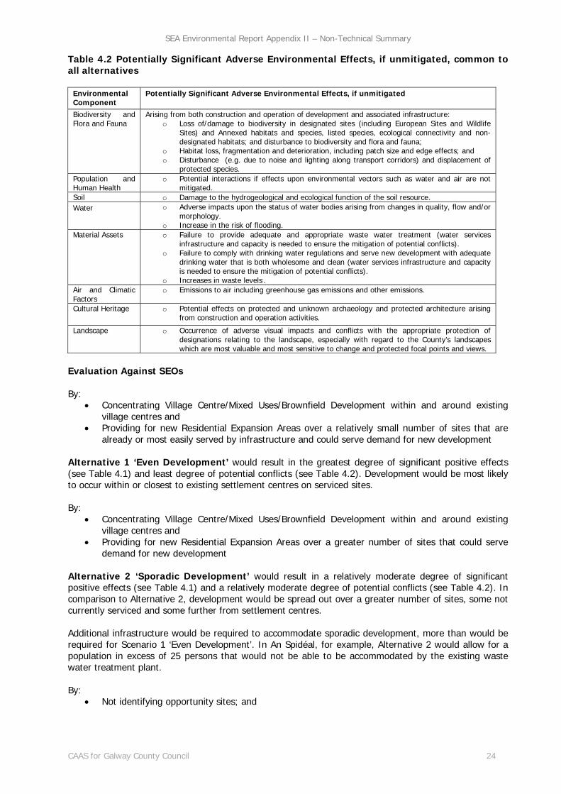
Table 4.2 Potentially Significant Adverse Environmental Effects, if unmitigated, common to all alternatives
Environmental Component
Potentially Significant Adverse Environmental Effects, if unmitigated
Biodiversity and Flora and Fauna
Arising from both construction and operation of development and associated infrastructure: o Loss of/damage to biodiversity in designated sites (including European Sites and Wildlife
Sites) and Annexed habitats and species, listed species, ecological connectivity and non-designated habitats; and disturbance to biodiversity and flora and fauna;
o Habitat loss, fragmentation and deterioration, including patch size and edge effects; and o Disturbance (e.g. due to noise and lighting along transport corridors) and displacement of
protected species. Population and Human Health
o Potential interactions if effects upon environmental vectors such as water and air are not mitigated.
Soil o Damage to the hydrogeological and ecological function of the soil resource. Water o Adverse impacts upon the status of water bodies arising from changes in quality, flow and/or
morphology. o Increase in the risk of flooding.
Material Assets
o Failure to provide adequate and appropriate waste water treatment (water services infrastructure and capacity is needed to ensure the mitigation of potential conflicts).
o Failure to comply with drinking water regulations and serve new development with adequate drinking water that is both wholesome and clean (water services infrastructure and capacity is needed to ensure the mitigation of potential conflicts).
o Increases in waste levels.. Air and Climatic Factors
o Emissions to air including greenhouse gas emissions and other emissions.
Cultural Heritage
o Potential effects on protected and unknown archaeology and protected architecture arising from construction and operation activities.
Landscape o Occurrence of adverse visual impacts and conflicts with the appropriate protection of designations relating to the landscape, especially with regard to the County’s landscapes which are most valuable and most sensitive to change and protected focal points and views.
Evaluation Against SEOs By:
Concentrating Village Centre/Mixed Uses/Brownfield Development within and around existing village centres and
Providing for new Residential Expansion Areas over a relatively small number of sites that are already or most easily served by infrastructure and could serve demand for new development
Alternative 1 ‘Even Development’ would result in the greatest degree of significant positive effects (see Table 4.1) and least degree of potential conflicts (see Table 4.2). Development would be most likely to occur within or closest to existing settlement centres on serviced sites. By:
Concentrating Village Centre/Mixed Uses/Brownfield Development within and around existing village centres and
Providing for new Residential Expansion Areas over a greater number of sites that could serve demand for new development
Alternative 2 ‘Sporadic Development’ would result in a relatively moderate degree of significant positive effects (see Table 4.1) and a relatively moderate degree of potential conflicts (see Table 4.2). In comparison to Alternative 2, development would be spread out over a greater number of sites, some not currently serviced and some further from settlement centres.
Additional infrastructure would be required to accommodate sporadic development, more than would be required for Scenario 1 ‘Even Development’. In An Spidéal, for example, Alternative 2 would allow for a population in excess of 25 persons that would not be able to be accommodated by the existing waste water treatment plant. By:
Not identifying opportunity sites; and
SEA Environmental Report Appendix II – Non-Technical Summary
CAAS for Galway County Council 25
Following a ‘laissez faire’ approach in relation to development, with each application considered on its own merits and no land use zoning would be provided for
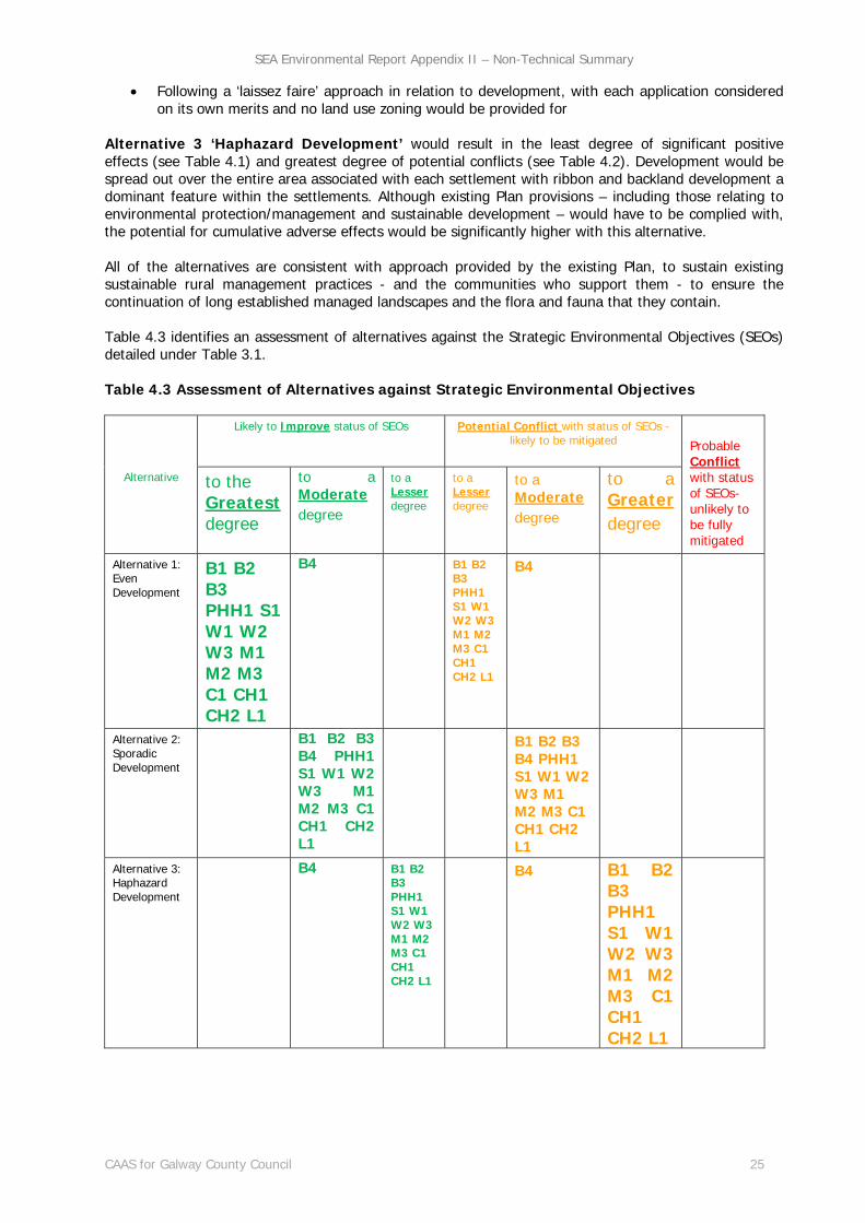
Alternative 3 ‘Haphazard Development’ would result in the least degree of significant positive effects (see Table 4.1) and greatest degree of potential conflicts (see Table 4.2). Development would be spread out over the entire area associated with each settlement with ribbon and backland development a dominant feature within the settlements. Although existing Plan provisions – including those relating to environmental protection/management and sustainable development – would have to be complied with, the potential for cumulative adverse effects would be significantly higher with this alternative. All of the alternatives are consistent with approach provided by the existing Plan, to sustain existing sustainable rural management practices - and the communities who support them - to ensure the continuation of long established managed landscapes and the flora and fauna that they contain. Table 4.3 identifies an assessment of alternatives against the Strategic Environmental Objectives (SEOs) detailed under Table 3.1. Table 4.3 Assessment of Alternatives against Strategic Environmental Objectives
Alternative
Likely to Improve status of SEOs
Potential Conflict with status of SEOs - likely to be mitigated
Probable Conflict with status of SEOs- unlikely to be fully mitigated
to the Greatest degree
to a Moderate degree
to a Lesser degree
to a Lesser degree
to a Moderate degree
to a Greater degree
Alternative 1: Even Development
B1 B2 B3 PHH1 S1 W1 W2 W3 M1 M2 M3 C1 CH1 CH2 L1
B4 B1 B2 B3 PHH1 S1 W1 W2 W3 M1 M2 M3 C1 CH1 CH2 L1
B4
Alternative 2: Sporadic Development
B1 B2 B3 B4 PHH1 S1 W1 W2 W3 M1 M2 M3 C1 CH1 CH2 L1
B1 B2 B3 B4 PHH1 S1 W1 W2 W3 M1 M2 M3 C1 CH1 CH2 L1
Alternative 3: Haphazard Development
B4 B1 B2 B3 PHH1 S1 W1 W2 W3 M1 M2 M3 C1 CH1 CH2 L1
B4 B1 B2 B3 PHH1 S1 W1 W2 W3 M1 M2 M3 C1 CH1 CH2 L1
SEA Environmental Report Appendix II – Non-Technical Summary
CAAS for Galway County Council 26
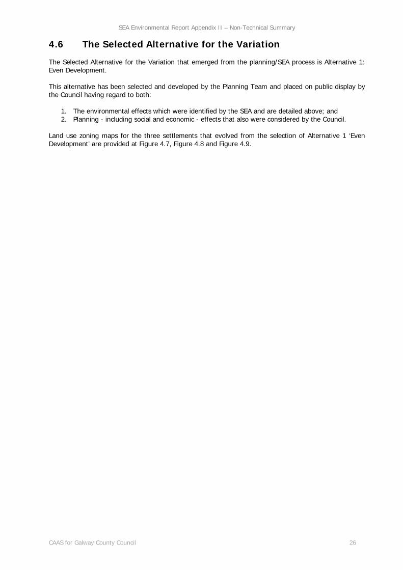
4.6 The Selected Alternative for the Variation
The Selected Alternative for the Variation that emerged from the planning/SEA process is Alternative 1: Even Development. This alternative has been selected and developed by the Planning Team and placed on public display by the Council having regard to both:
1. The environmental effects which were identified by the SEA and are detailed above; and 2. Planning - including social and economic - effects that also were considered by the Council.
Land use zoning maps for the three settlements that evolved from the selection of Alternative 1 ‘Even Development’ are provided at Figure 4.7, Figure 4.8 and Figure 4.9.

SEA Environmental Report Appendix II – Non-Technical Summary
CAAS for Galway County Council 27
Figure 4.7 Land Use Zoning An Cheathrú Rua

SEA Environmental Report Appendix II – Non-Technical Summary
CAAS for Galway County Council 28
Figure 4.8 Land Use Zoning An Spidéal

SEA Environmental Report Appendix II – Non-Technical Summary
CAAS for Galway County Council 29
Figure 4.9 Land Use Zoning Baile Chláir

SEA Environmental Report Appendix II – Non-Technical Summary
CAAS for Galway County Council 30
Section 5 Summary of Effects arising from Variation 2 (b)
Galway County Council have integrated all recommendations arising from the SEA and AA processes into the Variation (see Section 6). By providing for development within existing development boundaries (in An Cheathrú Rua, An Spidéal and Baile Chláir) and facilitating the use of existing utilities and brownfield sites, the Variation would be likely to contribute towards a reduced need to develop more sensitive, undeveloped areas elsewhere in the wider County that are further from established settlements and less well serviced. This would be likely to result in significant positive environmental effects on various environmental components as detailed on Table 5.1 overleaf. Table 5.1 provides a detailed overall evaluation of the environmental effects arising from the Variation. The effects encompass all in-combination/cumulative effects arising from implementation of the Variation. The potentially significant adverse environmental effects (if unmitigated) arising from implementation of the Variation are detailed as are residual effects, taking into account mitigation through both provisions integrated into the Variation and existing provisions already in force through the County Development Plan – see Section 6. Environmental impacts which occur will be determined by the nature and extent of multiple or individual projects and site specific environmental factors. Strategic Environmental Objective (SEO) codes taken from Table 3.1.
SEA Environmental Report Appendix II – Non-Technical Summary
CAAS for Galway County Council 31
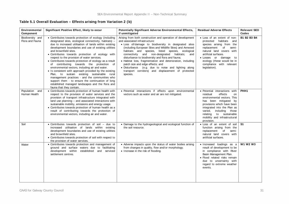
Table 5.1 Overall Evaluation – Effects arising from Variation 2 (b)
Environmental Component
Significant Positive Effect, likely to occur Potentially Significant Adverse Environmental Effects, if unmitigated
Residual Adverse Effects Relevant SEO Codes
Biodiversity and Flora and Fauna
Contributes towards protection of ecology (including designated sites, ecological connectivity, habitats) – due to increased utilisation of lands within existing development boundaries and use of existing utilities and brownfield sites.
Contributes towards protection of ecology with respect to the provision of water services.
Contributes towards protection of ecology as a result of contributing towards the protection of environmental vectors, including air and water.
Is consistent with approach provided by the existing Plan, to sustain existing sustainable rural management practices - and the communities who support them - to ensure the continuation of long established managed landscapes and the flora and fauna that they contain.
Arising from both construction and operation of development and associated infrastructure: Loss of/damage to biodiversity in designated sites
(including European Sites and Wildlife Sites) and Annexed habitats and species, listed species, ecological connectivity and non-designated habitats; and disturbance to biodiversity and flora and fauna;
Habitat loss, fragmentation and deterioration, including patch size and edge effects; and
Disturbance (e.g. due to noise and lighting along transport corridors) and displacement of protected species.
Loss of an extent of non-protected habitats and species arising from the replacement of semi-natural land covers with artificial surfaces.
Losses or damage to ecology (these would be in compliance with relevant legislation).
B1 B2 B3 B4
Population and Human Health
Contributes towards protection of human health with respect to the provision of water services and the provision of transport infrastructure integrated with land use planning – and associated interactions with sustainable mobility, emissions and energy usage.
Contributes towards protection of human health as a result of contributing towards the protection of environmental vectors, including air and water.
Potential interactions if effects upon environmental vectors such as water and air are not mitigated.
Potential interactions with residual effects on environmental vectors. This has been mitigated by provisions which have been integrated into the Plan as varied, including those relating to sustainable mobility and infrastructural provision.
PHH1
Soil Contributes towards protection of soil – due to increased utilisation of lands within existing development boundaries and use of existing utilities and brownfield sites.
Contributes towards protection of soil with respect to the provision of water services.
Damage to the hydrogeological and ecological function of the soil resource.
Loss of an extent of soil function arising from the replacement of semi-natural land covers with artificial surfaces.
S1
Water Contributes towards protection and management of ground and surface waters due to facilitating development within established and serviced settlement centres.
Adverse impacts upon the status of water bodies arising from changes in quality, flow and/or morphology.
Increase in the risk of flooding.
Increased loadings as a result of development to be in compliance with River Basin Management Plan.
Flood related risks remain due to uncertainty with regard to extreme weather events.
W1 W2 W3

SEA Environmental Report Appendix II – Non-Technical Summary
CAAS for Galway County Council 32
Environmental Component
Significant Positive Effect, likely to occur Potential Effect, if unmitigated Residual Adverse Effects Relevant SEO Codes
Material Assets
Allows for use of planned infrastructure including water services infrastructure and transport infrastructure.
Makes use of existing water services and drainage infrastructure.
Failure to provide adequate and appropriate waste water treatment (water services infrastructure and capacity is needed to ensure the mitigation of potential conflicts).
Failure to comply with drinking water regulations and serve new development with adequate drinking water that is both wholesome and clean (water services infrastructure and capacity is needed to ensure the mitigation of potential conflicts).
Increases in waste levels..
Residual wastes to be disposed of in line with higher level waste management policies.
M1 M2
Air and Climatic Factors
Facilitates contribution towards a shift from car to more sustainable and non-motorised transport modes.
Facilitates contribution towards reducing congestion and associated adverse effects on air quality.
Facilitates contribution towards reductions in travel related greenhouse gas and other emissions to air.
Emissions to air including greenhouse gas emissions and other emissions.
An extent of travel related greenhouse gas and other emissions to air. This has been mitigated by provisions which have been integrated into the Plan, including those relating to sustainable mobility.
C1
Cultural Heritage
Contributes towards protection of cultural heritage in wider region by facilitating development within existing settlements.
Potential effects on protected and unknown archaeology and protected architecture arising from construction and operation activities.
Potential alteration to the context and setting of architectural heritage however these will occur in compliance with legislation.
Potential alteration to the context and setting of archaeological heritage however this will occur in compliance with legislation.
Potential loss of unknown archaeology however this loss will be mitigated by measures integrated into the Plan as varied.
CH1 CH2
Landscape Contributes towards protection of wider landscape by facilitating development within existing settlements.
Occurrence of adverse visual impacts and conflicts with the appropriate protection of designations relating to the landscape, especially with regard to the County’s landscapes which are most valuable and most sensitive to change and protected focal points and views.
The Plan as varied contributes towards the protection of landscape designations. The County’s landscapes will change overtime as a result of natural changes in vegetation cover combined with new developments.
L1

SEA Environmental Report Appendix II – Non-Technical Summary
CAAS for Galway County Council 33
Section 6 Mitigation and Monitoring Measures
6.1 Mitigation
Mitigation measures are measures envisaged to prevent, reduce and, as fully as possible, offset any significant adverse impacts on the environment of implementing the Plan, as varied. Various environmental sensitivities and issues have been communicated to the Council through the various SEA, AA and SFRA processes undertaken for both the original 2015 Plan, Variation No. 1 and the Variation. By integrating all related recommendations into the Plan, the Council have ensured that both the beneficial environmental effects of implementing the Plan have been and will be maximised and that potential adverse effects have been and will be avoided, reduced or offset. Mitigation was achieved through:
Strategic work undertaken by the Council to ensure contribution towards environmental protection and sustainable development;
Integration of individual SEA and AA provisions into the text of the Variation; and Integration of environmental considerations into zoning provisions of the Plan.
A summary of individual SEA and AA provisions into the text of both the Plan as varied and the Variation is provided at Table 6.1.
6.2 Monitoring
The SEA Directive requires that the significant environmental effects of the implementation of plans and programmes are monitored. The Environmental Report contains proposals for monitoring the Variation that are adopted alongside the Variation. Monitoring enables, at an early stage, the identification of unforeseen adverse effects and the undertaking of appropriate remedial action. The Environmental Report identifies indicators - which allow quantitative measures of trends and progress in the environment over time. Measurements for indicators generally come from existing monitoring sources or from an internal monitoring of the environmental effects of grants of permission in the Council. Monitoring is an ongoing process and the Programme allows for flexibility and the further refinement of indicators and targets. The Monitoring Programme may also be updated to deal with specific environmental issues - including unforeseen effects - as they arise. A stand-alone Monitoring Report on the significant environmental effects of implementing the County Development Plan (including Variation 2b) will be prepared in advance of the review of the County Development Plan. This report will address the indicators that are set out on Table 6.1.
SEA Environmental Report Appendix II – Non-Technical Summary
CAAS for Galway County Council 34
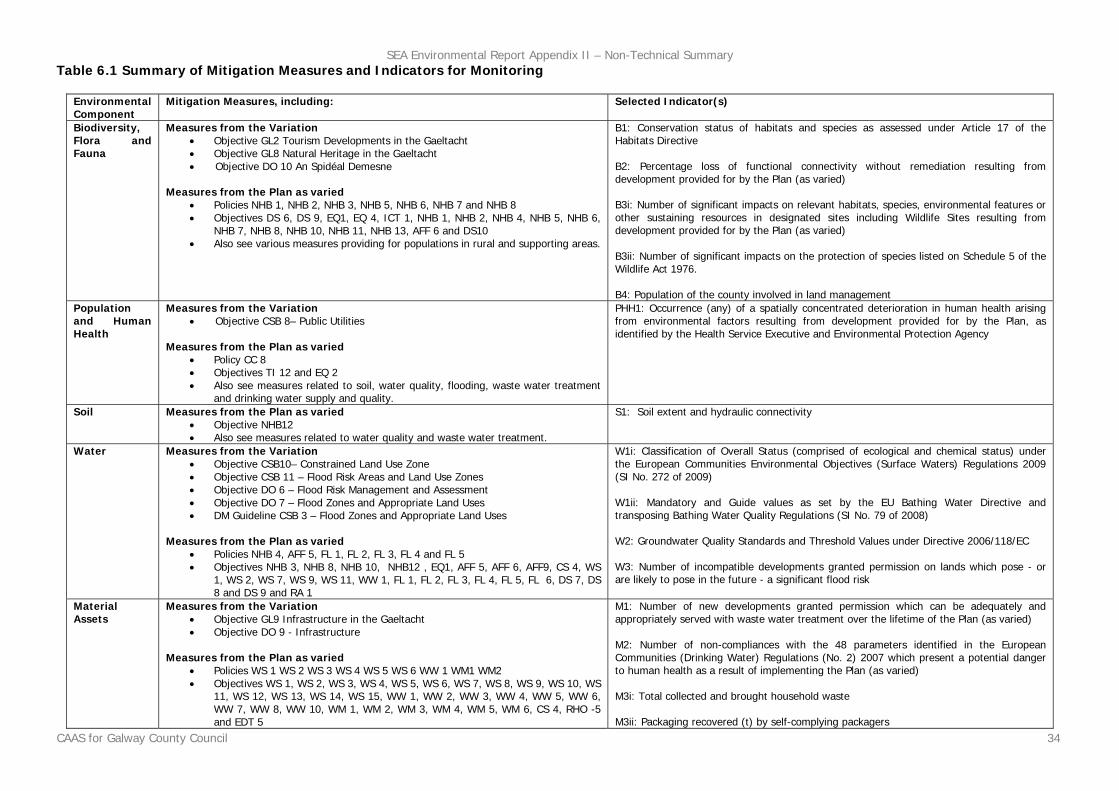
Table 6.1 Summary of Mitigation Measures and Indicators for Monitoring
Environmental Component
Mitigation Measures, including: Selected Indicator(s)
Biodiversity, Flora and Fauna
Measures from the Variation Objective GL2 Tourism Developments in the Gaeltacht Objective GL8 Natural Heritage in the Gaeltacht Objective DO 10 An Spidéal Demesne
Measures from the Plan as varied
Policies NHB 1, NHB 2, NHB 3, NHB 5, NHB 6, NHB 7 and NHB 8 Objectives DS 6, DS 9, EQ1, EQ 4, ICT 1, NHB 1, NHB 2, NHB 4, NHB 5, NHB 6,
NHB 7, NHB 8, NHB 10, NHB 11, NHB 13, AFF 6 and DS10 Also see various measures providing for populations in rural and supporting areas.
B1: Conservation status of habitats and species as assessed under Article 17 of the Habitats Directive B2: Percentage loss of functional connectivity without remediation resulting from development provided for by the Plan (as varied) B3i: Number of significant impacts on relevant habitats, species, environmental features or other sustaining resources in designated sites including Wildlife Sites resulting from development provided for by the Plan (as varied) B3ii: Number of significant impacts on the protection of species listed on Schedule 5 of the Wildlife Act 1976. B4: Population of the county involved in land management
Population and Human Health
Measures from the Variation Objective CSB 8– Public Utilities
Measures from the Plan as varied
Policy CC 8 Objectives TI 12 and EQ 2 Also see measures related to soil, water quality, flooding, waste water treatment
and drinking water supply and quality.
PHH1: Occurrence (any) of a spatially concentrated deterioration in human health arising from environmental factors resulting from development provided for by the Plan, as identified by the Health Service Executive and Environmental Protection Agency
Soil Measures from the Plan as varied Objective NHB12 Also see measures related to water quality and waste water treatment.
S1: Soil extent and hydraulic connectivity
Water Measures from the Variation Objective CSB10– Constrained Land Use Zone Objective CSB 11 – Flood Risk Areas and Land Use Zones Objective DO 6 – Flood Risk Management and Assessment Objective DO 7 – Flood Zones and Appropriate Land Uses DM Guideline CSB 3 – Flood Zones and Appropriate Land Uses
Measures from the Plan as varied
Policies NHB 4, AFF 5, FL 1, FL 2, FL 3, FL 4 and FL 5 Objectives NHB 3, NHB 8, NHB 10, NHB12 , EQ1, AFF 5, AFF 6, AFF9, CS 4, WS
1, WS 2, WS 7, WS 9, WS 11, WW 1, FL 1, FL 2, FL 3, FL 4, FL 5, FL 6, DS 7, DS 8 and DS 9 and RA 1
W1i: Classification of Overall Status (comprised of ecological and chemical status) under the European Communities Environmental Objectives (Surface Waters) Regulations 2009 (SI No. 272 of 2009) W1ii: Mandatory and Guide values as set by the EU Bathing Water Directive and transposing Bathing Water Quality Regulations (SI No. 79 of 2008) W2: Groundwater Quality Standards and Threshold Values under Directive 2006/118/EC W3: Number of incompatible developments granted permission on lands which pose - or are likely to pose in the future - a significant flood risk
Material Assets
Measures from the Variation Objective GL9 Infrastructure in the Gaeltacht Objective DO 9 - Infrastructure
Measures from the Plan as varied
Policies WS 1 WS 2 WS 3 WS 4 WS 5 WS 6 WW 1 WM1 WM2 Objectives WS 1, WS 2, WS 3, WS 4, WS 5, WS 6, WS 7, WS 8, WS 9, WS 10, WS
11, WS 12, WS 13, WS 14, WS 15, WW 1, WW 2, WW 3, WW 4, WW 5, WW 6, WW 7, WW 8, WW 10, WM 1, WM 2, WM 3, WM 4, WM 5, WM 6, CS 4, RHO -5 and EDT 5
M1: Number of new developments granted permission which can be adequately and appropriately served with waste water treatment over the lifetime of the Plan (as varied) M2: Number of non-compliances with the 48 parameters identified in the European Communities (Drinking Water) Regulations (No. 2) 2007 which present a potential danger to human health as a result of implementing the Plan (as varied) M3i: Total collected and brought household waste M3ii: Packaging recovered (t) by self-complying packagers

SEA Environmental Report Appendix II – Non-Technical Summary
CAAS for Galway County Council 35
Environmental Component
Mitigation Measures, including: Selected Indicator(s)
Air and Climatic Factors
Measures from the Variation Objective GL4 Brownfield Development and Vacancy Objective CSB 9 – Transport Infrastructure DM Guideline CSB 2 – Development Densities
Measures from the Plan as varied
Strategic Aims 6, 7 and 11 Policies CC 1, CC2, CC3, CC4, CC5, CC6, CC 7, TI 1, TI 2, TI 3 and TI 4 Objectives DS 1, DS 2, DS 3, DS 8, CS 3, CS 5, TI 1, TI 2, TI 3, TI 4, TI 16, TI
17, TI 18, TI 19, TI 20, TI 21, DS 8, CC1, CC 2, CC3, CC 4 and CC5
C1: Percentage of population travelling to work, school or college by public transport or non-mechanical means
Cultural Heritage
Measures from the Variation Objective GL7 Built Heritage in the Gaeltacht
Measures from the Plan as varied
Policies AH 1, AH 2, ARC 1, ARC 2, ARC 3, ARC 4 and ARC 5 Objectives AH 1, AH 2, AH 3, AH 4, AH 5, AH 6, AH 7, AH 8, AH 9, AH 10, AH 11,
ARC 1, ARC 2, ARC 3, ARC 4, ARC 5, ARC 6 and ARC 7
CH1: Percentage of entries to the Record of Monuments and Places - including Zones of Archaeological Potential (and the context of the above within the surrounding landscape where relevant) – protected from adverse effects resulting from development which is granted permission under the Plan (as varied) CH2: Percentage of entries to the Record of Protected Structures and Architectural Conservation Areas and their context protected from adverse effects resulting from development which is granted permission under the Plan (as varied)
Landscape
Measures from the Plan as varied Policy LCM 1 Objectives LCM 1, LCM 2, LCM 3, FPV 1 and WH 1
L1: Number of complaints received from statutory consultees regarding avoidable impacts on the landscape - especially with regard to the County’s landscapes which are most valuable and most sensitive to change and protected focal points and views - resulting from development which is granted permission under the Plan (as varied)