noaa storm surge modeling gaps and priorities · noaa storm surge modeling gaps and priorities hfip...
TRANSCRIPT
NOAA Storm Surge Modeling Gaps and Priorities
HFIP MeetingNovember 9th, 2017
Laura Paulik AlakaNHC Storm Surge Unit

• P-Surge is based on an ensemble of Sea, Lake, and Overland Surge from Hurricane (SLOSH) model runs
• SLOSH: numerical-dynamic tropical storm surge model• SLOSH requires bathymetry and is applied to a ‘basin’• SLOSH requires meteorological driving forces: “Wind model is just as important– if not
more so– as a surge model” (Jelesnianski et al. 1992)
Introduction to Probabilistic Storm Surge
2017090900 P-Surge Tracks• P-Surge ensemble incorporates
uncertainty using a statistical method based on NHC historical errors of:
• Cross track (landfall location) : includes 90% of possible cross track
• Along track (forward speed) • Intensity • Storm size
2

Irma Single Track Deterministic SLOSH
Advisory 43: Saturday September 9th 5:00pm Landfall Marco Island: Sunday 10th 3:35 pm
16
14
6
4
2
10
8
12
Wat
er L
evel
Abo
ve N
AVD8
8 (ft
)
Track errors even at short lead times produce significantly different Surge footprints
3
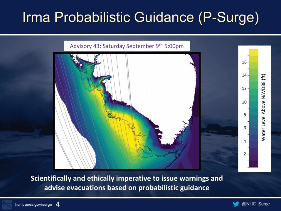
Irma Probabilistic Guidance (P-Surge)
Advisory 43: Saturday September 9th 5:00pm
Scientifically and ethically imperative to issue warnings and advise evacuations based on probabilistic guidance
16
14
6
4
2
10
8
12
Wat
er L
evel
Abo
ve N
AVD8
8 (ft
)
4

1. Improve the Probabilistic Ensemble• Replace SLOSH’s parametric wind model
• Incorporate wind structure information into P-Surge Ensemble
• Move from a Statistical to a Dynamical Ensemble
2. Provide Real-time Storm Surge Forecasts Sooner• Increase use of P-Surge from 48- to 72-hours before landfall
3. Extend Probabilistic Method to OCONUS• Support wave modeling in real-time probabilistic guidance for Puerto
Rico, Virgin Islands, and Hawaii
Outline: The Gaps and Priorities
5

Replace the Parametric Wind in SLOSH
• SLOSH uses a parametric wind field
• Relates Radius of Maximum Wind (RMW), Delta Pressure, and Intensity
• Only these parameters dictate the wind field structure
• Works well for classic symmetric hurricane structures
• Does not accurately capture surge for disorganized, asymmetric, and transitional storms
6
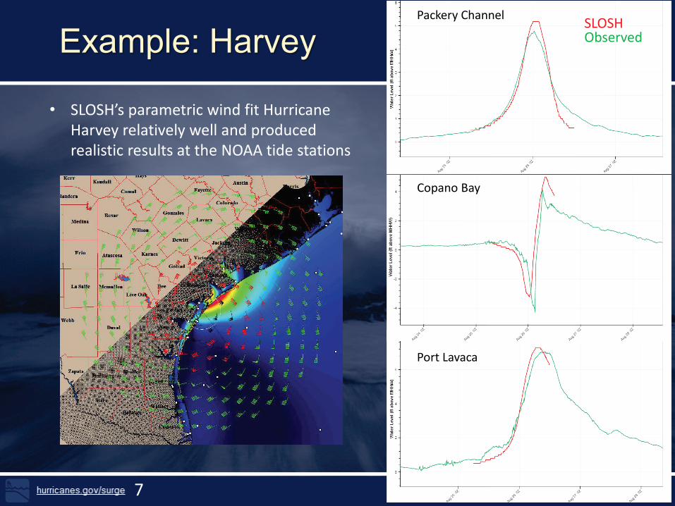
Example: Harvey
Port Lavaca
Copano Bay
• SLOSH’s parametric wind fit Hurricane Harvey relatively well and produced realistic results at the NOAA tide stations
Packery Channel SLOSHObserved
7
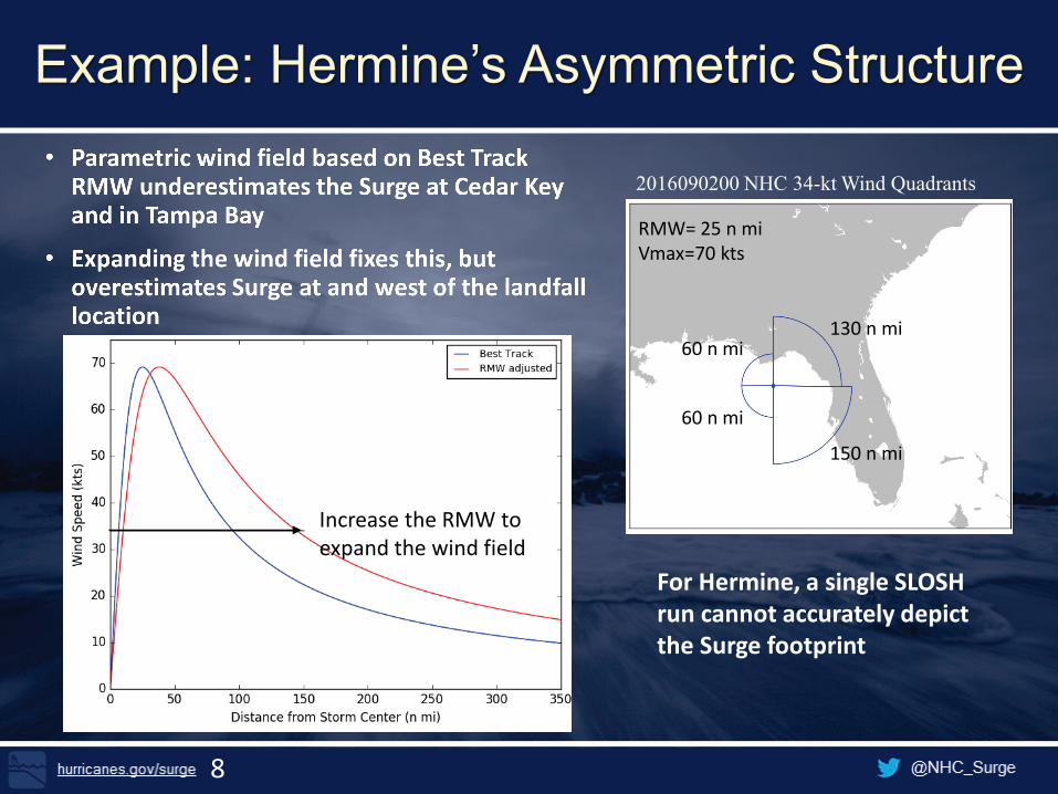
Example: Hermine’s Asymmetric Structure
150 n mi
130 n mi60 n mi
60 n mi
2016090200 NHC 34-kt Wind Quadrants
RMW= 25 n mi Vmax=70 kts
For Hermine, a single SLOSH run cannot accurately depict the Surge footprint
Increase the RMW to expand the wind field
8

Include Wind Structure in P-Surge Ensemble
• P-Surge does not include initial RMW from NHC Best Track • Uses the current pressure and intensity to calculate the RMW
(parametric wind)• led to large RMW initialization errors during Irma
• Also, P-Surge does not include NHC initial 34-, 50-, or 64-kt wind radii or their forecasts
200 n mi
360 n mi
240 n mi
150 n mi
2017091100 NHC 34-kt Wind Quadrants
RMW= 15 n mi Vmax=90 kts
9

Example: Irma’s Large Wind Field• P-Surge is unable to predict the Surge in
Charleston, SC due to the size of the wind field• Extra-Tropical Storm Surge model provides
better guidance
Observed Water Level
Advisory 44: Storm Surge Warning
USCG Station Charleston, SC
10

Statistical to Dynamical Ensemble
• As ensemble forecasts improve, they can provide more information on ideal cross track spread, intensity uncertainty, and wind field size relative to the event at hand
2017090812 P-Surge Tracks
11

Provide Real-time Surge Forecasts Sooner• At long lead times (>48hrs), the statistically
based P-Surge ensemble has large spread
• Including more wind structure information and moving to a dynamic ensemble can reduce the spread and make P-Surge useful at longer lead times
2017090812 P-Surge Tracks
12

Hurricane Maria SLOSH+SWAN: MEOWHurricane Maria SLOSH+SWAN: Single Track
Provide the Same Level of Service to OCONUS
• Waves can be a significant contributor to the total water level rise and cause substantial damage to property
• During Hurricane Maria, MEOWs were used to advise risk but are unable to run P-Surge
• Also ran single track SLOSH+SWAN run (computationally expensive) to advise emergency response post-storm
WNW, Cat4
13

2nd Gen (Parametric) Wave Model
• An efficient parametric wave model to couple with SLOSH (within P-Surge)
• Parametric models that reduce full solution space N(t,x,y,𝜎𝜎,𝜃𝜃), to e.g. M(t,x,y) (Schwab et al. 1984)
• Simplified physics, but significantly cheaper than SWAN or WW3
Path toward real-time probabilistic guidance for
OCONUS
14

1. Improve the Probabilistic Ensemble• Replace SLOSH’s parametric wind model
• Incorporate wind structure information into P-Surge Ensemble
• Move from a Statistical to a Dynamical Ensemble
2. Provide Real-time Storm Surge Forecasts Sooner• Increase use of P-Surge from 48- to 72-hours before landfall
3. Extend Probabilistic Method to OCONUS• Support wave modeling in real-time probabilistic guidance for Puerto
Rico, Virgin Islands, and Hawaii
Summary: The Gaps and Priorities
15