noaa product (integrated) validation system...
TRANSCRIPT

Noaa PROduct (integrated) Validation System (NPROVS)
Tony RealeNOAA-STAR
Bomin Sun, Mike Pettey, Frank TilleyIMSG
* Karen St. Germaine (NPOESS / IPO)
International A-TOVS Study Conference 16May 2008

http://www.orbit.nesdis.noaa.gov/smcd/spb/calibration/icvs/
Integrated Cal/Val System (Weng, Cao … Goldberg)

… procedures and strategies relevant to “evolving”GCOS Atmospheric Reference Observations Network

Environmental Data Graphic and Environmental Data Graphic and Evaluation System Evaluation System (EDGE)(EDGE)
NOAA Product Integrated Validation System (NPROVS) NOAA Product Integrated Validation System (NPROVS) …… streamlining the processing of data, calibration, and validationstreamlining the processing of data, calibration, and validation from satellites and ground stations.from satellites and ground stations.
UCARJPL
EastWest

NPROVS Provides Consistent Validation Across NOAA Product Landscape
Centralized Function– Routine Access of satellite (GOES, POES, COSMIC), ground truth (Raob, … GPS,
Dropsonde) and NWP observations• NWP 6-hr guess collocated to raob (… plan to append Analysis during wait time)• NWP 3-hr or 6-hr guess collocated to respective satellites
– “Consistent strategy” for collocating respective satellite and ground truth platforms• 6-hours; 200km• Single “closest” collocation• Accounts for respective platform spatial and temporal characteristics
– Screening / qc protocols per respective platform
– Display and analysis (EDGE…)

ATOVSO 1837Z 5 kmATOVST 1837Z 39 kmGOES(R) 2312Z 5 kmGOES(N18) 1820Z 52kmMIRS 1837Z 19 kmAIRS(R) 1853Z 17 kmAIRS(N18) (same)COSMIC(R) 0541Z (4/20) 105 kmCOSMIC(N18) 1547Z 235 km


Use of NPROVS to Evaluate Use of NPROVS to Evaluate RadiosondeRadiosonde Instrument Type PerformanceInstrument Type Performance
Global distribution of major radiosonde instrument types that are routinely collocated with multiple satellite data platforms contained in NPROVS
Significance:Significance: Knowledge of respective radiosonde instrument type performance will improve their utility in satellite sounding product validation, retrieval algorithm tuning, numerical weather prediction and the construction of long-term upper-air records for climate.
Vaisala RS80-57H
Sippican Mark IIAVaisala RS92/DigiCora I/II
Example of statistical tests which compare the measurement characteristics of different radiosonde instrument types.
Sippican Mark IIA & Vaisala RS80-57H: DIFFERENTSippican Mark IIA & Vaisala RS92/DigiCora I/II: DIFFERENTVaisala RS92/DigiCora I/II & Vaisala RS80-57H: SIMILAR
* also sites routinely launching different sondes …


Selective sampling at 70N (site 04220) 00Z (18Z to 04Z; upper) versus 12Z (10Z to 17Z; lower)

Analysis with Environmental Data Graphical
Evaluation (EDGE)
Profile DisplayHorizontal Imagery
Longer Term Statistics (vertical, trend …)
(visit SSSP Web site)

7418 (All)
6567 (AIRS + N18)
3409 (AIRS +N18 +QC)
1313 (Above +COSMIC)
362 (Above +/- 3hrs)

Raob - NWP
(solid) … 0,1 (dash) … 2,3,4, etc
• Agreement between Raob and NWP H20 vapor improves up to 40% using (0,1) reports
• Reale, Tilley Preliminary Report on Radiosonde Screening 9available on request)
Z(mb)

Inversion Depth(D) Exceeds2.5km


Other Issues
• NPROVS Based Papers– Radiosonde Instrument type performance for Temperature and Humidity (GRL)– COSMIC radio occultation sounding assessment (JGR)
• Temp, H20, tropopause, stratosphere …– Assessment of first guess approaches for satellite derived products (IJRS)
• Emerging NOAA Derived product Systems – MIRS / ATOVS merged products tuned with NPROVS– IASI Products (tuned with NPROVS)– NOAA vs EUMETSAT Product Comparison (April25-29)
• NWS Severe Storms Prediction Center request (preference) for polar satellite “cloudy” soundings to supplement radiosonde, NWP profiles, etc
– Case study August 19 2007… hurricane Erin re-develops over Oklahoma northward– regionally tuned local direct readout processing system (AAPP, IMAPP…)
• Historical TOVS collocation database on STAR Data Storage Facility– NPROVS sensor oriented collocation “database” (Phase-2)

First Guess RegressionUsing NPROVS NWP ATOVS Operation

NOAA / EUMETSAT MetOp Products Exchange (Eamonn McKernan, Tony Reale)
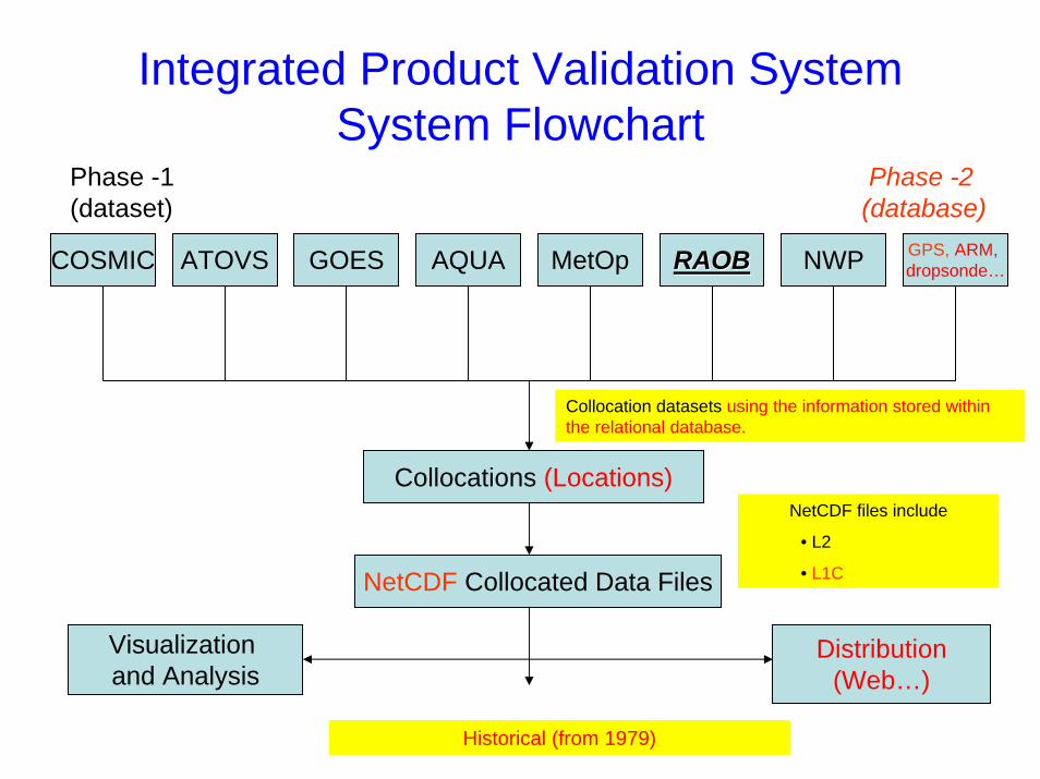
Integrated Product Validation System System Flowchart
COSMIC ATOVS GOES AQUA MetOp RAOBRAOB NWP GPS, ARM, dropsonde…
Collocation datasets using the information stored within the relational database.
Collocations (Locations)
NetCDF Collocated Data Files
Historical (from 1979)
Distribution(Web…)
Visualization and Analysis
NetCDF files include
• L2
• L1C
Phase -2(database)
Phase -1(dataset)

NOAA-10 1988 • Radiosondes at 0Z (dark red),0Z (dark red), 12Z (blue),12Z (blue), 6Z (green)6Z (green) and and 18Z (red) 18Z (red) and corresponding collocations with respective MSU and HIRS (lower curves)
• Over 300,000 radiosondes and 200,000 collocations with NOAA-10 HIRS and MSU for satellite year (1988)
•• ““Database on STAR Computer Facility contains over 50 satellite Database on STAR Computer Facility contains over 50 satellite years spanning NOAA 6 to 14 with over 10 million collocationsyears spanning NOAA 6 to 14 with over 10 million collocations””
• Planned expansions to append SSU, TOVS soundings, DMSP …
• Baseline for merging with Noaa PROducts (integrated) Validation System (NPROV) … Phase-2
• Resulting long term record (TOVS, ATOVS, MetOp … NPOESS) consistent with GEOSS goals
www.orbit.nesdis.noaa.gov/smcd/opdb/poes/TOVScollocation

Summary• NPROVS (Phase-1) provides centralized NOAA function for
validation of multiple satellite and ground data platforms– NOAA, Metop, GOES, COSMIC, AIRS, COSMIC, NWP, Raob…
• Data management, validation and analytical strategies presented (relevant to GCOS reference networks)
• NPROVS leveraging for NPP/NPOESS Level 2 QC …– Dataset archive (format) and longer term statistics
• Phase-2 expansion to sensor oriented “database” (existing TOVS Collocation database as baseline)
• SSSP web site access