noaa atlas 14 rainfall depths, nrcs rainfall distributions, and
TRANSCRIPT

NOAA Atlas 14 Rainfall Depths, NRCS Rainfall Distributions, and Dimensionless
Unit Hydrographs
AMANDA SMITH, P. E .
NRCS STATE HYDRAULIC ENGINEER

ObjectivesHistory
NOAA 14 Rainfall Depths
NRCS Rainfall Distributions
Dimensionless Unit Hydrographs
NRCS Hydrology Policy

HistoryU.S. Weather Bureau Technical Paper 40◦ Initial publication in 1961◦ Rainfall durations: 30 min to 24 hour◦ Rainfall frequency: 1 year to 100 year events◦ Universally used and widely accepted◦ Developed using available rainfall information from much fewer stations
than what exists today

History

History

NOAA Atlas 14There was concern within the state that TP-40 was not representative of the precipitation of today
Worked through a FHWA pooled fund project to coordinate with 11 other states to fund the regional study completed by NOAA
Within Minnesota the project was funded by:◦ MPCA◦ MnDOT◦ City State Aid
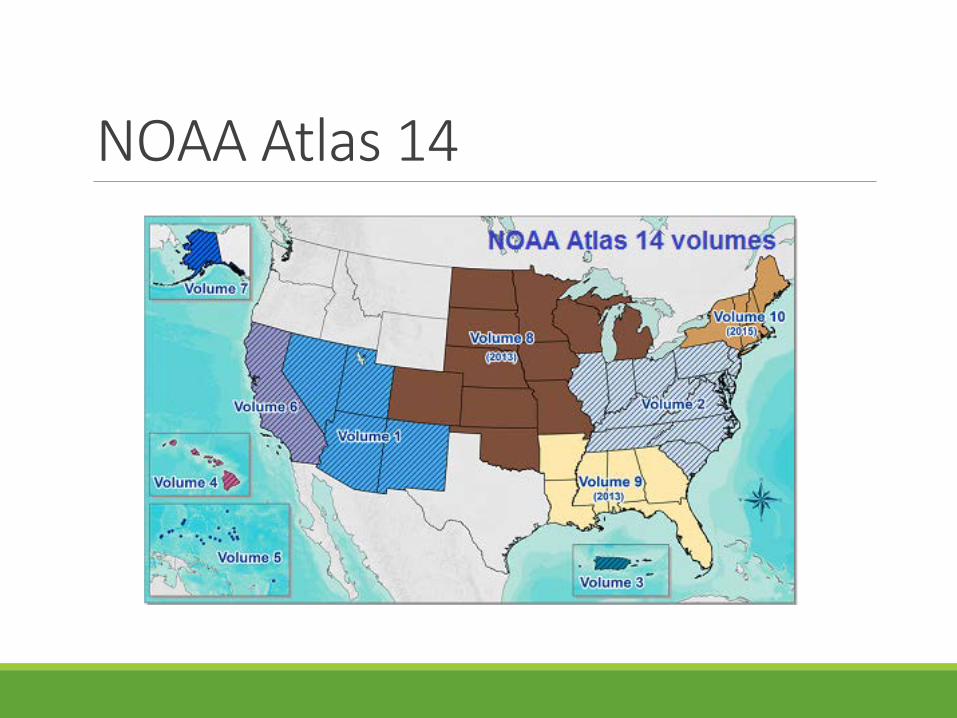
NOAA Atlas 14

NOAA Atlas 14Volume 8 of NOAA Atlas 14 Precipitation-Frequency Atlas of the United States was released in 2013
405 Data sets for MN were used in the analysis (vs. 140 in TP-40)
Average record length now over 50 years (more than double the record used in TP-40)
Rainfall durations: 5 min to 60 days
Rainfall frequency: 1 year to 1000 year events

TP-40 Daily Stations NOAA Atlas 14 Daily Stations


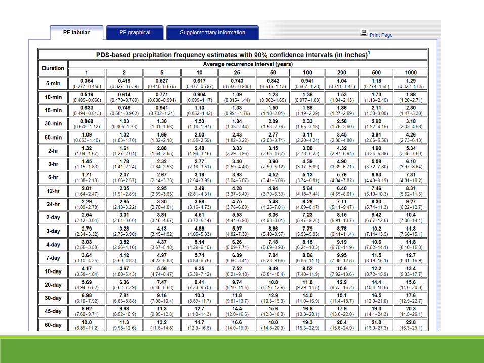

NOAA Atlas 14 Rainfall DepthsGIS was used to tabulate county wide average 24-hour rainfall depths by frequency for each county in MN
CountyRainfall
Type 1-year 2-year 5-year 10-year 25-year 50-year 100-yearAITKIN MSE 3 MN 2.30 2.67 3.32 3.90 4.76 5.48 6.25ANOKA MSE 3 MN 2.45 2.83 3.54 4.21 5.23 6.11 7.06BECKER MSE 3 MN 2.16 2.49 3.12 3.73 4.71 5.57 6.52BELTRAMI MSE 3 MN 2.12 2.46 3.09 3.66 4.54 5.28 6.09BENTON MSE 3 MN 2.32 2.69 3.35 3.93 4.81 5.53 6.30BIG STONE MSE 3 MN 2.19 2.54 3.14 3.68 4.48 5.13 5.82BLUE EARTH MSE 3 MN 2.51 2.92 3.68 4.38 5.47 6.40 7.41BROWN MSE 3 MN 2.39 2.75 3.42 4.05 5.01 5.84 6.74CARLTON MSE 3 MN 2.35 2.70 3.34 3.92 4.79 5.53 6.32CARVER MSE 3 MN 2.47 2.84 3.54 4.20 5.26 6.17 7.18CASS MSE 3 MN 2.23 2.59 3.25 3.84 4.72 5.46 6.24CHIPPEWA MSE 3 MN 2.31 2.65 3.27 3.88 4.83 5.65 6.56CHISAGO MSE 3 MN 2.42 2.80 3.49 4.11 5.03 5.80 6.63CLAY MSE 3 MN 2.10 2.47 3.14 3.77 4.75 5.58 6.49CLEARWATER MSE 3 MN 2.12 2.45 3.08 3.70 4.69 5.56 6.53COOK MSE 3 MN 2.09 2.42 3.01 3.52 4.28 4.91 5.57COTTONWOOD MSE 3 MN 2.41 2.80 3.51 4.18 5.21 6.09 7.04CROW WING MSE 3 MN 2.29 2.64 3.28 3.86 4.73 5.47 6.25DAKOTA MSE 3 MN 2.46 2.80 3.49 4.17 5.29 6.29 7.41

NOAA Atlas 14 Rainfall DepthsSome surprises with large changes over short distances:◦ Difference in 100-yr, 24-hr rainfall depths:
◦ Minneapolis, MN to St. Cloud, MN : 7.9” to 6.1” = 1.8” difference◦ Duluth Airport to Duluth Harbor: 6.65” to 6.0” = 0.65” difference

TP-40 vs. NOAA Atlas 14 Rainfall DepthsSome rainfall depths increased, some did not change, and some decreased. Depends on:◦ Frequency◦ Duration◦ Location

TP-40 vs. NOAA Atlas14 Rainfall DepthsNOAA 1410-year/24 hour◦ Itasca County: 3.79”◦ Pine County: 4.06”◦ Isanti County: 4.13”
100-year/24 hour◦ Itasca County: 6.05”◦ Pine County: 6.49”◦ Isanti County: 6.68”
TP-4010-year/24 hour◦ Itasca County: 3.67”◦ Pine County: 3.95”◦ Isanti County: 4.05”
100-year/24 hour◦ Itasca County: 5.25”◦ Pine County: 5.5”◦ Isanti County: 5.75”

TP-40 vs. NOAA Atlas 14 Rainfall Depths
TP-40 100 YR, 24 HR NOAA 14 100 YR, 24 HR

What is a Rainfall Distribution?Rainfall distributions are synthetic arrangements of a total rainfall amount over time such that it includes maximum rainfall duration intensities for the selected design frequency that is critical for producing peak runoff.

NOAA vs. NRCS Rainfall DistributionsNOAA Rainfall Distributions – Statistical Analysis of Individual Storms, Huff Distributions, etc.
NRCS Rainfall Distributions – Used for designs. Example: A 10-yr, 24 hrrainfall design storm needs to contain:◦ 10-yr – 5 min intensity◦ 10-yr – 30 min intensity◦ 10-yr – 1 hr intensity◦ 10-yr – 2 hr intensity◦ Etc.◦ Etc.◦ 10-yr – 24 hr intensity

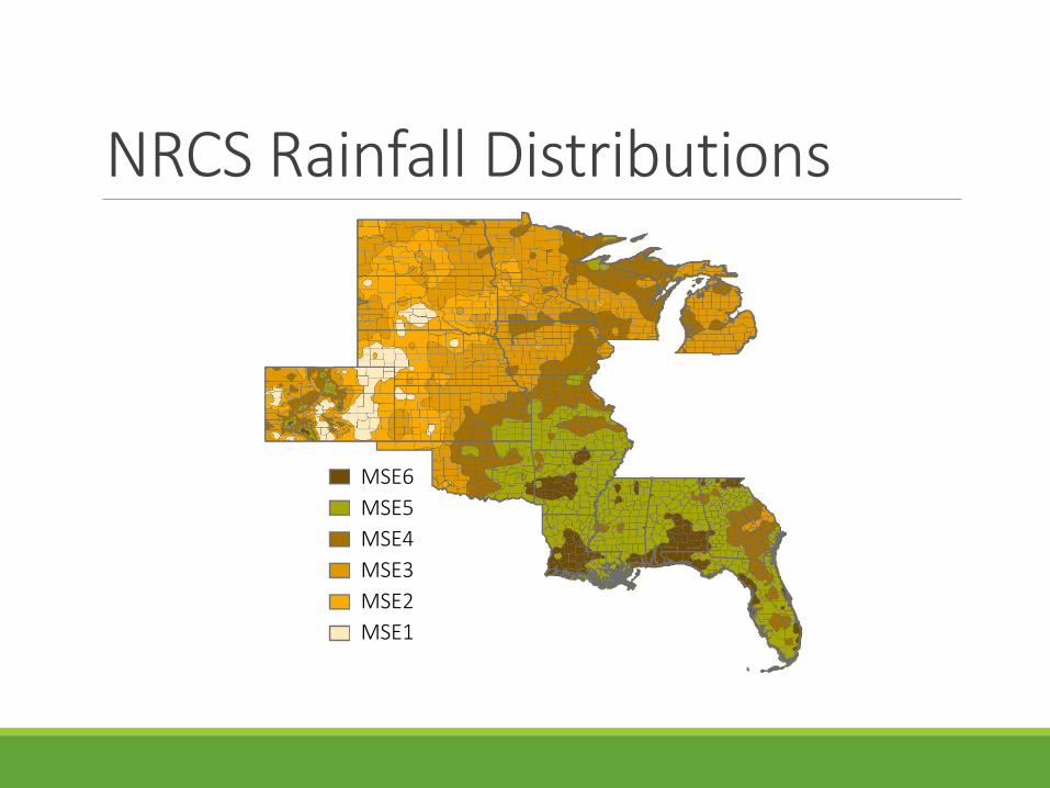
NRCS Rainfall DistributionsThe NRCS Water Quality and Quantity Team developed temporal storm distribution regions for the Midwest and Southeast US (NOAA Atlas 14 volumes 7 and 8)
Distributions were based on ratios of the NOAA Atlas 14 (25-yr, 1-hr)/(25-yr, 24-hr) precipitation depths
Since these were developed for the Midwest and Southeast US, the distribution regions were titled MSE (MSE 1 through MSE 6)
NRCS Rainfall Distributions
MSE6MSE5MSE4MSE3MSE2MSE1

NRCS Rainfall Distributions

NRCS Rainfall Distributions
Minnesota NRCS will use MSE 3 for the entire state

4 hours
70%
of t
he st
orm
rain
fall

Dimensionless Unit HydrographWhat is a Dimensionless Unit Hydrograph?
From NEH, Part 630, Chapter 16 - a dimensionless unit hydrograph is a hydrograph developed to represent several unit hydrographs; plotted using the ratio of the basic units time to peak and peak rate.
What is a Unit Hydrograph?
Discharge hydrograph resulting from 1 inch of direct runoff distributed uniformly over the watershed resulting from a rainfall of a specified duration.
SCS Dimensionless Unit HydrographWhat is SCS Dimensionless Unit Hydrograph?
Derived from many natural unit hydrographs from watershed varying widely in size and geographical locations.

Peak Rate FactorWhat is Peak Rate Factor?
Essentially controls the volume of water on the rising and recession limbs of a dimensionless unit hydrograph.
The higher the peak rate factor the higher the peak discharge will be from the watershed.
The standard SCS dimensionless unit hydrograph has a peak rate factor of 484.
According to NEH 4, Part 630, Chapter 16, peak rate factors can range from below 100 to more than 600.

Tr = time from the peak to the end of the triangular hydrographTp = time from the beginning of the triangular hydrograph to its peakTc = time of concentrationqp = peak discharge

Peak Rate Factor = 100 Peak Rate Factor = 600

MN NRCS Hydrology PolicyUse NOAA Atlas 14 Rainfall Depths.
Use NRCS Rainfall Distribution MSE 3 for the entire state.
Use a dimensionless unit hydrograph with a peak rate factor of 400.

MN NRCS Hydrology PolicyMN NRCS Homepage – Topics – Technical Resources – Engineering –Engineering Resources – Engineering Field Handbook (EFH) Minnesota Supplements – Chapter 2http://www.nrcs.usda.gov/wps/portal/nrcs/detail/mn/technical/engineering/?cid=nrcs142p2_023722
Google: MN NRCS EFH

How will this impact design?GRASSED WATERWAY
Cass County
Background:
244 Acre Watershed, RCN = 72, Watershed Slope = 2.4%, Watershed Length = 5600’
Design:
Initial Design Rainfall (10 yr-24 hr) = 3.73” (TP-40 – Type II)Peak Q = 83 cfs
Revised Design Rainfall = 3.84” (NOAA 14 – MSE 3 MN)Peak Q = 83 cfs

How will this impact design?
GRADE STABILIZATION STRUCTURE
Benton County
Background:264 Acre Watershed, RCN = 68, Watershed Slope = 2.8%, Watershed Length = 5900’
Design:Initial Design Rainfall (50 yr-24 hr) = 5.13” (TP-40 – Type II)Peak Q = 139.5 cfs
Revised Design Rainfall = 5.53” (NOAA 14 – MSE 3 MN)Peak Q = 151 cfs

Questions??

Amanda Smith
(651) 602-7884
An Equal Opportunity Provider and Employer