no. h. february atoll research bulletin
TRANSCRIPT

No. 86 HARLES H. LAMOOREW February 28, 1965 BOTANY DEPT.
UNlVERSllY OF HAWAII HONOLULU 14. HAWAII
ATOLL RESEARCH BULLETIN
Geography and land ecology of CZ;Pperton Idand
by
~arie-H6l;ne Sachet
Issued by
THE PACIFIC SCIENCE BOARD
National Academy of Sciences-National Research Council
Washington, D.C., U.S.A.
ATOU RESEARCH lNlUXTN
---..-------------
NO. 86
Geography and land ecology of Clipperton Island
by
Marie -&'lbne Sachet
Issued by
PACITE EClENCE BOARD
National Academcy of Sciences-4?a'tlonal Research Council
Washington, D. C.
February 28, 1962
It is a pleasure to conmend the far-sighted policy of the Of'fice of Naval Research, with i t s emphasis on basic research, as a r e s u l t of which a grant has made possible the continuation of the Coral A t o l l Program of the Pacific Science Board.
It is of in te res t t o note, historically, t h a t much of the f'unda- m n t a l Infomaation on a t o l l s of the Pacific was gathered by the U. S. Navy's South Pacific Exploring Ekpedition, over one hundred years ago, under the cormnand of Captain Charles kfillres. The continuing nature of such sc ien t i f ic in te res t by the Navy is shotm by the support f o r the Pacific Science Board ' s research programs during the past fourteen years.
m e preparation and issuance of the Atoll Research Bulletin i s assis ted by f b d s from Contract N70nr-2300(12).
The sole responsibil i ty for a l l statements made by authors of papers in the Atoll Research Bulletin r e s t s with them, and they do not necessarily represent the views of the Pacific Science Board o r of the edi tors of the Bulletin.
Edi tor ial Staff
F. R, Fosberg, edi tor M. -H. Sachet, ass i s tan t ed i tor
Correspondence concerning the Atoll Research Bulletin should be addressed t o the above
Pacific Vegetation -Project $ Natioml Research Council
2101 Constitution Avenue, N. W. Washington 25, D. C., U.S.A.

CONTENTS
. . . . . . . . . . . . . . . . . . . . INTRODUCTION 03
Geographic location. general description . . . . . . . 3
. . . . . . . . . . . . . . . . . . i s to r i ca l sketch 4
W E A T H E R A N D C m T E . . e . e e e . . e e e e e e e . 9
. . . . . . . . . . . . . . . . . . . . . Temperatme 9
. . . . . . . . . . . . . . . . Atm~pheric press- 10
. . . . . . . . . . . . . . . . . . . . . . . Winds 810
. . . . . . . . . . . Tropical storms and hurricanes 12
. . . . . . . . . . . . . . . . . . . . . . Rainfall 20
. . . . . . . . . . . . . . . . Aixmspheric humidity 24
. . . . . . . . . . . . . Cloudiness and v i s i b i l i t y 024
HYDROGRAPRY . . . . . . . . . . . . . . . . . . . . . 25 Surfacecurrents . . . . . . . . . . . . . . . . . . 25
. . . . . . . . . . . . . . . . . . . . . . . . 26
. . . . . . . . . . . . . . . . . . . . . . . . Tides 27
. . . . . . . . . . . . . . . . . ocean temperatures 28
SUBMARINETOPOGRAPHY . e * * * . e e e e e . e . . e 2 9
. . . . . . . . . . . . Ocean floor. Clipperton Ridge 29
. . . . . . . . . . . . . . . . . . . . Ocean bottom 29
. . . . . . . . . . . . . . . . . . Undersea mountain 30
. . . . . . . . . . . . . . Upper slopes and terraces 31
. . . . . . . . . . . . . . . . . Interpretation 32
Reef . . . . . . . . . . . . . . . . . . . . . . . . 3 2
. . . . . . . . . . . SURFACE F E A W S OF LAND STRIP 35
. . . . . . . . . . . . . . . . . . . . Owter shore -35
Beaches . . . . . . . . . . . . . . . . . . . . 35
Beach Rock . . . . . . . . . . . . . . . . . . . 36

m d . . . . . . . . . . . . . . . . . . . . . . . . 38 Beach ridges . . . . . . . . . . . . . . . . . . 38
. . . . . . . . . . . . . . . . . . Land surface 39
Unconsolidated material . . . . . . . . . . 39
The ledges . . . . . . . . . . . . . . . . 39
Exposed pavements . . . . . . . . . . . . . 40
Lagoon shores . . . . . . . . . . . . . . . . . . . . 41
Lagoon c l i f f s . . . . . . . . . . . . . . . . . 41
Other lagoon shore types . . . . . . . . . . . . 41
ClippertonRock . . . . . . . . . . . . . . . . . . . 42
.Analysis of Clipperton lagoon water . . . . . . 46
Lagoon level . . . . . . . . . . . . . . . . . . 47
. . . . . . . Lagoon.depth and nature of bottom 48
Lagoon reefs and i s l e t s 49
LITHOLOGY... . . . . . . . . . . . . . . . . m 0 . 5 1
Loose sediments . . . . . . . . . . . . . . . . . . . . 51
Boulder and cobble gravel . . . . . . . . . . . 52
Fine gravels. sands. silts. and mixtures of these . . . . . . . . . . . . . . 53
Beach conglomerates . . . . . . . . . . . . . . 58
Phosphatic conglomerates . . . ~ . ~ ~ . ~ . . -58
Pumice and other extraneous materials . . . . . . . .65
Analyses of Clipperton Island samples . . . . 66 . .
iii
PHYSIOGFUPHIC CHANGES. . . . . . . . . . . . . . . 69
Geological change . . . . . . . . . . . . . . 63 Historic jl. change due to natural causes . . . 69 Recent changes due to man . . . . . . . . . . 72
GENERALLAUDIEOLOGY . . . . . . . . . . . . . . . 75 ET8bikL-t . . . . . . . . . . . . . . . . . . . . . * 75 ~azld iota . . . . . . . . . . . . . . . . . . . . 76
p u t l i f e . . . . . . . . . . . . . . . . . . 76 Vegetation of the lagoon . . . . . . . . 79
Animal life . . . . . . . . . . . . . . . . . 79 Marrrm&ls . . . . . . . . . . . . . . . . . 79 BWLS . . . . . . . . . . . . . . . . . . 80 Reptiles . . . . . . . . . . . . . . . . 84 Invertebra-tes . . . . . . . . . . . . . . 84
. . . . . . . . . . . . . . . . Ecological history 86
CATALOGUE OF LAND AND LAGOON PLANTS AND ANIMALS . . 89 Plants . . . . . . . . . . . . . . . . . . . . . . 89
. . . . . . . . . . . . . . . . . . . . . . A n W s 94
BIBLIOGRELW . . . . . . . . . . . . . . . . . . . 103

PREFACE
During the Ii l ternational Geophysical Year, Scripps In s t i t u t i on of' Oceanogaphy, a branch of the University of California, organized several research cruises i n the Pacific, a s pa r t of the world-wide propaiii, Several previous cruises had cal led a t t en t ion t o Clipperton Island, and during the Doldrums Expedition of the surntner of' 1958 it was decided t o study the biogeography of t h i s l i t t l e - lmo~m island. A Zroup of 1 3 per- sons were l e f t on the i s land by the Research Vessel Spencer F. Baird on August 7, 1958 and were taken aboard aaain on August 26, excFpt fo r four who remained u n t i l September 25 t o cont ime t h e i r s tudies of sharks. I had the grea t zood f o r b e t o be one of the group and t o study plant l i f e on the is land. In addit ion I made observations on the land fauna and seology, and some col lect ions of animals, s o i l s and rocks.
It w i l l not be easy t o thank adequately the uany persons who have contributed t o the success of my work on C~ipper ton. In the f i r s t place of course I 17a11t t o express my grat i tude f o r t h i s unique opportunity t o Scripps In s t i t u t i on of Oceanog-aphy and t o i t s Director, D r . Roger Revelle. I owe xuch a l s o t o D r . Carl Hubbs, f r o i whom the inv i ta t ion rms received, t o I@. John A. Knauss, leader of tlle Doldr~li~~s 3:yedition, t o the l a t e Conrad Limbau~h, chief of the Clipperton f i e l d party, t o a l l my companions i n the f i e l d and t o the Master and crew of the Baird. Our v i s i t could not have taken place vi thout the authorization of the French Goverrxent, and without the intervention of D r . Jean Delacour, then Director of the Los Angeles County N~~se~lm and Professor Roger Heim, Director of the Ivluse/unl National d Histoire Naturelle i n Par is , rho helped procure t h i s author- izat ion. The French Embassy and the Office of the Naval ~ t t a c h g i n Vasn- ington vere a l s o very helpful ,
For penil i t t ins me t o join the expedition and. encouraging ~ile t o work up the material , I wish t o thank my superiors i n the U. S. Geological Survey and i n the Pacif ic Science Board, fiJationa1 Academy of Sciences-- National Research Council. The Acadeioy a l so provided very welcoule help i n the fom of a grant froii! tlle Joseph Hznry Fund. I cannot nac!e here a l l t he persons who have contributed iden t i f i ca t ions , analyses, and suz- zestions and .to whom I am deeply grateful . They w i l l be mentioned i n t he course of the paper. In assembling biblioeraphic mater ia l and photographs I have benefited from the f a c i l i t i e s of many individuals and several or- ganizations: the U. S. Navy's Naval History Division, Hydrographic Office and Office of Naval Research, the Service Historique de l a Nariile Na- t iona le of France, the U. S. Weather Bureau, the U. S. National IG~seur,, the U. S. National Archives, the Library 02 Congress, t he California Acaderkv of Sciences, and the ~ i b l i o t h & u e Nationale of France.
Miss Evelyn L. P r u i t t , Head. of the Geography Bra~ch , Office of Naval Research, gave me much help i3 searching f o r photographs and d.oc~ments i n the U. S. Navy f i l e s . Nessrs. E. C. Allison, Ted. Arnow, Willard Bs- corn, A. I. Coopeman, A. S, Hambly, Lester F. Hubert, W. L. Klatre, Job1 Knauss, H. S. Lad.d, Conrad Limbaugh, W. E. Nalone, H. 2. Naude, C. S. Rali~age, Waldo S c h d t t and R. E. Snodgrass gave me unpublished information, l e n t me photographs and documents, o r read and c r i t i c i z e d pa r t s or a l l of the urnnuscript. M r . V. A. Rossi gave me advice and help ~ i i t h the il- l u ~ t r a t i o n s , alld. D r . Gilbert, Corwin examined the samples of volcaric rocks.

I wish to make s p e c i d mention of M r . Obermiiller, ~e'olo~ue en Chef de l a France dfOutre-Mer, who worked on Clipperton a few mnths before I went there and gave me copies of h i s reports even before t h e i r publi- cation, as w e l l as samples of h i s rock collections.
Finally I wish to express my appreciation and gratitude to Dr. F. R. Fosberg who helped and encouraged me i n every s tep of t h i s work.
The appearance of t h i s paper has been delayed by various circumstances, as has tha t of a more extensive and profusely i l lu s t r a t ed memoir on Clip- perton (sachet, i n press).


Geographic location, general description
Clipperton Island ( ~ i g . l ) , one of the few oceanic islands i n the Faatern Pacific, excites the in te res t and curiosi ty of na tura l i s t s especia3ly because it is the only coral island in t h a t par t of the ocean The nearest a to l l , Arkapuka i n the Eastern Tumotus, l i e s 2300 nautical miles t o the southwest.
Here are some other figures that w i l l give an idea of the isolat ion of Clipperton, the coordinates of which are 10ol8'N and 10g013'W (adjusted position for Astro 1957, a monument placed by the U. S. Hydrographic Office on the northeast side: 1 0 ~ 1 8 ~ 41"N, 109Ol2' 3 4 " ~ ) . The nearest land is the Mexican west coast, 600 nautical miles t o the north-north-east. The nearest islands ta the north are the ReviUagigedo Islands of which Soccoro is 530 miles from Clipperton. The Galapagos l i e 1300 miles t o the southeast and Easter Island 2250 miles due south.
In i ts general form, Clipperton is a low closed r ing of coral lime- stone, but the island does not exactly qualify as an a t o l l as a small volcanic rock r i s e s a t the end of a short peninsula i n the lagoon. This t y p of island has been cal led an " a l ~ ~ ~ s t - a t o l l , " but t h i s category is not very natural and formstions have been placed in it which may have n o w i n conanon beyond the fact that they include both coral and volcan- i c features. For the purposes of t h i s description it seems prac t ica l to consider the island as an a to l l , the only one in the eastern t h i r d of the Pacific Ocean. In area, Clipperton Rock is very m, cornpazed t o the coral ring, and observations so far seem to Fndicate tha t it has l i t t l e influence on the ecology of the FsZaad. No m~lcroscopic plants grow on the Rock, except for some lichens.
The coral r ing is somewhat egg-shaped and synnnetrical along a northwest-southeast axis. This axis falls a l i t t l e north of the Rock, which i s close t o the southeast coast of the island. The r ing is con- tinuous and encloses a brackish lagoon. Only a small minority of a t o l l s are closed and few of these have a r i m as narrow a s Clipperton 's, around such a compazatively large lagoon. The g r e a k s t dimension of the atoll, along the NW-SE axis is 4 km and the circumference of the a t o l l r ing about 12 km. The emerged Land s t r i p is widest along the northwest c w t , w i t h a maximum width of about 400 m i n the west corner. The average width i s under 200 m, and in narrow places it is much less. In August 1958 the northern part of the northeast coast measured only 45 m from lagoon ta ocean. That area of the land was also the lowest, r i s ing only 0.65 m above estimated mean high t ide level. Generally the ground slopes up fm the ocean to the tops of the beaches o r boulder ridges, and gently down again toward the lagoon so that the highest point of any given ocean- lagoon section is the c res t of the outer beach o r boulder ridge. This cres t varies in al t i tude, reaching a maximm of about 4 p. The volcanic Clippertan Rock listed on charts a s 29 m high, i s v is ib le from every of the atoll. From a small boat i n the lagoon the land rim is vis ib le all m d , but appears very low. In fact one has the impreseion of floating

i n an immense saucer f u l l of water and with a very low rim. Oceaaward, the land rim is surrounded by a r ee f - f l a t lying a t about low t ide level. On the ocean side, the outline of the atoll i s pract ical ly featureless and smooth. The lagoon shores m e more irregular, with several small peninsulas aad bays. Half way along the northeast side the small tri- angular Green Point ( ~ o i n t e Verte) ju ts into the lagoon (see map). On the southeast side, Clipperton Rock cl ocher clipperton) r i s e s a t the end of a small peninsula, the Isthmus ( Isthme); Thumb Point ( ~ o i n t e du Pouce ) extends northward from the Isthmus, separated from the Rock by Thumb Cove ( ~ n s e du Pouce). Between the Isthmus and the landstrip, the lagoon forms an arm cal led Rock Bay ( ~ a i e du p ocher). Jus t west of the Rock, another peninsula, The Hook (Le Crochet), s t re tches northwestward into the lagoon.
The abandoned quonset vi l lage and the large coconut grove on the southwest 8-ide of the a t o l l are located along a small bay, Pincer Bay ( h i e de l a Pince) formed by two peninsulas, North and South Pincers ( ~ i n c e Nord and Pince ~ u d ) . Other recognizable features are the 5 Egg Islands (1les ~ g g ) along the northwest side, and the U. S. Hydrographic monument ( ~ s t r o 1957) and small group of coconut palms marking Naturalists1 Camp (CW des Naturalistes) nem the East corner of the island.
Historical sketch*
Clipperton Island is named a f t e r an English buccaneer, John Clip- perton, who i s reported t o have seen it i n 1705. Clipperton, who was travel l ing with the famous privateer and na tu ra l i s t William Dampier, deserted and s to l e a Spanish pr ize bark in which he crossed the Pacific, a remarkable feat . There is no account of t h i s voyage during which the island is supposed t o have received i ts name (Barney 1816), and i n the description of Clipperton ' s second voyage (Beta& 1728) of the e a r l i e r discovery, but the name was indicated on o r 1735 (Moll).
Various authors (Toni010 1919, Mexico L i g l q ) have Spanish navigators may have seen the is land ear l ie r , i n centuries, o r even t h a t Magellan m y have discovered it 1934). The island would then be ident ical with ~e&os
no mention is made maps about 1730
suggested tha t the 16th o r 17th i n 1 5 U ( ~ u n n and San Pablo
(Magellan). Historically, such considerations are of great i n t e re s t but as far as our sc i en t i f i c knowledge of the is land is concerned they are immaterial, as it is quite unlikely t h a t ancient descriptions w i l l come t o l ight .
Our knowledge of the island, and the extensive l i t e r a t u r e concerning it, then begin i n 1711. On April 3, Good Friday, two small French vessels, the Princesse and the Mcouverte, who had lef% Brest together i n 1708? met with an unknown island which was named I l e de l a Passion. The Captain of the Scouverte, Michel du kcage, and a passenger i n the Princesse, Mr. de Frudhomme described the new island, the one i n h i s log and the other
* For a more detai led treatment see Sachet 1960.

in h i s diary. Their discovery was first raentioned i n p r i n t in 1725 (Ia W b i n a i s Le ~ e n t i l ) , while the i r accounts were published in extenso i n a French report (France 1912). The original documents are kept i n the French Nationd Archives.
M r . du Bocage described Clipperton a s "A large Rock, cragged and jagged, a t the south point of a very f l a t island.. . I 1 The northeast side, "sandy with sow brush and a dried-up t ree on the north-east point, was but a very narrow tongue of land. The center of the island was a large lake reaching from one side t o the other. The west side appeared t o have some low brush with s o i l and some rock but very low, although a l i t t l e higher than the eas t side." M r . de Prudhomme also described the very low sandy island, without any trace of inhabitants, unwooded e x c e ~ t fo r some very low bushes, and with some dead t rees on the sea shore "as i f they had been thrown up by the currents."
!These brief accounts are remarkable i n tha t they describe Clipperton much as it appears today f'rom aboard ship, except f o r the recently added coconut t rees and various t races of human act ivi ty.
There can be no doubt tha t I l e de l a Passion i s the island now called Clipperton. The coordinates given i n 1 7 l l were:
Du Bocage 10028 'N, 263050 (ll3g3W ~reenwich) De Prudhomme 10018-19 'N, 268011' (10G 2 7 ' ~ )
(From the latest obsemtions , the coordinates are 10~18 'N, 1C)3*13 ' W) . Over a hundred years l a t e r (1832), an American sea-captain, Morrell,
described the is.l.md as he saw it i n August 1825: "It is low a l l around near the water, but a high rock r i ses in the centre, which mzy be seen a t the distance of six leagues.. ." A s far as lmo-vn, Morrell and h i s men were the f i r s t t o land on Clipperton.
Except for a small sketch map, poorly oriented, which M r . de Prudhomme mentions and which is kept with h i s diary and rqroduced i n the French re- port (1919), Clipperton Island was first mapped by S i r Edward Belcher and the map published by the Bri t ish Admiralty i n 1849. In May 1839, when Belcher v i s i t ed it, the island was ( ~ e l c h e r 1843): "a very dangerous low lagoon island, des t i tu te of trees, with a high rock on i ts southern edge, which may be mistaken for a sail . . , L%e b e l t of l a n g l i t e r a l l y consti- tu tes two islands, formed by i t s two openings . . . " (see fig.4, facing p. 69).
A fev years l a t e r , a, French ship owner, M r . Lockhart, arranged t o take possession of the unclaimed island fo r France and t o exploit i ts phosphate deposits. Thus it came about tha t i n 1858, one of Mr. Lock- ha r t 's mrchant vessels, 1 - 'Amiral, Captain Detaille, Master, arrived a t Clipperton. Lt. Victor Le Coat de Kerveguen, who had received a special commission for the purpose, took possession of the is-land fo r the Second 'Empire on November 17, 1858. The h i r a l -- then proceeded to Honolulu whera the necessary papers were f i l e d to amounce t o the world tha t the island was now a French possession. Le Coat de Kerveguen took notes on what was observed on Clipperton and h i s manuscripts, sketches and maps are w o d u c e d

i n the French report (1912). In 1858 the coral rim was closed, the lagoon salty, there was no vegetation, but great numbers of sea birds. Some s o i l samples were collected, but exploitation of the phosphate deposits did not seem worth while and was not then undertaken.
In August 1861 (Pease 1868) a young American, L t . Griswold, who l a t e r l o s t h i s l i f e a t Antietam, v i s i t ed Clipperton Island and found it uninhabited, covered with birds but devoid of vegetation. The lagoon w a s closed, i t s water fresh and f u l l of a water plant which he collected. This f i r s t botanical specimen from Clipperton was sent t o the California Academy of Sciences in San Francisco and l o s t i n the 1906 f i r e .
Jus t who discovered phosphate deposits on Clipperton Island i s obscure. They were known to b c l i i a r t i n 1857, and Griswola was on a phosphate explor ation t r i p . In 1892 Frederic W. Permien made several t r i p s t o Clipperton to survey the deposits and i n 1893 the Oceanic Phosphate Company of San Francisco sent two men, Jensen and H a l l , t o survey the island and begin exploitation (Anon. 1893). The observations of Jensen, and h i s excellent sketch-nap are reproduced by Agassiz (1894, pp. 174-175). Jensen had collected a piece of the volcanic rock, which was ident if ied as a trachyte. A t the same time, A. Churchill Fisher made observations on tides (u. S. National Archives). W. C. Ma t t , of the Schooner Anna - of San Francisco, surveyed the phosphatic deposits probably i n 1897, and h i s map is available i n the Archives. Also i n 1897, P. J. Hennig ( ~ n o n 1897) prepared a map, which he forwarded t o the U. S. Hydrographic Office. It was promptly published as an H. 0. Charrt (no. 1680), replacing the charts based on Bel- cher's sketch, and remaining in use by a l l navigators u n t i l the French survey of 1935.
Exploitation of the Clipperton phosphate proved d i f f i cu l t and not very profitable, and several companies were t o attempt it one a f t e r the other before the island was abandoned during World IIas I. When the French war ship Duguay-Trouin arrived a t Clipperton i n Nov. 1897, a small c a p was discovered w i t h t h e e employees of the Oceanic Phosphate Co., who hoist- ed the U. S. flag. France protested, the United States announced t h a t they had no claim on the island and Mexico joined the excitement. The Dump Trouin was W d l y out of s ight when a Mexican gunboat, the arrived (Dec. 13, 1897). Here s ta r ted a diplomatic confl ict which was t o l a s t u n t i l 1931, when King Victor-Emmanuel I11 of I t a l y awarded the island -to France, and which has become a text-book case for students of diplomacy and International Law. France and Mexico had agreed to submit the case to the monarch's a rb i t ra t ion i n 1909, and both countries publish- ed h is tor ica l reports ( ~ e x i c o Llglll , France 1912) t o present t h e i r cases. They are valuable documents, the French one especially, as it includes all the texts describing the island to date, som of them unpublished u n t i l then.
During t h i s period, Mexico continued to lease the phosphate deposits of the island to various companies including the Pacific Islands Company Ltd. of John Arundel. Also during that time, several na tura l i s t s v i s i t ed the island and made geological and zoological collections, among them John Arundel in 1897 (t~harton 1898, Gamm 1899), Snodpass and Heller i n 1898, R. H. Beck in 1901 ( ~ e c k 1907), and the California Academy of
Sciences expedition i n 1905 levi in 1931). Casual v i s i t o r s added specimens, especially shells, t o the collections of Clipperton a n i d b . For instance a group of she l l s i n the U. S. National Museum was received in 1897 from Mr. Arnheim, a ship chandler who had obtained them from sai lors .
In 1906 a l i g h t was b u i l t on top of the Rock, but during World War I, the island wasabandoned i n a dramatic chapter of i ts history, and was forgotten. mere are quite a few accounts of it for the period 1893-1.906, but hardly any information between 1917 and 1935. According to a l e t t e r i n the U. S. National Archives, several men from the Schooner Ethel M. S t e r l i n ~ f r o m San Pedro landed on Clipperton on January 5, 1929, a f t e r sever& days of bad weather kept them on board ship off the island, and they collected samples of guano and lagoon water. The research vessel Velero I11 (Fraser 1943) stopped at Clipperton on January 6, 1934, but landing was impossible, although some biological specimens were dredged a short distance off shore. In January 1935, the F'rench t raining ship Jeanne dlArc a f t e r several visits when-landing was impossible, c& ba.clr t o Clipperton, and a group of off icers and midshipmen succeeded i n making a landing on January 26. They drew a map, wrote descriptions of the is- land, and collected some plant and rock samples ( ~ a c r o i x 1939, Gauthier 1949). The ship 's seaplane took some photopaphs. A bronze plaque sealed on the eas t face of the Rock commemorated the v i s i t and established French ownership.
The next well-laown v i s i t was tha t of President F. D. Roosevelt in July 1938, during a cruise on the USS Houston. Dr. Waldo Schmitt of the U. S. National Museum, who had been invited t o t r ave l with the President as expedition naturalist,landed on Clipperton for a few hours and made some very valuable collections of plants and animaLs which were described i n a ser ies of papers ( Wthsonian MW. Coll., 1939-1942).
During the second World War, Clipperton is said t o have been v is i ted by Japanese submarines; i n 1943 and 1944, the U. S. Navy made several reconnaissances of the island and the famous Australian p i l o t Captain S i r P. G. Taylor landed h i s seaplane i n the lagoon. Such visits resulted i n valuable descriptions (Byrd 1943, Taylor 1948) and photographs. In Dec. 1944, a small U. S. Weather Station was established. The ship (LST 563) bringing most of the material for i ts construction struck the reef, and its great rusted carcass, battered and much dismantled was s t i l l a con- spicuous landmark near the landing point on the northeast side i n August 1958, and served as a breakwater for small boats effecting a landing. Rusting landing craf t , f u e l tanks and ammunition were scattered nearby across the land s t r ip . The weather s ta t ion las ted u n t i l October 1945, and its ruins are s t i l l recognizable as an abandoned quonset vi l lage i n the southwest coconut grove, the roads marked by tracked vehicles during t h a t period can s t i l l be followed most of the way around the island.
Since the end of World War 11, French Navy ships have been v i s i t ing the island regularly (Goua 1952, Bourgau 1954) and when landing turned out t o be possible, markers have been a.ttached t o the base of the Rock. In 1958, there were 4 such comnemorative tablets. Curing the fiflzkes, scien- t i f i c groups from various institutSons stopped a t Clipperton and made
observations or collections: the U. S. ITavy Electronics Laboratory i n May 1952 ( ~ e r t l e i n and W r s o n lg53), Scripps Ins t i tu t ion of Oceanography in Dec. 1954, and Oct. 1956 (Dawson 1957, Hertlein and W r s o n 19571, and U. S. Hydrographic Offlce, Nov. 1957. This last group was maldng astron- omical and geophysical observations, and determining the exact position of the island. A French Navy of f icer and M r . A. G. ObemdUer, chief geol- og i s t of the France dtOutre-Mer accompanied the American geophysicists. The geological collections have been described i n an important report (ObermUer 1959). Another valuable r e su l t of t h i s expedition is a col- lec t ion of photographs taken from a helicopter. In May 1958, Mr. W. L. KLawe, of the Inter-American Tropical Tuna Conmission v is i ted Clipperton for a few hours and collected some plants. Finally i n August and Septem- ber 1958, the group of na tu ra l i s t s from Scripps Ins t i tu t ion of Oceanography camped on the island and made observations a s complete as possible on the f lora , fauna, weather and other aspects. The group included four biologists using skin-diving equipment t o study the m i n e fauna, three icthyologists, two entomologists, an ornithologist, two radio operators, and myself as botanist. The marine biologis ts working on the reef and i n the surround- ing ocean, collected marine animals and algae and made ecological obser- vations and I concentrated my e f fo r t s on the land f lo ra and t e r r e s t r i a l and lagoon habitats. Ho~rever, to give a complete view of the a to l l , I sha l l include br ief descriptions of cer tain marine aspects from my l imited observations completed from information communicated t o me by my compan- ions and extracted from the l i t e ra tu re . A l is t of the recorded land f l o r a and fauna, the l a t t e r largely compiled f r o m the l i te ra ture , w i l l a lso be included, in-so-far a s necessary t o give an account of the land ecology. Extensive accounts of the zoology are being prepazed by the zoologists of the expedition, and other special is ts .

WEATHER AND CL3MATE
The weather and climate of Clipperton Island are very poorly known. The only weather records, outside of br ief mentions by v is i tors , were collected from January t o October 1945 when a U. S. Navy stat ion operated on the island, and during August and September 1958 when Messrs. Limbaugh and Chess of the Scripps group made dai ly observations. The Navy records have never been used and are not available; the others w i l l . be u t i l ized be lo^^ (and see table 1).
The U. S. Hydrographic Office publishes climate and weather data for ocean areas from information transmitted by ships. However the ocean area where Clipperton Island l i e s i s not included: The Weather sunrmary for Central America ( L O . 531, U6 S. Hydrographic Office 1948) has no information for areas west of 1 C O W long. SO the 5-degree square for Clipperton is not discussed, Smmaries of Pacific Ocean weather often do not extend f a r enough t o the east to include the region of Clipperton. One reason for t h i s s t a t e of a f f a i r s is probably the small amount of information available i n an area where there are no recording s tat ions and few ships records. According to the World Meteorological Organization ( ~ n o n . 1957) t h i s i s one of the poorly known ocean areas of the world, from which more reports are much needed.
Information on Clipperton must be gained *om general sources such as the Weather Bureau's Atlas of climatic charts of the ocean ( ~ c b n a l d 1938) and the U, S, Navy Atlas (1956).
The cl2mate of Clipperton Island is an oceanic t ropical one, v i t h l i t t l e variation i n temperature but w i t i z seasonal r a i n f a l l and storms. The seasonal variation is correlated v i th t ropical cyclone ac t iv i ty which reaches a maximum i n the eastern North Pacific i n August, September and October. In these months the island m q u e n t l y experiences winds f r o m a southwest quarter, probably generated by t ropical cyclones to the north.
Temperature
According to the most recent compilation U. S. Navy 1956) the mean monthly air temperature is never below 804 (26.7%) and only i n June is it equal t o or above 820F (27. ~ O C ) . From the same source, the mean air-sea temperature difference for 3-month periods is of the order of -l°F or at most -lo to -3' ( a i r cooler than sea).
In the period August - September 1958, the lowest recorded air temperature was 750F (23.g0c) a t 1300 PDT (pacific Daylight Tim, which
,
is the correct time for Clipperton island) taken during or just a f t e r a ra in storm. The highest recorded temperature was 87 '~ ( 3 0 . 6 ~ ~ ) also a t 1300. On sunny days it was qui te hot i n the sun, but never unbearably so. IVight temperatures were not recorded but seemed only s l i g h t w below day time temperatures.

Atmospheric pressure
Because Clipperton l i e s close t o the equator and its b e l t of low pressures, the atmospheric pressure there is always low, with l i t t l e yearly variation and v i th probably regular and s l igh t dai ly variation i n calm undisturbed weather. A t Colon, Panama (u. S. Hydrographic Off ice 1948) the yearly vmiat ion of mean monthly pressure is only of 2 mb, the highest mean i n February (10U.18 rnb) and the lowest i n June (1009.14 mb). In the same area of Panama, the total dai ly range a t Cristobal averages 2.9 mb f o r the year, being about 3 mb fo r October t o March and 2 mb for June to August. The highest pressures there occur a t 1000 and 2200 local. time and the lowest a t about 0400 and 1600. From a large sampling of ships' reports, the maxima over the ocean a t lo0 lat. occur a t the sane times, and the diurnal range is 2.8 mb. From the short record available ( ~ l ~ g u s t - September 1958) the daily variation a t Clipperton seems to f i t t h i s pattern, with a usual daily range of the order of 2 mb. During the period of record, the total range of recorded pressures was 8 mb (1002 to 1010). The low values coincided with bad weather and probable cyclone ac t iv i ty i n the area. Since the records m e only f o r August and September nothing can be said of any yearly pattern of atmospheric pressure variations.
Vinds - Surface winds a t Clipperton Island vary greatly during the year.
In the winter the dominant winds are the northeast trades, although they are f a r from erhibi t ing the type of constancy experienced on islands far ther west. I n the sunrmer the winds change considerably and f'rom August to October they blow principally from the SW quarter. Dning tha t tinme, as t ropica l cyclones dominate i n the area, winds are extremely var- iable and the i r direction can change rapidly during the day. Table 2 is from &cDonaldfs atlas. Wind roses for the 5-degree squares are included i n the Hydrographic Office's P i lo t charts of the North Pacific Ocean and those for the square of Clipperton are reproduced from recent monthly charts i n table 4.
Nothing more i s known of the wind regime for the island beyond t h i s generalized information except for the A u g u s t - September 1958 data and the observations of Taylor i n September - October 194.4 (P. G. Taylor, 1948. In 1958, the recorded observations of wind direction (see table 1 ) indicate a predominance of winds from the southwest quarter, especially SSW t o SW i n August and SW t o 31s i n September. These obser- vations f i t well with the generalized data of McDonald's a t l a s (see table 2). Recorded speeds were up t o 26 knots, but the majority of observations i n August indicated speeds of 10 knots or l e s s and in September a na jor i ty of obsemt ions below 20 lmots. In August, a t leas t , the strongest winds were not rxorded. There is only one record of calm and indeed the a l - most constant wind, whatever its direction, made l iv ing on the island very comfortable.
Rains almost always came f'rom the southwest; from the northeast land s t r i p one could see the dark rain clouds engulf the coconut grove


on the opposite side of the a t o l l , which promptly disappeared from view, cross the lagoon and eventually reach the northeast side, drenching it with a downpour of incredible suddenness and violence.
In October 1956 (Linibaugh, personal communication) the winds were generally from the southwest, w i t h veloci t ies up t o 13 knots.
During h i s first short s tay on Clipperton (from September gth, 1944) Taylor seems t o have encountered reasonably good weather, sunny and c lear much of the time, and he gives l i t t l e information on it in h i s book (1948). M i n g the second v i s i t (September 21 - October 14) the weather vas much worse, culminatbg in a hurricane (see p. 19 ). Strong winds from the southwest were comrpon, with squaXLs up to 35 or 45 knots (estimated) and frequent and rapid changes of surface wind directions were noted.
After spending some time on the island, Taylor summarized the gener- al pat tern of winds and tleather as follows (p. 194):
"From observations from the tinae we had been a t the island, it seemed tha t there was a f a i r l y regular weatlier cycle, with sometimes one period of the cycle m r e prominent.than others.
"Ve had arrived the second time i n the bad sector, when the wind was in the south-west and a t a time when t h i s phase was exaggerated, w i t h stormy conditions.
"As the wind swung into north-west the weather had improved, and by the time it had come round t o north the sky was clean with scattered cumulus, and the surface wind was seldom more tha.n f i f t een knots. Fine weather with l i g h t winds and l i t t l e cloud then prevailed fo r several days as the breeze worked round eas t t o south and back fo r south-west, when a high overcast would come over and the underlying c m u s would build up t o cmulo nimbus with l ightning and storms and the a i r was uneasy and wild till the wind sh i f ted again toward north. The weather vent round t h i s cycle i n about a week, and always there was ra in from the south-west o r west, and sometimes a shover from a loca l build-up of curnulus i n the f ine periods. "
This sequence f i t s well the storm tracks c o m n l y observed i n the Clipperton region, and has been represented i n a streamline/isotach reconstruction ( fig. 2) prepared by Professor Pznage (personal comuni - cation 1960): "The cycle starts with a tropical. cyclone (c), moving NW o r WNW to the north of the s ta t ion @lipperto$. ldinds veer t o W and NW and the weather inrproves as the eastern portion of a s m a l l high pressure c e l l (A) follows the storm circulation across the s tat ion. Winds de- crease fur ther but mather stays f a i r a s the divergent portion of a col preceding the next cyclone moves over. The cycle i s complete when strongly convergent Sf4 winds associated with the next cyclone s e t in." %is recon- s t ruct ion a lso compaxes well with the sequences recognized f r o m the 1958 data (P* 16 ) *

Tropical storms and hurricanes
While not a s numerous and destructive as they are i n the Caribbean area o r the Chiaa Sea, t ropical stom and hurricanes are common i n the southeast North Pacific, with an average of a t l e a s t 6 storms every year, two of which reach llwricane strength. Hwd (1929 p. 45, 1948) assembles the cyclonic storms of t h i s region in to 4 classes: 1. The coastwise storm, tha t run pa ra l l e l t o the Central American and Mexican coast, 2. those tha t s t r ike perpendicularly upon the Mexican coast, 3. cyclones of the Eevillagigedo Islands and 4. cyclones vest of the 125th meridian, The l a s t need not concern us here. The storms of the f irst class origin- a t e somewhere along the Amrican coast, often i n the Gulf of Tehua.ntepec or south of it, or sometimes perhaps as far south as the Gulf of Darien (1ves 1952). They t ravel usually northwestmxd i n a course pa ra l l e l t o the coast; some swing inland over the Mexican west coast, some t ravel f a r in to the G u l f of California; a few cross over to the Caribbean area, and conversely, some storms originating i n the Caribbean t ravel t o the Pacific side. The s t o m of t h i s class are far to the eas t of Clipperton and probably never a f fec t it.
The storms of the 2nd class occur far ther west and travel in a north- ward direction. Those of class 3 t ravel i n a west-north-west direction and are mostly observed north of Some of the storms of these 2 classes may f o m near Clipperton, or pass by it. There are also s t o m i n t h i s area which do not readily f i t i n the 4 classes, such as some vhich t ravel i n a westerly course o r sometimes even somewhat south of we st.
The occurrence of t ropical storms in the southeast North Pacific i s seasonal, and the monthly distribution is given by Visher (1925) as follows:
Dec. to Feb. 1% each MarchtoMay 0 June July
5% 11%
Aug 15% Sept . 3477 Oct. 24% Nov . 5%
Because Clipperton is removed from shipping lanes and has only been inhabitea occasionally and for short periods of time, h is tor ica l records of s-Lorn an8 hurricanes are poor. Hotrever, some of the storms which are reported west of l l o O W and t ravel l ing i n a northwest direction may have originated near the island or passea it, e i ther a s storms or, rarely, as ful l -s ize hurricanes. A t ropical storm, it must be remembered, need not score a d5rect h i t , or even have reached i ts f 'u l l development, to af fec t an a t o l l lyirtg only a few meters above sea level. Even storms travel l ing several hund~ed kilometers away m y generate storm waves high enough to bat te r the island and even to flood the lower areas of the land s t r ip .

The older records of storms i n the southeastern North Pacific a re l i s t e d by Redfield (1856), the ikutsche Seemrte (1895), Visher (1922, 1925) and Hurd (1929, 1948). In recent years, tracks of storms have been plotted by the >Jea.ther Bureau i n the National Summary of Climato- logica l Data and the Mariners Weather Log, and by the Hydrographic Office on the P i l o t Charts.
From these records the l i s t on the following pages has been extracted. Some of the storms may have passed Clipperton Island close enough t o a f f ec t it, or may have formed near it. Those marked with a -:- were reported very near the island, o r experienced a t it.


Date - *1915, June?
1915, Sept. 4-5
1922, July 31
1922, Sept. 9-10
1922, Oct. 13-16
1928, Oct, 15-16
1936, Oct. 27-29
1940, Sept. 22-24
1940, Oct. 6-11
*19f&, Octa 12
1955, June 5-8
1955, June 7-10
i95, May 17-19
*1957, July U-26
Place r e ~ o r t e d Source - Clipperton Morris 1934
109~40 ' K h b a l l 1915
118 W Visher 1925
113°f&t Visher 1925 and Hurd 1948
lloO Hurd 1948
113O29 1 11
106' n
11o0 II
l loO I1
Clipperton Taylor 1948
l.4. 5O 111. lo Nt a 1 Surmar y
1 1 . 4 O 107.4~ 11
10.3~ 109.5' II
and Mar, i;.ec..ther Log, March 1958
Skip report in^, and notes
Storn destroyed Mexican canp
C a l l i o ~
Besse r~er A very intense and very large hurricane
See be
Havaiian Citizen; noving N
Hanaiian Fishermn; center charted a t 11.5', 109.7O, noving NV3
Arapahoe; center e s t i r ~ t e d a t 13.7', 111,6O, aoving 1
Gravel Park; rloving lil then WNI"J --

Pate _*
Place reported Source s Ship report ing, and notes
( c ) Aug. 17-25
(d) Aug, 27 - Sept. 3
1961, Ju ly 10
Ju ly .U
C l ipper ton
Clipperton
"A sml l depression o r t r o p i c a l s t o rn moved on a westerly course jus t north of the s ta t ion.
"The center of a smll t r o p i c a l s t o rn passed across the s t a t i o n f rou SE t o EJBJ then possibly in tens i f i ed not f a r t o the NW.
"A depression appeared t o develop and slowly i n t ens i fy in the Clipperton area f i n a l l y noving t o t he N of the s t a t i on on the 3rd. It continued t o uove N and then NFJ being f irst located nhen rrinds on the is land of Roca Pmt ida (1911, 1 1 2 ~ ~ ) increased t o SE 40 knots a t 1200 GhiT on the 6th. By t h i s t ine ,o r shor t ly the reaf te r ninds of over 100 h o t s had developed near the s to ru center.f1 b h e I
s t o r m rientlioned a r e recorded in P -3 l e a t h e r Log f o r March 1959J I
None of t he s torns reported f o r 1959 in Mariners Weather Log, ,March 1960, s e e m l i k e l y t o have a f fec ted Clipperton Island.
None of the s torus reported fo r 1960 i n Mariners Weather h g , Mmch 1961, seerm l i k e l y t o have affec- t e d Clipperton Island.
1 6 ' ~ 1uq,ir Mar. Wecther Tropical s to rn Joanne ~ o v i n g nestmrd; on the Log, Sept. 1961 l l t h , yfinds near center 60 knots.
Hurricane Kathleen noving northnestvard; caxirnr:. ninds 70 knots.

Date - Place reported
1961, July 15 1 9 O 13g0
July 16 16'
July l-4 u0 t o
Ju ly 15-18 200
Ju ly 20 15O
1961, Sept. 6-8 1 7 O
Source s ---
M;LT. Weather Log
Ship r e p o r t i w , m d notes
Kathleen
Kathleen cioving west, 60 knot ninds near the center.
Hurricane Liza, ;!inds near t he center 70 knots.
Liza coving nest-northnestnard, r a x i ~ u n ninds near 50-60 knots.
Tropical s t o rn Madeline (see p. 231, noving nestnard, ninds near center 55 knots.
Tropical s to rn Naoni, ninds 30-50 knots. I
Tropical s to rn O r l a noving northnestnard, I
ninds 60 knots.

The following is condensed from Taylor ' s book (1948, pp. 224- 254), the only eye-witness account of a Clipperton Island hurricane. October 12, 1944. Soon a f t e r dam, fresh breeze from the north, sky dark, heavily overcast, nimbus hiding the tops of cumulus, and f a s t moving clouds below. Altimeter of a i r c ra f t s e t at zero read 29.95 (1010.8 mb), low on the scale of ea r l i e r dai ly readings, but no lower than had already been recorded. A t breakfast t h e , the fresh puffs on the lagoon had changed t o squalls, the wind swinging around as its force increased soon reaching 50 lmots. Rain came i n blinding sheets, drenching the camp. The squal l passed, but the wind hardened into a steady blow, and within an hour of coming ashore fo r breaMast, l i t t l e remained of the c a p . (This camp was on the west lagoon shore, just north of North pincer). Suddenly the wind eased to 30 knots, but soon a f t e r swung into e a s t and became worse. Half an hour l a t e r there was another sli&\t easing of the wind, but soon it swung more towards south and became more violent. "About two hours a f t e r the f i r s t squalls the wind swung nearer t o south... Toe Rock was blot ted out and the lagoon was sweeping towards us i n a trail of water l i k e spray from many hoses, reaching from shore t o shore and leaving no definition between sky and lagoon. It was a fantast ic sight. . . " The wind w a s s t i l l blowing with hurricane force, estimated as between 80 and 100 knots. A l i t t l e before noon it svung t o south and the lagoon, waves abated somewhat, but danger from the ocean became greater. In the coconut grove: "the heads of the p h s were s t w g back i n windblown fronds l i k e the ha i r of a g i r l in the wind. The t a l l e r palms were bent l i k e tight-strung born, and held till it seemed tha t the i r spines must break. Their fronds were awash i n the b las t of air . . . And now, instead of the horizon dark w i t h cloud against the f l a t r i m of the land, there was a cold white stream of breaking surf, vis ible above the land, and roaring madly at the island... Already only the reef was stopping the rol lers , which ... were higher than the land." If the hurricane were t o s w i n g in to southwest the ocean would flood the s t r i p of land where the camp was. %ying to reach the coconut grove only 200 yards away, two men went f i r s t oceanward t o seek some shel ter on the ocean side of the beach ridge, but the sea was abeady f a r up the beach, and kept rising. "It ms roaring by now not two f ee t below the"sp of the bank. The surge was sending l i t t l e r ivers t r ick l ing through the stones over the top... Now there were no r o l l e r s breaking on the reef. The whole ocean was tearing by i n a roaring flood of vater, clawing a t the island." The pigs and some birds had t akenshe l t e r i n the coconut grove. . .
About 3 p.m., there was a defini te lightening i n the sky and a s l igh t easing of the wind, which defini tely slacked up a few minutes l a t e r . BEtck i n the a i rcraf t , the altinoeter showed steadi ly r i s ing pres- sure. By 5 p.m., the wind had dropped to a hard blow of about 4.0 knots, and by night, eased to about 30 knots. The next day was sunny, with some showers and a l i g h t breeze from the south.
Two Catalina flying-boats were mchored in the lagoon during the storm and barely survived it. On the 14th, with f ine weather and a l i g h t southerly wind,,Captain Taylor took off i n h i s flying-boat the Frigate Bird fo r the Marquesas and Bora Bora.

Rainfall
The Pacific coast of Central America and the ocean area between it and Clipperton Island have a &ci&dly seasonal pattern of ra infa l l , with the months f r o m December or January to April or May dr ier than the sunnner and fall. This pattern apparently is st i l l valid westward as far as Clipperton Island. The SaUing Directions (u. S. Hydrographic Office, 1951) indicate that there is a "dry" season in December to May, but just how dry is not known. This information i s probably based, in part a t least , on observations furnished by the guano workers who l ived on the island during the last years of the 19th and the first yeaxe of the 20th centuries, as it was abeady included in the 1902 edition of the Sailing Directions. For instance, P. J. Hennig kept notes on the weather during his stay as "keeper" of Clipperton and is said t o have forwarbd them to the Hydrographic Office w i t h hia map (cf. p. 6 ) - I could not f ind a record of h i s data, but a newspaper account (&on. 1897) quotes excerpts from them:
"Mr. Hennig, who is a man of a b i l i t y as well as patriotism, kept an accurate log of the island from October 1, 1896 to A u g u s t 5, 1897. He has presented the log to the hydrographic office, and it is the first valuable record of the Clipperton conditions.
"October had -st dai ly rains, w i t h southerly and southwesterly winds. There was about a s much ra in i n November, several heavy thunder storms and a few h83"d sqUaUs. December was sultry, w i t h many rainy days. L i t t l e ra in fel l i n January, and the weather was hot. The word 'pleasantt occurs frequently in the February records. Severe thun&r
storms were again noted i n March, April and May. The record of the Kin- kora disaster is as follows:
"Friday, April 30th--Wind N. N, S. Moderate breeze with squalls i n first part; then gentle breeze with squalls and l i g h t rain, but m s t l y fa i r , hot, su l t ry weather. Heavy surf. A t 8 a.m., stranger tn W. S. W. i n sight.
"Saturday, May 1st--Vind N. E. by E. Mo&rate weather; heavy aurf. Stranger coming around eas t side of i s lmd, flying British colors. Proved t o be ship Kinkora, Belfast, water-logged, and bad steering. Beached a t 5 o 'clock. All hands saved.
"Easterly and northerly win& prevailed From the beginning of Novem- ber u n t i l June; then the south and southwest winds returned.
. .
"June and July were hot months, with occasional rains and squalls."
In addition, the manuscript diary of John Arundel fo r July and August 1897 (which I have seen by courtesy of Mr. H. E. Maude, and which is quoted here with the permission of Mrs, Sydney Aris) includes t h i s obsemt ion of one of the workmen, who "says it ra ins nearly every day - showers - though you may have 2 or 3 days without - but the winter months are a s a rule the d r i e s t - though he has never known a month w i t h - out ra in . . . In the winter dry season - 3 or 4 ms. you have North E a s t trades. "

The only recent observation bearing on this "dry" season is the fac t t ha t the vegetation on Clipperton Island i n August 1958, appeared t o be recovering from a dry spell: many plants had dead twigs together with young new growth. In May 1958 (Klawe, personal communication) the dry condition of the plants was s t r iking, P e r m s even more s ignif icant are the thick "trunks" (see p. 78 and Sachet 1962) of the beach morning- glory (~pomoea pes-caFrae) which suggest dying back of the vines during an unfavorable season. However, it must be kept i n mind tha t w i t h a very porous substratum such as i s found on coral islands generally, effect ive drought may occur even with a rather high t o t a l precipitation i f the l a t t e r is i r regular , Certainly the dry season at Clipperton cannot compare with the intense droughts occurring on some desert a t o l l s of the central equa- t o r i a l Pacific where occasionally there is no r a in at all fo r mnths. The d r i e r season is indicated i n the world a t lases (~cDonald, U.S. Navy) by a smaller number of observations reporting r a i n f a l l ( table 3). While there a re s t i l l many observations reporting ra in during the winter and spring, they may correspond to l i g h t showers very different f'rom the down- pours of the summer months.
The maps i n the same at lases , however, indicate tha t an axea of very abundant r a i n f a l l l i e s t o the west of Clipperton Island. In the Navy atlas, the January isogram f o r 40$ of observations reporting r a in forms a so r t of e l l i p se t o the gouthwest of Clipperton, between la t i tudes 5' and ON and longitudes 114 and 1270'd. The s ize and position of this e l l ip se vary somewhat during the year and while it is formed by the 40% isogram from November t o February, it is enclosed by the 30% o r 3574 isogr~ams fo r the r e s t of the yeax. 'What the f'requencies of observations reporting ra in represent i n terms of height of r a i n f a l l i s not mentioned. However, M8ller (1951) published quarterly maps of r a i n f a l l based i n par t on the frequency of r a i n f a l l f igures of McDonald's a t las , which m e comparable t o those of the Navy atlas, but based on fewer observations and compiled only from Greenwich noon observations (5 a.m. Clipperton time).
Corresponding t o the wet region of the Navy atlas, M8ller shows fo r the quarter December - February the isohyet f o r 400 mm forming a wide s t r i p i n the space o0 t o 10°N and stretching eas t to about 9pW. Clip- perton Island i s halfway between the 400 and 200 mm lines. In the March t o May quarter, Clipperton is s t i l l between those l ines , and the 400 mm tongue scarcely reaches e a s t of 10oOW, but is wider than before. On the June - August map it extends eastward a l l the way t o the Atlantic side of Central America, and Clipperton Island i s i n the middle of it. During tha t quarter, according t o the map, the G u l f of Panama has over 600 mm of ra in and the area of the isthmus over 1000 mm. In the l a s t quarter, the 400 mm isohyet s t i l l extends t o the Atlantic side of Central America, but it crosses the meridian of Clipperton only a short distance north of the island which presumably receives something over 400 mm of ra in i n that quarter.
Such calculated figures cannot give an idea of the exact pat tern or amount of r a in fa l l , but a re useful as indications of general trends. Clipperton Island is s i tuated between an area of year-round high r a i n f a l l t o the southwest and one of marked seasonal r a i n f a l l t o the east , and re- ta ins i n attenuated form the seasonal pattern of the l a t t e r , wi-t;h lower

r a i n f a l l i n the winter and spring. The rains during tha t period "probably resul t from persis tent low-level wind convergence but In the summer.. . cyclonic depressions or storms seem t o be the cause" amag age, personal communication).
In ~ u g u s t and September 1958, exact measurements of r a i n f a could not be taken, but an ordinary tin can was kept In the open during the heavy rainstorms which occurred with southwesterly squalls. A s much as 125 and 150 mm of ra in were recorded during 24 hour periods of violent rain. The t o t a l amount recorded fo r the period August 11 - September 17 was 890 mm.
No one who i s not familiar with the wet tropics can imagine t h i s type of rain. There is warning from the approaching dark cloud, but when the ra in starts, it i s with i ts fu l l intensi ty and in two seconds one is compleMy drenched. Protecting notebooks and films is a haunting worry. &cause of the strong winds which bring the ra in squalls, there is much of what we called "horizontal rain" which seems wetter and more able t o get into shel ters than the usual kind. Sonme such dotmpours l a s t fo r hours.
In October 1956 (~imbaugh, personal communication) it rained almost every afternoon o r evening. The amount of ra in was quite variable, prob- ably never exceeding an inch (25 mm) i n any one day.
The measurements made by Limbaugh i n 1958, h i s observations i n 1956 m d those of Taylor's indicate tha t much more ra in f a l l s in the Clipperton area than M8ller deduces (about 300 + 350 + 600 + 450 z 1700 mm). Profes- sor Ramage therefore has suggested another hypothetical calculation which may give a be t te r idea of possible r a i n f a l l distribution on Clipperton.
"Palmyra Island, a lso a coral speck is located at 5'53' N, 162O05' W i n the western part of the heavy ra in fa l l region which also af fec ts Clip- perton. Between 3 and 5 years1 r a i n f a l l measurements at Palmyra give an annual man of 4445 mm with l i t t l e apparent seasonal variations i n r a i n f a l l intensi t ies . We might assume that average ra in fa l l in tens i t ies are about the same for Clipperton and tha t the mean r a i n f a l l in both areas i s propor- t ional t o the average number of observations of ra in recorded in the Navy atlas. The a t l a s shows tha t over the year 19.77; of observations i n the Palmyra mea and 22.2% of observations i n the Clipperton area recorded rain. We might then estimate the annual r a i n f a l l a t Clipperton.as
and then by prorating q o n g the months i n accordance with the i r rain obser- vation frequencies, come up with t h i s hypothetical distribution:
It must be pointed out that the difference in the vegetation of Palmyra and Clipperton is much more s t r ik ing than would be expected from these figures, and that even the sonewhat greater seasonality indicated

fo r Clipperton would scarcely account fo r it. Although an absolute correlation between vegetation and r a i n f a l l i s not expected where such small f loras are involved, and considering tha t t ree species may never have reached Clipperton, s t i l l t h i s discrepancy suggests tha t caution should be observed in accepting these hypothetical figures.
A new source of information has recently become available in the photographs taken by the weather s a t e l l i t e Tiros III, The following paragraphs describing t h i s type of information were contributed by M r . Lester Fa Hubert, Meteorological Sa te l l i t e Laboratory, U. S. Weather Bureau.
"Meteorological observations made on Clipperton Island have been inadequate t o provide a re l iab le climatology. A small sample of ob- servations i s especially vulnerable at t h i s location because several years i n succession may display a single type of meteorological regime, followed by a year of radical ly different weather. This i s due t o the f ac t t ha t Clipperton Island is s i tuated on the boundary of the Pacific dry zone--a tongue of desert-l ike weather lying jus t north of the Equator. Approxi- mately each decade, during the E l ~ i n o ' ~ e a r s , t h i s zone is disturbed, t ha t is, becomes more rainy and s h i f t s i ts position.
"The meteorological s a t e l l i t e now provides a means of obtaining the i n f o m t i o n necessary t o reveal the r a i n f a l l regime, and the exceptional cases tha t are sometimes more important than the "average." TIROS pic- tures have demonstrated the potent ial of detecting and tracking cyclonic disturbances near Clipperton. They show t h a t many more cyclonic storms occur i n the area than were previously known from inadequatemnventional weather observations. The picture obtained by TIROS I11 on July 22, 1961, from an a l t i tude of approximately 450 miles, shows the curvature of the earth, the approximate location of Clipperton Island, and tha t of hurricane Madeline, with bright curved cloud bands t h a t a r e believed t o produce precipitation. Infrared measurements from the s a t e l l i t e can be used to approximate cloud heights, thereby distinguishing between the thick shower- producing clouds reaching up t o 15-18000 f t . and higher, even up t o the tropopause, and the shallow clouds reaching t o 4-5000 f t t h a t usxa$ly yield no s ignif icant precipitation. During the anomalous ( ~ l Nino ) years, we may f ind tha t disturbances (cyclonic storms) pass over Clipperton Is- land. We are now i n a posit ion t o commence accumulating data f o r t h i s neglected par t of the ocean. "
The photograph of Madeline represents a typical summer cyclone s i tua t ion i n tha t pa r t of the world. The orientation of the cloud bands seems to indicate tha t the winds at Clipperton were probably from the south- west (cf. pp. 10-11).
* El Wifio is a warm t ropica l current from the north, t h a t flows along the north coast of South America (~cuador , northern ~ e r u ) down t o about 6OS, during the southern swmer. %me years, at more o r l e s s regular intervals, it reaches fa r ther south, pushing away from the coast the cold waters tha t usually flow along it. A t the sane time, important atmospheric disturbances take place, especially unusually abundant ra ins t h a t may a f fec t vast regions.

Atmospheric launidity
A s could be expected i n a wet t ropical climate, atmospheric hwnidity is very high. The lowest re la t ive humidity recorded i n August - September 1958, as calculated from the depression of the wet bulb was 69$.
Cloudiness and v i s i b i l i t x
The U. S. Navy A t l a s presents data on cloudiness over the oceans on monthly charts including two ser ies of isograms, one representing "% frequency of low cloud amounts 6/10 o r more," i.e. cloudy, the other repre- senting "% frequency of t o t a l cloud amount 2/10 or less , " i.e. re la t ive lx clear. Extraction of positions of Clipperton Island in relat ion t o these lims gives, fo r low clouds, monthly f igwes ranging from between 20 and 30% iq November, i n the neighborhood of 3@ for most months, and approach- ing o r exceeding 40% in July, September and October.
The sene extraction of positions fo r t o t a l cloudiness gives figures l e s s than 20$ for the months f r o m May through December, and ranging between 20 and 30$ for the remainder. Thus both se t s of isograms indicate a high degrc- of cloudiness througho~t the year, with the summer months, from April t o October, even more cloudy than the winter.
On the basis of 85 observations between August 9 and September 16, 195Ep .the sky was completely cloud-covered over 3/4 of the t ine and half o r ~ C E S covered l e s s than 1/5 of the time. The clouds were generally cmi~'.us o r cumulonimbus, occasionally s t ra tus o r al tostratus , w i t h c i r rus usuLly v i r ib le when there were breaks i n the lower cloud layers. The bases of the principal clouds were usually estimated at between 600 and 2000 m al t i tude.
Visiblity i s generally always good at Clipperton Island except during ra in storms.

Table 5. Sea and swell roses for Clipperton's 5-degree square
The number of observations fo r sea i s shown i n the upper l e f t hand corner of the area and the percent of calms for those observations in the upper right hand corner. The num3er of observations for s ~ r e l l i s shown i n the lower l e f t hand corner and the percent of calms for those observa- t ions i n the lower r ight hand corner.
The sea conditions are represented by the l i g h t l ine arrows, while the swell conditions are represented by the heavy l i n e arrows. Wo arrow is shown when the percent of directions i s l e s s than 7. The arrows point i n the directions toward which the seas or swells move. The length of the arrow measured f r o m the center mark, when placed on the attached scale, and the numeral a t the t a i l of the arrow, give the number of times in each 100 observations tha t the seas or swells have been moving from or near the given point.
Maen the percent of direction i s 15 o r over, the condition ~ r i t h i n the direction are shown along the shaft of the arrow i n percentage of low and medium seas or swells, the first figure from the center is m a y s the percent of low. The percent of high seas or swells within the direction is the reminder of the percentage. Jhen the percent of direction is l e s s than 15 but more than 6, the conditions within the direction are shown by the l e t t e r L, M, or H (meaning predominantly low, medium or high) beside the percentage figures for direction. The conditions of seas and swells (low, medium and high) within each direction are defined as follows: low seas and swells, those of amount 1 a d 2; medium seas or swells, those of amounts 3 and 4; high seas m d swells, those of amounts 5 and above.
Ocean temperatures
Schott (1935 ) presents surface temperatures in maps XX-XXIII, by means of isograms. For Clipperton, the February temperature i s over 2T°C, thgt for May over 28O~, t k a t for August over 2'fk and that for Nov- ember 27 C
Agassiz (1906) includes information on water temperature a t s tat ions a l i t t l e distance from clipperton0(see p. 2 9). A t s ta t ion 4543 the sur- face temperature was 72.5'~ (26.4 C), the bottom temperature ( a t 2058 fathoms, 3375 m), 34.7 F (1. ~ O C ) . A t s ta t ion 4544, surface temperature ~ O O F (26.9 C), bottom temperature 34.4'~ (l.l°C) at 1955 fathoms (3570~1).
Yater temperatures are also l i s t e d in the results of the Swedish Deep-sea Expedition (see p. 30) and a t s tat ion 70 surface temperature was 26.93'~ while a t 905 meters depth it was 4.83'~ (bottom at 3690-3860 m). These figures are included i n a table of analyses of sea water a t varying depths (~runeau e t al., 1953, appendix, p. VII).
In August-September 1958, the sea temperature measured in a bucket of surface water collected on the reef ranged from 7 9 9 (26.1'~) a t 0900 t o 84.g°F (29.4'~) a t 1100.

a s table 5. Seas may be conveniently defined as reasonably large waves, i n the area of t h e i r generation, and are characterized by steep s ides and sharp crests . Their energy content is generally being a-nted by the wind. Waves t h a t have l e f t the area of generationo-no new energy being added by the wind--are called swell. They have l e s s steep sides, rounded c res t s and longer periods than are general fo r seas. They are gradually losing energy while t ravel l ing over great distances, often thousands of kilometers from t h e i r area of generation.
In any oceanic area the wave pat tern is extremely complex, resul t ing from seas generated local ly and swells arr iving simultaneously from sever- a l directions and points of origin. The e f fec t s on a t o l l morphology are correspondingly d i f f i c u l t t o unravel, but axe nevertheless very important. No attempt has been made t o establ ish any correlation on Clipperton except t o point out t h a t beach ridges, resul t ing from wave action, occur around most of the island, as do reef-front grooves and spurs ( a l l around), a lso correlated with wave directions (Munk and Sargent 1954).
Tides
No recent published information could be found on t ides a t Clip- perton Island so an inquiry WELS made a t the U. S. Hydrographic Office. The s v of information compiled by M r . W. E. Malone is quoted below.
"Tidal data f o r Clipperton Island are not given i n e i the r Bri t ish or U. S. t i d e tables indicating a lack of recent re l iab le observations. B. 0. Publication 84 does contain the notation regarding Clipperton Is- land t h a t high water occurs 8 hours and 40 minutes a f t e r an upper o r lower lunar t r a n s i t of the loca l meridian and that the s r ing r i s e is 4-* f e e t Li. 30 while the neap r i s e is 2-2/3 f e e t L5.80 3. The basis fo r t h i s information is obscure. However, extrapolation from tidal data fo r surrounding areas indicates t h a t high water a t Clipperton Island should occur about 8 to 9 hours after EUI upper or lower lunar t r a n s i t of the loca l meridian and t h a t mean spring tidal range should be between 3 and 4 f e e t LE.90 and 1.20 g. It appears then tha t the information contained i n He 0. Publication 84 is f a i r l y accurate. Tidal currents a re reported t o flood eastward and ebb westward, homver, tidal currents a re probably dominated o r obscured by the general ocean currents."
The information i n H. 0. 84 (u. S. Hydrographic Office 1951) is the s m e as tha t given on H. 0. Chart 1680, Clipperton Island. This chart, based on the 1897 survey of P. J. Hennig, Master Mariner, bears the information: "H.W.F. & C. VIII h. b. Springs r i s e 4 i feet . Neaps r i s e 2 2/3 feet." The chart a lso bears arrows indicating direction of ebb and flow currents, ebb arrow pointing westward, flood arrow eastward. Whether t h i s information was collected by Hennig himself, compiled from h i s obser- vations and those of others such as Fisher (cf'.p. 6 ) o r calculated, is not known. Since t h a t time various v i s i t o r s t o the island have made casual observations on the t ides, but t h e i r r e su l t s are not available. I n 1956, a t i de gauge was ins ta l led by a party from a Scripps Ins t i tu t ion vessel but the gauge functioned only a very short timR before it was removed for repairs. In 1958, i ts emplacement tms found to have been destroyed during the 1957-1958 storm.

a s it reaches central America and flows back toward the west with the North Equatorial Current, therefore it is not impossible tha t some Indo- Pacific organisms might reach Clipper-ton Island by this roundabout way rather than by d i rec t eastward flow.
Waves
There are many ways i n which ocean waves of various types af fec t oceanic islands and coral a t o l l s especially. For example, the very growth of the l iv ing reef is linked t o the amount of surf and consequent varying oxygenation of the surface water; wave erosion and deposition are major factors i n the arrangement of materials tha t form a to l l s . The reverse influence of an island as an obstruction t o swells i s also well known theoretically and has been demonstrated for some (Arthur 1951). In a detailed study of an atoll, therefore, a knowledge of ocean wave patterns i s necessary, but it has not generally been feasible, so far, t o obtain such knowledge. Only for a few a t o l l s has information on waves been available t o be correlated with data on the morphology or ecology (Munk and Sargent, 1954, Guilcher, 1956).
In the case of Clipperton, hardly anything is known of the pattern of waves and the i r influence on the atoll. Yet, besides the more general e f fec ts alluded t o above, waves have one very prac t ica l role on Clipperton, t h a t of en t i re ly preventing landing on the a t o l l more often than not. The Sailing Directions (u. S. Hydrographic Office 1951) as well as mst accounts of v i s i t s t o the island are replete with warnings of the dangers and d i f f i cu l t i e s t h a t may be encountered, and make it clear tha t it is often impractical to attempt a landing: "On the reef, the sea breaks heavily and continually; the surf i s t e r r i f i c and at times covers the whole island" ( t h i s last observation is exaggerated, although storm wave8 can cover the whole width of narrow parts of the atoll ring and pour in to the lagoon). There are times, however, when sea and wind are calm and when it i s possible t o land eas i ly with a smaJ.1 boat over the shallow reef, This was the case when I landed on Clipperton and when I l e f t the island.
Vaves approaching the island, because the reef f ront f a l l s off very rapidly, euddenlyfind themselves over a very sha.Uow area, and break with great violence, the continuous l i n e of such breakers forming the surf ( for a general discussion of t h i s and re la ted phenomena, see Bascom 1959).
Goua (1952) considers tha t the swells coming from the southwest t o southeast 9 months of the year are refracted around the reef and break on the north part of the atoll, while i n February, March and April the north- eas t trade wind prevails and the southern swells diminish, spring there- fore being the best time t o ef fec t landings. This is also rather over- generalized and simplified.
Except for these remarks, and fo r some observations made f'rom shore by Limbaugh i n 1958 (ined.) the only available information on waves appli- cable t o Clipperton is t h a t generalized from ships' observations i n the form of roses fo r the 5O square (lo0-150 N, 1 0 5 ~ - 1 1 0 ~ W) i n the U. S, Hydrographic Office Charts of Seas and Swel ls ( l g a ) , and reproduced here

Surface currents
Clipperton Island i s located in an ocean area of variable surface currents. In the eastern p a t of the t ropical Pacific ocean, the North Equatorial Current flows i n a general east-west direction around la t i tude lo0 N. The South Equatorial Current flows in the same general direction, straddling the equator and with a large part of i t s water moving in the northern hemisphere. The Equatorial Countercurrent, flows from west t o eas t between the other t;wo and always i n the northern hemisphere. The exact position of these currents varies seasonally. Information on the currents around Clipperton can only be derived from very general charts and summaries applying t o the eastern part of the Pacific and the central American region. Most of the available data of t h i s so r t are compiled from ships' reports and published for the use of ships (u. S. Hydrographic Office 1947). They have also been summarized by Schott (1935, maps 29, 30). Very l i t t l e of such information has been collected near Clipperton Island because it i s removed from shipping lanes.
According to Schott, the North Equatorial Current flows westward around Clipperton during the winter months, and according to data in the U. S. Hydrographic Office ( M r . W. E. Malone, personal communication) a t speeds from 0.5 t o 1.0 knot. A t t h i s season the Equatorial Counter- current is well t o the south of the island and, according to some authori- t i e s , it is weak and a t times nonexistent as a well-defined current.
During the summer months the Countercurrent is be t te r developed and according t o Malone (perscnal communication) the island l i e s in the shear zone between it and the North Equatorial Current. Schott 's map would indicate that the Countercurrent i t s e l f always f l o m past Clipperton i n the summer but t h i s generalization is probably only occasionally valid. In the summer of 1958 (Knauss and Pepin 1959) the Countercurrent was 250- 300 Ism wide.
During the IGY there was a great increase in the work on ocean currents and particula,rly on those of the Eastern Pacific. Indeed the main pur- pose of the Doldrums Expedition was t o study the Equatorial Countercurrent. Most of the data from such recent surveys are not yet available but John Knauss, leader of the Doldrums Expedition, considers (personal commwli- cation) tha t the Countercurrent runs about 50 miles south of Clipperton most of the time and probably does not move as far north as Schott has it, i n fac t probably does not even move as f a r north as Clipperton every year. The Countercurrent is irregular, can change i t s direction or speed, or can even disappear within a very short period (Knauss 1960). Besides the seasonal variation i n the surface currents around Clipperton, the s i tua- t ion may be complicated by the occurrence of transverse flow between the North Equatorial Current and the Countercurrent. These variable currents during the summer show a s l igh t predominance of eas t and northeast se t s with speeds of 0.5 knot o r l e s s (Malone, personal communication).
With regard to the transport of propagules of plants and animals by surface currents it must be kept i n mind of course t h a t when the Counter- current is well developed, much of its water mass is deflected northwestward


Table 4. Vind roses fo r Clipperton Island's 5-degree square ( l O - l ' j O ~ , 105- l l0~:~) from P i l o t charts
The wind percentages are concentrated upon 16 points of the compass. The arrows f l y with the wind. The length of the arrow, measured from the outside of the c i r c l e on the wind rose, when compared with the attached s c d e gives the percent of the t o t a l number of observations i n which the wind has blown from or near the given direction. In some instances the ful l length of the arrow cannot be shown. In such cases the arrow i s broken and the percentage is shown numerically, between the broken l ines . The number of feathers shows the average force of the wind on the Beaufort scale. The numeral i n the center of the c i r c l e gives the percentage of calms, l i g h t airs, and variable winds. The numeral i n the lower r ight corner shows fo r the month the percentage of ship reports in which gales have been recorded.

Table 3. Rainfall f o r Clipperton Island 5-degree square, adapted f'rom a t l a s e s
Months $ observations reporting precipi- t a t i on ( isograms) (Navy Atlas)
$ observations reporting steady r a in f o r 5 degree square ( ~ a c k n a l d Atlas )
$ observations reporting thunder- s t o m s (Macknald Atlas )
Clipperton between 20 & .25$ isograms
Clipperton between 20 & 25% isograms
10
Dec ,
Jan.
Feb . - -
March
April
-
June
above 25
~ ~
Sept.
Oct.

03
a3
&
I
0
I-'
0
I-'
I-'
FJ
0
(30
I I-'
N
Tdi
nd,
do
min
ant
dir
. fr
om
qu
.art
er
Dom
inan
t co
nst
ancy
: 1 =
25-4
0% f
rom
qu
art
er
W
2
= 41
-607
2 fr
om
qu
art
er
3 - 6
1-80
$ fr
om
qu
art
er
4 - 8
1% a
nd
ov
er
qu
art
er
5 fr
equ
ency
win
d sp
eed
or
les
s)
fro
m N
avy
Atl
as
Com
pute
d re
sult
an
t (D
win
d fr
om
qu
art
er
(D
rn P
I-'
Re
sult
an
t w
ind
@ v
elo
cit
ies
(~
ea
u~
or
t
2 1
-4).
Av
erag
e v
elo
cit
y i
n
lmo
ts f
or
3-m
onth
s
1.-
.
pe
rio
d
? -8
- I-'
l-9
I I-
' $
ob
serv
. in
dic
ati
ng
u
dea
d c
alm
E
-,
d
m
d
n,
g o
bse
rv.
ind
ica
tin
g
L or
I-'
I-
'
\In
I-'
I-'g
ga
le o
r st
ron
ge
r 6
4
< (B
eau
fort
7 a
nd
hig
he
r)
w
a3
.$
pl
d
o (D
? $
ob
serv
. in
dic
ati
ng
r
u I
-'
5
u o
-G
X 9
fre
sh g
ale
or
stro
ng
er
4
-9
(Bea
ufo
rt 8
an
d h
igh
er)
?
d
I-'
m
9 I
I-' E
I-'
u
$ o
bse
rv.
rep
ort
ing
haz
e \O
<
u
cn

Day of the Month (Sept. 1958)
Time (PDT) !tind d i r ec t i on
from Wind speed Knots Atmospheric ~ r e s s u r e mb: 1010
Day of t h e Month (Sept. 1958)
m (PDT) Wind d i r e c t ion
f r o m WinJ speed Knots Atms pheric
0600 IJOO 225-234 205-24
S!d SSW 17 19
0800 1300 195-204 23 5-244 SSW \EW 20 02
l600 205-24 SSW 17
Table 1, p. 5

Day of the Month ' i ~ e p t . 1958)
Time (PDT) Wind d i rect ion
f roa Wind speed Knots Atmos~heric pressure mb: 1010
1009 1038 1007 1006
Day of the Month (Sept. 1958)
Time ( S T ) >;ind di re ction
from I3Ii.d speed Knots Atmom heric pressure
0600 0700 0 500 0700 245-254 345-3 54 215-224 calm
IISW BNW SW 8 2 0 2 00
Table 1, p. 4

the .-(sept. 1958)
Time (PDT) \!id di rec t ion
from Wind speed Knots btnospheri c
Day of t h e Konth (Sept. 1958)
Time (PDT) Find d i re c t i on
f rorn Wind speed Knots Atmospheric pressure
0700 145-154
SSE 4
0700 1800 205-2U 225-234
SSW SW 19 23
0 7 0 1000 2200 215-224 SFI 215-224 SSW 205-214
SS!>/ 18 18 16
Table 1, p. 3

Day of t h e Month (A%. 1958)
Tine (PDT) kind d i r e c t ion
f rorn Wind speed Knots Atmospheric
ow0 2100 205-214 245-254 SSW WSW 5 5
35-44? 45-54 55-64? 115-124 N l E ? NZ? %NE? ESE 5 5 8 1
Day of t h e Month ( A u g . 1958)
Time (PDT) Mind d i r e c t i o n
from Yind speed Knots Ataosgheric
0700 1000 20 5-214 15 5-164
Y Sic! SSE
ow0 2100 ow0 2160 185-194 235-244 215-224 145-154 ssw 'dSW SW SSE:
Table 1, p. 2

Day of t h e Konth (Aug. 1958)
~ime (PDT) wind d i r e c t i on*
from I i i n d speed Knots Atmospheric pressure mb:1010
100 9 --
Day of t he Month (A 0 1958)
%me? PDT) Wind d i r e &ion
from \ l i d speed Knots Atmospheric pressure mb: 1010 -
1009 - 100 8
3 - 100 5 1004 1003
2100 0930 1300 1700 2100 315-324 275-284 215-224 215-224 195-204
NW 'AW SW SSW ssw 10 6 8 8 10
0900 1700 2100 0900 1700 195-X)4 195-X)k 215-224 215-224 w ?
SSW SSW Sd SSW E? 13 U Uc 9 8
Wirec t ion from which wind i s blowing, in degrees, clockwise from 0' = North
0900 1700 205-214 175-204
ssw S
0930 1700 195-204 205-24
ssw S S W 18 ll
om 2100 195-204 5-U?
SSy N ? 3 8
Table 1. Winds and atmospheric pressure a t Clipperton Island, 1958, from data collected by C. Limbaugh and 2". Chess


Ocean floor, Clipperton Ridge
The Pacific Ocesn between Clipperton I s l m d and the central American coast shows regional depths -not exceeding 2006 or 2100 fathoms (3660 to 3840 m) except for some deeper baeins and trenches reaching ( ~ i d d l e America Trench) 3000 fathams (5500 a). The topography of t h i s axes has been studied i n d e t a i l by Menard and Fisher (1958). The seme paper describes the Clipperton Fracture Zone, which ex$ends rou l y east-west for 3,300 miles (5,300 km) between longitudes 96 and 12 d W, and shows fo r the first time t h a t Clipperton Island is one of the peaks of a ridge, cal led Clipperton Ridge, 8,000 t o 10,000 f t (2500 to 3000 m) high above theoocean floor, and which represents tho fracture zone between 107' and 113 11. The roughly eas t west ridge is about 60 miles (95 km) vide and 330 miles (530 krn) long and is bordered along par t of i ts north side by a narrow deep trough. Clipperton is the only feature reaching the ocean surface, but there are at l e a s t two other seamounts on the ridge, one to the northwest, the other t o the southeast, of the atoll. To the north- northwest of Clipperton another group of seamounts and deep trougha called the Mathematicians Seamount Range occurs between la t i tudes 13' and 16'~. The paper by Menard and Fisher includes many maps and sections and should be consulted for further d e t a i l and general. interpretation. Recent explor- a t ion of the Clipperton area thus reveals t h a t the a t o l l is p w t of a.n east-west ridge, but remains isolated f r o m other emerged areas, i n par- tic* i s well separated f'rom the nearest group of islands, the Revilla- gigedo Is., which belong to a different system, and from the American continent. The features of the ocean b o t b n and the location of the frac- ture systems i n the East Pacific a re very well shown i n the maps accom- panying a recent a r t i c l e on the E a s t Pacific Rise (Menard 1961).
Ocean 'pottom
Some information on the character of the ocean bottom in the general area of Clipperton ccw be derive& f r o m the records of the Albatross East- ern Tropical Pacific Expedition of 1904-1905 (Agassiz l g O 6 ) m e return part of the voyage the Albatross sa i led jus t t o the eas t of Cl&pperton. Stations 4543 at 8'52 ' 2 ' ~ and 108~54'W and 4544 a t 10038 ' , 106 47'6" are the nearest to the island. A t s ta t ion 4543 at 2058 fathom (3775 m) the bottom ample was describe& as "rd. cly. dk. choc. br. stky. M., few glob., m y sm. blk. Mang. part., few bd . , Sponge spic., traulsp. m i n e crys. mass of yel. floc. mat. " A t s ta t ion 4544 at 1955 fathoms (3570 m) the bottom was described as "stky. dk. choc. br. M., many blk. M a n g . part. " In the general discussion and in plate 3 (character of the bottom) the Clipperton area is a t the l i m i t of a zone to the south and west, where manganese nodules are very abundant, and one t o the northeast of "brown and green mud." It is &so beyond the northern edge of the area where radiolarians are found, and north of the zone where diatoms aze abundant, which zone corresponds well with the cold waters of the Humboldt current (P. a*

More recently (l947-1948), the Swedish Deep-sea Expedition explored the Eastern Tropical Pacific w i t h another Albatross and collected infor- mation, including soundings of various types and bottom cores, near Clipperton (Pettersson, pp. 50, 117 and pl. I, 1957). Among the many papers collected in the Expedition's Reports, t ha t of Arrhenius (1952) concerns the ocean bottom of the Eastern Tropical Pacific and the Clip- perton area i n part icular ( s ta t ion 70, Sept. 20, 1947, core 47). From h i s very detailed studies, Arrhenius recognizes ( pp. 189-190) various environmental subdivisions in the East Equatorial Pacific, represented i n a map included i n each par t of h i s work ( ~ i g s . 1.0, 2.0, etc. ) Clip- perton falls i n the North Equatorial Carbonate Facies of the E a s t Pacific Ridge, with a calcium carbonate content of the surface sediments between 50 and 75$ (map, f ig . 1.1.3.1. p. 14). Core 47 (g014'~, lC9°39t~), from the top of a seamount near Clipperton Ieland, is described in de ta i l pp. 133-136 and in pl. 2.47. While the core was unsatisfactory for Arrheniust general correlations of geology and paleobiology of the E a s t Tropical Pacific, it is interest ing in the study of Clipperton Island. Arrhenius sumanLzes h i s study of core 47 as follows: "Core 47 consists of chalk ooze /~ lob ige r ina7wi th a few marl ooze layers. The topography of the surroundings, the lack of normal s t ra t i f ica t ion , and the faunal c o w s i - t ion make probable that redeposition strongly influences the sequence. The redeposited material appears par t ly t o be of ehallow water origin. This is understandable as high peaks r i s e from the &st Pacific Ridge in t h i s area, some of them extending above or close t o the surface of the sea (clipperton Island and Germaine Eank).
"The manganese present is to sn unusually high degree concentrated t o macroscopic nodules. A s a r e su l t the blackness of the deposit is comparatively low and the hue yellowish. "
Undersea mountain
No information is available on the mountain upon which Clipperton Island is perched beyond the data given by Menard and Fisher (1958). Their fig. 3 shows the 1400 fathom (2560 m) contmr surrounding the base of the Clipperton mountain and tha t of another seamount t o the northwest. The Clipperton mountain is elongate i n a NW-SE direction which is also t h a t of the longer axis of the a t o l l on top of it. According t o the same figure, the emerged atoll is located i n the southeast par t of the mountain top. This had been suggested by e a r l i e r fr-ntary observations : for instance i n 1942, .the TJSS A t l a n t a reported the 500 fathom ( g o b ) curve as being about one mile off the southern half of the a t o l l and twice tha t off the northern half. The existence of submerged peaks t o the north- northwest was also reported by the 1957 U. S. Hydrographic Office survey (0be&er 1959, p. 4-8).
The general slopes of the mountain form the asymptotic curves commonly found on a to l l s , but nothing is known of t h e i r aspect, detai led r e l i e f or composition, as there has been no dredging or detailed sounding along them. The only undersea mountains that have been explored In some d e t a i l are in the northern W s h a l l s ( W r y e t al. 1954).

Upper slopes and terrace
Some information on the uKper par t of the underwater slopes of Clipperton was collected during the 1958 survey by the marine biologists equipped for diving (Allison 1959a, 1959b, and personal communications). The i n t e r t i d a l reef f l a t slopes off a t i ts outer edge t o about 6 m, forming the reef-front (a360 called fore-slope). This feature is cut by deep grooves o r channels. A t the base of t h i s steeper par t the slope f l a t t ens out somewhat and a surface a few hundred meters wide extends outward and down. t o 12 o r 18 m depth. This has been termed the submarine terrace. It was observed a l l wound the i s lmd , but varied i n width, becoming narrower on the north side, to the west of the northeast sandwash. A t the edge of the submarine terrace, the slopes become more precipitous, and have been estimated as between 25' 'to 40' or even 60'. The divers were able t o make some observations down t o 40-45 m along t h i s steep outer slope. Its surface is very rough wit-h channels and crevices around the loosely-piled coral heads and boulders. Some boulders are loosely cemen- t ed ta the slope and s l ides can be s ta r ted by loosening the cement.
The marine biologists found that, while some coral and algal growth occurs on the reef front and submarine terrace, it is at the edge o f s the latter and on the outer slope just beyond tha t organisms a n most abundant and luxuriant. That axea was reported as 100$ covered with l iv ing corals.
It is very unfortunate thai these extremely valuable observations could not have been extended and documented by soundings and by dredging, and it is t o be hoped tha t such work w i l l be included i n h t u r e studies of Clipperton. The discovery by the marine biologists of a submarine terrace around Clipper-ton is of great in teres t in view of the f ac t tha t similar shallow terraces have been well mapped a t Bikini ( m r y e t a l . 1954, p. 68 and pl. 68)) Eniwetok (p. 95 ) and Rongelap (pp. 109, 191, pl. 71). The average depth of t h e i r edges are of the order of 45 f t (14 m) ( ~ i k i n i ) , 40 f t (12 m) (~ongelap) o r deeper (8-12 fathoms) (15-18 m) a t Eniwetakj where the terrace has been called 10-fathom terrace. The Bikini and Rongelap terraces have a maximum width of 360 m, tha t at Eniwetok reach- e s 3500 m between some of the reef projections. A 10-fathom terrace has also been reported, although not described i n detai l , i n Newell's study of Raroia atoll i n the Tusmotus (1956, pp. 39 , 341), and is apparently found around other a to l l s , such as Ifaluk i n the Carolines ( ~ a t e s and Abbott 1958, Tracey e t al. 1961)) and along other coral reefs.
In the northern Marshalls the dis tr ibut ion of l i v e reef fo-ng organisms on the slopes has been described by Wells (1954, p. 398). L i t t l e is known of growth on the reef-front, but apparently few corals grow i n t h i s zone, while beyond the 10-fathom terrace growth is more luxuriant. Growth on the terrace i s poor probably because it is an area of deposition of debris. Tracey e t al. (1948) suggested t h i s explanation f o r Bikini. These observations c m o t be compred i n d e t a i l with those made at Clip- perton but similarities are evident.

Interpretation
In the northern Marshalls, the 10-fathom terrace, which occurs also along lagoon shores, has generally been interpreted a s represen- t ing an ancient erosion surface, formed during a g lac ia l epoch when the ocean l eve l had been lowered, and upon which a reef grew during the post- g lac ia l period following, when the ocean became warmer and i ts level rose slowly. This interpretation is confirmed by the f a c t tha t i n the de- t a i l e d examination of the cores taken i n the d r i l l holes on Bikini i s l e t , sections a t depths corresponding t o the level of the terrace contain shal- low-water organisms, some of them i n position of growth and indicating lagoon edge o r reef environments ( m r y e t al. 1954, pp. 215, 224, 257. )
Reef - In a typical a t o l l the reef is the upper, f lat part; of the limestone
structure capping the undersea volcanic mountain. It usually reaches the in te r t ida l zone and is the seat of dynamic phenomena affect ing the a to l l : erosion and growth. In most atolls the reef, i f not circular, is a t l e a s t a closed geometric figure encircling the lagoon. The reef may be depressed in some places, forming relat ively shallow passages or, espec- i a l l y i n some very large a to l l s , may be interrupted so t h a t deep openings occur. In some atolls, the reef extends a t about the same level a l l around the lagoon and, while there is some water transport between ocean and lagoon over the reef between i s l e t s , such inter-island channels are very shallow and cannot be used by boats. In the majority of atolls, dry land consists of i s l e t s , discontinuous l i t t l e patches scattered along the reef surface. Such i s l e t s are of two main types (F'osberg and MacNeil 1956) : some are only small mounds of unconsolidated debris pi led up d i rec t ly on the reef, others have a core of reef rock forming a s o r t of obstruction around which the loose material is accumulated ( ~ e r c i n i e r 1955, p. 98). Such cores are usually erosion remnants of a higher reef sur face the greatest par t of which has been destroyed.
In the case of Clipperton Island, a closed oval-shaped continuous reef is topped by a continuous land area. None of the closed a t o l l s has been well studied, and the reasons for the occurrence of a few atolls with a continuous land s t r i p have never been examined i n detai l . Of some of these a to l l s , various authors have said tha t they have been uplifted, and while t h i s may be t rue i n some cases, i n others there seems l i t t l e factual evidence demonstrating up l i f t . "Uplift" and "raised" are here used t o mean only absolute u p l i f t due t o a change i n the sea-floor i n the v ic in i ty of the undersea mountain, excluding the re la t ive change i n height in regard t o ocean surface which is brought about by changes in ocean level , There is no evidence tha t Clipperton Island has been raised and no reason to think t h a t its continuous land r i m occurs as a resu l t of uplift . I suggest tha t i ts closed f o m may be a reflection of its position i n the ocean. The best Imown of a to l l s , the northern Mmshall Is lwds , are very strongly asymmetric, a l i n e separat-g two very different windward and leeward "sides." This l i n e is perpendicular to the resul tant of cer tain vectors,

the more or l e s s constant directions of predominant winds, waves, and currents. The asymmetry does not a f fec t so much the shape of the a t o l l s a s the characters of the i r reefs: the location of openings i n the reefs, of i s l e t s on the reef, of areas of maximum growth and other such features.
Clipperton Island may be looked upon, on the contrary, as being to a certain extent radiaJly symmetric, because the predominant winds, waves and currents vary throughout the year and f a i l t o form the so r t of oriented "field" which surrounds assymetric atolls. This explanation may fit other a t o l l s w i t h a continuous land rim and i ts applicabi l i ty w i l l be studied. If t h i s theory is va l id for Cligpeston Island, it may explain, not only the presence of emerged land a l l around the a to l l , but some ways i n which the reef d i f fers from the reefs of many well known a to l l s , par- t i cu la r ly the northern Marshalls.
Around Clipperton Island, the reef f l a t l i nes the shore in a regular be l t , but with some vmiat ion i n width, The greatest width, about 130 m, is a t the south corner of the a t o l l and the reef tends t o be narrower on the eas t side of the a t o l l w i t h a minimum width of about 50 m. During my stay on Clipperton the reef was almost always under some water a t low tide. Living corals cannot survive long out of water but in some a t o l l s cora l heads or massive algae are sometines l e f t dry f o r very short periods by the receding tides. This was only once observed a t Clipperton but probably occurs during some spring tides. Landward, the surface of the reef is often covered w i t h s a d , especially opposite the sand washes. Coral patches extend over some of the area. Seauard, coral colonies and various algae occupy the reef surface. The s t r ik ing character is t ic of the Clipperton reef is the prac t ica l absence of an a lga l (or "lithothamnion'3 ridge. In a t o l l s such as the Marshalls or Tuamotus, the seaward edge of the reef, a t l e a s t on the windward side of the a to l l , r i s e s conspicuously i n a rough ridge, of a bright pink color, prhcipaL3.y made up of massive coralline algae. A t low t ide t h i s ridge can be seen very well. Immedi- a te ly on i ts landward side a moat of s l igh t ly deeper water separates it f ' m m the main par t of the reef flat. A t Clipperton, this ridge is very poorly developed and when observed from a distance the edge of the reef i s marked only by the breakers. However, the marine biologists who were working on the r ee f - f l a t or diving outside the a t o l l noted that the outer eage of the reef was s l ight ly raised, wlth a vigorous growth of corals and algae. The deep grooves and channels, observed by the divers on the reef f ront and mentioned ear l ie r , r i s e t o the edge of the reef, and form surge channels. On the ve r t i ca l air photographs of the a t o l l the surge channels can be seen well, and appear to have approximately the same importance a l l around the island. In other a to l l s , surge channels cut through the algal ridge, and form passages, often roofed-over, between p i l l a r s and masses of fast-growing coralline algae, and through which the surf rushes toward the reef, and the backwash retreats . A t Clipperton, the surge channels cut through the s l igh t ly raised reef edge, but they were not studied i n detai l . The greater amount of dissolved gasses i n the breaking waters is no doubt responsible f o r the more active growth at the edge as is believed to be the case in other atol ls .
A t low tide, the reef f lat at Clipperton Island can be seen as strewn w i t h a great many boulders which were probably torn off the s-es of the reef and thrown up by storm waves. These boulders are of various sizes,

mostly less than a meter in diameter, which is generally rather small colnpared to those on some other atolls- They occur dl around the island but are especially abundant and concentrated in certain areas, such as near the north corner where they form a boulder f i e l d tha t l i e s opposite the gravel ridge on shore. The boulders are colored brown o r par t ly bright green by various algae and many organisms grow on t h e i r lower parts, including sponges, encrusting Foraminifera, c o r d s , many al- gae, molluscs, a s w e l l a s associated f h e l iv ing animals.
When an atoll reef dr ies o r almost dries, a t low tide, patterns of erosion, channels, cracks, pools or other forms normally can be observed. Such patterns were not recognized a t Clipperton, par t ly became most of the landward side of the reef f la t is covered w i t h f ine sand. Much of t h i s i s only a th in fi lm o r is replaced by pebbles o r cobbles, with in ters t ices f i l l e d with sand. These amas can usually be ident if ied by the abundance of algae growing on the pebbles. In certain places however, the reef is bordered by beach rock, which w i l l be described below, and occasionally the beach rock is located in such a way tha t it is the seat of active erosion and forms typical erosion ramps. Such a ramp occurs along the northeast coast- A s l igh t ly sloping slab of beach rock several meters wide stretches between reef and beach and exhibi ts a polished surface unevenly p i t t ed in to shallow, rounded depressions, which are probably the site of mechanical erosion (abrasion). The walls between the depressions w e not sharp and cut t ing as sometimes happens on other atolls, but form gently rounded, low shoulders between p i t s . Some of the p i t s are joined together i n shallow troughs, elongated i n a beach- reef direction. The landward side of the ramp borders on the sandy beach and, at times, sand may be deposited over the ramp and hide it from view. The reef s ide of the ramp is occupied by algae, forming a brown f e l t or an oraslge crust. In some areas along the northeast coast of the atoll pieces of t h i s ramp, undercut, broken and loosened by storm waves, have been displaced and r e s t on top of the sandy beach, In some par ts of the a to l l , small remnants of a ramp occur which may have been derived from an old reef surface rather than from old beach rock.
Presumably the reef f la t surface extends lagoonward under the island sediments, but novhere inland did I see any indurated material that could be interpreted as an exposure of t h i s surface. ObermWer (1959, p. 50) makes the same remark- A t the lagoon edge, a gently sloping, irregular surface of consolidated rock sometimes forms the bottom fo r at l e a s t a l i t t l e distance under water; what was seen of t h i s seenaed l i t t le dif'ferent from the consolidated phosphatic rock above water, and none of it suggested e i ther a reef surface or lagoon beach rock. Judging from the sample brought back (no. 35), broken from a rough place i n t h i s surface, it consists of coral debris indurated with a phosphatic cement.

SURFACE FEATURF:S OF LAND STRIP
Outer shore
%aches
Above the reef flat, often edged by beach rock, the island is surrounded by a beach of sand o r gravel; usually t h i s i s a nanow s t re tch of f ine coral sand, pinkish i n colclr, sloping up f'rom the beach rock ex- posures. Above it i n most areas is a ridge of white coral fragments, i n places branched even-sized pieces, s l sewkre larger cobbles o r boulders. In some areas, as on the southeast par t of the ieland, south of the Hook, there is no sand beach but a steep ridge of coral fragments r i s e s d i rec t ly above the reef flat. In other places, tha beact3 i s wider and steeper and forms the whole oceanside slope, up t o the cres t of the land s t r ip , In 1958, along a region 430 m long of the narrow northeast side of the a t o l l , sand had washed a l l the m y from the ocean across the land s t r i p to the lagoon. The beach here was lined oceanward by well-developed slabs of beach rock and on the Landward side merged into a lagoonward sloping area, but the break i n slope was faint, since the highest point was l e s s than 1 m above estimated mean high t ide level. This area w i l l be referred t o as the great sand wash. The sand was stained green a t the surface and for the first 0.5 cm i n depth, by blue-green algae. Below it was pale pink. Trans-~erse l ines of pebbles stretched across the wash, probably marking the d i r ~ c t i o n of water flow. Any doubt tha t the ocean waves poured into the lagoon a t t h i s place when it was denuded of vegetation between Nov- ember 1957 and May 1956 ~fould be dispelled by the f a c t t h a t marine shells, d r i f t seeds and &rift pumice had been carried across t o the lagoon edge. I n the lagoonward part of the wash two low roclqy ledges stretched para,llel t o the shore. Their upper surface was hidden but the sand had been remved from under t h e i r lagoonward f ree edges, so tha t each protruded s l igh t ly over a longitudinal depression several decimeters deep. That nearer the lagoon shore formed a moat f u l l of water green with algae.
There were several other, l e s s spectacular, sand washes. Near the East corner of the island, the beach sand reached up t o thg cres t of the island and sp i l led over the land i n a very gentle (about 3 ) lagoonward slope. The beach here was especially mobile and, a t the tiree of our v i s i t , one day formed a slope of about 12' fo r most of i ts width, topped by a ' l i t t l e vert?.cal c l i f f , about 30-50 cm high, cu t in the sand a t high water mark; on a l a t e r day the c l i f f had disappeared and the beach sand sloped regularly up from the ocean t o the break i n slope. On the southeast side, along Rock Bay, sand also sp i l led over from the beach onto the gentle lagoonward slope; t h i s sand wash probably marked the location of one of the a w i e n t passages in to the la goo^, as the great northeast wash marked the other. S t i l l another area occurred on the southwest side: The sandy beach occupied the whole width of the area between ocean and land cres t a d the dry land was again covered by a s t re tch of sand gently sloping to the legoon.
In a l l these places, the sand was white or pale pink-orange where it was usually washed by seawater, and above the reach of ordinary waves the pink sand was hidden under a layer, 0.5 cm or more thick, of sand stained green by blue-green algae and sometimes s l ight ly compacted in to a fYiable crust. Except fo r t h i s a lga l material., and for a very few seedlings of Ipomea pes-caprae a s well as occasional seedlings *om d r i f t seeds, there was no vegetation i n 1958 on Clipperton Island beaches. However, on photographs taken i n 1938, 1943 and 1957, Ipomoea vines can be seen to creep down the beackes *om the land s t r ip , a t l e a s t on the eas t side of the atoll, and i n 1958 masses of dead vines hung over the undercut edges of the land s t r ip . The beaches are very mobile and even the i r upper regions, which could be called storm beaches, are constantly changing under the action of frequent storm waves. In contrast t o t h i s mobility, the re la t ive permanence of the sand washes is worth invest i - gating. Two of them mark the former shallow openings into the lagoon and most of them can already be seen on photogrg;phs taken i n 1935 m d recognized i n older descriptions. They evidently correspond t o part icular configurations of the modern reef and undemat;er slopes and probably also of ancient, higher reef f l a t s , t h a t f a c i l i t a t e erosion and sand deposition but not gravel o r boulder accumulation.
Beach Rock
Typical exposures of beach rock are well-marlred along most of the seaward northeast coast of Clipperton. They can be clearly seen on the air photos of 1943, and were followed on the ground along most of t h e i r course. On the same photos, a dark l i n e about the middle of the south- east coast may represent beach rock, but in 1958 t h i s area was covered by a deposit of boulder or cobble gravel and no consolidated material was seen. Beach rock was also observed i n 1958 by other members of the party
communication) on the southwest coast, a f t e r a storm washed off the coral sand and gravel which had accumulated over it. The several slabs had approximately the same slope as the present beach, and pieces of iron, including par t of an o ld anchor, were embedded i n it. Nothing t h a t could be interpreted a s beach rock was observed anywhere on the lagoon shore.
Along the northeast side, some l i t t l e distance northwest of the camp, the beach rock presents the following aspect: the beach consists of a th in Layer of sand, occasionally removed and exposing a pavement-like layer of white rock. Over pa r t of this pavement, l i e s another smooth slab also apparently w i t h a small overhang on its landvard side. Further north, the upper surface of t h i s slab becomes p i t t ed w i t h shaXLow pot holes and takes on the aspect of an erosion ramp. Over it l i e other thin, broken and displaced slabs, very sonorous when h i t with the hammer. A piece of one was collected (no. 17) which seemed to be sof ter on its undersurface than on top. Some small tufts of green algae were attached t o i ts top surface. Other slabs were colored orange-brown by a f e l t of algae (no. 306). A l l the beach rock slopes oceanward, with a general dip of about lo0. Some slabs axe cracked pa ra l l e l to the coast l ine. In spi te of the sandy nature of the beach, aLmost all of t h i s beach rock is

not a sandstone but a conglomerate of small fragments of coral and material from a few other organisms, such as shells, with a sandy cement. Therefore beach conglomerate is the appropdte term f o r t h i s rock. The thin, sonorous slabs are very l ike typical beach sandstone except for the difference in texture.
Continuing along the ocean side, northwestward of the area jus t described, similaz groups of slabs occur, with the lowest one again forming a white pavement about 4 m wide i n places covered with beach sand. Above t h i s and immediately landward of it l i e s a thicker s t r i p over 6 metegs wide of coarser conglomerate, also sloping oceamard, with a dip of 17 i n i ts lower part , Its lower edge is undercut and dissected i n deep scaUops, perhaps somewhat overlapping the pavement. Nunverous blue-black Littorina shel ls are attached t o the crevices, as w e l l a s a very few specimens of Nerita. Because of i ts dip and because it is well indurated at i ts lower edge and over most of i t s surface, t h i s thick bed shows at l eas t a superf icial resemblance t o typical beach conglomer- ate. A t its upper edge, i n i t s texture and poor induration, it shows a strong resemblance t o the f lat beds of coarse, poorly indurated material lying t o landward and extending across the island. Unfortunately no samples were collected. The material might be interpreted as resulting from the same induration process as formed -the flat beds t o landward, but applied to the seaward face of a beach ridge. If, on the other hand, it is interpreted as beach rock, the f ac t t h a t it stretches well above present high t ide levels would suggest tha t it was formed during a prev- ious higher stand of the sea. The th in slabs and the pavement below this layer axe in te r t ida l and probably represent modern beach rock.
The area of the island here described is pa r t of the land s t r i p which had recently been affected by a violent storm. It may be as a resu l t of t h i s t h a t a long depression, pa ra l l e l t o the shore, about one meter deep and lined with broken coral gravel, was formed between the thick sloping bed just described and the laad~mrd flat ledge of indurated gravel. The highest elevation i n this general area is 2.25 m above e s t i - mated mean high t ide level. The longitudinal depression f la t tens out a s one continues t o walk northwestward along the beach and, fa r ther on, only a regular slope of loose gravel stretches from the f la t landward ledge of consolidated gravel t o the thick beach rock; s t i l l farther, the l a t t e r disappears under the gravel slope which extends all the way down to high water mark.
The thick elevated "beach rock" was not seen i n m y other pa r t of the island but stretches of it may be hidden under some of the beach ridges.
Along much of the northeast coast where in te r t ida l beach rock occurs, broken and displaced slabs, many too heavy t o be moved by one person, a re found at the top of the beach which is presumably reached only by storm waves, and are also strewn over the land area. These dry slabs are smooth and white, some with a marble-like glitter, Generally,like those i n situ, they are made up of coral fragments of varying size, but none weref ine enough i n texture to be properly called beach sandstone (cf. sample no. 28).
Beach ridges
Seaward of the Naturalists ' Camp, there i s no well-defined boulder ridge. Boulders and slabs of beach rock, some. of them quite thick and heavy, are scattered a t the top of the sandy beach, and above it r i s e s the c l i f f - l ike edge of the consolidated rock layer which forms the land area: t h i s is undercut and evidently has rather recently receded under the action of storm waves, as dead Ipomoea vines hang over the c l i f f ; they must have formerly extended far ther toward the ocean. Elsewhere around the a to l l , especially on the south and west sides, outer beach ridges are w e l l developed and consist of well-sorted coral fragments, most commonly about 7-10 cm long. The sorting is apparently f ac i l i t a t ed by the f ac t tha t the coral fauna i s rather poor, and i n most places pract ical ly the whole mans of gravel comes from one species o r a small. number of related species.
Around the north corner of the island, the ridge includes m a t e r i d of more varied s ize and also from a greater number of species. The range is from pebbles to cobbles and a few boulders. In tha t area, the beach ridge is an enormous one and extends inland into a narrow pebble and cobble f ie ld , which may have been r a ~ o r k e d somwhat a t a recent' date, as some of the blackened cobbles have been displaced and some of the i r l i gh te r undersurfaces are exposed. In the same area, a second- ary ridge or gravel bar has been formed on the seawad side of the reef flat, and cuts off par t of the f l a t as a reef pool. This is reminiscent of a feature observed on J a l u i t a t o l l a f t e r the typhoon of January 1958 (~osberg , personal comunication and Blumenstoclc, ed., 1g61), This secondary ridge may be a fugitive feature a d w i l l perhaps move land- ward u n t i l i ts material is added to the main ridge, This is what is happening on J a l u i t ( ~ l m n s t o c k e t a l . 1961). There are areas on the southwest coast where the beach ridge of even-sized gravel has a double crest , with a s l igh t longitudind depression, indicating tha t the ridge may have been added to secondmily. However it is not absolutely sure t h a t t h i s double-crested ridge is natural, as further north, along the main coconut grove and the abandoned quonset vil lage, the ridge has obviously been a r t i f i c i a l l y added to, i n order t o provide greater pro- tect ion f o r the cmp. Double crested ridges, however with very different profiles, are well known from other a t o l l s (~osberg , personal communi- cation).
A l l the beach ridges are white on the i r ocean facing slopes. Their flat b p s , sometimes depressed in the center i n the case of the double- crested ridges, and the i r shorter landward slopes are blackened. The l i n e of demarcation between blackened and white coral is sometimes very sharp. The discoloration is due to microscopic algw. The under surfaces of the coral pieces are usually paler and range from white t o dark gray. In some areas and under certain l ight ing conditions, the dark coral looks very much l ike a desert of black volcanic lava.

On the Isthmus leading to Clipperton Rock, and more pmticulaully on the land s t r i p para l le l t o it on the other side of Rock Bay, the pigs had worn conspicuous pale trails in the dark gray coral gravel, These trails can be seen very well i n the same area on the air photos taken in 1943. It will be interest ing to see how long they w i l l per- sist now that the pigs axe gone.
Land surface
As mentioned ear l ie r , the land slopes f'rom the top of the beach ridges lagoonward all around the island. Generally the slope is steep a t f i r s t , along the landmrd side of the beach ridge, then becomes more gentle. Obermuler (1959, p. 50) estimates the l a t t e r a.s 5-1%. In many areas the grade is s l igh t but a ser ies of step-like ledges bring the level down. The surface of the land s t r i p may consist of loose or consolidated material.
Unconsolidated material:
The sand washes and the inland slopes of the gravel and boulder ridges, as w e l l as the boulder f i e l e have already been mentioned as landward extensions of shore features. Other areas of the land, gener- aUy rather flat, are sandy o r covered with a very weakly developed s o i l and often sprinkled with a thin layer of coral fragmnts. The predomin- ant s o i l i s a mixture of small coral gravel and pale brown sil t (cf. samples 5, 9, ~ J J 51 H, shown by analyses -to be highly phosphatic. In places t h i s may be covered by gravel sheets of varying thickness, by l inea r ridges or s t r ipes of loose blackened coral fragments, or by a layer of sand, ihere the consolidated material is exposed, a th in irregular deposit of sand or scattered gravel usually l i e s i n depres- sions or on the surfaces. Of course, due t o the extensive disturbance by guano digging, l i t t l e can be said about the natural characteristics of the s o i l profi les o r the or iginal disposition of the older loose seddments.
The more character is t ic physiographic features of the land are fomed by consolidated sediments. These occur in three main aspects: ledges o r steps, pavements, and c l i f f s a t the lagoon edge.
The ledges:
mere are actual ly two kinds of ledges, both probably exposures of the same f l a t or almost f l a t consolidated beds. The f i r s t type is exposed only on the ocean side of the northeast land s tr ip: Stretching between Naturalists ' Camp and the beginning of the sand wash, the seaward margin of the f l a t bed just mentioned forms a wide ledge with an abrupt ve r t i ca l o r overhanging escarpment, 0.5 t o 1 m high, but with the lower pa r t covered by gravel deposits. Thrls ledge occurs opposite and just above the thick coarse oceanward-sloping conglomerate described on Pa 370 The upper surface of the ledge has a scarcely perceptible slope toward the lagoon. This exposed surface varies in trldth from almost nothing t o perhaps as much as 1/3 o r 1/4 of the width of the land s t r ip . In most
areas, the consolidated layer is covered landward by a storm-deposited sheet of white gravel composed of somewhat rounded coral branches (see p. 71 ). Very possibly, the consolidated bed, and i ts oceanside edge forming the first type of ledge, were exposed a t the time of the same storm by the removal of loose m a t e r i d and elsewhere are hidden under the beach ridges.
Around the far greater p u t of the periphery of the a t o l l , except for the sand washes, runs an interrupted and irregular ser ies of a second type of very low concentric ledges of what appears t o be the same material a s the f irst type. Their scarps face the lagoon and are never more than 2 o r 3 dm high. Where they are w e l l developed, as on the northeast side jus t vest of the wreck and i n some areas of the south- west side, the ledges, *om the lagoon shore, look l i k e the bleachers of an amphitheater and one can walk up them as a ser ies of i r regular steps. They are often axranged in groups, several steps very close together, then a wide pavement and another group of steps above it. The *ee edges of the s teps often form overhangs sheltering cavernous spaces inhabited by many land crabs. Seen from below, the f ree edges of a group of steps look somewhat l i k e those of bedded beach rock slabs, but as far as can be to ld from t h e i r i r regular surface the ledges do not dip as beach rock would. This agrees w i t h Obendller ' s observations (personal communi- cation and 1959, p. 50). Seen *om above, the ledges show a consolidated surface often covered i n places by loose sand or f ine gravel, especially near the base of the next upper ledge. Plants sometimes grow on the sur- face of the ledges, par t icular ly in t h i s loose material.
I n some areas, fo r instance near the East corner, the l i nes of ledges a re rather regularly pa ra l l e l t o the shore. Elsewhere, they m y follow the l i n e of the shore fo r a vhi le then swing inland away from it. Near the south corner a t the base of the Hook there is a vast area where vegetation is rather sparse, and where low ledges are very conspicuous. They form a complicated pattern of arcs which have l i t t l e re lat ion t o the present lagoon coast l ine. On the other side of the Rock, some se r i e s of low ledges swing away from the Isthmus t o form the low rocky Thumb Point. Some of the ledges can be followed fo r considerable distances and it i s not Impossible that by d i e i n g some could be shown t o extend more o r l e s s continuously all around the island. Measuring t h e i r height i n rE3ation t o a fixed point ( fo r instance the marker on top of h t r o 1957) and mapping t he i r courses might give useful. information and help understand t h e i r origin. Where they were shown t o be absent it might be assumed t h a t a passage once existed, nar f i l l e d wi-th loose sediaents.
Exposed pavements :
These a re especially w e l l developed in the southern par t of the a to l l , i .e. on pa r t of the Isthmus and on Thumb Point, and on the other side of the Rock, at the base of the Hook. In most areas, they appear as the top surface of ledges, i n others they are l e s s obviously connected with them, and disappear under loose material. o r denser vegetation. Their surfaces often seem horizontal. In places they a.re rather smooth, more often they appear dissected by erosion, par t icular ly by rain water, in to a miniature karst surface a few centimeters high. According t o O b e d l e r , they represent a r i ch phosphate deposit.

Lagoon shores
Lagoon c l i f f s :
When they reach the lagoon, groups of ledges and pave~lhents may end abruptly above the level of the water forming "cliffs."* Both on the northeast lagoon coast, a l i t t l e north of Naturalists ' Camp, and ahmst diagonally opposite, on the southwest side of the a to l l , north and south of the coconut groves, lagoon c l i f f s occur which are up to 1.50 m high above lagoon level. The rock forming these c l i f f s is uneven i n structure and hardness so tha t the cliffs m y present overhangs or, on the contrary, be cut back a t the top. Comonly they have been worn by erosion and blocks have fa l len off from the overhangs, o r l m d e r p m t s have occasion- a l l y been l e f t i n place i n front of the new c l i f f face a s "mushrooms." These small remnants, surrounded by water or by loose gravel, are much used by sea-birds as nesting s i t e s as they afford protection from the pigs. On the northeast side, such c l i f f s extend for a long distance, a r i s ing somewhat back from the water's edge and separated from it by a slope or beach of gravel. Some of t h i s probably originated from the erosion of the c l i f f and some may have been deposited by the 1957-1958 storm. The c l i f f was apparently much damaged by t h i s storm and Large over- hangs of i t s upper, more firmly consolidated, par t l ay broken off and t i l t e d near the lagoon shore.
Other lagoon shore types:
Along most of the lagoon shore, the land is not so high above m t e r leve l and rocky overhangs a few decimeters above water leve l replace the c l i f f s . They are orten hidden under a thick blanket of Ipomoea pes- caprae. They appear t o consist of the same type of consolidated rock a s the upper pa r t of the t a l l e r c l i f f s . Elsewhere, a s i n the v ic in i ty of the Rock, a low pavement may extend t o the water's edge, forming a very low roclqy shore. Consolidated rock or pavement may continue under water for some l i t t l e distance in to the lagoon. In other areas, f ine sediments o r plant debris accumulate on tine bottom at the edge of the lagoon. Mud f l a t s may also form the lagoon shore. Because of the con- s t an t ly fluctuating l eve l of the lagoon ( t ides and perhaps r a i n f a l l and evaporation) the i r width varies and the i r material may be reworked with the movement of the water. Often, however, they are held by vegetation, i.e. beds of sedges.
Near the eas t corner of the island, and for a long distance south- ward, the consolidated rock layers and ledges swing inland and a low lying area of generally f ine sediments spreads betveen them and the water. The lagoon shore here is of f ine white sand o r s m a l l gravel forming a narrow beach or more often axranged in a low (a few decimeters) and narrow beach ridge. Lower land often l i e s behind t h i s ridge and may be covered by stagnant pools of w a t e r and occupied by sedges. Strong
* "Cliff" perhaps gives an exaggerated idea of such low features, but it describes well t h e i r abrupt faces, and avoids conf'usion with some other miniature a t o l l lmdforms.

lagoon waves during storms keep reworking the ridge and a t times cut channels across it and flush the pools. The sand seems to extend from the beach for some distance under water into the lagoon. Because of the very gentle slope, the Lagoon water covers and uncovers sand flats with every small change i n water level. During our v i s i t , there were many wind and rain storms from the southwest which drove great quantit ies of water plants, principally Najas, towmd the eastern half of the atoll. They formed thick masses i n the shallow edge of the lagoon and were often deposited in windrows along the beach and beach ridge. Some dried up l ines of this material on the top of the beach ridge, or curling crusts of lagoon al@e some distance behind it i n the mud f la ts , indicated that a t times the lagoon must reach higher and spread fasther inland than we ever saw it. The sand beach ridge had probably been relat ively s-table fo r a while before our v i s i t , a s Ipomoea pes-caprae vines were creeping across it from a large patch inland. The sand vas a l ive with t ige r beetles .
Mobile sandy beaches and low beach ridges occur also on the north past of the northeast shore, a t the lagoon edge of the great sand wash. Here sand or gravel bars often form scallops sometimes closing off tempor- ary ponds, especially a t low lagoon levels. Between the camp and the great sand wash, gravel bars often occur a t the foot of the c l i f f s or, a t Green Point, along low lying ground, and may cut off from the lagoon some stagnant ponds or moats usually f 'ull of algae. These bazs occasion- ally are cut by channels and the ponds or moats flushed by lagoon water. The gravel is similar i n s ize and appearance with tha t of the recent @;ravel sheet and probably was deposited a t the same time.
Clipperton Rock
In the southeast par t of the atoll, a narrow tongue of Land called the Isthmus juts into the lagoon i n an eas t west direction and a t its free western end r i s e s the i rregular volcanic mass called Clipperton Rock. Its height has been variously indicated a s from 19 m t o 29 m or even 80 m. The l a t t e r was estimated from the distance a t which the Rock disappeared from view, and is certainly wrong. None of the recent sc ient i f ic and other surveys included measurements of the Rock, a s far a s could be ascer- tained. The most recent figure tha t is based on well-described surveys is -that of 29 m above ocean level obtained i n 1935 by the officers of the Jeanne-dtArc (Iacroix 1939, Gauthier 1949) but it may be a b i t high. Many v i s i to r s have been struck by the resemblance of the Rock to a distant sa i l , o r f'rom closer up, t o a ruined castle. Indeed these are apt compari- sons.
The base of the Rock is roughly lozenge-shaped, with its long =is in a general eas t west direction. The highest pinnacle is near the center of the mass. Seen from the Isthmus, the eas t face rises a s an almost ver t ica l w a l l , a s does the north face when seen from the Lagoon. A s one walks around the Rock, several passages, mostly roofless, roughly pazal lel and sepazated by thick ver t ica l ~ia,lls, are seen t o lead into it. The f loors of these passages slope upward and are covered by f ine material

mixed with coral pebbles, guano, feathers and other debris (cf. sample 15 p. 56). Some of the passages can be followed completely through the Rock. The pa ra l l e l walls separated by open passages are w e l l shown on some of the photos taken from helicopters.
Fmm a superf icial examination, the most obvious possible or igin f o r the Rock is that it i s par t of the cra ter of the undersea volcano, and t h i s was suggested by Geikie ( i n Teall, 1898, p. 233). The detai led study of the l i thology of the volcanic mterial, and of descriptions and photographs of the structure of the Rock, led A. Lacroix (1939) t o describe it as an extrusive dome, comparable t o tha t of Bogosloff, and formed in the same mainner as that of Montagne ~ e l d e . This would make it a cumu3dome o r bet ter , a plug dome (Cotton 1952), t h a t is, a mass of very viscous acid lava slowly squeezed out of the volcano and cooled without ever flowing. This is how the ~ e l k e spine was formed. The Bogoslof volcano i n the Aleutians forms small islands or rocks i n the ocean i n t h i s way. The main difference between Bogoslof and Clipperton i s i n the f ac t that the former is i n an unstable and very active area, and i ts various peala and islands have been formed and have been d e s t r y e d by erosion or explosion within the last century ( ~ y e r s 1960). The Pelee spine a lso was destroyed soon a f t e r i ts formation. By contrast, the Clip- perton volcano has been inactive fo r a very long time and the Rock has been s table f o r a t l e a s t as long a s it has taken the coral cap to form over and around it. It might be more evocative to compare Clipperton Rock with some land domes such a s some of the trachyte domes o r phonolitic plugs loca l ly cal led "sucs" i n the French Massif Central ( ~ i l l i a m s 1932). ~ b e r m u e r , a f t e r studying h i s samples and examining the Rock i t s e l f con- curs w i t h the interpretation of Lacroix.
Nothing is known of the roots of the Rock, nor of the thickness of the limestone which caps the other par t s of the undersea mountain.
The very s t r ik ing ruin-like aspect of the Rock, a s seen on photo- graphs or as visualized from descriptions, gives the impression tha t it is a crumbling p i l e of loose eroded material. Nothing could be further *om real i ty . When one climbs into the Rock, its massive waLls appear a s so l id and impervious to the elenents as possible. There are no joints o r cracks, no loose pieces of rock, no areas of scree or talus. To one accustomed to the "rotten" rocks of the Alps f o r instance t h i s i s very striking. It is known of course tha t the volcanic rock has been mdi f i ed by the combination of b i rd guano and ra in water and that much of it, t o an unknown depth, i s more or l e s s phosphatized, but this i s not apparent t o the casual observer, nor does it resu l t i n obvious disintegration of the rock, which i s very d i f f i c u l t t o break with a hammer. Handholds and footholds are precarious as most of the surface is very slippery, with rounded ra ther than sharp edges; climbing is made more hazardous by the great abundance of nesting birds who snap a t the intruder and can make him lose h i s gr ip not so much *om pain as from surprise a t the sudden attack. Xndeed the whole Rock i s d i v e w i t h birds, mostly noddies and brown boobies. Their nests occupy every small shelf, crevice and pro- jection of rock and many noddies a lso Lay eggs on the f loors of the pass- ages without any nesting material at all. The generally reddish surface of the Rock is i n many places splashed with white guano, of'ten i n t r ick les

below the nests, or is glazed with a white crust. The "corals" mentioned by Pease (1868 pa 201) could not be found. However ObenatUer points out tha t the birds carry coral pebbles t o the very top of the Rock as par t of the i r nesting ac t iv i t ies , and that i n places these might become cemented to the volcanic Rock. Another possible explamtion for Pease's remark is the occurrence, i n some caverns or along some walls of the Rock, of areas where water t r ickles down and encourages the formation of a tapestry of green algae, and the deposition of mineral incrustations (c f , sample 16 p. 64) which could be said to look l ike some coral skeletons,
The base of the Rock, and therefore the manner in which it joins the coral substratum, is generally hidden by p i l e s of coral debris and soi l , similar to the material on the f loor of the passages, and sloping down to the level of the lagoon. On the south side of the Rock, there is, how- ever, one s tr iking contact between volcanic rock and coral conglomerate, This is a small limestone shelf or ledge a meter or l e s s in width, dis- t inc t ly undercut t o form a notch or nip, 0.7 t o 1 m above lagoon level , The upper surface i s approximately horizontal, and was estimated a t 1.20 m above the lagoon water level , &spite osci l lat ions which are apparently of the order of a decbeter , the lagoon level can be grossly estimated as near mean sea level and t h i s would place the nip within the 5-6 foot (2 m) l evel (above mean low water) associated with the Abrolhos Terrace of Teichert and F a b r i d g e (Fairbridge 1958 p. 4-79). How the shelf was formed and what exactly it represents in terms of past aspects of the a t o l l could not be investigated but it certainly must have been undercut by lagoon, or possibly ocean, water a t a time when the level was higher. Such undercut benches, remnants of ancient higher reefs or coral conglom- erates, are common on limestone islands i n the Pacific. However, it is often d i f f i cu l t t o recognize them w i t h certainty on a to l l s , and t o be sure of the relat ive ages of various features, In t h i s case the coral shelf is a t l e a s t much more recent than the volcanic Rock, and one can tentatively suggest t h a t its material m y have been deposited and ce- mented during a post-glacial s l ight ly higher sea-level, and tha t l a t e r the shelf was undercut a t a level lower but s t i l l higher than present sea, It deserves detailed investigation. On the larger of the volcanic i s l e t s located a short distance off the south face of the Rock, another c o r d l b e s t o n e shelf is present, almost d i rec t ly opposite the one jus t mentioned, This may be pa r t of the same feature, perhaps a bench of conglomerate that extended across the present arm of the lagoon and was broken and undercut, The notch is l e s s obvious on the i s l e t than along the Rock, and the preserh surface of t h i s bench slopes along the side of the i s l e t from approximately the height of the one opposite down t o near lagoon level.
Lagoon
The closed lagoon of Clipperton I s h d forms a greet lake, oval i n shape, with an arm on the south side, around the Rock (~oclc &). In f a i r weather it is smooth but strong winds can make its surface very choppy.

Lagoon Wster
Since the time of Griswold's v i s i t i n 1861 (pease 1868)) v i s i to r s have been surprised to f ind the Lagoon water "fresh" ( ~ a y l o r 1948) or almost so. There is some indication tha t it may, i n tirnes of drought, become more sa l ty and unpleasant t o drink. Some laborers are even re- ported t o have died from drinking it (Slevin 1 9 3 ) . In September 1943 ( ~ y r d 1943) the s a l t content of surface water was given as 70 grains per gallon (about 1200 par ts per million). In October 1956 water was collected a t a depth of 10 meters (~imbaugh, unpublished report, 1957) and found to contain 2. gflfl s a l in i ty (about 3000 par ts per million). Surface water collected i n November 1957 bermfi filer 1959) had a salt content of 4 or 5 g per l i t e r (4000 or 5000 parts per million). In May 1958 surface water collected opposite the wrecked LST gave the following (Klawe, personal communication, 1959) :
Chlorinity $a Salini ty $o
Bottle 1 2.595 4.71 ( = 4700 par ts per million)
Bottle 2 2-59 4.69 ( Z 4700 parts per million)
This water was said t o be supersaturated with oxygen, as it was collected i n an area full of aquatic plants.
The water collected i n August 1958 was analyzed by the Quality of Water Branch, U. S. Geological Survey, and found t o have a sa l in i ty of 3840 pasts per miUion (see p. 46 for complete analysis). Samples col- lected by C. F. Harbison i n August 1958 and by Conrad Limbaugh i n h i s dives in September, .were t i t r a t e d i n the laboratory a t Scripps Ins t i tu- t ion of Oceanography and showed:
Chlorinity $a Salini ty '$a a ) Lagoon (sample s l ight ly murky, 1.17 2.15 ( =2000 ppm)
s l ight ly yellow, fermented odor, gelatinous substance a t bottom)
b) Pond f i l l e d with sedges, a t base of 0.01 0.05(50 P P ~ ) the Hook &robably a f t e r r a i g
c) Lagoon, surface (Sept. 1 ) 2.36 4.29(4300 P P ~
d) Lagoon, 4.5 m depth (15 f't) " 2.45 4.45(4500 P P ~ )
e ) Lagoon, 20 m depth (65 f t ) I $ 17.45 not calculated by the laboratory because of the abundance of sul- phites but e s t i - mated as 31.5 $ ( 31500 PW)
f ) Lagoon, surface (green fibrous subslxmce 2.39 a t bottom) (Sept. 8)
g) Lagoon, surface (Sept. 17) 2.28 4.16(4000 ppm)

Analysis of C l w r t o n Lagoon Water
by Quality of Water Laboratory. U . S . Geological Survey
( i n par t s per million)
Laboratory Number 55153 . Lagoon; Clipperton Island. eastern Pacific Ocean
Date of collection ........... 1958
S i l i ca (si02) ..................... 1.2 Aluminum (Al) ..................... 03 .. .................... Iron (Fe) .. .06
Manganese ( ~ n ) .................... .OO Copper (CU) .................... ... .00 zinc ( ~ n ) ................ ,. ...... .08 ~ - & ~ u m ( ~ a ) ...................... 65 Magnesium ( ~ g ) .................... 133 Sodium ( ~ a ) ............... .. ..... 1220 ~otass ium ( K ) ..................... 16 ...................... Lithium ( ~ i ) .4 Bicarbonate ( H C O ~ ) ............"'. 72 Carbonate ( c o ~ ) ................ ... 0 ..................... Sulfate (SO4) 80 Chloride ( ~ 1 ) .................. .. . 2270 Fluoride (F) ...................... . 0 Nitrate (NO ) ..................... 20
30 ................. Phosphate ( 4 ) .. 03
Dissolved sol ids ... ................ Calculated .. 3840 Residue on evaporation at 180OC . 4370 ................. Hardness as Cd03 709 .... Noncarbonate hardness as C d O 3 650 ............... Alkalinity as CaCOg 59 Free Cmbon ~ i o x l d e ( ~ 0 2 ) ( ~ a l c . ) . 18
Specific conductance ............. (micromhos a t 25Oc ) 6690 pH ................................ 6.8 Color ............................. 5
Ignition loss ............... .... 364

Another sample taken a t 0.60 m depth (2 f't ) by W. Baldwin and 5 . Winter- steen also had a sa l in i ty of 4300 ppm ( ~ d d w l n , personal communication). How comparable the different' f igures are is d i f f i c u l t to say. Even those obtained in 1958 may not be comparable, because of the a f f e r e n t methods used i n obtaining them, and cannot show defini tely whether there i s a significant seasonal change. Yet if there is rea l ly a marked dry season on Clipperton (u. S. Hydrographic Office 1951) it is t o be expected that w i t h continuing evaporation and lack of replenishment by ra in water the lagoon might become noticeably sa l t i e r .
Lagoon l eve l
The lagoon l eve l has been variously reported as being much lower, or much higher, than the surrounding ocean. One of Captain Taylor's companions studied it and decided (1948, p. 173) tha t it was "on the mean t ide level of the ocean." During our v i s i t the l eve l was osc i l la t ing continuously and it was obvious tha t i n addition t o possibly minute changes due t o heavy r a i n f a l l and evaporstion, a t i d a l e f fec t was present. No absolute measurements could be made but generally the lagoon level was never so conspicuously higher or lower than the ocean that an observer standing between the tam could notice it on casual observation. There is no doubt, however, t ha t during storms the ocean can pour over low and narrow areas of the a t o l l rim and add water t o the lagoon. This would affect both sa l in i ty and level fo r a while. Seepage through the walls of the undersea mountain eventually brings the lagoon l eve l down but with a lag, and shortly after a storm and pakicularly a t low ocean tide, the lagoon may appear t o l i e higher. Some open lagoons are well known t o present t h i s phenomenon: i n Polcak a to l l , Marshall Islands, with every high t i d e the ocean pours over the reef; a t low t ide the current out through the narrow opening and seepage do not suffice t o empty the lagoon and establ ish an equilibrium and the lagoon can always be seen t o have a higher l eve l a t low t i d e than the ocean.
In an idea l c ircular island (~entwor th 1947), considered as a porous mass r i s ing through sea water to above sea-level, the fresh water derived from ra in forms a lens (cal led the Ghyben-Herzberg lens) f loat ing on top of sea water and extending downward t o below sea level. Tidal effects through the porous mountain push the lens up and down with but l i t t l e mixing i f the t ide range is low and the fresh water lens is thick enough. The best lmown undersea atoll-mountains, Bikini and Enimtok, have been shown from the drill. cores taken f'rom them and f'rom geothermal measurements (Swartz 1958) t o be extremely porous. Nothing is known of the Clipperton mountain. Much of it probably is very porous, although the occurrence of the volcanic Rock indicates t h a t par t of its mass a l l the way up t o sea l eve l must be of l e s s porous volcanic material.
In an ideal situation, with d i s t i l l e d water versus sea water of a specif ic gravity of 1.025, the fresh water would extend 40 times as far below sea level a s it did above (COX 1951, Arnow 1954, Tracey e t al. 1961). Atoll i s l e t s i n wet climate areas have shown themselves t o be examples of t h i s phenomenon and t h e i r ground water bodies form Ghyben-Herzberg lenses, though by no means idea l examples since the water is never pure nor the porosity even. A comparable ef fec t perhaps occurs in Clipperton lagoon.

The s l ight ly sa l ty water r e s t s on sa l t i e r , heavier water occ- e i ther i n the bottom of the lagoon o r in the mountain under it. Unfortunately it was not possible t o dig wells, and nothing is known of the ground water on Clipperton, It may o r may not be fresher than the lagoon water, and may or may not form a separate water body. Perhaps the brackish water lens extends from the lagoon sideways under the dry land rim as ground water, and the water bodies in both lagoon and island might together be regarded a s a single large Ghyben-Herzberg lens. O r the two may function indepen- dently. It would be very important to study ground water i n wells and t o col lect lagoon-bottom water samples. Determining how f a r lagoon and ground water levels are above mean sea level muld also help speculate on the depth to which brackish water may extend in the lagoon and in the land.
The sc ien t i s t s who were skin-diving i n the lagoon reported (~ambly, All- personal communication) tha t the lagoon water was usually turbid near the surface, where it was warm; a cleaz layer of cold water began a t depth of about 6m. In a hole, the t o t a l depth of which could not be measured, a layer of inky black water, smelling strongly of hydrogen sulfide, was en- countered a t 20 neters. It was noticeably s a l t i e r (sasrple e, p. 45).
The numerous dead reefs which occur i n the lagoon, especially in i t s southern half, and r i s e to near the surface, divide the lagoon in to com- partaents. Even though the reefs must be porous, the i r presence must impede circulation and mixing.
Lagoon depth and nature of bottom
The maximum reported depth of the lagoon is 55 fathoms (100 m ) for a point in the southwest pa r t of the lagoon ( sounding by Hennig, 1897, U. S, Hydrogr. chart no. 1680, 1897 ed.) Various French sources quote depths of 100 m, probably based on the same record. I f Hennig's figures axe re l iab le and s t i l l apply, only a few loca l areas reach such depths. During recent v i s i t s , several par t ies (Byrd, ~ a ~ l o r ) made soundings but the results are mostly not available, On a photo map prepared from the airphotos taken in 1943, the soundings made by Byrd (1943, vol. 1 p. 22) are written in, apparently i n feet . On a traverse from Pincer Bay t o the eas t corner, depths from 38 to 60 f% (11.5 to 18 m) are recorded i n the open water i n the middle of the lagoon. Another traverse due south from the North corner gives a miximum depth of 32 f t (9.7 m) for the northwest par t of the lagoon. The traverse from NaturalistslCamp south to the Rock includes the greatest depths from 42 ft (12.8 m) just north of the Rock t o 120 f't ( 36.5 m) i n open water near the E a s t corner. Where the traverses pass over the submerged lagoon reefs, the recorded depths are between 4 and 7 f e e t (1.2 and 2.1 m). I n 1958, the biologists dived t o depths of 20 or 25 a. Much of the lagoon is probably between 10 and 20 m deep with deeper holes, and becomes shallow as shores are approached. Nowhere is the lagoon very deep close t o shore. There the bottom is sandy or muddy, or made up of consolidated coral rock extending from the shore. This cannot be observed very well, however, a s the w a t e r is generally turbid and great masses of water plants, l iv ing o r dead, obscure vision, Away from the shore, however, i n areas of deep and open water, the bottom is described (Hambly, Allison, personaJ. communications, Limbaugh unpublished report, 1957) as follows:

Past the fringe of plants growing i n thiclr muddy sediments, the layer of sedhen t becomes thinner, with occasional sandy patches. On such sand a,nd on some coral pinnacles dead marine lamellibranchs (~odak ia sp . ) and astropods ( ~ y p r a e a moneta, Hipponix a n t i q u t u s ) can be found i n place? Farther into the lagoon, in deeper clearer water, thiclr layers of sediments are found. Occasionally, coral pinnacles r i s e clear of t h i s muck, which covers the bottom around them. E. C. m i s o n (in -- lit. ) writes: "coral ridges pa ra l l e l t o the shore and sLtuated in water 1 t o 10 meters deep are made up of a single species of Pocillopora...Great fingers of coral which r i s e from depths at l e a s t as great as our deepest dives (25 meters) were b u i l t by a horizontally frsndose form of Porites which now l ives around the outer edge of the 10 fathom terracett {OCe&Z1side of atol l ) .
Lagoon reefs and i s l e t s
A s shown on charts, and more accurately on air photos, the lagoon i s crossed by a number of large reefs, the most conspicuous of which is a f l a t tr iangular one, located near the Rock and called Grand ~ e ' c i f . A t times it is apparently emerged and it was probably par t of it that Belcher saw and marked on h i s sketch as a round reef in the middle of the lagoon. Hennig's soundings give depths of only a felt (3-6) inches (7-15 cm) of water over t h i s reef. Snodgrass and Heller found novhere l e s s than 2 f e e t (60 cm) and a t the time of our v i s i t i n 1958 Grand if was certainly more than just 7-15 cm below the surface although the divers occasionally scraped the i r knees against such reefs. The most conspicuous character of t h i s reef is the presence in i ts center of an egg-shaped hole, Bottom- l e s s P i t ( ~ u i t s sans ~ o n d ) where depths of 20 fathoms (36 m) have been reported (Arundel, ex kJharton, 1898). From its aspect on air photos, the P i t w i t h i ts very abrupt chmge i n photo density must have rather steep walls.
f-' Then traced from the air photos (see map) the reefs, including Grand
Recif, have very dissected edges and are reminiscent of a karst surface. They may represent a karst now submerged but formed a t the time when the reefs were emerged, during an epoch of lowered ocean level. A feature perhaps comparable t o these reefs is the "Mazet' of Pelsar t Island de- scribed by Dakin (1919) and i l lu s t r a t ed and interpreted by Fsirbridge (1948 pp. 17, 28, and pl . 111). In t h i s case l i v e organisms are growing on an older, eroded limestone platform. The suggested lwst, i n Clip- perton lagoon, presents a curious feature i n tha t there is a roughly con- centric arrangement of the reefs. This would bear careful further invest i - gation as possibly indicating more than one episode i n the fluctuation of sea-level during the Pleistocene. It may, on the other hand, correspond t o what Tayama (1952 pp. 255-256) c a l l s "double r ing atol ls"; he discusses possible modes of origin of these but arr ives at no firm conclusion.
Besides the reefs which may, a t times, be par t ly emerged, there are i n the lagoon a number of small rocky i s l e t s . The more hpor tan t group is the l ine of 5 Egg Islands strung pa ra l l e l t o the northwest shore of the atoll, only a l i t t l e distance off shore. Four of them are quite s d , the f i f t h and la rges t is about opposite the north corner of the island.
* Species now l iving on the outer reef ( ~ e r t l e i n and Allison 1960a, lg60b) .; see also note p. 73.

There are also some i s l e t s across Pincer Bay and across Thumb Cove. The l a t t e r were often under water at the time of our v i s i t but birds stood on them nevertheless. A l l these i s l e t s m n s i s t of consolidated phosphatized coral material a3 do the adjacent rocky shores. The three small i s l e t s located close t o the south side of the Rock, on the contrary, are formed of the same volcanic material as the Rock.

Fig. 3 Clipperton I.
Rock and Soil samples
1 to 35: sample numbers
0 4m PO 1m011.

LITHOLOGY
Except fo r Clipperton Rock, the rocks on Clipperton Island above the reef flat are almost en t i re ly of organic origin and derived from the calcareous skeletons of asimals and plants, and from guano deposited by sea birds. By far the more important or iginal constituents are corals; mollusks, foraminifers and other animals, coralline and other algae, and pumice, are re la t ive ly minor constituents, much l e s s important than i n many other a t o l l s such as the Marshalls. Phosphate has been added in sub- stantial amunts. The sediments range i n s ize from s i l t asd f ine sand to large boulders. Many ase loose and almost f'resh, some have been weathered in to so i l , some have been al tered to phosphorite, and some are consolidated in to various types of rocks, the inland ones mostly phosphorites, the beach rocks calcarenites.
Sufficient samples and detailed enough f i e l d observations t o con- s t ruc t a re l iab le l i thologic map were not collected. The locations of the samples are indicated by numbers on the map (fig. 3 ) and t i e d i s t r i - butions of rock types are roughly indicated i n the descriptions of the land surface given above under Surface Features of Land Strip. Ober- &er (1959) presents a geological map indicating the areal distribution and arrangement of loose calcareous materials and two grades of phosphate ores. In a few areas I collected unconsolidated materials where ores are indicated on h i s map. His discussions of phosphate ores &aJ. only with consolicated types.
Only brief summaries are given of the occurrence of the groups into which my samples are wanged. More d e t a i l may be obtained by reference t o the description of surface features and to O b e r m ~ l e r ' s map. The re su l t s of chemical analyses of my samples are given together a t the end of t h i s chapter, p. 66. Detailed petrographic studies have not been completed, and w i l l not be included i n t h i s paper. Obendiller gives descriptions of some of h i s samples, analyses, and excellent photos of typical rock samples v i t h photomicrographs of thin sections. H i s report may be consulted t o supplement the present account, a t l eas t u n t i l studies of the samples are more advanced.
Reef sediments were not studies. Lagoon sediments were collected by E. C. Allison.
Loose sediments
The greater par t of the island surface is covered by loose material, ranging in depth from very th in layers of sand or gravel partly covering consolidated formations t o large masses several meters thick forming the boulder ridges. It was not pract ical to determine the thickness of the layers i n most cases.
Sediments have been roughly arranged i n s ize classes as follows:

Boulder and cobble gravel
Deposits of limestone debris of boulder or cobble size occur i n various parts of the ocean side of the island forming high beach ridges (e.g. a t the north corner) or boulder f i e lds (southeast side). These deposits may be well sorted or w i t h smaller gravel and sand f i l l i n g the interst ices . Most of the boulders are sma;ller than a chi ld ' s head, and worn and rounded. Occasionally larger, more i rregular ly shaped boulders occur, e i ther among the others o r more often as storm-cast isolated blocks. One such block observed on the northeast gravel sheet measured90 cm along i t s base and was 75 cm hi@. It was a chunk of coral, veneered w i t h a layer of she l l s of vermitid snails. Other blocks of similar s izes have been cast up f a r inland. Large blocks and rounded boulders are pieces of massive coral colonies, and appear t o represent a very small number of species. No sample of t h i s rock t y p was collected.
Gravel
A very important sediment on Clipperton Island is a type of gravel made up almost en t i re ly of branched coral pieces, probably one o r several species of Pocillopora. Some of the fragments are perhaps large t o be classed as pebbles, but the majority fit bet te r in this size class than with cobbles. Such gravel forms a great par t of the beach ridges around the island, as on the northwest side, outside the southwest coconut grove, and in the south, between Rock Bay and the reef. Some of these ridges, as described above (p. 3 8), extend for some distance inland i n wide gravel sheets especially on the northeast side, a t the north corner and on the Rock Bay side of the Isthmus. The gravel in these sheets was probably spread over the land a t the t ine of storms, and occasionally was poured as far as the lagoon edge, where it forms gravel bars (see p. 4.2 ). The following samples were secured:
Sample 7c:
Consists of pebbles 4. to 7 or 7.5 cm long and up t o 3 or 5 cm wide, rather well sorted and mostly white in color. The pebbles are mostly somewhat branched pieces of apparently unaltered coral, most of them rather worn and rounded but some quite fresh, or rounded fragments over- grown with other organisms such as snai l s or algae. The smple is perhaps too small t o be quite representative, a s it should include larger frag- ments. It was collected on the ocean side of a beach ridge, opposite the southwest coconut grove.
Sample 4.:
Pebbles 3 or 5 to 7 or 7.5 cm long, varying i n width up t o 4 cm, stained gray (gray-black when fresh) by microscopic algae. The pieces axe branched f'ragments of coral, somewhat W O ~ , but w i t h very sharp edges and angles. While i n size they compare well with sample 7c, their sharp cutting edges are i n great contrast with the rounded outlines of the pebbles

of that sample. The gravel represented by sample 4 was strewn over the ground i n a thin interrupted layer, o f k n only one pebble thick, a t the north corner of the a to l l . Underneath was a consolidated pavement (cf. sample 4a) or a fine so i l .
Sample 25:
Gravel very similar t o tha t i n sample 4, but with pieces 6 to 13 cm long and 3 to 6 cm wide o r more. The coral fragments are much branched, with sharp edges, and stained dark gray o r almost black with an e n c m t a - t ion of microscopic w. When knocked with a hanrmer o r against one another, such pieces gave a somewhat ringing sound. The coral i s part ly a l te red and easi ly breakable, o r i n places fr iable . This type of gravel, made up of large branches, is extremely unpleasant to walk on. The sample came *om the landward side of the gravel ridge i n the southwest pa r t of the island.
Fine gravels, sand, s i l ts and mixtures of these:
The majority of sediments on Clipperton are of these s ize classes, but, except fo r beach sand, they aze rare ly well sorted, and occur most o n e n in mixtures of materials of several. different sizes. Much of the vegetated par t of the island is occupied by such mixtures. Most of these sediments, except the beach sands and those making up the surface layers of the washes, m e highly phosphatic and have some accumulation of organ- i c matter showing some differenciation t o soi ls . Soils as such are discus- sed below (p. 75 ).
Sample 19:
Poorly sorted mixture of f ine gravel of al tered coral, and phosphatic c rus t fragments up t o 2 o r 3 cm greatest diameter, mostly rather thin, with a small amount of coarse sand made up of the same material. Light brownish gray, mottled with paler. Some pebbles stained with algae. A few dead shel l s and s h e l l fra@nents, f i sh bones, and feathers. From a depression i n the consolidated rock (sample 18) forming one of the small Egg Islands.
Sample 34:
Unsorted mixture of small pebbles of coral up t o 3 cm greatest dia- meter, somewhat a l te red but s t i l l res is tant t o crushing, and pieces of phosphatic coral conglomerate, f ine to coarse sand and small amount of s i l t . Gra -brown color mottled with paler t o ~ i h i t e when dry. Fine frac- t ions (34a 3 highly phosphatic, coarse (34b) l e s s so. Sample completely loose i n structure. Occasional dried undecomposed leaves, occasional sub-fossil land shells.
This material formed the surface deposit i n the v ic in i ty of Natural- ists' h m p , and where collected, between the camp and the lagoon, was a t

l e a s t 20 cm deep. Nearby, it was buried under a layer of sand loca l ly 8-10 cm thick but of yarying thickness.
Mixture of small, pa r t i a l ly altered, coral fragments and what appears t o be fragmnts of phosphate cement, gray t o grayish white i n color, High- l y phosphatic.
The material i s a sample of commercial phosphate from Clipperton, received fromthe Pacific Chemical and Fer t i l i ze r Campany i n Honolulu through the courtesy of M r . Ronald Q. Smith. This sample is included here w i t h som doubt, as it is recognized tha t it i s perhaps not i n i t s or ig ina l condition but may have been derived, a t l e a s t i n part, from a conglomerate by crushing.
Fair ly w e l l sorted f ine lime sand, almost white but with scat ter ing of brown part ic les , completely loose in structure. When boiled i n a cobalt n i t r a t e solution ( ~ e i g e n l s reagent) which s ta ins aragonite purple while ca lc i te remains white, t h i s sand becomes almost en t i r e ly purple, with only a very small f ract ion of white grains. Generally corals have skeletons of aragonite, molluscs have she l l s of varying proportions of aragonite and calci te , depending on the species, red corall ine algae, echinoderms and foraminifers have skeletons o r t e s t s of calci te . Sample 78 i s from the beach on the southwest coast, opposite the coconut grove,
Sample 1:
Medium t o f ine lime eand with occasional coarse par t ic les and s h e l l fragmnts, f ine r material par t ly coral debris but w i t h material of many other origins, the whole pale brownish gray but s l igh t ly stained with greenish, pale green when fresh, en t i r e ly loose i n structure except fo r occasional fragments several mm i n diameter of f ine material bound by algae which probably formed a thin crus t on the surface. Layer 0,5 t o 1 cm thick lying on top of sand represented by Sample 2.
Sample 2:
This is essent ia l ly sirnilaz except fo r possibly a s l ight ly larger proportion of coarse t o medium grains and a pinkish cream color with no t race of green and no f'ragmnts of a lga l crust. Most of the grains a r e stained purple by Meigenls reagent, but the proportion of white grains is greater than i n sample 78. From top of storm beach, opposite Natur- alists' Camp, on northeast side.
Unsorted mixture of al tered coral m n t s up to 2.5 cm long, with smal l amount of coarse to f ine sand and a considerable proportion of silt, e i the r loose o r coherent i n small f r iab le granules up t o the s ize of coarse sand, w i t h admixture of dried m o t s and grass, frequent small land shells. The whole a brown gray color somewhat mottled w i t h pale. Forming surface layer in southwest coconut grove, between clumps of palms.
Sample 14-1:
Mixture of small f'ragments, f'rom coarse sand size up t o 1 cm in d i e t e r , of very much a l te red f r iab le coral, and s i l t mostly aggregated in to firm but f r iab le crumbs up t o coarse sand size, a few snaall root fra~plents. Gray brown mottled w i t h whitish when dry, l i g h t brown when fresh, forming a layer 10-15 cm thick lying on Sample 14-2.
Sample 14-2:
Coarse irregular coral fr-nts up t o 5 cm or more i n length, outer layers (14-2a) d u l l gray-brown, and al tered t o phosphate, inner par t (14-2b) preserving structure of coral, whitish, f r iable; in ters t ices f i l l e d with fine t o coarse sand with sow s i l t particles, apparently made up of the same material, l i g h t gray brown. Samples 14-1 and 14-2 from Isthmus, a t the base of Thumb Point.
Sample 11-1:
Dark brown highly hmic silt, with numerous fragments of leaves, crustacean shells, b i rd bones, small pieces of decomposed coral, roots, decomposed wood and other miscellaneous organic remains, somewhat s t icky when fresh, caked and cloddy but f r iab le when dry. Forming a layer 8-10 cm thick. Many earthworms. Abruptly overlying w l e ll-2.
Mixture of highly a l te red coral fragments up -to several cm long (ll-2b), a f ine to coarse sand and much s i l t coherent in to firm but f r i ab le sand-size par t ic les (11-23). Medium t o l i g h t brown i n color; outer layer of coral fragments yellow t o ochre color, and fr iable; inner pa r t white, l e s s fr iable , preserving the structure of the coral. Consid- erable admixture of roots and small fra-nts of decomposed wood and other organic matter. Forming layer a t l e a s t 10 cm thick, coral frag- ments becoming more abundant and paler downward. Sarnples 11-1 and U-2 collected under coconut palms, at the base of the E a s t face of Clipperton Rock.

Sample 21:
Grayish-brown silt, pa r t i a l ly aggregated in to crumb-like part ic les , f r iab le when dry, mixed with a considerable proportion of whitish chalky part ic les up t o 1 cm in diameter, ranging from quite f r iab le t o so hard tha t although they can eas i ly be broken, they w i l l not crush between the fingers. Fine roots f a i r l y nwnerous. Many of the chalky par t ic les appear t o be pieces of phosphatic cement. Greatly resembles sample 22, but has even higher phosphate content and much more numerous chalky pasticles. Forming surface layer i n bottom of long shallow trench near west corner of island. Material was apparently dug out of t h i s trench and pi led up inb some mounds nearby, from one of which sample 20 was collected.
Resembles sample 21, paler color, @eater proportion of chalky fra-nts, some of which s t i l l show coral structure. Both samples are highly phosphatic.
Sample 22:
Uniform brownish @;ray ( p d e chocolate color en fresh) s i l t aggre- gated in to crumb-like par t ic les which are f r iab le under sore pressure when dry, with a few paler fragments of chalky f r iab le material, occas- iollal roots. Forming a surface layer 8-15 cm thick overlying Sample 23.
A layer of i r regular aggregates of pale gray firm but f r iab le chaJ.1~ material of s i lky texture when crushed, embedded i n f ine r grades of apparently the same material. On close exemination t h i s material pre- sents the appearance of a semi-consolidated coral sand which has undergone a chalky al terat ion. Analysis shows tha t it is highly phosphatic. These two samples came *om a wide area of f ine s o i l i n the oceanside half of the northwest land s t r ip .
Sample 31:
Broken up material of the same so r t as sample 23. From a mound a t the north end of the southwest coconut grove, perhaps a p i l e of phosphate ready for shipment.
Sample 15:
Dark brom loamy material, pa r t i a l ly aggregated into f r iab le clods, nixed w i t h highly al tered coral pebbles up t o 2 or rarely 3 cm i n diameter. Various fragments of plant t issues, bones, egg shells, feathers, etc. Form- ing surface layer in passageways within Clipperton Rock.

Sample 32:
Dark brown pa r t i a l ly decomposed Lit ter , made up chiefly of fragments of coconut leaves, roots and other parts, mixed with more or l e s s al tered coral fragments and what appears t o be fragnents of phosphate cement, some of the coral pieces up to 3-4 cm long, most very small. Forming thick layer on the surface of the ground within the dense coconut grove on the southwest side.
Sample 3:
Pale c r e w gray silt, powdery but some loosely aggregated into fr iable par t ic les up t o a cm across, mixed with a very s n d l amount of f ine to coarse sand and scattered rounded coral pebbles, these highly a l te red and challry i n appearance and somewhat f r iab le under strong pres- sure. Forming a patch among the coral pieces of the northeast gravel sheet, and probably extending under it and representing pa r t of the former surf ace layer.
Fine l i g h t grayish-brown silt, somewhat aggregated in to crumb-like f r i ab le par t ic les up t o 5 o r rarely more mm i n diameter, mostly l e s s than 3 ma, i n which are embedded a considerable proportion of worn coral pebbles up t o 3-4 cm greatest diameter, these apparently not highly a l t e r - ed. Very few sand-size pmt ic les . Surface layer on emerged Land s t r ip , near north corner of island.
Sample 6:
A silt, dark brown nott led with pale brown and with a thin surface layer of a very pale gray, with a s l igh t admixture of sand-size part ic les , small land she l l s and occasional small angular rock fragments. This mat- e r i a l is p las t i c when wet and smelled s l ight ly of H2S when fresh. When dry it is from pale gray to gray-brown, friable. It is highly phosphatic. From mud f lat occasionally inundated by lagoon water, and l ined with a bed of sedges, on north end of northeast side.
While several p i l e s of material which may represent stock ready fo r shipment consist, i n par t at leas t , of f ine highly phosphatic ~ m t e r i a l (cf. samples 20, 31) it has generally been implied t h a t the c o m r c i a l phosphate was obtained from conglomerates. This may be borne out by the small sample of exported material, no. 36. In any case, the occur- rence on Clipperton of f ine ly divided phosphatic sediments, including large amounts of silt, has never before been unequivocally reported.
Arundel, in h i s unpublished journal (cf. p. 20 ), speaks of a sample from Clipperton which, i f dried down t o 10% moisture, "would then be l i k e f lour and very d i f f i cu l t to ship. I' Later, i n discussing h i s own explora- t ions and sampling, he repeatedly mentions "alluvials," brown in color o r s o n ~ t i m s lighter, which apparently are unconsolidated phosphatic materials but which, however, he nowhere describes.

Consolidated sediments
Except for the reef rock of the in te r t ida l reef-f lat , which was not studled, the consolidated sediments belong t o two main types: beach conglomerate and phosphatic conglomerate.
Beach conglomerates
Sample 17:
Rounded small coral gravel, pieces mostly 1-2 ern in greatest dia- meter, some larger, some smaller, i n a matrix of medium t o coarse lime sand and she l l f'ragments, firmly indurated at the surface, becoming l e s s so downward, so t h a t at a depth of 2-3 cm they can be solnewhat crumbled between the fingers. General color pale pink, surface 5-10 mm stained green by algae. From one of the slabs of beach rock on the northeast ocean coast (see p. 36 ) .
Loose slabs, similar in nature to sample 17, but sonee with f ine r texture, hwder, much more compact, w e l l indurated, somewhat polished by wave action. General color pinkish whita, upper surface s l ight ly greenish, stained with algae but much l e s s so than i n similar material in place. Collected on the emerged land s t r i p on the northeast side, where they were evidently thrown up by a sAtrm a s they were lying over the Ipomoea vines . Sample 29:
Semi-indurated medium t o coarse sand, the surface rather even and hardest, but eas i ly broken with the fhgers. Bonded by what appears t o be a coarse silt. Induration extending do~mward t o 2 or 2.5 cm, but becoming l e s s firm. General color creamy pink. The surface stained greenish-gray by algae t o a depth of as much as 5 mm, t h i s a lso t rue of the ve r t i ca l surface of the free edge of tlds material. Embedded coral pebbles common. Lying on loose material t h a t is essent ial ly similar t o the indurated par t but with perhaps l e s s f ine components. This m y not be beach rock i n the s t r i c t sense since it is only semi-indurated and l i e s above high t ide level. Collected a t the top of the sandy storm beach, opposite the capp on the northeast side.
Phosphatic conglomerates
The mode of occurrence of consolidated rock over major areas of the land s t r i p has been described in the c b p t e r on Surface Features of Land Strip, pp. 35 -50. The original dis tr ibut ion and extent of these conglomer- ates, as w e l l as t h a t of the phosphatic silts and gravels which sometimes

cover them or replace them on the surface of the island cannot be known, because phosphatic material was removed from the island over a period of about 20 years.
As mentioned above, the commercial phospllate is generally believed -b have been derived from consolidated rocks, Snodgrass and Heller (1902) say that "where good formations are f o n d the mixture is dug up, broken into small pieces, dried, sacked and shipped without fur ther preparation. " Snodgrass collected some simples but they have not been described o r analy- sed. Elschner (1913) published an analysis (see p 67) of a sample 'by Gilbert, vhich is reproduced by Lacroix (1939). Elschner writes t h a t the material which he saw i n a plant in Honolulu was i n part a white, chalk- l i k e material, in par t a coarse y e l l o ~ d s h gray polder, together with rather hard stones. m e phosphatic conglomerate i n i ts natural condition has not been described i n d e t a i l u n t i l recently, when Mr. A. G, Obem&ler published a report (1959) on h i s survey. I fa i led t o f ind some of the types of conglomerate which he describes and conversely, I have not been able, in all cases, t o r e fe r my samples with confidence t o h i s classes, although he has kindly given me portions of h i s samples. My collection contains some types of conglomerate which he did not obtain. This i s eas i ly understood, since neither of us spent enough time on the island fo r an adequate study, and our purposes were very different. Our col- lect ions overlap and complete each other. In the follov5ng descriptions of my samples, they are related, where possible, t o the types described by Obermihler.
He recognizes 3 main types of phosphatic conglomerates: cuirasse, carapace and coral aggregates, but indicates tha t intermediate types occur and tha t the 3 types are stages i n the consolidation and enrichment i n phosphate of the coral material, the aggregates being the ear ly s-tage and the cuirasse the l a t e s t and r ichest in phosphate.
A ~ ~ e g a t e s consist of pieces of coral, s l ight ly phosphatic and cemented, where they touch, by a phosphatic substance. Carapace is a more compact rock, cream or brownish white, with a more or l e s s compact phosphatic cement, often fr iable; spaces usually remain between the ce- mented coral pieces. In the cuirasse phosphatization i s more advanced, the conglomerate is more compact. When i n place, it is usually s t i l l some- what vesicular, but spaces between coral pieces and cemnt are small. Samples taken by 0 b e d e r from p i l e s of phosphate stock are the most mas- sive and include a type (~0-15-cl. 57) which is pract ical ly pure calcium phosphate without any remnant of coral pieces, In other samples (cf. AO-14-~1.57), comparable material occurs between remnants of corals ( a t l e a s t between cavi t ies with marks of coral pores) and together with a handed phosphatic material of a different texture. Comparison of samples 14 and 15 seems t o indicate t h a t w h a t Obemdller interprets as possible t races of root le ts i n sample 15 are rather the l a s t narrow traces of the or iginal vesicular structure remaining a f t e r spaces have been f i l l e d i n by cement. These t ~ m samples of Obendller 's are two types of rock which I fa i l ed to f ind i n my collecting.
Of the types which I did not see in h i s collection, the most s t r ik ing is tha t represented by my samples 27A and 18. In t h i s material, cements- t ion of coral pieces by a hard, porcelain-like, banded phosphatic material
has apparently been followed by the solution of the coral pieces, and only cas ts of t h e i r pores seem t o remain on the surfaces of the phos- phatic walls. Such rock is heavy, but not compact, and looks m r e l i k e a hard sponge than anything else. Samples 27A and 18 were collected not fax above lagoon level, and solution may have been effected by lagoon water. Other samples approaching these and with remnants of pieces of coral still present and "rat t l ing" within the spaces between the ~ d l s (cf. sample 4a) were collected o r observed on top of the land s t r ip . In t h i s case, of course, superf icial solution may be due to ra in water.
This type of rock i s very striking, but not abundantly distributed over the island. I have not seen any description of a comparable mater- ial in the l i t e ra tu re on coral atoll o r Pacific Island phosphates.
F o m d of small coral pebbles in a rather abundant porous cement, probably phosph~ttic; the top surface seems t o consist only of t h i s cement, remaining to form the par t i t ions of a shallowly alveolar surface and bearing cas ts of the coral pores. The color i s From gray black, stained by microscopic plants. On the underside, the sample is white to pale brown. Several fragments of coral can still be seen embedded in the cement. A broken one has a crystal l ine structure in the center while i t s outer surface has been i n par t dissolved so tha t the coral piece r a t t l e s and could probably be removed From its mold of cement. This sample can- not be very well f i t t e d i n Oberm&Llerls categories, but i s probably an aspect of the carapace type, It came f r o m an area mapped as carapace, It tms too mall t o be analyzed.
The rock represented by sample k i s a type of consolidated pavement, rather thin and overlying a s i l t y material (sample 5); sample 4a i s 2-5 cm thick and was par t of a rather extensive area of such pavement, i n places overlaid by gravel (sample 4) o r sand, at the north corner of the island,
Sample 10:
A conglonmerate of coral branches of varying s ize embedded i n a cement which is f i l l e d with sand and f ine coral fragments pa r t i a l ly dissolved away. The coral branches have become fr iable . The top surface of the sample is very uneven and rough and is stained from pale brown t o greenish and black by microscopic algae. It i s deeply alveolar, some of the holes representing molds of coral pieces which have been dissolved, or par t ly so, and loosened, leaving the hard phosphatic cement. The broken under surface is white o r yellowish, very porous, showing the inner structure of the broken coral fragments. The lower par t is probably nearest a cara- pace o r intermediate be-tween it and cuirasse, but the upper, alveolar p a r t i s of the type not described by Obendller. The phosphab content (%p2o5) i s more comparable t o those given fo r cuirasse than carapace. The sample conaes from an overhang of consolidated rock above the lagoon water, i n the area jus t eas t of T h W Point along the Isthmus.

ample 27A:
'his i s a deeply ves icu la r rock, formed of walls general ly 1-2 rrn hick, l o c a l l y more. These walls m e very c l e a r l y m k e d with c a s t s of o r a l pores and the whole rock may be what remains of a c o r a l conglomer- t e from which all of the c o r a l p ieces have been dissolved, leaving the ement. The shzpe of the holes ind ica tes t h a t t h e c o r a l fragments were a the r l u g e , many of them branched; some c a s t s of branches a re 4-7 cm one. Such fragments then must have compared i n s i z e with the loose c o r a l a t e r i a l which forms mv.ch of the s a v e 1 r idges ( c f . samples 4, 7c, 25). he brnl o le rock i s oP a pale reddish brown, i n p laces shined by algae. The ec t ions of the w a l l s a r e of a pale brovn, somevhat banded or layered, very ompact and f irie textured, almost ,px celah-1il :e . Analysis s h o ~ ~ s t h i s ce - en-t t o be almost piwe c a l c i m phosphate. rock does !lot f i t the l a s s e s desc r i l~ed by tGbermall-er. The sample iras co l l ec ted i n t h e same 2neral uca . as sample 27, b u t near the l a g o m ledge.
m p l e 18:
Very s imi la r t o sample 27A: Coral branches which had been cemented n a conglomerate have been almost e n t i r e l y dissolved and the deeply zs icu la r mass of f ine hard brown cement remains, shoving the h o l l o ~ r c a s t s f t h e cora ls . m e m a l s of the c o r a l pores a re v i s i b l e along some of the as t s . I n a fetr p laces tne c o r a l struc-cure i s s t i l l v i s i b l e , bu t the ragnents a r e apparently phosphat ized. This rock had the llighe s t phosphate 3nten-t of a l l samples analyzed. The :rails ?f cement have the same banded opearance and p o r c e 1 a i ~ - l i k e sec t ion of those i.11 sample 27A b v t may i n Laces be th icker . The p r i n c i p a l d i f ference between t h i s sample and 27i; ; t h e f a c t t h a t the upper surface i s glazed v i t h 2 t h i n , ~ r h i t e shiny ?pos i t very l i k e l y derived froni f r e s h guano and perhaps polished by i r d s ' f e e t . A s imi la r glaze occurs 02 the s u f a c e oi" ObemiLLler's sa i i le 3 (from the I s t l m ~ ~ s ) , asld a comparable one, b u t made up of aluminm phos- l a t e ( ~ a c r o i x p. 301) i s common onthe Rock. Sample 18 was knocked o f f le top of one of the Egg I s l a i d s , which was covered by nes t ing boobies 1d noddies with a few sooty t e r n s . There ~ r a s no vegetat ion on t h i s o r ~y of the o ther 4 Egg Islands.
mple 27:
A dense conglomerate of small, worn c o r a l pebbles embedded in an ~undan t sandy cement. A s i n sample 4a which it resembles somevhat, tcept f o r d i f ferences i n the s i z e and shape of t h e c o r a l pieces, the top r f a c e is a lveolar , the c o r a l pebbles having been dissolved out leaving le cement t o form the low tralls of the alveolae with c a s t s of the c o r a l res . This a lveo la r surface is l i g h t gray t o greenish, probably s t a i n e d r microscopic p lan t s , and i s only about 2 cm thick; the w a l l s of cement .e very t h i n a t the very surface, thicl ier (2-3 mm) be1or.r; under the sur- tce mater ia l , t h e rock i s compact, with >rhite p ieces of c o r d embedded m a coarse, somewhat f r i a b l e , creamy cement. Analysis shows t h a t the ma1 pebbles (27-1) a r e s l i g h t l y phosphatized, while the cement (27-2) ; highly phosphatic. The mate r i a l should probably be considered as itermediate between carapace and cuirasse, because the lover p a r t i s qu i t e

comparable t o samples of carapace, but the upper part , except f o r the a l v e o l a surface structure, is similar t o some aspects of cuirasse. This sample is rather typical of much of the areas of ledges and pavements. It came from the southwest side of the a to l l , in an area where several s e r i e s of rock ledges are aligned para l le l t o the rocky lagoon shore. Sample 27 i s from the group of ledges nearest t o the lagoon.
The pieces of conglomerate i n t h i s sanple a re rather l i g h t and fr iable . They consist of coral fragments of varying s ize embedded i n a coarse cement containing coral grains, The coral pieces are rounded cobbles 8 cm or more along t h e i r greatest dimension, and pebbles. Peb- bles and cobbles are white and some are so softened tha t they can be deeply scratched with a finger nai l . The outer surface of the conglom- era te i s dark gray and i n places covered with a thin crust, pale gray- bluish i n color, and perhaps formed by microscopic plants, The cement and coral grains i n it are white or pale yellowish. Except i n a few small places of i ts roughly alveolar upper surface, t h i s rock lacks the hard porcelain-like cement TELLS of sanples 10, 27 and especially 18 or 27A. Analysis shows a lower phosphate content than i n these sanples. Sample 24 should probably be classed w i t h the carapace, but it tends dotrnward toward the coral aggregate category. This conglomerate forms a ser ies of low steps separated by rather wide areas of f l a t pavement, fa r ther in- land than the ledges from which sample 27 was collected but in the sane general area of the a t o l l ,
Sample 35:
The upper surface of t h i s conglomerate is stained green or brown by a dried crus t of blue green algae ( ~ y n g b ~ a ) . The broken s ides show white or yellowish pieces of coral embedded i n a coarse, darker cement. The a l te ra t ion of the coral branches varies. Some of them, freshly broken, are s t i l l crystal l ine inside, with a du l l white layer 1-3 mm thick all around. Others are dul l throughout and a t times very fr iable . Some of the pieces collected are formed only of cemented large branches of coral, but i n others a very small gravel, with grains of various s izes embedded i n the same yellowish cement, f i l l s the in te rs t ices betveen the branches. In places the coral grains seem t o have been par t ly dissolved and the cement remains as the paper-thin walls of a miniature alveolar structure i n formation, similar t o t h a t seen i n sample 27 and others. Some rather f'resh-looking coarse sand grains may have been deposited i n the in t e r s t i ces between the coral branches a f t e r cementation. m e rock is phosphatic but l e s s so than previously described samples. It f i t s between carapace and coral aggregates, par t s of the sample being nearer the one o r the other. It was collected underwater, a t the edge of the lagoon, a l i t t l e north of Naturalists1 Camp. There the coral conglomer- ate forms low banks above the lagoon and extends under water.

Several pieces of a poorly consolidated co ra l rock. White, ro l l ed , orn pebbles of coral , 1.5 t o 5 cm long a r e covered over p a r t of t h e i r urface by a ye l l o~ r i sh c ru s t which holds them together vhere t h e i r orners o r edges touch, leaving empty spaces between the pebbles. Occas- onally t he cement i s more a b u n h ~ t and the empty space much reduced, o r he spaces may be p a r t l y f i l l e d with a pale miU+c.chocolate colored f i ne and, probably phosphatic. In some ol" the pieces i n the sample, a begin- ing of the formation of an a lveolar surface can be seen: some of the o r a l pebbles a r e supe r f i c i a l l y dissolved m d loosened ~'rom the t h in a l l s of cement. Except Tor t h i s aspect, the sample i s t yp i ca l of tile o r a l aggregate type 01 Obemflller ' s . Analysis slio~~rs t h a t the phosphatf. ontent of t h i s s a m ~ l e i s low.
This sanple i s fTon the lagoon shore c l i f f northvest of Natura l is ts ' amp (described above p. 4 1 ) . 'ihe upper p a r t (?I' the c l i f f , 15-20 cm hick, i s s imi lar i n st:xcture t o the ledges ~f other regions c ~ f the a t o l l , ons is t ing in a conglornernte of co r a l fragments i n a dense dark cement. h i s cl:.anges domvai-d t o a much th icker mzter ia l GT loosely cemented ebbles; i n the upper p a r t a t l e a s t , the i n t e r s t i c e s a r e f i l l e d with f i ne and. Sample 33 represents t h i s p a r t of the c l i f f . The more l i g h t l y elnented pebbles can be loosened from the c l i f f face by a moderate stroke f the hammer. The lagoon c l i f f s of the nor theas t s ide between Green ~ i n t and P?atura l is ts f Camp form the edge of the area a f fec ted by the 357-58 storm and covered with a l ayer of f r e sh co ra l gravei. The loosely emented mate r ia l represented by sample 33 ~ r a s evidently exposed at the ime of the storrz by the breaking o f f of the harder, more compact c l i f f ace. Detached 'uloc1.r~ of a harder, ckrker rock vere ly ing a t the base of he c l i f f , and some j u t t i ng p i l l a r s , not recent ly brolce:l, had the same ppeamnce. P a t s of these p i l l a r s , a s ~ r e l l a s tne upper p a t of the c l i f f sp, consisted of a type of a lveolar hard rock s i m i l a t o t h e t represented n sanple 27A, i . e . ~ r i t h much o r most of the co r a l dissolved atmy, leaving he dark reddish-brom h r d phosphatic cement O n c l i f f s not afyec-. zd by the recent storm, the exposed top surfaces and v e r t i c a l faces con- i s t of a da,rk conglomerate comparable t o the more coinpact ledges.
Between the c l i f f damaged by the 1957-1358 storm and the lagoon shore t re tched a bank of cora l pebbles. Most of t h i s mater ia l was probably hrown over the whole width of the land s t r i p by the storm but some appear- 3 t o cons i s t of pebbles detached from the newly exposed, poorly consoli- s t ed c l i f f face. Time was not avai lable t o study the mater ia l i n the mk i n d e t a i l t o asce r ta in i t s or ig in .
Clipperton Rock
The volcanic mater ia l which forms Clipperton Rock i s generally, on resh surfaces, of a r a the r light gmy, sometimes with b lu i sh o r reddish inges. Unaltered rock has never been found, the dome being supe r f i c i a l l y Ltered t o unknown depths, a t l e a s t 30-60 cm, and phosphatized. &en the reshest -looking samples have shown some a l t e r a t i on .

Descriptions and analyses of t h i s rock have been given by Agassiz (1894), T e a (1898), Lacroix (1939) and Obermuler (1959). The l a t t e r two authors include very detailed petrographic descriptions of samples with, i n the case of ObendUer 's report, f ine photographs of samples and th in sections. Following h i s classif icat ion of lavas, Lacroix describc the Clipperton material a s a "rhyolito9ide $ l a l b n i t e d'un trachyte." Most authors c a l l it a trachyte. My specimens 'nave not yet been studied, and thedetailed descriptions of Lacroix and ObermUller can be consulted. They include information on the progressive phosphatization of the rock.
From Oberm&-ler 's summary description (p. 54) the principal charac- t e r i s t i c s of the rock may be l i s t e d as follows:
--pseudo porphyritic texture --abundance of sanidine --xenomorphic character of quartz which is secondary and is probably
~~eudoinorphous a f t e r tridymite --existence of p r i m j sodic pyroxenes as indicated by the occurrence,
however sporadic, of unaltered aegirine -augite within an in tac t c rys ta l of sanidine
--exi:itence of fresin sodic amphibole molded on the sanidine microlites, al-d often associated with decomposition products of the pyroxenes
--proba5le absence of plagioclase as a component of the lava --presence of fresh lmtophorite, xenomorphic and neogenetic i n character.
This rock may be considered an alkaline trachyte; t h i s is not essent ia l ly different from Lacroix' ident if icat ion as a s l igh t ly more acid rhyolitoide, the s l igh t difference being due probably %o tfie f ac t tha t h i s samples were more a l te red than those collected in 1957.
The phosphatic solutions from the guano af fec t especially the super- f i c i a l pa r t of the rock, perhaps t o a depth of one meter, leading t o the phosphatization of the lava:
--either by formation of var i sc i te in the leucocratic zones --or by formation of s t rengi te (or b a r a n d i t e ) i n the melanocratic zones.
Xhile I fa i l ed t o f ind them, Obermuler reported the presence of minute fragments f'rom the volcanic rock on the coral r i m , and explained the rare occurrence, in the phosphatic coral conglomerate, of varisci te , an aluminum phosphate, as being derived from them.
Sample 16:
Collected from the encrustations mentioned i n &is paper on p. 44. It appears to be a water-deposited material, perhaps comparable t o that described by Lacroix as superf icial encrustations representing aluminum and calcium phosphates of varying composition and re la t ive ly recent origin Samrple 16 is a piece of a large crust, i n places loosened fiom the vertica volcanic w a l l on which it has been deposited. The sample i s pale brown, 1-3 cm thick, the underside paler and powdery, the upper surface made up of small branched efflorescences.

Pumice and other extraneous mater ia ls
m e occurrence of d r i f t pumice and r a f t e d rocks on a t o l l s i s well iown, and takes on spec ia l s ignif icance i n the ecology of these is- wds i n view of the l imi ted number of cheinicd. elements othemrise :esent i n an organic limestone environinent. Examples of such occur- :nces have been l i s t e d by Sachet (1955) and by b e r y (1955).
Pumice \ras found on Clipperton, although it occurred a s r e l a t i v e l y ?w s ca t t e r ed pieces, r a t he r than a s l a rge f i e l d s o r windrows a s de- :ribed on other i s lands . Most of the pumice was col lec ted on the e a s t ide, lrhich was v r s i t ed more of ten because of the locat ion c f the camp, ~d where pumice was more e a s i l y located i n the washes on the large cpanses of sand. I t may be equally common elsewhere on the a t o l l . xndeJ i n h i s unpublished diary, describes an a rea a t the base of the ~ o k t h a t he sampled f o r phosphate, and where a l ayer of "a l luv ia l " ~hosphate ) abo:lt, 12 inches th ick over l i es a layer ( ' ) 02 " M i c e o r Lay - very white". This i s a r a the r puzzling reference, unless the mice were extremely decomposed.
The pieces col lec ted i n 1958 range from pea-size fragments t o ~ b b l e s of 15-20 cm g rea t e s t diameter. On supe r f i c i a l examination, they ?em t o represent several d i f f e r en t types, a s follows:
The l a rge cobbles, a s well as some smaller pieces, have a dense !ongy s t ruc tu re , 16th v i s i b l e cr iss-cross ing f i be r s . They are d i s - lo red, bu t i f the surface i s scratched, the pumice appears pale gray, : almost white.
Most of the pea-size and some l a rge r pieces a r e of very f i ne ly Irous texture , r a t he r t93n f ibrous . '13ey a r e irhite o r gray and some lclude numerous c ry s t a l s of both white and dark minerals. Several ieces cons i s t of long shiny f ibe rs , a i l arranged p a r a l l e l t o one another, le whole piece having a s i l k y appearance. Fragments o f these types :re co l l ec ted a t the edge of the lagoon, and have been so a l t e r ed t h a t ley can be crushed t o a very f i n e powder between the f ingers .
Several pieces of shiny black ves icular mater ia l may be s l ag from s h i p ' s furnace r a the r than volcanic rock. A f l a t piece of dark, com-
tct , heavy rock found not f a r from the camp i s perhaps b o i l e r scale. the base of the Rock a r e l a rge pieces of coal, possibly dat ing from
iosphate mining days, o r from a wreck.
Near the e a s t corner of the island, i n an a r ea where much d r i f t ; present , and arranged along ocean-lagoon l i n e s of flow, there a r e nong other things planks and other pieces of wood, bo t t l e s , Japanese Lass f l oa t s , small pieces of charcoal, and a l so some small f l a t pebbles i th rounded edges of volcanic o r poss ibly metamorphic rock. The ?bbles may have come from ba l l a s t , o r have been r a f t e d by d r i f t t r e e s . beau t i f u l example of a r a f t e d boulder was photographed near the north r n e r of the a t o l l by E. C . Allison. A l a rge d r i f t t r e e base holds a ~unded piece of greenish volcanic rock.
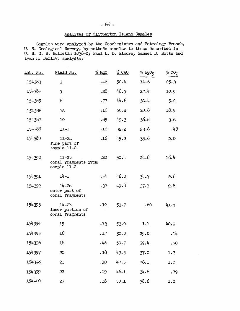
Analyses of Clipperton Island Samples
Samples were analyzed by the Geochemistry and Petrology Branch, U. S. Geological Survey, by methods similar t o those described i n U. S. G. S. Bulletin 10364; Paul L. D. Elmore, Samuel D. B o t t s and Ivan H. Barlow, analysts.
Lab. No.
154383
154384
154385
154386
154387
154388
154389
154390
154391
154392
154393
154394
154395
154396
154397
154398
154399
154400
Field No. $.2&
3 .46
5 .28
6 77
7A .16
10 85
11-1 .16
l l -2a .16 fine part of sample l l - 2
11-2b .20 coral ~"ra@ents *om sample 11-2
14 -1
14 -2a outer par t of coral fragments
14 -2b inner portion of coral f'ragments
15
16
18
20
21
22
23
$ CaO
50.4
48.5
44.6
50.2
49- 3
32.2
45.2
50.4
46.0
49.8
53- 7
53.0
30. o
50.7
49.5
47- 5
46.1
50.1

%bib. No. Field No.
154401 24
154402 26
154403 27A
154404 31
154405 33
154406 348 fine Fraction
154407 34b coarse fraction
154408 35
15UW 36
154410 4
1 5 4 4 ~ 27-1 coral fragments from conglomerate no. 27
154412 27-2 .28 cement from conglom- erate no. 27
$ CaO
51.2
53.5
50.0
50.8
53.0
48.4
52.9
5391
50.8
53.0
54.2
50.9
Analysis of Clipperton Island Commercial Phosphate
(from Elschner 1913, p. 91, reproduced i n Lacroix 1939, p. 303)
3Ca0 P205 78 09 N a C l 0.15
3M@ p205 0.55 Si02 0.28
2aOC 02 6.73 A12°3, FeZ03 0.04
8a0 2.84 Organic matter 4.83
capo3 0.78 h s s on ignition 3.80


PHYSIOGRAPHIC C1IAT;GES
Geological change
I n terms of geological h is tory , a t o l l i s l e t s may be regarded a s ?heneral, o r a t l e a s t very changeable, fea tures , even though t h e i r rbciarine foundations a r e i n c e r t a i n cases Imom t o date back t o the x e n e o r even t h e l a t e Cretaceous (Lacld 1960). On most of them a r e mnd some fea tu res which record o r ind ica te some of the l a t e r changes l a t have taken place. The p r i n c i p a l d i f f i c u l t y a t present i s t o read ld i n t e r p r 2 t t h i s record. On Clipperton, Teatures which may be s i g n i f - :ant i n t h i s r e spec t a re the "kars t " topography of the lagoon bottom iescribed on p. 117 ), t!x step-li::e concentric lpzdces of consolicin,teii ~ c k (descrlbed on p. 4 9 ) and the two t i n y rewxmts of an o l d c m s o l i - ~ t e d s u r f x e p e r s i s t i n g a s undercv.t shelves o r ledges on tlie s ide of Ie v o l c m l c Rock a t between one and t w o meters a!,ove low t i d e l e v e l iescribed on p. 411.).
The ka rs t - l ike lagoon bottom suggests one o r more e a r l i e r periods ? considerable energence and subaer ia l erosion, a h i s t o r y which has, deed, been suggested f o r c o r a l i s l ads general ly (MacHeil 1954). ?esent inadequate knowledge of the d e t a i l s of t h i s lagoon bottom pre- Ludes any more adequate discussion of t h i s aspect .
30th the concentric ledges and the she l f relnnmts suggest a more :cent period of somewha-t g rea te r submergence, o r higher sea l eve l . ? t a i l e d study of these, including ca re f id levelling, might malye pos- ible a more adequate o u t l i n e of the pos t -g lac ia l h i s t o r y of the a t o l l ~d perhaps a cor re la t ion wtth s imi la r f ea tu res on o the r a t o l l s , and ) a s t s i n general. The concentric ledges should be s tud ied i n the con- :xt both of the pi-iosphatization of the c o r a l and tlie p o s s i b i l i t y of langes i n s a l i n i t y and ac id i ty , a s w c l l a s i n level , of the lagoon water.
me f a c t t h a t tlie shel f on the small i s l e t of volcanic rock slopes -om a l e v e l of a r e t e r o r more a t one end t o about lagoon l e v e l a t the ;her can scarcely be explained on the ass~~mptic i i of changed sea l e v e l s ~ l y . Yithout caref'ul excavation, t h e only s u g y s t i o n t h a t seems tenable ; t h a t the rock fragnent may be a loose oae, 1yl:ig on c o r a l gravel which )uld have been washed out , somewhat, during a storm, permit t ing the -urnping of one end of the rock.
H i s t o r i c a l change due to n a t u r a l causes
His to r i c data show t h a t the i s l a n d has undergone changes i n c e r t a i n : i t s fea tures . The most important one i s t h e c los ing of the r e e f open- ~ g s and the consequent freshening of the lagoon. Unfortunately, n e i t h e r ? t h e e a r l i e s t accounts of Clipperton I s l and remark on the condition of le a t o l l r i n g o r t h e lagoon i n 1711 ( ~ r a n c e 1312) o r 1825 ( ~ o r r e l l , 1832). le map furnished by Ee Prudhomme does not sho~r m y opening, bu t is such sketchy d r a f t t h a t no absolute re l i ance can be placed on it. PIorrell
mded on Clipperton, and it i s t a n t a l i z i n g t h a t he should not say more lan he does. He makes no mention of openings o r lack of them, o r of t h e t s te of lagoon water.
Clipperton was first seriously mpped by S i r Edward Belcher i n 1839 (Belcher 1843) and two openings were seen from the masthead (f ig . 4). In November 1858, Le Coat de Kerveguen found the coral r ing continu- ous ( ~ r a n c e 19x2) and, as f a r as Imown, it has remained so ever since, although ocean waters pour over the land s t r i p and in to the lagoon ~ r i t h some frequency. Belcher is the only author to have seen the openings i f we except a not too re l iab le report by Permien ( ~ n o n . 1897-98, Aug. 19) who wrote: "There was, at the t ime I first saw it fi May lag, a channel connecting the lagoon with the ocean, but on my later v i s i t s L i 8 9 g I found tha t t h i s had been choked by logs and drift. The lagoon is now a body of f resh water not connected with the sea, and the pear l oysters in it have died." The va l id i ty of Belcherts observations cannot be doubted. The nature of the openings, and the manner of t h e i r closing nay be discussed, however. A t present the areas where the 1839 openings were located can eas i ly be recognized. One is the great northeast sand wash, the other i s across the land s t r i p opposite the Isthmus. The absence of high consolidated rock, e i the r as elevated beach rock, or is land phosphate rock, i s notable in both. In 1958, the great sand wash had a mimum elevation of 0.65 m above estimated mean high t ide level, and while the southeast spot was covered by a gravel beach ridge topped i n par t by a recent small sand s p i l l , it T J ~ S not very high, and apparently was en t i r e ly made up of loose, removable material. Griswold (pease 1868) described t h i s a r e a s "a heap of fragments, p i led i n windrows by the waves and some photos taken i n 1897 show it as a composite gravel ridge. It i s quite easy to imagine tha t a s tom, or several storms, could have closed the openings by p i l ing up sand or coral gravel across them. However, the outer reef of Clipperton does not show any important interruption near the former openings. It is narrower on the northeast side, and i ts sur- face may be somewhat depressed near the northeast landing place, but this is probably south of the former opening. My impression is t h a t the 1839 openings were not boat passages, but only reef-surfaces temporarily cleared of accumulated material, and therefore extremely shallow, and perhaps quite short-lived. This interpretat ion is compatible w i t h Bel- cher 's description which says: "There are tim entrances, which a t hi& water may be safe; but a t the moment we passed, the surf was too heavy, and the ref lux showed the rocks bare." These rocks must be the surface o f ' t h e reef, the bottom of the entrances. The storm o r storms which closed the 1839 openings may well have changed the surface of the reef and, more especially, the reef front, i n such a way as t o f a c i l i t a t e the accumulation of material so the openings have never formed again. This interpretat ion might seem to disregard the f a c t t h a t the lagoon, with coral heads and other marine a n M s in position of growth, has obviously f o r long periods of time, been in communication with the ocean, My impression is t h a t the closing and freshening of the lagoon had started before the disappearance of the 1839 openings, and t h a t the period vhen it was i n ample comunication with the surrounding ocean was probably much ear l ie r , perhaps dating back t o a time of higher sea-level. A de- t a i l e d study of the topography of the present reef, and of the nature of the dead marine fauna of the lagoon, including the physical. condition of the dead she l l s and corals, could help reconstruct t h e i r history. A t the same time, the hgoon reefs should be investigated (see P. 49, note p. 73).
Another instance of h i s to r i ca l change i n the Clipperton land s t r i p i s t h a t observed on the northeast side, and a t t r ibuted t o a storm occurrin

etween November 195'7 and May 1958. On the a i r photos taken i n September 943, the area northwest of Natural is ts ' Camp and t o the f a r side of Green o i n t exhibi ts f i ne l i ne s p a r a l l e l t o the shore, similar t o those maricing he phosphatic ledges elsewhere. The vegetation cover appears i r regula r u t continuous and probably consis ts of mixed herbs, with Ipomoea patches e c o ~ i z a b l e i n some places. A sedge marsh occupies the t i p of Green o in t . Beyond Green Point, axd a s far as the area where the land s t r i p egins t o widen and curve t o form the north corner of the a t o l l , no ore l i ne s are v i s ib le , there i s much exposed sand and the vegetation ppears t o consis t only of Ipomoea vines.
The photos taken from the helicopter i n November 1957 do not cover ll of t h i s area but shot? very well the vegecbation extending f o r several undred meters northr~estward of Uatural is ts ' Cmp w i t h Ipomoea vines reeping down the beach and n s d l coconut palm near Green Point.
In Aggust 1358 changes from these ccnditions were spectacular. 1 s t of the northeast side of the a t o l l was denuded of vegetation and mered with f resh cora l material. Going n o r t h ~ ~ e s t from Naturalists ' mp and past Astro 1957, the ocean t o lagoon cover of Ipomoea pes-caprae ines stopped abruptly 45 m from the Monument, and gave way t o a sheet of 3 r d gravel, i n places a t l eas t , ly ing over cora l sand or phosphatic s i l t . i e gravel was ra ther evensized but mixed with occasional l a rger cobbles i i t e , and somewhat inbricated from ocean t o lagoon. Here and there xrge boulders had been tossed up onto the land s t r i p . Some gravel had 3wed in to the lagoon was being reworked in to 1017 banks by the lagoon wes. !$here the o ld land surface ended in a c l i f f a t the lagoon edge, ie c l i f f face i n places had been undermined arld broken up and the f resh ravel was mixed with material detached *om tile c l i f f ( see p. 63 ) . O n ie ocean side, t h e edge of the land surface was undercut and bro!ren up ~rming a ledge, and coarse sand o r gravel sloped down from it t o the ?ach, except l~here a th ick formation of conglomerate, a l so eroded and -olten up a t the top, formed the ocem slope (see p. 3 7 ) .
Some sandy areas near the lagoon edge of the gravel sheet, elon- ~ t e i n an ocean-lagoon direct ion, seemed t o mark channels along which le water drained of f . Some were occupkdby f resh plants of Cenchrus o r ~omoea pes-caprae. Otherwise the gravel sheet was bare of vegetation, ~d ob l i t e ra ted any e a r l i e r surface features of the area, such a s ledges.
Somewhat beyond Green Point, the gravel sheet was interrupted, and ie land s t r i p formed an escarpment along the ocea-lagoon section, 1.40 a t i t s highest point, and with a slope of gravel below it. Beyond t h i s xff, northwestmzd of the gravel sheet, the land s t r i p became very )sr (0.65 m above estimated mean high t i de l e v e l ) and sand s t re tched :ross it *om ocean t o lagoon forming the grea t sand wash and extending )r 430 m tovard the north comer of the a t o l l . A t i t s f a r end, it gave LY t o a boulder f i e ld , and f i n a l l y t o an area covered with vegetation iich appeared undisturbed.
The storm then has deposited cora l debris over a s t r i p several ~ndred me-ters long, and across it in to the lagoon, at the same time ldercutting and eroding the ocean shore. Dr i f t seeds and pumice were U e c t e d on the lagoon beach, if proof were needed t h a t ocean waves !ached the lagoon.

Southeast of the most spectacularly affected axea, opposite Naturalists ' Camp, the storm had eroded and undercut the is land rock, and deposited boulders and slabs of beach rock at the top of the beach, and even over the vegetation of the land s t r i p . Some .swd was spread over the Zpomea vegetation and, washing down among the vines, covered the phosphatic silt. A buried s o i l was found, near the small group of palms, under 8-10 cm of sand.
The emplacement of a t i d e gauge ins ta l led near the wrecked LST i n 1956 was demolished, most probably by the same storm, and the wreck i t s e l f was so battered t h a t the mast and much of the s te rn f e l l i n the ocean. These changes were observed, together with the conspicuous white coral s t r i p on the northeast side, in May 1958 (W. L. Klawe written .
communication).
That the storm waves did not a f fec t only the land aad the upper par t s of the underwater slopes is demonstrsted by observations made by the marine biologists. Allison (personal conrmunication) was able t o observe some species of corals which grow only below the edge of the 10-fathom terrace; the large boulders made up of t h e i r skeletons and thrown up onto the reef and even the land s t r i p had therefore been l i f t e d from t h i s depth, a t leas t . This e f f e c t of the mves at consider- able depth is confirmed by some observations of the divers along the undersea slopes. They observed great differences i n aspect between the northeast slopes and those elsewhere around the a t o l l and believed t h a t they were seeing storm e f fec t s as far down as 30 to 45 meters. Detailed descriptions of such observations when available, w i l l be of great i n t e r - e s t indeed. Newell (1956, p. 3441 a lso suggested t h a t some of the coral debris thrown up by hurricanes on the reef and islets of Raroia Atol l originated on the terrace.
Elsewhere on Clipperton, along the southeast side, a vas t area of sand may have been deposited, or a t least reworked, by a storm, a s sug- gested by the black coral boulders p w t l y buried in fresh sand, and which must have been there for some t h e . The sand covers also the road marked i n 1945. The surface of the sand is l i t t e r e d with great amounts of drift material, pieces of wood, dead coconuts, bot t les , a very few glass f loa ts , pumice, drift seeds, often arranged along ocean-lagoon l ines of flow. Some white coral boulders were probably deposited at the same time. On the 1957 photos, t h i s area i s not very well shown, but it does not appear very d i f fe rent from what it was i n 1958, so the fresh-looking material may have been deposited o r re-arranged by a storm ea r l i e r than the 1957- 1958 one.
I n the southwest sand wash, black boulders par t ly buried i n sand, a l so seem t o indicate t h a t the sand has been reworked, o r added to. I n t h i s re la t ive ly small and rather permanent sandy area (see p 35), the e f f ec t may be due mostly to wind, however.
Recent changes due t o man
Some changes i n the aspect of the is land are due t o man's ac t iv i t i e s , While most t races of phosphate collecting have been obliterated, some mounds of phosphate occur near the s o u t h f ~ s t coconut grove and the west

orner of the lagoon. P lan t s asranged i n " l ines" along the northwest ide, m y follow hidden trenches along which phosphate was dug ( c f . p. 7 ) . John Arundel. (Anon. 1897-38, Aug. 20) m o t e r a t h e r d i sda in fu l ly
f some e a r l y prospectors: "some one ... chipped off some b i g blocks of h e f i o l c a n i g rock under the hal lucinat ion t h a t it was hardened guano, nd hauled them two miles across the lagoon t o the place where it was ntended t o ship the s t u f f . It l i e s t h e r e s t i l l . One might j u s t a s w e l l se cobble-stones f o r a f e r t i l i z e r a s t o use t h a t rock." The chunb a r e t i l l p i l e d up on the lagoon shore, opposite the LST. Two sand moulds 3ar the e a s t corner may a l s o date back to t h a t period, a s they were al- -.ad not iced i n 1943. The phosphate workers i n the 16901s had severa l x s e s and sheds on the nor theas t s ide , near the present ?Jat ,ural is ts l amp o r somewhat northwest of it. Later, the camp m s moved t o the south- ? s t s ide, and before 1 ~ 4 5 ~ ru ins of hu t s and machinery could s t i l l be 3und. The t r a c e of a m i n e d p i e r across the ree f , opposite the south- ? s t camp, can s t i l l be seen on a i r phot,os. Sane s h e l t e r s had a l so been rected near the Roci:. In 1958 a low w a l l a t the base of the e a s t face f t he Rock, some excavations and some la rge pieces of coa l sca t t e red near- y. renained; the ru ins of the phosphate digging establishments had disap- x r e d , except f o r p i l e s of phosphate, pieces of narrow-gauge r a i l tracl; ~d a lWge i ron mooring buoy; bu t the remnants of the U. S. Weather Sta- ion bui ld ings were conspicuous on the southwest s ide , i n the much- ~ l a r g e d coconut grove. Roads had been b u i l t from the S ta t ion around the t o l l , and can s t i l l be seen i n most places, the vegetat ion having a d i f - :rent appearance and the p l a n t s graving lower on the compacted mater ia l . lo tos taken i n 1945 show a l a r g e c lea red a rea vrhere the Weather Sta t ion l i ld ings were being put up, and a ban!; of c o r a l on the ocean s i d e of the mp, probably intended t o p ro tec t it from storm \raves. This bank i s t i l l recognizable today, although the c o r a l has turned black and p lan t s mer it i n p a r t s .
Another important change ought by man ol' course i s the i n t r o - sction of animals and p lan t s , which w i l l be 'rrief'ly discussed bcSbw.
~ t e : - After the above was m i t t e n , I received the following information. D r . Car l Xubbs, i n a l e t t e r dated Dec.27, 1961, says: " J e have jus t
x e i v e d the radiocarbon date of 370 + l o 0 years from the UCLA Radiocarbon iboratory ( t h e i r t e s t No. UCLA-115) 7 . . The t e s t was made on a complete !ecimen (both valves) of a clam i d e n t i f i e d by All ison a s Spondylus c f . tc i f icus , taken from a depth of 18.3 meters i n the lagoon, i n September ~ b y ~ i m b u g h .
"The exact date, even wi th in the indicated margin of e r r o r , is not ) be t r u s t e d too impl ic i t ly , because there a r e expected f luc tua t ions , id f o r o the r reasons." The date w i l l be included i n the 1962 Radio- ubon Supplement t o t h e American Journal of Science.
This i n t e r e s t i n g result, i n s p i t e of the wide margin of e r r o r iaxine carbonates o f f e r se r ious problems i n radiocarbon da t ing) , i n
way weakens the remarks made on p. 70, and confirms the view t h a t . thin r e l a t i v e l y recent times, the lagoon of Clipperton was s u f f i c i e n t l y t l ine t o support some s t r i c t l y marine organisms. It a l s o suggests t h a t ie present meager brackish water f l o r a and fauna of t h e lagoon a r e of : l a t i v e l y recen t o r ig in .

GENERAI; WTD ECOLOGY
Habitat
The outstmding ecological character is t ics of Clipperton Island are the rigorous environment and paucity of habi tats and land biota. The climatic conditions have been described above and can be summarized a s follows: extrene insolation; moderate temperature, with l i t t l e change throughout the year; high humidity; high ra in fa l l probably with a dry period; variable but often strong winds; seasonal but frequent storms and hurricanes and incidence of storm waves.
The landscape as a whole i s rather uniform and provides only a few habitat types: wdFormly low a l t i tude and l i t t l e variation i n topography, lack of much variation i n chemical composition i n the substratum, poor development of so i l s , l i t t l e shade, a l l contribute t o reduce the number of possible habitats, even more on Clipperton than on other a to l l s . For instance in the northern Marshalls, which are perhaps comparable i n many respects, a greater variety of habi tats resul t s from the denser, more mature vegetation which includes several native t r ees providing shade, more different iated so i l s , increased s o i l moisture locally, etc.
On Clipperton Island the surface s o i l s m e mostly very immature-- coral sands and gravels only s l ight ly discolored by organic matter. In some areas the surface material i s phosphatic gravel derived apparently from the indurated phosphatic rock, but i n many places the surfa.ce i s of only s l igh t ly modified recently deposited material.
On the broad northwest corner are large areas of phosphatic s i l t with s l igh t admixture of coral gravel, t h i s especially scattered i n a thin layer over the surface. The s i l t i s different iated into a brownish or brownish gray upper layer a s much as 15 cm thick, lying on a pale creamy white layer, more compact, of undetermined thickness. The two layers are almost en t i r e ly calcium phosphate, but the percentages of both P205 and C a O are somewhat lower i n the darker upper layer, perhaps indicating some profi le development (cf. samples 22 and 23 p. 5Q. Comparable material (cf. sample 3, p. 57) underlies the gravel sheet on the northeast side, a t l e a s t i n some places. Judging by the s imilar i ty of the material i n old stockpiles on the west corner near the lagoon, t h i s s i l t may be one of the kinds of phosphate t h a t were mined commercially. Therefore i ts present extent is probably much more res t r ic ted than it must once have been.
Otherwise no s ignif icant prof i le development was observed i n any well drained s i t e except i n -the coconut groves where a thick surface horizon of par t ly decomposed l i t t e r and humus had accumulated on the coral (c f . sample 32, p. 5 7). Crab holes are abundant and doubtless there is a continual s t i r r i n g up and turnover of the s o i l material, making any incipient horizons l e s s d is t inc t . Earthworms are local ly abundant. Drainage seems generally excellent except on ground lying a t about lagoon level. Here the so i l , i n i ts upper layer a t leas t , is a dark highly organ- i c s i l t y mud (cf . sample 6 p. 5 7).

The s o i l generally calcareous and phosphatic, may be loca l ly enriched by small amounts of material from the volcanic rock and of drftfted pumice and extraneous rock carr ied i n dr i f ted t rees .
There i s l i t t l e v is ib le evidence of the influence of s o i l on vege- ta t ion or the reverse, except i n the s o i l s of the coconut groves mention- ed above, i n the correlation of s i l t y , highly organic mud with sedge beds i n low places, and tha t of s i l t y sand with Heliotropium and Conyza stands. Of course the continuing enrichment of the s o i l by guano and the past enrichment which led t ~ - ~ h o s ~ h a t e formation undoubtedly make the s o i l a more f e r t i l e substratum f o r plants than the pure carbonate parent mater- i a l s . Since t h i s enrichment is a general feature, i ts ef fec ts a re not revealed i n the vegetation patterns. Recently deposited sands and gravels, not so enriched, have very l i t t l e vegetation as yet but t h i s is probably related t o time and other factors rather than t o lack of f e r t i l - i t y ,
Land Biota
The paucity of habi tats on a t o l l s i n general and Clipperton i n par t icular is matched by the poverty of the f lo ra and fauna. In Pacific a to l l s , there is an obvious attenuation of the fauna and, more especially, the flora. as one t ravels eastward, away from the land masses of Indo- Phlaysia. This trend is complicated by the r a i n f a l l gradients. Despite the enrichment from the east, Clipperton Is land 's impoverished biotas fit well a t the "end of the l ine."
Plant l i f e
The floraand vegetation of Clipperton have been described i n d e t a i l elsewhere (Sachet 1962) and only a swrmary need be given here.
Slhile the present survey increased the number of plants recorded from Clipperton, only some fungi (mostly isolated from s o i l samples), lichens m d blue-green algae, 3 mosses and 26 phanerogams could be found, with the addition of a few d r i f t seedlings. All the species a re l i s t e d below, pp. 89-94. There were several d r i f t trees, or large branches, thrown upon the beaches o r beach ridges.
Probably a l l the cryptogams present are of very wide dis t r ibut ion but too l i t t l e is knotm of the i r general occurrence t o draw useful in- form~btion on phytogeography. The three mosses, at leas t , a re pantropic. Of the phanerogams, some are pantropic and the i r place of or igin cannot be determined (e.g. Ipomoea -ca rae), a few are American (e.g. Heliotropium, Scirpus, Solanum ""P- Only one d r i f t seed, i f i ts iden t i f i - cation, S t r o n ~ l o d o n sp., is correct, appears t o be def in i te ly of Indo- Pacific origin. Most of the land plants were probably introduced by man, a few deliberately (e.g. C o c o s , Micotiana, ~ r a s s i c a ) others by accident (e . g. Waltheria, C o r c h o r u s , Solanurn, Sida Cenchrus E r a p o s t i s ) . The lagoon phanerogams and perhaps some algae (Prnct-: and the sedges may have been introduced mrn America by water birds.
There a r e no native t r e e s or shrubs on the island. Except for the coconut palms introduced about 1897 and forming a few groups about the coral r ing, the vegetation is uniformly low, only a fev centimeters o r i n places a few decimeters tall, and made up of herbs, some of them suffrutescent.
The la rger coconut grove on the southwest side, is too dense t o allow any undergrotrth o r ground cover. No plants grow under the palms a t the East face of the Rock ei ther , possibly because of trampling by the pigs. The other groups of palms a re so small t h a t the surrounding vegetation simply extends t o the palms o r among them, without any per- cept ible change i n character. Therefore, shade, humus, and the pro- tec t ion from wind, s a l t and evaporation provided by t rees , a r e of l i t t l e importance as factors influencing the vegetation. The s l i g h t l y more luxuriant condition of some plants near the la rger grove may ju s t a s well be due t o the presence of the ruined canp and attendant disturbances of the so i l , addit ion of chemical elements useful t o plants, and other effects . Similarly, it is not hown whether the t a l l e r , more luxuriant condition of and Solanum around the base of the Rock is re la ted t o shade, disturbance of the s o i l , o r addit ion of chemical elements from the volcanic rock o r of organic matter from other sources.
The most extensive vegetation type on Clipperton is a herbaceous cover, a few centimeters t o a few decimeters tall, made up of a varying mixture of grasses and suffrutescent perennials. The plants most common- l y present a r e Cenchrus--a grass with spiny burs, Sida, Corchorus, and Solanum. Other plants occur, bu t l e s s generally, mixed with these. Two plants appear t o prefe r sandy habi ta ts and may form pure patches i n such places; they a re Heliotropium and Conyza. The mixed herbaceous vegetation i s bes t developed on the northwest s ide of the island, which a l so appears t o have been l e a s t disturbed i n recent years. The density and composi- t i o n vary and over large areas, some t a l l e r plants, densely growing to- gether, form long narrow l ines , roughly p a r a l l e l t o the shores. A t h in layer of dark gray cora l gravel covers most of the s o i l i n t h i s p a r t of the a t o l l , hiding differences i n so i l , i f any, along the l i n e s of plants. Very l ikely, however, the l i n e s indicate buried features; some may be the continuation of the phosphatic ledges found elsewhere around the a t o l l , and the majority probably a r e old trenches or f'urrows along which the phos- phate was collected. One such trench is s t i l l c lear ly v i s ib le a l i t t l e south of the west comer of the a t o l l , not far f'rom the lagoon. On the 1943 a i r photos, it shows as a long dark gray s t r i p , with four round spots along it. I n 1958, the spots were found t o be p i l e s of phosphatic sand and gravel (c f . sample 20, p. 5 6 ) , with a c o v e r of t a l l e r vegetation, including much Brassica. Three p i l e s a re on the west s ide of the trench, the other on the lagoon side. The trench is 30 o r 50 cm deep, several meters wide and a t l e a s t 100 m long. The obvious impression is t h a t thz p i led up material was dug out of the trench. This may be how the phos - phate w a s mined. This interpreta t ion appeared strengthened by some of A rundel's remarks i n h i s d ia ry (cf . p. 20 ). When he was on Clipperton i n July-August 1897, he surveyed very minutely the phosphate resources of the island, and, i n h i s notes on surveying and phosphate sampling, he of ten mentions trenches, apparently pa ra l l e l t o the shores, fomd mostly

i n the northwest par t of the land s t r ip , the only area exploited a t the time of h i s v i s i t . H i s notes are too sketchy however t o give an exact idea of the method of exploitation and to permit correlations with present observations.
The mixed herbaceous vegetation i s a l so well developed on the southwest side and around the south corner of the land rim, but i s generally lower. The former roads running from the old U. S. Weather s ta t ion a re marked by low, primarily grassy, vegetation. On some areas of phosphatic pavements, especially a t the south corner, the mixed herbaceous vegeat ion consists mostly of clumps of =a and Solanum,or large cushions of moss (~ryum sp.) with much bare ground exposed.
Another important vegetation type is a blanket of Ipomoea E- caprae. The long thick vines, w i t h t h e i r bright green leaves notched at the apex and purple morning glory flowers, cover the whole width of the land s t r i p near the wrecked LST and 1Taturalists1 Camp, blanketing abandoned boats and other equipment, and form thick masses of stems over lagoon c l i f f s or banks around most of the island, except in the south. Here and there these creepers extend in to the mixed herbaceous vegetation, as on the west side where they cover the ruins of the weather s ta t ion and on the northwest landstr ip where they grow from old gnarled "trunks1' sev- e r a l decimeters high? These have been interpreted as a sign of seasond dryness, when the vines probably die back. I have found no reference t o such thickened ~ o o d y bases fo r t h i s species, but somewhat similax, even larger, woody trunks of another species, t - t have been observed on Polcak Atol l i n the northern Marshalls 1955), where there is a very marked dry season.
l;OW muddy areas o r s d l ponds and ditches along the lagoon shores are occupied by a vegetation made up of pure stands of several sedges. Tall, dark blue-green plants of Scirpus rub i~ inosus form a few small patches on the Hook and here and there along the eas t shore of the lagoon. They a re rooted i n mud, under water. In similar habitats, but much more abundant, occur the br ight green dense stands of Eleocharis m u n u l in ing the shores with narro~r s t r i p s or scallops and f i l l i n g shallow ponds. The low pale green Eleocharis geniculata forms stands around the former, grow- ing on wet m u d , b u t n o t e m i c a r p h a micrantha, the last species of sedge, prefers s t i l l d r i e r habitats, and i ts small gray-green t u f t s a r e found outside the Eleocharis geniculata zone o r alone i n quite dry areas. The different requirements f o r wetness of substratum of the three last- named species sometimes lead t o a s t r ik ing concentric arrangement as a t the base of the Hook i n (E. mutata) and around @. geniculata and Hemi- carpha) a small pond. The dense stand of Eleocharis m t a t a i n the pond is the habi tat of the damsel f l y Ischnura ' m d e t . C. F. arbi is on). This same sedge and the Scirpus are used f o r nesting s i t e s and material by the coots.
A type of vegetation which is not always recognized as such by the casual observer is represented by the crusts and films of blue- green algm which s t a in the sand green and blacken the cora l around the a to l l . Their ro le i n the ecology of a t o l l s is not known, althougli some possible e f fec ts of t h e i r occurrence have been suggested: the species
growing i n sand may have a role i n binding the sediments (cloud 1952, p. 61; Doty 1957). Nothing is def in i te ly Imo~m of the role of blue- green algae in nitrogen f ixat ion on a to l l s , and yet it may be of great significance in view of the paucity of nitrogen sources i n such environ- ments. This has been suggested by Doty (1957) and Newhouse (1954, p. 53). In gypsum sand, a similar type of very s t e r i l e habitat, an increased amount of nitrogen in algae-bound crusts has been demonstrated by Shields and collaborators (1957).
L i t t l e is la?o~m of the ecological significance of s o i l fungi on a to l l s , but they doubtless play a considerable role in the decomposition of organic matter and a large f lora of s o i l fungi is known from Clipper- ton (see p. @ and Sachet, 1962).
Vegetation of the lagoon
In addition t o various attached and f loat ing algae, the vegetation of the lagoon i s made up of aquatic phanerogams tolerant of s a l t . These plants, when alive, form great beds of weeds i n the shallow parts of the lagoon, especially along the Isthmus and around the Rock, i n Pincer Bay and around the Egg Islands. The most abundant is Iiajas marina, the stems of which, several meters long, are presumably rooted on the bottom. Potamogeton p e c t i n a t ~ ~ s was found around one of the Egg Islands, while Ruppia maritima i s common attached t o rocks just below the surface of the water together v i tn filamentous algae. Great tangled masses of these plants f loa t a t the surface of the lagoon and are deposited on the shores i n long r o l l s a f t e r periods of strong steady wit~ds. On t h i s plant mater- i a l feedlagoon invertebrates especially the very abundant isopod, a speeies of Cirolana.
A t l e a s t two plants are known t o have been present i n the lagoon, which could not be found i n August 1958. One is the Chara collected i n 1938 (w. R. Taylor 1939) the other i s a phmerogam resembling Zostera marina vis ible i n great abundance on a photo taken i n 1943 (B~-3, v a p h o t t 15). Nhat caused the disappearrtnce of these plants can only be guessed a t . They may never have become rea l ly established but only have flourished for a brief period a f t e r the i r introduction. O r they may have suffered from changes i n the sa l in i ty of the lagoon water, or other l e s s obvious causes.
Animal l i f e
In 1825 Morrell v is i ted Clipperton and mote (1832, p. 219) "Fur- s e a l and sea-elephant resor t here i n small numbers i n the proper seasons ... After taking what few *-seal could be found about the island ..." This is the only record of seals from Clipperton Island. Recent works (Allen 1942, p. 4-40, Scheffer 1958 p. 78) discuss Morrell's records of fur-seals on other islands of the E a s t Pacific but make no mention of h i s Clipperton observations. However, Dr . C a r l . Hubbs (personal communi- cation) believes there is no reason t o d i s t rus t Morrell.

In the eastern Pacific, there are three fur seals, the Galapagos f u r -seal ( Arctocephalus aus t ra l i s galapagoensis Heller ) , the Philippi fh-seal of Juan Fernand-ili philippi (peters)) and the
' d i l i p p i townsendi ~ e r r i a m ) . All Guadalupe or California fur-seal have been slaughtered ruthlessly fgr ti?eir skins m d the Juan Fernandez sea l may be extinct. The Guadalu3e fur-seal feared t o be ext inct or almost so when Dr. Hubbs (1356) found a small group of them on Guadalupe Island i n 1954. Which of the three fur-seals could have occurred on Clipperton can only be conjectured, but the location of the a t o l l p a t - way between the home of the different fur-seals makes the problem espec- i a l l y intriging.
The northern elephant sea l (Mirounga angus t i r o s t r i s ( c ill ) ) now occurs only on some of the islands off the coasts of Cd i fo rn ia and Baja California but formerly had a mch larger range and could have reached Clipperton. With the disappearance of the seals, no native mammals re- mained on Clipperton.
Pigs were introduced t o Clipperton Island around 1897, when a photo was taken showing two of them with the first two coconut palms, on the northeast side of the island. According t o newspaper reports, these two pigs were survivors of the wreck of the Bri t ish ship Kinkora (cf. p. 20). In 1917, when the phosphate works had been abandoned and the few remaining inhabitants were discovered and rescued by the U. S. gun- boat Yorktown, about a dozen pigs were running wild on the island, the people being unable t o catch and k i l l them orris, 1934). All v i s i to r s between tha t time and 1958 mentioned the pigs, most of them estimating t h e i r number as around 50, although the crew of the Ethel -- I\!. Sterling ( cf. p. 7) reported nearly one hundred. i n August 1958, a l l 58 of them were killed, because they seemed t o molest the nesting birds. The pigs had l ived in the Rock and hid i n the larger clumps of plants near it, in the coconut grove, or i n thick Ipomoea beds a t the lagoon edge. They had worn white tracks on the dark coral g a v e l , o r narrow paths in the vegeta- tion. Their droppings showed tha t they a t e plants and crabs, and probably also eggs and perhaps young birds. Some of the pigs were black, others a d i r t y pink, and spotted.
Unlike many other oceanic islands, Clipperton has been protected from the accidental introduction of r a t s and mice by the f a c t tha t ships cannot t i e a t the shore, but passengers and goods must be taken ashore by small boats. However, i n August 1958, M r . k v i d Peterson (written communication) saw a mouse i n a ruined quonset hut of the weather station.
Birds :
Most of the ear ly v i s i to r s t o Clipperton Island mention the great nunibers of seabirds roosting or nesting there. Morrell i n 1825 saw "the whole island . . . l i t e r a l l y covered with seabirds, I' and Belcher used almost the same words. Others mention myriads of birds. In 1958, even the most abundant species of birds occurred only i n groups of per- haps a few hundred and it was obvious tha t there had been a serious decrease i n numbers a t some time. The common species were boobies, noddies and other terns, and f'rigate birds.

The brown boobies in 1958 were nesting a,nd i n addition to eggs, they had young of all ages. They were very abundant on the Rock, which they shared, almost exclusively, w i t h white-capped noddies. They also occupied ledges and projections of consolidated phosphatic rock forming c l i f f s wound the lagoon. Whenever a piece of such a c l i f f had fa l len down, forming an isolated pinnacle i n f ront of the c l i f f face, boobies could be found on it. Brown boobies a lso roosted in the coconut palms, and on the wrecked LST, with other species. The nests were of dry Ipomoea runners and grass, sometines with a fresh green branch of Helio- tropium, perhaps for decoration. Along the c l i f f s , the nests seemed more substantial than on the Rock, and were very clean because boobies can expel1 the guano a long way from the nest.
In November 1898 (Snoagrass and Heller l902), they were common, breeding on the f l a t coral beach along the lagoon. In August 1905, i if ford 1913), they were nesting abundantly all around the island.
The blue -faced or masked boobies i n 1958 were much l e s s abundant than the brown boobies. One with a red-orange beak had an egg on the northwest land s t r ip . This par t of the island, together with the Egg Islands, is where they were most abundant, but a few roosted elsewhere. These birds make no nest, only a s l igh t depression i n the ground. In November 1898 they were "breeding in immense numbers," i n November 1901 Beck (1907) saw thousands of them, and i n August 1905 a large colony m a scattered among the brovn boobies but not nesting. It may be tha t they are more numerous i n the f a l l when they breed than during the summer months.
The absence of red-footed boobies from Clipperton was at t r ibuted by Snodgrass and Heller t o the lack of bushes. In August 1958, Dr. Stager s a w one on a palm near the Rock.
Vith the boobies, the most conspicuous birds on the island were the noddies. The common noddies occurred a l l around the island, sharing the rocky c l i f f s with the brown boobies and the Egg Islands with the blue- faced boobies and sooty terns. They also nested on all the abandoned rusting boats and vehicles on the island, Their crude nests included a few twigs of Ipomoea and sometimes a green Heliotropiwn branch. A few of them nested on the ground, with only a depression or a few pebbles and - twigs marking the s i t e among- the 1pomoea vines. They had eggs; and the chicks s ta r ted hatching W i n g our stay. In 1898 they were very abundant on the Rock, and i n 1905, on the Rock and the lagoon i s l e t s .
The white-capped noddies are not easy to distinguish from the others, unless they are seen together. The white-capped are somewhat smaller, the plumage is darker and the white cap in sharper contrast with it. In 1958, they nested a l l over the Rock i n great numbers, on a l l the project- ions and i n crevices too small for boobies. Some had nests of twigs and Heliotropium, others had no nest a t all; some thick, guano-incrusted nests appeared t o be o ld ones being re-used. Eelow the nesting places, t r i ck les and splashes of guano covered the Hock. Some noddies were seen picking up Ipornoea vines, pulling on them or f lying with them, the vines sometimes much longer than the bird. There may have been some confision

with common noddies, here. The noddies i n the Rock had eggs and, toward the end of our stay, chicks. The white-capped noddies nested also i n the coconut palm near the Rock, where they badly damaged the fronds and especially young inflorescences by s i t t i n g on them and covering them with guano. There were noddies nesting also in the large southwest coconut grove. In November 1898, only immature birds were recognized, associated with the common noddies. In 1905 white- capped noddies nested i n great numbers on the Rock, with nests of algae (or more l ike ly lagoon phanerogams).
The sooty terns, or wide awakes, roosted i n small numbers i n the southeast par t of the landstrip, opposite the Rock, and on the Egg Islands. A larger colony moved a l i t t l e distance west from the north corner, t o just landward of the beach ridge top, a few days a f t e r we arrived a t Clippertoq and s ta r ted laying eggs a i rec t ly on the ground, among coral rocks. In 1898 and 1905 sooty terns were nesting i n thou- sands on the Egg Islands. These birds sometimes occur i n incredible numbers but have been known t o abandon some islands where they were once very numerous, such as Canton Island (~urphy e t a l . 1954). They are very noisy and when approached shriek and scream i n a deafening manner. Very l i t t l e guano accumulates i n sooty te rn rookeries because they usually drop it only over the ocean. The ra in of guano, so un- pleasant when noddies, boobies or f r iga te birds a re disturbed, is noticeably absent under a f l i g h t of sooty terns.
Fairy terns have never been very abundant on Clipperton, a l l observers mention only a few pairs . In 1958 they had eggs i n different par t s of the island, on isolated large boulders, and i n the coconut palms and ruined quonsets of the southwest side. There i s no nest a t al l , the f a i ry te rn being famous fo r balancing its egg on a branch or rock, i n such a precarious way t h a t it is hard t o understand how the b i rd gets on and off the egg, and how the chick hatches ~r i thout moving the egg and fal l ing. The chicks of the beaut i ful l i t t l e white terns were hatching i n the l a t t e r par t of our stay. -&en disturbed, adults would f l u t t e r about the v i s i t o r ' s head, just beyond reach, and chatter.
Frigate birds i n 1958 roosted on the eas t corner of the island, i n a sandy area with scattered boulders and d r i f t material. The adults had almost grown juveniles w i t h them. A t the end of our stay, they seemed to be preparing t o nest i n the coconut t rees on the southwest s ide. Frigate birds had been recorded i n 1898 and 1905 and Belcher (1843) had mentioned "fr igate pelicans."
The last species of b i rd t o be seen i n large numbers at Clipperton i n 1958 was the American coot. These dark birds with t h e i r cuxbus white beaks were swimming i n the lagoon, or walking on shore, and some had b u i l t t he i r nests in the s e a e beds. Some had chicks swimming behind them. Coots had been observed by Beck i n 1901. Together with the ducks reported as common i n winter by Snodgrass and HeLler and by Beck, but of which we saw none, the coots have probably been very important i n increasing the f lo ra of the lagoon. Perhaps a l l the water phanerogams, the l o s t Chara - and the sedges were brought by these birds i n the i r stom- achs o r i n mud on t h e i r f ee t . The shore birds which were observed i n 1958 only a s isolated s t rays (golden plover, bi t tern, wandering t a t t l e r ,

sand pipers, and perhaps godwit, etc. ) may be more numerous at other seasons and may also transport seeds of water plants. Seabirds are a lso known t o ea t plants a t times, especially seeds (~uppy, 1906; Ridley, 1930; Fosberg, 1957) and may be responsible for some plant introductions i n t h i s way, although transport of prickly or sticky f r u i t s or seeds attached t o feathers is probably more frequent. The boobies and noddies may help spread some plants, especially H e l i o t r o p i u m , around the a t o l l because of the i r habit of carrying small branches.
Besides the i r probable role i n bringing plant species t o the island, the birds of Clipperton may have had other e f fec ts on the vegetation. On other widely separated islands it has been shown tha t birds can dam- age or even k i l l vegetation. Vesey-Fitzgerald (1941) suggests tha t sooty terns may destroy low vegetation o r inhib i t i t s growth. Tree-nesting birds damage t rees and bushes: On Canton Island f r iga te birds and red- footed boobies appear t o k i l l some t rees or bushes of Scaevola, Cordia and Messerchmidia (Hatheway 1955, pp. 5, 8). On Kapingamarangi, a much wetter a to l l , white-capped noddies damage o r perhaps k i l l breadfruit t rees ( ~ i e r i n g 1956, p. 19) . Another interesting example is t h a t of the Chesterfield Islands i n the Coral Sea ( ~ o h i c , 1959). The small f lora of 20 phanerogams forms a vegetation somewhat comparable t o tha t of Clipper- ton, except fo r the occurrence of shrubs l e s s than 2 meters tal l of Sophora tomentosa, Scaevola sericea and Colubrina asiat ica. These woody plants, as well as the few introduced coconut palms, are very much damaged by roosting and nesting f r iga te birds and red-footed boobies. It is conceivable t h a t on Clipperton, where the seed sources are obviously very poor, the birds, when they were much more numerous i n the past, could have prevented the establishment of cer tain plants, including shrubs and trees. Supposing tha tmre seeds of such plants could have arrived on the island i n d r i f t or by other means and that a few seedlings could have survived in sp i te of the crabs and developed t o maturity, those birds which can nest indifferently on the Rock or on t rees would probably have moved over t o them and destroyed them. A t present the number of birds on Clipperton is small and they have l i t t l e recognizable direct e f fec t on the vegetation. A s mentioned above, they do af fec t the condi- t ion and perhaps multiplication of coconut palms near the Rock. Conver- sely, the complete absence of t rees on the a t o l l u n t i l recent years has successfully precluded the presence of birds tha t nest exclusively on trees. 'ðer the recent development of coconut groves w i l l lead to the establishment of new tree-nesting birds, such as red-footed boobies, i s of course not Imown; too many factors are involved. However, t h i s is one of many questions which trill make periodic resurveys of the a t o l l very valuable.
The birds of course have an indirect e f fec t on the vegetation through the enrichment of the s o i l i n phosphate. On other a t o l l s ( ~ o h i c 1959), it has been suggested tha t the very high concentrations of phosphates and n i t ra tes i n s o i l s may have deleterious ef fec ts on plants. This could not be determined one way or the other on Clipperton.
The impact of the b i rd population on the island is most s t r iking when one considers the large phosphate deposits, par t icular ly the deep phosphatization of the volcanic rock. Perhaps a detailed study of the

phosphatized trachyte could lead t o en estimate of the duration of the process. In any case it i s obvious tha t staggering numbers of birds must have l ived on the is land fo r long periods of time. Whether any percept- i b l e phosphate formation occurs a t present with the much reduced b i rd flocks is not known. Fresh guano of course i s deposited.
Reptiles :
Morrell (1832) mentioned tha t green t u r t l e s came t o Clipperton t o deposit t h e i r eggs, but there has been no other such report since h i s time. While the beaches a t Clipperton are not the most favorable f o r t u r t l e nesting, it i s not impossible tha t they once came there. On the voyage from San Diego t o Clipperton i n 1958 occasional t u r t l e s Irere observed, swimming i n the open ocean. In 1934, f'rom the Jeanne dlArc thousands of them were observed between Panama and ~ l i p ~ e ( ~ i b e n , ' 1935
The skim, Emoia -- cyanura arundeli, on Clipperton Island were .y not noticed u n t i l collected by Arundel i n 1897 arman an 1899). Heller 1903), and 1905 (van Denburgh and Slevin 1914) they
were especially numerous a l l over the Rock, rather than on the coral ring. Th3.s is a curious observation as the reverse was true i n 1958 and the l i z s rds were very numerous i n the lotr vegetation of the island, espec<ally i n the Ipomoea blanket. It may well be t h a t they were l iv ing i n the Rock when lack of vegetation, scarci ty of insects, and abundance of crabs made the coral r ing too uninviting for them. Their coloring i s variable, from almost black t o brown tiith golden-bronze s t r ipes . None of those seen had the blue t a i l s commonly seen on this species e l se- where. M r . Harbison and I found the i r oval eggs i n old hollotr coconuts i n the coconut and once under a large boulder.
I was working wi th M r . Harbison when he doubied the known l i za rd fauna of C l i ~ p e r t o n by catching a gecko ( ~ e h y r a mutilata det. W.C. ~ rown) . me protective coloration of t h i s small animal was remarkable, and i - c took the discoverer's experienced eye t o detect i t s presence among the eqosed roots of an old ro t t ing coconut stump. We each caught two, a l l i n daylight, and a l l near the East face of the Rock, but saw no others.
Invertebrates :
Of the land invertebrates of Clipperton, the great majority were found together i n the coconut groves, especially i n the small grove a t the base cf the Hock. Ants, isopods, collembola, spiders, geophilids, earw2ys acd even small land sna i l s occurred together i n the base of coccnut fronds, inside damp, ro t t ing husks of old coconuts and i n the surf2c.e s o i l . In the old coconuts, a scolopendrid was common and earth- W O ~ S were sxtrelil.eI.y numerous i n the surface s o i l and i n coconut husks. F l i e s were cormnm, par t icular ly since dead pigs were lying i n the grove. Cockroaches vere r i m i n g through the ruins of the American weather s t a - t ion. Arm3el i n h i s diary fo r 1897 already had mentioned these insects t h a t must have been brought accidentally t o the island by man, as have

many of the other Land invertebrates. On the northwest side of the island, most of the same invertebrates were also found together under boulders or i n s o i l under vegetation. The two land snai ls (Opeas sp. and Succinea sp. ) often occurred together, l i ve spec-hens and many empty she l l s lying on top of the ground, under the layer of cora lbran- ches. On the plants, a coccinellid, some grasshoppers, ants and spiders were found, but the invertebrates most obviously affecting the plants were the moths. One small brown moth was very abundant on Cenchrus plants. Larvae of Prodenia sunia (det. H. PJ. capps) were eating Corchor- us - and - Sida leaves, those of the tomato hawk (~rotoparce sp.) were abun- dant on Solanum. Most conspicuous was the beautiful large morning-glory hawk mot-e cingulata, det. C .F. Elarbison), brown with pink wings, hovering i n large numbers over the Ipomoea and drinking out of the flowers through i ts long proboscis. The f'ull grown ca terp i l la rs are very large, br ight &reen with brown triangular markings on the sides. After I l e f t Clipperton, they became more numerous and according t o Hambly (personal communication) devoured a l l the leaves and flowers of the morning glory. The cicindelids were extremely abundant along the low lagoon shore, and the damsel f l i e s i n the sedge beds.
Among the insects, only the cicindelids, some f l i e s and agrionid dragon f l i e s had been mentioned e a r l i e r (Snodgrass and Heller, 1902). In addition b i rd l i ce , an earwig and an extremely abundant Machilis had been collected. Early zoological collections, t o be sure, were a l l gathered i n a few hoixrs, and some insects may have been missed, but a t the sane time, it is l ike ly tha t many insects and other land invertebrates were unable t o establ ish themselves when there was no vegetation on the island, and consequently tha t the fauna has become larger only recently, i n par t from accidental introductions by man. Conversely it is curious tha t some species seem t o have disappeared: Machilis mutica ( ~ a n k s 1901) was extremely abundant i n 1898 under the coral pieces scattered on the surface on the island according t o Dr . nodg grass' f i e l d notes (personal communication) but has not been collected since.
Two Crustaceans were especially noticeable on Clipperton i n 1958. One was the isopod ( ~ i r o l a n a sp.) extremely abundant i n the lagoon or a t l e a s t i n its shallow zones near the shores. They were apparently scaveng- ing among the abundant plant material f loat ing i n the lagoon, and attached themselves i n numbers to legs and bodies, t he i r numerous l i t t l e b i t e s making it very unpleasant t o wade or swim i n the lagoon. Here again a species collected in 1898 ( ~ a n a i s stanfordi) has not been found since.
The red-orange Clipperton land crabs (~ecarc inus planatus) were common i n 1958, but in f in i t e ly l e s s numerous than i n the past, when they covered the land i n millions. Their reduction i n number was f i r s t noted i n 1938 by D r . Waldo Schmitt. In 1958, they lived i n holes i n the ground, under the vegetation cover, the holes often opening under pieces of coral. They also inhabited what appeared t o be natural cracks and holes under the edge of the ledges of consolidated phosphate rock. During the heat of the day, they were mostly hidden, although some could be seen peering from under the ledges i f the i r overhang gave a l i t t l e shade. In the late a f t e r - noon, or during cool, cloudy periods, they would come out, and scramble down lagoon c l i f f s and over beach ridges apparently on the i r way t o the water. Some were defini tely seen dropping into the lagoon waters.

Some shore crabs venture on the land s t r i p and are sometimes found on the lagoon shores. Several species of hermit crabs occur i n reef habitats, but the absence of land hermit crabs on Clipperton is striking; yet one or more species a re abundant on the majority of other a t o l l s .
Other invertebrates &at had not been found before the 1958 survey of Clipperton were the earthtmrms. Numerous specimens, of rather s m a l l size, were found in the dark brown surface s o i l i n the coconut grove a t the base of the rock. They also occurred i n the damp husks of old coco- nuts. Elsewhere on the land s t r i p , they could be found under boulders among the vegetation, or, immediately a f t e r a rain, on the surface of bare wet sand. According t o D r . G. E. Gates, they represent a t l e a s t two species (cf. p. 94).
Ecological history
Reconstructing the his tory of the f lo ra and fauna of Clipperton in d e t a i l i s of course not feasible, but some changes and interrelat ions a re revealed by an examination of the l i t e ra tu re and of the present condition of the island. A chain of ecological cause and e f fec t can thus be tenta- t i ve ly reconstructed. This was discussed i n some d e t a i l i n a paper pre- sented i n the Symposium on Modification of b io t i c balance of island faunas and f loras a t the Tenth Pzcific Science Congress (~onolulu, August 1961) and w i l l be published i n the Proceedings of the Symposium. Only the highlights w i l l be given here.
When the island was f i r s t described there was some vegetation on it, but i n 1858 the vegetation had disa?peared, and land crabs were extremely abundant. This condition persisted u n t i l 1917 a t l eas t . A t present, the island has a low, but almost continuous plant cover, and the crabs a re much l e s s numerous. Another noticeable change i s the f a c t t h a t the l izards, formerly almost confined to the Rock, a re now rare on it, but very numerous in tlie vegetated area. I believe these phenomena are linked, and can be tentat ively explained with the data available. The vegetation disappeared between 1839 and 1858, i n the same period when the passes observed by Belcher did. Perhaps the same violent storm tha t blocked the passes flooded much of the land s t r i p and destroyed most of the vegetation. The land crabs may have eaten the r e s t , and thereafter devoured every plant t h a t managed t o establ ish i t s e l f on the island, aean- while increasing i n number. The large b i rd colonies may also have helped keep the vegetation from reappearing. The land s t r ip , devoid of vegeta- t ion a d overrun with red crabs, tras not a very suitable habi tat for lizazds, and they became instead more abundant i n the passages and cavi t ies of the Rock. What happened to reverse the process was probably the intervention of man, directly, o r more l ike ly indirectly. The guano diggers no doubt destroyed quantit ies of crab holes, k i l l ed many crabs, and a t the same time, introduced more plants, f o r t h e i r gardens or by accident, thus already changing the balance somewhat. The multiplication of the i r pigs, however, which went wild a f t e r 1914 i s probably the import- ant factor. The pigs had l i t t l e t o ea t except crabs, when they were f i r s t brought t o the island, and must have k i l led quantit ies of them. In 1958, some of t h e i r droppings were en t i r e ly made up of crab shel ls , and it seems

very l ike ly that the imnense numbers of crabs, which gave the island a red color according to some old reports, disappeared i n t h i s way. The plants developing from various seed sources, including the added source of human introduction, slowly became too numerous fo r the remain- ing crabs and few pigs t o keep in check, and the vegetation cover of the is land reestablished i t s e l f . Meanwhile, the pigs were a lso feedlng on birds.' eggs, frightening the nesting birds and apparently bringing about a decrease i n the number of seabirds l iv ing on the island. The guano diggers must have i n i t i a t e d and helped the process by scraping phosphate rock among bird rookeries, slaughtering birds and taking quantit ies of eggs. I n 1958, the pigs were ki l led so the birds could make a come-back. Whether t h i s aim w i l l be achieved, o r other consequences resul t , cannot be predicted. It w i l l be interest ing t o watch the experiment. Quite possibly, the ecological s i tuat ion had reached a certain s table point, and could have persisted as it was, except for catastrophic changes such as storms. There is no assurance that the b i rd population w i l l increase, i n the absence of the pigs, and other changes may take place instead.
A r ea l ly complete description of the land ecology of Clipperton, obviously, should include a study of b io t i c communities, or biocoenoses. I n the present s t a t e of our knowledge, however, t h i s is not feasible. Too l i t t l e tinre was spent on the a to l l , and, while the vegetation was studied in some &tail, even those animals which could be observed in t h e i r association with plants and substratum axe ~ m s t l y not identified, and de ta i l s of t h e i r biology, which presumably were recorded and w i l l be published by the zoologists, are not available.
Simila,rly, a treatment of the biogeography has had t o beanitted. The main p-se of the 1958 collections was t o make possible a study of the biogeography of the Clippertoll f loras and faunas. Earl ier papers (e.g. Dawson 1957, Hertlein and E$Yerson 1953) had called at tent ion to the f a c t t h a t the marine f loras and faunas exhibited an interest ing duality of origin:in par t Western Amrican (~anamic forms), i n pa r t Indo-Pacific. Some notes on the f loras are given i n my paper on Clipperton Botany (Sachet, 1962), but the land f lora (cf. p. 76) f a i l ed to be very indica- t ive. The land fauna w i l l probably turn out to be similarly rather disappointing when all the ident if icat ions are completed, because many species are probably of human introduction. The first papers t o be published on the marine forms collected i n 1958 (Allison 1959, Hertlein and Allison 1960a, 1960b) indicate t h a t the duality of origin of the Clipperton fauna is a real l ty . When a l l the identifications are available, a general biogeographical description can be written and w i l l undoubtedly be of great interest .
CATALOGUE OF LAND AM> LAGOON PLANTS AND ANIMALS
Listed below are systematic enumerations of plants and animals known *om Clipperton. Only the land and Lagoon species a re given here, but a similar c a t a l o w f o r marine forms w i l l be added elsewhere (sachet i n press. ) The l i s t of plants i s taken from my paper on Clip- perton botany (Sachet 1962) and based on own collections a s well as l is ts of algae given by Ihwson (1957, 1959 "V; and W. R. Taylor (1939). In the case of the a n W s , it must be pointed out tha t the collections made pr ior t o 1958 were very small, and tha t those of 1958 have not yet been reported upon or even completely studied. A few animals collected by myself are included i n the l i s t along with the names of the zoolo- g i s t s who ident i f ied them. So a s to give an indication, a t leas t , of the nature and s ize of the land fauna, I asked the spec ia l i s t s working on it t o give me some preliminary data on the groups under study, and they have kindly done so. Lis ts of orders, families or species i n various groups were provided by Nessrs. E. C . Allison (molluslcs, ostracods); Wayne Baldwin ( f i sh ) ; T. E. Bowman (isopods); J. S. Garth (crabs); C. F . Harbison ( insects and other invertebrates) and David Peterson (rodent). I wish to express t o them, and to others with whom I have discussed the Clipperton biota, my most sincere appreciation. Messrs. Allison and I1arbison have been especially pat ient and gracious i n answering my num- erous queries. Their papers, as well as other systematic treatments of the 1958 collections, axe eagerly awaited.
Dictydiaethalium plumbeun (Schw. ) Rost.
Phycomycetes
Cunninghamellaceae Cunnin~hamella echinulata (Ma.truchot ) Thaxter Cunninghamella elegans Lendner
Mucoraceae Absidia scabra Cocc. Rhizopus arrhizus Fischer
Piptocephalidaceae Syncephalastrum racernosum ( ~ o h n ) Schroet.
Ascomycetes
Eurotiaceae Eurotium chevalieri Mangin W t o r y a f'umigata Vuill.

Basidiomycetes
Telephoraceae Corticium lactescens Berk.
Agaricaceae
Funai Imperfecti
Dematiaceae Haplographium sp.?
Moniliaceae Aspergillus fbvus Link Aspergillus flavus -oryzae group Aspergillus f'umigatus Fres, Aspergillus micro-virido-citrinus Cost. & Lucet Aspergillus niger series Aspergillus phoenicis (Cda. ) Thcm Aspergillus ' S m & i n . & Sart. ) Thom & Church Aspergillus sydowl or versicolox ( interaedia te f c Aspergillus terreus Thom Aspergillus terreus new var,'? Aspergill- versicolor (~uill, ) Tirabaschi Aspergillus violaceo-f'uscus Gasp, Geotrichum sp. Hydopus spa Paecilomyces sp. Penicillium chrysogenum Thom Penicillium citrinum Thorn Penicillium commune Thom Penicillium cyclopium Westl, Penicillium funiculosum Thorn Penicillium funiculosum series Penicillium lanosum Westl. Penicillium meleagrinurn Biourge Penicillium oxalicum Currie & Thorn, Penicillium { ( - piscaxium Wes-Ll. ) Penicillium sp. Trichoderma viride Pers. ex Fr,
Tuberculariaceae Fusarium sp.
Lichenes
Pyrenocarp lichen
Buelliaceae Rinodina sp.
Physciaceae F'yxine sp.

- 91 - Algae
Myxoph~ceae Chroococcaceae
(Zanmd. ) Dr. & Daily f. ) Dr. & Daily
Chroococcus turgidus tu fit zing) Ndgeli Gomphosphaeria ~onina Kutzing Microcystis flos-aquae (~ittrock) Kirchner
C hamae s iphonaceae ~niophysalis deusta (~enegh. ) Dr. & Daily Entophysalis granulosa Kutzing
Stigonemataceae Mastigocoleus testarum Lagerh.
Nostocaceae Nostoc sp.
Scytonemataceae - Scytonema hofmannii
Rivulariaceae Amphithrix violacea Calothrix crustacea Calothrix parietina Calothrix stellaris
Ag*
(KUtz. ) Born Thur . (~aeg. ) Thuret Bornet & Flahaut
Lyngbya aestuarii (~ertens ) Liebmann Lyngbya semiplena ( Ag . ) J . Ag . Lyngbya confervoides Ag. Lyngbya g~laymasens is Droue t Lyngbya hgerheimii (Mabius) Grunow Lyngbya versicolor (liartmann ) Gomont Microcoleus chthonoplastes (~1. Dan. ) Plectonema nostocorn Born. Plectonema terebrans Born. & Flah. Schizothrix heufleri Grun.
Chlorophyceae
Desmidiaceae C 10s terium parvulum Nklgeli Closterium parvulum Ndgeli forma Closterium parvulum near var. majus West Cosmarim clippertonensis Taylor Cosmarium subprotumidum Nordstedt, forma
Oocystaceae, Ohcystis solitaria Wittrock approaching forma major Wille

Oedogoniaceae Oedogonium sp. Oedogonium sp.
Sphaerellaceae Protococcus grevi l le i ( ~ g . ) Crouan
Chazaceae Chara sp.
Peridiniaceae Glenodinium sp.
Musci (Mosses)
Bryace ae B r . m Spa Bryum argenteum Hedw. var . lanatum ( ~ a l i s o t de Beauv. ) BSG.
Leucobryaceae Oc toblephmum albidum Hedtr.
Potamogetonaceae Potamogeton pectinatus L. Ruppia maritha L. Zostera marina var. l a t i f o l i a Morong?
Na j adaceae Najas marina L. var. l a t i f o l i a A. Br.
Grazuineae Cenchrus echinatus L. (gbbrous form) Dactyloctenium Eragrostis Eragrostis c i l i a r i s (L.) R. Br.
Cyperaceae
Hemicarpha mi crantha ( Vahl) Pax Scirpm rubiginosus E!eetle
P a m Cocos nucifera L.

Portulacaceae Portulaca oleracea L.
Cruciferae Brassica Juncea L.
Leguminoseae Caesalpinia sp. Canavalia sp. Mucuna sloane i Fawc . & Rend. 7 Phaseolus adenanthus Mey.?
Euphorbiaceae Phyllanthus amamrs Sch. & Thonn.
Sapindaceae Sapindus saponaria L.?
Malvaceae Sida rhombifolia L. - -
Tiliaceae Corchorus aestuans L.
Sterculiaceae Pialtheria indica L.
C onvolvulaceae Ipomoea pes-caprae subsp. brasiliensis (L. ) v. Ooststrom Ipomoea triloba L.
Solanaceae Nicotiana plauca Grahan Solanum nfgrum L. var. americanum (Mill. ) 0. E. Sch.
Boraginaceae Heliotropium curassavicum L.
Compositae Conyza bonariensis ( L. ) Cronq. Eclipta alba (L.) Hassk.
Drift seeds
Astrocaryum sp. Several unidentified endocarps from cocoid palms
Leguminosae Caesalpinia bonduc (L. ) Roxb. Caesalpinia (Medic ) Dan* Canavalia Dioclea megacarpa Rolfe'?

Leguminosae (con ' t ) Dioclea reflexa Hook. ? Entada gm. ) Fawc. & Rendle Mucuna mutisiana ( HBK) DC . ? Mucuna sloanei 3awc. & Rendle hcuna SL. ) DC . ? Strongylodon lucidus orst st . f . ) Seem. ?
apindaceae Sapindus saponaria L.
Merremia tuberosa (L. ) Rendle
l i s t i s compiled mostly *om the l i t e r a t e e , 1st includes sane unpablished records. References cr other SO'L?-C~S ~ f ' 3.nf'mnatixt are given in parentheses for each species or m y higher p a u 2 t o &ich they apply. When several papers l is t the same species, u.sual.ly olily tine mst recent one is mentioned. The species or groups recurded Pron Clip- perton for the f i r s t time as a r e s u l t af +,he 1958 amrey are marked t i i tb an wter isk .
Wligochae t a (~arthworms, det. Dr. G. E. Gates , cf. p. 86)
Megascolecidae Dichogaster bolaui (Michaelsen) Pontodrilus bermudensis Bedd. ? --(sgeci%z~:s poorly
preserved).
Gastropoda ( ~ a r t s c h and Rehder 1939, Hertlein and Emerson 1953j
Aspidobranchia
Neritidae Nerita p l ica ta L. --just above high tide
Pectinibranchia
Littorinidae Littorina schmittj. Pwtsch m d Rehder--just above --
Nerita l eve l
Subulinidae Opeas oparanum Pfel.fr.--conanon on ground
*Succ ineidae Succinea sp. --common on ground (det. E.C. Allison).
*3 species found i n lagoon in 1958
Malacostraca
Tanaidacea
Tanais stanfordi H. Richwdson--lagoon (Richardson 1901, not found again i n 1958).
Isopoda
Flabel l i fera Jy: irolanidae
Cirolana sp. --lagoon (det. Thomas E. ow man).
Gniscoidea Ligiidae
Ligia exotica ( ~ o u x ) --splash zone (~ichardson l9OJ.).
q e r r e s t r i a l isopods of several species collected i n 1958.
Amphipoda
Talitridae Orchestia marquesam Stephensen--old b i rd nest ( Shoemaker 191cz>.
Decapoda
Brachyura G r a m idae -
Geograpsus l ividus (M. -E. ) --lagoon (~athbun 1902). Pachygrapsus minutus (M. -E. ) --shore ( Schmitt 1939).
Geearcinidae Gecarcinus planatus Stimpson- -land ( Schmitt 1939 ) . Gecarcoidea lalandei (M. -E. ) --in guano from Clipperton
(~enz 1 g o i T

Caridea Palaemonidae
Palaemon ( Palaemon ) gladiator Holthuis - -lagoon ( ~ a t h b u n 1902, Holthuis 1952, not found again in 1958).
*&me i d a
Argiopidae Arane inae Te tragnathinae
Tetragnatha sp. --(det. R.E. Crabill , Jr. )
Pholc idae 1 species
Acarina--old booby nest (idharton 1941)
&sostigmata Parasitoidea
Ascaidae Asca guinquesetosa Whaxton -
Laelaptidae Atricholaelaps clippertonensis Whmton Nae laps roosevelti Wharton + f C o s r n o l a d ~ d e t . E.W. E!aker).
*l new species of Parasitoidea obtained i n 1958
Uropodoidea Uropodidae
Uropoda spp. *Fuscuropoda sp.--(det. E.W. Eaker).
Warcoptiformes Analgesidae Proctophyllodidae
3 species, one new.
Oribatei Oribatulidae
fimbriatus calcaratus Jacot indica Oudemans
Chilo oda (Chamberlin -E6 191 , 1924)
Geophilomorphia Mecistocephalidae
Mecistocephalus p m s Chamberlin

Scolopendromorpha
Cryptopidae Cryptops navigans Chamberlin
*Scolopendridae Rhysida sp. --(det. R.E. Crabill , Jr. ).
Inse c ta
Machilidae Machilis mutica Banks--abundant on land (~anks 1901,
not found i n 1958).
Entomobryidae 2 species obtained i n 1958
Sminthuridae 1 species
Odonata
Coenagrionidae--(Snodgrass and Xeller 1902 as "agrionid") Ischnura ramburii ramburii (~e1ys)-set. C.F. arbi is on).
Blat tar ia
~latt idae--(cockroaches mentioned i n Arundells 1897 diary) 1 species taken i n 1958.
Wrthoptera
Tettigoniidae Conocephalinae
1 species taken i n 1958
Forficulidae Anisolab i s annulipes ~ u c a s - - ( ~ c ~ e i l l 1901).
Hornoptera-Ngoroidea Areopodidae
1 species taken in 1958

Heteroptera Pentatomidae
1 species
Lygae idae 1 species
Nabidae 1 species
Gerridae 1 species
Perientomidae 1 species
Procidae 1 species
Mallophaga--from sea birds ('Thompson 1938-39 ) .
- Actornithophilus mi l le r i ( Kellogg and ~uwana ) Colpocephalum angulaticeps Piaget Wnopon incertum Kellogg Menopon singularis Kellogg and Kuwana
Philopteridae Anatoecus dentatus ( Scopoli ) - - -
dolumbicola columbae (L. ) E g e e r i e l l a b Degeeriella g Degeeriella i Degeeriella -
l s o s t r i s (Giebel) ; loriosa ( ~ e l l o g g and Kumna) ep idaKel logg and Kuwana) btusa - (Kellogg and Kuwana)
k-rie1l.a separata ( Kellogg and ~uwana)
Pectinopygu aci l icornis (Piaget) s-
Heterocera Sphingidae
Herse - cingulata Fabr . --( det. C .F. arbi is on) Protoparce sp. --(det. K.W. ~ a p p s ) . F'rodenia sunia ( ~ u i n b e ) --(det. H.W. Capps ) . 7 species obtained i n 1958
Fyralidae 2 species obtained i n 1958

~iptera--(recorded as Diptera by Snodgrass and HeUer 1902).
*Sc iaridae 1 species obtained i n 1958
'kDo1ichopodida.e 1 species
Whor idae 1 species
Wrosophilidae 1 species
XTe thinidae 1 species
*Milichiidae Desmometopa sp. --(det. C.W. ~ a b r o s k ~ ) . 2 species taken i n 1958
Whloropidae 1 species
Wphydri dae 2 species
*Sphaeroceridae 1 species
-Wusc i dae 1 species
*Sarcophagidae 1 species
*Hippoboscidae 1 species
Cicindelidae Cicindela bifasciata Grobably misspelling for
t r i f a s c i a t a FabrJ --(van Dyke 1953).
*Staphylinidae 1 species
Woccinellidae Kippodamia convergens GU&. --(det. E.A. chapin).
Wenebrionidae 1 species collected i n 1958

Formicidae Tetramorium simillimum (~.Srn. )--(det T r i 1 hothrix s t r ia t idens (Emery)-- -n i n 1958
Chordata
Pisces
-xBcanthuridae 1 species
*Pomacentridae 1 species
Gobiidae Bathygobius mundel i i (~arnaan) --lagoon (Ginsburg 1947) .
Rept i l ia
Testudinata
Cheloniidae Chelonia m y h s L,--green t u r t l e ( ~ o r r e l l 1832, not
reported on island since).
Sauria Qkkonidae
Gehyra mutilata (~ iegmam) --(det , W,C. &own).
Scincidae Emoia cyanura arundeli (-)--(w.c. Brown 1954).
Ave s -
Procellariidae Pterodroma spp. --petrels ( several spp . recorded from
vic in i ty of Clipperton, a t sea, by homis 1918), Puffinus auricular is Townsend--Townsend1s sheevwater ( A m . ~ r n i t h , Union 1957).
Pelecanifomnes Phae tont idae
Phdton spp , --tropic -birds (several. spp. recorded from vic in i ty of Clipperton, a t sea, by Gifford 1913)~

Sulidae Sula dactylatra californica Rothschild--masked booby, -
blue-faced booby (~m. Ornith. Union 1957). Sula leuco as t e r nesiotes Heller and Snodgrass--bmwn ~ i o & e =
variegata Tschudi--Peruvian booby ( Beck 1907) a
Fregat idae F'regata minor - Gmelin- -great f r iga te ( nodg grass and
Heller 1902, as F. - aquila).
Ciconiiformes
Threskiornithidae Plegadis ?--a black i b i s sighted ( ~ c k 1907).
Anseriformes
~natidae--(Beck 1907, Am. Ornith. Union 1957). Anas acuta La - -pintai l Anas discors discors L.--blue-winged t e a l Aythya va l i s ineria7'Nilson) --canvasback Mareca a m e r i c ~ ~ m e l i n ) - -baldpate, American widgeon Spatula cly-peata ( L. )--shoveller
Gruif ormes
Rallidae Fulica americana americana Gmelin--coot ( ~ e c k 1907)
Charadriidae Squatarola squatarola ( L. ) - -black-bellied plover ( ~ e c k
1907, Am. Ornith. Union 1957).
Scolopacidae Heteroscelus incanus ( ~ m e l i n ) --wandering t a t t l e r
(Gifford 1'913)- Numenius haeo us hudsonicus Latham--Hudsonian curlew
La r idae - -(we b o r e 19 39 ) Anous s t o l i d u s r i d m y i Anthony--common noddy Anous minutus diamesus ( Heller and Snodgrass ) --white -
capped noddy Gygis alba candida ( ~ m e l i n ) --fairy tern Sterna fuscata c r i s sa l i s (Lawrence)--sooty tern
Passeriformes
Hirundinidae Hirundo rus t i c a ery-throgaster Boddaert - -barn svallow
( ~ e l l e r and Snodgrass 1902)

S m a l l land birds were recorded on Clipperton by Morrell (1832) and Taylor (1948). In 1958, some new records of land, shore and sea birds were made, 16 species i n a l l according t o Stager (1959).
Pinnipedia
Otariidae Arctocephalus sp. --fur-seal ( ~ o r r e l l 1832, not reported
since ) . Phocidae
Mirounga sp, --sea elephant ( ~ o r r e l l 1832, not reported since ) .
Artiodactyla
Suidae Sus scrofa L. --pig (introduced about 1897, destroyed -
i n ) .
sp . --mouse ( 1 mouse seen i n ruins i n 1958).
of Weather s ta t ion
Iominidae Homo sapiens L.--occasional vis i tors . -

- 103 - BIBLIOGRAPHY
Agassiz, A, A reconnoissauce of the Bahamas and of the elevated reefs of Cuba in the Stem Yacht "Vild Duck", January to April, 1893. Bull. Mus. Comp. Zool. Hmard 26: 1-203, 1891~.
-------------- Reports on the scientific results of the expedition..,by the U. S. Fish Commission stearner "ALbatross". . . October 1904, to W c h 1905 ...5. General report of the expedition. Mem. Mus. Comp. 2001. Harvard 33: 1-75, 1906.
Allen, G. M. Extinct and vmishing mammals of the Western Hemisphere. 1-620, Lancaster, Pa., 1942.
Allison. E, C. Invertebrates, &: Field report. IGY Clipperton Island Expedition. August-September 1958. Univ. Calif., Scripps Inst. Oceanography Progress Report. SIO Ref, 59-13: 3-4, 1959 (mimeogr. )
-------------- Distribution of Conus on Clipperton Island. The Veliger l(4): 32-33, April 1959.
American Ornithologists' Union Check-list of North American birds. Fifth Edition 1-691, Baltimore, Md., 1957
Anonymous Clipperton's two Crmsoes home again ... Morning Call, San Francisco, 74(153): 8, col. 3, Oct. 31, 1893.
-------------- "Old ~lory" waves on Clipperton. an Francisco m i n e r 45(55): I, ~ug. 24, 1897. Observations of Hennig.
-------------- /?!he return of the Navarro from Clipperton, and ensuing claims of - guano corrrpa31ieg. San Francisco Chronicle 66(30) : 4, Aug. 24; 66(35): 12, Aug. 19; 66(36): 4, AM. 20; 66(115): 15, NOV. 7, 1897. ~d. 67(14): 2, Jan. 29, 1898.
-------------- Strange experiences of the lone man who is defending Clipperton Island. San Francisco Call, Feb. 13, 1898.
Anon. How mariners can help during IGY. Mainers Yeather Log l(5): 128-130, 1957.

Amow, T. The hydrology of the Northern Masshall Islands. Atoll Res. Bull. 30: 1-7, 1954.
Arrhenius, G. Sediment cores from the -st Pacific. Parts 1-4. Repts. Swedish Deep-sea Ekped. 5: 1-227, Appendix to par t 2, 1-4, plates 2.6.1 - 2.62, 1952.
Arthur, R. S. The ef fec t of islands on surface waves. Bull. Scripps Inst. Ocewgr. 6(1): 1-26, 1951.
Arundel, J. T. See Anon. 1897-1898.
Banks, N. Papers from the Hopkins Stanford Galapagos Expedition, 1898-1899. V. Entomological r e su l t s (5): Thysanura and Termitidae. Proc. Vash. Acad. Sci. 3: 541-546, 1901.
Bartsch, P. and Rehder, H. A. Mollusks collected on the Presidential cruise of 1938. Smiths. Misc. Coll. 98(10): 1-18, 1939.
Elascorn, Y. Ocean waves Scient . Amer . 201(2) : 74-84, 1959.
Bates, Marston and Abbott, D. P. Coral island. Por t ra i t of an a to l l . 1-254, New York, Charles Scribner's Sons, 1958.
Beck, R. H. Notes f r o m Clipperton and Coccos Islands. Condor 9: 109-ll0, 1907.
Belcher, E. Narrative of a voyage round the world, performed in Her MaJestyls ship "Sulphur" during the years 1836-1842. .. 1: 1-387, 2: 1-474, London, 1843.
Betagh, W. A voyage round the world. 1-342 3, London, 1728.
Blumenstock, 3. I., edi tor A report on typhoon ef fec ts upon J a l u i t Atoll. Atoll Research Ekdletin 75: 1-105, 1961.
B l u r n e c k , D. I., Fosberg, F. R. and Johnson, C. G. The resurvey of typhoon ef fec ts on J a l u i t Atoll i n the Marshall Islands. Nature 189 : 618-620, 1961.

Bourgau, A. Journal touristique: Clipperton. Revue Maritirne n.s. 93: 66-73, 1954.
Brown, W. C. Notes on several l izards of the genus Ehoia with descriptions of nev species from the Solomon Islands. Fieldiana 2001. 34(25) : 263-276, 1954.
Bruneau, L., Jerlov, N. G. and KOCZY, F. F. Physical and chemical methods. Repts. Swedish Deep-sea Exped. 3(4): 99-112, Appendix: I-LV, 1953.
Burney, J. A chronological history of the voyages and discoveries i n the South Sea. Vol. 4: 439, 447-4-48, London, 1816.
Byers, F. M., Jr. Geology of Umak and Bogoslof Islands, Aleutian Isla;nds, Alaska. Geol. S u r v . 1028-L: i - v i i i , 267-369, 1960.
Byrd, R. E. Investigation by special mission of cer tain Pacific Islands ... Books 1, 2, 4, 5, ,&ashington, D. cJ, 1943.
Chamberlin, R. V. Notes on Chilopoda from the Galapagos Islands. Ent. News 24: 121-123, 1913.
-------------- A new diplopod from the Galapagos Islands with notes on the chilopods. Psyche 21: 85-89, 1914.
-------------- Chilopods of the Yillians Galapagos Expedition. Zoologica 5 : 137-141, 1924.
Cloud, P. E., Jr. P1-ellminary report on geology and miwine environments of Onotoa Atoll, Gilbert Islands. Atoll Res. B L U . 12: 1-73, 1952.
C o h i ~ F. Report on a v i s i t to the Chesterfield Islands, September 1957. A t o l l Res. Bull. 63: 1-11, 1959.
Cotton, C. A. Volcanoes as landscape forms. 1-416, New York, 1952.
COX, D. C. The hydrology of Arno A t o l l , Marshall Islands. Atoll Res. B u l l . 8: 1-29, 1951.
W n , W. J. The Percy Sladen Trust Expeditions t o the Abrolhos Islands ( Indian Ocean ) . Jour. Linn. Soc. 2001. 34: 127-180, 1919.
Dawson, E. Y. Notes on Eastern Pacific insular marine algae. Contr. Sci. Los Angeles County Mus. 8: 1-8, 1957.
-------------- Some algae from Clipperton Island and the Danger Islands. Pacific N a t . l ( 7 ) : 1-8, 1959.
Deutsche Seararte Segelhandbuch fh den S t i l l en Ozean. 1-916, amb burg, 1897.
Diben, L. @ o l l a n g l'Jeanne-dlArc'l 1934-1935. Revue Maritime n. s. 191: 596-623, 1935.
Doty, M. S. An enumeration of the hypothetical roles of a.lgae i n coral atolls. Proc. 8th Pac. Sci. Congr. (1953) . 3 A : 923-928, 19.57.
Ekman, S. Zoogeography of the sea. 1-417, London, 1953. .
Elschner, C. CoraJlogene Phosphat-Inseln Austral-Oceaniens. 1-L12g, Lubeclr, 1913.
Emery, K. 0. Pransportation of rocks by driftwood. Jour. Sedim. Petrol. 25: 51-57, 1955.
Rnery K. O., Tracey, J. I., Jr., and Ladd, H. S. Geology of Bikini and nearby a to l l s . U. S. Geol. Surv. Prof. Pap. 260-A: 1-264, 1954.
Fairbridge, R. 7;. Notes on the geomorphology of the P e l s w t Group of the Houtmanls Abrolhos Islands. Jour. R. Soc. West. Australia 33: 1-43, 1948.
I----------..--
Dating the l a t e s t movements of the Quaternary sea level. Wans. N.Y. Acad. Sci. 11, 20: 471-4432, 1958.
Ferris, G. F. New species and other records of MaUophaga from the Marquesas. Bishop Mus. Bull. 98: 53-72, 1932.

Fosberg. F. R. Northern Marshall Islands Expedition, 1951-1952. Narrative, Atoll. Research Bull. 38: 1-36, 1955.
-------------- The naturalized f lo ra of Micronesia and World W a r 11. Proc. 8th Pac. Sci. Congr. (1953) 4: 229-234, 1957.
Fosberg. F. R. and MacNeil, F. S. Geology in, U. S. Array, Office of the Engineer, Military Geography of the Northern Marshalls. i-xi, 1-320, 1956.
fiance ~gmoire ddf ensif pre'sentk par l e gouverncment de l a ~ g p u b l i ~ u e F r a n ~ a i s e dans l e l i t i g e r e l a t i f il l a souverainet4 de l l f l e Clipperton soumis a' l a decision arb i t ra le de Sa %jest4 Victor- Emmanuel I11 r o i d l I t a l i e en ex&ution de l a convention entre la France e t l e Mexique du 2 Mars 1909. 1-503, Paris, 1912.
Fraser, C. McL. General account of the sc ient i f ic work of the Velero I11 i n the eastern Pacific, 1931-1941. Part 11. Geographical and biological associations. Hancock Pac, Exped. l ( 2 ) : 49-258, 1943.
Garman, S. Concerning a species of l i za rd from Clipperton Island. Proc. New England Zool. Club 1: 59-62, 1899a.
A species of goby from the shores of Clipperton Island. Proc. New Ellgland Zool. Club 1: 63-64, 189gb.
Gauthier, L. Lev6 hydrographLque de 1 ' I l e Clipperton. Ann. Hydrogr. Lf iancd 111, 20: 5-12, 1949.
Gifford, E. I?. The birds of the Galapagos Islands with observations on the birds of Cocos and Clipperton Islands (Columbiformes t o ~elecaniformes ) . Proc. Calif. Acad. Sci. IV, 2(1): 1-132, 1913.
Ginsburg, I. American species and subspecies of Bathygobius, with a demonstration of a suggested modified system of nomencla-1;ure. Proc. Washington Acad. Sci. 37: 275-284, 1947.
Goua, A. Clipperton t e r re ~ Y a n ~ a i s e . Revue Maritime n.s. 70: 226-234, 1952,

Guilcher, A. Morphologie l i t t o r a l e e t sous-marine. 1-216, paris, 1954.
-------------- Etude ge/omorphologiq~ des rgc i fs coralliens du Nord-Guest de Madagascar. Ann. Ins t . ~c&nogr. 33: 65-1-36, 1956.
Guppy, H. B. Observations of a na tura l i s t i n the Pacific between 1896 and 1899. 11. Plant dispersal. 1-627, London, 1906.
Hamilton, E. L. Sunken islands of the Mid-Pacific mountains. Geol. Soc. Amer. Mem. 64: 1-97, 1956.
Hatheway, W. H. The natural vegetation of Canton Atoll Res. Bull. 43: 1-9, 1955.
Heller, E. Papers from the Hopkins Stanford XIV. Reptiles. Proc. Vash. Acad. Sci. 5: 39-98,
Island, an equatorial Pacific atoll.
Galapagos Expedition, 1898-1899.
190 3.
Hennig, P. J. See Anon. 1897.
Hertlein, L. G. and Allison, E. C. Species of the genus C raea from Clipperton Island. 37 Veliger 2(4): 94-95, 19 Oa.
Gastropods from Clipperton Island. Veliger 31): 13-16, 1960b.
Hertlein, L. G. and Emerson, W. K. Mollusks from Clipperton Island (eastern pacific) with the description of a new species of gastropod. Trans. San Diego Soc. N a t . H i s t . U: 345-364, 1953.
Additional notes on the Invertebrate fauna of Clipperton Island. Am. Mus. Novitates 1859: 1-9, 1957.
Holthuis, L. B. A general revision of the Palaemonidae (Crustacea Decapoda ~ a t a n t i a ) of the Americas. 11. The subfamily Palaemoninae. m a n Hancock Found. Pub. Occ. Pap. l2: h396, 1952.
Hubbs, C. L. Back from oblivion. Guadalupe f'ur seal: s t i l l a l iv ing species. Pac. Sci. g(6): 14-21, 1956.

- log - Hurd, W. E.
Tropical cyclones of the eastern North Pacific Ocean. Monthly Weather Rev. 57(2): 43-49, 1929.
-------------- Tropical cyclones of the eastern North Pacific Ocean. Ed. 4. Pr in ted on back cf U. S. Hydrographic Office, P i lo t Chart of the North Pacific Ocean No. 1401: Aug. 1948.
Ives, R. L. Hurricanes on the west coast of Mexico. Proc. 7th Pac. Sci . Cong. (1949). 3: 21-31, 1752.
Kimba3.1, J. H. A Pacific hurricane of September, 1915. Monthly Yeather Rev. 43: 486, 1915.
Knauss, J. A. Measurements of the Cromwell Current. Deep-sea Research 6: 265-286, 1960,
m u s s , J. A. m-d Pepin, R. Measurements of the Pacific Equatorial Countercurrent. Nature 183: 380, 1959.
La Barbinais Le Gentil Nouveau voyage autour du monde. 2 V O ~ S . , Paris, 1725-
Lacroix, A. Sur la transformatdon de roches volcaniques en phosphate dtalurmine sous l l inf luence de produits dlorigi.ne physiologique. C. R. Acad. Sci. Paris 143: 661-664, 1906.
-4-- - - - - - - - - - -
Clipperton, f l e s de Pkques e t Pitcairn, esquisse lithologique . ~nn. hs t . Oce'anop. 18: 290-330, 1939.
Ladd, H. S. Origin of the Pacific Island molluscan fauna. h. Jour. Sci, Bradley Vol. 258A: 137-150, 1960.
-------------- Reef building. science 134(3461): 703-715, 1961.
Lenz, H. Ergebnisse einer Reise nach dem Pacific ( ~chauinsland 1896-1897). Crustaceen. Zool, Jahrb. Syst. 14: 429-482, 1901. . ,
Loomis, L. M. A review of the a,lbatrosses, petrels and diving petrels . Proc. Calif. Acad. Sci. I V , 2(2): 1-187, 1918.

MacNeil, F. S. The shape of a to l l s : an inheritance from subaerial erosion forms. Am. Jour. Sci. 252: 402-427, 1954. . .
McDonald, W. F. ed. A t l a s of climatic charts of the oceans (w.B. No, 1247). i-vi,. 65 pp. of charts (130), Washington, D. C., 1938.
McNeiU, J. Papers from the HopMns Stanford Galapagos expedition, 1898-1899. IV. Entomologica3. resul t s (4); Orthoptera. Proc. Washington Acad. Sci. 3: 487-506, 1901.
Menard, H. W. The East Pacific Rise. sc ient i f ic American 205(6) : 52-61, 1961.
Mena.rd,H. W. and Fisher, R. L. Clipperton fracture zone i n the northeast equatorial Pacific. Jour. G ~ O L 66(3): 239-253, 1958.
Menard, H. W. and Hamilton, E. L. Sympsiwn on Pacific Basin biogeography: (B) Tropical relationships. Paleogeography of the t ropical Pacific . 10th Pac. Sci. Congress, Abstracts of 'Symposium Papers, 227, Honolulu, 1961.
Mexico. Secretaria de Relaciones exteriores. Isla de l a pasion llamada de Clipperton. 1-94, Mexico 1909 Li911g (~~ 1909, .3u.t contains documents of 1911).
Mdller, F. Vierteljahrskwten des Niederschlags fltr die gmze Erde. Petermanns Mitt. 95(1): 1-7, 1951. Map.
k r r e l l , B., Jr. A narrative of four voyages t o the South Sea, North and South Pacific Ocean . . . 182201831. 1-492, New York, 1832.
Morris, C. E. The island the world forgot. New Outlook 1&(1): 31-35, 1934.
W k , W. H. and Sargent, M. C. Adjustment of Bikini A t o l l t o ocean rmves. U. S. Geol. S u r v . Prof. Pap. 260-C: 275-280, 1954.
Murphy, R, C., Niedrach, R. J. and Bailey, A. M. Canton Island. Museum Pic tor ia l 10: 1-78, 1954.

Newell, N. D. Geological reconnaissance of RaJroia (Kon ~ i k i ) Atoll, Tuamotu Archipelago. Bull. Am. Mus. N a t . H i s t . 1q: 311-372, 1956.
Newhouse, J. F lo r i s t i c s and plant ecology of Raroia Atoll, Tuamotus. Part 2. Ecological and f l o r i s t i c notes on the Myxophyta of Raroia. Atoll Research Bull . 33: 42-54, 1954.
Miering, W. A. Bioecology of ICapingamarangi A t o l l , Caroline Islands: Terres t r ia l aspects. A t o l l Res. Bull. 49: 1-32, 1956.
B?Unn, G. E. Magellan ' s route i n the Pacif i c e Geogr. Rev. 24: 61-5-63> 1934.
ObermUler, A. G. Contribution 5 l lktude g6010gique e t minerale de l l f l e Clipperton ( ~ o l y n d s i e flrauqaise) in, ~echerche gkologique e t minerale en ~ o l y d s i e f'ranqa;se, 45-60, pl. I - X I , map, Inspection g&ndrsle des Mines e t de l a Geologie, Paris, 1959.
Pease, W. H. On the existence of an a t o l l near the west coast of America... Proc. Calif. Acad. Sci. 3: 199-201, 1868.
Pettersson, H. The voyage. Repts. Swedish Deep-sea Exped. l (1) : 1-123, 1957.
Proctor, V. W. Dispersal of fresh-water algae by m i g r a t o ~ j water birds. Science 130( 3376) : 623-624, 1959.
Rathbun, M. J. Papers f'rom the Hoplrins Stanford Galapagos Expedition, 1898-1899. VIII . Brachyura and Macma. Proc. Washington Acad. Sci. 4: 275-232, 1902.
Redfield, V. C. Observations in r h t i o n t o cyclones of the Western Pacific: embraced i n a comunication t o Commodore Perry. 33rd Congress, 2nd Session, Senate Executive Doc. 79, vol. 11:
33-359, 1856-
Richardson, H. Papers from the Hoplrins Stanford Galapagos Expedition, 1898-1699. V I . The Isopods. Proc. Wash. Acad. Sci. 3: 565-568, 1901.

Ridley, H. N. The disperal of plants throughout the world. 1-744, Ashford, Grit, 1930.
Sachet, M.-H. Pumice and other extraneous volcanic materials on coral a to l l s . Atoll Res. Bull. 37: 1-27, 1955.
-------------- Botany, in: Field report. IGY Clipperton Island Expedition. ~ u ~ u s t - ~Gtember 19 58. Univ. C a l i f . , Scripps Inst. Oceanography Progress Report SIO Ref. 59-13: 6-7, 1959a.
Vegetation of Clipperton Island. Boc. 9th Int . kt. Congress 11: 337-338, 1959b.
Histoire de l ' h e Clipperton. CaMers du Pacifique NO. 2: 3-32, 1960.
- - - . . _ C - - - - - - - - Flora and vegetation of Clipperton Island. Proc. Calif. Acad. Sci. IV, 31(10): 249-307, 1962.
..------------- Monographic physique e t biologique de 1 ' f l e Clipperton. Ann. Inst . Ocdaaogr., in press.
-------------- Symposium on Modification of b io t ic balance of island faunas and floras. History of change i n the biota of Clipperton Island. Proc. 10th Pacific Sci. Congress, Honolulu 1961, ined.
Scheffer, V. B. Seals, sea lions, and walruses. A review of the Pinnipedia. 1-179, Stanford, Calif., 1958.
Schmitt, W. L. Decapod and other Crustacea collected on the Presidential. cruise of 1938 (with introduction and s ta t ion data). Smiths, Misc. Coll. 98 (6): 1-29, 1939.
Schott, G o Geographic des Indischen und S t i l l en Ozeans . 1-413, Deutsche S e e w t e , Hamburg, 1935.
Shields, L. M., Mitchell, C. and Drouet, F. Alga- and lichen-stabilized surface crusts a s s o i l nitrogen sources. Am. Jour. Bot. 4.4: 489-498, 1957.
Shoemaker, C. R o
Amphipod Crustacea collected on the e e s i d e n t i a l cruise of 1938. Smiths. Misc. COU. 101(21): 1-52, 1942.

Slevin, J. R. Log of the schooner "Academy" on a voyage of sc ient i f ic resewch to the Galapagos Islands, 1905 -1906. Calif. Acad. Sci. Occ. Pap. 17: 1-162, 1931.
Snodgrass, R. E. and W r , E. Papers from the Hopkins Stanford Galapagos Expedition, 1898-1899. X I . The birds of Clipperton and Cocos Island; Proc. Washington Acad. Sci. 4: 501-520, 1902.
Stager, K. E. Expedition t o Clipperton Island. Los Angeles Comty Mus. Quart. 15(1) : 13-14> 1959.
S m r t z , J. 13. Geothermal measurements on Eniwetok and Bikini atolls. U. S. Geol. Surv. Prof. Pap. 260-U: i-iv, 711-741, 1958.
Tayama, R. Coral reefs in the South Seas. Hydrogr. E!ull. 11: 1-292, appendix I, views: 1-133, appendix 11, figures: 1-18 plus table, 1952.
Taylor, P. G. Forgotten island. 1-345, London, 1948.
Taylor, ;J. R. Algae collected on the Presidential cruise of 1938. Smiths. Misc. Coll. 98(9): 1-18, 1939.
Teall, J. J. A phosphatised trachyte from Clipperton Atoll. Quart. Jour. Geol. Soc. London 54: 230-233, 1898.
Tercinier, G. Rapport dlune mission a m Etablissements f r a n ~ a i s de 110c6anie. Fasc. 1. Etude des sols, leurs propri&&s etj vocations. 1-129, ~om&a., 1955 ( I n s t i t u t F r a n ~ a i s d Oceanie ) .
Thompson, G. B. The Hallophaga (bi t ing-l ice) recorded from the Pacific Islands. Ent. MO. Mag. 74: 184-189, 202-208, 1938; 75: 18-38, 71-76, 120-U3, 209-218, 1939.
Toniolo, A. R. A proposito d e u a situazione e del la prima conoscenza de l l l I so la d i Cl ip~er ton . Riv. Geogr. Ital. 26: 85-105, 1919.
Tracey, J. I., Jr., Abbott, D.. P. and Amow, T. Natural history of Ifaluk Atoll: Physical environment. Bishop Mus. B u l l . 222: 1-75, 1961.
eacey , J. I., Jr., Ladd, H. S., and Hoffheister, J. E. eefs of Bikini, Marshall s l n h. k o l . Soc. Am. 59: 8k~-87e.1948.
U. S. Hydrographic Office Sea and swell charts, Northeastern Pacific Ocean. H. 0. Misc. No. 10, 712-D: 32 c h a ~ t s , Washington, 1944.
A t l a s of surface currents Northeastern Pacific Ocean. H. 0. Arb. 570: 12 charts, 1947.
Veather summary, Central America, fo r use with N a v a l A i r Pilots. H. 0. Arb. 5 3 : 1-16, Washington, 1948.
-------------- Sailing directions fo r the west coats of Mexico and central America. H. 0. Arb. 84: 1-308, Vashington, 1951 (9th ed.)
U. S. Navy (CNO) Marine climatic a t l a s of the world. Vol. 11. BJorth Pacific Ocean. NAVAER 50-1C -529: i -xvi i i , 275 charts, Washington 25, D. C., 1956 li9517.
U. S. Weather Bureau See McDonald 1938 (w. B. 1247), and U. S. Navy 1956 / i 9 5 r . -
Van Denburgh, J. and Slevin, J. R. Reptiles and amphibians of the islands of the west coast of America. Proc. Calif. Acad. Sci. N, 4: 129-152, 1914.
Van Dyke, E. C. The Coleoptera of the Galapagos Islands. Occ. Pap. Calif. Acad. Sci. 22: 1-181, 1953.
Vesey -FitzGerald, D. Further contributions to the ornithology of the Seychelles Islands. Ib i s X N , 5: 518-531, 1941.
Visher, S. S. Tropical cyclones i n the eastern North Pacific between R a w a i i and Mexico. Monthly Weather Rev. 50: 295-297, 1922.
--..------------ Tropical cyclones of the Pacific. Bishop Nus. B U . 20: 1-1-63, 1925.
\Jells, 3. W. Recent corals of the Marshall Islands. U. S. Geol. Sum. Prof. Pap. 260-1: 385-486, 1954.
Ventworth, C. K. Factors in the behavior of ground water i n a Ghyben-Herzberg system. Pac. Sci. 1: l72-l&, 1947.

Wentworth, C. K. Describing s ize grades of beach and other sedimentary materials, in, Fosberg, F. R. and Sachet, M. -He, eds., Fadbook for Atoll Research (Second PrelimFnary ~ d i t i o n ) . Atoll Res. B u l l . 17: 23, 1953.
Wetmore, A. B i r d s from Clipperton Island collected on the Presidential cruise of 1938. smiths. USC. COU. 98 (22): 1-6, 1939.
iharton, G. W. Acarina collected on the presidential cruise of 1938. Smiths. Misc. Coll. 99(12): 1-8, 1941.
Iharton, W. J. L. Note on Clipperton Atoll ( Northern ~ a c i f i c ) . Quart. Jour. Geol. Soc. London 54: 228-229, 1898.
W i l l i a m s , H. The his tory and character of volcanic dones. Univ. Calif. Pub. B u l l . Dept. Geol. 21(5): 51-146, 1932.
Maps and Charts
France, Service Hydrographique de la Marine I l o t Clipperton. No. 5825, 1/20,000, Paris, 1937.
Great Britain, Admiralty Clipperton lagoon island. No. 1936, July 1893 (1s t ed. 1849).
M o l l , H. A new and exact map of the coast, countries and Islands within ye Limits of Y e South Sea Compan . . . 1 sheet, undated, ~ 3 0 - 1 7 3 5 3 .
U. S. Hydrographic Office Clipperton Island. H. 0. no. 1680, 1/20,000, Washington, 1938 (1s t ed. 1897).
-------------- Pi lo t chart of the PJorth Pacific. No, 1401, issued monthly.