no front page provided - rajasthanpwd.rajasthan.gov.in/content/dam/doitassets/roads/pwd/ppp...the...
TRANSCRIPT

No front page provided

RHSDP II a May 2018
Palri Makrana Khatu (SH 2B) & Rev.No: Draft 1.0
Makrana Bidiyad Parbatsar (SH 2D)
ABBREVIATIONS AADT - Annual Average Daily Traffic
AAQ - Ambient Air Quality
AAQM - Ambient Air Quality Monitoring
BDL - Below Detection Limit
bgl - Below Ground Level
BOD - Biological Oxygen Demand
BIS/IS - Bureau of Indian Standard
cd - Cross Drainage
CGWB - Central Ground Water Board
CO - carbon monoxide
COD - chemical oxygen demand
CPCB - Central Pollution Control Board
DO - Dissolved Oxygen
DEM - Digital Elevation Model
DPR - Detailed Project Report
DFO - Divisional Forest Officer
EA - Executing Agency
EIA - Environmental Impact Assessment
EMP - Environmental Management Plan
EPA - Environmental Protection Act
GDP - Gross Domestic Product
GHG - Green House Gas
GIS - Geographic Information System
GoI - Government of India
GoR - Government of Rajasthan
IMD - Indian Meteorological Department
INR - Indian Rupees
IRC - Indian Road Congress
LOS - Level of Service
Max - Maximum
Min - Minimum
MDRs - Major District Roads
MoEF&CC - Ministry of Environment, Forests and Climate Change
NGO - Non Government Organization
NH - National Highway
NOx - Oxides of Nitrogen
PCU - Passenger Car Unit
PHC - Primary Health Centre
PIU - Project Implementation Unit
PMC - Project Management Consultant
PF - Protected Forest
PUC - Pollution under Control
RF - Reserve Forest

RHSDP II a May 2018
Palri Makrana Khatu (SH 2B) & Rev.No: Draft 1.0
Makrana Bidiyad Parbatsar (SH 2D)
Table of Contents
Executive Summary ......................................................................................................................... e
1 INTRODUCTION .................................................................................................................... 1
1.1 Project Background ............................................................................................................ 1
1.2 Brief about the Project Road .............................................................................................. 1
1.3 Need of the ProjectRoad .................................................................................................... 1
1.4 Benefits of the Sub-Project Road ....................................................................................... 2
1.5 Need of Environment Impact Assessment Study ............................................................... 3
1.1 Scope of the EIA Study ...................................................................................................... 3
1.2 Approach and Methodology of the EIA Study ................................................................... 4
1.3 Limitation of EIA Study ..................................................................................................... 8
1.4 Layout of the EIA Report ................................................................................................... 8
2 PROJECT DESCRIPTION .................................................................................................. 10
2.1 Project Profile ................................................................................................................... 10
2.2 Project Location & Accessibility ..................................................................................... 10
2.3 Project Features ................................................................................................................ 11
2.4 Project Improvement Plan ................................................................................................ 14
2.5 Project Environmental Setting ......................................................................................... 21
2.6 Components & Activities of The Proposed Project ......................................................... 22
2.7 Infrastructure Requirement for Highway Development ................................................... 22
2.8 Resource Requirements for The Project ........................................................................... 24
2.9 Pollutant Sources & Characterisation............................................................................... 25
3 POLICY, LEGAL & ADMINISTRATIVE FRAMEWORK ............................................ 27
3.1 Introduction ...................................................................................................................... 27
3.2 Overview of Indian Environmental Legislation and Administrative Framework ............ 27
3.3 Applicable Environmental Legislation ............................................................................. 27
3.4 Operational Policies of World Bank ................................................................................ 35
3.5 Guidance .......................................................................................................................... 36
3.6 Other Applicable Laws ..................................................................................................... 37
4 ENVIRONMENTAL BASELINE STATUS ........................................................................ 40
4.1 Introduction ...................................................................................................................... 40
4.2 Methodology .................................................................................................................... 40
4.3 LAND ENVIRONMENT ................................................................................................ 41
4.4 AIR ENVIRONMENT ..................................................................................................... 44
4.5 WATER ENVIRONMENT ............................................................................................. 48
4.6 BIOLOGICAL ENVIRONMENT ................................................................................... 52
4.7 SOCIOECONOMIC ENVIRONMENT .......................................................................... 55

RHSDP II b May 2018
Palri Makrana Khatu (SH 2B) & Rev.No: Draft 1.0
Makrana Bidiyad Parbatsar (SH 2D)
4.8 Economy .......................................................................................................................... 56
5 ANALYSIS OF ALTERNATIVES (Technology & Alignment) ........................................ 57
5.1 No Project Scenario .......................................................................................................... 57
5.2 Alternative Alignment ...................................................................................................... 57
5.3 Realignment ..................................................................................................................... 60
5.4 Alternative Materials and Technologies........................................................................... 60
6 IMPACT ASSESSMENT AND MITIGATION MEASURES ........................................... 62
6.1 Impact Assessment and Mitigation Measures .................................................................. 62
6.2 Potential Impact on Land Use .......................................................................................... 62
6.3 Potential Impact on Soil ................................................................................................... 63
6.4 Potential Impact on Surface Water Resources ................................................................. 64
6.5 Potential Impact on Surface Water Quality ...................................................................... 65
6.6 Potential Impact on Ground Water Resources ................................................................. 68
6.7 Potential Impact on Ground Water Quality ...................................................................... 69
6.8 Potential Impact on Ambient Air Quality ........................................................................ 69
6.9 Potential Impact on Noise Quality ................................................................................... 70
6.10 Potential Impact on Physiography and Drainage ............................................................. 71
6.11 Potential Impact on Biological Environment ................................................................... 72
6.12 Potential Impact on Socio-economic Environment .......................................................... 72
6.13 Community Health and Safety Issues .............................................................................. 73
6.14 Occupational Health and Safety Issues ............................................................................ 74
7 PUBLIC CONSULTATIONS AND DISCLOSURE ........................................................... 75
7.1 Introduction ...................................................................................................................... 75
7.2 Local Level Consultation ................................................................................................. 75
7.3 Continuation Of Public Consultations .............................................................................. 76
7.4 Conclusion of Stakeholder Consultations ........................................................................ 76
8 Environment Management Plan ........................................................................................... 77
8.1 Introduction ...................................................................................................................... 77
8.2 Environment Management Plans ..................................................................................... 77
8.3 Environmental monitoring Programme ............................................................................ 88
9 IMPLEMENTATION ARRANGEMENT ........................................................................... 90
9.1 Environmental Health Safety Management System ......................................................... 90
9.2 Monitoring & Auditing Plan ............................................................................................ 98
9.3 Review and Corrective Action Plan ............................................................................... 101
9.4 Environment Management Budget ................................................................................. 101
10 Summary and Conclusion ................................................................................................... 104

RHSDP II c May 2018
Palri Makrana Khatu (SH 2B) & Rev.No: Draft 1.0
Makrana Bidiyad Parbatsar (SH 2D)
List of Tables
Table 1-1:Secondary collected for the EIA Study .............................................................................. 6 Table 2-2:Location of Bus shelters .................................................................................................. 21 Table 3-1: Summary of the Legal and Policy requirement in the Project ........................................ 28 Table 3-2:Applicable World Bank Policies in the Project ............................................................... 35 Table 4-1: Landuse along the Project Corridor ................................................................................ 43 Table 4-3:Rationale of selection of the Air Monitoring Location .................................................... 45 Table 4-4:Results of Ambient Air Quality Monitoring .................................................................... 46 Table 4-5:Rationale for selection for noise monitoring location ...................................................... 46 Table 4-6: Results of Primary Noise Monitoring ............................................................................. 47 Table 4-7:Ground water Quality monitoring results along Project Corridors SH 2B & SH 2D ...... 49 Table 4-8:Location of water bodies along the corridor .................................................................... 52 Table 4-9: List of Flora in the Study Area ....................................................................................... 53 Table 4-10:Trees to be felled along the Palri Makrana Khatu SH 2B) and Makrana Bidiyad
Parbatsar SH 2D alignment .............................................................................................................. 54 Table 4-11:List of Fauna along the Project Influence area .............................................................. 54 Table 5-1:Subjective analysis of the 2 alignments in Bidiyad Bypass ............................................. 59 Table 5-2:Mathematical Model for Analysis of the Alternative Alignment for Kankarai Bypass .. 59 Table 6-1: Water bodies which can be used for Rainwater harvesting ............................................ 64 Table 7-1:Public Consultation during the EIA Preparation ............................................................. 76 Table 8-1:Environmental Management Plan Palri – Makrana – Khatu Road .................................. 78 Table 8-2:Process and Performance Indicators in Palri -Makrana Khatu ........................................ 88 Table 9-1:Roles and Responsibilities for implementation of Environmental Safeguards ................ 92 Table 9-2:Environmental Management Budget for Palri – Makrana – Khatu Road ...................... 102
List of Figures
Figure 1-1: Index Map of the Palri- Makrana – Khatu Road Project ................................................. 2 Figure 1-2: Methodology for the EIA Studies.................................................................................... 5 Figure 2-1: Start and End points of SH 2B and SH 2D .................................................................... 10 Figure 2-2: Present alignment marked on Satellite Imagery (Google Earth) ................................... 11 Figure 2-3: Condition of Pavement along the Project Road............................................................. 13 Figure 2-4: TCS-1 Typical Cross Section for New Construction .................................................... 16 Figure 2-5: TCS-2 Typical Cross-section for Reconstruction of existing 2 lane road ..................... 16 Figure 2-6: TCS 3 Typical cross section for strengthening 2-lane with DBM and BC ................... 16 Figure 2-7: TCS 4 Typical Cross for Widening of Intermediate lane to 2-lane ............................... 17 Figure 2-8: TCS 4A Typical Construction for New Construction Rigid Pavement ......................... 17 Figure 2-9: TCS 5 Typical Cross Section for Widening & reconstruction of Intermediate lane ..... 17 Figure 2-10: TCS 6 Typical Cross Section for Widening & Reconstruction of Single Lane road .. 18 Figure 2-11: TCS 7 Typical Cross Section for widening and strengthening of 2 lane with DBM and
BC .................................................................................................................................................... 18 Figure 2-12: TCS 8 Typical cross section for reconstruction of 4 lane reconstruction with
bituminous Course with median ....................................................................................................... 18 Figure 2-13: TCS 9 Typical Cross section for 4 Lane Reconstruction of Road pavement with
Median.............................................................................................................................................. 19 Figure 2-14: TCS 10 Typical Cross Section for strengthening of 4-lane with DBM and BC .......... 19 Figure 2-15: TCS 11 Typical Cross Section for widening of 2- lane to four lane and strengthening
with DBM and BC ........................................................................................................................... 19 Figure 2-16: TCS 12 Strengthening of 2 lane paved shoulder with DBM and BC .......................... 19 Figure 2-17: TCS 13 Typical Cross Section for Eccentric Widening .............................................. 20 Figure 2-18: Activities in the Typical Highway development project under PPP mode ................. 22

RHSDP II d May 2018
Palri Makrana Khatu (SH 2B) & Rev.No: Draft 1.0
Makrana Bidiyad Parbatsar (SH 2D)
Figure 4-2: Physiography of Nagaur District ................................................................................... 41 Figure 4-4: Geological profile of Jodhpur and Nagaur Districts ...................................................... 42 Figure 4-6: Windrose of Jodhpur and Nagaur Districts ................................................................... 45 Figure 5-1: The alternative options of Bidiyad Bypass on Google earth Imagery ........................... 58 Figure 9-1: EHS Management System for RHSDP II ...................................................................... 90 Figure 9-2: Implementation Arrangement ........................................................................................ 91 Figure 9-3: The training to be carried out as part of Capacity Building .......................................... 98 Figure 9-4: Monitoring and Auditing Protocol .............................................................................. 100
List of Boxes
Box 1-1: Outcome of the Screening Study ......................................................................................... 4 Box 2-1: Design Standards for the Palari- Makrana -Khatu (SH 2B) and Makrana- Bidiyad Khatu
(SH 2D) Road ................................................................................................................................... 15 Box 3-1:Codes and Guidelines applicable ....................................................................................... 36 Box 6-1: Guidance on Site Selection of Contractor’s Camp ............................................................ 62 Box 6-2: Facilities in Contractors Camps ........................................................................................ 65 Box 10-1:Inspection Checkpoints for Borrow Area Operations ...................................................... xx Box 2:Design Parameters for the Detention Tank ........................................................................... xxi Box -3:Considerations for Storage of Topsoil ................................................................................ xxi Box -4: Vegetative material for stockpile stabilisation .................................................................. xxii Box 5:Hazard Zones in Hot Mix Plant and at Worksites ............................................................... xlvi
List of Annexures
Annexure2.1: Carriageway Details……...……………….…………………………………………..i
Annexure 2.2: Existing Cross Drainage Structures…..…………………………………………….iii
Annexure 2.3: Major and Minor Junctions………………………………………………………… v
Annexure 2.4: Widening Schedule ……………………………..……………………………… . vii
Annexure 6.1:Guidance Note on Borrow Area Management …………………………………….xi
Annexure 6.2: Guidance Note on Storage handling and Management of Hazardous Waste,
Municipal Solid Waste and Construction and Demolition Waste ….........……………………… xix
Annexure 6.3: Schematic Diagram for Oil -Water Seperator ……………………………………xxii
Annexure 6.4 Emergency Spill Control Procedure ...…………………………….……………...xxiv
Annexure 6.5:Schematic Diagram for Rainwater Harvesting ………………………….…….. xxvii
Annexure 6.6 ..... : Guidance Note on Site Clearance ………………………………….………. xxix
Annexure 6.7 : Guidance Note on Occupational Health and Safety ………………………… xxxi

RHSDP II e May 2018
Palri Makrana Khatu (SH 2B) & Rev.No: Draft 1.0
Makrana Bidiyad Parbatsar (SH 2D)
Executive Summary Public Works Department (PWD), Government of Rajasthan (GoR) intends to improve the state
highways and major district roads in Rajasthan, under the Rajasthan State Highways Development
Program II (RHSDP II). Many of these roads are poor condition with respect to the ride quality,
geometry, pavement strength, drainage, and safety standards. The investment made, to widen and
strengthen the highway will improve the efficiency and safety of transport on the state highways.
These investments would be done through Public Private Partnership (PPP) mode with either EPC
(with Viability Gap Funding), Annuity or Swiss Challenge mode of funding. The World Bank
would financially assist the PPP Division of the PWD, GoR in widening, strengthening and
upgrading 11 roads stretches. The Palri - Makrana Khatu (SH 2B) and Makrana – Bidiyad
Parbatsar (SH 2D) was selected as one of the Project Road to be widened and upgraded with
support of World Bank funding under the EPC mode of funding.
The Project road
• Palari – Makrana - Khatu (SH 2B) starts at Manglana originating from the T junction of
SH 2B and SH 7 and terminates at Khatu at the junction of SH 2B with SH 19A
• Makrana-Bidiyad- Parbatsar (SH 2D) originates from the Parbatsar Bypass (SH 21A) to
the junction of SH 2B at Makrana
The Palari- Khatu project road traverses a length of 52.0 km and passes through habitation areas
like Manglana, Makrana, Borawar, Kalwa, Manani, Gorawa, Bolathanam, Ranigaonm Khatu. The
Makrana - Parbatsar section is 22 km in length and connects the settlements of Makrana, Bidiyad,
Kinsariya, Narwa, Parbatsar. At present most of the length of project road is a 2-lane undivided
carriageway. The proposed would include widening and upgrading of the exiting road to a 2-lane
corridor with 1.5 m wide paved shoulder or 2.5 granular shoulder both side. The existing 3.850 km
of 4 lane divided carriageway would be retained with the required strengthening. The geometric
deficiencies, repairs, rehabilitation of bridges, culverts, embankment and providing traffic safety
measures in the road would also be included as part of the Project. The development of these
highways would provide a link between the State Highways 21A and SH 59. More importantly
this corridor would provide the connectivity to the marble quarrying areas and trading areas in
Makrana, Bidiyad and the RIICO Industrial Areas Bidiyad. Thus. this connectivity improvement
would provide impetus to the industrial activity in the region. It would also provide connectivity to
several settlements mentioned above.
The Rajasthan State Highway Development Program II (RHSDP II) is partly being funded with
assistance from the World Bank. As per the operational policy 4.01 of the World Bank, different
types of environmental issues would be encountered during the development of highways.
However, in absence of any environmentally sensitive areas, the activities under the project would
have predictable impact which would primarily be limited to the construction stage and can be
mitigated by a Site Specific Environmental Management Plan. Thus, the project has been classified
as Category “B”. A rapid/ short term EIA study was thus carried out for each of the project roads
prior to implementation. The PPP division of the Public Works Department, Government of
Rajasthan had engaged M/s YONGMA Engineering Company Private Limited in association with
Sterling Indo Tech Consultants Private Limited for undertaking the feasibility studies as well as
carrying out the Environmental Studies. However, as per the EIA Notification 2006 and the
subsequent amendment all State Highway with exceptions are classified as Category B2 and are
exempted from the process of Environmental Clearance under the Indian legal system. However,
the Project, has to obtain statutory permits relating to discharges and emission to air and water and
also generation of hazardous waste. The Contractor also need to abide by the other statutory
provisions applicable e.g. Fly Ash Notifications 2016. For abstraction of groundwater for
construction the Contractor needs to apply to the Central Groundwater Board for permits.

RHSDP II f May 2018
Palri Makrana Khatu (SH 2B) & Rev.No: Draft 1.0
Makrana Bidiyad Parbatsar (SH 2D)
As discussed above the investment proposal include widening and strengthening of both alignment
to a two a two-lane configuration with either paved and unpaved shoulders. Existing four laning
would be maintained with necessary strengthening. The improvement would also include
geometric improvement as per the provisions of IRC: SP:73 2007. The project would also include
reconstruction of 5 and widening of 3 cross drainage structures and 1 would be retained in its
original configuration, There is no proposal for new bridges or culverts bus-shelters are proposed
at 6 locations on both sides of the project road. Due to the restriction in the RoW bypasses have
been prosed at Bidiyad on SH 2D.
To understand the baseline environmental condition in addition of primary baselines environmental
monitoring, desktop studies were carried out for the project influence areas of 10 km on either side
of the corridor through review of secondary literature. The EIA was focused on interactions
between the project activities and various resources/receptors and identified significant impacts.
The alignment SH 2B passes through an undulating terrain with height of 360 m near Manna and
then increase to maximum height of 437m after Makrana where it crosses the Aravalli. The SH 2D
follows an undulating terrain between Makrana and Bidiyad beyond which the slope increase and
reaches a maximum height of 477m when it crosses the Aravalli range. Some minor cut and fill is
required in the Bidiyad bypass, but they would not cause any significant impacts. However, to
prevent any erosion it is suggested that stone pitching using quarry waste be carried out. It may be
pointed out, that even though the alignment crosses the Aravalli range it would not attract the
provisions of the Aravalli Notification 2006 because the notification is limited to only Alwar
district of Rajasthan.
The alignment falls in the Sekhewat Basin which drains into the Sambhar Lake. There are no major
rivers in the areas and thus only existing pipe and box culvert have been retained. The micro
drainage studies of the project influence area indicate that there are several 1st order stream. These
are usually dry because the area receives very little rainfall. The absence of cross drainage
structures can have impact on the drainage, so the adequacy of the cross-drainage structures would
be looked into during the detailed design stages. Also, during the construction if the community
indicates any location wherein water flows across the alignment a culvert may be considered for
the location.
Due to the scanty rainfall and presence of sandy loam soil the surface water resource is scarce in
the project influence area. This scarcity of surface water has led to an over dependence on
groundwater as a result number of block in Nagaur district are already declared as “notified
blocks” or “over-exploited” by CGWB. Further, the ground water in the areas are also saline but in
absence of any surface water resources the local population is dependent on it for domestic and
drinking purpose. Using groundwater especially surface water or freshwater (groundwater) for
construction activities would have serious impacts on the availability of the resource for domestic
purpose. It is thus suggested that the contractor should harvest rainwater and use it for construction
activities or use saline ground water form deeper aquifers. A number of measures have been
discussed for the reduction of water consumption; these include use of plasticizers in cement
concrete, use of dust suppressants.
There are no National Park, Wild Life Sanctuaries within 10 km of the site. Also, there are no
protected forest which would interfere with the alignment. However, it is estimated 212 trees need
to be felled for this project. Even though there are no Wildlife sanctuaries foxes and Nilgai have
been reported from the area by the local people. At time these small animal stray into the construction
area and fall into the excavation. To prevent such accidents from happening temporary woven wire
mesh guards of about 2.4 m (8 ft.) high will be put around the excavated areas. Further, if any stray
animal falls in an excavation. No harm would be done to the trapped animal. The contractor in
association with PIU and Forest Department would ensure safe release of the animal.

RHSDP II g May 2018
Palri Makrana Khatu (SH 2B) & Rev.No: Draft 1.0
Makrana Bidiyad Parbatsar (SH 2D)
In addition, to the above specific measures to mitigate construction related impact the Environmental
Management Plan has also suggested mitigation measures and action plans which would be
implemented during the construction and operation stage of the project. A management system has
also been developed to ensure that these measures are effectively implemented.
The Environment Management Plan for the Palri – Makrana- Khatu (SH 2B) and Makrana-
Bidiyad – Parbatsar (SH 2D) road has been drawn based on the mitigation measures which has
been identified during the impact assessment in the EIA Study. It furthers detail out the mitigation
measures discussed earlier during the Pre-Construction, Construction and Operation Phases of the
project. This will ensure that environmental issues are properly addressed during road upgradation.
This Environment Management Plan would be included as part of the Bidding Document and shall
at a later date used by the Contractor for developing the Contractor’s EMP. The contractor’s
management plan would:
• Fill any gaps in the existing EMP with respect the final design to ensure effective
implementation of environment protection measures;
• Help comply with all applicable environmental, safety, labour and local legislation;
• Ensure that public opinions and obligations are taken in to account and respected. The
project and the design accommodate them to the extent it is technically feasible or provide
alternative measures;
• Modify the mitigation measures or implementing additional measures, if required
The environmental health safety management system developed in RHSDP II would be also be
used for the monitoring of the Palri- Makrana- Khatu Road Project\. The system essentially
consists of plans and procedures, processes, institutions and responsibilities, Capacity building and
Monitoring and Review.
The institutional arrangement for the implementation of the EMP in the project road has been
designed in conformity with the institutions considered under the RHSDP II and help the PPP
division achieve the desired level of environmental performance during project implementation of
various project components as specified by the various conditions of EMP.
RHSDP II is headed by the Chief Engineer of the PPP cell who will be responsible for the
successful implementation of the Project. The Chief Engineer would be assisted by an
Environmental Officer and Health Safety officer equivalent to the rank of an Executive Engineer.
The team at the PMU would be assisted by the Environmental Officer Project Management
Consultant (PMC).
At the PIU, (responsible for implementation of the SH 2B and SH 2D Road), an officer of the rank
of Executive Engineer who is the Project Director, would also be responsible for the environmental
health safety performance of the project road. He would be assisted by an EHS Engineer of the
rank of Assistant Engineer who would be responsible for ensure that the provisions of the
environmental management plan are implemented. The Authority Engineer associated with the PIU
would also have an Environmental Engineer. He would assist the PIU in ensuring that the
provisions in the EMP are implemented. The actual responsibility of implementation of the EMP
would be with the Contractor. The Contractor’s Environmental Engineer and Health Safety Officer
would be responsible for the implementation of the environmental safeguards. The roles and
responsibilities of each of these officials have also been detailed out in the EMP.
Training and capacity building would be required especially for the PMU and PIU staff associated
with the project as the Environmental Safeguards would be a relatively new areas which staff are
required to handle. The training and capacity building would not only be project specific but would

RHSDP II h May 2018
Palri Makrana Khatu (SH 2B) & Rev.No: Draft 1.0
Makrana Bidiyad Parbatsar (SH 2D)
target and developing long term capacities in the PPP Division. The training program would
include
• Sensitisation Training: primarily aimed at introducing the EHS safeguards to the officers
and make them aware of the responsibilities and benefits of implanting the environmental
safeguards.
• Orientation Training: introducing the Environmental safeguards to the PIU staff and
making them aware of the key principles of environmental safeguards
• Detailed Training: aimed at the PIU staff and the Authority Engineer to make them aware
of the detailed activities which needs to be implemented and enforced during the EMP
Implementation
• Refresher Training: this would be a need-based training organised to rectify the
shortcomings identified during the Monitoring and Auditing.
An Environmental Monitoring Program has been drawn up to essentially monitor the day to day
activities in order to ensure that the environmental quality is not adversely affected during the
implementation. The monitoring programme consists of Performance Indicators and Process
Indicators. The performance indicators would identify the components which have to be monitored
and reported on a continuous basis during the stage of the implementation. These would help
identify the level of environmental performance of the project. In addition, there would be Process
Indicators which would help in assessing the effectiveness of the system which has been instituted
for the program.
For the purpose of reporting of environmental performance, a reporting framework has been
defined. This include:
• Daily Monitoring Report: by the contractor tot eh Authority Engineer on the
environmental actions which has been implemented.
• Fortnightly Monitoring Report: by the Authority Engineer to the PIU and PMC
• Monthly Monitoring by the PMC and reporting to the PMU
• Quarterly Auditing by the PMU to the Management
• Annual Audit by an External Agency of the entire process of EMP Implementation and
reporting to the PMU for onward reporting to the World Bank

RHSDP II 1 May 2018
Palri Makrana Khatu (SH 2B) & Rev.No: Draft 1.0
Makrana Bidiyad Parbatsar (SH 2D)
1 INTRODUCTION
1.1 PROJECT BACKGROUND Public Works Department (PWD), Government of Rajasthan (GoR) intends to improve the state
highways and major district roads in Rajasthan, under the Rajasthan State Highways Development
Program II (RHSDP II) many of which are poor condition with respect to the ride quality,
geometry, pavement strength, drainage, and safety standards. The investment will be made, to
widen and strengthen the highway and it will improve the efficiency and safety of transport on the
state highways. These investments would be done through Public Private Partnership (PPP) mode
with either EPC (with Viability Gap Funding), Annuity or Swiss Challenge mode of funding. The
World Bank would financially assist the PPP Division of the PWD, GoR in widening,
strengthening and upgrading 11 roads stretches. The Palri -Makrana Khatu section of SH 2B and
2D was selected as one of the Project Road to be widened and upgraded with support of World
Bank funding under the EPC mode of funding.
1.2 BRIEF ABOUT THE PROJECT ROAD The Palari- Makrana Khatu project comprises of two sections namely:
• Palari – Khatu which starts at Manglana originating from the T junction of SH 2B and SH
7 and terminates at Khatu at the junction of SH 2B with SH 19A. This Palarai- Khatu
section measures 52.0 km.
• There is an additional stretch from Makrana-Bidiyad- Parbatsar of 21 km which originates
from the Parbatsar Bypass (SH 21A) to the T junction of SH 2B at Makrana.
As part of the project the Single/Intermediate/two lane single existing road will be upgraded to 2
lane configurations with paved or granular shoulders. Existing sections which have 4-lane would
be strengthened. The other improvements would include removal of geometric deficiencies,
repairs, rehabilitation of bridges, culverts, embankment and providing traffic safety measures. The
upgradation to the two-lane carriageway with additional safety features are hereafter referred as
“the Project”. The project would get implemented through EPC mode (Public Private Partnership)
and funded by the World Bank. The Index Map of the Project is presented in Figure 1-1.
1.3 NEED OF THE PROJECTROAD The development of these highways would provide a link between the State Highways 21A1 and
SH 592. More importantly this corridor would provide the connectivity to the marble quarrying
and trading areas in Makrana, Bidiyad and the RIICO Industrial Areas Bidiyad. Thus, this
connectivity improvement would provide impetus to the industrial activity in the region
The development of the SH would also provide connectivity to several settlements along the
highways. The notable settlements along the project corridor include Manglana, Makrana,
Borawar, Kalwa, Manani, Gorawa, Bolathanam, Ranigaonm Khatu in the Palari Khatu section.
1 This road length of 60 km passing through Nagaur district connects Parbatsar to NH 89 Junction via Piplad, Bagaut, Harsore, Bherunda, Dodiyana. 2 The SH 59 from Beawar to Neemla Jodha via Pisangan, Govindgarh, Ladpura,Tehla, Bherunda, Harsore, Degana, Khatu, Bhantri is
159.90 km in length and passes through Ajmer and Naguar distrct.

RHSDP II 2 May 2018
Palri Makrana Khatu (SH 2B) & Rev.No: Draft 1.0
Makrana Bidiyad Parbatsar (SH 2D)
Figure 1-1: Index Map of the Palri- Makrana – Khatu Road Project
1.4 BENEFITS OF THE SUB-PROJECT ROAD The project is expected to remove transport bottlenecks in the road corridor and provide all season
access; to enhance economic opportunities and social services to the habitations. In addition to a
boost to the economic activity the improvement of the road would also provide enhanced economic
opportunity to the inhabitants in the catchment of the project road, provide boost to local
businesses. The improved connectivity, would also benefit the road users through improved
connectivity, reduced travel time and comfortable journey. The major benefit will be improvement
in the ride quality, safety, and carrying capacity of road. The improvement in the geometrics of the
existing horizontal curves under this project, at critical spots would avoid sharp curves and reduce
accident black spots. Further, improved vertical and horizontal alignment designs would reduce
travel time for users. Additional cross drainage structures would be provided for improving
drainage of the area. Besides, other aspects like lane marking, road signs, junction improvements,
road side amenities etc. have all been incorporated in the designs to cater to public needs.

RHSDP II 3 May 2018
Palri Makrana Khatu (SH 2B) & Rev.No: Draft 1.0
Makrana Bidiyad Parbatsar (SH 2D)
Wherever the roads pass through heavily built up towns bypass options have been considered in
consultation with PWD department and the local public. After detailed studies and deliberation the
bypasses have been planned only for Bidiyad settlement on SH 2D to avoid congested habitations
and ensure smooth flow of traffic
1.5 NEED OF ENVIRONMENT IMPACT ASSESSMENT STUDY The Rajasthan State Highway Development Program II (RHSDP II) is partly being funded from
the World Bank. As per the operational policy 4.01 of the World Bank, projects are classified into
Category A, B & C depending on the scale of the associated environmental and social impacts of
the project. Projects falling in Category A & B are required to carry out the EIA study whereas
project falling in Category C are likely to have minimal or no adverse environmental impacts.
In absence of any environmentally sensitive areas3 in the vicinity of the road stretches covered
under RHSDP II, the impacts are likely to be predictable, local in nature and limited to the
Construction Stage of the project. These impacts can thus be mitigated with the Site-Specific
Environment Management Plan (EMP). Hence the RHSDP II has been classified as Category “B”.
Consequently, a rapid/ short term EIA study was carried out for each of the road stretches prior to
implementation. The PPP division of the Public Works Department, Government of Rajasthan had
engaged M/s Indian Technocrat Ltd for undertaking the feasibility studies for determining the
technical feasibility and financial viability of the Palri – Makrana Khatu and Makrana Bidiyad
Parbatsar Road. The scope of work also included carrying out of the EIA study for the proposed
development.
Even though an EIA is required to be carried out for the Palri – Makrana Khatu and Makrana
Bidiyad Parbatsar Road as per OP 4.01, no such studies are required as per the Indian statutory
requirement. In India, environmental assessment is governed by the EIA Notification 2006 and the
subsequent amendment. The Schedule I of the notification defines threshold of activities which
require to undertake an environmental assessment and obtain an environmental clearance from
statutory bodies. All State Highway with exceptions4 are classified5 as Category B2 and are
exempted from the process of Environmental Clearance. A standard term of reference has been
developed by MoEF&CC for undertaking EIA for Highway Projects.
1.1 SCOPE OF THE EIA STUDY The EIA study has been developed in accordance to the requirement of OP 4.01 and the Terms of
Reference developed by MoEF&CC for highway projects. The EIA study accordingly covers the
following key elements:
• Collecting primary and secondary environmental baseline data within the project boundary
and surrounding areas;
• Assessing potential adverse environmental impacts that might arise during operation of the
Project after reviewing Project information and using the environmental baseline study
conducted during the feasibility study;
3 A Separate Screening study has been carried out for all the road stretched considered under the RHSDP II. 4 However New highway alignment (greenfield Projects) and expansion of existing state highway in hilly terrain above 1000 m above
mean sea level and or ecologically sensitive areas would require prior environmental clearance from the State Level Environmental
Impact Assessment Authority (SEIAA) . However, in case projects fall within (i) Protected Areas notified under the Wild Life (Protection) Act, 1972; (ii) Critically Polluted areas as notified by the Central Pollution Control Board from time to time; (iii) Notified
Eco-sensitive areas; and (iv) 5 kilometres from interstate boundaries and international boundaries would be treated as a Category A
project and would require prior Environmental Clearance from the Expert Appraisal Committee of MoEF&CC 5 The notification specifies that prior Environmental Clearance is required for the projects listed in the schedule of the notification. The
Schedule of the notification lists eight broad categories of projects that require prior environmental clearance. These are sub categorised
into to Category ‘A’ and category ‘B’ based on the magnitude and environmental impacts of the project. A category Projects require Clearance to be obtained from the Ministry of Environment, Forests while Category ‘B’ projects, require clearance from the State
Environment Impact Assessment Authority (SEIAA). . Category ‘B’ projects will be further classified in to category ‘B1’ and category
‘B2’

RHSDP II 4 May 2018
Palri Makrana Khatu (SH 2B) & Rev.No: Draft 1.0
Makrana Bidiyad Parbatsar (SH 2D)
• Suggesting appropriate mitigation measures to effectively manage potential adverse
impacts; and
• Analyse the alternatives in terms of alternative alignment, technology, design and
operation, including the "without project" situation. A detailed analysis for each of the
alternatives, were carried out to analyse the feasibility in terms of capital and recurrent
costs; their suitability under local conditions and quantify the environmental impacts to the
extent possible, and attach economic values where feasible and explain the rationale
behind the preferred/chosen option
• Consultation with the Public/Stakeholders and incorporate their concerns into the project
design;
• Developing an Environmental Management Plan (EMP) to implement suggested
mitigation measures and management plans to minimise adverse impacts through effective
management systems including formulation of monitoring and reporting requirements;
• Conducting additional studies for the enhancement of the benefit to the local community
and the road users;
1.2 APPROACH AND METHODOLOGY OF THE EIA STUDY The methodology for the EIA study employs a traditional approach of identifying the
environmental sensitivities along the project corridor and analysing the environmental issues
identified. The EIA process simultaneously informs the design of the project road about these
issues so that necessary modification can be carried to minimise these environmental concerns.
Thereafter the impact assessment that is carried out would identify the impacts which are still
likely and also identify mitigation measures which need to be adopted during the construction and
operation of the state highway. The methodology adopted is presented in Figure 1-2.
1.2.1 Screening of Project Road
As a part of the project feasibility study, Environmental Screening is undertaken in parallel with
the Preliminary Economic and Engineering studies to determine any significant social or
environmental issues which could require further analysis (including the analysis of alternative
alignments, improvement of junctions etc.) to resolve such issues.
The environmental screening typically identifies the natural habitats (e.g. national parks, wildlife
reserves, sanctuaries, sacred groves, protected areas, forests, water bodies etc.), major rivers and
waterways, notified cultural heritage sites and any other potentially sensitive areas. The
information available from secondary sources along with the inputs from the site visits and
consultation with local people are used to identify these issues and sensitive receptors which might
be located along the corridor. The results of this analysis are communicated to the design team to
resolve them (including recommendation for exclusion, analysis of alternative alignment and/or
mitigation) as a precursor to preliminary engineering design and undertaking the required for
environmental assessment studies. The outcomes of the Screening Study of Palri Makrana Khatu
and Makrana – Parbatsar road is presented in Box 1-1.
Box 1-1: Outcome of the Screening Study
A separate screening study was conducted for all the project roads to identify the environmental
sensitivities along the project road. This study helped not only in categorisations of the project
but also helped in identifying the key issues which should be studies in details during the EIA
studies for the respective project roads.
In case of Palri - Makrana – Khatu and Makrana - Parbatsar Roads there are no protected areas
e.g. National Parks, Sanctuaries within the project corridor. There is also no protected forest
along the corridor. Being an arid area there are no major river or stream crossing in the project.

RHSDP II 5 May 2018
Palri Makrana Khatu (SH 2B) & Rev.No: Draft 1.0
Makrana Bidiyad Parbatsar (SH 2D)
1.2.2 Delineation of Project Impact Zone
For carrying out further environmental studies and subsequently the assessment it was required to
delineate the project influence zone. Depending on the severity of impact the Project influence
zone has been classified as:
Corridor of Impact (CoI)
The area of 500 m on either side of the proposed road centreline is considered as the corridor of
impact. The proposed RoW i.e. 30 m is thus included within the CoI This area is more vulnerable
to the project’s direct impacts. `
Project Influence Area (PIA)
In accordance with MoEF&CC’ S EIA Guideline Manual for Highways and as per guidelines of
EIA Notification-2006, the Project Influence Area has been defined as 10 km on either side (Arial
distance) from boundary of road for collection of secondary data, including impacts due to
ancillary sites like borrow areas, quarry, material storage, disposal areas, etc
Figure 1-2: Methodology for the EIA Studies
1.2.3 Preliminary Engineering Surveys
With the information available from the screening the design team took the preliminary surveys of
the project site to assess the engineering aspects of the road including the likely environmental
issues associated with the project. The survey carried out as part of the detailed design data
collection also provided valuable information regarding area adjacent to the proposed project
corridor.

RHSDP II 6 May 2018
Palri Makrana Khatu (SH 2B) & Rev.No: Draft 1.0
Makrana Bidiyad Parbatsar (SH 2D)
1.2.4 Collection of Secondary Environmental Data
Secondary data was collected from various verifiable sources about different components e.g.
Climate, Physiography, Soil type, Ecology, etc. The sources from which information is gathered is
presented in Table 1-1
Table 1-1:Secondary collected for the EIA Study
Environmental and Social
Aspects
Parameters of Concern Source of Information
Climatic Conditions in the
Project Influence Area
Climate, Temperature,
Rainfall
Indian Metrological
Department
Soil & Geology Soil type and its stability,
Fertility of the Soil
potentiality for soil erosion
Geological Survey of India,
State Mining Department
Slopes Direction of slope, Percentage
of slope
Contour Survey,
satellite image and Survey of
India topographic sheets
Drainage/ Flooding Existing drainage map and
flooding level including its
extent of water spread.
Identification of drainage
channel and its catchments
area around the Project stretch
Satellite Imagery/ Topo sheet
/Hydrology study/State Water
Resource Department.
Water Bodies and Water
Quality
Identification of
water bodies/canal/drainage
channels where the run off
surface water will flow/due to
erosion and also due to
spillage oil and other
hazardous materials.
Status of surface water and
ground water quality
Topography sheets/field
study. Hydrological data from
the CGWB Reports
Air Quality Air quality status of the
project area.
Monitoring of the ambient air
quality carried out by the
Rajasthan State Pollution
Control Board.
Ambient Noise levels Existing noise level in the
project area
Monitoring of the ambient
noise level carried out by the
Rajasthan State Pollution
Control Board.
Forest Within Proposed ROW
Legal Status – Protected
Areas, Endangered Plant and
Animal, Ecological Sensitive
Area, Migratory
Corridor/Route,
Status of the forests,
Conservation of forest area, &
endangered plant and animal
and any other species
Department of Forest, Govt.
of Rajasthan, DFOs,
Discussion with local
community and local DFO
officers
Trees and Vegetation Cover Identification of existing tree
species and the project
influence area
Forest Department, Research
Institution, Field Survey.
Settlements within the PROW
Settlements & its
population along the corridor.
Its location & numbers
Population/ District Census
report 2011. Topographic
survey.

RHSDP II 7 May 2018
Palri Makrana Khatu (SH 2B) & Rev.No: Draft 1.0
Makrana Bidiyad Parbatsar (SH 2D)
Environmental and Social
Aspects
Parameters of Concern Source of Information
Cultural / Heritage and
Ancient Structures.
Conservation areas if any,
Protected structures,
monuments and heritage
structures.
Archaeological Survey of
India, State Archaeological
Department
1.2.5 Collection of Primary Baseline Information
For gathering the baseline environmental condition along the project corridor baselines studies
were conducted. These baseline studies carried out included:
• Baseline environmental surveys for assessing the ambient air, water and noise quality;
• Enumeration of trees to identify the Location, number, types spread, girth etc. Local name,
value of the trees within the proposed RoW;
• Ecological surveys to identify the habitats and the flora and fauna;
• Structure enumeration to identify the one likely to be impacted;
• Socio-economic surveys to identify the condition of the impacted persons.
In addition to the above survey interactions are carried out with the populations along the project
corridor to gather local level information on the following:
• Local practices and traditions with respect to conservation and use of natural resources;
• Farming practices and Cropping pattern;
• Perception of the people about the project
• Traffic surveys were used to estimate the present and future traffic
• Preliminary engineering surveys to identify the topographical features
This information was used to develop the baseline environmental condition in the project area and
identify the environmental sensitivities which might still get affected by the proposed alignment
1.2.6 Public consultation
At the beginning of the EIA process, a preliminary identification of probable stakeholders was
carried out. An inventory of actual / potential stakeholders, including local groups and individuals,
local institutions like the panchayats which may be directly or indirectly affected by the project or
with interest in the development activities in the region was made at a preliminary stage. This
inventory was arrived through discussions with local PWD official and also in consultation with
members of the local community.
Consultations with the community is a continual process that was carried out during the EIA study
and would also be continued during the construction and operation phases of the project. Issues
like disturbance during the construction, severance and increased congestion, noise and air
pollution, employment opportunities, need for development of basic infrastructure, safe drinking
water, sanitation facilities in the villages adjoining to the corridor were discussed during the
consultations so that they can be adequately addressed through the environment management
plans. The consultations with community and local institution like panchayat also helped in
developing preliminary understanding of the requirement of people in the area and identification of
the enhancement proposals.
1.2.7 Impact Identification and Evaluation
The principal impact assessment (IA) steps comprise of the following:

RHSDP II 8 May 2018
Palri Makrana Khatu (SH 2B) & Rev.No: Draft 1.0
Makrana Bidiyad Parbatsar (SH 2D)
• Impact prediction: to determine what could potentially happen to resources/ receptors as
a consequence of the project and its associated activities.
• Impact evaluation: to evaluate the significance of the predicted impacts by considering
their magnitude and likelihood of occurrence, and the sensitivity, value and/or importance
of the affected resource/ receptor.
• Mitigation and enhancement: to identify appropriate and justified measures to mitigate
negative impacts and enhance positive impacts.
• Residual impact evaluation: to evaluate the significance of impacts assuming effective
implementation of mitigation and enhancement measures.
1.2.8 Environmental Management and Monitoring
The final stage in the EIA Process is definition of the management and monitoring measures that
are needed to ensure: a) impacts and their associated Project components remain in conformance
with applicable regulations and standards; and b) mitigation measures are effectively implemented
to reduce the effects to the extent predicted.
An Environmental Management Plan, which is a summary of all actions which the Project has
committed to execute with respect to environmental/social/health performance for the Project, is
also included as part of the Bidding Documents. The Environmental Management Plan includes
mitigation measures, compensatory measures and offsets and management and monitoring
activities
1.3 LIMITATION OF EIA STUDY This report is based on the preliminary design which were prepared. The final design would be
developed by the Contractor before the initiation of construction. Even though no major changes
are expected in the design the EIA report needs to be verified against the final engineering design.
Further, the report has been developed on certain information available at this point of time,
scientific principles and professional judgement to certain facts with resultant subjective
interpretation. Professional judgement expressed herein is based on the available data and
information.
The Report only deals with the environment health and safety aspects (both community safety and
occupational health and safety) associated with the project during the construction and operations.
The social impact and the resettlement and rehabilitation requirement of private and community
property have been detailed in the Social Impact Assessment and Resettlement and Rehabilitation
Plan. In case of common property structures the report only considers those structures where
relocation is required and only enhancement is required either for the aesthetics or safety purpose.
1.4 LAYOUT OF THE EIA REPORT The EIA report contains the following chapters:
• Chapter 2: Project Description: This chapter presents all the technical information
related to the project roads and also presents information on the existing and
proposed RoW, cross drainage structures, junctions etc. It also summarises the
resource requirement for the project road
• Chapter 3: Policy Legal and Administrative Framework: This section presents
the Environmental policy, laws and rules which would be applied to the project. It
also presents the regulatory agencies and the permits and compliance requirements
of the project.
• Chapter 4: Environmental Baseline Status: It delineates the project influence area
and defines the baseline environmental condition within it. The environmental
sensitivities along the project corridor is also presented in the document.

RHSDP II 9 May 2018
Palri Makrana Khatu (SH 2B) & Rev.No: Draft 1.0
Makrana Bidiyad Parbatsar (SH 2D)
• Chapter 5: Analysis of Alternatives: The chapter analyses various design
alternatives which were considered especially in case of the bypasses. In addition,
alternative material which can be used for construction has also been described in
the document.
• Chapter 6: Impact Assessment and Mitigation: The chapter identifies the various
impacts likely due to the construction and operations of the project road. The
assessment considered the various sensitivities which have been identified during
the baseline studies and suggest mitigation measures
• Chapter 7: Public Consultation and Discussion: The consultation and discussion
which were carried out during the preparation of the EIA study have been
documented in the chapter
• Chapter 8: Environment Management Plan; The chapter discusses the
Environmental Management Plan which has been proposed for minimising the
impacts. The EMP would be implemented by the contractor and would be part of the
Contract Document
• Chapter 9: Conclusion and Recommendation: The document summaries the
environmental sensitivities in the project. The environmental safeguards, monitoring
etc which need to be implemented is also summarised in the Chapter.
RHSDP II 10 May 2018
Palri Makrana Khatu (SH 2B) & Rev.No: Draft 1.0
Makrana Bidiyad Parbatsar (SH 2D)
2 PROJECT DESCRIPTION The Palari- Makrana Khatu road project comprises of two road sections
• Palari – Makrana - Khatu (SH 2B)
• Makrana-Bidiyad- Parbatsar (SH 2D)
The chapter describes the salient features of both these roads.
2.1 PROJECT PROFILE The Project road
• Palari – Makrana - Khatu (SH 2B) starts at Manglana originating from the T junction
of SH 2B and SH 7 and terminates at Khatu at the junction of SH 2B with SH 19A
• Makrana-Bidiyad- Parbatsar (SH 2D) originates from the Parbatsar Bypass (SH 21A)
to the junction of SH 2B at Makrana
The Palari Khatu project traverses a length of 52.0 km and passes through habitation areas like
Manglana, Makrana, Borawar, Kalwa, Manini, Gorawa, Bolathanam, Ranigaon Khatu. The
Makrana -Parbatsar section is 22 km in length and connects Makrana, Bidiyad, Kinsariya, Narwa,
Parbatsar. At present most of the length of project road is a 2-lane undivided carriageway.
However, there are some stretches which are single lane or intermediate lane. The project road is
having fair pavement condition in general, with few stretches having poor pavement condition. The
proposed ROW is 30m for both open areas as well as the built-up areas.
2.2 PROJECT LOCATION & ACCESSIBILITY The proposed project road lies entirely in the Nagaur District. While the Palari Khatu road moves
in an North-Westerly direction between Manglana (27° 0'36.93"N, 74°48'0.27"E) and Khatu (27°
8'39.08"N & 74°20'17.91"E) the Makrana -Parbatsar alignment moves in a South -easterly
direction between Makrana (27° 1'42.81"N, 74°42'52.64"E) and Parbatsar (26°53'8.51"N,
74°45'51.94"E). The existing alignment on the Google Imagery is presented in Figure 2 3 and the
start and end point of SH 2 B and SH 2D are presented in Figure 2 2.
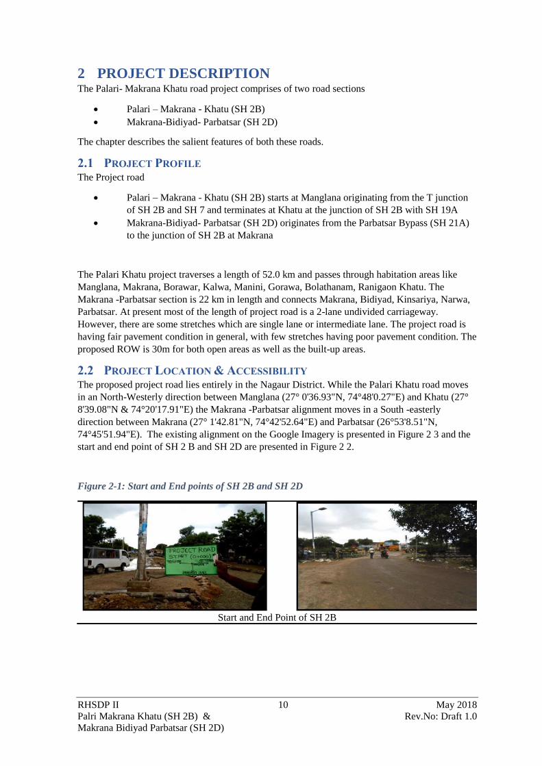
Figure 2-1: Start and End points of SH 2B and SH 2D
Start and End Point of SH 2B

RHSDP II 11 May 2018
Palri Makrana Khatu (SH 2B) & Rev.No: Draft 1.0
Makrana Bidiyad Parbatsar (SH 2D)
Start and End Point of SH 2D
Figure 2-2: Present alignment marked on Satellite Imagery (Google Earth)
Source: Google Earth
2.3 PROJECT FEATURES The features of the exiting road and the proposed road is presented in the following section.
2.3.1 Right of Way
The right of way in SH 2B varied between 6 m and 25 m. At the settlement sections the RoW was
constricted, and some encroachment were also observed. However, at Bidiyad in SH 2D the
constriction was really limiting with ROW of just 4 m. It was thus decided to develop a bypass at
Bidiyad. For the rest of the sections on SH 2D the RoW varied between 8 – 20 m.
Details of existing & proposed RoW in the project stretch are given in Table 2-
Table 2-1: Existing and proposed Right of Way

RHSDP II 12 May 2018
Palri Makrana Khatu (SH 2B) & Rev.No: Draft 1.0
Makrana Bidiyad Parbatsar (SH 2D)
Sl. No Existing Chainage Existing Row Proposed
RoW
Remarks
(Settlement
/ Junction
Etc)
From To
SH 2B
1 0.000 1.600 25 25 SH-2B
2 1.600 1.900 25 68 Toll Plaza
3 1.900 5.000 25 25 SH-2B
4 5.000 9.200 15 16 SH-
2BMakrana
5 9.200 14.692 12 16
SH-
2BMakrana/
Borawar
6 14.692 19.300 25 25 SH-2B
7 19.300 20.250 5 30 Kalwa Bypass
8 20.250 20.420 5 16 SH-2B
Kalwa)
9 20.420 25.900 25 25 SH-2B
10 25.900 27.320 6 30 Manana
Bypass
11 27.320 31.200 25 25 SH-2B
12 31.200 32.750 6 30 Manini
Bypass
13 32.750 36.250 25 25 SH-2B
14 36.250 37.550 25 30
Kalyan Pura
(Gorawa)
Bypass
15 37.550 40.850 25 25 SH-2B
16 40.850 43.000 6 30 Rani Gaon
Bypass
17 43.000 43.725 25 25 SH-2B
18 43.725 44.025 25 68 Toll Plaza
19 44.025 51.875 15 16 SH-2B
SH 2D
20 0.000 0.350 12 16 SH-2D
21 0.350 1.200 15 16 SH-2D
22 1.200 1.400 15 30 Realignment
23 1.400 4.957 15 16 SH-2D
24 4.957 6.126 4 16 SH-2D
25 6.126 8.640 4 30 Bidiyad
Bypass
26 8.640 9.060 8 16 SH-2D
27 9.060 10.400 10 16 SH-2D
28 10.400 10.650 10 30 Realignment
29 10.650 13.040 20 20 SH-2D
30 13.040 13.340 15 68 Toll Plaza
31 13.340 14.193 15 16 SH-2D
32 14.193 20.209 20 20 SH-2D
33 20.209 20.920 15 16 SH-2D
34 20.920 21.220 10 16 SH-2D
35 21.22 22.5 12 16 SH-2D
Source: Feasibility Report

RHSDP II 13 May 2018
Palri Makrana Khatu (SH 2B) & Rev.No: Draft 1.0
Makrana Bidiyad Parbatsar (SH 2D)
2.3.2 Existing Traffic
The project road is divided into three homogenous sections for better assessment of traffic in each
section. The homogenous sections are as follow:
• Homogenous Section (HS)-1: Km 0.000 (Palari) – Km 16.000 (Borawar) on SH 2B
• Homogenous Section (HS)-2: Km 16.000 (Borawar) – Km 52.000(Khatu) on SH 2B
• Homogenous Section (HS)-3: Km 0.000 (Makrana) – Km 22.300 (Parbatsar)
Classified traffic count was carried out at three mid block locations. Of the three locations two
were on SH 2B (Chainage 1+750 and Chainage 44+000) and 1 location (Chainage 13+000) was on
SH 2D. From seven days’ classified traffic count survey was observed to be 6621 and 1738 at the
locations on SH 2B and 3096 at locations on SH 2D. The projected traffic at these locations are
respectively 9986, 2659,4725 PCU’s in 2020 and 33817, 9006, 15999 PCU’s in 2045 respectively.
The traffic was sufficient for development of a 2-lane carriageway.
2.3.3 Existing Road
Carriageway
The detailed inventory on existing carriageway reveals that the project road stretch comprises of
mainly Single/Intermediate/two lane undivided carriageway with 1.0m to 1.5m earthen shoulder
configuration except Makrana urban area where existing road having four lane divided carriageway
in a length of 3.85 km. The existing pavement is flexible at most locations and rigid at some and
the details are given in Annexure 2.2
Pavement Conditions
The existing pavement of project road is bituminous surface with earthen shoulders of width 1.0 m
to 1.5 m exist predominantly on both sides throughout the project stretch. The pavement is flexible
type having earthen/gravel shoulders. Rigid pavement is found only at a few locations e.g. at
Makrana. Pavement condition is fair except few locations where it has been badly damaged. The
pavement is showing signs of distress at some locations. The defects noticed include Cracking
(alligator, transverse, longitudinal, edge cracks), Rutting and edge breaking. The shoulders are
earthen/gravel with fair to poor condition. The road surface is black topped with Bituminous
Macadam (BM); Semi Dense Bituminous Concrete (SDBC); except few locations in habitation
area. At some locations along the corridor the rigid pavement is present and was observed to be in
fair to poor conditions.
Figure 2-3: Condition of Pavement along the Project Road
Road Damage near km 5+700 Road Damage near km 15+550

RHSDP II 14 May 2018
Palri Makrana Khatu (SH 2B) & Rev.No: Draft 1.0
Makrana Bidiyad Parbatsar (SH 2D)
2.3.4 Existing Cross Drainage Structures
There is no major or minor bridge and box culvert in the present alignment. However, there are 2
nos. of rail overbridge bridges at km 3+900 (under construction), km 8+300(open to traffic). In
addition, there are 5 nos. pipe culverts and 4 nos. of slab culverts. Details of the Cross-drainage
structure are provided in Annexure 2.3.
2.3.5 Railway Level Crossings
The Makrana- Jaipur railway line of the North -Western Railways intersects the alignment at three
locations. There are three level crossings in the alignment at:
• km 3+660 after Manglana (2 lane RoB under construction);
• km 7+875 at Makrana (newly constructed 2 lane RoB) and;
• km 15+300 after Makrana (RoB is not warranted as project traffic would not reach the
threshold).
2.3.6 Junctions and Intersections
There are 10 nos. (2 major and 8 minor) of junction in SH 2B and 30 nos. (5 major and 25 minor)
in SH 2D. The details of the junctions are provided in Annexure 2.4
2.3.7 Trees Cutting
The preliminary engineering surveys conform that felling of 212 is required for the improvement
of SH 2B and SH 2D.
2.3.8 Longitudinal Side Drain
Road side drainage is noticed in the settlement area of SH 2B as below:
• Makrana (6+030 to 6+947 RHS)
• Makrana (6+135 to 6+437 LHS)
• Borawar (14+667 to 15+150 LHS)
In case of SH 2D the side drains are available in Bidiyad settlement only
2.4 PROJECT IMPROVEMENT PLAN
2.4.1 Proposed Carriageway Width
As part of the road improvement for SH 2B and SH 2D the existing 2-lane road would be
converted into either:
• 2-lane corridor with 1.5 m wide paved shoulder on either side
• 2-Lane corridor with granular shoulder of 2.5m wide on either side
• Existing 4 lane divided carriageway in a length of 3.850 Km has been retained with the
required strengthening
In addition, provisions the following provision for improvement have been made:
• Geometric Improvements and realignments
• Pavement – strengthening and reconstruction
• Cross-Drainage Structures
• Safety and
• Road Appurtenances
The draft design standards proposed for this project are based on IRC: SP:73 2007,” Manual of
Standards & Specifications for Two Laning of State Highways on BOT basis” for two laning
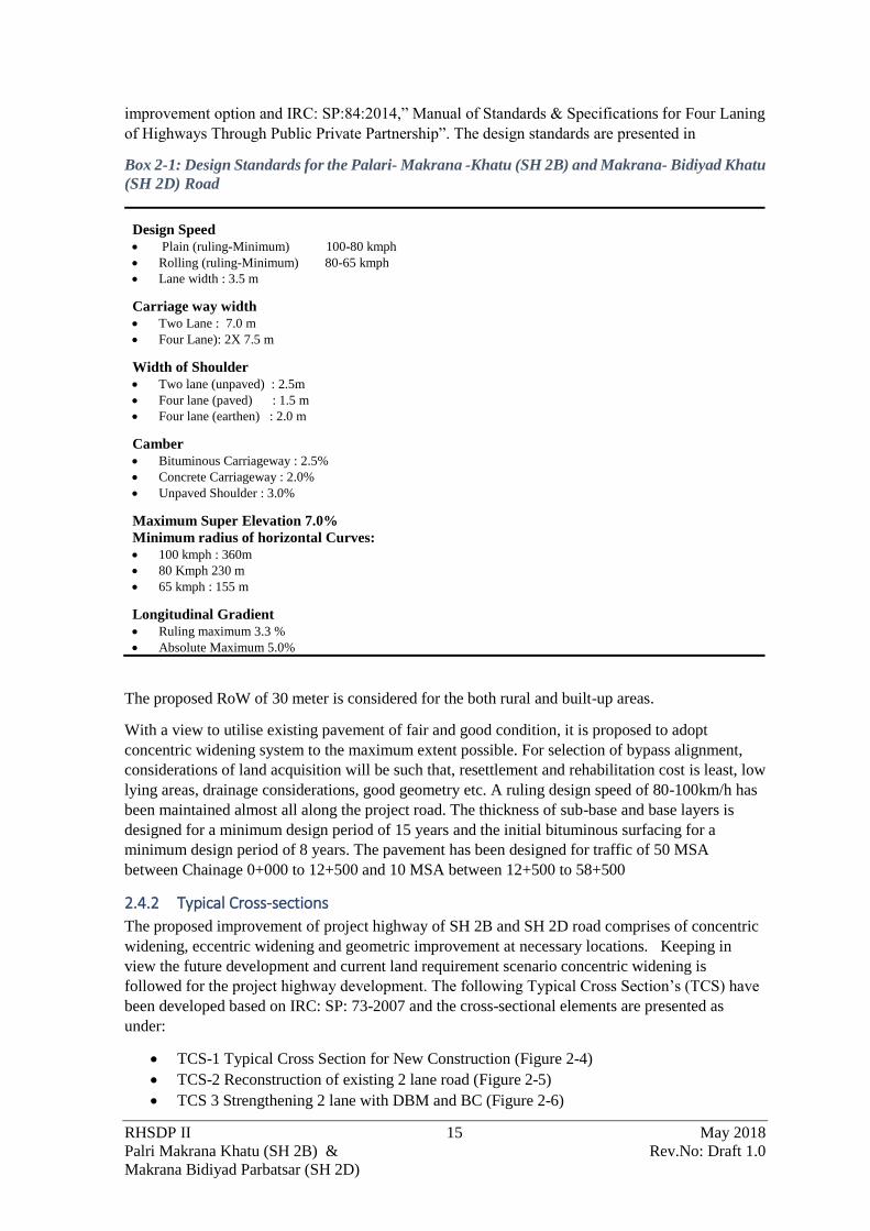
RHSDP II 15 May 2018
Palri Makrana Khatu (SH 2B) & Rev.No: Draft 1.0
Makrana Bidiyad Parbatsar (SH 2D)
improvement option and IRC: SP:84:2014,” Manual of Standards & Specifications for Four Laning
of Highways Through Public Private Partnership”. The design standards are presented in
Box 2-1: Design Standards for the Palari- Makrana -Khatu (SH 2B) and Makrana- Bidiyad Khatu
(SH 2D) Road
Design Speed
• Plain (ruling-Minimum) 100-80 kmph
• Rolling (ruling-Minimum) 80-65 kmph
• Lane width : 3.5 m
Carriage way width
• Two Lane : 7.0 m
• Four Lane): 2X 7.5 m
Width of Shoulder
• Two lane (unpaved) : 2.5m
• Four lane (paved) : 1.5 m
• Four lane (earthen) : 2.0 m
Camber
• Bituminous Carriageway : 2.5%
• Concrete Carriageway : 2.0%
• Unpaved Shoulder : 3.0%
Maximum Super Elevation 7.0%
Minimum radius of horizontal Curves:
• 100 kmph : 360m
• 80 Kmph 230 m
• 65 kmph : 155 m
Longitudinal Gradient
• Ruling maximum 3.3 %
• Absolute Maximum 5.0%
The proposed RoW of 30 meter is considered for the both rural and built-up areas.
With a view to utilise existing pavement of fair and good condition, it is proposed to adopt
concentric widening system to the maximum extent possible. For selection of bypass alignment,
considerations of land acquisition will be such that, resettlement and rehabilitation cost is least, low
lying areas, drainage considerations, good geometry etc. A ruling design speed of 80-100km/h has
been maintained almost all along the project road. The thickness of sub-base and base layers is
designed for a minimum design period of 15 years and the initial bituminous surfacing for a
minimum design period of 8 years. The pavement has been designed for traffic of 50 MSA
between Chainage 0+000 to 12+500 and 10 MSA between 12+500 to 58+500
2.4.2 Typical Cross-sections
The proposed improvement of project highway of SH 2B and SH 2D road comprises of concentric
widening, eccentric widening and geometric improvement at necessary locations. Keeping in
view the future development and current land requirement scenario concentric widening is
followed for the project highway development. The following Typical Cross Section’s (TCS) have
been developed based on IRC: SP: 73-2007 and the cross-sectional elements are presented as
under:
• TCS-1 Typical Cross Section for New Construction (Figure 2-4)
• TCS-2 Reconstruction of existing 2 lane road (Figure 2-5)
• TCS 3 Strengthening 2 lane with DBM and BC (Figure 2-6)

RHSDP II 16 May 2018
Palri Makrana Khatu (SH 2B) & Rev.No: Draft 1.0
Makrana Bidiyad Parbatsar (SH 2D)
• TCS 4 Widening of Intermediate lane to 2-lane (Figure 2-7)
• TCS 4A New Construction Rigid Pavement (Figure 2-8)
• TCS 5 Widening & reconstruction of Intermediate lane (Figure 2-9)
• TCS 6 Widening & Reconstruction of Single Lane road (Figure 2-10)
• TCS 7 Widening and strengthening of 2-lane with DBM and BC (Figure 2-11)
• TCS 8 Reconstruction of 4 lane reconstruction with bituminous Course with median
(Figure 2-12)
• TCS 9: Reconstruction of 4 Lane Road pavement with Median (Figure 2-13)
• TCS 10: Strengthening of 4-lane with DBM and BC (Figure 2-14)
• TCS 11 Typical Cross Section for widening of 2- lane to four lane and strengthening with
DBM and BC (Figure 2-15)
• TCS 12 Strengthening of 2 lane paved shoulder with DBM and BC (Figure 2-16)
• TCS 13 Typical Cross Section for Eccentric Widening (Figure 2-15)
The typical cross sections are also presented in figures as indicated above
Figure 2-4: TCS-1 Typical Cross Section for New Construction
Figure 2-5: TCS-2 Typical Cross-section for Reconstruction of existing 2 lane road
Figure 2-6: TCS 3 Typical cross section for strengthening 2-lane with DBM and BC

RHSDP II 17 May 2018
Palri Makrana Khatu (SH 2B) & Rev.No: Draft 1.0
Makrana Bidiyad Parbatsar (SH 2D)
Figure 2-7: TCS 4 Typical Cross for Widening of Intermediate lane to 2-lane
Figure 2-8: TCS 4A Typical Construction for New Construction Rigid Pavement
Figure 2-9: TCS 5 Typical Cross Section for Widening & reconstruction of Intermediate lane

RHSDP II 18 May 2018
Palri Makrana Khatu (SH 2B) & Rev.No: Draft 1.0
Makrana Bidiyad Parbatsar (SH 2D)
Figure 2-10: TCS 6 Typical Cross Section for Widening & Reconstruction of Single Lane road
Figure 2-11: TCS 7 Typical Cross Section for widening and strengthening of 2 lane with DBM
and BC
Figure 2-12: TCS 8 Typical cross section for reconstruction of 4 lane reconstruction with
bituminous Course with median
RHSDP II 19 May 2018
Palri Makrana Khatu (SH 2B) & Rev.No: Draft 1.0
Makrana Bidiyad Parbatsar (SH 2D)
Figure 2-13: TCS 9 Typical Cross section for 4 Lane Reconstruction of Road pavement with
Median
Figure 2-14: TCS 10 Typical Cross Section for strengthening of 4-lane with DBM and BC
Figure 2-15: TCS 11 Typical Cross Section for widening of 2- lane to four lane and strengthening
with DBM and BC
Figure 2-16: TCS 12 Strengthening of 2 lane paved shoulder with DBM and BC

RHSDP II 20 May 2018
Palri Makrana Khatu (SH 2B) & Rev.No: Draft 1.0
Makrana Bidiyad Parbatsar (SH 2D)
Figure 2-17: TCS 13 Typical Cross Section for Eccentric Widening
2.4.3 Proposed widening and pavement
Widening Schedule
For most of the alignment in SH 2B (Palari-Makrana- Khatu) the Typical Cross section 5 (2 lane
paved shoulder) has been provided except for sections where 4- laning is proposed or in case of
settlements. In case of SH 2D throughout the alignment Typical Cross Section ( TCS- 2)2-lane
with granular shoulder would be prepared except at toll plaza where rigid pavement has been
proposed.
Only one bypass has been proposed i.e. Bidiyad Bypass of 3 km length. Realignment the typical
cross section ( TCS- 1) 2-lane with granular shoulder has been proposed. The proposed widening
schedule for project highway is presented in Annexure 2.6.
Pavement Design
Pavement for the new carriageway has been designed as per IRC: 37: 2102. The rigid pavement
shall be provided at Toll Plaza Location and existing rigid pavement locations.

RHSDP II 21 May 2018
Palri Makrana Khatu (SH 2B) & Rev.No: Draft 1.0
Makrana Bidiyad Parbatsar (SH 2D)
2.4.4 Bridge & Cross Drainage Structures
Of the 9 present CD structures on 1 would be retained and of the remaining 8, 5 would be
reconstructed and 3 would be widened. There is no proposal for new bridges or culverts
2.4.5 Toll Plaza
2 nos. of Toll plazas have been proposed one each on SH 2B and SH 2D at chainage 1+750 and
13+000 respectively.
2.4.6 Bus-Shelters
Bus-shelters are proposed at 6 locations on both sides of the project road. 2 of them are in SH2B
and 3in SH 2D. The locations of these are presented in Table 2-1.
Table 2-1:Location of Bus shelters
Sl. No Design Chainage Side of the carriageway Village Name
State Highway SH 2B
1. 0+300 LHS Maglana
2. 0+320 RHS Maglana
3. 14+700 LHS Borawar
4. 14+730 RHS Borawar
State Highway SH 2D
5. 4+250 LHS Industrial area
Gunawati
6. 4+250 RHS Industrial area
Gunawati
7. 13+500 LHS Kinsariya
8. 13+550 RHS Kinsariya
9. 16+000 LHS Basani Sandwa
10. 16+050 RHS Basani Sandwa
11. 77+154 Both LHS & RHS (same chainage) Khidarpura
Source: Feasibility Study
2.4.7 Junction improvement
The investment proposal includes proposal for improvement of all the existing 10 (2 major and 8
minor) and 30 (5 major and 25 minor) junctions on SH 2B and SH 2D respectively into priority
junctions.
2.5 PROJECT ENVIRONMENTAL SETTING The proposed Palri- Makrana- Khatu Road starts at Malanga town and traverses in a North -
Western directions till Makrana. The SH 2D originates from Makrana and moves in a South
westerly direction initially and then moves in a south easterly direction to Parbatsar. The SH 2B
continues further north in a north-westerly direction and terminates junctions of SH 19 and SH 2B
approximately 1.3 km South west of Khatu Kurd and 2.5 K North east of Khatu Kalan.
• Both project roads are in Nagaur district. While SH 2B traverses through Parbatsar (5 km),
Makrana (41.27 km) and Deedwana (5.3 km) block/tehsils the SH 2D traverses primarily
through Parbatsar (13.80 km) and Makrana (7.20 km) tehsils.
• The SH 2B cross the Aravalli Range between Makrana and Malanga while SH 2D crosses
the range near Kinsariya. However, the major portion of the alignment in SH 2B lies on the
western side of the Aravalli and lies in the arid region. The SH 2D however runs parallel to
the Aravalli range
• The alignment passes through the marble quarry areas of Makrana and Bidiyad and the
marble trading areas of Borawar.

RHSDP II 22 May 2018
Palri Makrana Khatu (SH 2B) & Rev.No: Draft 1.0
Makrana Bidiyad Parbatsar (SH 2D)
2.6 COMPONENTS & ACTIVITIES OF THE PROPOSED PROJECT The development of the road would necessarily entail the following three stages. Each of the stages
would have several activities and sub-activities. The three stages are
• Detailed design and Pre-Construction Stage
• Construction Stage
• Post-Construction, Operations & Maintenance Stage
The sub-activities and activities which would be undertaken in each of the three stages are detailed
in Figure 2-18.
2.7 INFRASTRUCTURE REQUIREMENT FOR HIGHWAY DEVELOPMENT During the construction and operations of the highway the following infrastructure would be
developed and maintained by the Contractor
Construction Camp
Even though local labour would be employed to the extent possible number of activities would
require specialised skilled labour e.g. operator of the vehicle and machinery, skilled crews for
specialised operations e.g. bar-bending and casting. These labours in most cases would be migrant
from other parts of Rajasthan or other states. The Contractor would setup a construction camp for
the accommodation of the workers.
Figure 2-18: Activities in the Typical Highway development project under PPP mode

RHSDP II 23 May 2018
Palri Makrana Khatu (SH 2B) & Rev.No: Draft 1.0
Makrana Bidiyad Parbatsar (SH 2D)
Hot Mix Plant
For the manufacturing of the Bituminous material the Contractor would setup a Hot mix Plant. The
plant would be setup considering the siting guidelines specified by regulatory authorities.
Batching Plant
The Concrete batching plant would also be installed for concrete casting of structures i.e. Minor
bridges, box and Hume pipe culverts. The Batching plant in addition to cylos for cement,
aggregates and sand would also have an area for storage of cement and additives.
Laydown Areas
The contractor would identify an area for storage of the raw-material required for construction
including soil, sand GSB and aggregates. These would be stored as open heaps within the laydown
area. The laydown area might also be sued as a maintenance yard for the vehicles and machinery.
Waste Storage Area

RHSDP II 24 May 2018
Palri Makrana Khatu (SH 2B) & Rev.No: Draft 1.0
Makrana Bidiyad Parbatsar (SH 2D)
The excavate material from the pavement would have to be stored at some places before it can be
utilised or disposed of at a permanent disposal site provided by the PWD or the panchayat.
2.8 RESOURCE REQUIREMENTS FOR THE PROJECT
Soil for the embankment, sub grade and shoulders
The Feasibility studies have estimated that 4,90,690.67cum of earth would be required for the
embankment. This would be sourced from borrow areas which would be identified by the
Contractor at the time of construction. The locations of the borrow area would not only satisfy the
requirements of MoRTH specifications but also meet the environmental health safety requirement.
Granular material for sub-base
The feasibility studies estimated that 2,59,895.11cum of granular sub-base would be required.
These would be sources from local sources in the proximity to the project locations. The facilities
which operate with valid environmental clearance would only be selected by the contractor during
the Pre- Construction stage
Stone aggregate for use in pavement course and cement concrete
The preliminary design estimates that 27,306.67 cum of bituminous concrete and 15.911. 80 cum
of Dense Bituminous Macadam would be used for the project. The aggregate required for these
works would be sources from licensed quarriers. The Contractor shall identify these during the pre-
construction stage
Power
Power required at the construction camp would be drawn from the grid where it is available else
DG sets would be used to supply the power to the Camp. 2 nos. of 250 KVA DG set would be used
for the supply of power. 1 DG would be in running condition and 1 on standby. In addition, one
nos. of 100 KVA DG set would be used for domestic purpose.
Manpower
The manpower requirement would vary over the construction period depending on the quantum
and type of work involved. The peak manpower requirement would be approximately 150 which
the average manpower requirement for the project road would be approximately 75. The skilled
manpower, primarily the machine operators and concrete casting crew would be migrant labour
and would be housed in the construction camp. On an average the crew in the construction camp is
likely to be around 50 persons at any given point of time. The remaining 25 workmen would be
local labour who would be working as day labours
Time Frame
The construction period would be 24 months and the earth work and GSB would be completed
within the 6- 9 months.
Water
Water requirement during the construction stage has been calculated considering the above
timeframe. The project would require water for both construction activities and domestic purpose
during the construction period. The operations period of the project would have water requirement,
but the quantities required would be much lesser in quantities.

RHSDP II 25 May 2018
Palri Makrana Khatu (SH 2B) & Rev.No: Draft 1.0
Makrana Bidiyad Parbatsar (SH 2D)
The water requirement for construction depends on the climatic conditions, type of equipment,
type of material available, mix design; type of construction. Water quantity required for the project
road has been calculated considering the following:
• 8-10% of weight of soil for the embankment construction
• 7-8% of weight of soil for sub grade construction
• 5-6% of weight of GSB materials for GSB and WMM
• 150 litre/cum for concrete
• 110 lpcd for person residents of the camp
• 45 lpcd for the no-residents
Considering the above it is estimated that during the earthwork and the subgrade formation the
total consumption of water is around 45,850 KL which would be an average of 175-200 KLD
during the peak construction period. This would be inclusive of 263 KL of water required for
concrete casting.
In addition to the above approximately 6-7 KLD of water would be required for domestic purpose
at the camp and construction site. During the operations phase the water would be required
primarily for domestic use at the toll plaza and landscaping. The daily consumption would be
around 5 KLD
2.9 POLLUTANT SOURCES & CHARACTERISATION
2.9.1 Construction Phase
During construction phase environmental impacts are likely to result primarily from operation of
heavy machinery and equipment, vehicular movement and from influx of workforce. The potential
pollutant sources for construction phase and their characterisation has been discussed in the
subsequent section.
Operations of Heavy Machineries & Vehicular Movement
The operations of construction vehicles, diesel generators and machineries would contribute to
Suspended Particulate Matter (SPM), Sulphur and Nitrogen dioxides (SO2 and NOx), Carbon
monoxide (CO) and other hydrocarbons (HC).
In addition, fugitive emissions are envisaged from plying of vehicles and also from storage,
handling and transportation of materials during the construction phase. Mainly dust will be emitted
during material transport and during loading-unloading activities which is planned to be controlled
by periodic water sprinkling and by adopting adoption of good engineering practices.
Also, during construction phase, noise will be generated from operating heavy machineries to be
used and from vehicular movement. All the generator sets will be equipped with exhaust mufflers
and acoustic enclosures and subjected to periodic preventive maintenance.
Generation of Construction waste
It has been estimated in the Feasibility Report that approximately 1.49 lakhs cum of earth would be
excavated and 1.59 lakhs cum of scarified bitumen would be generated from the existing
carriageway. In addition, there would be waste from the batching plant, hot mix plant and from the
demolition of existing cross drainage structures on the road. Some of the material would be
recycled and used for back filling. Material which cannot be recycled would be considered as
Construction and Demolition waste and has to be disposed of as per the existing rules.

RHSDP II 26 May 2018
Palri Makrana Khatu (SH 2B) & Rev.No: Draft 1.0
Makrana Bidiyad Parbatsar (SH 2D)
Influx of Workforce
Sewage effluent will be to be generated during this phase from construction camps. Solid waste
generated during the construction phase from the camps is expected to comprise of food waste and
recyclables viz. packaging material, etc. such
2.9.2 Operation Phase
During operations of the proposed highway both solid (municipal) and liquid waste would be
primarily generated from toll plaza and rest area. In case of maintenance the bituminous layer
would be excavated during the repair of pavement and needs to be disposed of.

RHSDP II 27 May 2018
Palri Makrana Khatu (SH 2B) & Rev.No: Draft 1.0
Makrana Bidiyad Parbatsar (SH 2D)
3 POLICY, LEGAL & ADMINISTRATIVE FRAMEWORK
3.1 INTRODUCTION To address environmental risks of the project and its associated components and to protect and
conserve the environment from any adverse impacts, the regulations, policy and guidelines enacted
by the Government of India and Government of Rajasthan which must be followed are presented in
the sections below. In addition, The World Bank have their own set of requirements i.e. the
Operational Policy to which any project funded by them must also ensure compliance.
This Section focuses on the administrative framework under the purview of which the Project will
fall and the ESIA study will be governed, namely:
• The national and local, legal and institutional framework;
• World Bank Policies and framework; and
• International Safeguard Requirements.
3.2 OVERVIEW OF INDIAN ENVIRONMENTAL LEGISLATION AND
ADMINISTRATIVE FRAMEWORK The Constitution of India under Article 21 assures that “The State shall endeavour to protect and
improve the environment and to safeguard the forests and wildlife of the country.” Similarly,
Article51 (A) also make say that “It shall be the duty of every citizen of India to protect and
improve the natural environment including forests, lakes, rivers and wildlife and to have
compassion for living creatures.” Considering the direction from the constitution, the Government
of India has laid out various policy guidelines, acts and regulations pertaining to protection of
environment. Consequently, the individual states have also framed rules to further the cause of
environment projection.
The Environment (Protection) Act, 1986 provides umbrella legislation for the protection of
environment. As per this Act, the responsibility to administer the legislation has been jointly
entrusted to the Central Ministry of Environment Forests and Climate Change (MoEF&CC) and
the Central Pollution Control Board (CPCB) / State Pollution Control Board (SPCB).
3.3 APPLICABLE ENVIRONMENTAL LEGISLATION The legislation rules and policies applicable to the project has been reviewed and the actions which
would be required has also been defined. The summary also provides the responsibilities for the
implementation along with the statutory agency responsible for its enforcement. A summary of
environmental legislations / regulations relevant to Palri-Makrana - Khatu , Makrana – Bidiyad
Parbatsar is furnished in Table 3-1.

RHSDP II 28 May 2018
Palri Makrana Khatu (SH 2B) & Rev.No: Draft 1.0
Makrana Bidiyad Parbatsar (SH 2D)
Table 3-1: Summary of the Legal and Policy requirement in the Project
Policy/Acts/Rules Applicable /Project Relevant
policies
Responsible Agency Implications for Palri-
Makrana -Khatu (SH 2B) and
Makrana Parbatsar (SH 2D)
Road
Responsible Institution
The Environment
Protection Act
1986
The Environment (Protection) Act
is an umbrella legislation seeking to
supplement the existing laws on the
control of pollution (the Water Act
and the Air Act) by enacting a
general legislation for environment
protection and to fill the gaps in
regulation of major environmental.
hazards.
The act empowers central
government to make rules to
regulate environmental pollution,
such as- Prescribe the standards of quality of air,
water, soil for various areas and
purposes etc.
Prohibits carrying out of any industry,
operation or process which discharges
or emits environmental pollution more
than the standards
Regulates handling of hazardous
substances
• States, the persons
responsible for discharges,
bound to prevent or
mitigate environmental
pollution and intimate the
MoEFCC The Act and the Rules framed
under the act defines the
standards for emission and
discharges. All the equipment
machinery which would be used
in the project has to comply
with the emission and or
discharge standards specified.
The wastes which would be
generated if gets classified
under any of the said category
(municipal, plastic, construction
and demolition, hazardous, e-
waste etc) would also have to
meet the requirements of the
rules framed under the
provisions of the act.
The responsibility of ensuring
compliance to these rules and
standards under the act would lie
with the Contractor. However, The
PPP Division of the PWD needs to
have oversight and would be
responsible for ensuring
compliance as an employer.

RHSDP II 29 May 2018
Palri Makrana Khatu (SH 2B) & Rev.No: Draft 1.0
Makrana Bidiyad Parbatsar (SH 2D)
Policy/Acts/Rules Applicable /Project Relevant
policies
Responsible Agency Implications for Palri-
Makrana -Khatu (SH 2B) and
Makrana Parbatsar (SH 2D)
Road
Responsible Institution
any accidents due to any
occurrences
EIA
Notification
2006 and amendments
thereafter
Sand borrow soil and aggregate
used for road construction has been
classified as a minor mineral as per
The Rajasthan Minor Mineral
Concession Rules, 2017.
District Level Expert
Appraisal
Committee/ District
Level Impact
Assessment
Authority
The quarry sites borrow areas
and the sand mines would
require a prior environmental
clearance under the EIA
Notification 2006.
The Contractor has to obtain
necessary clearance before use of
any borrow area and quarry. The
PPP Division through the
PIU/Authority Engineer should
ensure that no un-authorised sites
are used for procuring the
construction material
The Forest
Conservation Act
1980 and The
Forest
Conservation Rules
1981
The central government enacted
The Forest (Conservation) Act in
1980 to stop largescale diversion of
forestland for non-forest use.
The Forest
Department,
Government of
Rajasthan and
MoEF&CC
The proposed alignment does
not pass through any forest area
hence no clearance is required.
Any change in the alignment would
require a fresh diligence to be
carried out to assess the
implications on forest and
protected areas. Highways /sub-
projects passing through any
protected area (e.g. National Park,
Reserve Forest, Protected Forest
Wildlife Sanctuaries) or requiring
use of any forest land for
construction would need to obtain
prior clearance6 under the
provisions of the Act
6 As per the Forest Conservation Rules (1981, amended 2003) a Forest Clearance from Department of Forests is required for diversion of forest land for non-forest purpose. Processing of the forestry clearance entails
two stages: stage I and stage II. Amongst other requirements stage I clearance requires the
applicant to make payments for compensation of forestry land that will be acquired and trees that will be cut under the project. Accordingly timely allocation of budget for this purpose by the applicant is necessary to expedite the clearance process.

RHSDP II 30 May 2018
Palri Makrana Khatu (SH 2B) & Rev.No: Draft 1.0
Makrana Bidiyad Parbatsar (SH 2D)
Policy/Acts/Rules Applicable /Project Relevant
policies
Responsible Agency Implications for Palri-
Makrana -Khatu (SH 2B) and
Makrana Parbatsar (SH 2D)
Road
Responsible Institution
The Wildlife
Protection Act
19727 and the
Supreme Court
Ruling thereto
The act was enacted to protect wild
animals and birds through the
creation of National Parks,
Sanctuaries, Conservation Reserve,
Tiger Reserve.
Wildlife Division,
Government of
Rajasthan/
MoEF&CC
The present alignment does not
pass through any wild life
sanctuary
Not applicable
Notification of
Eco-Sensitive
Zones
Non-forest activities in the eco-
sensitive zone around a Wildlife
Sanctuary or National Park would
require recommendation8 of the
National Board of Wildlife
Wildlife Division,
Government of
Rajasthan/
MoEF&CC
There are no Eco-Sensitive
Zone in the Project Influence
Area
Not applicable
The Water
(Prevention and
Control of
Pollution) Act 1972
(Amended 1988)
and Rules 1974
The Act vests regulatory authority
on the State Pollution Control
Board and empowers them to
establish and enforce effluent
standards for industries and local
authorities discharging effluents.
Rajasthan State
Pollution Control
Board
All the discharges from the
project activities especially
construction camps/Labour
Camps need to meet the
standards specified.
The Contractor has to obtain a
Consent to Operate under the said
Act. The Consent has to be
regularly renewed during the tenure
of the project. The PPP Division
through the Authority Engineer
should ensure compliance.
The Air
(Prevention and
Control of
Pollution) Act,
1981(Amended
1987) and Rules
1982
An Act to provide for the
prevention, control and abatement
of air pollution
The Act vests regulatory authority
on the State Pollution Control
Board and empowers them to
establish and enforce emission
standards for industries, other
Rajasthan State
Pollution Control
Board
Applicable for equipment and
machineries potential to emit air
pollution e.g. hot mix plant,
rock crusher, diesel generator
and construction vehicles need
to adhere to the norms specified
in the rules. Consent for
Establishment (CFE) and
Consent for Operation (CFO)
The Contractor has to obtain a
Consent to Operate under the said
Act. The Consent has to be
regularly renewed during the tenure
of the project. The PPP Division
through the Authority Engineer
should ensure compliance.
7 Hon'ble Supreme Court though a number of order has made it essential to seek the recommendations of the National Board of Wild Life for regulating activities in the adjoining areas to the Protected Areas. Protection 8 In pursuance to the order of Hon'ble Supreme Court dated 4th December 2006 in \Writ Petition (Civil) No. 460/2004, all non-forest activities in the Ecosensitive Zone would be under the jurisdiction of the
notification. The Hon’ble Supreme Court vide its order dated 4th December 2006 had further directed that in case the Eco-Sensitive Zones are not declared by the respective states an area of 10km adjoining the
sanctuary or national park would be declared as an Eco-Sensitive Zone

RHSDP II 31 May 2018
Palri Makrana Khatu (SH 2B) & Rev.No: Draft 1.0
Makrana Bidiyad Parbatsar (SH 2D)
Policy/Acts/Rules Applicable /Project Relevant
policies
Responsible Agency Implications for Palri-
Makrana -Khatu (SH 2B) and
Makrana Parbatsar (SH 2D)
Road
Responsible Institution
activities including local authorities
carrying out emissions.
would be required for the plants
from RSPCB prior to the
establishment
Ancient
Monuments &
Archaeological
Sites and Remains
Act, 1958;
Indian Treasure
Trove Act, 1878;
The Rajasthan
Monuments,
Archaeological
Sites and
Antiquities (Act
1961) & Rules
(19680
This Act provides for the
preservation of ancient and
historical monuments,
Archaeological sites, remains of
national importance, sculptures,
carvings, etc.
According to this Act, areas within
the radii of 100m and 300m from
the 'protected property' are
designated as 'protected areas' and
'controlled areas' respectively. No
development is permitted in such
areas without prior permission from
the Archaeological Survey of India
(ASI).
Rajasthan
Archaeological
Dept. &
Archaeological
Survey of India
The proposed alignment would
not interfere or infringe on any
archaeological monument in
Jodhpur or Nagaur District.
However, in case of Chance
find the provisions of the Indian
Treasure Trove Act, 1878
The Contractor and PPP Division
have to ensure compliance of the
Indian Treasure Trove Act, 1878 in
case of chance finds
Solid Waste
Management
Rules 2016
• Source segregation of degradable,
non-degradable and hazardous
wastes to be ensured.
The municipal solid waste
generated from the labour
camps would have to comply
with the provisions of
segregation of waste and its
treatment & disposal.
The Contractor has to ensure
compliance to the rules
Construction
and
Demolition
Wastes
(Management)
Rules 2016
• Every waste generator shall
prima-facie be responsible for
collection, segregation and storage
of construction and demolition (C
& D) waste generated, as directed
or notified by the concerned local
Rajasthan State
Pollution Control
Board
Sub-projects would generate
construction waste during the
dismantling of the old pavement
or cross drainage structures.
These wastes must be
segregated, stored and disposed
The Contractor has to ensure
compliance and ensure disposal.
However, the excavated material
can only be declared as a waste in
case the Authority Engineer

RHSDP II 32 May 2018
Palri Makrana Khatu (SH 2B) & Rev.No: Draft 1.0
Makrana Bidiyad Parbatsar (SH 2D)
Policy/Acts/Rules Applicable /Project Relevant
policies
Responsible Agency Implications for Palri-
Makrana -Khatu (SH 2B) and
Makrana Parbatsar (SH 2D)
Road
Responsible Institution
authority in consonance with these
rules.
• The generator shall ensure that
other waste (such as solid waste)
does not get mixed with this waste
and is stored and disposed
separately.
• Any activity that generates 20
tonnes per day or 300 tonnes per
project in a month must prepare a
Waste Management Plan.
• Waste generator either must store
the waste within the premises or
must supply to the city level
collection centre and should avoid
all kinds of obstruction to
traffic/public or in drains.
of separately as per the
provision of these rules. A
Waste Management Plan would
also be developed for the
project.
certifies that the same cannot be
used for any other use.
Hazardous Waste
(Management,
Handling and
Trans-boundary
Movement)
Rules 2008
(Amended 2009),
The rules regulate the management
and handling of Hazardous Waste
generated from any activity. The
rules make a distinction between
hazardous waste and other waste
(Waste tyre, paper waste, metal
scrap, used electronic items, etc)
and recognise them as resource for
recycling and reuse.
Rajasthan State
Pollution Control
Board
The hazardous waste generated
from the construction e.g. waste
oils, lubricants, and bitumen
would have to comply with the
provisions of the rules with
regards to storage and disposal.
The rules also make it
mandatory for maintaining
records and reporting the same
to the RSPCB.
The Contractor Would have to
obtain an authorisation as a
generator of hazardous waste from
the Rajasthan pollution Control
boards. All the waste oil, lubricants
would have to be disposed as per
the provisions of the act. The PPP
Division/Authority Engineers has
to ensure that the Contractor
complies with these provisions
Central Motor
Vehicle Act (1988)
The act and the rules formulated
thereunder have provisions for
control of vehicular air and noise
Transport
Department,
The vehicles must obtain a
Pollution Under Control
The Contractor has to ensure all
vehicle operating in the project
ether directly under their control or

RHSDP II 33 May 2018
Palri Makrana Khatu (SH 2B) & Rev.No: Draft 1.0
Makrana Bidiyad Parbatsar (SH 2D)
Policy/Acts/Rules Applicable /Project Relevant
policies
Responsible Agency Implications for Palri-
Makrana -Khatu (SH 2B) and
Makrana Parbatsar (SH 2D)
Road
Responsible Institution
Central Motor
Vehicle Rules
(1988)
pollution. They regulate
development of the transport sector,
check and control vehicular air and
noise pollution.
Government of
Rajasthan
Certificate under the provisions
of the Act.
through subcontractor have valid
Pollution under Control
Certificates.
Rajasthan Land
Revenue Act,1956
and its amendments
No forest produce shall be moved
into or from or within any area in
the State of Rajasthan without a
pass issued by a Forest Officer and
as per the conditions specified in
the pass
District
Administration
The removal of trees from
forest land would require
authorisation from the District
Administration. The trees on
private land are being dealt
separately in the Resettlement
Action Plan
The Contractor has to obtain
permission for felling of trees on
government land.
Abstraction of
Ground water u/s 5 of
the Environment
(Protection) Act,
1986
Abstraction of groundwater is a
regulated activity and would
require a permission from CGWB
or State Groundwater Department,
State Groundwater
Department
In case the Contractor abstracts
groundwater for the
construction purpose the
permission has to be obtained
under the
The PPP Cell through the PIU
ensure that the contractor procures
water only from borewells
registered for the purpose of
development of infrastructure. Fly Ash Notification
2016 The Notification mandates road
construction projects within an area
of 300 Km to mandatorily use fly
ash for construction of the
embankment.
Ministry of
Environment Forest
and Climate Change
The Contractor has to use the
fly ash from Kota Thermal
Power Plant in Kota
The responsibilities lie with the
Contractor while the PPP
division/Authority Engineer has to
ensure that the fly ash utilisation
takes place. As per the direction of
the NGT9 the PPP division as
employer is responsible for
ensuring utilisation of fly ash.
9 Application No. 102 of 2014 by Sandplast (India) & Anr. regarding Utilization of Fly Ash

RHSDP II 34 May 2018
Palri Makrana Khatu (SH 2B) & Rev.No: Draft 1.0
Makrana Bidiyad Parbatsar (SH 2D)
Policy/Acts/Rules Applicable /Project Relevant
policies
Responsible Agency Implications for Palri-
Makrana -Khatu (SH 2B) and
Makrana Parbatsar (SH 2D)
Road
Responsible Institution
Aravalli Notification
2006 The Aravalli Notification states that
identified activities10 in the
notification in reserve forest,
protected forest or designated as
forest in land records or all land
designated as Gair Mumkin Pahar,
Gair Mumkin Rada, Gair Mumkin
Behed, Banjad Beed, Rundh as per
land records in Gurgaon district of
Haryana and Alwar districts of
Rajasthan would be covered under
the Notification and would require
a clearance from the District Expert
Committee in the Gurgaon and
Alwar.
District Level
Committee (Alwar)
The are located in Nagaur
district so that would not be
covered under the Aravalli
Notification 2006
NA
10 (i) Location of any new industry including expansion modernisation; (ii) (a) All new mining operations including renewals of mining leases, (b) Existing mining leases in sanctuaries/national Park and areas covered under Project Tiger and/or (c) Mining is being done without permission of the competent authority, (iii) Cutting of trees;
(iv) Construction of any clusters of dwelling units, farms houses, sheds, community centres, information centres and any other activity connected with such construction (including roads a part of any infrastructure
relating thereto); (v) Electrification (laying of new transmission lines).

RHSDP II 35 May 2018
Palri Makrana Khatu (SH 2B) & Rev.No: Draft 1.0
Makrana Bidiyad Parbatsar (SH 2D)
3.4 OPERATIONAL POLICIES OF WORLD BANK Projects financed with World Bank assistance should comply with World Bank Operational
Policies. The objective World Bank’s environmental safeguard policies are to prevent and mitigate
undue harm to people and the environment in the development process. These policies provide
guidelines for the identification, preparation, and implementation of programs and projects. The
World Bank Environmental Safeguard Policies which would be triggered due to the project and are
presented in Table 3-2
Table 3-2:Applicable World Bank Policies in the Project
World Bank
Safe Guard
Policies
Objective Safeguard Requirements Applicability
to Palri-
Makrana –
Khatu
Project OP 4.01:
Environmental
Assessment
The policy requires environmental
assessment (EA) of projects under
Bank financing to help ensure that
they are environmentally sound and
sustainable. EA considers the
natural environment (air, water, and
land); human health and safety;
social aspects (involuntary
resettlement, indigenous peoples,
and physical cultural resources); and
transboundary and global
environmental aspects.
The environmental issues in
all projects need to be
addressed adequately in
advance. An integrated
Environmental Screening
and Environmental
Assessment (EA) with
Environmental Management
Plan (EMP) needs to be
developed to manage
environmental risks and
maximise environmental
benefits
For each of the
sub project road
an
Environmental
Assessment and
Environmental
Management
Plan would be
carried out
covering all the
phases of the
project
OP 4.04 Natural
Habitats
The policy recognises that the
conservation of natural habitats is
essential for long-term sustainable
development. This policy provides
for the conservation of natural
habitats, which is essential for long-
term sustainable development. The
Bank supports the protection,
maintenance, and rehabilitation of
natural habitats and their functions
in its economic and sector work,
project financing, and policy
dialogue.
This policy may be triggered
by the sub-projects where
improvement activity of road
would require forest/
sanctuaries, locating close to
the natural habitats.
Additionally, conservations
areas which are not legally
protected but have significant
wildlife may also be called a
modified habitat and would
also trigger this policy
In case of the
sub-project road
this would not
be triggered
OP 4.36: Forest This policy focuses on the
management, conservation, and
sustainable development of forest
ecosystems and
resources. It applies to
project that may have
impacts on (a) health and quality of
forests;
(b) affect the rights and
welfare of people and their level of
dependence
upon forests and projects that aim to
bring about changes in
the management, protection or
utilisation of natural forests or
plantations, whether they are
publicly, privately or community
Efforts would be made to
ensure that the widening
/construction of sub-projects
do not infringe upon Forest
lands
This would also
not be triggered
in case of this
road

RHSDP II 36 May 2018
Palri Makrana Khatu (SH 2B) & Rev.No: Draft 1.0
Makrana Bidiyad Parbatsar (SH 2D)
World Bank
Safe Guard
Policies
Objective Safeguard Requirements Applicability
to Palri-
Makrana –
Khatu
Project
owned. The Bank does not support
the significant conversion or
degradation of
critical forest areas or related critical
natural habitats.
The Operational Policy (OP) 4.01 classifies projects into:
• Category A- requires a full Environmental Assessment (EA).
• Category B- projects require a lesser level of environmental investigation.
• Category C- projects require no environmental analysis.
The Rajasthan State Highway Development Project II (RHSDP II) has been categorised as
“Category B” project because of the project does not interfere with any natural habitat or sensitive
environmental areas. Further the impacts are mostly during the construction activities and are
predictable and thus mitigation measures can be clearly defined.
3.5 GUIDANCE The Ministry of Surface Road Transport & Highways (MOSRT&H) specifications that govern
road and bridges construction in India also cover environmental aspects of the works. In addition,
the Indian Roads Congress also have environmental Codes which have integrated environmental
considerations in them. These sections and codes which specifically related to the environmental
safeguards are presented in Box 2.1
Box 3-1:Codes and Guidelines applicable
MOSRT&H Code: • Section 111: Protecting the Environment, and Annexure A to Clause 501 which covers pollution aspects directly
address environmental issues
• Clause 301 and 305: Stipulation of topsoil conservation
• Clause 302: Safety during construction for blasting
• Clause 304: Excavation and safety for operation stage
• Section 810: Maintenance of existing amenities and facilities
• Clause 201: Clearing and grubbing
• Clause 2501, Precautions during river training works
• Clause 305: Location of borrow areas, soil erosion and control measures
• Clause 701: Provision of geotextiles under
• Section 517 Recycle and reuse of existing pavement
• Clause 407: provision of turning
• Guidelines for Design of High Embankment
• Guidelines on Utilisation of Fly ash
IRC Codes: • Survey & Design:
• IRC SP 19 2001: Manual for Survey Investigation and Preparation of Road Project
• IRC SP 54 - 2000: Manual for bridge Projects Geometric Design:
• IRC SP 73 - 2007 Two-lining of Highways through Public Private Partnership Manual of Specifications &
Standards,
• IRC: 86, Guidelines for Selection, Operation and Maintenance of Pavers
• IRC 38 - 1988 Design of Horizontal Curves for Highways
• IRC SP 23 - 1983 Vertical curves on Highways
• Embankment:
• IRC 75 - 1979 Design of High Embankments

RHSDP II 37 May 2018
Palri Makrana Khatu (SH 2B) & Rev.No: Draft 1.0
Makrana Bidiyad Parbatsar (SH 2D)
• IRC 88 - 1984 Lime Fly-ash stabilised soil
• IRC SP 58 - 2001 Guidelines for Use of Fly Ash in Road Embankment Structures
• Drainage
• IRC SP 42 - 2004 Guidelines of Road Drainage
• Signage
• IRC 67: Codes of Practice for Road Signs
• Plantation & Landscaping
• IRC SP 21 2009: Landscaping and Tree plantation
3.6 OTHER APPLICABLE LAWS Environmental issues during road construction stage generally involve equity, safety and public
health issues. The road construction agencies require complying with laws of the land, which
include inter alia, the following:
• The Public Liability Insurance Act, 1991 as amended and The Public Liability Insurance
Rules, 1991 as amended: These provide for public liability insurance for providing
immediate relief to the persons affected by accident occurring while handling hazardous
substances and for mattes connected herewith or incidental thereto. Hazardous substance
means any substance or preparation which is defined as hazardous substance under the
Environment (Protection) Act 1986, and exceeding such quantity as may be specified by
notification by the Central Government
• Noise Pollution (Control and Regulation) Rules, 2000, and as amended: This provides for
standards for noise for day and night for various land uses and specifies special standards
in and around sensitive receptors of noise such as schools and hospitals. Contractors will
need to ensure compliance to the applicable standards and install and operate all required
noise control devices as may be required for all plants and work processes.
• The Explosives Act 1884 and the Explosives Rules, 2008: These provide for safe
manufacture, possession, sale, use, transportation and import of explosive materials such
as diesel, Oil and lubricants etc.; and, for regulating the use of any explosives used in
blasting and/or demolition. All applicable provisions will need compliance by the
contractors.
• The Petroleum Rules, 2002: This provides for safe use and storage of petroleum products
and will need to be complied by the contractors.
• The Gas Cylinder Rules 2004 and amendments: This provides for regulations related to
storage of gas, and possession of gas cylinder more than the exempted quantity.
Contractors should comply with all the requirements of this Rule.
• Manufacture, Storage and Import of Hazardous Chemical Rules of 1989 and as amended:
These provide for use and storage of hazardous material such as highly inflammable
liquids like HSD/LPG. Contractors will need to ensure compliance to the Rules; and in the
event where the storage quantity exceeds the regulated threshold limit, the contractors will
be responsible for regular safety audits and other reporting requirements as prescribed in
the Rules.
• Hazardous & Other Wastes (Management and Transboundary Movement) Rules, 2016:
These provide for protection of public from improper handling storage and disposal of
hazardous waste. The rules prescribe the management requirement of hazardous wastes
from its generation to final disposal. Contractors will need to obtain permission from the
State Pollution Control Boards and other designated authorities for storage and handling of
any hazardous material; and will to ensure full compliance to these rules and any
conditions imposed in the permit.
• The Bio Medical Waste Management Rules, 2016: This provides for control, storage,
transportation and disposal of bio-medical wastes. As and where the contractor has any

RHSDP II 38 May 2018
Palri Makrana Khatu (SH 2B) & Rev.No: Draft 1.0
Makrana Bidiyad Parbatsar (SH 2D)
first aid facility and dispensaries, established in either temporary or permanent manner,
compliance to these Rules are mandatory.
• The E-Waste (Management) Rules, 2016: This provides for management of E-wastes (but
not covering lead acid batteries and radio-active wastes) aiming to enable the recovery
and/or reuse of useful material from e-waste, thereby reducing the hazardous wastes
destined for disposal and to ensure the environmentally sound management of all types of
waste of electrical and electronic equipment. This Rule applies to every manufacturer,
producer, consumer, bulk consumer, collection centres, dealers, e-retailer, refurbisher,
dismantler and recycler involved in manufacture, sale, transfer, purchase, collection,
storage and processing of e-waste or electrical and electronic equipment listed in Schedule
I, including their components, consumables, parts and spares which make the product
operational.
• Plastic waste Management Rules, 2016: This provides for control and management of the
plastic waste generated from any activity. Contractors will ensure compliance to this Rule.
• The Batteries (Management and Handling) Rules 2001: This provides for ensuring safe
disposal and recycling of discarded lead acid batteries likely to be used in any equipment
during construction and operation stage. Rules require proper control and record keeping
on the sale or import of lead acid batteries and recollection of the used batteries by
registered recyclers to ensure environmentally sound recycling of used batteries.
Contractors will ensure compliance to this Rule.
• The Ozone Depleting Substances (Regulation and Control) Rules, 2000 and as amended:
This provides for regulation of production and consumption of ozone depleting substances
in the country, and specifically prohibits export to or import from countries not specified in
the Rules, and prohibits unless specifically permitted, any use of ozone depleting
substance.
• Easement Act, 1882: This provides for the rights of landowners on groundwater.
Contractors will need to ensure that other landowners’ rights under the Act is not affected
by any groundwater abstraction by the contractors.
• State Groundwater Acts and Rules as may be in force and the Guidelines for Groundwater
Abstraction for drinking and domestic purposes in Notified Areas and
Industry/Infrastructure project proposals in Non-Notified areas, 2012: These provide for
regulating extraction of ground water for construction/industrial and drinking and domestic
purposes. Contractors will need to obtain permission from Central/State Groundwater
Boards prior to groundwater abstraction through digging any bore well or through any
other means; and will to ensure full compliance to these rules and any conditions imposed
in the permit.
• The Insecticides Act, 1968 and Insecticides Rules, 1971 and as amended: These provide
for provisions to regulate the manufacture, sale, transport, distribution, export, import and
use of pesticides to prevent risk to human beings or animals, and for matters connected
therewith. No one should import or manufacture; sell, stock or exhibit foe sale; distribute,
transport, use: (i) any misbranded insecticides, (ii) any insecticide the sale, distribution or
use of which is for the time being prohibited under the Act; and (iii) any insecticide except
in accordance with the condition on which it was registered under the Act.
• National Building Codes of India, 2005 and as amended: This provides guidelines for
regulating the building construction activities in India. The code mainly contains
administrative regulations, development control rules and general building requirements;
stipulations regarding materials, structural design and construction; and building and
plumbing services. Contractors will be required to comply with all Bureau of Indian
Standards Codes dealing with: (i) use and disposal of asbestos containing materials in
construction; (ii) paints containing lead; (iii) permanent and temporary ventilations in
workplace; (iv) safety, and hygiene at the workplace; (v) prevention of fire; (vi) prevention

RHSDP II 39 May 2018
Palri Makrana Khatu (SH 2B) & Rev.No: Draft 1.0
Makrana Bidiyad Parbatsar (SH 2D)
of accidents from faulty electrical gadgets, equipment and accessories; and all other such
codes incidental to the Contract.

RHSDP II 40 May 2018
Palri Makrana Khatu (SH 2B) & Rev.No: Draft 1.0
Makrana Bidiyad Parbatsar (SH 2D)
4 ENVIRONMENTAL BASELINE STATUS
4.1 INTRODUCTION This section describes the existing environmental and social baseline of the study area around the
Project Road. It includes relevant components of physical, biological and socio-economic
environment.
The purposes of describing the environmental settings of the study area are:
• To understand the project needs and environmental characteristics of the area; and
• To assess the quality of the existing environment, as well as the environmental impacts of
the future developments being studied.
The baseline environment for the EIA was studied through primary survey, information collected
from secondary sources and discussion with local stakeholders.
4.2 METHODOLOGY
4.2.1 Study Area
As discussed in Section Error! Reference source not found. the study area has been defined as f
ollows
Corridor of Impact (CoI): The area of 500 m on either side of the proposed road centreline is
considered as the corridor of impact. The proposed RoW i.e. 30 m is thus included within the CoI
This area is more vulnerable to the project’s direct impacts.
Project Influence Area (PIA): In accordance with MoEF&CC’ s EIA Guideline Manual for
Highways and as per guidelines of EIA Notification-2006, the Project Influence Area has been
defined as 10 km on either side (Arial distance) from boundary of road. Collection of secondary
data, including likely impacts due to ancillary sites like borrow areas, quarry, material storage,
disposal areas, etc. are done within this influence area
4.2.2 Environmental Surveys and Studies
The baseline information on physical, chemical, biological, social and economic aspects of the
project area is the most important reference for conducting environmental impact assessment
studies. The environmental setting, in which the activity of the project road including proposed
bypasses would occur would determine the nature, and severity of the impact. Thus, for conducting
EIA, existing environmental conditions along the project road have been obtained by primary data
collection, monitoring, sampling and secondary data collection from published source and various
government agencies. The primary studies are focused on the Corridor of influence but the
sensitivities in the project influence area has been collected through secondary literature review.
To assess the baseline environmental status of the Corridor of Impact, monitoring of various
environmental attributes were conducted by the consultants during April 2015. Primary data for
ambient air quality, ambient noise status, water quality (Ground and surface) and soil quality was
collected and analysed through an NABL accredited laboratory.

RHSDP II 41 May 2018
Palri Makrana Khatu (SH 2B) & Rev.No: Draft 1.0
Makrana Bidiyad Parbatsar (SH 2D)
4.3 LAND ENVIRONMENT
4.3.1 Topography
Both the project roads i.e. SH 2B and SH 2D are within the Nagaur district. The general
topography of Nagaur district is undulating. Eastern part of the district (namely the tehsils/block of
Parbatsar and Makrana) comprises small scattered hillocks. The slope of the area is towards west.
The north-western part of the district is extensively covered with sand dunes. The general
topography in the district ranges between 275 m to 375 m above mean sea level. Elevation ranges
from a minimum of 275.0 m above mean sea level in Nagaur block in the NW part of the district
and maximum of 794.0 m above mean sea level. The alignment primarily contained with the
Parbatsar and Makrana block with only a small portion in Deedwana Block. The ridge of the
Aravalli range crosses the districts in the southern part near Makrana (in Makrana Tehsil) and
Bidiyad (in Parbatsar Tehsil/Block) The physiography of Nagaur districts are presented in Figure
4-1.
Figure 4-1: Physiography of Nagaur District
The SH 2B thus has an undulating terrain with height of 360 m near Manna and then increase to
maximum height of 437m after Makrana when it crosses the Aravalli. The SH 2D follows an
undulating terrain between Makrana and Bidiyad beyond which the slope increase and reaches a
maximum height of 477m when it crosses the spurs of the Aravalli range. The Digital Elevation
model of the project influence area is presented in Error! Reference source not found.
4.3.2 Geology
The Nagaur Group is characterised by the presence of evaporite sequence i.e. anhydrite and
gypsum in Nagaur area and halite in Lakhasar area. Youngest lithounits exposed in the district are
of Lower Eocene age named as Jogria Fullers Earth which has locally been described as Kuchera-
Khawaja Formation by the recent workers who had carried out geological mapping in Nagaur
district. This formation is represented by calcareous shale, siltstone, marble, limestone and sandy
limestone with highly fossiliferous horizons as can be seen in Figure 4-2. The marble deposits at
Makrana are valued for the block ability, whiteness, (high CaO 50-56 %, low MgO 0.90-1.77 %),

RHSDP II 42 May 2018
Palri Makrana Khatu (SH 2B) & Rev.No: Draft 1.0
Makrana Bidiyad Parbatsar (SH 2D)
good polishing character and lustre. It is fine grained and exhibits stable, well distributed colours,
pleasing and attractive designs and patterns. (Natani,2001). These are known for the marble
mining.
Figure 4-2: Geological profile of Jodhpur and Nagaur Districts
The marble quarries run perpendicular to the SH 2B and crosses the alignment between 9+700 and
9+800, 9+900 and 10+000, 10+200 and 10+250, 11+400 and 11+450, 11+575 and 11+600. The
alignment of SH 2D however is parallel to the quarries between Chainage 0+000 and 1+200. The
average distance between the edge of the carriage way and the quarries in case of SH 2D is 30 m
except for the Chainage 9+800 where the edge of the alignment is only 5 m from the quarry. At
some location on SH 2B the quarries are 2-3 m from the edge of the carriageway.
4.3.3 Seismicity
Though the state of Rajasthan has not had a major earthquake in recent years, small to moderate
earthquake have been felt in the state. Several faults have been identified in this region out of
which many show evidences of movement during the Holocene epoch. The Cambay Graben
terminates in the south-western part of the state. The Konoi Fault near Jaisalmer trends in a north-
south direction and was associated with the 1991 Jaisalmer earthquake. Several active faults criss-

RHSDP II 43 May 2018
Palri Makrana Khatu (SH 2B) & Rev.No: Draft 1.0
Makrana Bidiyad Parbatsar (SH 2D)
cross the Aravalli range and lie parallel to each other. The most prominent of them is the north-
south trending Sardar Shahr fault and the Great Boundary Fault which runs along the Chambal
River and then continues in the same direction into Uttar Pradesh.
The Nagaur districts in which both the project road passes however fall in Seismic Zone II i.e. low
earthquake damage risk zones.
4.3.4 Soil Type and Quality
Four types of soils have been reported in the Nagaur district viz, clay, clay loam, sandy loam and
sandy soil. The general texture of the soil in the area is sandy loam to clayey loam which is further
classified into “Barani” or un-irrigated and “Chahi” or irrigated soil. A part of Nagaur tehsil and
south-eastern part of Merta tehsil have deep sandy loam, while red loamy soil exists elsewhere in
Merta tehsil except on the banks of river Luni. Light loamy soil occurs in Parbatsar tehsil away
from hill ranges. The alignment of SH 2D lies in the east of Nagaur district and is thus
characterised by sandy loam to clayey loam. Since major part SH 2B lies in the central part of the
district which are characterised by “Barani” or unirrigated soil except around the Aravalli where
deep sandy loam exist.
4.3.5 Land Use
It Nagaur district about 69.58% of the total area (1,771,800 ha) is being cultivated. The district had
only 1.01% forest cover. Net cultivable area of the district is 1338,100 ha whereas non-agriculture
land area including fallow land is 317,400 ha. Agriculture is the main occupation of the rural
population in both the district.
Land use pattern abutting the SH 2B is mainly unirrigated agricultural between Khatu and Borawar
and Makrana and Malanga. The marble mining and allied activities are all located between
Borawar and Makrana. area followed by built-up areas. In case of SH 2D the areas around
Makrana and the land use within the project influence area and the settlement along the project
corridor is presented in Error! Reference source not found..
The town of Markaran along the alignment is known for the marble quary . The marble quarry are
located perpendicular to the alignment . It cuts the alignment at three locatiosn i.e. Chianage 9+900
– 10+000, 10+1000 – 10+200 and 11+400 and 11+500 on SH 2B. At these locatiosn the quarries
are located on both sides of the corridor. The minimum distance of the quarry is 3-4 m form the
edge of the 2- lane carraigeway. In case of SH 2D the quarries are located parallel tot eh
alignment . It runs along the alignment onboth sides for the first 400 m at a disnace of
approximately 30-35 m from the centreline. Thereafter the quaries run alogn the alignment till
around 1+700. There after the quaries are located on the LHS between Chainage 2+100 and 4+350
on the RHS. In both these cases the quries are located at an average distance of 60 m . The land in
between the corridor and the corrid and the qarriesare primarly used for trading of the marble
extracted from the quarries.
Table 4-1: Landuse along the Project Corridor
Sl. No Chainage Landuse Habitation
From To
SH 2B 1. 00+000 05+000 AG
2. 05+000 15+600 BU/CA Makrana
3. 15+600 19+800 AG
4. 19+800 20+300 BU Kalwa
5. 20+300 25+400 AG
6. 25+400 25+700 VG Vegetation
7. 25+700 26+400 AG

RHSDP II 44 May 2018
Palri Makrana Khatu (SH 2B) & Rev.No: Draft 1.0
Makrana Bidiyad Parbatsar (SH 2D)
Sl. No Chainage Landuse Habitation
From To
SH 2B 8. 26+400 27+100 BU Manana
9. 27+100 28+900 AG
10. 28+900 29+600 VG Vegetation
11. 29+600 31+500 AG
12. 31+500 31+300 BU Manani
13. 31+300 36+400 AG
14. 36+400 37+100 BU Gorwa
15. 37+100 41+100 AG
16. 41+100 41+700 BU Ranigaon
17. 41+700 51+998 AG
SH 2D
18. 0+000 4+450 QU Quarry/Marble
Trading
19. 4+450 6+200 CA Marble Trading
20 6+200 9+000 BU Bidiyad
21. 9+000 19+800 AG
22. 19+800 20+600 BU Parbatsar
Note: AG: Agriculture Land; BU: Built-up Area; BA: Barren Area; CA: Commercial Area; QU:
Quarry
Source: Primary Surveys
4.4 AIR ENVIRONMENT
4.4.1 Climate & Meteorology
Rajasthan has varying climate influenced to a large extent by the topography. The average
temperature in winter ranges from 8° to 28° C (46° to 82° F) and in summer the average
temperature ranges from 25° to 46° C (77° to 115° F). The rainfall is largely influenced by the
Aravalli Range. The western part i.e. areas to the west of the Aravalli’s that consists of the desert
receives an annual rainfall of 100 mm (about 4 inches). The south-eastern part of Rajasthan, i.e.
areas south east of the Aravalli Range, receives annually 650 mm (26 inches). Like most parts of
India, the state receives a maximum rainfall during the monsoon season during the months of July
to September. The annual spatially averaged rainfall is highly variable, and it is most erratic in the
western region with frequent dry spells, punctuated occasionally by heavy downpour in some years
associated with the passing low-pressure systems over the region.
The project road lies in the arid to semi-arid regions of the eastern part of the desert area. The study
area thus experience extremes of heat in summer and cold in winter the characteristic of the desert.
Both day and night temperatures increase gradually and reach their maximum in May and June
respectively. The temperature varies from 49oC in summer to 1oC in winter. In the months of April,
May and June, high temperatures routinely exceed 40 degrees Celsius. During the monsoon season,
average temperatures decrease slightly. The highest temperature recorded in Jodhpur was on 18
May 2016 when it rose up to 53.2 degrees Celsius.
Mean annual rainfall (1971-2012) varies between 374 mm – 410 mm whereas normal rainfall
(1901-1970) is lower than average rainfall and is placed between 314 mm- 363.1mm in the study
area. Rainy days are limited to maximum 15 in a year. Almost 80% of the total annual rainfall is
received during the southwest monsoon, which enters the study in the first week of July and
withdraws in the mid of September. Probability of annual rainfall exceeding 650 mm is only 10%.
However, there is 90% probability that the annual rainfall will be more than 190 mm. The
probability of occurrence of mean annual rainfall is 45%. The Makrana and Parbatsar block in

RHSDP II 45 May 2018
Palri Makrana Khatu (SH 2B) & Rev.No: Draft 1.0
Makrana Bidiyad Parbatsar (SH 2D)
which the project corridor majorly lies receive higher rainfall than rest of the district. These two
block receives an average of 635 mm and 750 mm of rainfall annually.
Atmosphere is generally dry except during the monsoon period. Humidity is the highest in August
with mean daily relative humidity at 81%. The annual maximum potential evapotranspiration in the
district is quite high and is highest (264.7 mm) in the month of May and lowest (76.5 mm) in the
month of December.
The wind direction, frequency and magnitude are shown in Figure 5.5. The predominant wind
direction is from South-West (SW) to North-East (NE). Nagaur district have a dry climate with hot
summer. Sand storms are common in summer season.
Figure 4-3: Windrose of Jodhpur and Nagaur Districts
Source: https://www.meteoblue.com/en/weatherjodhpur_india/Nagaur
4.4.2 Ambient Air Quality
A network of three ambient air-sampling locations has been selected for assessment of the existing
status of air environment within the study zone. The selection of monitoring locations has been
distributed throughout the study area so as to get representative baseline of any variation in land
use as well as road geometrics and traffic conditions across the project road including the baseline
at Sensitive Receptors along the project. The heights of the sampling locations were kept between
3.2 to 4.0 m in all the locations. The monitoring of the Ambient Air Quality (AAQ) for the various
land uses along the project corridor was carried out at each selected location as per guidelines of
Central Pollution Control Board (CPCB) and the requirements of MoEF&CC.
Table 4-2:Rationale of selection of the Air Monitoring Location
Sl.
No
Location
Code
Chainage Location
Name
Category
as per
AAQ
Standards
Distance
from
Project
Road (m)
Environmental
Setting and
Justification
for Selection
1. AAQ- 1 Km. 1+000 Maglana:
Residential
cum
Urban 15 The monitoring
Station at
location of

RHSDP II 46 May 2018
Palri Makrana Khatu (SH 2B) & Rev.No: Draft 1.0
Makrana Bidiyad Parbatsar (SH 2D)
Sl.
No
Location
Code
Chainage Location
Name
Category
as per
AAQ
Standards
Distance
from
Project
Road (m)
Environmental
Setting and
Justification
for Selection
Commercial
Property on
RHS
Maglana was
selected
considering that
this was one of
the bigger
habitation on SH
2B
2. AAQ- 2 Km.
12+000
Makrana:
Commercial
area
Urban 30 This being a
major
commercial
town which is
common to both
the alignment
3. AAQ- 3 Km.
18+200
Parbatsar:
Residential
cum
Commercial
Semi-Urban 10 This is the
largest
settlement in the
alignment other
than Makrana.
The summary of ambient air quality results for the project stretch is presented in Table 4-3.
Table 4-3:Results of Ambient Air Quality Monitoring
Sl. No Location PM10
(μg/m3)
PM 2.5
(μg/m3)
SOx
(μg/m3)
NOx
(μg/m3)
CO
(μg/m3)
1 AAQ- 1 109.0 62.0 6.0 27.7
2 AAQ- 2 99.0 52.0 4.0 23.9 0.56
3 AAQ- 3 177 91 5.0 24.7 0.88
NAAQS Limit 100 60 80 80 04
The PM 10 and PM 2.5 levels in all the settlement along the highway are higher than the
permissible limits. In case of gaseous pollutant, the however the measured levels are lower than
standards.
4.4.3 Ambient Noise Quality
Noise is an important environmental attribute in all road projects because vehicular traffic is a
source of noise pollution. Three monitoring sites were identified for noise monitoring to
characterise the baseline noise levels in the project area. Locations for noise monitoring along the
corridor are identified based on the criteria same as those used for air monitoring. The description
of environmental settings of noise
Table 4-4:Rationale for selection for noise monitoring location
Location
Code
Chainage Location
Name
Category as
per AAQ
Standards
Distance
from Project
Road (m)
Environmental
Setting and
Justification
for Selection
NQ-1 Km. 1+000 Maglana:
Residential
Urban 15 Being a
residential area,

RHSDP II 47 May 2018
Palri Makrana Khatu (SH 2B) & Rev.No: Draft 1.0
Makrana Bidiyad Parbatsar (SH 2D)
Location
Code
Chainage Location
Name
Category as
per AAQ
Standards
Distance
from Project
Road (m)
Environmental
Setting and
Justification
for Selection
cum
Commercial
Property on
RHS
it was
considered as
sensitive
receptor
NQ-2 Km. 12+000 Makrana:
Commercial
area
Urban 30 Being a
commercial
area and the
congestion, it
was considered
to carry out
noise
monitoring at
this location
NQ-3 Km. 18+200 Parbatsar:
Residential
cum
Commercial
Semi-Urban 10 Due to the large
residential area
this was
selected as a
sensitive
location
The main objective of noise monitoring in the study area is to establish the baseline noise levels,
which was used to assess the impact of the total noise generated by the proposed project activities.
Noise level monitoring was carried out continuously for 24 - hours with one-hour interval at each
location using Sound level meter (HTC made in Taiwan Model No. SL-1350) capable of
measuring the Sound Pressure Level (SPL) in dB (A). Hourly Leq values were computed by the
noise integrating sound level meter and statistical analysis was done for measured noise levels at 4
locations in the study area. The Leq day, and Leq night calculated for various locations in the area
are presented below which are compared with the standards prescribed by CPCB for various zones.
The Noise quality result presented in Table 4-5 show Leq Day time varies from 67.56 to 70.14
dB(A) and Leq Night time varies from 58.66 to 70.00 dB(A).
Table 4-5: Results of Primary Noise Monitoring
Sl. No Monitoring
Location
Leq dB (A)
day
Leq dB(A)
night
Limits in Leq dB (A)
Day Night
1 NQ-1 60.6 50.3 65.011 55.0
2 NQ-2 58.9 45.3
3 NQ-3 58.3 45.4
The noise levels even though are within the standards are almost comparable to the standards.
11 The results of noise have been compared against commercial Zone noise levels considering that these schools are located inside settlements where there is mixed landuse. However as per the provision of The Noise Pollution (Regulation and Control) Rules, 2000
the school an be declared by the Government as a silence zone. In case of silence zone the noise standards are 50 dB(A) and 40 dB(A)
respectively for day and night times.

RHSDP II 48 May 2018
Palri Makrana Khatu (SH 2B) & Rev.No: Draft 1.0
Makrana Bidiyad Parbatsar (SH 2D)
4.5 WATER ENVIRONMENT
4.5.1 Hydrogeology
Based on the hydrogeological formation, the Nagaur District can be divided into three
hydrogeological units namely, unconsolidated sediments, semi-consolidated sediments and
consolidated rocks. The unconsolidated sediments are of two types- alluvial sediments and aeolian
deposits. The Alluvial sediments are confined to Barmer, Jalore and Jodhpur district, consisting of
sand, clay, gravel and cobbles. The Aeolian sediments constitute one of the major aquifers east of a
major fault, east of Bikaner. These forms the chief source of ground water in the district. Confined
condition is also met sometimes at deeper levels in the north western part of the district.
Ground water occurs under unconfined to semi-confined conditions in rocks of Delhi Super Group,
Jodhpur sandstone, Bilara limestone, Nagaur sandstone, Lathi sandstone and unconsolidated
sediments (valley fills and alluvium). Delhi Super Group generally form poor aquifer. The
groundwater level in the Makrana and Parbatsar Blocks/Tehsils vary between 60-70m below
ground levels. The water level in these areas have reduced due over-exploitation of ground water.
Due to the very deep-water table the abandoned pits of the marble quarries in Makrana, Bidiyad do
not have any water.
Notified Blocks
CGWA has notified Mundwa, Merta and Kuchaman in Nagaur District “Notified Blocks12”.
Additionally, the non-saline groundwater resources in all the other block of the district are “over-
exploited”. Project road traverses through overexploited blocks.
Consultation indicated that even though the ground water along the alignment is saline people are
dependent on ground water for meeting the daily needs in absence of any surface water source. At
time the people also sell of the water from the borewell which yield saline water for construction
and other commercial purpose.
4.5.2 Groundwater Quality
Major part of the district is covered by hard rock formations such as Jodhpur sandstone, Nagaur
sandstone Bilara Limestone, Delhi Super Group metamorphic and granites. These have poor water
yielding capacity and also suffer from water quality problem. In some of the areas ground water is
highly saline. Higher salinity has been observed in the west central part of the district of Nagaur
and in depressions in the vicinity of the saline lakes i.e. Sambhar Lake. Fluoride in the ground
water ranges between traces and 11.20 mg/l. Fluoride concentration more than maximum
permissible limit of 1.5 mg/litre has been noticed in central and northeastern parts of the district.
Nitrate concentration in ground water varies widely. Its concentration ranges between traces to as
high as 1000 ppm13In view the importance of ground water to the local population, three
representative ground water quality-monitoring stations at Manglana(GWQ1), Makrana (GWQ2)
and Parbatsar (GWQ3) in the study corridor were identified and analysed for assessment of ground
water quality.
The water was analysed in a laboratory as per the methods prescribed in “Standard Methods for the
Examination of Water and Wastewater (American Public Health Association)” and the result was
12 Notified areas are those blocks / talukas / mandals / areas which have been notified under Environment (Protection) Act, 1986 by
Central Ground Water Authority for regulation of ground water development and management. In notified areas abstraction of ground water is not permissible for any purpose other than drinking and domestic use. The CGWA has appointed the concerned District
Collectors as the authorized officers for implementation of regulatory measures. Artificial recharge measures are being implemented by
Government of Rajasthan on large scale for augmenting ground water resources by roof top rain water harvesting, construction of sub surface barriers, anicuts and other suitable recharge structures at appropriate locations. The water saving of the Nagaur district is now
being done by change in cropping pattern and advance irrigation practices. 13 The permissible value for nitrate in ground water is 45 ppm.

RHSDP II 49 May 2018
Palri Makrana Khatu (SH 2B) & Rev.No: Draft 1.0
Makrana Bidiyad Parbatsar (SH 2D)
compared against IS 10,500: 2012 for drinking water standards. The results are presented in Table
4-6
Table 4-6:Ground water Quality monitoring results along Project Corridors SH 2B & SH 2D
Sr.
No
.
Test
paramet
er
Unit Test
Method
As per IS: 10500:
2012
GWQ-
1
GWQ-
2
GWQ-
3
Desirab
le limit
(Max)
Permissib
le Limit
in
absence
of
Alternate
Source
(Max.) 1 pH (at
25 ͦC)
- APHA
22nd
Edition,
4500-H+
B
6.5 to 8.5 No
Relaxation
28 28 27
2 Colour Hazen APHA
22nd
Edition,
2120 B
5 15 <1.0 <1.0
<1.0
3 Turbidity NTU APHA
22nd
Edition,
2130 B
1 5 <1.0 <1.0
<1.0
4 Odour -- APHA
22nd
Edition,
2150 B
Agreeabl
e
Agreeable Agreeab
le
Agreeab
le Agreeab
le
5. Total
Hardness
as CaCO3
mg/l APHA
22nd
Edition,
2340 C
200 600 388.0 450.0
250.0
6. Calcium
as Ca
mg/l APHA
22nd
Edition,
3500 Ca B
75 200 90.94 45.47
75.0
7. Alkalinity
as CaCO3
mg/l APHA
22nd
Edition,
2320 B
200 600 310.0 356.42
201.50
8. Chloride
as Cl
mg/l APHA
22nd
Edition,
4500-Cl B
250 1000 24.69 103.36 13.2
9. Cyanide
as CN
mg/l APHA
22nd
Edition,
4500-CN
D
0.05 No
Relaxation
BDL
(DL
0.02
mg/l)
BDL
(DL
0.02
mg/l)
BDL
(DL
0.02
mg/l)
10 Magnesiu
m as Mg
mg/l APHA
22nd
Edition,
2340 B
30 100 38.57 53.62
32

RHSDP II 50 May 2018
Palri Makrana Khatu (SH 2B) & Rev.No: Draft 1.0
Makrana Bidiyad Parbatsar (SH 2D)
Sr.
No
.
Test
paramet
er
Unit Test
Method
As per IS: 10500:
2012
GWQ-
1
GWQ-
2
GWQ-
3
Desirab
le limit
(Max)
Permissib
le Limit
in
absence
of
Alternate
Source
(Max.) 11. Total
Dissolved
Solids
mg/l APHA
22nd
Edition,
2540 C
500 2000 415 618
320
12. Sulphate
as SO4
mg/l APHA
22nd
Edition,
4500 E
200 400 42.6 15.4
6.0
13 Fluoride
as F
mg/l APHA
22nd
Edition,
4500-F D
1.0 1.5 0.38 0.63
0.5
14 Nitrate as
NO3
mg/l IS 3025
(P-34)
1988
45 No
Relaxation
15.76 0.4
1.0
15 Iron as Fe mg/l APHA
22nd
Edition,
3500-Fe B
0.3 No
Relaxation
O.1 <0.05
0.29
16 Boron mg/l APHA
22nd
Edition,
4500 B C
0.5 1 <0.5 <0.5
<0.5
17 Hexa
Chromiu
m as Cr+6
mg/l APHA
22nd
Edition,
3111 B
0.05 No
Relaxation
BDL
(DL
0.01
mg/l)
BDL
(DL
0.01
mg/l)
BDL
(DL
0.01
mg/l)
18 Phenolic
Compoun
ds
mg/l APHA
22nd
Edition,
5530 C
0.001 0.002 BDL
(DL
0.001
mg/l)
BDL
(DL
0.001
mg/l)
BDL
(DL
0.001
mg/l)
19. Anionic
Detergent
s as
MBAS
mg/l APHA
22nd
Edition,
5540 C
0.2 1.0 BDL
(DL
0.02
mg/l)
BDL
(DL
0.02
mg/l)
BDL
(DL
0.02
mg/l)
20. Zinc as Zn mg/l APHA
22nd
Edition,
3111 B
5 15 <0.02 0.45
0.1
21 Copper as
Cu
mg/l APHA
22nd
Edition,
3111 B
0.05 1.5 <0.02 <0.02
<0.02
22 Manganes
e as Mn
mg/l APHA
22nd
Edition,
3111 B
0.1 0.3 <0.02 0.07
0.07

RHSDP II 51 May 2018
Palri Makrana Khatu (SH 2B) & Rev.No: Draft 1.0
Makrana Bidiyad Parbatsar (SH 2D)
Sr.
No
.
Test
paramet
er
Unit Test
Method
As per IS: 10500:
2012
GWQ-
1
GWQ-
2
GWQ-
3
Desirab
le limit
(Max)
Permissib
le Limit
in
absence
of
Alternate
Source
(Max.) 23 Cadmium
as Cd
mg/l APHA
22nd
Edition,
3111 B
0.003 No
Relaxation
BDL
(DL
0.001
mg/l)
BDL
(DL
0.001
mg/l)
BDL
(DL
0.001
mg/l)
24 Lead as Pb mg/l APHA
22nd
Edition,
3111 B
0.01 No
Relaxation
0.08 BDL
(DL
0.005
mg/l)
BDL
(DL
0.005
mg/l)
25 Arsenic as
As
mg/l APHA
22nd
Edition,
3111 B
0.01 No
Relaxation
BDL
(DL
0.01
mg/l)
BDL
(DL
0.01
mg/l)
BDL
(DL
0.01
mg/l)
26. Mercury
as Hg
mg/l APHA
22nd
Edition,
3111 B
0.001 No
Relaxation
BDL
(DL
0.001
mg/l)
BDL
(DL
0.001
mg/l)
BDL
(DL
0.001
mg/l)
27. Total
Coliform
MPN/100
ml
IS 1622,
1981
(Reaffirm
ed 2003)
10.00 <2/100
ml
<2/100
ml <2/100
ml
28. Faecal
Coliform
MPN/100
ml
IS 1622,
1981
(Reaffirm
ed 2003
Absent Absent Absent Absent Absent
Analysing the tests result of the groundwater analysis it was observed that the hardness near
Maglana and Makrana are high. The Total Dissolved solid even though it is within the desired
limits it is high indicating the water in the region is saline. The other parameters are all within the
desired limits.
4.5.3 Hydrological Flow & Drainage
There are 13 river basins in the state viz.: Shekhawati, Ruparail, Banganga, Gambhiri, Parbati,
Sabi, Banas, Chambal, Mahi, Sabarmati, Luni, West Banas, and Sukli. Out of these, Luni, Banas,
and Chambal basins are the largest and are divided into several sub basins. The Project area lies in
the Shekawat14 Basin as is indicted in Figure 4-1. The drainage channels finally drain into the
Sambhar Lake15, situated at the border of the Nagaur and Jaipur districts. Sin the precipitations in
14 Shekhawati River Basin is located in north-eastern part of Rajasthan, It covers an area of 11,238.6 sq. km in the parts of Ajmer,
Alwar, Churu, Jaipur, Jhunjhunun, Nagaur and Sikar districts. Shekhawati river basin is actually made up of two distinct units – one, with its main river Kantli draining northwards, the other, including Mendha river and other streams is landlocked basin draining into the
Sambhar lake. Shekhawati basin is draining westwards and belongs to the Outside basin. The north eastern part of the area is also fairly
flat, interspersed with moderately elevated hills. 15 Sambhar lake (Location: 26°52'31” to 27°01'57” N Latitude and 74°53'47” to 75°13'41” E Longitude
Area: 24294 ha) is a Ramsar site and it is a typical shallow saline wetland of Rajasthan located near Sambhar village at the border of
Nagaur and Jaipur districts. The average depth is 3 meters in the monsoon while in pre-monsoon it becomes very shallow (< 100 cm). During monsoon season it receives rain water from its catchments. The flora and fauna mainly represent of fresh water during monsoon

RHSDP II 52 May 2018
Palri Makrana Khatu (SH 2B) & Rev.No: Draft 1.0
Makrana Bidiyad Parbatsar (SH 2D)
this area is scanty there is no major rivers which cut the alignment. A review of the micro
watershed study of the project influence area indicates that there are number of 1st order stream in
the project influence area. Since the rainfall is less these channels remain dry. Thus, there are no
minor or major bridges. However, there are 5 nos. of pipe culverts and 5 nos. of slab culverts.
As these areas are primarily sandy loam or clayey loam, soils which have higher permeability. As
result there are only 4 water bodies in the projects areas. In some places however, it was observed
that people have created tankas16 for water harvesting. There are 4 water bodies 2 along SH 2B and
2 water bodies along SH 2D. Some of them are used for drinking water and some used for
domestic requirements. As is the traditional practice in these areas the water bodies are bunded to
prevent intrusion of the contaminated water into the ponds. The location of the water bodies
adjoining the project corridor is presented in Table 4-7.
Table 4-7:Location of water bodies along the corridor
Sl. No Location of
Water body
Side Distance
from
Highway
Use
1. Borawar LHS 17.2 m Reserved for
Drinking Purpose
2. Manglana LHS 58.2m Used for
Domestic
Purpose
3. Khidarpura LHS 143 m Reserved for
Drinking Purpose
4. Narwa RHS 32.1m Reserved for
Drinking Purpose
It was observed that the catchment of these water bodies is protected to prevent any contamination
to the water bodies. Additionally, in case the periphery of the waterbody or the catchment abuts the
road the same has been bunded to prevent the runoff from the highway entering these water bodies.
People are not allowed to extract water for any purpose other than drinking not even for domestic
purpose. Extracting water for construction purpose from these waterbodies is thus strictly
prohibited. A review of the alignment indicates that the it would neither encroach nor interfere with
any of these water bodies.
4.5.4 Surface water quality
Since water was not available in any of the waterbodies / channels during the period of monitoring.
Hence their water quality could not be monitored on account of absence of water in the rivers.
4.6 BIOLOGICAL ENVIRONMENT According to Champion and Seth (1968), the forest in the region has been classified partly under
Group 5: Northern Dry Deciduous Forest”. and partly under Group 6: Tropical Thorn Forest”.
While the western part of Nagaur district is under the Group 6 the vegetation in the eastern part of
the district are under Northern tropical dry deciduous forest.
season while season proceeds the water becomes saline. Fresh water flora of monsoon season will be replaced by fresh water flora and
fauna mainly plankton population. A large part of the lake dries up during summer to accelerate mining activity of ground water for
manufacturing of salt. There are thousands of saltpan at the periphery of the Sambar Lake. 16 Taanka is a traditional rainwater harvesting technique, in Rajasthan especially in the western part. A Taanka is a cylindrical
underground rainwater storage cistern usually 10’ x 10’ in size, wherein rainwater from courtyard or natural or artificially prepared
catchment flows into the paved underground pit. Before the water flows into the pit it is screened and filtered.
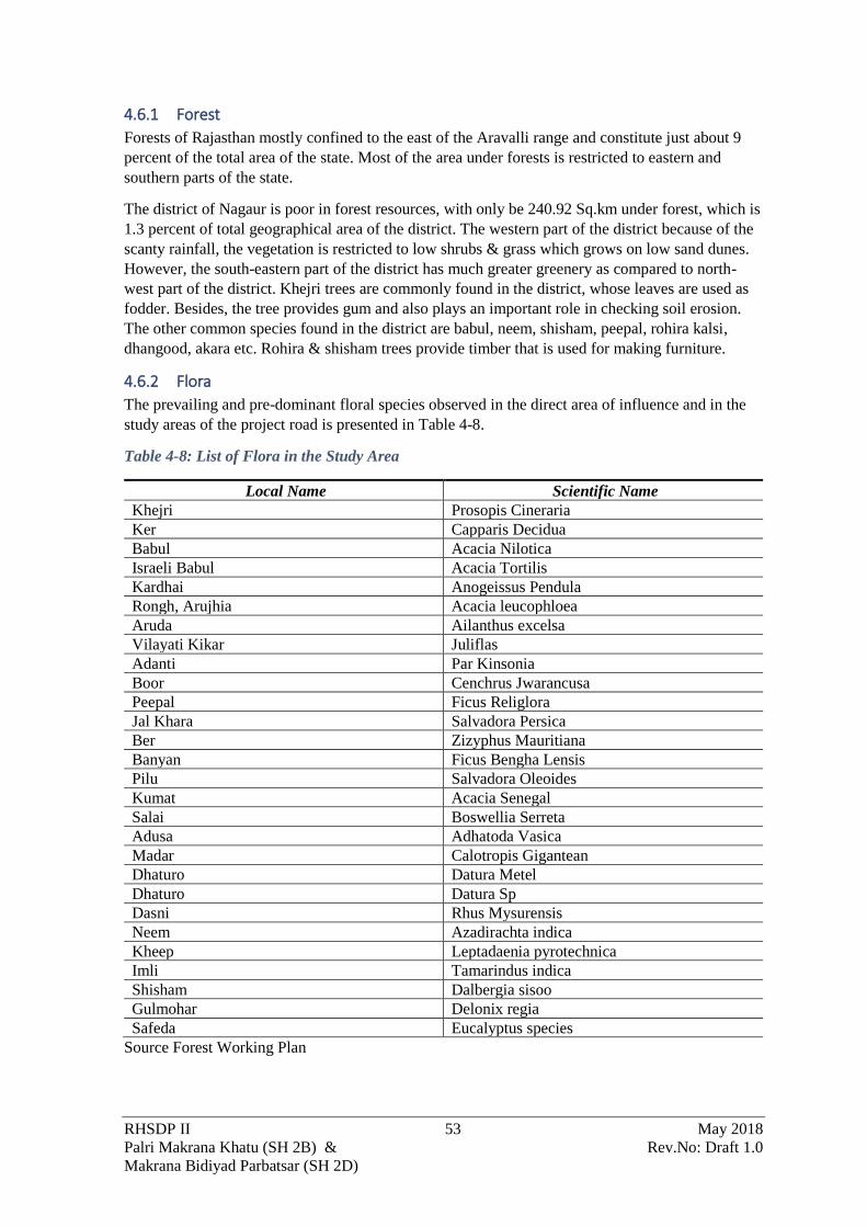
RHSDP II 53 May 2018
Palri Makrana Khatu (SH 2B) & Rev.No: Draft 1.0
Makrana Bidiyad Parbatsar (SH 2D)
4.6.1 Forest
Forests of Rajasthan mostly confined to the east of the Aravalli range and constitute just about 9
percent of the total area of the state. Most of the area under forests is restricted to eastern and
southern parts of the state.
The district of Nagaur is poor in forest resources, with only be 240.92 Sq.km under forest, which is
1.3 percent of total geographical area of the district. The western part of the district because of the
scanty rainfall, the vegetation is restricted to low shrubs & grass which grows on low sand dunes.
However, the south-eastern part of the district has much greater greenery as compared to north-
west part of the district. Khejri trees are commonly found in the district, whose leaves are used as
fodder. Besides, the tree provides gum and also plays an important role in checking soil erosion.
The other common species found in the district are babul, neem, shisham, peepal, rohira kalsi,
dhangood, akara etc. Rohira & shisham trees provide timber that is used for making furniture.
4.6.2 Flora
The prevailing and pre-dominant floral species observed in the direct area of influence and in the
study areas of the project road is presented in Table 4-8.
Table 4-8: List of Flora in the Study Area
Local Name Scientific Name
Khejri Prosopis Cineraria
Ker Capparis Decidua
Babul Acacia Nilotica
Israeli Babul Acacia Tortilis
Kardhai Anogeissus Pendula
Rongh, Arujhia Acacia leucophloea
Aruda Ailanthus excelsa
Vilayati Kikar Juliflas
Adanti Par Kinsonia
Boor Cenchrus Jwarancusa
Peepal Ficus Religlora
Jal Khara Salvadora Persica
Ber Zizyphus Mauritiana
Banyan Ficus Bengha Lensis
Pilu Salvadora Oleoides
Kumat Acacia Senegal
Salai Boswellia Serreta
Adusa Adhatoda Vasica
Madar Calotropis Gigantean
Dhaturo Datura Metel
Dhaturo Datura Sp
Dasni Rhus Mysurensis
Neem Azadirachta indica
Kheep Leptadaenia pyrotechnica
Imli Tamarindus indica
Shisham Dalbergia sisoo
Gulmohar Delonix regia
Safeda Eucalyptus species
Source Forest Working Plan

RHSDP II 54 May 2018
Palri Makrana Khatu (SH 2B) & Rev.No: Draft 1.0
Makrana Bidiyad Parbatsar (SH 2D)
It is estimated that 212 trees would be felled during the construction of the road. An inventory of
the trees to be felled was prepared by girth size and species. The species wise count is presented in
Table 4-9
Table 4-9:Trees to be felled along the Palri Makrana Khatu SH 2B) and Makrana Bidiyad
Parbatsar SH 2D alignment
Section of the Road Side Girth Size (cm)
30-50 50-90 90-120 >
120
Total
Palri Makrana Khatu (SH
2B)
LHS 19 13 14 4 50
RHS 28 11 3 1 43
Makrana Bidiyad Parbatsar
SH (2D)
LHS 22 21 6 0 49
RHS 44 9 7 0 60
Source; Primary Survey
Engineering surveys indicate felling of 212 trees is expected for the construction of the road.
4.6.3 Fauna
The wildlife in Rajasthan includes species like Indian gazelles or chinkaras, black bucks, Indian
foxes, great Indian bustards, the Nilgai, and wild cats. No wild life movement or road kills have
been reported from the alignment.
The prevailing and pre-dominant Fauna in the direct area of influence and in the study areas of the
project road is presented in Table 4-10.
Table 4-10:List of Fauna along the Project Influence area
Local Name Scientific Name
Chinkara Gazella gazelle
Blackbuck Antilope cervicapra
Nilgai Boselaphus tragocamelus
Jungle Cat Felis chaus
Rhesus Monkey Macca Mulatta
Capped Langur Presbytis pilectus
Jackal Canis aureus
Cat Snake Boiga spp.
Red vented bulbul Pycnonotus cafer
Indian cuckoo Megalaima merulinus
Common House Rats Rattus Rattus
Indian Fox Vulpes Bengalensis
Indian Hare Lepus Nigricollis
Five Stripped Squirrel Funambulees pennant
Wild Boar Sus Scrofa
House Sparrow Passer Domesticus
Common Myna Acridotheres Tristis
Common kingfisher Acledo atthis
Common Peafowl Pavo Cristatus
Palm Swift Cypsiurns parvus
Common Pigeon Columbo Livia
Goose Greylag Anser Anser
Grey Heron Ardeo Cinerea
House Crow Carvus Splendens

RHSDP II 55 May 2018
Palri Makrana Khatu (SH 2B) & Rev.No: Draft 1.0
Makrana Bidiyad Parbatsar (SH 2D)
Local Name Scientific Name
Indian Courser Cusorius Coromandelicus
Indian Pond Heron Ardeola Grayii
It was reported consultations that small animal e.g. like Jackal, Fox are spotted at some places near
Parbatsar along the alignment. At some locations Nilgai is also spotted, and the people are very
much aggrieved because they cause damage to crop.
4.6.4 Legally protected areas
There are 2 legally protected forest areas along the SH 2D alignment
• near Kinsariya settlement at Chainage 11+400 at a distance of approximately 100 m
• at Chainage 9+800 at a distance of 100m
from the proposed RoW. Thus, the alignment would not interfere with thee areas. Only very space
vegetation of Prosopis Cineraria was observed in the area. There are however no legally protected
forest areas on SH 2B. There are No National Parks or Wildlife Sanctuary within 10 km of the
proposed alignment.
4.7 SOCIOECONOMIC ENVIRONMENT
4.7.1 Demographic Profile
Population
In 2011, Nagaur had population of 3,307,743 of which male and female were 1,696,325 and
1,611,418 respectively. In 2001 census, Nagaur had a population of 2,775,058 of which males were
1,424,967 and remaining 1,350,091 were females. There was change of 19.20 percent in the
population compared to population as per 2001. In the previous census of India 2001, Nagaur
District recorded increase of 26.65 percent to its population compared to 1991.
Sex Ratio
With regards to Sex Ratio in Nagaur, it stood at 950 per 1000 male compared to 2001 census figure
of 947. The average national sex ratio in India is 940 as per latest reports of Census 2011
Directorate. In 2011 census, child sex ratio is 897 girls per 1000 boys compared to figure of 915
girls per 1000 boys of 2001 census data.
Child Population
In census enumeration, data regarding child under 0-6 age were also collected for all districts
including Jodhpur. There were total 606,490 children under age of 0-6 against 557,374 of 2001
census. Of total 606,490 male and female were 320,731 and 285,759 respectively. Child Sex Ratio
as per census 2011 was 891 compared to 920 of census 2001. In 2011, Children under 0-6 formed
16.45 percent of Jodhpur District compared to 19.31 percent of 2001. There was net change of -
2.86 percent in this compared to previous census of India.
4.7.2 Population profile of the Project Area and affected People
The socio-economic profile of the likely Project Affected Households has been detailed in the
Social Impact Assessment Report

RHSDP II 56 May 2018
Palri Makrana Khatu (SH 2B) & Rev.No: Draft 1.0
Makrana Bidiyad Parbatsar (SH 2D)
4.8 ECONOMY
4.8.1 Agriculture
Agriculture is the main occupation of the rural population in Nagaur. Bajra, wheat, jowar, til,
barley and pulses are the major crops of the Nagaur District. The other crops of the district are
taramira, rape and mustard seeds and gram. Since here also the agriculture is dependent on rains
Kharif crops constitute the bulk of the food production in the district.
Due to the paucity of water irrigation facilities are not developed in the district. The irrigation
structures are primarily being dug well, in some cases borewells are used.
4.8.2 Industries
Nagaur District
The Nagaur town is famous for its cottage and house hold industries. There are about 812
registered industrial units in the town which in all, employ about 2820 workers. Only a few
medium and small-scale units like Plaster of Paris, Hand tools, Metal works and leather industries
have been established on the western side of railway line and along Basni road where recently
RIICO have developed and organised Industrial area. There is no large-scale industry in the town.
Small units of dying and printing, Cement work, auto parts etc. have come up along major roads of
the town. Most of the famous hand tools making house hold industries are located within the
commercial areas north east of the fort. The Multani Luharo, who migrated to the town from
Multan now in Pakistan are mostly manufacturing the axe, evils, swords, knives, scissors and other
iron hand tools.
Large & medium scale industries: - There are seven large and medium scale industries existing in
the district. Out of seven four are in Makrana and all are in the field of marble processing. One
cement industry exists in Gotan, one chemical industry of large scale category exists in Deedwana
and one unit in Degana among small scale industries. The major units are food based, agriculture
based etc.
Along the project alignment around the town of Makrana marble quarrying and associated
industries have developed. RIICO has developed an industrial park at Parbatsar where some
MSME are located
RHSDP II 57 May 2018
Palri Makrana Khatu (SH 2B) & Rev.No: Draft 1.0
Makrana Bidiyad Parbatsar (SH 2D)
5 ANALYSIS OF ALTERNATIVES (Technology & Alignment) This chapter discusses the analysis of alternatives that have been considered for the proposed
widening/upgradation. It also includes a discussion on the “With” and “Without” project scenario.
Further, the evaluation and selection of alternative bypass alignments to the Bidiyad is based on
engineering, economic, environmental and social considerations. The minimisation of
environmental impacts by considering design alternatives determines the extent of mainstreaming
of the environmental component. An evaluation of the various alignment options has been done for
arriving at the most promising alignment for the bypass.
5.1 NO PROJECT SCENARIO The existing road have intermediate lane and two-lane carriageway with single lane in some cases.
The constricted carriageway poses restriction in smooth movement of traffic as well as increases
the risk of accidents. Makrana located on both SH 2B and SH 2D being a commercial centre due to
the marble quarrying has ad-hoc parking of commercial vehicles which often obstructs the free
flow of traffic. Further, the numerous intersections, narrow settlement areas, sharp curves, non-
motorised traffic and a variety of road users coupled with the constricted road space impedes
traffic. In case of “No Project” alternative, the regional development as well as any other
developmental activities will be adversely affected due to inadequate service level of the highway.
The economic stability and growth of the area will be impeded. The quality of life of local people
will also be affected as the issues are directly related to the communication systems available to
them.
The development of the transportations corridor is likely to provide the following benefits:
• The improvement of road surface and bottlenecks will improve, thus reducing the traffic
congestion
• Flourish in trade and commerce
• Reduction in accident rate
• Access to new employment opportunities
• Employment of local workers for the execution of project
• Better access to health care and other social services
• Improved quality of life of the local people
• Better way side amenities and other facilities like bus bays/shelters
• Increase of aesthetics and environmental condition due to Avenue Plantation along the
project road
• Provision of systematic utility duct will enhance the road aesthetics as well as reduction in
frequent damage of road due to repairing/ up gradation of utilities.
Hence, it is clear that the implementation of the project will be a definite advantage to the people in
the region in particular and the district of Nagaur which is industrially backwards to achieve all-
round development of its economy and progress for its people
5.2 ALTERNATIVE ALIGNMENT The need for bypass around the congested towns along the project road was identified in
consultation with the PWD and other stake holders and also considering the quantum of
development within the towns. Accordingly, Bidiyad town along SH 2D was identified for bypass
provision as the proposed improvement and widening in the town is very difficult on account of
significant Resettlement & Rehabilitation problem.
5.2.1 Proposed Bidiyad Bypass alignment study
Rationale of the Bypass

RHSDP II 58 May 2018
Palri Makrana Khatu (SH 2B) & Rev.No: Draft 1.0
Makrana Bidiyad Parbatsar (SH 2D)
Inside the Bidiyad town the available RoW varied between 8- 23 m. With the insufficient RoW it
was not possible to develop the road with the land available. Additional land was also not available
without huge resettlement as the entire alignment was heavily built-up. Further the geometry of the
alignment within the town also had to be improved. All these factors contributed to the requirement
of the bypass of Bidiyad town.
Alignment Options
After considering the growth potential and the spatial growth trends the options were decided. Two
options were identified. The alternative alignment options are presented in Figure 5-1
Figure 5-1: The alternative options of Bidiyad Bypass on Google earth Imagery
Evaluation of Options
A comparative evaluation of all these alternatives has been given in Table 5-1, which will help in
selecting the alignment with least social and environmental issues as well addressing the
engineering requirements.

RHSDP II 59 May 2018
Palri Makrana Khatu (SH 2B) & Rev.No: Draft 1.0
Makrana Bidiyad Parbatsar (SH 2D)
Table 5-1:Subjective analysis of the 2 alignments in Bidiyad Bypass
Sl.
No
Particulars Option -1 Option -2
Merits Demerits Merits Demerits 1. Length(km) 3.0 3.8
2. Land
requirement*
(ha)
9.0 13.2
3. Geometry Good Poor
4. Structure 3 7
5. Environmental/
Tree cutting
Tree
cutting will
be
comparatively
less
Tree cutting
will be
comparatively
more
7. Base cost of
Civil Works (cr)
5.4 7.8
*: these estimates of the land requirement. The actual land acquisition is presented in the Social
Impact Assessment Report
Mathematical Evaluation Matrix for Alternative Alignment of Kankarai Bypass
The options for the different alignment has been discussed above and a qualitative evaluation of
the same was carried out for different environmental and social factors. A mathematical model was
developed using relative factors for engineering, social, environmental and traffic aspects. The
existing alignment through the town was considered as Option 3 for the purpose of the analysis.
The result of the mathematical model is presented in Table 5-2.
Table 5-2:Mathematical Model for Analysis of the Alternative Alignment for Kankarai Bypass
Sl.
No
Particulars Maximum
Points
Allotted
Option -1 Option -2 Option -3
Actual
Factor
Points Actual
Factor
Points Actual
Factor
Points
1 Length (km) 15 3.0 13 3.8 10.26 2.6 15
2. Land
requirement*
(ha)
15 9.0 8.7 13.2 5.9 5.2 15
3. Structure! 0 0 0 0
4. Traffic
Dispersal /
Access Control
15 Good 15 Fair 10 Poor 5
5. Environmental
Constraint
10 Low 10 Medium 5 High 0
7. Construction
Problem %
25 Low 25 Medium 15 High 5
8. Cost 20 Low 20 Medium 15 High 10
Total 100 70 45 20
*: these are estimates of the land requirement. The actual land acquisition is presented in the Social
Impact Assessment Report
%The Construction problem also includes a qualitative judgement to estimate the social issues
which might occur in each of the alignment.
! No of structure and related factors have been integrated with Construction problem
Conclusion and Recommendation for Bidiyad Bypass

RHSDP II 60 May 2018
Palri Makrana Khatu (SH 2B) & Rev.No: Draft 1.0
Makrana Bidiyad Parbatsar (SH 2D)
Out of the various alternative alignments, Option-3 of following existing alignment is not a
feasible solution as this does not solve the problem of traffic congestion through habitation area of
Bidiyad. Further, land is not available to accommodate two lane road alignment within Bidiyad
town as required in accordance with terms of reference. Option -2 a realignment of the town even
though it is better than Option 3 does not figure well with the land requirement, construction
related issues and the geometrics involved. Hence Option 1 is preferred as it fully bypasses the
congested Bidiyad town, scores maximum points (70) from mathematical evaluation matrix
analysis and would allow smooth flow for through traffic. The assessment made by the consultant
has covered the Techno-economic viability of the proposed alignment. Therefore, the preferred and
finalised Bidiyad bypass alignment is Option-1.
5.3 REALIGNMENT In SH 2B and SH 2D no realignment is proposed.
5.4 ALTERNATIVE MATERIALS AND TECHNOLOGIES Increasing demand for natural material for other construction activities e.g. building construction,
urban development projects has put pressure on the exiting natural resources e.g. aggregates, sand,
soil. Procuring natural construction material for the road construction has thus not only become
difficult due to increased competition from other sectors but also escalated both time and money
required for procuring them. Increased regulatory compliance requirements have also made
availability difficult. Added to this is the increase lead distance because at times these materials
have to be procured from quarries away from the construction site thus not only increasing cartage
cost but also increasing the carbon-footprint of the project.
The use of alternate materials for construction focuses on the management and reuse of alternate
material including waste materials locally available in the project area or generated by the project
itself.
5.4.1 Use of Alternate Recycled Material or Waste in Road Construction
Use of fly ash in construction
In tandem with the IRC Guidelines for promoting the use of fly ash in road embankments (IRC:
SP:58-2001), MoEF&CC issued an amendment to their fly ash notification which make it
mandatory for road construction within a radius of hundred kilometres of thermal power plant to
undertake construction or approve design for construction of roads or flyover embankment with fly
ash as mentioned in the IRC specification No. SP:58.
Further, a number of guidelines been formulated by for promoting use of fly ash in different
structural parts of road and bridge construction, these include:
• IRC: SP:63-2004 “Guidelines for the Use of Interlocking Concrete Block Pavement”
• IRC:44-2008 “Guidelines for Cement Concrete Mix Design for Pavement”
• IRC: SP:89-2010 “Guidelines for Soil and Granular Material Stabilization using Cement,
Lime & Fly Ash”
• IRC:36-2010 “Recommended Practice for Construction of Earth Embankments and
Subgrade for Works”
• IRC: -2011 “Specifications and Code of Practice for Construction of Concrete Roads”
• IRC: -2011 “Code of Practice for Concrete Road Bridges”
• IRC:37-2012 “Tentative Guidelines for the Design of Flexible Pavements”
• IRC: SP:102-2014 “Guidelines for Design and Construction of Reinforced Soil Walls”

RHSDP II 61 May 2018
Palri Makrana Khatu (SH 2B) & Rev.No: Draft 1.0
Makrana Bidiyad Parbatsar (SH 2D)
Since the Kota Power Plant is within 300 km of the project road fly-ash would be used to the
maximum extent possible
Reuse of Excavated Material
It has been estimated that the 1.49 lakhs Cum of earth work materials and 1.59 lakhs cum of
scarified bitumen will be generated due to roadway drain excavation. It is proposed to reuse about
15,843 cum cut materials for sub-grade and embankment. The balance quantity of about 1.34 lakhs
cum of earth will be taken from borrow areas. Rest quantity of excavated materials is not suitable
for construction will require to be disposed off. Reuse of excavated materials will not only reduce
the impact on land due to borrowing of earth and at the same of the excavated time the disposable
quantity will also be reduced.
5.4.2 Reduction in Water Usage
Concrete Casting is of the major water consuming components of the road construction. To reduce
the water content in the cement mixture IRC SP 015: 2100: Standard Specifications And Code Of
Practice For Construction Of Concrete Roads makes specification of the use of plasticizers/super
plasticizers on concrete. The Plasticizers are water-reducing agents, so that for a given workability,
the water-cement ratio can be reduced to achieve a higher strength as compared to mix without the
additive.
The plasticisers alter the physio-chemical forces at the interface between two phases. The
plasticizers are adsorbed on the surface of the cement particles, which gives them a negative
charge, which cause mutual repulsion, leading to their dispersal. Even air bubbles are repelled and
cannot attach themselves to the cement particles. The negative charge causes a sheath of oriented
water molecules around each particle which separates them. The water, free from the flocculated
system, is thus available to lubricate the mix, thereby increasing its workability. The decrease in
mixing water varies between 5 and 1 5 percent in case of plasticizer and more than 15 percent in
case of superlicizers, and depends on the cement content, aggregate type, presence of pozzolana or
admixture etc. The water/cement ratio shall however, not be less than 0.25.
5.4.3 Resilience to Heat
Since the project area experiences extreme heat, it also has impact on the road asset. Bitumen
normally used for road construction i.e. VG 10/VG 20 has a softening point of <45oC. Thus, in
extreme temperature conditions of western Rajasthan in May and June there is bleeding of asphalt
resulting in damage to the pavement. To prevent such damages in this project, VG 30 with a
softening point of 47oC is being recommended.
RHSDP II 62 May 2018
Palri Makrana Khatu (SH 2B) & Rev.No: Draft 1.0
Makrana Bidiyad Parbatsar (SH 2D)
6 IMPACT ASSESSMENT AND MITIGATION MEASURES
6.1 IMPACT ASSESSMENT AND MITIGATION MEASURES The impacts due to proposed project activities across different phases have been identified and
predicted. The proposed project activities will impact the environment in two distinct phases:
a) Construction phase
b) Operational phase
Impacts are identified and predicted based on the analysis of the information collected from the
following:
• Project information (as outlined in Chapter Error! Reference source not found.);
• Baseline information (as outlined in Chapter Error! Reference source not found.).
The identification of likely impacts during construction and operational phases of the proposed
project has been carried out based on likely activities having their impact on environmental
parameters.
6.2 POTENTIAL IMPACT ON LAND USE
6.2.1 Impact Assessment
Since the road strengthening would follow the existing alignment of the road the change in land use
would be limited only to areas where realignment is proposed, or improvement of geometrics is
required, or widening is undertaken and at the Bidiyad Bypass. Most of the land along the corridor
is single cropped agricultural land. The facility of irrigation is poor in the district. Due to the poor
agricultural condition in the district the impact on conversion of agricultural land for road
construction is low.
Some temporary changes in land use might occur due to setting up of construction camp, material
storage yards and plant and machinery. These would be fallow land or waste land and would be for
a period of 2-3 years and the impacts would be low. With the development of the road there is a
likelihood of induced ribbon development along the project roads. The agricultural or other landuse
would change to commercial and or residential use over time.
6.2.2 Mitigation Measures
To prevent any adverse impacts on land-use the following measures need to be adopted:
• For realignments, irrigated agricultural lands, grazing land would best be avoided if possible.
In case the same is not feasible least amount of agricultural land would be used for road
construction;
• No agricultural land, fallow land (current or temporary), grazing land should be used for
setting up of construction camps, material storage or staging of plant and machinery. The
following parameters would be considered while selecting site for construction camp. The
guidance for site selection for Contractor’s camp is presented in Box 6-1.
Box 6-1: Guidance on Site Selection of Contractor’s Camp
Sites /land types to be avoided:
• Lands close to habitations • Irrigated agricultural lands
• Lands belonging to small farmers • Lands under village forests
• Lands within 100m of community water bodies and
water sources as rivers
• Lands supporting dense vegetation and Forest
with/without conservations status
• Low lying lands • Lands within 100m of watercourses

RHSDP II 63 May 2018
Palri Makrana Khatu (SH 2B) & Rev.No: Draft 1.0
Makrana Bidiyad Parbatsar (SH 2D)
• Grazing lands and lands with or without tenure
rights
• Lands where there is no willingness of the
landowner to permit its use
• 2km from Class A and above towns • 500m from any villages
• Community land ((Gochars, mandir vans (dev vans) or banis, Kakad bani Orans, Kesar chhanta, Radi) which
is traditionally used as conservation areas
Land Types Preferred
• Waste lands.
• Waste Lands belonging to owners who look upon the temporary use as a source of income.
• Community lands or government land not used for beneficial purposes.
• Private non-irrigated lands where the owner is willing.
• Lands with an existing access road.
6.3 POTENTIAL IMPACT ON SOIL
6.3.1 Impact Assessment
The impacts on the soil are expected along the alignment especially in case of expansion of
carriageway, realignment as well as in the borrow areas and construction camp. The impact on the
soil is primarily due to the:
• Loss of topsoil. The topsoil on the land parcels which is ether used for short term (e.g. borrow
areas, construction camps etc) or permanent use (expansion of the road alignment) would be
lost unless the same has been preserved.
• Compaction: The movement of vehicle over the agricultural land to access the construction
site would also cause compactions of soil and affect soil fertility.
It is estimated that approximately 1.49 lakhs Cum of earth will be generated due to excavations of
roadway and drainage and 1.59 lakhs Cum would be generated from scarifying of bitumen of the
existing pavement. It is estimated to reuse about 15,843 cum of excavated earth for sub-grade and
embankment. The remaining quantity of excavated material approx. 1.34 lakhs cum which is not
suitable has to be disposed off. In addition, waste from off-spec hot-mix as well as from the regular
operations of the machinery e.g. layers and bitumen sprayers during the surfacing of the roads. The
concrete wastes from the batching plant and transit mixer wash would also be generated.
The labour camps would be setup for construction which would generate municipal solid waste and
hazardous waste (waste oil from the maintenance and operation of machinery). These wastes have
potential to contaminate the soil around the site if it is not properly stored, handles and disposed.
If these excess excavated material, construction and demolition wastes are disposed on agricultural
land it may result in loss of productivity of land.
6.3.2 Mitigation Measures
Mitigation measures which would be considered to reduce impacts on soil during road and bridge
construction are given below:
• The borrow areas should be developed as per the guideline presented in Annexure 6.1 to
minimise impacts
• Excess excavated material should not be dumped by the contractor on any adjoining
property. The excess excavated material to be stored at a specified location so that it can be
reused where ever possible or used for strengthening of shoulders of village roads;
• All demolition debris especially from cross drainage structures and pavement should be
utilised in the backfilling where ever possible. No virgin material shall be utilised unless the
demolition debris are certified by the Engineer as “not fit for use”. All construction debris
which cannot be reused should be disposed at pre-designated sites. The Contractor should
identify site for temporary storage of the construction debris during the pre-construction

RHSDP II 64 May 2018
Palri Makrana Khatu (SH 2B) & Rev.No: Draft 1.0
Makrana Bidiyad Parbatsar (SH 2D)
• Since the project road is within 300 Km of Kota Thermal Power Plant. The Contractor thus
has to mandatorily ensure utilisation of fly ash as per the provisions of IRC Codes
• Vehicular movement should be restricted over the open fields or agricultural land.
• The storage, handling and disposal of Municipal Solid Waste, Hazardous Waste and
construction demolition waste the Contractor should follow all the provision of the
respective rules. The guidance for storage of these waste are presented in Annexure 6.2.
The same guidance (storage of Hazardous Waste) may be used for storage of hazardous
materials (oil, lubricants)
6.4 POTENTIAL IMPACT ON SURFACE WATER RESOURCES
6.4.1 Impacts Due to Construction
The project area is mostly located to the west of the Aravalli and has very little rainfall. Surface
water is thus scarce in most parts of the project area. There are only a few water bodies along the
road. These waterbodies are primarily used by community for drinking water. The construction
activities e.g. earthwork, concreting of structure and labour camps, would require large quantities of
water and may result in conflicting situations with local communities. In addition, the construction
activities would also witness influx of skilled labour who would be housed in the construction camps.
Water would also be required for domestic requirement and the ground water at places also does not
meet the required standards of IS 10500: 2012.
The projects districts are affected by water crisis during the summer months. Additional water
requirement for construction would not only put stress on the resource but also lead to conflict with
the local community.
All the 4 water bodies along the alignment are at a distance and are not likely to be affected by the
project.
6.4.2 `Mitigation Measures
• Water for construction should not be sourced from any waterbody used for drinking purpose.
• The Contractor with support from the project, shall consider development of new surface
water bodies or renovation of existing surface water bodies with prior permission of the
village panchayat for harvesting of water. This water can be used for construction purpose
and on completion of the construction the same can be handed over to the community for
maintenance and use. To facilitate the selection of the site for location of the surface water
bodies a Digital Elevation Model for the study area may be created. From the initial studies
the following existing waterbodies has been identified and presented in Table 6-1 . These
locations may be investigated further developed and used for construction purpose
Table 6-1: Water bodies which can be used for Rainwater harvesting
Sl. No Water body Coordinate Side Distance from
the Site
Size
SH 2D
1. Within RIICO
industrial estate
26°53'42.65"N
74°44'34.27"E
RHS 205 m 6586 sqm
SH 2B
2. Abandoned Pit 27° 6'47.05"N
74°22'2.18"E
LHS 600 m 7566 sqm
4. Along SH 7 near
Malanga
27° 0'13.57"N
74°47'37.55"E
LHS 1000m 1321 sqm
•

RHSDP II 65 May 2018
Palri Makrana Khatu (SH 2B) & Rev.No: Draft 1.0
Makrana Bidiyad Parbatsar (SH 2D)
• During the pre-Construction stage the contractor should preferably identify local
depression along the alignment in consultation with the local panchayat to be developed as
water storage areas. The PIU can enter into an agreement with the panchayat for
development of this water body and using the water stored on it for construction purpose.
The runoff of from the surrounding area and or pavement can also be channelized into
them depending on feasibility. As part of the development it is envisaged that the water
body would be excavated to a dept of 2-3 m and the excavated material may be used for
earthwork of used for creating bunds of the waterbody. Since the project area has sand and
sandy loam soil it is proposed to use HDPE line 1.5mm thick on the for lining the water
body so that the water does not perchlorate. This waterbody would be handed over to the
community for use and maintenance after the completion of construction.
• In water scare areas dust suppressant /dust binders shall be used to reduce water
consumptions. The acceptable dust suppressants include: Acrylic polymers, Solid recycled
asphalt, Chloride compounds (calcium chloride and magnesium chloride), Lignin
compounds (lignin sulphate and lignin sulfonate powders), Natural oil resins (soybean oil)
and Organic resin emulsions.
• The water from the longitudinal drains should not be allowed to drain into any water body
used for drinking water. In case the drinking water body is the lowest point in the
topography the Contractor shall identify a separate location and used it for storage of water
as described above
• None of the project components i.e. existing alignment, realignment or toll plaza shall
neither encroach into any waterbody. During construction, no construction and demolition
debris shall be left in the catchment of the water body.
• The Contractor should notify the PIU its source for procurement of water. It should provide
monthly reports of water consumed and its source.
• The water consumption for concrete mixing can be reduced by use of plasticizers/ super
plasticizers as mentioned in IRC 015:2011
• Enhancement measures may be considered in all the ponds along the corridor. These could
include the strengthening of the embankment, excavation of the pond to increase its holding
capacity, construction of the silt traps at the end of the pond so that the siltation reduces.
6.5 POTENTIAL IMPACT ON SURFACE WATER QUALITY
6.5.1 Impacts Due to Construction
In addition to competition over the scarce resource, the construction camp and the construction
activities would generate waste water. These would include domestic wastewater from the
construction camp and the wash water from the machinery e.g. batching plant concrete transit mixers
would cause deterioration of the water quality These liquid wastes have potential to contaminate the
water bodies around the site if it is not properly handled.
6.5.2 Mitigation Measures
• No wastewater should be discharged from construction camps. Runoff from the camp shall
be passed through an oil-water separator. All peripheral drains shall be linked to the oil water
separator. The design of the oil water separator is presented in Annexure 6.3. The
construction camps would have the measures specified in Box 6-2.
Box 6-2: Facilities in Contractors Camps
Security:
• The contractor shall put in place the following security measures to ensure the safety of the workers. The following
measures shall be incorporated:
• The contractor/sub-contractor shall provide Identity cards to all the employees/workers;

RHSDP II 66 May 2018
Palri Makrana Khatu (SH 2B) & Rev.No: Draft 1.0
Makrana Bidiyad Parbatsar (SH 2D)
• Access to the campsite shall be limited to the residing workforce;
• The contractor shall be responsible for deploying adequate number of guards;
• Adequate, day-time night-time lighting shall be provided;
• The security personnel shall be provided with training to respect the community traditions and in dealing with, use
of force etc.; and
• The rental accommodation shall be provided with firefighting equipment and portable fire extinguishers.
Provision of Drinking Water:
• Access to an adequate and convenient supply of free potable water is necessary for workers. The domestic water
supply shall be made available by the contractor.
• Safe drinking water conforming to the IS 10500:2012 for drinking water shall be provided;
• Bottled Potable drinking water would be provided to all the employee/workers both at the worksite and at the
construction camps;
• Every water supply or storage shall be at a distance not less than 15m from any wastewater / sewage drain or other
source of pollution. Water sources within 15m proximity of toilet, drain or any source of pollution will not be used
for any consumption purpose in the project
• The Contractor should regularly monitor (every quarter) the quality of drinking water available. In case of non-
compliance with the Drinking Water Specifications, additional treatment shall be provided, or alternative sources
of water supply shall be arranged; and
• All tanks used for the storage of drinking water shall covered as to prevent water stored therein from becoming
polluted or contaminated.
• The tanks shall be cleaned at regular interval (minimum every 3 months) to ensure hygiene conditions are
maintained.
Cooking Arrangement:
• The construction phase will involve engagement of large number of migrant people in the project area for a limited
time. Hence, there shall be requirement of provision of cooking facilities (kitchen) as listed below:
• The cooking area shall be separate from the Living quarters;
• Places for food preparation are designed to permit good hygiene practices, including protection against
contamination between and during food preparation;
• The cooking area should be provided with water connections which is fit for consumption;
• Adequate personal hygiene including designated areas for cleaning hands and cleaning of utensils; and
• All kitchen floors, ceiling and wall surfaces adjacent to or above food preparation and cooking areas are built using
durable, non-absorbent, easily cleanable, non-toxic materials;
• Food preparation area to be durable, easily cleanable, non-corrosive surface made of non-toxic materials.
• To ensure that the fuel need of labourers in the project area does not interfere with the local requirements, necessary
arrangements for supply of cooking fuel to the labourers shall be done by the contractor. Clean fuels shall be used
in no circumstance fuel wood shall be used for cooking or heating.
Washing and Bathing Facilities
• In every site, adequate and suitable facilities for washing clothes and utensils shall be provided and maintained for
the use of contract labour employed therein. Separate and adequate bathing shall be provided for the use of male
and female workers. Such facilities shall be conveniently accessible and shall be kept in clean and hygienic
conditions.
Toilets Facilities
• Sanitary arrangements, latrines and urinals shall be provided in every work place separately for male and female
workers. The arrangements shall include:
• A latrine for every 15 females or part thereof (where female workers are employed).
• A latrine for every 10 males.
• Every latrine shall be under cover and so partitioned as to secure privacy and shall have a proper door and
fastenings.
• Where workers of both sexes are employed, there shall be displayed outside each block of latrine and urinal, a
notice in the language understood by most of the workers ―” For Men Only” or ―” For Women Only” as the
case may be. Pictographic signages can also be used
• The latrines and urinals shall be adequately lighted and shall be maintained in a clean sanitary condition at all times
and should have a proper drainage system;
• Water shall be provided in (preferably) or near the latrines and urinals by storage in suitable containers
Waste Water Generation:
• There will of generation of wastewater from the campsite. About 80% of water used shall be generated as
sewage/wastewater. Contractor shall ensure that the campsite/s is/are equipped with:
• Septic tank and soak pit for disposal of sewage or with mobile bio-toilets. The toilets and the septic tank and soak
pit should not be located near any drinking water sources either within or outside the camp.

RHSDP II 67 May 2018
Palri Makrana Khatu (SH 2B) & Rev.No: Draft 1.0
Makrana Bidiyad Parbatsar (SH 2D)
• The storm water and sewage system should be separate. The surface water drainage shall include all necessary
gutters, down pipes, gullies, traps, catch pits, manholes etc. An Oil water separator should be in the drains leading
out of the maintenance area. Water passing out of the camp should be passed through a sedimentation tank of at-
least 3hrs holding capacity.
• Sanitary and toilet facilities are constructed of materials that are easily cleanable. Sanitary and toilet facilities are
required to be cleaned frequently and kept in working condition.
Solid Waste Management:
• The solid waste generated from campsite will mostly comprise of compostable wastes like vegetable residues
(kitchen waste) and combustible waste like paper, cans, plastic and some non-degradable waste like glass/glass
bottles. Improper disposal of solid waste will lead to environmental degradation and health hazards to labour as
well as nearby community.
• The following measures shall be adopted by contractors for ensuring effective management of solid waste:
• The solid wastes of domestic nature (especially food waste, waste from canteen) shall be collected and stored
separately in appropriate containers with proper covers on them so that they are not littered;
• Separate bins with proper markings in terms of recyclable or non-recyclable waste shall be provided in the houses
and kitchen premises in sufficient numbers for collection of garbage;
• Food waste and other refuse are to be removed from the kitchen frequently to avoid accumulation; and
• The contractor shall ensure that the all food waste generated is composed within the camp premises. All recyclables
except for the waste which are covered by any other act/rules other than the Municipal Solid Waste Rules 2016.
Roads
• All the internal roads shall be paved. The concrete slurry from the batching plant shall be used for paving the roads
Medical Facility:
• Effective health management is necessary for preventing spread of communicable diseases among labour and
within the adjoining community. The following medical facilities shall be provided by contractors for the
construction workers:
• A first aid centre shall be provided for the labour within the construction site equipped with medicines and other
basic facilities;
• Adequate first aid kits shall be provided in the campsite in accessible place. The kit shall contain all type of
medicines and dressing material;
• Contractor shall identify and train an adequate number of workers to provide first aid during medical emergencies;
• Regular health check-ups shall be carried out for the construction labourers every six month and health records
shall be maintained;
• Labours should have easy access to medical facilities and first aid; where possible, nurses should be available for
female workers;
• First Aid Box will be provided at every construction campsite and under the charge of a responsible person who
shall always be readily available during working hours. He shall be adequately trained in administering first aid-
treatment. Formal arrangement shall be prescribed to carry injured person or person suddenly taken ill to the nearest
hospital. The first aid box shall contain the following.
• small sterilised dressings
• 3 medium size sterilised dressings
• 3 large size sterilised dressings
• 3 large sterilised burns dressings
• 1 (30 ml) bottle containing 2 % alcoholic solution of iodine
• 1 (30 ml) bottle containing Sal volatile
• 1 snakebite lancet
• 1 (30 gms) bottle of potassium permanganate crystals
• 1 pair scissors
• Ointment for burns
• A bottle of suitable surgical antiseptic solution
• In case, the number of labour exceeds 50, the items in the first aid box shall be doubled. All the vehicles and
equipment shall be provided with a fir-aid box with all the above. The medicines should be regularly checked for
the expiry of the medicines.
• Information and awareness of communicable diseases, AIDS etc. shall be provided to workers.
Basic collective social/rest spaces are provided to workersFire-fighting arrangement
• The contractor shall carry out demarcation of area susceptible to fires and put in precautionary signages as specified
in IS 9457
• Portable fire extinguishers and/or sand baskets shall be provided at easily accessible locations in the event of fire
as per the provisions of IS 2190
• The contractor shall carry out fire safety drill every quarter and Workers shall be trained on the usage of such
equipment/s

RHSDP II 68 May 2018
Palri Makrana Khatu (SH 2B) & Rev.No: Draft 1.0
Makrana Bidiyad Parbatsar (SH 2D)
Fuel and Chemical Storage
• Licence is required for storage and transport of any such product (i.e. petroleum class B) if the total quantity in in
possession does exceed 2500 litres in non-bulk (i.e. drums) or 1000litres in a receptacle / tank (i.e. bulk).
• All fuel and chemical storage area should be made impermeable either by concrete flooring or by placing an HDPE
liner.
• The storage area shall be provided with a bunded. The capacity of the bund shall be 110% of the volume of the
maximum storage tank
• The area shall be covered and secured under lock and key.
• In no condition shall the fuel be decanted by tilting of drums. An approved fuel pump manual or energy driven
shall be used.
• In case of spills Emergency Spill care procedures as presented in Annexure 6.4 shall be used.
• During the detailed design the longitudinal drains shall be so planned that it does not
discharge into any waterbody used for drinking or its catchments.
• Small check dams can be considered in the longitudinal drains to allow the recharge of
water
• Rainwater water harvesting puts can also be considered as per the feasibility. During the
detailed design these can be considered. The schematic drawing of rainwater harvesting
pits is presented in Annexure6.5
6.5.3 Impacts During Operation
During the operation if discharge from the longitudinal drains enters into the water bodies used for
drinking water it would pollute these sources and severely affect the availability of water in the
region.
6.5.4 Mitigation Measures
• Water from longitudinal drain should not be disposed into any surface water body or its
catchments used for drinking purpose and at all times.
• Water used for domestic purpose at the toll plaza shall conform to IS 10500: 2012.
6.6 POTENTIAL IMPACT ON GROUND WATER RESOURCES
6.6.1 Impact Identification
Like surface water and groundwater are scarce with number of block in Nagaur already declared as
notified blocks by CGWB. The remaining blocks have been declared “over-exploited” The ground
water in the areas are also saline but in absence of any surface water resources the local population
is dependent on it for domestic and drinking purpose. Using groundwater especially freshwater for
domestic and construction activities would have serious impacts on the availability of the resource
for domestic purpose.
6.6.2 Mitigation Measure
• Construction water would not be procured from any unauthorised wells or existing wells
which has been given permission for domestic or agriculture purpose. The permission of
CGWB would be obtained in case new wells are sunk
• In the project area, the deep saline water should preferably be used for the construction
activities after treatment. The feasibility of using the saline water for construction and the
treatment technologies shall be identified during the project design and pre-construction;
• Water usage for construction work would be reduced by adopting following best practices:
o Use buckets etc. to wash tools instead of using running water;
o Use of auto shut off taps (without sensors) in labour accommodation;
o Install water metres with main supply pipes/water tanks/bore well to assess quantity
of consumed water and
o Use of plasticizers/superplasticizers in the concrete production to reduce water
consumption.

RHSDP II 69 May 2018
Palri Makrana Khatu (SH 2B) & Rev.No: Draft 1.0
Makrana Bidiyad Parbatsar (SH 2D)
6.7 POTENTIAL IMPACT ON GROUND WATER QUALITY
6.7.1 Impact Identification
The construction activities would also witness influx of skilled labour who would be housed in the
construction camps. Water would also be required for domestic requirement and the ground water
at places also does not meet the required standards of IS 10500: 2012 as is presented in Section
4.5.2. The limited/non-availability of fit for use drinking water would also affect the workforce.
6.7.2 Mitigation Measures
• The Contractor shall make arrangement for bottled drinking water which conforms to IS
14543 (2004).
• In case the contractor uses groundwater for drinking purpose he shall install adequate
treatment technologies e.g. reverse osmosis and fluoride removal filters.
6.8 POTENTIAL IMPACT ON AMBIENT AIR QUALITY The impact on the air environment are likely both during the construction as well as the operations
phases.
6.8.1 Impacts Due to Construction
In the construction phases the activities related to the earthwork is likely to generate large
quantities of particulates. The possible sources of generation of such particulates are borrow area
operations, transport of material, storage of construction material, carrying out of earthwork,
movement of vehicles on unpaved road. Vehicular movement due to the project would also add to
PM 2.5 and SOx and NOx emissions. In case of the project road both PM 10 and PM 2.5 are
identified as a major source of pollutant.
The operations of the Hot-mix plant, handling of cement in batching plants is also likely to
generate the air pollutant. The generation of PM2.5 due to the construction activities would add on
the already stressed air environment.
6.8.2 Mitigation Measures During Construction
To prevent the generation of dust during the construction activity the following measures may be
considered:
• The speed limit of project vehicle movement over unpaved surface should be limited to 15
kmph;
• All vehicles carrying construction material should be covered;
• The construction material should be stored against wind breaks so that they are not carried
away by wind. The length of the windbreak wall shall be twice the height for it to effectively
work. The stockpiling of material should be carried out considering the prevailing wind
direction;
• Water sprinkling should be restricted due to the scarcity of water. Dust suppressant17 should
be applied on the surface of the unpaved earthwork to reduce the consumption of water;
• Vehicular movement on the unpaved pavement should be strictly restricted. The access roads
within the construction camp should be paved using the waste concrete or batching plant and
concrete mixer wash;
• All project related vehicles and equipment should have valid Pollution Control Certificates.
• The pollution control equipment in the Hot-mix plant shall be kept in working condition at
all times. The plant shall not be operated if the pollution control equipment is not functional;
• Requisite permits shall be obtained from the RSPCB for operation of the Hot Mix Plant and
Quarry (in case of new Quarry is used for the project). In case existing quarry is used for
17 Dust Suppressants include: Acrylic polymers, Solid recycled asphalt, Chloride compounds (calcium chloride and magnesium
chloride), Lignin compounds (lignin sulphate and lignin sulfonate powders),

RHSDP II 70 May 2018
Palri Makrana Khatu (SH 2B) & Rev.No: Draft 1.0
Makrana Bidiyad Parbatsar (SH 2D)
procuring the material the contractor shall ensure that the quarry possesses the
environmental clearance and all valid licenses. It shall also run a due diligence that the said
quarry has not been issues any notice for violation by any statutory agencies;
• The grievance redressal mechanism for the project would also be used for reporting any
matter related to air pollution.
6.8.3 Impacts During Operation
The strengthening of the carriageway would improve vehicular movement, congestion is likely to
get reduced and speed to vehicles are likely to improve. Even though there would be a decrease in
vehicular emission due to the reduction in congestion the increased vehicular traffic on the state
highways would increase the pollution load.
6.8.4 Mitigation During the Operations
To mitigate the impacts of vehicular pollution during operations phase:
• Green belt shall be developed along the corridors. Local drought resistant species which
can arrest both gaseous and particulates shall be planted
6.9 POTENTIAL IMPACT ON NOISE QUALITY
6.9.1 Impact due to Construction
The principal source of noise during construction of highway would be from operation of
equipment, machinery and vehicles. Earth moving machineries e.g. excavators, graders and
vibratory rollers has potential to generate high noise levels. These machineries produce noise level
of more than 70 dB (A). This can cause disturbance to the settlement, adjacent to the carriageway
or at 500 m from the worksite. The vibration produced by rollers can be transmitted along the
ground. This may cause damage to kutcha structure located along the alignment. The extent of
damage would be dependent on the type of soil, the age and construction of the structure.
The noise generated during the construction would cause inconvenience to the population
adjoining the highways especially within 500 m of the alignment after which it would be
attenuated to acceptable levels Since, the settlement along the road alignment would be sparse the
severity of the impact would be low. The impact on the workers however would be dealt with in
the section 6.14.
6.9.2 Mitigation Measures
• The DG sets used in the project should conform to the CPCB stimulated standards and have
obtained the COP (Conformity of Product Verification) certification.
• Regular maintenance of the machinery, equipment and vehicle would be carried out to
prevent excessive noise. A maintenance schedule would be prepared and maintained by the
contractor.
• Night time construction activity would be prohibited in case settlement/habitation is located
within 500 m of the construction site.
• Consider the use of traffic calming measures18 in the final design to reduce the speed of the
vehicle
.
18 The following traffic calming measures can be considered in settlements: i) circular humps : this is capable of reducing the speed of vehicle by 5kmph below the desired speed.; ii) trapezoidal humps raised flat areas with two ramps; iii) zebra crossing on top of a
trapezoidal hump with two pair of jingle strip on both side. This can be used in settlement areas where there is pedestrian crossover
points; v) rumble strips cased by asphalt and thermoplastic would increase noise and but reduce speed vi) jingle strips vi) traffic islands

RHSDP II 71 May 2018
Palri Makrana Khatu (SH 2B) & Rev.No: Draft 1.0
Makrana Bidiyad Parbatsar (SH 2D)
6.9.3 Impact During Operation
The development of the road is expected to increase the traffic volume but at the same time reduce
the congestion in the settlements. The noise levels are still expected to increase with the increase in
traffic. As pointed out in section 0 the noise measured in front of the sensitive receptors e.g.
settlement are more than standards for residential areas.
The increase in traffic would further aggravate the problem and would cause inconvenience
especially at settlements.
6.9.4 Mitigation Measures
• In cases where land is available three-layer plantations would be carried out with local
species to act as a vegetative barrier for noise
• The traffic calming measurers introduced is also likely to reduce noise19
• Since the congestion would reduce the honking of vehicle would reduce resulting in
reduction of the noise.
6.10 POTENTIAL IMPACT ON PHYSIOGRAPHY AND DRAINAGE
6.10.1 Impact Identification
The alignment follows the existing topography for most of the route, however in few sections in
Bidiyad bypass there would be some cut and fill operations. However, these would be minimal and
would not result in any change in the topography. In case of fill section, the filling is not likely to
have impact on soil e.g. soil erosion. Even though the soil is sandy loam or clayey sandy loam
because the rainfall is low.
There is no major river along the alignment, all the existing CD structure have been retained. Of
the 9 present CD structures on 1 would be retained and of the remaining 8, 5 would be
reconstructed and 3 would be widened. Thus, any change in the drainage is also not envisaged.
However, a micro-watershed study indicates that there are number of 1st order stream in the project
influence area. These drainage channels may be obstructed unless the cross-drainage structures are
provided
6.10.2 Mitigation Measures
• Excess excavated material generated from the road construction should not be dumped by
the contractor on any adjoining property. The excess excavated material may be reused
where ever possible or used for strengthening of shoulders of village roads. In case after
re-use excess material is available it shall be dumped at locations which are pre-identified
in consultation with the Panchayat;
• Surface Stabilisation of the cut and fill slopes shall be carried out to prevent erosion of
sandy loam. Even though the rainfall in this region is not very high the sandy loam would
be prone to erosion by winds. Alternative materials like quarry waste may be used for
pitching.
• Even though preliminary hydrological studies do not indicate any major drainage channel,
there are number of 1st order stream. The drainage aspects should thus be considered
during the final design and if required the cross-drainage structures may be increased.
During the construction also if the local people indicate any location where there is
19 Experience has shown that reductions in vehicle speed may also lead to reductions in noise. Excessive use of low gears and frequent
acceleration and deceleration may increase noise levels. Thus, it would be best to have traffic calming measures that would ensure constant use of 3rd gear rather than requirement of frequent changes to 2nd gear. However, the trade-off would be between the noise and
higher average speed. Empirical studies have observed that, where speeds have been reduced from 50 to 30kph, typical reductions in
noise levels of between 4-5 dBA have been measured http://www.its.leeds.ac.uk/projects/primavera/p_calming.html#fn8

RHSDP II 72 May 2018
Palri Makrana Khatu (SH 2B) & Rev.No: Draft 1.0
Makrana Bidiyad Parbatsar (SH 2D)
passage of water across the embankment then the provision of a culvert at that location can
be considered.
6.11 POTENTIAL IMPACT ON BIOLOGICAL ENVIRONMENT
6.11.1 Impact on Flora
It is estimated that 212 trees would be felled for the proposed road improvement project. thus the
impact on the flora as well as the micro climate would be limited.
6.11.2 Mitigation Measures
• Plantation would be taken along the corridor, subject to availability of land, to improve the
green corridor along the highway
• Only local tree species which are less water consuming should be used for plantation.
6.11.3 Impact on Fauna during construction
There are no National Park or wildlife sanctuary along the alignment. Some spotting of small
animals is reported in areas around Parbatsar. These animals at time stray into the construction area
and gets trapped in the excavations.
6.11.4 Mitigation Measures During Construction
• During the excavation temporary woven wire mesh guards of about 2.4 m (8 ft.) high will
be put around the excavated areas to prevent small wild animal from falling into
excavations
• During the construction if any stray animal falls in an excavation. No harm would be done
to the trapped animal. The contractor in association with PIU and Forest Department
would ensure safe release of the animal.
6.11.5 Impact on Fauna during Operation
Since there is no reported population of wildlife in the project area impacts on wildlife are not
envisaged.
6.11.6 Mitigation Measures During Operation
• In case roadkills are observed/reported during operations a survey of the vulnerable stretches
of the road especially with respect to road kill would be carried out. The following measures
would be taken:
o Reflectors should be installed along the highway in these areas to prevent wildlife
from approaching the road
o Display boards (as per IRC 30 - 1968 - Numerals of Different Height for Use on
Highway Signs and IRC 67 - 2012: Code practice for Road Signs) should be placed
ahead of the stretch to warn drives of the approaching wildlife crossing areas
o Traffic Calming measures described in section 6.9.2 shall be considered for
implementation.
•
6.12 POTENTIAL IMPACT ON SOCIO-ECONOMIC ENVIRONMENT The socio-economic impacts have been detailed in the Social Impact Assessment and Resettlement
and Rehabilitation study carried out under the project.

RHSDP II 73 May 2018
Palri Makrana Khatu (SH 2B) & Rev.No: Draft 1.0
Makrana Bidiyad Parbatsar (SH 2D)
6.13 COMMUNITY HEALTH AND SAFETY ISSUES
6.13.1 Impacts during Construction
The construction activities would be carried out without hampering the existing traffic since there
is no alternate corridor for diversions of traffic. The construction activities would also remove the
additional spaces i.e. shoulder to accommodate the construction of the additional carriageway or
strengthening of the carriageway and shoulders. Since the local slow-moving traffic including
pedestrians and the through highway traffic would be using a reduced road space the congestions
on the highway would increase during construction. This situation would be further aggravated by
the additional vehicle used in the construction activity using the road for haulage of construction
material.
The local slow-moving traffic and pedestrians are thus prone to collision with the through highway
traffic and the construction vehicle. Also, at times the excavations are carried out close to a village
access road or settlement. These work sites may also cause potential injuries to the public unless
they are protected.
6.13.2 Mitigation measures
• All worksites should be barricaded, and the integrity of the workspace segregation from the
traffic maintained at all times;
• In settlement area the workplace should be segregated by the erecting barriers. Separate
walkway should be identified in the settlement areas for use by pedestrians and slow-moving
traffic. Crossover points should be provided at the worksite locations in settlement areas so
that people can easily crossover without coming is in close proximity with the construction
work or equipment.
• At the point of entry or exit from the work site flagman should be provided. The entry and
exit vehicle shall be regulated by the flagman to prevent collision;
• All worksite shall be provided with reflective stickers so that it can be easily identified
during night;
• Precautionary signages should be put-up well in advance to warn drivers of impending
construction works;
• Flashers should be provided near excavation to warn the traffic of the excavations;
• The worksite within the settlement shall be properly illuminated as a safety precaution;
• The construction debris should not be placed on the road as it would further constrict the
space available for the public.
Impacts During Operations
During the operations phase of the highway the traffic volumes and vehicular speeds are both
likely to increase. This can potentially be risky both for pedestrian as well as slow -moving traffic.
In case of sensitive receptors mentioned above in addition, as traffic speeds increase the chances of
vehicular collisions are also expected to increase.
Mitigation Measures
• During the design activity a traffic hotspot study should be carried out to identify the location
of accident or areas of conflicting traffic. Design interventions should be carried out at these
locations
• During the operations of the highway traffic hotspot studies should be carried out every
year as per the MoRTH’s Circular. The traffic safety expenditure should be included in the
annual budget.

RHSDP II 74 May 2018
Palri Makrana Khatu (SH 2B) & Rev.No: Draft 1.0
Makrana Bidiyad Parbatsar (SH 2D)
6.14 OCCUPATIONAL HEALTH AND SAFETY ISSUES
6.14.1 Impact Identification
Highway workers are at risk of injury from i.) passing traffic vehicles, ii) Construction equipment
operating within the work zone and in ancillary areas which support the work zone e.g. batching
plant, hot-mix plants iii) construction vehicles entering and leaving the work zone. The statistical
information20 indicate that the worker on foot are the most vulnerable in the Highway Construction
work zone. Similarly, there are occupational risks during operation of the highway is from traffic.
Accidents primarily occur due to collisions with passing vehicle.
The sub-project districts experience extreme weather conditions especially during summers. This
can cause fatigue and lead to issues of dehydration and heat-stoke.
6.14.2 Mitigation Measures
The following mitigation measures need to be adopted to protect the workers:
• Temporary traffic control devices such as signages, warning devices, concrete barriers can
be used to segregate the highway traffic from the work zone. These control devices should
be setup at a distance ahead of the work zone to control traffic. Cover or remove the
precautionary signages when the workers are not present;
• Flaggers/Flagmen should be placed with high reflective jackets and other devices so that
they can slow down the traffic;
• No equipment or vehicle should enter the work zone without the flagmen being present to
guide the equipment/vehicle;
• All vehicle should be fitted with reverse siren. Rotating equipment should also be fitted with
siren which should come on when the equipment rotates to the reverse;
• To prevent the workers form getting dehydrated or being affected by heat stroke the
following measures may be considered:
o All workplace to have adequate provisions of drinking water,
o The workplace should be provided with temporary shelters where the workers can
rest during prolonged exposure to sun
o In case of extreme temperatures, the working hours may be regulated. Night time
working can be considered especially in areas outside settlement with the
permission of the Employer/Engineer.
These measures as discussed above would also be made part of the Standard bidding document of
Contractor involved in sub-projects. The detailed Guidance on Occupations Health and Safety is
presented in Annexure 6.7
20 Building Safer Highway Work Zones: DHHS (NIOSH) PUBLICATION No. 2001-128, April 2011,
https://www.cdc.gov/niosh/docs/2001-128/pdfs/2001-128.pdf

RHSDP II 75 May 2018
Palri Makrana Khatu (SH 2B) & Rev.No: Draft 1.0
Makrana Bidiyad Parbatsar (SH 2D)
7 PUBLIC CONSULTATIONS AND DISCLOSURE
7.1 INTRODUCTION Public participation and community consultation has been taken up as an integral part of
environmental assessment process for this project. Public participation has been viewed as a
continuous two-way process, involving providing information to the public about the project and
understanding their needs and expectation from the project. The consultation is thus a process of
informed decision making and helps in developing sustainable solutions. Focus Group Discussion
(FGD), key stakeholder informant interviews were used as a tool to inform and educate the
stakeholders and the project about the proposed action both before during the decision making and
development decision.
The consultation program included the following:
• Heads of households likely to be impacted;
• Household members including women;
• Villagers in the Project Influence area;
• Village panchayats; and
• Government Agencies and Departments.
The objectives of Focus Group Discussion for this project are:
• Awareness of the project to local people, impacts and their suitable mitigation measures;
• Identify alternative design and mitigation measures;
• To improve environmental and social conditions;
• Establish transparent procedures for carrying out proposed projects;
• Create accountability and sense of local ownership during project implementation.
7.2 LOCAL LEVEL CONSULTATION Preliminary discussions were conducted by the consultant in March 2015 and first week of April
2015 through Group Discussions (GDs) and mass meetings with the APs as well as the general public
in the villages and towns. In additions, discussion was held with some key informant in the village
to solicit their opinion on these issues. Efforts were made to select both small and big habitations
along the project road in order to get representation of all the segments of affected population. Prior
intimation of at least 15 days before the planned consultation meeting was given to Village office
/Sarpanch /Villagers, so that the villagers were aware of date and location of meeting before hand
for active participation.
The objectives of local level consultations were to inform the population about the project, solicit
their opinion on the proposed development and understand their requirement with respect to a
transportation corridor. The apprehensions about the project both during the construction and
operation phases were also considered and incorporated their views into the policy making and
design.
7.2.1 Key findings of the local level consultations
The key findings of the local level consultations are as follows:
• Most of the people were aware about the project.
• People were convinced about the requirement to improve the condition of the State
Highway in their region since it will enhance economic opportunities.
• Requests were received for development of roadside facilities and amenities at points of
congestion and intersections.

RHSDP II 76 May 2018
Palri Makrana Khatu (SH 2B) & Rev.No: Draft 1.0
Makrana Bidiyad Parbatsar (SH 2D)
The consultation which have been undertaken during the EIA Preparation stage are presented in
Table 7-1. The issues related to social impacts, resettlement and rehabilitation, economic
opportunities etc have been discussed in the Social Impact Assessment Report.
Table 7-1:Public Consultation during the EIA Preparation
Name of the Village Participants Issues/Suggestions
Parbatsar
Date – 04/04/2015
Affected villagers, the
local residents,
roadside residents and
probable impacted
families and the
feasibility study team
members.
People expressed their happiness that the road is
going to be widened.
They believe that the development of the road would
lead to development of the village.
The people informed that Neelgai, Fox, Jackal is
observed sometime in this area. Many a times
Neelgai causes great damage to their crop.
Requested for traffic calming measures so that there
is no accident when the road becomes better and
wider.
Makrana
Date – 05/12/2015
Affected villagers, the
local residents,
roadside residents,
marble traders and
probable impacted
families and the
feasibility study team
members.
The participants are glad to hear that Project road
involving development of 2 lane road with granular
paved shoulders.
They believe that the socio-economic benefits
would be more if the conditions of the road improve.
However, they are aware that the good road might
lead to accident due to over-speeding of vehicles.
They insisted that the design should be made
properly so that Safety aspects are addressed
properly
It was reported Neelgai is commonly observed in
that area and it causes great harm for cultivations.
7.3 CONTINUATION OF PUBLIC CONSULTATIONS The effectiveness of the consultative process is directly dependent to the degree of continuing
involvement of those affected by the project. During the preparatory stage, consultations were held
at local level as documented above. Several additional rounds of consultations with the community
has been planned during the implementation phase.
7.4 CONCLUSION OF STAKEHOLDER CONSULTATIONS All the stakeholder’s suggestions and comments were conveyed to the design team for consideration
and incorporation in the project design. It can be concluded that all the concerns of stakeholders have
been taken into account in the project planning and design issues

RHSDP II 77 May 2018
Palri Makrana Khatu (SH 2B) & Rev.No: Draft 1.0
Makrana Bidiyad Parbatsar (SH 2D)
8 Environment Management Plan
8.1 INTRODUCTION This Environmental Management Plan has been drawn based on the understanding of the interactions
of the project activities on the environmental setting of the project area and an assessment of the
resultant impacts. Mitigation measures described earlier in the report has been further elaborated as
specific actions which would have to be implemented during the project implementation. The EMP
would help the PPP Division implement the project in an environmentally sustainable manner and
where all contractors, understand the potential environmental risks arising from the proposed project
and take appropriate actions to properly manage such risk.
This EMP can thus be considered to be an overview document that will guide environment
management of all aspects of PPP Divisions activities in Palri -Makrana Khatu (SH 2B) and
Makrana, Bidiyad Parbatsar (SH 2D) Road Project. This EMP may also be considered as flexible
and will be further developed by the Contractor in the Contractor’s Environment Management Plan.
8.2 ENVIRONMENT MANAGEMENT PLANS The Environment Management Plan furthers detail out the mitigation measures discussed earlier
during the Pre-Construction, Construction and Operation Phases of the project. Implementation of
the Plans will ensure that environmental issues are properly addressed during road upgradation.
The Environmental Management Plan is presented in Table 8.1.

RHSDP II 78 May 2018
Palri Makrana Khatu (SH 2B) & Rev.No: Draft 1.0
Makrana Bidiyad Parbatsar (SH 2D)
Table 8-1:Environmental Management Plan Palri – Makrana – Khatu Road
P r e - C o n s t r u c t i o n S t a g e
S. No. Environmental
Issue Management Measures
Responsibility
Planning and Execution Supervision/Monitoring
P r e - co n s t ru c t i o n a ct i v i t i e s b y Pr o j ec t I m p l em en t a t i o n U n i t
P.1 Land Acquisition
The acquisition of land and private properties will be carried out in accordance with the RAP and entitlement framework for the project. PIU has to ascertain that any additional environmental impacts resulting from acquisition of land shall be addressed and integrated into the EMP and other relevant documents.
PIU, Revenue Dept., NGOs, Collaborating
Agencies
PIU
P.2 Preservation of
Trees
All efforts will be made to preserve trees including evaluation of minor design adjustments/alternatives (as applicable) to save trees. Specific attention will be given for protecting giant trees and locally important trees (religiously important etc.).
Tree cutting is to proceed only after all the legal requirements including attaining of In-principle and Formal Clearances from the Forest Dept./DoEF/MoEF are completed and subsequently a written order is issued to the Contractor.
Particular species declared as ‘protected’ by the State’s Forest Dept. in the private land will be felled only after due clearance from the Forest Dept. is obtained.
PIU, Forest Department, Contractor
Authority Engineer and PIU

RHSDP II 79 May 2018
Palri Makrana Khatu (SH 2B) & Rev.No: Draft 1.0
Makrana Bidiyad Parbatsar (SH 2D)
S. No. Environmental
Issue Management Measures
Responsibility
Planning and Execution Supervision/Monitoring
In the event of design changes, additional assessments including the possibility to save trees shall be made. Stacking, transport and storage of the wood will be done as per the relevant norms.
Systematic corridor level documentation for the trees cut and those saved will be maintained by the PIU.
P.3
Relocation of Community Utilities and
Common Property Resources
All community utilities and properties i.e., water supply lines, sewer lines, bank buildings, health centers, schools, health clinics and veterinary hospitals will be relocated before construction starts, on any section of the project corridor. The PIU will relocate these properties in consultation and written agreement with the agency/ owner/community. The schools and health centers will be constructed as per the relevant state norms.
All other community property resources within the corridor of impact such as hand pumps, ponds, grazing lands etc. will be relocated. The relocation sites for these schools will be identified in accordance with the choice of the community.
Environmental considerations with suitable/required actions including health and hygiene aspects will be kept in mind while relocating all community utilities and resources.
PIU, Concerned Agencies, Contractor
PIU
P.4 Relocation of affected Cultural
All religious property resources such as shrines, temples and mosques within the project zone will be relocated. Sites for the
PIU, NGOs, Contractor PIU

RHSDP II 80 May 2018
Palri Makrana Khatu (SH 2B) & Rev.No: Draft 1.0
Makrana Bidiyad Parbatsar (SH 2D)
S. No. Environmental
Issue Management Measures
Responsibility
Planning and Execution Supervision/Monitoring
and Religious Properties
relocation of these religious structures will be identified in accordance with the choice of the community.
The NGO and PIU in consultation with local people will finalize design of these temples. As far as possible, the architectural elements of the structure should be conserved/ reflected/translated into the design of new structures.
The entire process (i.e. selection of relocation sites and designs) will be under supervision of Environmental Expert of the Authority Engineer. The relocation will be completed before the construction starts in these sites.
Pre-construction activities by the Contractor/Environmental Expert of Authority Engineer
P.6 Field Verification and Suggested Changes in Design
P.6.1 Joint Field
Verification
The Environmental Expert of the Authority Engineer and the Contractor will carry out joint field verification to ascertain the possibility to saving trees, environmental and community resources. The verification exercise should assess the need for additional protection measures or changes in design/scale/nature of protection measures including the efficacy of enhancement measures suggested in the EMP. Proper documentation and justifications/reasons shall be maintained in all such cases where deviation from the original EMP is proposed.
Contractor/ Environmental Expert
of the Authority Engineer
PIU

RHSDP II 81 May 2018
Palri Makrana Khatu (SH 2B) & Rev.No: Draft 1.0
Makrana Bidiyad Parbatsar (SH 2D)
S. No. Environmental
Issue Management Measures
Responsibility
Planning and Execution Supervision/Monitoring
P.6.2
Assessment of Impacts due to
Changes/Additions in the Project
The Environmental Expert of the Authority Engineer will assess impacts and revise/modify the EMP and other required sections of the project document/s in the event of changes/revisions (including addition or deletion) in the project’s scope of work.
Contractor/ Environmental Expert
of the Authority Engineer
PIU
P.6.3 Crushers, hot-mix plants and
Batching Plants Location
Hot mix plants and batching plants will be sited sufficiently away from settlements and agricultural operations or any commercial establishments. Such plants will be located at least 1000 m away from the nearest village/settlement preferably in the downwind direction.
The Contractor shall submit a detailed lay-out plan for all such sites and approval of Environmental Expert of the Authority Engineer shall be necessary prior to their establishment.
Arrangements to control dust pollution through provision of wind screens, sprinklers, dust encapsulation will have to be provided at all such sites.
Specifications of crushers, hot mix plants and batching plants will comply with the requirements of the relevant current emission control legislations and Consent/NOC for all such plants shall be submitted to the SC and PIU.
The Contractor shall not initiate plant/s operation till the required legal clearances are obtained and submitted.
Contractor/ Environmental Expert
of the Authority Engineer
PIU

RHSDP II 82 May 2018
Palri Makrana Khatu (SH 2B) & Rev.No: Draft 1.0
Makrana Bidiyad Parbatsar (SH 2D)
S. No. Environmental
Issue Management Measures
Responsibility
Planning and Execution Supervision/Monitoring
P.6.4 Other Construction
Vehicles, Equipment and
Machinery
All vehicles, equipment and machinery to be procured for construction will confirm to the relevant Bureau of India Standard (BIS) norms. The discharge standards promulgated under the Environment Protection Act, 1986 will be strictly adhered to.
Noise limits for construction equipment to be procured such as compactors, rollers, front loaders concrete mixers, cranes (moveable), vibrators and saws will not exceed 75 dB (A), measured at one meter from the edge of the equipment in free field, as specified in the Environment (Protection) Rules, 1986.
The Contractor shall maintain a record of PUC for all vehicles and machinery used during the contract period.
Contractor/ Environmental Expert
of the Authority Engineer
PIU
P.7 Identification and Selection of Material Sources
P.7.1 Borrow Areas Finalizing borrow areas for borrowing earth and all logistic arrangements as well as compliance to environmental requirements, as applicable, will be the sole responsibility of the contractor. The Contractor will not start borrowing earth from select borrow area until the formal agreement is signed between land owner and contractor and a copy is submitted to the SC and the PIU.
Locations finalized by the contractor shall be reported to the Environmental Expert of the Authority Engineer and who will in turn report to PIU. Format for reporting will be as per the
Contractor/ Environmental Expert
of the Authority Engineer
PIU

RHSDP II 83 May 2018
Palri Makrana Khatu (SH 2B) & Rev.No: Draft 1.0
Makrana Bidiyad Parbatsar (SH 2D)
S. No. Environmental
Issue Management Measures
Responsibility
Planning and Execution Supervision/Monitoring
Reporting Format for Borrow Area and will include a reference map. Planning of haul roads for accessing borrow materials will be undertaken during this stage. The haul roads shall be routed to avoid agricultural areas as far as possible (in case such a land is disturbed, the Contractor will rehabilitate it as per Borrow Area Rehabilitation Guidelines) and will use the existing village roads wherever available.
In addition to testing for the quality of borrow materials by the SC, the environmental personnel of the SC will be required to inspect every borrow area location prior to approval (follow criteria for evaluation of borrow areas).
P.7.2 Fly Ash Contractor will work out proper haulage network for transportation of fly ash from plant to project site. If any village road is identified for transportation of fly ash, the road will be improved before starting the transport work.
The haul road will avoid using agricultural land (in case such a land is disturbed, the Contractor will rehabilitate it as per Borrow Area Rehabilitation Guidelines) and try to use the existing road network of the area wherever possible.
The contractor will consult the Environmental Expert of the Authority Engineer before finalizing the haulage network and also take necessary approval from the expert. SC in turn report to the PIU before giving final approval to the contractor.
Contractor/ Environmental Expert
of the Authority Engineer
PIU

RHSDP II 84 May 2018
Palri Makrana Khatu (SH 2B) & Rev.No: Draft 1.0
Makrana Bidiyad Parbatsar (SH 2D)
S. No. Environmental
Issue Management Measures
Responsibility
Planning and Execution Supervision/Monitoring
P.7.3 Quarry Contractor will finalize the quarry for procurement of construction materials after assessment of the availability of sufficient materials and other logistic arrangements.
In case the contractor decides to use quarries other than recommended by DPR consultants, then it will be selected based on the suitability of the materials.
The contractor will procure necessary permission for procurement of materials from Mining Department, District Administration and State Pollution Control Board and shall submit a copy of the approval and the rehabilitation plan to the PIU and Environmental Expert of the SC.
Contractor will also work out haul road network and report to Environmental Expert of the Authority Engineer and SC will inspect and in turn report to PIU before approval.
Contractor Environmental Expert of the Authority
Engineer and PIU
P.7.4 Arrangement for
Construction Water
To avoid disruption/disturbance to other water users, the contractor will extract water from fixed locations and consult the Environmental Expert of the Authority Engineer before finalizing the locations.
The Contractor will provide a list of locations and type of sources from where water for construction will be used.
The contractor will not be allowed to pump from any irrigation canal and surface water bodies used by community.
Contractor Environmental Expert of the Authority
Engineer and PIU

RHSDP II 85 May 2018
Palri Makrana Khatu (SH 2B) & Rev.No: Draft 1.0
Makrana Bidiyad Parbatsar (SH 2D)
S. No. Environmental
Issue Management Measures
Responsibility
Planning and Execution Supervision/Monitoring
The contractor will need to comply with the requirements of the State Ground Water Department and seek their approval for doing so and submit copies of the permission to SC and PIU.
P.8 Labor
Requirements The contractor preferably will use unskilled labor drawn from local communities to give the maximum benefit to the local community.
Contractor Environmental Expert of the Authority
Engineer and PIU
P.9
Construction Camp Locations –
Selection, Design and Lay-out
Siting of the construction camps will be as per the guidelines below. Locations identified by the contractor will report as per format given.
Construction camps will not be proposed within 500 m from the nearest settlements to avoid conflicts and stress over the infrastructure facilities with the local community.
Location for stockyards for construction materials will be identified at least 1000 m from water courses.
The waste disposal and sewage system for the camp will be designed, built and operated such that no odor is generated.
Unless otherwise arranged by the local sanitary authority, arrangements for disposal of night soils (human excreta) suitably approved by the local medical health or municipal authorities or as directed by Environmental Expert of the Authority Engineer will have to be provided by the contractor.
Contractor Environmental Expert of the Authority
Engineer and PIU

RHSDP II 86 May 2018
Palri Makrana Khatu (SH 2B) & Rev.No: Draft 1.0
Makrana Bidiyad Parbatsar (SH 2D)
S. No. Environmental
Issue Management Measures
Responsibility
Planning and Execution Supervision/Monitoring
P.10 Arrangements for Temporary Land
Requirement
The contractor as per prevalent rules will carry out negotiations with the landowners for obtaining their consent for temporary use of lands for construction sites/hot mix plants/traffic detours/borrow areas etc.
The Environmental Expert of the Authority Engineer will be required to ensure that the clearing up of the site prior to handing over to the owner (after construction or completion of the activity) is included in the contract.
Contractor Environmental Expert of the Authority
Engineer and PIU
P.11
Orientation of Implementing
Agency and Contractors
The PIU shall organize orientation sessions and regular training sessions during all stages of the project. This shall include on-site training (general as well as in the specific context of a sub-project). These sessions shall involve all staff of Environmental Cells, field level implementation staff of PIU, Environmental Experts of SCs and Contractors.
PMU/PIU PIU

RHSDP II 87 May 2018
Palri Makrana Khatu (SH 2B) & Rev.No: Draft 1.0
Makrana Bidiyad Parbatsar (SH 2D)

RHSDP II 88 May 2018
Palri Makrana Khatu (SH 2B) & Rev.No: Draft 1.0
Makrana Bidiyad Parbatsar (SH 2D)
The Environment Management Plan would be included as part of the Bidding document and shall
at a later date used by the Contractor for developing the Contractor’s EMP. The contractor’s
Environment Management Plan should thus be in accordance with the Environment, Assessment
Report
8.3 ENVIRONMENTAL MONITORING PROGRAMME The Environmental Monitoring Program is aimed at essentially monitoring the day to day activities
in order to ensure that the environmental quality is not adversely affected during the implementation.
The monitoring programme consists of Performance Indicators and Process Indicators.
8.3.1 Monitoring Indicators
Monitoring indicators have been defined to objectively identify and assess a particular environmental
component which is expected to be affected due to particular activities at a particular time of the
project lifecycle. These indicators would be a mix of both objective as well as subjective. The
performance indicators shall be evaluated under three heads as;
• Environmental condition indicators to determine efficacy of environmental management
with respect to air, noise, water and soil pollution.
• Environmental management indicators to determine compliance with the suggested
environmental management measures
• Operational performance indicators have also been devised to determine efficacy and utility
of the proposed mitigation measures
The performance indicators include the components which have to be identified and reported
during the different stages of the implementation. These would help identify the level of
environmental performance of the project. The monitoring indicators would however be classified
into Process Indicators and Performance Indicators. Process Indicators would help in assessing the
effectiveness of the system which has been instituted while the performance indicators would as
the name suggest look into the quality of implementation. The process and performance indicators
for different stages are presented in Table 8-2.
Table 8-2:Process and Performance Indicators in Palri -Makrana Khatu
Sl. No Indicator Description Type of
Indicator
Pre-Construction Stage 1. Sourcing of Water Has the Contractor applied for permit for
groundwater abstraction
Performance
Indicator
Has the contractor identified the
technologies for treatment of saline
groundwater for construction purpose
Performance
Indicator
2. Rainwater Harvesting Has the Contractor initiated the process of
rainwater harvesting
Performance
Indicator
3. Siting of Contractors Camp Have the PIU intimated the Contractor the
guidelines for siting of the Camp
Process
Indicator
4 Facilities in Contractors Camp Has the Authority Engineer/PIU verified
the design /Plan of the Contractor’s Camp
for adequacy of the Facility
Process
Indicator
5. Potential to pollute surface
water bodies
The design of longitudinal drainage should
ensure that the runoff from the road should
not drain into these catchment or water
body. In case of draining of embankment
the hydraulic design of the culvert should
Performance.
Indicator

RHSDP II 89 May 2018
Palri Makrana Khatu (SH 2B) & Rev.No: Draft 1.0
Makrana Bidiyad Parbatsar (SH 2D)
Sl. No Indicator Description Type of
Indicator
be checked so that flooding or water
logging do not take place due to the raised
embankment
6 Adequacy of cross drainage
structures
The adequacy of cross drainage structure
should be checked not only from the
hydraulic perspective but also whether the
location and number of culverts for
efficiency in removing water from the
different micro-catchment along the
alignment so that the embankment does
not impede on the movement of water or
there is no back flow.
Performance
Indicator
7 Number of Trees which could
be saved
Possibility of preventing felling of trees
especially mature trees by modification of
design. The Feasibility of transplantation
of trees should also be worked out
Performance
Indicator
8. Schools and Hospitals: The design should include mitigation
measures for noise and safety of children
in front of the school. The design should
traffic calming measures and also measure
for ensuring noise attenuation
Performance
Indicator
9. Review of Design Has the design been reviewed and
observations sent
Process
Indicator
Construction stage
1. Dust Suppression Dust suppression activities carried out by
the Contractor using the dust suppressant
Process
Indicator
2. Air Quality Monitoring carried out by the
Contractor
Process
indicator
3. Effectiveness of the dust suppression
carried out by the Contractor
Performance
indicators
4. Nuisance due to Noise Complaints received from local people Performance
Indicator
5. Noise monitoring carried out by the
Contractor
Process
indicator
6. Usage of Water for
Construction
Quantity and source of extraction of water Performance
indicator
7. Effectiveness of the use of
water harvesting structure
Percentage of water extracted from water
harvesting structures developed from the
project
Performance
Indicators
8. Safety of the workers No of cases where the non- conformance
has been reported to the Health and Safety
Plan in Annex
Process
Indicator
9 No of cases of injuries or fatalities
reported
Performance
Indicators
10 Community Health safety Non-conformance on Community health
safety pointes in the audit
Performance
Indicator
11 Prevention of pollution No of cases of non-conformance pointed
out from discharges from labour camps
and equipment (concrete wash water)and
emission from machinery
Performance
Indicator

RHSDP II 90 May 2018
Palri Makrana Khatu (SH 2B) & Rev.No: Draft 1.0
Makrana Bidiyad Parbatsar (SH 2D)
9 IMPLEMENTATION ARRANGEMENT
9.1 ENVIRONMENTAL HEALTH SAFETY MANAGEMENT SYSTEM The environmental health safety management system developed in RHSDP II would be also be used
for the managing of the environmental issues in Palri Makrana – Khatu Road (SH 2B) Project and
Makrana – Bidiyad – Parbatsar (SH 2D) Road Project. The system essentially consists of plans and
procedures, processes, institutions and responsibilities, Capacity building and Monitoring and
Review. The components of the EHS Management System is presented in
Figure 9-1: EHS Management System for RHSDP II
The Individual components of the system are described in the sections below.
9.1.1 Operational Procedures
The Environment Management Plan for the SH 2B and SH 2D Road is presented in the Section 8.2.
The process and procedures which have to be adopted are described in the Operational manual
prepared for the project.
9.1.2 Institutions Capacities and Controls
The section details out the staffing for the entire implementation and oversight of the EMP
implementation during the construction and operation of the project. It would also present training
plan for capacity building of the personnel who would be involved in the implementation of the
environmental safeguard.
Institutional Arrangements
The institutional arrangement for the implementation of the EMP in the project road has been
designed in conformity with the institutions considered under the RHSDP II. Institutional
arrangements are intended to help the PPP division achieve the desired level of environmental

RHSDP II 91 May 2018
Palri Makrana Khatu (SH 2B) & Rev.No: Draft 1.0
Makrana Bidiyad Parbatsar (SH 2D)
performance during implementation of various project components as specified by the various
conditions of EMP. These would not only help the project attain the compliance with the statutory
requirement and World Bank Safeguard requirement but also ensure protection of environment,
health and safety are integrated into the program.
RHSDP II is headed by the Chief Engineer of the PPP cell who will be responsible for the successful
implementation of the Project. The Chief Engineer is also responsible for the Environment Health
Safety performance of the project. The Chief Engineer would be assisted by a Nodal Environmental
Officer and Health Safety officer equivalent to the rank of an Executive Engineer and form the
Project management Unit. The team at the PMU would be assisted by the Project Management
Consultant (PMC). The PMC also would have an Environmental Officer who would assist the Nodal
Environmental Officer at the PMU in ensuring environmental safeguards are implemented
An officer of the rank of Executive Engineer who is the Project Director of the Project
Implementation Unit will be implementing the project at the site and also be responsible for the
environmental health safety performance of the project road. He would be assisted by an EHS
Engineer of the rank of Assistant Engineer who would be responsible for ensuring that the provisions
of the environmental management plan are implemented. The Authority Engineer associated with
the PIU would also have an Environmental Engineer. He would assist the PIU in ensuring that the
provisions in the EMP are implemented.
The actual responsibility of implementation of the EMP would be with the Contractor. An
Environmental Engineer and Health Safety Officer would be responsible for the implementation of
the environmental safeguards. The organisation structure for environmental safeguards is presented
in Figure 9-2
Figure 9-2: Implementation Arrangement
Roles and Responsibilities
The roles and responsibilities of the different officers and professionals involved in the
implementation of the environmental safeguards are presented in Table 9-1.

RHSDP II 92 May 2018
Palri Makrana Khatu (SH 2B) & Rev.No: Draft 1.0
Makrana Bidiyad Parbatsar (SH 2D)
Table 9-1:Roles and Responsibilities for implementation of Environmental Safeguards
SL. No Position Responsibilities 1. Chief Engineer (PMU) • Overview of the RHSDP II’s compliance to Bank's and
national laws and regulations
• Oversight of the EHS requirements to be integrated in
the Project formulation, implementation and
formulation e.g. bid documents and contract, design
• Ensure that sufficient funds are available for
implementation of all agreed Environmental
safeguards measures.
• Review of environment monitoring and audit findings,
grievance associated with environment performance
during each of the project review
• Submit annual safeguards monitoring reports to the
Bank and closure of the observation made by the Bank.
• Review of the annual environmental audit and approve
of the mitigation of the EMP if any new or
unanticipated environmental impacts occur during
project implementation due to design change or other
reasons
• In case of significant new or unforeseen impacts,
immediately inform Bank to make a decision on the
same besides updating relevant project reports.
Environmental Officer
(PMU) • Ensure that RHSDP II meets the statutory requirement
and Bank's requirement;
• Recommend for approval to PMU all document and
ensure that design and documents include all relevant
EHS Safeguards;
• Recommend for approval to PIU the Contractor’s
Environment Management Plan after approval of the
Environmental Engineer of the PMC;
• Review the environmental performance of the project
through Monthly Reports and Monthly Environmental
Audits reports submitted by the Project Management
Consultants and report to the Management;
• Carry out quarterly environmental audits and report
back to the management
• Review Corrective Action Plan for closure of the
Environmental Audit Findings
• Overall coordination and management through PIU
supported by PMC and Authority Engineer for
implementation of Environment Safeguards.
• Review and action on all grievance related to
environment through the Grievance Redress
Mechanism.
• Prepare the Annual Safeguards Monitoring & closure
Reports to the Management for review and onwards
submission to the Bank and its closure;
• Review of all the finding in the monitoring and
auditing report and ensuring corrective action are
implemented so that it does not reoccur;
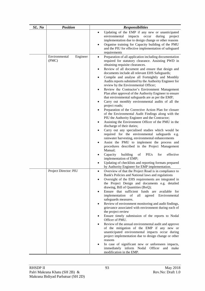
RHSDP II 93 May 2018
Palri Makrana Khatu (SH 2B) & Rev.No: Draft 1.0
Makrana Bidiyad Parbatsar (SH 2D)
SL. No Position Responsibilities
• Updating of the EMP if any new or unanticipated
environmental impacts occur during project
implementation due to design change or other reasons
• Organise training for Capacity building of the PMU
and the PIU for effective implementation of safeguard
requirements
Environmental Engineer
(PMC) • Preparation of all application including documentation
required for statutory clearance. Assisting PWD in
obtaining requisite clearances.
• Review of all document and ensure that design and
documents include all relevant EHS Safeguards;
• Compile and analyse all Fortnightly and Monthly
Audits reports submitted by the Authority Engineer for
review by the Environmental Officer;
• Review the Contractor’s Environment Management
Plan after approval of the Authority Engineer to ensure
that environmental safeguards are as per the EMP;
• Carry out monthly environmental audits of all the
project roads;
• Preparation of the Corrective Action Plan for closure
of the Environmental Audit Findings along with the
PIU the Authority Engineer and the Contractor;
• Assisting the Environment Officer of the PMU in the
discharge of their duties;
• Carry out any specialised studies which would be
required for the environmental safeguards e.g.
rainwater harvesting, environmental enhancements
• Assist the PMU to implement the process and
procedures described in the Project Management
Manual;
• Capacity building of PIUs for effective
implementation of EMP;
• Updating of checklists and reporting formats prepared
by Authority Engineer for EMP implementation.
Project Director: PIU • Overview of that the Project Road is in compliance to
Bank's Policies and National laws and regulations
• Oversight of the EHS requirements are integrated in
the Project Design and documents e.g. detailed
drawing, Bill of Quantities (BoQ);
• Ensure that sufficient funds are available for
implementation of all agreed Environmental
safeguards measures.
• Review of environment monitoring and audit findings,
grievance associated with environment during each of
the project review
• Ensure timely submission of the reports to Nodal
Officer of PMU.
• Review of the annual environmental audit and approve
of the mitigation of the EMP if any new or
unanticipated environmental impacts occur during
project implementation due to design change or other
reasons
• In case of significant new or unforeseen impacts,
immediately inform Nodal Officer and make
modification in the EMP.

RHSDP II 94 May 2018
Palri Makrana Khatu (SH 2B) & Rev.No: Draft 1.0
Makrana Bidiyad Parbatsar (SH 2D)
SL. No Position Responsibilities Assistant Engineer: PIU • Review the Contractor compliance with all the
statutory requirement and the Safeguard requirement
mentioned in the EMP.
• Approve the Contractor’s EMP Implementation Plan
after the same has been approved by the Authority
Engineer;
• Review the weekly environmental reports submitted
by the Authority Engineer and submission to the PMU
for review;
• Review the grievances in the Grievance Management
System and ensure its closure. If required interact with
the district authorities and ensure its closure;
• Coordinate with the Environmental Officer of the
PMU for the Implementation of the EMP and
environmental Safeguards;
• Oversight of the package specific EMP’s and make
necessary modifications if required;
• Review the Environmental Performance during the
project review meeting;
• Ensure monthly, quarterly and annual environmental
monitoring reports are prepared by Authority Engineer
and submitted to PMU.
• Review the Corrective Action Plan for closure of the
Environmental Audit findings
Environmental Engineer
(Authority Engineer) • Ensure that Contractor is in compliance with all the
statutory requirement and the Safeguard requirement
mentioned in the EMP.
• Review and approve the Contractor’s EMP
Implementation Plan;
• Ensure that the regular environmental reports are
compiled by Contractor, reviewed and submitted to
PMC;
• Carry out any specialised designs which would be
required for the environmental safeguards;
• Facilitating the Contractor to obtain necessary
permissions/ approvals and its submission to PMC
• Directly interact with aggrieved persons and record
their views and grievances in the Grievance
Management System.
• Work with the contractor to ensure grievances if any at
field level is resolved
• Review and approve the package specific EMP’s and
make necessary modifications if required.
• Ensure that all mitigation measures as given in the
EMP are implemented properly by the Contractor
during the study.
• Conduct weekly environmental monitoring of all
project during pre-construction, construction and
operation phases.
• Ensure monthly, quarterly and annual environmental
monitoring reports are prepared and submitted to
PMC.
• Work with the Contractor PIU and PMC for
preparation of the environmental corrective actions on
audit observations
Environmental Engineer
(Contractor) • Responsible for ensuring integration of the mitigation
measures proposed in the Environmental Management
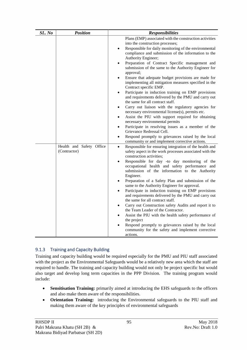
RHSDP II 95 May 2018
Palri Makrana Khatu (SH 2B) & Rev.No: Draft 1.0
Makrana Bidiyad Parbatsar (SH 2D)
SL. No Position Responsibilities
Plans (EMP) associated with the construction activities
into the construction processes;
• Responsible for daily monitoring of the environmental
compliance and submission of the information to the
Authority Engineer;
• Preparation of Contract Specific management and
submission of the same to the Authority Engineer for
approval;
• Ensure that adequate budget provisions are made for
implementing all mitigation measures specified in the
Contract specific EMP.
• Participate in induction training on EMP provisions
and requirements delivered by the PMU and carry out
the same for all contract staff.
• Carry out liaison with the regulatory agencies for
necessary environmental license(s), permits etc.
• Assist the PIU with support required for obtaining
necessary environmental permits
• Participate in resolving issues as a member of the
Grievance Redressal Cell.
• Respond promptly to grievances raised by the local
community or and implement corrective actions.
Health and Safety Office
(Contractor) • Responsible for ensuring integration of the health and
safety aspect in the work processes associated with the
construction activities;
• Responsible for day -to day monitoring of the
occupational health and safety performance and
submission of the information to the Authority
Engineer.
• Preparation of a Safety Plan and submission of the
same to the Authority Engineer for approval.
• Participate in induction training on EMP provisions
and requirements delivered by the PMU and carry out
the same for all contract staff.
• Carry out Construction safety Audits and report it to
the Team Leader of the Contractor.
• Assist the PIU with the health safety performance of
the project
• Respond promptly to grievances raised by the local
community for the safety and implement corrective
actions.
9.1.3 Training and Capacity Building
Training and capacity building would be required especially for the PMU and PIU staff associated
with the project as the Environmental Safeguards would be a relatively new area which the staff are
required to handle. The training and capacity building would not only be project specific but would
also target and develop long term capacities in the PPP Division. The training program would
include:
• Sensitisation Training: primarily aimed at introducing the EHS safeguards to the officers
and also make them aware of the responsibilities.
• Orientation Training: introducing the Environmental safeguards to the PIU staff and
making them aware of the key principles of environmental safeguards

RHSDP II 96 May 2018
Palri Makrana Khatu (SH 2B) & Rev.No: Draft 1.0
Makrana Bidiyad Parbatsar (SH 2D)
• Detailed Training: aimed at the PIU staff and the Authority Engineer to make them aware
of the detailed activities which needs to be implemented and enforced during the EMP
Implementations
• Refresher Training: this would be a need-based training organised to rectify the
shortcomings identified during the Monitoring and Auditing.
The modalities of the training are presented in

RHSDP II 97 May 2018
Palri Makrana Khatu (SH 2B) & Rev.No: Draft 1.0
Makrana Bidiyad Parbatsar (SH 2D)
Figure 9-3.

RHSDP II 98 May 2018
Palri Makrana Khatu (SH 2B) & Rev.No: Draft 1.0
Makrana Bidiyad Parbatsar (SH 2D)
Figure 9-3: The training to be carried out as part of Capacity Building
9.2 MONITORING & AUDITING PLAN Reporting system for the suggested monitoring and auditing plan, operating at two levels are as
follows:
• Reporting for environmental management (EM) indicators to assess the progress of the EMP
Implementations
• Auditing of the Environmental management implementation to assess the effectiveness of
the implementation
The monitoring and auditing responsibilities and their reporting authority over the period of one year
is presented in

RHSDP II 99 May 2018
Palri Makrana Khatu (SH 2B) & Rev.No: Draft 1.0
Makrana Bidiyad Parbatsar (SH 2D)
Figure 9-4. This cycle would be replicated over the tenure of the project

RHSDP II 100 May 2018
Palri Makrana Khatu (SH 2B) & Rev.No: Draft 1.0
Makrana Bidiyad Parbatsar (SH 2D)
Figure 9-4: Monitoring and Auditing Protocol
9.2.1 Monitoring
Periodic Monitoring of the EMP is required for assessing the progress of the implementation of the
EMP. The monitoring would include regular activities related to the activities proposed in the EMP.
The following Monitoring reports would be submitted as per the protocol described earlier:
• Daily Monitoring Report: by the Contractor to the Authority Engineer on the
environmental actions which has been implemented on site on a daily basis. The complains
received from the community, observations at site for EHS issues, daily site audit, unsafe
acts etc would also recorded;
• Fortnightly Monitoring Report: by the Authority Engineer to the PIU and PMC. This
would review the Action Taken Report submitted by the Contractor and certify for the
completion. In addition, an independent monitoring would be carried out by the Authority
Engineer and observations include in the report. The Action Plan agreed with the Contractor
shall also be appended to the report.
• Monthly Monitoring: by the PMC for reporting to the PMU, would include a monitoring
of all the packages and report the observations. The Completed Action would also be
assessed for its effectiveness and sustainability.
9.2.2 Auditing
Internal Audit
The Internal Audit will be conducted once every quarter by the Nodal Officer of the PMU and
annually by an External Agency. The audit team would conduct document review of earlier issues
and their closure and also make visits for verification and auditing of the works being carried out.
It has been envisaged that auditing shall be carried out for
• assessing the process and the effectiveness of the measures suggested. In addition, an
external

RHSDP II 101 May 2018
Palri Makrana Khatu (SH 2B) & Rev.No: Draft 1.0
Makrana Bidiyad Parbatsar (SH 2D)
• compliance audit shall be conducted every before the annual review to assess the
effectiveness of the management system and compliance of the environmental safeguards.
External Audit
At the end of every year of the project cycle an audit of the environmental performance and
efficiency of the process would be carried out by an external independent agency. This
independent audit has been designed to understand the project’s environmental performance
without any biases. The external Agency would review the monitoring and Internal Auditing report
including the closure reports before carrying out auditing of at least three of the project sites every
year. The agency would verify the effectiveness of the actions taken for closure. In case repeat
incidence of non-conformance are observed the causative factors leading to the same shall be
analysed.
9.2.3 Monitoring Indicators
The Performance and Process Monitoring Indicators have been discussed in Section 8.3.1. The
Performance Indicators would be primarily used for monitoring of the performance of the
Environmental Management Plan. The Process Indicators would be used for assessing the
effectiveness of the Environment management System.
9.3 REVIEW AND CORRECTIVE ACTION PLAN
9.3.1 Formats and Checklists
To facilitate monitoring and auditing of the EMP implementation formats and checklist would be
developed by the PMU . The EMP matrix presented in Table 8.1 and the indicator mentioned in
Table 8-2 would act as a guidance for the development of the monitoring format.
9.3.2 Records
All monitoring and auditing records would be transmitted and maintained electronically. No hard
copies of the documents would be used for circulation. Each of the documents would be uniquely
numbered by the Package, Project Corridor Nomenclature of the Report and Date. The records of
the project would be stored in a Central repository at the PMU.
9.3.3 Review and Corrective Action
An annual review shall be conducted by Additional Chief Engineer at the time of the Project Review
meeting and after the completion of the Quarterly and Annual audit. The Project Directors and the
Assistant Engineer of the respective projects shall deliberate on the findings and recommendation of
Environment Audit and agree on a Corrective Action Plan including budgetary support if required.
The Corrective Action Plan shall be implemented in a time-bound manner and reported back to the
PMU. The PMU would prepare a closure report which would form a part of the Annual Report
submitted to the Bank
9.4 ENVIRONMENT MANAGEMENT BUDGET The budget for implementing the Environmental management Plan is presented in Table 9-2. This
budget would not be part of the Contract and would be used by the PMU/PIU to implement the
Environmental Safeguards. The budget should not form a part of the Bid Document.
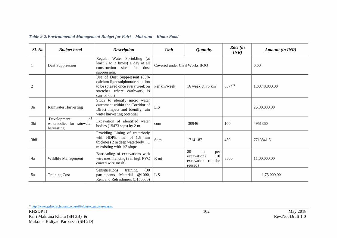
RHSDP II 102 May 2018
Palri Makrana Khatu (SH 2B) & Rev.No: Draft 1.0
Makrana Bidiyad Parbatsar (SH 2D)
Table 9-2:Environmental Management Budget for Palri – Makrana – Khatu Road
Sl. No Budget head Description Unit Quantity Rate (in
INR) Amount (in INR)
1 Dust Suppression
Regular Water Sprinkling (at
least 2 to 3 times) a day at all
construction sites for dust
suppression.
Covered under Civil Works BOQ 0.00
2
Use of Dust Suppressant (35%
calcium lignosulphonate solution
to be sprayed once every week on
stretches where earthwork is
carried out)
Per km/week 16 week & 75 km 837421 1,00,48,800.00
3a Rainwater Harvesting
Study to identify micro water
catchment within the Corridor of
Direct Impact and identify rain
water harvesting potential
L.S 25,00,000.00
3bi
Development of
waterbodies for rainwater
harvesting
Excavation of identified water
bodies (15473 sqm) by 2 m cum 30946 160 4951360
3bii
Providing Lining of waterbody
with HDPE liner of 1.5 mm
thickness 2 m deep waterbody + 1
m existing with 1:2 slope
Sqm 17141.87 450 7713841.5
4a Wildlife Management
Barricading of excavations with
wire mesh fencing (3 m high PVC
coated wire mesh)
R mt
20 m per
excavation) 10
excavation (to be
reused)
5500 11,00,000.00
5a Training Cost
Sensitisations training (30
participants Material @1000,
Rent and Refreshment @150000)
L.S 1,75,000.00
21 http://www.geltechsolutions.com/soil2o/dust-control-uses.aspx
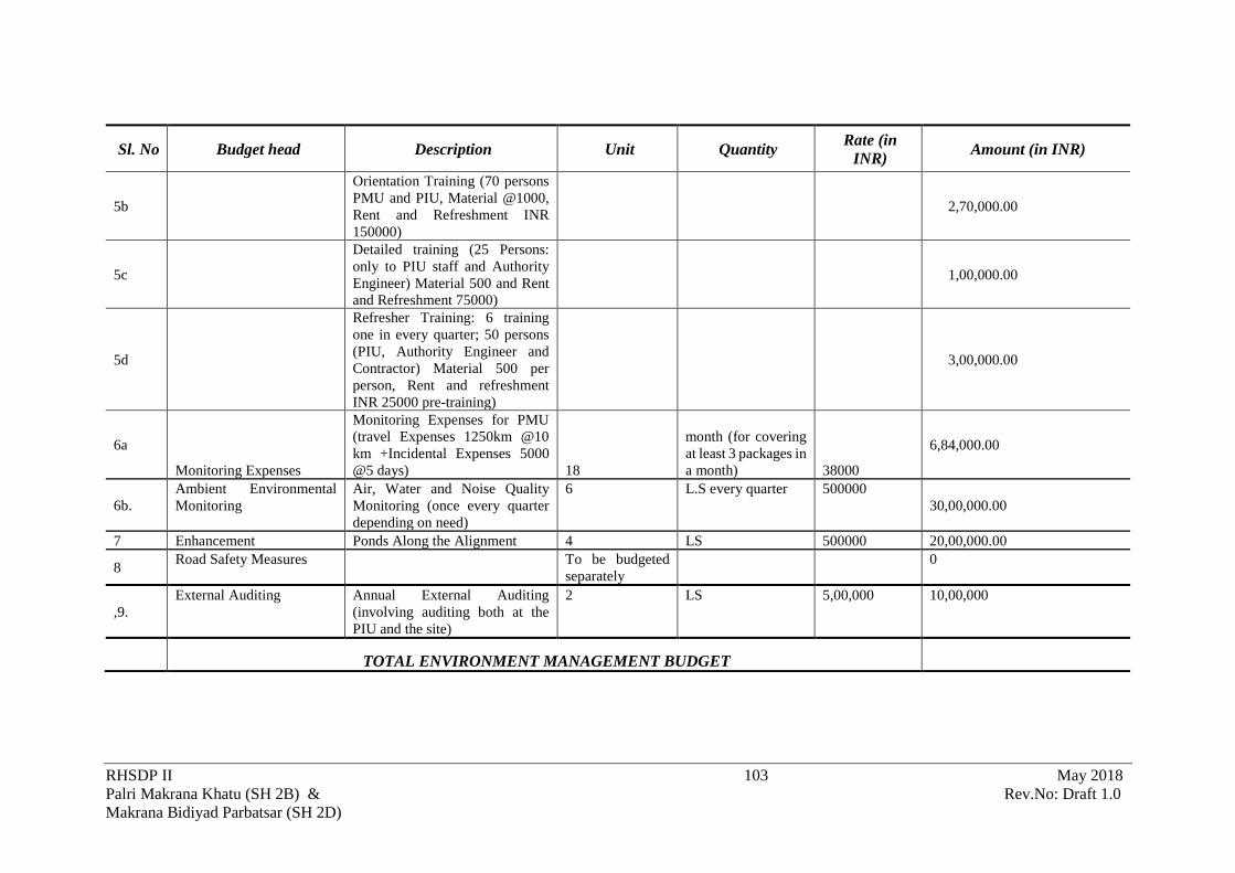
RHSDP II 103 May 2018
Palri Makrana Khatu (SH 2B) & Rev.No: Draft 1.0
Makrana Bidiyad Parbatsar (SH 2D)
Sl. No Budget head Description Unit Quantity Rate (in
INR) Amount (in INR)
5b
Orientation Training (70 persons
PMU and PIU, Material @1000,
Rent and Refreshment INR
150000)
2,70,000.00
5c
Detailed training (25 Persons:
only to PIU staff and Authority
Engineer) Material 500 and Rent
and Refreshment 75000)
1,00,000.00
5d
Refresher Training: 6 training
one in every quarter; 50 persons
(PIU, Authority Engineer and
Contractor) Material 500 per
person, Rent and refreshment
INR 25000 pre-training)
3,00,000.00
6a
Monitoring Expenses
Monitoring Expenses for PMU
(travel Expenses 1250km @10
km +Incidental Expenses 5000
@5 days) 18
month (for covering
at least 3 packages in
a month) 38000
6,84,000.00
6b.
Ambient Environmental
Monitoring
Air, Water and Noise Quality
Monitoring (once every quarter
depending on need)
6 L.S every quarter 500000
30,00,000.00
7 Enhancement Ponds Along the Alignment 4 LS 500000 20,00,000.00
8 Road Safety Measures To be budgeted
separately
0
,9.
External Auditing Annual External Auditing
(involving auditing both at the
PIU and the site)
2 LS 5,00,000 10,00,000
TOTAL ENVIRONMENT MANAGEMENT BUDGET

RHSDP II 104 May 2018
Palri Makrana Khatu (SH 2B) & Rev.No: Draft 1.0
Makrana Bidiyad Parbatsar (SH 2D)
10 Summary and Conclusion
The Palri -Makrana -Khatu (SH SB) and Makrana – Bidiyad -Parbatsar (SH 2D) road would be
developed in PPP Mode with Financial assistance of The World Bank. This stretch of the roads
(approx. 52 Km in case of SH 2B and 22 Km in case of SH 2D) is presently a two-lane undivided
carriageway. This would be upgraded to a two-lane corridor divided carriageway with granular
shoulder.
The alignment passes through Nagaur district. The SH 2B passes through Parbatsar (5 km), Makrana
(41.27 km) and Deedwana (5.3 km) block/tehsils while SH 2D passes through Parbatsar (13.80 km)
and Makrana (7.20 km) tehsils. The development of these highways would provide a link between
the State Highways 21A22 and SH 5923. More importantly this corridor would provide the
connectivity to the marble quarrying areas and trading areas in Makrana, Bidiyad and the RIICO
Industrial Areas Bidiyad. Thus, this connectivity improvement would provide impetus to the
industrial activity in the region. It would also provide connectivity to several settlements along the
highway notably Manglana, Makrana, Borawar, Kalwa, Manani, Gorawa, Bolathanam, Ranigaonm
Khatu in the Palari -Makrana -Khatu section and Makrana, Bidiyad, Kinsariya, Narwa, Parbatsar in
Makrana-Bidiyad- Parbatsar in SH 2D.
The EIA was focused on understanding the interactions between the Project activities and various
resources/receptors that could result in significant impacts. To understand the baseline
environmental condition of the resources and receptors along the project corridor primary baselines
environmental monitoring and studies were carried out. In addition, desktop studies were carried out
for the project influence areas of 10 km on either side of the corridor through review of secondary
literature to identify any sensitive receptors/area. The paragraph below gives a description of the
significant impact on the sensitive resources/receptors which were identified during the EIA studies
and the and mitigations which have been adopted in the project.
The alignment SH 2B passes through an undulating terrain with height of 360 m near Manna and
then increase to maximum height of 437m after Makrana where it crosses the Aravalli. The SH 2D
follows an undulating terrain between Makrana and Bidiyad beyond which the slope increase and
reaches a maximum height of 477m when it crosses the Aravalli range. Some minor cut and fill is
required in the Bidiyad bypass, but would not have any sever impacts as it only for a small portion
of the road However, to prevent any erosion it is suggested that stone pitching using quarry waste
be carried out.
The alignment falls in the Sekhewat basin which drains into the Sambhar Lake. There are no major
rivers in the areas and thus only existing pipe and box culvert have been retained. The micro
drainage studies of the project influence area indicate that there are several 1st order stream. These
are usually dry because the area receives very little rainfall. The absence of cross drainage
structures can have impact on the drainage, so the adequacy of the cross-drainage structures would
be looked into during the detailed design stages. Also, during the construction if the community
indicates any location wherein water flows across the alignment a culvert may be considered for
the location.
Due to the scanty rainfall and presence to sandy loam soil the surface water resource is scarce in
the project influence area. Due to the scarcity of surface water there is an over dependence on
22 This road length of 60 km passing through Nagaur district connects Parbatsar to NH 89 Junction via Piplad, Bagaut, Harsore,
Bherunda, Dodiyana. 23 The SH 59 from Beawar to Neemla Jodha via Pisangan, Govindgarh, Ladpura,Tehla, Bherunda, Harsore, Degana, Khatu, Bhantri is 159.90 km in length and passes through Ajmer and Naguar distrct.

RHSDP II 105 May 2018
Palri Makrana Khatu (SH 2B) & Rev.No: Draft 1.0
Makrana Bidiyad Parbatsar (SH 2D)
groundwater as a result number of block in Nagaur district are already declared as “notified
blocks” or over exploited by CGWB. Further, the ground water in the areas are also saline but in
absence of any surface water resources the local population is dependent on it for domestic and
drinking purpose. Using groundwater especially surface water or freshwater (groundwater) for
construction activities would have serious impacts on the availability of the resource for domestic
purpose. It is thus suggested that the contractor should harvest rainwater and use it for construction
activities or use saline ground water form deeper aquifers. A number of measures have been
discussed for the reduction of water consumption; these include use of plasticizers in cement
concrete, use of dust suppressants.
There are no National Park, Wild Life Sanctuaries within 10 km of the site. Also, there are no
protected forest which would interfere with the alignment. However, it is estimated 212 trees need
to be felled for this project. Even though there are no Wildlife sanctuaries foxes and Nilgai have
been reported from the area by the local people. At time these small animal stray into the construction
area and fall into the excavation. To prevent such accidents from happening temporary woven wire
mesh guards of about 2.4 m (8 ft.) high will be put around the excavated areas. Further, if any stray
animal falls in an excavation. No harm would be done to the trapped animal. The contractor in
association with PIU and Forest Department would ensure safe release of the animal.
In addition to the above specific measures to mitigate construction related impact the Environmental
Management Plan has suggested mitigation measures and action plans. A management system has
also been developed to ensure that these measures are effectively implemented.
However, in spite of the earnest attempt of PPP division to implement the EMP s its full earnest the
and develop the project in a sustainable manner some issues/impacts would remain especially during
the construction period. However, these environmental issues/impacts would be short term i.e.
during the construction period and would not cause any permanent change in the receiving
environment. The benefits accruing to the local people from the project would far outweigh the
inconvenience faced during the construction.

RHSDP II 106 May 2018
Palri Makrana Khatu (SH 2B) & Rev.No: Draft 1.0
Makrana Bidiyad Parbatsar (SH 2D)
ANNEXURE

RHSDP II i May 2018
Palri Makrana Khatu (SH 2B) & Rev.No: Draft 1.0
Makrana Bidiyad Parbatsar (SH 2D)
2.1: CARRIAGEWAY DETAILS.

RHSDP II ii May 2018
Palri Makrana Khatu (SH 2B) & Rev.No: Draft 1.0
Makrana Bidiyad Parbatsar (SH 2D)

RHSDP II iii May 2018
Palri Makrana Khatu (SH 2B) & Rev.No: Draft 1.0
Makrana Bidiyad Parbatsar (SH 2D)
Sl.
No
Existing
Chainage
Length
(km)
Type of
Carriageway
Width of
Carriageway
Width of Shoulder (m)
From To
1 0.000 0.035 0.035 C.C. 7 1.0m to 1.5m Earthen
shoulder 2 0.035 0.180 0.145 B.T. 7 1.0m to 1.5m Earthen
shoulder 3 0.180 0.300 0.120 C.C. 7 1.0m to 1.5m Earthen
shoulder 4 0.300 2.950 2.650 B.T. 7 1.0m to 1.5m Earthen
shoulder 5 2.950 3.950 1.000 B.T. 7 1.5m Footpath 6 3.950 5.150 1.200 B.T. 7 1.0m to 1.5m Earthen
shoulder 7 5.150 5.250 0.100 B.T. 10 1.0m to 1.5m Earthen
shoulder 8 5.250 5.350 0.100 C.C. 14 1.0m to 1.5m Earthen
shoulder 9 5.350 6.250 0.900 B.T. 14 1.0m to 1.5m Earthen
shoulder 10 6.250 7.600 1.350 C.C. 14 1.0m to 1.5m Earthen
shoulder 11 7.600 8.150 0.550 B.T. 7 1.5m Footpath 12 8.150 8.250 0.100 B.T. 14 1.0m to 1.5m Earthen
shoulder 13 8.250 9.650 1.400 C.C. 14 1.0m to 1.5m Earthen
shoulder 14 9.650 9.800 0.150 B.T. 10 1.0m to 1.5m Earthen
shoulder 15 9.800 12.000 2.200 B.T. 7 1.0m to 1.5m Earthen
shoulder 16 12.000 12.250 0.250 C.C. 7 1.0m to 1.5m Earthen
shoulder 17 12.250 12.700 0.450 C.C. 5.50 1.0m to 1.5m Earthen
shoulder 18 12.700 13.506 0.806 B.T. 7 1.0m to 1.5m Earthen
shoulder 19 13.506 13.606 0.100 C.C. 7 1.0m to 1.5m Earthen
shoulder 20 13.606 13.706 0.100 B.T. 7 1.0m to 1.5m Earthen
shoulder 21 13.706 14.017 0.311 C.C. 7 1.0m to 1.5m Earthen
shoulder 22 14.017 14.638 0.621 B.T. 7 1.0m to 1.5m Earthen
shoulder 23 14.638 14.798 0.160 C.C. 7 1.0m to 1.5m Earthen
shoulder 24 14.798 15.173 0.375 B.T. 7 1.0m to 1.5m Earthen
shoulder 25 15.173 15.343 0.170 B.T. 3.75 1.0m to 1.5m Earthen
shoulder

RHSDP II iv May 2018
Palri Makrana Khatu (SH 2B) & Rev.No: Draft 1.0
Makrana Bidiyad Parbatsar (SH 2D)
Sl.
No
Existing
Chainage
Length
(km)
Type of
Carriageway
Width of
Carriageway
Width of Shoulder (m)
From To
26 15.343 15.423 0.080 B.T. 7 1.0m to 1.5m Earthen
shoulder 27 15.423 15.498 0.075 B.T. 5.50 1.0m to 1.5m Earthen
shoulder 28 15.498 20.198 4.700 B.T. 3.75 1.0m to 1.5m Earthen
shoulder
29 20.198 20.423 0.225 C.C. 5.50 1.0m to 1.5m Earthen
shoulder
30 20.423 26.600 6.177 B.T. 3.75 1.0m to 1.5m Earthen
shoulder
31 26.600 27.075 0.475 C.C. 5.50 1.0m to 1.5m Earthen
shoulder
32 27.075 28.595 1.520 B.T. 3.75 1.0m to 1.5m Earthen
shoulder
33 28.595 28.625 0.030 C.C. 5.50 1.0m to 1.5m Earthen
shoulder
34 28.625 32.390 3.765 B.T. 3.75 1.0m to 1.5m Earthen
shoulder
35 32.390 32.420 0.030 B.T. 5.50 1.0m to 1.5m Earthen
shoulder
36 32.420 36.700 4.280 B.T. 3.75 1.0m to 1.5m Earthen
shoulder
37 36.700 36.825 0.125 C.C. 5.50 1.0m to 1.5m Earthen
shoulder
38 36.825 36.925 0.100 B.T. 3.75 1.0m to 1.5m Earthen
shoulder
39 36.925 37.200 0.275 C.C. 5.50 1.0m to 1.5m Earthen
shoulder
40 37.200 39.300 2.100 B.T. 3.75 1.0m to 1.5m Earthen
shoulder
41 39.300 39.410 0.110 B.T. 5.50 1.0m to 1.5m Earthen
shoulder
42 39.410 41.550 2.140 B.T. 3.75 1.0m to 1.5m Earthen
shoulder
43 41.550 42.040 0.490 C.C. 5.50 1.0m to 1.5m Earthen
shoulder
44 42.040 48.490 6.450 B.T. 3.75 1.0m to 1.5m Earthen
shoulder
45 48.490 48.540 0.050 B.T. 5.50 1.0m to 1.5m Earthen
shoulder
46 48.540 51.150 2.610 B.T. 3.75 1.0m to 1.5m Earthen
shoulder
47 51.150 51.300 0.150 B.T. 5.50 1.0m to 1.5m Earthen
shoulder
48 51.300 51.875 0.575 B.T. 3.75 1.0m to 1.5m Earthen
shoulder
49 0.000 0.350 0.350 B.T. 7 1.0m to 1.5m Earthen
shoulder
50 0.350 0.700 0.350 C.C. 7 1.0m to 1.5m Earthen
shoulder
51 0.700 2.500 1.800 B.T. 7 1.0m to 1.5m Earthen
shoulder
52 2.500 2.600 0.100 C.C. 7 1.0m to 1.5m Earthen
shoulder
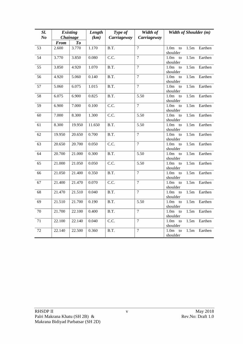
RHSDP II v May 2018
Palri Makrana Khatu (SH 2B) & Rev.No: Draft 1.0
Makrana Bidiyad Parbatsar (SH 2D)
Sl.
No
Existing
Chainage
Length
(km)
Type of
Carriageway
Width of
Carriageway
Width of Shoulder (m)
From To
53 2.600 3.770 1.170 B.T. 7 1.0m to 1.5m Earthen
shoulder
54 3.770 3.850 0.080 C.C. 7 1.0m to 1.5m Earthen
shoulder
55 3.850 4.920 1.070 B.T. 7 1.0m to 1.5m Earthen
shoulder
56 4.920 5.060 0.140 B.T. 7 1.0m to 1.5m Earthen
shoulder
57 5.060 6.075 1.015 B.T. 7 1.0m to 1.5m Earthen
shoulder
58 6.075 6.900 0.825 B.T. 5.50 1.0m to 1.5m Earthen
shoulder
59 6.900 7.000 0.100 C.C. 7 1.0m to 1.5m Earthen
shoulder
60 7.000 8.300 1.300 C.C. 5.50 1.0m to 1.5m Earthen
shoulder
61 8.300 19.950 11.650 B.T. 5.50 1.0m to 1.5m Earthen
shoulder
62 19.950 20.650 0.700 B.T. 7 1.0m to 1.5m Earthen
shoulder
63 20.650 20.700 0.050 C.C. 7 1.0m to 1.5m Earthen
shoulder
64 20.700 21.000 0.300 B.T. 5.50 1.0m to 1.5m Earthen
shoulder
65 21.000 21.050 0.050 C.C. 5.50 1.0m to 1.5m Earthen
shoulder
66 21.050 21.400 0.350 B.T. 7 1.0m to 1.5m Earthen
shoulder
67 21.400 21.470 0.070 C.C. 7 1.0m to 1.5m Earthen
shoulder
68 21.470 21.510 0.040 B.T. 7 1.0m to 1.5m Earthen
shoulder
69 21.510 21.700 0.190 B.T. 5.50 1.0m to 1.5m Earthen
shoulder
70 21.700 22.100 0.400 B.T. 7 1.0m to 1.5m Earthen
shoulder
71 22.100 22.140 0.040 C.C. 7 1.0m to 1.5m Earthen
shoulder
72 22.140 22.500 0.360 B.T. 7 1.0m to 1.5m Earthen
shoulder

RHSDP II vi May 2018
Palri Makrana Khatu (SH 2B) & Rev.No: Draft 1.0
Makrana Bidiyad Parbatsar (SH 2D)
2.2: EXISTING CROSS-DRAINAGE STRUCTURE

RHSDP II vii May 2018
Palri Makrana Khatu (SH 2B) & Rev.No: Draft 1.0
Makrana Bidiyad Parbatsar (SH 2D)
List of Culverts
Sr. No. Chainage (Km) Structure Type Span/ Opening
with Span
Length (m)
Width (m)
1 3.800 Slab 1X4.0 8.81
2 4.012 Slab 1X4.0 11.22
3 4.327 Slab 1X4.0 8.22
4 14.865 Pipe 2x0.6 8.24
5 15.924 Pipe 2x0.450 8.33
6 9.966 Pipe 3x1.0 8.09
7 10.458 Pipe 1x1.0 8.2
8 15.895 Pipe 4X0.750 8.15
9 21.195 Slab 1x5x2.7 8.09

RHSDP II viii May 2018
Palri Makrana Khatu (SH 2B) & Rev.No: Draft 1.0
Makrana Bidiyad Parbatsar (SH 2D)
ANNEXURE 2.3: MAJOR AND MINOR JUNCTIONS

RHSDP II ix May 2018
Palri Makrana Khatu (SH 2B) & Rev.No: Draft 1.0
Makrana Bidiyad Parbatsar (SH 2D)
List of Major Junctions
Sl. No
Chainage Type Side Towards Cross Road Width
Size
Exisiting Proposed Left Right 1 0.000 0.000 T Both Roopangarh Jaipur 10.00 Major
2 2.030 2.032 Y Right Jusari 3.75 Minor
3 2.668 2.672 Y Right Gudha 7.00 Minor
4 9.900 9.900 Y Left Parwatsar 7.00 Major
5 10.280 10.278 X Both Makrana City Makrana
City
3.75 Minor
6 11.870 11.870 Y Left Ramnagar
Colony
7.00 Minor
7 12.270 12.268 Y Right Borawar City 7.00 Minor
8 13.370 13.365 Y
Left
Market 10.00 Minor
9 13.942 13.950 Y Right Makrana City 7.00 Minor
10 14.470 14.487 Y Left Market 10.00 Minor
SH 2B
1 0+000 0+000 T Both Manglana Khatu 7.00 Major
2 1+350 1+400 T Right To Mines 3.50 Minor
3 3+145 3+200 Y Right To Mines 3.50 Minor
4 3+495 3+550 Y Right To Mines 3.50 Minor
5 4+170 4+225 Y Left Tikoniya Ki
Dhani
5.50 Minor
6 4+350 4+407 Y Right Kala Dungari 3.75 Minor
7 4+448 4+505 T Left Tikoniya Ki
Dhani
3.75 Minor
8 4+525 4+582 T Left Tikoniya Ki
Dhani
3.75 Minor
9 4+535 4+592 T Right Kala Dungari 3.75 Minor
10 5+286 5+332 Y Right Kala Dungari 7.00 Minor
11 5+400 5+450 Y Right Kala Dungari 7.00 Minor
12 5+910 5+965 Y Right Kala Dungari 7.00 Minor
13 5+940 6+000 X Both Tikoniya Ki
Dhani
Borawar 3.75 Minor
14 6+283 6+370 Y Right Bidiyad 5.50 Major
15 7+173 7+240 X Both Bidiyad Dhani 5.50 Minor
16 7+653 7+740 X Both Bidiyad Dhani 5.50 Minor
17 8+173 8+260 X Both Bidiyad Dhani 5.50 Minor
18 8+400 8+550 Y
Right
Bidiyad 5.50 Major
19 10+550 10+700 Y Right Mored Road 3.50 Minor
20 12+400 12+590 Y Right Basada 7.00 Minor
21 13+250 13+442 Y Right Kinsariya 3.00 Minor
22 13+523 13+720 Y Right Kevay Temple
Road
3.75 Minor
23 14+275 14+470 Y Right KinsariyaNadaba 7.00 Minor
24 15+640 15+833 Y Left Kidharpura 3.75 Minor
25 17+525 17+729 Y Right Nadba 3.75 Minor
26 19+735 19+950 Y Left Railway Station 7.00 Minor

RHSDP II x May 2018
Palri Makrana Khatu (SH 2B) & Rev.No: Draft 1.0
Makrana Bidiyad Parbatsar (SH 2D)
27 19+870 20+080 Y Right Mandadh 3.75 Minor
28 20+386 20+600 X Both Parbatsar Dhani 7.00 Minor
29 21+751 21+970 Y Left Parbatsar 7.00 Major
30 22+500 22+274 Y Left SH-7 7.00 Major

RHSDP II xi May 2018
Palri Makrana Khatu (SH 2B) & Rev.No: Draft 1.0
Makrana Bidiyad Parbatsar (SH 2D)
ANNEXURE 2.4: WIDENNING SCHEDULE

RHSDP II xii May 2018
Palri Makrana Khatu (SH 2B) & Rev.No: Draft 1.0
Makrana Bidiyad Parbatsar (SH 2D)
Widening Schedule
Sl.No Exisitng
Chainage
Design Chainage Design
Length
Description Proposal for
Proposed
Pavement To From To From
1. 0+000 0+035 0+000 0+035 35 2 Lane Existing
in Built –up area
2 lane with
paved shoulder
2 0+035 0+180 0+035 0+180 145 2 Lane Existing
in Built –up area
2 lane with
paved shoulder
3 0+180 0+300 0+180 0+300 120 2 Lane Existing
in Built –up area
2 lane with
paved shoulder
4 0+300 0+700 0+300 0+700 400 2 Lane Existing 2 lane with
paved shoulder
5 0+700 1+600 0+700 1+600 900 2 Lane
Strengthening (
Ex. 7.0m)
2 lane with
paved shoulder
6 1+600 1+900 1+600 1+900 300 Toll Plaza-Rigid
Pavement
2 lane with
paved shoulder
7 1+900 2+250 1+900 2+250 350 2 Lane
Strengthening (
Ex 7.0m)
2 lane with
paved shoulder
8 2+250 2+350 2+250 2+350 100 2 Lane Existing 2 lane with
paved shoulder
9 2+350 2+600 2+350 2+600 250 2 Lane
Strengthening (
Ex 7.0m)
2 lane with
paved shoulder
10 2+600 2+750 2+600 2+750 150 2 Lane Existing 2 lane with
paved shoulder
11 2+750 2+820 2+750 2+820 70 2 Lane Existing 2 lane with
paved shoulder
12 2+820 2+950 2+820 2+950 130 2 Lane
Strengthening (
Ex.7.0m)
2 lane with
paved shoulder
13 2+950 3+950 2+950 3+950 1000 ROB Under
Construction
No new work
Proposed
14 3+950 5+150 3+950 5+150 1200 2 Lane
Strengthening (
Ex.7.0m)
2 lane with
paved shoulder
15 5+150 5+250 5+150 5+250 100 2-Lane + Paved
Shoulder (
Ex.10.0m)
2 lane with
paved shoulder
16 5+250 5+350 5+250 5+350 100 4 Lane (Rigid
Pavement)
Newly
Constructed No
work
17 5+350 5+800 5+350 5+800 450 4 Lane (Flexible
Pavement)
Strengthening
with Bituminous
course of 4 lane
with 1.50m
Granular
Shoulder,
Drainage Layer
Not Extended
18 5+800 6+250 5+800 6+250 450 4 Lane (Flexible
Pavement)
Strengthening
with Bituminous
course of 4 lane
with 1.50m

RHSDP II xiii May 2018
Palri Makrana Khatu (SH 2B) & Rev.No: Draft 1.0
Makrana Bidiyad Parbatsar (SH 2D)
Sl.No Exisitng
Chainage
Design Chainage Design
Length
Description Proposal for
Proposed
Pavement To From To From
Granular
Shoulder,
Drainage Layer
Not Extended
19 6+250 7+600 6+250 7+600 1350 4 Lane (Rigid
Pavement)
Newly
Constructed No
work
20 7+600 8+150 7+600 8+150 550 ROB Under
Construction
No new work
Proposed
21 8+150 8+200 8+150 8+200 50 4 Lane (Flexible
Pavement)
Strengthening
with Bituminous
course of 4 lane
with 1.50m
Granular
Shoulder,
Drainage Layer
Not Extended
22 8+200 8+250 8+200 8+250 50 4 Lane (Flexible
Pavement)
Strengthening
with Bituminous
course of 4 lane
with 1.50m
Granular
Shoulder,
Drainage Layer
Not Extended
23 8+250 9+500 8+250 9+500 1250 4 Lane (Rigid
Pavement)
Newly
Constructed No
work
24 9+500 9+650 9+500 9+650 150 4 Lane (Flexible
Pavement)
Strengthening
with Bituminous
course of 4 lane
with 1.50m
Granular
Shoulder,
Drainage Layer
Not Extended
25 9+650 9+800 9+650 9+800 150 2-Lane + Paved
Shoulder ( Ex
10.0m)
2 lane with
paved shoulder
26 9+800 12+000 9+800 12+000 2200 2 Lane
Strengthening (
Ex 7.0m)
2 lane with
paved shoulder
27 12+000 12+250 12+000 12+250 250 2 Lane (Rigid
pavement)
2 lane with
paved shoulder
28 12+250 12+700 12+250 12+700 450 Intermediate
Lane Rigid
Pavement (Ex
5.50m)
2 lane with
paved shoulder
29 12+700 12+800 12+700 12+800 100 2 Lane
Strengthening (
Ex. 7.0m)
2 lane with
paved shoulder
30 12+800 12+900 12+800 12+900 100 2 Lane
Strengthening (
Ex. 7.0m)
2 lane with
paved shoulder

RHSDP II xiv May 2018
Palri Makrana Khatu (SH 2B) & Rev.No: Draft 1.0
Makrana Bidiyad Parbatsar (SH 2D)
Sl.No Exisitng
Chainage
Design Chainage Design
Length
Description Proposal for
Proposed
Pavement To From To From
31 12+900 13+200 12+900 13+200 300 2 Lane
Strengthening (
Ex. 7.0m)
2 lane with
paved shoulder
32 13+200 13+506 13+200 13+500 300 2 Lane
Strengthening (
Ex. 7.0m)
2 lane with
paved shoulder
33 13+506 13+606 13+500 13+600 100 2 Lane (Rigid
Pavement)
2 lane with
paved shoulder

RHSDP II xv May 2018
Palri Makrana Khatu (SH 2B) & Rev.No: Draft 1.0
Makrana Bidiyad Parbatsar (SH 2D)
ANNEXURE6.1: GUIDANCE NOTE ON BORROW AREA MANAGEMENT

RHSDP II xvi May 2018
Palri Makrana Khatu (SH 2B) & Rev.No: Draft 1.0
Makrana Bidiyad Parbatsar (SH 2D)
Preconstruction Stage
The contractor shall identify the borrow area locations in consultation with the individual owners
in case of private lands and the concerned department in case of government lands, after assessing
suitability of material. The contractor shall submit an application to the District Level
Environmental Assessment Committee for Environmental Clearance with the required details. The
Environmental clearance shall be submitted to the Employer before the borrowing operations can
begin.
Borrowing are to be avoided in the following areas:
• Lands close to toe line of the existing or proposed road.
• Irrigated agricultural lands shall be avoided. (In case of necessity for borrowing from
agricultural land, the topsoil shall be preserved in stockpiles. The subsequent Guidelines
detail the conservation of topsoil.
• Grazing land or any community property e.g. Orans, Gochars etc.
• Lands within 0.8km of settlements.
• Environmental sensitive areas such as Reserve Forests, Protected Forests, Sanctuary,
wetlands. distance of 1000 m should be maintained from such areas.
• Eco-sensitive areas around Mount Abu and Eco-Sensitive Zones of the Wild Life
Sanctuaries
• Unstable side-hills.
• Water-bodies.
• Streams and seepage areas.
• Areas supporting rare plant/ animal species;
The Employer/Authority Engineer will have the right to stop work at any borrow location even
after the required environmental clearance is received if it violates any of the above.
The Contractor shall ensure soft rock is not prominent within the proposed depth of excavation as
it will render rehabilitation difficult. The following options for redevelopment of Borrow area
might be considered in compliance to with MoRTH, clause 305.2.2.2.
Box 1: Options for Borrow Area redevelopment
• Borrow areas can be developed as: • Ponds (various types) (e.g.: Drinking Water only; Washing and for other Domestic Chores; Only for Cattle;
Mixed Uses etc.) (a large pond can be divided into two parts - each having a defined use)
• Agricultural land
• Water Recharging Zones (depending on the geology of the area)
• Pastureland
• Fish Ponds (pisciculture)
• Plantation Zones
• Recreational Zones (depending upon location, size, potential of the site, willingness of the local bodies to
develop it)
• Wildlife Refuge and Drinking Area (applicable only in case of sensitive environs with appropriate planning
and understanding including regulation of depth for safety of animals etc.)
• Waste disposal Sites (depending upon the location, distance from settlements, pollution risks, safety,
associated environmental risks and hazards, regulations/ permissions of appropriate authority and other
precautions e.g. HDPE Lining to prevent contamination of soil and groundwater)
The rehabilitation measures for the borrow areas shall be dependent on the following factors:
• Land use objectives and agreed post-borrowing activities with the owner of the land as per
the agreement;

RHSDP II xvii May 2018
Palri Makrana Khatu (SH 2B) & Rev.No: Draft 1.0
Makrana Bidiyad Parbatsar (SH 2D)
• Physical aspects (landform stability, erosion, re-establishment of drainage, geological
profile);
• Biological aspects (species richness, plant density,) for areas of native re vegetation;
• Water quality and soil standards; and
• Public safety issues.
The method statement which can be adopted for different options is presented in the Appendix 1:
Options for Rehabilitation of Borrow areas to the Guidance Notes
Operation of the Borrow Areas during the Construction Period
The Contractor will work out statutory requirement for borrowing with the land from the
Department of Mining and Geology, Govt. of Rajasthan. The Contractor must also obtain the
necessary environmental clearance as per the EIA Notification 2006.
The Contractor shall also work out an agreement for the borrowing of soil with the concerned land
owner. The arrangements will include:
• commitment not to use the topsoil;
• redevelopment after completion of borrowing;
• Commercial terms and conditions as may be agreed between the two parties;
The contractor shall submit to the Employer/Engineer the following before beginning work on the
borrow areas.
• Environmental Clearance Certificate of the borrow area
• Written No-objection certificate of the owner;
• Estimate extent of earth requires;
• Extent of land required and duration of the agreement;
• Photograph of the site in original condition; and
• Site redevelopment plan after completion.
The arrangements (except for the commercial terms and conditions) will be verified by the
Employer/Engineer to enable redressal of grievances at a later stage of the project. The
Employer/Engineer shall approve the borrow area with or without inspection of the site to verify
the reclamation plan and its suitability with the contractor and landowner. The contractor shall
commence borrowing soil only after the approval by the Employer/Engineer.
The depth of excavation should be decided based on natural ground level of the land and its
surroundings, as well as based on the rehabilitation plan. In case of highland larger depths may be
allowed but the final level of the borrowed land shall in no case be lower than the adjoining plots
so that it gets water logged. In case higher depth of excavation is agreed by backfilling using
unsuitable excavated soil (from roadway), in those cases filling should be adequately compacted
except for topsoil, which must be spread on the top most layer (for at least 20m thick).
In case the borrow pit is on agricultural land, the depth of borrow pits shall not exceed 45 cm and
may be dug out to a depth of not more than 30 cm after stripping the 15 cm top soil aside. In case
of stripping and stockpiling of topsoil, provisions of Appendix 2: Topsoil Salvage, Storage and
Replacement need to be followed.
The guidelines for location, depth, size and shape of the borrow areas are available in the
following:
• Clause 305.2.2.2 of MoRTH specification for roads and bridge works of IRC;

RHSDP II xviii May 2018
Palri Makrana Khatu (SH 2B) & Rev.No: Draft 1.0
Makrana Bidiyad Parbatsar (SH 2D)
• Guidelines for environmental impact assessment of highway projects, Indian Roads
Congress, 1989: IRC: 104-1988);
• IRC: 10-1961-Recommended practice for borrow pits for road embankments constructed
by manual operations, as revised in 1989;
• IRC SP: 58-2001 guideline for use of fly ash in road construction;
• Highways Sector EIA manual of MoEFCC, 2010
(http://envfor.nic.in/sites/default/files/highways-10_may_0.pdf );
• MoEFCC notification on utilisation of fly ash dated 25th March 2015 vide S.O. 1396 ( E )
mandating all road projects within a radial distance of 500 km to mandatorily use fly ash.
During the excavation the contractor must ensure that following database must be documented for
each identified borrow areas that provide the basis of the redevelopment plan.
• Chainage along with offset distance;
• Area of the plot (Sq.);
• Geo-tagged Photograph of the borrow pit from all sides;
• Type of access/width/kutcha/pucca etc from the carriageway;
• Soil type;
• Slope/drainage characteristics;
• Water table of the area or identify from the nearest well, etc;
• Existing landuse, for example barren/agricultural/grazing land;
• Location/name/population of the nearest settlement from borrow area;
• Present usage of borrow area; and
• Community facility near borrow pit.
During the excavation of the borrow areas the Contractor should maintain the following
precautions
:Mitigation Measures to be adopted in case of the Borrow Area excavation
Activity Mitigation Measures
Access Road to Site • Access road shall be used for hauling only after it is approved.
In case of any of the infrastructure i.e. road or culvert is in poor
conditions they may either be strengthened so that the
conditions do not deteriorate after the activity is over
• In case of Sensitive receptors on the access road e.g. school,
hospitals flagman should be posted to control the traffic. These
areas should also be maintained as a no-horn zone. The traffic
movement should be planned to avoid the movement during the
School timings.
Removal of natural
vegetation • The natural vegetation from the plot may be removed and stored
separately. This may be used as a mulch to protect the topsoil
heaps from wind erosion
• No tree would be felled without the permission of the forest
Department
Top Soil
Preservation
Before any excavation is carried out:
• In case of agricultural land, the topsoil (30 cm) shall be stripped
and stored at corners of the plot. The topsoil shall be stored at
location so that it is not disturbed during the process of
excavation of the borrow area. Top soil should be reused / re-
laid as per agreed plan.;
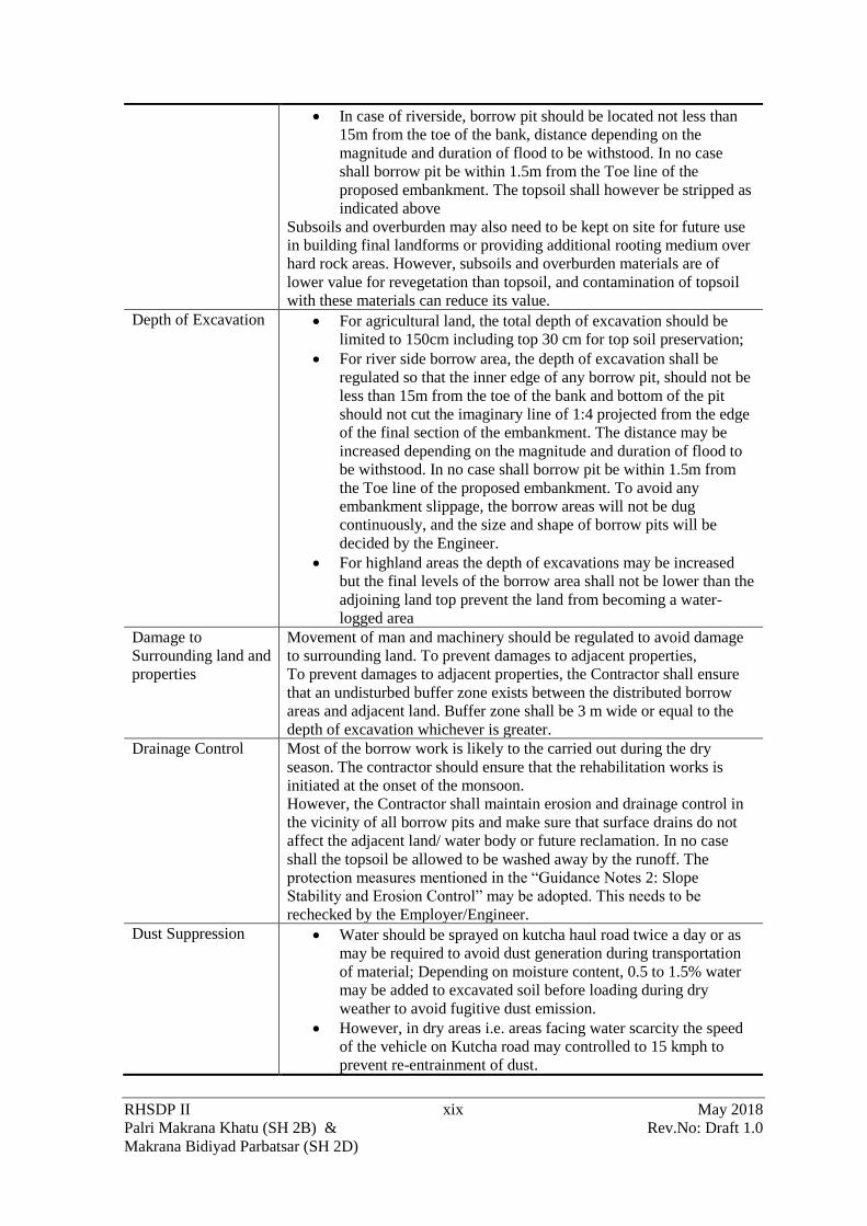
RHSDP II xix May 2018
Palri Makrana Khatu (SH 2B) & Rev.No: Draft 1.0
Makrana Bidiyad Parbatsar (SH 2D)
• In case of riverside, borrow pit should be located not less than
15m from the toe of the bank, distance depending on the
magnitude and duration of flood to be withstood. In no case
shall borrow pit be within 1.5m from the Toe line of the
proposed embankment. The topsoil shall however be stripped as
indicated above
Subsoils and overburden may also need to be kept on site for future use
in building final landforms or providing additional rooting medium over
hard rock areas. However, subsoils and overburden materials are of
lower value for revegetation than topsoil, and contamination of topsoil
with these materials can reduce its value.
Depth of Excavation • For agricultural land, the total depth of excavation should be
limited to 150cm including top 30 cm for top soil preservation;
• For river side borrow area, the depth of excavation shall be
regulated so that the inner edge of any borrow pit, should not be
less than 15m from the toe of the bank and bottom of the pit
should not cut the imaginary line of 1:4 projected from the edge
of the final section of the embankment. The distance may be
increased depending on the magnitude and duration of flood to
be withstood. In no case shall borrow pit be within 1.5m from
the Toe line of the proposed embankment. To avoid any
embankment slippage, the borrow areas will not be dug
continuously, and the size and shape of borrow pits will be
decided by the Engineer.
• For highland areas the depth of excavations may be increased
but the final levels of the borrow area shall not be lower than the
adjoining land top prevent the land from becoming a water-
logged area
Damage to
Surrounding land and
properties
Movement of man and machinery should be regulated to avoid damage
to surrounding land. To prevent damages to adjacent properties,
To prevent damages to adjacent properties, the Contractor shall ensure
that an undisturbed buffer zone exists between the distributed borrow
areas and adjacent land. Buffer zone shall be 3 m wide or equal to the
depth of excavation whichever is greater.
Drainage Control Most of the borrow work is likely to the carried out during the dry
season. The contractor should ensure that the rehabilitation works is
initiated at the onset of the monsoon.
However, the Contractor shall maintain erosion and drainage control in
the vicinity of all borrow pits and make sure that surface drains do not
affect the adjacent land/ water body or future reclamation. In no case
shall the topsoil be allowed to be washed away by the runoff. The
protection measures mentioned in the “Guidance Notes 2: Slope
Stability and Erosion Control” may be adopted. This needs to be
rechecked by the Employer/Engineer.
Dust Suppression • Water should be sprayed on kutcha haul road twice a day or as
may be required to avoid dust generation during transportation
of material; Depending on moisture content, 0.5 to 1.5% water
may be added to excavated soil before loading during dry
weather to avoid fugitive dust emission.
• However, in dry areas i.e. areas facing water scarcity the speed
of the vehicle on Kutcha road may controlled to 15 kmph to
prevent re-entrainment of dust.

RHSDP II xx May 2018
Palri Makrana Khatu (SH 2B) & Rev.No: Draft 1.0
Makrana Bidiyad Parbatsar (SH 2D)
• Consider the direction of prevailing winds when designing the
work area, work faces and stockpile layouts to minimise dust
nuisance
• Loading of the excavated earth on to the tippers shall be done to
minimise the dust
• In case of extreme windy condition leading to dust emission
stoppage of work may be considered.
Material transport Material transport shall only be provided with tarpaulin cover Decommissioning of
Equipment
All site should be cleaned of all contamination e.g. contamination from oil
spillage. These contaminated areas should be scrapped and sent with the
excavated material for use in embankment.
In case any adjoining area or property or area has become unstable the same shall
be repaired before the decommissioning of the machinery
Any damage to road, culverts or any other common property shall be repaired
immediately
Redevelopment of Borrow Areas
All reclamation shall begin within one month of decommissioning of borrow area, in accordance
with the redevelopment plan. The site shall be inspected by the Employer/Engineer after
implementation of the reclamation plan. Certificate of Completion of Reclamation is to be obtained
by the Contractor from the landowner that ―the land is restored to his satisfaction.
Inspection of the Redevelopment Works
Inspection needs to be carried out by the Employer/Engineer for overseeing the redevelopment of
borrow areas as per the plan. The checklist for the inspection by the Employer/Engineer is given
below (Box 10-1).
Box 10-1:Inspection Checkpoints for Borrow Area Operations
• Compliance of post-borrowing activities and land use with the restoration plan;
• Drainage measures taken for inflow and outflow in case borrow pit is developed as a detention pond;
• Levelling off the bottom of the borrow areas;
• In case the borrow area is on private property, the contractor shall procure written letter from landowner for
satisfaction on rehabilitation. In case of no rehabilitation is desired by the landowner, the letter should include
statement ― “no responsibility of PWD or the contractor in the event of accident”.
• Condition of the reclaimed area in comparison with the pre-borrowing conditions.
Appendix 1: Options for Rehabilitation of Borrow Areas
Option I: Suitable in locations with high rainfall and productive areas
The sites which have relatively better rainfall is well suited for conversion to agricultural fields.
The following process can be used for the rehabilitation of the borrow area into agricultural field:
• After the decommissioning of the machinery the entire area shall be graded so that the plot
is level. A grader or even a Dozer may be used for the purpose.
• The subsoil soil if any which has been scrapped shall also be re-laid. Once the site is
levelled no heavy machinery would enter the plot of land. To remove any compaction of
the soil the deep ploughing would be applied;
• Once the site ash been levelled at the deep ploughed the topsoil shall be evenly re-laid.
Topsoil must be placed, seeded, and mulched within 30 days of final grading if it is within
a current growing season or within 30 days of the start of the next growing season.

RHSDP II xxi May 2018
Palri Makrana Khatu (SH 2B) & Rev.No: Draft 1.0
Makrana Bidiyad Parbatsar (SH 2D)
• Vegetative material used in reclamation must consist of grasses, legumes, herbaceous, or
woody plants or a combination thereof, useful to the community for the fuel and fodder
needs.
• Plants must be planted during the first growing season following the reclamation phase.
Selection and use of vegetative cover must consider soil and site characteristics such as
drainage, pH, nutrient availability, and climate to ensure permanent growth. The vegetative
cover is acceptable if within one growing season of seeding, the planting of trees and
shrubs results in a permanent stand, or regeneration and succession rate, sufficient to
assure a 75% survival rate.
Option II: In barren land, the borrow areas can be redeveloped into detention ponds.
The plots of land which cannot be put into agricultural or other productive use may be considered
for such rehabilitation. These detention tanks will be doubled up as water bodies for rain-water
harvesting and for removal of sediment from runoff flowing through the ponds. Design of the
detention basin depends upon the particle size, settling characteristics, residence time and land
area. A minimum of 0.02 mm size particle with a settling velocity of 0.02 cm/sec (assuming
specific gravity of solids 2.65) can be settled in the detention basin.
The parameters are to be observed while setting up a detention pond:
Box 2:Design Parameters for the Detention Tank
• The plot in which the pond is being created should be located at the lowest point in the catchment area.
• Care should be taken that the horizontal velocity should be less then settling velocity to prevent suspension
or erosion of deposited materials.
• Minimum Effective Flow Path: 5 times the effective width
• Minimum Free Board: 0.15 m
• Minimum Free Settling Depth: 0.5 m
• Minimum Sediments Storage Depth: 0.5 m
• Maximum interior slope: 2H: 1V
• Maximum exterior slope: 3H: 1V
The inlet structure should be such that incoming flow should be distributed across the width of the
pond. A pre-treatment sump with a screen should be provided to remove detritus/debris. The
settled sediments should get settled in the sedimentation tank.
Appendix 2: Topsoil Salvage, Storage and Replacement
Poor handling and stockpiling practices will result in a significant loss of viable seed and topsoil
quality. Quality control procedures should be applied for the movement and handling, storage and
re-spread of soil layers for use in revegetation
In case of hilly and desert areas, topsoil with humus wherever encountered while opening the site
for construction shall be stripped and stockpiled (Refer MoRTH- Technical Specification no.
301.3.2 and 305.3.324 and for measurement for payment 301.8).
Location of Stockpile
The Topsoil stockpile shall be located within the agricultural plot. In case two or more plots are
adjacent to each other the topsoil of the plots should not be mixed and stored separately. The
location for storage of the topsoil shall have the following consideration (Box -3)
Box -3:Considerations for Storage of Topsoil
24 November, 2000

RHSDP II xxii May 2018
Palri Makrana Khatu (SH 2B) & Rev.No: Draft 1.0
Makrana Bidiyad Parbatsar (SH 2D)
• The surface topsoil layer and the subsoil should not be mixed during the stripping and stockpiling process.
• A secure area away from:
• Grade, Subsoil & Overburden materials;
• Pit activities and Day-to-day operations.
• Areas that do not interfere with future pit expansion
• Areas away from drainage paths and uphill of sediment barriers
• Areas away from the access roads
• Scalp good quality topsoil in windrow to each side of the earthworks to prevent erosion by wind.
• The stripping and handling of topsoil should occur when the field soil moisture content is optimum i.e. early
morning for the soil texture class
Specifications for Stockpiles
The stockpiles for storing the topsoil shall be designed such that the slope does not exceed 1:2
(vertical to horizontal), and the height of the pile is restricted to 2m. A minimum distance of 1m is
required between stockpiles of different materials.
Preservation of Stockpile
In cases where the topsoil must be preserved for more than a month, the stockpile is to be
stabilized within 7 days. The stabilisation shall be carried out through temporary seeding. It
consists of planting rapid-growing annual grasses or small grains, to provide initial, temporary
cover for erosion control.
Box -4: Vegetative material for stockpile stabilisation
• Must consist of grasses, legumes, herbaceous, or woody plants or a mixture thereof
• Selection & use of vegetative cover to take into account soil and site characteristics such as drainage, pH,
nutrient availability, and climate to ensure permanent growth
• The following precautions shall be considered for stockpile stabilisations:
• Stockpiles will not be surcharged, or otherwise loaded and multiple handling will be kept to a minimum to
ensure that no compaction will occur.
• Divert runoff around stockpiles unavoidably located in drainage paths using a perimeter bank uphill.
• The stockpiles shall be covered with gunny bags or tarpaulin immediately in case they are not stored for
periods longer than one month.

RHSDP II xxiii May 2018
Palri Makrana Khatu (SH 2B) & Rev.No: Draft 1.0
Makrana Bidiyad Parbatsar (SH 2D)
ANNEXURE 6.2: GUIDELINES FOR STORAGE , HANDLING AND DISPOSAL OF HAZARDOUS
WASTE MUNICIPAL SOLID WASTE AND CONSTRUCTION AND DEMOLITION WASTE

RHSDP II xxiv May 2018
Palri Makrana Khatu (SH 2B) & Rev.No: Draft 1.0
Makrana Bidiyad Parbatsar (SH 2D)
Hazardous Waste
• For storing of hazardous waste (Used oil and waste oil, Empty barrels/containers of oil,
lubricant and grease, Contaminated cotton rags or other cleaning materials), the Contractor
shall follow the guidelines while planning and designing the hazardous waste storage
areas:
o The storage area should be provided with concrete floor;
o The storage area floor should be provided with secondary containment;
o Proper slopes as well as collection pit to be provided in the storage area to collect
wash water and the leakages/spills etc.;
o Storage area should be provided with the flameproof electrical fittings;
o Automatic smoke, heat detection system should be provided in the sheds;
o Adequate firefighting systems (ABC type fire extinguisher) should be provided for
the storage area; and
o The Storage area shall be designed in such a way that the floor level is at least 150
mm above the maximum flood level.
Municipal Solid Waste
• The Contractor shall segregate and store bio-degradable and non-biodegradable
municipal solid waste in two separate bins (primary collection point). The storage area
should be provided with concrete floor;
• The Storage area shall be designed in such a way that the floor level is at least 150 mm
above the maximum flood level.
• The storage area shall be enclosed, or the storage containers shall be covered to prevent
vermis and scavengers from littering
Construction and Demolition Waste
• The Contractor shall keep the construction and demolition waste within the premise or at a
designated place for the collection of the C&D waste. The designated place shall be
decided in consultation with the local body. The agreement with the local body shall
essentially mention the end-use of the designated location. The designated site shall be
away from:
o Located at least 1000 m away from sensitive locations;
o do not contaminate any water sources, rivers etc; and
o Lotal site has adequate capacity equal to the amount of debris generated;
o Public perception about the location of debris disposal site has to be obtained
before finalizing the location;
o Productive lands are avoided; and available waste lands shall be given preference;
o Forest land shall be avoided.
• During the site clearance and disposal of debris, the contractor will take full care to ensure
that the public or private properties are not damaged/affected and that the traffic is not
interrupted.
• In the event of any spoil or debris from the sites being deposited on any adjacent land, the
contractor will immediately remove all such spoil debris and restore the affected area to its
original state to the satisfaction of the Authority Engineer.
• The contractor will at all times ensure that the existing water bodies and drains within and
adjacent to the site are kept safe and free from any debris.
• In case the dumping operations are carried out in dry and windy condition Contractor will
regulate the dumping operations so that the dust generation is minimised, or preferably

RHSDP II xxv May 2018
Palri Makrana Khatu (SH 2B) & Rev.No: Draft 1.0
Makrana Bidiyad Parbatsar (SH 2D)
carry out the operations in early morning when the environment is moist. The contractor
may utilize effective water sprays during the delivery and handling of materials.
• Materials having the potential to produce dust will not be loaded to a level higher than the
side and tail boards and will be covered with a tarpaulin in good condition.
• Any diversion required for traffic during disposal of debris shall be provided with traffic
control signals and barriers after the discussion with local people and with the permission
of Authority Engineer.
• During the debris disposal, contractor will take care of surrounding features and avoid any
damage to it.
• While disposing debris / waste material, the contractor will take into account the wind
direction and location of settlements to ensure against any dust problems. The contractor
can also consider the use of dust screens to prevent dust pollution.

RHSDP II xxvi May 2018
Palri Makrana Khatu (SH 2B) & Rev.No: Draft 1.0
Makrana Bidiyad Parbatsar (SH 2D)
ANNEXURE6.3: SCHEMATIC DIAGRAM FOR OIL-WATER SEPERATOR

RHSDP II xxvii May 2018
Palri Makrana Khatu (SH 2B) & Rev.No: Draft 1.0
Makrana Bidiyad Parbatsar (SH 2D)

RHSDP II xxviii May 2018
Palri Makrana Khatu (SH 2B) & Rev.No: Draft 1.0
Makrana Bidiyad Parbatsar (SH 2D)
ANNEXURE6.4: EMERGENCY SPILL CONTROL PROCEDURE

RHSDP II xxix May 2018
Palri Makrana Khatu (SH 2B) & Rev.No: Draft 1.0
Makrana Bidiyad Parbatsar (SH 2D)
Emergency Spill Procedure
Should a spill occur, either though spillage or equipment failure, the applicable emergency spill
procedure outlined below must followed.
Spill Procedure
In the case of a spill, overflow or release fluid into the stream waterway (whether water is flowing
during the spill or not), any actions that is practical and safely possible to control the situation,
shall be implemented.
• Stop the flow
o Stop the release into the stream waterway
o Shutdown equipment
o Close valves and pumps
o Plug hoses
• Remove Ignition Sources
o Shut off vehicles and other engines
• Do not allow torches, mobile phone, vehicles, smoking or other sources of ignition near
the area. Keep a fire extinguisher on hand but keep it a safe distance away from the
potential ignition source (if a fire starts, the extinguisher must be easily accessible).
• Contact the environmental Officer and initiate Emergency Response
• Notify the site supervisor and the Contractor’s Environmental Engineer and Health and
Safety Officer as soon as possible
• The Environmental Engineer of the Contractor will review the situation and decide if
Emergency Services like Fire Brigade are required
• Appropriate parties to be notified of the spill are The contractor’s Project Manager, The
Authority Engineer through his designated Environmental Officer, The PIU, Regulatory
Agencies like Pollution Control Board, Municipal Authorities, as applicable,
Cleanup and Disposal
• Identify nature and type of chemical/fuel spilled through information available onsite or
from first responder.
• Refer to the MSDS for any special instruction
• Wear personal protective equipment (PPEs) viz. chemical resistant gloves, safety boots,
safety glasses etc. Reach for the spill kit placed at the Contractor Camp.
• In case of spill on land create a dyke on the spill and use readily available sand, saw dust to
contain the spill. Use absorbent pads, to clean up the spill. In case of spill in a water
channel which is dry use the above method.
• In case the spill occurs within a waterbody stop any agitation to the waterbody and place
absorbent material to remove the spill.
• Recover the spill contaminated absorbent materials and use pads and store the same in
“Hazardous Waste” containers and store it in the waste storage area for disposal.
• For spill on unpaved areas such as soil, remove the upper layer of soil in the contaminated
area with a shovel and transfer it to the hazardous waste containers using a bucket.
• If any of your PPEs have been exposed to spill material dispose it off safely in hazardous
waste containers
Reporting

RHSDP II xxx May 2018
Palri Makrana Khatu (SH 2B) & Rev.No: Draft 1.0
Makrana Bidiyad Parbatsar (SH 2D)
• The Contractor’s Environmental Officer will document the event and submit reports to the
Authority Engineer. The Authority Engineer would send a report of the incident
immediately with its observations to the PIU, PMC and Environmental Officer at the
PMU.
• If required the Client would direct the Contractor to iniate the process of reporting to the
regulatory agencies. like the Pollution Control Board.
Procedure Review
The Environmental Office will review the report, determine if changes are required to procedures
and recommend implementation of all required changes. He would also intimate the management
of such incident.

RHSDP II xxxi May 2018
Palri Makrana Khatu (SH 2B) & Rev.No: Draft 1.0
Makrana Bidiyad Parbatsar (SH 2D)
ANNEXURE6.5: SCHEMATIC DIAGRAM FOR RAINWATER HARVESTING PIT

RHSDP II xxxii May 2018
Palri Makrana Khatu (SH 2B) & Rev.No: Draft 1.0
Makrana Bidiyad Parbatsar (SH 2D)

RHSDP II xxxiii May 2018
Palri Makrana Khatu (SH 2B) & Rev.No: Draft 1.0
Makrana Bidiyad Parbatsar (SH 2D)
ANNEXURE 6.6: GUIDANCE NOTE ON SITE CLEARANCE

RHSDP II xxxiv May 2018
Palri Makrana Khatu (SH 2B) & Rev.No: Draft 1.0
Makrana Bidiyad Parbatsar (SH 2D)
Vegetation Clearance
• Vegetation clearance shall comprise uprooting of vegetation, grass, brushwood, shrubs,
stumps, trees and saplings of girth upto 30 cm. measured at a height of one meter above
the ground level. Where only clearance of grass is involved it shall be measured and paid
for separately. The procedure/ steps involved for uprooting, skating and felling trees are
described below.
Uprooting of Vegetation
• The roots of trees and saplings shall be removed to a depth of 60 cm. below ground level
or 30 cm. below formation level or 15 cm below sub grade level, whichever is lower.
• All holes or hollows formed due to removal of roots shall be filled up with earth rammed
and levelled .
• Trees, shrubs, poles, fences, signs, monuments, pipe lines, cables etc. within or adjacent to
the area, which are not required to be disturbed during vegetation clearance shall be
properly protected by the contractor at his own cost.
Staking and Disposal
• All useful materials obtained from clearing and grubbing operation shall be staked in the
manner as directed by the Consultant.
• Trunks and branches of trees shall be cleared of limbs and tops stacked properly at the
places indicated by the Consultant. These materials shall be the property of the
Government.
• All unserviceable materials are disposed off in such a manner that there is no livelihood of
getting mixed up with the materials meant for construction.
Felling Trees
• Marking of tress: Trees, above 30 cm girth (measured at a height of one meter above
ground level) to be cut, shall be approved by the Consultant and then marked at the site.
• Felling of trees: Felling of trees shall include taking out roots up to 60 cm. below ground
level or 30 cm. below formation level or 15 cm. below sub-grade level, whichever is
lower.
• Filling: All excavations below general ground level arising out of removal of trees, stumps
etc. shall be filled with suitable material in 20 cm. layers and compacted thoroughly so that
the surface at these points conform to the surrounding area.
• Sizing: The trunks and branches of trees shall be cleared of limbs and tops and cut into
suitable pieces as directed by the Consultant.
• Staking: The serviceable materials shall be staked in the manner as directed by the
Environmental specialist of Supervision Consultant.
Disposal: The material, which cannot be used or auctioned shall be removed from the area and
disposed off as per the directions of the Consultant. Unsuitable waste materials should not get
mixed with construction material during disposal

RHSDP II xxxv May 2018
Palri Makrana Khatu (SH 2B) & Rev.No: Draft 1.0
Makrana Bidiyad Parbatsar (SH 2D)
ANNEXURE 6.7: GUIDANCE NOTE ON OCCUPATIONAL HEALTH & SAFETY

RHSDP II xxxvi May 2018
Palri Makrana Khatu (SH 2B) & Rev.No: Draft 1.0
Makrana Bidiyad Parbatsar (SH 2D)
. Guidance on General OHS Applications
General Safety procedure
All workers entering the site should be trained and made aware of the environmental and safety
practices. They should be made aware of the safety signages at the site;
Housekeeping
Improper housekeeping is the primary hazard in any construction site. The Contractor shall ensure
that a high degree of housekeeping is always maintained at the work sites. All site personnel, and
line management shall demonstrate committed and continued efforts towards housekeeping.
General Housekeeping shall be carried out by the contractor and ensured at all times at Work Site,
Construction Depot, Batching Plant, Labour camp, Stores, Offices and toilets/urinals. In case
public areas adjoining the worksites are soiled by construction debris, soil either spilled from
worksite or carried by the vehicle moving out of the worksite it shall be the Contractor’s
responsibility to clean-up. Toward general house keeping the Contractor shall constitute a special
group of housekeeping personnel. This group shall ensure daily cleaning at work site &
surrounding areas and maintain a register.
The contractor shall be responsible to provide segregated containers for disposal of debris at
required places and regular cleaning of the same.
Safety During Clearing and grubbing
If a tractor dozer is employed on clearing scrub or felling trees, it shall be provided with adequate
driver protection.
When two or more scrapers are working on the same job, a minimum distance of at least 25m or
adequate shall be kept between them.
In case of hydraulic breakers, hydraulic rams and hoses shall be in good working condition.
During the clearing operations no material shall be dumped on public land so as to reduce the
width of the carriageway;
The stumps of trees shall not be dumped on the public land nor shall it encroach on the right of
way.;
Construction within Settlements
Full height fence, barriers, barricades, etc. shall be erected around the site in order to prevent the
working area from the risk of accidents due to speedy vehicular movement. In the same way
barricades protect the road users from the danger due to construction equipment and other
temporary structures.
Specific walkways should be demarcated by barricade for use by pedestrians;
Cross-over sites would be provided at all worksites within settlements. At all cross over points
flagman shall be posted to control the traffic and facilitate movement of the pedestrians,
At night the worksite and adjoining areas within the settlement shall be well lit so that the people
are not inconvenienced;
Flasher should be provided at all cross over points to warn vehicular traffic of impending
movement of pedestrians

RHSDP II xxxvii May 2018
Palri Makrana Khatu (SH 2B) & Rev.No: Draft 1.0
Makrana Bidiyad Parbatsar (SH 2D)
Safety Measures for Vehicles
Drivers entering site shall be instructed to follow the safe system of work adopted on site. These
shall be verbal instructions or, preferably, written instructions showing the relevant site rules, the
site layout, delivery areas, speed limits, etc.
No passengers shall be carried, on any vehicle unless specific seating has been provided in
accordance with the manufacturers recommendations;
All Vehicles procured for the project shall be fitted with audible reverse alarms and maintained in
good working conditions. Reversing shall be done only when there is adequate rear view visibility
or under the directions of a Flagman.
All vehicle drivers including Hydra operators shall be trained on defensive driving at recognized
Institute for Driver Training. All vehicle drivers shall also undergo refresher training on defensive
driving provided by recognized institutes for the purpose once in 6 months.
No vehicle shall travel through the settlement at speed of more than 15 kmph
Flagman shall be placed at the both ends of the settlement and at the cross-over point to facilitate
movement of vehicle;
Safety measures at slopes
Working on gradients beyond any equipment capability shall not be allowed. Prevention of dumper
and dump truck accidents should be managed by providing wheel stops at a sufficient distance
from the edges of excavations, spoil heaps, pits, etc.
The manufacturer’s recommended bucket size must not be exceeded in excavators.
If excavators operating on a gradient, which cannot be avoided, it must be ensured that the working
cycle is slowed down, that the bucket is not extended too far in the downhill direction, and that
travel is undertaken with extreme caution. A large excavator must never be permitted to travel in a
confined area, or around people, without a flagman to guide the driver, who should have the
excavator attachment close in to the machine, with the bucket just clear of the ground. On wheeled
excavators, it is essential that the tyres are in good condition and correctly inflated. If stabilizing
devices are fitted, they should be employed when the machine is excavating.
When the front shovel of the 180° backhoe loaders is being employed, the backhoe attachment
shall be in its “travel” position, with the safety locking device in place.
When operating the backhoe in poor ground conditions, the stabilizers tend to sink into the surface
of the ground, reducing stability. Therefore, frequent checks shall be made for the stability of the
machine. The loading shovel should always be lowered to the ground to stabilize the machine
when the backhoe is employed.
Safety Measures During Bitumen Construction Work…
The Contractor shall ensure that bitumen storing, handling as well as mixing shall be done at hot-
mix plant or designated areas5 to prevent contamination of soil and ground water.
Skilled labour shall be used while hand placing the pre-mixed bitumen material.
The hand placing of pre-mixed bituminous material shall be done only in following circumstances:
o For laying profile corrective courses of irregular shape and varying thickness

RHSDP II xxxviii May 2018
Palri Makrana Khatu (SH 2B) & Rev.No: Draft 1.0
Makrana Bidiyad Parbatsar (SH 2D)
o In confined spaces where it is impracticable for a paver to operate and
o For filling potholes
The Contractor shall provide safety equipment i.e. gumboots and gloves to the workers while
handling bitumen.
While applying Tack Coat, spraying of bitumen shall be done in the wind direction. The labour
shall wear jacket while spraying the bitumen.
All the bituminous work shall be done as per IRC’s Manual for Construction and Supervision of
Bituminous Works.
Dangerous Work Environment
As per BOCWR:
When an internal combustion engine/s is/are used in a confined space or excavation or tunnel or
any other workplace where either natural or artificial ventilation system is inadequate to keep
carbon monoxide below 50ppm, exposure of workers shall be avoided unless suitable measures are
taken and provided by the contractor.
No worker shall be allowed into any confined space or tank or trench or excavation wherein there
is given off any dust, fumes/vapours or other impurities which is likely to be injurious or offensive,
explosive or poisonous or noxious or gaseous material or other harmful articles unless steps are
carried out by the contractor and certified by the responsible person to be safe.
Danger areas
The Contractor shall carry out a workplace safety assessment (not limited to the requirement of the
any legislation) where a workplace contains an area in which, owing to the nature of the work,
there is a risk of any person at work
o falling a distance; or
o being struck by a falling object or moving vehicle and equipment which is liable to cause
personal injury, and;
Such area may be clearly indicated as a Danger area. The area shall be clearly demarcated by
precautionary signages indicated in both pictorial and local language.
In case of active worksite which are also dangerous, or dangerous worksite where there is heavy
traffic or pedestrian movement flagman shall
Excavation
In case of excavation the safety plan should safeguard against the following::
• Collapse of the sides,
• Material falling on the people working in the excavation,
• People and vehicles falling into the excavation,
• People being stuck by plant and machinery,
• Access of both workers and local people to the excavation,
• Fumes/gas
• Underground utilities
• Accidents to members of the public.

RHSDP II xxxix May 2018
Palri Makrana Khatu (SH 2B) & Rev.No: Draft 1.0
Makrana Bidiyad Parbatsar (SH 2D)
Make sure the necessary equipment needed such as trench sheets, props, etc. is available on site
before work starts.
The following precautionary measures need to be considered:
Before starting excavation; it shall be checked whether there are any underground utilities present
like electrical power cables, pipe line or any other service line.
• If the excavation is deep more than 1.2 meters worker shall wear full body harness.
• For deep excavations appropriate preventive measure to be taken to avoid earth collapse
like slope or bench providing to the walls of the pit or sheet piling etc. as per norms and
design. The slope of excavation would not be steeper than the angle of repose of the
particular soil. When the slope is less than the angle of repose, which cannot be achieved
because of limited place or if it is uneconomical to provide such a slope then shoring
should support the earth.
• Excavation area would be barricaded 1-meter away from the edge of excavation pit. Tube
& coupler type hard barricades shall be used for the barricading.
• No materials would be stacked at edge of the excavation pit.
• There would not be any vehicle movement close to the edge of the excavation pit.
• Proper access would be made for workers, either by providing Stairways or cutting steps
on the wall of the pit or by any appropriate means
• Proper ramp to be made if the excavated earth is to be moved by vehicles.
• Proper lighting shall be provided for working at night. Reflectors & caution boards are to
be fixed to caution outsiders.
• Electrical cable routing would be laid such that it does not cause tripping hazard.
• Care would be taken that the persons working near by the excavation may not be hit by
moving part of the machine.
• The Dump Truck that shifts the excavated material shall move only after lowering the hull
to original position; after completion of dumping the material.
• Well trained two person are deployed for locking and unlocking backdoor of dumper.
Hand Tools & Power Tools
• Proper hand tools with insulated body shall be used.
• If duct dismantling is done at site, then the sheet handling shall be done carefully as it may
cause cut injury. Proper gloves shall be used to prevent any injury.
• When not in use, sharp edged hand tools shall be provided with proper protection for the
edges, Hand tools shall not be left unattended in the passageways, suitable cabinets or
covers shall be provided for hand tools. (Especially metal bending and cutting tools).
• Power tools shall be connected through ELCB (Earth Leakage Circuit Breaker).
• Plug-top shall be provided with all power tools.
Temporary Electrical Supply Installation
• In case of layout of temporary cable and distribution board the layout shall displayed at the
office and the main DB room.
• Cable markers shall be fixed to identify the route of the cables.
• The electrical installations shall be done in accordance with the regulation of the country
• All temporary electrical connection shall be done by authorized electrician, so deployed
shall necessarily have the electrical license from the concerned Government authority.
RHSDP II xl May 2018
Palri Makrana Khatu (SH 2B) & Rev.No: Draft 1.0
Makrana Bidiyad Parbatsar (SH 2D)
• Earth Leakage Circuit Breaker (ELCB) shall be provided to all portable equipment
supplies and a register to be maintained for its weekly check.
Setting up of Temporary Diesel Generator Set
• DG set shall be installed as per the electrical regulations;
• Fuel shall be stored away from the D.G Set and the area to be cordoned;
• CO2 fire extinguisher and two sand buckets shall be provided;
• All rotating parts of the equipment shall be adequately guarded;
• Fuelling shall be avoided while D.G is in operation;
• All cables shall be double insulated / armoured;
• Routing of cables shall be proper;
• Proper earthlings shall be provided. Earth resistance shall be maintained as per norms in
the Indian Electricity Act;
• Only authorized personnel shall be allowed to operate the generator;
• Smoking shall be strictly prohibited in the area around the generator and fuel storage area;
• The designated operator shall use earmuff in addition to other common PPEs.
Hydraulic Excavators /Lifts/Cranes
• Operator should have valid license;
• The equipment should also have a valid load test certificate;
• The driver should always carry his valid license and the certificate of the equipment he
operates.
• No person would enter the radius of action of Earth-moving equipment when in operation.
• No Earth-moving equipment would be started up until all workers are away from the
operating radius. The Flagman/traffic marshal/Signaller should assist the operator to
ensure safety in operation. Similar precautions should be taken during lifting operations of
cranes. The precautions mentioned in IS 13367: (Part 1): 1992 should be followed.
• The person directing the movement of the earth moving equipment/mobile crane
(signaller) should be easily identifiable by the driver and should be wearing high visibility
clothing. The Driver and the signaller should be providing with appropriate personnel
protective equipment such as safety boots googles gloves safety harness, safety spectacles
and ear plugs as applicable.
• Earth-moving equipment would not travel on bridges, viaducts, embankments, etc. unless
it has been found safe for it to do so.
• Adequate precautions shall be taken to prevent Earth-moving equipment being operated in
dangerous proximity to live electrical conductors.
• On Earth-moving equipment motors, brakes, steering gear, chassis, blades, blade-holders,
tracks, wire ropes, sheaves, hydraulic mechanisms, transmissions, bolts and other parts on
which safety depends shall be inspected daily.
• Earth-moving equipment shall not be left on a slope with the engine running.
• No adjustments, maintenance work or repairs would be made on equipment in motion.
• Deck plates and steps shall be kept free from oil, grease, mud or other slippery substances.
• Permit to Work Procedures should ideally be followed.
Working at Night

RHSDP II xli May 2018
Palri Makrana Khatu (SH 2B) & Rev.No: Draft 1.0
Makrana Bidiyad Parbatsar (SH 2D)
• Arrangement shall be made for adequate lighting of the work area. Precautions for
electrical safety should be considered during lighting
• Illumination shall be provided at working locations and passages the workers may use;
Workers shall be instructed to use the passage;
• All workers would wear Hi-visibility jackets, Safety helmets with chin strip, Safety shoes
and other PPEs.
• Availability of EHS person, safety personnel with beacons is essential during night work
Fall Protection
These safety precautions shall be applied when working at height especially in case of bridges or
any place where the workers are working at heights more than 2m
• Employee/ worker deployed for height work shall be selected persons who are experienced
and screened by the site management.
• Proper access and working platform shall be provided to reach the work spot.
• Fall protection must be provided for each employee on a walking/working surface with an
unprotected side or edge at the height. One of the following measures must be used when
employees are exposed to a fall of 6 feet or more:
o Guardrail: To an extent possible guard rails would be provided along the edges
o Safety Net Systems: Safety Nets to be provide when workers are exposed to risks
of fall from height.
o Fall Arrest Systems: Workmen shall wear full body harness with double lanyards
for work above 1.2 m height. The selection of safety Belts and harness would have
done in accordance to the IS 3521: 1999.
o On horizontal movements the lanyard of fall arrestor shall be hooked to the static
line.
o Life lines shall be used for easy movement during work of standard size as
specified in IS Codes.
o Cover or guard floor holes as soon as they are created. In case holes cannot be
covered the holes / opening/ vacant spaces in the floor should be guarded (with
isolation tapes or guard rails) or covered as soon as they are created.
• Height work permit to be followed on daily basis.
• Tool box talk shall be conducted on daily basis for height work.
Dropping Objects
These safety precautions shall be applied when working at height especially in case of bridges or
any place where the workers are working at heights:
• Workers shall carry tools in a bag;
• No materials shall be dropped from height. The material would be lowered by a headline. A
workman shall be posted at ground level to clear and caution person from coming under the
lowering material;
• In case where the work is carried out at height and the area below is used as a workspace or is
a passage for worker the following additional precaution shall be undertaken:
o The entire area shall be declared as a hard hat area and it shall be strictly enforced. No
personnel shall be allowed inside that area with safety helmets.
o Safety nets shall be provided below the work area

RHSDP II xlii May 2018
Palri Makrana Khatu (SH 2B) & Rev.No: Draft 1.0
Makrana Bidiyad Parbatsar (SH 2D)
Slips & Trips
The following are means to either prevent slips, trips, and falls or to minimize the consequences if
they should happen:
• Make the workers aware of the slipping and falling hazards when working on the ground
or other platforms.
• Keep all work areas clean and clear of oil, tools, and debris.
• Provide guardrails and guards around work areas that are prone to slips, trips, and falls.
• Instruct workers on proper procedures for using and installing ladders as per IS 3696-2
(1991):
• Keep all cables and hoses orderly and clear of walking spaces.
• Wear personal protective equipment (such as hard hats, work gloves, safety shoes, and eye
protection).
Fire and Explosion Hazards
To prevent risks of fires from ignition of flammable or combustible materials in the space, and
from leaks of flammable gas into the space, from hot work equipment during hot work such as
welding, cutting, brazing, soldering, and grinding the following precautions would be undertaken:
• Perform hot work in a safe location, or with fire hazards removed or covered.
• Use guards to confine the heat, sparks, and slag, and to protect the immovable fire hazards
In addition, these basic safeguards have fire-extinguishing equipment readily available and be
trained in its use. Make suitable fire-extinguishing equipment immediately available in a state or
readiness.
Occupational Health and Safety Training
• The contractor shall organize quality Occupational Heath Safety training for all its
employees/ contractor and sub-contractors (including managers, supervisors, works
(skilled/unskilled/ both temporary and permanent) and other personnel).
• The contractor shall arrange behavioural-based training programmes for all the executives
to identify, recognize and eliminate unsafe act and unsafe conditions. The contents of
Occupational Health and Safety shall be discussed and assessed by Managers and
Supervisors in all the regular and review meetings.
• Based on the outcomes of the review meting and the observations made during the
different audits and inspections Refresher-Training programme shall be conducted once in
six months.
• Every day before start of work Toolbox talk shall be conducted by the supervisor during
the morning meeting highlighting the safety precautions which needs to be taken and the
rectifications in safety behaviour which has been pointed out.
• In case of failure on the part of the contractor to provide all the above- mentioned training
programs to all employees in time, the same shall be provided by the Employer through
recognized & competent agencies if required by formulating a common scheme to all
contractors. Any administrative expenses and training fee towards the same shall be at the
cost of the contractor.
OHS Inspection & Audits

RHSDP II xliii May 2018
Palri Makrana Khatu (SH 2B) & Rev.No: Draft 1.0
Makrana Bidiyad Parbatsar (SH 2D)
• The Contractor shall carry out the following OHS inspections to identify any variation in
construction activities and operations, machineries, plant and equipment. The following
OH inspections program shall be adopted.
• Planned General Inspection
• Routine Inspection
• Specific Inspection
• Other inspection
• In addition, the Employer/Engineer shall carry out periodic surprise inspection not less
than once every month
• In addition, the Contractor shall carry out OHS Internal audit is to assess potential risk,
liabilities and the degree of compliance of construction Occupational Health and Safety
Plan. The Employer shall carry out annual OHS Audit of all sites every year. If required
supplementary procedures and programs would be developed.
Occupational Health Safety in Plant and Machinery
Construction Machinery
Construction machineries may include dumpers and dump trucks, lift trucks and telescopic
handlers piling figs, vibrio hammers, mobile elevation work platforms, cranes, tipper lorries, lorry
loaders, 360° excavators, 180° backhoe loaders, crawler tractors, scrapers, graders, loading
shovels, trenchers, side booms, pavers, planers, chippers, vibratory rollers, tankers and bowsers,
trailers, hydraulic and mechanical breakers etc.
A large number Construction machinery are deployed by the contractors for construction work,
bridge rebuilding etc. It is therefore essential that adequate safety measures are taken for safety of
trains as well the workforce. The following measures should invariably adopt:
• The Vehicle and equipment shall not start any work without the presence of Contractor’s
Supervisor at site.
• Since the vehicles and/or machinery are required to work in the close vicinity of active
traffic on the highway, the work shall be so carried out is such a way that there is no
infringement either to the movement of traffic or the slow-moving vehicle including
pedestrian. For this purpose, the area where the vehicles and/or machinery are required to
ply/operate, shall be clearly demarcated and acknowledged by the contractor. Special care
shall be taken for turning / reversal of vehicles / machinery without infringing the road
space available. Barricading shall be provided wherever justified and feasible as per site
conditions.
• The supervisor / workmen should be counselled about safety measures.
• The Contractor shall provide a Safety Certificate to the Employer/Engineer. Every
construction equipment shall be in sound mechanical working condition undertaken in the
past, any accident to the equipment, visual examination details critical components safety
check, devises and its working condition, manufacturer’s maintenance checklist, past
projects wherein the equipment were used etc as its minimum content.
Excavation & Trenching
Liaison with Utility Companies Prior to Excavation
• Prior to any excavation the contractor is responsible for notification of all applicable utility
companies, reasonably expected to be encountered during excavation work, -such as

RHSDP II xliv May 2018
Palri Makrana Khatu (SH 2B) & Rev.No: Draft 1.0
Makrana Bidiyad Parbatsar (SH 2D)
sewer, telephone, fuel, electric, water lines, or any other underground installations that
excavation work is being performed.
• It is expected that Utility companies or owners shall be contacted within established or
customary local response times, advised of the proposed work, and asked to establish the
location of the utility underground installations prior to the commencement of actual
excavation.
• Contractor must verify the location of any marked utility or as-built information either
prior to or during excavation.
Safety of Road Users and Workers
• During excavation, the contractor shall be responsible for ensuring a safe working
environment for its employees and pedestrians. When excavation operations approach the
estimated location of underground installations, the exact location of the installation will
be determined by safe and acceptable means.
• Maintain a physical barrier around all excavations and machinery. Often times caution tape
is insufficient, and barriers like properly supported fencing or temporary chain link fencing
must be installed. All excavation sites are to be secured during off work hours to prevent
unauthorized access.
• The contractor is responsible for providing the proper signage necessary to direct both
vehicular and pedestrian traffic safely around or through the work area.
• The contractor is responsible for routine inspections of all excavation equipment. The
inspection is to include safety features like back-up warning sounds and appropriate
lighting.
• The contractor is responsible to ensure that equipment operators carry the required (valid)
licenses and have the necessary training to operate the equipment on site.
Safe Practices for Excavation and Trenching
The contractor shall ensure that:
Each employee in an excavation shall be protected from cave- ins by an adequate
protective system.
• All excavation which is more than one 1.5 m or above, such excavation should be
protected by adequate piling and bracing against such bank or side
• Where banks of an excavation are undercut, adequate shoring is provided to support the
material or article overhanging such bank.
• Excavated material is not stored at least 0.65 m from the edge of an open excavation or
trench and banks of such excavation or trench are stripped of loose rocks and the banks of
such excavation or trench are stripped of loose rocks and other materials which may slide,
roll or fall upon a construction building worker working below such bank
• . Metal ladders and staircases or ramps are provided, as the case may be, for safe access to
and egress from excavation where, the depth of such excavation exceeds 1.5 m and such
ladders, staircases or ramps comply with the IS 3696 Part 1&2 and other relevant national
standards.
• Trench and excavation is protected against falling of a person by suitable measures if the
depth of such trench or excavation exceeds 1.5 m and such protection is an improved
protection in accordance with the design and drawing of a professional engineer, where
such depth exceeds 4m.
Concrete and Masonry Construction
Concrete Construction

RHSDP II xlv May 2018
Palri Makrana Khatu (SH 2B) & Rev.No: Draft 1.0
Makrana Bidiyad Parbatsar (SH 2D)
No construction loads shall be placed on portion of concrete structure unless the
Supervisor determines, based on the information received from a person who is qualified
in structural design, that the structures capable in supporting the loads.
• All protruding reinforced steel onto and into shall be guarded to eliminate the hazard.
• No employee shall be permitted to work under the concrete buckets while buckets are
being elevated or lowered into the position. To the extent practical, elevated concrete
buckets shall be routed so that no employee or the fewest number of employees are
exposed to the hazards associated with buckets or concrete falling from it.
Form work shall be designed, fabricated, erected, supported, braced and maintained so that
it is capable of supporting without failure all vertical and lateral loads that may be
reasonably be anticipated to be applied to form work.
• Forms (except those used for slabs on grade and slip forms) shall not be removed until it is
determined that the concrete has gained sufficient strength to support its weight and
superimposed loads. Such determination shall be based on one of the following:
• The concrete has been properly tested with an appropriate standard test method designed to
indicate the compressive strength, and the test results indicate that it has gained sufficient
strength to support its weight and superimposed loads.
Reinforced Earth (RE) I Masonry Wall
• To the practically feasible extent at site, a limited access zone will be established whenever
a RE Masonry wall is under construction. It shall be established prior to the start of the
construction of the wall. The zone shall conform to the following as far as practical:
• It shall be equal to the height of the wall to be constructed plus 1.2 m and shall run the
entire length of the wall.
• It shall be established on the side of the wall that will be un-scaffold or free standing.
• It shall be restricted to entry by the employees actively engaged in construction of the wall.
No other employee shall be permitted to enter the zone.
• It shall remain in place until the wall is adequately supported to prevent overturning and to
prevent collapse.
• All masonry walls more than 2.4 m in height shall be adequately braced to prevent
overturning and to prevent collapse unless wall is adequately supported so that the wall
will not overturn or collapse. The bracing shall remain in place until permanent supporting
elements of the structure are in place.
Compaction of Backfill of Material
• Tracked equipment shall not be allowed to come into direct contact with reinforced strips.
• Heavy equipment shall not be allowed to come within 1.5 m of the retaining wall. The
limited access zone shall be marked with the tape "No Heavy Equipment Beyond This
Point".
• Tags shall be hung from the tape every 25m.
• Compaction of backfill close to the wall shall be done only with hand operated vibrating
plate compactor or light weight rollers (< 500 kg). The compactor shall move only parallel
to the wall.
• Props shall be placed on two layers for preventing outward movement before compaction
is started.
• To avoid kicking out, backfill shall not be placed against the initial row of panels until the
first row of reinforcement has been connected.
Safety Measures for Handling Bituminous Materials

RHSDP II xlvi May 2018
Palri Makrana Khatu (SH 2B) & Rev.No: Draft 1.0
Makrana Bidiyad Parbatsar (SH 2D)
In cases of bitumen handling and application the following hazards
• Burn injuries if there is possibility of skin contact and if temperature is elevated exposure
to bitumen fumes and solvent vapours
• In case of Hot-mix works and hot mix plants the hazard zones are as follows:
Box 5:Hazard Zones in Hot Mix Plant and at Worksites
• In the Hot Mix Plant:
• Around the vents of the bitumen storage tanks.
• Near the asphalt mixer, asphalt conveyor -belt, skip, hot storage bins, during loading of trucks.
• Near the crusher of old asphalt.
• In the Plant laboratory
• Exposure in and around the mixing plant is in general of short duration.
• On the Work Site
• During the application of hot asphalt, exposure to asphalt / bitumen fume: may be experienced by paver
driver, screed man, rake man and roller driver since the work on and around the paving machine.
• Exposure to asphalt/ bitumen fume condensate via the skin may be considerable for people
working on the paving machine.
• During spraying bitumen emulsions or cut back bitumen the sprayer may receive highest exposure to
spray cloud or fume.
• During milling or crushing, annihilated of and skin contact with bitumen.
The safety measures which are essential during the process of heating of paving bitumen are:
• Mercury-in-steel dial thermometer, with long stem, should be used for recording
temperature of bitumen.
• The bitumen boiler should be filled with bitumen with sufficient space left for expansion
of bitumen. It should be loaded with that much quantity of bitumen so as to avoid keeping
hot bitumen continuously at high temperature for long periods.
• The heating process has to be controlled depending on the quantity of bitumen in the
boiler, the outlet for bitumen should be leak-proof and the boiler should be covered when
not in use.
• The boiler should have a chain pulley type of loading arrangement for lifting bitumen
drums.
• Hydrogen Sulphide Gas: In view of the possible presence of hazardous concentrations of
hydrogen sulphide gas in the vapour space in hot bitumen storage tanks or vessels
appropriate precautions must be taken when opening or entering tanks, vessels or other
containers to avoid inhalation of this acutely toxic gas. Gas detectors, available for rapid
monitoring of hydrogen sulphide gas, should be used for suitability of atmospheres for safe
entry into such storage spaces. Personal alarms for hydrogen sulphide could be used as a
further safeguard. Advice on selection of suitable respiration and other protective devices
could be obtained from a health and safety specialist.
• Protective Clothing: Labourers attending to the process of heating bitumen or its
application should be provided with hand gloves, gumboots, face masks and goggles to
ensure adequate personal safety and as a guard against any accidental contact with any
bitumen or bitumen derivatives. They should wear full sleeve shirts and full-length
trousers to ensure that they have the least exposure to bitumen.
• Facilities: Workers should be provided with adequate washing facilities viz. warm water
mild soap, mild skin cleanser, and clean (preferably disposals) towels.
• Awareness about thorough washing of skin after handling bitumen materials should be
encouraged through various educational means.
• First Aid:

RHSDP II xlvii May 2018
Palri Makrana Khatu (SH 2B) & Rev.No: Draft 1.0
Makrana Bidiyad Parbatsar (SH 2D)
o In case of burn injury from hot bitumen falling on the body, first-aid may be done
by thorough cooling of the affected part by cold running water up to 10 minutes or
longer if layer is thick or by giving an ice pack. No attempt should be made to
remove firmly adhering bitumen from the skin. It should either be allowed to fall
of gradually or it may be removed when necessary by warm medicinal paraffin or
a blend of paraffin and kerosene oil, remembering that kerosene oil may cause skin
irritation. This shall be followed by washing with soap and water and then
applying a skin cleansing cream. The burnt area should not be bandaged. The
casualty should be taken to hospital for treatment without delay.
o If bitumen is splashed into the eye it should be cooled immediately under cold
running water for at least 5 minutes. Medical attention should be obtained.
o First aid treatment for inhalation is only to be required if hydrogen sulphide is
involved. If this is suspected, all necessary precautions must be taken including the
use of breathing apparatus to avoid exposing rescuers to a contaminated
atmosphere.
• Transportation:
o Closed systems should be used for the handling and transportation of hot and cut-
back bitumen. Transfer from storage tanks to point of use should be by mechanical
means in order to minimize the possibility of skin contact or fume inhalation. The
bitumen boiler containing hot bitumen should be shifted from site to site carefully
by towing at slow speed to avoid splashing of bitumen.
o When hot bitumen is added in a hot mix plant for mixing with hot aggregates, care
should be taken to avoid burn injuries. In the case of manual handling of hot
bitumen, buckets should never be filled to the brim with hot bitumen. In mixing
plants, which have no separate pug mill for mixing of aggregates and bitumen and
where heating is done in the drum itself, the burner flame should be reduced after
adding bitumen to avoid overheating of bituminous mix.
• Spraying: Care should be taken when spraying of bitumen from perforated can sprayer or
from bar sprayer. The spraying nozzle and the hosepipe should be kept thoroughly clean
for smooth and uniform spraying of hot bitumen. Under no circumstances, the hosepipe
should be disconnected as any pressure developed in the pumping unit may result in hot
bitumen splashing and thus injuring the operator.
Batching Plant & Casting Yard
• The batching plant/casting yard shall be effectively planned for smooth flow of unloading and
stacking the aggregates reinforcements and cement, batching plant, transport of concrete,
casting the segment, stacking the segment and loading the segments to the trucks. As far as
possible the conflicts should be avoided.
• The batching plant / casting yard shall be barricaded and made as a compulsory PPE zone
• If in case of material unloading area is not maintainable as PPE zone, the same shall be
segregated properly and made as a non-PPE zone with appropriate barricading.
• Electrical system shall also be suitably planned so that location of diesel generator, if any,
location of DBs, routing of cables and positioning of area lighting poles/masts does not
infringe on any other utility and pose danger.
• Drainage shall be effectively provided, and waste water shall be disposed after proper
treatment
• Time office, canteen, drinking water, toilet and rest place shall be suitably located for the easy
access to workers. All the facilities shall be properly cleaned and maintained during the entire
period of operation.

RHSDP II xlviii May 2018
Palri Makrana Khatu (SH 2B) & Rev.No: Draft 1.0
Makrana Bidiyad Parbatsar (SH 2D)
• Manual handling of cement shall be avoided. Whenever it is absolutely necessary the workmen
shall be given full body protection, hand protection and respiratory protection as a basic
measure of ensuring better health.
• Access roads and internal circulation roads shall be well laid paved and maintained properly at
all time.

RHSDP II xlix May 2018
Palri Makrana Khatu (SH 2B) & Rev.No: Draft 1.0
Makrana Bidiyad Parbatsar (SH 2D)
ANNEXURE9.1: MONITORING FORMATS

RHSDP II l May 2018
Palri Makrana Khatu (SH 2B) & Rev.No: Draft 1.0
Makrana Bidiyad Parbatsar (SH 2D)
To be inserted as per the EMP