njdep - njgs - annual report of the state geologist for ...the administrative report, it contained...
TRANSCRIPT

GEOLOGICAL SURVEY OF NEW JERSEY
ANNUAL REPORT
OF THE
For the Year 1904
TRENTON. N. J. M A c C n a ~ r s ~ & QVICLBY, STATE PPINTEPS.
NEW JERSEY GEOLOGICAL SURVEY

NEW JERSEY GEOLOGICAL SURVEY

NEW JERSEY GEOLOGICAL SURVEY
iu COSTESTS. ?AGE
PART v I ~ o r r r p w d l . a t W Y t r o a k I t i l g r . - ~ . by c. c. \-eml&~. .................................. 253
P A W Flro b New Jasey D d m g 1904. % F. R ................................................... Yticr. 273
P A W Vm.-Tk I-. by H q B. KLmmeI, . - - - - - - - - 291
The Iron 3fina. .............................................. apl
The Zinc Hints, ............................................. 301 W~xen~r . .%~rrsrrcs, ........................... .. ................... .P3
NEW JERSEY GEOLOGICAL SURVEY

ILLUSTRATIONS . PLATES . PAGE .
PLATE I.-Semionotus agassizii. . . . . . . . . . . . . . . . . . . . . . . . . . . . . . . . . . . 104 PLATE 11.-Fins and scales of Semionotus. . . . . . . . . . . . . . . . . . . . . . . . . 106 PLATE 111.-Head. fins and scales of Semionotus. . . . . . . . . . . . . . . . . . . . . 108 PLATE 1V.-Semionotus ovatus. .................................... 110
PLATE V.-Semionotus ovatus. . . . . . . . . . . . . . . . . . . . . . . . . . . . . . . . . . . . 112
PLATE VI.-Semionotus ovatus. . . . . . . . . . . . . . . . . . . . . . . . . . . . . . . . . . . . . 114 PLATE VI1.-Semionotus agassizii. . . . . . . . . . . . . . . . . . . . . . . . . . . . . . . . . . . 116 PLATE VII1.-Semionotus agassizii. . . . . . . . . . . . . . . . . . . . . . . . . . . . . . . . . . . 118 PLATE 1X.-Semionotus fultus. . . . . . . . . . . . . . . . . . . . . . . . . . . . . . . . . . . . . 120
PLATE X.-Semionotus lineatus. . . . . . . . . . . . . . . . . . . . . . . . . . . . . . . . . . . . 122'
PLATE XI.-Semionotus lineatus. . . . . . . . . . . . . . . . . . . . . . . . . . . . . . . . . . . . 124 PLATE XI1.-Semionotus elegans. ................................... 126 PLATE XII1.-Capoterus gracilis. . . . . . . . . . . . . . . . . . . . . . . . . . . . . . . . . . . . . 128 PLATE X1V.-Semionotus. mechanically deformed. ................... 130 PLATE XV.-Fossils from the Cliffwood Clays. . . . . . . . . . . . . . . . . . . . . . . 136 PLATE XV1.-Fig. I . View through Weygadt. ....................... 168
. . . . . . . . . . . . . . . . . . . . . . . Fig 2 View of Warne's Quarry. 168 C PLATE XVI1.-Two views of the Verdolite Quarry. . . . . . . . . . . . . . . . . . . . . 172
PLATE XVII1.-Sections showing the rock structure near Easton. Pa.. . . . . 182 PLATE X1X.-Map showing extent of Forest Fires in New Jersey. .... 278
FIGURES . FIGURE I.-Pterichthys testudinarius. ................................. 40 FIGURE 2.-Cephalaspis m,urchisoni. .................................. 41 FIGURE 3.-Pteraspis rostrata. ....................................... 41 FIGURE 4.-Coccosteus decipiens. .................................... 42 FIGURE 5.-Cladoseloche fyleri. ...................................... 48 FIGURE 6.-Cestracion phillippi (Port Jackson Shark). . . . . . . . . . . . . . . . . 49 FIGURE 7.-Dipterus valenciennesi. ................................... 52 FIGURE 8.-Devonian fishes. .......................................... 53 FIGURE 9.-Head of Semionotus capensis. lateral aspect, .............. 73 FIGURE 10.-Head of Semionotus nilssoni. dorsal aspect. .............. 74 FIGURE 11.-Head of Semionotus nilssoni. lateral aspect. ................ 75 FIGURE 12.-Dorsal fin of Semionotus fultus. . . . . . . . . . . . . . . . . . . . . . . . . . . . 85 FIGURE 13.-Dorsal fin of Semionotus micropterus. .................... 88 FIGURE 14.-Map of the talc quarries near Phillipsburg. ................ 167 FIGURE 15.-Diagram showing relation between the percentage of ad-
herent clays and the bonding power of molding sands. . . 197 FIGURE 16.-Diagram showing the effect of size and arrangement of
spherical grains on the pore space. . . . . . . . . . . . . . . . . . . . . zoo FIGURE 17.-Map of Wells of the East Orange Water Works . . . . . . . . . . . 256 FIGURE 18.-Strata in the East Orange Water Company's Wells. . . . . . . . . 257
NEW JERSEY GEOLOGICAL SURVEY

NEW JERSEY GEOLOGICAL SURVEY
The ~eb lo~ i ca l Survey of New Jersey .
BOARD O F MANAGERS .
HIS EXCELLENCY FRANKLIN MURPHY. Governor and ex-officio Presi- dent of the Board. .......................................... .Trent0 n.
Members at Large .
........... EMMOR ROBERTS. ........................... Moorestown. 190j* . . . . . . . . . . . . . . ERNEST R . ACKERMAN. ...................... Plainfield . 1906
............ GEORGE G . TENNANT. . . . . . . . . . . . . . . . . . . . . . . .Jersey City. 1 9 6 .............. . . . . . . . . . . . . . . . . . . . . . . . . . . HERBERT M LLOYD. Montclair. 1907
................ HARRISON VAN DUYNE. .................... .Newark. 1 9 7 ................ S . BAYARD DOD. . . . . . . . . . . . . . . . . . . . . . . . . . . . . Orange. 1908 ............... JOHN C . SMOCK. ........................... .Trenton. .I@
.............. THOMAS W . SYNNOTT. ...................... Wenonah. 1909
.............. ..................... ALFRED A . WOODHULL. .Princeton. 1909
Congressional Districts .
I . FREDERIC R . BRACE. ................... .Blackwood. ............. 1906 ............... I1 . EDWARD C . STOKES. ................... Millville. 1 9 7 i
I11 . M . D . VALENTINE. ................... Woodbridge. . . . . . . . . . . . 1909 I V . WASHINGTON A . ROEBLING. . . . . . . . . . . .Trenton. . . . . . . . . . . . . . . . 1908
................ V . FREDERICK A . CANFIELD, ............. .Dover. . 1905* ............ VI . GEORGE W . WHEELER. ................ .Hackensack. 1906
............... . .............. VII . WENDELL P GARRISON. .Orange. . 1907 VIII . JOSEPH L . MUNN. ................... .East Orange. . . . . . . . . . . . I909
............. IX . JOSEPH D . BEDLE. ................... .Jersey City. Igo8 ............... X . AARON S . BALDWIN. .................. .Hoboken. 190j*
State Geologist . HENRY B . K ~ ~ M M E L .
*Reappointed April st, 1905. for five years . t P . Kennedy Reeves. Bridgeton. appointed April I. Igoj. to fill vacancy
caused by resignation of E . C . Stokes .
(vii)
NEW JERSEY GEOLOGICAL SURVEY

NEW JERSEY GEOLOGICAL SURVEY

T o His Excellency Franklin Murphy, Gouernor of the State of
New Jersey and ex-officio Presidettt of the Board of Mana-
gers of the Geologicad Survey:
SIR-I have the honor to submit my Annual Report upon the
work of the Geological Survey for the year 1 9 4 .
Yours respectfully,
HENRY B. KUMMEL,
State Geologist.
TRENTON, N. J., November 30, 1904.
NEW JERSEY GEOLOGICAL SURVEY

NEW JERSEY GEOLOGICAL SURVEY

ADMINISTRATIVE REPORT.
Administration, Publications, Distribution, Library, Labora- tory.-Topography, Field Work, Office Work, Pre- vention of Floods on the Passaic.-Geology, Talc Deposits, Molding Sands, Building Stone, Mineral Industry, Paleozoic Stratigraphy, Cretaceous Stratig- raphy, Pleistocene, Paleontology, Cooperation with the U. S. National Survey.-Forestry, Forest Fires, White Cedar Swamps.-Louisiana Purchase Exposi- tion.
I GEOL
NEW JERSEY GEOLOGICAL SURVEY

NEW JERSEY GEOLOGICAL SURVEY

Administrative Report,
The work of the Geological Survey during 1904 may best be considered under five heads : Administration, Topography, Ge- ology, Forestry and Louisiana Purchase Exposition. A brief statement of the work accomplished in each of these lines is herewith presented, while in the scientific papers which accompany the Administrative Report, the results of some of these investi- gations are set forth more at length.
ADMINISTRATION.
The conduct and direction of the Geological Survey is vested by law in the Board of Managers.and the State Geologist. The latter has direct charge of the wark in all its details, and is respon- sible to the Board for the successful and economical manage- ment of the department. During the past year, as heretofore, he has given his personal attention to the administrative work. This has included the direction of the scientific investigations, correspondence, examination and audit of accounts, editorial work on reports and maps, and direction of the distribution of the Survey publications. The direction of trhe scientific work has necessitated conferences with the various workers, not only in the office but also in the field, and the careful examination of reports submitted for publication. During the year, manuscript equivalent to about 800 printed pages has been read and re- vised, the same amount read both in galley and page proof and' indexed. The proof sheets of various topographic and geologic maps have also been examined.
3
NEW JERSEY GEOLOGICAL SURVEY

Pub1icationr.-The Annual Reprd: for 1903 (pp. 132 J- xxn-i, plates XIV) published in JLard2. In addition t ~ p
the Administrative Report, it contained the following report% and scientific papers :
Repod on a Proposed Tide %Vatern-ay between Bay Head and JIanasquan Inlet.--€. C. Vermeule.
The Floods of October9 rgo;j--Passtic El& and their Con- trol.--€. C. Vermuele.
, Forest Fires in Sew Jersey during 1903.-F- R- Jieier. Underground Waters of Sew Jersey-Wells drilled in 1903.
-G. S. Knapp. The Mining and Cement Industry.-S. H. Hamilton. I'olume VI, Clays and Clay Products; H. Ries, H. B. Kiim-
mel, G. S. Knapp (pp. j48+xrr\-ii. piates LVI. figures 41 !. \\-as issued in September. This report discussed the properties of clay, the stratigraphy of the Sew- Jersey clavs. the manufac- ture of clay products and the economic description of Sew Jersey clays. Many requests for it have been received from clay miners and manufacturers, and it seems to have met with much favor from the practical men engaged in that industn-.
The publication of revised atlas sheets has been continued. Sheet 26, the Metropolitan district, adjacent to Sew York. \\-as issued in December. Sheets 31 and 32, covering the region from Camden east to Whitings, and south to Elmer and Egg Harbor City. were issued later in the year. Sheet 23, covering northern Bergen and Passaic counties, and Sheet 28. the region from Mount Holly to New Brunswick, were.in the hands of the en- graver at the close of the year.
Distribution.-The demand for the reports and maps of the Survey steadily increases and a considerable part of the daily work of the office force is spent in filling these orders. During the year shipments of maps and reports were made as folio\\-s. It will be noticed that the demand for reports issued years ago is still active :
..................................... Annual Report for 1903, 3.691 copies '6 " 1902, . . . . . . . . . . . . . . . . . . . . . . . . . . . . . . . . . . . . . I j "
' I '6 I gor, ..................................... 73 " ' I I' IgOO, ..................................... ss "
NEW JERSEY GEOLOGICAL SURVEY

T H E SITATE GEOLOGIST. 5
,Annual Report for 1899, ...................................... 7 j copies Reports between 1883-1898, .......................... 810 "
Final Reports, Vol. 11, ...................................... 244 " ' " Vol. 111, ...................................... 138 "
' Vol. IV, ...................................... 70 "
' Vol. V, ...................................... 217 "
' Vol. VI, ....................................... 876 "
Other Reports, ............................................... 461 "
Total Reports, ............................................... 6,899 "
Map sheets- Scale I inch per mile, . . . . . . . . . . . . . . . . . . . . . . . . . . . . . . . . . . . . 1,408 Scale 2,000 feet per inch, . . . . . . . . . . . . . . . . . . . . . . . . . . . . . . . . . 1,367
Total map sheets, ................................... 2,775 Total separate packages sent out, . . . . . . . . . . . . . . . . . . . . . . . . . . . . . 5,678
Library.-The library is maintained for the benefit of the workers on the Survey, and is composed chiefly of volumes on geology, mineralogy and allied branches. It is supplemented by reports and pamphlets received in exchange for the Survey publications, as well as by purchases. During the past year the accessions were 49 bound volumes, 130 unbound volumes, I 18 pamphlets and 93 maps.
Laboratory.-For many years the Survey has been hampered by lack of suitable accommodations for its work. The office on the third floor of the State House is no larger than is necessary for the administrative work. T,he space in the basement allotted to the Survey, is sufficient only for the storage of its duplicate collections, its maps and reports and for shipping facilities. There has been no place regularly available for the examination and study of materials, or for laboratory work of any description. In fact it has at times been diKclllt to obtain desk room for mem- bers of the Survey engaged in preparing reports. In part this diKculty has been met by the employment of scientific assistants, who were connected with various colleges and who had, there- fore, laboratory and oKce facilities in which the work could be - done. In spite of the relief thus obtained, the work has been seriously hampered at times by the congestion in the office.
This condition has, however, been greatly relieved by the gen- erosity of one of the members of the Board of Managers, Col. W. A. Roebling, who has put at the disposal of the Survey a
NEW JERSEY GEOLOGICAL SURVEY

6 ANNUAL REPORT O F
two-story brick building, not far from the State House. I t has thus been possible to fit up a chemical and physical laboratory with the necessary office rooms, in which the scientific work of the Survey can be carried on without interruption from those who call to see the State Geologist on business matters.
In t,he work of the office, the State Geologist has been assisted by Laura Lee, clerk, and James A. Grant and J. Lewis Hen- dricks, assistants.
TOPOGRAPHICAL WORK.
, The topographic work has continued in charge of C. C. Ver- meule, who has been assisted at various times by P. D. Staats, W. A. Coriell, Asher Atkinson, George E. Jenkins, Robert Allen, Jr., C. V. Coriell, L. M. Young, George W. Conover and V. D. Keeley.
Field Work.-Sheet 28, on a scale of oqe inch per mile, has been revised in the field, representing an area of 649 square miles.
A special appropriation was made by the Legislature to extend the large-scale maps to the region about Boonton, Dover and Chester. Three sheets, aggregating 279 square miles, covering this area, have been surveyed. The total topographic field work covered 928 square miles.
Office Work.-The necessary changes have been incorporated on Sheets 23 and 28 (1,300 square miles) and the copy made ready for the engraver. The proofs of Sheets 31 and 32 ( 1,300 square miles) were examined and corrected. The Boonton sheet was drawn for photolithographing and some work was done on the Dover and Chester sheets.
The preparation of drawings, diagrams and other illustrations , for both the Annual Report for 1903 and Volume V I has de-
manded some time.
T H E PREVENTION OF FLOODS UPON THE PASSAIC.
The occurrence during 1902 and 1903 of high floods upon the Passaic river, with the consequent loss of property, particularly in
NEW JERSEY GEOLOGICAL SURVEY

THE STATE GEOLOGIST.
the cities of Paterson and Passaic, has called attention again t o the peculiar configuration of the Passaic drainage basin and to the necessity of finding some measures of relief from a recur- rence of these losses.
For many years the Geological Survey has studied various phases of this problem. The excessive floods of 1882, 1896, 1902 and 1903 were carefully investigated and much informa- tion, regarding the height of water, rapidity of rise, rate of dis- charge and profile of the stream was obtained and published in the Annual Reports of 1896, 1902 and 1903.
I n addition to these great floods which occur only at irregular intervals, there are.the minor annual floods, which, while they do no great damage along the lower course of the river, neverthe- less flood the flat lands above Little Falls for weeks at a time, thus rendering them useless for agriculture, but affording ad- mirable breeding places for mosquitoes. Large tracts, which under other conditions would be valuable farm land, under the present conditions are malarial swamps, the existence of which is more or less a detriment to the health of the surrounding tracts, and an eyesore in what would otherwise be one of the most charming residental districts of the State.
The Survey has on numerous occasions pointed out in its reports the desirability of completing the drainage work at Little Falls, by which the water would be drained from the meadows above more rapidly than at present. Under present conditions, the lowlands above Little Falls remain submerged two or three weeks, or even, in extreme floods, months, after the river has passed its flood stage. During this period, while the river is bank-full and discharging from 3,000 to 6,000 cubic feet per second, one-fifth of its maximum flood discharge, the height of the dam and the constricted channel above are controlling factors. If the contemplated improvement should be carried out, very substantial relief would be afforded to the submerged lands above, and no harm would be done to the lands below at any time.
I t is well to reiterate here what has been said so often in these reports, but which seems to be largely misunderstood, that the completion of this work would in no way imperil any interests
NEW JERSEY GEOLOGICAL SURVEY
ANNUAL REPORT OF
below the falls, because in times of great flood the height of the dam is not a controlling factor in the rate of stream discharge. Furthermore it was never contemplated that the flooding of the lowlands could be entirely prevented by the plan as outlined by the Survey. The rapid removal of the water from the lowland
. after the maximum flood stage had passed, was all that was in- tended.
Inasmuch as for various reasons this plan has failed of com- pletion, and since even if carried out, it could have no great effect on the height of the floods below the falls, and so could not pre- vent the damage which may recur at any time that the requisite conditions are present, the Survey has made investigations along other lines. Two plans for preventing dangerous floods upon the lower Passaic were presented in the Annual Report for 1903. b n e of them provided for the construction of a dam at Little Falls, with a permanent opening, of such a size that the volume of water passing it could never exceed the capacity of the lower channel. This plan, as it was pointed out, would not interfere with the completion of the drainage work at Little Falls, since the latter aims chiefly at remedying conditions which prevail after the flood stage. The other plan contemplated the establishment at Little Falls of a permanent dam with gates, which, except in time of flood, would be kept closed. A permanent reservoir and lake would thus be formed in the low country, which is now chiefly a malarial swamp or wet meadow. Startling as this project may seem at first thought, it is perfectly feasable from an engineering standpoint, and although there are many diverse in- terests which would have to be reconciled, it is not believed that these would be insurmountable.
The suggestion which was made in the Report for 1903, was so favorably received by many persons that it seems wise for the Survey to investigate somewhat more in detail problems which would be met in-putting such a plan in execution. Ac- cordingly, Mr. Vermeule will prepare a further discussion of this question, setting forth the nature of the problem, the resultant advantages and some suggestions as to methods by which the work might be carried out. His report will probably be published in the Annual Report for 1905.
NEW JERSEY GEOLOGICAL SURVEY

THE STATE GEOLOGIST.
GEOLOGIC INVESTIGATIONS.
The geological work of the Survey has been along economic, stratigraphic and paleontological lines. Economic studies have been made of the talc, molding sands, building stones and mining industries. Work of a stratigraphical character has been done on the Paleozoic, Cretaceous and Pleistocene formations. Drs. Weller and Eastman have contributed to our knowledge of the fossils of the State.
Talc Deposits.-Talc and serpentine are mined quite exten- sively near Phillipsburg, N. J., and Easton, Pa., a portion of the rock being ground to a fine powder, known as "mineral pulp," used more or less as an adulterant, and a portion, the dark-green beds, being sawed into blocks for interior decoration. Dr. F. B. Peck, of Lafayette College, h p for a number of years made a careful study of these deposits, and has prepared a paper de- scribing their location, mode of occurrence, origin and economic importance. His conclusions regarding their origin are particu- larly of interest. H e shows that they are the result of the alter- ation of lime and magnesia silicates, the minerals tremolite, pyroxene or phlogopite-unaltered masses of these minerals be- ing of frequent occurrence in the talc and serpentine. The 'sili- cates, however, are themselves an alteration product, having been derived from beds of dolomitic limestone, where the latter have been cut by pegmatite intrusions. "All gradations can be found. from nearly pure limestone or dolomite containing but small amounts of these silicates, to rocks consisting wholly, it may be, either of pure white tremolite or white pyroxene, or an aggrega- tion of phlogopite mica scales, or mixtures of these different mineral species."
MoPding Sands.-Tche molding sands of the State have been the subject of both laboratory and field investigation during the past year. I t has been found that a great variety of materials belonging to various geological horizons and widely distributed over the State, are used by foundrymen for molding. Large quantities are dug along Rancocas creek, particularly in the vi- cinity of Hainesport and Lumberton and also in the vicinity of
NEW JERSEY GEOLOGICAL SURVEY
10 ANNUAL REPORT OF
South Amboy. In both regions cheap water transportation is an important factor in this industry. A large part of the sand goes to other States.
The laboratory investigations were made to determine, if pos- sible, the essential qualities of good molding sands. The coarse- ness, porosity, permeability, bonding power, mineralogical con- stitution, shape of grains, etc., have been determined by a great variety of experiments, and it is hoped that results of some value have been reached. The field is relatively a new one, as there is comparatively little information obtainable regarding molding sands. The results of these investigations are given in one of the accompanying papers. These laboratory investigations have been carried out by S. H. Hamilton, assisted by James A. Grant, and by C. W. Parmelee, of New Brunswick.
Building Stone.-The Baltimore fire put to severe test many kinds of structural materials, and demonstrated in a striking man- ner the tendency of building stones, particularly granites, t o spa11 and crack when subjected to high temperature. This has sug- gested a series of experiments to determine the degree to which New Jersey building stones, particularly the brownstones from the Triassic system, will be affected when subjected to sudden and great changes of temperature. Samples were collected late in the year and experiments along these lines are now being carried out. The work is being done by W. E. McCourt, under the di- rection of Dr. Heinrich Ries, and through c&peration with the Geological Department of Cornell University, the work can be done at merely a nominal expense to the Survey. Since the in- vestigations were not commenced until late in the year, the re- sults cannot be announced in this report.
Mineral Industry.-At the beginning of the year a canvass of the iron mines and cement plants was made in order to determine the production during 1903. Tmhe results of this investigation, although made during the present year, were included in the Report for 1903, where they properly belonged. A similar in- quiry will be made as soon as possible after January st, in order to obtain statistics relative to the ore production of 1904.
Stratigraphic Work-Paleozoic rocks.-The State Geologist spent some time in the field completing the mapping of the Paleo-
NEW JERSEY GEOLOGICAL SURVEY

T H E STATE GEOLOGIST, I I
zoic formations of Warren and Sussex counties. During a part of this time he was in consultation with members of the United States Geological Survey, who were studying the adjoining crys- talline rocks, in accordance with the plan of cooperation between the two Surveys, agreed upon in 1891.
Cretaceous Work.-In connection with his work upon the Ple- istocene formations of South Jersey, Mr. Knapp found it neces- sary to study carefully the different members of the Cretaceous and Tertiary systems. This work was done and these beds ac- curately mapped, at intervals from 1893 to 1903. During the past year, under Mr. Knapp's direction, all the data on the field maps were transferred and office copies prepared by Mr. C. B. Hardenberg. This work is now in such shape that final geolog- ical maps of this region can be published at once, if such action seems desirable.
In accordance with an agreement made in 1903 with the United States Geological Survey, at their request, Mr. Knapp has been engaged during a part of the ye'ar in studying and identifying the numerous samples of well borings which have been collected by Mr. Woolman, and in preparing a paper upon the artesian water horizons of the Coastal Plain. In this work he has been assisted chiefly by Mr. Hardenberg, as draughts- man. I t has been impossible, however, to complete this work in time for incorporation in this Annual Report.
Pleistocene Work.-The Pleistocene work has been under the charge of Professor R. D. Salisbury. Mr. Knapp, so far as he has not been occupied with the artesian well work, has been en- gaged in compiling his field data, drawing final maps, and pre- paring his report, work which is of'necessity preliminary to the preparation of a final report upon the Coastal Plain region by Mr. Salisbury.
Paleontology.-Dr. Stuart Weller and Dr. C. ,R. Bastman have k e n engaged in paleontological studies for portions of the year. Dr. Weller spent about two months in the field completing his collections of Cretaceous faunas, and several months, both before and after his field work, in laboratory work on the collections in hand. His studies are far enough advanced to warrant the statement that well-marked and distinctive faunas characterize
NEW JERSEY GEOLOGICAL SURVEY

12 ANNUAL REPORT OF
nearly all of the lithological units into which it is possible to sub- divide the Upper Cretaceous beds of New Jersey, and that the differentiations made on the basis of the lithological composition are substantiated by the life forms. As soon as Dr. Weller's studies are finished, the results will be published in full; in the meantime he has contributed to this report a brief paper setting forth his conclusions regarding the faunas in these beds.
Dr. Eastman has studied and described the large collecticm of fossil fish found some years ago at Boonton. Since this locality is no longer accessible, owing to the construction of a dam and huge reservoir, and no other collecting grounds are known in that locality, these collections have an added interest. Dr. Eastman's paper, which accompanies this Report, is a valuable contribution in several respects. In the first part he presents, in as untechnical a way as possible, the place which fossil fish occupy in paleon- tology; their importance from the standpoint of the evolutionist : the conclusions which the specialist is enabled to draw from their occurrence in the rocks, and the more striking changes which have taken place in their organization and structure during geological times. Every geologist knows that the earlier fish possessed many characteristics not found among their modern representatives, or found in only a few forms. Not a few ge- ologists, however, and most persons who are not geologists, do not carry in mind the essential points of these differences. Dr. Eastman has, therefore, from the fulness of his special knowl- edge on this subject, prepared this paper, that the geologist who is not a paleontologist, as well as the intelligent layman who is interested in this phase of nature, may know the place the Boon- ton fish occupy, and the essential ways in which they differ from their modern representatives.
In the second paper, Dr. Eastman describes these specimens from the standpoint of the specialist, and subjects them to a critical study, in comparison with similar forms from elsewhere. T o some extent his paper is a revision of Dr. Newberry's well- known monograph on the Fossil Fishes of the Triassic Rock of New Jersey and Connecticut, but in introducing a few needed modifications, Dr. Eastman has taken pains to do no vidence to the views of the earlier worker, to whom we owe so much of our
NEW JERSEY GEOLOGICAL SURVEY

T H E STATE GEOLOGIST. . I3
knowledge concerning these forms. The changes in classification and nomenclature are probably only such as Dr. Newberry would have made himself, had he possessed the additional material at the disposal of Dr. Eastman. In this connection, acknowledg- ment must be made to the authorities of the American Museum of Natural History in New York, for an opportunity, granted to Dr. Eastman, of studying many of Dr. Newberry's types, and t o Messrs. Appleton & Co., and Macmillan & Co., publishers, for the loan of several of the illustrations used in the first paper.
CO-OPERATION WITH THE UNITED STATES GEOLOGICAL SURVEY.
In 1891 a plan of coijperative work was arranged between the National Survey and the State Survey. This agreement was a verbal one, made after a conference participated in by Dr. Smock and Mr. Lebbeus B. Ward, for the State, and Major Powell, Di- rector of the United States Geological Survey, and perhaps others. for the ~ a i i o n a l Survey. The following statement regarding this agreement is given in the Twelfth Annual Report of the Director for the United States Geological Survey, for 1890-1891.
"Through the coijperation of the State surveywith the United States Geological Survey, a topographic map of the entire State has been completed. Upon this base it is proposed to map in detail all the formations of the State, and it has been arranged that this work, like the topographic work, shall be carried on in coijperation by the two organizations. Initially, attention is di- rected chiefly t o the two classes of rocks-the superficial deposits, which rest upon all other formations and constitute a large por- tion of the surface of the State, and the crystalline schists, which contain the ores of iron and zinc, and occupy a compact area in the northwestern part of the State.
The State Survey undertakes the mapping of the superficial formations, the national survey undertakes the mapping of the crystalline schists and associated Paleozoic formations, and the results of the two works will be made to contribute at the same time to the geologic atlas of the State and to the geologic atlas of the United States. In the organization of corps for the work by
NEW JERSEY GEOLOGICAL SURVEY

14 ANNUAL REPORT OF
the United States Geological Survey, Prof. Raphael Pumpelly, geologist in charge of the Archean Division, was given general supervision, and immediate charge was assigned to Prof. J. E, WOE."
The work on the Crystalline and Paleozoic rocks was put in im- mediate charge of Dr. J. E. Wolff, and with the concurrence of Mr. Gilbert, then Chief Geologist of the United States Geological Survey, Mr. R. D. Salisbury was employed by Dr. Smock to study the superficial or Pleistocene geology.
The work under Prof. Salisbury was taken up at once and pushed vigorously. The field work on the glacial Pleistocene de- posits (in North Jersey) was substantially completed in 1895, although some portions of the field were reviewed a few years later. The preliminary work on the non-glacial Pleistocene (chiefly in South Jersey) was commenced in 1892, and by 1898 it had practically covered the State. As the work progressed, however, it was found necessary to make m e changes in the representation of the data, and so in 1900 a careful re-examina- tion of the field was commenced. This continued through the summer of 1903. At present the final results and conclusions are bang compiled.
The National Survey commenced its share of the work in 1891 with a large force of men. In 1892, however, the Congressional appropriation for geologic work was much curtailed and the work in New Jersey proceeded very slowly for several years thereafter. In 1893, the State Survey was requested to assist in the mapping of the sedimentary rocks within the crystalline area, and from that time forward the National Survey restricted its coiiperative work in this field solely to the crystalline rocks. Under a s u p plementary agreement of coiiperation, some work was carried on in southern New Jersey on the Cretaceous and Tertiary forrn- ations, and some portions of the Triassic rocks were mapped by them, independently of the coiiperative work.
In 1903, the National Survey took up again with some vigor the work upon the crystalline rocks, and during the field seasons of 1903 and 1904, Dr. IV. S. Bayley has carried on this work. chiefly in IVar~en and Morris counties. During the past season.
NEW JERSEY GEOLOGICAL SURVEY

THE STATE GEOLOGIST. 15
also, Dr. A. C. Spencer' was sent to Franklin Furnace to investi- gate particularly the origin of the zinc ores there, and to revise the earlier areal work in that vicinity. Owing to the necessity of this revision, the publication of the Franklin Furnace folio, f o r which the State Survey has supplied data for the Paleozoic and Pleistocene formations, has been greatly delayed. The Passaic and Raritan folios are also in cc6perative preparation, as well as several folios in the southern part of the State.
The original agreement of coiiperation contemplated the pub- lication by each organization of its own maps, but the cost of the engpving was to be borne by the National Survey, and transfers were to be #furnished the State Survey. In 1903, however, this part of the agreement was modified by mutual consent, and the State survey-has the privilege of at cost of paper and printing, a certain number of any geologic folio to which it has wntributed data, and of issuing the same under its own title
page. During the past year there has been some misunderstanding
between the two Surveys, regarding the scope of the agreement, particularly in respect to the non-glacial Pleistocene data collected by the State. The matter is now in process of adj~stment .~
'A preliminary report by Dr. Spencer will be published among the scientific papers accompanying this report.
'On December ad, 1904 after the above was written, a conference was held at Washington with the Director of the United States Geological Survey, a t which the State Geologist and Harrison Van Duyne, of the Board of Man- agers, represented the State Survey. I t was there agreed that the National Survey would receive for publication in its geological folios relating to New Jersey the data furnished by the State Survey in accordance with the agree- ment of 1891. Any question regarding the nomenclature employed should be settled according to the established usage and by the regularly appointed com- mittee of the National Survey. If, after the matured results have been sub- mitted, the National Survey should feel there is any reason for questioning the accuracy of the mapping o r the correctness of interpretation, the state Survey would be informed of the grounds of criticism and would be given an opportunity either of changing its report to meet these criticisms or of demonstrating the correctness of its conclusions to the proper scientific author- ity of the National Survey by a conference and examination of the data in the field. Thereupon, if the National Survey should be still unwilling to accept for its folios the work of the State Survey, it would not be under obligations to do so. A decision unfavorable to the State Survey, after a
NEW JERSEY GEOLOGICAL SURVEY
ANXUAL REPORT O F
FORESTRY.
The importance of the forests to the prosperity of the country has not in the past received the attention it deserved. The vast extent of timber, originally covering thousands of square miles, has made the American people lavish of their wealth, and in the popular mind, a t least, the timber resources of the country have seemed inexhaustible. That this is not the case--that merchant- able timber is decreasing at an alarming rate, and that until recent years absolutely no measures whatever have been taken to guard against the threatened famine, is only too true. Once a tree iscut down, more than a generation is needed t o replace it. Once the forests of this country are destroyed, the damage cannot be re- paired in less than a lifetime.
New Jersey is not primarily a forest-producing State. Never- theless, 46 per cent. of the upland area (as distinguished from tidal marshes, etc.), is forest land, including in this term all land given over to the growth of timber. Much of this land is better adapted to timber than to anything else, and the forest products of the State were estimated a few years ago to have a value of about $4,000,000 annually.
Railroad ties, trolley, telegraph and telephone poles, and mine timbers may be cited as specific instances of the annual demand within ,the State for certain classes of forest products. The rail- roads of the State use probably 1,200,000 ties annually for re- newals alone, to say nothing of those used for new construction and by the trolley lines. The annual cost of all ties is probably
hearing as above outlined, should not warrant it in declining to furnish other data under the terms of the agreement, but it should have the privilege of distributing, with its edition of the folios, a statement of its interpretation of the formations in question.
I t was also agreed that the State Geologist should have an opportunity to exaxmine, before publication, the maps and manuscript submitted by members of the National Survey for geologic folios relating to New Jersey, and to which the State is furnishing data. H e should have the privilege of sugges- tion and criticism, and if these should not be accepted by the author and incorporated in the folio, the State Survey should have the privilege of insert- ing, at its own expense, in its edition of the folio, a statement of its interpre- tation of the facts in question.
NEW JERSEY GEOLOGICAL SURVEY
T H E STATE GEOLOGIST. I7
not short of $625,000. The annual tonsumption of telegraph, telephone and trolley poles within the State is not short of 14,000 poles, ranging in price from $2 to $10 each.' The mines of 'the State are absolutely dependent upon a supply of cheap timber for their operation. During the past year they produced about 700,000 tons of ore, and gave employment to hundreds of miners, but any great increase in the cost of timber for mine props and lagging, would prove a serious detriment, with present prices for ore. The successful marketing of the cranberry crop is dependent, to a large extent, upon cheap crates, and the white cedar swamps are being rapidly cut for this pur- pose. The marketing of the peach crop, apple crop, tomato crop, berry crop, and numerous other lines of farm produce, are like- wise dependent, to a certain degree, upon cheap crates, baskets and boxes. The brick and tile industry is, in part, dependent upon cheap supplies of firewood, and every farmer must have fence posts, if not fence rails, for his farm.
I t is manifestly impossible to enumerate all 'the varied lines in which wood enters into the activities of the citizens of New Jer- sey, nor to point out the importance t o these industries of an abundant supply of cheap timber. I t is, of course, not claimed that all the demands for timber from the industries in the State can be met from the forests in the State, not even if they were many times more productive than a t present. But it is certain that there are some industries of the State which will greatly suffer, and that people in many walks of life would be more or less seriously affected if the forests of the State cease to be pro- ductive.
In view of these facts, so evident that they scarcely need re- cital, it is clear that a more enlightened policy regarding the for- ests should be adopted, both by the State as a cmmonwealth and by the people as land owners and users of forest products.
The State Geologist has repeatedly called attention to the necessity of active and aggressive measures on the part of the State to prevent forest fires and to extinguish them when started. The Annual Reports for 1902 and 1903 contained detailed studies
'Report on Forests, State Geologist of N. J., 1899, p. 24.
2 GEOL .
NEW JERSEY GEOLOGICAL SURVEY

ANNUAL REPORT O F
of the forest fir? for the tivo years mentioned, and again in this report the figures for the past year are given.
In order to prevent misapprehension on the part of some, it may be well to state that these estimates are based upon a careful examination of every burned tract by a trained and expert for- ester. The acreage burned over is determined as carefully as possible, without actual measurement by a surveyor. The trees are carefully inspected to determine what percentage has been killed, what percentage severely burned and what scarcely in- jured. In making up the estimate of the damage, due regard is given t o all these facts, as well as .to others relating to the age and size of the timber, density of stand, character and kind of growth.
I t has been charged, in some quarters, that these losses are grossly overestimated and exaggerated, and that the Geological Survey has been imposed upon. I t is hardly possible that those making these charges could have read carefully the reports in question. As already said, the data were obtained by an expert forester of thorough training and of many years' experience in the management of forest tracts in New Jersey. As an employe of the State, he was under instructions not to overestimate the damage, but t o investigate each tract impartially and carefully. The figures were not obtained from parties who might be inter- ested in exaggerating the losses. Furthermore, the fact seems t o have been overlooked that standing timber, when killed by fire, is generally worthless even for fire wood. The cost of cutting is in effect prohibitory, for men refuse to handle it except at con- siderably increased prices, and it brings considerable less than clean wood. Moreover, the estimated losses are not discordant
* with the values of the various grades of timber land given in the Report of Forests ( 1899), which was determined by another set of investigators, working on different lines. I t can, therefore, be accepted as a fact that the estimates of the losses through forest fires, as given in the Annual Reports for 1902, 1903 and in the present report, are as near the truth as careful, discriminating and unprejudiced surveys can determine.
Mr. F. R. Meier reports that during the past year there were eighty-one fires, which burned 41,530 acres, and he estimates the loss at $193,413. When these figures are compared with those
NEW JERSEY GEOLOGICAL SURVEY

T H E STATE GEOLOGIST. 19
for 1903, there is seen to be a decided gain in some respects. Although there were two more fires in 1904 than in 1903, the acreage burned is less than one-half-41,530 as against 85,046 acres in 1903-and the loss is about two-thirds-$193,113 for 1904 as against $305,744 for 1903.
From these figures it is evident that while the fires were slightly more numerous, they were much less extensive, but the relatively greater loss per acre would imply that a better class of timber was burned, or that the fires were more intense and so more de- structive. Further details are given in Mr. Meier's report, which is published as a paper accompanying the Administrative Report.
The Survey has repeatedly pointed out, that by the expenditure of a comparatively moderate sum, the State could establish an efficient forest-fire service, as has been done in many other States, which would do much t o prevent and restrict these fires. I t is too much to hope that they could be entirely prevented, but it is en- tirely reasonable to believe that by the expenditure of a sum which would be only a fraction of the annual loss occasioned by them, they could be so restricted that there would be some induce- ment for the timber-land owner t o improve his holdings and initiate forestry methods.
The cedar swamp investigations, which were commenced by Mr. Meier in 1903, have been continued during 1904, for such times as he could give to this work. I t was hoped that these sur- veys could be completed this season and a comprehensive report presented at this time, but the work has progressed more slowly than was anticipated, and more time next year will be needed.
I ST. LOUIS EXPOSITION. ' ' - '
At the request of the New Jersey Commissioners to the Lot~is- iana Purchase Exposition, the Geological S,urvey prepared an exhibit to show !the mineral resources of the State, and the work of the Survey in developing them. Specimens, maps, photo- graphs and models were used to accomplish these results. The underlying principle controlling the selection of material and its installation was an educational one. The effort was made, not
NEW JERSEY GEOLOGICAL SURVEY

ANNUAL REPORT OF
only to display samples of the rocks, minerals, ores, etc., of the State, but to show their distribution, their value, the method of utilization, and in some instances, specimens of the articles made from them. Another part of the exhibit was designed to illus- trate the work which the Survey had accomplished in investiga- tion and dissemination of inforination regarding the State. The way in which these results were accomplished may be shown by a brief description of the exhibit.
Geology.-A systematic collection of rocks, ores, minerals and fossils was arranged in a series of cases, to show in outline t h e geological structure and history of the State. Beginning with the extremely ancient rocks of the pre-Cambrian era, a suite of specimens was shown illustrating the main rock types belonging here. A small map showed the distribution in New Jersey of rocks of this era, and a brief descriptive label gave the important facts regarding the geography, culture and economic resources of the region underlain by them. The workable iron and zinc de- posits of the State lie almost exclusively in these rocks, so that the specimens of iron and zinc ores, with maps showing the lo- cation of the mines, were placed here. So, too, the various steps in the processes by which the iron and zinc minerals are crushed and separated, by electrical methods, from the accompanying waste rock, were illustrated by sets of specimens. Finally there were displayed specimens of the various minerals which are found so abundantly in rocks of this era at some localities, notably at Franklin Furnace. In this way all the information relating to the geography, geology, mineral resources and mineralogy of the pre-Cambrian rocks was grouped together and so arranged that the visitor might carry away a definite conception of these relationships.
Following the pre-Cambrian rocks, came those belonging to the Paleozoic era. These are chiefly sandstones, shales and lime- stones, belonging to the Cambrian, Ordovician, Silurian and De- vonian systems. The principal economic products are Portland cement rock, roofing slate, and limestone for lime. They contain but few available mineral specimens, but the fossil remains of the ancient life of this time are of interest to the layman and of great importance to the geologist.
NEW JERSEY GEOLOGICAL SURVEY

T H E STATE GEOLOGIST.
The arrangement in these cases w'as similar to that of the pre- vious ones. A small map showed the distribution of the Paleo- zoic rocks, and another the narrow bands of Portland cempt rock. Specimens of sandstone, shale and limestone illustrated the rock types, while other specimens showed the various stages in the manufacture and testing of Portland cement. The unique forms of many of the fossils and their importance t o the geolo- gist, were shown by specimens and drawings.
The cases containing material from the Triassic or red sand- stone formation were arranged on the same plan as the others. Samples of shale, sandstone and trap represented the rock types. A large number of beautiful mineral specimens occur in the trap, and these were well shown. The principal economic products are 66 brownstone," for building, crushed trap rock, for concrete and road material, and native copper. The chief fossil remains are the footprints of the huge reptiles which walked the mud-flats, and the fish, which swam the shallow waters of those days, and representatives of these were here included. Maps showed the distribution of the sandstone and of the trap rock, and photo- graphs made plain the columnar structure of the trap, and the way the latter rested upon the gently inclined beds of shale and sandstone.
The Cretaceous rocks .of New Jersey are sands, clays and greensand marl or glauconite, numerous samples of each of which were shown. Inasmuch as the clays and greensand marls are the only products of economic importance, considerable emphasis was placed upon their proper representation. Here, as before, maps, brief descriptions, mineral specimens and fossils make the exhibit a completed unit.
For the Tertiary and Pleistocene ages a similar arrangement of materials was adopted, but details are unnecessary. Enough has been said to show that in arranging the display of rocks, min- erals, ores and fossils representative of the State, the effort was made to group these in their natural relations and to supplement the specimens themselves by the necessary maps, labels and photo- graphs to make the whole intelligible.
Since the building stones of the State are widely distributed geologically, it seemed best to group the samples of these in one
NEW JERSEY GEOLOGICAL SURVEY
2a ANNUAL REPORT O F
central pyramid, which wai capped by a polished cube of dark green serpentine, quarried near Phillipsburg, and used for interior decoration.
The center of the exhibit space was occupied by a restoration of Hadrosaurus goulkii (Leidy). This was a reptile of the order of Dinosaurus, which lived during the Cretaceous, their fossilized bones having been found at a number of localities in South Jersey, the best preserved individual being discovered near Haddonfield, about fifty years ago. "It was a herbivorous animal of heavy proportions and very long hind limbs; the fore limbs measuring less than half the length of the latter. * * * * * Its great tail, hind limbs and pelvic bones were an efficient s u p port, while it reached upward to the limbs of trees, on whose foliage it fed. The fore limbs were chiefly used in drawing its food to it, though it probably rested on them as it stooped to the ground to devour vegetable matter there." (Cope. Geology of New Jersey, 1868, p. 736.)
Through the kindness of the Philadelphia Academy of Sciences, he Survey was permitted to reproduce in plaster the Haddonfield specimen. This was supplemented by material obtained from the American Museum of Natural History, New York ; the National Museum, in Washington, and the Yale Museum, at New Haven. In this way the errors which had crept into some of the previous restorations through insufficient data, were avoided, and the result was scientifically accurate, as well as of popular interest. Other types of extinct reptiles and mammals, which lived in New Jersey, and whose remains have been found in the State, were represented by small models or drawings. A gold medal was awarded the Survey for the exhibit of rocks, minerals, ores and fossils. .
Since New Jersey is the chief clay-producing State in the country, and stands third in the importance of manufactured clay products, it was fitting that a special exhibit of clays should be made. Sixty clays were taken, representing all grades of ball clay, fire clay, terra-cotta clay, hollow-brick clay, and clay for front and common brick. Bricklets of these were burned at var- ious temperatures, so that by a comparison of the raw clay with the burned bricklets, the amount of fire shrinkage, the color and behavior in burning of each clay, could be determined. Ad-
NEW JERSEY GEOLOGICAL SURVEY

T H E STATE GEOLOGIST. 23
ditional facts, regarding the chemical constitution and physical character of the samples, were shown upon the labels. Forty or fifty other samples of raw clay completed this feature of the exhibit.
Specimens illustrating the origin of clays, the air shrinkage, the determination of the tensile strength, and the chemical, min- eralogical and physical constitution, were also prepared.
The breaking and crushing strength of New Jersey brick had been the subject of long and careful examination by the Survey. This phase of our investigations was illustrated by a display of the fractured specimens and labels giving the results of each of these experiments.
Maps showed the distribution of clay and [the location of clay- working plants, and the mining, preparation and manufacture of clay were illustrated by photographs, as well as by a large model of Edgar Brothers' clay-washing plant near Sayresville, N. J. The latter was an exact reproduction of the clay pits, storage houses, washing troughs and sluices, by which the sand and other ,impurities are separated from the high-priced ball clay.
Samples of structural and fancy brick, floor and wall tile, terra cotta, stoneware, fire brick, etc., illustrated a few of the clay pro- ducts manufactured from New Jersey clay, but there was no effort to make a complete exhibit of manufactured ware, the work
'
of the Survey being with the raw materials. In this connection should be mentioned, however, the handsome terra-cotta columns, which marked the entrance to the New Jersey clay exhibit, which were contributed by the Perth Amboy Terra-cotta Company. The enamel brick piers on which they rested were furnished by the Sayre & Fisher company, and the American Enameled Brick and Tile Company.
The clay exhibit was awarded a gold medal, and one of the judges, a noted clay expert, pronounced it the most complete ex- hibit of raw clays and the methods of testing them he had ever seen.
New Jersey has the well-deserved reputation of having the best maps of any State. Emphasis was, therefore, laid upon *is feature of the exhibit. A large copper relief map, fifteen feet long and eight feet wide, on a scale of one inch per mile, showed
NEW JERSEY GEOLOGICAL SURVEY

ANNUAL REPORT O F
the topography of the entire State, and was much studied by visitors. Several smaller relief maps, some colored to represent geological features, gave in greater detail the topography of smaller areas. A complete set of the engraved topographical atlas sheets, on a scale of one inch per mile, and of the larger-scale maps, 2,000 feet per inch, were on exhibition, as well as a great number of special maps, engraved and manuscript, illustrating different topics, such as the relation of geology and topography, the distribution of water-powers, artesian wells, seaside resorts, changes of the coast line, etc., etc.
The scenery of the State was shown by large photographs, some hung upon the wall, others arranged on an endless chain in a graphoscope, so that by turning a wheel they could be suc- cessively observed through a magnifying glass.
The judges awarded a gold medal for the exhibit of maps and models.
The study of thin rock sections under a microscope is a well- ,
established and important branch of geologic investigation. In order that this phase of work might be brought to the attention of !the public, as well as t o show the contrasted character of var- ious rocks when seen by polarized light, a magazine microscope was designed, by which a large number of rock sections, fastened to an endless belt which travels on a revolving drum, can be brought successively across the field of vision. The drum is rotated by a thumb screw, and by other screws the necessary adjustment of the focus and the analyser can be obtained. The entire apparatus is enclosed in a case, from which only the eye- piece of the microscope and the thumb screws project. About seventy-five different rock sections can be shown, and the entire apparatus is so arranged that it cannot readily get out of order. It attracted much attention from the general visitors and was warmly commended by several prominent museum workers. It received a silver medal.
The preparation and installation of the general exhibit was in charge of S. H. Hamilton, who was assisted by C. B. Harden- berg. The clay exhibit was prepared and installed under the direction of the State Geologist. After installation, Julius
NEW JERSEY GEOLOGICAL SURVEY

T H E STATE GEOLOGIST. 25
F. Kiimmel was in charge during the greater part of the Expo- sition period. I t is not possible to mention by name all persons from whom specimens of various sorts were obtained, for this would necessitate the listing of practically all the miners, cement mdnufacturers, quarrymen, clay miners and clay manufacturers of the State. Thanks are due to all who in any way assisted by supplying material. Esl;ecial mention should be made, however, of the kindness of Col. Washington A. Roebling, who loaned a portion of his valuable mineral collection and who greatly assisted the preparation of the exhibit by placing at the disposal of the Survey ample storage and work room.
NEW JERSEY GEOLOGICAL SURVEY

NEW JERSEY GEOLOGICAL SURVEY
PART I.
A Brief General Account of Fossil ' ' Fishes.
The Triassic Fishes of New Jersey.
NEW JERSEY GEOLOGICAL SURVEY

NEW JERSEY GEOLOGICAL SURVEY

A Brief General Account of 'Fossil Fishes.
BY C. R. EASTMAN, HARVARD UNIVERSITY.
SUMMARY.
Province of palaeontology and its relations to other natural sciences. General notions of palaichthyology; some generalizations resulting from
its study. Geological time-scale. Introduction and succession of the class of fishes. Characteristic forms of fish life in the Devonian system. Geological history of Elasmobranchs, Lung-fishes and Ganoids. General nature of the Boonton Triassic fish fauna. Discussion of probable physical conditions and causes of destruction of
fish life in the Newark beds. Brief survey of the progress of palreichthyology. Progress of our knowledge of American Triassic fishes.
Province of Palaonto1ogy.-It having been suggested by the State Geologist that a presentation in untechnical language of the leading facts brought to light by the study of fossil fishes of New Jersey, together with some statement of their relations to the science of palzontology in general, would be of interest to a wide class of readers, the following section of the report has been prepared in accordance with that idea, detailed systematic descriptions being reserved for a separate chapter. Owing to the large number of persons whose attention has been attracted in one way or another to the remarkable fish remains found at Boonton and elsewhere, it is taken for granted that a lively interest exists in questions concerning their origin, their rela- tions to extinct and modern forms, and the conditions under which they met their death and became preserved in the rocks. These and kindred topics it is our purpose to examine into in the following pages.
NEW JERSEY GEOLOGICAL SURVEY
ANNUAL REPORT OF
Probably everyone has some notion of what is meant by the term fossil. Strictly defined, fossils include the remains or traces of plants and animals that have lived during former periods of the earth's history, and whose remains or other indications have become preserved in the rocks. By the process of petrifaction, as it is called, the hard parts of animal bodies, such as the shelly cov- ering of mollusks, crustaceans, echinoderms (sea-urchins, star- fish, etc.), or the internal skeleton of vertebrates, become replaced by mineral matter, all organic substances being converted into stone. Horney chitinous tissue undergoes a similar process ; and certain other substances, such as vegetable matter, feathers, and in rare instances animal integument, become carbonized. But almost invariably the soft parts of dead bodies suffer decomposi- tion either before or after burial in the preserving medium, thus leaving no traces in the rocks. I t is only under exceptionally favorable circumstances that muscular fibre, dermal coverings, cartilage, or internal organs (such as the swim-bladder, walls of the intestinal canal, or egg-cases of cartilaginous fishes) have been preserved in recognizable condition. Nevertheless, con- ditions have sometimes permitted even the most delicate struc- tures, such as insects' wings and impressions of jelly-fishes, t o become retained in the soft mud, which afterwards became solidified. Localities famous the world over for the beauty and delicacy of their fossil remains are the lithographic stone quarries of Bavaria and the department of Ain, France. An inquiry into the conditions under which these deposits were laid down sug- gests with much plausibility that they represent filled-in lagoons of coral atolls.
I t is worthy of remark that any investigation of fossil faunas takes into account all questions relating to the environment of the forms represented, the climatal and geographic conditions amidst which they flourished, their food, habits, migration, and genetic relations to other species. In a word, we have not only to consider the nature of organic remains which have become preserved in the fossil state, but must also reconstruct as ac- curately as possible the conditions that were operative during their lifetime, approaching them in the saqe manner as we would organisms of the present day. There is, therefore, no essential
NEW JERSEY GEOLOGICAL SURVEY

THE STATE GEOLOGIST.
diff er'ence between zoijlogy and palaeontology, it being evident, as Huxley has said, that "fossils are only animals and plants which have been dead rather longer than those that died yeter- day." I& the same way, palaeichthyology, or that branch of nat- ural science which treats of fossil fishes, extends our information from the existing fauna back to the earliest advent of vertebrate life upon our globe, and furnishes important information concern- ing the mode of succession and evolution of one of the great classes of back-boned creatures, the ground-type of that remark- able sequence of forms whose culmination is man.
Right at the outset we are brought face to face with the all- important and all-pervading doctrine of evolution, which forces upon us the truth that man is an organism amongst organisms, his origin and history being in nowise disassociated from the origin and history of other living creatures in the world. Let us once appreciate the intense human interest in the study of organic creation, once recognize the fact that geology reveals an elaborate history of organisms that have successively popu- lated the earth from the time life first began, and it is clear that we enter upon a most fascinating field for research. Stripping palaeontology of its more technical aspects, and looking upon it in a broad way a s part of universal history, the foremost question we should seek to answer is, what general principles or laws are revealed by this history? Having ascertained what these laws are, we have next to interpret them philosophically, to ascertain the underlying cause or causes to which they are attributable. Do they of themselves afford a satisfactory summing up of the operation of natural processes which have always been at work in the world, and have the latter merely happened to behave in this manner-fortuitously, rather than in some other manner- or do they suggest a teleological explanation, in that they reflect the presence of ulterior plan and design?
I n respect to these fundamental problems, palaeontology vastly enlarges the material at our disposal for philosophical analysis, furnishing at the same time a most important aid and ally to cognate sciences like zGlogy and embryology; and the extent to which these sciences severally supplement one another is indeed remarkable. A word may be said to illustrate the truth of this
NEW JERSEY GEOLOGICAL SURVEY
32 ANNUAL REPORT OF
statement. Let us imagine the evidence of fossils to be excluded; and let the zoologist, whom we may suppose is acquainted only with the modern fauna, be required to frame a theory of evolu- tion. He will at once perceive that animals belonging to certain groups resemble one another more or less closely, but the groups themselves are widely separated; and, moreover, in some of them there exist wide gaps without any hint that they were ever filled or bridged over by intermediate forms. Holding in his grasp merely the ends of disconnected threads, how is the ioijlogist to prove their continuity, how demonstrate that they have all di- verged from a common strand? Is it not equally logical for him to maintain, under the assumed limitations, the doctrine of special creation, and deny that the most extreme types of varia- tion are linked by common ancestry?
All the way from a quarter to half a century ago, before palaontology had made its great strides in advance, the con- ditions we have imagined were altogether real, and the lacunz between genera, families and higher groups presented a diffi- culty which it appeared unreasonable to explain by an appeal to the imperfection of the palwntological record. On the one hand the doctrine of evolution required these gaps to be filled, -
on the other no evidence was forthcoming to show that they ever had been filled. An interesting anecdote is related of the elder Agassiz by one of his students, Professor A. S. Packard,' which illustrates the attitude of the great naturalist toward evolution in his latter years. At the close of a lecture on Limdus, the horseshoe crab, in which Agassiz advocated the view that it does not stand as an isolated form in creation, but is descended from the common stem of jointed animals, the mas- ter strode up and down in a state of evident excitement, and then, as Packard recalls, "remarked to us with one of his most genial smiles on his lips: 'I should have been a great fellow for evoluticm if it had not been for the breaks in the palaecmtological record.' We replied: 'But, Professor, see what gr9at gaps have been filled by the recent discoveries of birds with teeth, and of Tertiary mammals connecting widely separated existing orders.'
'Amer. Nat., vol. xxxii (1898), p. 164. - -
NEW JERSEY GEOLOGICAL SURVEY

T H E STATE GEOLOGIST. 33
And then, with a few more words, which we do not distinctly remember, we separated. * * * And so it is, in youth the older naturalists of the present generation were taught the doc- trine of creation by sudden, cataclysmic, mechanical 'creative' acts; and those to whose lot it fell to come in contact with the ultimate facts and principles of the new biology had to unlearn this view, and gradually to work out a larger, more profound, wider-reaching, and more philosophic conception of creation."
One of the chief merits of palaeontology is that it has within recent years brought to light a wealth of facts which establish beyond dispute the continuity of life; and reveal, often in most circumstantial manner, how modern forms have been derived from antecedent forms, thus pointing to the conclusion that all animals and plants have sprung from a few primitive common ancestors. Though now all but univerplly accepted, the doctrine of evolution has been long in gaining ascendancy over the minds of men, and we are unable to declare that the newer views are at variance with the time-honored teleological explanation. Any- one who has read the late Professor Joseph Le Conte's "Evolu- tion in Relation to Religious Thought," or Huxley's "Scientific Essays," or similar works, must have been convinced that the evolutionary hypothesis strengthens rather than weakens the claim that the workings of Nature are but the expression of a divine intelligence. There are those who maintain it is unnecessary to conjure up a deus ex machim to explain physical processes ; and opposed to these there are others, rather in the majority we think, who declare that the whole system would be unintelligible with- out purposeful design-hence the assertion that the present order of things has come about as the result of hazard is contrary to our senses.
Palaeontology may not hope to answer such vital and far-reach- ing questions as these; and yet it is not vain to expect from it light concerning the nature of the problems involved, and con- cerning our manner of viewing them. A very learned, very high- minded, very reverent palaeontologist, for many years President of one of the sections of the French Academy, has thus apos- trophized the sources of our information in regard to creation: "We cannot refrain from looking with curious admiration upon
3 GZOL
NEW JERSEY GEOLOGICAL SURVEY

34 ANNUAL REPORT OF
the innumerable creatures that have become preserved to us from earth's early days, and calling them to life again in our im- agination. We interrogate these ancient inhabitants of the earth whence they were derived: 'Speak to us and say whether you are isolated remnants, disseminated here and there throughout the immensity of the ages, without an order more comprehensible to us than the scattering of flowers over the prairie? Or are you in verity linked one to another, so that we may yet be able, amid the diversity of nature, to discover indications of a plan wherein the Infinite has stamped the impression of his unity?' The unraveling of the plan of creation,, this is the goal toward which our efforts aspire nowadays."
General Notions of Pal&chthyology.-If this cursory review of the scope and province of palzeontology has shown us anything, it must convince us that fossils are to be regarded as precious and authentic historical documents, which, in so far as they reveal important truths of nature, have vastly widened our com- prehension of the organic world, and materially assist us in arriv- ing at a unification of truth. What is true of fossils in general is true in particular degrees of fossil fishes, which we have now to consider somewhat more fully. Enough has already been saiC to show that the history of the group of fishes, the most primitive and most ancient of the vertebrate phylum, is of fascinating inter-
' Gaudry, A., Les Enchainements du monde animal, etc., p. 3. Paris, 1883.
The continuation of this striking passage we shall do better to give in i t s original choice diction, as follows :
" Les palContologistes ne sont pas d' accord sur la maniire dont ce plan a 6th rCalisC; plusieurs, considerant les nombreuses lacunes qui existent encore dans la sCrie des itres, croient h 1' indkpendance des esptces, et admettent que 1'Auteur du monde a fait apparaitre tour d tour les plantes et les animaux des temps gbologiques de maniere A simuler la filiation qui est dans sa pensee; d* autres savants, frappCs au contraire de la rapidit6 avec laquelle les lacunes diminuent, supposent que la filiation a CtC rCalisCe materiellement, et que Dieu a produit les itres des diverses Cpoques en les tirant de ceux qui les avaient prCcCdCs. Cette derni&re hypothkse est celle que je preftre; mais, qu'on 1' adopte ou qu' on ne 1' adopte pas, ce qui me parait bien certain, c' est qu' il y a eu un plan. Un jour viendra sans doute oh les paleontologistes pourront saisit le plan qui a preside au dCveloppement de la vie. Ce sera 18 un beau jour pour eux, car, s' il y a tant de magnificence dans les dktails de la nature, . il ne doit pas y en avoir moins dans leur agencement gCnCra1."
NEW JERSEY GEOLOGICAL SURVEY

THE YI'ATE GEOLOGIST. 3 5
est. Apart from its intrinsic interest, the study of fossil fishes deserves a high place in our esteem on account of its having re- vealed certain fundamental truths, the importance of which can scarcely be overestimated. One of the most far-reaching of these in its later application is Louis Agassiz's discovery of the analogy between embryological phases of recent fishes and the geological succession of the class, which led him to a well defined conception of what is commonly called the "biogenetic law" : The history of the individual is but the epitomized history of the race. In thus introducing the element of succession in time, Agassiz laid the basis for all more recent embryological work.
Another notable achievement arising from Agassiz's study of fossil fishes was the recognition of so-called "embryonic," "pro- phetic" or "synthetic" types, or such as combine in their structure peculiarities which afterwards became distributed amongst dif- ferent distinct types, and are never again recombined. Differ- ences in the organization of fossil fishes led Agassiz to discrim- inate between "lower" and "higher" forms, identical with the generalized and more highly specialized types' of modern zo6lo- gists. In the same way, Agassiz's "embryonic types," which he held to "represent in their whole organization early stages of the growth of higher representatives of the same type," are in many cases the ancestral types of the modem evolutionist.
A single illustration must suffice to show the application of these important generalizations derived from the study of fossil fishes. Agassiz, in the initial volume of his famous Poissolts Pmsiles, remarks more than once upon the fact that all fishes antedating the Lias have the extremity of the vertebral column deflected upward into a more or less prolonged caudal lobe, a condition technically described as heterocercal. Subsequently he observed that modern fishes exhibit a similar condition in their early stages, though it was left for the younger Agassiz to demon- strate that they faithfully reproduce ancestral characteristics. Adverting to this matter in hi2 well-known "Essay on Classifica- tion," Professor Agassiz remarks : "In my researches upon fossil fishes, I have pointed out at length the embryonic character of the oldest fishes, but much remains to be done in that direction. The only fact of importance I have learned of late is that the
NEW JERSEY GEOLOGICAL SURVEY
ANNUAL REPORT O F
young Lepidosteus, long after it has been hatched, exhibits in the form of its tail, characters thus far only known among the fossil fishes of the Devonian system." l
Still more suggestive was the same author's comment upon the remarkable resemblance between the human fe tus in an early embryonic stage and those of the shark and skate; the similarity being so obvious that it may properly be claimed for higher ani- mals, including man, that they pass through a "fish-stage," in which even gills and a rudimentary tail are present during the course of their early development.
I t is hoped that the above general observations will serve t o help the reader t a a more or less definite idea concerning the scope and aims of palzeontology, and the important influence exerted by it upon other lines of inquiry. Coming now more par- ticularly to the question of fossil fishes, it remains to sketch in outline the general history of this class of vertebrates so far as it is revealed to us by the palaeontological record, and finally t o discuss the relations of those fishes occurring in the Triassic rocks of New Jersey to others that have preceded and followed them during the course of geological time. First of all, it is necessary to fix in our minds the chief divisions of the geological time scale, in order that the chronological succession of fossil forms may be kept clearly in view, and that we may form a more ade- quate appreciation of the time-interval between the Triassic fishes of New Jersey, and the Palaeozoic, let us say, of adjoining States.
Geologica2 Time Scale.-Most persons are probably aware that geologists divide the fossiliferous rocks into three principal series, known respectively as Primary, Secondary and Tertiary, or more familiarly as Palaeozoic, Mesozoic and Cenozoic-these latter terms signifying "Ancient Life," "Medizeval Life" and "Recent Life." The term Archaean or Archaozoic is applied to primitive rocks of great thickness underlying the lowermost Palmzoic, none of which exhibit satisfactory evidence of organic life; if they formerly contained fossils, these have become entirely oblit- erated by metamorphic processes. The principal time-relations, 66 eras" or "ages," as they are called, are subdivided into various
Contributions to the Natural History of the United States of America, vol. 1. (1857)~ P. 115.
NEW JERSEY GEOLOGICAL SURVEY

T H E STATE GEOLOGIST. 37
"systems" which are accepted everywhere as standard units of chronology; and the systems are further subdivided into "periodst and "epochs." I t is important to observe the distinction between the historical categories expressing time-relations, and the cor- responding division of the solid rocks into systems, series and groups. The stratigraphical column, that is to say, the entire rock series, is divided by means of unconformity and character of the fossils into "systems," as already observed, and these are in turn divided into series, groups and formations. The.corre- spondence between this dual historical and stratigraphical class- ification is exhibited l5y the following schedule :
1 Ed, Epochs
TIME
-
}systems
Series Groups
ROCKS.
I
For convenience of reference we may also be permitted to insert here a table showing the principal subdivisions of the strati-
\ graphical column :
NEW JERSEY GEOLOGICAL SURVEY

AXNUAL REPORT -OF
-. - - - - - - I
%S SYSTEMS I PERIODS : LIPe
Quaternary ; Pleistocene Man I
! Pliocene I Miocene Mammals the dominant class
Ceuoxoic , Tertiary Oligocene Eocene
i Cretaceous Mesoxoic ; Jurassic
I Triassic
' Reptiles dominant ! Birds appear 8 Earliest mammals I i
Permian I I
1 Upper ~ a r n i e r o s ( h w e r
1 Upper Pak~ozoic Devonian I { Middle 1 Lower
Silurian Ordovician
, Cambrian I
. ~
I I Amphibians the dominant * class I j Fishes dominant
i Invertebrates still dominant / Fishes appear I All classes of invertebrates
I
Algonkian Huronian Indistinct evidence of life Archrpozoic : Laurentian No evidence of life
Introduction and Succession of t h Class of Fishes.-We may now proceed to take a brief -survey of the introduction and prog- ress of the class of fishes, as revealed to us by palzontological evi- dence, after which we shall be better prepared to understand the relatiofis born by our local fossils to the group as a whole. I t requires but a limited exercise of the imagination to picture to ourselves a world essentially like the one we inhabit to-day, but warmer, and tenanted only by lower groups of organisms; the land mostly in the form of scattered islands, destitute of grasses, deciduous trees and flowering plants, untrodden by any verte- brate creature; the sea without aquatic mammals, reptiles, fishes;
NEW JERSEY GEOLOGICAL SURVEY

THE YI'ATE GEOLOGIST. 39
and the highest types of animal life consisting of forms related to the scorpion and king-crab. "Monsters in those days" there were none; life, such as it was, existed in profusion, but was of decidedly inferior organization, sluggish or sessile, mostly of small size, and rather uniformly distributed. But already, at as far distant a period as the oldest fossiliferaus horizon, differentia- tion had been taking place, and all the great divisions of inverte- brates had become definitely established. Finally it came to pass, in some manner and at some epoch-how and when we know not for certain-that the earliest chordate animals were introduced; that is to say, animals ancestral to modern vertebrates, probably cartilaginous and with only dermal folds for limbs, but craniate, and having an axial skeleton.
Some have imagined that the transition from invertebrates to ' chordates occurred through annelid worms, others through jointed animals (Arthropods), but here at least is a great gap as yet unfilled. All that we can affirm is that the Cambrian system has yielded hitherto no trace of forms which one may regard as standing in ancestral relations to chordates, and it is not until the Ordovician (or Lower Silurian) that we first meet with such creatures in the reality. These primitive, weird-looking organ- isms differ from fishes proper, and likewise from all other verte- brates, in the absence of paired limbs and of a lower jaw, as well as in the microscopical structure of their hard parts. Under the name of Ostracophores (literally "shell-bearing") , Professor Cope has placed them in a distinct class (Agna tb ) , thus sharply separating them from fishes proper. Nevertheless they approach in other respects very closely to fishes, and when we remember that the great group of Elasmobranchs (sharks and rays) has equally remote an origin, it will be clear that the history of verte- brate life on our globe extends over incredibly lcmg periods of time.
One of the best known of these primitive vertebrates is that curious form to which Agassiz has given the name of Pterichthys, familiar to all readers of Hugh Miller's fascinating works. The first impression produced by these bizarre creatures upon the mind of their discoverer has been graphically described both by Miller and Agassiz. Says the latter: "This remarkable animal
NEW JERSEY GEOLOGICAL SURVEY

40 ANNUAL REPORT OF
has less resemblance than any other fossil of the Old Red Sand- stone to anything that now exists. When first brcmght to view by the single blow of a hammer, there appeared on a ground of light-colored limestone [i. e., sandstone], the &gy of a creature, fashioned apparently out of jet, with a body covered with plates, two powerful-looking arms articulated at the shoulders, a head as entirely lost in the trunk as that of the ray (or skate), and a long angular tail, equal in length to a third of the entire figure."
Elsewhere when commenting on the singular fish fauna of the Old Red Sandstone he remarks: "I can never forget the impres- sion produced upon me by the sight of these creatures, furnished with appendages resembling wings, yet belonging, as I had satis- fied myself, to the class of fishes. * * * It is impossible to see aught more bizarre in all creation than the genus Ptevichthys; the same astonishment felt by Cuvier in examining Plesiosaurs, I myself experienced when Mr. H. Miller, the first discoverer of these fossils, showed me the specimens which he collected in the Old Red Sandstone of Cromarty." The genus Pterichthys (Fig; I ) is not represented in the rocks
of this country, although a closely related form, Bottoriolepis,
- - Fig. I .
Pterichthys testudinarius Ag. Lower Old Red Sandstone; Scotland. Lat- eral aspect, restored by Dr. R H. Traquair. X %.
occurs in the Devonih of eastern North America and in Color- ado. Other most curious and ancient Ostracophores are the forms known as Cephulospis (Fig. 2 ) , Pteraspis (Fig. 3) and
' Introduction to Hugh Miller's "Footprints of the Creator," p. xxi. Amer- ican edition (Boston), 1850.
NEW JERSEY GEOLOGICAL SURVEY

THE S A T E GEOLOGIST. 4 1
Fig. 2.
Cephalaspis murchisoni Egert. Silurian and Lower Devonian; Hereford- shire. Lateral aspect, restored by Dr. A. S. Woodward. X %.
Fig. 3.
Pferaspis rostrata Ag. Lower Old Red Sandstone; Great Britain. Side view of partially restored fish. X %.
Tremataspis, together with the remarkable forms described with- in recent years from the Scottish Silurian, grouped by Dr. Tra- quair under the name of Ampida. Of the above mentioned forms, only the genus Cephlaspis appears to have been common to both Europe and America.
Another primitive group of organisms found in association with Ostracophores in the Devonian of various parts of the world, and by many regarded as more or less akin to them, has received the name of Arthrodires, in allusion to a curious hinge: like device by which the body armor is movably united with the head-shield. Arthrodires are heavily armored fish-like verte- brates, the head and forward portion of the body being encased in a system of dermal plates, usually ornamented with fine stellate tubercles, and with cartilaginous axial skeleton. No indications have been found of paired fins, properly speaking, but a lower jaw occurs, suspended freely in the soft parts without being artic- ulated to the cranium.
The typical genus is Coccosteus (Fig. 4), a comparatively small form, common to both sides of the Atlantic, and ancestral to the
NEW JERSEY GEOLOGICAL SURVEY

42 ANNUAL REPORT OF
Pig. 4.
Coccocteuc dccipienr Ag. Lower Old Red Sandstone; Scotland. Lateral aspect, restored by Dr. R. H. Traquair. X g.
hugest of all Palaeozoic fishes, Dinichthys and Tita&hthys, which occur in the uppermost Devonian of Ohio and neighboring States. The length of these creatures has been estimated at upwards of fifteen or twenty feet, and the solidity of their armor- plating has never been surpassed amongst fishes. Over the back and head the bones were in places fully three inches thick, and exceedingly dense, though in smaller forms, of course, the arm- oring was lighter. Equally effective was their dental armature, Dinichthys having in the upper jaw a pair of beak-like incisors, behind which were formidable shear-teeth; and in the lower jaw a large and exceedingly powerful dental plate, likewise provided with a beak-like projection in front.' It is evident that these creatures could not have been very mobile, owing to their cum- bersome armor and lateral expanse of body, Titankhthys having a total width of about six feet; and it is further obvious from the character of sediments that they frequented the mouths of shallow estuaries, where they maintained probably a not very active existence. The characters already enumerated, such as the peculiar dermal plating, cartilaginous axis, and non-articulation of the lower jaw with the cranium, separate Arthrodires widely from modern bony fishes.
Considerable numbers of these armored creatures flourished throughout the Devonian, but became extinct at the close of that . period without leaving any descendants. It is worth while to take note, in passing, of these and similar instances of extinction, which have in times past affected not only species and genera, but entire groups of organisms, sometimes without any discernible cause. No doubt in the majority of cases large groups become crowded out through the incessant and relentless struggle for
NEW JERSEY GEOLOGICAL SURVEY

THE STATE GEOLOGIST. 43
existence, weaker, less active, and less suitably adapted creatures giving way before their more successful competitors. I t is a general rule, also, that overspecialized forms, or those whose habits and organization have responded so as to conform to par- ticular external conditions, are liable to perish when these condi- tions change, through inability to readjust themselves in some other direction. But it would appear, further, that races of ani- mals have a life-period of their own, comparable to those of in- dividuals, or the nations of mankind. Just as the history of the latter iesolves itself into periods of early development, dominant culmination--or "Bluthezd," as the Germans call it-and final decadence; so species, genera and larger groups may be said to pass through various stages of immaturity, maturity and senility. Amongst old-age characteristics, whether of the individual or the race, must be reckoned an increased incapacity for' variation, or decay of evolutional vigor; and after a certain point has been reached, this road leads on to extermination, either sudden ar long-postponed. We shall have occasion to observe presently that there is a wide difference in longevity amongst various groups of organisms.
It will aid us to a graphic conception of the processes of evolu- tion by likening them to a body rotating not always with uniform velocity in an ascending spiral, and giving off particles which par- take of its own motion. At irregular intervals the centrifugal force is great enough to cause the particles to fly off in all direc- tions, thus giving rise to what is known in palaeontology as "ex- pression points." l Now these particles, which we may call
, 'The following.definition of expression points is taken from Smith Wood- ward's "Outlines of Vertebrate Palaeontology" (Introduction, p. xxi.) :
"All known facts appear to suggest that the processes of evolution have not .operated in a gradual and uniform manner, but there has been a certain amount of rhythm in the Course. A dominant old race at the beginning of its greatest vigor seems to give origin to a new type showing some fundamental change; this advanced form then seems to be driven from all the areas where the dominant ancestral race reigns supreme and evolution in the latter becomes .comparatively inhignificant. Meanwhile the banished type has acquired great developmental energy, and finally it spreads over every habitable region, re- placing the effete race which originally produced it. Another 'expression point' (to use Cope's apt term) is thus reached, and the phenomenon is re- peated. The actinoptergian fishes furnish an interesting illustration. The
NEW JERSEY GEOLOGICAL SURVEY

4 4 ANNUAL REPORT OF
variants, may be supposed to throw off in turn smaller particles, corresponding to species, which radiate in the same manner. Some will be precipitated at tangential extremes, halting finally when resistance overcomes their momentum; others will strike downwards in a retrograde path, and shortly disappear-these being the so-called degenerate species. And st!l others will be given an impetus in an upward direction, their movement contin- uing until they too are overcome by resistance. These last are the progressive species, and it is evident that only amongst this class can any persist and keep pace with fresh competitors that are constantly entering the field at higher levels. Certain ones that persist longer than others thus come to stand out in the changing complex as archaic types, their antique characters con- trasting strangely with the remodeled order of things.
The pahllelism we have imagined is not exact, but may serve as a graphic portrayal of the manner of succession and decadence of species and higher groups. One meets with a closer analogy in studying the history of languages, or of individual words in a single or in various languages. Every one knows that certain primitive roots, especially designations of essential objects and relations, have survived from early Aryan speech down to mod- ern times; and innumerable cognate expressions exist side by side in European tcmgues derived from the Latin and Greek. Roots and stems, that is to say, the ground types, persist practically unchanged throughout all the vicissitudes and changing condi- tions of human progress. Variations, too, once firmly estab- lished, and favored by environment, are apt to persist indefinitely. Not only do words, idioms and figures of speech all illustrate the principle of evolution, but standards of pronunciation furnish
earliest known member of this order (Cheirolepis) appears as an insignificant item in the Lower Devonian fauna, where crossopterygian and dipnoan fishes are dominant. When the latter begin to decline in the Lower Carboniferous, the suborder to which Cheirolepis belongs (Chondrostei) suddenly appears in overwhelming variety. By the period of the Upper Permian another funda- mental advance has taken place-the Protospondyli have arisen; but only a solitary genus is observed among the hosts of the dominant race. In the Trias the new type becomes supreme, and at the same time the next higher suborder, that of the Isospondyli, begins to appear. This lingers on in the midst of t h e dominant Protospondyli during the Jurassic period, and then in the Cretaceous this and still higher suborders suddenly replace the earlier types and inaugu- rate a race which has subsequently changed only to an insignificant extent!'
NEW JERSEY GEOLOGICAL SURVEY
T H E STATE GEOLOGIST. 45
excellent examples of the working of the same governing force. Some of these are sufficiently significant as to be worth noting.
As has been aptly remarked by Professor bunsbury,l the survival of ancient usage explains the existence amcmg the unedu- cated of many pronunciations which, at a former period, were regularly employed by the educated. "The language of the illit- erate is," this author observes, "to a great extent, archaic. I t retains words and meanings and grammatical constructions which were once in the best of use, but have ceased to be used by the best. This is as true of pronunciation as it is of vocabulary and grammar. In this respect the archaic nature of the speech of the uneducated manifests itself in practices which would be little ex- pected to exist. It sometimes affects the place of the accent. In our tongue it is generally popular usage which is disposed to lay the stress upon a syllable far from the end of the word. * * * Yet, curiously enough, this practice, based upon classical author- ity, lingers sometimes in the mouths of the uncultivated long after it has been abandoned by the cultivated. Readers of Milton are well aware that with him blmphemous is invariably pronounced blasphel-mom. It was probably the general usage of the educated men of his time. Now no one pronounces it so save the unlet- tered. They remain faithful to the classical quantity, and are treated with contumely for it by such as deem it both their right and duty to be horrified by hearing illustrate pronounced iltmtrate. Similar observations may be made of contrary and mischievous."
It is apt to provoke a smile on hearing familiar words pro- nounced as if spelled critter, nater, picter, etc., instead of sounding the final ture, yet these are instances of inherited usage which two or three centuries ago was common in good society. A Lon- doner's pronunciation of the word clerk is another interesting survival, as is also the custom of replacing the sound of e by a in words like cerfnin (vulgarly smfirt), service, servant, sermon and serpent. Even Jersey was once pronounced Jarsey, as clprgy was pronounced clavgy. The reader will not fail to notice the close parallel existing between these cases of survival of ancient
'The Standard of Pronounciation in English (New York and London, 1904).
NEW JERSEY GEOLOGICAL SURVEY

ANNUAL REPORT OF
mannerisms and the persistence of archaic types of animal life. The analogy may be developed a little further.
A tendency is to be noted nowadays toward accommodating the spoken word to the written, that is to say, there is purposeful adaptation along definite lines. This tendency is adverted to by Professor Lounsbury in following wise: "Colloquial or provin- cial speech will long continue to retain the old pronunciation. But even in those quarters they tend to die out with the increase of the habit of reading and the steadily waxing influence of the schoolmaster. Furthermore, in most, if not in all, of the instances where anomalies now exist, or once existed, it will be found that the current pronunciation represents a form of the word which at some time or at some place prevailed in writing as well as in sepaking. Illustrations of this are frequent. As good a one as any is furnished by the name itself of our language. We spell i t Engllslz; we pronounce it Indglish; and we pronounce it so be- cause by many it was once so spelled." And finally it is to be observed that all language is full of what Trench very happily calls the "fossil remains of metaphorsH-that is to say, words which were once used to convey ideas by comparing them t o something known, but the figurative sense of which is now for- gotten. Examples of this kind will occur to the minds of every reader.
The object of the digression we have just made has been t o bring the reader directly in contact with some of the fundamental facts with which palaeontology has to deal, and to aid him to a n understanding of them, or of their significance, through analogous examples. Returning now to our main theme, we may say finally of the Ostracophores and Arthrodires that they stand for diver- gent groups which branched off at a remote date from the parent stock, but failed to maintain their own as against later derivatives of the same stem. I n the end their fate was identical, and, which is the more surprising, nearly contemporaneous with that of domil nant groups of invertebrates during the Palaeozoic, such as Tril* bites and Eurypterids.
E1mmobrmchs.-We have now to consider another very an- cient, very primitive and very conservative group of fishes, one which has retained the essential features of its organization prac-
NEW JERSEY GEOLOGICAL SURVEY

T H E STATE GEOLOGIST. 47
tically unchanged from the Silurian down to the present day. This is the great subclass of cartilaginous fishes, or Elasme branchs (chimaeroids, sharks and rays), by many supposed to be the ancestral stem from which all modem fishes have been derived, or at least which may be looked upon as representing most nearly the persistent ancestral condition of fishes. Amongst the salient characteristics of Elasrnobranchs, by which they may be distin- guished at once from all modem fishes, are to be noted ( I ) their cartilaginous skeleton; (2) shagreen integument; (3) heterocer- cal (asymmetrical) tail; (4) separate, slit-like gill-openings, metamerally arranged; ( 5 ) clasping organs in the male, and (6) various internal peculiarities. The skeleton is cartilaginous, sometimes calcified to a considerable extent, but never ossified, and never with dermal bones. The sturgeon is one of the few existing fishes which also has a cartilaginous skeleton and het- erocercal tail-that is to say, one with a much produced superior lobe, instead of having the upper and lower lobes about equal; but it differs in its remaining characters, such as the absence of shagreen, of slit-like gills, presence of dermal bones, etc. Even a superficial examination of any shark or ray must serve to con- vince one that the characters enumerated above, taken in their entirety, are very trenchant, but there are numerous others besides these. For very full and minute accounts of the structure and habits of Elasmobranchs, it will be necessary to consult standard works on ichthyology, such as Dr. Giinther's "Introduction to the Study of Fishes," the volume on Fishes in the "Cambridge Nat- ural History," or Bashford Dean's "Fishes, Living and Fossil." The following general remarks, taken from the second of the works just mentioned, must suffice for the present discussion.
"The Elasmobranchs are f& the most part active predaceous fishes, living at different depths in the sea, from the surface to nearly a thousand fathoms, and ranging from mid-ocean to the shallower waters round the coasts in almost every part of the world. Although typically marine, they sometimes ascend rivers beyond the reach of tides, and a few are permanent inhabitants of fresh water. They are most abundant in tropical and sub- tropical areas, where they also attain their greatest size, and are numerous in temperate regions, but there are some species which
NEW JERSEY GEOLOGICAL SURVEY

48 ANNUAL REPORT O F
are typically Arctic. None of them are small, and some of the sharks are the largest of living fishes. All are carniverous, but so diversified is their food that in different species it may range from other fishes of no mean size to mollusks, crustaceans and other invertebrates, or even to plankton. In their breeding habits the sharks and dog-fishes present many interesting features. * * * The majority of the sharks, dog-fishes and rays are viviparous, that is, the young are born alive; the rest * * * are ovipa- rous, that is, the young are hatched out after the extrusion of the eggs."
Fossil remains of Elasmobranchs in the shape of detached hard parts, such as teeth, fin-spines and dermal tubercles, are known from a few Silurian localities, and are therefore amongst the earliest undoubted indications of vertebrate life. . Fragments of this description become more numerous in the Devonian, and in the uppermost horizons of the system are found magnificently preserved skeletons, which exhibit in some instances even the microscopic structure of muscular tissues.'
Fig. 5.
Cladoselache fyleri Newb. Cleveland Shale (Upper Devonian) ; Ohio. Lat- eral aspect, anterior dorsal fin-spine omitted. X '/% (From Dean.) '
The best known of these primitive sharks is Ckrduse1ach.e (Fig. s), from the Cleveland shale of Ohio, an elongated, round- bodied form attaining a length of about five feet, with two dorsal fins and a very remarkable caudal extremity. The structure of the paired fins is extremely interesting in that it enlightens us as to the probable origin of vertebrate limbs from continuous dermal folds on either side of the body, just as the dorsal, caudal and anal fins are presumably derived from a continuous median fold. The teeth of Cladoselache are in the form of sharply
' Dean, B., Preservation of Muscle-fibres in Sharks of the Cleveland Shale. Amer. Geol., vol. xxx. (~goz), pp. 273-278.
NEW JERSEY GEOLOGICAL SURVEY

T H E STATE GEOLOGIST. 49
pointed cusps adapted for piercing, and the anterior dorsal fin appears to have been armed with a powerful spine similar to those described under the name of Ctenacanthw. This Devonian genus, as has been said, is the mast primitive type of Elasmobranch yet discovered, and is regarded as the ancestral form from which a host of Carboniferous and most modern sharks are derived. A curious form intermediate between sharks and rays (Tamwbatis) is also known from the Devonian; and if we may assume dental plates to furnish a reliable clue, chimaeroids (Ptyctodus) were present throughout this system in astonishing abundance.
During the Carboniferous the group of Elasmobranchs in- creased prodigiously in point of numbers, size and variety, and attained a world-wide distribution, but their rapid culmination which took place at the opening of this era was followed toward its cl'ose by an equally notable decline, approaching almost to the verge of extinction during the Permian. Some of the Carbonifer- ous sharks were formidably armed, the largest fin-spines and most powerful crushing, cutting and piercing teeth known to the science of ichthyology having been developed during this era. An inter- esting generalized shark from the French Coal Measures (Pleura- canthus) combines within itself such a variety of synthetic char- acters as to justify the observation that "it is a form of fish which might with little modification become either a selachian, dipnoan, or crossopterygian." The long-lived group to which the Port Jackson shark (Cestracwn) Fig. 6, belongs was exceedingly plentiful during the Carboniferous, and the number of species very
Fig. 6.
Port Jackson shark, Cestracion philippi (female). Recent ; Australia. X (From Dean, after Garman.)
4 GEOL
NEW JERSEY GEOLOGICAL SURVEY

50 ANNUAL REPORT OF
extensive; but with the close of Palaeozoic time the family became decadent.' The group of Elasmobranchs as a whole, however, began to flourish anew during the Mesozoic, gradually acquiring fresh evolutional trigor. It cannot be said to show signs of decadence in modern times, since it is represented in apparently undiminished numbers in the marine fauna of the present day. No members of the group have yet been discovered in the New- ark rocks of New Jersey or New England.
Dipnow.-The Devonian, which has justly been styled the "age of fishes," is remarkable for the introduction of two great subdivisions of Pisces, known commonly as Dipnoans and Ganoids, both of which are represented sparsely in the modern fauna. T o the Dipnoans, or Lung-fishes, belong the "Barra- munda" or Neoceratodus of Queensland, and two other genera, one of them (Protopterus) inhabiting African, and the other (Lepidosirm) South American rivers. As indicated by the com- mon name of Lung-fishes, or Dipnet&, these fishes are remark- able for having pulmonary respiration, there being a functional lung (paired in the two last-named genera) in addition to the regular gills, thus enabling them to live out of water for con- siderable periods. The action of the lungs in conjunction with the gills furnishes a suggestion as to the manner in which air- breathing vertebrates have probably originated from gill-breath- ing, fish-like progenitors. Indeed, owing to the striking resern- blances which Dipnoans present to amphibians in their vascular system and lungs, many have supposed that the former group was directly ancestral to the latter. The best modern opinion, however, is inclined to doubt that these resemblances are indica- tive of direct ancestral relations, regarding them rather as the outcome of physiological convergence, associated with adaptive and parallel modifications in structure, and due to the influence of a similar environment. It appears more probable that both Lung-fishes and amphibians have been derived from some primi- tive crossopterygian (ganoid) ancestor, not very divergent from the Elasmobranch stem, and subsequently became modified in certain respects along parallel lines.
' Hay, 0. P., The Chronological Distribution of the Elasmobranchs. Trans. .lmer. Phil. Soc., vol. xx. (IQOI), pp. 63-75.
NEW JERSEY GEOLOGICAL SURVEY
THE STATE GEOLOGIS'I'.
The habits of existing Lung-fishes are interesting. Neocera- todus lives all the year round in the water, there being no evidence that it ever becomes dried up in the mud, or passes into a summer sleep in a cocoon; and its paired fins, moreover, are useless for progression on the land. The following account of the habits of the remaining genera is taken from the "Cambridge Natural His- tory" :
"'Protopterus has a wide distribution over the middle portion of the great African continent, * * * and is usually found in marshes in the vicinity of rivers. The tail is the principal organ of locomotion, and by its means the fish is capable of rema'rkably quick, agile movements. When slowly moving over the bottom of an aquarium the paired limbs are observed to move to and fro ' on opposite sides alternately in somewhat bipedal fashion. The limbs are use- less for swimming, although it is possible that they may be helpful ifi creeping over the bottom, or in balancing, or as tactile organs. Protopterus is said to breathe by its lungs as well as by its gills, and to rise to the surface at short intervals to take in fresh air. I n the dry seasons the marshes in which Pro- topterus lives become dried up, and to meet this adverse change in its sur- roundings the fish aestivates, or passes into a summer sleep, until the next rainy season brings about conditions more favorable to active life. Prepara- tory to this summer sleep, and before'the ground becomes too hard, the fish makes its way into the mud to a depth of about 18 inches, and there coils itself up in a flask-like enlargement at the bottom of the burrow. * * * While encapsuled in its cocoon the fish is surrounded by a soft, slimy mucus, no doubt for the purpose of keeping the skin moist, and its lungs are the sole breathing organs, the air passing from the open mouth of the burrow through the hole in the lid directly to the mouth of the animal. * * * The length of the summer sleep naturally varies with the duration of the dry season, and probably it lasts on the average nearly half the year (August to Decemberj. The cocoons, embedded in an outward casing of hardened mud, have often been brought to Europe, and when placed in water of suitable temperature the long torpid Protopterus escapes from its prison in a perfectly healthy condi- tion and resumes its partly branchial and partly pulmonary mode of breath- ing."
"Lepidosiren paradoxa, probably the only species of the genus, is confined to South America. * * * Of sluggish habits, the fish wriggles slowly about at the bottom of the swamp like an eel, using its hind limbs in an irregular bipedal .fashion as it wends its way through the dense network of subaqueous plants. * * * Like other living Dipneusti, Lepidosiren rises to the surface to breathe. The intervals are, however, very variable, and no doubt depend on the relative purity or impurity of the water. Both expiration and inspira- tion are said to take place through the mouth. The snout is protruded on the surface and the creature expires. After being withdrawn for a moment the head is again projected and inspiration takes place through the partially opened lips. When the fish'finall~ sinks a few bubbles of surplus air escape through the gill-clefts. * * * Like its African relative, the fish ceases to feed on the approach of the dry season and eventually hibernates at the dilated extremity of a tubular burrow, the entrance to which is plugged by a small
NEW JERSEY GEOLOGICAL SURVEY

52 ANNU-4L REPORT OF lump of day perforated by several round holes. On the rising of the water at the next rainy season the LapidoJirrr pushes out the plug and sooa emerges from its burrow. The breeding season begins sooa after the escape of the hh."
Fig. 7.
Dipterus valenciennesi Sedgw. and Murch. Lower Old Red Sandstone; Scotland. Lateral aspect, restored. X H. (From Dean.)
NEW JERSEY GEOLOGICAL SURVEY

THE STATE GEOLOGIST. 53
NEW JERSEY GEOLOGICAL SURVEY

ANNUAL REPORT O F
Concerning the origin of Lung-fishes as a group, it is further observed in the same work, that "it seems reasonable to look for their ancestors in the early Devonian Crossoptergii with acutely lobate fins, or, with greater probability, to same still more primi- tive Crossopterysian with simple, non-rhizodont teeth, capable by fusion of giving rise to massive tritoral plates." Throughout the Palzeozoic this group of fishes formed a conspicuous feature of the vertebrate fauna, and although they appear to have attained their maximum development and specialization during the Devon- ian, they did not become entirely insignificant until near the close of the Trias. Teeth similar to those of the recent Neoceratodus are profusely distributed throughout Triassic rocks of the world, but none have been obtained thus far from the eastern part of the United States. I t has been shown in a highly instructive manner by Dollo that the oldest known Lung-fishes, such as Dipterus (Fig. 7) and its associates, are the most archaic, and that their modern representatives have been derived from them by a series of retrogressive changes; or, in other words, the latter have much the same relation to the former as the degenerate stur- geons and paddle-fishes to their Palaozoic ancestors, the P d ~ o n - iscidcz. Owing to a fortunate abundance of material it is possible to select a series of genera, beginning with Dipterus, and termin- ating with modern forms, which illustrate the evolution of the group both in structure and in chronological sequence. Some of the more important structural modifications observable in the transition from the older to the recent genera are: ( I ) the grad- ual union of isolated median fins to form a continuous fin; (2)
the conversion of a heterocercal tail into a symmetrically formed one; (3 ) the degeneration of the squamation, the thick, ganoid scales of the earlier types being replaced by thin, non-ganoid scales, or the skin becoming almost entirely naked ; (4) a reduc- tion in the number of cranial dermal bones and the loss of their original ganoid investment; (5) the suppression of the jugular plates, and (6) a reduction in the size of the opercular bones.
Ganoids.-The final and one of the most important contin- gent of the Devonian fauna is furnished by Ganoids, or enarneled- scale fishes. These are divided into two orders, the secalled "fringed-finned" (Crossopteryg-ian) and the "stout-finned" (Ac-
NEW JERSEY GEOLOGICAL SURVEY

T H E STATE GEOLOGIST. 55
tinoptmygim), from which the manifold variety of modern bony fishes has been derived. Both of these orders are repre- sented in the Devonian, but the former greatly predominate, and the latter only begin to outstrip them during the Carboniferous. There is but little reason to doubt that the fringe-finned Ganoids gave rise to the class of amphibians, which makes its first appear- ance in the Carboniferous, this class in turn being ancestral to reptiles, and the latter to birds and mammals. The history of Crossopterygians is strikingly similar to that of Dipnoans, in that the majority of forms become extinct before the close of the Meso- zoic, although in each case a few moribund survivors continue on to the present day. Only a solitary member of the order occurs in the Newark series of this State, a 1arge.form known as Diplurus, of which not mare than three or four examples have come to light. A more particular notice of this form will be found in a subse- quent section of this report.
Our attention may now be claimed by the important order of Acanthopterygii, which embraces not only large numbers of enarn- eled-scale fishes, but all modern Teleosts, or so-called "bony fishes." The earliest and most primitive member of this order is Cheirolepis, which occurs in the Devonian of North Britain and Canada; but this is succeeded in the Carboniferous and Permian by a variety of forms, all exhibiting the same general features, and commonly grouped in the single family Palzeoniscidze. m e r e is a marked resemblance between the members of this family and modern sturgeons and paddle-fishes ; these latter, accordingly, can hardly be looked upon other than as late survivors of the ancient stem. Their similarity of structure is most evident in the struc- ture of their fins, especially the heterocercal tail, and in the pres- ence of characteristic plates (the secalled infraclavicles) in the jugular region. As for the degeneration of teeth and scales in recent forms, these seem to be characters of minor importance. Hence we may say that primitive sturgeons arose in the Devon- ian, and after giving off more specialized branches during the Palzozoic and Mesozoic, maintained a conservative existence down to the present day. Consequently, the longevity of the sturgeon tribe is no less remarkable than that of Lung-fishes, fringe-finned ganoids, and cartilaginous fishes like the Port Jack- son shark.
NEW JERSEY GEOLOGICAL SURVEY

56 ANNUAL REPORT O F
Throughout the Devonian and Carboniferous, s tou t -bed Ganoids appear to have been represented by but this one group of primitive sturgeons. During the Permian, however, a typical "expression point" was reached, when a new suborder arose through various modifications of the skeleton. These latter in- volved atrophy of the upper lobe of the heterocercal tail, special- ization of the fins, and loss of the infraclavicular plates already alluded to. Although represented by but a single genus (Acentro- phorus) in the Upper Permian, the new suborder--known as Protospmdyli-blossomed forth in surprising variety and at- tained world-wide distribution during the Trias, giving rise at the same time to a still higher suborder (Isospondyli) . This last con- tinued on during the Jurassic in the midst of the still dominant Protospondyli, until finally in the Cretaceous this and still higher suborders became supreme, practically monopolizing the seas, as do their descendants at this day.
T o recapitulate briefly the history of the sturgeon tribe, we should bear in mind its introduction in the Devonian, its flourish- ing condition throughout the later Palaozoic, its giving rise in the Permian to a new suborder known as Protosportdyli, and its per- sistence with only minor modifications until modern times. As for its Permian offshoot, this group acquired great importance during , the Trias, giving forth still higher suborders, and these in turn leading to modern bony fishes. Inasmuch as the fish-bearing rocks of New Jersey are of Triassic age, it is not surprising to find the fauna largely composed of Protospondyli. The occurrence is to be expected here of sturgeon-like fishes, more highly specialized than the primitive Pa l~onisc id~ , and less so than the four modem genera of sturgeons and paddle-fishes; and this expectation is realized.
General Nature of the Boonton Fish Fauna.-Of the half dozen genera represented in the Triassic rocks of New Jersey, and likewise in New England, the one which is numerically the most abundant, and at the same time represented by the largest number of species, is that which has received the name of Sew& onotus. This form, with its abbreviate heterocercal tail, modified fin-structure and absence of infraclavicular plates, together with its ossified arches of the vertebral axis, falls within the definition
NEW JERSEY GEOLOGICAL SURVEY

T H E STATE GEOLOGIST.
of Protospondyli. The next most important genus, Catoptmu, and the nearly related Dictyopyge, have a less highly modified organization, and thus approach more closely to the primitive sturgeons, or Palmoniscidcr. Acentrophorws, though not occur- ring in the New Jersey Trias, is present in the Connecticut Valley region, and belongs with Semionotus amongst the Protospondyli. Hence, the afore-named genera, under which the majority of local species are comprised, may all'be regarded as more or less prim- itive sturgeon-like fishes. Of the remaining genera, each of which is represented by a single species only, Diplurus is a member of the fringe-finned and Ptycholepis of the stout-finned or division of Ganoids. The Newark series is totally lacking in remains of sharks or lung-fishes, a circumstance. which may possibly be associated with sedimentary conditions. These latter will be considered immediately.
For the benefit of many who may not be specially familiar with the teachings of palaeontology, or who have but slight acquaint- ance with fossil fishes in general, it may be well to point out very distinctly that the Boontcm fishes differ markedly from ordinary types of fishes now living. Consequently, the statement which one hears frequently asserted with more or less positiveness that this or that fossil specimen is exactly like a modern perch, or sun-fish, or other familiar form, springs from ignorance and careless observation. The nearest comparison with modern types that can be made is, as we have already explained, with the stur- geon, a comparatively rare form, and notably distinct from our common fresh-water fishes. One of the most obvious character- istics of the latter, as everyone knows, is that they have bones. The very name of "shad" is immediately suggestive of a fish "full of bones." That is to say, there is, first of all, a "back-bone," or ossified vertebral column, with stout spines above and below; secondly, there are well-ossified ribs, these being a conspicuous feature, and lastly, in many forms at least, there are numerous fine inter-muscular bones. The head also, in modern bony fishes, is well ossified. But none of the Boonton fossils exhibit these features, save only in some species the ribs and vertebral arches (but not the centra or body of the vertebrae) are imperfectly ossified.
NEW JERSEY GEOLOGICAL SURVEY
XXSU-4L REPORT OF
Another very notable difference is that the Boonton fishes do not have round or cyloidal, over-lapping scales; but instead, these are rhomboidal, enamel-like and typically united by a peg-and- socket articulation. And again, we must take due note of the fact that the tails of the Boonton fish are very unlike those of modem Teleosts, or "bony fishes," the vertebral column project- ing into the upper caudal lobe and making that lobe longer and larger than the lower lobe. The unsymmetrical or heterocercal caudal fin, and the presence of fine ray-lets or "fulcra" along the borders of all the fins are characters by which the fossil species may be told at a glance from the vast majority of recent forms.
Reconstruction of Physical Conditions.-An investigation into the nature of sedimentation over the Triassic area enables us to reconstruct more or less perfectly in imagination the former environment of the Boonton fish fauna, and to account with some plausibility for the sudden extinction and preservation of vast numbers of creatures.
Both in New Jersey and New England the inference may be drawn from a variety of evidence, such 'as geographical surround- ings, composition of the sediments, presence of ripple-marks, abundance of land plants and similar indications, that the rocks of the Newark group were laid down under shallow-water con- ditions in proximity to the land. In the Connecticut Valley region the strata were clearly depsited in a sort of embayrnent, bounded on either side by eruptives of the mainland, and it is even possible to determine the current directions over part of this area, as has been done by Professor Emerson, of Amherst. As the tide rose and fell, alternately covering and leaving bare exten- sive mud-flats, huge reptiles, the like of which no longer exist, roamed in large numbers up and down the shore, searching their prey and leaving tell-tale footprints, which have been preserved from their day to this.
Little else but footprints bears witness to the existence of these weird creatures, a fact which offers a striking commentary on the imperfection of the palaeontological record. Although for a long time regarded as imprints made by birds, it is now known that these are traces of reptiles belonging to the order of Dinosaurs, whose gait was bipedal. In New Jersey, also, similar tracks have
NEW JERSEY GEOLOGICAL SURVEY

T H E STATE GEOLOGIST. 59
been found, though less plentifully, and on some slabs may be seen impressions of rain-drops that fell incredibly long ages ago. All these facts are of significance for our present purpose, but there are others more important. We know that deposition of Triassic sediments over both the areas under consideration was accompanied by great volcanic activity, and the question at once arises whether there may have been any connection between such phenomena and the sudden mortality of fisbes on a large scale. An affirmative answer appears to us not only legitimate, but highly plausible.
If one inquires what are the reasons for believing that the mortality was accomplished suddenly and on an extensive scale, it may be pointed out that no other explanation can account for the remarkable abundance of these fish remains in beds of limited thickness; hence, the destruction must be attributed to some un- usual cause or causes. Now, amongst the possible causes which are known to have produced similar results in other instances, those which proceed from volcanic and seismic disturbances acquire force by reason af the established contemporaneity of these agencies. The conditions which we are justified in suppos- ing to have existed here were not such as involve the partial or total evaporation of land-locked waters, or irruptions from the outer sea into sheltered, more or less brackish inlets. Nor does the copious discharge of fresh water from the mouths of estuaries offer a likely explanation for so widespread a destruction of ichthyic life. T o assume that these creatures perished from an outbreak of parasitic diseases would be a wanton hypothesis. There remains finally the 'pleausible conjecture of earthquake shocks and volcanic explosions-the two being closely related- shocks killing marine life by the violence of the concussion, and volcanoes either from the heat of the lava, or from the abundance of ashes and poisonous gases.
I t has been repeatedly observed that earthquake shocks have been followed by the washing ashore of vast quantities of dead fish. The learned Greek geographer, Strabo,' for instance, men-
'The account given by Strabo (Geog. vi., 2, 11) of the destruction of fish life by submarine disturbances in the vicinity of the Lipari Islands, near Sicily, reads as follows :
NEW JERSEY GEOLOGICAL SURVEY

'60 ANNUAL REPORT OF
tions the remarkable effects of earthquakes in anciat times, and gives a particular account of the upheaval of an island in the Zgean, parallel occurrences being the sudden . formation of Monte Nuovo, near Naples, in 1538, and of a new island near Santorin, in 1707. All these considerations lend the color of plausibility to the hypothesis that either seismic or volcanic dis- turbances, or both together, stand in causal relation to the Boon- ton fish beds. Nevertheless, the means at our disposal do not permit us to push the hypothesis further, so as to arrive at a demonstration of the real cause or causes.
Progress of Pd&htkiyology.-Before closing this general ac- count of the Triassic fishes of New Jersey, it may be of interest to some to take a brief retrospect wer the history of that branch of natural science which is concerned with the investigation of fos- . sil fishes. In so 'far as this class of organisms was one of the earliest to attract attention in the fossil state, it may be claimed that palaeichthy~log~ is coival with the broader field of palaeon- tology in general. The earliest mention of fossil fishes in litera-
"Posidonius says that a t a time so recent as to be almost within his recol- lection, about the summer solstice and at break of day, between Hiera [now called Volcano] and Euonymus [one of the Lipari, not certainly identified], the sea was observed to be suddenly raised aloft and to abide some time raised in a compact mass, and then to subside. Some ventured to approach that part in their ships; they observed the fisH dead and driven by the current, but being distressed by the heat and foul smell were compelled to turn back. One of the boats which had approached nearest lost some of her crew, and was scarcely able to reach Lipari with the rest, and they had fits like an epileptic person, a t one time fainting and giddy, and at another returning to theix senses; and many days afterwards a mud or clay was observed rising in the sea, and in many parts the flames issued, and smoke and smoky blazes."
A chapter in Pliny's Natural History (ii., 89), which is devoted to islarids that have been uplifted from beneath the sea, contains an altogether similar account: "Opposite to us, and near to Italy, among the Xolian isles; an island emerged from the sea; and likewise one near Crete, 2,500 paces in extent, and with warm springs in it; another made its appearance in the third year of the 163d Olympiad (B. C. 125) in the Tuscan gulf, burning with a violent explosion. There is a tradition, too, that a great number of fishes were floating about the, spot, and that those who made use of them for food im- mediately expired."
Other well-known instances of the sudden destruction of fish life in enor- mous quantities are those following the destruction of disturbances at Vera Cruz in 174.2, and at Sumatra in 1755. The recent history of tile-fishes off the coast of Massachusetts is also extremely suggestive.
NEW JERSEY GEOLOGICAL SURVEY

T H E STATE GEOLOGIST.
ture is attributed to Xenophanes of Colophon, who flourished to- wards the end of the sixth century of the pagan era, and was founder of the Eleatic school of philosophy. Only a few frag- ments of his writings have come down to us, but he is reported by later authors to have commented upon the remains of fishes and other animals in the fossil state, their occurrence having been explained by him in a most sagacious manner. He not only in- ferred from them the former transgression of the sea over the land, but also the possibility of future submergence, with accom- panying extinction of all forms of terrestrial life.
Xanthus and Herodotus, of the fifth century B. C., enter- tained similar opinions concerning the nature of fossils, and it is evident from the writings of numerous Greek and Roman au- thors, both prior to and after the beginning of the Christian era, that petrified remains attracted considerable attention. The Em- peror Augustus even possessed a collection of fossil bones. At a later period, however, the views of Aristotle, especially those relating to spontaneous generation, exerted a baneful influence upon the interpretation of nature, it being assumed that living creatures could spring into existence and acquire of themselves almost any conceivable shape; and if this were possible for living creatures, so also might it be possible for mineral matter to as- sume endless variety of form. In consequence, fossils were for a long time regarded as fortuitous aggregations which had been formed within the rocks, or had become moulded on the spot through occult agencies, or through the medium of a vis plmtica. A rival theory that fossils were the remains of bodies which had been overwhelmed by the Scriptural deluge, afterwards becoming preserved in the rocks, also engrafted itself firmly upon the popu- lar imagination.
Leonardo da Vinci, one of the most original and versatile gen- iuses the world has seen, and Girolamo Fracastoro, his younger contemporary and fellow-countryman, were among the first to ridicule the prevailing misconceptims of their time (early part of the sixteenth century), and to point out the true nature of fossils in convincing manner. Those interested in the development of geological and palaeontological science during the formative per- iod of their history will find excellent accounts in Sir Charles
NEW JERSEY GEOLOGICAL SURVEY

62 ANNUAL REPORT O F
Lydl's "Principles of Geology," in von Zittel's "History of Geology and Palaeontology," in Andrew Dickson White's "His- tory of the Conflict of Science with Theology," in Huxley's "& say on the Progress of Palieontology," and numerous similar works.
As an example of the persistence with which the minds even of learned men lent themselves to absurd and impossible theories, instead of heeding the sagacious explanations of Fracastoro and others, we may point to one of the early occasions when a scientific body was addressed on the subject of fossil fishes. An instance is furnished by J. P. Maraldi's communication to the French Academy on Veronese fossils, an abstract of which is published in the proceedings of that society for the year 1703. Some general comments on the appearance of Bolca fishes, and others from Sicily and Phoenicia, are followed by suggestions concern- ing their origin, which at the present day seem most c u r i ~ u s . ~
Fossil fishes from the Monte Bolca locality, near Verona, also furnish the subject for an address before the Royal Irish Acad- e m y towards the close of the eighteenth century, this being the earliest paper in English devoted to this class of remains. The discovery of fossil elephant remains in various parts of Europe and America gave rise to animated discussions of gigantology;
' Hist. de 1' Acad. Roy. des Sciences, ann6e 1703, pp. 22-24. Paris, 1720. Consult also G. Astruc's "Histoire naturelle de la Province de Languedoc," chap. x. Paris, 17.57.
' The passage may be quoted as follows : "Qui peut avoir port6 ces poissons et ces coquillages dans les terres, et jusques sur le haut des montagnes? I1 est vraisemblable qu'il y a des poissons souterrains comme des eaux souter- rains, et ces eaux, * * * s' Clevent en vapeurs, emportent peut-etre avec elles des oeufs et des semences tres-legtres, apres quoi lorsqu'elles se con- densent et se remettent en eau, ces oeufs y peuvent kclorre, et devenir poissons ou coquillages. Que si ces courants d' eaux d6j l Clevis beaucoup au-dessus du niveau de la mer viennent * * * enfin i abandonner de quelque mani6re que ce soit les animaux qui s'y nourissoient, ils demeureront l sec, et envel- oppCs dans les terres, qui en se p6trifiant les pktrifieront aussi. Ces eaux elles-memes peuvent se pktrifier apres avoir pass6 par de certaines terres, et s'etre charge de certains sels. Si toutes les pierres ont 6tC liquides, comme le croyent d'habiles physiciens, cette espPce de systtme en est plus recevable.:'
"raydon, G., On the Fish Enclosed in Stone of Monte Bolca. Trans. R. Irish Acad., vol. v. (1794)~ P. 281.
NEW JERSEY GEOLOGICAL SURVEY

T H E STATE GEOLOGIST. 63
these bones being regarded by many as remains of human giants, the most famous specimen passing for the actual skeleton of Tezliobochus rex. But it would prove altogether too lengthy a task for the limits of the present article to sketch even rapidly the history of this branch of natural science since the time of LinnC and Artedi, the two great Swedish naturalists with whom the scientific study of fishes properly begins. I t is to be noted, how- ever, that very few contributions can be claimed to have mater- ially advanced the science of palaeichthyology prior to the time of Louis Agassiz, whose well known rrPoissons Fossiks" con- stitues even to this day the most valuable repmitory of informa- tion we have on the whole subject.
In Agassiz's monograph are enumerated more than one thou- sand species of fossil fishes, the greater part of which are carefully described and excellently illustrated. The publication of this work marked an epoch, not only in palaeontology, but general zoology as well, since one of its most brilliant results was the discovery of certain fundamental laws, a knowledge of which has aided wonderfully in strengthening the doctrine of evolutlo~~. Without doubt the most far-reaching of these in its consequences is the analogy which he pointed out between the embryonic phases of recent fishes and the geological succession of the class; whence followed the generalization, "The history of the individual is but the epitomized history of the race." Another notable result was the recognition of his so-called prophetic or synthetic types, or such as embrace features in their organization which afterwards become distributed amongst various groups, never again to be recombined. Yet more fruitful was Agassiz's insistence that the comparative anatomy of a group, including its palaeontdogical record, ihould be studied in connection with the comparative embryology of the same; since, as he maintained, "the results of these two methods of inquiry complete and control each other."
Since the time of Louis Agassiz the scientific investigation of fossil fishes has made steady and most satisfactory progress. The ichthyic faunas of different horizons and localities are known in many cases almost as well as thme of modern regioas, and details of structure have been worked out in the most minute and painstaking manner. Our knowledge of the history of this
NEW JERSEY GEOLOGICAL SURVEY

ANNUAL REPORT OF
class of vertebrates has been vastly extended, and lines of descent have become revealed which afford new and precious insight concerning the inter-relations of different groups. If it was pos- sible for Agassiz to reconstruct accurately the entire skeleton of a fish from a single scale, it is possible for us now to treat whole faunas in much the same way, since we are able to trace their origin, migrations and genetic relationein many cases at least- and on bringing all these facts together, to observe the progress of evolution taking place, as it were, before our eyes.
Contributions to o w Knowledge of Americm Triassic Fishes. -We must now turn from this imperfect survey of the scope and .
progress of the science to an equally rapid consideration of the work that has been done on American Triassic fishes. As early a s the first decades of the preceding century the pioneers of American geology became interested in the fossil fishes and reptilian foot-prints of the Connecticut Valley sandstone, several communications in regard to them having been furnished by Hitchcock,' Silliman,2 Mitchell3 and Dekay.* l%ey were also brought at an early date to the attention of scientists abroad, Brongniart, Agassiz, Lyell and Egerton having successively com- mented upon them during the first half of the century. But it is to the Redfields, father and son, who wrote between 1837
* Hitchcock, E., Discovery of Fossil Fish. Amer. Journ. Sci., vol. iii. ( & I ) ,
pp. 365-366. Zbid., vol. vi. (1823), p. 43. Final Report on the Geology of Massachusetts, vol. ii. (1841), pp. 458-525.
* Silliman, B., Miscellaneous Observations, etc. Amer. Journ. Sci., vol. iii. (1821), pp. 216,365.
'Mitchell, S. L., Observations on the Geology of North America. 1818. 'Dekay, J. E., Fossil Fishes, in "Zoology of New York, or the New York
Fauna" (Part iv., Fishes, pp. 385-387). Albany, 1842. Also an unpublished paper read before the Lyceum of Natural History of New York, noticed by J. H. Redfield in the Annals of the Lyceum, vol. iv., 1848.
The titles of these papers,'with a single exception, are given by Dr. 0. P. Hay in his Bibliography and Catalogue of the Fossil Vertebrata of North America, published in Bulletin No. 179 of the United States Geological Sur- vey (1902). The exceptional paper is the posthumous report of John H. Red- field, published in part by Professor Newberry in his Monograph on the Fossil Fishes and Fossil Plants of the Triassic Rocks of New Jersey and the Con- necticut Valley (1888). American vertebrate palzeontology properly begins with the description in 1787, by President Thomas Jefferson, of mastodon re- mains from Virginia, followed a few years later by descriptions of the bones of Megalopyx, a gigantic sloth.
NEW JERSEY GEOLOGICAL SURVEY

T H E STATE GEOLOGIST.
and 1857, that we are indebted for the first really satisfactory and detailed account of the Triassic fish-fauna of this country, these two having described nearly all the important species. Their results are embodied in ten contributions, eight by William C. Redfield, the elder, and two by John R., the younger; and they also brought together a valuable collection, which unfortunately has not been preserved in its entirety.
Some detached notices in regard to Triassic fishes appear also in the writings of Ebenezer Emmons,' accompanied by a few figures, but it was reserved for Professor John Strong New- berry to prepare the most elaborate and, on the whole, most satisfactory acco~~nt of this fauna which we possess. His Monc- graph, which includes not only fossil fishes, but also fossll plants of the eastern United States, embodies a vast deal of painstaking and conscientious labor, carried on during the latter part of an active career. Since Newberry's time but little has been added to our knowledge of American Triassic fishes. An important memoir on the genus Semionotus, by Dr. E. S~hellwien,~ of Kijnigsberg, appeared in 1901, in which some details and illus- trations are given of two previously known species. Dr. George F. Eatoq3 of Yale University, has also furnished brief accounts of several familiar forms, but pointing out a number of anatom- ical characters which had been previously overlooked. A sup- posed new species of Se11zioaotz4s was described by the able collector, S. W. L ~ p e r , ~ in 1893, under the name of "Ischypterus nerwberryi," and another doubtful species, which received the name of "Ischypterus beardmorei," was illustrated some years later in a popular magazine by Mr. J. H. Smith: formerly of the Montclair High School. More recently a detached dermal spine
'Emmons, E., Geological Report of the Midland Counties of North Caro- lina, 1856.-Report of the North Carolina Geological S ~ ~ r v e y . Agriculture of the Eastern Counties, together with Descriptions of the Fossils of the marl beds. Raleigh, 1858.-Manual of Geology, second edition. New York, 1560.
'Schellwien, E., Ueber Semionotus Ag. Schriften der Phys.-Oekonom. Gesellsch. zu Konigsberg i. Pr. ( I ~ o I ) , p. 34, pl. i-iii.
'Eaton, G. F., Notes on the Collection of Triassic Fishes at Yale. Amer. Journ. Sci., ser. 4, vol. xv. (193) . pp. 259-268, pl. v., vi.
'Loper, S. W., On a new Fossil Fish. Popular Science News (1893). 'Smith, J. H., Fish Four Million Years Old. hletropolitan Magazine, vol.
xii. n goo), pp. 498-506.
5 GEOL
NEW JERSEY GEOLOGICAL SURVEY
66 --\SSU.-\L REPORT O F STATE GEOLOGIST.
from the Lower Trias of Idaho, apparently belonging to Astera- canths, has been described by H. M. Evans1 as a new species of Cosmacanthus. This last-named species is the only ichthyodoru- lite yet recorded from the American Trias, and the total absence of Elasmobranch remains in the eastern area may be regarded, so far as the evidence goes, as strenghtening our belief that these sediments were deposited under brackish water conditions.
One other western locality furnishing fossil fishes of sup- posed Triassic age is worthy of brief mention in this connection. During the years 1879 and 1882 a small collection of ichthyic remains was obtained by Dr. C. D. Walcott, Director of the United States Geological Survey, in the Kanab Valley, Utah, and adjoining regions in Arizona. These remains, which have recently been placed in the hands of the writer for investigation, are extremely fragmentary, and do not premit of accurate specific determinations. Of the few genera which are tolerably well indicated, such as Pholidophorus and several Lepidotus-like forms, it cannot be said that they evince anything in common with the Triassic fauna of the eastern States. Some resemblance is to be noted between the Kanab fish-fauna and that of Perledo, near Lake Como, but the general aspect of the material collected by Walcott is much more suggestive of Jurassic than of Triassic relations. This might very well happen notwithstanding the horizon be definitely proved by stratigraphic and other evidence to be of Triassic age, as other instances of pioneer faunas and overlapping types are not uncommon. It does not appear, however, that the data thus far obtained warrants more than a plausible supposition that the Kanab beds are of Triassic age, their reddish coidr and relative position being consistent with what we should expect of rocks of that horizon. Accepting the evidence furnished by the fossil fishes at its full value, we shall have to regard the red beds of Kanab Cafion as belonging presumably to the Lias.
' Evans, H. M., A. New Cestraciont Spine from tht Lower Triass'c of Idaho Bull. Dept. Geol. Univ. of California, vol. iii. (1904), pp. 397-402, pl. xlvii.
NEW JERSEY GEOLOGICAL SURVEY

The Triassic Fishes of New Jersey.
BY C. R. EASTMAN, HARVARD UNlVERSITY.
SUMMARY.
PAGE. I . Preliminary considerations.
I. General constitution of the Triassic fish-fauna of New Jersey, 2. Physical condition of t h e remains, ahd inferences as to probable .
................................... causes of destruction, 68 3. Relations of the fauna to those of other regions, ............ 70 4. Evidence in regard to homotaxial relations of the Newark
series, .................................................... 71 5. Reference of the Newark series by leading authorities to the
Uppermost Trias, ......................................... 71 6. Table showing correspondence between the Newark fish fauna
and that of the Alpine h.luschelkalk, .................... 72
11. Systematic descriptions.
I. Family Semi~not ide . ....................................... Genus Semionotus, 73
.................................... Genus Acentrophorrcs, 94 2. Family Catopteride.
........................................ Genus Catopterus, 95 ....................................... Genus Dictyopyge, gg
3. Family Eugnathide. Genus Ptycholepis, ....................................... IOO
CROSSOPTERYGII.
I. Family Calacanthide. Genus Diplurus, .......................................... IOI
PRELIMINARY CONSIDERATIONS.
The character of the Triassic fish-fauna of the eastern United States from Virginia northward is singularly homogeneous anci monotonous. All told, there are only half a dozen genera repre-
(67)
NEW JERSEY GEOLOGICAL SURVEY

ANNUAL REPORT OF
sented, four of which are known by a solitary species each. Of the remaining genera, Catopterz4s and Semionotus, the latter is numerically the more important, and is also represented by a larger number of species.
I t is often difficult to distinguish the species of Senzionotzrs irom one another, except in the case of well preserved individuals, but the genera can always be separated with ease. The serration of the posterior scale-borders in Catopterus, and delicately fringed condition of the anterior ray of all the fins, are characters by which any menlber of this genus can be recognized at a glance. The fringed appearance of the fins just mentioned is due to the presence of numerous spine-like splints or raylets known as fzdcra, which ate peculiar to ganoid fishes-or those having rhomboidal, enameled scales. According to the familiar dictum of Johannes Miiller, "every fish with fulcra on the an- terior edges of one or more of its fins is a ganoid." The group of fishes embraced in this category was vastly more important during remote geological periods than in later times, and at the present day it is on the verge of extinction. In'fact, not more than seven genera of the modern fauna can be classed as ganoids, according to the more precise definition of this series, the most familiar of these being the sturgeon (Acipenser), gar- pike (Lepidosteus) , and bow-fin ( Amiu) . Recent ganoids, with the exception of the sturgeon, have acquired a fresh-water habitat, whereas their predecessors were chiefly marine.
I t is probable that the Triassic fishes we are about to con- sider belonged to a more or less brackish-water fauna, as there is abundant evidence to show that the shallow-water sediments of the Connecticut Valley Trias, and of the Newark series in New Jersey, were deposited under estuarine, or off-shore condi- tions. It need scarcely be remarked that of this exclusively ganoid fauna, all the genera are now extinct. One of them, Diplurtis, belongs to the Crossopterygian or fringe-finned ganoids, of which there are but two living representatives-Polypterus and Cala- moichthys. The remaining five belong to the group of Actinop terygian fishes, and one of the number, Cntopterzts. is interest- ing in that it stands close to the ancestral line of the sturgeons, which originated as far back as the Devonian.
NEW JERSEY GEOLOGICAL SURVEY

T H E S T A T E GEOLOGIST.
As to the probable causes which brought about the destruc- tion of the immense quantity of fish-life as is found in the Boon- ton and other localities, these can only be postulated in a general way, and have already been referred to in the preceding pages. I t is evident that a vast number of creatures met their death sud- denly,. sank to the bottom and became embedded in sediment before their bodies had suffered serious injury, either from decom- position or mechanical disruption. Accidental lengthening or compression of the body, due to wave or current action, and such other deformation as occurred prior to the fossilization process, was no doubt accomplished quickly. I t is even possible, in some cases, to determine the direction of current or wave action, since, if two individuals are found lying at right angles t o each other on the same slab (as in Plate XIV), and one of them is vertically and the other longitudinally compressed, it is evident that such distortion must have been produced by a force operating in one and the same direction. Friction of the water on the bot- tom, and the wash of sediment by tidal action, offer convenient and plausible explanations of these appearances. The extent to which the original contour of fish skeletons has become distorted by accidents of fossilization, which seem to have been unusually prevalent at Boonton, cannot be fully appreciated except by those who have had considerable experience in collecting, or in the de- termination of species.
A variety of accidental phenomena has been suggested to account for the destruction of multitudes, of brackish-water or marine organisms simultaneously in such manner as to produce what are known as "bone-beds" or "fish-beds." Amongst the more important of these may be mentioned: ( I ) Earthquake shocks; (2) volcanic explosions, with the emission of poisonous vapors; ( 3 ) sudden changes in temperature, or in salinity brought about by the shifting of currents, by irruptions from the outer sea into sheltered or brackish-water inlets, or by unusu- ally copious discharges of fresh water into the open sea; (4) the accidental impounding of marine forms within land-locked embayments, including coral island lagoons, coal marshes, inun- dated areas, etc. ; and (5 ) parasitic infections and other physio- logical disturbances. The possibility of some of these agencies
NEW JERSEY GEOLOGICAL SURVEY

70 ANNUAL REPORT O F
having led to the mortality of Eocene fishes found at Monte Bolcac in the Veronese was discussed by prominent Italian geol- ogists more than a century ago.'
As to the correspondence between the Triassic fauna of eastern North America with organic assemblages of other regions, it must be admitted that the fishes alone furnish insufficient data for correlation. The vertebrate contingent of the Newark fauna is essentially a local one, and does not stand in close agreement with the corresponding element of the European or South African Mesozoic. On the other hand, rve.must not overlook the fact that a certain and not inconspicuous analogy exists between the New- ark fish-fauna and that of the Alpine Tf as, especially the Vir- glorian (Muschelkalk) of Perledo, near Lake Como, which con- tains a number of species of Scmio~zotzls closely resembling the American forms. In the Keuper of Besano both Semcionotus and Ptycholepis occur, along with other forms having a Liassic aspect, and the association of these two genera in our local fauna immedi- ately suggests that the Newark beds belong to the uppermost divi- sion of the Trias.
This conclusion with respect to the relations of the Newark sys- tem agrees with that shared by most palambotanists who have investigated its flora, and whose opinions are brought together by I. C. Russell in his correlation paper on the Newark system." The testimony furnished by palaobotany on this subject is held by most writers to be definite and reliable. According to I,. I?. Ward: the most recent authority to discuss the. relations of the Newark flora, the evidence of fossil plants h e s the horizon of the Newark "with almost absolute certainty at the summit of the Triassic system, and narrows the discussion down chiefly to the verbal question whether it shall be called Rhatic or Keuper.
' Gazola, G., Lettere recentemente pubblicate sui pesci fossili veronesi, con annotazioni inediti agli estratti delle rnedesime. Milan, 1793, and Verona, 17% ' Russell, I. C., Correlation Papers : ' The Newark System (Bull. U. S.
Geol. Surv. No. 85, pp. 126-I~I), r@z. Kiimmel, H. B., The Newark System of New Jersey (Ann. Rept. State Geol. N. J. for 1897, pp. 23-15g), 1898. , Ward, I,. F., The Plant-bearing Deposits of the American Trias (Bull. Geol. Soc. America, rol. iii. pp. 23-31). 1891. Principles and Methods of Geologic Correlation by means of Fossil Plants (Amer. Geol., vol. ix, pp. 34-47), 1891.
h
NEW JERSEY GEOLOGICAL SURVEY

T H E STATE GEOLOGIST. 71
* * * The beds that seem to be most nearly identical, so far as the plants are concerned, are those of Lunz, in Austria, and of Neue Welt, in Switzerland. These have been placed by the best European geologists in the Upper Keuper. Our American Trias [Newark] can scarcely be lower than this, and it probably can not be higher than the Rhaetic beds of Bavaria."
Newberry was mistaken in supposing that the fishes of the Newark system were not nearly related to those of any Europeari formation,l but agreed with the majority of writers in the view that the evidence of fossil plants favored a correlation with the Uppermost Trias. Agassiz2 at one time expressed an opinion that the fossil fishes of the Virginia area, and "from the so-called New Red Sandsone, indicate an age intermediate between the European New Red and the Oolite." Later he developed this view so far as to 'state that the fossils referred to correspond neither with'the Triassic fishes of Southern Germany, nor with those from the English Lias, and he accordingly referred the New- ark rocks to, a group intermediate between the Trias and Lias, for which there is no European eq~ivalent .~
Those desirous of tracing the correspondence between the New- ark fish-fauna and various assemblages of the Alpine Trias may profitably consult the comparative lists given by Baron de Zigno of the species obtained from five well-known localities, In the following table we have arranged his list of the forms occurring at Perledo and that showing the principal American species in parallel columns. For a list of the localities from which fossil fishes have been obtained in greater or less abundance in the New- ark system one may consult page 57 of the correlation paper of I. C. Russell, already referred to. A discussion will also be found in the same paper of the probable physical conditions under which the beds of the Newark system were deposited:
Newberry, J. S., The fauna and flora of the Trias of New Jersey and the Connecticut Valley (Trans. N. Y. Acad. Sci., vol. vi, pp. 124-128), 1887.
'Agassiz, I,., Proc. Amer. Assoc. Adv. Sci., vol. iv ( I ~ s o ) , p. 276. 'Idem, Proc. Arner. Acad., vol. iii (1852-57), p. 69.
NEW JERSEY GEOLOGICAL SURVEY

ANNUAL REPORT OF
List o f Fossil Fishes occurring in the I List of Fossil Fishes occfcrring in the Alpine Muschelkalk at Perledo. i . Newark Series.
I . Lepidotils serratus Bell. 2. " pectoralis Bell. 3. Allolepidotus rueppelli (Bell.). 4- nothosomoides
Deecke. 5. Semionotus brevis Bell. 6. " balsami Bell. 7. " inermis Bell. 8. " dubius Bell. 9. 61 , altolepis Deecke.
10. " bellotti Riippel. 11. " trotti Bell. 12. " ' hermesii Bell. (MS.). 13. " lepisurus Bell. (MS.). 14. Arch~osemionotus connectens
Deecke. 15. Pholidophorus rueppelii Bell. 16. 6' oblongus Bell. 17.
'6 lepturus Bell. 18. 6 porroi Bell. 19.
6' curioni Bell. zo. Urolepis macroptera Bell. 21. " microlepidotus Bell. 22. " elongata Bell.. 23. Heptanema paradoxum Riippel. 24. Belenorhynchus macrocephalus
Deecke.
I. Semionotus ovatus (W. C. Red- field).
2.. " robustus (Newb.). 3. ' agassizii (W. C. Red-
field). 4. " gigas (Newb.). 5. " fultus (Ag.). 6. " tenuiceps (Ag.). 7. " micropterus (Newb.). 8. " lineatus (Newb.). 9. " elegans (Newb.). 10. brauni (Newb.). 11. Acentrophorus chicopensis Newb. 12. Catopterus gracilis J. H. Redfield. 13. " redfieldi Egerton. 14. Dictyopyge- macrura (W. C. Red-
field). . 15. ~ t ~ c h o l e p i s marshi Newb. 16. Diplurus longicaudatus Newb.
Systematic Descriptions.
Order ACTINOPTERYOII.'
Family SEMIONOTIDZ.
Trunk more or less deeply fusiform, rarely cycloidal. Crania1 and facial bones more or less robust, and opercular apparatus complete. Gape of mouth small, teeth styliform or tritoral. Notochord persistent, vertebrx not more than rings. Fin-rays robust, fulcra large, dorsal fin not extending more than onehalf the length of the trunk. Scales rhombic, except occasionally in the caudal region.
'For sake of convenience, the two most important genera, Sernionotus and Catopterus, are here treated slightly out of their usual order, the remain- ing genera, which are of excessively rare occurrence, being placed after them.
NEW JERSEY GEOLOGICAL SURVEY

T H E STATE GEOLOGIST. 73
Genus SEMIONOTUS Agassiz.
Trunk fusiform. Marginal teeth slender, conical, somewhat spaced, inner teeth stouter; opercular apparatus well-developed, with a narrow arched preoperculum. Ribs ossified. Fulcra un- usually large. Paired fins small, dorsal fin large, arising at or behind the middle of the back, and in part opposed to the relatively small anal; caudal fin slightly forked. Scales smooth or feebly ornamented, and the narrow overlapped margin pro- duced at the angles and at the superior border. Flank-scales not more than twice as deep as broad, the dorsal ridge-series of acuminate scales forming a prominent crest.-(Wcmdward.)
The cranial osteology of this genus is imperfectly known, a consequence of the jnferior preservation of most of the remains. Agassiz, in his great work on Fossil Fishes, described briefly the arrangement of cranial plates in S. nilssoni, and more recently
I E.. Schellwien has furnished us with similar information regard-
Fig. 9.
Semionotus capensis Woodw. Lateral aspect of head, X '/> br, branchi- ostegal rays ; cl, clavicle; co, circumorbitals ; coy, coracoid ( 7 ) ; fr, 'frontal; i. op, interoperculum ; md, mandible ; mx, maxilla ; pa, parietal ; p. cl, post- clavicular scale; p. o, postorbital; p. op, preoperculum; p. t, post-temporal; s. cl, supraclavicle ; so, suborbitals ; s. op, suboperculum ; sq, squamosal ; s. t, supratemporal. Sensory canals are indicated by dotted lines; doubtful sutures by dashes (after Schellwien).
ing S. capnsis (Fig. g), both of these forms being trans-Atlantic species. Newberry remarks in his Monograph on Triassic Fishes that he has "not been able to verify by personal examination
NEW JERSEY GEOLOGICAL SURVEY

74 ANNUAL REPORT O F
the descriptions of the head plates of Semionotus given by European authors," but offered on his own part no new infor- mation as regards the head structure of American forms. Only within the past year has a really satisfactory figure of the head of an American species been published, and this, which we owe t o Dr. G. F. Eaton, is unaccompanied by a textual description. In the following paragraphs it is not intended to present more than a general sketch of the cranial structure so far as it has yet been deciphered.
The membrane bones of the cranial roof form a continuous shield, 'extending from the snout nearly to the occipital border. The two principal pairs of bones are the narrow and elongate frontals, reaching from the premaxillaries to behind the orbits, and the much shorter parietals in contact with them posteriorly. As is frequently the case amongst the Semionotidae, these pairs are not quite bilaterally symmetrical, but the sutures are more regular than in some other genera. Skirting the lateral border of the frontals, and extending also over the forward part of the parietals, are deep mucous canals, which are developed on the under side of the bones, and hence not commonly apparent from the external aspect. I n S. nilssoni (Fig. IO), the impres-
Fig. 10.
Semionotus nilssoni Ag. Dorsal aspect of head, slightly modified, after Agassi, a, frontals ; b, parietals ; c, squamosal ; d, postorbital.
sions of these canals are unusually broad and deep, and so diffi- cult to distinguish from sutures that Agassiz was misled into confusing them with the latter. For the benefit of those who may care to consult Agassiz's description of the latter head in this form, and seek acquaintance with a single perfectly preserved individual before attempting the decipherment of imperfect ones, we quote from Agassiz's original description as follows :
NEW JERSEY GEOLOGICAL SURVEY

THE STATE GEOLOGIST. 75 "Les fronteaux, a, a, sont fort allongks; leur prolongement antCrieur ne se
rktrCcit pas trh-considCrablement; en sorte que la t i t e est moins effilCe dans cette espece que dans les autres. La suture qui les unit, est inkgale, le frontal gauche Ctant plus large que le droit, e t faisant saillie sur lui B sa partie posterieure. Les pariktaux, b, b, sont petits; le droit est cependant un peu plus grand que le gauche. Le mastoiden gauche, en partie conservQ c, montre rl sa surface de tres-petits tuberales pointus. L'orbite est assez petite; les sous-orbitaires qui l'entourent sont Ctroits et granuleux i leur surface. Les plaques buccales, d, considCrablement plus larges, semblent complcitement lisses, B en juger du moins par un fragment dont la surface est visible. L'opercule est beaucoup plus haut que large; les autres pi6ces operculaires sont enlevees." (Poiss. Foss. I, p. 230.)
Behind the parietals occur a pair of wedge-shaped plates corresponding to the supratemporals of Palzoniscus. These are followed in turn by the scaly post-temporals, which in most species have a decidedly Palzoniscus- like aspect. I t is remarked by Schellwien, with regard to the plates forming the cranial roof, that "die Mittellinie, in welcher die paarigen Platten des Schiideldaches an einander stossen, ist keine gerade, sondern mehr oder weniger gewellte, anscheinend besonders stark in der Parietalregion. Die correspondierenden Platten sind auf beiden Seiten des Kopfes theilweise sowohl in der Grosse, wie in der Form verschieden ausgebildet."
Fig. 11.
Semionotus nilssonni Ag. Lateral aspect of cranium, X I/=. Lettering as in Fig. 10.
The squamo~sal is a plate of variable width and irregular shape abutting against the parietals and frontals. I t is terminated anteriorly by a ring of circumorbitals, but its posterior limits are apparently not the same for all species. The circumorbitals, as their name implies, are a series of small plates surrounding the orbit. They are of polygonal contour (Fig. I I ) , and are arranged much in the same manner as in Lepidotus, those along the lower border being of larger size and extending some dis-
NEW JERSEY GEOLOGICAL SURVEY

ANNUAL REPORT OF
tance in advance of the upper tier. Indications of a mucous canal are observable over part of the circumorbital ring in some species. Immediately beneath the latter is situated a series of suborbitals, which are much larger and less numerous than those of Lepidotus, Dapedius and related genera. Evidence of specialization is observable here, these large plates having no doubt resulted from the fusion of smaller ones. 'I'he boundaries between the suborbitals and contiguous plates have not been satisfactorily determined even in the best preserved individuals. The postorbital, or "plaque buccale" of Agassiz, is a large thin plate on either side of the head, situared between the circumor- bitals and the operculum. I t is sometimes in contact with the latter plate posteriorly, as in S. bergeri and possibly also in S. lailssoni (although it may have been displaced in the type so as to come to occupy this position accidentally), or in other cases it may be entirely separated from it by the preoperculum, as in S. capensis.
The opercular apparatus consists of ( I ) a large operculum, of variable shape, but generally with a narrower upper border; (2)
a narrow, falciform preoperculum, with the mucous canal inter- rupted and appearing as a series of perforations; (3 ) a sub- operculum, the exposed surface of which generally exhibits a sublunate outline; and (4) a triangular interoperculum. The posterior borders of the operculum and interoperculum are ern- braced by a large and heavy plate, often very conspicuous, the clavicle. This is similar t o the preoperculum in form, but is much more solid, and its terminal angle in front is frequently thickened or otherwise prominent. I t is succeeded behind by one or two enlarged postclavicular scales. There is a series of branchiostegal rays, but these, like the coracoid, are seldom well preserved, and hence not satisfactorily known. The dental characters have been indicated with sufficient fulness in the preceding family and generic diagnoses.
In the following systematic discussions, conscientious regard has been paid to the opinions of Professor Newberry, and none . of the changes here introduced can be said to be inharmonious with his views, implied or expressed. But it is clear to everyone that this author, with all his clarity of perception, did not always
NEW JERSEY GEOLOGICAL SURVEY

T H E STATE GEOLOGIST.
carry out his arguments to their logical conclusions, and, whether owing to conservatism or other reasons, he often declined taking a novel procedure, preferring to abide instead by precedent and established usage. In the second place, he was sometimes led through caution and hesitancy to doubt his own determinations, instances being not at all uncommon where he has contradicted himself in this respect.
As has been remarked by Dr. Eaton, "the late Professor New- berry belonged to a school of palmntologists whose practice it was to decide all doubtful cases in favor of a new species." Examples of this tendency are to be found in his recognizing a distinction between S. fultus and S. macropterus, species which had been previously united by J. H. Redfield. Semimotus latus was also regarded a$ a distinct species, although pronounced a synonym of S. teruliceps by earlier writers, nor are these the only instances that might be cited. Even the identity of Eger- ton's genus "Ischypterus" with Semionotus was more than sus- pected by him, although he appears not to have arrived at a decided conviction on this point. Wherever the former generic term occurs in the present article, it is to be understood as a synonymy of Semionotus, this being the accepted usage. The new species of Semionotus described by Professor Newberry were named by him as follows:
Semionotus ("Zschypterus") gigos. 66 6 1 ro bustus. ,, ,‘ micropterus.
' lineatus. '6
" '6
"
16 66
lenticuloris. modestus. elegans.
'6 minutus.
Newberry took occasion to observe more than once in his Monograph that his work was liable to modification through the discovery of more and better material, and he predicted that further investigation would probably reduce instead of increase the number of species. The names bracketed together in the
NEW JERSEY GEOLOGICAL SURVEY

ANNUAL REPORT O F
above list are treated as synonyms, the legitimacy df which course was practically acknowledged by Newberry. For in- stance, in the description of his so-called I . ala,tus, he tells us that he "hesitated long before separating it from I. lineatus, as it is probable that the two will be found to run into each other, so that they must be regarded as varieties of one species." Similarly the differences between his Ischypterus elegans and I . lenticularis were admitted to be so slight as to be perhaps attributable to age or sex; and under his description of I. modestus we read: "The fishes most nearly allied to these are those which I have included under the name of I. elegaw, and it is perhaps not cer- tain that they should be regarded as distinct." I t will be seen, therefore, that no violence is done to the ,views of the original author, to whom we owe much and valuable enlightenment, in introducing a few slight modifications.
Semionotus ovatzcs ( W . C. Redfield).
(Plates 4-6.)
1842. Pal~onkcus ovatus, W . C. Redfield, Amer. Journ. Sci., vol. xli, p. 26. 1%. ( 7 ) Tetragonolepis, Sir P. G. Egerton, Quart. Journ. Geol. Soc, vol. . . .
111, p. 277. 1850. Ischypterus ovatus, Sir P. G. Egerton, op. cit., vol. vi, p. 10.
1888. Palaoniscus ovatus, J . H . Redfield, Monogr. U. S. Geol. Surv., vol. xiv, p. 27.
1888. Ischypterus ovatus, Ibid, loc. cit. 1903. Semionotus ovatus, G. F. Eaton, Amer. Journ. Sci., [4] vol. xv, p. 266.
A large species, attaining a total length of about 23 cm. (9 in.), with trunk very much deepened midway between the head and dorsal fin. Scales large and thick, becoming gradually deepened toward the middle of the flanks ; tail strong and considerably ex- panded. Number of dorsal and anal fin-fulcra greater than in any other species, each fin having sometimes as many as twenty or more. Length of the longest fulcrum of dorsal fin nearly equaling one-half that of the anterior margin of the fin.
In the original description of S . ovatus, by W . C. Redfield. it is stated that "it exceeds all the known American species in the comparative width or roundness of its form, and is also remark- able for the large size of its scales. I t is of rare occurrence, and
NEW JERSEY GEOLOGICAL SURVEY
T H E STATE GEOLOGIST. 79
owing probably to its great thickness, is seldom obtained in a per- fect form." The younger Redfield, commenting on the same species in 1854, pronounced it "the broadest and most' ovate species of Palaoniscus that is known," and added further that "in size of the scales it resembles P. Agassizii, but its form will readily distinguish it."
This species is recorded by both of the Redfields from the Con- necticut Valley Trias and from Boonton, New Jersey. The same distribution is claimed for it by Newberry, who also identifies with this species a fragmentary individual from the Triassic Coal- field of Virginia, originally referred to Tetragonolepis by Sir Philip Grey Egerton. I t is to be observed that all of the more perfect examples have been obtained from Boonton, and the rec- ognition of this species from other localities depends upon the evidence of more or less fragmentary remains. The original of Newberry's published figure is now preserved in the American Museum of Natural History, in New York. In Plate VI. is repre- sented what is evidently a young individual of this species, and it will be noticed that some reshblance exists between it and the published figure of the secalled S. beardmorei.
Semionotus robustus (Newberry).
1888. Zschypterus robustus, J . S. Newberry, Monogr. U. S. Geol. Sum, vol. xiv, p. 36, pl. vi., fig. I.
A species of slightly smaller size than the preceding, and stated to be distinguished from it by "the great height, breadth and sirength of the dorsal fin and its anterior position." Dorsal fin- fulcra very numerous, strong, curved ; rays of dorsal fin I I, very strong. Pectorals relatively long and broad; pelvic fins inserted nearly opposite the anterior margin of the dorsal. Dorsal ridge- scales well developed, forming a prominent crest; trunk scales large and strong.
This species, of which only two or three examples are known, is doubtfully distinct from S. omtus. During the time this report was in preparation Newberry's originals were packed in cases awaiting rearrangement in the American Museum of Natural His- tory in New York, and hence not available for study. They were derived from Boonton, and no others have since been obtained.
NEW JERSEY GEOLOGICAL SURVEY
ANNUAL REPORT OF
Semionotus agassizii ( W. C. Redfield).
(Plate I.; Plate II., Figs. 5, g, 10, 12; Plate 111.. Figs. I, 2; Plates VII., VIIL)
1841. PaLoniscus agassizii, W . C . Redfield, Amer. Journ. Sci., vol. xli., p. 16 18% Ischypterus agassizii, Sir P. G. Egerton, Quart. Journ. Geol. Soc., vot
vi., p. 10.
1856. Zschypterws marshi, W . C. Redfield, Proc. Amer. Assoc. Adv. Sci., pt. ii., p. 188 (name only).
1888. Ischypterus agawizii, J. S. Newberry, Monogr. U. S. Geol. Surv., d xiv., p. 30, pl. iii., Fig. I.
1888 Ischypterws marshi, J. S. Newberry, ibid., p. 28, pl. ii., Fig. I. 1903. Semionotus marshi, G. F. Eaton, Amer. Journ. Sci. [4], vol. xv., p. 264,
pl. v., Figs. 5, g, 10, 12; pl. vi., Figs. I, 2.
A large and elegantly fusiform species, attaining a total length to the base of the caudal fin of about 25 cm., in which the length of the head and opercular apparatus is contained three and one- half times. The maximum depth occurs between the paired fins, where the number of longitudinal scale-rows is about 20. Num- ber of transverse scale-rows, counting along the lateral line, about 34. Scales universally large and thick. The boat-shaped dorsal ridge-scale covering the base of the dorsal fin anteriorly is rather small, rounded in front and not notched behind, the posterior extremity prolonged instead into a fine point. Fins strong, but relatively short, the caudal rather prominently forked, and with about 17 rays. Dorsal, anal and pectoral fins with about 14 fulcra each, the ventral with about 12. Apparently four dorsal fin-fulcra originate on the dorsal line over the basal supports, the fifth being slightly less than one-half the length of the anterior fin-margin.
The original description of this species by W. C. Redfield is very meagre, the principal characters noted by him being the stoutness of the fins, and the usually disturbed condition of the dorsal ridge-scales. A more accurate definition was drawn up by John H. Redfield in the report presented by him to the Amer- ican Association of Geologists and Naturalists in 1845, portions of which were published in the Proceedings of the Association for 1856, and still others by Professor Newberry, in 1888. Those to whom these sources are not readily accessible may find satisfaction
NEW JERSEY GEOLOGICAL SURVEY

THE STATE GEOLOGIST. 81 *
in having the original description placed before them, which we quote as follows :
"Head narrow and pointed, scales large and smooth, sometimes with faint concentric striae; those of the anterior portion of the dorsal ridge very much elongated, strong and pointed, and apparently erectile; when in an erect posi- tion much resembling rays, and giving the appearance of a comb-like dorsal fin; back arched, but not so abruptly as in P. tenuiceps. The widest portion of the fish is found just anterior to the ventral fin; pectoral fin moderate; anterior raylets rather short; primary rays, six or eight; ventral fins small; anterior raylets, about ten; primary rays, about five or six; dorsal fin large, triangular, preceded by erect, pointed scales; anterior raylets very long, twelve or more in number; primary, eight to ten; anal fm large, but not so much elongated as in P. tenuiceps or P. fultus; anterior raylets very strong, about twelve in number; primary rays, six to eight; tail forked, lobes acute, anterior raylets rather stout, rays of lower lobe much stouter than those of upper; length, seven to eight inches; breadth, three to three and one-half inches. Occurs a t Sunderland, Mass. ; Westfield and Middlefield, Conn.; Pompton and Boonton, N. J."
The additional characters are mentioned by Newberry that the dorsal ridge-scales, which are usually depressed, are less strongly developed than in S. tenuiceps, and "the arch of the back does not show the hump which is so characteristic of that species ; the fins are very strong; the fulcra of the dorsal and anal fins unusually broad and long, forming arches nearly half an inch wide at the base, curving gracefully backward to a point."
I t is further stated by Newberry that fishes answering to the above description occur nowhere except at Boonton. As for the remarkably similar specimens from the Connecticut Valley, these were held by him to constitute a distinct species, which he de- scribed under the name of Ischpterus marshi. The latter form was supposed to differ from S. agasizii in having a less-deepened trunk, weaker dorsal and anal fins, and thicker scales arranged in more oblique rows along the flanks. At a subsequent period, although there is no published record of it in his writings, he appears to have become convinced that actual differences did not exist, and that S. marshi should be treated as a synonym of S. agassizii. This view certainly accords with all the facts, and is adopted in the present paper. But as Newberry did not himself propose the abandonment of his S. marshi, it is proper to explain this matter more fully.
NEW JERSEY GEOLOGICAL SURVEY

82 . ANNUAL REPORT O F
There are preserved in the American Museum of Natural His- tory in New York three very excellent specimens of Semionotus, from Sunderland, Mass., which were presented to that institution amumber of years ago by Mr. Robert I,. Stuart, and are referred to by Newberry in his Monograph under the caption of Ischyp- terus marshi. One of them he mentions as "an exceptionally per- fect specimen about twelve inches long," this being probably the identical individual which is shown in Plate VII. of this report, and forms the basis of our restoration in Plate I. Another of the trio is represented in Plate VIII., this one having the pectoral fir1 and dorsal ridge-scales very well preserved. After the completion of his Monograph, these specimens were again examined by Pro- fessor Newberry, and according to the veteran curator, Professor Whitfield, were redetermined by him as belonging to S . agnssizii, this name being thereupon inscribed upon the labels. These speci- mens, which may be regarded upon Newberry's authority as be- longing undoubtedly to S. agassizii, have more recently been in- vestigated by Dr. G. F. Eaton, of Yale University, and his opinion is that no differences are to be observed between them and the type of S. marshi, which is preserved in the Yale Museum. Dr. Baton's view that the species is "probably common to Massachu- setts, Connecticut and New Jersey" is in accord with the original statement of Redfield.
The illustration given in Plate III., fig. I , for the use of which we are indebted to Dr. Eaton, shows the head of the type-speci- men of the so-called S. marshi, which is poorly represented in Newberry's figure. The tail, too, in the same illustration, has been largely restored without the .fact being so indicated. Certain de- tached scales from different parts of the body are likewise repro- duced from Dr. Eaton's article in the American Jounzal o f Science. Plate I . of the present report having been drawn from an actual photograph, it has been thought advisable to leave the squamation, including the dorsal ridge-scales, and also the fin- rays, exactly as they occur in the original specimen, without at- tempting a restoration.
NEW JERSEY GEOLOGICAL SURVEY

T H E STATE GEOLOGIST. 83
Semionotus gigas ( Newberry).
1888. Ischypferus gigas, J. S. Newberry, Trans. N. Y. Acad. Sci., vol. vi., p. 127 (name only).
1888. Ischypterus gigas, J. S. Newberry, Monogr. U. S. Geol. Surv., vol. xiv., p. 49, pl. xiv., Fig. 3.
This species is founded upon the fragmentary caudal portion of a large example of Semionotus from the Newark series at Boonton, the total length of. the fish being estimated by Newberry to have been about two feet. I t is quite possible that the type specimen was simply a large-sized individual of S . agassizii, but in the absence of all other material the name may be allowed to stand in a provisional sense as indicating a form not clearly distinguish- able from the preceding.
.. -
Semionotw fultus (Agassiz) .
(Plate II., Figs. 1-4; Plate IX.)
1833-36. Paleoniscus fultus, L. Agassiz, Poiss. Foss., vol. ii., pt. i., pp. 4, 43, pl. viii., Figs. 4, j.
1841. Paleoniscus fultus, W. C. Redfield, Amer. Journ. Sci., vol. xli., p. 25. 1841. Paleoniscus macropterus, W. C . Redfield, ibid., p. Zj. 147. Ischypferus fultus, Sir P. Egerton, Quart. Journ. Geol. Soc., vol. iii.,
P 277. 1850. Ischypterus fultus, Sir P. Egerton, ibid., vol. vi., pp. 8, 10.
1877. Ischypterus fultus, R. H. Traquair, ibid., vol. xxxiii., p. 559. 1888. Ischypterus fulfus, J. S. Newberry, Monogr. U. S. Geol. Surv., vol. xiv.,
p. 34 pl. vi., Fig. 2; pl. vii., Fig. I. 1888. Ischypterus macropterus, J. S. Newberry, ibid., p. 41, pl. xii., Fig. I.
1901. Semionotus tenuiceps, W. H. Hobbs, ~ 1 s t Ann. Rept. U. S. Geol. Surv., pt. iii., p. 56, pl. iii., Fig. A (errore)?
1901. Semionotus fulfus, E. Schellwien, Phys.-okon. Gesellsch. Konigsberg, p. 29, pl. iii., Figs. 4 (?), 5.
1903. Semiorrotus fultus, G. F. Eaton, Amer. Journ. Sci. [4], vol. xv., p. 261, pl. v., Figs. 1-4.
1895. Semionotus fultus, A. S. Woodward, Cat. Foss. Fishes Brit Mus., pt.. iii., p. 58.
The synonymy given above is that generally concurred in by recent writers. The two species, S. fultus and S. ~nacropterus,
The present writer is not responsible for this determination. The original of Fig. B was referred by him to S. fultus, that of Fig. A to Catopterus.
NEW JERSEY GEOLOGICAL SURVEY

84 ANNUAL REPORT OF
were first united by J. H. Redfield in his report presented t o the American Association of Geologists and Naturalists in 1845, but were again separated by Professor Newberry on the ground of their seeming to present slight differences in the proportions of length and depth-appearances due to varying conditions of preservaton. The principal characters distinctive of this species may be enumerated as follows:
A gracefully fusiform species attaining a total length to the base of the caudal fin of about 15 cm., in which the length of the head and opercular apparatus is contained three and one- half times. The maximum depth of trunk, which is equal to about one-fourth the total length, occurs midway between the head and dorsal fin, where there are about 20 longitudinal rows of scales. Lateral line scales about 33. Dorsal fin arising at mid-length, pelvic nearer to anal than to the pectoral pair, arising opposite a point directly in advance of the dorsal. Caudal not much forked. Anal with 10 rays, partly opposed to hinder half of the dorsal, its origin being on the third oblique scale-row in advance of the dorsal fin. Dorsal fin-fulcra about 12, anal 10, ventral and pectoral 10 each. Apparently four dorsal fin-fulcra originate on the dorsal margin over the interneurals. The fifth dorsal fulcrum has its origin adjacent t o that of the first ray (Fig. 12), and is about equal in length to one-half the anterior margin of the fin. Scales smooth and not serrated posteriorly, the deepest ones occurring in the fourth row behind the clavicular arch; these are about twice as deep as they are wide in their exposed portion. Dorsal ridge-scales acuminate.
NEW JERSEY GEOLOGICAL SURVEY

THE STATE GEOLOGIST. . -
85
Fig. 1.2.
Semionofus fultus Ag. Fulcra and anterior rays of dorsal ~IU
As already remarked, the sole criterion relied upon by New- berry for distinguishing the so-called S. nwcropterus consisted in a supposed relatively greater depth of body-"the fusiform and slender fish standing for I. fultus, and the broader one for I. ~ r o p t e v u s . " Curiously enough, it has been shown by Dr. Eaton, after a study of Newberry's originals in the American Museum of Natural History, that whereas one of the specimens of S. macropterw in its compressed and flattened condition is deeper than a type of S. fultus, all the others are proportionately more slender.' J. H. Redfield, after advocating the suppression of the name cc~rop€erus ," remarks that S. fultus is specially characterized by the length of the dorsal and anal fins, which are even longer than in S. tenuiceps. A comparison of text Fig- ures 12 and 13 will enable one to appreciate the differences as regards structure of the dorsal fin in this species and S. micrap- terus. In Plate IX. of this report is given a photographic repro- duction of one of Newberry's originals.
This is the most abundant of all the New Jersey species, and in the Connecticut Valley T'rias is only inferior numerically to the ubiquitous S. tenuiceps. The average length is stated by New-
' Amer. Joum. Sci. [4], vol. xv., p. 262.
'Cit., Newberry, Monogr. U. S. Geol. Surv., vol. xiv. (1888), p. 35.
NEW JERSEY GEOLOGICAL SURVEY

ANNUAL REPORT OF
berry to be about six inches, the extreme of eight inches being only rarely attained.
Srmionofirs tmlllceps ( Agassiz ) .
1835-36. Eurynotus trnuicrps, L. Agassiz, Poiss. Foss., vol. ii., pt. i.. pp. 159, 303. pl. xir. c, Figs. 4 5.
1837. Polaon~scus latus, J. H . Redfield, Arm. Lyceum Nat. Hist., N. Y., vol. iv., p. 38, pl. ii.
1857. Euiynotus trnuicrfs. J. H . Redfield. ;bid., p. 1841. Eurynotvs trnuicrps, E. Hitchcock, Geol. Mass., vol. ii, p. 459, pl. xxix.,
Figs. 1, 2.
1841. Palaonircus latus. W. C. Redfield. Amer. Joura Sci., vol. xli., p. 25. I@. Ischyptrrus lotus, Sir P. Egerton, Quart. Journ. Geol. SOL, vol. vi., p. 10.
1857. Eurinotus crrotocrpholus, E. Emmans, Amer. Geology, pt. 6, p. pl. ix a.
I&. Eurinotus crratocrphalus. E. Emmons, Manual Geology, ed. 2, p. 188, Fig. 164.
I&. Ischyptrrus lotus. R. H . Traquair, Quart Journ. Geol. SOL, vol. e i i , P- 559.
1888. Isrhyptrrus trnuicrps. J. S. Sewberry, Monogr. C. S. Geol. Sum., voL xir., p. 32, pl. r., Figs. 1-3; pl. vii., Fig. 3.
1888. Ischyptrr~s latus. J. S. Newberry. ibid., p. 46, pl. liii., Fig. 3. 1889. z 4 1 1 ~ l r f i d f f f ~ ~ amrriconus. W. Deecke, Pa~arontogr., vol. xxxv., p. 114 1895. Srmionotus trnuicrps. A. S. M'oodw-ard, Cat. Foss. Fishes Brit. %5,
pt. iii., p. 59. 1901. Srmionotus irnuicrps. W. H . Hobbs, 21st Rept. V. S. Geol. Sum., pt
iii.. p. 56 (non pl. 4). 1903. Srmionotus trnuicrps. G . F. Eaton, Amer. Journ. Sci 141, v01. xv,
A species attaining a total length of about 20 m., and readily distinguished from all others (except in young stages) by the escessi\-e develt rpment of the dorsal ridge-scales ; these are v e q large and conspicuous. and. in mature individuals. comparatively obtuse. The anterior dorsal outline is considerably arched, usually fom~ing a characteristic "hump" immediately behind the head. Length of head and opercular apparatus less than the maximum depth of the trunk. and contained four times in the total length of the fish. Fins as in S. fulfi ls . Scales smooth and serrated. thew of the middle of the flank in part twice as deep as broad. The dorsal ridge-scale immediately in advance of the dorsal fin has its psterior border c~1)tuse. and not pro- ducetl. and the correspt,ntling ridge-scale in front oi the anal fin
NEW JERSEY GEOLOGICAL SURVEY

T H E STATE GEOLOGIST. 87
is notched behind. Ribs more strongly developed than in any other species.
It is usually possible to determine this form with great facility, even in the case of fragmentary remains, none of the other species having the back so much elevated immediately behind the head, and set along the middle with such long, thickened, distally pointed or clavate scales. The ribs are also more cmspicuous than in most other species, their curved outlines showing sometimes even when covered with scales. Owing to the frequency with which this species has been illustrated, and impossibility of mistaking it amongst collecticms, it has not been considered necessary to figure it in the present repart.
S. tcszuucps outnumbers all other species in the Connecticut Valley Trias, and is tolerably abundant also in Xew Jersey. At Turner's Falls and at Sunderland, Mass., it is especially common, probably more than one-half of the individuals derived from the latter locality pertaining to this form.
(Plate II., Figs. 6-8, 11, 13.)
1888. Ischypicrus micropterus, J . S. Newberry, Trans. N. Y. Acad Sa., voL vi., p. 127 (name only).
1888. Ischyptcrus microptcrus, J . S . Newberry, Monogr. U. S. Geol. Sum., vol. xiv., p. 31, pl. iv., Figs. I, 2; pl. xii., Fig. 2.
1893. Ischypterus newbcrryi, S. W . Loper, Pop. Sci. News, p. 1903. Semionoius micsogterus, G. F. Eaton, Amer. Journ. Sci. [ I ] , vol. xv,
p. 263, pl. v., Figs. 6-8.
D. 8; C. 15; A. 8.
A regularly fusiform species attaining a total length to the base of caudal fin of a b u t 20 cm., the maximum depth occurring in the pectoral region and not exceeding 8 an. The dorsal and ventral contours are more strongly convex than in S. fdtw, but the relative position and size of the fins are about the same in the two species. Dorsal. anal and pectoral fin-fulcra relatively shorter than in S. fultus. Apparently three dorsal fin-fulcra originate on the dorsal line over the interneurals. The fifth dorsal fulcrum has its origin on the anterior margin of the an-
NEW JERSEY GEOLOGICAL SURVEY

88 ANNUAL REPORT O F .
terior ray at a considerable distance from its base, and is about one-third as long as the ariterior fin-margin (Fig. 13). Pec-
Fig. 13.
Semwnotur micropterns (Newb.). Fulcra and anterior rays of dorsal fin.
torals with upwards bf 20 fulcra. Ridge-scales moderate, spini- form, the one immediately in advance of the dorsal fin slightly . produced into a point behind. Scales frequently serrated, those below the lateral line on the flanks tending to become bi- or tri- dentate on the postereinferior angle (text-fig. 13).
According t o Newberry, the most striking diagnostic charac- ters. of this species are "its pointed rostrate, depressed muzzle; conical narrow head, horizontal below ; the wedge-shaped outline of the body, which is widest near the head; the small and delicate fins, and the narrow and oblique tail." The maximum size attained by this species, as stated by the same authority, is "ten and one-half inches long by three and one-half -inches wide, the smallest * * * only about three and one-half inches long." The fin and scale characters have been worked out in detail by Dr. G. F. Eaton, from whose paper the illustrations given in Plate 11. are b,orrowed.
This species is known only from Connecticut, and is stated by Newberry to be especially common in the vicinity of Durham. I t is possible that the detached head figured by Schellwien, in Plate III., fig. 4, of his memoir belongs t o the species in question, this being one of the few in which the cheek plates are granulated.
NEW JERSEY GEOLOGICAL SURVEY
THE STATE GEOLOGIST.
Semionotus lineatus ( Newberry).
(Plates X., XI.)
1888. Ischypterus lineatus, J. S. Newberry, Trans. N. Y. Acad. Sci., vol. vi, p. 127 (name only).
1888. Zschypterw alatus, J. S. Newberry, ibid., p. 127 (name only). 1888. Ischypterus alatus, J . S. Newberry, Monogr. U. S. Geol.'Surv., vol. xiv.,
p. 37, pl. viii., Figs. I, 2. 1888. Ischypterus lineatus, J. S. Newberry, ibid., p. 40, pl. xi., Figs. I, 2.
The original description of this species is as follows: "Fishes six to eight inches in length; outline, when perfectly
preserved, uniformly arched above and below; head relatively large, contained about four times in the entire length, broadly con- ical in outline ; fins all large; fulcra arched; scales of dorsal line spinous and strong, but less developed than in I. tenuiceps; ribs and irlterspinous bones frequently preserved ; scales on sides thick and strong, arranged in continuous rows from the head backward, so as to give a lined appearance, which has suggested the specific name."
I t will be observed that the above diagnosis applies to robust and comparatively large-sized fishes, with thick scales and strong fins and ribs. Distinctive characters, by which the species can be readily separated from others accompanying it in the same forma- tion, are not embraced in this general definition. For instance, nothing is stated in regard to the fulcra, except that they are "arched" ; their number, and likewise that of the fin-rays, is not given in the text, nor is it apparent from the figures, and it is evi- dent that one of the latter has been more or less restored. In a word, the species has not yet been adequately defined, and on inquiring in what light Newberry viewed its relations to other species, we find that he was considerably perplexed over their distinction. In one place, for instance, it is stated by him that "the fishes of this group [referring to S. litzea.tus] are not easily separated from some of their associates, some individuals re- sembling those of I. lenticularis; but in these latter the outline is more symmetrical, the fins smaller, the scales more delicate, par-
'Monogr. U. S. Geol. Surv., vol. xiv. (1889), p. 40.
NEW JERSEY GEOLOGICAL SURVEY
90 ANNUAL REPORT OF
ticularly those of the dorsal line. On the other hand they a p proach through the smaller individuals the group to which I have given the name of I. elegans; but these latter are smaller, the arch of the back is higher, the head more depressed and acute, the fins and scales are more delicate. Still another variety, in- cluding the narrower forms, comes nearer t o I. f d t w . On the whole, however, this group of long, ovoid fishes, from two to three inches wide, are distinguishable at a glance from those which have the narrow lanceolate outlines of I. fultus."
At the close of his general remarks on the genus Ischypterus, on page 27 of his Monograph, Newberry makes the following significant statement : "In the following pages, so far as I have been able, I have enumerated and defined all the species of the genus which have come under my observation. I deem it neces- sary t o say, however,' that future observations will probably diminish rather than increase the number of forms in which the differences should be given specific value. For example, I. alatus may to be only a variety of I. lineatus, and I. modestus a phase of I. elegazs; but with marked differences and without connecting links, so far as yet observed, it has seemed to me hardly justifiable without further evidence of identity to unite them under a common name."
Amongst the species admitted by Newberry to bear a close resemblance to S. l i w a . h , his secalled S. datus approaches it so closely as to have created doubt in the author's mind whether it was really distinct from the form under consideration. His remarks on this subject are as follows: "The fishes to which I have given the name of Ischypierzls alatus, and have repre- sented in P1. VIII., are perhaps most like those under considera- tion [S. liwatzcs], and I have hesitated long hefore separating them; indeed it is probable they will be found t o run into each other, so that they must be regarded as varieties of one species." Not only was their founder sceptical as to a distinction between S. lineatus and S. alatus, but no one else who h a . examined his types has been able to discover essential differences between them. They are here regarded as identical, and it may be further stated that the resemblance between S. lineatzts and S. elcgans is such as to excite suspicion lest we have not to do in the one case with
NEW JERSEY GEOLOGICAL SURVEY

T H E STATE GEOLOGIST.
the adult, and in the other with immature forms belonging to one and the same species.
Little can be added to the definition already given of S. line- atus, for the reason that no further satisfactory material has come to light. In determining fragnyentary individuals, the chief features to be relied upon are first of ail the dorsal and anal fin-fulcra, which form a fringe fully as wide at the base as in S. ovatus, are as strongly curved as in that species, and are relatively longer. The moderately deep trunk, conspicuous ribs, and minor scale characters are also of service in distinguishing these fishes from other members of the same fauna.
Semionotus elegans (Newberry).
(Plate XII.)
1888. Zschypterus elegans, modestus, lenticulark, J . S. Newberry, Trans. N. Y. Acad. Sci., vol. vi., p. 127 (names only).
1888. Zschypterus elegans, J. S. Newberry, Monogr. U. S. Geol, Surv., vol. xiv., p. 37, pl. vii., Fig. 2; pl. x., Fig. I ; xiv., Figs. 1,z.
1888. Ischypterus modestus, J. S . Newberry, ibid, p. 38, pl. ix., Figs. 1-3. 1888. Zschypterus lenticularis, J. S. Newberry, ibid, p. 39, pl. x., Figs. 2, 3.
D. I I ; C. 15 ; A. 7. Lat. line scales about 32 (fide Newberry).
A species of slightly smaller size than the preceding, and dis- tinguished from it only by its fin and scale characters. Dorsal fin arising at mid-length, with 12 fulcra, which are shorter and more closely appressed than in S. liwatus. Anal fin not extend- ing to the base of the tail, with about 10 fulcra. Squarnation regular, firmly united, and hence usually preserved intact ; num- ber of scales along the lateral line about 32, in transverse rows a t widest part of trunk about 20; ridge-scales in advance of the dorsal fin 18-20, moderate in size; the hindermost ridge-scale shield-shaped, not emarginate posteriorly. Dorsal and ventral outlines symmetrically arched, but rapidly contracting behind the median fins to a depth equal only to about half that of the middle of the trunk. ' I t will be noticed in the above synonymy that three of New- berry's species are united under one head. The propriety of this arrangement is self-evident, there being absolutely no characters
NEW JERSEY GEOLOGICAL SURVEY

92 ANNUAL REPORT OF
for distinguishing them from one another. This was virtually acknowledged by Newberry, as the following extracts show, al- though through hesitancy he maintained their formal separation. Under the description of S. elegcms we read :
"This is the neatest species of the genus known to me; the curves of the outline of the body are graceful, the scaling crowded but exact. In form it most nearly reseibles I. lineatus, but is smaller and broader, the back more distinctly and regularly arched, and the scales more numerous." As to the affinities of the so-called S. modestus, Newberry remarks : "The fishes most nearly allied to these are those which I have included under the name of I. e legm, and it is perhaps not certain they should be regarded as distinct," and finally, under the head of "Ischryptms Ze~ticdwis,'' it is stated: "The relation between these smaller ovoid fishes is rather t o those to which I have given the name I. elegam, and here the differences may be those of age or sex. The group designated by the latter name consists of fishes which are much smaller, often not much'more than half the length and breadth, the lower line of the body being nearly straight, the upper highly arched before the dorsal fin, concavely narrowed behind. Hence I have supposed that they constitute a distinct species."
There is still further proof of Newberry's indecision in this matter. Examination of the co-types of his so-called S. modcstus, now preserved in the American Museum of Natural History in New York, shows one of them .to bear an original label in Newberry's handwriting, which reads as follows: "Isch. modestus.-Perhaps only a variety of Isch. elegans N., but having a broader and more rounded head, stronger fins, and larger and thicker scales.-J. S. N." The scant importance of these characters can be appreciated on comparing the figure of this specimen, which is given at the bot$om of his Plate IX, with the figures properly referred to S. elegans.
Anyone who attentively examines a large series of Boonton fishes, and attempts to identify the more slender and elegantly fusiform species according to Newberry's ideas, will appreciate the difficulties presented by the wide range of effects produced by distortion, faulty preservation, and individual variation. The
NEW JERSEY GEOLOGICAL SURVEY

T H E STATE GEOLOGIST. 93
contour of the head, curvature of the dorsal and ventral margins (within certain limits), and slight differences in the thickness and obliquity of the squamation, will come to be regarded as characters of minimum importance; and in the present instance, absolutely valueless for discriminating between S. elegcns, S. modestus and S. 1enticukari.s. In Plate-XII we have refigured one of Professor Newberry's originals.
Semwnotus braurti (New berry).
1886. Paleoniscus lotus, I,. P. Gratacap, Amer. Nat., vol. xx., p. 243, text- fig. (ewore).
1888. Zschypterus brauni, J. S. Newberry, Trans. N. Y. Acad. Sci., vol. vi., p. IV (name only).
1888. Zschypterus brawn;, J. S. Newberry, Monogr. U. S. Geol. Surv., vol. xvi., 1
p. 43, pl. xii., Fig. 3, pl. xiii., Figs. I, 2.
A small species, attaining a total length to the base of caudal fin of about 10 cm., in which the length of the head and oper- cular apparatus is contained in a little more than three times. Cranial bones granulated. Fins small, with delicate fulcra and rays; dorsal and anal remote, the latter extending to the base of the caudal. Scales rhomboidal or quadrangular, remarkably uniform in size over the greater part of the trunk. Dorsal ridge- scales small, anteriorly rounded, and terminating in a short, pointed prolongation behind.
This small and imperfectly known species occurs at a horizon several thousand feet lower than that of Boonton, 'being limited to the base of the Triassic system in New Jersey. The partic- ulars of its occurrence are thus indicated by Newberry: "The only locality from which fishes of the present species have been obtained is Weehawken, N. J. Here, beneath the trap of the Palisades, is a stratum of highly metamorphosed slate which was once a bituminous shale, but which has been baked by the effu- sion of the great mass of molten matter above i t ; the fishes are found in this slate. In some layers it also contains great num- bers of bivalve crustaceans (Estheria,), which would seem to indicate that it was deposited in brackish water."
NEW JERSEY GEOLOGICAL SURVEY

ANNUAL REPORT OF
DOUBTFUL SPECIES.
A number of small forms, some of them no doubt representing the young of different species, have been described from the Con- necticut Valley and from New Jersey, but owing to one cause or another, such as faulty preservation, inadequate description, or subsequent injury to or loss of the type-specimens, the names which have been proposed for them cannot be said to rest upon a secure foundation. In this category may be placed the so-called "Ischypterus paruus" founded upon a figure pub- lished in Hitchcock's Geology of Massachusetts i n I 835 ; "Ischyp- terus mindus" Newberry, from Durham, Connecticut; "Ischyp- term r n b e r ~ y ; ' ~ Loper, also from Durham; and "Ischypterus beardnaorei" Smith, from Boonton. The last name was pro- posed without definition for a specimen figured in the Metro- politan Magazine for October, IF (p. 502). Except for its small size, the original (which belongs to Mr. G. C. Berrien, of Upper Montclair) is suggestive of Semionotus ovatus. Mr. Loper's species is considered by Dr. Eaton to be identical with S. micropterus.
Genus ACENTROPHUS Traquair.
Trunk fusiform; teeth slender. Fins small, with very large fulcra; dorsal fin short, opposed to the space between the anal and the pelvic pair; caudal fin symmetrical, slightly forked. Scales rhombic, smooth or feebly ornamented ; no enlarged dorsaI ridge-scales; the scales of the flank not much deeper than broad, and those of the ventral aspect nearly equilateral.
It will be noticed that the only trenchant distinction between this genus and Semionotus consists in the absence of enlarged ridge-scales.
Acentrophorus chicopevzsis Newberry.
1888. Acentropkorws chicopensis, J . S . Newberry, Monogr. U. S. Geol. Surv., vol. xiv., p. 69, pl. xix., Figs. 3, 4.
Under this name are described certain fishes of moderate size ("six inches long by one and one-half inches wide," according
NEW JERSEY GEOLOGICAL SURVEY

T H E STATE GEOLOGIST. 95
to Newberry), which are too imperfectly preserved for satis- factory determination or definition. They have been obtained from but a single locality, in rather coarse sandy shales near Chicopee Falls, Mass., which have been considerably metainor- phosed by igneous agencies. This circumstance, as stated by Newberry, "has obscured some of the details of structure, such as the surface of the scales, the shape and markings of the head- bones, etc., but has left the outlines of the body and the position and form of the fins distinctly visible. The most striking char- acters of these fishes are the narrow wedge-shaped form of body, the straightness of the dorsal and ventral lines, the smallness of the fins, the posterior position of the dorsal, and the rounded and unarmed margins of the median dorsal scales." Assuming the correctness of the generic determination, this is the only 'species of Acentrophorus which has yet been recognized in this country.
Genus CATOPTEXUS Redfield (Redfieldiw Hay).
Trunk elegantly fusiform, head relatively small, tail. herni- heterocercal. External bones more or less ornamented with i-idges and tubercles of ganoine; no median series of cranial roof bones. Fins of moderate size, consisting of robust rays, m&e or less enameled, and distally bifurcated; fulcra well developed, short and closely set. Dorsal and anal fins triangular, the origin of the former behind that of the latter; caudal fin forked. Scales large or of moderate size, nearly or quite smooth, and serrated along their postero-inferior margin ; dorsal ridge-scales not much enlarged. Teeth numerous, small, acutely conical.
This is an exclusively American genus, although a closely allied form, Dictyopyge, occurs in both Europe and America. These two genera constitute a family by themselves, Catopteridcz, which is evidently descended from the ancient ,?alczoniscidcz, the group from which modern sturgeons and paddle-fishes are also derived. The structure of the head and shoulder-girdle has not yet been worked out for these two Triassic genera, but they
NEW JERSEY GEOLOGICAL SURVEY

96 ANNUAL REPORT OF
have a general Palxoniscid aspect, the eye being far forwards, snout prominent, and gape of the mouth wide. In this short- lived family, also, specialization had not advanced so far as to result in the correlation of the dermal rays of the unpaired fins with their endoskeletal supports, and the scales are all rhombic and ganoid, as in the more ancient types.
Remains of Catopterus are on the whole less abundant than those of the accompanying genus Semionotus, both in New Eng- land and New Jersey, and as a rule are less perfectly preserved. Nevertheless, the characters presented by the former genus are so well marked and distinctive that there is seldom any diffi- culty in determining even the most fragmentary individuals. The most obvious peculiarity of the genus consists, as the name implies, in the remote position of the dorsal fin. In Semionotus the dorsal is always anterior to the anal, in Catopterus it is either opposite or posterior. m e margins of all the fins are thickly set with fine fulcra, and present in consequence a delicately fringed . appearance, and the fin-rays themselves are very numerous, finely articulated, and enameled. Other noticeable differences con-
' sist in the ornamented condition of the cranial bones, and serra- tion of the hinder margin of the scales.
Although the genus Semionotus is represented in this country by half a dozen or more species, only two of Qtopterus can be definitely recognized. These are C. gracilk Redfield and C. red- fieldi Egerton, both founded on large and nearly complete fishes which differ from one another chiefly in the proportions of body
, proportions and scale characters. The so-called C. p d u s Redfield is probably to be regarded as the young of C. gracilis. Catopterus minor and C. ornutus-Newberry are supposed to stand in a similar relation to C. redfieldi.
Catopterus gracilis J. H. Redfield.
(Plate XIII.)
1837. Catopterw gracillis, J . H. Redfield, Ann. Lyceum Nat. Hist., N. Y., vol. vol. iv., pp. 37-39, pl. i.
1811. Catopterus gracilis, W . C . Redfield, Amer. Journ. Sci., vol. xli., p. 27. 1888. Catopterus gracilis, J. S. Newberry, Monogr. U. S. Geol. Surv., vol. xiv.,
p. 55, pl. xvi., Figs. 1-3.
NEW JERSEY GEOLOGICAL SURVEY
NEW JERSEY GEOLOGICAL SURVEY

NEW JERSEY GEOLOGICAL SURVEY

NEW JERSEY GEOLOGICAL SURVEY

NEW JERSEY GEOLOGICAL SURVEY

T H E STATE GEOLOGIST. 101
No indications of this species have yet been discovered in New Jersey. The dozen or so examples which have been obtained were all derived from the Newark series of Durham, Connecticut.
Order CROSSOPTE!RY<III.
Body deeply and irregularly fusiform, with cycloidal, deeply overlapping scales, more or less ornamented with ganoine. Branchiostegal apparatus between the mandibular rami consist- ing of a pair of large gular plates. Paired fins obtusely lobate; two dorsal fins, the anterior without baseosts, the posterior dor- sal and the anal with baseosts, obtusely lobate. Axial skeleton extending to the extremity of the caudal fin, usually projecting and terminated by a small supplementary caudal. Air-bladder assified.
Genus DIPLURUS Newberry.
Supplementary caudal fin prominent, with much elongated pedicle; fin-rays robust, closely articulated in the distal half; pre- axial rays of the first dorsal and caudal fins with spinms tubercles. Scales and head-bones irregularly striated.
Diplurus longicdatus Newberry.'
1878. Diblurus longicaudatus, J . S . Newberry, Ann. N. Y. Acad. Sci., vol. i., p. 127.
1888. Diplurus langicaudatus, J . S. Newberry, Monogr. U. S. Geol. Sum, vol. xiv., p. 74, pl. xx.
The type and only known species, attaining a total length of about 70 cm. to the tip of the supplementary caudal fin, and maxi- mum depth of trunk of about 20 cm. Anterior dorsal fin strong, supported by a single large laminar axonost ; the lobate posterior dorsal nearly opposite the anal, and corresponding to it in form and size; caudal fin much elongated, and separated from the supplementary caudal by a distinct interval; paired fins obtusely lobate; scales large cycloidal, and deeply overlapping; the ex-
NEW JERSEY GEOLOGICAL SURVEY

102 ANNUAL REPORT O F STATE GEOLOGIST.
posed portion marked with fine longitudinal rugae; teeth un- known.
This large Crossopterygian is of extremely rare occurrence, being known only by five specimens, two of which were obtained from Boonton, and the remainder from Durham, Connecticut. All of these specimens are now preserved in .the American Museum of Natural History, in New York.
NEW JERSEY GEOLOGICAL SURVEY

hplanatiom of Plates.
NEW JERSEY GEOLOGICAL SURVEY
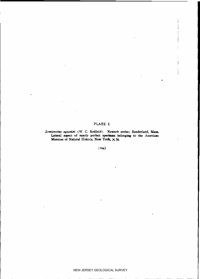
PLATE I.
Setnionotus ngo5sizii (W. C. Redfield). Newark series; Sunderland, Mass. I a t d aspect of nearly perfect Specimen belonging to the American Museum of Natural History, New Y& X 5.
NEW JERSEY GEOLOGICAL SURVEY

PLATE I. ~ -- -
NEW JERSEY GEOLOGICAL SURVEY

NEW JERSEY GEOLOGICAL SURVEY

NEW JERSEY GEOLOGICAL SURVEY

PLATE 11.
Fig. I . Semionotus fultus (Ag.). Dorsal fin. " 2.
'6 6' Pectoral fin. " 3. '6 ' I Anterior flank scales. " 4
" '6 Posterior flank scales. " 5. Semionotus agassiki (W. C. Redf.). Scales from the twelfth longi-
tudinal row, a little bdow the lateral line. " 6. Semionotus micropterus (Newb.). Pectoral fin. " 7.
'6 ' I I' Anterior flank scales. 8. 6' ' I 6' Posterior flank scales.
" g. Semionotus ogassieii (W. C. Redf.). Posterior flank scales show- ing "pegs!'
" 10. Semionotus agassizii (W. C. Redf.). Hindermost scale of anterior dorsal ridge.
" 11. Semionotus micropterus (Newb.). Hindermost scale of anterior dorsal ridge.
" 12. Semionotus agassizii (W. C. Redf.). Scales of the seventh and eighth longitudinal rows, immediately below the lateral line.
" 13. Semionotus micropterus (Newb.) Dorsal fin.
All the figures of Plate 11. are of twice the natural size, and drawn by Dr. G. F. Eaton from specimens belonging to the Yale Museum. (See American Journal of Science, vol. xv., April, roo3.)
NEW JERSEY GEOLOGICAL SURVEY

PLATE 11.
NEW JERSEY GEOLOGICAL SURVEY

NEW JERSEY GEOLOGICAL SURVEY

NEW JERSEY GEOLOGICAL SURVEY

PLATE 111.
Fig. I. Senrionotw agossisii (W. C. Redf.). Head, natural size Pr, frontal ; Pa, parietal ; S.t, supratemporal ; Sq, squamosal ; P.w, postorbital ; Op, operculum ; P.op, prcopercul&; Z.op8 interoperat- lam; S.op, subopcrmlum.
a a Sminonotsu a g m M ( W. C. Redf.). Lower 9ank scale, showing a ~ - ticular process or "peg," natural size
' 3. Smrionotus sp. Lower flank scales, showing double articuln- tion. X%
a 4 Semionotsu sp. Pnmaxilk, natural size " 5. Smionohu m t s u (W. C. Redf.). Dorsal fin, twice arturclt size
All the 6gures of this plate are reproduced after Eaton, loc cit., (199).
NEW JERSEY GEOLOGICAL SURVEY

b
PLATE 111.
NEW JERSEY GEOLOGICAL SURVEY

NEW JERSEY GEOLOGICAL SURVEY

NEW JERSEY GEOLOGICAL SURVEY

PLATE .IV.
Semionotus owatus (Redf.), X %.
Small-sized, somewhat distorted individual from Boonton, N. J. State Geological Collection.
NEW JERSEY GEOLOGICAL SURVEY

PLATE IV.
NEW JERSEY GEOLOGICAL SURVEY

NEW JERSEY GEOLOGICAL SURVEY

NEW JERSEY GEOLOGICAL SURVEY

PLATE V.
Semionotus owdus (Redf.). Natural size.
Imperfect specimen from the Newark series of Boonton, sl;owing char- acters of the median fins. State Geological Collection.
NEW JERSEY GEOLOGICAL SURVEY
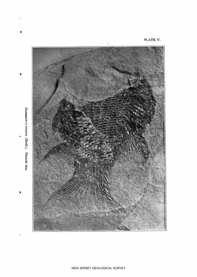
PLATE V.
NEW JERSEY GEOLOGICAL SURVEY

NEW JERSEY GEOLOGICAL SURVEY

8 GEOL
NEW JERSEY GEOLOGICAL SURVEY
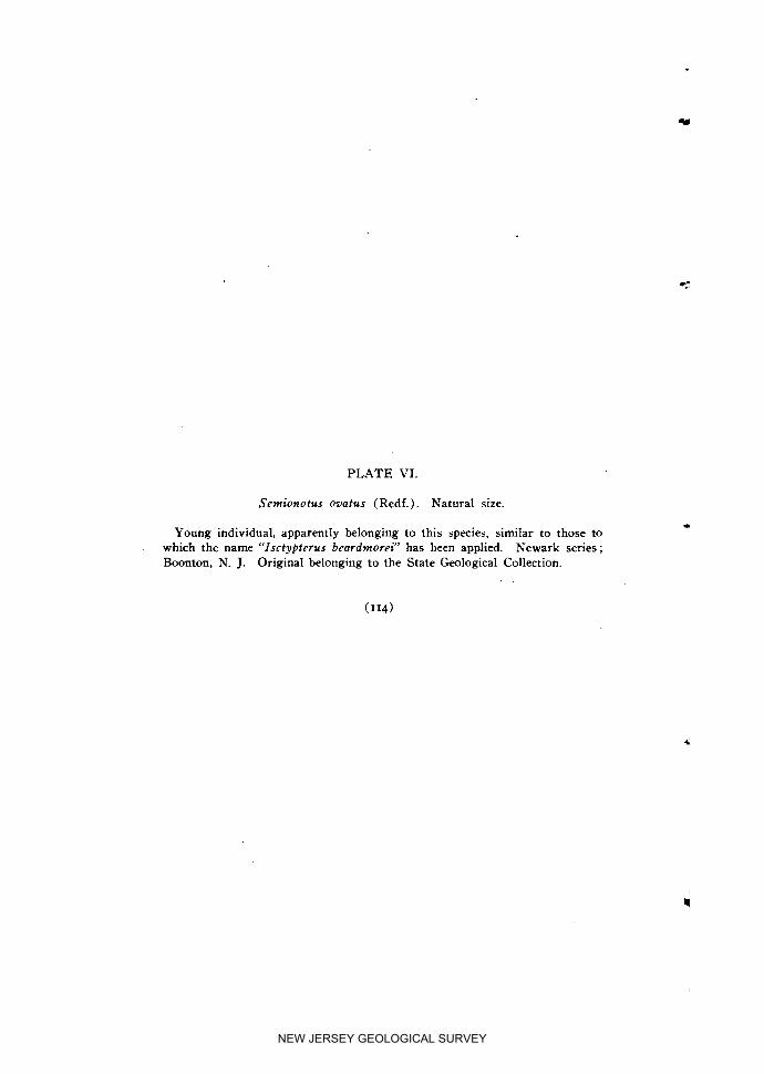
PLATE VI.
Semionotus ovatus (Redf.) . Natural size.
Young individual, apparently belonging to this species, similar to those to which the name "Isctyptcrus bcardmorci" has been applied. Newark series; Boonton, N. J. Original belonging to the State Geological Collection.
NEW JERSEY GEOLOGICAL SURVEY

PLATE VI.
NEW JERSEY GEOLOGICAL SURVEY

NEW JERSEY GEOLOGICAL SURVEY

NEW JERSEY GEOLOGICAL SURVEY

PLATE VII.
Semionotus agassizii (Redf.). Natural size.
Nearly perfect fish from the Newark series of Sunderland, Massachusetts, determined by Professor Newberry as belonging to this species. An outline figure of the same specimen is shown of one-half the natural size in Plate I. Original preserved in the American Museum of Natural History in New York.
NEW JERSEY GEOLOGICAL SURVEY

NEW JERSEY GEOLOGICAL SURVEY

PLATE VIII.
Semionotus ogassi,-ii (Redf.). Natural size
Photographic reproduction of a specimen from the same locality as the last, and, like it, belonging to the American Museum of Natural History in New York. Dorsal contour and ridge-scales well displayed.
NEW JERSEY GEOLOGICAL SURVEY
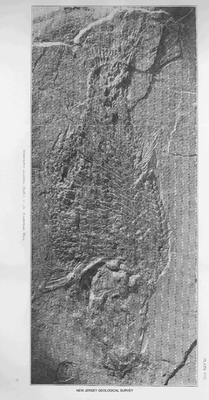
NEW JERSEY GEOLOGICAL SURVEY

PLATE IX.
Semionotus fultus (Agassiz) . Natural size.
Photographic reproduction of the original specimen figured in Plate VI, Fig. 2, of Newberry's Monograph (1888), now preserved in the American Museum of Natural History in New York. (Cat. No. 602G). Boonton, N. J.
NEW JERSEY GEOLOGICAL SURVEY

PLATE IX.
NEW JERSEY GEOLOGICAL SURVEY

NEW JERSEY GEOLOGICAL SURVEY

NEW JERSEY GEOLOGICAL SURVEY

PLATE X.
Sernionotus lineatus (Newb.) X
Imperfect specimen displaying characters of the dorsal and anal fins, and showing ossified ribs. Newark series ; Boonton, N . J. Original belonging to the State Geological Collection.
NEW JERSEY GEOLOGICAL SURVEY

PLATE X.
NEW JERSEY GEOLOGICAL SURVEY

NEW JERSEY GEOLOGICAL SURVEY

NEW JERSEY GEOLOGICAL SURVEY

PLATE XI.
Semionotus lineatus (Newb.) X
Fragment with the dorsal fin excellently preserved, and showing anteriorly notched dorsal ridge-scales. Newark series ; Boonton, N. J. Original belong- ing to the State Geological Collection.
NEW JERSEY GEOLOGICAL SURVEY
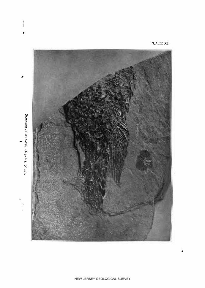
PLATE XI.
NEW JERSEY GEOLOGICAL SURVEY

NEW JERSEY GEOLOGICAL SURVEY

NEW JERSEY GEOLOGICAL SURVEY
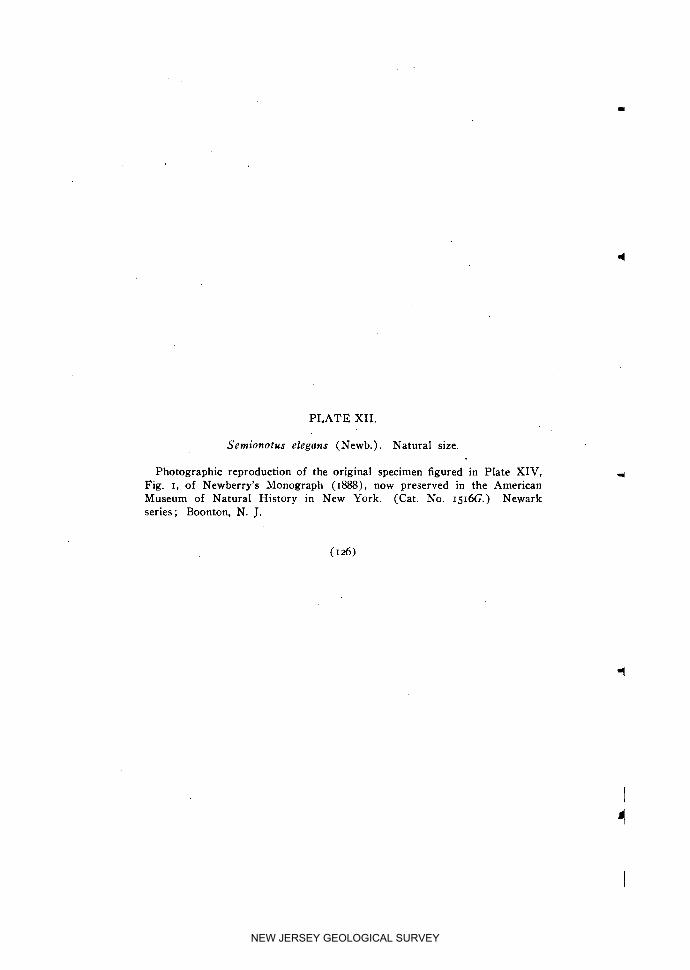
PLATE XII.
Semionotus elegans (Newb.). Natural size.
Photographic reproduction of the original specimen figured in Plate XIV, Fig. I, of Newberry's Monograpll ( I=) , now preserved in the American Museum of Natural History in New York. (Cat. No. 1516G.) Newark series; Boonton, N. J.
NEW JERSEY GEOLOGICAL SURVEY

w
PLATE XII.
NEW JERSEY GEOLOGICAL SURVEY

NEW JERSEY GEOLOGICAL SURVEY

NEW JERSEY GEOLOGICAL SURVEY

PLATE XIII.
Catopterus gracilis (Redf.). Natural size.
Specimen of less than the average size, but with well preserved squamation, from the Connecticut Valley .Trias. Original belonging to the Museum of Comparative Zoology, at Cambridge, Massachusetts.
NEW JERSEY GEOLOGICAL SURVEY

PLATE XIII. I
NEW JERSEY GEOLOGICAL SURVEY

NEW JERSEY GEOLOGICAL SURVEY

NEW JERSEY GEOLOGICAL SURVEY

PLATE XIV.
Examples of Semionofus showing effects of mechanical deformation, one of them being compressed, and the other elongated, by a force acting in a single direction. Newark series; Boonton, N. J. Original belonging to State Geological Collection.
NEW JERSEY GEOLOGICAL SURVEY

PLATE XIV.
NEW JERSEY GEOLOGICAL SURVEY

NEW JERSEY GEOLOGICAL SURVEY

PART 11.
The Fauna of the Cliffwood Clays.
The Classification of the Upper Cretaceous Form- ations and Faunas of New Jersey.
By S N A R T WELLER.
NEW JERSEY GEOLOGICAL SURVEY

NEW JERSEY GEOLOGICAL SURVEY

The Fauna of the Cliffwood Clays.
BY STUART WELLER.
Several papers have recently appeared in which the beds at Cliff- wood Point, on the south shore of Raritan Bay, New Jersey, have been discussed, and some difference of opinion as to their correla- tion has been expressed-l For the most part the discussion has been based upon the evidence as shown by the fossil flora, although mention of marine invertebrate fossils has been made in several of the papers. During the past two field seasons extensive collections of these invertebrates have been made by the writer from the locality in question, as well as from the clay pits in the neighboring region which.have been opened in the same beds. At Cliffwood Point the fossils were collected from smooth, concretionary nodules, which occur in great num- bers along the beach at low tide. Although most of the fossils were collected from nodules not in situ, a few similar nodules carrying the same fossils have been found embedded in the clay, and no doubt can be entertained as to the original source of all
The Cretaceous Clay Marl Exposures at Cliffwood, N. J., by Arthur Hol- lick, Trans. N. Y. Acad. Sci., vol. xvi., pp. 124-136; The Flora of the Mat- awan Formation (Crosswick's Clays), by a w a r d W. Berry, Bull. N. Y. Bot. Garden, vol. iii., No. g, pp. 45-103; New Species of Plants from the Mat- awan Formation, by Edward W. Berry, Am. Nat., vol. xxxvii., pp. 677-684; The Cliffwood Clays and the Matawan, by G. N. Knapp, Amer. Geol., vol. xxxiii., pp. 23-27; The Cretaceous Exposure near Cliffwood, N. J., by Ed- ward W. Berry, Amer. Geol., vol. xxxiv., pp. 253-260; The Matawan Forma- tion of Maryland, Delaware and New Jersey, and Its Relations to Overlying and Underlying Formations, by W. B. Clark. Am. Jour. Sci., 4th Ser., vol. xviii., pp. 435-440; Additions to the Rora of the Matawan Formation, by Edward W. Berry, Bull. Torrey Bot. Club, vol. xxxi, pp. 67-82; Additions to the Fossil Flora FFom Cliffwood, New Jersey, by Edward W. Berry, Bull. Torrey Bot. Club, vol. xxxii, pp. 43-48
I
( 133)
NEW JERSEY GEOLOGICAL SURVEY

ANNUAL REPORT OF
the nodules being from the clay a t the locality in question, from a horizon near or somewhat below high-water level. Their occur- rence in essentially the same beds, or even in beds a little lower than those containing the plants described by Hollick and Berry, , may be safely assumed.
One of the most notable features of the fauna from these Cliff- wood nodules is the great number 6f crustacean remains. Nearly every one of the concretions, when broken, yields the remains, more or less fragmentary and crushed, of one of these creatures ; indeed, a crab of some sort seems to have been the nucleus around which nearly every one of these concretionary nodules in the clay has been formed. In addition to the crustacean remains, which seem to represent several species, the nodules have yielded a goodly number of mollusca, and the following species have been '
more or less satisfactorily determined :
PELECYPODA. I . Ostrea sp. undet. At least two species of oysters have been recognized
in the Cliffwood fauna, neither one of which can be identified with any of the species occurring in the other Cretaceous beds of New Jersey.
2. AnomM tellinoides Mort. 3. A m s i u m sp. undet. This species is much larger than either of t h e .
members of the genus previously recorded from New Jersey, and it seems to be undescribed. I t resembles in general form some specimens of Camptonectes burlingtoneasis Gabb, but lacks the dis- tinctive ornamentation of that shell.
. 4 Mytilus oblivius Whit. Although this shell attains a larger size in the Cliffwood clays than any specimens observed from the Wenonah sand, the only other horizon where it has been observed, there seems to be no reason for considering the Cliffwood specimens as specifi- cally distinct.
5. Modiola sp. yndet. A single imperfect specimen may be referred here. I t somewhat resembles the shell described from the West as Vol- sella attenuata M . & H.
6. PterM petrosa Con. Whitfield saw but one imperfect specimen of this species during the preparation of his monograph of the New Jersey Cretaceous pelecypods,' and Conrad, in his original description, mentions seeing but a single specimen from the Delaware and Ches- apeake canal. In the Cliffwood fauna it is one of the most com- mon forms, and has been seen elsewhere in New Jersey only in the Wenonah sand. I t seems to be indistinguishable from P. lingui- formis E. & S., from the West. .
' Pal. N. J., vol. i., p. 68; also Monog. U. S. Geol. Surv., vol. ix, p. 68.
NEW JERSEY GEOLOGICAL SURVEY

THE STATE GEOLOGIST.
7. Inoceramus sagensis Owen. Elsewhere in New Jersey this,species oc- curs most commonly in the Merchantville clay marl.
8. Nemodon brevifrocrs Con. This species has been recognized elsewhere in the New Jersey faunas only in the Woodbury clay near Haddon- field and in the same formation in Monmouth County.
g. BrwMrca sp. undet. This is probably an undescribed form. I t is closely allied to, if not identical with, a species occurring in the Woodbury clay fauna of Monmouth County.
10. Nsculo. slackMna Gabb. Specimens of this species in the Cliffwood fauna are indistinguishable from specimens from the Woodbury clay.
11. Nucula sp. undet. This species seems to be undescribed, but it is iden- tical with a form which occurs in the Wenonah sand fauna.
12. Nuculana protexta (Gabb) ? Specimens which seem to be referable to this species are rather common in the fauna.
13. Nuculana sp. undet. The specimens here indicated are possibly but a form of the last.
14. Lucina cretacea Con. This species, which occurs so abundantly in the Woodbury clay, is one of the rarest forms in the Cliffwood fauna.
15. Cardium ripkyanum Con.? Several specimens of a small Cardium have been referred questionably to this species ; they are too imper- fect for certain identification.
16. Isocardia cliffwoodensis n. sp. (Figs. 1-3). This is one of the most characteristic, though not the most common, species of the Cliff- wood fauna, being present in every locality where the fauna has been observed. A similar, if not identical, species occurs in the Wenonah sand fauna.
17. Dosinia gabbi Whitf. Several fragmentary specimens seem to be refer- able to this species, although they are too fragmentary for certain identification.
18. Tellina equilateralis M. & H.? Several incomplete specimens seem to resemble this species originally described from the Fox Hills beds of the West. The specimens are too imperfect for certain identifit cation.
19. Veleda lintea (con:). This is a rather Variable shell, but specimens from the Cliffwood clays are indistinguishable from examples occur- ring in the Wenonah sand, where the species most commonly occurs.
20. Veleda transversa Whitf.? Among the specimens of Veleda in the Cliffwood fauna several specimens seem to approach this species in form and have been so identified provisionally.
21. Pholadomya occidmtalk Mort. A single incomplete impression of a large shell seems to represent this species. Elsewhere it seems to be quite closely confined to the Merchantville clay marl.
22. Corbula sp. undet. The internal casts of this species are rather abundant, but it is difficult to identify them with shells which have been described from external characters. The species seems to re- semble the shell illustrated by Whitfield under the name C. foulkei Lea. which is in reality not that species, but C. bisulcata Con.
NEW JERSEY GEOLOGICAL SURVEY

ANNUAL REPORT OF
GAST~LO~ODA. - 23. Pyropsis sp. undet. This shell resembles P. naticoides Whitf., and
it is possible that it should be so identified. 24- Pyrifusus erraticus Whitf. This species is represented by two speci-
mens. I t was originally described from a nodule said to have been collected at Cliffwood, New Jersey.
25. Volutimorpha gabbi Whitf.? This species is represented by a single specimen which most closely resemble Whitfield's' Figure 4, Plate viii., referred provisionally to V. gabbi Whitf. The Cliffwood specimen is a nearly smooth internal cast and does not show the external markinas of the shell.
26. Scarlaria sp. undet. -A fragmentary specimen of a member of this genus has been observed. I t is too imperfect for identification.
27. Turn'telfa encri~oides Mort.? Fragments of the internal casts, as well as impressions of the external markings of a Turritella, occur in the Cliffwood fauna, which seem to be referable to this species.
CEPHAWPODA: 28. Placenticeras placenta De Kay. A single fragment of the cast of the
chamber of habitation of a large ammonite resembles in all respects similar specimens known to belong to P. placenta, and little doubt can be entertained as to the cotrectness of this identification of the Cliffwood specimen.
29. Baculites sp. undet. A fragment of the cast of the chamber of hab- itation may certainly be referred to this genus. The specific deter- mination cannot be satisfactorily made. It may belong to the com- mon B. ovatus of the New Jersey Cretaceous beds, but it seems to possess stronger oblique, annular ridges than is usual in that species.
CRUSTACEA. 30. Tetracarcinus subquadratus n. gen. and sp. (Figs. 4-6). Several species
of crustaceans, all of them probably undescribed, are present in the Cliffwood fauna. A single one of these forms, however, may be considered in the present connection, for the reason that it is also a common form in the fauna of the Woodbury clay. I t has not been possible to place this little crab in any of the described genera, and, therefore, it may be called Tetracmcinus on account of its sub- quadrangular form, with the specific name subquadratus. The dimensions of an average specimen are: Length of carapace, 14.5 mm.; breadth, 14 mrn.; greatest convexity, 5 mm. The regions of the carapace are clearly marked by more or less deeply impressed furrows, as shown in the accompanying illustrations. This is one of the common forms in the Cliffwood fauna, and is the only crustacean which has been observed in the fauna of the Woodbury clay.
A sandstone mass was collected on the beach at Cliffwood, eighteen inches in length by twelve inches in breadth and, per-
' Pal. N. J., vol. ii.; also Monog. U. S. Geol. Surv., vol. xviii.
NEW JERSEY GEOLOGICAL SURVEY

PLATE XV.
Figs. I , 2,3. Isocardia cliffwoodensis. Figs. 4 ,5 ,6 . Tetracarcinus subquadratus.
NEW JERSEY GEOLOGICAL SURVEY

NEW JERSEY GEOLOGICAL SURVEY

T H E STATE GEOLOGIST. I 37
haps, three inches thick, completely filled with fossils. This mass of sandstone was not in situ, and being different in its lithologic characters from any material imbedded in the clay at this point, it may have been transported to this locality from elsewhere. It, however, is somewhat similar in its lithologic characters to certain sandy, fossiliferous nodules occurring in the clay at the pits of the Cliffwood Brick Company, a little over 1% miles distant, on Whale Creek. The fauna yielded by this sandstone undoubt- edly indicates its Cliffwood age, although several species occur which have not been observed elsewhere. The species of fossils identified are as follows :
PELECYPODA. I . BrevMrca sp. undet. This is apparently the same species as that noted
from the fauna of the crustacean nodules. 2. Trigonarca n. sp.? This is one of the common species of the fauna and
is apparently undescribed. I t has the form of a small Idonearca, but is less convex than most species of that genus and has a differ- ent hinge structure.
3. Trigonarca n. sp.? This is a larger species than the last, and the hinge bears a much larger number of teeth. Neither of the species have been observed elsewhere.
4 Nuculana protexta (Gabb).? The specimens of this species are poorly preserved, but they seem to be specifically identical with those from the crustacean nodules which have been identified as N. protexta.
5 . Yoldio cf. evansi M . & H . This is a rather common species in the fauna, and is closely allied to if not identical with Y. mansi from the Fox Hills beds of the West.
6. Cardium sp. undet. This species can be identified with none of the recognized forms from New Jersey, and is probably an undescribed species.
7. Isocardia cliffwoodensis n. sp. This is the same form that occurs in the fauna of the crustacean nodules.
8. Veleda lintea Con. This is the most abundant species in the fauna. g. Corbula sp. undet. Two or three unidentified species, and possibly un-
described, seem to be referable to the gems Corbula.
GASTROPODA. 10. Pyrifusus sp. undet. This is apparently an undescribed species, and has
not been observed elsewhere. 11. Volutomorpha sp. undet. This also seems to be an undescribed form
which has not been observed elsewhere. 12. Gyrodes sp. undet. This is a small species which apparently cannot be
referred to any of the recognized New Jersey species and may be new.
13. ScalarM sp. undet. 74. Turritella sp. undet.
NEW JERSEY GEOLOGICAL SURVEY

ANNUAL REPORT OF
At Geldhaus' clay pits, a little over a mile west of Cliffwood Point, on Whale Creek, crustacean-bearing nodules similar to those collected on the beach at Cliffwood, occur in situ in the clay. Besides the numerous imperfect crustacean remains, the following species have been recognized at this locality:
PUECYPODA. I . Pteria petrosa Con. 2. Nuculana protexta Gabb. 3. Lucina cretacea Con. 4. Isocardia cliffwoodensis n. sp. 5 . Veleda Iintea (Con.). 6. Corbula sp. undet.
In the Cliffwood Brick Company's south pits, at the crossing of the New York and Long Branch Railroad over Whale Creek, numerous sandy, abundantly-fossiliferous nodules were obtained in situ. In the fauna of these nodules the following species have been recognized :
PELECYPODA. I . Ostrea sp. undet. A small undetermined species. 2. Amusium sp. undet. This is the same species noted in the fauna of the
crustacean nodules from the beach at Cliffwood. 3. BrevMrca sp. undet. This is the same species as that occurring in the
crustacean nodules at Cliffwood point. 4. Nuculana protexta (Gabb) . ? 5. Yoldia cf. evansi M. & H . 6. Cardium sp. undet. This is the same species noted from the sandstone
slab collected at Cliffwood. 7. Cymbella bella Con. This species is represented by several specimens.
Elsewhere it occurs rarely in the hlerchantville, more commonly hl the Woodbury, and most abundantly in the Wenonah formation.
8. Isocardia cliffwoodensis n. sp. g. Cyprimeria sp. undet. This is a small species which cannot be identified
with other New Jersey forms, but it is most like a species in the Woodbury clay, where the genus occurs most abundantly. A form apparently identical with this Cliffwood shell occurs rarely in the Wenonah fauna.
10. Tellina sp. undet. Several specimens of a shell apparently referable t o this genus are present in the fauna. They seem to belong to an un- described species.
11. Linearia metastriata Con. This species rarely occurs in the Merchant- ville clay; it is abundant in the Woodbury clay near Haddonfield, and is one of the most abundant species of the Wenonah sand.
12. Veleda lintea (Con.) This is the most abundant species in the fauna.
NEW JERSEY GEOLOGICAL SURVEY

T H E STATE GEOLOGIST.
13. Pholadomya occidentalis Mort. Several fragments which seem to rep- resent this species have been observed.
14 Corbula sp. undet. A species of this genus, apparently undescribed, is represented by several specimens.
15. Leptosokn bipluota Con. This species has been recognized elsewhere in the Merchantville clay, the Woodbury clay, and the Wenonah sand, it being most common in the last of these formations.
GASTROPODA. 16. Pyrifusus sp. undet. A single specimen of an undescribed shell is ap-
parently referable to this genus. 17. Gyrodes sp. undet. Fragmentary specimens of a small species of this
genus are present in the fauna. They are apparently different from any of the recognized New Jersey forms.
18. Turritella encrinoides Mort.? Fragmentary specimens of a species of Tuwitella, probably belonging to this species, occur in this fauna.
Several nodules, not in situ, were collected in the same pits of the Cliffwood Brick Company, as the fauna last recorded. They undoubtedly had their origin in these same clay beds, and the following species of fossils have been recognized in them :
PUE~YPODA. I. Ostrea sp. undet. One of the same species noted in the fauna of the
crustacean nodules at Cliffwood Point. 2. Anomina tellinoides Mort. 3. Amusium sp. undet. This is the same as the species recorded in the
Cliffwood fauna. 4. PterM petrosa Con. 5. Znoceramus sagensis Owen. 6. Breviarca sp. undet. This is the same form as that recorded from the
crustacean nodules. at Cliffwood Point. 7. Nuculana protexta (Gabb) . ? 8. Cardium sp. undet. g. Isocardia cliffwoodensis n. sp.
10. Veleda lintea (Con.). 11. Corbula sp. undet. This is the same species as that numbered n in the
list of species from the crustacean nodules collected at Cliffwood Point.
12. Corbula ? sp. undet.
GASTROPODA. 13. Pyrifusus sp. undet.
CRUSTACEA. 14. Tetracarcinus subquadratus n. gen. and sp.
NEW JERSEY GEOLOGICAL SURVEY

140 ANNUAL REPORT OF
The data recorded in the preceding lists of fossils is assembled in the following table in order that it may be more readily an- alyzed. A separate column is allotted to each of the preceding groups of species, numbered as follows : I), nodules collected on the beach at low tide at Cliffwood Point ; 2), sandstone mass from beach at Cliffwood Point ; 3), Geldhaus' clay bank ; 4), Cliffwood I
Brick Company's south pits, nodules in situ; 5 ) , Cliffwood Brick Company's south pits, ferruginous nodules not in sifu. The last three columns are assigned to the three higher formations as fol- lows: Merchantville clay (Mv ), Woodbury clay (Wb), and Wenonah sand (W), and the occurrence of the Cliffwood species in these formations is noted.
PELECYPODA. I . Ostrea sp. I , .................. 2. Ostrea sp. 2, ................... 3. AnomM tellinoides Mort., ...... 4. Amwium sp. undet., ........... 5. Mytilw oblivius Whitf . , ....... 6. Modwlo sp. undet., ............ 7. Pterk petrosa Con., ........... 8. Inaceramus sagensis Owen, ....
-
x - - x x - - - - -
x - - - x x - -
X X X
X X X
9. Nemodon brevifrons Con., ...... 10. Breviarca sp. undet., ........... X - 11. Trigonarca sp. I , .............. - X - - - - - 12. Trigonarca sp. 2, .............. 13. Nucula slackiana Gabb, . . . . . 14. Nucuh sp. undet., ..........
... X
I j. Nuculana protexta (Gabb) ?. 16. YoldM cf . evansi M. & H., ..... 17. Lucina cretacea Con., .......... 18. Cardiutn sp. I , ................ 1g.Cardiumsp.2, ................ 20. Cymella bella Con.. ........... .I - 1 - 1 - 21. Isocardia cliffwoodensis n. sp., . . l X 1 X I X X X - - X 22. Cyprimeria sp. undet., ......... . I - I - 1 - l X X 1 - 1 - 1 - I X
- I X
- X X -
- -
X - X - - X
23. DosinMgabbiWhitf.? ......... I X 1 - 1 - 1 - 1 - 1 - 24. Tellina equilateralis M. & H.? . .I X I - I - I - I - I - 25. Tellina sp. undet., ........... ..I - 1 - I - I X I - 1 -
- - -
- - -
- I - - I - - 1 -
X - - X -
- -
26. Linearia metostriato Con., ..... l - 1 - 1 - I X 1 - 1 X 1 X 1 X 27. Veleda lintea (Con.), ....... . . I X I X I X I X I X I X I X I X 28. Pholadomya occidentalis Mort., I X I - 1 - 1 X 1 - 1 X 1 - 1 X 29. Corbula sp. undet., ........... . I X I - I - 1 - I X 1 X I - I - 30. L~ptosolen biplicata Conr, ..... . I - ( - 1 - I X 1 - I X I X I X
- - - - -
- X
X -
- - -
- -
NEW JERSEY GEOLOGICAL SURVEY

T H E STATE. GEOLOGIST. 141
GASTROPODA. 1 1
31. Pyro sis naticoides Whitf.? .... X p. Pyrifwur mat i rrs Whiff., ..... X 33. Pyrifusus sp. undet., .......... - 34. Pyrifusus sp. undet, .......... - 35. Pyrifusus sp. undet., .......... - 36. Volutomorpha gabbi Whitf.? . . X 37. Volutornorpha sp. undet., ...... - 38. Gyrodes sp. undet., ............ - 39. Scalar& sp. undet., ............ X 40. Scalar& sp. undet., ............ - 41. Tuwitella encrinoides Mort.? . . X
CEPHALOPODA. 42. Placenticerac placenta .De Kay,. . X ........... 43. Baculites sp. undet., X
CRUSTACEA 44. Tetracarcinus subquadratus n. sp. X I A careful analysis of this fauna of the Cliffwood clays brings
clearly to view several important facts. In the first place, the large number of species which are common to the fauna and to one or more of the faunas of the formations above, emphasizes the close relationship between the Cliffwood fauna and these higher faunas. This relationship is, indeed, so close that they constitute essentially but different faunules of one large fauna. There is no sharper distinction between the fauna of the Cliff- wood clays and the Merchantville clay than there is between the Merchantville and the Woodbury clays. However, the Cliff- wood fauna does possess characteristics which distinguish it somewhat sharply from the Merchantville fauna, among which may be mentioned the abundance of the species Pteria petrosa and Isocardin cliffwoodensis which have nowhere yet k e n recog- nised in the Merchantville, and the especial abundance, .in some cases at least, of Veleda lintea which is sometimes present, al- though always rare, in the Merchantville. None of the crusta- ceans which are so abundant in the Cliffwood fauna have been recognized in the Merchantville, although claws and other dis- articulated joints of crustacean appendages are not uncommon in
NEW JERSEY GEOLOGICAL SURVEY

142 ANNUAL REPORT OF
the higher fauna at some localities. The distinction between these two faunas is not alone emphasized by the species present in the Cliffwood and absent from the Merchantville, but also by the
'genera and species which are absent from the Cliffwood and . almost universally present in the Merchantville fauna. Among such genera may be mentioned Idonearca, Ttigonia, Panopeu, Axinea and Lkopistha.
On making a careful comparison between the Cliffwood fauna and that of the Woodbury clay, the formation immediately above the Merchantville, a much greater resemblance is noted than be- tween the Cliffwood and the Merchantville; the same Merchant- ville genera mentioned above as being conspicuously absent from the C l i f f w d fauna are also conspicuous for their absence from the Woodbury. Furthermore, several forms are common to the Cliffwood and the Woodbury faunas which have not been ob- served in the intervening formation; among these may be men- tioned Brevinrca, Lucina cretacea, and the little crustacean here called Tetracarcittm subquadratus. In making this comparison, however, it must not be overlooked that some of the most char- acteristic Cliffwood species, as Isocardia cliffwoodensis and Pteria petrosa, have nowhere been observed in the Woodbury fauna.
I t is unnecessary to make comparison between the Cliffwood and the Marshalltown faunas, as there is scarcely anything in common between them, but with the fauna of the Wenonah sand the Cliffwood fauna has more in common even than with that of the Woodbury clay. Among the species listed in the table given above, it will be seen that fourteen species are recorded as being common to the Cliffwood and the Wenonah, eleven to the Cliff- wood and the Woodbury, and only ten to the Cliffwood and the Merchantville. These numbers do not- fully express the relative proximity of relationship between these several faunas, although they do partially, because no account is taken of the relative abundance of the forms noted. As a matter of fact, when the abundance of the different species in the different faunas is taken into account, the similarity of the Cliffwood and Wenonah faunas is accentuated, while that between the Cliffwood and the Mer- chantville is diminished. Aside from the crustaceans of the Cliff-
NEW JERSEY GEOLOGICAL SURVEY

T H E STATE GEOLOGIST. I43
wood fauna, the two species Pteria petrosa and Isocardia cliff- woodensis are, perhaps, the most characteristic forms, and both of these occur in the Wenonah fauna. Veleda lintea is another conspicuous C l i f f w d species which occurs more frequently in the Wenonah fauna than in any other of the New Jersey Creta- ceous formations.
I t is believed that these comparisons which have been instituted make clear the fact that however much or however little the Clifi-
'
wood fauna has in common with the faunas of the higher forma- tions, it does have a unity of its own. Although many of the species occur also in other horizons, the whole assemblage of species considered as a faunule, possesses characteristics which serve to distinguish it from any of the other faunules with which it has been compared.
The geographic distribution of this Cliffwood fauna differs notably from that of the Merchantville, it being limited, so far as now known, to a small area between Cliffwood Point and the head of Cheesquake Creek. The, distribution of the Merchantville fauna is entirely across the State, from the south shores of Rari- tan Bay to the shores of Delaware Bay; throughout its entire extent it is remarkably constant in its characters, and the Mer- chantville beds are everywhere marked by constant lithologic characters, yielding fossils, usually in abundance, wherever they are well exposed. There is scarcely a formation in the entire Cretaceous series of New Jersey which is more sharply marked. both lithologically and faunally, than the Merchantville clay. The base of the formation constitutes an easily recagnizable and perfectly natural geologic horizon, the beds below being char- acterized by the great heterogeneity of their lithologic characters, while the beds above are just as strongly characterized by the constancy of their lithologic characters.
The heterogeneous assemblage of sands and clays beneath the Merchantville have been called the Raritan formation, and the fossiliferous clays at Cliffwood, which are interbedded with sands and are lithologically allied to the subjacent beds, must certainly be considered as a lens-like body included in the Raritiin. The (Raritan beds for the most part give evidence of a non-marine origin, but there must have been marine conditions present along
NEW JERSEY GEOLOGICAL SURVEY

141 ANNUAL REPORT O F
the Atlantic border at no great distance during the entire period of their deposition. The non-marine, - perhaps estuarian condi- tions of Raritan time were supplanted in Merchantville time by more uniform marine conditions, but previous to the initiation of marine conditions in the area entirely across New Jersey, we find evidence here in the Cliffwood clays of a slight transgression of the sea from the direction where marine conditions had con- tinuously existed, and the occupation of a small area where non- marine sediments h5d previously been deposited.
This occurrence at Cliffwood of marine fossils in the Raritan is not the only case of the kind in New Jersey, although it is the most notable one. Whitfield mentions the occurrence of Tz~rri- tella encknoides, a not uncommon species in the Cliffwood beds as well as in some of the higher forinations, in the clays at Sayre- ville, which are near the very base of the Raritan, and the slab mentioned by him, bearing many examples of this species, is now preserved in the collections of the Geological Survey of New Jer- sey. Other specimens of marine fossils from near the same local- ity have recently been acquired by Mr. J. M. Manley, of New Brunswick, New Jersey. I t is altogether possible, and indeed most probable, that faunas more or less closely allied to those of the higher formations, were living throughout the entire period of deposition of the Raritan beds, at no great distance from the present shores of Raritan Bay, and if that were the case it is not at all surprising that there should be occasional transgressions of marine conditions within the area where non-marine sedimenta- tion was usually in progress, with the consequent deposition of marine beds with marine fossils.
January pph, 1905.
NEW JERSEY GEOLOGICAL SURVEY

The Classification of the Upper Cretaceous Forma- tions and Faunas of New Jersey.
BY STUART WELLER.
Since the organization of the present Geological Survey of New Jersey three classifications of the Cretaceous formations of t'he State have been proposed and have been published in the reports of the Survey. The first of these, elaborated by Professor Cook during his administration as State Geologist, was published in 1868.' At that time the practice of naming geological formations by geographical names was not usually adopted by working geologists, and the successive beds were designated by names suggested by their lithologic characters. Above the "plastic clays," since known as the Raritan formation, two major series of beds were recognized, the "clay marl" series below and the "marl" series above. The discrimination of the beds of the "marl" series as first described by Cook, has not been changed by any of the more recent investigations, but a closer study of the "clay marl" series has led to the discrimination of a series of beds not recognized by Cook. In his interpretation of the stratig- raphy of the southern part of the area, however, Cook, in the absence of accurate topographic maps, fell into one error on ac- count of his failure to recognize the disappearance of his "red sand" formation in that direction, and the consequent continuity of the "lower" and "middle" marl beds. T o the south he identi- fied a bed now known to belong in the "clay marl" series, with the "lower marl" of Monmouth county, and considered the bed now known to represent the combined "lower" and "middle" maris, to be the continuation of the "middle" marl alone.
Geol. N. J.. 1868, p. 241.
I 0 GOL ( 145)
NEW JERSEY GEOLOGICAL SURVEY

I 46 AXNUAL REPORT OF
In 1891 Professor W. B. Clark entered upon a study of the Cretaceous beds of New Jersey, and the results of his work are published in the Annual Reports of the Survey for 1892, 1893 and 1897. The two essential differences between his classifica- tion and that of Cook are in the position of the major dividing line between what are, roughly speaking, Cook's "clay marl" and "marl" series, and in the interpretation of the "yellow sand" formation above the "middle marl." In place of Cook's litho- logic names, however, Clark substituted a series of geographic names in accordance with more modern usage. In a more recent paper Clark has made some modification of his earlier interpre- tation of the beds, notably in the position of the lower boundary line of his lower or Matawan division in the region adjacent to Raritan Bay. In this paper he has excluded the Cliffwood clays from the Matawan, so bringing the basal line of this division to conform exactly with the base of Knapp's Merchantville clay.
During his study of the Pleistocene deposits under the direc- tion of Professor R. D. Salisbury, Mr. G. N. Knapp found it necessary to make a close study of the underlying formations of Cretaceous age. In the course of this study he was able to dis- criminate a series of five distinct formaticms in the old "clay marl" series of Cook. Each one of these formations was found to be marked by constant lithologic characteristics, but at that time the paleontologic characters of the beds had not been inves- tigated. These formations were traced by Knapp and carefully mapped entirely across the State from Monmouth to Salem coun- ties. A description of the beds, especially in relation to the soils to which they give rise, was first published by Professor Salis- bury in the 1898 Report of the Survey 2, and geographic names were applied to them, viz. : Merchantville, IVoodbury, Colum-
'.4m. Jour. Sci., 4th. ser., vol. 18, pp. 435-440.
'Ann. Rep. State Geol. N. J., for 1898, pp. 35-36. It may be said that the tracing out of the Cretaceous beds was no part of Professor Salisbury's plan. It was done by Mr. Knapp because the several beds of the "clay marl" series sustained very definite relations to the Pleistocene formations. The names published at this time were not published by Professor Salisbury for the purpose of making a new classification of the Cretaceous, but merely hecause the soils could best be described in connection with these several sub- divisions.
NEW JERSEY GEOLOGICAL SURVEY

T H E STATE GEOLOGIST. I47
NEW JERSEY GEOLOGICAL SURVEY

ANNUAL REPORT O F
bus, Marshalltown and Wenonah. A fuller description of the 1ithologic.characters of these formations has been given by Dr. H. B. Kiimmel in the recent Clay Report of The Survey1.
These three systems of classification have been arranged side by side in the preceding table, in order that they may be easily compared one with the othere2 At the time of publication of Cook's classification, although a large number of Cretaceous fossils had been described from New Jersey, little was known of the actual distribution of the fossil species in these beds except in the case of the conspicuous shell-beds which can be recognized continuously across the State. Cook's classification may there- fore be considered as being based almost exclusively upon the lithologic characters of the beds. Before Clark's classification was proposed, however, Whitfield's3 two iinportant volumes upm. the paleontology of the Cretaceous formations of New Jer- sey had been published, and Clark gives long lists of fossil species in his papers as representative of the faunas of his major divi- visions, so that his classification was founded at least in part upon paleontologic data. Knapp's subdivisions of the "clay marl" series are professedly based upon the lithologic characters alone.
During the field seasons of 1903 and 1904, the writer has .been engaged in an investigation of the paleontology of these Cre- taceous beds and has accumulated a large amount of information in regard to the faunas of the successive formations, especially those of the "clay marl" series, and in the following pages an attempt will be made to point out the bearing which this new evidence has upon the classification of the formations and faunas.
In his Matawan division, Clark has recognized two forma- tions, the Crosswicks clays and the Hazlet sands. The Cross-
'Geol. Surv. N. J., final Rep., vol. vi., pp. 152-161. 'In this table Cook's classification of the beds in Monmouth County is rec-
ognized. His understanding of the stratigraphy in the south was incomplete, and in that portion of the area he considered Knapp's Marshalltown forma- tion as the equivalent of the "lower marl," and the Wenonah as the equiv- alent of the "red sand," the true Red Bank sand and the Tinton beds being absent there.
'Pal. N. J., vols. i. and ii., also hlonog. U. S. G. S., vols. ix. and xviii.
NEW JERSEY GEOLOGICAL SURVEY

T H E STATE GEOLOGIST.
wicks clays colrrespond exactly with Cook's "Clayey greensand," and with Knapp's two formations, the Merchantville clay marl and the Woodbury clay, while the Hazlet sands correspond in Monmouth County with Cook's "laminateh sands" and with Knapp's two formations, the Columbus sand and the Marshall- town clay marl, as well as with a portion of the Wenonah sand. In his faunal lists Clark does not differentiate the fauna of the Crosswicks clays from that of the Hazlet sand, but gives a single generalized list of species as the fauna of the whole Matawan. As a matter of fact there is a considerable community of char- acters among the faunas of all five formations recognized by Knapp in the "clay marl" series, except only the fauna of the upper beds of the Wenonah sand in the southern portion of the area, enough at least, t o make their inclusion in one major divi- soin fully justifiable. The two cephaloped genera, Plmticeras and Scaphites, characterize the whole series of beds, either m e or both being present at every locality where fossils have been ex-
* tensively collected, while neither of them have been detected in the higher beds. There are, however, sharp distinctions between the faunas of the successive formations recognized by Knapp, and these faunal characters are easily recognizable throughout the whole extent of the beds across the State, wherever fossils have been found. In the discrimination of these faunal zones of the "clay marl" divisions. however, it is not safe to assert that any particular species is absent from any one of the faunas, and bare lists of species without some statement of the abundance of the forms noted, might not in all cases show the characteristic features of the different faunules. The combined faunas of the whole series of formations, and even including those to the sum- mit of Clark's Monmouth division, really make one unit of a larger order. The constant recurrence of various species and groups of species, in this entire series of faunal zones, indicates that somewhere along the Atlantic border they lived continu- ously. As local conditions of environment changed from time to time, the dominant characteristics of the local faunas changed. and it is such changes, for the most part but not wholly, that are recorded in the faunas of these New Jersey formations.
NEW JERSEY GEOLOGICAL SURVEY

ANNUAL REPORT OF
The Merchantville clay marl is characterized by the abundance, among other species, of Axinea tnortoni, Idonearca antrosa, Tri- gonia eufaulensis, and Panopea decisa. In the Woodbury clay these same species are conspicuous for their absence or great rarity. In a collection from the Woodbury clay in Monmouth county, including sixty or more species and many hundreds of individuals, a single specimen of Idonea.rca and a single Axinea mortoni were found, while, on the other hand, Cyprimeria, Lucina cretacea, Br&rca, Cancellaria subalta and others which were rare or entirely absent from the Merchantville, are the commonest species in the fauna. Furthermore, this same faunal distinction between the two beds holds as sharply in the region opposite Philadelphia as in Monmouth County. The faunal lists of the Matawan, heretofore published, omit many of the most abundant and widespread species of the Woodbury clay, and are predomi- nantly of Merchantville species, so that the Matawan fauna as previously recorded is somewhat incomplete.
The Columbus sand has as yet not yielded a single fossil, and is, perhaps, entirely barren. The Marshalltown formation, how- ever, in its more southern extent, is abundantly fossiliferous, although in Monmouth County no fossils have as yet been found. Near Swedesboro the fossils in this bed occur in a remarkably perfect state of preservation and in great numbers. A large Trigonia, probably T. mortoni, is represented by hundreds of individuals, and associated with this species are Cyprimeria sp. and Idonearca vulgaris in abundance. In this fauna the large and ponderous specimens of Gryphrea vesicula?rzs and Exogyra cos- tata, with innumerable specimens of a variety of Ostrea larva, are a conspicuous faunal element for the first time, foreshadow- ing, perhaps, the Navesink fauna. The whole complexion of the fauna is different from either the Merchantville or the Wood- bury, although certain species are present which occur also in one or both of these lower faunas.
Between the Marshalltown clay marl and the "lower" or Navesink marl there is a well-marked sand bed 40 to 60 feet thick. In Monn~outh County it is, on the ~vhole, a fine micaceous sand, \\-it11 some clay laminze and locally near its base with thicker clay lenses ; locally its upper portion is a coarser quartz sand with
NEW JERSEY GEOLOGICAL SURVEY

T H E STATE GEOLOGIST. 1.51
a commingling of glauconite near the marl bed. In the southern counties it is predo~ninantly a coarse quartz sand with some dis- seminated glauconite, the fine micaceous phase being inconspicu- ous or even, perhaps, entirely wanting. This formation Knapp called the Wenonah sand.
In Moamouth County Clark's Hazlet sands in the earlier classification correspond exactly with Cook's "laminated sand" and almost exactly with Knapp's three formations, the Columbus sand, Marshalltown clay marl and the Wenonah sand, the upper few feet of the latter being apparently excluded. In the southern counties the Hazlet sands correspond only with Knapp's Colum- bus and Marshalltown, all the Wenonah being excluded. The line, therefore, between the Matawan and Monmouth, as these two divisions were defined in 1897, was a line running diagon- ally across Knapp's Wenonah sand, from near the summit of that formation at Atlantic Highlands to its base in Gloucester and Salem counties. This lack of agreement between the two inter- pretations was apparently due to Clark's interpretation of the relations of the coarse quartz sand phase, which he called the Mount Laurel sand. In regard to this formation he said,' "They have a thickness of about five feet in the vicinity of Atlantic Highlands, which slowly increases to the southward, until in the region to the east of Philadelphia they have increased to over 25 feet. Beyond that point they increase more rapidly throughout the southern counties, reaching 50 feet in Gloucester County and fully 80 feet in the vicinity of Salem."
In New Jersey the lithological change at the top uf the We- nonah is much more marked than at its base, and for this reason the Wenonah was grouped by Knapp and Kiimme12 with the underlying rather than with the overlying beds. In effect, there- fore, two positions for a major dividing line in this portion of the section have been suggested: a ) diagonally across the We- nonah sand; and b) at the top of the Wenonah sand. Recent paleontological studies cast some light upon this problem even although they do not definitely settle it.
' Ann. Rep. State Geol N. J. for 1897, p. 183; also Bull. Geol. Soc. Am., vol. viii., p. 334 ' Loc. cit.
NEW JERSEY GEOLOGICAL SURVEY

152 A S S U A L REPORT OF
The IVenonah sand, so far as known at present, carries two different faunas. One of these has been found in Jlonmouth County, and at two localities from which extensive collections have been made over one hundred species have been recognized. This fauna is very different from that in the overlying Savesink marl, and for the present will be referred to as the Wenonah fauna, although ultimately it may be best to give it another name. The other fauna occurs in Gloucester and Salem counties and will be described in connection with that of the Savesink marl.
At one locality where the Wenonah fauna has been found the fossils occur in a coarse ferrugineous sand a t a distance of 9 feet beneath the base of the Kavesink marl. The other locality is in a fine, more micaceous and argillaceous bed, immediately beneath the marl. In this iVenonah fauna there is a return of many Merchantville and Woodbury species, among them being Trigonia eufaulensis, Axitlea ~tortofri and Panopra decisa. Idonearca is also present, but is much less conspicuous than in the Merchant- ville or the Marshalltown. Among the W d b u r y species which occur in the Wenonah fauna may be mentioned Cynzella bella, which, although rarely present in the Merchantville, was much more conspicuous in the Woodbury fauna. Leptosolen biplicata is one of the very common forms in the Wenonah fauna which was present both in the Woodbury and the Merchantville. The ponderous Gryphaa and Exogy-a of the Marshalltown fauna are absent, but Ostrea plzrmosa is sometimes a very common species.
The faunal change in passing from the Wenonah to the Nave- sink formations in Monmouth County is far greater than the change in passing over the line between any two of the forma- tions below. In the fauna of the Navesink marl a new factor is introduced which is entirely foreign to the earlier faunas of the area, the most characteristic species of this new element being the cephalopod Belrnzfzitella atncricana and the brachiopod Tere- bratclla plicata, both of which are especially abundant and char- acteristic of this zone. We also find a recurrence of the massive Gryphaa vcsict4laris and Exog-yra costata which characterized the Marsliallto\vn beds below, but the Exogyra is usually less ahnntlant than in the earlier fauna. Ostrea l a r ~ a also occurs in great abundance, as it did in the Marshalltown fauna, but is a
NEW JERSEY GEOLOGICAL SURVEY

T H E STATE GEOLOGIST. I 5 3
somewhat different variety of the species. In place of the ceph- alopods Placenticeras and Scaplzites of the "clay marl" faunas, Nautilus dekayi occurs in this fauna and also in the fauna of the Red Bank sand next above. In the fauna of the beds just be- neath the base of the Navesink marl, Placenticmas placenta .
occurs more frequently than in any other bed of the New Jersey Cretaceous, associated with many other species common also to the Merchantville or Wmdbury formations. These facts, taken together with the marked lithological change at the top of the Wenonah, are strong evidence for placing the major dividing line in this portion of the New Jersey Cretaceous at the base of the Navesink marl in Monmouth County. But there are other facts to be considered.
One of the most characteristic faunal features of the Navesink marl is a conspicuous shell bed about twelve feet above the base of the marl in Monmouth County. I t is usually about one foot in thickness, and is co~nposed almost exclusively of the shells of G r y p h ~ a vesicularis and Ostrea larva, with occasional specimens of other pelecypods and gasteropols. At the base of the Nave- sink in Monmouth County there is sometimes an arenaceous, more or less abundantly fossiliferous bed, which Cook designated as the "sand marl." At Atlantic Highlands this bed is three or four feet thick, and is evidently the bed which Clark mentioned in his description of the Mount Laurel sand at that locality, and which Knapp regarded as forming the top of his Wenonah sand. In passing to the southward this arenaceous basal member of the Navesink seems to become more and more conspicuous, replacing higher and higher beds of the greensand marl, until at Mullica Hill it extends up to and even includes the conspicuous shell layer
, of the formation. This arenaceous facies of the Navesink f r e quently abounds in fossils, although they are usually imperfectly preserved casts, and the fauna is always characterized by the typical Navesink species Bclcmnifclln americmza.
It is believed that Clark's conception of the.Mount Laurel sand formation has grown out from this changing facies of the Nave- sink to the southward, and in the absence of sufficient data con- cerning the fauna of the beds immediately beneath those with the Brlemnitella fauna, he has extended the Mount Laurel formation
NEW JERSEY GEOLOGICAL SURVEY

ANNUAL REPORT O F
downward to include the entire sand bed to the top of the Mar- shalltown clay. On the other hand, ~ n a ~ ~ and Kiimmel have extended the Wenonah formation upward to include all the sand to the south, so that their uppe; boundary line of that formation marks a higher and higher geologic horizon in that direction. From the standpoint of the faunas the major division line in this portion of the Cretaceous beds must be drawn where the Belemni- tella faufza is introduced, and although the Wenonah fauna of Monmouth County has not yet been detected in the more southern portion of the area, neither has the Belemnitella fauna been ob- served in the lower portion of this Mount Laurel-Wenonah sand. 18 feet beneath the top of the sand being the lowest horizon where the Belemnitella fauna has been seen in New Jersey.
With this interpretation it is possible that both the terms, Mount Laurel and Wenonah, should be retained in the nomencla- ture of these beds, the Wenonah for the sand formation beneath the beds bearing the Belemnitella fauna in Monmouth County and for the southern continuation of the same beds, while the name Mount Laurel will designate the arenaceous facies of the Navc- sink, which becomes more and more conspicuous to the south. These relations, however, complicate the task of mapping the beds in the southern portion of the New Jersey area, because of the juxtaposition of two arenaceous formations whose separation can only be based upon the presence or absence of the Belemni- tella fauna. However, further observations upon these beds must be made before the relations here suggested can be considered as established.
The fauna of the Red Bank sand is to some extent a recurrence of the faunas of the beds beneath the Navesink marl, Trigonia eufaulensis, Axinea ~nortoni and other species of the Merchant- ville, Woodbury and Wenonah formations being commonly pres- ent. Some species such as Pcrrisonota protexta and Corbz~la crassiplica which were present, although usually rare. in one or more of the "clay marl" formations, become much more abundant in the Bed Bank. The fauna is characterized everywhere by the large shells of Gryphaa vesiczrlaris and by Ostrea larva, species which were abundant in none of these lower formations except the Marshalltown, but they never form such a shell bed as that
NEW JERSEY GEOLOGICAL SURVEY

T H E STATE GEOLOGIST. I55
which occurs so commonly in the midst of the Navesink marl. Other elements in the fauna are also inherited from the Navesink, although the two most characteristic Navesink species, Belemni- tella americana and Terebrafulla plicata have nowhere been ob- served in the fauna.
In none of the classifications as published, except Cook's, is any special recognition given to the hard, glauconitic, indurated sand bed at the top of the Red Bank, although it was briefly referred to by Clark and has been carefully mapped by Knapp. This bed, called by Cook the "indurated green earth," marks a definite hori- zon and yields a fauna which especially characterizes it through- out its entire extent. The most characteristic member of this fauna is the large ammonite Sphenodiscus, which has frequently been collected from this horizon, but has not been observed else- where. Another very characteristic species is Trigonia c~ru l i a , which has been seen only in this formation, and almost every- where the beds furnish numerous crustacean claws probably be- longing to the genus Callimessa. A fine exposure of this forma- tion occurs at Tinton Falls, New Jersey, where this hard bed, 22
feet thick, is responsible for a water-fall in a tributary of the Swimming River, and the name Tinton beds may be used to des- ignate the formation. The fauna of the Tinton beds is much more closely allied to the faunas of the beds below than to those above, many of the earlier species being present, while Terebra- tzcla hrlani , the most characteristic species of the next higher division, has never been observed.
Judging from their faunas, the three formations, Navesink (including that portion of the underlying sand with the Belemni- tella fauna), Red Bank and Tinton, constitute together a major division of the entire Cretaceous series, comparable in rank with the five formations of the "clay marl" series, and Clark's name, Monmouth, very nearly expresses the limits of the division.
The Rancocas division of Clark, if some modification of inter- pretation be admitted, is another natural paleontologic division, characterized by the brachiopd Tmebratula karlani, but the later investigations of the New Jersey Survey have thrown much light upon this portion of the Cretaceous section. The Sewell marl rarely contains fossils except at its summit, where a very constant
NEW JERSEY GEOLOGICAL SURVEY

I 54 ANNUAL REPORT O F
shell layer of about j feet thickness occurs, being made up almost exclusively of the shells of Gryphc~a. vesicdaris and Tere- b r~ tu la hurlani. The Vincentown formation consists in large part of calcium carbonate furnished by immense numbers of several species of bryozoans. The remains of echinoids are also more or less common, and in the past some very fine specimens of these fossils have been found in this formation. The Vincentown fauna, however, is so different from that occurring at the summit of the Sewell marl, that were it not for the relationships of the "yellow sand" fauna, which combines both elements, one would scarcely be justified in including the Sewell and the Vincentown under one larger division.
In Cook's original classification of the Cretaceous beds of New Jersey, the stratigraphic position of the "yellow sand" was con- sidered to be above the "lime sand" or Vincentown formation of Clark, and it was believed to be intimately related to that forma- tion, but Clark, from his published statements, seems to have been somewhat uncertain in regard to the relationships of this bed. It appears that while at first he was inclined to follow Cook in including the "yellow sand" in the Cretaceous, yet at a later date he arrived at a different conclusion and considered the beds to be of Miocene age.
A careful search by the writer, in company with Knapp, dis- closed good fossils in the "yellow sand" at several localities, and fragments of fossils may be found in the formation at almost every exposure. At the base of Gold Hill, I mile south of Eatontown, Tcrebra:tu.la hn.rln,~zi and Gr3rphac.a' vesicularis occur in abundance, and with them fragments of spines and plates of echinoids, and broken bryozoans. At California hill, near Deal, fossils occur near the summit of the formation in abundance, Tcrcbmtzda ha;rla+li again being the most common form asso- ciated with several species of pelecypods. In the bank of the Manasquan river at New Bergen mills. 1% miles west of Farmingdale, this formation is well exposed in an un-
'Ann. Rep. State Geol. N. J. for 1892, p. 205; Ann. Rep. State Geol. N. J. for 1893, p. 338; Ann. Rep. State Geol. N. J. for 1897, p. 186; also Bull. Geol. Soc. Amer., vol. viii., p. 336; and Ann. Rep. State Geol. N. J. for 1897, p. 190; also Bull. Geol. Soc. Amer., vol. viii., p. 340.
NEW JERSEY GEOLOGICAL SURVEY

THE STATE GEOLOGIST.
weathered condition, and contains a somewhat larger percentage of glauconite than at the other localities mentioned. Fossils are exceedingly abundant at this locality, some layers of the sand being filled with bryozoan remains, with some echinoids, the fauna being essentially that of the Vincentown limesand. In other beds at the same locality, fragments of Terebratzcla harlani were observed. I have interpreted these fossils as definite evi- dence that the sand in which they occur is of Cretaceous age, and is to be correlated with the Vincentown limesand. If it be thought worth while to designate the "yellow sand" facies of this formation by a separate name, it may be called the Long Branch sand, as has been suggested by Knapp.
Clark does not regard the presence of these Cretaceous forms as militating against the Miocene age of the "yellow sand," since he explains them on the supposition that the present position of the included fossils is not their original position, but that they 3ave been washed odt from their original place of deposition, and have been redeposited in these sands in Miocene time. This interpretation, however, seems to me to be untenable on account of the stratigraphic relations of the beds, on account of their geographic distribution, and on account of the difference in character between these beds and the dark clay beds which form the base of the undisputed Miocene in the adjacent region. Furthermore, wells drilled to the south of the outcrop of the "yellow sand" show the presence of a similar arenaceous bed beneath the Manasquan marl.
If the reference of these beds to the Cretaceous is correct, it shows that the Terebratula hcmlmi zone has a much greater vertical range in New Jersey than the shell bed at the summit of the Sewell marl, in this respect corresponding with the condi- tions in Maryland, where, Clark says, "the Terebru,tula, harlafli is no longer limited to its former horizon at the top of the Sewell marls, hut occurs frequently within and even at the top of the lime-sands".
As regards the "upper" or Manasquan marl of Clark, there is no difference of opinion excq:t as Clark's earlier interpretation of
'Ann. Rep. State Geol. N. J. for 1897, p. 189; also Bull. Geol. Soc. Amer., .
vol. viii., p. 339.
NEW JERSEY GEOLOGICAL SURVEY
158 ANNUAL REPORT OF
the "yellow sand" affected the lower limits of the formation in his original definition. The fauna differs in most of its species from the lower faunas, Caryatis veta and Crassatella delnwar- ensis, being two species usually found in this horizon and not ob- served elsewhere. The bed is especially characterized by the large number of shark's teeth it contains. The higher beds of the II upper marl," separated by Clark as the Shark River forma- tion, are recognized by everyone, who has studied them, as of Eocene age, and therefore they need no further consideration here.
From the viewpoint of the writer, the arrangenient of the formations as expressed in the fourth column of the table, on page 147, seems to express best the true faunal relationships of the beds. With the exception of the Tinton beds and the Long Branch sand, no new names are introduced. For the designa- tion of the four major divisions the letters A, B, C and D are used, instead of Clark's four names, Matawan, Monmouth, Ran- cocas and Manasquan, these divisions being strictly faunal, while Clark's names were proposed primarily to designate stratigraphic divisions.
In conclusion, the following summation of results in connec- tion with recent investigations upon the Cretaceous formations and faunas of New Jersey may be made:
I. Cook's classification fully differentiated all the beds of the I I marl" series that have been recognized since his investigations were carried on, but the "clay marl" series has been more fully divided since his work was completed. H e was in error, how- ever, in applying his classification to the southern counties.
2. In the discrimination of beds. Clark's classification is in the main that of Cook, his contribution being a modernization of the older classification by the introduction of geographic forma- tion names for Cook's lithologic names, and a grouping of the formations into larger divisions.
3. In so far as the discrimination of beds is concerned, Knapp's differentiation of the "clay marl" series is a distinct advance over the earlier classification. >
4. -4 study of the paleontology of the "clay marl" formations of Knapp shows them to he as fully differentiated by their faunas as by their lithologic characters.
k
NEW JERSEY GEOLOGICAL SURVEY
.THE STATE GEOLOGIST. I 5 9
5. For both faunal and stratigraphic reasons, the "indurated green earth" of Cook is separated from the Red Bank sand, and is recognized as a distinct formation to which the name Tinton beds is applied.
6. The "yellow sand" is regarded to be. of Cretaceous age, as originally interpretated by Cook, and its fauna to be the equivalent of that of the Vincentown limesand.
January 27, 1905.
NEW JERSEY GEOLOGICAL SURVEY

NEW JERSEY GEOLOGICAL SURVEY

PART III.
The Talc Deposits of Philipsburg, N. J., and Easton, Pa.
By F. B. PECK.
I I GEOL
NEW JERSEY GEOLOGICAL SURVEY

NEW JERSEY GEOLOGICAL SURVEY

NEW JERSEY GEOLOGICAL SURVEY

NEW JERSEY GEOLOGICAL SURVEY
THE STATE GE0,LOGIST. 165
Olivine, ........................ .formula (MgFe)rSiOi ....................... Enstatite, " (MgFe) SiO8
Augite, ......................... " (MgFe) Ca (SiOa) 2
Phlogopite, ..................... ' H,KMgaAl (SiO.)a
Of these minerals the last, under certain circumstances, alters to talc.
Mineral pulp is manufactured somewhat extensively at Easton and Phillipsburg, the rock being derived from quarries in the immediate vicinity. At the quarry the rock is sledged into con- venient size for handling and taken to the mill, where it is passed through a large crusher which breaks it to fragments of about the size of stove coal. I t is then passed through a smaller crusher, which reduces it to about the size of pea coal. I t is then conveyed to storage bins, from which it is fed to French buhr-stones, the lower one of which revolves. Most of the rock is here ground to an impalpable powder, which is then bolted in precisely the same manner that wheat flour is prepared. I t is then put up in sacks of 50, 100, 1 5 0 or 200 pounds weight, or put in barrels of 400 pounds weight each.
Several grades of pulp are manufactured according to the demands of the trade. The best quality is nearly pure white and is made by grinding the lighter colored rocks. The darker colored rocks grind to a pulp which has a tinge of color undesir- able for most of the uses to which it is put. In order to main- tain a uniform shade of color for the different grades of pulp, the different kinds of rock are mixed in various proportions before grinding.
THE USES OF MINERAL PULP.
The uses of mineral pulp are various. Among them we may mention its employment as a pigment in the manufacture of mineral paints. Some is used in the manufacture of wall plas- ter where special resistance to heat is desired. Considerable
'These statements refer to the practice at Phillipsburg and Easton.
NEW JERSEY GEOLOGICAL SURVEY

166 ANNUAL REPORT OF
quantities are employed as an adulterant in the cheaper grades of soap. The entire product of one mill at Easton is said to be used in the manufacture of rubber goods. noth he; of its chief uses is as a filler in paper, where it comes into competition with the 'finer and more expensive grades of porcelain clay. In- formation received from one paper mill showed that in the man- ufacture of manilla paper four times as much clay was used as mineral pulp. The mineral pulp, however, is said to be superior to clay, in that it produces a softer and more flexible paper.
Pulp of thequality used in the manufacture of manilla paper costs $6.50 per ton f. o. b at Easton.
DESCRIPTION O F QUARRIES.
The accompanying map shows sixteen localities, all lying to the northward from the cities of Phillipsburg and Easton and within 2% miles of them, at which rock more or less suitable for grinding purposes has been found. Ten of these localities (viz., I, 5, 6, 7, 8, 10, I I , 12, 15 and 16) either are or have been pro- ducers of rock in sufficient quantities to merit the name of quar- ries. Of these ten quarries four (viz., 5, 8, 12 and 15) are no longer producers; two (viz., 10 and 16) are worked intermit- tently, and four (viz., I , 6, 7 and I I ) are steady producers. Two of the quarries ( I and 6 ) are producing materials of two kinds, viz., the ordinary rock for grinding purposes, and a rather supe- rior quality of serpentine rock used for interior decoration. At the present time two new quarries are being developed for decora- tive materials alone (viz., 4 and 13).
All of these quarries have been opened up on beds of rock be- longing to the same geologic horizon, and while the rocks in any particular quarry vary quite widely in character, all of the varieties of rock there found can be duplicated in some one or more of the other quarries.
Wwtze's quar/ry.-Quarry numbered I on the map is leased and operated by the Lizzie Clay and Pulp Co. of Phillipsburg, N. J., and is the only quarry at present being worked on the New Jersey side of the Delaware River. It was opened 24 years ago by Mr. E. J. iyarne, and is known as \Var~ie's quarly. I t is one of the
NEW JERSEY GEOLOGICAL SURVEY

THE STATE GEOLOGIST. 167
NEW JERSEY GEOLOGICAL SURVEY

ANNUAL REPORT O F
largest of the region and consists of an open cut IOO feet deep reaching to a considerable distance below the low-water level of the Delaware River. This necessitates some pumping to keep the quarry dry.
The character of the rocks in this quarry may be taken as typical for the entire region. I t furnishes rock for commercial materials of two sorts, viz. :
( I ) Rock used in the manufacture of mineral pulp--ground rock, and
(2) Rock quarried in blocks for decorative materials-slabs, columns, etc.
The rock at present largely used in the manufacture of pulp is rather hard, compact, massive to very 'finely granular in texture, and very light green, or mottled green and white in color. It consists of a very intimate mixture of two or three different mineral species, chief of which is serpentine, which gives the rock its greenish color. The colorless portion consists of a lime- magnesia silicate, having approximately the chemical composi- tion of the colorless amphibole, tremolite. This mineral has undergone a partial alteration, by hydration and a loss of its lime, to talc, which shows as floury patches wherever the rock is struck with a hammer. The lime thus set free by the more or less complete decomposition of the trernolite, remains, in part at least, in the rock as a third constituent, though a small one, constituting usually not more than 2 or 3 per cent. of the entire rock mass. Occasionally this aggregate of minerals has been so thoroughly kneaded together as to result in a homogeneous mix- ture of its constituents, so that it assumes a uniform apple-green color, is tough and compact or very finely granular, has a splin- tery fracture and approaches very closely that variety of serpen- tine known as bowenite in all physical properties except that of hardness, which is only 3.5 instead of 5 to 6.
A complete chemical analysis of this sort of rock showed :
NEW JERSEY GEOLOGICAL SURVEY

PLATE XVI.
Fig. I . View through Weygadt, on'the Delaware River, above Phillipsburg.
Fig. 2. Warne's Serpentine Quarry, near Phillipsburg.
NEW JERSEY GEOLOGICAL SURVEY

NEW JERSEY GEOLOGICAL SURVEY

T H E STATE GEOLOGIST. 169
Analysis o f Rock, Warne's Quarry. Silica ( S O 2 ) , ...................................... 45.23 Aluminum (A120s), and ........................... Iron (Fez Oa), ..................................... 12.68
....................................... Lime (CaO), 1.41 Magnesia (MgO), .................................. 38.34 Loss on ignition, .................................... 12.30
99.96 Specific gravity equals 2.66; hardness, 3.5.
This corresponds very closely to typical serpentine. I t is rock of this character which is used in the manufacture of the better grades of pulp.
The rock from this quarry which is used for decorative pur- poses is essentially a serpentine, but is usually darker green in color than the rock used for grinding, for only the lighter col- ored rocks grind to a pulp of the desired whiteness. I t is a mottled niixture of light and dark serpentine, occasionally sprinkled with grayish, pinkish or flesh-colored dolomite crystals and sometimes veined with streaks or seams of pure white, these streaks consisting of a compact to fibrous-looking calcite, in which are embedded fibres of asbestos. Much of this rock is said to furnish beautiful polished slabs and columns and should find a ready market.
The inferior varieties of serpentine here found are the result. of the alteration of a compact or finely granular (but sometimes coarsely granular) aggregation of mica crystals of the phlogopite variety. This alteration of phlogopite mica to serpentine was confirmed by chemical test, where a piece of the micacems ser- pentine consisting of pseudomorphous serpentine after phlogopite had the following composition :
Chemical Composition of Micaceous Serpentine. Silica ( S O 2 ) , ...................................... 43.62 Alumina (A12 Os), ................................. Iron (Fez Oa), ..................................... 14-39 Lime (CaO), ........................................ 0.00 Magnesia (MgO), .................................. 40,78 Alkalies, undetermined. Water ( H 2 0 ) , ...................................... 9.95
NEW JERSEY GEOLOGICAL SURVEY
ANNUAL REPORT O F
This alteration of phlogopite to serpentine is not common. In other instances the same rock passes over into talc as might be expected, talc being the natural alteration product of phlogopite.
A confirmatory chemical test of pseudomorphous phlogopite rock, identical in character to the one above described as altering to serpentine, but in this case distinctly talcose in character, showed
There appears, therefore, to be abundant evidence of the altera- tion of phlogopite either to serpentine or to talc.
A small amount of molybdenite has been found in the serpen- tine here. I t occurs as thin flakes or films on slickensides.
Among the rocks of this quarry are pearl or ashy-gray dolo- mites and dolomitic limestones, of pre-Cambrian age, and not to be confused in any sense with the Cambrian or Kittatinny dolomites of the newer formations of the surrounding valleys. These appear to be the original rocks from which the serpen- tinaceous, tremolitic and talcose rocks were derived.l By shear- ing they pass directly over into greenish or grayish talc or talcose schists. This alteration would be possible in the presence of water containing silica in solution. These friable talcose rocks
;7nrl to a certain extent are at present quarried for grinding purposes. The entire product of this quarry, except the blocks quarried for sawing purposes, is ground into pulp at the mill of the Lizzie Clay and Pulp Company,. located at Green's Bridge, one-half mile southeast of Phillipsburg.
'Analysis of the pre-Cambrian Dolomite.
- Silica ( S O Z ) , .................................... - .28 Alumina (AlzOs), .............................. Iron (FezOt), 1 = 2.38 .................................
- Manganese oxide (MnO), ........................ - .60 Lime (CaO), ..................................... = 31.80 Magnesia (MgO), ................................ = 19.62 Carbon dioxide (COz), ........................... = 45.20
NEW JERSEY GEOLOGICAL SURVEY
THE STATE GEOLOGIST. 171
At localities numbered 2 and 3 are old openings of some 20
years standing in peculiar talcose and squeezed serpentine rocks which are of too impure a nature to be utilized for pulp. At 2 the rock is stretched and squeezed serpentine of very light- green color, in which numerous small veins, lenses and irregular
I nodules of quartz occur. At 3 the rocks are distinctly talcose in character; are grayish or greenish in color and pass over into dark-green schists of a chlorite nature.
Weygadt quarry.-Just across the Delaware River, on the Pennsylvania side, at locality No. 4, is a new opening on the property of W. F. Anthony, of the city of Easton, who is devel- oping a quarry with the purpose of producing stone for decorative purposes only. I t is known as the Weygadt quarry, although at present it is little more than a prospect. ?"he 1 ock quarried is ashy-gray or pearl-gray dolomite similar or iden- tical to that found at Warne's quarry, in which occur masses of light to dark, yellowish-green, waxy-looking serpentine, beauti- fully translucent in thin pieces, but so far not in quantities large enough or in bodies continuous enough to make it possible to secure blocks of the usual size for sawing.
Whedon quarry.-One-fourth mile southwest along the Dela- ware River road and 175 feet above it, on the southern slope of Chestnut Hill, and behind the prominence known as Anthony's Nose, occurs the old Whedon quarry (No. 5 ) , no longer a pro- ducer, though rather vigorously worked 20 years ago for materials similar to those now being taken from No. I.
Sherrer's quarry.--Quarry No. 6 is the largest and oldest one of the region. I t was owned until 1898 by Abram Sherrer (now deceased), who opened the quarry nearly 50 years ago. I t is a large cut, which opens directly on the Dela- ware River road, and has been driven into the south- ern slope of the hill a distance of 150 feet. Almost from the beginning the value of much of the purer serpentine rock for wainscoting, mantles, columns, etc., was recognized, and from time to time Mr. Sherrer sold large blocks of it in New York at $30 a ton in the rough. The chief product of the quarry was, however, stone for grinding.
NEW JERSEY GEOLOGICAL SURVEY

I 72 ANNUAL REPORT O F
Verdolite quarry.-In 1898 William B. Reed, then of Easton, formed a company and opened a new quarry a little above and to the west of the Sherrer quarry in a rock similar to that found in the Sherrer quarry, but differing in the larger amount of pinkish and flesh-red dolomite crystals scattered through the light-green serpentine. This rock Mr. Reed called "verdolite" (contraction of verd-antique and dolomite), and the company formed was known as "The Verdolite Company." They pur- chased the Sherrer quarry, and began operations for producing blocks for sawing on a somewhat extensive scale, with the result that considerable excellent material has been produced, the blocks selling in New York at from $2.50 to $10.00 per cubic foot in the rough, or, reckoning at 12 cubic feet to the ton, at from $30.00 to $120.00 per ton. At present the company is shipping its blocks to the Empire Marble Company of New York. The rock suitable for griding, which is removed in quarrying the blocks, is sold to the neighboring pulp mills owned by C. K. Williams & Co.
The rocks of this quarry are quite identical in character to those found in quarry No. I, being more or less intimate mix- tures of serpentine and pink dolomite, or serpentine and tremo- lite, the latter mineral being more or less thoroughly altered to talc. The rocks especially on the south side of the quarry have suffered a tremendous amount of shearing and squeezing, and are here very fissile and talcose. A typical sample of the rock used for grinding showed a portion soluble in strong hydro- chloric acid amounting to 63.7 per cent. of the bulk of the rock, 2.2 per cent. of which proved to be calcite. The remaining 61.5 per cent. analyzed as follows :
Analysis of Rock from the Verdolite Co. Quarry.'
Silica ( S O z ) , ....................................... Alumina (AlzOa), . . . . . . . . . . . . . . . . . . . . . . . . . . . . . . . . . . Iron (FezOa),
41:C . . . . . . . . . . . . . . . . . . . . . . . . . . . . . . . . . . . . . . Magnesia (MgO), . . . . . . . . . . . . . . . . . . . . . . . . . . . . . . . . . . 40.79
...................................... Water ( H 2 0 ) , 13.73
'This analysis was kindly furnished me by Dr. Porter W. Shimer, of Easton, Pa.,
NEW JERSEY GEOLOGICAL SURVEY

PLATE XVII.
Fig. I . The Verdolite Quarry, near Easton, Pa.
2 - I -7
Fig. 2. Near view of the Verdolite Quarry.
NEW JERSEY GEOLOGICAL SURVEY

NEW JERSEY GEOLOGICAL SURVEY

THE STATE GEOLOGIST. r 73
which corresponds closely to typical serpentine. The insoluble portion, after being boiled in a strong solution of carbonate of soda, gave
Silica (SiOa), ....................................... 60.15 Alumina (Allot), ................................... 0.82
Iron (FeaOs), ....................................... 0.82
Lime (CaO): ....................................... 8.52 Magnesia (MgO), .................................. 27.75 Alkalies undetermined.
which can be considered as a partially decomposed tremolite, from which a portion of the lime has been leached, and which is in the process of alteration t o talc.
A short distance above this quarry are the ledges of verdolite which first attracted Mr. Reed's attention, and it was here that the Verdolite Company first began operations.
Fox quamy.-A short distance farther takes one into quarry No. 7, known as the Fox quarry, which was opened some 12
years ago, and which has been a steady producer of pulp rock ever since. The quarry is located on the property of the Verdolite Company, but is leased and operated by C. K. Williams & Co., the most extensive pulp manufacturers of the region. The rock is lowered by an inclined tramway t o the highway along the Delaware River and conveyed from there to mills owned by the same company located at the points b and e along the Bushkill Creek, just north of Easton. This quarry has been excavated in tremolite rock, which lies in heavy beds nearly 50 feet thick, and dips south under the granite which constitutes the southern wall. On the northward it lies on granite and gneiss. Evidently this rock has been faulted into its present position. The shearing tc; which it has been subjected has partially altered the tremolite to talc along the shearing planes. Scattered through this finely crystalline, sometimes massive white tremolite rock, are seams and irregular aggregations of what was originally phlogopite or pyroxene, now altered thoroughly to a handsome apple-green , serpentine, which contrasts beautifully with the white tremolite. Microscopic thin sections of the rock show a felt-work of inter- lacing needles of trernolite through which is scattered a subor- dinate amount of colorless, or nearly colorless pyroxene, prob-
NEW JERSEY GEOLOGICAL SURVEY

I74 A N N U A L R E P O R T O F
ably of the diopside variety. The tremolite shows all stages of alteration to talc, and the pyroxene changes to a cloudy, very light, yellowish-brown serpentine. A small amount of a very fine quality of talc is found along the shearing planes, as is also a small amount of asbestos. All the rock at present used in the manufacture of pulp by C. K. Williams & Co. comes from this and the Verdolite quarry.'
LercMs quary.-Quarry No. 10 is known as Lerch's quarry and was opened 26 years ago, but was abandoned and filled up, to be reopened 12 years ago by C. K. Williams & Co., who pur- chased it and the adjoining property. The rocks of the quarry are banded, made up of thin layers or streaks of much sheared white or grayish tremolite, alternating with light to dark yel- lowish-green bands of finely granular micaceous material, which is composed of phlogopite scales in process of alteration to either talc or serpentine, or rather the first alteration appears to be to serpentine and from that they change to talc. These bands of mica scales themselves appear to be the result of squeezing and stretching or shearing and seem to form along planes of move- ment. Their subsequent alteration to talc is the result of shearing
'The following analyses are of specimens of rock from this quarry which were selected from the pile at the foot of the tramway.
Analysis No. I is of a very light yellowish-green rock consisting of a finely granular aggregate of micaceous material.
Analysis No. 2 is of a much darker rock, which is a typical specimen of the darker colored material used for grinding.
Analyses of Serpe~ltine Rock from Fox Quarry.
I . 11. Silica (SiOz), ............................ 46.80 42.94 Alumina (AlzOa), ....................... Iron (FezOa), 3.14 3.76 ...........................
............................ Lime (CaO), .82 .67 Magnesia (MgO), ...... .'. ................ 38.70 40.58
............................ Water ( H 2 0 ) , 10.64 12.00 - - 100.10 99.95
Sp. gr., ................................ 2.64 2.57 '
Hardness, . . . . . . . . . . . . . . . . . . . . . . . . . . . . . . 3.5 to 4 3.5 to 4 Both of these analyses show the rocks to be essentially serpentine.
NEW JERSEY GEOLOGICAL SURVEY

T H E STATE GEOLOGIST. I 7 5
and stretching. Small grayish calcite or dolomite crystals are a t times abundant, constituting 20 per cent. of the rock. Consider- able free quartz.in nodules and films, much crushed and milky white in color, is also occasionally to be found. This banding is due to the squeezing and shearing of the beds, which at present dip at from 30-40 degrees to the south. In the center of the quarry is a mass of much crushed, coarsely granular pegmatite granite.
Quary No. I I is operated by D. D. Wagner & Co., of Easton. The rock taken from it is ground to pulp in the two mills owned by the company located on opposite sides of the Bushkill Creek at c and d. The rocks of the quarry are so similar in character to those of 10 that a description. of them will not be necessary.
At 12 are two old open cuts, from which considerable talc of a rather superior quality was at one time taken. The talc itself was obtained from seams formed along shearing planes a few feet beneath beds of a dark basic-looking rock, sometimes coarsely granular, occasionally very fine grained in texture, con- sisting of green augite (now mostly altered to uralite), ortho- clase and microperthite; also having much dark mica of the biotite variety, and some ore, probably magnetite. Talcose beds of considerable thickness occur beneath these biotite-augite- orthoclase rocks, which appear to take the form of beds dipping at an angle of 60" to the south and striking N. 55" E. The same beds shear also into chloritic rocks. Phlogopite in large masses, the crystals of which are two or three inches in diameter, is scattered about in the quarry and on the dump. Upon the latter trees eight inches in diameter are growing, showing thus the considerable antiquity of the workings.
Sckweyer's quarry.-At 13 is a quarry recently opened by Mr. H. A. Schweyer, of King of Prussia, Montgomery County, Pa., near which he is operating extensive marble quarries. The property is owned by C. 4K. Williams, from whom it has been leased. This quarry was opened by Mr. Schweyer because of the exceptional promise here for dark and light-green serpentines, identical in character to those found at the other localities already described, but without the pink dolomite. It faces on the highway which runs northwest through the cut made
NEW JERSEY GEOLOGICAL SURVEY

,176 ANNUAL REPORT OF
by the Bushkill Creek, through Chestnut ridge. The beds which are here exposed to a thickness of 75 feet, strike N. p a - 6 z 0 E. and dip 55O-65" S.
Beginning at the north side of the quarry we have the follow- ing sequence of rocks :
( I ) Ledge of coarse pegmatite granite 20 feet thick, appar- ently in the form of a much drawn-out lens or sheet lying parallel to the other beds and dipping with and under them to the south.
(2) Twenty feet of a dense, light to dark-green serpentine rock, or mixture of serpentine and tremolite.
(3 ) Ten feet of fine, even, granular pearl-gray to white tremo- lite mixed with more or less calcite or dolomite, or consisting largely of these two carbonates. I t passes upwards into
(4) Similar tremolite beds with streaks of light to dark-green serpentine or mottled light-green and white mixtures of serpen- tine and tremolite or very light-green pyroxene ( ?).
(5) Cutting diagonally across these southerly dipping beds is a mass of coarse very light-colored pegmatite granite, which ap- pears to extend downward and dip northward, and which we can suppose joins the lens or sheet of pegmatite first mentioned. Southward come
(6) Thinner, less massive beds of lighter-colored serpentine- tremolite rock of essentially the same character as (2) and (4), which passes upward into
(7) Beds highly micaceous or distinctly talcose in character containing an abundance of phlogopite scales imbedded in rocks which were apparently highly calcareous or dolomitic, but which are badly decomposed. They have altered mostly to light-grayish or greenish masses of clayey or talcose materials, loose enough to be removed with pick and shovel. Lapping upon these thin- ner beds to the p u t h and dipping with them in that direction is
(8) A bed of dark-green, basic-looking rock, consisting of augite altered mostly to bluish-green hornblende; biotite; abun- dant plagioclase (albite) ; subordinate orthoclase ; and much ore, probably magnetite. I t is scarcely to be distinguished from the augite-orthoclase rock found at locality 12. The width of the quarry which has been opened up on these serpentine- tremolite beds is about 75 feet. The entire series, including the
NEW JERSEY GEOLOGICAL SURVEY

THE STATE GEOLOGIST. I77
serpentine-tremolite rocks below and the more talcose and mica- ceous rocks above, is considerably more in thickness. The area is too badly covered, however, to ascertain accurately their thick- ness.
Across Bushkill Creek at 14 is a similar occurrence of rocks, formerly prospected, but never extensively developed.
New Walter's station.-There is but one remaining locality in this regicm from which either talc or serpentine has been obtained in commercial quantities. This is one-half mile east of Walter's station at Kepler's Mill.
Here in a badly covered area, well out in the Cambrian dolo- mites (Kittatinny), and entirely isolated from the pre-Cambrian rocks of Chestnut Hill, are two open cuts, 15 and 16, excavated in very much squeezed and fissile talcose rocks, ranging from very light-green, almost pure white talc of a more or less fibrous o r foliated character and of the best quality, through darker- green impure talcose rocks carrying much calcareous matter (as is shown by their rapid effervescence with hydrochloric acid), also pyrite cubes and dark mica scales; and containing beds of fresh pearl-white trernolite. Immediately in contact with these talcose rocks, and on the south side of them in quarry No. 16 is a dark basic-looking rock,' much jointed and contorted, apparently in the form of a sheet, dipping southward, but the disturbance has been too great to allow certain evidence. I t is essentially the same macroscopically and microscopically as the basic beds found at 12 and 13.
'The rock is very fresh and is unusual enough to merit special attention. Macroscopically it shows an abundance of a dark-green, ferro-magnesian con- stituent with little feldspar, or at times containing abundant black mica scales (biotite). I t is for the most part fine-grained, but is occasionally quite coarsely granular, and with distinct foliation, the folia: showing great con- tortion.
In microscopic thin section the rock is seen to have as its most prominent constituent hypidiomorphic augite, having the peculiar green tinge of the soda-bearing variety. On separation with Toulet's solution it gave the fol- lowing analysis :
I2 GEOL
NEW JERSEY GEOLOGICAL SURVEY

ANNUAL REPORT OF
In a previous paper (Annals of the N. Y. Academy of Science, Vol. XIII, No. 6), in describing this same occurrence of augite- orthoclase rock, I\suggested that it might be considered, either as a dyke cutting through the Cambrian dolomites, which would make it of post-Algonkian age, o r that it might be considered as
Silica (SiOl), ....................................... 50.55 . . - -- ( FeO), Iron Oxides, { l(FloI), ......................... 7.27
.................................... Alumina (A1lOa), 8.66 Magnesia (MgO), .................................. 11.00
Lime (CaO), ....................................... 19.70 Soda (Na,O), ...................................... 1.70 Potash ( K O ) , ...................................... .48
- 99.36
which shows an approach to an aegirine augite. The allotrimorphic feldspars, as a rule about equal in quantity to the augite,
consist usually of microperthitic intergrowths of albite or oligoclase and orthoclase. The feldspars generally show a wavy extinction due to pressure, and frequently the confused, patchy intercrystallization seen in many syenites containing nearly equal amounts of both soda and potash. On isolation the feldspars were shown by an alkali determination to contain 8.04% of potash and 4.55% of soda. The last constituent of importance is biotite, which may quite replace the augite, and the rock thus becomes essentially a mica syenite. Magnetite occurs in but limited quantities. Long prisms of apatite are quite abundant, and were, as usual, among the first crystals to form, being included in both the biotite and augite.
An analysis of the rock as a whole gave the following:
SO2, ............................................. = 53.58 AlzOa, ........................................... = 13.56 FezOs ........................................... = 1.48 FeO , ............................................. - - 4.75 CaO, ............................................ = 8.20 MgO, ............................................ = 8.93 K O , ............................................. = 2.37 Na20, ........................................... = 3.08
- P,O,, ............................................ - .I7 - MnaO,, .......................................... - .92 HzO, . . . . . . . . . . . . . . . . . . . . . . . . . . . . . . . . . . . . . . . . . . . . - - 1.33
- 98.37
Sp. gr., ............................................. 2.89
This rock can be traced by outcrops one-fourth mile to the southwest, and the talcose rocks by fragments in the soil both northeast and southwest, a distance of one-half mile from i6.
NEW JERSEY GEOLOGICAL SURVEY

T H E STATE GEOLOGIST. I79
belonging to the pre-Cambrian series of the region and to have been faulted into its present position from below. I suggested also an origin for the talc at that locality somewhat different from the occurrences along the southern slope of Chestnut Hill. The finding of similar augite-orthoclase rocks in close proximity to and in their proper relation with the talcose beds at Schweyer's quarry (No. 13) makes it more reasonable to suppose that the talc at Walter's is identical in mode of origin and in age with the others of the region, and that the augite-syenite and talc has been thrust-faulted up from below. (See section C.-D., Plate XVIII.)
The quarry a t 16 has until recently been operated by D. D. Wagner & Co., but owing, as it would appear, to the depth of covering of inferior rock and soil, and the consequent expense in quarrying, it is at present lying idle.
Kleln's quaw~y-Lo-wr Harmony .-At Klein's quarry, Lower Harmony1, there occur rocks of somewhat similar derivation, but different mineralogical composition, which may well be de- scribed here.
The rmks of the'quarry consist of coarse, light-colored lime-- stone with dark streaks of pyrite and chalcopyrite, also finer grained limestones and grayish dolomites, approaching marble in texture. Certain of the beds have developed in them an abun- dant light-green hornblende which occasionally comprises 50 per cent. of the rock mass. Biotite is also present in considerable quantities, as is also occasionally massive tourmaline. The lime- stones here contain lenses of coarse feldspar with light-green to dark hornblende and some toknaline. Biotite is more or less abundant about these feldspar lenses.
I The minerals tremolite, white pyroxene and phlogopite, which at the localities near Easton and Phillipsburg have altered to talc or serpentine, are not found here.
North of the quarry and in immediate contact with the lime- stones of it, occur heavy ledges of coarse pegmatite.
Twenty-five years ago these rocks were quarried and sawn into slabs and monuments, while the quarry refuse was burned to lime.
'At the extreme northeast corner of the map.
NEW JERSEY GEOLOGICAL SURVEY

180 ANNUAL REPORT OF
RELATION OF THE TALC AND SERPENTINE-BEARING BEDS TO THE
OTHER ROCKS OF THE REGION.
Gmnd relations.-The belt of pre-Cambrian rocks which ex- tends across the northern part of New Jersey in a southwesterly direction, crosses the eastern border of the State of Pennsylvania between Easton on the north and Kintnersville on the south. The belt is here broken into a series of parallel ridges, consisting chiefly of gneiss, with intervening valleys of dolomites of Cam- brian age.
The northernmost of these ridges in the region under consid- eration is the southwestern extension of Scott's Mountain in New Jersey and crosses the Delaware River just north of Phil- lipsburg. On the Pennsylvania side of the river it is known as Chestnut Hill. On the New Jersey side it is known as Marble Mountain.
These two prominences are parts of one and the same ridge of crystalline rocks, across which the Delaware River has sawn its way obliquely, forming a picturesque cut known locally as the -Weygadt. This ridge at the Delaware has a maximum elevation of 700 feet, and a general trend of S. 60' W. I t diminishes in altitude toward the southwest, and at a distance of 4% miles from the river disappears under the Cambrian (Kittatinny) dolomites.
Struct~re.-Along the northern border of this pre-Cambrian ridge runs a break-thrust fault, and shearing diagonally across . it from the northeast to southwest is a probable stretch-thrust fault which follows along the southern flank of the hill, dying out at or near the Bushkill cut. Over the southwestern half of its course the faulting appears to have developed into a differential movement parallel to the foliation of the beds, and to have confined itself to the softer and more yielding ones, which now constitute the tremolite, talc and serpentine deposits. In the paper above cited I suggested a similar fault along the northern margin of Morgan's Hill south of Easton, but on further investigation this seems improbable. North of Chestnut Hill a portion of the pre-Cambrian series is repeated along an obscure thrust fault of no great linear extent.
Structurally both Marble and Chestnut hills consist of rather closely appressed anticlinal folds, both the northern limbs of
NEW JERSEY GEOLOGICAL SURVEY

T H E STATE GEOLOGIST. 181
which have suffered much squeezing and stretching, and in the case of the Chestnut Hill fold, this northern limb has been faulted off. The primary folds have suffered secondary folding and crumpling, especially along their southern limbs, one of the sec- ondary folds being well developed along the southern slope of Chestnu.t Hill at the Delaware River. This secondary folding developes into faulting of considerable throw. The syncline between the Chestnut Hill and Marble Hill folds disappears to the ndrtheast soon Bfter reaching the New Jersey side of the river.
That there has been crustal shortening in a direction at right angles to the principal folding is shown by a series of more or less parallel faults running at right angles to the series already described. In the southern limits of the city of Phillipsburg are two curved thrust faults, which hade to the east, and which bring the pre-Cambrian rocks to the surface in two masses separated by about 30 feet of Cambrian dolomite. The Penn-
' sylvania railroad, in traversing this mass, has blasted all the way through in the dolomite, being the line of least resistance, and has left either wall of the cut as granitoid gneiss. Two other faults cutting at right angles across the southwestern end of Chestnut Hill can be traced.
In brief, the stratigraphy of the region can be described as follows : (See Fig. I, Plate XVIII.) Beginning on the northern side of Chestnut Hill, at the contract of the pre-Cambrian rocks and the Cambrian (Kittatinny) dolomites, are to be found ( I ) Rather massive light-colored granitoid rocks with indistinct foliation, much crumpled and constituting the axis of the fold. They oarry vumerous pegmatite veins which lie for the most part parallel to the foliae and frequently contain numerous black tourmaline crystals. Lying on these more massive granitoid
' rocks come (aa) dark, basic diorite-gneisses, consisting largely of hornblende, with subordinate feldspar (orthoclase and some plagioclase) , and, considering their basic character, having an unusually large amount of quartz. A large constitutent of mag- netite is usually present. Certain phases of these basic gneisses are augitic rather than hornblendic, and occasionally show a considerable amount of limy material in very thin laminae parallel to the foliation or bedding which shows clearly on
NEW JERSEY GEOLOGICAL SURVEY
I 82 ANNUAL REPORT OF
weathered surfaces as lines of small pits and depressions, or is manifested by marked differential weathering. These dark limy gneisses alter readily to epidote, the mineral which alters most readily being the feldspar. As a result of what appears to be shearing they pass over into rocks having large amounts of bio- tite and resembling biotite schists.
An Analysis o f the Dark Limy Gneisses. . I Silica (SiO.), ....................................... 63.30 Alumina (AlzOs), ................................. Iron (FezOz), } 18.82 ..................................... Lime (CaO), ....................................... 4.58 Magnesia (MgO), .................................. 3.82 Carbonic acid and water (CO~+HIO), ............... 9.68
100. Ie
Next in importance to these basic diorite-gneisses may be mentioned :
(2b) Certain light-colored sandy, or highly feldspathic gneisses, sometimes so limy in character as to effervesce rapidly with hydrochloric acid. Their chief constituents, however, are an abundance of microcline and orthoclase feldspar, a rather subordinate amount of quartz, a sprinkling of light-green horn- blende and accessory magnetite and zircon.
Interstratified in these basic and acid gneisses occur two series of beds totally unlike either of the other two above described, the first of which (ac) is the series with which, in the present paper, we are primarily concerned. I t originally consisted of beds of carbonate of lime and magnesia, carrying considerable amounts of free infiltrated silica, and in some localities these rocks still persist.
The following is ,an analysis of a typical specimen of the coarsely granular siliceous limestones, where the silica percentage is high :
Silica (SiOr), ...................................... 48.40 Alumina (ALOs), ................................ Iron (FelOa), ................... :. ............... 1 5 . 6
Lime (CaO), ....................................... 22.46 Magnesia (MgO), .................................. .80 Carbon dioxide (C02), .............................. 22.20
NEW JERSEY GEOLOGICAL SURVEY

NEW JERSEY GEOLOGICAL SURVEY

THE STATE GEOLOGIST. 783
This sample was taken from the old quarry 1% miles north of Phillipsburg, on the Delaware River road, where there is a typical occurrence of these beds intercalated in the gneisses, at the southqn end of Marble Mountain. In this vicinity the rock is at times a coarsely granular limestone composed of pinkish calcite and carrying numerous scales of hair-brown mica (phlo- gopite), light-green hornblende, or light-seen pyroxene, or perhaps a colorless variety of the latter mineral. Again, certain beds are composed of light-grayish or cream-colored, fine- grained, dolomitic limestones, with included silicates; or again of a coarsely granular pearl-gray d01ornite.l As previously noticed (p. 17g), these rocks are well shown at Lower Harmony, where they were formerly quarried, but in the intervening area they are apparently buried by the Cambrian sediments. The total thickness of this limestone-dolomite series ranges from 30 to 75 feet.
Above this limestone series, though separated somewhat from it by diorite gneiss, occurs the other unusual series of beds (ad), which consists of talcose rocks of light color, passing into gray- ish-green chloritic rocks more or less slaty in character, contain- ing pebbly beds, jaspery beds of impure hematite, or beds of very pure hematite, in rapid alternation. On the summit of Marble Mountain these beds have a thickness of 50 to 75 feet, and years ago were prospected quite extensively. for iron ore, but with no paying results.
This hematite-bearing series is followed by diorite gneisses, some of which are more or less limy in character, as already explained.
In brief, the stratigraphy of the region, as exhibited in Marble and Chestnut hills, is as. follows :
Reckoning from below upward, we find ( I ) Massive, rather granitoid gneisses, with indistinct banding or foliation, followed by (2) A series of beds of widely varying character, all of which are distinctly banded or bedded, and which are at least in part of undoubted sedimentary origin. Under (2) we distinguish the following sub-series, viz. :
'See analysis on p. 170.
NEW JERSEY GEOLOGICAL SURVEY

184 ANNUAL REPORT OF
(aa) dark basic diorite gneisses, sometimes limy in char- acter and altered to epidote;
(2b) light colored feldspathic or sandy gneisses, sometimes limy in character;
(ZC) beds of limestone and dolomite; (2d) talcose and chloritic beds, carrying lenses and beds of
more or less pure hematite, followed by other beds resembling (2a) and (2b) in character. Intruding all of the sub-series za- zd, and occurring usually in sheets or taking the form of much drawn-out lenses lying parallel to the banding or bedding, are (2p) numerous occurrences of coarse pegmatitic granite. Occa- sionally these pegmatites cut across the beds or surround angular fragments of the rocks which they intrude, suggesting veritable intrusions. In other instances they fade out into the surroundiilg rock in such a way as to suggest segregations.
In considering the above series as described, we are not to assume that the lower granitoid gneisses described under ( I ) are necessarily older than the overlying banded or bedded series (2a)-(ad), for the granitoid gneisses may prove to be true igneous intrusions injected into a pre-existing series, of which (za)-(ad) were components, in which case they would be younger. Of this, however, there is no positive evidence, and we can at present affirm nothing with regard to the relative ages of the two series.
Altercation of t h lienestow d o l o d e beds.-Wherever these pegmatites are found cutting the crystalline limestones and dolomite, or wherever they are found anywhere in the immediate neighborhood, the latter become utterly changed in character from their original condition. The contact effect of these gran- itic masses on the limestone-dolomite beds aided at least in build- ing up in the latter one or more silicates of lime and magnesia, such as tremolite, pyroxene or phlogopite. Locally these silicates entirely replaced the original carbonates, but all intergradations can' be found from nearly pure limestone or dolomite, containing but small amounts of the silicates, to rocks consisting wholly, it may be, of either pure white tremolite or white pyroxene, or an aggregation of phlogopite mica scales, or mixtures of these different mineral species.
NEW JERSEY GEOLOGICAL SURVEY
T H E STATE GEOLOGIST. 185
At Lower Harmony the changes were of the same general nature, but differed in detail. Tremolite, white pyroxene and phlogopite are wanting, but the limestone-dolomite beds were more or less altered to light-green hornblende, with the develop ment of biotite and tourmaline and lenses of coarse feldspar and dark hornblende. Then followed the subsequent alteration of these silicates of
lime and magnesia to either serpentine or talc. In this alteration the tremendous forces which folded, squeezed, stretched and faulted the rocks into their present condition, together with the hydrating and leaching power of ever-present water, were the principal factors.
OCCURRENCZ OF SERPENTINE NEAR MONTVILLE.
During the preparation of this report the writer had occasion to visit the Gordon serpentine quarry, located 2 miles north of Montville in Morris county. Exactly the same conditions pre- vail there which obtain throughou,t the region about Easton and Phillipsburg. Beds of very coarsely granular dolomitic lime- stones of light ashy-gray colbr have been intruded by fine to medium-grained, even-granular granite, highly feldspathic in .cornpition and having all the appearance of an intru.sive. De- veloped in the limestone are masses of the grayish-whi.te amphi- bole, trernolite, the crystals of which are occasionally 3 or 4 inches long. Also scattered through the limestone is considera- ble light greenish-yellow to yellowish-green, waxy-looking ser- pentine, occuring either in masses of considerable size on and near slipping planes, or disseminated through it, forming ophi- calcite.
NEW JERSEY GEOLOGICAL SURVEY

NEW JERSEY GEOLOGICAL SURVEY

PART TV.
A Report Upon Some Molding Sands of New Jersey.
By HENRY B. K-.
Assisted by S, H. HAMILTON.
NEW JERSEY GEOLOGICAL SURVEY

NEW JERSEY GEOLOGICAL SURVEY

Report Upon Some Molding Sands of New Jersey. '
CHAPTER I.
Properties of Molding and Core Sands.
The term molding sand embraces a variety of material used i n making the molds and cores for casting iron, steel, brass, etc. T h e material varies from a heavy clayey loam to a clean sharp sand or even gravel, according to the nature of the casting, the metal employed, the method pursued, and the part of the mdd. For example, a finer grained sand is used for fine casting than for coarse work; the molds are frequently of different material than the cores, and a different grade of sand is often used for t h e face of the mold than for the body. So, too, somewhat dif- ferent materials are used in green-sand molding, i. e., using moist sand and not subjecting the molds to a preliminary baking, than in dry molding, where molds and cores are first baked. In fact, s o diverse is the practice in various lines and different foundries, that not only is a great variety of .material used in its natural state, that is, without preliminary mixing, but in many in- stances various other ingredients are mixed in definite proportions t o the sands to give the desired results. I t becomes extremely difficult, therefore, to establish any definite standard or set of -standards to which a sand must conform in order t o be called a molding sand. Many grades of sand may be used in a mixture
'The author has been assisted in the preparation of this report by G. N. Knapp, S. H. Hamilton and C. W. Parmelee. Much of the information re- garding the distribution and geological age of the sands has been taken from unpublished reports of Mr. Knapp; Mr. Hamilton has carried out most of the laboratory experiments, with the assistance of J. A. Grant; the tests to deter- mine the tensile strength were, however, made by Mr. Parmelee.
(189)
NEW JERSEY GEOLOGICAL SURVEY

ANNUAL REPORT OF
and give g d results, which if used alone would never be classi- fied as molding sands, and a certain sand may be used alone in one foundry and give good results in one line of work, whereas it may be valueless for other lines unless with the addition of other material.
As an illustration of the variety of material which is used, either alone or in combination for making molds and cores, the following incomplete list may be cited : I, loamy sands; 2, earthy gravel ; 3, clean angular sand ; 4, sharp crushed stone ; 5, clay ; 6, cinders; 7, brick; 8, ground coal; g, graphite; 10, straw, hay, etc. ; I I , molasses, flour, linseed oil, etc.
Of the above list the first two only would naturally be re- garded as molding sands, and exception might be taken by some to including the gravel under this term. Clean, angular sand, crushed stone, clay and cinders, while not used alone for molds or cores, are not infrequently used in mixtures to obtain porosity, strength or some other desired quality. The face of the mold or core is often coated with graphite or gro'und coal to prevent the adhesion to the metal, while straw, hay or other like sub- stances are added to ensure porosity while casting, -and adhesion while the core or mold is being made. Molasses, flour, oil and like substances are sometimes used to increase the adhesive power of the sand and so give strength to the mold. I n the case of very large castings which necessitate large cores, the body. is often built up of brick, which are then cbated with the molding-sand mixture. The body of a mold may also be built up of a poorer quality of sand, while it is faced- with a better and more expensive grade.
While a large variety of materials may thus be used in making molds and cores, only the first two mentioned on the list are in general included in the terms molding sands or core sands, and only these materials are considered in this paper.
Material for molds, whether unmixed or mixed, must possess certain properties, chief of which is a sufficient bonding power to permit the sand to hold the shape of the mold, and permeability to permit the escape of the steam and gases generated in casting. Furthermore, a certain grade of fineness is necessary according to the character of the work done. Chemical and mineralogical
NEW JERSEY GEOLOGICAL SURVEY

T H E STATE GEOLOGIST. 1 9 1
composition is of some slight importance, as is also the shape of ,the sand grains. These will now be considered at somewhat greater length.
BONDING POWER.
Definition.-By bonding power is meant that quality of a mold- ing sand by virtue of which the grains adhere to one another and the sand when properly packed or tamped retains the desired form, after the pattern around which it has been packed has been removed. It is essential, of course, that a molding sand have sufficient bonding power to enable it to "stand up" in the mold. Furthermore, when the metal is poured, parts of the mold are subjected to a certain amount of attrition from the flowing metal, and the bond must be sufficient to prevent serious wear from this cause. So great would be the wear from this cause, where the stream of metal first strikes the mold, that it is usually necessary to reinforce it by mechanical means.
I t is evident that the degree of bond necessary will vary greatly according to the shape of the mold. Molds of intricate form with narrow necks, large openings and long projections that must support themselves, of necessity need a sand with stronger bond than one of simpler form. In such cases other materials like clay, molasses, linseed oil and other sticky substances may be added to give the sand the desired tenacity. I t is a matter of familiar experience that a mass of wet sand will cohere some- what firmly, although crumbling dourn as soon as dry. The dampness of the sand is one factor determining the bonding power. I t is well known also that the grains of a clayey sand cohere more or less firmly, particularly when the mass has been squeezed and dried. The clay in a sand is, therefore, another cause of the bond. Within certain limits, the more a sand has been packed, the more tightly its grains adhere to each other. I t seems not improbable that sharply angular grains would tend to interlock more readily than round grains, if they were tightly packed, but since, as will be seen later, angular sands are more difficult to pack closely than round sands, this character may weaken rather than strengthen their bond.
NEW JERSEY GEOLOGICAL SURVEY

ANNUAL REPORT OF
Determination of.-Whether or not a sand has sufficient bond for the purpose required, is in practice usually determined simply by squeezing the moist sand in the hand. An experienced molder can by this means determine whether or not the sand is of the desired quality for work with which he is familiar, but since vari- ous degrees of bonding power are needed for different classes of castings, it is evident that such a method depends wholly upon the knowledge, skill and range of experience of the molder.
In some foundries experiments have been made to measure the amount of bond possessed by the sand in use and so to estab- lish standards by which other sands might be tested. One method1 has been to ram the sand into a core box a foot or more in length and a square inch in cross section. After it has been removed from the box the bar of sand is gradually pushed along a board and beyond the edge, until a piece of greater or ,
less length breaks off. The length or weight of the broken piece gives some measure of the bonding power. In making this test, in order to secure uniform results, the sand must be uniformly tamped and the rate of motion along the board must be uniform in all tests, since the element of time is a very important factor in determining the break in this case. The results obtained are at best only comparative and do not give any approximation to absolute measurements of the adhesion of the sand.
Another methoda consists in making a briquette by ramming the tempered sand into a core box, I by 2 by 2 inches. After removal it is dried in the air. I t is then placed upon a block un- supported on the sides, and a flat-ended steel pin one-quarter of an inch in diameter is placed upon it. The pin, working vertically, is attached to a horizontal beam, one end of which is hinged to a vertical support, while the free end carries a bucket into which mercury is allowed to run. The weight of the mercury causes the pin to penetrate the briquette, whereupon the flow of mercury is cut off. This is in reality more a test of the hardness or penetra- bility of the briquette, rather than of the adhesiveness or bond-
'From information furnished by Mr. Outerbridge, chemist of William Sellers Company, Philadelphia, Pa.
'From information furnished by A. R. Calder, Superintendent of the Penn- sylvania Steel Company Foundry, Steelton, Pa.
NEW JERSEY GEOLOGICAL SURVEY

T H E STATE GEOLOGIST.
ing power of the molding sand. Its value consists in the fact that it is in some degree a measure of the resistance to wear which the sand may show to the impact of the molten metal in casting,
I t seems probable that the "bond" in a molding sand is analo- gous to the tensile strength of clays, and as has been said, that it is due in part at least to the amount of clayey material present with the sand and particularly coating the grains. I t can, there- fore, be measured by the same methods used for cements or clays; that is, by determining the strain necessary to pull apart a bri- quette having a given cross section.
Tests were accordingly made' upon about twenty samples of molding sands of various grades, some being standard grades obtained from founders, others being New Jersey sands taken from worked pits and others still from undeveloped localities.
Each sample was first rubbed gently in a mortar, taking care to do no more than crush the lumps of clay and sand that might be present, but avoiding breaking the grains of sands. This material was then sieved, and the portion remaining on the 20- mesh screen was rejected. This residue varied more in amount than in character. Generally it was made up of rounded grains of quartz sand, of nearly the same size, although pebbles large and small were often present, and in some instances the sand was angular. The portion which passed through the sieve was then wet with water, and thoroughly worked by the operator until the mass was uniformly moistened and mixed. The experimenter has to use judgment based on experience in determining when the sand is sufficiently moistened, but so far as possible the sam- ples were reduced to a uniform condition. An excess of water makes the mass sticky and difficult to free from the mold, where- as with insufficient water the sand does not pack properly. The molds were lightly oiled with kerosene, in order that they might deliver readily.
I t was found that the amount of water necessary varied from 5.2 per cent. to 21.6 per cent., although from 10 per cent. to 15 per cent. was generally enough. An increase in the amount of
'This work was done by C. W. Parmelee, of the State School of Ceramics, New Brunswick.
13 GEOL
NEW JERSEY GEOLOGICAL SURVEY

water over the normal was followed by a very considerable in- crease in the bonding power, as shown in the following table.
Table Showing Effect on Bonding Power of Excess Water.
No. I. Albany moldingrwith 11.4% water gave 2.9 Ibs. tensile strength. sand, 1 " 16.1% " " 5.3 " "
6' .......... " 314. Lumberton loam, ( " 8.1% " " 10.0 " " ‘,
Jos. Engle,. .... ) " 11.2% " " 36.3 " " 6
' I 321. Core sand, Geo. " 6.7% " " 9.5 " . "
Moore, ........ 10.3% " " 17.0 " "
" 304. Loamy sand (un-( " 9.ii% " " 14.0 " " 6
developed), .... ) " 12.8% " " 18.0 " "
I t appears from the figures in the above table that the increase in the tensile strength did not bear any definite relation t o the increase in the amount of water, for when the latter was increased by 41, 28, 54 and 33 per cent. in the four different samples, the tensile strength was increased 82, 263, 78 and 28 per cent., re- spectively. The results of these experiments are too meager, however, to warrant any definite conclusions as to the extent to which the tensile strength can be increased in tempering the sand, although they do show that an increase does take place.
After tempering, the dampened sand was placed in brass molds, such as are used for the preparation of briquettes in testing the tensile strength of cements and clays. These are somewhat similar in shape to an hour glass and have a cross section of a square inch at the waist. In order to avoid the probable un- equal tamping, if done by hand, and the consequent irregular results in breaking, the mold was loosely filled and then packed by means of an automatic hammer. This machine is devised to permit a hammer weighing nearly four and a half pounds to fall a uniform distance any desired number of times. I t falls upon a block which rests upon the damp sand in the mold, and at each blow the sand packs closer. The first five taps were made gently, not with the full force of the hammer, in order that the inclosed air might be forced out. After these preliminary strokes five were delivered with full force.
Since it was highly probable that the tensile strength would be affected in some degree by the amount of tamping, one bri-
NEW JERSEY GEOLOGICAL SURVEY

T H E STATE GEOLOGIST.
quette from each set was subjected to 30 full taps for the sake of comparison, and in every case these samples showed a tensile strength much greater than that developed by the lesser number of blows, the detailed results being given in the table below.
The briquettes were then dried by heating in an air bath for 12 hours at 100" to 110' C., after which they were cooled and broken. It was found, as might be expected, that the shrinkage due to the drying was so sliiht as to be negligible, and, therefore, no correction for variations in the area of the cross section of the broken briquette was necessary.
The usual form of tensile-strength machine employed for breaking cement or clay briquettes is constructed with compound levers, so that a weight of I pound applied at the extremity of one lever will exert a pull of 50 pounds at the jaws. An ex- amination of the dried-sand briquettes showed that they would probably break under a very small strain, and this machine might give rise to consid&-able error in the reading. For example, an excess of one-fourth of an ounce would occasion an error of about three-fourths of a pound in the estimation of the strain, which in at least one instance was equal to the tensile strengtli of the briquette tested. A modification of the apparatus was therefore devised, consisting of a standard, from which there was suspended a spring balance. From the balance a strong .cord was led under a large pulley to one of the jaws, which rested on a flat surface. The other jaw rested opposite, on the same flat, smooth surface, and was connected by a strap with a roller. The briquette was placed between the jaws, and then, by turning the roller, a gentle and gradually increasing strain could be brought to bear, the amount of which could be read upon the dial of the spring balance. The results obtained were relative and comparable, but subsequent experiments demonstrated that error due to various frictions prevent us from regarding them as absolute. For a few of the tests it was found necessary to resort to the cement-testing machine.
For absolute results, it is suggested that the jaws be suspended and that shot be fed from a reservoir with an automatic cut-off into a bucket attached to the lower jaw. The fractures were
NEW JERSEY GEOLOGICAL SURVEY

ANNUAL REPORT OF
usually good and without structural faults so troublesome in testing clays.
Table Showing Tensile Strength o f Molding Sands.
Sample Number.
Tensile Strength in Per Cent. Pounds per Square Inch. Water. Light. Tamping. Heavy.
No. o Albany, ....................... 16.6 6.90 ...... 11.00
No. I Albany, . . . . . . . . . . . . . . . . . . . . . . . 11.4 2.95 . . . . . . 5.50 No.zAlbany, . . . . . . . . . . . . . . . . . . . . . . . 10.5 4.39 ...... ...... Barlow's Unused, .................... 14.6 4.31 ...... 8.65 Barlow's Used, ...................... 303, ................................. 304, ................................. 307A, . . . . . . . . . . . . . . . . . . . . . . . . . . . . . . . 314, . . . . . . . . . . . . . . . . . . . . . . . . . . . . . . . . . 315, ................................. 316, ................................. 320, . . . . . . . . . . . . . . . . . . . . . . . . . . . . . . . . . 32 I, . . . . . . . . . . . . . . . . . . . . . . . . . . . . . . . . 323, ................................ 326, ................................. 330A, . . . . . . . . . . . . . . . . . . . . . . . . . . . . . . 330B, . . . . . . . . . . . . . . . . . . . . . . . . . . . . . . 330 c, .............................. 332, . . . . . . . . . . . . . . . . . . . . . . . . . . . . . . . . . 334, . . . . . . . . . . . . . . . . . . . . . . . . . . . . . . . . .
No. o Albany-Extra-fine, Albany molding sand, used for the finest grade of- work, principally brass and aluminium.
No. I Albany-Albany molding sand used for stove plate. No. 2 Albany-Albany molding sand. Barlow's unused-Sample of unused No. I Albany molding sand received
from Arthur E. Barlow, Newark. Barlow's used-Sample of used and burned-out No. I Albany molding sand
from A. E. Barlow. 303-A sandy loam from near Wilburtha, not used. 3q-A sandy loam from near Washington's Crossing, not used. 307A-A sand from pits of E. M. Haedrich, Florence, used for steel mold-
ing. 314-Molding loam from near Lumberton, pits of Jos. Engle, used at Mount
Holly. 315-Molding loam from near Lumberton, pits of J. W. Paxson Co. 316-Molding loam from near Lumberton; pits owned by The H. I. Budd
Estate. A fine grade of sand. 320-Core sand from pits of E. D. Riggs, near Burlington. 321-Core sand from pits of Geo. Haines, near Burlington. 323-Molding loam from pits of Pettinos Bros., Hainesport. p6--Molding loam from pits of J. W. Paxson Co.
NEW JERSEY GEOLOGICAL SURVEY

THE STATE GEOLOGIST. I97
SPA-"Coarse molding loam" from pits of J. W. Paxson Co., near Haines- port.
330 B-"Fine, mild" molding loam from pits of -J. W. Paxson Co., near Haines- port.
330 C-"Strong" molding loam from pits of J. W. Paxson Co., near Haines- port.
332-Molding sand from pits of C. H. Horner, Masonville, N. J. 334-Heavy molding sand from pits of J. W. Paxson Co., near Borton's
Landing.
I t is evident from the above table thaf there is a wide range in the bonding power of molding sands which are in common use. In practice this variation is more or less equalized when necessary by mixing various grades of sands, or by adding some bonding material, such as clay, molasses, or linseed oil.
The relations between the bonding strength and the amount of clay in the sand, particularly that adherent to the grains, is clearly brought out in the accompanying diagram (Fig. I S ) , in
Fig. 15.
Diagram showing relation between percentage of adherent clay and the bonding power of molding sands.
which the line A-C represents the percentage of clay adherent to the grains which were too coarse to pass a 100-mesh sieve, and the line D-E represents the bonding power as measured by the weight in pounds necessary to break a briquette with a cross section of one inch. While in general there is an increase in the bonding power, with an increase in the per cent. of adherent clay, yet the diagram shows at once marked exceptions to this
NEW JERSEY GEOLOGICAL SURVEY

ANNUAL REPORT OF
rule-exceptions so striking that it is evident that other factors enter into the problem.'
I t has already been shown (p. 194) that an excess in the amount of water used in tempering was accompanied by marked and unequal increase in the bonding strength.
The experiments showed also that the bonding strength was affected by the amount of packing or tamping in making a bri- quette, and the results obtained by heavier tamping are given in the above table. The ratio of increase is not uniform, and indeed it varies greatly, but in every case there was a decided increase, due to greater tamping. In the closer packing which results from such tamping the grains are brought closer together and re-arranged, so that they touch at more points than when loosely packed. In this way the cohesion of the clay particles becomes more effective, and at the same time the sand grains are more or less wedged together and to a degree interlocked.
I t was also f ~ n d that if the briquettes were broken, the material passed through the sieves, miied again with water and remolded, the same number could not be made from a given amount of sand, even though great care was taken in saving all the fragments. I t was evident that by the first tamping the finest material was compacted and not thoroughly disintegrated in the
'remixing. Briquettes made of this reworked material, even when struck with the same number of blows of the hammer as in the first making, uniformly showed a greater strength than in the previous experiments.
I t is probable that the strength of the sand is increased by the amount of hydrated ferric oxide ("iron") which coats the grains as well as of clay, but no tests were made to obtain a quantitative measure of this factor. So, too, the shape of the grains may have some slight effect upon the strength, but it is questionable whether there is enough difference in the shape of the sand grains in the general run of New Jersey molding sands
'In the case of those sands, the larger part of which passed the 100-mesh sieve, the amount of clay as thus determined does not adequately represent ' that present, but even if the clay coating the finest particles were taken into account the two lines of the diagram would not correspond in detail.
NEW JERSEY GEOLOGICAL SURVEY

T H E STATE GEOLOGIST.
t o prove an important factor from this cause; at least, a some- what careful examination under the microscope failed to show any striking differences.
T o sum up, therefore, it may be said that the strength or bond of a clay depends chiefly upon the clay content, the amount of water used in tempering, and the amount of tamping, and to a less extent perhaps upon the ferric iron, and the shape of the grains. These factors are of varying importance in accordance with the method of molding followed. When cores and molds are baked before using the water is largely or entirely driven off, whereas in green-sand molding it is a more important factor. In any event, the compositicm of the sand and the amount of ramming are the chief factors.
PERMEABILITY.
D&finition.-Permeability and porosity or amount of pore space are commonly conceived to be the same thing, whereas they are different. Two sands may have the same permeability and yet have very different porosity, while on the other hand their porosity may be the same and their permeability different. A sand is porous when the total amount of pore space or voids is large, without regard to the size of the passageways. A sand is permeable when the pores are large enough and numerous enough to permit the ready passage of liquids and gases.
A mold must possess permeability t o permit the escape of gases during casting. Air fills the pores in the mold, and when this is heated during casting it expands. The sand must have sufficient cohesion to withstand this pressure and sufficient per- meability to permit its escape. The greater the ease with which it escapes the less the need for a strong bond. Moreover, in green-sand nlolding more or less water is contained in the pores of the mold. Steam is consequently generated in casting, and this must escape. So, too, other gases are often given off from the molten metal. If all these cannot escape through the mold or core, blow-holes are formed and the casting is injured. A mold- ing sand must, therefore, not only possess cohesion between its particles to withstand certain strains, but it must at the same time possess the aesired permeability.
NEW JERSEY GEOLOGICAL SURVEY

200 . ANNUAL REPORT OF
Various methods are taken to secure this result when a sand does not possess this quality to the desired degree. Wisps of straw are laid as the mold is built up, and these furnish the nec- essary vents; so too fine holes are punched in mold; vents 'are left in building up the centers of large cores. I t is often possible, too, by the mixture of different grades of sand to form a combination having the desired permeability, a clean, sharp, coarser sand being added to a finer, clayey material. The latter gives the desired bond, the former makes the mold permeable.
Fig. 16.
Diagram showing the effect of size and arrangement of spherical grains on the pore space.
Factors determilling permeability.--The permeability of a sand depends upon the amount of pore space or voids, and second, upon the size of the passageways between the grains.
I t is a matter of common knowledge that if sand be poured loosely into a tube it will have a certain volume. If the same sand be poured in slowly and at the same time be gently rammed,
NEW JERSEY GEOLOGICAL SURVEY

T H E STATE GEOLOGIST.
i t will occupy less space. Finally if the tube be gently tapped on the side after ramming, still further compression may be secured. By the ramming and tapping the grains have been changed with reference to each other, and forced into a closer arrangement. In each instance the amount of sand was the same, but in the first case the pore space was large, in the last it was small. I t is evi- dent, also, that for any given sand there is a limit beyond which it cannot be packed. In this case the grains have reached their closest possible arrangement ; the pore space is a minimum.
In the ideal case of a sand composed of perfectly spherical grains of uniform size the amount of pore space depends entirely upon the arrangement of the grains with reference to each other. This is illustrated in figure 16 by comparing A with B or C with D, in which the areas A and B are the same, but the pore space is different, owing to different arrangement of the grains.
I t has been shown that the most compact arrangement possi- ble is that in which each grain touches twelve other grains. In this case the pore space equals 25.95 per cent. If the grains are s o arranged that each one touches six others in such a manner that the lines joining their centers form cubes, the pore space is a maximum, 47.64 per cent. Between these two extremes all variations are possible. By agitation and packing the open ar- rangement will approach the compact arrangement and theoreti- cally will reach it, although in practice it is doubtful whether any amount of tamping or shaking could bring it about. I t is true, however, that in the case of spherical grains of a uniform size, the amount of pore space is dependent solely upon the arrange- ment of the grains, and that it may conceivably be a minimum of 25.95 per cent. The arrangement of the grains is, of course, greatly regulated by ramming or tamping.
In the ideal case the amount of pore space is independent of the size of the grains, as may be seen by comparison of A and C or B and D. In A and B the amount of pore space is exactly the same as in C and D, respectively, although in the first two the diameter of the grains is twice that of the other. While each
' C. S. Slichter, U. S. G. S., 19th Annual Report of the Director, Pt. 11, p. 306, et seq.
NEW JERSEY GEOLOGICAL SURVEY
interspace in A and B has four times the area of the corresponding one in C and D, nevertheless there are only one- fourth as many spaces and therefore the total pore space is the same. If, therefore, we were dealing with sands of spherical grain, of a uniform size, the pore space would range from 25.95 to 47.64 per cent., whatever the size, and the arrangement of the grains with respect to each other would be the only factor deter- mining it. But these conditions are never met with in nature, and we have now to inquire the effect upon the pore space of sands with angular grains and of different sizes present in different pro- portions.
The experiments of King1 give us the best data obtainable upon these points. As the result of many tests he showed that the finer- grained sands, even when the grains are approximately the same size, have greater pore space than the coarser sands when both are equally tamped. The average pore space of seven samples of a No. IOO quartz sand2 was 36.6 per cent., while that of three samples of No. 20 sand was 33.09 per cent. In other words. with equal ramming or tamping, a fine-grained sand does not pack so closely as does a coarser sand, owing to the greater difficulty of forcing the larger number of smaller grains into the position of closest contact. He found also that sharp angular sands have a greater core space with equal tamping than rounded sands of the same size, indicating apparently the greater difficulty of making angular grains pack well. Furthermore, he found that the small- est pore space is obtained when two sands having rounded grains but quite dissimilar diameters are mixed in about equal propor- tions by weight. I t is evident, therefore, that in this case the pores between the larger grains are filled by the smaller. But even under the most favorable conditions in only one instance out of a large number of experiments did the pore space of these mixed sands fall below the theoretical minimum of 25.95 per cent- for simple sands with spherical grains.
From the above statements, the follou-ing conclusions may be drawn :
'19th Annual Report of the Director, U. S. G. S., Pt. 11, p. 209-215.
'A sand retained on a sieve having loo meshes to a linear inch, but passing
h an %-mesh sieve.
NEW JERSEY GEOLOGICAL SURVEY

THE STATE GEOLOGIST. 203
a. While the pore space can be greatly decreased by tamp- ing, yet very rarely can even the theoretical minimum be reached.
b. Under equal treatment mixed sands of different diameters give lower pore space than sands with uniform grain, degree of rounding being the same.
c. Angular sands have more space than rounded sands, other things being equal.
d. The least pore space may be expected when the round grains are about equally divided between large and small with no in- termediate sizes.
In the last analysis, therefore, the permeability of a molding sand depends upon the arrangement of the grains, their size, the proportions of different sizes, their shape. The closer the grains are packed the less the permeability. Other things being equal, coarse sands are more permeable than fine sands, since the indi- vidual spaces are larger, and angular sands are more so than round sands.
While it is possible to determine each of the above factors either by calculation, measurement or observation, yet with all of them capable of infinite variation, it is evident that sands may vary greatly in permeability, and that it is next to impossible to form a definite opinion regarding this property of a sand without a test by actual use. Various attempts were made to measure directly the permeability of sands in the laboratory, but with the apparatus in hand and the time at our disposal, satisfactory results were not obtained. Duplicate results varied so greatly that is was evident that the limits of error were so large as to vitiate the whole work and the attempt was abandoned. This subject has, however, been studied by King,l and his experiments show that the permea- bility as indicated by " the time necessary for 5,000 cubic centi- meters of air to pass through a given sample holds no very appar- ent relation to the pore space which was found, except, indeed, that generally the larger the per cent. of pore space the slower the air was in passing through." This being the case in a very gen- eral way the relative permeability of a molding sand may be in- ferred from the amount of pore space, which can be made in the following manner :
' Loc. cit.
NEW JERSEY GEOLOGICAL SURVEY

ANNUAL REPORT OF
If the difference in weight between a given volume of the sand and what it would weigh if there were no pore spaces between the grains, be divided by the latter, the quotient represents the per- centage of pore space. The volume of sand taken, multiplied by the specific gravity,' gives the weight if there were no pore spaces. These relations are then represented by the following
formula Vd-V=P, - - in which V equals the volume, d the spe- Vd I
cific gravity and P the pore space expressed decimally. In making these determinations, in order t o obtain comparable I
results, it is absolutely necessary that each sample be equally I packed. T o accomplish this, the sand w& poured slowly into a glass cylinder, in a fine stream, and at the same. time gently rammed with a flat-faced pestle. After ramming, the cylinder was tapped gently a number of times t o secure further packing. I t is possible to use either a constant weight of sand for each ex- periment, in which case the volume will vary after tamping, or as was done in these experiments, a constant volume of sand was taken each time, loo cubic centimeters,' and its weight then de- termined, the empty cylinder having first been weighed. If sand had no more pore spaces, loo cubic centimeters would weigh 263 grams, the specific gravity being 2.63. In reality, however, loo cubic centimeters of fine loam packed as above described weighs about 155 grams, or 108 grams less than if there were no pore spaces, while a coarse sand with less interspace weighs 180 grams, instead of 263. I n the former case the pore space would be
*- or .41 of the volume or 41 per cent. In the latter it 243
*'-Iso =.31 o r 3 1 per cent. would be - 263 I
I The results of these determinations are given in detail in the 1
table in Chapter 111, from which it may be seen that the per cent. of pore space varied from a maximum of 47 per cent. in the case of a loam from Lumberton, whose percentage of fineness was 85, to a minimum of 27 per cent. in the case of a core sand with a fineness of only 14.7 per cent.
'Its weight as compared to that of an equal volume of water, determined with a specific gravity bottle or pycnometer.
T h e use of the metric system greatly simplifies the calculation, since I
cubic centimeter of water weighs I gram.
NEW JERSEY GEOLOGICAL SURVEY

T H E STATE GEOLOGIST. 205
SIZE O F SAND.
Determinati0l.t.-The size of a sand used in molding is of im- portance both from its effect upon the permeability, as already noted, and upon the grade of work for which it can be used. Other things being equal, the finer and more intricate the design, the finer must be the sand used.
The size of sand, as well as the proportion of different sizes present, is most readily determined by passing it through sieves having a certain number of holes, or meshes, to the inch, thus a 20-mesh sieve has 20 holes to the linear inch, while a 100-mesh sieve has IOO holes. The larger the number of sieves used, the more complete will be the separation, and the more accurate the determination of the size. Since between each hole there is of necessity a fine wire, the diameter of the hole itself is a somewhat smaller,fraction of an inch than the figure indicated by the num- ber of meshes. Since, too, the diameters of the wire may v a b in different sieves, even of the same denomination, it is necessary to . know the diameter of the mesh in order to know the actual size of the largest grains which can pass a given mesh. The effective mesh diameter or " rating " of each sieve must, therefore, be de- termined in order to permit accurate work upon sands.
Deferminution, of sieve rating.-This may be done in two ways. The actual diameter of the wire may be measured by means of a micrometer gauge, and from this the diameter of the mesh may be calculated, the number of meshes to the inch being known.
A more common method is by computing the diameter of the grains which can just pass a given sieve. A quantity of sand is placed upon the sieve and shaken a given number of times until all the sand which can readily pass has done so. One or two more shakes will then dislodge a few grains, which are presumably of such a size that they just pass,. A certain number of these are counted and accurately weighed, and the, average weight of each determined. I t is then assumed that each of these is a perfect sphere, and its volume is found by dividing its weight by the specific gravity, the quotient being the volume of a drop of water having the same diameter as the sand grain, since I gram weight
NEW JERSEY GEOLOGICAL SURVEY

NEW JERSEY GEOLOGICAL SURVEY

NEW JERSEY GEOLOGICAL SURVEY

208 ANNUAL REPORT OF
clay is found coating the grains of various sizes. This, of course, does not appear in the percentage of finest material, pass- ing the 100-mesh sieve, but is distributed through all the screens. In the experiments, therefore, after weighing, the sand was re- turned to the respective sieves and carefully washed. I t was afterwards dried and weighed, the loss in weight being calculated as the per cent. of adhering clay on each size of screen. The washings were caught, filtered, and the clay dried and weighed, in which case the clay removed in the wash should equal the per cent. of adhering clay. These results were then tabulated as follows :
No. o f screen. Per cent. Per cent. after Per cent.
remaining on. washing. passing
4, ...................................... 8, . . . . . . . . . . . . . . . . . . . . . . . . . . . . . . . . . . . . . . 10, . . . . . . . . . . . . . . . . . . . . . . . . . . . . . . . . . . . . . . 20. . . . . . . . . . . . . . . . . . . . . . . . . . . . . . . . . . . . . . . 40, ...................................... 60, . . . . . . . . . . . . . . . . . . . . . . . . . . . . . . . . . . . . . . 80, . . . . . . . . . . . . . . . . . . . . . . . . . . . . . . . . . . . . . .
100, . . . . . . . . . . . . . . . . . . . . . . . . . . . . . . . . . . . . . . In pan, . . . . . . . . . . . . . . . . . . . . . . . . . . . . . . . . . . .
I t is sometimes more convenient to express the degree of fineness by a single term rather than by a table, as above, and for this reason it is desirable to find a numerical expression which shall represent relative fineness. If in the above table the column showing the per cent. which passed each sieve be added, and the sum divided by the number of screens used, a figure will be obtained, which may be called the per cent. of fineness and which will give an approximate means of comparing sands with each other, provided they Izrze each been screelled with the s a w set of sieves. If, however, additional sieves are used, a different "per cent of fineness" may be obtained with the same sand, as may be seen from the following example:
NEW JERSEY GEOLOGICAL SURVEY
T H E STATE GEOLOGIST. 209
I . II . Mesh of sieve. Per cent. passing. Per cent. passing. 20, ..................................... 98.5 98.5 40, ..................................... 91.0 91 .o 60, ..................................... 78.5 78.5 80, ..................................... 57.0 57.0
100, ..................................... 36.0 36.0 200, . . . . . . . . . . . . . . . . . . . . . . . . . . . . . . . . . . . . . . . . . . . 5.0
5- 6 ) 366.0
72.2 61.
In the first instance five sieves were used, the finest being a I-mesh, while in the second case (the same sand) 5 per cent. is supposed to pass a zoo-mesh sieve. In the former the per cent. of fineness is 72.2 ; in the latter, 61. If the computation be based on three sieves, 20-mesh, &mesh and I-mesh, the per cent. of fineness is 71, while if it is reckoned on sieves 20 and 100, it is 67.2. I t is evident, therefore, that the "per cent. of fineness," as thus calculated, is not absolute, but varies with the number of sieves used. Under similar tests, however, the results are comparable. In the experiments herein described, eight sieves were used, namely, 4-, 8-, I-, 20-, 4-, 6, 80- and 100-mesh. The core sands yielded some material t6 each sieve, but with the finer molding sands it was the exception rather than the rule to find anything more than a trace on a sieve coarser than 20-mesh, but in order to compare the size of all the sands the per cent. of fineness is computed in all cases to the eight sieves.
Summary of results.-The results of the sieving tests are given in detail in Chapter 111, and there tabulated for purposes of comparison.
In the finest loams used for the most delicate castings, such as the Greenville Company's No. I for brass and Albany No. o, over 98 to 99 per cent. passes a 100-mesh sieve. Several samples of Albany No. I commonly used for stove plate and similar castings showed 80 to 90 per cent. passing the 100-mesh, while in sands for heavy work and for general founding, from 15 to 60 per cent. passed the 100-mesh sieve and from 12 to 45 per cent. were re- tained on the 40-mesh.
The extremes for each of the finer sieves was as follows:
NEW JERSEY GEOLOGICAL SURVEY

ZIO ANNUAL REPORT O F
Sieve. Maximum. Minimum. m-mesh, ............................. ;. ........... 11.5 0 -
40-mesh, .......................................... 45.31 o 66-mesh, ........................................ 28.75 o &-mesh, .......................................... 34.50 trace
roo-mesh, .......................................... 33.0 0.12
Pan, ................. , ............................. 99.28 4.63
The core sands are much coarser, the maximum passing the roemesh being 9.5 per cent., while from 27 to 56 per cent. (ex- cept in one case) was caught on the 40-mesh. The extremes for the various sieves are as follows :
Sieve.
10-mesh, m-mesh, 40-mesh, 60-mesh, &mesh,
100-mesh, Pan, .....
Maximum. per cent.
Minimum. per cent.
0.00
2.00
2.00
9.00 27.00 5.00 2.92 1.94 1.00
It is evident from the above statements, and still more from the detailed figures given in Chapter III., that there are wide variations in the sizes of molding sands and loams, and to a less extent in core sands. This is not surprising when the great range in the character of castings is considered, from fine brass work to heavy iron pipe and machinery. With such a wide variation in the sizes, a sand suitable in this respect for some grade of work can usually be easily found, but, of course, size is only one of the factors determining the value of a molding sand.
COMPOSITION.
The conlposition of molding sands is not of so much import- ance aslthe properties already mentioned, since the sand is used in a purely mechanical way. There are, however, a few points re- garding composition which may be noted briefly. The presence of minerals which are likely to fuse at the temperatures reached
NEW JERSEY GEOLOGICAL SURVEY

T H E STATE GEOLOGIST. 21 I
in casting is necessarily objectionable, but inasmuch as such low- fusing substances are rarely or never present in any quantity in molding sands, this point needs only mention in passing. So, too, the presence of easily decomposable minerals, or of those which would readily combine with the heated metal is a detriment, but again these are not often present in considerable amounts. Sands containing considerable quantities of calcite, or the sulphides or limonite might be objectionable. On the other hand, sufficient clay must be present to afford the necessary bonding strength, unless the sand is to be used in a mixture. With then these ex- ceptions, viz., the absence of low-fusing minerals or those chemi- cally active at comparatively low temperatures, apd the presence of some clay, the composition of a molding sand is of relatively small importance.
In the molding sands and loarns tested, the clay adhering to the grains which were caught on the sieves varied from 18 per cent. in the case of a particularly "strong" sand, t o .3 per cent. in a silica sand for steel molding, and averages about 7.5 per cent. In the core sands the maximum adherent clay was 20 per cent., the minimum 2.5 per cent., the average being about 13 per cent.
The composition may be determined in two ways, by ultimate chemical analysis which gives the various chemical elements present, and by mineralogical analysis which determines the various minerals present. In a study of molding sands chemical analyses are of comparatively little value, and for this reason but little attention was given to it in these investigations. In the accompanying table are given all the analyses noted in the course of these investigations. Probably in most sands the alumina (A1,0,), and the combined water may be calculated to kaolin (clay), and the excess water calculated with the iron oxide (Fe,O,) to limonite or some hydrous oxide of iron. These may give some suggestion as to the bond in strength of a sand, but no precise and conclusive inferences can be drawn.
NEW JERSEY GEOLOGICAL SURVEY
212 ANNUAL REPORT OF
NEW JERSEY GEOLOGICAL SURVEY

THE STATE GEOLOGIST.
Quartz is naturally the chief mineral constituent of molding/ sands, as it is of all common sands. Much of the New Jersey molding sand contains considerable amounts of glauconite in small grains, which appear chiefly on the 4e, 60- and 8*mesh screens. Other minerals recognized are mica, hornblende, limon- ite, feldspar, chert and garnet. Minute grains of trap ( ?), quartz- ite and shale also occur.
Life of sad.-After a sand has been used it loses some of its desirable qualities and is less fit than when fresh. With contin- ued use it becomes "dead," as the saying is, and is useless. The length of life of a sand is variable, depending upon the sand itself, and the nature of the work. When cores and molds are baked, the material is frequently used but once. The same thing is true of some steel molding. In other lines, the sand is used over and over, a small amount of fresh sand being added each time. Where the latter method is the practice, it is, of course, economy to use a sand which deteriorates slowly.
By repeated exposure to the heat of the casting, particularly where large castings are made and the heat is lost slowly, the combined water in the clay is driven off and the clay constituent of the sand loses its plasticity. Analyses of the same sand, be- fore and after use, show that the only essential difference is in the amount of combined water present, the "dead" sand contain- ing practically none. Hence it is concluded that the dehydration of the clay is the chief reason for the sand becoming "dead."
NEW JERSEY GEOLOGICAL SURVEY

ANNUAL REPORT OF'
CHAPTER 11.
The Distribution of New Jersey Molding Sands. ~ In discussing the distribution of the molding sands of New
Jersey it will be well to consider the core sands and the molding loams separately, inasmuch as they are in general derived from somewhat different districts, and in nearly all cases from differerit geological formations.
CORE SANDS. 1
The core sands which are most extensively dug in this State are derived chiefly from two geological formations, known re- spectively as the Pensauken and Bridgeton.
The Pensawken.'-The Pensauken is predominantly a sand and gravel formation occurring in two belts, the most important of which extends across the State in a northeast-southwest di- rection, from South Amboy to Salem. This belt is comparatively narrow and well defined, and in it the formation occurs in closely connected patches, some large and some small, which for the most part were originally one continuous bed, varying in thick- ness from IOO feet at South A m b y to 50 feet at Salem. Since its formation it has been greatly dissected and partially removed by erosion, so that now for the most part only isolated patches remain, often forming the tops of hills, and the remnants have usually a much less thickness than the figures given.
Core sand can be obtained a t numerous points from these Pensauken remnants, and it is dug in the vicinity of South Amboy, Hightstown, Trenton, Bordentown, Burlington, Cam- den, Woodbury, Swedesboro and Salem. Not all of the Pen- sauken formation is sand, and not all of the sand is core sand. I t follows, therefore, that core sand cannot be dug everywhere in the Pensauken formation. Nevertheless, core sands are very
'This formation has been somewhat fully described in earlier reports of the State Geologist, notably in the Annual Reports for 1896, 1897.
NEW JERSEY GEOLOGICAL SURVEY

T H E STATE GEOLOGIST. 215
widespread within the Pensauken, and may occur over nearly the whole extent of the formation, except in the small isolated patches along the southeastern side, which lie beyond the main body, and the sand of which does not seem to be suitable for this pur- pose.
The core sand of the Pensauken is described by founders as a sand of strong bond and a high degree of "porosity," or more properly permeability. , The sand grains are uniformly coated with a film of clay, and small bits of decomposed feldspar and of granite are common, from both of which sources an addi- tional clay element is derived. I t is frequently found in a nearly clear state, with little or no gravel and needs only a slight tem- pering t o be ready for use. More commonly, however, selective digging is necessary, certain thin beds or pockets in the pit being taken, or the beds of coarse gravel being screened to obtain the sand. There may be as many grades as there are pits, and the same foundry not infrequently buys from several sources and uses a mixture for its cores.
S o far as our studies have gone, the chief market for these core sands is found at foundries within hauling distance by wagon, comparatively little of it being shipped by rail or boat to distant points. T h Bridgeton.-10 many respects the Bridgeton formation
closely resembles the Pensauken, and they cannot usually be dif- ferentiated on lithological grounds. For the most part, how- ever, they occur in a somewhat different district, and where both are present in the same region, the Bridgeton occurs at the greater elevation. I t is older than the Pensauken, but the conditions of origin were probably somewhat similar.
The Bridgeton formation lies mainly within the area bounded by the Great Egg Harbor River on the east, Berlin on the north and the Pensauken on the northwest. Within this district it in- cludes many large areas and some isolated patches both large and small. I t lies chiefly on tops of hills and along the divides between streams, not down in their valleys. Numerous other. areas of varying size and more or less disconnected border the coast from Tuckahoe northeast to Toms River and Farmingdale.
Core sands occur in the Bridgeton very much as they do it1
NEW JERSEY GEOLOGICAL SURVEY

216 ANNUAL REPORT O F
the Pensauken. Only a portion of the formation furnishes sand of the right grade, and its distribution is more or less erratic, so that its occurrence cannot readily be determined except by actual testing. The stratification in the Bridgeton is somewhat more regular than in the Pensauken, so that on the whole there is greater depth and uniformity to Bridgeton beds suitable for core sands. Occasionally it is possible to use entire banks 10
to 12 feet deep in the Bridgeton, whereas, this is rarely if ever possible in the Pensauken. The Bridgeton is, on the whole, apt to carry more fine sand with the coarse, and to that extent is less permeable, but after all is said, there is but little difference between the core sands of the two formations, and samples from one can almost always be duplicated in the other.
MOLDING LOAMS.
The molding loams, including under this term loamy sands also, are more widespread in distribution and variable in origin than the core sands described above. They most commonly occur on terraces along the main drainage lines at levels which are now or were formerly overflowed by the streams in times of flood. They are best developed on terraces at elevations not exceeding 60 feet above sea level, in which case they belong to the Cape May formation,l either in its original position or as it has been reworked by the streams in recent time. Sometimes, however, they occur at elevations much above 60 feet, but usually in locations which either in glacial or post-glacial time have been lines of stream and river action. While for the most part they are the result of deposition by slowly moving water, which formed definite streams, yet in some cases they are quite plainly local accumulations of wash from hillsides, where the rain water has deposited a mantle of loam at the foot of the steep slope. In other cases they may be due to the weathering of the older forma- tions beneath.
As was the case with core sands, their distribution is erratic and within the limits of a single field great variation in the grade
'Annual Reports of the State Geologist for N. J., 1896, 1897, V O ~ . V.
NEW JERSEY GEOLOGICAL SURVEY

T H E STATE GEOLOGIST.
of sand may be found. They are usually found immediately be- neath the soil and are rarely more than four feet thick. The upper portion is usually heavier and more clayey than the lower, and there is commonly a gradual transition from a heavy loam immediately beneath the soil to a loose open sand, too loose by itself for molding purposes, within a distance of a few feet.
In digging, the soil is first taken off a strip the length of the desired working and about the width of a cart. The molding sand is then dug from this strip, shoveled into carts and hauled to a dump where it can be loaded to cars or a boat. After the mold- ing sand is dug, the layer of soil from the next strip is thrown into the excavation, and the process repeated until the whole field is gone over. Since the soil is replaced, it is then possible to cultivate the field again, the general surface having been lowered only three or four feet at the most. Since it is possible to remove the layer of molding sand without permanently destroying the field for agricultural purposes, a farmer very frequently sells the molding sand in a field, while still retaining title to the land itself. Much of the sand is thus dug on a royalty basis by firms who do not purchase the land. At a royalty of 10 cents per ton, and 5,000 to 7,500 tons per acre, according to depth dug, a farm un- derlain by good molding sand is not an undesirable possession, particularly as the use of the fields is lost for only a compara- . tively short time.
By the above method of digging it is possible to secure con- siderable variation in the grade of sand shipped or to maintain a constant grade even though there is considerable variation in the material as it occurs. By hauling from different pits at the same time, the sand becomes mixed at the dump. Further mixing is obtained when it is there shoveled into barrows and wheeled aboard the scow for shipment. By varying the proportions from different parts*of the field the desired grade of sand can be main- tained. In this work the practice and experience of the foremen is the only guide, no accurate tests of any kind being made.
At the present time the most important centers for molding sands and loams are along Rancocas Creek and its branches from Mount Holly and Lumberton down to Bridgebro, and in the
vicinity of South Amboy, south to the head of Cheesequake Creek.
NEW JERSEY GEOLOGICAL SURVEY

218 ANNUAL REPORT OF
The pre-eminent importance of these two centers is due to the fact, first, that abundant supplies of excellent material are there found, and, second, that both regions have good transportation facilities, by rail and more particularly by water, to the great markets of Philadelphia and the metropolitan district around New York, respectively. The material from the Rancocas district is generally known to the trade as Lumberton loam.
Molding loam of a good quality occurs also on Burlington Island and over the region lying between Burlington and Flor- ence. I t has been dug quite extensively on the island and some pits have been opened elsewhere. Loamy sands similar in gen- eral appearance to these molding loams are known to occur along the Delaware at various points between Trenton and Titusville a t elevations of about go feet. They have also been noted a t various points between Chesterfield and Bordentown; along the north bank of Mantua Creek, one-half to three-fourths miles back from the creek; between'wenonah and Hurffville; a mile or so northeast of Paulsboro; and for several miles in all directions about Salem.
Some loamy sands which overlie the glacial drift in the regien of Fairmount (near Hackensack) and east of Kinderkamac (Etna), between the Musquapsink and Hackensack rivers, may be
. available for molding purposes, but so far as known they are not dug at present. Molding loam has been dug along the Passaic River, just east of Paterson, in the vicinity of Passaic, and also near Great Meadows, in Warren County. I t doubtless occurs a t many other points than those specified above, but so far as the present investigations have gone, the distribution is as stated.
Adaptability.-In order to learn the extent to which New Jer- sey molding sands and loams are used in this State, circulars were sent to many manufacturers asking information. Some of the questions asked were these :
What faults have New Jersey molding sands? What merits have New Jersey molding sands? What proportion of your sand is used without special treat-
ment ? What proportion is treated to strengthen its bond? What proportion is treated to strengthen its permeability?
NEW JERSEY GEOLOGICAL SURVEY
THE STATE GEOLOGIST. 219
The replies to these were not so numerous as to afford all the information hoped for, and they naturally differed considerably, owing to the different grades of work done.
The manufacturers of fine, intricate castings were in general of the opinion that the New Jersey sands were too coarse and riot so well adapted for their use as the finer grades of Albany sand. One firm reported that for castings averaging from 10 to ~ , o o o pounds, the local sand met every requirement. Another reported that the New Jersey sand lacked permeability and burned out too quickly for his purposes. Still other firms reported that the New Jersey sands were suitable for their work and had the great merit of being cheaper than sands from other states.
There was great diversity also in the answers to the questions regarding the preliminary treatment of sand. The majority of ,those reporting do not use the sand as dug, but treat it to in- crease either the bonding power or the permeability. The nature of the treatment, whether merely the mixing of different grades or the addition of material, not to be classed as a molding sand, was not indicated by their replies.
NEW JERSEY GEOLOGICAL SURVEY

ANNUAL REPORT O F
CHAPTER 111.
Local ~e ta ih .
I t was not possible in the time allowed for these investigations to visit all the localities in the State where molding sand was known or believed to occur, nor to take and examine samples from all lgalities from which it was being shipped, but an effort was made to collect and study enough samples to enable us to make out the range of qualities in molding sands1 A few undeveloped localities were also studied and samples collected for purposes of comparison.
In the following local details, a few standard grades of sands obtained from founders or sand dealers are first described. Then the New Jersey sands in actual use are considered, and lastly, the facts regarding a few undeveloped localities are men- tioned.
SANDS PROM OTHER STATES.
Albany molding smd.-Three grades of Albany molding sand were obtained from Albany, New York, through the assistance of Prof. J. M. Clarke, State Geologist of that state. Of these, No. o extra fine is used for the finest grade of work, principally brass and aluminum. No. I is stove-plate sand, while No. 2 is used for heavier castings. The sands were. obtained by Dr. Clarke through Whitehead Brothers.
The results of our tests u p n these sands were as follows:
'Most of the following results--especially those for pore space-are the average of several determinations. In some instances, however, an anomalous result was rejected as due to error in manipulation. All results have been checked more or less, but in the analysis of such heterogeneous material it is not usually possible to get two samples to run just alike.
NEW JERSEY GEOLOGICAL SURVEY

THE STATE GEOLOGIST .
Sieve No . Per cent . on . Per cent . passing .
Pan. ...................................... 98.94 Fineness. 99.51
Specific gravity. 2.62. Pore space. 40.8%. Tensile strength. 6.9 lbs . per square inch .
Sieve No . Per cent . on . Washed . Per cent . passing . 4 , .................... 0 .... 100.00
In pan. ................ 92.50 Clay adhering. 0.36 Fineness. 98.10 Pore space. 46.19%. Tensile strength. 2.95 lbs . per square inch .
Sieve No . Per cent . on . Washed . 0.30 0.92 0.61 1.62 4.86
Per cent . passing . 98.37 97.35 96.50 94.68 89.34 83.18 69.59 50.06
Pan. ................... 50.06 Clay adhering. 2.30 Fineness. 81.80
Specific gravity. 2.65. Pore space. 38.5%. Tensile strength. 4.39 Ibs . per square inch .
NEW JERSEY GEOLOGICAL SURVEY

222 ANNUAL REPORT O F
A . E . Barlow.-A sample of unused No . I Albany sand was sent us by Arthur E . Barlow, of Newark. manufacturer of malle- able and gray-iron castings . Tests of this sand resulted as iollows :
Sieve No . Per cent . on . After washing . Per cent . passing .
Pan. ................... Clay adhering. 5.5 Fineness. 95.0
Specific gravity. 2.65. Pore space. 43.3%. Tensile strength. 4.31 Ibs . per square inch .
Partial chemical analysis . Siliac (SiO.). ................................................... 80.88 Alumina (All 0 . ) . ................................................ Iron oxide (Fez 0.). ............................................. 14.03
CaCo*. ............................................................ 1.32 Combined water. .................................................. 2.54
Albany "Stove Plate'' .sand.- A sample of Albany "stove plate" sand was obtained from the Stuart & Peterson Company, of Burlington. manufacturers of iron castings . It was tested with the following results :
Sieve No . Per cent . on . 0
0
0
0
tr . I
7 14
Washed . 0
0
0
0
0
I
6+ 13+
Per cent . passing . 100
100
100
100
9 8 . 97 90 77
Pan. ................... 77 Clay adhering. I+ Fineness. 95
Specific gravity. 2.635. Pore space. 41.55%.
NEW JERSEY GEOLOGICAL SURVEY

T H E STATE GEOLOGIST .
Greenville Coal Company.-The Greenville Coal Company. of Greenville. Pa., kindly sent the Survey for examination a num- her of samples of their molding sands. which were tested as follows :
Sieve No . Per cent . on .
................... Pan , 99.28 Pore space, 43% .
After washing . Per cent . passing . .... 100.00
.... 100.00
.... 100.00
.... 100.00
.... 100.00
.... 100.00
.... 99.44
.... 99.28 -
.... Fineness, 99 .4
Sieve No . Per tent . on . After washing . Per cent . passing . 100.0
100.0
100.0
99.5 95.5 93.0 83.5 84.5
Pan. ................... Bq.5 Clay adhering. 2.5 Fineness. 95.2 Pore space. 43% .
NO . 2.-USED FOR STOVE PLATE WORK . Sieve No .
Pan. ................. Pore space. 37% .
Per cent . on . After washing . Per cent . passing .
71.36 Clay adhering. 46.5 Fineness. 88.4
NEW JERSEY GEOLOGICAL SURVEY

224 ANNUAL REPORT OF
. N 0. US USED FOR GENERAL FOUNDING . Sieve No . Per cent . on . After washing .
4 , .................... 0 0
8, . . . . . . . . . . . . . . . . . . . . 0.5 0.5 10, .................... 0.5 0.5 20, .................... 4.0 4.0 40, .................... 29.0 27.5 60 , .................... 25.0 240
80, .................... 19.5 18.0 100, .................... 9.0 9.0
Per cent . passing .
Pan. ................... 11.5 Clay adhering. 3.0 Fineness. 65.8
Pore space. 36% .
NO . US USED FOR HEAVY CASTING . Sieve No . Per cent . on .
4. ....................................... 0
8 , ....................................... 0.63 10, ....................................... 0.43 20, ....................................... 0.96 40, ....................................... 11.03 60 , . . . . . . . . . . . . . . . . . . . . . . . . . . . . . . . . . . . . . . . 26.60 80, ....................................... 34.56
roo, ....................................... 11.23
Per cent . passing . 99.27 98.64 98.21 97.25 86.22 59.62 . 25.12 13.89
Pan. ...................................... 13.89 Fineness. 72.2
Pore space. 37% .
NO . US USED FDR CORES . . Sieve No . Per 'cent . on .
4. ....................................... 49.01 8. ....................................... 24%
10. ....................................... 5.75 20. ....................................... 7.03 40. ....................................... 6.39 60. ....................................... 2.37 . 80. . . . . . . . . . . . . . . . . . . . . . . . . . . . . . . . . . . . . . . . I . 38
100. ...................................... '3.55
Per cent . passing . 49.68 24.80 19.05 12.02
5.63 3.26 1.88 1.33
Pan . . . . . . . . . . . . . . . . . . . . . . . . . . . . . . . . . . . . . . . 1.33 Fineness. 14.7
Pore space. 27% .
In comparing the above sands it will be noticed that No . 3. which from its use. and also from its number in the dealer's scale. might be expected to be finer than No . 4. is in reality
NEW JERSEY GEOLOGICAL SURVEY

T H E GEOLOGIST.
coarser, having a smaller percentage of sizes, 60, 80, 100, and less than 100, so that its per cent. of fineness as calculated by this method is 65.8, as against 72.2. It will be noticed, too, that the finest sands have the largest percentage of pore space, but, as already pointed out, this does not mean that they are therefore the most permeable, since the size of the pores is more important than the total porosity. The core sand (No. 8) averages coarser than any tested, and its pore space is less than any other, although not below the minimum for a simple sand with spherical grains.
Tullytozenz loam.-A sample of loam from Tullytown was ob- tained from the Stuart & Peterson Company, of Burlington, manufacturers .of iron castings. This material is m e of several grades used by them in their molds.
Sieve No. Per cent. on. 0
0
0
0
tr. 5 4 15
Pan , ................... 75 Clay
Washed. Per cent. passing. 0 I00
0 100
0 I00
0 I00
tr. 99 I 94 2 90 9 75
adhering, 10 Fineness, 94.7
Specific gravity, 2.633. Pore space, 39.3%.
Coxsackie No. 2.-A sample of this grade of sand, presimablg from Coxsackie, New York, was obtained from Richardson & Boynton, Dover, who report its use in boiler and furnace cast- ings. Sieve No. Per cent. on. 4 , .................... 0
8 ..................... o 10 ..................... 0
20 ..................... 0.51 40, .................... 11.64 60 ..................... 13.71 80, .................... 10.86 100, .................... 9.60
Washed. Per cent. passing. 100.00 100.00
98.84 98.33 86.69 72.98 62.12
Pan, ................... 52.52 Clay adhering, 5.0 Fineness, 83.9 Pore space, 33.%.
15 GEOL
NEW JERSEY GEOLOGICAL SURVEY

ANNUAL REPORT OF
NEW JgRSgY MOLDING SANDS.
In the following pages brief notes are given on the various molding sands and loams (as distinct from core sands) dug in New Jersey. The samples were obtained either from foundries,. dealers, or more commonly were collected in the field by a mem- ber of the Survey.
I
Florence.-Loc. 307a.l E. M. Haedrich. A sharp white and yellow sand is dug in this bank facing the Delaware River, and is used for steel molding, in puddling mills, etc. The sand runs. 37 to 40 feet in thickness, with occasional thin seams of clay. I t is underlain by mottled and blue clay at least to the water's edge, a distance of 45 feet. Both sand and clay belong to the Cretaceous formation, in what has heretofore been classed a s the Raritan. The bank being situated on the river, with a dock for loading, affords fine opportunities for cheap shipment. The sample represents the run of the bank.
Sieve No. Per cent. on. After washing. Per cent. passing.. 4 ..................... 0 0 100.0
8 ............ i........ o o 100.0 10 , .................... tr. tr. 98.5 20 ..................... 1.0 0.5 97-5 40 , .................... 6.5 5.0 91.0 60 ,....... .............. 12.0 11.0 79.0 80, .................... 27:s 27.0 51.5 100, .................... 33.0 34.0 18.5
Pan, ................... 18.5 Adherent clay, 3.5 Fineness, 79.5
Specific gravity, 2.63. Pore space, 41.8%. Combined water, 5.80%.
Florence Iron Works.-Large castings, such as pipe, loco- motive cylinders, etc., are made here, and a variety of materials are used in making molds and cores, in all cases the raw materials being mixed in varying proportions. A sample of molding loam was obtained from them and tested.
'This is the number given this locality on field maps and note-books.
NEW JERSEY GEOLOGICAL SURVEY

T H E STATE GEOLOGIST .
Sieve No . Per cent.on. Washed . Per cent . pacdng . , .................... 0 .... 100.0
8 , .................... o .... 100.0
I0 , .................... 0 .... 100.0
Pan. ................... 15.5 Clay adhering. 8.0 Fineness. 74 Specific gravity. 2.657. Pore space. 40.9%.
Mount Hol ly . -h 314 . Molding loam occurs on the farm of Joseph Engle. and has been dug for a number of years . Its depth'at the pits open in 1go4. was about two feet . The material is chiefly quartz. with a considerable percentage of glauconite . A sample was tested with the following results : Sieve No . Per cent . on .
4 , .................... 0
.................... 8 , o 10 , .................... 0
20 , .................... 1.0
40, .................... ' 12.5 60, .................... 13.0 &, .................... 19.5
100, .................... 15.5
Washed . ....
Per cent . passing . 100.0
100.0
100.0
Pan. ................... 38.5 Adhering clay. 15.0 Fineness. 81.4 Pore space. 40.8%.
Lzlmberton L o w No . 2.-F. A . Hillman. of South Amboy. sent 4 to the Survey a sample of No . 2 Lumberton loam from his pit near Lumberton . Sieve No . Per cent . on . Washed . Per cent . passing .
4 ..................... 0 ' .... 100.00
8 ..................... o .... 100.00
10 ..................... o .... 99.61 zo ..................... 1.00 0 . 9 98.61 40 ..................... 7.15 5.43 91.46 60 ..................... 10.03 8.00 81.43 & ..................... 16.47 13.75 64.96 '
IOO ..................... 20.54 17.40 444
Pan. ................... 44.42 Clayadhering. 10.27 Fineness. 85 Pore space. 47.4%.
NEW JERSEY GEOLOGICAL SURVEY

ANNUAL REPORT O F
Lumberton.-Loc. 315. J. W. Paxson Company have pits of molding loam just north of Lumberton, along the railroad, so that shipping facilities are good. The molding loam has a thick- ness of 20 to 24 inches beneath about 10 inches of soil. Beneath it is loose sand which is not dug. Glauconite (greensand marl) is an abundant mineral constituent, although most of the grains are quartz. A sample on analysis gave the following:
Sieve No. Per cent. on. Pf'ashed. Per cent. passing. 4 , .................... 0 .... 100.0 8 , .................... o . . . . 100.0 I0 , .................... tr. .... 99.0 20, .................... 3.5 3.5 95.5 40 , .................... 32.0 29.5 63.5 60, .................... 23.0 21.5 40.5 80 , .................... 16.0 13.0 24-5 100, .................... 9.5 7.5 15.0
Pan, ................... 15.0 Adhering clay, 7.5 Fineness, 67.2
Specific gravity, 2.613. Pore space, 45.1%. Tensile strength, 15.37 lbs. per square inch.
Lzcmberton.-Loc. 316. Henry I . Budd Estate. A 5ne qual- ity of molding loam is dug by Tullytown parties on the estate of Henry I. Budd, close to the above mentioned pits of the Paxson Company. The thickness and general relations are similar to those at Paxson's pits. A sample tested gave the following re- sult :
Sieve No. Per cent. on.
8 , .................... o 10, .................... tr. 20, .................... 3.0 40, .................... 23.5 60, .................... 18.5 80, .................... 15.5 100, .................... 14.5
Washed. Per cent. passing.
Pan, ................... 24.5 Adhering clay, 10.0 Fineness, 73.4
Specific gravity, 2.611. Pore space, 43.3%. Tensile strength, 22.1 Ibs. per square inch.
NEW JERSEY GEOLOGICAL SURVEY

T H E STATE GEOLOGIST. 229
LzlmberCon.-H. Brennan & Son. A sample of Lumberton , load used by the Florence foundry for facing brick cores and obtained from ~ ' r k n a n & Son, of Tullytown, Pa., was taken for testing. It is regarded as a superior grade of material for this work.
Sieve No. Per cent. on. Washed. Per cent. passing. 4 ..................... 0 0 100.0
8 , .................... o o 100.0 10 , .................... o o 99.0 a
20, .................... 3.5 3 95.5 4 , .................... 15.0 I I 80.s
.................... 8 69.5 60, 11.0
80 ..................... 19.0 13.5 50.5 100 , .................... 20.0 16 30.5 .
Pan, ................... 30.5 Clay adhering, 16.5 Fineness, 78.2
Specific gravity, 2.637. Pore space, 41%.
This loam compacts firmly when squeezed in the hand, yet re- tains its permeability. . The large percentage of adherent clay is another indication of its strength. I t is probable that this sam- ple and the preceding one (No. 316) are from the same place.
H&nesporf.-Loc. 323. Pettinos Brothers, of Bethlehem, Pa. Molding sand is dug at various points in the woods a mile or more west of Hainesport, and loaded upon scows from docks on Rancocas Creek. I t occurs as a thin layer 8 to 24 inches in thick- ness and not just under the soil as at Lumberton, but interstrati- fied with coarser, looser sand at various, although shallow depths. This increases slightly the cost of digging, but the excellent ship- ping facilities fully compensate for this difference.
Sieve No. Per cent. on. Washed. Per cent. passing. 4 ..................... 0 .... 100.0 8 ..................... o .... 99.0 10, .................... 0.5 0.5 98.5 20, .................... 45 4.0 94-0 40, .................... 25.0 21.5 69.0 60 , .................... 13.5 12.5 55.5 80 ..................... 14.5 13.0 41.0 100, .................... 15.5 14.0 25.5 - Pan, ................... 25.5 Adhering clay, 7.5 Fineness, 72.8
Specific gravity, 2.62. Pore space, 39%. Tensile strength, 9.70 lbs. per square inch.
NEW JERSEY GEOLOGICAL SURVEY
230 . ANNUAL REPORT O F
Haiwsport.-Loc. 326. J. W. Paxson Company have shipped by boat a large quantity of sand from their pits on the south side of the South Branch of Rancocas Creek, a mile west of Haines- port. The molding sand occurs as-a layer 2 to 3 feet thick below 3 or 4 feet of coarse loose sand which has first to be stripped off. A large area has been dug over and the upper sand and soil returned after the mld ing sand has been removed. The coarser grains of sand showed some angularity when viewed under the microscope, and a small amount of glauconite is present.
An average sample gave the following results:
Sicye No. Per cent. on. , Washed. Per cctct. passing. . 4 , .................... 0
8, ..;;: ............... o 10 ,... .................. tr. 20, .................... 3.0
Pan, ................... 36.5 Clay adhering, 8.5 Fineness, 78.6
Pore space,' 37.9%. Tensile strength, 32.04 lbs. per square inch.
Hahesport.-Loc. 330. J . W. Paxson Company also dig considerable quantities of molding sand along the Rancocas, about a mile south of Hainesport. Several grades of sand are found on different parts of the property, three samples of which were taken and analyzed.
The "coarse" sand is used for heavy molding, like pipes, car wheels, etc., and much of it goes to the Baldwin Locomotive Works.
The "fine, mild" sand is a loose open textured sand used for fine iron work and some brass work.
The "strong" sand, as its name indicates, is characterized by its strong bonding power, and is so clayey that it can be readily squeezed into a tight compact mass when damp. I t is used mainly in mixtures to give strength of bond.
NEW JERSEY GEOLOGICAL SURVEY

THE STATE GEOLOGIST .
Sieve No . Per cent . on . Washed . Per cent . passing . 4. .................... I pebble .... 99.5 8 , .................... 2.5 25.0 97.0 10, .................... 2.5 2.0 94.5 20 , .................... 11.5 10.5 83.0 40 , .................... 2q.0 22.5 59.0 60, ..... : .............. 17.5 15.5 41.5 80 , .................... 12.0 10.5 29.5 100, .................... 13.5 11.5 16.0 - Pan, ............:...... 16.0 Adhering clay, 7.5 Fineness, 65
Specific gravity. 2.582. Pore space. 39.5%. Tensile strength. 12.57 lbs . per sq . in .
Sieve No . Per cent . on . Washed . Per cent . passing . 4 ..................... 0 .... 100.0 8 , .................... tr . tr . 100.0 10 ..................... tr . tr . 97.5 ao, .................... 3.5 2.5 94.0 40 ..................... 21.0. 16.0 73.0 60 ...................... 11.0 8.0 62.0
.80. .................... 12.5 10.5 49.5 roo. .................... 12.5 10.5 37.0 - Pan. ................... 37.0 Clay adhering, 11.5 Fineness, 76.6
Specific gravity. 2.631. Pore space. 41.8%. Tensile strength. 10.35 lbs . per sq . in .
Sieve NO . Per cent . on . 4 , .................... 0
8 , .................... tr . .................... . 10 , tr
20 ..................... 5.5 40 ..................... 25.5 60, .................... 11.5 80 ..................... 14.5 roo , .................... 12.0
Washed . 0
tr . tr .
Per cent . parsing . 100.0 100.0
100.0
94.5 69.0 57.5 43.0 31.0
Pan. ................... 31.0 Clay adhering. 18 Fineness. 74.4
Pore space. 39.5%. Tensile strength. 23.72 Ibs . per sq . in .
NEW JERSEY GEOLOGICAL SURVEY

232 ANNUAL REPORT OF
Centreton.-Molding sand occurs at many localities in the vicinity of Centreton and has been dug over large areas. Con- spicuous pits are those half a mile south of the bridge (Loc. 332), on property belonging to Charles H. Homer. Here the loamy sand in a layer 3 or 4 feet thick underlies 2 or 3'feet of a coarser loose sand, which is first stripped off. A sample of the molding sand was' tested with the following results:
Sieve No. Per cent. on. Washed. Per cent. passing. 4 , .................... d 0 100.0 8 , .................... o o 100.0
10 , .................... tr. tr. 99-5 20, .................... 45 3-5 95.0 40, .................... 32.5 25.5 62.5 60, .................... 19.5 16.5 43.0 80, .................... 17.5 15.0 25.5 100, .................... 11.5 95 14.0
Pan, ................... 14.0 Clay adhering, 14.0 Fineness, 67.4
Pore space, 36%. Tensile-strength, 10.20 lbs. per sq. in.
Centreton.-Loc. 334. A heavy molding sand was also taken from pits of the J. W. Paxson Company, about a mile west o f . Centreton. This material is used for heavy foundry work, and much of it has been sent to the foundries at Burlington and Flor- ence. The molding sand occurs as a layer 3 feet thick, just be- neath the soil, and extends over the top of the hill, at an elevation of 78 feet. When tested it gave the following results:
Sieve NO. Per cent. on. Washed. 4 , .................... 0 0
8 , .................... o o 10 , .................... tr. 20 , .................... 6.0 40, .................... 28.5 60 , .................... 18.5 80, .................... 14.5 100, .................... 9.0
tr. 45 26.0 13.5 12.5 7.5
Per cent. passifrg. 100.0 100.0 99.0 93.0 64-5 46.0 31.5 22.5
Pan, ................... 22.5 Clay adhering, 11.5 Fineness, 69.6
Specific gravity, 2.613. Pore space, 38.7%. Tensile strength, 44.57 lbs per aq. in
NEW JERSEY GEOLOGICAL SURVEY

THE STATE GEOLOGIST. 233
South Amboy.-Loc. 341. Molding sand and loam has been stripped off a large area about 2 miles south of South Amboy. Its thickness varies from 3 to 5 feet, and it lies immediately'be- neath the soil. A sample from pits worked by A. 0. Ernst was tested with these results :
MOLDING SAND (b. 341).
Sieve .No. Per cent. on. Washed. Per cent. parsing. '4 , .................... 0 .... 100.00 8 , ..................... o .... 100.00 10 , .................... tr. .... 100.00
w , .................... tr. .... 98.94 40, .................... 20.36 19.5 79.64 60, .................... 21.41 w. I 58.23 80, .................... 22.43 21.8 38.80 100, .................... 14.55 13.6 21.25 - Pan, ................... 21.25 Adhering clay, 3.6 Fineness, 74.6
Pore space, 39.25%. Tensile strength, undet.
Sieve No. Per cent. on. Washed. Per cent. passing.
Pan, ................... 60.50 Adhering clay, 17.73 Fineness, 83.6
Pore space, 44.16%. Tensile strength, undet.
These two materials present some interesting contrasts. The grains of the first are nearly evenly divided between the four sieves, 40, 60, 80, 100, and less than 100, the per cent of fineness being 74.6; the loam has over 4 per cent coarser than anything in the other samples; sizes 40, 60, 80, IOO are much less in amount, while 60 per cent. passed the 100-mesh sieve. In other words, in the loam there was a larger percentage of the coarsest material, a very much larger amount of the finest, and a less amount of the intermediate sizes, but on the whole the average of fineness, 83.6, is higher.
NEW JERSEY GEOLOGICAL SURVEY

234 ANNUAL REPORT OF
South Amboy.-A series of samples was received from F . A . Hillman. of South Arnboy . The represent different grades of sands dug in the vicinity of South Amboy and sold by him to the trade . His trade names are retained .
No . 3 JE~SEY MOLDING SAND-USED POP CAST-IRON FOUNDING . Sieve No . Per cent . orr Washed . Per cent . pawing .
4 ..................... 0 0 100.m 8 , .................... o o 100.00
10, .................... 0 0 99.59 m, .................... 5.25 5.01 94.34 40, .................... 44.m 4.12 50.14 60, .................... 13.37 12.40 36.77 80, .................... 10.62 9.83 26.15 '
100. .................... 5.80 5.22 10.35
Pan, ................... 10.35 Clay adhering, 3.15 Fineness, 66
Pore space . 42.26%.
Sieve No . Per cent . on . Washed . 4 , .................... 0 .... 8 , .................... 0 ....
10 ..................... tr . tr . m, .................... 9.36 8.50 40, .................... 45.31 4 .90 60, .................... 8.95 7.50 80, .................... 6.36 5.00
100, .................... 3.92 3.15
Per cent . parsing . 100.00
100.00
6 8 1 8945 44-14 35.18 28.32 '4.90
Pan, ................... 24.90 Clay adhering. 6.15 Finenus. 65.1
Pore space, 41 .a k.
Sieve No . Per cent . on 4 .................... 8. .................... 1 2.46
10. .................... 0.44 20, .................... 2.57 40, .................... 21.41 60. .................... 16.27 80. .................... 11.06
100. .................... 7.77
Pan. ................... 36.04 Clay
Washed . Per cent . passing .
I : 98.02 95.56
0.43 95-12 2 . I4 90.55
20 . 13 71-14 I 3 . a M 7 8.90 43.81 6.00 3 6 . ~ -
adhering. 7.77 Fineness. 734
Pore space, 46.75%.
NEW JERSEY GEOLOGICAL SURVEY

THE STATE GEOLOGIST.
The last sand affords another illustration of the fact that the percentage of fineness may be higher in one sand with a few coarse grains than in another in which there are none.
MOLDING LOAM (F. A. HILLMAN).
Sieve No. Per cent. on. 4 .................... 0
8 , .................... o 10 , .................... tr. lo, .................... 3.77 40 , .................... 16.78 60, .................... 15.00 80 , .................. 9.94
100 , .................... 6.69
Washed. . Per cent. passing. IOO.00 100.00
98.85 95.08 78.30 63.30 53.36 46.67
Pan, ................... 46.67 Clay adhering, 6.42 Fineness, 77.9
Pore space, 45.46%.
SILICA MOLDING SAND (F. A. HILLMAN)-STEEL MOLDING.
Sieve No. Per cent. on. Washed. Per cent. passing. 4 , .................... 0
8 , .................... o I 0 , .................... 0 lo, .................... 0 .9
- Tan, .................... 4.63 Clay adhering, 0.30 Fineness, 68.6
Pore space, 38.65%.
CORE SANDS.
As a class, the core sands are much coarser than the sands and loams heretofore considered. In fact they might almost be called core gravels, inasmuch as pebbles one-half an inch in diameter are not wanting, although, .of course, the bulk of the material is
'
much finer than this. Many of them also contain a considerable clayey constituent, giving them good bonding strength. As al- ready indicated in the previous chapter, those found in New Jersey are derived chiefly from the Pensauken and Bridgeton .formations.
NEW JERSEY GEOLOGICAL SURVEY

ANNUAL REPORT O F
Florence.-Loc. 307. E. M. Haedrich. At Haedrich's bank, just east of Florence, 4 to 5 feet of sandy gravel (Pensauken) occurs above the Cretaceous sand and clay. This is screened to eliminate the large pebbles, and the earthy sand sold to the pipe foundries for core sand. The material is chiefly quartz, with some shale, sandstone, chert and ironstone. An analysis of a sample gave the following results : 1 S h e No. Per cent. on. Washed. Per cent. passing. 4 , .................... 12.0 10.0 87.0 8, .............. , ..... 5.5 3.5 81.5 10 , .................... 3.5 1.5 78.0 20 ..................... 12.0 8.0 66.0
.................... 40 , 31.5 25.0 34.5 60, :.. ................. 13.0 10.0 21.5 80, .................... 7.0 6.0 14.5 100, .................... 5.0 4.0 9.5
Pan, ................... 9.5 Clay adhering, 20.0 Fineness, 49 Specific gravity, 2.642. Pore space, 43.2%. 1.59 Ibs. per sq. in.
B2cstleton.-Loc. 309. Geo. Bowne. Core sand (Pensauken) is dug by George Bowne from pits one-half mile northeast of Bustleton and 2% miles from Florence. I t is used chiefly at the Burlington and Florence pipe foundries. The sand is screeened before hauling to the foundries, 3 and 4 miles distant. Bits of feldspar, chert, red shale and ironstone occur along with the quartz, which forms the bulk of the sand.
Sieve No. Per cent. on. Washed.
4.0 8.0 6.0 18.5 28.5 6.0 3.5 I .O
Per cent. passing-
95.0 86.0 79.0 55.0 18.0 9.5 4.5 2.5
Pan. ................... 2.5 Clay adhering, 18.0 Fineness, 43.7 Specific gravity, 2.609. Pore space, 37.8%. Tensile strength, undet.
A second sievixig with another lot of the same sample gave slightly different results, less of the coarser sizes and more of the finer, so raising the fineness percentage to 49.6.
NEW JERSEY GEOLOGICAL SURVEY

T H E STATE GEOLOGIST. 237
Florence.-Loc. 3 10. Joseph West. Core sand (Pensauken) is dug by Joseph West at his brickyard and shipped to the Flor- ence foundry. I t is reported by the foundry men to be a sharp sand and more open than some others.
Sieve No. Per cent. on.' Washed. Per cent. passing.' 4 .................... 2.31 I .o 96.79 8, .................... 13.45 15.0 83.34
10, .................... .... 4-48 78.86 zo, .................... ~7.82 . 15.0 61.04 40, .................... 27.08 25.0 33.96 60 , .................... 11.66 11.0 22.30 80 , .................... 8.98 7.5 13.32
roo, .................... 4.59 4.0 8.73 - Pan, ................... 8.73 Adhering clay, 14.275 Fineness, 49.79
Specific gravity, 2.666. Pore space, 37.3%.
Bw1ington.-Loc. 320. E. D. R,iggs. These pits are lo- cated about 2 miles southeast of Burlington. The upper layer to a depth of 20 inches is a heavy clay loam, which is mixed with the 4-foot layer of gravelly sand beneath. The mixture is used at the pipe foundry at Burlington and elsewhere for cores.
Sieve NO. Per cent. ort. 4 ..................... 6.5 8 ..................... 12.0
10 , .................... 8.0 .................... 20, 29.5
40, .................... 27.0 ..................... 60 5.0 ..................... 80 3.0 .................... 100,' 2.0
Washed. 6.5
10.5 6.5
23.5 22.0 2.5 1.5 I .o
Per cent. pass;ng. 93.5 81.5 73.5 44.0 I 7.0 12.0 9.0 7.0
Pan, ................... 7.0 Clay adhering, 17.4 .Fineness, 42.2
Specific gravity, 2.597. Pore space, 38%. Tensile strength, 52.56 lbs. per sq. in.
Deacon station.-Lot. 321. George Haines. A mixture of the top clayey loam and the coarse sand (Pensauken) from these pits is used at the Burlington foundry for cores. The quartz grains are rather angular:
'These columns represent the average of three analyses, only one of which was washed to determine the amount of clay. Hence the apparent discrepancy between columns one and two.
NEW JERSEY GEOLOGICAL SURVEY

238 ANNUAL REPORT OF
Sieve No. Per cent. on. .................... 4 , 8.5 .................... 8 , 7.5
10 ..................... 5.0 20 ..................... 13.0 40, .................... 39.0
.................... 60, 14.0 80, .................... 7.0
100, ..................... 3.5
Washed. 8.0 6.5 40
11.5 36.0 12.5 6.5 3.0
Per cent. passing. 91.5 a.0 79.0 66.0 27.0 13.0 6.0 2.5
Pan, ................... 2.5 Clay adhering, 8.5 Fineness, 46.1
Specific gravity, 2.639. Pore space, 38.6%. Tensile strength, 4.62 Ibs. per sq. in.
Rancocas creek.--loc. 331. Pettinos Brothers dig core sand from a pit on the left bank of the South Branch of Rancocas Creek, about a mile above its junction with the North Branch, The sand is strongly impregnated with iron, and in the pit many layers are firmly cemented, forming a sandstone. The softer incoherent .beds are dug, but even in these layers there are masses of varying size composed of coherent grains, which in sieving act like pebbles, unless great care is taken to break them up be- forehand. In use, these are in part broken in the mixing and tamping which the sand undergoes and in part they persist. All the material remaining on the coarser screens was of this char- acter. The separate quartz grains are flattened and sub-angular, with rounded edges and corners. The small amount of adherent clay is rather exceptional for core sands. A partial analysis gave :
Quartz sand (SiO.), ................................ 93.31 Iron oxide and Alumina (FQO. and Al2Oa), .......... 5.38 a
.................................... Combined water, 1.34
100.03 I
Sieve No. Per cent. on. 4 , .................... 1.0
.................... 8 , 2.0
.................... 10 , 2.0
.................... 20 , 9.0
.................... 40 , 48.5 60 , .................... 23.5 80 ..................... 9.5
.................... 106 , 2.0
Washed. 1.0
2.0
2.0
8.5 47.0 23.0 9.0 2.0
Per cent. passing- 97.5 95.5 93.5 a .5 36.0 12.5 3.0 1.0 -
Pan, .................... 1.0 Adhering clay, 2.5 Fineness, 52.9
NEW JERSEY GEOLOGICAL SURVEY
T H E STATE GEOLOGIST.
South Amboy.-Loc. 340. A coarse arkose sand is dug in small pits a h t 2 miles south of South Amboy. Compared t o the core sands from the western part of the State, it was decidedly deficient in bonding strength, but could be used in mixtures. No. tests were made of it.
South Amboy.-F. A. Hillman. A sample of core sand was received from F. A. Hilhnan and tested, with the following re- sults :
Sieve No. Per cent. on. Washed. Per cent. pasqing-
................... Pan, 3.28 Adhering clay 1o.m Fineness, 47.6
Pore space, 38.15%.
Md1ville.-Samples of core sand from Millville were also ob- tained from Mr. Hillman and were tested, with the following results :
Siewe No. Per cent. on. Washed. Per cent. passing-
Pan, ................... 4.53 Adhering clay, 13.50 Fineness, 49.2
Pore space, 41.06%.
'Two pebbles remained on this screen, but as they were exceptional they were not included in the per cent.
NEW JERSEY GEOLOGICAL SURVEY

ANNUAL REPORT OF
UNDEVELOPED LOCALITIES.
A few sands are given here which from their resemblance to those in actual use may be regarded favorably for molding pur- poses.
Wi1burth.-Loc. 303. A clayey loam, 4 to 6 feet thick occurs on the red shale in the vicinity of Wilburtha, and is particularly well shown at the quarries. The upper portion is more clayey than the base and the lower layer contains a few stones. The de- posit being near the canal, water transportation is readily accessi- ble. Upon testing, the results were as follows: Sieve No. Per cent. on. Washed. Per cent. parsing. 4 , .................... 0 0 100.0
.................... 8 , o o 100.0 I 0 , .................... 0 0 100.0 m , .................... 0 0 100.0 40 , .................... tr. tr. 99.0 60 , .................... 4.5 2.5 94.5 80 , .................... 14.0 11.0 80.5 100, .................... 17.5 17.5 63.0 - Pan, ................... 63.0 Adhering clay, 5.5 Fineness, 9
Specific gravity, 2.634. Pore space, 34.7%. Tensile strength, 9.93 lbs. per sq. in. Combined water, 2.18%.
Washingtofi Crossing.-Loc. 304. A fine loamy sand occurs on the red shale about one-half mile south of Washington Cross- ing and at an elevation of go feet above tide. It is 4 feet or more in thickness and apparently covers sufficient area to pay for open- ing. It is close to the railroad and canal. A sample represent- ing the average of the deposit gave the following : Sieve No. Per cent. on. Washed. Per cent. passing. 4 , .................... 0 .... 100.0 8 , .................... o .... 100-0
I0 , .................... 0 .... 100.0 .... 20 , .................... 0 100.0
40 ,.... ................ 4 20 96.0 60 , .................... 8.5 7.0 87.5 80 , .................... 20.0 18.0 67.5 roo, .................... 17.5 15.0 50.0 - Pan, ................... 50.0 Adhering clay, 5.0 Fineness, 88.6
Specific gravity, 2.6j. Pore space, 36.4% Tensile strength, 458 lbs. per sq. in.
NEW JERSEY GEOLOGICAL SURVEY

T H E STATE GEOLOGIST.
These sands are not so fine as the finest of the Albany sands, but are intermediate between them and the bulk of the sands from Rancocas Creek. So far as these tests show there is no reason
' why they should not find a market as well as many of those dug along the Rancocas Creek, particularly as shipping facilities are good. Somewhat similar sands occur near Titusville at about the same elevation on property belonging to S. K. Walker, but no samples were tested.
Bw1ington.-Loc. 306. A mile northeast of Burlington along the railroad there is a considerable deposit of sand which has been dug to some extent, but whether or not for molding sand is not known. I t was for the most part rather loose and open and with the exception of a clayey layer I to I j/2 feet thick, apparently lacks sufficient bond to be used alone for molding. A sample showing run of bank for 6 feet, including the clayey layer, was tested as follows :
Sieve No. Per cent. on. Washed. Per cent. passing. 4 .................... 0 0 100.0 8 , .................... o o 100.0 I 0 , .................... 0 0 100.0 20 , .................... 0 0 98.5 40, .................... 2.5 2 96.0 60, .................... 7.0 6.5 89.0 80, .................... 29.0 28.5 60.0 100, .................... 25.0 25.0 35.0
Pan, ................... 35.0 Adhering clay, 1.0 Fineness, 84.8
Specific gravity, 2.671. Pore space, 36.7%.
The absence of any large amount of clayey material to give strength, as shown by the analysis, corroborates the impression derived from field examination.
M o m t Holly.-Loc. 3 I I . About one-quarter of a mile east of Mount Holly a small sand pit was noted in which the material ranged from a tight clay loam 1% feet thick at the top to rather loose sand at a depth of 7 feet, but which contains sufficient cohe- sion to stand in a vertical face when dry. The lower 3 feet of sand have too little bond to compact when squeezed in the hand. A sample representing the run of the bank, excluding the upper clayey layer, was taken and tested.
16 GEOL
NEW JERSEY GEOLOGICAL SURVEY

242 ANNUAL REPORT OF
Sieve No. Per cent. on. Washed. Per cent. passing. 100.0
100.0 99-5 98.5 91.5 78.5 57-0 36.0
Pan, ................... 36.0 Adhering clay, 2.5 Fineness, 85.5
Specific gravity, 2.6361. Pore space, qo.g%.
Lu;mberton.-h. 317. Just east of the depot at Lumberton, a fine, tight, earthy sand occurs in the bottom of an old sand and gravel pit. The overlying material belongs geologically to the Cape May formation, ,while the sand in question is one of the Cretaceous sands the Wenonah or Clay Marl V.' I t is not used and it seems as if it is probably lacking too much in permeability to be available for molding, although the tests show it is a very fine-grained sand.
Sieve No. Per cent. on. 4 , .................... 0
8 , .................... o I0 , .................... 0
20 , .................... 0
.................... 40 , tr. 60, .................... 2.5 80 , .................... 6.0
100, .................... 15.0
Pan, ................... 75.0 Adhering
Washed. Per cent. passing. . . . . . 100.0 .... 100.0 .... 100.0 .... 100.0 .... 98.5 1.5 96.0 5.0 90.0 12.5 75.0
clay, 3.5 Fineness, 94.9
Specific gravity, 2.606. Pore space, 47-4876.
Bu-rlington.-Loc. 3 19. A fine yellow sand is exposed in cuts 6 feet deep along the railroad a mile southeast of Burlington. Judging by its feeling, its bonding power is low, but its grain is fine and smooth. Similar sand apparently covers a considerable area in this vicinity. A sample was tested.
' Vol. VI of the Final Reports of the N. J. Geological Survey, p. 154.
NEW JERSEY GEOLOGICAL SURVEY

THE STATE GEOLOGIST . 243
Sieve No . Per cent . on . Washed . Per cent . passing . 4 , .................... 0
.................... 8 , o
.................... I 0 , 0
w , .................... tr . ..................... 40 , 13.5
60, .................... 22.5 80, .................... 25.5 roo , .................... 16.0
Pan. ................... 22.5 Clay adhering. 3.0
100.0
100.0 100.0 100.0
86.5 64.0 38.5 22.j
Fineness, 76.4
Specific gravity. 2.646. Pore space. 36.8%.
NEW JERSEY GEOLOGICAL SURVEY

NEW JERSEY GEOLOGICAL SURVEY

TABLE OF MECHANICAL ANALYSES-Contiwed.
NAMI AND QRADI.
N. J. MOWINQ SANDS AND LOAMS-CO8ltinued
J. W. Paxson Co., "we, mfld" sand; h e Imn and ....... J. W. Paxwn Co.. coarse sand, heavy ust lngs, .
somebrass ....................................... J.W.PaxsonCo. ."stmng"sand ..................... J.W.PaxsonCo..Centreton .......................... J. W. Paxson Co., Centreton, heavy foundry work.. .... A. 0. Ernst. South Amboy, molding nand.. ............. A. 0. Ernst, South Amboy loam. ..................... F. A. I?lllman, Jersey molding sand. NO. S. cast iron,. F. A. Hillman. Jersey moldlng m d . No. 3%. ............... F. A. Hillman, Jersey molding sand. No. 2%. ............... F. A. I?lllman, molding loam. .............................. B. A. Hillman, Sillca molding sand, steel molding,.
CORl SANDS.
E .M.Haed r i ch , co remr~d ............................ GrorgeBowne,coresmd , ............................. JoeephWes t , eo r e smd , .............................. E.D.Riggs ,corenands ............................... GeorgeHaines,coresand ............................. Pet t lnosBms. ,coresand ............................. ............................ F. A. Hillman, m e mand. ...................... F. A. Hillman, Millrille core sand ,...
lz
a" Percentage Bemllnhg on Sieve.
4 / 8 / 1 0 1 20
40 1 @l/ 8 0 ~ 1 0 0 ~
24.0
21.0 25.6 82.5 28.6 20.38 15.88 44.20 46.81 21.41 16.78 21.84
31.5 37.0 27.W 27.0 89.0 48.5 42.47 66.65
830a
380b SOc 882 88.4 841 841
.......
..........
807 809 310 820 321 881 ......I :62I 4 . 2 8 1 1 5 . ~
8.82 10.85
2.6
tr. tr. tr. tr. tr. 0 0 tr. 0.44 tr. 0
3.6 7.0 4.48 8.0 6.0 2.0
11.6
3.5 6.6 4.6 6.0 tr. 4.46 6.26 9.36 2.57 3.77 0.92
12.0 24.0 17.82 28.5 18.0 9.0
17.6
11.0 11.6 10.6 18.5 21.41 7.00
13.87 8.05
16.27 16.00 28.75
13.0 8.5
11.86 5.0
14.0 23.6
1 pebble
0 0 0 0 0 0 0 0 2.46 0 0
12.0 6.0 2.31 6.5 8.5 1.0
2.8
tr. h. 0 0 0 0 0 0 2.46 0 0
5.6 0.0
18.45 12.0 7.6 2.0
120
12.5 14.6 17.5 14.6 22.43 6.60
10.62 6.36
11.08 0.84
29.67
7.0 5.0 8.98 8.0 7.0 9.6
1300 8.28 i 8 8 1 2: 1 tg 1 4.58
18.5
5 12.0 11.5 0.0
14.65 5.26 5.80 3.02 7.77 6.W
14.68
6.0 2.0 4.69 2.0 8.6 2.0
10.84 47.6 18.60 1 40.2
16.0
87.0 81.0 14.0 22.6 21.26 60.60 20.35 24.90 86.04 46.67 4.68
0.5 2.5 8.78 7.0 2.5 1.0
88.16 nndet. :: I U.08 I nndet.
7.5
11.5 18.0 14.0 11.5 8.6
17.73 8.16 6.16 7.77 6.42 0.80
20.00 18.00 14 .n 17.4 8.5 2.6
85.0
76.6 74.4 67.4 60.6 74.6 88.6 86.0 85.1 73.4 77.0 88.6
49.0 48.7 40.70 422 46.1 62.0
2.682
2.681 ** **
2613 ** ** ** ** ** ** **
2.823 2.600 2.888 2.587 2.839 2.67
89.5
41.8 89.5 86.0 88.7 89.25 44.16 42.28 41.48 40.75 46.46 88.65
48.2 87.8 87.8 88 88.6 87.6
12.57
10.35 23.72 10.20 44.67 undet. undet. undet. nndet. undet. undet. nndet.
1.69 ondet. nndet. 62.66 4.62
undet
NEW JERSEY GEOLOGICAL SURVEY

.q 'bs rad '891 .qa~uxas aIlsua3
.a~tlds alod )o lUa3 l a d --
NEW JERSEY GEOLOGICAL SURVEY

PART V.
Progress of Work in the Pre-Cambrian Rocks.
By ARTHUR C. SPENCER.
NEW JERSEY GEOLOGICAL SURVEY

250 AXlUUAL REPORT OF
brought into their present crystalline condition by extreme meta- morphism. Two of the widely occurring types of gneiss have been found intrusive into the limestone, and a third, although nowhere noted in c o n k with the limestone itself, cuts other rocks which d o show intrusive relations with the white limestone.
For the purpose of geologic mapping, both in the E'ranklin Fur- nace quadrangle, and in the Raritan quadrangle, where Dr. W. S. Bayley has been working, the pre-Cambrian rocks will be grouped under five heads: ( I ) The white limestone; (2) a complex of light and dark-gray gneiss; (3) black hornblende and pyroxene-gneiss; (4) white granite-gneiss; and (5) peg- matite (equivalent to Dr. Wolf's granite). This order repre- sents the general age relations which are shown as follows : Peg- matites are found cutting all of the other rocks in the district ; the white gneiss cuts the two remaining gneisses, though it is nowhere seen in contact with the limestone; and the black rock cuts the gray gneiss and the limestone.
The greater part of the gray gneiss complex has the composi- tion of oligoclase-diorite. It is coarse-grained, but not evenly granular, because the hornblende usually occurs in pencils pro- ducing what Dr. Wolff has called "pitch structure." Associated with this common type, which is the usual rock in the mountains lying east of the Wallkill Valley, there are masses of lighter- colored, more silicious, and finer-grained rock. Unfortunately, the age relations of these two varieties of gneiss have not been discovered. The finer-grained type shows intrusive relations with the white limestone in exposures north of the New York, Susquehanna, and Western R. R. tracks, about one mile west of Sparta station: The relative age of the coarse phase of this gneiss and the white limestone has not been determined. So far as obser- vation goes, therefore, the many patches of limestone bounded by this coarse gneiss may be infolded with, rather than intruded by it. As already stated, all of the other types of gneiss which will be separated in mapping, are certainly intrusive into both phases of the gray complex.
The latest pre-Cambrian intrusions, namely, the pegmatites, occur in dikes or masses often of considerable dimensions. These intrusions are commonly elongated parallel with the northeast
NEW JERSEY GEOLOGICAL SURVEY

T H E STATE GEOLOGIST. 4
and southwest strike of the older rocks. A considerable varia- tion in mineralogical composition can be made out from examina-
' tion in the field, but the pegmatites have not been studied under the microscope, and further field observations must be made be- fore their relations are fully known. This investigation will be taken up next season in order to establish a basis for adequate. discussion of .the origin of the magnetite deposits of the region.
So far as examined, the magnetic iron ores are always closely associated with the pegmatite intrusions. The ores are found in all s i r t s of country rock, but, on the whole, limestone seems to be the most frequent ore carrier in the region which has been studied. When limestone is the matrix, the magnetite often impregnates the rock for a considerable distance from the pegmatite, though in other cases the iron oxide is limited to the vicinity of the con- tact between the limestone and the intrusive dikes. At almost every mine the pegmatites themselves contain magnetite as an essential constituent along with feldspar, hornblende and quartz. The relations thus generally stated are clearly exhibited in the abandoned workings extending for a mile or so southwest of Franklin Furnace, where considerable amounts of pegmatite are found along the contact of the white limestone and the gneiises which lie to the west. ,
At Edison some large bodies of high-grade ore in the Ogden mine were exhausted several years ago, but low-grade ores occupy a zone averaging 800 feet in width which has been stripped for a distance of more than one mile. No limestone is found, but the country gneiss is completely penetrated by many interleaving vein-like stringers composed of quartz, feldspar and magnetite.
In the two localities mentioned, and in many other places, the intimate association of magnetic ores and the pegmatite, leads to the conclusion that the two are connected in origin. The peg- mat i t e~ exhibit no characteristics tending to show that they could have been secreted from the enclosing gneisses, but on the con- trary, they are evidently invasions of material from some deep- seated source. I t is suggested that the pegmatites were formed by an aqueo-igneous process, and that their essential waters have been the active agents in segregating the oxide of iron, which
NEW JERSEY GEOLOGICAL SURVEY

252 ANNUAL REPORT OF
occurs both in the dikes and as impregnations of the wall rocks.' Investigation of this problem will be the main objective of next summer's work.
I am indebted to the New Jersey Zinc Company for oppor- tunity to examine the mines at Franklin Furnace. Here, and especially at Stirling Hill, facts have been observed, leading to Ithe recognition of relaticms not hitherto recorded, which, when fully worked out, are expected to eliminate certain hypotheses advanced by previous students to explain the origin of these unusual ore deposits. Further studies must be made in this direc- tion before results can be published.
February, 1 9 5 .
'Arthur C. Spencer. The Genesis of the Magnetite Deposits of Sussu County, New Jersey. Mining Mag., Vol. X, pp. 377-381, 1904.
NEW JERSEY GEOLOGICAL SURVEY

PART VI.
East Orange Wells at White Oak Ridge, &ex Comty.
Other Well Records.
NEW JERSEY GEOLOGICAL SURVEY

NEW JERSEY GEOLOGICAL SURVEY

East Orange Wells at White Oak Ridge, Mifiburn Township, Essex County.
BY C. C. VERMEULE, ENGINEER I N CHARGE.
In 1903 the city of East Orange began prospecting for water in the vicinity of White Oak Ridge, in Millburn township, Essex County, in order t o obtain a new supply for the city, and in all 22 test wells were put down to determine the nature and extent of the water-bearing strata in that vicinity. Having determined the extent of the water-bearing gravels and the direction of the flow, a systematic development of the artesian-well supply was hegun, and 20 wells were put down in the vicinity of Canoe Brook, a pumping station built and a 24-inch main laid g miles to the city, with a distributing reservoir at South Orange and other necessary works to supply the city. Of the 20 wells finally developed and connected, 3 were of the original number of test wells. In all, therefore, 39 wells were put down within an area of about 600 acres of land, purchased by the city. The location of the wells and their numbers are shown on the accompanying plan, and a section of the strata passed through, following gen- erally the line of Parsonage Hill road, running southeast to northwest, is also shown.
A record of the material passed through at a number of the wells is appended to this report. Referring to the cross-section, it may be stated that the upper stratum of clay and loam is ir- regular in thickness, and is composed of the ordinary superficial formations of that part of the Passaic Valley, being largely dis- integrated red shale, with some cobble stone and boulders of gneissic rock and conglomerate or trap. The hard pan is com- . posed of an indurated till largely of red sandstone origin, in
(255)
NEW JERSEY GEOLOGICAL SURVEY

NEW JERSEY GEOLOGICAL SURVEY
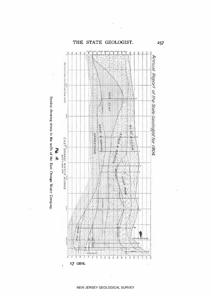
THE STATE GEOLOGIST. 257
NEW JERSEY GEOLOGICAL SURVEY

258 ANNUAL REPORT O F
which is imbedded cobble' stone and boulders. Underlying these formations is a brown sand and gravel, being a mixture of red sandstone with other material. The red clay underlying this appears to be a product of the disintegration of red shale, hav- ing its characteristic red color, and being a rather adhesive or sticky clay. The sand and gravel underlying this is the main water-bearing formation, and is composed of a variety of ma- terial, containing . a considerable amount of gneissic, granitic, and other cobble stone or gravel; and notably near the right- hand side of the section there is a deposit marked "White Sand," which is composed of nearly pure quartz sand and gravel. Un- derlying this water-bearing stratum is either a more or less argillaceous red sandstone, or sometimes at the top of the rock a layer df hard pan.
The cross-section has marked on it, at the side, the elevations in feet above mean sea level. This location is near the ancient pre-glacial outlet of the Passaic Valley, by way of Short Hills and Millburn. The results of the boring are strongly corrobora- tive of the evidence previously found of the existence of such a pre-glacial outlet. I t will be seen that the rock beneath Canoe Brook is at an elevation of between 40 and 50 feet above sea level. The trap rock reef, over which the Passaic River now finds an outlet at Little Falls, is at about an elevation of 158 feet above mean sea level at its lowest point, or I 10 feet or more higher than the rock beneath Canoe Brook. This of itself is a strong indication of a former outlet lower than the present one at Little Falls. The borings furthermore indicate an ancient valley, coinciding to some extent with the present valley of Canoe Brook, and abutting against the trap rock at its easterly side. Well No. 20, at the extreme southeast of the cross-section, struck trap rock at a depth of a little over 50 feet, and was driven into the rock sufficiently to make sure that it was on the ledge. Well No. 21, about 125 feet further west, on the contrary, went 125 feet deeper before striking rock. The material passed through appears to indicate that the water-bearing sand, gravel and cobble immediately underlying the large body of red clay is in the nature of an over-wash deposit, probably from the glacier when it was advancing down the valley and before it had closed
NEW JERSEY GEOLOGICAL SURVEY

T H E STATE GEOLOGIST. 259
the outlet at Millburn. The red clay deposit above it is of such a nature as would indicate that it must have been deposited in still water, being of very fine particles easily held suspended in water, and 'which would not have been deposited from water in motion. The sand and gravel above the red clay appears to have been more washed, although it contains also much very fine material. This layer of sand and gravel is to some extent water-bearing also.
Of the wells coupled up and in use, Nos. 33, 34, 35 and 37, also a well not shown, near the southerly corner of the pumping station, draw water from this upper sand. 'Some of these yield as high as 200 gallons per minute of fine, clear, soft water, but the sand is so fine that it is necessary to provide them with screens.
The wells sunk to the lower water-bearing stratum are pro- vided with slotted pipe at the lower end, the slots being about one-eighth of an inch in width, but the water in this stratum is under considerable pressure and there is much coarse material, so that the finer particles are soon washed out by the flow of water and the coarse gravel and cobble collects around the bot- tom of the pipe to such an extent that even a slotted pipe is not always necessary.
The static pressure on the group of wells near the pumping station was about 8 pounds at the surface of the ground. When the wells first began to flow, they would throw up a considerable quantity of sand and gravel, and occasionally cobblestones as large as the pipe would permit. Several of the wells flowed up- wards of 400 gallons per minute, natural flow, and No. 10
flowed 513 gallons per minute, and No. 32 about as much. When the 20 wells were all connected up and were discharging together, the natural flow was about 3,500,000 gallons per day. With a pump attached, 5,280,000 gallons per day was obtained under continuous test during two days, and at times the yield was as high as 6,000,000 gallons daily. The wells have been in actual operation supplying the city with water since January 13th, 1905, and have yielded continuously an average of 3;1oo,- ooo gallons per day. This may be increased to 5,ooo,ooo gallons daily by increasing the suction lift. The water is of exception-
NEW JERSEY GEOLOGICAL SURVEY

260 ANNUAL REPORT OF
ally fine quality, as is indicated by the following analysis fur- nished the city by Dr. Thomas B. Stillman :
Certificate of Water Analysis.
HOBOKEN, N. J., Jan 17th. 1905- . From whom received: East Orange Water Committee, No. H, 740.
When received : January 16th. Source of sample: Faucet, City Hall, East Orange, N. J. Color : Slightly opalescent ; taste : normal ; odor : none. Data obtained by analysis :
Parts in Grains per ~,ooo,ooo. Gallon.
....................................... Free ammonia, ................................ Albuminoid ammonia,
........... Oxygen required to oxidize organic matter,. .................................. Nitrogen in nitrites,
Nitrogen in nitrates, ................................ ............................................ Chlorine,
Total hardness, ...................................... Permanent hardness, ................................. Temporary hardness, ................................. Total solids, ......................................... Mineral matter, ...................................... Organic and volatile matter, .......................... Other data, when required for judgment.
0.020
0.700 0.63
None. I .86 6.12
0.001 0 . w 0.036
None. 0.107 0.354 4.50 2.90 I .60 7.88 5.74 2.14
Interpretation of results : Fine sanitary water. (Signed) THOS. B. STILLMAN, KAc., Ph.D.,
Professor of Engineering Chemistry, Stevens Institute of Technology.
The 20 wells now in use were placed close together for con- venience in connecting up and operating, although the available water is not confined entirely to the locality in which they are situ- ated. Wells No. 6 and No. 7 each yielded on test over 200 gal- lons per minute. Wells Nos. I, 2 and 3 were also good flowing wells, but were not connected up, it being cheaper t o sink other wells nearer the pumping station. Indeed not one of the wells put down, except No. 20, proved t o be entirely dry.
The following is a record of a few of the typical wells :
NEW JERSEY GEOLOGICAL SURVEY
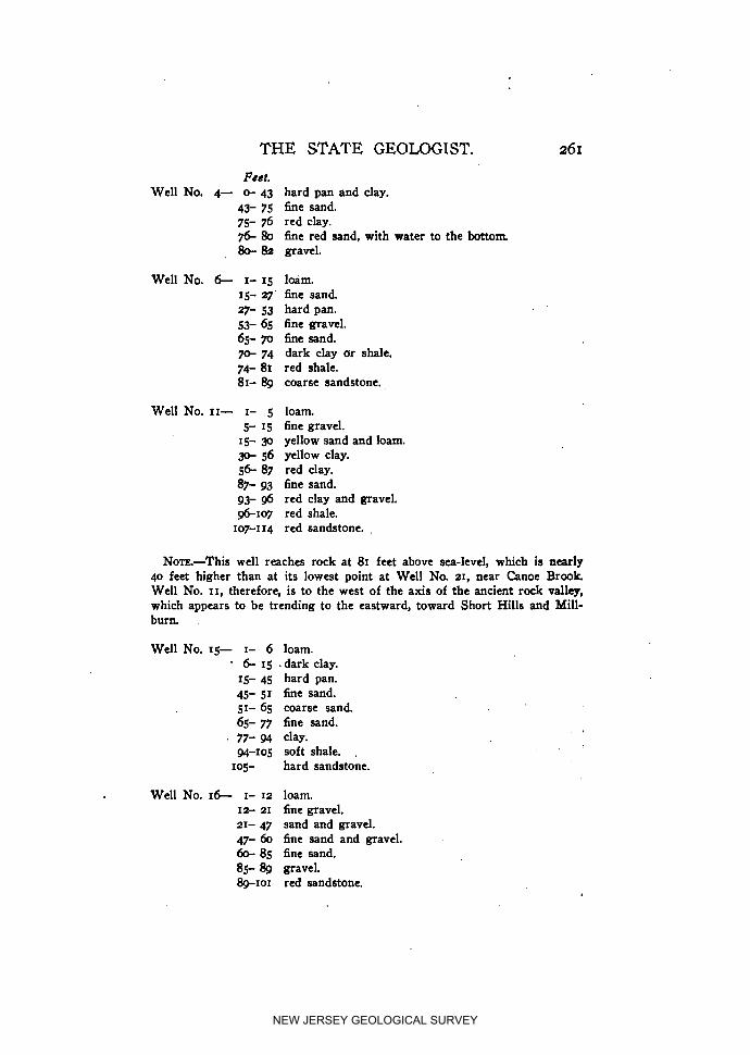
THE STATE GEOLOGIST.
Feet. Well No. 4- c+ 43 hard pan and clay.
43- 75 fine sand. 75- 76 red clay. 76- 80 fine red sand, with water to the bottom 80- 82 gravel.
Well No. 6 I- 15 loam. 15- r fine sand. r- 53 hard pan. 53- 65 fine gravel. 65- 70 fine sand. 70- 74 dark clay or shale. 74- 81 red shale. 81- 8g coarse sandstone.
Well No. 11- I- 5 5- 15
15- 9 30- 56 5 6 87 87- 93 93- 96 *I07
107-1 I4
loam. fine gravel. yellow sand and loam. yellow clay. red clay. fine sand. red clay and gravel. red shale. red sandstone. .
No~~.-This well reaches rock at 81 feet above sea-level, which is nearly 40 feet higher than at its lowest point a t Well No. 21, near Canoe Brook. Well No. 11, therefore, is to the west of the axis of the ancient rock valley, which appears to be trending to the eastward, toward Short Hills and Mill- burn
Well No. IS- I- 6 6 - 1 5 .
15- 45 45- 51 51- 65 65- 77 77- 94 94-105
105-
loam. dark clay. hard pan. fine sand. coarse sand. fine sand. clay. soft shale. . hard sandstone.
Well No. 16- I- 12 loam. 12- 21 fine gravel. 21- 47 sand and gravel. 47- 60 fine sand and gravel. 60- 85 fine sand. 85- 8g gravel. 8g-IOI red sandstone.
NEW JERSEY GEOLOGICAL SURVEY

ANNUAL REPORT OF
Well No. 17- I- 10 loam. I* 35 hard pan. 35- 38 coarse sand. 38- 41 fine sand. 41- 52 coarse sand. 52- 60 fine sand. 60- 78 red clay. 78- 85 soft shale. 85-104 red sandstone.
Well No. 21- o- 18 loam. 18- 34 clay and hard pan. '
34- 52 sand. 52-- 57 coarse sand. 57- 85 fine sand. 85-110 red clay. 110-116 coarse, brown sand. 116130 coarse, white quartz sand. 130-147 toarse sand. 147-158 hard pan. 158 red sandstone rock.
Nm-This well is in the main axis of the ancient valley. The rock is a t 145 feet elevation above mean tide.
Well No. 22- o- 5 loam and clay. 5- 7 boulders, cobblestone, water. 7- 25 hard pan, containing gravel and boulders at bottom
of hard pan and flow of water. 25- 45 sand containing water. 49- 50 coarse sand. 50- 70 fine sand. 70- 88 red clay. 88- 91 coarse sand. Water at 91. Well finished.
Well No. z8- o- 8 loam. 8- 9 hard pan. 27- 45 coarse sand, with much water flowing. 45- 65 fine sand. 65- 86 red clay. 86-108 sand. 108-110 gravel stones up to 2% inches in circumference.
Water flows 5 .inches above edge of 6-inch pipe.
Well No. 32- o- 6 loam. 6 30 hard pan. 30- 65 sand. 65- 86 red clay. &A18 coarse sand. Finished at 118. Natural flow, 500 gallons per minute.
NEW JERSEY GEOLOGICAL SURVEY

T H E STATE GEOLOGIST. 263
The existence of this supply of underground water was sug-a gested by the conclusidn reached during the work of the Geologi- cal Survey, notably in Vol. V., Surface Geology, that the pre-gla- cia1 outlet of the Passaic Valley was by way of Short Hills and Millburn, instead of, as at present, by way of Paterson. Assum- ing such an outlet t o have existed, it was a natural inference that water-bearing gravels might be found near the rock in the vicinity o f the ancient outlet.
Feb. 23, 1905.
Additional Well Records.
T'he following well records have been reported to the State Geologist at various times and not heretofore published. In only one case-the Princeton well-have samples been examined, and the data has not, therefore, been verified in any way, but are pub- lished as received, except that in some cases the records have been condensed.
ABSECON.
Kenneth Allen, Engineer of the Atlantic City Water Depart- ment, informs us that in 1903 a new system of 10 wells was put down near the Absecon pumping station. Their depth varied from 43 to 108 feet, all but 3 of them being either gg o r IOO feet, and their diameters were 10 inches. Nine of these, together with a 10-inch and a 4-inch well previously sunk, have been yielding about 3,500,000 gallons per day. I t is hoped to increase this to 4,000,000 gallons by the installation of a larger compressor.
A test well was also sunk to the depth of 320 feet, the casing being washed and driven down. ?"his boring showed the follow- ing section :
Elevation ro feet above sea level.
o- 18 ft.-Yellow sand and gravel. IS- 29 " -Blue clay, some stones. 2g- 35 " -Yellow sand, with bark and wood. 35- 55 " -White sand, coarser above, fine below. 55-100 " -Yellow sand and gravel, varying sizes.
NEW JERSEY GEOLOGICAL SURVEY

264 ANNUAL REPORT O F
1oo-1~0 ft.-White and gray clay, some stones. 120-138 " -Layers of sand and clay, sand predomiaating. 138-148 " -White and red sand. 148-158 " -Red sand (water overflowed casing at 12' A. T.). 168-200 " -Red sand, finer than water-bearing stratum. 200-250 " -Gray sand, with some clay seams at 230 to 240 ft. 250-2843 " -Marl. Bo-290 " -Sandy clay. 290-310 " -Marl. 310-320 " --Gray clay. 320 ft.-Clay with sand.
The material reported as marl from depths of 250 to 280 and from 290 to 310, cannot be correlated with any of the Cretaceous marl beds which reach the surface near the Delaware to the northwest, but must belong to the later formations, Miocene or Pliocene. Samples of the borings have been preserved in tubes at the office of the Water Department.
ATLANTIC HIGHLANDS.
Matthews Brothers report drilling a well for E. Rice about 1% miles southwest of Atlantic Highlands, at an elevation of 58 feet. The tube i s . 4 5 inches in diameter, and the well is 187 feet deep. I t has a large supply of water, but it is somewhat strongly im- pregnated with iron.
BAYONNE.
In 1892, a deep well was drilled for the Tidewater Oil Com- pany, to a depth of nearly 1,400 feet. The following data were obtained from J. E. Morse, Engineer of the company.
The well was located on a pier about 52 feet south from the front of No. I warehouse on the shore of Kill von Kull, and almost directly north of Livingston station on Staten Island. A 6-inch pipe was driven IOO feet through sand and clay to rock, the top of the pipe being 6 feet above high water. For 960 (100
to 1,060) feet the boring penetrated beds of sandstone and shale, belonging to the Triassic series. A gray or brown sandstone pre- dominated, with occasional thin beds of soft red shale. From
NEW JERSEY GEOLOGICAL SURVEY

THE STATE GEOLOGIST. 265
1,060 feet to 1,397 feet, the boring was in the pre-Triassic crystal- line rocks. No fresh water of any amount was obtained at any point.
BOYNTON BEACH.
Phillips & Worthington furnished the Survey with the follow- ing record of a well drilled by them for the Vulcan Detinning Company, at their factory at Boynton Beach, a short distance east of Woodbridge Creek, which is here affected by tides and is salt : Red clay and sand (glacial), ................ zo feet Gray sand and gravel-Water, ............... 20 " Clean white sand, .......................... 5 , la
Blue clay, .................................. 4 " Coarse gravel, .............................. 11 "
Blue clay, .................................. 15 "
Red shale, ................................. 3 " Trap rock, ................................. 70 "
Red sandstone, ............................. 2 "
Trap rock, ................................. 7 "
o - m feet. 20-.@ "
40 - 45 " 45 - 49 " 4 9 - 63 " 60- 75 " 75 - 78 "
78 -- 148 " 148 - 150 "
I50 - 157 "
A pumping test was made at a depth of 157 feet and the water was found to be very salty. A wooden plug was then inserted a t 148, just above the red sandstone, but the water was still salt. No samples were obtained by the survey, so it is not possible to identify with certainty the beds. The first 40 feet is probably in glacial drift, and the beds from 75 feet to 157 belong to the Triassic. The sand, gravel and clay between 40 and 75 feet may belong to the base of the Cretaceous, although coarse gravel is not certainly known to occur in this formation in this part of the State.
If there has been no mistake in identification of the material, the occurrence of a thin bed of sandstone between the trap is rather unusual, although perfectly possible.
EAST LONG BRANCH.
Matthews Brothers put down two wells for Gaston's Cold Storage plant, about one-fourth mile north of East Long Branch, a t an elevation of 14 feet above tide. One is 6 inches in diameter
NEW JERSEY GEOLOGICAL SURVEY

264 ANNUAL REPORT OF
100-120 ft.-White and gray clay, some stones. 120-138 " -Layers of sand and clay, sand predominating. 138-148 " -White and red sand. I&-158 " -Red sand (water overflowed casing at 12' A. T.). 168-200 " -Red sand, finer than water-bearing stratum. 200-250 " -Gray sand, with some clay seams at 230 to 240 ft. 250-280 " -Marl. 280-290 " -Sandy clay. -310 " -Marl. 310-320 '' - G r a y clay. 320 ft.-Clay with sand.
The material reported as marl from depths of 250 to 280 and from 290 to 310, cannot be correlated with any of the Cretaceous marl beds which reach the surface near the Delaware to the northwest, but must belong to the later formations, Miocene or Pliocene. Samples of the borings have been preserved in tubes at the office of the Water Department.
ATLANTIC HIGHLANDS.
Matthews Brothers report drilling a well for E. Rice about 15 miles southwest of Atlantic Highlands, at an elevation of 58 feet. The tube i s .45 inches in diameter, and the well is 187 feet deep. I t has a large supply of water, but it is somewhait strongly im- pregnated with iron.
BAYONNE.
In 1892, a deep well was drilled for the Tidewater Oil Com- pany, to a depth of nearly 1,400 feet. The following data were obtained from J. E. Morse, Engineer of the company.
The well was located on a pier about 52 feet south from the front of No. I warehouse on the shore of Kill von Kull, and almost directly north of Livingston station on Staten Island. A 6-inch pipe was driven IOO feet through sand and clay to. rock, the top of the pipe being 6 feet above high water. For 960 (100 to 1,060) feet the boring penetrated beds of sandstone and shale, belonging to the Triassic series. A gray or brown sandstone pre- dominated, with occasional thin beds of soft red shale. From
NEW JERSEY GEOLOGICAL SURVEY
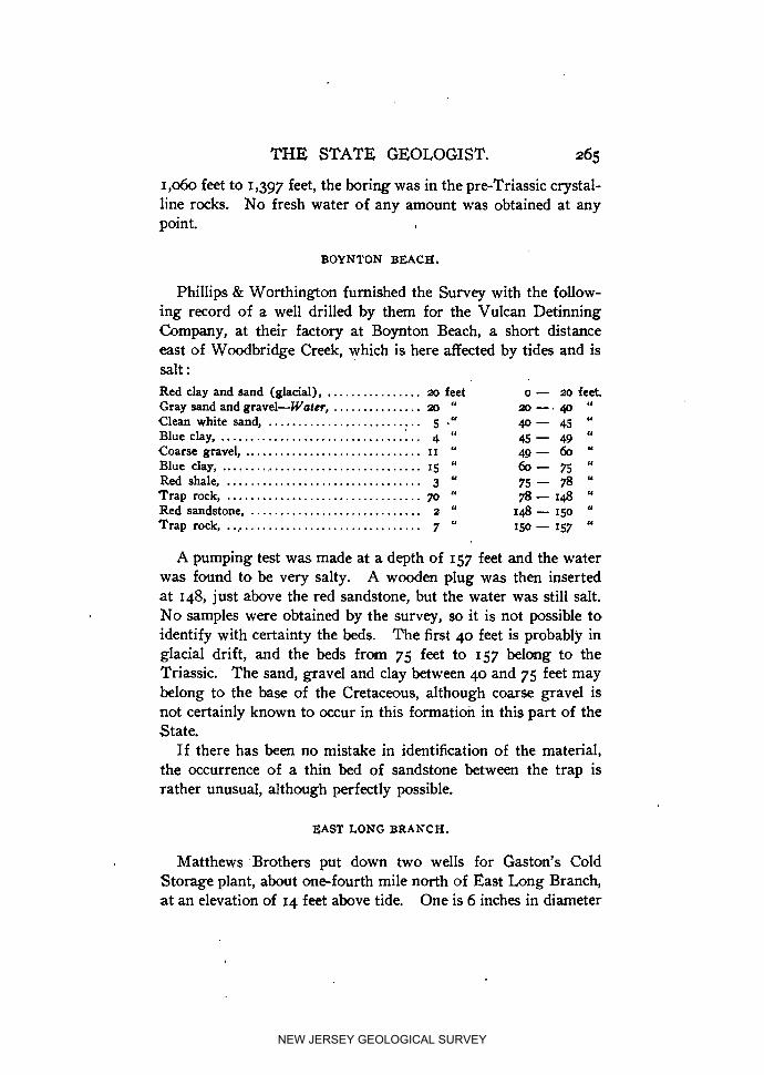
THE STATE GEOLOGIST. 265
1,060 feet to 1,397 feet, the boring was in the pre-Triassic crystal- line rocks. No fresh water of any amount was obtained at any point.
BOYNTON BEACH.
Phillips & Worthington furnished the Survey with the follow- ing record of a well drilled by them for the Vulcan Detinning Company, at their factory at Boynton Beach, a short distance east of Woodbridge Creek, which is here affected by tides and is salt : Red clay and sand (glacial), ................ 20 feet o - 20 feet. Gray sand and gravel-Water, ............... 20 " 20 - . 40 " Clean white sand, .......................... 5 ," 40- 45 " Blue clay, .................................. 4 " 45 - 49 " Coarse gravel, .............................. 11 " 4 9 - 6 0 " Blue clay, ................................... 15 " 60- 75 " Red shale, ................................. 3 " 75 - 78 <"
Trap rock, ................................. 70 " 78 - 148 " Red sandstone, ............................. 2 " 148 - 150 " Trap rock, .................................. 7 " 150 - 157 "
A pumping test was made at a depth of 157 feet and the water was found to be very salty. A wooden plug was then inserted a t 148, just above the red sandstone, but the water was still salt. No samples were obtained by the survey, so it is not possible to identify with certainty the beds. The first 40 feet is probably in glacial drift, and the beds from 75 feet to 157 belong to the Triassic. The sand, gravel and clay between 40 and 75 feet may belong to the base of the Cretaceous, although coarse gravel is not certainly known to occur in this formation in this part of the State.
If there has been no mistake in identification of the material, the occurrence of a thin bed of sandstone between the trap is rather unusual, although perfectly possible.
EAST LONG BRANCH.
Matthews -Brothers put down two wells for Gaston's Cold Storage plant, about one-fourth mile north of East Long Branch, a t an elevation of 14 feet above tide. One is 6 inches in diameter
NEW JERSEY GEOLOGICAL SURVEY

268 ANNUAL REPORT OF
PERTH AMBOY.
W. R. Osborne reports drilling two wells for the Barber Asphalt & Paving Company at Maurer station, Perth Amboy, at an elevation just a little above tide.
Well No. I.
Whitish clay, ..................................................... 10 feet. ........................................................ Blue clay, XI "
Spotted red clay, .................................................. 15 "
Water-bearing horizon, ............................................ 5 "
Red clay, ......................................................... 14 "
Trap rock.
Well No. 2.
Sand, ............................................................ 5 feet Black clay, ....................................................... 5 "
Whitish clay, ..................................................... 30 "
Water-bearing horizon, ........................................... lo "
In both wells the water rose to within 13 feet of the surface. Pumping 30 gallons per minute lowered the water in the
first well to 23 feet, while pumping 50 gallons per minute lowered the water in the second well but I foot.
RED BANK.
Ambrose Matthews & Co. report having drilled a 4-inch well for Dr. Bruster at Red Bank. The well is 180 feet deep, and with pumping yields 80 gallons per minute. The water rises to within 3 feet of the surface.. The ,section as reported by the drillers can be readily identified with the strata observed at the surface to the northwest. 6 Sand and clay, ......... 18 ft. o- 18 ft.
Cape May, ....... 1 Gravel, ................ 10 " 18- 28 " "2 .d
0 ................. E ~ o c k , I 28- 29
( Navesink, ....... Marl, .................. 20 " 29- 49 "
Wenonah ,....... Sand, ................. 40 " 49- 89 "
( Marl, ................. 6 " 89- 95 " .
Marshalltown, ... Sand, ................. 18 " 95-113 "
.................. 1 Marl, 15 " 113-128 "
Columbus, ....... Sand and lignite, ...... 52 " 128-180 "
NEW JERSEY GEOLOGICAL SURVEY

T H E STATE GEOLOGIST. 265)
SOUTH ELBERON.
Two wells have been recently drilled by Geo. B. Kisner adjoin- ing the railroad at South Elberon and f / 2 mile north of the Deal Beach station, surface elevation being between 20 and 30 feet.
Cape May, ....... (Pleistocene), . Sand and gravel, ....... 12 ft. o- 12 ft.
[ Manasquan, ...... Greensand marl, ...... 7 8 " 1 2 - 9 0 "
"Yellow sand" and
Vincentown limesand.
( Quartz sand with some I marl grains, ......... 40 '< 90-130 "
I Quartz and lime sand with some lime rock and numerous shells,. . 70 " I31+200 "
Sewell, .......... Greensand marl, ....... IOO " -300 "
Red Bank ( ?),. .. Red sand becoming black sand at base, ......... 59 " 3-359 "
Navesink ( ?),. ... Clay, .................. 19 " 359-378 "
Wenonah ( ?),. ... Sand, ................. 31 " 378-409 ('
Marshalltown ( ? ) Clay, .................. 35 " 409-444 "
r Sand, .................. 21 " 1 Columbus ( ?),'. ... More clayey sand, ...... 7 " 1 444-505 "
Sand, ................. 33 " 1
In interpreting the above section there is no difficulty with the higher beds. The first marl bed is the Upper marl of Cook or the Manasquan marl of later writers. T'he thick sand-bed beneath it is without question the equivalent stratigraphically of the Vincen- town limesand found further south, and of C d s "yellow sand." The thickness of the marl bed assumed to represent the Sewell marl (Middle marl of Cook) is rather abnormal, and the further fact that a clay bed is reported where the Navesink (Lower) marl was to be expected casts some little doubt upon the correct- ness of this part of the correlation.
Water was found both in the Vincentown sand bed and the bed correlated with the Columbus sand.
WEST LONG BRANCH.
A well was drilled by Matthews Brothers for the Sheffield Farm Creamery, oneeighth mile north of the West Long Branch depot, at an elevation of about 18 feet. The depth of the well is 505 feet. Diameter of the tube, 3 inches, and the water rises to within 14 feet of the surface.
NEW JERSEY GEOLOGICAL SURVEY

NEW JERSEY GEOLOGICAL SURVEY
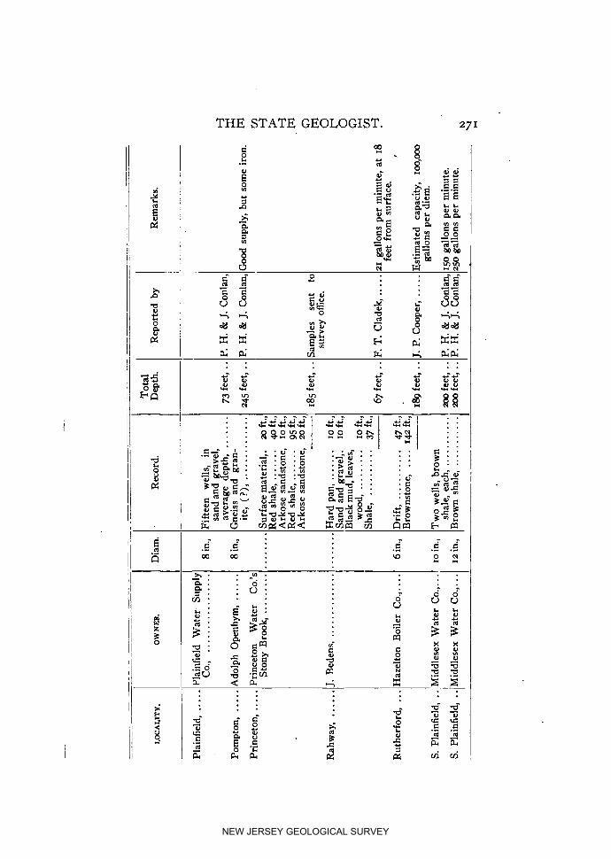
NEW JERSEY GEOLOGICAL SURVEY

NEW JERSEY GEOLOGICAL SURVEY
PART VII,
' Forest Fires in New Jersey During, 1904.
18 GEOL
NEW JERSEY GEOLOGICAL SURVEY

NEW JERSEY GEOLOGICAL SURVEY
Forest Fires in New Jersey During 1904.- ,
BY F. R. MEIER.
In order to obtain the data necessary for this report, five hun- dred of the following circulars, with an addressed and stamped ,
return envelope, were sent to correspondents throughout the State, particularly to those sections where fires were likely to occur.
Circulw Respecti~zg Forest Fires.
F. R. MEIER,
CONSULTING FORESTER
MAHWAH, N. J. DEAR SIR:
I am asked by the State Geologist to report upon all forest fires which have occurred in New Jersey during the year 1904.
You would greatly oblige me by answering the following questions as ac- curately as possible, giving information of each fire which to your knowledge has occurred.
Should you be unable to answer all questions, answer as many as you can and direct me to places where forest fires have occurred, or refer me to per- sons acquainted with them.
An answer before November ~ o t h , 1904, would greatly be appreciated by, Yours very truly,
I?. R. MEIER, Forester Geological Surwey. .
I. What forest fire, or forest fires, have you knowledge of, and in what month did the fires occur? Give date if possible.
2. Over how niany acres did the fire burn? 3. Where is the burned area? Give location as accurately as possible. 4. What kind of timber was destroyed? Is it all killed, or is it only injured?
How old is the killed and injured timber? Was it young and promising growth, or partly barren land?
5. Was there anything else but timber destroyed? , .
(275)
NEW JERSEY GEOLOGICAL SURVEY

ANNUAL REPORT O F
6. What is the money value of the property destroyed or injured? 7. What was the cause of the fire? 8. When was this area burned over prior to the fire of this year? g. Was there any effort made to extinguish the fire? If so, how was it
fought, and with what success? 10. What practical measures can you suggest toward checking and pre-
venting forest fires? Name, ......................................
. Address, ....................................
Replies to the number of 278 were receivd and were used as guides for further investigations by me as to the character of the timber burned and the damage done. Except in nine cases, where small fires were reported by persons well known to me and the loss was inconsiderable, every tract was visited and inspected and the damage calculated in the following manner : The density of the stand was determined, on a scale of which I. represents the well-stocked or ideal forest. Five classes of timber were recognized, I. to V., according to the quality. Estimates were made of the value of such stands at maturity, assuming that they were protected from fire. Owing to the detailed studies made previously by the Geological Survey this could be done quite accurately. The present value was then assumed t o be that part of the value at maturity that the average age of the timberbore the age at maturity1. For example, in the case of 800 acres of pine and oak, average age 10 years, which were killed by fire, the density was determined to be 0.5 ; the quality, grade 111. Such a stand was calculated to yield at maturity at 80 years, 7,000 feet B. M. of lumber per acre, worth at present on the stump
' I t is recognized that this method is not strictly accurate, as the value of growing timber does not increase in the same ratio as the age. Perhaps a more strictly accurate method would be to regard the present value of the forest as that sum which at three oer cent. comoound interest would amount to the estimated value in the time between its age and maturity. In the case cited the value computed by this method would be $5.30, instead of $5.25. The results would not, however, always be so close as this. For instance, in the second case cited above the value, as calculated by compomd interest, would be $2.15, instead of $1.70. Other cases could be given in which the compound interest method gives smaller results at certain periods than the one used. Until more is known regarding the actual rate of growth amd increase in volumes of trees, different methods of computing the value of immature timber will give somewhat different results.
NEW JERSEY GEOLOGICAL SURVEY
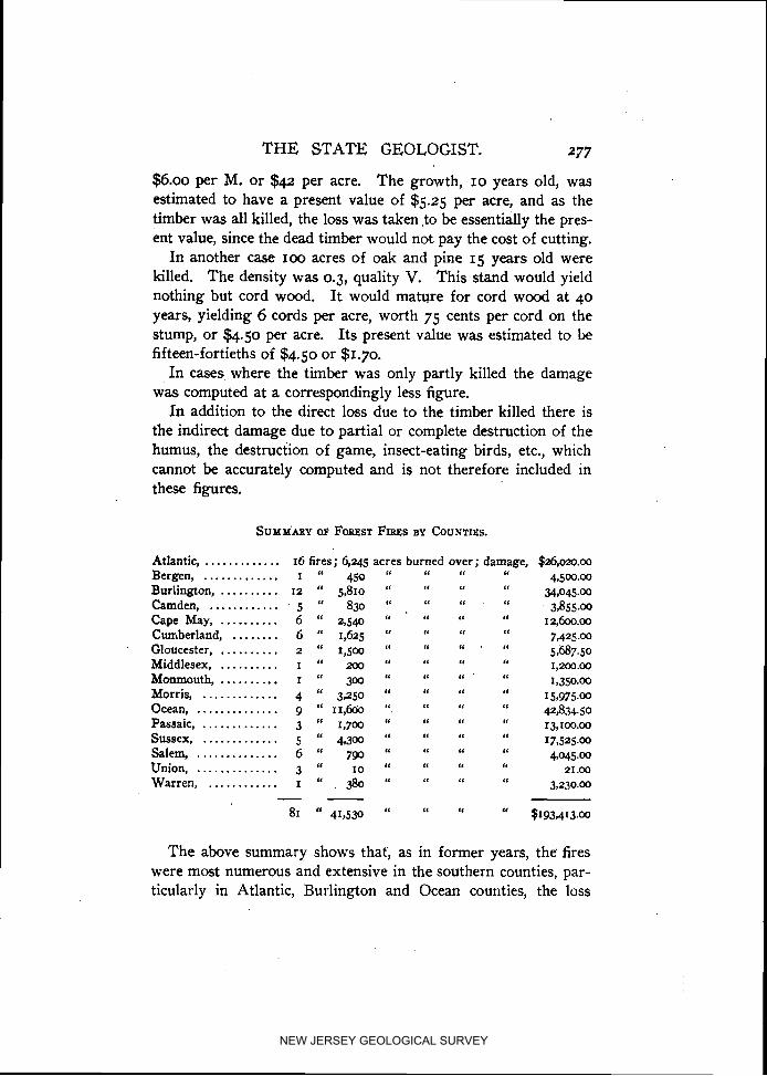
T H E STATE GEOLOGIST. 277
$6.00 per M. or $42 per acre. The growth, - 10 years old, was estimated to have a present value of $5.25 per acre, and as the timber was all killed, the loss was taken >o be essentially the pres- ent value, since the dead timber would not pay the cost of cutting.
In another case IOO acres of oak and pine I 5 years old were killed. The density was 0.3, quality V. This stand would yield nothing but cord wood. It would mature for cord wood a t 40 years, yielding 6 cords per acre, worth 75 cents per cord on the stump, or $4.50 per acre. I t s present value was estimated to be fifteen-fortieths of $4.50 or $1.70.
I n cases, where the timber was only partly killed the damage was computed at a correspondingly less figure.
I n addition to the direct loss due t o the timber killed there is the indirect damage due t o partial or complete destruction of the humus, the destruction of game, insect-eating birds, etc., which cannot be accurately computed and is not therefore included in these figures.
Atlantic, ............. 16 fires; 6,245 acres burned over; damage, $26,ozo.oo Bergen, I 450 6' L C '6 ............. " I.
' " 4,500.00
Burlington, .......... 12 " 5,810 " 6' "
" 34,045.00 Camden, ............ 5 " 830 " I ,
L< '6 3,855.00
Cape May, .......... 6 " 2,540 “ 'I 12,600.00 Cumberland, ........ 6 " 1,625 " 1 ,‘ '6
' I ' 6 . " 7,425.00
Gloucester, .......... 2 " 1,500 “ LC 6'
5,687-50 Middlesex, .......... I " mo "
6' 1,200.oo Monmouth. I " 300 ' 8 ' I 6' .......... "
' I '6 1,350*,0.00
Morris, ............. 4 “ 3,250 “ 6L 6'
" 15,975.00 Ocean, .............. g “ I I , ~ ".
'6 ' 4 " 42,834.50
Passaic, ............. 3 " 1,700 " " 13,roo.oo Sussex, ............. 5 " 4,300 " ' 6 '6 " 17,525.00 Salem, 6 790 *I ' I I' .............. " "
'6 6' 4,045.00
Union, .............. 3 “ 10 " '6 21.00 Warren, I " 380 6' ' 8 6' ............ , " 3,230.00
- - 81 " 41,530 " ' I '1
" $193,413.00
The above summary shows that, as in former years, the fires were most numerous and extensive in the southern counties, par- ticularly in Atlantic, Burlington and Ocean counties, the loss
NEW JERSEY GEOLOGICAL SURVEY
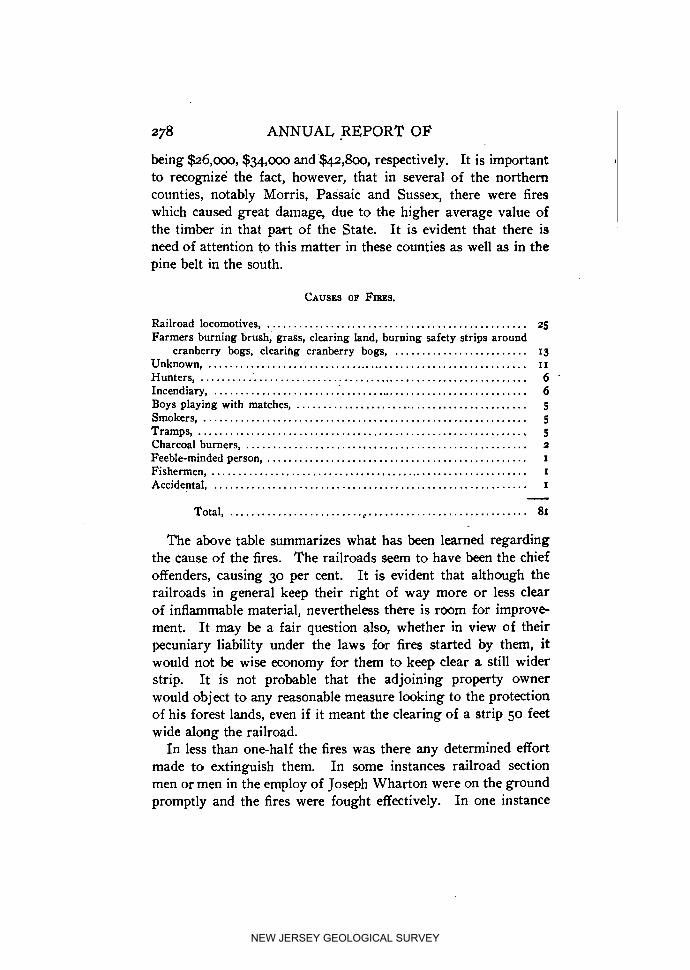
278 ANNUAL REPORT OF
being $26,000, $34,000 and $LI.Z!,~OO, respectively. I t is important to recognize the fact, however, that in several of the northern counties, notably Morris, Passaic and Sussex, ,there were fires which caused great damage, due to the higher average value of the timber in that part of the State. I t is evident that there is need of attention to this matter in these counties as well as in the pine belt in the south.
Railroad locomotives, ................................................. 25 Farmers burning brush, grass, clearing land, burning safety strips around
cranberry bogs, clearifig cranberry bogs, ......................... I 3 Unknown, ............................................................. 11
Hunters, .............................................................. 6 A
Incendiary, ............................................................. 6 Boys playing with matches, ............................................ 5 Smokers, ............................................................. 5 Tramps , .............................................................. 5 Charcoal burners, ..................................................... 2
Feeble-minded person, ................................................. I
Fishermen , ............................................................ I
Accidental , ........................................................... I - Total, ......................................................... 81
The above table summarizes what has been learned regarding the cause of the fires. The railroads seem to have been the chief offenders, causing 30 per cent. I t is evident that although the railroads in general keep their right of way more or less clear of inflammable material, nevertheless there is room for improve- ment. I t may be a fair question also, whether in view of their pecuniary liability under the laws for fires started by them, it would not be wise economy for them to keep clear a still wider strip. It is not probable that the adjoining property owner would object to any reasonable measure looking to the protection of his forest lands, even if it meant the clearing of a strip 50 feet wide along the railroad.
In less than one-half the fires was there any determined effort made to extinguish them. In some instances railroad section men or men in the employ of Joseph Wharton were on the ground promptly and the fires were fought effectively. In one instance
NEW JERSEY GEOLOGICAL SURVEY

PLATE XIX.
MAP OF
NEW JERSEY
FOREST FIRE
D E L A W A R E
NEW JERSEY GEOLOGICAL SURVEY

NEW JERSEY GEOLOGICAL SURVEY
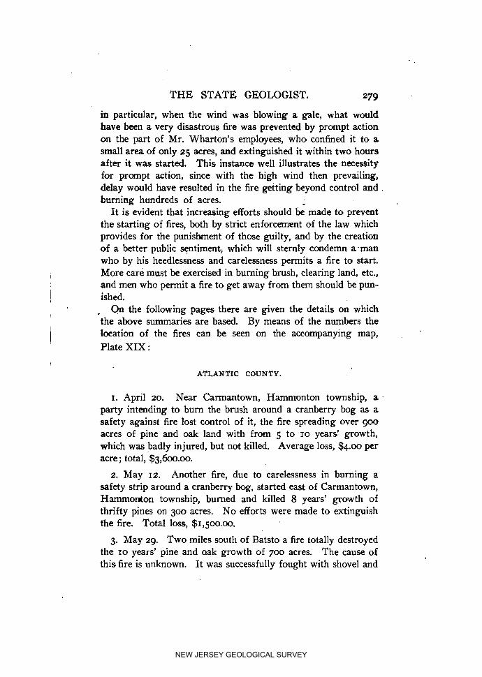
THE STATE GEOLOGIST. 279
in particular, when the wind was blowing a gale, what would have been a very disastrous fire was prevented by prompt action on the part of Mr. Wharton's employees, who confined it t o a small area of only 25 acres, and extinguished it within two hours after it was started. This instance well illustrates the necessity for prompt action, since with the high wind then prevailing, delay would have resulted in the fire getting beyond control and . burning hundreds of acres. -
I t is evident that increasing efforts should be made t o prevent the starting of fires, both by strict enforcement of the law which provides for the punishment of those guilty, and by the creation of a better public sentiment., which will sternly condemn a.man who by his heedlessness and carelessness permits a fire to start. More care must be exercised in burning brush, clearing land, etc., and men who permit a fire to get away from them should be pun- ished.
On the following pages there are given the details on which the above summaries are based. By means of the numbers the location of the fires can be seen on the accompanying map, Plate XIX :
ATLANTIC COUNTY.
I. April 20. Near Carmantown, Hammonton township, a party intending to bum the brush around a cranberry bog as a safety against fire lost control of it, the fire spreading over goo acres of pine and oak land with from 5 to 10 years' growth, which was badly injured, but not killed. Average loss, $4.00 per acre; total, $3,600.00.
2. May 12. Another fire, due to carelessness in burning a safety strip around a cranberry bog, started east of Carmantown, HammoMon township, burned and killed 8 years' growth of thrifty pines on 300 acres. No efforts were made to extinguish the fire. Total loss, $1,5oo.oo.
3. May 29. Two miles south of Batsto a fire totally destroyed the 10 years' pine and oak growth of 700 acres. The cause of this fire is unknown. I t was successfully fought with shovel and
NEW JERSEY GEOLOGICAL SURVEY

280 ANNUAL REPORT O F
sand by Joseph Wharton's men. The area was burned over 10
years ago. Average loss, $4.50 per acre. Total loss, $3,150.00.
4. June 16. I t is said that smokers set fire to the woods one- half mile west of Green Bank, Mullica township. The fire was promptly fought and put out by employees of Joseph Wharton before it had time to develop. Sixty acres of pine and oak 15 years old were injured. Average loss, $5.00 per acre. Total loss, $300.00.
5. July 20. Again. Joseph Wharton's men rushed to a fire which was started by a tramp on the road from Batsto to Glouces- ter, Mullica township, and extinguished it two hours after it was set. The wind was blowing at a heavy gale 'and had the fire not been fought promptly a great conflagration would undoubtedly have devastated a large area. Twenty-five acres of oak and pine were partly killed. Average loss, $2.50 per acre. Total loss, $62.50.
6. August 25. Boys started a fire on the road from Elwood to Weekstown which entirely killed 12 years' growth of pine and oak on 350 acres. The fire was allowed to burn itself out. Aver- age loss, $4.75 per acre. Total loss, $1,662.50.
7. September 29. About 2 miles southwest of Pleasant Mills a fire, origin unknown, totally destroyed 750 acres of good growth of pine and oak, as well as large beds of wild cranberry vines. I t burned three days, but was finally extinguished by Joseph Wharton's men. Loss, not including cranberry vines, $6.00 per acre; total loss, $4,500.00.
8. May 7. A fire, due to sparks from a locomotive, broke out between Newtonville and Pancoast, running over 20 acres, injur- ing a go-years' growth of good-sized pines. Fire was extin- guished by railroad section men. Loss, $7.00 per acre ; total loss, $140.00.
g. October I. In clearing land a fire was started southeast of Newtonville, covering 500 acres. Eighty-five per cent. of the 25 years old pines were killed, the balance badly injured. Very little effort was made to check the fire. Average loss, $6.00 per acre; total loss, $3,000.00.
NEW JERSEY GEOLOGICAL SURVEY

T H E STATE GEOLOGIST. 28 I
10. August 28. In burning the right of way railroad section men allowed the fire to get away between Richland and Doughty. It burned over go acres and killed the 15 years old oak and pine growth. Section men put it out. Total loss, $360.00.
11. September 23. Fishermen fishing in Great Egg Harbor river neglected to put out their camp fire a little north of Wey- mouth, Hammilton township. This carelessness caused a fire of .
25 acres extent. I t was promptly and successfully fought with water and sand. Average loss, $I .oo per acre; total, $25.00.
12. October 3. One mile east of Weymouth a fire was promptly extinguished after burning and injuring 30 acres of oak and pine land, covered with 20 years old growth. A farmer burning brush in clearing a cranberry bog caused the fire. Loss, $4.75 per acre; total, $142.50.
13. May 7. A locomotive set fire to 250 acres of pine and oak a little south of Doughty, killing 40 per cent. o i the growth and injuring the balance. I,oss, $1.00 per acre; total, $250.00.
14. Smokers set fire to the woods a little east of Buena Vista. The fire destroyed 175 acres of promising oak and pine f r o m 8 to 18 years' growth. Loss, $4.50 per acre; total, $787.50.
15. April 18. Between May's Landing and McKee City, the railroad started a fire of 870 acres extent, burning 8-year oak and pine growth. Fire was fought and extinguished by railroad men. Loss, $2.00 per acre; total, $1,740.00.
16. July 19. There was a fire northeast of McKeetown, caused by tramps, destroying entirely the growth of oak and pine, averaging 10 years, on 1,200 acres. Loss, $4.00 per acre; total, $4,800.00.
BERGEN COUNTY.
17. November 14. One-half mile north of Oakland, hunters, it is said, caused a fire on 450 acres of woodland. The fire killed 60 per cent. of the standing timber, which consisted of oak and chestnut 50 years old. Loss, $10.00 per acre; total, $4.500.00.
NEW JERSEY GEOLOGICAL SURVEY

ANNUAL REPORT OF'
BURLINGTON COUNTY.
18. July 5. An incendiary started a fire a little south of Atsion. Twenty acres, chiefly barren land, were burned, doing but little damage. The fire was discovered soon after it was set, and promptly put out. Loss, $10.00.
19. July 30. Tramps set fire to 300 acres of oaks and pines 10 years old, I mile south of Atsion. The oaks were killed, the pines mostly injured. I t was fought and extinguished by Joseph Wharton's men. Loss, $5.00 per acre; total, $1.500.00.
20-22. August 5. Three fires, set undoubtedly by an incendiary, and all within 15 miles east of Atsion, covered 150 acres of small oaks and pines, brush and barren land, and small wild cranberry meadows. They were promptly discovered and extinguished. Lpss, $4.00 per acre; total, $600.00.
23. August 5. In burning turf on a cranberry bog near Friendship Bog, about 5 miles east of Atsion, a fire was started which burned over 300 acres of pine and barren land. I t was fought with sand and shovels. k, $3.50 per acre; total, $1,050.00.
24. April 16. A locomotive started a fire between Atsion and - Harris Station, which burned over 40 acres of young pine, when
it was extinguished by the section men, Loss, $4.00 per acre; total, $160.00.
25. April 16. Another fire, due to a locomotive, was started just below Chatsworth, but was extinguished before damage was done.
26. June 15. Again a farmer burning around his cranberry bog to protect it from fire lost control of it, the fire burning over 1,500 acres in Medford township, 4 miles south of Medford. The timber, which is pine from 5 to 25 years old, was mostly killed. Loss, $6.00 per acre; total, $~,OOO.OO.
There was one cranberry bog burned, the value of which is not included in this estimate.
27. October I. There was a severe fire between Tuckerton and New Gretna which is said to have started at Green Bush, a settle-
NEW JERSEY GEOLOGICAL SURVEY

T H E STATE GEOLOGIST. 283
nlent just east of Bass River. I t destroyed oak and pine from 5 to 30 years' growth on 2,000 acres. Some efforts were made to check it, with p r success, and it was practically left to burn itself out. The cause of the fire is unknown. Loss, $8.00 per acre; total, $16,ooo.oo.
28. May 14. The railroad started a fire between Chatsworth and Woodrnansie, which burned over 800 acres of more or less barren land. I t was fought by railroad men. Loss, $3.00 per acre; total, $~,L~o.oo.
29. April 23. At Hanover Station sparks from a locomotive set fire to 700 acres of pine and oak from 10 to 40 years old, of poor quality. Loss, $4.75 per acre ; total, $3,325.00.
CAMDEN COUNTY.
30. April 14. About 15 miles east of Chesilhurst a fire broke out, set by a feeble-minded person, which killed the pine and oak growth on 750 acres. No efforts were made to check the fire. Loss, $4.50 per acre; total, $3,375.00.
31-34. April 16, 19, 24, 30. Four fires were set by locomotives between Atsion and Elm; all were promptly extinguished by railroad section men. Eighty acres of young pine from 5 to 40 years' growth were killed in these four fires. Loss, $6.00 per acre ; total, $480.00.
CAPE MAY COUNTY.
35. September. A very severe fire took place in the first part of September between Belleplain and Woodbine, caused by burn- ing brush. The fire covered an area of 1,000 acres stocked with oak and pine from 2 to 25 years old, 75 per cent. of which was killed outright. Loss, $4.50; total, $4,500.00. I t was fought by gangs of men back-firing.
36, 37. October I. Two fires were started at Bellplain, p r o b ably by the railroad, but were discovered and put out before they reached any extent. Forty acres were burned, but lightly.
NEW JERSEY GEOLOGICAL SURVEY

284 ANNUAL REPORT OF
38. September 12. A locomotive set fire to 175 acres of oak and pine, 80 per cent. of which was killed. m e fire was between Goshen and South Dennis, 2 miles north of Gashen. Forty acres were burned 8 years ago. Men with shovels and rakes, clearing the old roads of leaves and all combustible material, fought the fire with success. Loss, $3.00 per acre; total, $525.00. .
39. April 18. A locomotive started a fire 1% miles north of Dennisville, totally destroying 850 acres of pine and some white cedar. It was a "hot fire" and was put out after 8 hours' hard work with shovel and sand. Loss per acre, $5.00; total, $47250.00.
40. May 8. One mile south of Petersburg the railroad caused a fire which killed 75 per cent. of a 20-year oak and pine growth on 475 acres. Loss, $7.00 per acre; total, $3,325.00.
CUMBERLAND COUNTY.
41, 42. In the last part of May an incendiary set fire at two places along the road from Port Elizabeth to Estelville, about 2% miles from Port Elizabeth. These two fires covered 75 acres, destroying 60 per cent. of the 20 years' growth of pine and oak. Loss, $5.00 per acre; total, $375.00.
43. August 10. A fire was started by smokers on the road from Port Elizabeth to Dorchester, running over 250 acres of pine and oak timber, 35 years old, killing all growth. The fire was fought by back-firing. Loss, $8.00 per acre ; total, $2,000.00.
44. %me time in April a fire was set about 2 miles east of Manumuskin Station, burning over 100 acres stocked chiefly with oak growth from 10 to 30 years old, 60 per cent. of which was killed. The cause of the fire is unknown. Rain extinguished it. Loss, $2.00 per acre; total, $200.00.
45. One thousand acres of oak and pine, 75 per cent. oak from 5 to 25 years' growth, were badly injured by a fire, cause un- known, which started between Manumuskin and Hunter's Mill. The fire was back-fired during the night with success. Loss, $3.00 per acre; total, $3,000.00.
NEW JERSEY GEOLOGICAL SURVEY

T H E STATE GEOLOGIST. 285
46. October 23. A farmer burning.brush started -a fire on the so-called "Station road," of a mile from Dividing Creek. The fire burned over 200 acres-of mixed woods, from 10 to 60 years old, burning and killing everything, including 40 cords of cord- wood. Loss, $9.00 per acre; $1.25 per cord; total, $1,850.00.
GI.0UCESTE.R COUNTY.
47. In the first part of April, farmers burning safety strips around cranberry bogs at Piny Hollow, set fire to 950 acres of oak and pine, averaging 19 years' growth. Fifty per cent. was killed. Loss, $4.25 per acre; total, $4.037.50.
48. April 12. Between Piny Hollow and Cecil a fire devas- tated 550 acres of 15 years old oak and pine, 40 per cent. oak. It is said that charcoal men are responsible for the fire. Loss, $3.00 per acre; total, $1,650.00.
MIDDLI$SEX COUNTY.
49. In April, a locomotive is said to have started a fire at Old Bridge. The fire burned in an easterly direction, covering 200
acres, stocked.with oak and chestnut from 10 to 45 years old. All growth was killed. Loss, $6.00 per acre; total, $~,aoo.oo.
MONMOUTH COUNTY.
50. May 8. ear Robertsville, along the county line, 300 acres of oak, 18 years old, were totally destroyed by fire of un- known origin. Loss, $4.50 per acre; total, $1,350.00.
MORRIS COUNTY.
51. November 23. At Hibernia hunters started a fire which injured the growth .of promising oak and chestnut, averaging 20 years old; 2,500 acres were burned over. k s , $4.00 per acre ; total, $~o,ooo.oo.
NEW JERSEY GEOLOGICAL SURVEY

ANNUAL REPORT OF
. 52. April 12. Sparks from a locomotive set fire to 350 acres of oak and chestnut timber, averaging 30 years old, south of Green Pond, on Copperas Mountain. The fire was back-fired with success. Loss, $7.50 per acre; total, $2,625.00.
53. In November sparks from a locomotive set fire to 300 acres of oak and chestnut, 40 years old, 5 mile south of Tabor, badly injuring the chestnuts. The fire was fought with cedar boughs. Loss, $8.00 per acre ; total, $2,400.00.
54. In the first part of April a fire was started, origin un- known, a b u t 2 miles north of the New Jersey Asylum, near Morris Plains, killing 30 years growth of chestnut and oak on IOO acres. The fire was fought by a strong force and was extin- guished after five hours work. Loss, $9.50 per acre; total, $950.00.
OCEAN COUNTY.
55. April. Boys playing with matches and smoking set a fire a little east of Lakehurst, which burned an area of 2,000 acres, stocked with pine and oak from 5 to 40 years old. Sixty per cent. were killed, 30 per cent. badly injured and 10 per cent. scorched. I t was back-fired after 1,500 acres were burned over. Loss, $5.00 per acre; total, $~o,ooo.oo.
56. November I. Three and a half miles north of Tuckerton, 3,800 acres of mixed woods, mostly pine and oak, from 10 to 25 years old, were burned by a fire set by smokers. The fire burned east and west of the Tuckerton Mill Branch and lasted three days. A small part of this area was burned 10 years ago. Loss, $5.00 per acre; total, $~g,ooo.oo.
57. April 10. About 4 miles west of Lakehurst a fire started by farmers burning brush, destroying 2,500 acres of oak and pine, from I to 40 years old; also 20 acres of white cedar. Some weak efforts were made to check the fire after it threatened sev- eral buildings. A small house was burned. Loss, $2.00 per acre ; total, $5,000.00.
58. In the latter part of May a fierce but not extensive fire took place near the railroad station at Lakehurst, the fire running
NEW JERSEY GEOLOGICAL SURVEY

T H E STATE GEOLOGIST. 287
northwest for about 2 miles, over 300 acres. A locomotive is said to have caused the fire. The entire pine growth on this area was killed. Loss, $3.50 per acre; total, $1,050.00.
59. April 19. Tramps set fire at Double Trouble, running over 150 acres, of which 40 acres were fine pine timber 30 years old, and I 10 acres pine 20 years old. Fire was successfully fought. Loss, $1,809.50.
60. April 22. Twelve hundred acres of rather poor pines, from I to 25 years growth, were more or less badly injured by a fire between Whitings and Wheatland, set by tramps. Loss, $2
per acre; total, $2,400.00.
61. May 16. One and a half miles north of Toms River a fire, caused by careless farmers in burning brush, killed the 12 years pine growth on 250 acres. Loss, $3.50 per acre; total, $875.00.
62. April 18. From the same cause 400 acres were burned over, 2 miles northwest of Toms River. This area iilcludes about 300 acres of waste and brush land, and 100 acres is stocked with poor oaks and pines. Loss, $0.50 per acre; total, $200.00.
63. May 19. Charcoal burners are said to have caused a fire at Brookville which burned over 1,000 acres of pine barren. Loss, $2.50 per acre; total, $2,5oo.m.
I PASSAIC COUNTY.
64. October 15. A fire, origin unknown, started 3 miles northeast of Midvale, burning IOO acres of oak and chestnut, 40 acres of which is 19 years, 60 acres 50 years old. Seventy-five per cent. of all trees were killed. Loss, $10.00 per acre; total, $I,ooo.oo.
65. November 14. Hunters started a fire east of Hewitt, near the State line, which burned for four days, destroying 20 to 40 years old oak and chestnut on 700 acres. Lass, $7.00 per acre; total, $4,900.00.
66. Hunters are also responsible for a fire which occurred in November northeast of Uttertown, on Bearfort, Mountain. Nine
NEW JERSEY GEOLOGICAL SURVEY

288 ANNUAL REPORT O F
hundred acres of oak and chestnut, averaging 45 years old, were in part killed. Loss, $8.00 per acre; total, $7,200.00.
. SUSSEX COUNTY.
67. July 5. A fire of unknown origin started a little east of Vernon, on Wawayanda Mountain. I t was not very severe, al- though it burned over 750 acres of oak and chestnut of 40 years' growth, severely injuring, but not killing it. I t was back-fired. Loss, $4.50 per acre; total, $3,375.00.
68. April 14. Two hundred acres of oaks and chestnuts, 20
years old, were totally destroyed through the carelessness of a farmer burning brush 2 miles west of Beernerville. The destroyed growth was thrifty and most promising. The fire was extin-. guished with water. Loss, $5.00 per acre; total, $~,ooo.oo.
69. In the middleof November, a fire, said to have been caused by hunters, started 2 miles south of Glenwood on the eastern slope of Pochuck Mountain. I t destroyed the 5 years old growth of chiefly oak and chestnut on 150 acres. Loss, $1.00 per acre; total, $I 50.00.
70. In the first part of April a fire, started by unknown parties, burned 3,100 acres of young promising oak and chestnut, in the northeastern part of Montague township. The growth, averaging 15 years, was killed outright. The fire was fought by back-firing, with poor success. Loss, $4.00 per acre; total, $12,400.
71. April 20. Sparks from a railroad set fire, a little north of Two Bridges, to IOO acres of oak and chestnut timber, 50 years old. The chestnuts, which form about 60 per cent. of the stand, were more or less all killed, while the oaks were badly in- jured. Loss, $6.00 per acre; total loss, $600.00.
72. October 15. A fire was accidentally started west of Elmer, burning over 1,000 acres, stocked with oak and chestnut; 700 acres, 16 to 25 years' growth; zoo acres, 6 years old, and IOO
NEW JERSEY GEOLOGICAL SURVEY

T H E STA'IX GEOLOGIST. 289
acres, 5 years. All the young growth was killed, the older trees injured. Of this tract IOO acres were burned over 6 years ago. The fire was fought by back-firing. Loss per acre, $400; total loss, $4,000.00.
73-75. April, May, June. Three small fires between Elmer and Palatine stations were caused by sparks from locomotives. Thirty acres were lightly burned over and the damage done was small. Loss, $15.00.
76, 77. April. Boys started two fires about 2 miles south of Alloway, causing 60 acres of brush land. to bum. The fires did but little damage. Total damage, $30.00.
UNION COUNTY.
78. May 15. A fire, cwering 4 acres, started a little west of Branchville by smokers. The fire was promptly discovered and put out: Nothing but brush was burned.
79. September 19. Three acres of oak and chestnut timber, 45 years old, were somewhat injured by a fire of unknown origin 1% miles west of Scotch Plains. Loss, $3.00 per acre; total, $9.00.
80. November I. Joining the above fire, one was set by boys which destroyed the 10 years growth of oak and chestnut on 3 acres. The fire was extinguished promptly. b s s , $4.00 per acre ; total, $12.00.
WARREN COUNTY.
81. November 18. At Millbrook, along the county line, hun- ters set fire to thrifty oak and1 chestnut, averaging 45 years old. Sixty per cent. were killed over a tract of 380 acres. Loss,'$8.50 per acre ; total, $3,230.00.
January 16, 1905.
I9 GEOL
NEW JERSEY GEOLOGICAL SURVEY

NEW JERSEY GEOLOGICAL SURVEY

PART VIII.
The Mining Industry.
Bp HENRY B. K~~V~MJ% I
--
NEW JERSEY GEOLOGICAL SURVEY

NEW JERSEY GEOLOGICAL SURVEY
The Mining Industry.
In spite of the fact that for a part of 1904 the iron market was dull and there was little sale for ore, the iron-ore production of the New Jersey mines for 1904 was 499,952 tons, an increase over that for 1903. In fact, it reached the highest p i n t attained since 1891. For ten of the thirty-eight years for which the Sur- vey has a record, the production of 1904 was exceeded, but it surpassed the production of the other twenty-seven years. The shipments were about 2,500 tons in excess of the production, the stocks on hand being diminished by that amount.
The tendency of recent years t o concentrate the iron-mining industry in the hands of a few individuals and corporations was further illustrated during the year by the purchase by Joseph Wharton of the holdings of the New Jersey Iron Mining Com- pany. These comprised the active Irondale mines at Wharton, as well as undeveloped property near Hibernia. Mr. Wharton, the Thomas Iron Company and the Empire Steel and Iron Company are now the chief producers in New Jersey, their mines yielding during 1904 about 91 per cent. of the whole, and those of Mr. Wharton alone over 50 per cent.
The following is a list of the active mines during the whole or a part of the year: The McKinley, Washington and Basic Iron
.Ore, at Oxford; the Richard and Hurd, at Wharton; the Hude, 4
a t Stanhope; Taylor and Elizabeth, at Mount Hope; the Andover, De Camp, Upper Wood and Wharton, at Hibernia; Peters, a t Ringwood, and a new mine, the Lurk, near Mt. Arlington. A few tons were also taken from the Lewis mine near L e d g e w d .
The average value of the ore at the mines was $2.28 per ton, ranging frsm $1.85 to $2.60. The total value was about $1,1~1,000.
NEW JERSEY GEOLOGICAL SURVEY

ANNUAL REPORT O F 294
The unique zinc deposit at Franklin Furnace continued to be a large producer, but showed a slight falling off from 1903.
The copper mines are still in the development stage and have not yet taken rank as producers. -
I
The Iron Mines.
THE OXFORD MINES, OXFORD FURNACE.
Empire Steel and Iron Company, Catasauqua, Pa., owners and operators.
The McKinley and Washington mine were both in operation during the year, but the company preferred not to furnish for publication any statement regarding the nature of their oper- ations.
THE BASIC IRON ORE COMPANY MINE.
The Basic Iron Ore Company, operators; R. I,. Ahles, Presi- dent; Erskine Hewitt, Secretary, Buttzville, N. J.
Mining has been continued steadily during the year in spite of the depression during a part of the time in the iron market. The .three shafts mentioned in the Report for 1903 now have the fol- lowing depths: No. I, 208.5 feet ; No. 2, 164.5 Get, including a go-foot sump, and No. 3, 150 feet. All three of the shafts are to one side-northeast--of the ore, and cross-cuts are driven to -the ore at two levels in Nos. I and 2, and three levels in No. 3. Shaft No. I is now being deepened to a third level. On level No. 2 the lengths of the cross-cuts from the shafts to the ore are go feet, 30 feet and 140 feet, respectively.
Caving has commenced on the upper level working from Shaft No. 2, while development work in the way of blocking out ore has continued on the lower level, since for the successful carrying out of the caving system of mining it is necessary to have the de- velopment work far in advance of the mining.
A r e c e ~ t analysis of this ore, first dried at 212' F., gave . the following :
NEW JERSEY GEOLOGICAL SURVEY

T H E STATE GEOLOGIST. 295 .
Metallic iron, ..................................................... 47.650 Silica, ............................................................ 15.705 Sulphur, .......................................................... .038 Phosphorus, ...................................................... .ogz Manganese, ....................................................... 4.351 Lime , ............................................................. 1.260 Magnesia, ......................................................... 1.636 Alumina , ......................................................... 1.347 Combined water,' ............................................... .not deter.
During 1904, the production amounted to 28,812 tons, giving a total of 63,425 tons since the mine was opened. This is in part shipped to the Pequest Furnace, where it is used with "hard" ore from the Ringwood mines for making basic pig iron. Dur- ing the past year the fuinace was out of blast for some time, so that a large supply of ore was accumulated on the stock piles.
HUDE MINE, STANHOPE, N. J-
Musconetcong Iron Works, Elizabethport, N. J., lessees; John S. Kennedy, Stanhope, Manager.
This mine has continued t o be worked steadily, but the total product for the year has not been large. The mining operations consist principally in "following" the ore, which occurs in dis- tinct "shoots," but complicated by offsets, pinches and some fold- ing. The ore is all used at the Musconetcong furnace at Stan- hope. During the year 10,323 tons were produced.
LURK MINE, NEAR MT. ARLINGTON.
During the past year a new mine which may be callei the Lurk mine has been opened by A. K. Baker and Richard Fitz- herbert, of Dover, on the Lurk property, 5 mile southeast of Mt. Arlington, Roxbury township.
In addition to the chemically combined water due to the fact that the ore is in part limonite, there is some hygroscopic or mechanically combined water in all soft ores of this character as they are taken from the mine. This does not show in the dried sample taken for analysis, but if an ore is very wet, it may make considerable difference in the amount of iron per ton of ore.
NEW JERSEY GEOLOGICAL SURVEY

296 ANNUAL REPORT O F
The ore body was struck by a shaft about 18 feet from the sur- face and has been followed on the slope for about IOO feet. I t has well-defined walls and is about 6 feet in width, but streaks of rock alternate with the ore. About 400 tons were mined, of which 200 were sent to the Wharton furnace. Analysis of a selected sample gave metallic iron 66.534 per cent; phosphorus .ogg per cent. Four car-load lots shipped to the Wharton fur- naces showed metallic iron 64.482, 58.405, 56.717 and 54.016 per cent., respectively.
The owners suspended operations at the beginning of cold weather at the close of the year, but expect to resume in the spring if the iron market warrants it.
Joseph Wharton, owner and operator; Edward Kelly, Man- ager, Wharton.
During the year all the property of the New Jersey Iron Min- ing Company, which formerly owned these mines, was purchased by Joseph Wharton. Very little mining was done on this prop- erty during the year, until purchased by Mr. Wharton late in the year. Stope No. 4 has been driven to the southwest about 80 feet and a sink made 60 feet. Both of these have shown improve- ment in the vein. The production was only 1,750 tons.
RICHARD MINE, WHARTON, N. J.
The Thomas Iron Company, B. F. Fackenthal, Jr., President, Easton, Pa., owners; James Arthur, Superintendent, Wharton, N. J.
The following facts regarding the Richard mine, which was purchased by the Thomas Iron Company in 1856, have recently been published by the Company and are here reprinted through the courtesy of the President:
"The Richard Mine contains several shoots of iron-ore, two of which are worked at the present time. No. I shoot, now referred to as the 'Moupt Pleasant vein,' farthest to the north, is the one from which ore was mined
NEW JERSEY GEOLOGICAL SURVEY

THE STATE GEOLOGIST.
in 1856, when The Thomas Iron Company 'bought the property. Mining from this shoot continued for several years, but was then temporarily abandoned; and No. 2 shoot, now referred to as the 'Richard vein,' lying to the south and overlying the 'Mount Pleasant vein,' was opened. A cross-cut was driven in 1893 at the western end of the property, near No. I slope, and connection made between the 'Richard' and 'Mount Pleasant' shoots, which are about 300 feet apart. This cross-cut intersected a shoot of ore about two feet thick, lying between the 'Richard' and 'Mount Pleasant' shoots, which is referred to as the 'Middle vein.' The intersection of these shoots was at a depth of 471 feet in length on the incline. As the depth of the 'Mount Pleasant' shoot of ore had never before been tested on The Thomas Iron Company's property, its development was at once commenced.
' Mininz o~erations have been carried on ever since from both shoots. with - . consequent ,increase of the output. There are three slopes on the 'Richard vein' going down on the foot-wall, known as No. I (length, 533 ft.) ; No. 2 (length, 630 ft.), and No. 3 (length, 738 ft.) ; and two slopes going down on the foot-wall of the 'Mount Pleasant vein,' known as No. 4 (length, 932 ft.), and No. 6 (length, 600 ft.).
"A new slope, known as No. 5, was begun Augsut st, 1896, and com- pleted April 3oth, 1901, through which ore is now being hoisted from both shoots. The slope has three compartments, and goes down at an'angle of 52 degrees into the rock lying between the 'Richard' and 'Mount Pleasant' shoots. At the depth of 570 feet two cross-cuts were driven; one going south IIO feet 6 inches, and intersecting the 'Richard vein' IOO feet below the old working at No. 3 slope; and the other going north 191 feet, and inter- secting the 'Mount Pleasant vein.' The slope has a length of 868 feet, equiva- lent to a vertical depth of 685 feet. The 'Richard vein' a t the point of inter- section is 18 feet wide between walls. The 'Middle rein' at the point of in- tersection is 4 feet wlde between walls, and lies 65 feet south of the 'Mount Pleasant vein.' The total cost of the slope and drifts, aggregating 1,361 feet, was $36,311.98.
"The total output of the Richard Mine, since its purchase by The ~ h o m a s Iron Company, up to February 28th, rgoq, was 2,212,838 tons, being an average of 46,000 tons per year. The average output during the first eight years was 11,683 tons per year; while the average output during the last eight years was 101,gjg tons per year. The output for ~ g o z equalled the aggregate for the first ten years.
"During the year 1900 the mine was equipped with new Babcock & Wilcox boilers of 1,250 horse-power, and a new Ingersoll compressor, with compound Corliss engines of 750 horse-power, together with other machinery, a t a total cost of $68,417.96. During the years 1go3-04 the mine is being equipped with electrical machinery, the greater part of which has been installed, which enables the hoisting to be done by electricity.
"The ore from Richard Mine is magnetic, of high grade. The average analysis for the past twelve years, representing shipments of over one mil- lion tons (every shipment being sampled), was 60.19 per cent. metallic iron. The highest yearly average was 61.89 per cent., and the lowest 58.54 per cent. The phosphorus averages about .75 per cent.; silica, 6 per cent.; lime, 5 per cent.; alumina, 3 per cent."
NEW JERSEY GEOLOGICAL SURVEY

298 ANNUAL REPORT OF
During the year 1904 the output of the mine was 88,398 tons 5 cwt.
TEABO MINE, MOUNT HOPE, N. J.
Joseph Wharton, owner; Edward Kelly, Manager.
Nothing was done at the Teabo mine during 1904 until late in the year, when preparations were made t o resume the develop ment work outlined in previous reports.
MOUNT HOPE MINES, MOUNT HOPE, N. J.
Empire Steel and Iron Company, Catasauqua, Pa., owners and operators.
Extensive explorations by means of diamond drills have been mac\e at these mines during the past year and improvements started, but the company preferred not to furnish a statement of their operations for publication at present.
HIBERNIA MINES, HIBERNIA, N. J.
Joseph Wharton, owner and operator; Edward Kelly, Man- ager, Wharton.
During the past year operations at this group of mines have been on a more extensive scale than ever before. The completion of extensive improvements in hoisting, cobbing, separating and concentrating commenced several years ago has enabled the man- agement to make a better showing in ore production than ever before, while the demands of the four furnaces at Wharton and Phillipsburg compel the mines to be worked to their utmost capacity.
The Andover Mitw (formerly Lower Wood, Crane and Church mines) .--Two new levels, Nos. 25 and 26, 60 feet apart, have been opened in this mine during the last year. Levels 24 and 25 have been worked nofiheast to the De Camp line, 800
NEW JERSEY GEOLOGICAL SURVEY
T H E STATE GEOLOGIST. 299
feet, and the latter has also been stoped southwest t o the lean ground. Some work to the northeast has also been done on level 26, where the vein has a width of 5 feet.
The drift on level 24, through the 62 feet of lean ground to -the southwest, mentioned in the report for 1903, was stoped IOO
feet further to the southwest in a vein of ore 8 feet or so in width. Here another "pinch" or more "lean ground" was found. It is planned to continue this level westward to a point below the skipway or main incline. When this is accomplished the hoisting facilities for the deeper workings will be much im- proved. a
During 1904 the Andover mine produced 3g,41 I tons 13 cwt. De Camp and Upper Wood Mines.-These two mines are
worked through Shafts No. 4 and'No. 6, about 500 feet apart, the former on the De Camp lot, the latter on the Upper Wood. Stopes are driven westward from No. 6 to No. 4, only the ore lying in stopes west of No. 4 being hoisted through that shaft, which is now down to level 7, 600 feet deep.
In the Upper Wood there are now 12 levels, as against g at the close of 1903. No stoping has been done on No. 12, but No. I I has been stoped about 100 feet each way from the slope, and No. 10 about 150 fee% each way. On levels 8 and g, stoping to the southwest has extendfd about to a point in line with the pro- posed extension of Slope No. 4. Some ore has also been taken from the higher levels.
The lean ore from the Upper Wood and De Camp mines is taken t o the magnetic concentrator at the foot of the hill and concentrated. During 1904 these two mines produced 100,097 tons 10 cwt., and the product of the separator was 16,297 tons 4 cwt. additional. Sand and! crushed stone are by-products of the concentrator, for which there is considerable demand, and of which over 20,000 tons were shipped during the year.
The W h r t o n M i w . 4 r e is taken from the Wharton mine from Shafts g and 11, about 400 feet apart and 875 and 1,275 feet, respectively, northeast of No. 6 on the Upper Wood. In -addition to these, there is the new shaft, No. 12, which is not yet a producer. Magnetic cobbers have been in~talled for several years at both No. g and No. I I , and the results obtained have been
NEW JERSEY GEOLOGICAL SURVEY

300 ANNUAL REPORT O F
so satisfactory that further expenditures are contemplated along this line in order to keep pace with the increased production of the mines. These improvements, when carried out, will embody the following features :
1st. A crushing to 2%-inch mesh, and the complete separa- tion of all iron-bearing rock from the waste rock by powerful magnets.
2d. The heads or iron-bearing rock from No. I will then pass a second and weaker set of magnets, which will separate the pure ore from that containing considerable rock.
gd. The tails from the second operation will be recrushed and again passed over a third set of magnets.
4th. The tails from the third passage will again be crushed and passed over a sizing screen, from which pieces over three- eighth inches will be sent back for still another crushing, while those passing the screens are carried to a fourth magnet. Here the final separation takes place, the tails being rejected as sand. I t is believed that by this means the iron in the tails will be re- duced to 10 per cent.
In the Wharton mine, stoping progressed on levels g, 10, 11,
12 during the year, while a still lower level, 13, was reached and a sink below this level was started. No. g shaft now has a depth of 1,540 feet, No. 11 shaft reaches 1,570 f&, and the new shaft, No. 12, located 1,000 feet northeast of No. 11, has been sunk to 800 feet. Cross-cuts have been made in the hang- ing wall, as follows: At 630 feet, cross-cut t o the vein, 105 feet, the vein being 4 feet wide; at 6go feet, cross-cut IOO feet, vein 9 feet; at 750 feet, crosscut to vein, which was 8 feet wide; at 800 feet, cross-cut now driven 40 feet.
During 1904 the Wharton mine has produced 102,984 tons 11 cwt., making a total for the Hibernia mines of 258,795 tons 12 cwt. Shipments during the same period show 270,256 tons 7 cwt .
Mrs. Sarah A. Hewitt, owner; R. L. Ahles, Easton, Ba., con- sulting engineer in charge.
NEW JERSEY GEOLOGICAL SURVEY

T H E STATE GEOLOGIST. 301
During the most of the year the mine was closed down, wait- ing better prices in the iron market, but toward the end of the year operations were resumed and a small amount of ore mined from the shaft northeast of the open-cut. This shaft, as noted in the report for last year, cut two of the ore shoots, Nos. 4 and 3, which were known from the workings from the open-cut, and a drift 8 feet in the hanging wall from the foot of the shaft revealed another ore body, the exact relationship of which to the other shoots is as yet unknown. Surveys of the mine have been made and accurate maps prepared, which show the extent of the old workings.
Practically no ore was mined during the year.
The Zinc Mines.
James B. Tonking, Superintendent of the New Jersey Zinc Company's mines at Franklin Furnace, has furnished the fol- lowing notes regarding the work done there during 1904:
During the year the work of development has continued in the lower portion of the Parker mine on the northeast end of the lens far enough to outline practically the ore body up t o the 700-foot level. Plans have been considered for mining the deep ore from this end and will soon of necessity be carried into ex- ecution. This will involve the sinking of a shaft 1,200 feet deep, equipped with modern improvements, as well as the hoist- ing and pumping machinery.
In sinking the Parker shaft a water course was cut about 600 feet from the surface, and much trouble with water and sand has been experienced from it ever since. Many theories have been advanced as to the source of this water, and recently a hole has shown itself on the surface, which would indicate that the sand comes from the vicinity of the swamp lying slightly southwest of the shaft and between it and Trotter No. 4.
The raise from the 700-foot level in the Taylor mine has been completed and connection made with No. 4 shaft of the Trotter mine, so that that part of the deposit known as the Trotter mine has now been brought into connection with the
NEW JERSEY GEOLOGICAL SURVEY

302 ANNUAL REPORT O F
other workingi and a third outlet established, which can be used as a travelling way, hoisting shaft, or for pumping pur- poses.
On the southwest end, commonly called the Buckwheat mine, the open work has been extended far enough to clean out nearly all of the ore down to the tunnel level. About twenty thousand tons still remain above this level on the west leg. Preparations have been made for dropping the skip roads t o the next lower level, in order to facilitate the removal of the overhang of the east wall at the extreme southwest end.
At the 700-foot level a large duplex pump has been installed, with a capacity of 500 gallons per minute, to throw to the sur- face. At the 4 m f o o t level in the slope, another large pump has been installed to take the top water. With these new pumps, this'end of the mine is exceedingly well equipped for the freshets that occur at intervals during the year.
Steam has been replaced by compressed air at the southwest end, and so far has worked very satisfactorily, and a consider- able saving has been effected.
The total product mined for the year was 250,025.90 gross tons.
The Stirling Hill mines at Ogdensburg, N. J., were inactive throughout the year.
NEW JERSEY GEOLOGICAL SURVEY

Mineral Statistics For the Year 1904.
IRON ORE.
The total production of the mines, as reported by the several mining companies, was 499,952 tons.
The table of statistics is reprinted, with the total amount for 1904 added.
TABLE OP STATISTICS.
Year. Iron. Ore. Authority. 1190. ............. 10,000 tons. ............ .Morse's estimate. 189. ............. a o , m tons. ............ .Gordon's Gazetteer. 1855. ............. I O O , ~ . ................. .Dr. Kitchell's estimate. 1860. ............ . I ~ ~ O O tons. ............ .U. S. census. 1864. ............ .226,m tons. ............ .Annual Report State Geologist. 1867. ............ .275,067 tons. ...... ; ...... 6
18 70. ............ .362,636 tons. ............. U. S. census. 1871. ............ .45o,m tons. ............. .Annual Report State Geologist 1872. .6oo,m tons. '6 ' ............ ............. 1873. ............ .665,ax, tons. ............. ' 1874. .525,m tons. ' ' I' ............ ............. 1875. .3go,ax, tons. ' ' I 't ............. ............ 1876. .285,m tons*. '6 ' ............ ............ 1877. .315,ax, tons*. 6' U 8' ............ ............ 1878. ............ .409,674 tons. ............. ' 1879. .488,028 tons. '6 I' ............ ............. 1880. .745,m tons. ' 6' ............ ............. 1881. .737,052 tons. 6' ' ............ ............. 1882. .932,762 tons. ' I ' ............ ............. 1883. .521~16 tons. '6 ' I $6 ............. ............ I.&. .3g3,71o tons.. 6' ' '6 ............ ............ 1885. . 3 p , m tons. ' " ............ ............. 1886. 5oo,501 tons. I 6' ............. ............. 1887. .547,889 tons. ' I ' ............ ............. 1888. ............. 447,738 tons. ............. ' I 6' 6'
* From statistics collected later.
. (303)
NEW JERSEY GEOLOGICAL SURVEY
ANNUAL REPORT OF
Year. Iron Ore. Authority. . 1889. ............ .q&.~og tons. ............ .Annual Report State Geologist.
I 890. ............. 552,996 tons. ' '6 '6 ............. 1891. ............. 551,358 tons.. '6 '6 6' ............ I 892. ............. 465,455 tons. ............. ' 1893. ............ .356,150 tons. ............. *, *(
1894 ...-........ .277,&3 tons. ............. 1895.. ........... .282~3 tons.. ............ '< 1896.. ........... .*,ggg tons. ;. ........... L '8
1897. -257,235 tons. I' ' " ............ ............. 1898. ............ .275,378 tons. ............. ( I ' I 899. ............. 300,757 tons. ............. ' L '6
Igoo .............. 342,390 tons*. '6 ' 6' ............ 1901 40 1,151 tons. 6' 6' .............. .............
............. 1902 .............. 443,728 tons. ' I "
1903. ............ .&796 tons*. ............ . " ' 19 04 ..............499, 952 tons '6 Id ' I ..............
ZINC ORE.
The production of the New Jersey Zinc Company's mines is reported by Mr. James B. Tonking, Superintendent, to be 250,025.9 gross tons of zinc and franklinite ore. I t was chiefly separated at the company's mills. This report shows a loss in production below 1903 of 29,394 tons.
The statistics for a period of years are reprinted from the last annual report.
ZINC ORE.
Year. Zinc Ore. Authority. 1868. ............. 25,000 tonst. ........... .Annual Report State Geologist. 1871. 22,000 tonst.. " '6 '6 ............. ........... 1873.. 17,500 tons.. 6' ' ' I ............ ............ 1874. 13,500 tons. ' I I ............. ............. 1878. 14467 tons.. 6' ' I 6' ............. ............ 1879. 21,937 tons. '6 6' 6' ............. ............. 1880. 28,311 tons. I' - " '6 ............. ............. 1881.. 49,178 tons.. '6 '6 '6 ............ ............ 1882.. 40,138 tons.. I6 8' ............. ............ 1883.. 56,085 tons.. '6 6' I' ............ ............
* The figures, 407,596 tons, given in the report for 1900, included 75,206 tons of crude material which should have been reduced to its equivalent in con- centrates. The figures for 1903, given in the report for that year, were in- correct.
t Estimated for 1868 and 1871. Statistics for 1873-1890, inclusive. are for shipments by railway companies. The later reports are from zinc-mining companies.
NEW JERSEY GEOLOGICAL SURVEY
THE STATE GEOLOGIST.
Year. Zinc Ore. Autlrority. 1884. ............. 40,094 tons. ............. Annual Report State Geologist. 1885. ............. 38,526 tons. ............. 6
1886. ............. 43,877 tons. . ............ 1887. ............. 50,220 tons. ............. ' I
1888. ............. 46,377 tons. . ............ ' 1889.. ............ 56,154 tons. . ............ ,,
1890. 49,618 tons. " " ............. ............. 1891. ............. 76.032 tons. . : ........... 1892. .............. 77,298 tons. . ............ ‘, I
1893. ............. 55,852 tons. ............. 1894. ............. jg,382 tons. ............. 1895* 1896. ............. 78,080 tons. . . . . . . . . . . . . . 1897.. ............ 76,973 tons. ............. 1898. ............. ~ ~ 4 1 9 tons. ............. ' I
1899.. ........... .154,447 tons. ... ........... "
1900.. .194,881 tons. . " 6' ........... ............ 1901.. .191,221 tons. 6' 6' ........... ............. 1902. ............ .209,386 tons. . . . . . . . . . . . . . , 1903. ............ .27g,41g tons. ............. ' rgo 4 250.025 tons 6' 6' .............. ..............
* No statistics were published in the Annual Report for 1895.
20 GEOI,
NEW JERSEY GEOLOGICAL SURVEY

NEW JERSEY GEOLOGICAL SURVEY

Publications.
The demand for the publications of the Survey is continuous and active, and requests for the reports a;e granted in the case of all the later editions.
I t is the wish of the Board of Managers to complete, as far as possible, incomplete sets of the publications of the Survey, chiefly files of the Annual Reports in public libraries, and librarians are urged to correspond with the State Geologist con- cerning this matter.
By the act of 1864 the Board of Managers of the Survey is a board of publication, with power to issue and distribute the publications as they may be authorized. The Annual Reports of the State Geologist are printed by order of the Legislature as a part of the legislative documents. They are distributed by the State Geologist to libraries and public institutions, and, as far as possible, to any who may be interested in the subjects of which they treat.
Six volumes of the Final Report series have been issued. Volume I, published in 1888, has been very scarce for several years, but all the valuable tables were reprinted in an appendix of Volume IV, of which a few copies still remain, although the supply of this vdume is so far reduced that indiscriminate re- quests cannot be granted.
The appended list makes brief mention of all the publications of the present Survey since its inception in 1864, with a statement of the editions now out of print. The reports of the Survey are distributed without further expense than that of transportation. Single reports can usually be sent more cheaply by mil than otherwise, and requests should be accompanied by the proper postage as indicated in the list. Otherwise they are sent express collect.
The maps are distributed only by sale, at a price, 25 cents per sheet, to cover cost of paper, printing and transportation. In
( 307 )
NEW JERSEY GEOLOGICAL SURVEY

ANNUAL REPORT OF
order :to secure prompt attention, requests for both reports and maps should be addressed simply "State Geologist," Trenton, N. J.
CATALOGUE OF PUBLICATIONS.
GEOLOGY OF NEW JERSEY. Newark, 1868, 8vo., xxiv + 899 pp. Out of print. PORTFOLIO OF MAPS accbmpanying the same, as follows: I. Azoic and paleozoic formations, including the iron-ore and limestone dis-
tricts; colored. Scale, 2 miles to an inch. 2. Triassic formation, including the red sandstone and trap-rocks of Central
New Jersey; colored. Scale, 2 miles to an inch. 3. Cretaceous formation, including the greensand-marl beds; colored. Scale,
2 miles to an inch. 4. Tertiary and recent formations of Southern New Jersey; colored. Scale,
2 miles to an inch. 5. Map of a group of iron mines in Morris county; printed in two colors.
Scale, 3 inches to I mile. 6. Map of the Ringwood iron mines; printed in two colors. Scale, 8 inches
to I mile. 7. Map of Oxford Furnace iron-ore veins; colored. Scale, 8 inches to I
mile. 8. Map of the zinc mines, Sussex county; coloied. Scale, 8 inches to I mile.
A few copies are undistributed. REPORT ON THE CLAY DEPOSITS of Woodbridge, South Amboy and other
places in New Jersey, together with their uses for firebrick, pottery, etc. Trenton, 1878, 8vo., viii + 381 pp., with map.
A PRELIMINARY CATALOGUE of the Flora of New Jersey, compiled by N. L. Britton, Ph.D. New Brunswick, 1881, 8vo.. xi + 233 pp. Out of print.
FINAL REPORT OF THE STATE GEOLOGIST. Vo1. I. Topography. Magnetism. Climate. Trenton, 1888, 8vo., xi + 439 pp. Very scarce.
FINAL REPORT OF THE STATE G E O ~ I S T . Vo1. 11. Part I. Mineralogy. Botany. Trenton, 1889, 8vo., x + 64.2 pp. (Postage, 25 cents.)
FINAL REPORT OF THE STATE GEOWIST. Vo1. 11. Part 11. Zoology. Tren- ton. 1890, 8vo., x + 824 pp. (Postage, 30 cents.)
REPORT ON WATER-SUPPLY. Vo1. I11 of the Final Reports of the State Geologist. Trenton, 1894, 8vo., xvi + 352 and 96 pp. (Postage, 21 cents.)
REPORT ON THE PHYSICAL GEOGRAPHY of New Jersey. Vol. I V of the Final Reports of the State Geologist. Trenton, 1898, 8vo., xvi+ 170+zoo pp. Unbound copies, postage, 24 cents; cloth bound, $1.35, including photo-relief map of State.
REPORT ON THE GLACIAL GEOLOGY of New Jersey. Vol. V of the Final Re- ports of the State Geologist. Trenton, 1902, ~vo . , xxvii +802 pp. (Sent by express, 35 cents if prepaid, or charges collect.)
REPORT ON CLAYS AND CLAY INDUSTRY of New Jersey. Vol. VI. of the Final Reports of the State Geologist. Trenton, 1904, 8vo., xxviii + 548 pp. (Sent by express, 30 cents if prepaid, or charges collect.)
NEW JERSEY GEOLOGICAL SURVEY

THE STATE GEOLOGIST.
B W C H I O ~ D A AND LAMEUIBANCHIATA of the Raritan Clays and Greensand Marls of New Jersey. Trenton, 1886, quarto, pp. 338, plates XXXV and Map. (Paleontology, Vol. I.) (By express.)
GASTEROPODA AND CEPHALOWDA of the Raritan Clays and Greensand Marls of New Jersey. Trenton, ~Sgz,quarto, pp. 402, plates L. (Paleontology, Vol. 11.) (By express.)
PALEOZOIC PALWNTO~Y. Trenton, 1903, 8vo., xii + 462 pp., plates LIII. (Paleontology, Vol. 111.) (Postage, 20 cents.)
ATLAS OF NEW JERSEY. The complete work is rpade up of twenty sheets, each about 27 by 37 inches, including margin. Seventeen sheets are on a scale of I inch per mile and three on a scale of 5 miles per inch. I t is the purpose of the Survey gradually to replace Sheets 1-17 by a new series of maps, upon the same scale, but somewhat differently arranged so as not to overlap. The new sheets will be numbered from 21-37, and will be subject to extensive revision before publication. These sheets will each cover the same territory as eight of the large maps, on a scale of 2,000 feet per inch. Nos. 2, 4, 5, 7, 8, 11,12 and 17 have already been replaced as explained below. No. z. Kittatinny Valley and Mountain, from Hope to the State line. No. 3. Central Highlands, including all of Morris county west of Boonton,
and Sussex south and east of Newton.* No. 6. The Valley o f the Passaic, with the country eastward to Newark and
southward to the Raritan river. No. 9. Monmouth Shore, with the interior from Metuchen to Lakewood. No. zo. Vicinity of Salem, from Swedesboro and Bridgeton westward to the
Delaware. No. 13. Vicinity o f Barnegat Bay, with the greater part of Ocean county.* No. 14. Vicinity o f Bridgeton, from Allowaystown and Vineland southward
to the Delaware bay shore. NO. 15. Southern Interior, the country lying between Atco, Millville and Egg
Harbor City. No. 16. Egg Harbor and Vicinity, including the Atlantic shore from Barnegat
to Great Egg Harbor. No. 18. New Jersey State Map. Scale, 5 miles to the inch. Geographic. No. 19. New Jersey Relief Map. Scale, 5 miles to the inch. Hypsometric. No. 20. New Jersey Geological Map. Scale, 5 miles to the ,inch. (Out of
pr int) No. rr. Eastern Swsex and Western Pacsoic counties. Replaces Sheet 4. No. 23. Northern Bergen and Eastern Passaic counties, to West Point, New
York. (Ready .in March, 195.) No. 24. Southern Warren, Northern Hunterdon and Western Morris coun-
ties. Replaces Sheet 2.
No. z6. Vicinity o f Newark and Jersey City-Paterson to Perth Amboy. Re- places in part Sheet 7.
No. 27. Vicinity o f Treaton--Raven Rock to Palmyra, with inset, Trenton to Princeton. Replaces Sheet 5.
No. 28. Trentm and Eastward-Trenton to Sayreville. Replaces Sheet 8. (Ready in March, 195.)
*At the date of publication of this report these sheets are out of print. New editions will be issued as soon as possible.
NEW JERSEY GEOLOGICAL SURVEY
310 ANNUAL REPORT OF
No. 31. Vicinity of Camden, to Mount Holly, Hamrnonton and Elmer. Re- places Sheet 11.
No. 32. Part of Burlington and Ocean counties, from Pemberton and Whit- ings to Egg Harbor City and Tuckerton. Replaces Sheet 12.
No.37. Cape May.-Cape May City to Ocean City and Mauricetown. ( In preparation.)
Other sheets of the new series, Nos. 21-37, will be printed from time to time, as the older sheets become out of print All the maps are sold at the uniform price of twenty-five cents per sheet, either singly or in lots. Since the Survey cannot open small accounts, and the charge is merely nominal, remittance should be made with the order. Order by ?lumber of the State Geologist, Trenton, N. J.
TOPOGRAPHIC MAPS, NEW SERIES.
These maps are the result of recent surveys, and contain practically all of the features of the one-inch scale maps, with much new material. They are published on a scale of 2,000 feet to an inch, and the sheets measure 26 by 34 inches. The Paterson, Hackensack, Morristown, Newark, Jersey City, Plainfield, Elizabeth, New York Bay, Amboy, Navesink, Long Branch, Shark River, Trenton East, Camden, Mount Holly, Woodbury, Taunton, and Atlantic City Sheets have been published and are now on sale. The Boonton, Dover-Stanhope and Chester Sheets will be issued in March, 1905. The price is twenty-five cents per sheet, payable in advance. Order by name any of the sheets above indicated as ready, of The State Geologist, Trenton, New Jersey.
ANNUAL REPORTS.
REPORT OF PROFESSOR GEORGE H. COOK upon the Geological Survey of New Jersey and its progress during the year 1863. Trenton, 1864, 8vo., 13 pp.
Out of print. THE ANNUAL REPORT of Prof. Geo. H. Cook, State Geologist, to his Ex-
cellency Joel Parker, President of the Board of Managers of the Geological Survey of New Jersey, for the year 1864. Trenton, 1865, 8vo., 24 pp.
Out of print. ANNUAL REPORT of Prof. Geo. H. Cook, State Geologist, to his Excellency
Joel Parker, President of the Board of Managers of the Geological Survey of New Jersey, for the year 1865. Trenton, 1866, 8vo., 12 pp. Out of print
ANNUAL REPORT of Prof. Geo. H. Cook, State Geologist, on the Geological Survey of New Jersey, for the year 1866. Trenton. 1&6r/, 8vo., a8 pp.
Out of print. REPORT OF TEE STATE GLOLOGIST, Prof. Geo. H. Cook, for the year of IW.
Trenton, 1868, 8vo., 28 pp. Out of print. ANNUAL REPORT of the State Geologist of New Jersey for 1869. Trenton,
1870, 8vo.. 57 pp.. with maps. Out of print. ANNUAL REPORT of the State Geologist of New Jersey for 1870. New
Brunswick. 1871, 8vo.. 75 pp., with maps. Very scarce.
NEW JERSEY GEOLOGICAL SURVEY

THE STATE GEOLOGIST. 311
ANNUAL REPORT of the State Geologist of New Jersey for 1871. New Brunswick, 1872, ~vo., 46 pp., with maps. Out of print.
ANNUAL REPORT of the State Geologist of New Jersey for 1872 Trenton. 1872, ~vo., 44 pp., with map. Out of print.
ANNUAL REPORT of the State Geologist of New Jersey for 1873. Trenton, .
1874, 8vo., 118 pp., with maps. Out of print. ANNUAL REPORT of the State Geologist of New Jersey for 1874. Trenton,
1874, ~vo., 115 pp. Out of print. ANNUAL REPORT of the State Geologist of New Jersey for 1875. Trenton,
1875, 8 vo., 41 pp., with map. Out of print. ANNUAL REPORT of the State GeoIogist of New Jersey for 1876. Trenton,
1876, 8vo., 56 pp., with maps. Out of print. ANNUAL R ~ R T of the State Geologist of New Jersey for 1877. Trenton.
1877, ~vo., 55 Pp. Out of print. ANNUAL REPORT of the State Geologist of New Jersey for 1878. Trenton,
1878, Svo., I31 pp., with map. Out of print. ANNUAL REPORT of the State Geologist of New Jersey for 1879. Trenton,
1879, 8vo., 199 pp., with maps. Out of print. ANNUAL REPORT of the State Geologist of New Jersey for 1880. Trenton,
1880, 8vo., 220 pp., with map. Out of print. ANNUAL REPORT of the State Geologist of New Jersey for 1881. Trenton,
1881, 8vo., 87+1g+xiv. pp., with maps. Out of print. ANNUAL REPORT of the State Geologist of New Jersey for 1882. Camden,
1882, 8 ~ 0 , 191 pp., with maps. Out of print. ANNUAL REPORT of the State Geologist of New Jersey for 1883. Camden,
1883, ~vo., 188 pp. Scarce.* ANNUAL REPORT of the State Geologist of New Jersey for 1884. Trenton,
1884, 8vo., 168 pp., with maps. ANNUAL REPORT of the State Geologist of New Jersey for 1885. Trenton,
1885, 8vo., 228 pp., with maps. ANNUAL REPORT of the State Geologist of New Jersey for 1886. Trenton,
1887, 8vo., 254 pp., with maps. ANNUAL REPORT of the State Geologist of New Jersey for 1887. Trenton,
1887, 8vo., 45 pp., with maps. ANNUAL REPORT of the State Geologist of New Jersey for 1888. Camden.
1889, 8vo., 87 pp., with map. ANNUAL REPORT of the State Geologist of New Jersey for 1889. Camden,
1889, ~vo. , 112 pp. ANNUAL REPORT of the State Geologist of New Jersey for 1890. Trenton,
1891, 8vo., 305 pp., with maps. (Postage, 10 cents.) ANNUAL REPORT of the State Geologist of New Jersey for 1891. Trenton,
1892, ~vo . , xii+270 pp., with maps. (Postage, 10 cents.) Out of print. ANNUAL REPORT of the State Geologist of New Jersey for 1892. Trenton,
1893, 8vo., x+368 pp., with maps. (Postage, 10 cents.) ANNUAL REPORT of the State Geologist of New Jersey for 1893. Trenton,
ISM, 8vo., x+qsa pp., with maps. (Postage, 18 cents.) ANNUAL REPORT of the State Geologist of New Jersey for 1894 Trenton,
1895, avo., x+304 pp., with geological map. (Postage, 11 cents.)
*This report can be supplied only to libraries.
NEW JERSEY GEOLOGICAL SURVEY
312 ANNUAL REPORT OF STATE GEOLOGIST.
ANNUAL REPORT of the State Geologist of New Jersey for 1895. Trenton, 1896, 8vo., xl+1g8 pp., with geological map. (Postage 8 cents.)
ANNUAL REPORT of the State Geologist of New Jersey for 1896. Trenton, 1897, 8vo., xxviii+377 pp., with map of Hackensack meadows. (Postage, 15 cents.)
ANNUAL REPORT of the.State Geologist of New Jersey for 1897. Trenton, 18g8, 8vo., x1+368 pp. (Postage, 12 cents.)
ANNUAL REPORT of the State Geologist for 18g8. Trenton, 1899, 8vo., xxxii+zqq pp., with Appendix, ICU pp. (Postage, 14 cents.)
ANNUAL REPORT of the State Geologist for 18gg and REPORT ON FORESTS.
Trenton, 1900, 2 vols. 8vo., Annual Report, xliii+~gz pp. FORESTS, xvi+327 pp., with seven maps in a roll. (Postage, 8 and 22 cents.)
ANNUAL RE-T of the State Geologist for 1900. Trenton, 1go1,,8vo., xl+ 231 pp. (postage, 10 cents.)
ANNUAL REPORT of the State Geologist for 1901. Trenton, ~goz, 8vo., xxviii+178 pp., with one map in pocket. (Postage, 8 cents.)
ANNUAL REPORT of the State Geologist for ~goz. Trenton, 1903, 8vo., viii+155 pp. (Postage, 6 cents.)
ANNUAL REPORT of the State Geologist for 1903. Trenton, 1904, 8vo., xxxvi+13z pp., with two maps in pocket. (Postage, 8 cents.)
NEW JERSEY GEOLOGICAL SURVEY

INDEX . A .
Page Absecon. well at. .................... 263 .4canthopterygii. .................... 55 .4centrophus. described. .............. gq Acentrophorus chicopensis. described. .. 94 -4dministrative work. ................ 3 Albany molding sand. tests of. ........ 220
Allolepidotus americanus . See Semio- notus tsnuiceps .
.4?nusium. sp . undet.. ........ I34 138. I39 Analysis. augite.syenite. ............. 178
dark limy gneiss. ........... 182 micaceous serpentine. ....... 169 molding sands. ............. 212
rock of Verdolite quarry. .... I ya table of mechanical .......... z a ~ . . pre-Cambrian dolomite. ..... 170 serpentine. tremolite. ....... 164 serpentine from Pox quarry. . 174 serpentine. Warne's quarry. .. 169 siliceous limestone. ......... 182 talc. ...................... 163 water from East Orange wells. 260
Andover mine. ...................... 298 Anon~ia tellinoides. .............. 134 . 139 Augite.syenite. analysis of. ............ 178 Atlantic county. forest fires in. ....... 279 Atlantic Highlands. well at. ........... 264
P w e Bothriolepis. ........................ 40 Bowne. Geo.. test of sand from. ...... 236 Boynton Beach. well at. .............. 265 Brennan & Son. H., tests of loam from. azg Brcviarci. sp . undet ....... 135. 137 . 138. 139 rridgeton formation. core sands in. ... 215 Euilding stone. ..................... ro Rurlington county. forest fires in. ..... 282 Burlington. test of sand from. 237. 241. 242 Bustleton. test of sand from. ......... 236 Buttzville. iron mines at. ............. 294 Rodd Estate. test of loam from. ...... 228
....... Csmden county. forest fires in. Cape May county. forest fires in. ...... Cardium repleyanum. ................ Cardium. sp . undet ........... 137. 138.
.......... Catopterus. genus. described. Catopterus gracilis. described (PI . xiii). Catopterus macrurus . See Dictyopyge
macrura . ........ Catopterus redfieldi. described.
......... Centreton. test of sand from. Cephalacpis. ........................ Cestracion. .........................
....................... Cladoselache. 48 Clark. W . B., classification of Creta-
............. B . ceous. 146
............. work of. 158 Baculitrs . sp . undet.. ................ 136 Clay in molding sand. determination of. 208 Barlow. A . E.. tests of sand from. .... zzz Cliffwood Brick Company's clay pits. Basic Iron Ore Company mine. ....... 294 fossils at. ................... 138. 140 Payonne. well at. ................... 264 Cliffwood clays. fauna of ............. 133 Belemnitella fauna. .................. 154 Cliffwood fauna. compared to Marshall-
................ Bergen county. forest fires in. ........ 281 town fauna. 142 Rernardsville. well at. ............... 270 compared to Merchantville fauna. 141
.... Ronding power of molding sands. ..... 191 compared to Wenonah fauna. 142 ... determination of. ............. 192 compared to Woodbury fauna. 142
......... effect of water on. ............. I94 geographic distribution. 143 table showing amount of. ....... 196 Ccelacanthida. family described. ....... I O I
......................... Boonton fish. cause of death ........ 59.69 Coccosteus. 41 ........ correlation with other Composition of molding sands. 2x0
............. faunas. 70 Cook. G . H..classification of Cretaceous. 145 ....... ................ conditions of life. 58 work of. 158
general nature. ......... 56 Columbus sand. ..................... 149
(313)
NEW JERSEY GEOLOGICAL SURVEY

p w e Corbuh. 6p . undCL ....... 135 . 137.138. 139 Core sand, distribution of ............. 214
report on, ................ 189 tests of. .................. 235
....... Cossackie molding sand, t e a of 225 ................ Cretacums foroutions I 1
crosrwicka clays. .................... 148 . .... Cumberland county forest fires in, 284 ..................... Cymbelh belh. 138
cyp,immia. sp . p.tmde+ ................ 138
Deacon station, tats of sand fr- ... Deal, fossils at, .....................
well at. ....................... ..................... . De Camp mine.
DzvonLn bsba ...................... ........ Dictyopyge macrura. described.
Dinichthys. ......................... Diglurus longicaudatur. described, ..... Diprrrus. ........................... Dipnoans ...........................
... Dolomite. analysis of p r e G ~ ~ b r i a n . Dorinia gabbi. ...................... Doubtful spacia .....................
. ............ Eastman . C R.. report by 29 work of. ............ 2
k t Long Braneb. well at, ........... 265 Easton . Pa .. talc near. ............... 163 East Orange . wells at. ................ 25s Eatontown . well at .................. 266
..................... Elasmobrancbs. 46 Elizabeth. well at .................... 270 . ................ Elizabethport well a t 270 Engle . Josepb. test of loam from. ..... 227 Eugnathida. family described ......... loo Ernst . A . 0.. t a t s of loam from. ..... 233 Eurinotus reratocephalus . See Semi-
onotus tenuiceps . Eurynotus tenuiceps . See Snniorrotur
tenuireps . ................ "Expression points." 43
Fairhavm. well at. .................. 266 Fishes of Newark rocks. age relations. . 70 Floods ............................. 6
. Florence. test of sand from. .22 6. 236. 237 test of loam from ........... 227
Forest fires. ........................ 275 .............. cause of. 278 .............. losses by. 18
PWF Fora t products . value of. ............ 16 Forestry. work in, ...................I Fossils . Boonton .................... 67
Cliffwood Brick Co.'s pits, 138 . 140 Cliffwood Point, ........ .IJ 3. 140 Geldhaus d a y pits ...... .138. 140 meaning of .................. 30
.......... Mercbantdle clay. 140 Red B a d formation, ........ 154
.......... plants of Newark, 70 ............. Wenonah sand. 140
\YoodbQ~ day. ............. 140 ......................... FOX quur). 173
Franklin Ftunaoe, c lass i i t ion of rocks near ...................... 250
......... Franklin Furnace. m i n a at, 301
Ganoids ............................ 54 ....... Geldhaus' clay pits. fossils at. 138
.... Gloucester County. f o r a t fires in. 285 .................. Gneiss. analysis of 182 ................. Gold Hill. fossils at 156 ............... . . .. Grant J A work of 189
Grcenville Coal Co .. list of sand from. 223 ............ . Gyrodes. sp undet .. .I37 . I39
Haedrick . E . M., test of sand from. ........................... .22 6. 236
Haines . George. tarts of sand from . 237 Hainesport. tests of loam from . 229 . 230 Hamilton . S . H .. report by .......... 1 %
work of. .......... 9 ................. H z l a sands. ..-. 148
........ correlation of. 151 .................... Hibernia mines. 298
..... . .. Hillman. F A test of loam from 227 t a t of sand from . 234 . 239
.................. Hoboken. well at. 266 Horner. Chas . H., test of sand from. 232
......................... Hude mine 295
............ Znoreramus sagensis. .I3 5. 139 ...................... Irondale mine 296
........ Iron.ore. production of. .30 3. 293 ................... value of 293
Isrhypterus beardwwrei. .............. 94 minutus. .............-.. 94 nmberryi. ............... 94 gowus. .................. 94 See Semwnotus .
Isocardia Cliffwoodensis. . .13 5. 137.138. 139
NEW JERSEY GEOLOGICAL SURVEY

NEW JERSEY GEOLOGICAL SURVEY

NEW JERSEY GEOLOGICAL SURVEY
NEW JERSEY GEOLOGICAL SURVEY