nitrogen mineralization and streamwater chemistry, rock creek watershed, denali national park,...
TRANSCRIPT

The Regents of the University of Colorado, a body corporate, contracting on behalfof the University of Colorado at Boulder for the benefit of INSTAAR
Nitrogen Mineralization and Streamwater Chemistry, Rock Creek Watershed, Denali NationalPark, Alaska, U.S.A.Author(s): Robert StottlemyerSource: Arctic and Alpine Research, Vol. 24, No. 4 (Nov., 1992), pp. 291-303Published by: INSTAAR, University of ColoradoStable URL: http://www.jstor.org/stable/1551284 .
Accessed: 17/06/2014 02:10
Your use of the JSTOR archive indicates your acceptance of the Terms & Conditions of Use, available at .http://www.jstor.org/page/info/about/policies/terms.jsp
.JSTOR is a not-for-profit service that helps scholars, researchers, and students discover, use, and build upon a wide range ofcontent in a trusted digital archive. We use information technology and tools to increase productivity and facilitate new formsof scholarship. For more information about JSTOR, please contact [email protected].
.
INSTAAR, University of Colorado and The Regents of the University of Colorado, a body corporate,contracting on behalf of the University of Colorado at Boulder for the benefit of INSTAAR are collaboratingwith JSTOR to digitize, preserve and extend access to Arctic and Alpine Research.
http://www.jstor.org
This content downloaded from 62.122.76.45 on Tue, 17 Jun 2014 02:10:04 AMAll use subject to JSTOR Terms and Conditions

Arctic and Alpine Research, Vol. 24, No. 4, 1992, pp. 291-303
Nitrogen Mineralization and Streamwater Chemistry, Rock Creek Watershed, Denali National Park, Alaska, U.S.A.
Robert Stottlemyer* Great Lakes Area Resource Studies Unit, Department of Biological Sci- ences, Michigan Technological Univer- sity, Houghton, Michigan 49931, U.S.A. * Present address: Water Resources Di- vision, National Park Service, % Rocky Mountain Forest and Range Experi- ment Station, 240 W. Prospect, Fort Collins, Colorado 80526, U.S.A.
Introduction
Nitrogen (N) is the nutrient most frequently limiting ter- restrial ecosystem growth, and N limitations in interior Alaskan forests have been known for years (Heilman, 1966). However, comparative information regarding nutrient cycling over the vast range of Alaska's interior boreal forest and northern eco- systems in general remains small (Mooney et al., 1991). To ac- quire N and other nutrients costs considerable energy (carbon), and this can be a significant part of the plant's energy budget (Binkley, 1986). Thus the N cycle is intimately connected to the carbon cycle and therefore will likely be quite responsive to any shifts in global climate. Ecosystem N reservoirs also are easily impacted by onsite disturbance (Vitousek and Melillo, 1979). Over major portions of the temperate forest region, atmospheric inputs of N constitute a significant fraction of ecosystem re- quirements (Nihlgard, 1985; NADP, 1989), and these inputs are expected to increase. While significant portions of Alaska have been recently subjected to human-induced disturbance (Walker and Walker, 1991), most of it remains relatively undisturbed and is subject to much lower atmospheric contaminant inputs relative to the lower contiguous U.S. This is particularly true for the older national parks in Alaska, as Denali National Park, where direct human disturbance has been minimal and atmo- spheric contaminant inputs are among the lowest in the nation
Abstract
Change in upstream-downstream streamwater chemistry and terrestrial nitrifi- cation and nitrogen mineralization were studied on a south-facing, gauged water- shed vegetated by spruce-aspen at low elevations, alder at mid- elevations, and dry-mesic tundra at upper elevations. The objectives were (1) to compare vege- tation productivity and nutrient cycling rates as indicated by nitrification and nitrogen mineralization, and (2) see if variation in these processes might be re- flected in streamwater. Replicated 0.1-ha plots, one facing east, south, and west within each vegetation type, served as study sites. The watershed air temperature gradient was 0.8?C 100 m-' elevation. Shallow (5 cm) soil temperatures for spruce, alder and tundra sites were 6.3, 5.5, and 7. 1C, respectively, while deep (10 cm) soil temperatures were 5.3, 4.0, and 7.1?C, respectively. Beneath spruce at the beginning of the monitoring period, the difference between shallow and deep average daily soil temperatures was >2? (7.8 to 5.5?C). There was a similar dif- ference beneath alder (7.5 to 4.0?C). This soil temperature difference with depth disappeared by early September. East-aspect plots were more moist, had the coolest soil temperature, largest N reservoirs, and most rapid nitrification and N mineralization rates. Upstream-downstream chemistry showed decreases in spe- cific conductance (r2 = 0.19, p = 0.03), H+ (r2 = 0.37, p < 0.0001), and SO42- (r2 = 0.23, p < 0.01); and increases in NO3- (r2 = 0.71, p < 0.0001), total N (r2 =0.62, p < 0.0001), and dissolved organic carbon (DOC) (r2 = 0.33, p < 0.0001) concentration. While these differences were significant, they were small in mag- nitude. The sharpest increases in NO3- and total N occurred in streamwater just downstream from alder. Nitrification rates increased throughout the season be- neath alder, but N mineralization rates were highest in July when streamwater NO3- concentration peaked.
(NADP, 1989). Such areas lend themselves well to the study of ecosystem structure and processes prior to alteration by anthrop- ic impact. A number of these national parks contain extensive taiga-tundra ecotones. Such transition zones may prove quite responsive to change in ecosystem stress imposed by natural or human-induced factors such as atmospheric contamination or climate change (Nadelhoffer et al., 1989). Such ecosystems are present in the eastern and southern portions of Denali National Park and Preserve.
The use of surface water quality in catchments to detect change in terrestrial ecosystem function and response to distur- bance has been demonstrated at numerous sites (Bormann and Likens, 1979; Lewis and Grant, 1979; Stottlemyer, 1987; Dris- coll et al., 1988; Stottlemyer and Toczydlowski, 1990). However, in Alaska the influence of vegetation on soil processes and surface water quality has received less attention in part due to difficulty in locating biosequences (Hart, 1988). In Alaska, topography, in particular aspect and slope, plays a major role in modifying local climate, soil temperature, and moisture, which in turn affects decomposition, productivity, and nutrient cycling rates (Slaugh- ter and Viereck, 1986). Productivity and nutrient cycling in the major forest types of interior Alaska have been well studied (Van Cleve and Noonan, 1975; Barney et al., 1978; Chapin, 1983, 86; Van Cleve et al., 1983; Hart, 1988; Hart and Gunther, 1989), and additional study has been undertaken on tundra (Marion
? 1992 Regents of the University of Colorado R. STOTTLEMYER / 291
This content downloaded from 62.122.76.45 on Tue, 17 Jun 2014 02:10:04 AMAll use subject to JSTOR Terms and Conditions

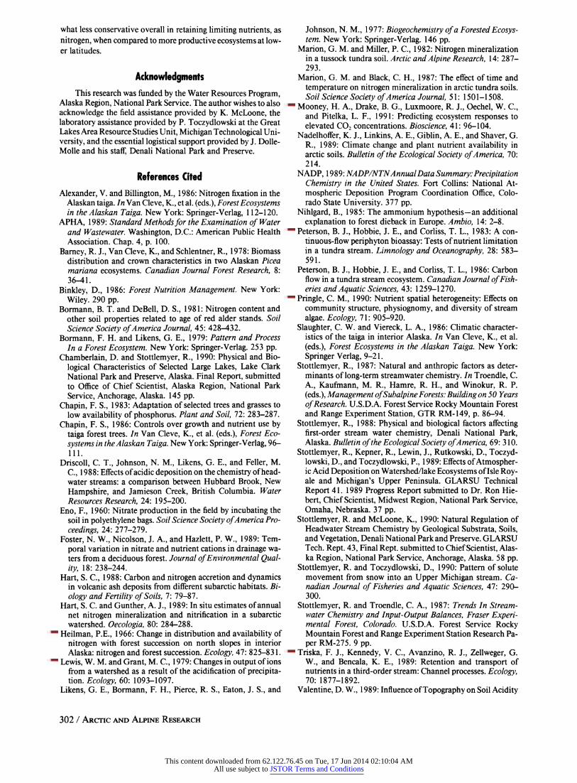
MT. HEALY
A m1210 m*
1360 m-
A Stream sampling station . and number i
* Vegetation plot V Stream gauge at Station 5
i: White spruce E.;; White spruce & Aspen F7777 Birch, Willow, tundra
Dry tundra
!E Nonvegetated Alder 0 1 2 Km
I I I
35 m *NADP ST,
PARK HEADQUARTERS
149057'48"
FIGURE 1. Rock Creek wa- tershed showing vegetation, lo- cation of sample plots, stream sampling stations and gauge, and selected elevations.
and Black, 1987; Hart, 1988). These studies include some re- search on the importance of temperature and moisture in the control of nutrient cycling and vegetation productivity (Van Cleve et al., 1981).
The objectives of the present study were (1) to compare vegetation productivity and nutrient cycling rates as indicated by summer nitrification and nitrogen mineralization, and (2) to see if variation in these processes might be reflected in stream water.
Study Area WATERSHED GEOLOGY AND VEGETATION
The Rock Creek drainage (Fig. 1) is located just upslope from Denali National Park headquarters. The watershed area above the stream gauge is 770 ha. It has a south-southeastern aspect, and ranges in elevation from 640 m at the gauging site to 1700 m on Mount Healy. The catchment is underlined with metavolcanic quartz schist and marble. The bedrock near the mouth of the watershed is overlain by glacial deposits. In most of the watershed, Rock Creek is confined into a discrete channel by topography and exposed bedrock. Near Station 4, the stream channel widens somewhat as it enters an alluvial area which extends to just above the stream gauging site. The soils have not been mapped, but most likely are Alfic Cryochrepts. No evidence of extensive permafrost is visible.
Rock Creek is one of the relatively few watersheds in the park on the north slope of the Alaska Range vegetated with white spruce (Picea glauca [Moench] Voss). Mid-age spruce and aspen (Populus tremuloides Michx.) dominate the vegetation of the lower 20 to 25% of the watershed. In the alluvial areas near the
stream, scattered balsam poplar (Populus balsamifera L.) occur mixed with the white spruce. Predominant spruce associates are feathermoss, Viburnum edule [Michx.] Raf.), and Equisetum spp. with occasional, very scattered patches of Alnus crispa [Ait.] Pursh). Less prevalent are stands of closed and open broadleaf forest (aspen, Salix spp., Arctostaphylos uva-ursi [L.] Spreng.) in lower portions of the watershed with southwest aspects. On low- elevation sites with southeast or eastern aspects, open black spruce (Picea mariana [Mill.] B.S.P.) occur in patches alternating with areas of white spruce and Betula glandulosa Michx. Closed tall scrub, dominated by Betula glandulosa, occurs in portions of the watershed at low to mid-elevations.
Just upstream from the coniferous and mixed forest is an extensive band of closed tall scrub dominated by Alnus crispa with occasional Salix spp. This vegetation dominated upslope away from the stream on soils where there appeared near-surface soil water movement. Mixed mesic shrub (Betula, Ericaceae) is common at higher elevations above the tall scrub along the east and west ridgelines of the watershed in its lower section. Up- stream of the alder, and over most of the watershed including the upper east and west-facing ridges, scattered patches of mesic to dry Dryas-tundra with some lichen and bearberry dominate.
TEMPERATURE AND PRECIPITATION
A long-term temperature (Table 1) and precipitation record exists for Denali Park (Park Headquarters) which is adjacent the mouth of the Rock Creek watershed (Fig. 1). In 1988, July had the highest daily mean maximum (21.2?C) and minimum (8.1 C) temperatures (Table 2) which were about 20C above the long- term average. Summer diurnal air temperature variation aver- ages about 12?C with a record winter diurnal variation of 350C.
292 / ARCTIC AND ALPINE RESEARCH
63043'30"-
This content downloaded from 62.122.76.45 on Tue, 17 Jun 2014 02:10:04 AMAll use subject to JSTOR Terms and Conditions

TABLE I
Mean monthly maximum and minimum temperaturesfor 1940- 1970, NOAA weather station, Denali Park, Alaska
Maximum temp. Minimum temp. Month (?C) (?C)
January -10.6 -20.7 February -8.1 -18.3 March -4.8 -16.8 April 3.2 -8.4 May 11.0 -0.7 June 17.7 4.7 July 18.8 6.6 August 16.3 4.4 September 10.8 0.3 October 1.9 -7.6 November -7.1 -16.5 December -10.4 -20.0
Mean annual precipitation at the base of the watershed is 38 cm and is rather uniformly distributed throughout the year. In 1988, the precipitation amount was 44 cm with most of it (10 cm) occurring in July (Table 2). On average, there are about 20 to 22 d of rainfall per year.
Materials and Methods
Vegetation within the watershed was mapped using U2 1: 60,000 color IR transparencies at the Remote Sensing Library, University of Alaska-Fairbanks, followed by on-site confirma- tion. The major vegetation types aligned somewhat along an elevational gradient. The white spruce type, dominated by Picea glauca, Populus balsamifera, and Populus tremuloides, was dis- tributed at elevations between 660 and 820 m. Moist shrub tundra, dominated by Alnus crispa, Arctostaphylos alpina, and Betula glandulosa, occurred at elevations between 660 and 1050 m. Alpine tundra, a more common vegetation type within Denali National Park, dominated by Arctostapylos alpina, Betula glan- dulosa, Dryas octopetala, D. integrifolia, Empetrum nigrum, and Vaccinium vitis-idaea, was found predominantly at elevations between 1050 and 1300 m.
Within each major vegetation type three sites were selected on the map. Sites were located so as to have one each with a west, east, and south aspect (Fig. 1). Distance and direction were scaled from the mapped site to the stream channel to serve as starting points for plot location. This sampling design was uti- lized to establish 0.1 ha plots (50 m x 20 m) at a predetermined minimum distance from the stream channel. In spruce and tun- dra, vegetation plots were established a minimum distance of 100 m from the stream channel. Alder plots were established a minimum distance of 50 m from the streambed since distribu- tion of alder was generally limited to less than 100 m elevation above the streambed. No plots were located on alluvial soils. On each site with a southern aspect (elevations of approximately 730, 970, and 1215 m), a partial Li-Cor meteorological station, consisting of instrument shelter, datalogger, pyranometer, soil temperature sensors (thermocouples at 5 and 10 cm depth be- neath the organic layer), and air temperature (1.3 m height) was installed the last week in June and operated continuously until the first week of October. Daily mean, maximum, and minimum air temperature and daily mean soil temperature at both depths were logged throughout the study. The tundra and alder stations
TABLE 2
Mean monthly maximum and minimum temperatures and pre- cipitation for 1988, NOAA weather station, Denali Park, Alaskaa
Maximum temp. Minimum temp. Precipitation Month (?C) (?C) (cm)
January -8.7 -18.0 0.3 February -5.2 -17.5 1.1 March -3.2 -14.2 1.6 April 3.3 -9.1 0.4 May 13.2 0.7 4.7 June 18.2 6.2 8.3 July 21.2 8.1 9.9 August 17.0 4.6 4.6 September 9.5 -1.6 3.9 October -3.7 -14.2 6.9 November -13.3 -21.8 1.3 December -5.5 -15.9 0.9
a Data provided by Tom Ford, National Park Service, Denali National Park and Preserve, Alaska.
were equipped with a solar pyranometer and total daily solar radiation (MJ m-2 d-') recorded. Solar radiation information was not collected in spruce because of the difficulty in avoiding forest canopy shading. Raingauges, for precipitation quantity only, were installed at similar elevations. Daily precipitation data came from the National Park Service (NPS) weather station and National Atmospheric Deposition Program (NADP) station lo- cated near the mouth of the watershed.
Within each of the nine 0.1 ha plots, a grid of 5 x 10 m cells was marked off. Sites for incubations, soil sampling, litter fall, and forest floor sampling were randomly selected from the intersections on this grid. Nitrogen mineralization and nitrifi- cation rates in each vegetation type were estimated using the buried polyethylene bag technique (Eno, 1960). After cutting along three sides of a 0. 1-m2 frame and carefully folding back the surface organic layer, the upper 5 cm of soil was collected by excavating a shallow rectangular pit. Standard soil corers were found to be impractical due to the variable rockiness of the sites. Exact dimensions of the pit were recorded. Following removal of visible roots, the excavated sample was divided into two fractions. One portion, representing a nonincubated sample, was placed in a Whirl Pac, brought to the field laboratory, and stored at 2?C. The other portion was placed in a 0.025-mm thick poly- ethylene bag and returned to the same hole for incubation. Soil taken from approximately 1 m away was used to fill in the gap created by removal of the nonincubated fraction. The original surface organic matter was then replaced. After 30 d, the incu- bated sample was collected, returned to the field laboratory, and stored at 2?C. All incubations and nonincubations were done in triplicate for each plot and date.
All soil samples were refrigerated for no more than 3 to 4 d. This allowed time for completion of sample collection. Sub- samples from the nonincubated splits were used to determine pH (field moist, CaCl2). Soil bulk wet weights were recorded and samples homogenized. Percent moisture was determined by oven drying (105?C for 24 to 30 h) a subsample. The ratio of air-dried moisture to oven-dried moisture was determined gravimetri- cally. A larger subsample was then air-dried. The >2-mm frac- tions were separated with a sieve, weighed, and discarded. The <2-mm material was then weighed and refrigerated in a whirl pack for further laboratory analysis.
R. STOTTLEMYER / 293
This content downloaded from 62.122.76.45 on Tue, 17 Jun 2014 02:10:04 AMAll use subject to JSTOR Terms and Conditions

The forest litter layer was sampled once in August. A 0.1- m2 frame was used with six replications from each site. At the alpine tundra sites, the entire living layer was collected since it was difficult to discern a discrete litter layer from the ground cover. These plots were vegetated by bearberry and scattered Dryas with a sparse and discontinuous litter layer. In the initial attempts at separating ground litter, we found it to be < 15% the plot biomass. Forest floor and tundra samples were immediately weighed upon return to the field laboratory then air dried and stored.
LABORA TOR Y ANAL YSES OF SOIL AND FOREST FLOOR SAMPLES
To compare with field laboratory measurements, soil pH was also determined at the Michigan Technological University Forest Soils laboratory on air-dried samples with a combination electrode (Coming pH/Tempmeter 4) using a 1:5 ratio (w/v) of soil to 0.01 M CaCl2. This ratio was chosen due to the relatively high organic matter content of most soils.
Nitrate (cadmium reduction) and ammonium (indophenol) were determined by autoanalyzer from 2M KC1 extracts of air- dried subsamples. The net mineralization rate for each incu- bation period was estimated from the difference between initial and final NO3- and NH4+ content, and net apparent nitrification was estimated by the difference between initial and final NO3- content.
The forest floor samples were individually oven dried (80?C, 48 h minimum), weighed, then ground in a Wiley Mill to pass a 40-mesh stainless steel sieve. The six replicates from each plot were then paired resulting in three composites/plot for chemical analyses. Total N determinations (Kjeldahl) were completed at the University of Wisconsin Soil and Plant Analysis Laboratory in Madison, Wisconsin.
STREAM SAMPLES
Stream sampling stations were established along Rock Creek at its mouth (Rock 5, gauging station) and immediately down- stream from all major vegetation transitions (Fig. 1). The up- permost station consistently sampled (Rock 2) drained only bar- ren area and patches of dry and mesic tundra (Still higher in elevation was station Rock 1 located on a small tributary which had only seasonal flow. Results are not reported here.). The next station (Rock 3) 1450 m downstream was immediately below the most dense band of alder. Rock 4, 880 m downstream of Rock 3, added drainage from areas vegetated by a mix of alder and a few scattered spruce. Rock 5, at the mouth of the catch- ment, added drainage of areas extensively vegetated by spruce- aspen forest.
Streamwater samples for basic ion chemistry and total ni- trogen were collected in 500-ml amber linear polyethylene bot- tles. Samples for dissolved organic carbon (DOC) were collected in glass bottles with Teflon lined caps. All collection bottles were first double rinsed with streamwater. Stream stations were sam- pled every 7 to 14 d beginning in mid-June. Stream sampling included measurements of stream discharge (USGS pygmy me- ter) and streamwater temperature.
Upon return to the field laboratory, samples were brought to a uniform temperature with pH and conductivity standards (APHA, 1989). This occurred usually within 8 h of sample col- lection. Then pH (Coring pH/Tempmeter 4), alkalinity (end- point titration with 0.02M H2SO4 to pH 4.5), and specific con- ductance (Beckman-Altex conductivity bridge) were determined
on unfiltered subsamples. The pH meter was calibrated each day of use with pH 4 and 7 buffer solutions and a dilute pH 4.3 reference solution from the NADP. The conductimeter was sim- ilarly calibrated using a NADP reference standard and more concentrated stock standard.
Filtered (0.45 um) subsamples for ionic analyses were re- frigerated at 2?C in amber 60-ml linear polyethylene bottles, and shipped in coolers to our university laboratory. Ion analyses for Ca2+, Mg2+, K+, Na+, C1-, P04-, NO3-, and SO42- were con- ducted using ion chromatography (Dionex Model 2020). Av- erage storage time from collection to analyses was 4 wk. Samples were analyzed in blocks of 150 to 350 samples of similar age since collection. Twelve percent of the analyses were blanks, standards, or other QA materials. Working strength standards were of similar age to that of the samples. Laboratory quality assurance procedures included splitting weekly National At- mospheric Deposition Program (NADP) samples (Michigan Sta- tion MI99), participation in the EPA's National Acid Precipi- tation Assessment Program (NAPAP) quality assurance (QA) program, routine use of National Bureau of Standards inorganic standards, and the long-term comparison of paired cation results from AA and IC (Stottlemyer et al., 1989).
Whole water subsamples for total N and P were kept frozen until analyzed (Autoanalyzer) as were filtered subsamples for DOC (Dohrman 80 Carbon Analyzer). Heavy/trace metal scans were conducted on acidified (pH <2.0, Ultrex) samples analyzed by Inductively Coupled Plasma Emission Spectroscopy (ICPE).
A stream stage height recorder (Stevens Model F) was in- stalled at station 5. A continuous record of stage height was obtained throughout the study period. Stage height was trans- formed to stream discharge by use of a calibration curve devel- oped from periodic measurements of discharge (Pygmy meter estimates of velocity multiplied by stream cross section) at dif- ferent stage heights.
Statistical analyses were conducted using SYSTAT modules. Data sets were initially tested for normality and homogeneity of variances (Bartletts) between and within groups (stream sam- pling stations and within station variation, vegetation type and plots).
Results
TEMPERATURE, MOISTURE, AND SOIL PH IN VEGETATION PLOTS
The long-term temperature record (Table 1) shows mean monthly summer temperatures at Denali Park to be 1 to 5?C below those of Fairbanks (Slaughter and Viereck, 1986) while temperatures during the coldest months average slightly warmer. In 1988, the peak daily mean air temperature (17.50C) during the period of monitoring (last week in June to October 1) oc- curred beneath the low elevation spruce stand the second week of July (Fig. 2). The mean daily air temperature at this plot was 8.6?C (S.D. = 4.4?). The mean daily maximum temperature was 13.6?C and the mean minimum 3.1?C. The maximum diurnal air temperature change was about 15?C. Beneath the alder canopy the mean daily air temperature was 7. 1?C (S.D. = 3.9?). The peak daily mean was 15.5?C. This site was cooler (mean daily max- imum = 12.5?C, mean minimum = 3.1?C) than the spruce site. At the tundra site the peak daily mean air temperature was very similar to that observed beneath alder. But temperatures overall were cooler and more variable throughout the period of study (mean daily = 5.5? C [S.D. = 3.8?]). The mean maximum and minimum air temperatures were 9.30C and 30C, respectively.
294 / ARCTIC AND ALPINE RESEARCH
This content downloaded from 62.122.76.45 on Tue, 17 Jun 2014 02:10:04 AMAll use subject to JSTOR Terms and Conditions

25
* '?~ ^,~~f sMean Daily ---------- Daily Maximum
_ i D " " 'Daily Minimum
V ' l a t'l' \ . ..................... Daily Minimum
Alder I . I I I
7/6 7/24 8/10 8/27 9/13 10/1
1988
FIGURE 2. Daily maximum and minimum air temperatures (?C) above tundra and beneath alder and spruce for the study period, Rock Creek watershed.
10
0
-10
20
E i8 HL
10
0
-10
20
10
0
-o
Tundra
= Soil temperature at 5 cm depth ............... = Soil temperature at 10 cm depth
..-.... . ~ L
Spruce . . . I . . . . I . . . . I . . . . I . . . I
7/6 7/24 8/10 8/27 9/13 10/1 Date
FIGURE 3. Daily mean soil temperatures (?C) at 5 and 10 cm depth beneath tundra, alder, and sprucefor the studyperiod, Rock Creek watershed.
Soil temperatures showed no evidence of permafrost (Fig. 3, Table 3). Permafrost is generally absent in southeast-facing catchments at this latitude. The mean shallow depth (5 cm) soil temperatures for spruce, alder and tundra sites were 6.3 (S.D. =
2), 5.5 (S.D. = 2), and 7.1 (S.D. = 2.9)?C, respectively, while the average deep (10 cm) soil temperatures were 5.3 (S.D. = 1.2), 4.0 (S.D. = 0.7), and 7.1 (S.D. = 3)?C, respectively. Beneath spruce at the beginning of the monitoring period (early July) the difference between shallow and deep average daily soil temper- atures was >2?C (7.8 to 5.5?C). There was a greater difference beneath alder (7.5 to 4.0?C). No differences in soil temperature with depth were observed by early September. The tundra soils had much higher temperatures in early July (14?C), and there was little difference with depth. This would be expected on a steep site with poorly developed, dry soils without an insulating canopy.
While there was a gradient of declining air temperature with elevation gain (mean 0.8?C 100 m -') in the Rock Creek catch- ment, soil degree days where higher at the dry tundra site es- pecially in July (Table 4). The lowest soil temperatures were associated with the most moist site beneath alder. Soil degree days beneath spruce during July, August, and September were similar in trend though somewhat lower than those recorded on other spruce sites with southerly aspects (Slaughter and Viereck, 1986), and on a well-drained northern aspect site at Bonanza Creek (Van Cleve et al., 1981). The latter site had some per- mafrost, and its soil temperature continued to increase well into August before starting a decline.
TABLE 3
Plot number, topographic aspect, mean soilpH, moisture content, temperature, and total N, Rock Creek watershed
Temper- Moisture ature
Plot Aspect pH (%) (?C) N (%)
Spruce 1 E 4.03 82 3.7 0.56 S.D.a (0.12)b (48) (0.14) Spruce 2 W 5.03 18 8.7 0.23 S.D. (0.47) (11) (0.10) Spruce 3 S 4.86 35 6.5 0.40 S.D. (0.30) (27) (0.19) Alder 4 S 6.33 86 4.8 0.5 S.D. (0.34) (28) (0.19) Alder 5 E 5.85 151 6.3 1.2 S.D. (0.76) (96) (0.63) Alder 6 W 4.89 164 4.7 1.13 S.D. (0.77) (104) (0.54) Tundra 7 S 5.16 67 8.2 0.47 S.D. (0.26) (69) (0.46) Tundra 8 E 5.3 71 4.9 0.52 S.D. (0.37) (23) (0.19) Tundra 9 W 4.48 53 4.8 0.39 S.D. (0.39) (51) (0.34)
a S.D. = standard deviation. N = 12 for all means. b Computed from H+ concentrations.
R. STOTTLEMYER / 295
15
5
-5
25 -
o 15
0
5
-5
25
15
. . . . I . . . . I . . . . lI . l. . . .
20
I
I . . . . I . . . - . - - - - . I
This content downloaded from 62.122.76.45 on Tue, 17 Jun 2014 02:10:04 AMAll use subject to JSTOR Terms and Conditions

TABLE 4
Soil temperature degree days for south aspect vegetation plots, 0?C as base
Depth Site (cm) July Aug. Sept.
Spruce 5 250 203 107 10 193 174 109
Alder 5 227 165 90 10 144 123 94
Tundra 5 318 237 118 10 325 236 112
Stream temperatures recorded manually at all stations re- flected the general trends observed in air and soil temperature. Regression models of stream temperature with both air and soil temperature showed significant relationships, but the best agree- ment was with air temperature (r2 = 0.83, p < 0.001).
Soil moisture was greatest beneath alder (Table 3). The in- fluence of aspect on soil moisture was not observed for this vegetation type suggesting again that the vegetation occupied areas of near-surface horizontal soil water movement. The driest sites were in spruce with a pronounced effect of aspect on mois- ture and temperature. Soil moisture was less than one-half that observed over a similar season for forested sites on northern slopes (Van Cleve et al., 1981). As with temperature, soil mois- ture was most uniform with depth in tundra soils. There was no significant seasonal trend noted in soil moisture at any site. However, the means are only for about 30 samples, and this limits more detailed examination.
Soil pH beneath alder and tundra varied widely due likely to the calcareous nature of the soils and bedrock. Beneath alder, soil pH was slightly above the average found beneath alder of the Pacific Northwest (Bormann and DeBell, 1981) and near Brooks Lake (Hart and Gunther, 1989).
SOLAR RADIATION
The mean solar radiation above the alder canopy was 9.64
(S.D. = 5.4) MJ m-2 d-' for the period of study (Fig. 4). Solar radiation input was about 70% that recorded at Fairbanks which
suggests increased cloudiness at the Denali site. This would be
expected in such a region where local orographic lifting likely results in more cloudy conditions. Also the record for Rock Creek is only one season. The tundra site had a mean solar radiation of 8.93 (S.D. = 5.23) MJ m-2 d-l which also suggests some increase in cloudiness with elevation. Monthly means show that the difference between sites was most pronounced in July.
PRECIPITATION
Precipitation chemistry at the mouth of the Rock Creek watershed has been monitored since 1980 as part of the NADP. The pH of precipitation here has consistently varied between 5.00 and 6.00 with no long-term trend evident (NADP, 1989). Seasonally, pH tends to increase slightly during summer. How- ever, in no instance has the volume-weighted H+ exceeded 10 ,jeq L-'. Seasonal trends are even less evident for NO3- and SO42- (maximum volume-weighted concentrations of 4 and 10 ,ueq L-', respectively).
During 1988, the amount of precipitation increased in sum- mer and fall (Table 2). The long-term trend has been for some
30
m20 I E o ..J
10 -
O , , , , , ,
7/12 8/1 8/21 9/10 10/1
1988
FIGURE 4. Solar radiation recorded above alder and tundra for sample period, Rock Creek watershed.
seasonal increase in June-July approaching 10 cm mo-'. With this increased precipitation amount some dilution of ion con- centration occurs (NADP, 1989). This is most evident in base cation concentration. The increase in seasonal precipitation cou- pled with late melting snow and saturated soils accounts for the large stream discharge observed in June and July and for the "flashiness" of the stream to early summer precipitation inputs. This seasonal trend in stream discharge is similar to that ob- served at other interior Alaskan sites (Stottlemyer and McLoone, 1990), but the amount per unit area in 1988 was about 60 to 80% greater at Rock Creek (Slaughter and Viereck, 1986).
TRENDS IN STREAMWA TER CHEMISTRY
Streamwater ion concentrations were high for a second- order watershed in Denali National Park (Tables 5, 6). Up- stream-downstream comparisons of ion chemistry showed sig- nificant decreases in specific conductance (r2 = 0.19, p = 0.03), H+ (r2 = 0.37, p < 0.0001), and SO42- (r2 = 0.23, p < 0.01); and significant increases in NO3- (r2 = 0.71, p< 0.0001), total nitrogen (r2 = 0.62, p < 0.0001), and DOC (r2 = 0.33, p <
0.0001) concentration. DOC concentrations were about 10% the levels commonly found in temperate and some tundra streams (Peterson et al., 1986). The sharpest decrease in specific con- ductance and increase in NO3- and total N concentrations oc- curred between stations 2 and 3. This appeared to be in response to the presence of nitrogen fixers and the overall wetness of the alder sites. While slight, the steady increase in NO3-, total N, and DOC concentration going downstream from stations 2 to 4 opposed the concentration trend of all other ions and the increase in streamwater discharge.
Significant seasonal declines in Ca2+ (r2 = 0.58,p < 0.0001), Mg2+ (r2 = 0.54, p = 0.002), Na+ (r2 = 0.79, p < 0.0001), H+ (r2 = 0.46, p < 0.0001), S042- (r2 = 0.45, p = 0.015) and HCO3- (r2 = 0.8, p < 0.0001) concentration occurred primarily during the first half of August. This was likely due to the high stream- water discharge the last 10 d of July and during the second week of August. Nitrate concentrations showed no such decline except for a slight, but insignificant, decline during the second week of August.
Transforming stream ion concentration to a discharge- weighted basis resulted in base cation, S042-, and HCO3- con- centrations being significantly higher (p < 0.05) the third week in July than for most other weeks particularly later in summer (Table 7). NH4+ and NO3- also significantly increased in con- centration relative to the previous week, but they were not sig- nificantly different from the first week of study. All ions signif-
296 / ARcIC AN ALPINE RESEARCH
This content downloaded from 62.122.76.45 on Tue, 17 Jun 2014 02:10:04 AMAll use subject to JSTOR Terms and Conditions

TABLE 5
Mean 1988 unweighted concentration (,ueq L-1) for major ions," carbon, and total N by station, Rock Creek
Stationb
5 4 3 2
pH 8.5 8.44 8.39 8.29 H+ 0.003 (.00 1) 0.004 (.001) 0.004 (.001) 0.005 (.001) Temp 7.8 (3.3) 6.8 (3.3) 6.6 (3.4) 6.3 (3.3) Cond 852 (115) 1250 (169) 1061 (212) 1146 (314) Ca2+ 2384 (377) 2548 (344) 2593 (256) 2427 (632) Mg2+ 7116 (910) 8222 (896) 8716 (1036) 8765 (2555) Na+ 223 (43) 251 (45) 254 (48) 241 (82) K+ 49 (9) 53 (6) 59 (4) 51 (13) NH4+ 2.8 (10) 2.8 (9) <1 3.1 (11) NO3- 20 (5) 22 (5) 16 (3) 7 (2) S042- 3919 (703) 4704 (764) 5618 (1031) 6218 (2690) C1- 11 (2) 12 (1) 15 (6) 12 (4) HCO3- 5144 (513) 5726 (566) 5850 (697) 5424 (1764) C/Ad 1.07 (.08) 1.06 (.05) 1.01 (.04) 1.00 (.25) DOC 1.2 (.9) 0.5 (.1) 0.47 (.1) 0.29 (.2) Nf 0.3 (.1) 0.4 (.1) 0.3 (.1) 0.14 (.03)
a All ion concentrations are for the compound. b Station 5 was at gauging station, station 4 just below spruce, station 3 just below alder, and station 2 above alder. Station 1 was only occasionally sampled
and the results are not presented. c Parentheses = 1 S.D. d Cation to anion ratio. e Dissolved organic carbon (mg L-'). fTotal nitrogen (mg L- ).
TABLE 6
Summary statistics for late summer and early fall streamwater chemical composition of > 60first- and second-order watersheds,
Denali National Park and Preserve, Alaskaa
Median Mean Range Ion (Aeq L-') (Aeq L-l) (ueq L-1)
Ca2+ 1647 1566 31 4584 Mg2+ 789 1180 8 13773 K+ 18 23 2 70 Na 65 296 23 2699 H+ 0.02 0.03 0.003 0.3 C1- 6 11 0.73 82 NO3- 4 5 <0.1 20 S04- 494 1089 3 6903 HCO3- 1328 1612 131 7888 C/Ab 1.4 1.2 0.49 1.4
a From Stottlemyer and McLoone (1990). b Cation/anion ratio.
icantly declined in concentration the following week (25 July) which was the period of peak streamwater discharge (Fig. 5). This was further evidence of the inverse relationship which exists in most Denali streams between ion concentration and stream- water discharge (Stottlemyer and McLoone, 1990). Streamwater concentrations of DOC and total N where highest the first week (22 June) of study and were significantly reduced in concentra- tion by the week of 25 July. However, unlike the significant decline in ion concentration observed from 18 to 25 July, dis- charge-weighted DOC concentrations significantly increased and total N remained the same during this period of high streamwater discharge. This suggests increased flushing of soil organic res- ervoirs following 10 cm of precipitation input the previous 2 wk.
SPATIAL AND TEMPORAL RELATIONSHIPS OF STREAM CHEMISTRY TO WATERSHED NITROGEN RESER VOIRS AND MINERALIZATION
Nitrogen Reservoirs
The total N concentration (Table 8) in the top 5 cm of tundra mineral soil was at the low end of the range found in several lowland tussock tundra sites in interior Alaska (Marion and Black, 1987), but greater than that found beneath similar veg- etation at Brooks Lake in Katmai (Hart and Gunther, 1989). KCl-extractable NH4+ and NO3- concentrations in soil beneath alder were very similar to those found in a subarctic site in southwestern Alaska (Hart, 1988). However, beneath dry and mesic tundra and spruce, the Rock Creek values were much lower in NO3- and somewhat higher in NH4+.
On an areal basis, alder plots had 29 and 47% greater N content in the mineral soil than did spruce and tundra, respec- tively. These differences were significant (p < 0.05). The N con- tent beneath spruce and tundra was slightly below that found by Van Cleve et al. (1981) beneath black spruce on a north-facing slope. The N values from alder stands were below those found beneath similar vegetation in the Pacific Northwest (Bormann and DeBell, 1981). A considerable amount of variation in total N soil reservoirs in high latitude sites is due to differences in soil depth. At Rock Creek, a large portion of the variation within a given vegetation type was also due to the considerable differ- ences in soil bulk density and percentage of soil < 2 mm in size. The alder and tundra sites, in particular, had high variation in the stone content of surface mineral soils. Soil total N increased throughout the growing season except for one alder plot which showed no net change. The N increase was most pronounced in August, and the greatest relative gain was beneath alder. How- ever, in no instance were these monthly changes in nitrogen significant for any vegetation type.
R. STOTTLEMYER / 297
This content downloaded from 62.122.76.45 on Tue, 17 Jun 2014 02:10:04 AMAll use subject to JSTOR Terms and Conditions

TABLE 7
Weekly discharge-weighted concentration (gteq L- ) for selection major ions,a carbon, and total N in Rock Creek, for 1988 sampling period
Sample Date
Ion 6/22 7/10 7/18 7/25 8/4 8/14 8/25 9/2 9/14 9/26
Ca2+ 2582 2240 2711 2281 2448 1796 2454 2629 2651 2769 S.D. 763 811 1333 615 408 2183 1213 1097 922 628
Mg2+ 7730 7015 8754 6950 7724 6203 8564 8640 8924 9259 S.D. 1615 2183 3660 1666 847 3904 2961 2873 2837 1649
Na+ 246 182 269 184 220 163 252 270 275 292 S.D. 69 62 135 51 39 104 92 111 92 58
K+ 58 47 59 49 54 43 51 57 54 53 S.D. 16 14 31 11 8 30 17 27 18 12
H+ .003 .002 .004 .003 .006 .004 .003 .004 .0004 .0004 S.D. .001 .0002 .001 .0001 .0003 .001 .0006 .001 .0001 .0001
NH4+ 6 n.d. 24 n.d. n.d. n.d. n.d. n.d. n.d. n.d. S.D. 12 - 30 - - - - - -
NO3- 20 14 21 18 15 9 18 20 17 19 S.D. 13 8 15 9 8 6 11 14 10 11
SO42- 5096 3938 5547 3539 4343 3329 5059 5168 5673 6052 S.D. 592 1174 1835 738 328 2363 1329 1251 1580 1377
HCO3- 5171 4667 5639 4975 5439 5378 6009 6064 5978 6169 S.D. 1726 1405 2520 1243 909 1474 2207 2043 2037 1161
C1- 13 11 14 10 12 8 17 12 13 13 S.D. 4 4 6 3 2 6 11 4 4 2
DOCb .65 .20 .22 .36 .30 .20 .49 .47 .44 .40 S.D. .44 .27 .34 .50 .27 .23 .35 .31 .46 .10
Nc .35 .24 .32 .30 .26 .18 .32 .32 .25 .31 S.D. .21 .13 .21 .16 .12 .06 .18 .22 .16 .16
aAll ion concentrations are for the compound. b Dissolved organic carbon (mg L-1). cTotal nitrogen (mg L-'). S.D. = standard deviation, n = 4. n.d. = below level of detection.
500 -
400
300
. 200
100
7/1 7/19 8/6 8/24 9/12 9/30 10/18
Date
FIGURE 5. Daily discharge from Rock Creek during period of study.
Among the three vegetation types, surface organic layer bio- mass, percent N, and N content were significantly (p < 0.05) higher beneath alder (Table 9). Organic layer biomass beneath alder in Rock Creek was about 65% the amount found under alder in the Pacific Northwest (Bormann and DeBell, 1981), and litter layer biomass and total N beneath spruce was also less compared to results from other interior Alaskan sites (Van Cleve et al., 1983). In the latter instance this difference was likely due to more rapid decomposition rates and the generally open nature of the spruce plots in Rock Creek. In tundra, the biomass values represent the entire ground cover, which only rarely was con- tinuous.
Nitrification and Nitrogen Mineralization
Within each vegetation type, nitrification rates were highest on east-facing slopes. In tundra, the nitrification rate was about 8 times greater on the east-facing plot. Beneath alder, nitrification rates on the east-facing plot were about twice the rate observed on the west-facing plot. These results were consistent with those found for soil and litter nitrogen reservoirs and soil moisture, the latter a major factor in regulating nitrification rates. Study objectives and resource limitations did not permit plot repli- cation by aspect within vegetation types and no statistical com- parisons are possible.
Average nitrification rates beneath alder were significantly above those beneath tundra and spruce (Table 10). Nitrification rates for these vegetation types were very similar to those ob- tained in 28-d laboratory incubations (22?C) of soil samples collected beneath alder, tundra, and spruce for sites in south- western Alaska (Hart, 1988). However, no significant differences in N mineralization rates among vegetation types were found. Net mineralization rates were lower at Rock Creek, which likely reflected both the overall lower moisture content of its soils and the much lower in situ soil temperatures.
Areal variation within a given plot was considerable in large part due to change in soil particle content >2 mm. For nitrifi- cation, on average the plot standard deviation on a given date exceeded plot mean by 84% and the standard deviation for min- eralization exceeded the mean by 44%. There was also much
298 / ARCTIC AND ALPINE RESEARCH
This content downloaded from 62.122.76.45 on Tue, 17 Jun 2014 02:10:04 AMAll use subject to JSTOR Terms and Conditions

TABLE 8
Mineral soil characteristics by plot and vegetation typea beneath spruce, alder, and tundra plots. Soils were composites of the top 5 cm, and analyses are for sample which passed through 2 mm
sieve. Standard deviation in parentheses
Bulk Nitrogen Nitrogen Stand density (%) (kg ha-') pH
Plot No.
1 Spruce .69 (.47) .55 (.14) 999 3.89 (.11) 2 Spruce .70 (.25) .21(.10) 380 5.10 (.47) 3 Spruce .66 (.36) .43 (.19) 712 4.87 (.30) 4 Alder .51 (.16) .49 (.19) 661 6.32 (.32) 5 Alder .56 (.58) 1.13 (.54) 1050 5.81 (.75) 6 Alder .40 (.39) 1.20 (.63) 958 4.92 (.77) 7 Tundra .80 (.51) .50 (.46) 489 5.11 (.25) 8 Tundra .52 (.25) .53 (.19) 717 5.29 (.37) 9 Tundra 1.02 (.78) .35 (.34) 610 4.50 (.39)
Vegetation Type
Spruce .69 (.35)b .39 (.19)b 685 (442) 4.6 (.6)b" Alder .49 (.41)c .91 (.56)C 890 (388)' 5.7 (.9)' Tundra .76 (.53) .46 (.33) 605 (332) 5.0 (.5)
aFor each vegetation type, n ranged between 59 and 63 except for com- putation of total N ha-' where n = 27.
b Mean value shown is significantly different (p < 0.05) from that for alder. c Mean value shown is significantly different (p < 0.05) from that for tundra.
TABLE 9
Surface organic layersfor spruce, alder, and tundra, Rock Creek, Denali National Park
Dry Weight Nitrogen Nitrogen Plot Stand (tons ha-') (%) (kg ha-')
1 Spruce 6.2 (2.0) 1.05 (0.02) 65 (21) 2 Spruce 8.8 (2.8) 1.29 (0.26) 113 (35) 3 Spruce 8.2 (5.2) 0.88 (0.17) 72 (46) 4 Alder 12.8(1.8) 2.27 (0.18) 290(41) 5 Alder 19.2 (4.9) 2.45 (0.10) 470 (121) 6 Alder 20.1 (7.8) 2.15 (0.40) 432 (168) 7 Tundraa 3.5 (0.4) 0.98 (0.27) 34 (3) 8 Tundraa 7.6 (2.6) 1.15 (0.34) 87 (30) 9 Tundraa 5.0(1.0) 1.26 (0.06) 63(12)
Vegetation typeb
Spruce 7.7 (3.5)c 1.07 (.23) 84 (40)c Alder 17.2 (6.1)d 2.29 (.26)d 393 (139)d Tundra 5.4 (2.3) 1.13 (.25) 61 (29)
a Includes all above-ground biomass. b For each vegetation type, n ranged between 15 and 18 except for com-
putation of total N ha-' where n - 9. c Mean value shown is significantly different (p < 0.05) from that for alder. d Mean value shown is significantly different (p < 0.05) from that for tundra.
variation in nitrification with season, but no significant trends or changes were found (Table 10). In spruce, net nitrification
during July was negative. Net rates doubled in August and in- creased another 40% during September but still were very small. The lag in nutrient cycling and availability apparently is a char- acteristic of some interior Alaskan ecosystems (Nadelhoffer et al., 1989). Beneath alder, nitrification rates in July and August were similar while rates increased about 47% during the first two-thirds of September. The opposite trend was observed in tundra, where the highest nitrification rates occurred in July, but
TABLE 10
Seasonal net nitrogen mineralization and nitrification by vege- tation and month
Nitrification N mineral Site Month (mmol m-2) (mmol m-2)
Spruce Julya -1.8 (7.8) 432 (609) Spruce Aug. 1.4 (6.9) -120(637) Spruce Sept. 1.9 (12) 212(679) Alder July 455 (1318) 1026 (2140) Alder Aug. 489 (640) 130 (1340) Alder Sept. 679 (929) 743 (2600) Tundra July 28 (55) 742 (1286) Tundra Aug. -8 (5) -527 (965) Tundra Sept. 4 (4) 476 (602)
By vegetation typea
Spruce 0.07 (8.7)b 224 (652) Alder 543 (975)C 654 (2067) Tundra 9.4 (30) 229 (1395)
a For monthly samples by vegetation type, n = 9. For comparisons among vegetation types, n = 27.
b Mean value shown is significantly different (p < 0.05) from that for alder. c Mean value shown is significantly different (p < 0.05) from that for tundra.
in August they declined to about 6% of July levels only recovering to about 13% of July levels in September.
Seasonal variation in nitrification was consistent with changes in soil moisture. During the study, soil moisture declined in the tundra plots by almost 40% while it increased slightly beneath alder and nearly doubled beneath spruce. The relationship of nitrification to soil temperature at the time of sample collection was less clear. Beneath spruce for the period of study, the east- facing plot had the lowest average soil temperature (3.7?C). Un- der alder, the east-facing plot was the warmest (6.3?C) and was drier than the west-facing alder plot. In tundra, both west- and east-facing plots had similar temperatures (4.9?C). Such plot tem- peratures were not likely as limiting on nitrification rates as soil moisture.
The trend in nitrogen mineralization rates varied somewhat from nitrification. The highest mineralization rates were ob- served in July and the lowest rates in August. Except under alder, N mineralization rates far exceeded nitrification rates. These results suggest that most of the nitrogen available for possible leaching to the stream would have been in July. However, July and early August would likely also have been the peak season for biological incorporation of nitrogen by the terrestrial envi- ronment.
Ecosystem Nitrogen Input/Output Estimates
Atmospheric inputs of chemical constituents found in sur- face waters of Denali are very low. At Rock Creek the average annual NO3- and NH4+ input, expressed as elemental N, is ap- proximately 0.12 kg N ha-'. This is about 2% the input to forested ecosystems in New England (Likens et al., 1977). In- organic nitrogen output (NO3- and NH4 + expressed as elemental N) from the watershed for the 1 14-d sampling period was about 0.25 kg N ha-' (Table 11), or 81% of total N export (0.31 kg N ha-'). In general, stream export of inorganic N increased up to middle July with peak discharge the week of 18 to 25 July. It then declined and remained nearly constant (about 0.03 kg N ha-' wk-') until early September. Following leaf fall in late September, total N export increased to almost the levels ob-
R. STOrLEMYER / 299
This content downloaded from 62.122.76.45 on Tue, 17 Jun 2014 02:10:04 AMAll use subject to JSTOR Terms and Conditions

TABLE 11
Weekly streamwater and elemental N discharge from inorganic and organic sources at the gauged mouth ofRock Creek watershed
for the period of study in summer, 1988
Start Discharge NO3-- NH4+- Total DOC- Date (m3) Na Na Na Nb
6/22 67730 21 0.6 26 0.7 7/10 38880 12 0.6 14 0.2 7/18 97200 33 1.5 39 0.7 7/25 103550 31 n.d. 38 0.9 8/4 140240 31 n.d. 40 0.9 8/14 126100 28 n.d. 49 1.1 8/25 72230 25 n.d. 30 0.9 9/2 84670 28 n.d. 31 1.0 9/14 117200 38 n.d. 43 1.3 9/26
a Amounts are given in g ha-~ of elemental N. b Assumes an elemental N content in DOC of 15%.
served during mid-August. The late season increase was asso- ciated with an increase in precipitation and streamwater dis- charge which occurred in the second half of September. Except for the late September increase, the trend in total N export was consistent with the trend observed for nitrification and nitrogen mineralization rates particularly beneath alder. Nitrogen export from the watershed represented <0.05% of the soil reservoir in the top 5 cm of mineral soil.
Twenty percent of the NO3- discharged from the catchment was added to the stream above station 2 (41% of the catchment area) and 61% was in the stream at station 3 (60% of the catch- ment area upstream). However, on a watershed unit area basis NO3- contributions to the stream between stations 2 and 3 in- creased 4.3 times over those above station 2. Below station 3, NO3- added to the stream/unit area of watershed was the average of the entire catchment. There was little, if any, NH4+ export from station 3 and the export from station 4 was the same as station 5. As previously mentioned, the most concentrated stands of alder occurred between stations 2 and 3.
Discussion This study was of very short duration. While it is appropriate
to discuss its results relative to those from longer-term studies, any direct comparison of seasonal changes in watershed mete- orological and nutrient budgets should be made with consider- able caution. As the comparison of the long-term meteorological record at Denali Park (Table 1) with the 1988 data illustrate (Table 2), there is much year-to-year and seasonal variation in meteorological conditions, and therefore likely watershed pro- cesses such as nutrient cycling and budgets.
TEMPERA TURE
Differences in daily soil temperature among sites demon- strate the importance of microclimate on vegetation and site productivity. Even under taiga and the dry tundra plots, and especially those plots with an aspect which permits direct ex- posure to solar radiation at a low angle of incidence, there were rather high soil temperatures and heat sums for a site at this latitude. However, the fact that air temperatures in 1988 were above average qualifies comparison with other sites. The above average temperatures in May likely helped move forward the timing of peak soil temperature at Rock Creek when compared
to other sites and aspects at this latitude. And maximum summer temperatures were reached earlier than one would find on a site with permafrost. At Rock Creek, the soil temperature sums were considerably above those observed for north-facing interior Alaskan sites. This temperature difference is a major causal fac- tor behind the relatively high productivity and rapid cycling of energy and nutrients on south-facing sites.
Soil temperature differences among plots were more pro- nounced than air temperature. The well-drained tundra soil in particular responded quickly to the change in seasonal low-angle incident radiation and diurnal air temperatures, while on the more shaded and moist alder and conifer sites soil temperature increased much more slowly. Differences in maximum summer soil temperature between tundra and forested sites were es- pecially pronounced. These differences, however, disappeared by September when soil temperatures at the Rock Creek sites were not greatly different than those observed on sites with per- mafrost despite the warmer than average summer. This indicates that soil temperature changes sharply in south-facing catchments with steep slopes aligned with the low angle of the sun. Soil temperatures observed in all three vegetation types were suffi- cient for rapid nutrient cycling at this latitude. Remineralization would have been favored by the temperatures observed early in the study except possibly for tundra which is relatively unre- sponsive to soil temperatures between 3 and 9?C (Nadelhoffer et al., 1989). This assumes that moisture is not limiting.
An examination of seasonal surface water temperatures col- lected for a large group of Denali watersheds (Stottlemyer and McLoone, 1990) showed that temperature peaked during the first 2 wk of July (6.6?C [S.D. = 2.1], n = 50). The mean tem- perature was lower than observed for Rock Creek as might be expected with its southern aspect and relatively steep topograph- ic relief. SNK analyses revealed no significant monthly change in surface water temperature.
STREAMWA TER ION CONCENTRATION
The high streamwater ion concentrations, relative to other Denali National Park streams, apparently result from the easily eroded shales and marble within the catchment. Much of the uppermost one-third of the catchment is without vegetation, steep, and unstable. The high erodibility of this material coupled with high-frequency freeze/thaw due to the slope and aspect and other physical erosion likely account for why major cation con- centrations were highest upstream. This situation is quite un- usual in watersheds. The high Mg2+ concentrations relative to Ca2+ apparently is also unusual in Alaskan surface waters (Cham- berlain and Stottlemyer, 1990). This high Mg2+ concentration reflected the presence of dolomitic marble.
WATERSHED NITROGEN AND STREAMWATER CHEMISTRY
In tundra, soil nitrogen reservoirs were within the range observed for the limited number of similar studies in Alaska. However, at Rock Creek there was evidence of reduced nitrogen mineralization relative to similar sites in southwestern Alaska (Hart and Gunther, 1989). In the latter study, extractable soil NO3- and NH4+ were much higher than observed at Rock Creek. These differences likely reflected variation in density of vege- tation cover since the summer of 1988 was warmer than average and had the usual distribution and amount of precipitation.
Within the watershed, the importance of aspect on N res- ervoirs and soil moisture was evident. For a given vegetation
300 / ARCTIC AND ALPINE RESEARCH
This content downloaded from 62.122.76.45 on Tue, 17 Jun 2014 02:10:04 AMAll use subject to JSTOR Terms and Conditions

type, the largest soil N reservoirs were in the east-facing plots. Soil moisture content was also highest on these plots except under alder where both east and west facing plots had similar moisture content. This was likely due to the shallow depth-to- bedrock and the presence of near-surface water flow on these plots. Moisture is usually the most significant factor limiting N fixation in northern ecosystems (Alexander and Billington, 1986). Generally, the east-facing plots were cooler, and this likely re- duced nitrogen remineralization and loss and could help account for the higher N reservoirs (Marion and Miller, 1982).
The products of watershed nitrogen fixation and mineral- ization were strongly conserved even during maximum rates. Nitrogen mineralization for the top 5 cm of mineral soil averaged about 2 kg ha- and nitrification about 1.1 kg ha- for the study period. This does not include mineralization of surface organic layers which can be of equal or greater importance to the annual budget in such ecosystems (Hart and Gunther, 1989). The sea- sonal nitrogen mineralization rates at Rock Creek were about 8% the annual mineralization rates found in a productive, suc- cessional northern hardwood watershed ecosystem in New En- gland (Likens et al., 1977). However, the results for dry tundra and alder at Rock Creek were similar to those found beneath alder and tundra in a seasonal study near Toolik Lake (Valentine, 1989). The results for spruce and alder, when extrapolated to an annual basis, were somewhat less than those observed for these vegetation types at Katmai National Park, but the latter study also included organic-layer mineralization (Hart and Gunther, 1989).
Watershed seasonal nitrogen output exceeded 1988 annual atmospheric inputs as measured at the base of the Rock Creek watershed. This is in contrast to many other successional and old-growth forested ecosystems even where atmospheric nitro- gen inputs are large due to HNO3- contamination (Likens et al., 1977; Stottlemyer and Troendle, 1987). Despite overall water- shed conservation of N, this suggests a relatively "leaky" eco- system at least during the period of study. But this study may have underestimated inputs somewhat due to the absence of precipitation chemistry at the higher elevations of the catchment. Change in solute loading with elevation can be significant, but has been very little studied in Alaska.
There appeared some concurrent spatial trends among soil nitrogen reservoirs especially beneath alder, nitrification and N mineralization, and change in streamwater chemistry. The N reservoir beneath alder (mineral soil and surface organic layers) was much larger than found beneath the other two vegetation types, and most of this reservoir was located upslope between streamwater sampling stations 2 and 4. Similarly, nitrification rates were significantly higher beneath alder, and mean N min- eralization rates were highest though the increase was not sig- nificant. The highest discharge-weighted and unweighted NH4+ and unweighted NO3- concentrations in streamwater occurred between stations 3 and 4. Discharge-weighted NO3- concentra- tions were also the highest though the difference was not signif- icant. Similarly, discharge-weighted and unweighted DOC and total N concentrations were highest at stations 3 or 4. If it is assumed that within stream biotic N uptake did not vary greatly spatially, and the uniform steep stream gradient and absence of any nearby forest canopy shading upstream of station 4 would lend some support to this assumption, then it appears likely that some of the spatial trends noted in surface water nitrogen were due to terrestrial trends in the N cycle.
Streamwater chemistry may have also indicated some sea- sonal trends in terrestrial nitrification and N mineralization, but here the relationship is less clear. During the study, maximum
terrestrial nitrification and nitrogen mineralization rates were concurrent with sustained precipitation inputs, a peaking of streamwater discharge, streamwater concentrations of inorganic and organic nitrogen, and watershed output of inorganic and organic nitrogen. The highest discharge-weighted streamwater NO3- and NH4+ concentrations in Rock Creek occurred 25 July and 18 July, respectively. The only time NH4+ concentrations were detectable in Rock Creek streamwater was in late June and the first half of July. The elevated discharge-weighted stream- water concentrations of NO3- in late June were likely the result of flushing by snowmelt of over-winter mineralization products in soil solution (Foster et al., 1989) since atmospheric inputs of NO3- are very small. By month, the mean discharge-weighted NO3- concentration increased from June to July, dropped in August, and increased again in September. The late season in- crease was likely due to the increase in net mineralization cou- pled with a large reduction in biological uptake and some in- crease in streamwater discharge. To what degree the time trend observed in streamwater nitrogen concentration can be attrib- uted to seasonal variation in terrestrial nitrification and min- eralization and how much to precipitation flushing can not be separated in a study of this duration or design.
Another qualifier on the trends noted in stream N concen- tration was that this study did not attempt to measure in-stream uptake or transformation of nitrogen species. These processes could have had some effect on nitrogen export from the catch- ment. To my knowledge, no studies of the distribution or com- position of attached algal communities in lotic environments, and especially steep-gradient (Rock Creek's overall channel gra- dient is 0.107), first- or second-order streams, has been under- taken in this region. But in much less steep, higher order streams (Triska et al., 1989) and rivers (Peterson et al., 1983, 1986) biotic nitrogen uptake has been found to be as high as 29% when phosphorus is not limiting. But one must use considerable cau- tion when applying results from rivers and high order streams to low order streams. Stream benthic habitats are diverse mi- croenvironments differing in chemical characteristics and there- fore limiting nutrients (Pringle, 1990). Accurate measurements of nutrient uptake and primary production are extremely difficult (Wetzel, 1983). In streams, phytoplankton, attached algae, and aquatic macrophyte biomass is typically one or two orders of magnitude less than in rivers. As streams decrease in size and increase in velocity, autochthonous primary production and bi- otic nutrient uptake may become very low to negligible. In ad- dition, due to the absence of vegetation and steep slope in upper reaches of the Rock Creek watershed, the stream responds quick- ly to modest precipitation inputs. The result is high streamwater turbidity from inorganic sediment inputs (Stottlemyer, pers. obs.). Such events, which occurred occasionally in July and August of 1988, would further reduce the habitat quality and stability for benthic algae.
In sum, while short in duration, this study suggests that streamwater chemistry is a possible indicator of spatial and per- haps even seasonal differences in terrestrial productivity and nutrient cycling in taiga-tundra ecosystems. However, a longer study period with more intensive replication within vegetation types would be required before any significant relationships be- tween temporal or spatial variation in terrestrial processes and streamwater chemistry might be detected. Such study would also require better quantification of in-stream processes especially nutrient retention. The study results indicate that spatial rela- tionships between vegetation type and streamwater chemistry might be more easily found than temporal. Finally, these rela- tively productive taiga-tundra ecosystems appear to be some-
R. STOTTLEMYER / 301
This content downloaded from 62.122.76.45 on Tue, 17 Jun 2014 02:10:04 AMAll use subject to JSTOR Terms and Conditions
what less conservative overall in retaining limiting nutrients, as nitrogen, when compared to more productive ecosystems at low- er latitudes.
Acknowledgments This research was funded by the Water Resources Program,
Alaska Region, National Park Service. The author wishes to also acknowledge the field assistance provided by K. McLoone, the laboratory assistance provided by P. Toczydlowski at the Great Lakes Area Resource Studies Unit, Michigan Technological Uni- versity, and the essential logistical support provided by J. Dolle- Molle and his staff, Denali National Park and Preserve.
References Cited Alexander, V. and Billington, M., 1986: Nitrogen fixation in the
Alaskan taiga. In Van Cleve, K., et al. (eds.), Forest Ecosystems in the Alaskan Taiga. New York: Springer-Verlag, 112-120.
APHA, 1989: Standard Methods for the Examination of Water and Wastewater. Washington, D.C.: American Public Health Association. Chap. 4, p. 100.
Barney, R. J., Van Cleve, K., and Schlentner, R., 1978: Biomass distribution and crown characteristics in two Alaskan Picea mariana ecosystems. Canadian Journal Forest Research, 8: 36-41.
Binkley, D., 1986: Forest Nutrition Management. New York: Wiley. 290 pp.
Bormann, B. T. and DeBell, D. S., 1981: Nitrogen content and other soil properties related to age of red alder stands. Soil Science Society of America Journal, 45: 428-432.
Bormann, F. H. and Likens, G. E., 1979: Pattern and Process In a Forest Ecosystem. New York: Springer-Verlag. 253 pp.
Chamberlain, D. and Stottlemyer, R., 1990: Physical and Bio- logical Characteristics of Selected Large Lakes, Lake Clark National Park and Preserve, Alaska. Final Report, submitted to Office of Chief Scientist, Alaska Region, National Park Service, Anchorage, Alaska. 145 pp.
Chapin, F. S., 1983: Adaptation of selected trees and grasses to low availability of phosphorus. Plant and Soil, 72: 283-287.
Chapin, F. S., 1986: Controls over growth and nutrient use by taiga forest trees. In Van Cleve, K., et al. (eds.), Forest Eco- systems in the Alaskan Taiga. New York: Springer-Verlag, 96- 111.
Driscoll, C. T., Johnson, N. M., Likens, G. E., and Feller, M. C., 1988: Effects of acidic deposition on the chemistry of head- water streams: a comparison between Hubbard Brook, New Hampshire, and Jamieson Creek, British Columbia. Water Resources Research, 24: 195-200.
Eno, F., 1960: Nitrate production in the field by incubating the soil in polyethylene bags. Soil Science Society ofAmerica Pro- ceedings, 24: 277-279.
Foster, N. W., Nicolson, J. A., and Hazlett, P. W., 1989: Tem- poral variation in nitrate and nutrient cations in drainage wa- ters from a deciduous forest. Journal of Environmental Qual- ity, 18: 238-244.
Hart, S. C., 1988: Carbon and nitrogen accretion and dynamics in volcanic ash deposits from different subarctic habitats. Bi- ology and Fertility of Soils, 7: 79-87.
Hart, S. C. and Gunther, A. J., 1989: In situ estimates of annual net nitrogen mineralization and nitrification in a subarctic watershed. Oecologia, 80: 284-288.
Heilman, P.E., 1966: Change in distribution and availability of nitrogen with forest succession on north slopes in interior Alaska: nitrogen and forest succession. Ecology, 47: 825-831.
Lewis, W. M. and Grant, M. C., 1979: Changes in output of ions from a watershed as a result of the acidification of precipita- tion. Ecology, 60: 1093-1097.
Likens, G. E., Bormann, F. H., Pierce, R. S., Eaton, J. S., and
Johnson, N. M., 1977: Biogeochemistry of a Forested Ecosys- tem. New York: Springer-Verlag. 146 pp.
Marion, G. M. and Miller, P. C., 1982: Nitrogen mineralization in a tussock tundra soil. Arctic and Alpine Research, 14: 287- 293.
Marion, G. M. and Black, C. H., 1987: The effect of time and temperature on nitrogen mineralization in arctic tundra soils. Soil Science Society of America Journal, 51: 1501-1508.
Mooney, H. A., Drake, B. G., Luxmoore, R. J., Oechel, W. C., and Pitelka, L. F., 1991: Predicting ecosystem responses to elevated COZ concentrations. Bioscience, 41: 96-104.
Nadelhoffer, K. J., Linkins, A. E., Giblin, A. E., and Shaver, G. R., 1989: Climate change and plant nutrient availability in arctic soils. Bulletin of the Ecological Society of America, 70: 214.
NADP, 1989: NADP/NTNAnnual Data Summary: Precipitation Chemistry in the United States. Fort Collins: National At- mospheric Deposition Program Coordination Office, Colo- rado State University. 377 pp.
Nihlgard, B., 1985: The ammonium hypothesis-an additional explanation to forest dieback in Europe. Ambio, 14: 2-8.
Peterson, B. J., Hobbie, J. E., and Corliss, T. L., 1983: A con- tinuous-flow periphyton bioassay: Tests of nutrient limitation in a tundra stream. Limnology and Oceanography, 28: 583- 591.
Peterson, B. J., Hobbie, J. E., and Corliss, T. L., 1986: Carbon flow in a tundra stream ecosystem. Canadian Journal of Fish- eries and Aquatic Sciences, 43: 1259-1270.
Pringle, C. M., 1990: Nutrient spatial heterogeneity: Effects on community structure, physiognomy, and diversity of stream algae. Ecology, 71: 905-920.
Slaughter, C. W. and Viereck, L. A., 1986: Climatic character- istics of the taiga in interior Alaska. In Van Cleve, K., et al. (eds.), Forest Ecosystems in the Alaskan Taiga. New York: Springer Verlag, 9-21.
Stottlemyer, R., 1987: Natural and anthropic factors as deter- minants of long-term streamwater chemistry. In Troendle, C. A., Kaufmann, M. R., Hamre, R. H., and Winokur, R. P. (eds.), Management of Subalpine Forests: Building on 50 Years of Research. U.S.D.A. Forest Service Rocky Mountain Forest and Range Experiment Station, GTR RM-149, p. 86-94.
Stottlemyer, R., 1988: Physical and biological factors affecting first-order stream water chemistry, Denali National Park, Alaska. Bulletin of the Ecological Society of America, 69: 310.
Stottlemyer, R., Kepner, R., Lewin, J., Rutkowski, D., Toczyd- lowski, D., and Toczydlowski, P., 1989: Effects of Atmospher- ic Acid Deposition on Watershed/lake Ecosystems of Isle Roy- ale and Michigan's Upper Peninsula. GLARSU Technical Report 41. 1989 Progress Report submitted to Dr. Ron Hie- bert, Chief Scientist, Midwest Region, National Park Service, Omaha, Nebraska. 37 pp.
Stottlemyer, R. and McLoone, K., 1990: Natural Regulation of Headwater Stream Chemistry by Geological Substrata, Soils, and Vegetation, Denali National Park and Preserve. GLARSU Tech. Rept. 43, Final Rept. submitted to Chief Scientist, Alas- ka Region, National Park Service, Anchorage, Alaska. 58 pp.
Stottlemyer, R. and Toczydlowski, D., 1990: Pattern of solute movement from snow into an Upper Michigan stream. Ca- nadian Journal of Fisheries and Aquatic Sciences, 47: 290- 300.
Stottlemyer, R. and Troendle, C. A., 1987: Trends In Stream- water Chemistry and Input-Output Balances, Fraser Experi- mental Forest, Colorado. U.S.D.A. Forest Service Rocky Mountain Forest and Range Experiment Station Research Pa- per RM-275. 9 pp.
Triska, F. J., Kennedy, V. C., Avanzino, R. J., Zellweger, G. W., and Bencala, K. E., 1989: Retention and transport of nutrients in a third-order stream: Channel processes. Ecology, 70: 1877-1892.
Valentine, D. W., 1989: Influence of Topography on Soil Acidity
302 / ARcrIC AND ALPINE RESEARCH
This content downloaded from 62.122.76.45 on Tue, 17 Jun 2014 02:10:04 AMAll use subject to JSTOR Terms and Conditions

and Hydrogen Ion Budgets in an Arctic Landscape. PhD dis- sertation, Duke University. 135 pp.
Van Cleve, K. and Noonan, L. L., 1975: Litter fall and nutrient cycling in the forest floor of birch and aspen stands in interior Alaska. Canadian Journal of Forest Research, 5: 626-639.
Van Cleve, K., Barney, R., and Schlentner, R., 1981: Evidence of temperature control of production and nutrient cycling in two interior Alaska black spruce ecosystems. Canadian Jour- nal of Forest Research, 11: 258-273.
Van Cleve, K., Oliver, L., Schlentner, R., Viereck, L. A., and Dyrness, C. T., 1983: Productivity and nutrient cycling in taiga forest ecosystems. Canadian Journal of Forest Research, 13: 747-766.
Vitousek, P. M. and Melillo, J. M., 1979: Nitrate losses from disturbed forests: patterns and mechanisms. Forest Science, 25: 605-619.
Walker, D. A. and Walker, M. D., 1991: History and pattern of disturbance in Alaskan arctic terrestrial ecosystems: A hier- archical approach to analyzing landscape change. Journal of Applied Ecology, 28: 244-276.
Wetzel, R. G., 1983: Limnology. Philadelphia, PA. Saunders. 760 pp.
Ms submitted February 1991 Revised ms submitted January 1992
R. STOTTLEMYER / 303
This content downloaded from 62.122.76.45 on Tue, 17 Jun 2014 02:10:04 AMAll use subject to JSTOR Terms and Conditions