ningaloo marine park monitoring program: re-survey … · episodic regional physical and biological...
TRANSCRIPT

MARINE MANAGMENT SUPPORTNINGALOO
NINGALOO MARINE PARK MONITORING PROGRAM:RE-SURVEY OF MONITORING SITES IN BENTHIC COMMUNITIES IN
AREAS OF HIGH HUMAN USAGE IN DECEMBER 2000
Data Report: MMS/NIN/NMP-30/2000
A collaborative project between the Marine Conservation Branchand Exmouth District Office of CALM
Part funded by Coasts and Clean Seas
an initiative of the Natural Heritage Trust
Prepared by Tim Grubba and Carolyn Williams
December 2000
Marine Conservation BranchDepartment of Conservation and Land Management
47 Henry St.Fremantle, Western Australia, 6160

i

Marine Conservation Branch CALM
ii
ACKNOWLEDGMENTS
Direction
Director, Nature Conservation Division, CALM - Keiran McNamaraManager, Marine Conservation Branch (MCB), CALM - Dr. Chris Simpson
CALM Regional/District collaboration
Regional Manager, Pilbara Region, CALM - Chris MullerDistrict Manager, Exmouth District, CALM - Doug MyersMarine Conservation Officer, Exmouth District, CALM - Carolyn WilliamsMarine Reserves Officer, Exmouth District, CALM - Adam MeyerOperations Officer, Exmouth District, CALM - Arvid HogstromPortfolio Leader - Monitoring, MCB, CALM - Jennie CaryMarine Conservation Officer, MCB, CALM � Timothy Grubba
Project Supervisor, MCB, CALM � Jennie CaryField Team Leaders, Exmouth District, CALM � Carolyn Williams and Adam Meyer
Funding / Resources
This project was partially funded by Coasts and Clean Seas, an initiative of the Natural Heritage Trust.Significant resources including personnel, equipment and logistical support were provided by the CALMExmouth District office and MCB.
This report may be cited as:
Grubba T and Williams C (2000). Ningaloo Marine Park Monitoring Program: Re-survey of monitoringsites in benthic communities in areas of high human usage in December 2000. Data ReportMMS/NIN/NMP-30/2000. (Marine Conservation Branch, Department of Conservation and LandManagement, 47 Henry St., Fremantle, Western Australia, 6160). Unpublished report.
Copies of this report may be obtained from:
Marine Conservation BranchDepartment of Conservation and Land Management
47 Henry St.Fremantle, Western Australia, 6160
Ph: (08) 9336 0100Fx: (08) 94305408

Marine Conservation Branch CALM
iii
SUMMARYThis data report presents the data collected during the re-survey in December 2000, of ten monitoring sitesin benthic communities located in areas of high human usage in the northern region of Ningaloo MarinePark. The ten sites were established in 1999 as part of the Ningaloo Marine Park Monitoring Program(NMPMP). For each site, the habitat type, dominant species and visible impacts were described. Associatedhigh quality video imagery that was acquired at the sites has been archived. The Department and the MarineParks and Reserves Authority (MPRA) use this data to assess (audit) the status of the key ecological andsocial values of the NMP against pre-determined management targets. If targets are exceeded or adversetrends are identified then this triggers the Department and the MPRA to adapt NMP management strategiesto ensure that human activities are ecologically sustainable.
The NMPMP is part funded by Coasts and Clean Seas, an initiative of the Natural Heritage Trust andCALM.
The NMPMP is coordinated by the Exmouth District Office and Marine Conservation Branch (MCB) ofCALM.
Companion reports associated with this project are: Cary et al., (1999), Cary et al., (2000), Cary et al.,(2000) and Grubba and Williams (2000).

Marine Conservation Branch CALM
iv
CONTENTS
1 INTRODUCTION.......................................................................................................................................1
1.1 General ..................................................................................................................................................11.2 Background............................................................................................................................................11.3 Aims of the NMPMP.............................................................................................................................21.4 Objectives of the December 2000 survey..............................................................................................2
2 METHODS .................................................................................................................................................7
2.1 Re-survey of sites in areas of high human usage...................................................................................72.2 Water depth correction ..........................................................................................................................7
3 RESULTS ...................................................................................................................................................7
3.1 Data sheets.............................................................................................................................................7
4 DATA MANAGEMENT..........................................................................................................................11
4.1 Report ..................................................................................................................................................114.2 Video Records .....................................................................................................................................11
5 REFERENCES..........................................................................................................................................11
LIST OF FIGURES
Figure 1. Location map of Ningaloo Marine Park and proposed southern extension........................................3Figure 2. Location of the ten monitoring sites in benthic communities re-surveyed in December 2000 in the Ningaloo Marine Park. Sites were originally established in 1999 as part of the Ningaloo Marine Park Monitoring Program (Cary et al., 2000)........................................................5
LIST OF TABLES
Table 1. Key Performance Indicators (KPIs) for the Ningaloo Marine Park.....................................................2Table 2. Summary description of the monitoring sites re-surveyed in December 2000 as part of the NMPMP................................................................................................................................................9
APPENDICES
APPENDIX 1: DATA SHEETS � �NON-TRANSECT� LONG-TERM MONITORING SITES...................13
N27 Bundegi-human usage....................................................................................................................13N30 Naval Jetty � South........................................................................................................................15N31 Jurabi � South ................................................................................................................................17N56 Tantabiddi boat ramp.....................................................................................................................19N35 Tantabiddi � glass bottom boat......................................................................................................21N33 Tantabiddi-snorkel.........................................................................................................................23N34 Mangrove Walk .............................................................................................................................25N36 Mesa...............................................................................................................................................27N38 Lakeside.........................................................................................................................................29N37 Turquoise Bay................................................................................................................................31
APPENDIX 2: NMPMP 12/00 VIDEO TAPES ..............................................................................................33

Marine Conservation Branch CALM
v

Marine Conservation Branch CALM
1
1 INTRODUCTION
1.1 GENERAL
In 1998, Coasts and Clean Seas, an initiative of the Natural Heritage Trust provided $103,050 to theDepartment of Conservation and Land Management (CALM) to establish a long-term monitoring program inthe Ningaloo Marine Park (NMP) (Figure 1). This was titled the Ningaloo Marine Park MonitoringProgram, (NMPMP). The main aim of the NMPMP is to establish a network of long-term re-locatablemonitoring sites to gather quantitative baseline data. The Department and the Marine Parks and ReservesAuthority (MPRA) use this data to assess (audit) the status of the key ecological and social values of theNMP against pre-determined management targets. If targets are exceeded or adverse trends are identifiedthen this triggers the Department and the MPRA to adapt NMP management strategies to ensure that humanactivities are ecologically sustainable.
This data report presents the data collected during the re-survey in December 2000, of ten monitoring sitesin benthic communities located in areas of high human usage in the northern region of NMP. The ten siteswere established in 1999 as part of the NMPMP. For each site, the habitat type, dominant species and visibleimpacts were described. Associated high quality video imagery that was acquired at the sites has beenarchived.
The December 2000 field survey was coordinated by the Exmouth District office of CALM (Contact: DougMyers) in collaboration with the Marine Conservation Branch (MCB) of CALM (Project Supervisor: JennieCary).
1.2 BACKGROUND
The management of WA's marine conservation reserves is now based on an outcome-based �best practice�model of performance reporting in natural resource management (ANZECC, 1997). The �best practice�model facilitates the assessment (auditing) of management performance allowing for a more adaptive andeffective management style. To facilitate the conversion to this new model, the Department is developingmarine work plans (MWP) for each marine park as an interim bridging mechanism. The MWP for eachmarine park identifies all the ecological and social values, listing for each value:• existing and potential uses and/or pressures,• management objectives,• strategies,• performance measures/s,• desired trends, and• targets.In addition, the MWP prioritises values and management strategies using a value/threat framework(Simpson et. al, 2002). Values identified as having the highest priority and being the most threatened byhuman impacts are classified as Key Performance Indicators (KPI). For each KPI there are established short-term and long-term targets, which can be audited. Lower priority values are classified using the scale: high,medium and low. Priority is given to monitoring programs that provide the quantitative baseline datanecessary to identify trends and assess whether established management targets of KPIs are being met (i.e.auditing).
Monitoring programs generally comprise of one or more of the following components: (i) local scale impactor compliance monitoring that examines the effects of human activities in a localised area; (ii) temporally-constrained, broadscale surveillance monitoring to assess the response of key biological parameters toepisodic regional physical and biological processes (eg the effect of storms and predators) and (iii) spatially-constrained, long-term monitoring of key biological parameters to determine the extent and cause of naturalvariation (eg seasonal and inter-annual variability) of key ecosystem attributes.

Marine Conservation Branch CALM
2
The NMPMP established a network of 52 monitoring sites in 1998 and 1999 along the back reef and lagoonareas of the NMP and proposed southern extension to collect baseline data on the benthic communities.Thirty sites are permanent �transect� long-term monitoring sites. At each �transect� site there are three 50mlong straight transects, laid end to end, with a 10m gap between each. The start of the first transect and theend of the third transect are permanently marked using star pickets. �Transect� sites are used toquantitatively sample benthic communities for surveillance and natural variation monitoring. Twenty-twosites are �non-transect� sites. At each �non-transect� site there is a sample area, which is not permanentlymarked. �Non-transect� sites are used to qualitatively sample larger areas and are used for compliancemonitoring. An additional 17 non-permanent 'transect' sites were added to the NMPMP network (bringingthe total to 69 sites) that were established in Bills Bay in 1989 to monitor the impacts of the 1989 coralspawning which caused anoxia which resulted in mass coral mortality. At each of the 17 non-permanent'transect' sites three 50m long transects are laid parallel to each other, with a 20m gap between each. Starpickets were not used to mark these sites.
Additional monitoring sites will be added to the NMPMP as required, to fill gaps identified in the networks.The NMPMP will also expand with the development and implementation of monitoring programs to collectbaseline data on the other KPIs (Table 1).
Table 1. Key Performance Indicators (KPIs) for the Ningaloo Marine Park
Key Performance Indicator• Water Quality• Coral reef communities• Whale sharks• Loggerhead turtles• Seascapes• Coastal use• Indigenous heritage
1.3 AIMS OF THE NMPMPThe main aim of the NMPMP is to establish a network of re-locatable long-term monitoring sites to monitorthe status of key ecological and social values in the NMP and proposed southern extension.• To establish a network of sites in representative undisturbed areas of the NMP to assess the effects of
natural processes on KPIs.• To establish a network of sites in areas of human activity/pressure in NMP to assess the impacts of
human activities on KPIs.• To determine the presence/absence and relative abundance (if appropriate) of key species at each
monitoring site.• To take still images and video footage of benthic communities at representative sites on an opportunistic
basis to assist with future education programs.
1.4 OBJECTIVES OF THE DECEMBER 2000 SURVEY
The objectives of the December 2000 field survey were:• To re-survey 10 monitoring sites established in 1999, in benthic communities in areas of high human
usage in the northern region of the NMP in order to collect qualitative data on human impacts and coralcommunity �health�.

Marine Conservation Branch CALM
3
Ningaloo Marine ParkCommonwealth WatersGeneral Use ZoneRecreation ZoneRestricted Recreation UseSanctuary ZoneProposed southern extension
Coastal Park
Pastoral Lease
Cape Range National Park
BombingRange (Commonwealth)
Legend
N
0 20 Kilometers
Exmouth#
#
ExmouthGulf
CardabiaPastoralStation
WarrooraPastoralStation
GnaralooPastoralStation
Coral Bay
Gnaraloo#
Pt. Cloates#
AmherstPoint#
Locality Map
Exmouth
Perth#
Mandu Mandu
NingalooPastoralStation
Figure 1. Location map of Ningaloo Marine Park and proposed southern extension

Marine Conservation Branch CALM
4

Marine Conservation Branch CALM
5
##
#
#
#
#
#
#
#
#
#
N27
N33
N30N30
N34
N35
N36
N37
N38
N56
N30
ExmouthGulf
BundegiSanctuary
Mangrove Sanctuary
#Exmouth
Mandu Sanctuary
Osprey Sanctuary
NingalooMarineParkCommonwealth WatersGeneral UseRecreationRestricted Recreation UseSanctuaryZone
# "Non-transect' longtermmonitoring sites
Legend
0 2 4 Kilometers
N
Figure 2. Location of the ten monitoring sites in benthic communities re-surveyed in December 2000in the Ningaloo Marine Park. Sites were originally established in 1999 as part of the Ningaloo MarinePark Monitoring Program (Cary et al., 2000).

Marine Conservation Branch CALM
6

Marine Conservation Branch CALM
7
2 METHODS
2.1 RE-SURVEY OF SITES IN AREAS OF HIGH HUMAN USAGE
A total of ten �non-transect� monitoring sites in benthic communities in areas of high human usage in thenorthern region of the NMP were re-surveyed (Figure 2 and Table 2). Sites were re-located using the sitedescription data recorded during site establishment in August 1999. This data includes site maps and sitecoordinates taken using differential global positioning system (DGPS) set to the datum WGS84 (Cary et al.,2000).
At each site, the surrounding benthic habitat and any visible impacts were recorded using high quality digitalvideo imagery. In addition, these data were qualitatively registered onto two data sheets, as follows:1. ‘Non-transect’ monitoring site data sheet - a site map which includes �non-transect� site location,
observed impacts on benthic habitats, types and abundance of litter and other features of interest; and2. Habitat data sheet � habitat description, including dominant species, description of impacts, human
activities, target species presence/absence of crayfish and Drupella abundance (referred to as either'none' (no Drupella feeding scars), 'low' (≤ 5 Drupella feeding scars) or medium/high (> 6 Drupellafeeding scars)).
2.2 WATER DEPTH CORRECTION
At each site it was determined whether the site was sub-tidal or inter-tidal by noting the average water depthat the time of sampling and using predicted water level for that same time (source: Department ofTransport) to ascertain whether the site is exposed at low water throughout the fortnightly tidal cycle.
3 RESULTS
3.1 DATA SHEETS
See Appendix 1 for the respective pairs of data sheets completed for each monitoring site. See Table 1 for asummary of the information recorded at each site.

Marine Conservation Branch CALM
8

Marine Conservation Branch CALM
9
Table 2. Summary description of the monitoring sites re-surveyed in December 2000 as part of the NMPMP.SiteNo
Site Name Habitat Depth(m) 1
Depth(m) 2
Intertidal orsubtidal
Dominantcoral
Litterpresent
Panulirus sp. Drupella Drupellafeeding scars
Recentbleaching
N 27 Bundegi human usage Back reef 2.5 1.35 Subtidal Acroporidae.(Fungidaebleached)
r r b b b
N30 Navy jetty - South Limestonepavement/lagoon
5.0 3.96 Subtidal Alcyoniidae b r r r r
N31 Jurabi - North/South Limestonepavement/lagoon
2.0 1.05 Subtidal - r r r r r
N56 Tantabiddi boat ramp Lagoon 0.45 -0.42 Intertidal - r r r r rN35 Tantabiddi glass bottom
boatLagoon 3.0 1.68 Subtidal Acroporidae r r b r r
N33 Tantabiddi-snorkel Lagoon 2.5 1.27 Subtidal Poritidae b r b r r
N34 Mangrove Walk Mangrove land land Terrestrial - b r r r r
N36 Mesa Camp Limestonepavement/lagoon
3.0 1.93 Subtidal - b r r r r
N38 Lakeside Back reef 3.0 2.05 Subtidal Poritidae b r r r r
N37 Turquoise Bay Back reef 3.0 2.24 Subtidal Acroporidaeand Alcyoniidae
b r b r r
Note: bmeans present1 water depth (m) measured at site at the time of observation2 water depth (m) at lowest low water (ie chart datum)

Marine Conservation Branch CALM
10
Marine Conservation Branch CALM
11
4 DATA MANAGEMENT
4.1 REPORT
Hard copies of this report will be held at the following locations:1. Marine Conservation Branch library, Department of Conservation and Land Management, 47 Henry St.,
Fremantle, Western Australia, 6010. Ph. (08) 9366 0100, Fax (08) 9430 5408.2. Woodvale Library, Science and Information Division, Ocean Reef Rd., Woodvale, Western Australia,
6026. Ph (08) 9306 1641.3. Archives, Woodvale Library, Science and Information Division, Ocean Reef Rd., Woodvale, Western
Australia, 6026. Ph. (08) 9405 5100, Fax. (08) 9306 1641.4. Exmouth District, Department of Conservation and Land Management, 20 Nimitz St., Exmouth,
Western Australia, 6707. Ph: (08) 9949 1676 Fax: (08) 9949 1580.5. Pilbara Region, Department of Conservation and Land Management, Mardie Rd., Karratha, Western
Australia, 6714. Ph: (08) 9143 1488 1676 Fax: (08) 9144 118.
The Marine Conservation Branch will hold digital copies of this report at the following directory pathways:1. The Marine Conservation Branch Server:
Shareddata on 'CALM-frem-1' [T:\144-Marine Conservation Branch\SharedData\Current_MCB_reports\MMS\mms_3000]
2. MCB Server full backup DAT tape:[T:\144-Marine Conservation Branch\Shared Data\Current_MCB_reports\MMS\mms_3000]
3. CD_ROM [mms_3000]4. MCB homepage on the Department of Conservation and Land Management Intranet CALMweb:
http://calmweb.calm.wa.gov.au/drb/ncd/mcb/rep_pdf/mms_reps/mms_2000/mmsrep00.htm#mms_3000
4.2 VIDEO RECORDS
Original digital videotapes of the sites monitoring during the December 2000 survey (Appendix 2) will beheld as follows:• Mini digital video (MDV) masters have been archived in HOLD08 at the Information Management
Branch, Department of Conservation and Land Management, 17 Dick Perry Avenue, Kensington,Western Australia. Ph: (08) 9334 0392 Fax: (08) 9334 0466.
• MDV copies have been stored at the Marine Conservation Branch, Department of Conservation andLand Management, 47 Henry St, Fremantle, Western Australia. Ph: (08) 9336 0100 Fax (08) 9430 5408.
5 REFERENCESANZEC (1997). Best Practice in Performance Reporting in Natural Resource Management. Department ofNatural Resources and Environment, Melbourne.
Cary J L, Grubba T L and Myers J (1999). Ningaloo Marine Park Monitoring Program: Benthic Monitoringsites established in 1998. Data Report: MMSP/NIN/NMP-18/98. (Marine Conservation Branch, Departmentof Conservation and Land Management, 47 Henry St., Fremantle, Western Australia, 6160). Unpublishedreport.
Cary J L, Grubba T L, Mahendran M & Radford B (2000). Ningaloo Marine Park Monitoring Program:Benthic monitoring sites established in 1999. Data Report: MMS/NIN/NMP-21/2000 (Marine ConservationBranch, Department of Conservation and Land Management, 47 Henry St., Fremantle, Western Australia,6160). Unpublished report.
Cary J L and Grubba T L (2000). Ningaloo Marine Park Monitoring Program: Re-survey of monitoring sitesin benthic communities in Bills Bay, impacted by the 1989 coral spawning event, in May 2000.MMS/NIN/NMP-24/2000 (Marine Conservation Branch, Department of Conservation and LandManagement, 47 Henry St., Fremantle, Western Australia, 6151). Unpublished report.
Marine Conservation Branch CALM
12
Grubba T L and Williams C (2000). Re-survey of long-term monitoring sites established at high humanusage sites in Ningaloo Marine Park in 1999. Field Program Report: MMS/NIN/NMP-28/2000 (MarineConservation Branch, Department of Conservation and Land Management, 47 Henry St., Fremantle,Western Australia, 6160). Unpublished report.
Marine Conservation Branch CALM
13
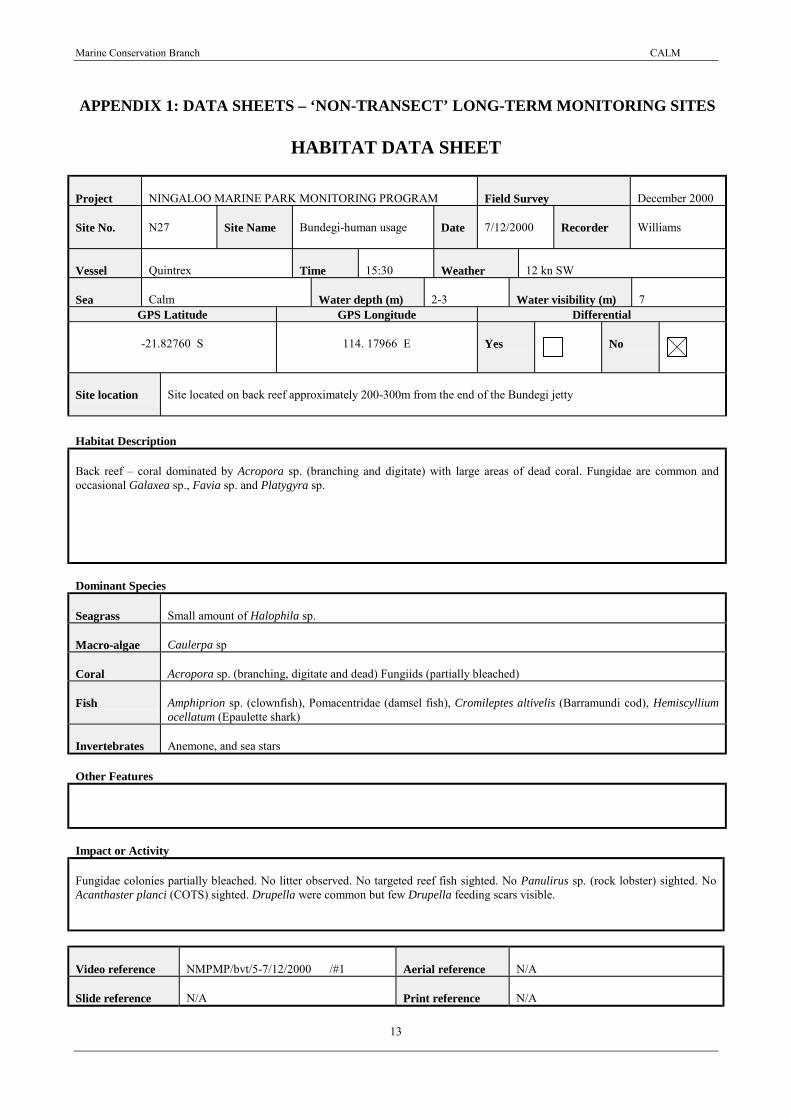
APPENDIX 1: DATA SHEETS – ‘NON-TRANSECT’ LONG-TERM MONITORING SITES
HABITAT DATA SHEET
Project NINGALOO MARINE PARK MONITORING PROGRAM Field Survey December 2000
Site No. N27 Site Name Bundegi-human usage Date 7/12/2000 Recorder Williams
Vessel Quintrex Time 15:30 Weather 12 kn SW
Sea Calm Water depth (m) 2-3 Water visibility (m) 7GPS Latitude GPS Longitude Differential
-21.82760 S 114. 17966 E Yes No
Site location Site located on back reef approximately 200-300m from the end of the Bundegi jetty
Habitat Description
Back reef � coral dominated by Acropora sp. (branching and digitate) with large areas of dead coral. Fungidae are common andoccasional Galaxea sp., Favia sp. and Platygyra sp.
Dominant Species
Seagrass Small amount of Halophila sp.
Macro-algae Caulerpa sp
Coral Acropora sp. (branching, digitate and dead) Fungiids (partially bleached)
Fish Amphiprion sp. (clownfish), Pomacentridae (damsel fish), Cromileptes altivelis (Barramundi cod), Hemiscylliumocellatum (Epaulette shark)
Invertebrates Anemone, and sea stars
Other Features
Impact or Activity
Fungidae colonies partially bleached. No litter observed. No targeted reef fish sighted. No Panulirus sp. (rock lobster) sighted. NoAcanthaster planci (COTS) sighted. Drupella were common but few Drupella feeding scars visible.
Video reference NMPMP/bvt/5-7/12/2000 /#1 Aerial reference N/A
Slide reference N/A Print reference N/A

Marine Conservation Branch CALM
14
NON-TRANSECT MONITORING SITE DATA SHEET
Project NINGALOO MARINE PARK MONITORING PROGRAM Field Survey December 2000
Site No. N27 Site Name Bundegi�human usage Date 7/12/2000 Observer Williams
Co-ordinates of Boundary Markers Observed Impacts
DGPS Latitude DGPS Longitude1
-21.82760 S 114.17966 ERefer to Habitat data sheet
2-21.82773 S 114.17993 E
3-21.82745 S 114.18007 E
4-21.82732 S 114.17981 E
5N/A N/A
6N/A N/A
Video operator Hogstrom Tape no. NMPMP/bvt/5-7/12/2000 /#1 Main HumanActivity
snorkelling
Time coding for all video footage atsite:
From: 0:14:27:00 To: 0:23:46:00
Notes:

Marine Conservation Branch CALM
15
HABITAT DATA SHEET
Project NINGALOO MARINE PARK MONITORING PROGRAM Field Survey December 2000
Site No. N30 Site Name Naval Jetty � South Date 7/12/2000 Recorder Williams
Vessel Quintrex Time 14:55-15:19 Weather 12 knots SW
Sea Calm Water depth (m) 5 Water visibility (m) 10GPS Latitude GPS Longitude Differential
-21.81783 S 114.18968 E Yes No
Site location Site located just south of the Navy Pier at Pt. Murat inshore from southern dolphin, slightly north (closer to Pier)than shown on August 1999 site data sheet.
Habitat Description
Some limestone pavement with dominant large (3m diameter) limestone lumps covered mainly by soft corals and inverts.Surrounding habitat comprised of flat limestone pavement.
Dominant Species
Seagrass -
Macro-algae
Coral Sarcophyton sp
Fish Scaridae (parrotfish), Zanclus cornutus (Moorish Idol)
Invertebrates Tridacna sp (clam) and Holothuria atra (sea cucumber)
Other Features
Impact or Activity
Litter included one large pipe (filmed). No targeted reef fish sighted. No Panulirus sp. (rock lobster) sighted. No Acanthaster planci(COTS) sighted. No Drupella sighted.
Video reference NMPMP/bvt/5-7/12/2000 /#1 Aerial reference N/A
Slide reference N/A Print reference N/A

Marine Conservation Branch CALM
16
NON-TRANSECT MONITORING SITE DATA SHEET
Project NINGALOO MARINE PARK MONITORING PROGRAM Field Survey December 2000
Site No. N30 Site Name Naval Jetty - South Date 7/12/2000 Observer Williams
Co-ordinates of Boundary Markers Observed Impacts
DGPS Latitude DGPS Longitude1
-21.81783 S 114.18968 ERefer to Habitat Data sheet
2 S E
3 S E
4 S E
5N/A N/A
6N/A N/A
Video operator Hogstrom Tape no. NMPMP/bvt/5-7/12/2000 /#1 Main HumanActivity
Pier activities
Time coding for all video footage atsite:
From: 0:09:42:15 To: 0:14:22:08
Notes:

Marine Conservation Branch CALM
17
HABITAT DATA SHEET
Project NINGALOO MARINE PARK MONITORING PROGRAM Field Survey December 2000
Site No. N31 Site Name Jurabi � South Date 6/12/2000 Recorder Williams
Vessel N/A Time 13:30 Weather 20 kts SW
Sea Choppy Water depth (m) 2 Water visibility (m) 3GPS Latitude GPS Longitude Differential
-21.88508 S 113.99338 E Yes No
Site location Site located 50m offshore from Jurabi beach. Access to beach via a track 2.3km south of Lighthouse CaravanPark.
Habitat Description
Limestone pavement shoreline with thin covering of sand.
Dominant Species
Seagrass
Macro-algae Padina sp., Halidmeda sp.
Coral
Fish
Invertebrates Holothura atra (Sea cucumber), Black sponge
Other Features
Site noted for large number of juvenile (2cm long) sea cucumbers on sand and adult H. atra on black sponge. No video was taken atthis site.
Impact or Activity
No litter observed. No targeted reef fish sighted. No Panulirus sp. (rock lobster) sighted. No Acanthaster planci (COTS) sighted. NoDrupella sighted.
Video reference NMPMP/bvt/ /# Aerial reference N/A
Slide reference N/A Print reference N/A

Marine Conservation Branch CALM
18
NON-TRANSECT MONITORING SITE DATA SHEET
Project NINGALOO MARINE PARK MONITORING PROGRAM Field Survey December 2000
Site No. N31 Site Name Jurabi � South Date 6/12/2000 Observer Williams
Co-ordinates of Boundary Markers Observed Impacts
DGPS Latitude DGPS Longitude1
-21.88508 S 113.99338 ERefer to Habitat Data sheet
2 S E
3 S E
4 S E
5N/A N/A
6N/A N/A
Video operator Hogstrom Tape no. NMPMP/bvt/ /# Main HumanActivity
Time coding for all video footage atsite:
From: 0:00:00:00 To: 0:00:00:00
Notes: No video footage.

Marine Conservation Branch CALM
19
HABITAT DATA SHEET
Project NINGALOO MARINE PARK MONITORING PROGRAM Field Survey December 2000
Site No. N56 Site Name Tantabiddi boat ramp Date 6/12/2000 Recorder Williams
Vessel N/A Time 12:30 Weather 25 knots SW
Sea N/A Water depth (m) 0.45 Water visibility (m) N/AGPS Latitude GPS Longitude Differential
-21.91327 S 113.97742 E Yes No
Site location Site located on intertidal reef north of the Tantabiddi boat ramp in front of Tantabiddi boat ramp toilet block.
Habitat Description
Intertidal reef with rich macro algae assemblage
Dominant Species
Seagrass
Macro-algae Some Ulva sp. � not extensive. Variety of red, green and brown algal species on beach at water mark
Coral
Fish
Invertebrates Small gastropods and molluscs
Other Features
Impact or Activity
Possible nutrient enrichment from toilet block located about 50m from waters edge. No litter observed. No Panulirus sp. (rocklobster) sighted. No Acanthaster planci (COTS) sighted. No Drupella sighted.
Video reference NMPMP/bvt/5-7/12/2000 /#1 Aerial reference N/A
Slide reference N/A Print reference N/A

Marine Conservation Branch CALM
20
NON-TRANSECT MONITORING SITE DATA SHEET
Project NINGALOO MARINE PARK MONITORING PROGRAM Field Survey December 2000
Site No. N56 Site Name Tantabiddi boat ramp Date 6/12/2000 Observer Williams
Co-ordinates of Boundary Markers Observed Impacts
DGPS Latitude DGPS Longitude1
-21.91327 S 113.97742 E Refer to Habitat Data sheet2
S E3
S E4
S E5
N/A N/A6
N/A N/A
Video operator Hogstrom Tape no. NMPMP/bvt/ 5-7/12/2000 /#1 Main HumanActivity
Toilet block
Time coding for all video footage atsite:
From: 0:00:00:00 To: 0:09:40:00
Notes:

Marine Conservation Branch CALM
21
HABITAT DATA SHEET
Project NINGALOO MARINE PARK MONITORING PROGRAM Field Survey December 2000
Site No. N35 Site Name Tantabiddi � glass bottomboat
Date 28/12/2000 Recorder Meyer
Vessel Quintrex Time 12:15 Weather 12 kts SW
Sea calm Water depth (m) 3 Water visibility (m) 5GPS Latitude GPS Longitude Differential
-21.91017 S 113.96328 E Yes No
Site location Site located in the lagoon area visited by the glass bottom boat tour.
Habitat Description
Lagoon � coral dominated by Acropora sp. (tabular and branching) with very little sand.
Dominant Species
Seagrass
Macro-algae
Coral Echinopora sp, Porities sp. (large) Acropora sp.(digitate, tabular and branching)
Fish Pomacentridae (damselfish), Amphiprion sp. (clown fish), Labridae (wrasse), Epinephelus multinotatus (Rankincod), Scaridae (parrotfish)
Invertebrates
Other Features
One juvenile Chelonia mydas, (Green turtle)
Impact or Activity
During 2000, a new glass bottom boat operator replaced the previous operator (Richard Wain). The new operator uses the same boatand route as the previous operator. There is no evidence of impacts due to the glass bottom boat and snorkelling. No litter observed.No Panulirus sp. (rock lobster) sighted. No Acanthaster planci (COTS) sighted. Drupella abundance low with individuals sighted onPorities sp. and Acropora sp. No Drupella feeding scars sighted.
Video reference NMPMP/bvt/28/12/2000 /#2 Aerial reference N/A
Slide reference N/A Print reference N/A

Marine Conservation Branch CALM
22
NON-TRANSECT MONITORING SITE DATA SHEET
Project NINGALOO MARINE PARK MONITORING PROGRAM Field Survey December 2000
Site No. N35 Site Name Tantabiddi�glassbottom boat
Date 28/12/2000 Observer Meyer
Co-ordinates of Boundary Markers Observed Impacts
DGPS Latitude DGPS Longitude1
-21.91017 S 113.96328 ERefer to Habitat Data sheet
2 S E
3 S E
4 S E
5N/A N/A
6N/A N/A
Video operator Williams Tape no. NMPMP/bvt/28/12/2000 /#2 Main HumanActivity
snorkelling
Time coding for all video footage atsite:
From: 0:08:47:14 To: 0:14:01:00
Notes: Very little sand so anchor vessel 50m away from site.

Marine Conservation Branch CALM
23
HABITAT DATA SHEET
Project NINGALOO MARINE PARK MONITORING PROGRAM Field Survey December 2000
Site No. N33 Site Name Tantabiddi-snorkel Date 28/12/2000 Recorder Meyer
Vessel Quintrex Time 11:00 Weather 8 kts SW
Sea Calm Water depth (m) 2-3 Water visibility (m) 8GPS Latitude GPS Longitude Differential
-21.91522 S 113.9555 E Yes No
Site location Site located adjacent to the Tantabiddi boat ramp at the glass bottom boat snorkelling site
Habitat Description
Lagoon � coral dominated by Porites sp. with limestone substrate. Very little sand on top of limestone.
Dominant Species
Seagrass
Macro-algae
Coral Porites sp.,
Fish Pomacentridae (damselfish), Pomacanthidae (angelfish), Chaetodontidae (butterflyfish),Taeniura lymma (bluespot ray), Triaenodon obesus (white tip reef shark), Scombridae (mackeral), Caranx ignobilis (giant trevally),Ostraciidae (boxfish), Syngnathidae (pipefish) and Plotosidae (catfish).
Invertebrates Holothuria nobilis (x9), Stichopus chloronotus (Holothurian), urchins, sea stars, clams, and oysters.
Other Features
Nudibranchs and egg mass.Most number of H. nobilis that Exmouth staff have seen.
Impact or Activity
Six pieces of old fishing line. No targeted reef fish or Panulirus sp. (rock lobster) sighted. Drupella abundance low (ie. 2) and noDrupella feeding scars visible. No Acanthaster planci (COTS) sighted.
Video reference NMPMP/bvt/28/12/2000 /#2 Aerial reference N/A
Slide reference N/A Print reference N/A

Marine Conservation Branch CALM
24
NON-TRANSECT MONITORING SITE DATA SHEET
Project NINGALOO MARINE PARK MONITORING PROGRAM Field Survey December 2000
Site No. N33 Site Name Tantabiddi-snorkel Date 28/12/2000 Observer Meyer
Co-ordinates of Boundary Markers Observed Impacts
DGPS Latitude DGPS Longitude1
-21.91522 S 113.9555 ERefer to Habitat Data sheet
2-21.91537 S 113.9563 E
3-21.9158 S 113.95605 E
4-21.9156 S 113.95547 E
5N/A N/A
6N/A N/A
Video operator Williams Tape no. NMPMP/bvt/28/12/2000 /#2 Main HumanActivity
snorkelling/fishing
Time coding for all video footage atsite:
From: 0:00:15:01 To: 0:08:45:17
Notes: Please ignore first 15 seconds of footage of coffee cup and Jo walking into the Office. Adam strikes again!

Marine Conservation Branch CALM
25
HABITAT DATA SHEET
Project NINGALOO MARINE PARK MONITORING PROGRAM Field Survey December 2000
Site No. N34 Site Name Mangrove Walk Date 5/12/2000 Recorder Williams
Vessel N/A Time 15:20 Weather 25 knots SW
Sea N/A Water depth (m) N/A Water visibility (m) N/AGPS Latitude GPS Longitude Differential
-21.9643 S 113.94298 E Yes No
Site location Site located onshore and included the bird hide and adjacent mangroves. Follow walk tracks to beach and point.
Habitat Description
Mainly Avicennia marina and Rhizophora stylosa surrounded by samphire flats and buffel grass.
Dominant Species
Seagrass
Macro-algae
Coral
Fish
Invertebrates
Other Features
Impact or Activity
Mangrove walk is used by bird watchers and reef walkers. Mangrove walk is also used by the annual Exmouth school Year 7 campwho visit the site with Exmouth CALM staff. When the site was visited, two people were bird watching, however no birds sighted.Litter included a beer can and various plastic bags. A cooked mud crab carapace (2 pieces) sighted. No damage to the mangrovesobserved (ie no broken branches)
Video reference NMPMP/bvt/5-7/12/2000 /#1 Aerial reference N/A
Slide reference N/A Print reference N/A

Marine Conservation Branch CALM
26
NON-TRANSECT MONITORING SITE DATA SHEET
Project NINGALOO MARINE PARK MONITORING PROGRAM Field Survey December 2000
Site No. N34 Site Name Mangrove Walk Date 5/12/2000 Observer Williams
Co-ordinates of Boundary Markers Observed Impacts
DGPS Latitude DGPS Longitude1
-21.9643 S 113.94298 ERefer to Habitat Data sheet
2 S E
3 S E
4 S E
5N/A N/A
6N/A N/A
Video operator Hogstrom Tape no. NMPMP/bvt/ 5-7/12/2000 /#1 Main HumanActivity
bird watching
Time coding for all video footage atsite:
From: 0:07:00:01 To: 0:11:11:23
Notes: No birds at hide.
Marine Conservation Branch CALM
27
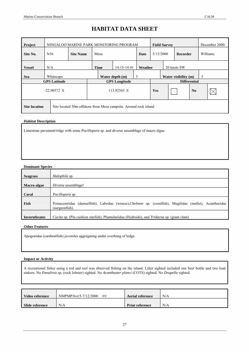
HABITAT DATA SHEET
Project NINGALOO MARINE PARK MONITORING PROGRAM Field Survey December 2000
Site No. N36 Site Name Mesa Date 5/12/2000 Recorder Williams
Vessel N/A Time 14:15-14:41 Weather 20 knots SW
Sea Whitecaps Water depth (m) 3 Water visibility (m) 3GPS Latitude GPS Longitude Differential
-22.00572 S 113.92565 E Yes No
Site location Site located 50m offshore from Mesa campsite. Around rock island
Habitat Description
Limestone pavement/ridge with some Pocillopora sp. and diverse assemblage of macro algae.
Dominant Species
Seagrass Halophila sp.
Macro-algae Diverse assemblage!
Coral Pocillopora sp.
Fish Pomacentridae (damselfish), Labridae (wrasse),Chelmon sp. (coralfish), Mugilidae (mullet), Acanthuridae(surgeonfish).
Invertebrates Cucita sp. (Pin cushion starfish), Plumulariidae (Hydroids), and Tridacna sp. (giant clam)
Other Features
Apogonidae (cardinalfish) juveniles aggregating under overhang of ledge.
Impact or Activity
A recreational fisher using a rod and reel was observed fishing on the island. Litter sighted included one beer bottle and two leadsinkers. No Panulirus sp. (rock lobster) sighted. No Acanthaster planci (COTS) sighted. No Drupella sighted.
Video reference NMPMP/bvt/5-7/12/2000 /#1 Aerial reference N/A
Slide reference N/A Print reference N/A

Marine Conservation Branch CALM
28
NON-TRANSECT MONITORING SITE DATA SHEET
Project NINGALOO MARINE PARK MONITORING PROGRAM Field Survey December 2000
Site No. N 36 Site Name Mesa Date 5/12/2000 Observer Williams
Co-ordinates of Boundary Markers Observed Impacts
DGPS Latitude DGPS Longitude1
-22.00572 S 113.92565 E Refer to Habitat Data sheet2
S E3
S E4
S E5
N/A N/A6
N/A N/A
Video operator Hogstrom Tape no. NMPMP/bvt/5-7/12/2000 /#1 Main HumanActivity
fishing
Time coding for all video footage atsite:
From: 0:04:45:00 To: 0:06:58:00
Notes: Battery four failed at end of filming. Change to battery six.

Marine Conservation Branch CALM
29
HABITAT DATA SHEET
Project NINGALOO MARINE PARK MONITORING PROGRAM Field Survey December 2000
Site No. N38 Site Name Lakeside Date 5/12/2000 Recorder Williams
Vessel N/A Time 13:00-13:38 Weather 20 knots SW
Sea whitecaps Water depth (m) 3 Water visibility (m) 6GPS Latitude GPS Longitude Differential
-22.03925 S 113.90989 E Yes No
Site location Site located in the lagoon adjacent to the Lakeside access (�Lakeside Bommies� in CALM Dive and Snorkel sitesin WA.).
Habitat Description
Lagoon � corals include Porites sp. (bommies 0.5-4m) and some Acopora sp. (branching and tabular).
Dominant Species
Seagrass
Macro-algae Filamentous algae abundant
Coral Acropora sp. (tabular and branching) and Porities sp.,
Fish Lethrinidae (emperor) and Pomacentridae (damselfish)
Invertebrates Holothuria atra and Stichopus chloronotus (Holothurians), urchins, Tridacna sp. (giant clam), sea star, and blacksponge,
Other Features
Impact or Activity
Litter includes one beer can on the beach and one old car tyre with coral on it (filmed). No Panulirus sp. (rock lobster) sighted. NoAcanthaster planci (COTS) sighted. No Drupella sighted. Large Porites sp. colony with 5% recent damage.
Video reference NMPMP/bvt/5-7/12/2000 /#1 Aerial reference N/A
Slide reference N/A Print reference N/A

Marine Conservation Branch CALM
30
NON-TRANSECT MONITORING SITE DATA SHEET
Project NINGALOO MARINE PARK MONITORING PROGRAM Field Survey December 2000
Site No. N 38 Site Name Lakeside Date 5/12/2000 Observer Williams
Co-ordinates of Boundary Markers Observed Impacts
DGPS Latitude DGPS Longitude1
-22.03925 S 113.90989 E Refer to Habitat Data sheet.2
S E3
S E4
S E5
N/A N/A6
N/A N/A
Video operator Hogstrom Tape no. NMPMP/bvt/5-7/12/2000 /#1 Main HumanActivity
snorkelling/fishing
Time coding for all video footage atsite:
From: 0:01:07:00 To: 0:04:45:00
Notes: Tape reset to 0:00:00:00 after N37 Turquoise Bay. Lakeside footage starts with dead mullet (0:00:00:00 � 0:01:06:00) thencontinues with u/water footage from 0:01:07:00 � 0:04:45:00).

Marine Conservation Branch CALM
31
HABITAT DATA SHEET
Project NINGALOO MARINE PARK MONITORING PROGRAM Field Survey December 2000
Site No. N37 Site Name Turquoise Bay Date 5/12/2000 Recorder Williams
Vessel N/A Time 11:00�11:49
Weather 18 kts SW
Sea Calm Water depth (m) 3 Water visibility (m) 12GPS Latitude GPS Longitude Differential
-22.10178 S 113.88422 E Yes No
Site location Site located at Turquoise Bay (See �Turquoise Bay Drift snorkel� in CALM Dive and Snorkel sites in WA.
Habitat Description
Lagoon � sand patches with Porites close to shore. Acropora sp. dominate further from shore with Sinularia sp. becoming common.Strong current.
Dominant Species
Seagrass Halophila sp. sparse
Macro-algae Filamentous brown or Blue-Green.
Coral Acropora sp. (digitate and branching) and Porities sp.
Fish Labridae (wrasse), Scaridae (parrotfish), Pomacentridae (damselfish), Balistidae(triggerfish), Lethrinidae(emperor), Pomacanthidae (angelfish) and Mullidae (goatfish)
Invertebrates Holothuria atra, Stichopus chloronotus (holothurian), sea stars, octopus, Tridacna sp. (giant clam) and urchins
Other Features
Lots of filamentous weed.One Chelonia mydas (green turtle) sighted in water. 1 turtle track (up and down) on beach at Point.
Impact or Activity
When the site was visited there were 30 people on beach and in the water. 10 cars + 2 buses in carpark. Some evidence of possiblefin damage - small amount of broken hard coral. Litter includes one piece of broken glass encrusted with coralline algae and onepiece of fishing line (filmed). No Panulirus sp. (rock lobster) sighted. No Acanthaster planci (COTS) sighted A few Drupella(uncommon) sighted and no Drupella feeding scars sighted.
Video reference NMPMP/bvt/5-6/12/2000 /#1 Aerial reference N/A
Slide reference N/A Print reference N/A

Marine Conservation Branch CALM
32
NON-TRANSECT MONITORING SITE DATA SHEET
Project NINGALOO MARINE PARK MONITORING PROGRAM Field Survey December 2000
Site No. N37 Site Name Turquoise Bay Date 5/12/2000 Observer Williams
Co-ordinates of Boundary Markers Observed Impacts
DGPS Latitude DGPS Longitude1
-22.10178 S 113.88422 E Refer to Habitat data sheet2
S E3
S E4
S E5
N/A N/A6
N/A N/A
Video operator Hogstrom Tape no. NMPMP/bvt/5-7/12/2000 /#1 Main HumanActivity
snorkelling
Time coding for all video footage atsite:
From: 0:00:00:00 To: 0:04:03:00
Notes: Battery one failed after 4:03 sec. Changed to battery four.

Marine Conservation Branch CALM
33
APPENDIX 2: NMPMP 12/00 VIDEO TAPES
Tapes # Programme Description Digitaloriginal
VHScopy
Digitalcopy
MMS/NIN/NMP/BVT 5-7/12/00 #1 Ningaloo Marine Park MonitoringProgram
N27, N30, N56, N34,N36, N38, N37
Yes Yes Yes
MMS/NIN/NMP/BVT 28/12/00 #2 Ningaloo Marine Park MonitoringProgram
N33, N35 Yes Yes Yes