nic flemming noc uk - europa · nic flemming noc uk 1st oct 2014 sea level curve for last half...
TRANSCRIPT
1
Data needs for Quaternary and Prehistoric Landscapes/Archaeology:
Objectives and next steps
Nic Flemming
NOC UK1st Oct 2014
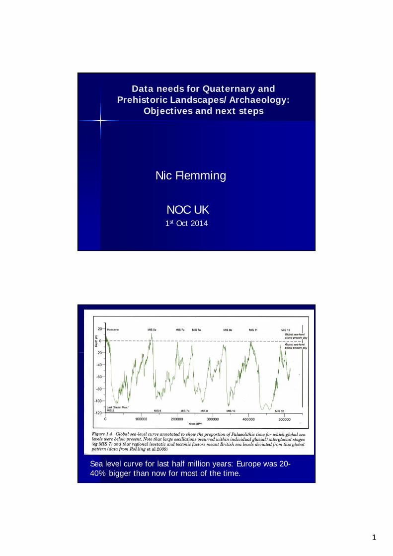
Sea level curve for last half million years: Europe was 20-40% bigger than now for most of the time.
2
Data needs for Quaternary and Prehistoric Landscapes/Archaeology:
Objectives and next steps
1.Objectives, context, connections 2.Existing relevant data types 3.Accuracy, resolution, coverage 4.Conversion to terrain characteristics 5.Data sources and new data 6.Establish a preparation group 7.Terms of reference and timescale
1.Objectives, context, connections
2500+ submerged prehistoric sites Legal/treaty/UNESCO obligations Links to industry, very constructive Research objectives; stake-holders Deukalion/SPLASHCOS/SUBLAND PP. Connection to EMODNet already Improvements in modelling, all kinds
3
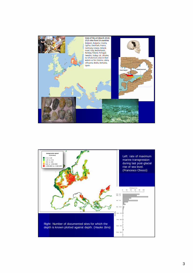
Left: rate of maximum marine transgression during last post-glacial rise of sea level.(Francesco Chiocci)
Right: Number of documented sites for which the depth is known plotted against depth. (Hauke Jöns)
4
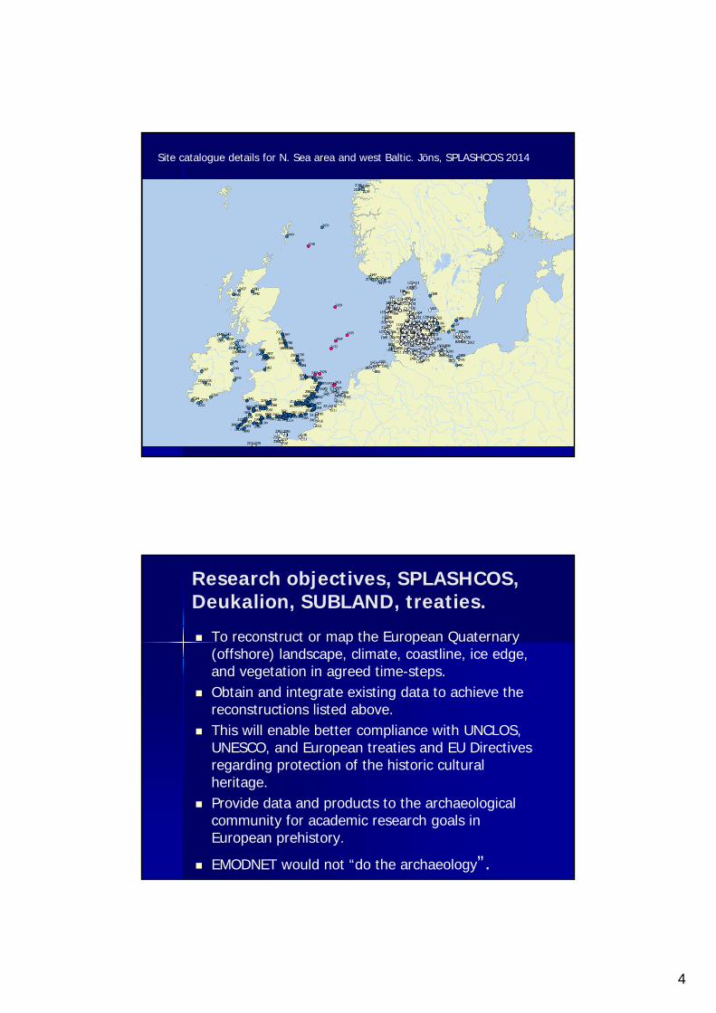
Site catalogue details for N. Sea area and west Baltic. Jöns, SPLASHCOS 2014
Research objectives, SPLASHCOS, Deukalion, SUBLAND, treaties.
To reconstruct or map the European Quaternary (offshore) landscape, climate, coastline, ice edge, and vegetation in agreed time-steps.
Obtain and integrate existing data to achieve the reconstructions listed above.
This will enable better compliance with UNCLOS, UNESCO, and European treaties and EU Directives regarding protection of the historic cultural heritage.
Provide data and products to the archaeological community for academic research goals in European prehistory.
EMODNET would not “do the archaeology”.
5
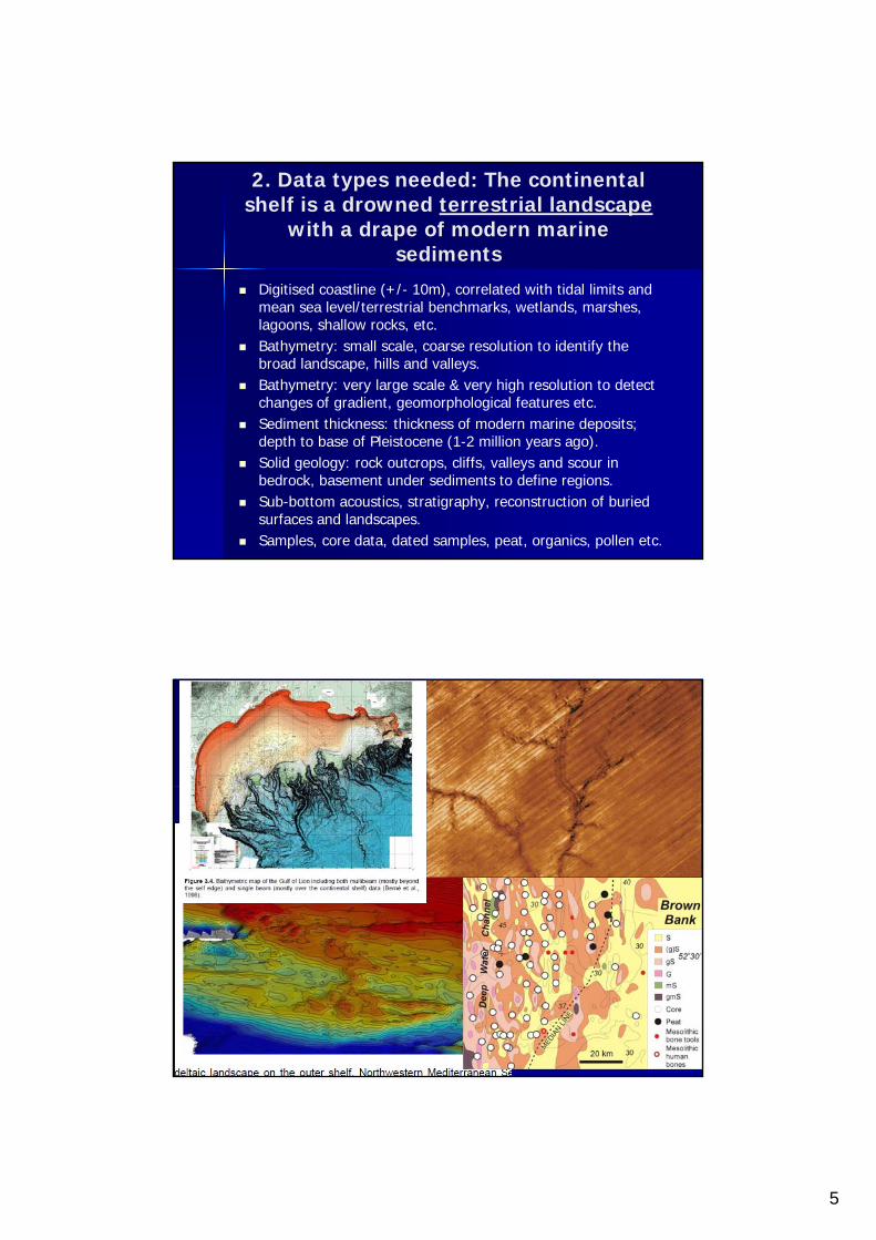
2. Data types needed: The continental shelf is a drowned terrestrial landscape
with a drape of modern marine sediments
Digitised coastline (+/- 10m), correlated with tidal limits and mean sea level/terrestrial benchmarks, wetlands, marshes, lagoons, shallow rocks, etc.
Bathymetry: small scale, coarse resolution to identify the broad landscape, hills and valleys.
Bathymetry: very large scale & very high resolution to detect changes of gradient, geomorphological features etc.
Sediment thickness: thickness of modern marine deposits; depth to base of Pleistocene (1-2 million years ago).
Solid geology: rock outcrops, cliffs, valleys and scour in bedrock, basement under sediments to define regions.
Sub-bottom acoustics, stratigraphy, reconstruction of buried surfaces and landscapes.
Samples, core data, dated samples, peat, organics, pollen etc.
6
3. Accuracy, resolution and coverage (faux-naïf)
Geographical coverage: High-tide line to 150m isobath.
Harmonise stratigraphy and terminology. Dating accuracy and methods.
Bathymetry to HO standards and geo-referenced to GPS, or other global/European standard.
HR Multibeam where possible direct access. Sediments standard BGS-type classifications. Tens of
thousands of cores and samples. Sub-bottom profiling data, many thousands of track
km. Time step of maps to be decided. Not just LGM &
post-LGM (if possible).
4. Conversion to features Terrestrial geomorphological features occur both
exposed on the surface of the seabed and buried in the sediment column.
Cliffs never occur on charts. There are more steep gradients and sharp changes of
gradient than gridded DTMs would suggest. DTMs tend to remove abrupt discontinuities. Even DTA algorithms use polynomial splines. (Is this true?)
Gradients, changes of gradient, junctions, continuity of features, etc., need developing as algorithms (has this been done? Habitats?)
Papers on digitised feature recognition: Tarolli et al.; Finkl; Grohmann et al., Seijmonsbergen (etc…).
Feature recognition required: next slide…
7
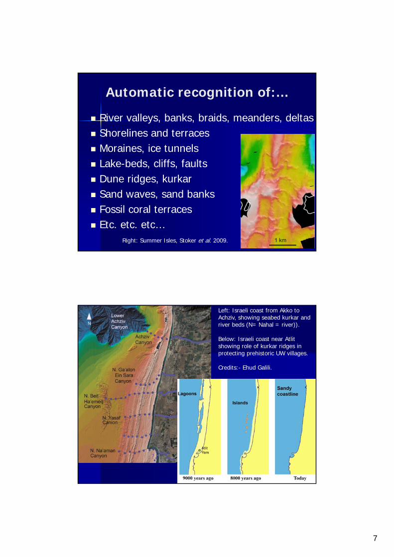
Automatic recognition of:…
River valleys, banks, braids, meanders, deltas Shorelines and terraces Moraines, ice tunnels Lake-beds, cliffs, faults Dune ridges, kurkar Sand waves, sand banks Fossil coral terraces Etc. etc. etc…
Right: Summer Isles, Stoker et al. 2009.
Left: Israeli coast from Akko to Achziv, showing seabed kurkar and river beds (N= Nahal = river)).
Below: Israeli coast near Atlit showing role of kurkar ridges in protecting prehistoric UW villages.
Credits:- Ehud Galili.
8
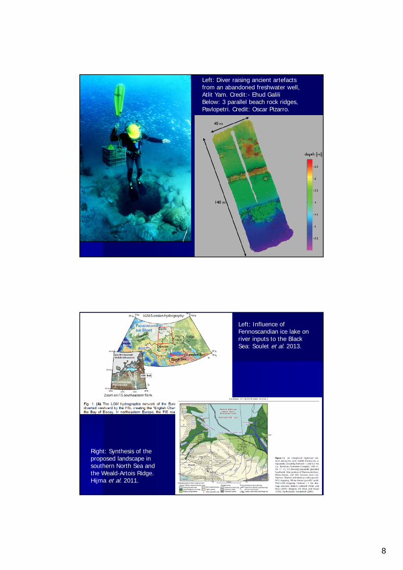
Left: Diver raising ancient artefacts from an abandoned freshwater well, Atlit Yam. Credit:- Ehud GaliliBelow: 3 parallel beach rock ridges, Pavlopetri. Credit: Oscar Pizarro.
Left: Influence of Fennoscandian ice lake on river inputs to the Black Sea: Soulet et al. 2013.
Right: Synthesis of the proposed landscape in southern North Sea and the Weald-Artois Ridge.Hijma et al. 2011.
9
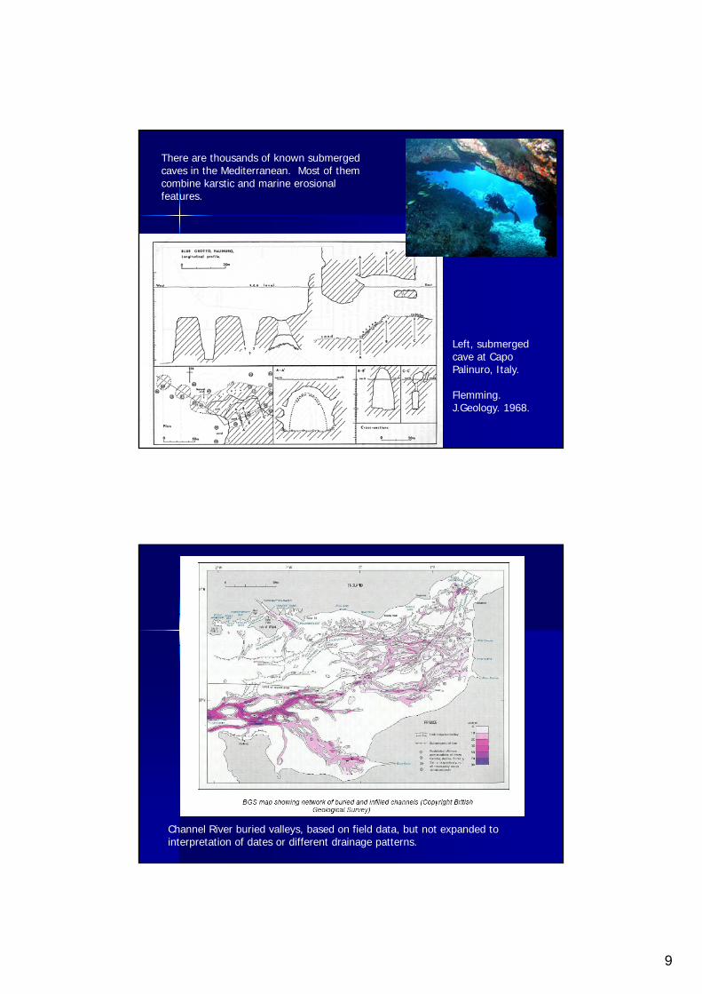
There are thousands of known submerged caves in the Mediterranean. Most of them combine karstic and marine erosional features.
Left, submerged cave at Capo Palinuro, Italy.
Flemming. J.Geology. 1968.
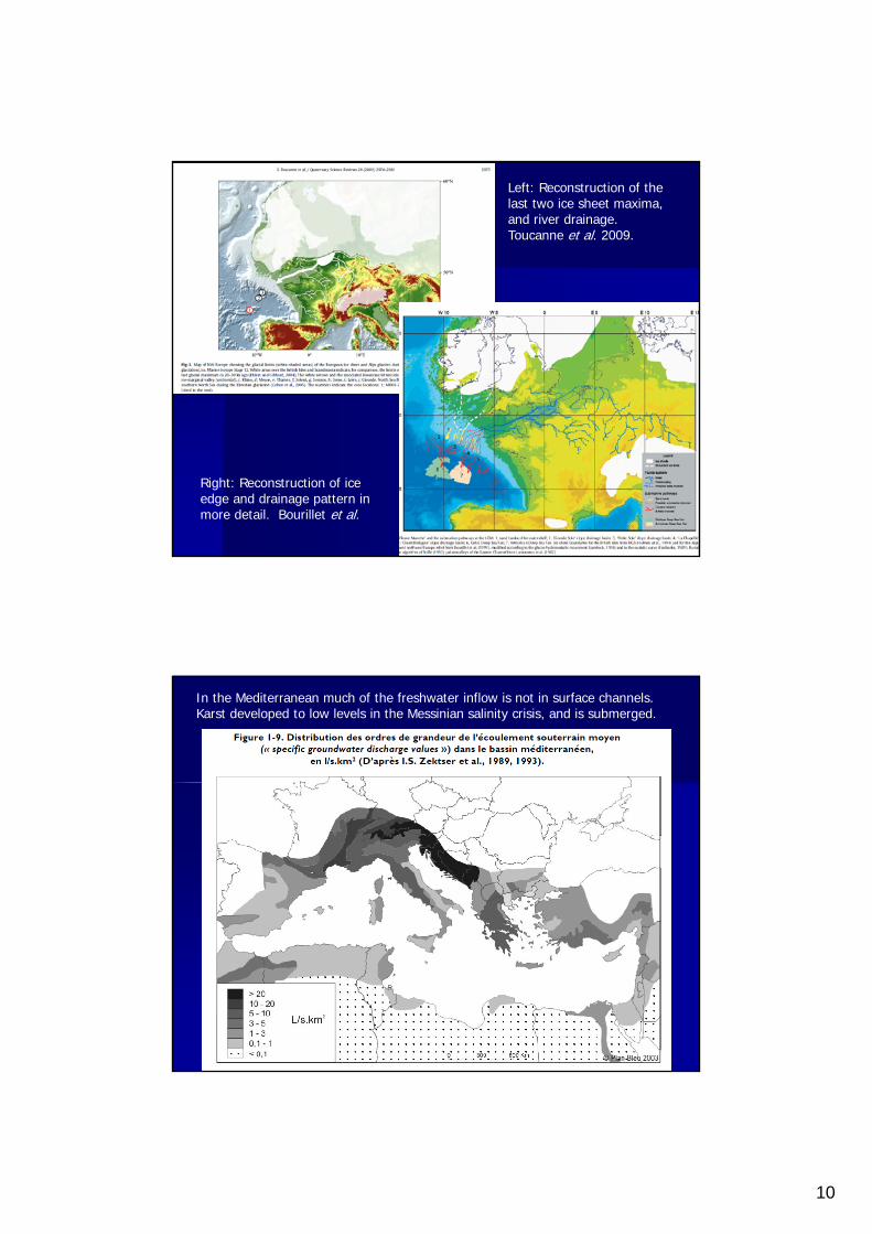
Channel River buried valleys, based on field data, but not expanded to interpretation of dates or different drainage patterns.
10
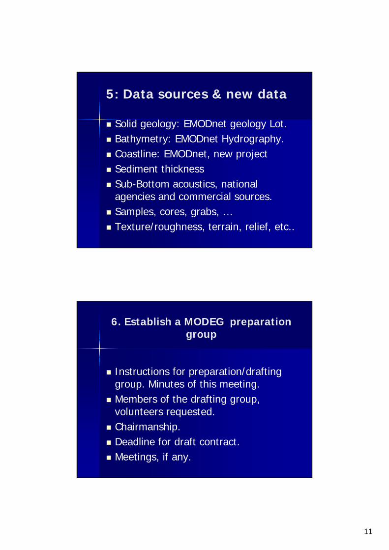
Left: Reconstruction of the last two ice sheet maxima, and river drainage. Toucanne et al. 2009.
Right: Reconstruction of ice edge and drainage pattern in more detail. Bourillet et al.
In the Mediterranean much of the freshwater inflow is not in surface channels. Karst developed to low levels in the Messinian salinity crisis, and is submerged.
11
5: Data sources & new data
Solid geology: EMODnet geology Lot. Bathymetry: EMODnet Hydrography. Coastline: EMODnet, new project Sediment thickness Sub-Bottom acoustics, national
agencies and commercial sources. Samples, cores, grabs, … Texture/roughness, terrain, relief, etc..
6. Establish a MODEG preparation group
Instructions for preparation/drafting group. Minutes of this meeting.
Members of the drafting group, volunteers requested.
Chairmanship. Deadline for draft contract. Meetings, if any.
12
7. Terms of reference and timescale
Task within a geology/Quaternary layer
Contract date 2016; contract duration? All European seas and shelf area Metadata, browser maps, links to data
sources. Samples of high resolution data. Feature recognition software if
possible.
Thank you for listening.