ngu geologi for samfunnet geology for … · marianne engdal, tove aune, and bjørn frengstad :...
TRANSCRIPT

GEOLOGI FOR SAMFUNNETGEOLOGY FOR SOCIETY
NGUNorges geologiske undersøkelseGeological Survey of Norway

Geological Survey of Norway Postboks 6315 Sluppen NO-7491 Trondheim, Norway Tel.: 47 73 90 40 00 Telefax 47 73 92 16 20
REPORT Report no.: 2013.024
ISSN 0800-3416
Grading: Open
Title: 22nd NGU Seminar on Hydrogeology and Environment, May 14-15, 2013. "Groundwater and Cultural Heritage".
Authors: Marianne Engdal, Tove Aune, and Bjørn Frengstad
Client: NGU
County:
Municipality:
Map-sheet name (M=1:250.000)
Map-sheet no. and -name (M=1:50.000)
Deposit name and grid-reference:
Number of pages: 36 Price (NOK): 60,- Map enclosures:
Fieldwork carried out:
Date of report: 6 May 2013
Project no.: 336500
Person responsible:
Summary: The report presents programme, list of participants and abstracts of oral presentations and posters from the 22nd NGU Seminar on Hydrogeology and Environment: "Groundwater and Cultural Heritage", held on May 14-15 in Trondheim. Speakers and participants from Northern Europe have been invited to Trondheim 14 and 15 May. Hydrogeologists, archaeologists and urban planners will share their expertise and experience and discuss the challenges of managing groundwater in a way that both preserves our heritage and facilitates sustainable development. The abstracts are organised in main themes: “Mapping, monitoring and modelling”, “Planning and management”, “Mitigative measures” and “Case studies” and in the same order as in the programme. The seminar is followed by a half-day post-seminar excursion in Trondheim and an open Urban WATCH workshop 16 May. 49 seminar participants are registered of which 40 are external. Except for formatting and spell check, the abstracts are published directly from the material delivered by the presenters who are fully responsible for the content.
Keywords: Hydrogeologi
Arkeologi
Hydrogeokjemi
Grunnvann

3
Contents Programme ................................................................................................................................................... 5
Participants ................................................................................................................................ 9
Mapping, monitoring and modelling preservation conditions of cultural deposits
Henning Matthiesen, National Museum of Denmark ..................................................................................... 12
Groundwater and the in situ preservation of a medieval mound in the city of Vlaardingen, the
Netherlands
Michel Vorenhout, MVH Consult & Archeologische Monumentenwach, the Netherlands ............................. 13
The decay and corrosiveness of materials in archaeological artifacts
Ola Magne Sæther, NGU ................................................................................................................................ 14
Modelling water content and soil temperature in unsaturated urban archaeological deposits
Anna Seither, NGU, Henning Matthiesen, National Museum of Denmark ...................................................... 15
In situ preservation in the unsaturated zone: case Avaldsnes
Vibeke Vandrup Martens, NIKU ..................................................................................................................... 16
Geophysical electrical resistivity methods to characterize and monitor archaeological sites.... Ester Bloem, Bioforsk, Perrine Fernandez, Bioforsk, UMB, Helen French, Bioforsk, UMB ............................... 17
Cultural deposits and the local water balance, examples from Bryggen in Bergen, Norway
Nils-Otto Kitterød, UMB ................................................................................................................................. 18
Damage to the wooden foundation of Amsterdam by climate change
Jeroen Ponten, Waternet ............................................................................................................................... 19
Preservation conditions for archaeological remains in wetlands – an interaction between
cultural heritage and biodiversity
Anna K. E. Tjelldén, Aarhus University, Søren M. Kristiansen, Aarhus University ........................................... 20
In-situ redox situation: a tool to protect archaeological structures
Perrine M. Fernandez, Esther Bloem, Bioforsk, Ove Bergersen, Bioforsk, Helen K. French, UMB, Bioforsk ..... 21
Urban groundwater monitoring – a heritage support tool De Beer, J. NGU, Donald, A., GSNI, Campbell, S.D.G., BGS, Taugs, R. GLH, Eriksson, I., City of Oslo, Mielby, S.,
GEUS, Dahlqvist, P., SGU ................................................................................................................................ 22
3D modelling of hydrogeological conditions between Akerselva and Youngstorget, City of
Oslo
Anniken Mjøen Solli, NTNU ............................................................................................................................ 23
Low cost microscreen multilevel groundwater samplers for monitoring changes in
groundwater chemistry with depth under different geological conditions
Atle Dagestad, NGU & Oliver Kracht, NGU ..................................................................................................... 24

4
The Bergen Way – Experiences with Cultural Heritage Management in an Urban Context Johanne Gillow, City of Bergen ....................................................................................................................... 26
Cultural Heritage and Water Management in Urban Planning
Hans de Beer, NGU, Kjell Harvold, NIBR, Rory Dunlop, NIKU ......................................................................... 27
Urban planning and cultural heritage – The northbound light-rail alignment from the centre
of Bergen, Norway
Ole-Magne Nøttveit, Norconsult AS ............................................................................................................... 28
Sustainable management of the World Heritage Site, Bryggen
Ann Christensson, Riksantikvaren, Rory Dunlop, NIKU, Hans de Beer, NGU, Henning Matthiesen,
Nationalmuseet ............................................................................................................................................. 29
Sustainable management of humidity within in situ deposits in the medieval town of
Trondheim, Norway
Anna Petersén, NIKU ...................................................................................................................................... 30
Ladegårdsgaten in Bergen - the tunnel that did not cause settlements
Amund Gaut, Sweco Norge AS, Arne Instanes, Instanes Polar AS, Werner Stefanussen, Sweco Norge AS ...... 31
Implementation of sustainable urban drainage systems to preserve cultural heritage
Floris Boogaard, Delft University of Technology, Hans de Beer, NGU, Tone M. Muthanna, NTNU .................. 32
Medieval groundwater spring and cultural layers in Tønsberg, Norway. Evaluation of their
hydrogeological dependence and vulnerability
Kevin J. Tuttle, Norconsult AS ......................................................................................................................... 33
The sedimentological and hydrological background for two sacred springs from Bø in
Telemark
Harald Klempe, Telemark University College, Norway ................................................................................... 34
The hidden heritage at Nantwich and York: groundwater and the urban cultural sequence
Timothy Malim, David Morgan, SLR Consulting Ltd, UK, Ian Panter, York Archaeological Trust, UK ............... 35
Suspended animation: the peculiar preservation conditions of the Must Farm – Flag Fen
Bronze Age landscape
Timothy Malim, SLR Consulting Ltd, UKDavid Morgan, SLR Consulting Ltd, UK, Ian Panter, York Archaeological
Trust, UK ........................................................................................................................................................ 36

5
Groundwater and Cultural Heritage 22nd Seminar on Hydrogeology and Environment
Tuesday 14 May Programme 10:00 Opening of the Seminar Managing Director Morten Smelror, Geological Survey of Norway (NGU)
Mapping, monitoring and modelling Chair: Hans de Beer 10:10 Keynote lecture:
Mapping, monitoring and modelling preservation conditions of cultural deposits Henning Matthiesen, National Museum of Denmark
10:55 Groundwater and the in situ preservation of a medieval mound in the city of
Vlaardingen, the Netherlands Michel Vorenhout, MVH Consult & Archeologische Monumentenwacht, the Netherlands
11:15 The decay and corrosiveness of materials in archaeological artifacts
Ola Magne Sæther, NGU 11:35 Break 11:55 Modelling water content and soil temperature in unsaturated urban
archaeological deposits Anna Seither, NGU & Henning Matthiesen, National Museum of Denmark.
12:15 In situ site preservation in the unsaturated zone: case Avaldsnes
Vibeke Vandrup Martens, Norwegian Institute of Cultural Research (NIKU).
12:35 Geophysical electrical resistivity methods to characterize and monitor archaeological sites Esther Bloem, Bioforsk, Perrine Fernandez & Helen French, The Norwegian University of Life Sciences (UMB)
13:00 Lunch
Chair:Bjørn Frengstad
14:00 Cultural deposits and the local water balance, examples from Bryggen in Bergen, Norway Nils-Otto Kitterød, UMB
14:20 Damage to the wooden foundation of Amsterdam by climate change Jeroen Ponten, Waternet, Amsterdam, the Netherlands

6
Introduction to Posters 14:40 Preservation conditions for archaeological remains in wetlands
- an interaction between cultural heritage and biodiversity Anna K.E. Tjelldén & Søren M. Kristiansen, Aarhus University, Denmark
14:45 In-situ redox situation: a tool to protect archaeological structures
Perrine M. Fernandez, UMB, Esther Bloem, Ove Bergersen, Bioforsk, Helen K. French, UMB 14:50 Urban groundwater monitoring - a heritage support tool
De Beer, J., NGU, Donald, A,. GSNI, Campbell, S.D.G., BGS, Taugs, R., GLH, Eriksson, I., City of Oslo, Mielby, S., GEUS, Dahlqvist, P., SGU
14:55 3D modelling of hydrogeological conditions between Akerselva and Youngstorget,
City of Oslo Anniken Mjøen Solli, Norwegian University of Science and Technology (NTNU)
15.00 Low cost microscreen multilevel groundwater samplers for monitoring changes in
groundwater chemistry with depth under different geological conditions Atle Dagestad & Oliver Kracht NGU
15:10 Poster session
17:00 Seminar Dinner

7
Wednesday 15 May Planning and management 09:00 Start of day 2 09:05 Keynote speech: The Bergen Way – experiences with cultural heritage
management in an urban context Johanne Gillow, Bergen municipality
09:50 Cultural heritage and water management in urban planning
Hans de Beer, NGU; Kjell Harvold, NIBR & Rory Dunlop, NIKU 10:10 Urban planning and cultural heritage – The northbound light-rail alignment from
the centre of Bergen, Norway Ole-Magne Nøttveit, Norconsult AS, Norway
10:30 Break
10:50 Sustainable management of the World Heritage Site, Bryggen Ann Christensson, Riksantikvaren; Rory Dunlop, NIKU; Hans de Beer, NGU & Henning Matthiesen, Nationalmuseet
11:10 Sustainable management of humidity within in situ deposits in the medieval town of Trondheim, Norway Anna Petersén, NIKU
11:30 Ladegårdsgaten in Bergen - the tunnel that did not cause settlements Amund Gaut, Sweco Norge AS; Arne Instanes, Instanes Polar AS; Werner Stefanussen, Sweco Norge AS
11:50 Poster session 12:20 Lunch Mitigative measures Chair: Henk Kars 13:20 Implementation of sustainable urban drainage systems to preserve cultural
heritage Floris Boogaard, Delft University of Technology; Hans de Beer, NGU & Tone M. Muthanna, NTNU.

8
Case studies
13:40 Medieval groundwater spring and cultural layers in Tønsberg, Norway. Evaluation of their hydrogeological dependence and vulnerability Kevin J. Tuttle, Norconsult AS
14:00 The sedimentological and hydrological background for two sacred springs from
Bø in Telemark Harald Klempe, Telemark University College, Norway
14:20 Break
14:40 The hidden heritage at Nantwich and York: groundwater and the urban cultural sequence Timothy Malim, SLR Consulting Ltd & Ian Panter, York Archaeological Trust, UK
15:00 Suspended animation: the peculiar preservation conditions of the Must Farm – Flag Fen Bronze Age landscape Timothy Malim & David Morgan, SLR Consulting Ltd; Ian Panter, York Archaeological Trust, UK
15:20 Summing-up discussion
16:00 Closure of seminar

9
Participants
Family name First name Organisation Email Bergersen Ove Bioforsk [email protected] Bloem Esther Bioforsk [email protected] Boogaard Floris Delft University of Technology [email protected] Christensson Ann Riksantikvaren [email protected] Cramer Jan Geological Survey of Norway (NGU) [email protected] Dagestad Atle Geological Survey of Norway (NGU) [email protected] de Beer Hans Geological Survey of Norway (NGU) [email protected] Dunlop Rory Norwegian Institute for Cultural Heritage Research (NIKU) [email protected] Fernandez Perrine UMB - Bioforsk [email protected] Fredriksen Ivar Geonor AS [email protected] Fredriksen Joachim Rosenvilde vgs [email protected] Frengstad Bjørn Geological Survey of Norway (NGU) [email protected] Gaut Amund Sweco Norge AS [email protected] Gaut Sylvi Sweco Norge AS [email protected] Gillow Johanne Bergen kommune, Byantikvaren [email protected] Gundersen Pål Geological Survey of Norway (NGU) [email protected] Hagen Heming Byantikvaren i Bergen [email protected] Houen Gunnar Trondheim kommune, Byantikvaren [email protected] Johannessen Live Riksantikvaren [email protected] Jæger Øystein Geological Survey of Norway (NGU) [email protected] Kars Henk Vrije Universtiteit, Amsterdam [email protected] Kitterød Nils-Otto UMB [email protected] Klaussen Monica Norwegian Institute for Cultural Heritage Research (NIKU) [email protected] Klempe Harald Telemark University College [email protected]
10
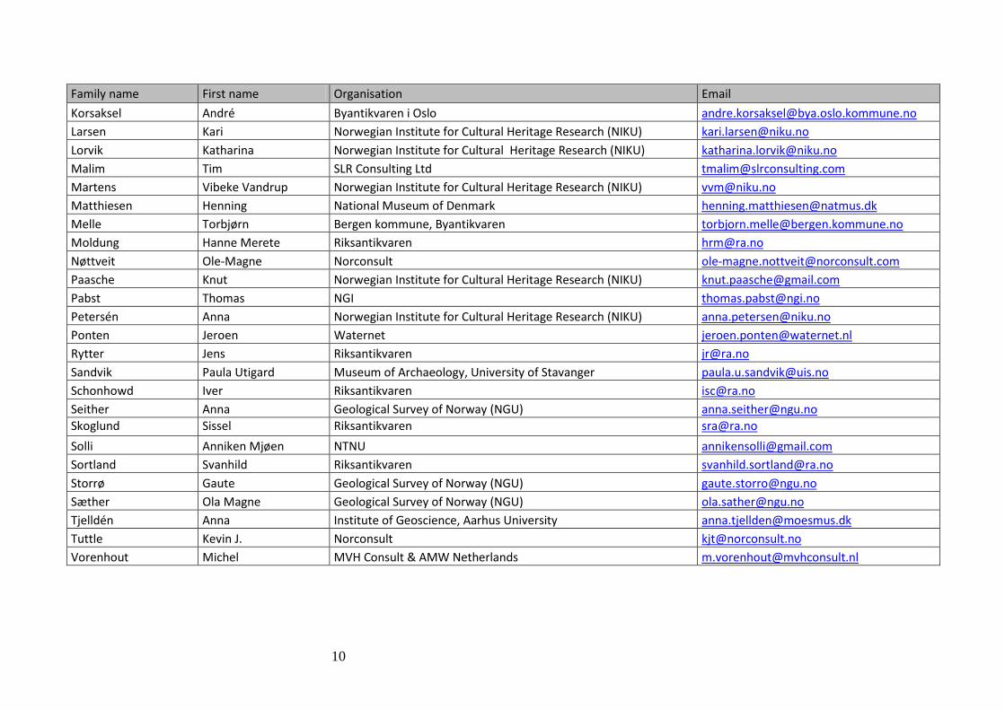
Family name First name Organisation Email Korsaksel André Byantikvaren i Oslo [email protected] Larsen Kari Norwegian Institute for Cultural Heritage Research (NIKU) [email protected] Lorvik Katharina Norwegian Institute for Cultural Heritage Research (NIKU) [email protected] Malim Tim SLR Consulting Ltd [email protected] Martens Vibeke Vandrup Norwegian Institute for Cultural Heritage Research (NIKU) [email protected] Matthiesen Henning National Museum of Denmark [email protected] Melle Torbjørn Bergen kommune, Byantikvaren [email protected] Moldung Hanne Merete Riksantikvaren [email protected] Nøttveit Ole-Magne Norconsult [email protected] Paasche Knut Norwegian Institute for Cultural Heritage Research (NIKU) [email protected] Pabst Thomas NGI [email protected] Petersén Anna Norwegian Institute for Cultural Heritage Research (NIKU) [email protected] Ponten Jeroen Waternet [email protected] Rytter Jens Riksantikvaren [email protected] Sandvik Paula Utigard Museum of Archaeology, University of Stavanger [email protected] Schonhowd Iver Riksantikvaren [email protected] Seither Anna Geological Survey of Norway (NGU) [email protected] Skoglund Sissel Riksantikvaren [email protected] Solli Anniken Mjøen NTNU [email protected] Sortland Svanhild Riksantikvaren [email protected] Storrø Gaute Geological Survey of Norway (NGU) [email protected] Sæther Ola Magne Geological Survey of Norway (NGU) [email protected] Tjelldén Anna Institute of Geoscience, Aarhus University [email protected] Tuttle Kevin J. Norconsult [email protected] Vorenhout Michel MVH Consult & AMW Netherlands [email protected]

11
Presentations 14 May

12
Mapping, monitoring and modelling preservation conditions of cultural deposits
Henning Matthiesen, National Museum of Denmark The presence of water is of paramount importance for the preservation or degradation of organic archaeological remains, as will be demonstrated in many presentations at this conference. However, there are still some questions that haven’t been fully answered yet, such as:
˗ How wet is wet enough to preserve cultural deposits? ˗ How important is the water quality? ˗ How, and how much, can the preservation conditions be improved through mitigation?
This presentation will discuss how mapping, monitoring and modelling can contribute to our understanding of the preservation conditions and how we may estimate degradation rates for cultural deposits.

13
Groundwater and the in situ preservation of a medieval mound in the city of Vlaardingen, the Netherlands Michel Vorenhout, MVH Consult & Archeologische Monumentenwach, the Netherlands The medieval mound in the centre of Vlaardingen has a rich archaeological history. The lower end dates from the Roman period. Finds show excellent preservation status, even at higher elevations in the mound, and in all material classes. The very well preserved graves just below street surface show the archaeological potential of this site. The mound is several meters higher than the surrounding area, making it special for the Netherlands. The presence of such well preserved organic remains suggested that the soil was anaerobic, causing slow degradation rates. A study was started in 2011, alongside a geo-archaeological study on the build-up of the mound, to find the reasons for the good preservation. This study included measuring of groundwater levels in boreholes, permanently installed dip-wells with logging, visual descriptions of large diameters soil cores, permanent redox potential measurements and modelling of the build up of the mound. The results showed that the anaerobic conditions were found at undeep levels. The groundwater table was at the level of the organic layers, showing the link between wet conditions and preservation in situ. The cause of this relative high groundwater table is thought to be a combination of high infiltration of rain water at street level, and low flowthrough of the groundwater. The results were used to create a local set of rules for developments and building activities, making sure the base conditions will not influence the high water content of this mound.

14
The decay and corrosiveness of materials in archaeological artifacts
Ola Magne Sæther, NGU The deterioration of a substance by environmental constituents is referred to as decay, whereas corrosion is usually restricted to the attack on metals by the environmental agents. Of interest in archaeology is the stability of all kinds of materials in artifacts in the aqueous environment, where we encounter solid(s), liquid(l), gaseous(g) and aqueous(aq) phases of reactants and products of a wide range of chemical reactions. The reactions are thermodynamically spontaneous when the free energy of the overall reaction is negative. All types of chemical reactions in the aqueous environment can be classified in pH versus Eh (or pe) diagrams (Pourbaix 1956, Baas Becking 1964). Along the pH-axis is plotted the negative logarithm of aH+ (measured by a pH-electrode) and along the pe-axis the negative logarithm of ae- (measured by platinum electrode in mV). The chemical properties of metals are related to their tendency to lose outer shell electrons, generally by donating them to atoms of O, S, Cl, and C. Wood and organic matter is best preserved under conditions where insects, beetles, and fungi cannot survive, i.e. under extremely dry, cold, or wet conditions. In marine sediments wood is best preserved in pore waters with reduced levels of oxygen (O2), usually referred to as anoxic or stagnant waters. Parameters which are good indicators of such conditions are O2(g), S2-
(aq), pH, and pe. Burnt wood, i.e. charcoal, is resistant to decay under atmospheric or hydrospheric conditions. Flint or chert, i.e. cryptocrystalline quartz (SiO2) found as artifacts is stable in aqueous environments of pH < 9 and independent of pe-level as Si4+ is not an electron donor at surface conditions (P= 0.5-1 atm and T=220-320K). However, in alkaline waters with pH > 9 the solubility of amorphous silica increases significantly, especially in the presence of fluoride. Animal bones and teeth of different compositions consist partly of apatite which may decay by ion-exchange. Bone marrow in root canals act as a conduit for water, but also for insects, beetles, fungi seeking accessible forms of C, Ca and P.

15
Modelling water content and soil temperature in unsaturated urban archaeological deposits Anna Seither, NGU Henning Matthiesen, National Museum of Denmark The preservation conditions of cultural deposits and artefacts at the World Heritage Site of Bryggen in Norway are strongly influenced by the water content of the respective soil layers. Concerns regarding the degradation rates of these underground archaeological archives have driven the development of a soil infiltration model that predicts soil temperature and water content. A one-dimensional water balance model (CoupModel) is used to simulate soil water dynamics in a soil profile at the rear of Nordre Bredsgården at Bryggen. Local precipitation, air temperature data, and measured soil characteristics serve as input data. The basic structure of the model is a depth profile consisting of 9 distinct horizons, two of which are cultural deposits. Unit-gradient flow and a fixed water table were defined as lower boundary conditions. The hydraulic properties are described by the Brooks & Corey equations with parameters representing soils from the textural classes sand, loamy sand, sandy loam, and loam. Missing parameters regarding the cultural layers were substituted by corresponding values from peat soils. Results from continuous logging of soil temperature and water content in 2011 are currently used to calibrate the model. Subsequently, the model will be validated by comparing model predictions with field data obtained in 2012. The current model successfully simulates temperature variations in the soil profile. However, the simulated water contents as well their variability over time are generally underestimated. These constraints are presumably caused by the limited amount of soil physical measurements. Nevertheless, the preliminary results indicate that the model will be a valuable tool to evaluate preservation conditions and predict the degradation rates of the cultural layers at Bryggen.

16
In situ preservation in the unsaturated zone: case Avaldsnes Vibeke Vandrup Martens, NIKU The past couple of years, attempts have been made to transfer systems of monitoring archaeological deposits outside the medieval towns. This paper intends to present the preliminary results of the past two years' investigations at Avaldsnes, Karmøy, Rogaland. The intention is to discuss methods of measuring directly in soil, as most sites with preserved archaeological deposits outside and even to a large extent within the medieval towns are in the unsaturated zone and thus require different tools and methods for measuring relevant parameters.

17
Geophysical electrical resistivity methods to characterize and monitor archaeological sites Ester Bloem, Bioforsk Perrine Fernandez, Bioforsk, UMB Helen French, Bioforsk, UMB Many archaeological structures are still buried in the subsurface and these may be threatened by careless design and construction of modern infrastructure. In order to preserve these valuable archaeological structures it is important to characterize these sites carefully as well as monitor them in the long term as soil, water, and temperature conditions might change over time. Over the recent years the use of geophysical techniques has become more widespread in order to characterize geological and archaeological structures, monitor hydrogeological (hydrogeophysics) and biological (biogeophysics) processes, and to monitor environmental problems at the field scale. These techniques can provide information about the physical properties of larger volumes of the subsurface than traditional soil/soilwater sampling techniques and are cost-efficient. Although these techniques are very promising with regards to cost efficiency and the spatial versatility (three-dimensional instead of point measurements), the techniques give quantitative information, but absolute levels often need to be fixed by ground truth (i.e., local, point measurements at the scale of geophysical method resolution). Therefore integration of invasive and non-invasive methods combined with modelling provides a way forward on how to monitor and increase understanding of site characterization, and soil and groundwater processes. Traditional soil and soil-water sampling techniques have the disadvantage that they only represent point measurements while geophysical methods can provide a continuous picture of the subsurface as well as cover large areas or volumes. In the geo-archaeological field geophysical methods like ground penetration radar (GPR) and electrical resistivity (ER) methods are promising methods for resolving buried archaeological structures in both rural as well as urban areas. These techniques are able to unlock geo-archaeological information: to characterize archaeological sites, to reconstruct the natural and cultural landscape, and by their non-invasive character preserve the structures at the same time. Continuous time-lapse geophysical monitoring techniques which are integral parts of hydrogeophysics and biogeophysics have greatly improved our understanding of soil and groundwater processes. These methods and knowledge can also help to preserve archaeological structures. The presentation will show how electrical resistivity methods can be used to characterize and monitor archaeological sites. Examples from the literature and case studies where electrical resistivity methods have been used successfully will be given.

18
Cultural deposits and the local water balance, examples from Bryggen in Bergen, Norway Nils-Otto Kitterød, UMB The purpose of this study was to examine the impact of a planned tunnel construction on the local groundwater level at Bryggen in Bergen. The groundwater level is a function of infiltration rates, transmissivity, and boundary conditions. These variables were deduced from available data and supplemented by leakage measurements into the existing railway tunnel located upstream of the Bryggen area. Previous studies have documented that the pore water in the deposits at Bryggen has different origin (viz fresh precipitation; leakage from drainage systems; infiltration of seawater; and infiltration via the bedrock). The catchment of Bryggen is characterized by variable topography (from sea level to about 500 m a.s.l.) and steep gradients. Major parts of the catchment have very sparse sediment cover and can be considered as exposed bedrock. The major sediment volumes are deposited close to the sea front. In the upper part of the catchment, the groundwater level in the bedrock is close to the surface. Some observations indicate that boreholes located in lower part of the catchment have artesian pressure, which implies that there is a groundwater flux from the bedrock and into the sediments. Based on this conceptual model, a numerical model was constructed where the seawater was the boundary condition at one side and the groundwater divide on the other side. Transmissivities in the bedrock were deduced from pumping analysis, and steady state infiltration rates was calibrated to give simulated groundwater levels that were consistent to observations. Given these model simplifications, it was possible to calculate a groundwater level in the sediments at Bryggen were all water into the sediments came from the bedrock only. The simulated groundwater level captured roughly the observed groundwater levels. After simulation of the natural groundwater level (i.e. without any artificial extraction of water in the catchment), the impact of the water leakage into the existing tunnels was calculated. Given the relatively rough estimates on water leakage into existing tunnels (4 litre/day/tunnel meter), the calculated decline of the groundwater table was about 1% of the natural groundwater table (less than 1 cm). If leakage rates were increased to one and two orders of magnitude, the steady state groundwater decline would be from 5% to more than 35% of the natural groundwater level (4 - 15 cm). The reason for this relatively robust groundwater conditions in the sediments are the boundary conditions: Without any local water sinks in the deposits, the steady-state groundwater table at Bryggen will always be higher than the seawater level. The crucial point in this study was the leakage rates into the existing tunnels, which is highly recommended to monitor before any new tunnel constructions are carried out

19
Damage to the wooden foundation of Amsterdam by climate change Jeroen Ponten, Waternet, the Netherlands Amsterdam is built on wooden piles. It is important that this wooden foundation always remains sufficiently under water in order to prevent damage to it. The average water cover must be enough to allow for seasonal fluctuations in ground water levels. The amount of precipitation and the periods in which it falls are changing due to climate change and this affects ground water levels. The relationship between ground water levels, depth of foundations and climate change is continually studied and monitored by the City of Amsterdam. The most important questions here are: ‘What are the consequences of climate change for ground water levels in a period of drought?’ and ‘Is the water cover sufficient in a period of drought?

20
Preservation conditions for archaeological remains in wetlands – an interaction between cultural heritage and biodiversity Anna K. E. Tjelldén, Aarhus University Denmark Søren M. Kristiansen, Aarhus University Denmark The in situ preservation of archaeological remains is globally challenged by changes in soil chemistry and physical disturbance arising from climate change, intensified agricultural cultivation and continuing soil acidification due to air pollution [1]. For centuries, wetlands have preserved rich prehistoric sites but now these lands have been drained and become multifunctional, leading to deterioration in preservation conditions [2].
The aim of this project is: i) to develop an interdisciplinary understanding of how new landscape managing initiatives for wetlands are effecting our in situ preserved cultural heritage, and ii) how in situ preservation strategies and monitoring can be implemented while, at the same time, optimising the biodiversity and recreational values of the landscape.
Two Danish Iron Age wetland sites, located in the valley Illerup Ådal (56⁰03’N; 9⁰55’E), have been selected as study sites due to their rich content of in situ archaeological finds, comprised of metal, bone and wood. The first covers c. 60% of a 100,000 m2 Iron Age sacrificial war booty site, where several thousand objects are expected to be found in situ. A pilot monitoring project carried out in 2008-09 into the in situ preservation status of the site demonstrated a critically low groundwater table, the presence of enriched road-salt-derived chloride and the growth of grey willow (Salix cinerea) [3].The second site is a recently excavated Iron Age sacrificial area in the valley containing the remains of an unknown number of mutilated warriors. The area was drained in 1956 in order to streamline agricultural usage and this most likely resulted in oxidation of the skeletal material, but the scientific value of the site was first appreciated only recently.
Monitoring of the environmental threats is projected, beginning with a risk analysis aimed at optimising the biodiversity of the landscape. Focus on the archaeological remains will be through a combination of geological, biological and archaeological sciences.
The following methods will be employed: - Geophysical survey combined with hand augering. Measurement of fluctuations in
water level, water chemistry and in situ pH. - Estimation of the risk of object penetration from plant roots and mapping of ecosystem
services, landscape maintenance and criteria for optimising biodiversity. - Implementation of environmental changes regarding vegetation type, emission of
nutritional components and water-level changes. References
[1] Daly, C. 2011, Climate Change and Conservation of Archaeological Sites: A Review of Impacts Theory, Conservation and Management of Archaeological Sites, Maney Publishing, 13, 4, 293-310. [2] Holden, J., West, L.J., Howard, A.J., Maxfield, E., Panter, I., Oxley, J. 2006, Hydrological controls of in situ preservation of waterlogged archaeological deposits, Earth-Science Reviews 78, 59-83. [3] Tjelldén, A., Kristiansen, S.M. & Botfeldt, K. 2012, “In situ preservation of the weapon sacrifice in Illerup Ådal – an estimation of the preservation conditions in the northern part of the sacrificial bog in 2009, Preserving Archaeological Remains In Situ: proceedings of the 4th conference, 23-26 May, 2011 Copenhagen (PARIS4), Conservation and Management of Archaeological Sites, Maney Publishing, 14, 1/2, 150-158.

21
In-situ redox situation: a tool to protect archaeological structures Perrine M. Fernandez, UMB Esther Bloem, Bioforsk Ove Bergersen, Bioforsk Helen K. French, UMB, Bioforsk In Norway many archaeological structures consists of layers of wood and other organic material. Hence, preservation of these layers is most optimal when conditions are anaerobic because this reduces the degradation rates. Subsurface archaeological site conservation starts with the characterization of the subsurface environment and understanding the in-situ redox situation in this environment. The redox potential drives the degradation or the preservation of organic compounds, such as wood, tissue or bodies, and how the soil system is affected on long term. The redox potential is strongly linked to two factors; 1) the saturation level, diffusion of oxygen into saturated pores is a very slow process and 2) degradation of organic material which consumes oxygen and other electron acceptors. The underlying theory is that degradation potentially induced by modern construction site activities (due to for example lowering the water table) affects the water chemistry, gas release which may give a measureable response of the geo-electrical signature which potentially can be measured in time lapse measurements of electrical properties. The combination of measurements sensitive to gas release and geo-electrical properties combined with models describing the petrophysical relationships and theoretical bio-geo-chemical responses will provide quantitative information about the in-situ redox situation and might lead to improvement in term of protection of the cultural heritage represented by archaeological sites. This work will show examples of geo-chemical measurements in the soil water at some Norwegian archaeological sites and refer to state-of-the-art knowledge with respect to the potential for monitoring in-situ redox situations in general

22
Urban groundwater monitoring – a heritage support tool De Beer, J., Geological Survey of Norway (NGU) Donald, A., Geological Survey of Northern Ireland (GSNI) Campbell, S.D.G., British Geological Survey (BGS) Taugs, R., Hamburg Ministry of Urban Development and Environment, Geological Survey of Hamburg (GLH) Eriksson, I., City of Oslo Mielby, S., Geological Survey of Denmark and Greenland (GEUS) Dahlqvist, P., Geological Survey of Sweden (SGU) Heritage management in historic urban areas is dependent on the character of the shallow subsurface environment and the dynamic processes that are taking place in this environment, such as groundwater flow, quality, settling and degradation processes. The stability of the shallow subsurface of course affects the stability of monuments in direct way. In many cities in northern Europe, standing historic buildings and other infrastructure are founded on wooden or other organic foundations of different types (e.g. cow hides, sawdust). Conservation of wooden foundation structures is primarily dependent on the groundwater level that prevents access of oxygen and consequential rotting processes to occur. In addition, historic urban areas often contain extensive buried archaeological remains, also known as cultural deposits, consisting of highly organic, natural degradable strata. Cultural deposits of substantial volume are found both in modern (re)development urban areas, and below historic buildings. European agreements (e.g. Valetta Treaty) state that cultural deposits with a high intrinsic archaeological value should be preserved in-situ if possible. Preservation conditions and ground stability are strongly dependent on the presence or absence of groundwater, as well as variations of groundwater levels in time. Preservation of organic strata and organic foundations are also to a lesser, but not negligible, degree dependent on the chemical composition and temperature of groundwater. Knowledge of groundwater levels and fluctuations, chemical composition and temperature is thus necessary to adequately support understanding and management of archaeological sites. There are many good arguments to develop systematic groundwater monitoring networks in cities, and cultural heritage is one of them. The heterogeneity of the urban subsurface environment with ongoing constructions, (re)development processes and conflicting interests, requires development of new and adaptation of existing urban groundwater monitoring nets that are also designed to support heritage management. This poster gives an overview of existing groundwater monitoring in the partner cities of NAG-City with their main aims. For heritage management, an estimation of the potential heritage values that are or could be supported by systematic groundwater monitoring data is presented.

23
3D modelling of hydrogeological conditions between Akerselva and Youngstorget, City of Oslo Anniken Mjøen Solli, NTNU The Cultural Heritage Management Office in Oslo finds it important to conserve the 19th century buildings located in the middle of the city centre. Over the last years, there have been observed major settlement damages on several buildings. This is likely to be caused by a changed groundwater level, resulting in either settlements in clay or anthropogenic material, or decay of foundations made of wood. To take care of this cultural heritage it is necessary to have an understanding of the ground conditions, concerning the geological stratigraphy, groundwater level and groundwater flow. This is a master thesis to be done within the NFR project “Cultural Heritage and Water Management in Urban Planning" (Urban WATCH) and will be finished in May 2014. The area of investigation is chosen in cooperation with The Cultural Heritage Management Office in Oslo, and is bounded by Akerselva in the North and Youngstorget in the South. The goal of this thesis is to test 3D modelling as a tool for combining the (hydro)geology with the available information on buildings and infrastructure in the area. This will easily visualize the relationship between geology, groundwater conditions and infrastructure (both above and below ground) and be a valuable tool in urban planning. This will especially be of interest in the evaluation of settlements beneath buildings laying on clay or having their wooden foundations in a critical depth regarding the groundwater table. One important thing to figure out during this process is how much data are needed to give a good picture of the subsurface. Can the same conclusions be made with less data, and therefore be less time consuming? In a later part of the thesis, the cause of the buildings´ damages should be evaluated, a risk assessment on the further development and the potential for new damages should be made and any preventing measures must be considered. The 3D model visualizing the (hydro)geology in connection with infrastructure, will be made in the program GSI3D developed by the British Geological Survey.

24
Low cost microscreen multilevel groundwater samplers for monitoring changes in groundwater chemistry with depth under different geological conditions Atle Dagestad, Geological Survey of Norway (NGU) Oliver Kracht, Geological Survey of Norway (NGU) Depth specific groundwater samples are of vital importance to obtain information of hydrochemical stratification in the subsurface, and to get better understanding of natural weathering processes, hydrochemical evolution, groundwater flow conditions, in addition to contaminant transport. However, an everlasting issue in hydrogeological studies lies in the limited depth resolution in groundwater samples obtained from conventional observation or production wells. Groundwater samples taken from long screen intervals, and extraction of large water volumes, may often lead to vertical hydrodynamic mixing of groundwater with different hydrochemical signatures and conceal actual heterogeneity and hydrochemical stratification in the subsurface. In order to obtain more reliable information on vertical distribution of groundwater quality parameters the use of an appropriate multilevel sampling technique can be the optimal choice. Many different multi level water sampling systems have been proposed in hydrogeological science. However, the suitability of a specific multilevel sampler design is strongly dependent upon the intended application and local requirement. Other factors influencing the design are the geological conditions, available drilling techniques and economical limitations. NGU has during the last years gained experience in using various setups of self made small volume multi-level samplers with micro screens. These samplers have been used in various geological settings and different scientific issues, ranging from vulnerability studies of groundwater wells in coarse grained glaciofluvial deposits at Granli waterworks Kongsvinger municipality, to evaluation of preservation status of organic rich soils at the world heritage site at Bryggen, Bergen city. These multi-level samplers are made up of a series of PE tubing (Ø 5 mm) of different length, each connected to a separate microscreen of nylon mesh. During field installation the micro screens and tubing are successively attached to an aluminum profile and lowered into the open end hole drill casing. When all the micro screens are in place at wanted depth the casing is lifted and the micro screens are exposed and ready for sampling. Samples are taken using a multi channel peristaltic pump under low flow rates and up to 8 screen levels are simultaneously sampled to reduce possibility of cross vertical flow along the installation. Up to 10 individual screen levels have been installed in a casing as small as 5/4 inch using handheld drilling equipment which clearly demonstrates the flexibility of drilling techniques to be used during installation and the minimal volume of the sampler.

25
Presentations 15 May

26
The Bergen Way – Experiences with Cultural Heritage Management in an Urban Context Johanne Gillow, City of Bergen Bergen is probably not very different from other Norwegian cities when it comes to cultural heritage management. That being said, Bergen is probably the Norwegian city with the highest density of cultural heritage in a horizontal and vertical dimension. It is also believed to be the city where the most opinionated Norwegians reside. This can be a colourful and interesting backdrop for cultural heritage management. Cultural management in Bergen is practiced with division and collaboration between different managements; the local, regional and national level, using a range of different laws and regulations. Finding the path that gives the most efficient, and interesting, management is an exercise we continuously practice. We find that even though we have regulated most of our society, painstakingly adopting EU-regulations, there are still loopholes for the cultural heritage to fall through. Our job is to catch them, preferably before they fall. With this in mind, successful heritage management is very much a question of teamwork, everybody doing what they are best at. Examples of the challenges we meet are demonstrated clearly at the World Heritage Site, Bryggen, with the Light rail system being planned as we speak and not in the least our wonderful medieval city quarters in Vågsbunnen. Vågsbunnen is built on cultural deposits, still following the street pattern of the Middle Ages, and with several buildings as ancient as Bryggen, built after the great fire in 1702, and, as at Bryggen, some stone buildings that survived the fire. The last decade it has been possible to observe, with the naked eye, that the settlings are dramatic and maybe even accelerating. Obviously, then comes the unavoidable questions:
˗ How could this happen? ˗ Who is to blame?
˗ And what can be done?

27
Cultural Heritage and Water Management in Urban Planning Hans de Beer, NGU Kjell Harvold, NIBR Rory Dunlop, NIKU Norwegian cultural heritage management is generally known for its leading role with regards to in-situ preservation of archaeological deposits and protection of individual monuments and sites. However, Norwegian urban surface- and groundwater management is, from an international perspective, lagging behind on implementation of innovative sustainable solutions as well as improvement of legislative issues. This leads to tension in local planning systems – especially in urban areas. This paper reviews current policy, legislation and regulation and their practical application in Norwegian urban planning, and compares this with practices in the Netherlands and Denmark. This presentation will present the main policies on cultural heritage management, ground- and surface water management in Norway and the European Union and highlight some remarkable differences from the Netherlands and Denmark. The presentation will focus on elements in the legislative framework that are relevant for in-situ preservation of archaeological deposits in-situ and (indirectly) for cultural heritage objects above the surface, as the latter may be influenced by ground instability caused by adverse ground- and surface water management decisions.
28
Urban planning and cultural heritage – The northbound light-rail alignment from the centre of Bergen, Norway Ole-Magne Nøttveit, Norconsult AS Planning the northbound alignment of Bybanen, the Bergen light-rail system, from the centre of Bergen to the northern suburban area of Åsane (a distance of about 14 kilometres) is one of the most comprehensive urban planning projects undertaken in Bergen in recent years. A key issue in the assessment process is the rich preserved cultural heritage, both as monuments and standing buildings, as well as underground archaeological deposits. The preservation of the cultural layers, dating back to the early medieval period, is closely linked to stable groundwater conditions underneath the townscape. The deposits underground, together with numerous buildings and defined architectural milieus, forms an assemblage of cultural heritage of local, regional and international importance. Consequently, the consideration of the cultural heritage has been a leading premise in the process of planning the light rail alignment. The planning environment at Norconsult includes several disciplines, among them archaeology, art history and hydrogeology. These disciplines have been an integrated part of the planning process. Cultural layers have been assessed on a basis of archive research and archaeological reports. The building environment has been assessed and analysed based on a report from the Cultural heritage management office, City of Bergen. Considerations of prehistoric and underwater archaeology have also been carried out. Groundwater conditions have also been a part of the overall assessment. The work has been carried out in close cooperation with the relevant authorities of cultural heritage. It follows, as typical for this kind of reports, the methodology of Norwegian Handbook 140 for Environmental Impact Assessments. A great number of possible alignments have been proposed and evaluated. Many have been discarded, some of them partly due to archaeological, hydrogeological or heritage-related arguments. However, these disciplines constitute just a few of many subjects that are involved in this multidisciplinary planning project.
Considerations regarding cultural heritage, cultural layers and groundwater are complex and many-facetted. In Norway, there is a strong tradition that these issues should be handled by official authorities or under close supervision by such authorities. The present project is in accordance with this, but by including the cultural heritage competence in-house, Norconsult has been able to handle “cultural heritage challenges” in an early stage of the planning process, rather than carrying them along as “undetonated bombs” through the whole planning process.
However, the reception accorded to the final report remains to be seen; it is currently under final review and will be delivered in the near future.
29
Sustainable management of the World Heritage Site, Bryggen Ann Christensson, Riksantikvaren Rory Dunlop, NIKU Hans de Beer, NGU Henning Matthiesen, Nationalmuseet The Bryggen Project, Prosjekt Bryggen, is headed by Norway’s Directorate for Cultural Heritage, Riksantikvaren, which comes under and reports to the Ministry of the Environment. Following the introduction of the sustainability principle by the Brundtland Commission in 1987, one of the Directorate’s main priorities in recent times has been to strive for sustainable management of the nation’s cultural heritage, with particular regards to the world heritage sites. In the Report to the Storting “Leve med kulturminner, St.meld. nr. 16, 2004-2005”, archaeological deposits are classified as a non-renewable resource and thereby qualify for sustainable management. Riksantikvaren’s Strategic Plan for the Management of Archaeological Heritage and Cultural Environments 2011-2020 (Riksantikvaren 2011) contains a number of important premises. The following statements are taken from this plan: • The preservation of archaeological heritage and cultural environments with their
individuality and diversity, as part of the nation’s cultural heritage and in accordance with a holistic environmental and resource management.
• It is a national responsibility to safeguard these resources either by in-situ preservation or by archaeological excavation.
With greater awareness and knowledge we stand a much better chance of achieving the national target that the annual rate of loss of protected archaeological heritage should not exceed 0.5 %. Specific annual objectives for the World Heritage Site Bryggen itself have been defined, and one of the highest priorities ever since 2002 has been to develop methods of environmental monitoring designed to help safeguard the archaeological deposits beneath the historic buildings. These methods were to be as cost-effective and sustainable as possible, with a minimal amount of physical intervention in intact deposits. Thanks to excellent collaboration between specialists drawn from a range of disciplines, it can safely be said that these aims have been achieved. All the investigations carried out so far show that water is the key factor governing the survival of both the buildings and the underlying organic deposits. It is imperative that rain water be kept away from the buildings’ timber walls, so systems are now in place to collect the rain water and channel it into the ground in a controlled fashion, where it can help replenish the groundwater reservoir.
30
Sustainable management of humidity within in situ deposits in the medieval town of Trondheim, Norway
Anna Petersén, NIKU Medieval Trondheim was located on the eastern part of Nidarneset, a small peninsula on the river plain at the mouth of the river Nid on the southern shore of Trondheim fjord. The topographic conditions for medieval Trondheim differ from those of the other Norwegian medieval towns (notably Bergen, Oslo and Tønsberg), and the protected, historic part of Trondheim is unique in containing anthropogenic sediments which lie entirely in an unsaturated environment. A large proportion of these sediments contain wood and other types of organic material. The Directorate for Cultural Heritage (Riksantikvaren) and the Norwegian Institute for Cultural Heritage Research (NIKU) have different roles in the administration of cultural heritage sites. However, they cooperate in developing sustainable management and a scientific approach to research, as well as finding practical solutions aimed at securing stable preservation conditions for anthropogenic sediments that are vulnerable and sensitive to environmental changes, both chemical and mechanical. In this paper we present the results from recent interdisciplinary work on a number of archaeological investigations where analysis and monitoring of chemical parameters has been undertaken. We present basic parameters such as moisture, temperature and loss of ignition (LOI) in anthropogenic sediments from different parts of the medieval town, and discuss them in relation to the cultural-historical background as well as the challenges involved in meeting the demands of growth and exploitation in urban development. The key questions that will be addressed are, firstly, how to maintain the existing level of humidity in anthropogenic sediments that contain organic material, and secondly, how would the environmental conditions benefit if the level of humidity could be raised using modern technology?

31
Ladegårdsgaten in Bergen - the tunnel that did not cause settlements Amund Gaut, Sweco Norge AS Arne Instanes, Instanes Polar AS Werner Stefanussen, Sweco Norge AS Ladegården Street 64-76 in Bergen was built in 1921 on filled soil in a valley side near the river Mulelven. The river was some 20 years before placed in a culvert under the filled deposits. In the area, there was previously a system of dams, canals and mills; no one knows if parts of the ponds remain under the fill masses. During and after the building period, it became clear that the stability of the ground was less than expected, and over the years repeated repairs of building damages caused by settling of the masses were carried out. The property was last renovated in the mid-1990s. It was felt that the settlements then had stopped, and therefore the new settlements that took place in the early part of this century were unexpected. In 1998, Bergen municipality built a tunnel for water and wastewater only a few tens of meters from the nearest buildings in Ladegården Street. The local residents claimed that the groundwater drainage towards the tunnel had caused lowering of ground water in the soils, thereby creating new settlements under the building. The settlements were said to be due to both reduced pore pressure and the decomposition of organic material caused by oxidation. From the municipality's side, it was claimed that the groundwater level could never have been particularly high in the steep terrain. It was demonstrated that the leakage in the tunnel was considerably less than the natural drainage through soils towards the valley. In the Norwegian court system, the views of the residents were first upheld in the Tingretten (first court) only later to be overturned in the Lagmannsretten (second court). The Lagmannsretten’s judgment was the final ruling on the matter by the Norwegian court system. In the trial, it was also discussed whether erosion damage of the Mulelven culvert could have caused the settlements. The conclusion was that the problems were caused by the poor ground conditions under the building. This presentation does not discuss the question of erosion damage, but highlights the groundwater conditions in rock and soil around the tunnel.

32
Implementation of sustainable urban drainage systems to preserve cultural heritage Floris Boogaard, Delft University of Technology Hans de Beer, NGU Tone M. Muthanna, NTNU Preservation conditions for naturally degradable archaeological remains are strongly dependent on both water quality and the presence or absence of groundwater in particular (Van de Noort et al., 2001, Caple, 1996). Deterioration of archaeological material often occurs as a consequence of lowering of the groundwater level (Holden et al, 2006, 2009, De Beer and Matthiesen, 2008). A main goal at heritage sites as Bryggen in Norway is to establish a stable hydrological environment, so the site will be safeguarded for posterity. Green infrastructural solutions such as sustainable urban drainage systems (SUDS) facilitate restoration and upholding of the water balance, and thus support preservation of cultural deposits and contribute to sustain connected urban infrastructure. This is exemplified in this paper by the case of Bryggen in Bergen, Norway. Bryggen in Bergen is one of the oldest trading ports in northern Europe, and the location of one of the Hanseatic League’s four overseas offices. Monitoring of ground- and soil water quantity and quality as well as settling rates, has shown damaging settling rates at Bryggen in the last decade, caused by deterioration of underlying, man-made deposits (Jensen, 2010, De Beer 2005, 2008). SUDS as bioswales, IT drainage and rainwatergardens are planned and constructed to preserve this UNESCO World Heritage site. In preparation of the water management solutions, an indicative flood mapping using the “WOLK” tool (Boogaard, 2012). It delineated the current flows of surface water during high rainfall intensities. The results were used to locate intakes of surface water from the upstream area and identify possible locations for water management solutions, such as rainwater gardens. The following infiltration solutions have been designed and are currently under implementation: 1. A step-wise infiltration trench, with adjustable infiltration levels in individual sections. 2. Infiltration-type swales in small green areas behind the heritage buildings. 3. Rainwater garden as a buffer between the upstream urban area and the heritage site. 4. Direct shallow infiltration of rainwater from local downpipes. 5. Infiltration-transport pipes as a buffer between developed and historic areas.
Several workshops have taken place with stakeholders. The swales are implemented and monitored on the effect of the groundwater levels. In this paper the first results on quantity and quality effects are presented. Long-term predictions are derived from Dutch research where swales have been implemented for 20 years now.

33
Medieval groundwater spring and cultural layers in Tønsberg, Norway. Evaluation of their hydrogeological dependence and vulnerability Kevin J. Tuttle, Norconsult AS During the last decade, several railway and road tunnel projects have been planned and some implemented in and around Tønsberg. Great concern has been focused on the well-known Medieval groundwater spring, “Kjelleolla”, and the cultural layers near the wharf “Brygga”. This paper will present the sites and their cultural value along with the plans for tunnels that could alter the preservation of these sites. The paper will also describe the field tests and modelling exercises undertaken to assess the vulnerability of the sites, as well as discuss the hydrogeological conditions under which the sites have been preserved. Borehole tests, groundwater table monitoring, bedrock fracture mapping, tracer tests and water chemistry were used to characterise the hydrogeology near the "Kjelleolla" spring. Numerical modelling of the area simulated the decrease in spring discharge and the reduction in porewater pressure in scenarios for varying groundwater ingress. Results set the grounds for ingress-limits in tunnel and tunnel portal construction. The groundwater spring still flows even after two tunnels and a surface bedrock excavation have been constructed near the spring. Several numerical simulations of soil water content and groundwater level in cultural layers near "Brygga" were run in connection with future roads through the city of Tønsberg. The simulations were of 2-D profile models through Tønsberg. They were run to evaluate the possible effects after constructing either a tunnel or a road culvert upstream from the Brygga-area where the majority of the cultural layers are located. There was concern that the tunnel/culvert ingress of groundwater could lower the groundwater table, and thereby also the water content in the cultural layers. This would seriously decrease the preservation potential of the cultural layers where the groundwater had been affected. The results from the simulations and the hydrogeological conditions are discussed and general hydrogeological relationships are explained.

34
The sedimentological and hydrological background for two sacred springs from Bø in Telemark Harald Klempe, Telemark University College, Norway Bø in Telemark is located in South Norway around 50 km from the Oslo fjord. A branch of this fjord existed in the Bø area up to the middle of the Bronze Age around 1000 y BC. The Bø area is blessed with lots of Quaternary glaciofluvial deposits which are sources for many groundwater outflow areas seen in the field as huge seepage faces and springs. Two of these springs are named after St. Olav and these are the St. Olav’s spring and Olasbekk assumed to have been sacred springs. Bekk is in the Bø dialect synonymous with a spring. The wealthy Folkestad farmers used to give their horses water from the spring Olasbekk at the day before Christmas Eve. Close to St. Olav’s spring a stone with several cup marks has been found. When somebody was to die at the nearby farm they had to drink water from that spring. These two springs are to be found in the same area and in the same geological formation but from different aquifers. The aquifers have been surveyed by surface mapping, sound drillings, mini well tests, seismic, and GPR surveys. St. Olav’s spring is just a hole in the marine sediments from where the water is flowing out. From old days it is said about this spring that it never dries up and the water has a special quality. The aquifer is in a subglacial/subaquatic fan formed below the melting glacier and in front of the glacier. The fan is covered by a moraine consisting of three parallel ridges with a plain surface between. The moraine again is covered partly by glacial delta deposits and partly by marine sediments. It is a confined aquifer 5 – 7 m thick and 70 -100 m wide. The aquifer is located between 5 and 25 m below surface. A small watershed drains into the aquifer in an opening between the bedrock and the moraine and this is the only source for the groundwater. The length of the aquifer is 1 km and travel time for the water is around three years before it emerges from the spring. Olasbekk is from an aquifer formed in a depression in the moraine and is probably from a small unconfined aquifer in the glacial delta deposit fed just by precipitation on the surface. This spring is in a kettle hole formed as an amphitheatre. These two sacred springs are close to the sacred places at the nearby farm Gaara where two menhirs (large upright stones) and a boulder with eight cup marks have been found.

35
The hidden heritage at Nantwich and York: groundwater and the urban cultural sequence Timothy Malim, David Morgan, SLR Consulting Ltd, UK Ian Panter, York Archaeological Trust, UK This paper will describe the two phases of investigation into the conditions that have led to preservation of archaeological remains beneath the historic core of Nantwich and compare this to conditions in York. It will discuss the different types of monitoring employed and the relative merits between methodologies for monitoring key indicators. The continuation of conditions that have preserved organic remains beneath these two historic centres for over a thousand years are now subject to threat due to various causes from the impact of the modern world. Continued preservation will require a holistic approach from spatial planners, engineers, hydrologists and others, as archaeologists alone do not have sufficient influence or the remit to ensure that archaeological remains are preserved for future generations. The irony is that people visit and value historic urban centres because of their heritage, whilst economists and developers insist that development is essential to ensure the continued viability of these towns.

36
Suspended animation: the peculiar preservation conditions of the Must Farm – Flag Fen Bronze Age landscape Timothy Malim, SLR Consulting Ltd, UK David Morgan, SLR Consulting Ltd, UK Ian Panter, York Archaeological Trust, UK Since 2007 a monitoring programme for the internationally important timber platform at Hanson’s Must Farm clay extraction site has been developed and enhanced, whilst excavation within the footprint of the quarry have revealed outstanding preservation of organic remains. The 3000 year inundation and sedimentary sequence, and the 100 years recent development in this landscape, will be described along with the unusual preservation processes which have contributed to exceptional survival or archaeological remains. The results from Must Farm will be compared to the situation at Flag Fen, and the separate trajectories between a developer-funded project and a nationally protected monument will be discussed. This will explore the paucity of scientific evidence for the conditions of preservation and techniques for monitoring it, that presently exist for sites that lie in a tension saturated zone or perched water-table above the conventional understanding of a water-logged site. It will also discuss how challenge and review by peers is essential for a robust approach to ensuring management measures are appropriate, rather than relying on the knowledge and experience of a single individual or team.

Geological Survey of NorwayPO Box 6315, Sluppen7491 Trondheim, Norway
Visitor addressLeiv Eirikssons vei 39, 7040 Trondheim
Tel (+ 47) 73 90 40 00Fax (+ 47) 73 92 16 20E-mail [email protected] Web www.ngu.no/en-gb/
Norges geologiske undersøkelsePostboks 6315, Sluppen7491 Trondheim, Norge
BesøksadresseLeiv Eirikssons vei 39, 7040 Trondheim
Telefon 73 90 40 00Telefax 73 92 16 20E-post [email protected] Nettside www.ngu.no
NGUNorges geologiske undersøkelseGeological Survey of Norway