new zealand farm data standards irrigation and effluent ... · new zealand farm data standards...
TRANSCRIPT

New Zealand Farm Data Standards
Irrigation and Effluent Data
Standard Version 1.0
Don Wilson, Jenna Thornborough, Andrew Cooke 12 November 2015

- 2 -
Rezare Systems Limited, Waikato Innovation Park, Ruakura Lane, PO Box 9466, Hamilton 3240, New Zealand ph +64 7 857 0820 www.rezare.co.nz
Contents
1 Document Management ....................................................................................................... 5
1.1 Referenced Documents ................................................................................................. 5
1.2 Related Documents ....................................................................................................... 5
1.3 Latest Revisions ............................................................................................................. 5
1.4 Review of Standards ...................................................................................................... 5
2 Introduction .......................................................................................................................... 6
2.1 Overview ........................................................................................................................ 6
2.2 Outcome Statement ...................................................................................................... 6
2.3 Scope and Application ................................................................................................... 6
2.4 Interpretation ................................................................................................................ 7
2.5 Definitions and Abbreviations ....................................................................................... 7
3 Identification of Observations .............................................................................................. 7
3.1 Location Identification ................................................................................................... 7
3.2 Identification of Farm Entities ....................................................................................... 8
4 Irrigation and Effluent Observations and Attributes ............................................................ 9
4.1 Irrigation Equipment and Water Supply ........................................................................ 9
4.2 Production, collection, storage and treatment of effluent ........................................... 9
4.3 Irrigation and effluent application .............................................................................. 10
4.4 Soil attributes and observations .................................................................................. 10
4.5 Use of water by plants ................................................................................................. 10
4.6 Climatic and Weather Observations ............................................................................ 11
Appendix A Irrigation and Effluent Data Dictionary (Normative) ............................................ 12
A.1 Irrigation Equipment Attributes .................................................................................. 12
A.2 Irrigation Equipment Observations ............................................................................. 13
A.3 Irrigation Equipment Alert Observations .................................................................... 14
A.4 Water Supply Attributes .............................................................................................. 15

- 3 -
Rezare Systems Limited, Waikato Innovation Park, Ruakura Lane, PO Box 9466, Hamilton 3240, New Zealand ph +64 7 857 0820 www.rezare.co.nz
A.5 Water Supply Observations ......................................................................................... 16
A.6 Effluent Production and Collection Attributes ............................................................ 17
A.7 Effluent Production and Collection Observations ....................................................... 17
A.8 Effluent Storage and Treatment Attributes ................................................................. 18
A.9 Effluent Storage and Treatment Observations ............................................................ 19
A.10 Effluent Nutrient Observations ................................................................................... 20
A.11 Irrigation and Effluent Application Observations ........................................................ 20
A.12 Soil Moisture Attributes .............................................................................................. 21
A.13 Soil Moisture Observations ......................................................................................... 22
A.14 Soil Nutrient Observations .......................................................................................... 23
A.15 Plants Use of Water ..................................................................................................... 23
A.16 Climatic and Weather observations ............................................................................ 23
Appendix B Lists of Enumerated Values .................................................................................. 25
B.1 Geometry Type ............................................................................................................ 25
B.2 Irrigation system type .................................................................................................. 25
B.3 Equipment Type........................................................................................................... 26
B.4 Irrigation Equipment Alert Type .................................................................................. 26
B.5 Water Source ............................................................................................................... 27
B.6 Source of Effluent ........................................................................................................ 27
B.7 Soil Moisture Test Method .......................................................................................... 27
B.8 Soil Texture .................................................................................................................. 28
B.9 Device Type ................................................................................................................. 29
B.10 Weather Metric ........................................................................................................... 29

- 4 -
Rezare Systems Limited, Waikato Innovation Park, Ruakura Lane, PO Box 9466, Hamilton 3240, New Zealand ph +64 7 857 0820 www.rezare.co.nz
Acknowledgements
Part funded by New Zealand dairy farmers through DairyNZ and the Ministry for Primary Industries through the Primary Growth Partnership funding to the Transforming the Dairy Value Chain. Part funded also by the Red Meat Profit Partnership through its Primary Growth Partnership with Ministry for Primary Industries, Alliance Group, ANZCO Foods, ANZ Bank, Beef and Lamb New Zealand Limited (representing sheep and beef farmers), Blue Sky Meats, Greenlea Premier Meats, Progressive Meats, Rabobank, and Silver Fern Farms. Co-funding was provided by FarmIQ Systems Limited.
- 5 -
Rezare Systems Limited, Waikato Innovation Park, Ruakura Lane, PO Box 9466, Hamilton 3240, New Zealand ph +64 7 857 0820 www.rezare.co.nz
1 Document Management
1.1 Referenced Documents
Irrigation Code of Practice and Irrigation Design Standards, Irrigation New Zealand Inc and
Sustainable Farming Fund, March 2007
Irrigation Glossary Book 2, Irrigation New Zealand, 2013
Guide to Agricultural Meteorological Practices (GAMP) 2010 Edition (WMO-No.134) Updated in
2012 , World Meteorological Organisation
Guide to Climatological Practices WMO-No. 100 (third edition), Chapter 4 Characterizing Climate
from Datasets, World Meteorological Organisation
OGC® WaterML, Open Geospatial Consortium
1.2 Related Documents
Related standards documents to be published in 2014 on the Farm Data Standards website
include:
Stock Reconciliation Data Standard
Financial Data Standard.
1.3 Latest Revisions
The users of this standard should ensure that their copies of the above-mentioned documents are
the latest revisions. The latest version of this Standard will always be published at
www.farmdatastandards.org.nz.
1.4 Review of Standards
Suggestions for improvement of this document will be welcomed. Submit your comments using
the feedback mechanisms at www.farmdatastandards.org.nz.

- 6 -
Rezare Systems Limited, Waikato Innovation Park, Ruakura Lane, PO Box 9466, Hamilton 3240, New Zealand ph +64 7 857 0820 www.rezare.co.nz
2 Introduction
2.1 Overview
Pastoral farming is becoming a data rich activity. Most biophysical processes from soil nutrient
management to animal performance have both paper based and more organised data bases
recording status, productivity and intentions. There are a significant number of tools covering
livestock, nutrition and financial management1. Most of these require the user to re-enter data
from other sources and they overlap in functionality. It is probable that if data had been more
accessible their design would have better focussed on the service they undertook to provide.
Farmers will benefit from a highly innovative technology sector that delivers applications that are
simple to use and access, which source the information they need without impedance and deliver
value.
This document is part of a work stream focusing on Data Standards for interchanging land
information for agriculture. Work on this project commenced in early 2013, funded by DairyNZ
and with contributions from FarmIQ Systems and Rezare Systems.
2.2 Outcome Statement
Broad adoption of a common vocabulary and data dictionary for exchange of farm information will
result in farmers and other industry parties entering data only once and having that data readily
accessible for populating multiple decision-making systems. As a result, industry and individual
farm businesses will be better placed to undertake systems analysis to inform management
practice. More accurate and structured interchange of farm data will also support industry
breeding objectives and other information system targets.
2.3 Scope and Application
This standard addresses the following areas:
1. Irrigation equipment and water supply
2. Production, collection, storage and treatment of effluent
3. Irrigation and effluent application
4. Characteristics of soil focusing on those related to soil moisture
5. Use of water by plants
1 Wolfert, S and Allen, J. Farming for the future: Towards better information-based decision-making and communication. 2011. A Report for the Centre of Excellence in Farm Business Management pp 27.

- 7 -
Rezare Systems Limited, Waikato Innovation Park, Ruakura Lane, PO Box 9466, Hamilton 3240, New Zealand ph +64 7 857 0820 www.rezare.co.nz
6. Climatic observations relevant to irrigation and the spreading of effluent
2.4 Interpretation
For the purposes of this standard, the word SHALL refers to requirements that are essential for
compliance with the standard, while the word SHOULD refers to practices that are advised or
recommended. The term MAY is used to distinguish a permissible or optional practice.
The terms ‘Normative’ and ‘Informative’ have been used in this standard to define the application
of the Appendix to which they apply. A ‘Normative’ Appendix is an integral part of a standard
while an ‘Informative’ Appendix is only for information and guidance.
2.5 Definitions and Abbreviations
For the purposes of this standard, the following definitions shall apply:
Term Definition
KPa Kilopascal is a unit of pressure
kW Kilowatt is a unit of power
m metre
psi Pound per square inch is a unit of pressure
3 Identification of Observations
This section focusses on the identification of the observations and attributes defined in this
standard. The identifier of the observation may be a location (such as of a farm or irrigation
scheme), a block or paddock within a farm, a transect or a geographic feature, a pond, a system or
piece of equipment.
3.1 Location Identification
A farm or irrigation scheme SHALL be defined as a location. The Animal Data Standard2 discusses
in section 3.1 the identification of locations or farms. It specifies a number of identifiers that are
accepted for property identification in New Zealand and supports the interchange of data using all
of these mechanisms. This Irrigation and Effluent Data Standard adopts the same location
identification.
A number of identifiers are accepted for property identification in New Zealand:
2 Animal Data Standard (http://www.farmdatastandards.org.nz/animal-data/)

- 8 -
Rezare Systems Limited, Waikato Innovation Park, Ruakura Lane, PO Box 9466, Hamilton 3240, New Zealand ph +64 7 857 0820 www.rezare.co.nz
Ministry of Primary Industry FarmsOnLine identifier;
NAIT Location identifier (one or more FarmsOnLine identifiers registered with NAIT)
AgriBase3 farm_id (based on a coordinate pair in lat/long, NZTM or NZMG coordinates)
EPCglobal Serialised Global Location Number4 (as used by the NZ Business Number
system); and
Herd Testing Location identifier using the NZMS1 (1939 to 1975) map grid reference.
For historic reasons it will be necessary to support the interchange of data utilising all of these
mechanisms. This standard therefore requires that location identifiers shall be prefixed with a
URN namespace identifier. Acceptable URN namespaces for use in New Zealand location
identifiers shall be:
urn:epc:id:sgln or
a nzl: registered location namespace.
For specific interchanges agreed between two parties, the parties may agree to exchange
identifiers within a single namespace only, and dispense with the namespace prefix.
3.2 Identification of Farm Entities
Entities within a farm such as blocks, paddocks, ponds, pieces of equipment may be identified by
the location identifier of the farm and by a string representing the name of the entity.
A geographic feature such as a point on a farm, a polygon defining an area where irrigation or
effluent is applied or the position of a transect may be defined using spatial representation.
Field Data Type and Notes
Data Format Enumeration: format of the data; e.g. KML, SHP, KMZ, WKT
Geometry Type Enumeration: see Appendix B.1 Geometry Type
Coordinate System String: a recognised coordinate system. An Authority is an organization that maintains definitions of Authority Codes. For example the European Petroleum Survey Group (EPSG)5 maintains a database of coordinate systems, and other spatial referencing objects, where each object has a code number ID e.g. EPSG::4326
3 AgriBase, AsureQuality (https://secure.asurequality.com/capturing-information-technology-across-the-supply-chain/agribase-database-for-new-zealand-rural-properties.cfm) 4 EPCglobal SGLN and GLN are defined at http://www.gs1.org/gdsn/standards 5 EPSG Geodetic Parameter Registry

- 9 -
Rezare Systems Limited, Waikato Innovation Park, Ruakura Lane, PO Box 9466, Hamilton 3240, New Zealand ph +64 7 857 0820 www.rezare.co.nz
4 Irrigation and Effluent Observations and Attributes
For the purpose of this Standard, an observation is the act or instance of viewing or noting a fact
or occurrence for some scientific or other special purpose. Thus an observation can include a note
or record of an activity carried out, an event that has occurred, or a measurement taken.
An attribute is a characteristic or inherent part of something. Some attributes will not change over
time. For example, characteristics of irrigation equipment are attributes. The maximum flow rate
of the equipment is an attribute whereas the flow rate is an observation – it is measured on a
specific date and time.
4.1 Irrigation Equipment and Water Supply
This section of the standard is concerned with:
The physical characteristics (attributes) and operational observations of the irrigation
equipment
Details of the irrigation water source and observations relating to use of water.
The identifier for these data may consist of the farm identifier and optionally an additional string
naming the equipment or the water supply respectively and/or a spatial representation identifying
its location. Examples of irrigation equipment include the irrigator, irrigation pump, transfer
pump, vat, water tank, agitator. Alerts on the equipment are additionally identified by the type of
the alert.
Observations regarding continuous monitoring of Water Supply (for example, flow rates) SHALL be
interchanged using the WaterML 2.06 standard.
For the data dictionaries refer to Appendices A.1 Irrigation Equipment Attributes, A.2 Irrigation
Equipment Observations, A.3 Irrigation Equipment Alert Observations, A.4 Water Supply
Attributes and A.5 Water Supply Observations.
4.2 Production, collection, storage and treatment of
effluent
The production and collection of effluent data defines the source of the effluent, the associated
volumes, the methods of removal and separation and the washing down of surfaces. These data
are identified by the farm identifier and optionally an additional string naming the storage facility
and/or a spatial representation identifying its location.
6 OGC® WaterML (http://www.opengeospatial.org/standards/waterml)
- 10 -
Rezare Systems Limited, Waikato Innovation Park, Ruakura Lane, PO Box 9466, Hamilton 3240, New Zealand ph +64 7 857 0820 www.rezare.co.nz
The storage and treatment of the effluent includes the parameters of the storage pond, the level
of nutrients involved and the treatment employed.
For the data dictionaries refer to Appendices A.6 Effluent Production and Collection, A.7 Effluent
Storage and Treatment Attributes, A.8 Effluent Storage and Treatment Attributes, A.9 Effluent
Storage and Treatment Observations and A.10 Effluent Nutrient Observations.
4.3 Irrigation and effluent application
Observations of irrigation and effluent application will be for a period or for a specific date. These
may identify the land where the substance is being applied and the rate at which it is applied.
The land areas affected may be identified by a farm identifier with optionally an additional string
naming the block(s) or paddock(s) receiving the application. Alternatively, the land areas may be
defined by a spatial representation.
For the data dictionary refer to Appendix A.11 Irrigation and Effluent Application Observations.
4.4 Soil attributes and observations
Soil data fields in the standard are particularly concerned with characteristics affecting soil
moisture. These observations will be for a specific date. Soil tests may be for a transect, block,
paddock or geographic feature which may be identified by a farm identifier with optionally an
additional string naming the area represented by the tests. Alternatively, the area may be defined
by a spatial representation.
The data fields in section A.12 are considered a proxy for formal descriptions of the soil that will
be able to be interchanged using the Australia-New Zealand Standard for Soils – SoilML.
For the data dictionaries refer to Appendices A.12 Soil Moisture Attributes, A.13 Soil Moisture
Observations and A.14 Soil Nutrient Observations.
4.5 Use of water by plants
This section of the standard concerns plants use of water. The subject of these observations may
be a transect, block, paddock or geographic feature which may be identified by a farm identifier
with optionally an additional string naming the area represented by the tests. Alternatively, the
area may be defined by a spatial representation. For the data dictionary refer to Appendix A.15
Plants Use of Water.
- 11 -
Rezare Systems Limited, Waikato Innovation Park, Ruakura Lane, PO Box 9466, Hamilton 3240, New Zealand ph +64 7 857 0820 www.rezare.co.nz
4.6 Climatic and Weather Observations
This section of the standard is for weather and climatic observations relevant to irrigation and the
spreading of effluent. Climatic observations are defined for a period and are expressed in a
generalised form to provide for different quantitative summary measures (total, mean, median,
minimum, maximum). Weather observations are for the current day defined by the observation
date. The subject of these observations the identified location.
For the data dictionary refer to Appendix A.16 Climatic and Weather observations.

- 12 -
Rezare Systems Limited, Waikato Innovation Park, Ruakura Lane, PO Box 9466, Hamilton 3240, New Zealand ph +64 7 857 0820 www.rezare.co.nz
Appendix A Irrigation and Effluent Data Dictionary
(Normative)
A.1 Irrigation Equipment Attributes
This data dictionary SHALL be used in developing messages for interchange of data concerned with attributes of the irrigation equipment.
Attributes Data Type Notes
Equipment identifier String: Name or identifier of equipment
Equipment type Enumeration: see Appendix B.3
Type of equipment or device
Change in head Float: KPa The effects of elevation and friction on the head, taken as the difference in pressure on the inlet vacuum gauge and the intake pressure.
Elevation change Integer: m The difference between the intake elevation and pump elevation.
Energy per unit volume Float: kW hour/m3 Amount of energy used to deliver a volume of water.
Friction loss Float: KPa Amount of pressure lost due to water
movement and turbulence.
Full load motor efficiency Float: % Efficiency of the irrigation pump motor when run at full load
Headworks efficiency Float: % Pressure loss through intake structure, pump and headworks (excluding pump pressure and elevation differences)
Hydraulic efficiency Float: % Pressure lost between the delivery (mainline entry) and discharge points (machine entry, hydrant, or take-off in drip‑micro systems), excluding variations in elevation.
Intake elevation Integer: m Surface level of the water supply.
Intake pipe internal diameter
Integer: mm Internal diameter of the irrigator intake pipe;.
Irrigation system type Enumeration: see Appendix B.2
Enumeration: The irrigation system in use.
Mainline entry elevation Integer: m Elevation at the exit point of the headworks.
Mainline entry pressure Float: KPa, bar, psi Pressure at the exit of the headworks.
Mainline exit elevation Integer: m Elevation at the exit point of the mainline.
Mainline exit pressure Float: KPa, bar, psi Pressure at the exit of the mainline.
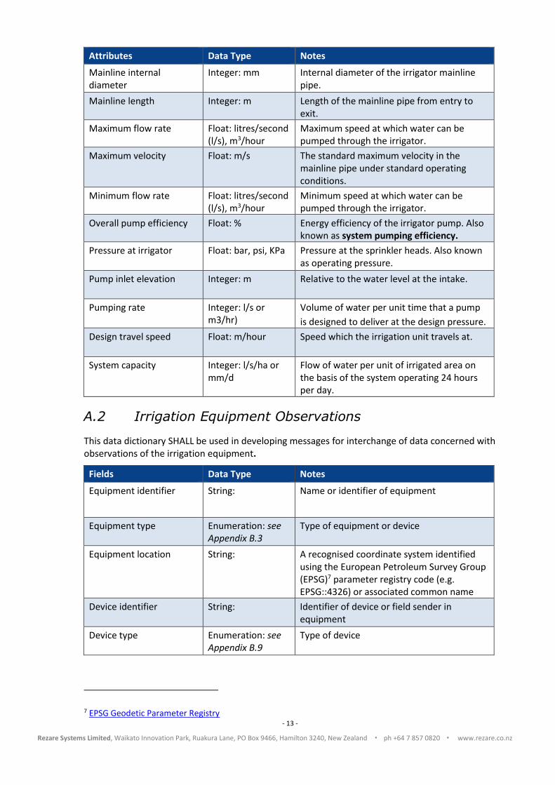
- 13 -
Rezare Systems Limited, Waikato Innovation Park, Ruakura Lane, PO Box 9466, Hamilton 3240, New Zealand ph +64 7 857 0820 www.rezare.co.nz
Attributes Data Type Notes
Mainline internal diameter
Integer: mm Internal diameter of the irrigator mainline pipe.
Mainline length Integer: m Length of the mainline pipe from entry to exit.
Maximum flow rate Float: litres/second (l/s), m3/hour
Maximum speed at which water can be pumped through the irrigator.
Maximum velocity Float: m/s The standard maximum velocity in the mainline pipe under standard operating conditions.
Minimum flow rate Float: litres/second (l/s), m3/hour
Minimum speed at which water can be pumped through the irrigator.
Overall pump efficiency Float: % Energy efficiency of the irrigator pump. Also known as system pumping efficiency.
Pressure at irrigator Float: bar, psi, KPa Pressure at the sprinkler heads. Also known as operating pressure.
Pump inlet elevation Integer: m Relative to the water level at the intake.
Pumping rate Integer: l/s or m3/hr)
Volume of water per unit time that a pump
is designed to deliver at the design pressure.
Design travel speed Float: m/hour Speed which the irrigation unit travels at.
System capacity Integer: l/s/ha or mm/d
Flow of water per unit of irrigated area on the basis of the system operating 24 hours per day.
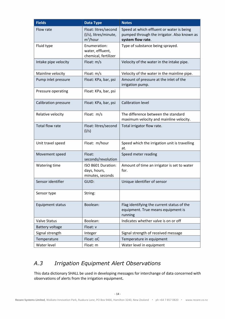
A.2 Irrigation Equipment Observations
This data dictionary SHALL be used in developing messages for interchange of data concerned with observations of the irrigation equipment.
Fields Data Type Notes
Equipment identifier String: Name or identifier of equipment
Equipment type Enumeration: see Appendix B.3
Type of equipment or device
Equipment location String: A recognised coordinate system identified using the European Petroleum Survey Group (EPSG)7 parameter registry code (e.g. EPSG::4326) or associated common name
Device identifier String: Identifier of device or field sender in equipment
Device type Enumeration: see Appendix B.9
Type of device
7 EPSG Geodetic Parameter Registry
- 14 -
Rezare Systems Limited, Waikato Innovation Park, Ruakura Lane, PO Box 9466, Hamilton 3240, New Zealand ph +64 7 857 0820 www.rezare.co.nz
Fields Data Type Notes
Flow rate Float: litres/second (l/s), litres/minute, m3/hour
Speed at which effluent or water is being pumped through the irrigator. Also known as system flow rate.
Fluid type Enumeration: water, effluent, chemical, fertilizer
Type of substance being sprayed.
Intake pipe velocity Float: m/s Velocity of the water in the intake pipe.
Mainline velocity Float: m/s Velocity of the water in the mainline pipe.
Pump inlet pressure Float: KPa, bar, psi Amount of pressure at the inlet of the irrigation pump.
Pressure operating Float: KPa, bar, psi
Calibration pressure Float: KPa, bar, psi Calibration level
Relative velocity Float: m/s The difference between the standard maximum velocity and mainline velocity.
Total flow rate Float: litres/second (l/s)
Total irrigator flow rate.
Unit travel speed Float: m/hour Speed which the irrigation unit is travelling at.
Movement speed Float: seconds/revolution
Speed meter reading
Watering time ISO 8601 Duration: days, hours, minutes, seconds
Amount of time an irrigator is set to water for.
Sensor identifier GUID: Unique identifier of sensor
Sensor type String:
Equipment status Boolean: Flag identifying the current status of the equipment. True means equipment is running
Valve Status Boolean: Indicates whether valve is on or off
Battery voltage Float: v
Signal strength Integer Signal strength of received message
Temperature Float: oC Temperature in equipment
Water level Float: m Water level in equipment
A.3 Irrigation Equipment Alert Observations
This data dictionary SHALL be used in developing messages for interchange of data concerned with observations of alerts from the irrigation equipment.

- 15 -
Rezare Systems Limited, Waikato Innovation Park, Ruakura Lane, PO Box 9466, Hamilton 3240, New Zealand ph +64 7 857 0820 www.rezare.co.nz
Fields Data Type Notes
Equipment identifier String: Name or identifier of equipment
Equipment type String: includes values in Appendix B.3
Type of equipment or device
Alert type Enumeration: see Appendix B.4
Type of alert issued by the equipment or device
Alert value Boolean:
A.4 Water Supply Attributes
This data dictionary SHALL be used in developing messages for interchange of data concerned with attributes of the water supply.
Attributes Data Type Notes
Drainage index Float: m3/ha/year Volume of water draining through the area irrigated.
Drawdown Float: m Difference between the static and pumping water level.
Flow rate Float: m3/s Flow rate of water from a pipe.
Maximum well flow rate Float: l/s Highest flow rate which a well can be pumped at.
Natural water storage volume
Float: m3 Amount of water naturally held by a reservoir.
Pump type Enumeration: Surface, submersible
Intended pumping water level
Integer: m Water level during pumping. Also known as dynamic water level.
Redistribution index Float: m3/ha/year Volume of water reaching the target area.
Typical water electrical conductivity
Float: decisiemens/metre (dS/m),
Salinity level of irrigation water reported as electrical conductivity.
Typical salinity Float: mg/l, parts per million (ppm)
Concentration of salts in the irrigation water reported as total dissolved solids
Expected seasonal water use
Float: mm/season Amount of water used for irrigation in a season;
Intended static water level
Integer: m Water level relative to the ground level when the well is not being pumped. Also known as standing water level

- 16 -
Rezare Systems Limited, Waikato Innovation Park, Ruakura Lane, PO Box 9466, Hamilton 3240, New Zealand ph +64 7 857 0820 www.rezare.co.nz
Typical stream velocity Float: m3/s Velocity of the flow of water in a stream or channel. Also known as channel velocity.
Total storage volume Float: m3 Total volume of a reservoir or dam.
Typical water lost Float: mm/season Typical amount of water lost to drainage and runoff.
Water source Enumeration: see Appendix B.5
Typical water use efficiency
Float: mm tonne/DM
Amount of water used in irrigation per tonne of dry matter produced.
A.5 Water Supply Observations
This data dictionary SHALL be used in developing messages for interchange of data concerned with observations of the water supply.
Fields Data Type Notes
Pumping water level Integer: m Water level during pumping. Also known as dynamic water level.
Redistribution index Float: m3/ha/year Volume of water reaching the target area.
Water electrical conductivity
Float: decisiemens/metre (dS/m),
Salinity level of irrigation water reported as electrical conductivity.
Salinity Float: mg/l, parts per million (ppm)
Concentration of salts in the irrigation water reported as total dissolved solids
Seasonal water use Float: mm/season Amount of water used for irrigation in a season;
Static water level Integer: m Water level relative to the ground level when the well is not being pumped. Also known as standing water level
Stream velocity Float: m3/s Velocity of the flow of water in a stream or channel. Also known as channel velocity.
Water lost Float: mm/season Amount of water lost to drainage and runoff.
Water use efficiency Float: mm tonne/DM
Amount of water used in irrigation per tonne of dry matter produced.

- 17 -
Rezare Systems Limited, Waikato Innovation Park, Ruakura Lane, PO Box 9466, Hamilton 3240, New Zealand ph +64 7 857 0820 www.rezare.co.nz
A.6 Effluent Production and Collection Attributes
This data dictionary SHALL be used in developing messages for interchange of data concerned with attributes of effluent production and collection.
Fields Data Type Notes
Depth of wash water Float: mm Depth of the water applied during wash-down.
Effluent removal method Enumeration: wash-down hoses, flood washing, scrapers
Method used to remove effluent from the area.
Effluent separation method
Enumeration: weeping wall, sludge bed, sump
Method used to separate solid and liquid effluent.
Source of effluent Enumeration: see Appendix B.6
Location where effluent is collected.
Effluent fluid state Enumeration: Liquid, slurry, solid
Wash water velocity Float: m/s Velocity at which the wash water is delivered.
Yard fall Float: %, m/m Slope of the wash-down area.
Yard area Integer: m2 Area of the wash-down area
A.7 Effluent Production and Collection Observations
This data dictionary SHALL be used in developing messages for interchange of data concerned with observations of effluent production and collection.
Fields Data Type Notes
Hours spent on collection areas
Integer: hours Number of hours each day that animals spend on effluent collection areas.
Animal species Enumeration: see Animal Data Standard Appendix A.1 Animal Characteristics
Species binomial name or common name
Number of animals Integer: Number of animals of species.
Effluent production rate Float: m3/day, l/animal/day
Amount of effluent produced in a time period.
Total daily water use Integer: litres/day (l/day), m3/day
Amount of water used to wash down surfaces which collect effluent

- 18 -
Rezare Systems Limited, Waikato Innovation Park, Ruakura Lane, PO Box 9466, Hamilton 3240, New Zealand ph +64 7 857 0820 www.rezare.co.nz
Fields Data Type Notes
Total effluent solids Integer: kg/animal/day
Total amount of solid effluent produced by an animal over a time period.
Total effluent volume produced
Float: l/animal/day Volume of effluent produced by an animal over a time period.
Diluted effluent volume Float: l/animal/day Volume of effluent which has been diluted with wash-water and other materials.
Undiluted effluent volume Float: l/animal/day Volume of undiluted effluent produced.
Wash-water volume Float: l/animal/day Volume of wash-water used per animal per day.
A.8 Effluent Storage and Treatment Attributes
This data dictionary SHALL be used in developing messages for interchange of data concerned with attributes of effluent storage and treatment.
Attribute Data Type Notes
Batter angle Float: degrees, radians
Angle between the top edge of the pond and the side of the pond.
Typical BOD5 Float: kg/animal/day
The biochemical oxygen demand of effluent over a 5-day period.
Primary nitrogen form Enumeration: organic, nitrate, ammonia
Nature of the effluent.
Effective liquid storage volume
Float: days, m3 Storage capacity for liquid effluent, represented as volume or a timeframe.
Effective solids storage volume
Float: m3 Storage capacity for solid effluent, represented as volume or a timeframe days.
Effluent storage type Enumeration: sump, settling pond
Type of storage used for effluent.
Loads per hectare Integer: loads per hectare
Number of loads of effluent required to cover a hectare of land.
Percentage unpumpable Float: % Percentage of the total volume which makes up the unpumpable area.
Pond capacity Float: m3 Volume of the effluent treatment pond.
Pond depth Integer: m Depth of the effluent treatment pond.

- 19 -
Rezare Systems Limited, Waikato Innovation Park, Ruakura Lane, PO Box 9466, Hamilton 3240, New Zealand ph +64 7 857 0820 www.rezare.co.nz
Attribute Data Type Notes
Pond floor size Float: m2 The area of the floor of the effluent treatment pond.
Pond surface area per animal
Float: m2/animal Area of pond per animal producing the effluent.
Storage volume Float: litres/animal/day
Volume of effluent storage facilities
Top area Float: m2 Area of the top of the effluent pond.
Total loads Integer: Number of loads of effluent required to cover a specified area
Total working volume Float: m3 Total working volume of the effluent pond.
Treatment method Enumeration: land application, treatment pond, constructed wetlands, barrier ditches
Unpumpable depth Float: m Depth of the effluent pond which cannot be pumped due to build-up of solids.
Volume of unpumpable area
Float: m3 Volume of the area of solids at the bottom of the pond.
A.9 Effluent Storage and Treatment Observations
This data dictionary SHALL be used in developing messages for interchange of data concerned with observations of effluent storage and treatment.
Field Data Type Notes
BOD5 Float: kg/animal/day
The biochemical oxygen demand of effluent over a 5-day period.
Limiting nutrient Enumeration: nitrogen (N), phosphorus (P) or potassium (K)
The nutrient present in the highest quantity in effluent which will liit how much can be applied.
Limiting nutrient concentration
Float: mg/l, g/m3 Concentration of the limiting nutrient in the effluent.
Freeboard height Integer: m Distance between the top of the pond and the waterline.
Percentage Freeboard Float: % Percentage of the total volume which makes up the freeboard.
Pond level % Integer: % Pond/tank level percentage
Flag pond high level Boolean: True = pond/ tank level is higher than high threshold

- 20 -
Rezare Systems Limited, Waikato Innovation Park, Ruakura Lane, PO Box 9466, Hamilton 3240, New Zealand ph +64 7 857 0820 www.rezare.co.nz
Field Data Type Notes
Flag pond low level Boolean: True = pond/ tank level is lower than low threshold
Volume of Freeboard Float: m3 Volume of the area between the top of the pond and the waterline.
pH Integer: A measure of the acidity or basicity of effluent
Solid content of diluted effluent
Float: % by weight Percentage of solids in diluted effluent.
Solid content of undiluted effluent
Float: % by weight Percentage of solids in undiluted effluent.
Storage period Integer: days, months
Period of time for which effluent has been stored between emptying events.
A.10 Effluent Nutrient Observations
This data dictionary SHALL be used in developing messages for interchange of data concerned with observations of effluent nutrients.
Field Data Type Notes
Nutrient Enumeration: Nitrogen (N), phosphorus (P) or potassium (K)
Nutrient captured Float: kg/cow/day of N, P or K
Amount of nutrient captured per animal per day.
Effluent Nutrient concentration
Float: mg/l of N, P or K
Concentration of a nutrient in effluent.
Nutrient produced Float: kg/animal/day of N, P or K
Amount of nutrient produced per animal per day.
A.11 Irrigation and Effluent Application Observations
This data dictionary SHALL be used in developing messages for interchange of data concerned with observations for irrigation and effluent application.
Fields Data Type Notes
Block name String: Name of block or paddock where irrigation or effluent is applied
Area feature Float: Reference to a geographic feature which a substance is being applied to; (described using an Open Geospatial standard)
Application area Integer: ha Area of land which the substance is being applied to. Also known as area or surface area.
Application depth Float: mm Depth of a substance applied to an area.

- 21 -
Rezare Systems Limited, Waikato Innovation Park, Ruakura Lane, PO Box 9466, Hamilton 3240, New Zealand ph +64 7 857 0820 www.rezare.co.nz
Fields Data Type Notes
Application rate Float: mm/hour Rate at which the substance is applied. Also known as application intensity.
Distribution uniformity Float: % Measure of how evenly a substance has been applied to an area.
Return interval Integer: days, hours
Interval between application events.
Maximum effective loading Float: kg/ha/year Maximum amount of the limiting nutrient which can be applied. Also known as maximum loading criteria.
Effluent Application Months
String: List of months in which effluent has been applied to areas
A.12 Soil Moisture Attributes
This data dictionary SHALL be used in developing messages for interchange of data concerned with attributes for soil moisture data relating to irrigation and effluent.
Fields Data Type Notes
Profile drainage class Enumeration: Well, Moderately well, Imperfect, Poor, Very poor
Hydrophobic condition Enumeration: Rain always soaks in, Generally soaks in occasionally runs easily off slopes, Mostly runs off unless there is a long period of gentle rain
Susceptibility to pugging Enumeration: Rare, Occasional, Winter, Winter or rain
Susceptibility to pugging or treading damage.
Drainage method Enumeration: None, Mole/tile system, Other
Artificial drainage system
Percentage of block drained
Integer: %
Field capacity Float: mm, millimetres per meter (mm/m)
Amount of water in the soil once drainage by gravity has stopped.
Infiltration rate Float: mm/hour Rate at which soil can absorb moisture.

- 22 -
Rezare Systems Limited, Waikato Innovation Park, Ruakura Lane, PO Box 9466, Hamilton 3240, New Zealand ph +64 7 857 0820 www.rezare.co.nz
Fields Data Type Notes
Permanent wilting point Float: mm, millimetres of water per meter of soil (mm/m)
Soil moisture content at which a plant will die from drought stress; also known as stress point.
Available water Float: mm, millimetres of water per meter of soil (mm/m)
Amount of water plants can extract from the soil, the difference in moisture content between field capacity and permanent wilting point.
Readily available water Float: mm, millimetres of water per meter of soil (mm/m)
Amount of water plants can extract from the soil before growth is limited due to the difficulty of extracting water; the difference in moisture content between field capacity and the stress point. Also known as plant readily available water.
Refill point Float: mm, millimetres of water per meter of soil (mm/m)
Point at which the soil water level needs to be topped up to avoid dropping to the permanent wilting point. Also known as trigger point.
Saturation point Float: mm, millimetres of water per meter of soil (mm/m)
Point at which the soil can no longer hold water.
Soil texture Enumeration: see Appendix B.8
Stone content of upper soil layer
Float: % Percentage of the upper soil layer which is stone.
Water holding capacity Float: mm, millimetres of water per meter of soil (mm/m)
Amount of water the soil can hold.
A.13 Soil Moisture Observations
This data dictionary SHALL be used in developing messages for interchange of data concerned with observations for soil moisture data relating to irrigation and effluent.
Fields Data Type Notes
Critical deficit Float: mm, millimetres of water per meter of soil (mm/m)
Difference between the current soil moisture content and the field capacity. Also known as soil moisture deficit.
Dry weight Float: mg Dry weight of soil.
Soil moisture test method Enumeration: type of test used to test soil moisture; see Appendix B.7
Soil temperature Float: oC Observed temperature of the soil.
Soil water content Float: mm, millimetres of
Amount of water currently in the soil.

- 23 -
Rezare Systems Limited, Waikato Innovation Park, Ruakura Lane, PO Box 9466, Hamilton 3240, New Zealand ph +64 7 857 0820 www.rezare.co.nz
Fields Data Type Notes
water per meter of soil (mm/m)
Volumetric soil moisture content
Float: V% Percentage of the soil which is made up of water.
Wet weight Float: mg Wet weight of soil.
A.14 Soil Nutrient Observations
This data dictionary SHALL be used in developing messages for interchange of data concerned with observations of soil nutrients.
Field Data Type Notes
Nutrient Enumeration: Nitrogen (N), phosphorus (P) or potassium (K), Sulphur (S)
Nutrient load Float: kg of nutrient/ha
Amount of a nutrient present in the soil.
Nutrient loss Float: kg of nutrient/ha
Amount of a nutrient which has been lost.
A.15 Plants Use of Water
This data dictionary SHALL be used in developing messages for interchange of data concerned with plants use of water relating to irrigation and effluent application.
Fields Data Type Notes
Average daily crop water use
Float: l/day Average amount of water consumed by crops
Crop factor Float: The ratio of the water requirements of a particular crop to that of a reference crop (usually average grass pasture).
Estimated crop water use Float: mm/day, mm/week
Amount of water used by a crop over a time period.
Root depth Float: mm, m depth of soil profile that has enough rooting density for extraction of available water.ciency
Transpiration Float: mm Amount of water which is lost to transpiration through plant leaves.
A.16 Climatic and Weather observations
This data dictionary SHALL be used in developing messages for interchange of data concerned with climatic observations affecting irrigation and the spreading of effluent.
Fields Data Type Notes
Duration ISO 8601 duration The period of the observation
Metric Enumeration: variable being
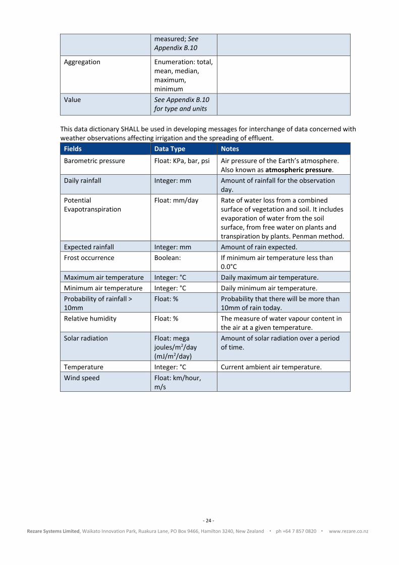
- 24 -
Rezare Systems Limited, Waikato Innovation Park, Ruakura Lane, PO Box 9466, Hamilton 3240, New Zealand ph +64 7 857 0820 www.rezare.co.nz
measured; See Appendix B.10
Aggregation Enumeration: total, mean, median, maximum, minimum
Value See Appendix B.10 for type and units
This data dictionary SHALL be used in developing messages for interchange of data concerned with weather observations affecting irrigation and the spreading of effluent.
Fields Data Type Notes
Barometric pressure Float: KPa, bar, psi Air pressure of the Earth’s atmosphere. Also known as atmospheric pressure.
Daily rainfall Integer: mm Amount of rainfall for the observation day.
Potential Evapotranspiration
Float: mm/day Rate of water loss from a combined surface of vegetation and soil. It includes evaporation of water from the soil surface, from free water on plants and transpiration by plants. Penman method.
Expected rainfall Integer: mm Amount of rain expected.
Frost occurrence Boolean: If minimum air temperature less than 0.0°C
Maximum air temperature Integer: °C Daily maximum air temperature.
Minimum air temperature Integer: °C Daily minimum air temperature.
Probability of rainfall > 10mm
Float: % Probability that there will be more than 10mm of rain today.
Relative humidity Float: % The measure of water vapour content in the air at a given temperature.
Solar radiation Float: mega joules/m2/day (mJ/m2/day)
Amount of solar radiation over a period of time.
Temperature Integer: °C Current ambient air temperature.
Wind speed Float: km/hour, m/s

- 25 -
Rezare Systems Limited, Waikato Innovation Park, Ruakura Lane, PO Box 9466, Hamilton 3240, New Zealand ph +64 7 857 0820 www.rezare.co.nz
Appendix B Lists of Enumerated Values
B.1 Geometry Type
Geometry Type may be used in spatial representations for geographic identification for a number
of observation types.
Valid values for Geometry Type are:
Point
LineString
Polygon
MultiPoint
MultiLineString
MultiPolygon
B.2 Irrigation system type
Irrigation System Type is used in the Irrigation Equipment observation.
Valid values for Irrigation System Type are:
border-strip
centre-pivot
drip (point source)
drip line
fixed boom (low pressure)
fixed boom (medium pressure)
hand shift
linear move
micro sprinkler
rotary boom
side roll
solid set sprinklers
travelling gun
- 26 -
Rezare Systems Limited, Waikato Innovation Park, Ruakura Lane, PO Box 9466, Hamilton 3240, New Zealand ph +64 7 857 0820 www.rezare.co.nz
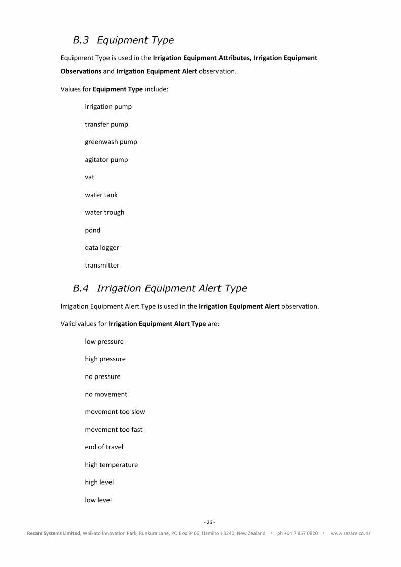
B.3 Equipment Type
Equipment Type is used in the Irrigation Equipment Attributes, Irrigation Equipment
Observations and Irrigation Equipment Alert observation.
Values for Equipment Type include:
irrigation pump
transfer pump
greenwash pump
agitator pump
vat
water tank
water trough
pond
data logger
transmitter
B.4 Irrigation Equipment Alert Type
Irrigation Equipment Alert Type is used in the Irrigation Equipment Alert observation.
Valid values for Irrigation Equipment Alert Type are:
low pressure
high pressure
no pressure
no movement
movement too slow
movement too fast
end of travel
high temperature
high level
low level

- 27 -
Rezare Systems Limited, Waikato Innovation Park, Ruakura Lane, PO Box 9466, Hamilton 3240, New Zealand ph +64 7 857 0820 www.rezare.co.nz
no signal
B.5 Water Source
Water Source is used in the Water Supply observation.
Valid values for Water Source are:
confined aquifer (groundwater)
water table aquifer (groundwater)
run-of-river surface water
stored surface water
B.6 Source of Effluent
Source of Effluent is used in the Effluent Production & Collection observation.
Valid values for Source of Effluent are:
dairy
feed pad
loafing pad
stand-off pad
winter barn
wintering pad
B.7 Soil Moisture Test Method
Soil Moisture Test Method is used in the Soil Moisture Characteristics observation.
Valid values for Soil Moisture Test Method are:
capacitance probe
electric resistance
gravimetric
neutron thermalisation
soil suction
soil thermocouple psychrometers
- 28 -
Rezare Systems Limited, Waikato Innovation Park, Ruakura Lane, PO Box 9466, Hamilton 3240, New Zealand ph +64 7 857 0820 www.rezare.co.nz
thermal dissipation methods
time domain reflectometry
time domain transmission
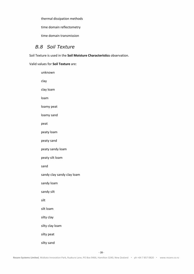
B.8 Soil Texture
Soil Texture is used in the Soil Moisture Characteristics observation.
Valid values for Soil Texture are:
unknown
clay
clay loam
loam
loamy peat
loamy sand
peat
peaty loam
peaty sand
peaty sandy loam
peaty silt loam
sand
sandy clay sandy clay loam
sandy loam
sandy silt
silt
silt loam
silty clay
silty clay loam
silty peat
silty sand

- 29 -
Rezare Systems Limited, Waikato Innovation Park, Ruakura Lane, PO Box 9466, Hamilton 3240, New Zealand ph +64 7 857 0820 www.rezare.co.nz
B.9 Device Type
Equipment Type is used in the Irrigation Equipment Observations
Valid values for Device Type are:
Devices:
pump controller
travelling irrigator monitor
k-line irrigator monitor
centre pivot irrigator monitor
Field Senders:
bore monitor
flow monitor
pond monitor
vat monitor
soil monitor
sump monitor
magflow monitor
pimstop monitor
tank monitor
B.10 Weather Metric
Metric is used in the Weather observation to identify the variable concerned.
Valid values for Metric and associated units are:
Metric Type Units
Rainfall Integer mm
Temperature Float °C
Maximum Temperature Float °C
Minimum Temperature Float °C

- 30 -
Rezare Systems Limited, Waikato Innovation Park, Ruakura Lane, PO Box 9466, Hamilton 3240, New Zealand ph +64 7 857 0820 www.rezare.co.nz
Soil Temperature Float °C
Wind speed Float Km/hour, m/s
Wind gust Float Km/hour, m/s
Wet days Integer Days
Relative humidity Float %
Barometric pressure Float KPa, bar, psi
Potential evapotranspiration
Float mm/day
Solar radiation Float MJ/m2/day
Frost occurrence Boolean
Day length Float hour