new mexico’s major reservoirs - utton centeruttoncenter.unm.edu/pdfs/water-matters-2012/16 - nm...
TRANSCRIPT
New Mexico’s Major Reservoirs | 16-1Water Matters!
New Mexico’s Major Reservoirs – An Overview
“Suffice it to say that there isno western water issue that sostrikes fear into the heart ofwestern water managers asthe issue of the federaloperation of dams andreservoirs on western rivers.There is also no issue that isso shrouded in the mystery ofarcane operating agreementsas are the operations of thesefacilities.”
Em Hall, Introduction,Natural Resources Journal,
Vol. 47, No. 3 (2007)
Rivers are the lifeblood of New Mexico. Most of the water in NewMexico’s rivers is managed through a highly engineered and regulatedsystem of dams and reservoirs. The impact of such water storage
facilities on rivers and their importance in extending and managing scarcewater supplies for human use and irrigation cannot be overstated. Theobjective is, of course, to capture surface water – snow melt and runoff fromrainfall – and release it for later use when needed downstream.
The state’s reservoirs store water for a number of different purposes: floodcontrol (generally water is released as soon as downstream conditions allow);conservation storage (storing the natural flow of the river for later use, usuallymunicipal or agricultural); power production; sediment control; fish andwildlife benefits; and recreation. Each storage dam and reservoir may haveseveral of these purposes; and for federal reservoirs, their purposes are strictlydefined by congressional authorizations. In recent years, the operations ofsome dams have been altered to reduce the impacts they may have on aquaticspecies and habitat.
This paper describes the salient facts about the major water storage reservoirsin New Mexico. For each reservoir, we address: the purposes of water storageallowed by law; storage capacity; the responsible operating agency; and somekey operational issues. This is by necessity a vast simplification of the topic.Books, articles, research reports, operation manuals, and other materials onthese topics run into the hundreds. Millionsof dollars have been spent on technicalstudies and computer models to understand,and sometimes alter, the operations of thevarious dams and reservoirs.
Each storage dam and reservoir may haveseveral of these purposes; and for federal
reservoirs, their purposes are strictly defined bycongressional authorizations.

16-2 | Water Matters! New Mexico’s Major Reservoirs
The goal here, however, is to provide legislators and others ashort, handy reference guide, to some of the more importantdams and reservoirs.
Small Reservoirs and Dams
The discussion in this paper is mostly limited to reservoirswhich have storage capacities of at least 20,000 acre-feet. Wedo not address details of numerous small reservoirs, some ofwhich play critical roles in water management. Such reservoirsmay hold irrigation water for irrigation districts or be used formunicipal purposes. They have been built with a variety offunding sources, usually local landowners and irrigators. Mosthave interesting operational features. (See box for severalexamples).
Examples of Small Reservoirs in New Mexico
McClure and Nichols reservoirs, in a canyon of the Santa Fe River, justabove the City of Santa Fe, are used for the Santa Fe municipal supply (theyhold 3,255 and 684 acre-feet respectively). The growing city also uses wellwater and is beginning to use San Juan-Chama water diverted from the RioGrande. They were both constructed after 1929 and all but 1,061 acre-feetof their combined storage is subject to Article VII of the Rio GrandeCompact (see below).
Bluewater Lake, on the western side of the state, is partially owned by theNew Mexico Department of Game and Fish and partially by the Bluewater-Toltec Irrigation Co. Storage levels vary widely depending upon snowmeltrunoff, monsoonal rainfall, and irrigation drawdowns, but the averagestorage is about 16,000 acre-feet. The concrete arch dam was built in 1927and was rehabilitated in the 1980s.
Bonito Lake, located in the Sierra Blanca range northwest of Ruidoso, wascreated by the Southern Pacific Railroad in 1931. It is owned and operatedby the City of Alamogordo. The dam and lake are in the Lower Pecos basin,while Alamogordo is in a different watershed, the Tularosa Basin. A 90-milepipeline carries water to Alamogordo and Holloman Air Force Base. Thelake holds about 3,000 acre-feet and annual quantities are split betweenAlamogordo and Holloman, with small amounts going to Carrizozo, Nogal,and Ft. Stanton.

New Mexico’s Major Reservoirs | 16-3Water Matters!
There are also hundreds of small floodcontrol dams that do not store water forbeneficial use, but instead are required torelease floodwater within a certain amountof time (typically 96 hours), or as soon asdownstream conditions safely allow. Suchdams are usually owned and managed bysoil and water conservation districts, andare currently the subject of muchdiscussion: many were built long ago toprotect farms and agricultural areas, andwere built using relatively low standards forthe design of their emergency spillways.Now, instead of fields, developedsubdivisions lie below many of them,necessitating upgraded spillways to meetcurrent dam safety standards. Theseupgrades will be expensive and there is aconsiderable debate about how to pay forthem. The owners of the dams, who hadno control over allowing the downstreamdevelopments to occur, cannot bear fullresponsibility. The Office of the StateEngineer estimates that there are 162deficient dams statewide and that $5million per year is needed for 10 years toaddress the upgrades. It is clear that astatewide assessment of dams is needed, aswell as a reasonable process in order to fundand prioritize upgrades to problem dams.
Interstate Compacts
A few of New Mexico’s rivers begin withinthe state and then flow into adjacentstates – the Canadian, Pecos, Gila, andseveral smaller streams. Other rivers,especially the Rio Grande and the San JuanRiver, flow into New Mexico fromColorado and then continue into otherstates. In both cases, agreements or“compacts” have been found necessary forthe equitable sharing of water.
New Mexico is party to eight interstatestream compacts:
Animas-La Plata Project Compact..(1968)
Canadian River Compact...............(1950)
Colorado River Compact ...............(1922)
Costilla Creek Compact.................(1946)
La Plata River Compact .................(1925)
Pecos River Compact .....................(1948)
Rio Grande Compact.....................(1939)
Upper Colorado River Basin Compact ..........................(1949)
Overview of Major Reservoirs
We begin upstream in the Rio GrandeBasin, since most of New Mexico’sreservoirs are located on the Rio Grandeand its tributaries. Then we address theCanadian and Pecos River basins. Theoverview ends with Navajo Reservoir,which is tributary to the San Juan and partof the Colorado River Basin. TheColorado River and Rio Grande basins areseparated by the Continental Divide.
It is clear that a statewide assessment of dams is needed, as well as a reasonable process in order to fund and prioritize
upgrades to problem dams.
We begin upstream in the Rio Grande Basin,since most of New Mexico’s reservoirs are
located on the Rio Grande and its tributaries.
16-4 | Water Matters! New Mexico’s Major Reservoirs
Rio Grande Basin
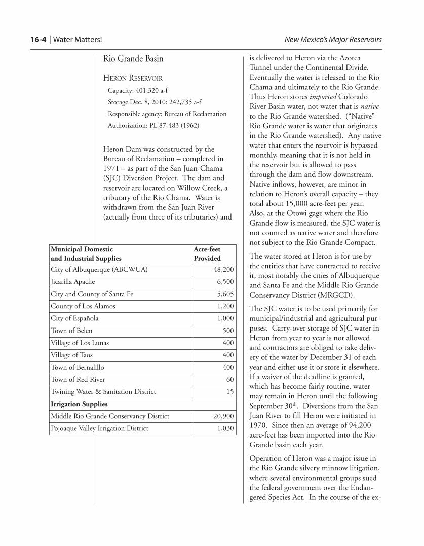
HERON RESERVOIRCapacity: 401,320 a-f
Storage Dec. 8, 2010: 242,735 a-f
Responsible agency: Bureau of Reclamation
Authorization: PL 87-483 (1962)
Heron Dam was constructed by theBureau of Reclamation – completed in1971 – as part of the San Juan-Chama(SJC) Diversion Project. The dam andreservoir are located on Willow Creek, atributary of the Rio Chama. Water iswithdrawn from the San Juan River(actually from three of its tributaries) and
Municipal Domestic and Industrial Supplies
Acre-feetProvided
City of Albuquerque (ABCWUA) 48,200
Jicarilla Apache 6,500
City and County of Santa Fe 5,605
County of Los Alamos 1,200
City of Española 1,000
Town of Belen 500
Village of Los Lunas 400
Village of Taos 400
Town of Bernalillo 400
Town of Red River 60
Twining Water & Sanitation District 15
Irrigation Supplies
Middle Rio Grande Conservancy District 20,900
Pojoaque Valley Irrigation District 1,030
is delivered to Heron via the AzoteaTunnel under the Continental Divide.Eventually the water is released to the RioChama and ultimately to the Rio Grande.Thus Heron stores imported ColoradoRiver Basin water, not water that is nativeto the Rio Grande watershed. (“Native”Rio Grande water is water that originatesin the Rio Grande watershed). Any nativewater that enters the reservoir is bypassedmonthly, meaning that it is not held inthe reservoir but is allowed to passthrough the dam and flow downstream.Native inflows, however, are minor inrelation to Heron’s overall capacity – theytotal about 15,000 acre-feet per year.Also, at the Otowi gage where the RioGrande flow is measured, the SJC water isnot counted as native water and thereforenot subject to the Rio Grande Compact.
The water stored at Heron is for use bythe entities that have contracted to receiveit, most notably the cities of Albuquerqueand Santa Fe and the Middle Rio GrandeConservancy District (MRGCD).
The SJC water is to be used primarily formunicipal/industrial and agricultural pur-poses. Carry-over storage of SJC water inHeron from year to year is not allowedand contractors are obliged to take deliv-ery of the water by December 31 of eachyear and either use it or store it elsewhere.If a waiver of the deadline is granted,which has become fairly routine, watermay remain in Heron until the followingSeptember 30th. Diversions from the SanJuan River to fill Heron were initiated in1970. Since then an average of 94,200acre-feet has been imported into the RioGrande basin each year.
Operation of Heron was a major issue inthe Rio Grande silvery minnow litigation,where several environmental groups suedthe federal government over the Endan-gered Species Act. In the course of the ex-
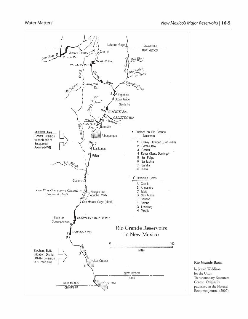
New Mexico’s Major Reservoirs | 16-5Water Matters!
Rio Grande Basin
by Jerold Widdison for the UttonTransboundary ResourcesCenter. Originallypublished in the NaturalResources Journal (2007).

16-6 | Water Matters! New Mexico’s Major Reservoirs
tensive litigation (1999-2010), federal dis-trict court Judge James Parker ruled thatthe Bureau of Reclamation has “discretion”to use agricultural and municipal con-tracted water from Heron to maintainminimum stream flows for the minnowand therefore should consider this waterwhen developing measures to meet the biologic needs of endangered species. Theentities for which the water was intended –Albuquerque and the MRGCD – arguedthat it was unfair and contrary to law fortheir contracted water to be taken for theminnow. In April, 2010, the 10th CircuitCourt of Appeals vacated the district courtruling as moot, because a new BiologicalOpinion had since been issued in 2003,setting out new flow requirements. Thelitigation has ended for now, but the issueis not resolved. The Middle Rio GrandeEndangered Species Act Collaborative Pro-gram is working hard to develop a recoveryprogram and avoid further litigation.
EL VADO RESERVOIRCapacity: 198,000 a-f (reduced bysedimentation to a current capacity of less than 190,000 a-f )
Storage Dec. 8, 2010: 102,307 a-f
Responsible agency: Bureau of Reclamation
Authorization: 1927 Conservancy Act, NMSA§ 73-14-1 to 73-14-88; Act of 1928, 45 Stat.312 (appropriating federal funds to pay forPueblos’ share of Conservancy works)
El Vado Dam and reservoir were built aspart of the Middle Rio GrandeConservancy District (MRGCD) works in1935. The Bureau of Reclamationrehabilitated the dam in the 1950s andstorage rights were assigned to Reclamationin 1963. El Vado is primarily used to storenative Rio Chama flows for use by theMRGCD for irrigation. It is the reservoirwhere the Bureau of Reclamation stores“prior and paramount” water for the sixMiddle Rio Grande Pueblos: Kewa (SantoDomingo), Cochiti, San Felipe, Santa Ana,Sandia, and Isleta. It also playedprominently in the minnow litigation, andanother unresolved issue is that both theMRGCD and the Bureau of Reclamationclaim title to the works of the Middle RioGrande Project, including El Vado.
The basic concept in operations at El Vadoinvolves the storage of natural inflow thatexceeds current MRGCD irrigationdemand. As one of the few reservoirsconstructed after 1929 that stores nativeRio Grande water, El Vado is subject toArticle VII of the Rio Grande Compact.Typical operations include filling thereservoir as much as possible during springrunoff and drawing it down during theirrigation season. El Vado is operatedduring the irrigation season to pass all thenatural flow of the Rio Chama up to 100cfs, in order to provide water for the RioChama acequias. After the end of the year,and when it is determined how much
El Vado reservoir is where the Bureau ofReclamation stores “prior and paramount”water for the six Middle Rio Grande Pueblos:Kewa (Santo Domingo), Cochiti, San Felipe,Santa Ana, Sandia, and Isleta.
New Mexico’s Major Reservoirs | 16-7Water Matters!
ABIQUIU RESERVOIRCapacity: 183,099 a-f of SJC storage
• Primarily for ABCWUA, but small amounts are leased to other SJC contractors
• 551,000 a-f flood and sediment control
Storage Dec. 8, 2010: 182,996 a-f
Responsible agency: Corps of Engineers
Authorization: Flood Control Act of 1948, PL 81-858; Flood Control Act of 1960, PL 86-645; PL 97-140 (1981) SJC storage; PL 100-522 (1988) native storage
Below El Vado, on the Rio Chama, isAbiquiu Reservoir, about 30 milesupstream from the Chama’s confluencewith the Rio Grande. This reservoir wasbuilt in 1962 for flood and sedimentcontrol purposes by the U.S. Army Corpsof Engineers (COE). In 1981, theauthorizing legislation was amended toallow limited storage of Albuquerque’s SJCwater. For this purpose, the City ofAlbuquerque – predecessor in interest tothe Albuquerque Bernalillo County WaterUtility Authority (ABCWUA) – acquiredstorage easements from landowners to
water New Mexico owes Texas under theCompact, water may be released from ElVado to meet New Mexico’s deliveryobligation at Elephant Butte.
El Vado also provides power generationduring its operations for Los AlamosCounty, whenever flows and waterelevations fit the criteria necessary forpower production. The dam is operated toregulate flows in the Rio Chama, anational Wild and Scenic River, by therelease of water for irrigation and also bythe pass-through of San Juan-Chama waterto Abiquiu Dam. Weekend releases forriver rafting are also accommodated asconditions permit.
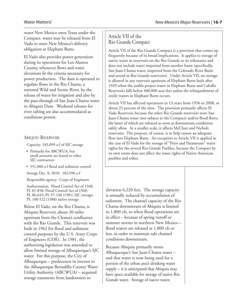
Article VII of the Rio Grande Compact
Article VII of the Rio Grande Compact is a provision that comes upfrequently because of its broad implications. It applies to storage ofnative water in reservoirs on the Rio Grande or its tributaries anddoes not include water imported from another basin (specifically,San Juan-Chama water, imported from the Colorado River Basinand stored in Rio Grande reservoirs). Under Article VII, no storageis allowed in any reservoir upstream of Elephant Butte built after1929 when the usable project water in Elephant Butte and CaballoReservoirs falls below 400,000 acre-feet unless the relinquishment ofcredit waters in Elephant Butte occurs.
Article VII has affected operations in 13 years from 1956 to 2008, orabout 25 percent of the time. The provision primarily affects ElVado Reservoir, because the other Rio Grande reservoirs store SanJuan-Chama water (not subject to the Compact) and/or flood flows,the latter of which are released as soon as downstream conditionssafely allow. At a smaller scale, it affects McClure and Nicholsreservoirs. The purpose, of course, is to help ensure an adequateflow into Elephant Butte. An exception to Article VII is applied inthe case of El Vado for the storage of “Prior and Paramount” waterrights for the several Rio Grande Pueblos, because the Compact byits own terms does not affect the water rights of Native Americanpueblos and tribes.
elevation 6,220 feet. The storage capacityis annually reduced by accumulation ofsediment. The channel capacity of the RioChama downstream of Abiquiu is limitedto 1,800 cfs, so when flood operations arein effect – because of spring runoff orsummer storms in northern New Mexico –flood waters are released at 1,800 cfs orless, in order to maintain safe channelconditions downstream.
Because Abiquiu primarily storesAlbuquerque’s San Juan-Chama water –and that water is now being used for aportion of the urban area’s drinking watersupply – it is anticipated that Abiquiu mayhave space available for storage of native RioGrande water. Storage of native water,
16-8 | Water Matters! New Mexico’s Major Reservoirs
within the available space approved for SJCwater, is authorized by law, but major hurdlesmust be overcome, such as environmentalclearances and agreements with underlyingreal property owners, for native storage on apermanent basis to occur.
Flexibility was in play at Abiquiu when thereservoir was used for storage under theConservation Water Agreement in 2001-2003 and the Emergency Drought WaterAgreement of 2003, both of which wereentered into between the State of NewMexico and the United States, andapproved by the Rio Grande CompactCommission. Such flexibilities in storage atAbiquiu have attracted interest andattention among water-resource expertswhen they have considered alternativestorage scenarios for Rio Grande water.Their concerns have been to optimize watermanagement and not over-deliver to Texas,and to reduce evaporative losses from thehigh rates of loss that Elephant Butteexperiences. To settle part of the litigationover the silvery minnow, the ABCWUAagreed to work with environmental groupsto develop a 30,000 acre-footenvironmental storage pool at Abiquiu to beused for ecosystem purposes during times oflow flow on the Rio Grande.
COCHITI RESERVOIRCapacity: 50,000 a-f recreation pool; 590,000a-f flood control pool
Storage in Dec. 8, 2010: 52,997 a-f
Responsible agency: Corps of Engineers
Authorization: Flood Control Act of 1960, PL 86-645; PL 88-293 (50,000 a-f SJC waterfor recreation, fish, and wildlife)
Cochiti Reservoir is the onlyimpoundment in the Rio Grande’s MiddleValley that exists on the mainstream of theriver. Cochiti Dam was built for flood andsediment control purposes, primarily toprotect the City of Albuquerque fromextreme flooding events. A permanentrecreational pool was authorized in 1964and 5,000 acre-feet of SJC water wasallocated annually – in the first 10 years tocreate a 50,000 acre-foot pool; andthereafter to replace the evaporative losseseach year. Cochiti Dam’s construction wascompleted in August 1975, and the damand most of the reservoir are on Pueblo deCochiti land. During high water, thereservoir intrudes into Bandelier NationalMonument; between this impact and itseffects on the natural hydrograph of theriver, environmentalists have called Cochiti“the dam that got away.”
Cochiti Dam passes all inflow except whenholding back flood inflows or when thepermanent pool is being refilled. The damdirectly regulates Rio Grande flows intothe river’s Middle Valley. The channelcapacity below Cochiti, to safely pass floodflows, is limited to 7,000 cfs (determinedin Albuquerque at the Central Avenuebridge). The San Marcial railroad bridgesome 200 miles downstream createsanother choke point for safely passingflood flows.
Cochiti Pueblo has a strong voice in themanagement of the reservoir, and in work-ing with the Corps of Engineers (COE)
Water-resource experts concerns have been tooptimize water management and not to over-deliver to Texas, and to reduce evaporative losses from the high rates of lossthat Elephant Butte experiences.

New Mexico’s Major Reservoirs | 16-9Water Matters!
they have allowed minor deviations in op-erations at Cochiti. This has providedextra storage of water in order to create re-leases for pulse flows to promote spawningof the silvery minnow. Also, temporarystorage of native water has been allowed totrap water that has been released from ElVado for irrigation in the Middle Valleywhen a thunderstorm occurs which negatesthe need for the release. Due to the historyof issues that arose during the planningand construction of the reservoir, and dam-age that has in fact resulted to agriculturallands and sacred sites, the Pueblo is cau-tious about any potential changes to thedam’s authorized operations.
Jemez Canyon Dam and Reservoir andGalisteo Dam and Reservoir are also Corpsof Engineers facilities. Their primary purposeis flood control and trapping sediment.
ELEPHANT BUTTE RESERVOIRCapacity: Two million a-f
Storage Dec. 8, 2010: 400,674 a-f
Responsible agency: Bureau of Reclamation
Authorization: Rio Grande ReclamationProject, enacted in 1905, PL No. 58-108.
At the downstream end of the Rio Grande’sMiddle Valley is Elephant Butte Dam,built in 1912-1916 by the fledgling“Reclamation Service,” now the Bureau ofReclamation. At the time, the dam was thelargest in the world. Controversyabounded between the federal governmentand private interests over the right toimpound waters of the Rio Grande in thisapproximate location, and threads of thatcontroversy continue to the present day.
Elephant Butte Reservoir is the principalstorage facility for the Bureau’s Rio GrandeProject, delivering water for use undercontracts between the Bureau ofReclamation and the Elephant ButteIrrigation District (90,000 water-righted
acres in New Mexico) and El Paso CountyWater Improvement District No. 1(69,000 water-righted acres in Texas).New Mexico’s Rio Grande Compactdelivery obligation takes place at thespillway of Elephant Butte Dam: thusabout 57 percent of the water deliveredunder the Compact, is actually delivered tosouthern New Mexico farmers. ElephantButte is also operated to ensure that theobligation of the U.S. under the 1906Treaty with Mexico to deliver 60,000 acre-feet per year is met. That delivery ismanaged by the International Boundaryand Water Commission, by means of adiversion facility near Ciudad Juárez. FullRio Grande Project delivery is 790,000acre-feet. When a full amount is notavailable, which is the situation in manyyears, water to the irrigation districts andMexico are reduced on a pro rata basis. In2008, a new operating agreement wasnegotiated which specifies procedures forallocation and releases. The InterstateStream Commission is evaluating theoperating agreement from a technicalstandpoint to resolve a number ofquestions and concerns.
Recreation is also an important function atElephant Butte. More than one millionpeople annually visit the Elephant ButteLake State Park. As in most of the
Due to the history of issues that arose duringthe planning and construction of the reservoir,
and damage that has in fact resulted toagricultural lands and sacred sites, the Pueblo is
cautious about any potential changes to thedam’s authorized operations.
Elephant Butte Reservoir is the principal storagefacility for the Bureau’s Rio Grande Project.
16-10 | Water Matters! New Mexico’s Major Reservoirs
reservoirs, there is both compatibility, andat times tension, between recreational usesand the primary purpose – water storage.The size of the reservoir varies widely,depending upon storage levels. Evaporativelosses on the lake are estimated at about 10feet annually. When the lake is full, at 2million acre-feet, evaporative losses areestimated at 140,000 acre-feet per year(roughly two times the annual use of thecity of Albuquerque), leading many to thinkabout how to reduce such losses or how tostore water at higher elevations where theevaporative losses are not so great. Waterhas seldom gone over the dam’s spillway;once was in the high flood year of 1941.Now the dam is operated in ways that avoidactual spills, although this has not been aconcern in recent low-water years. WhenElephant Butte “spills,” it erases all accrueddebits and credits under the Rio GrandeCompact. The last spills under theCompact occurred in the wet years of thelate 1980s. Operation of Article VII of theCompact is based on water levels atElephant Butte. (See box above.)
CABALLO RESERVOIRCapacity: 350,000 a-f flood storage; 50,000 a-f target
Storage Dec. 8, 2010: 21,007 a-f
Responsible agency: Reclamation
Authorization: Rio Grande ReclamationProject, enacted in 1905, PL No. 58-108
Caballo is a reservoir that works inconjunction with Elephant Butte providingstorage for irrigation, power, and floodcontrol. Since its construction in 1938,Caballo Dam has provided supplementalstorage for Rio Grande Project storage.Water released from Elephant Butte forpower production is re-impounded inCaballo for use in irrigation the followingseason. Further, Caballo is operated forflood control in cooperation with theInternational Boundary and WaterCommission (IBWC) to limit flow in theRio Grande below the dam and to meetthe 1906 Treaty deliveries to Mexico’sAcequia Madre irrigation canal. Per a1996 Court Order, which resulted from anegotiated settlement with EBID and ElPaso #1 irrigation districts, Caballo’sstorage is targeted not to exceed 50,000acre-feet from October 1 to January 31each year. A variety of exceptions arespecified, but any significant variationfrom the target requires that Reclamationconsult and collaborate with the districts.
Water-resource experts concerns have been tooptimize water management and not over-deliver to Texas, and to reduce evaporative losses from the high rates of lossthat Elephant Butte experiences.
New Mexico’s Major Reservoirs | 16-11Water Matters!
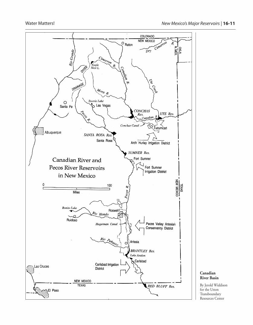
Canadian River Basin
By Jerold Widdison for the UttonTransboundaryResources Center

16-12 | Water Matters! New Mexico’s Major Reservoirs
Canadian River Basin
EAGLE NEST RESERVOIRCapacity: Approximately 78,000 a-f(maximum); 52,800 a-f (average)
Storage in Nov. 2010: About 75,000 a-f
Responsible agency: Interstate Stream Commission
Eagle Nest was built at the upstream end ofthe Canadian River Basin in 1918 inCimarron Canyon by the Springerranching family in order to capture therunoff from the Moreno Valley watershedfor irrigation use. Over the years, EagleNest has become a popular lake for fishing,and in 2002 the reservoir was conveyed tothe New Mexico Game and FishDepartment. The dam is now operatedand managed by the New MexicoInterstate Stream Commission, whilerecreational use of the lake is managed byNew Mexico State Parks.
Water in the lake is owned by 18 entities; itis primarily used for irrigation, butdomestic water is also provided to thetowns of Raton and Springer. After twoyears of litigation, a negotiated agreementwas reached in 2006 on water deliveries tofulfill about 16,000 acre-feet of waterrights demand per year. The capacity ofthe lake is limited to about elevation 8,140feet, the crest of the dam being at 8,146feet. The lake’s level is closely tied toprecipitation patterns in the immediatearea: if there is good rainfall in thesummer, not much water needs to be takenout for irrigation; with a poor snowpack,followed by a dry summer, the lake can besignificantly drawn down.
UTE RESERVOIRCapacity: 200,000 a-f conservation storage; 24,000 per year under contract for municipal purposes
Storage in Nov. 2010: 185,000 a-f
Responsible agency: Interstate Stream Commission
Authorization: New Mexico Legislature (1957, 1959, 1975, 1978, 1982)
The Interstate Stream Commission builtUte Reservoir in 1962 by constructing adam on the Canadian River near Logan,New Mexico. The ISC has operated itsince that time. In the 1970s the dam’sheight was increased, so as to impoundadditional water. Its storage capacity islimited by the Canadian River Compact to200,000 acre-feet. Storage of 24,000 acre-feet annually is subject to a purchasecontract with the Ute Reservoir WaterCommission. The Commission is anorganization of entities including citiesfrom Tucumcari south to the Portales areaand they have an option to purchase thewater in the reservoir for consumptive use.Currently, the water in the reservoir is notbeing used for purposes other thanrecreation – boating and fishing. UteReservoir provides a potential renewablesource of water to the communities inEastern New Mexico that are dependenton the dwindling groundwater of theOgallala Aquifer. The pendingarrangements for proposed delivery ofwater from Ute Reservoir to the EasternNew Mexico Rural Water System arecovered under a separate article in thisedition of Water Matters!
Water in Eagle Nest is owned by 18 entities.

New Mexico’s Major Reservoirs | 16-13Water Matters!
CONCHAS RESERVOIRCapacity: 198,000 a-f flood control purposes;70,500 a-f sediment control; 252,000 a-fconservation storage (irrigation)
Storage Dec. 8, 2010: 83,374 a-f
Responsible agency: Corps of Engineers
Authorization: Emergency Relief AppropriationAct of 1935 (July 29, 1935); Flood Control Actof 1936
Conchas Dam was constructed by theArmy Corps of Engineers in 1939. It wasapproved by President Roosevelt as a workrelief project during the Great Depression.The dam is located just downstream fromthe confluence of the Canadian andConchas rivers, about 35 miles northwestof Tucumcari. The lake providesconservation storage for the Arch HurleyConservancy District in the vicinity ofTucumcari, and the Bell Ranch, locatednortheast of the lake. Recreation areas areleased to the State of New Mexico Parksand Recreation Division and privateoperators. The Arch Hurley district, alsoknown as the Tucumcari Project, wasauthorized by the New Mexico Legislaturein 1937, but construction was notcompleted until 1954. Irrigation of42,321 acres is authorized, but the averageis under 30,000 and the district has beenchronically affected by drought.
Under the Canadian River Compact, NewMexico has free use of the Canadian forwater originating above Conchas Dam andis entitled to 200,000 acre-feet ofconservation storage for water originatingin the Canadian River drainage basin inNew Mexico below the dam. Ambiguitiesin the Compact sent the states ofOklahoma, Texas and New Mexico to theSupreme Court in 1991. The Courtdetermined that Ute Reservoir’s capacitywas limited to stored water not to exceed
200,000 acre-feet. Currently, Ute is nearlyfull, while Conchas is at one of its lowestlevels since the drought years of the 1950s,except for a brief period in the 1970s.Inflow to Conchas is reliant on rainfall andseveral years of persistent drought havetaken a toll. The lake is so low that ArchHurley cannot withdraw water unless thelevel comes up, because the elevation of thewater surface of the lake is below theirrigation outlet.
Currently, Ute is nearly full, while Conchas is atone of its lowest levels since the drought
years of the 1950s.

16-14 | Water Matters! New Mexico’s Major Reservoirs
Pecos River Basin
STORRIE LAKECapacity: 22,900 a-f
Responsible agency: Storrie Project Water Users Association
Storrie Lake is a small reservoir just northof the City of Las Vegas, owned andmanaged by the Storrie Project WaterUsers Association. Water from theGallinas River, tributary to the Pecos, isstored here and used primarily forirrigation. Water from the reservoir is alsoused for municipal purposes by the City ofLas Vegas, and Storrie is operated formunicipal purposes in conjunction withBradner and Peterson Reservoirs. Bradnerand Peterson are the city’s primaryreservoirs, and Storrie is a back-up,connected to them by a pipeline. Storriebecomes a critical component of the watersupply system when Las Vegas is in adrought. Storrie was the subject of adispute over public access to the lake in2010, but the New Mexico State ParksDivision of the New Mexico Departmentof Energy, Minerals and Natural Resourcesand the Storrie Project Water UsersAssociation negotiated an agreement for athree year lease, providing the parties timeto reach a permanent agreement.
LOWER PECOS RESERVOIRS
SANTA ROSA RESERVOIRCapacity: 438,364 a-f flood storage; 92,236 a-f conservation storage (irrigation)
Storage Dec. 8, 2010: 42,743 a-f
Responsible agency: Corps of Engineers
Authorizations: 52 Stat. 1224; 68 Stat. 1260; 94 Stat. 520
SUMNER RESERVOIRCapacity: 93,828 a-f flood storage; 40,398 a-fconservation storage (irrigation)
Storage Dec. 8, 2010: 19,229 a-f
Responsible agency: Bureau of Reclamation
Authorizations: November 6, 1935; FloodControl Act of 1939.
BRANTLEY RESERVOIRCapacity: 414,466 a-f flood storage; 40,000 a-f conservation storage (irrigation)
Storage Dec. 8, 2010: 9,457 a-f
Responsible agency: Bureau of Reclamation
Authorizations: PL 92-514 (1972)
LAKE AVALONCapacity: 4,466 a-f flood storage; 3,866 a-fconservation storage (irrigation)
Storage Dec. 8, 2010: 2,126 a-f
Responsible agency: Bureau of Reclamation, built in 1907
Santa Rosa Reservoir, Sumner Reservoir,and Brantley and Avalon reservoirs areoperated as a system for the CarlsbadProject, which primarily serves theCarlsbad Irrigation District (CID). TheCarlsbad Project was originally authorizedon November 28, 1905. The capacitiesreflected in this article are variable,depending upon the storage and operationsin each of the Carlsbad Project reservoirs.The total annual allowable storage asdefined by the Pecos River Compact is176,500 acre-feet, which is the maximumconservation storage allowed for irrigation.Each reservoir is constrained by its ownconservation storage limits, with a portion
Storrie was the subject of a dispute over publicaccess to the lake in 2010

New Mexico’s Major Reservoirs | 16-15Water Matters!
of its storage space allocated for floodcontrol. As on the Rio Grande, manyagencies and interests are involved indecision-making on the Pecos.
Generally, water is kept in Santa Rosa andSumner to take advantage of lowerevaporative losses. This keeps capacityavailable in Brantley to capture runofffrom monsoon season rainfall. When CIDneeds water for irrigation, water is movedto Brantley. Avalon is a small reservoir,used for staging releases from Brantley foruse by CID.
In the case of flood control operations bythe Corps of Engineers and the Bureau ofReclamation, if a reservoir’s conservationstorage limits are exceeded, inflows are by-passed. Another driver is the Pecos Com-pact and the 1988 Texas v. New MexicoU.S. Supreme Court Amended Decree. In1988 the U.S. Supreme Court held thatNew Mexico had under-delivered to Texasfrom 1950 to 1983 by about 10,000 acre-feet per year. New Mexico had to payTexas $14 million and the Court mandatedthat New Mexico not fall behind on its re-quired deliveries. Spills from CarlsbadProject storage are one source for meetingthe delivery requirement. Another opera-tional factor on the Pecos is how to aug-ment flows for the endangered Pecosbluntnose shiner while conserving Carls-bad Project water supplies.
Irrigation in the Pecos Valley in not limitedonly to the Carlsbad area. Fort SumnerIrrigation District (FSID) is locateddownstream from Sumner Dam andirrigates approximately 6,000 acres out of10,000 authorized by its diversion right,which is a direct flow right of the naturalriver flow up to 100 cfs.
The Pecos Valley Artesian ConservancyDistrict (PVACD) relies on ground waterand irrigates approximately 100,000 acres
on the west side of the river from Roswellto south of Artesia. The Hagerman Canalsupplies water to approximately 9,000acres in the PVACD using a combinationof surface water diverted from the RioHondo and groundwater pumped from theRoswell basin. CID irrigates approxi-mately 20,000 acres a year out of a total of25,055 authorized by the Carlsbad Project.
The complex history of the Pecos Basin’sdevelopment and history of water issuesand litigation is fascinating, and alsocritically important to understanding thecurrent posture of water administrationnot only in the Pecos but throughout thestate. The legal imperative to makedeliveries to Texas and avoid priorityadministration has cost the State about$100 million. Currently, the Lower PecosBasin Commission (an ad hoc group ofwater users advisory to the InterstateStream Commission) has been advising theInterstate Stream Commission and federalagencies on compliance with the Compact.A settlement agreement on water rightswas reached in 2003 and measures havebeen implemented such as the purchase of18,000 acres of farmland. The Pecos
Another driver is the Pecos Compact and the 1988 Texas v. New Mexico U.S.
Supreme Court Amended Decree.
The complex history of the Pecos Basin’sdevelopment and history of water issues andlitigation is fascinating, and also critically
important to understanding the current postureof water administration not only in the Pecos
but throughout the state.

16-16 | Water Matters! New Mexico’s Major Reservoirs
presents an example of a successful regionalcooperative approach to settling waterrights, addressing endangered species, andmeeting Compact deliveries.
The history of the Pecos Basindevelopment and Compact difficulties issummarized in a readable summary byretired Representative Joe Stell in the firstedition of Water Matters! For newLegislators, we recommend his article andalso, for a more detailed discussion, thebook HIGH AND DRY by Emlen Hall.
Colorado River Basin
NAVAJO RESERVOIRCapacity: 1,708,600 a-f
Storage Dec. 8 2010: 1,362,627 a-f
Responsible agency: Reclamation
Authorizing legislation: Colorado River Storage Project Act of April 11, 1956 (70 Stat.105); Act of June 13, 1962
Navajo Dam was constructed in 1962 onthe San Juan River, a tributary of theColorado River, pursuant to the ColoradoRiver Storage Project Act. The San JuanRiver originates in southern Colorado andruns westward from the ContinentalDivide into New Mexico. After flowingthrough New Mexico and Utah, the SanJuan joins the Colorado River at LakePowell. Navajo Dam is located about 30miles east of Farmington.
Navajo Dam and Reservoir are owned,operated, and maintained by the Bureau ofReclamation. Water is released primarilyfor irrigation, for municipal and industrialpurposes, and for hydropower generationby the city of Farmington. In addition toregulating the flows of the San Juan River,Navajo Reservoir is the principal storagereservoir for the Navajo Indian IrrigationProject (NIIP). Water is released through atunnel into a long aqueduct for use on theNIIP to irrigate about 110,000 acres ofland on the Navajo Indian Reservation.
Navajo Dam is subject to the terms of theUpper Colorado River Basin Compact, theColorado River Storage Project Act and theact authorizing the San Juan-ChamaDiversion and Navajo Indian IrrigationProject. It provides irrigation andmunicipal and industrial water supply,flood control, recreation, hydropower, andfish and wildlife benefits.
The history of the Pecos Basin developmentand Compact difficulties is summarized in areadable summary by retired Representative JoeStell in the first edition of Water Matters!
After flowing through New Mexico and Utah, the San Juan joins the Colorado
River at Lake Powell.

New Mexico’s Major Reservoirs | 16-17Water Matters!
The San Juan Basin RecoveryImplementation Program was initiated in1992 to address two endangered fish in theSan Juan below Navajo and operations ofthe reservoir are affected by this Program.All of the federal agencies, the State of NewMexico and major water rights interests arerepresented. The purpose is to worktogether to protect and promote recoveryof the endangered fish without impairingwater users. The Program has beenconsidered to be a successful approach toaddressing the ESA issues on the San Juan.
In 2003, in the face of anticipated watershortages, the major water users in theBasin came together and developed a shar-ing of shortages agreement. PNM, ArizonaPublic Service, and BHP Billiton reachedagreement with the Navajo Nation, the Ji-carilla Apache Nation and others for alter-native water administration and operationof Navajo Dam in the event of shortages.The agreements were accepted and sup-ported by the Interstate Stream Commis-sion and the Bureau of Reclamation.
Conclusion
This article is a snapshot of New Mexico’smajor reservoirs. It only touches thesurface of the myriad issues that confrontthe owners and managers of thesereservoirs. Our intention in updatingWater Matters! each year is to provide anon-going record of storage levels andupdates on major issues concerning thereservoirs. As New Mexico moves intofuture challenges of scarce and extremelyvariable water supplies, it will becomemore important than ever to use andmanage our reservoirs wisely.
By Susan Kelly
In 2003, in the face of anticipated watershortages, the major water users in the
San Juan Basin came together and developed asharing of shortages agreement.

16-18 | Water Matters! New Mexico’s Major Reservoirs
Sources Consulted and Other ContributorsCarlsbad Project Water Operations andWater Supply Conservation FEIS (2003).
IRA CLARK, WATER IN NEW MEXICO: A HISTORY OF ITS MANAGEMENT
AND USE (1987).
Eagle Nest State Park Management Plan(2010); Matthew Bogar, N.M. InterstateStream Commission, Dam Operator, Eagle Nest.
Kevin G. Flanigan, Surface WaterManagement: Working Within the Legal Framework, 47 NAT. RESOURCES J. 515 (2007).
G. EMLEN HALL, HIGH AND DRY (2002).
Susan Kelly, Iris Augusten, et al., History ofthe Rio Grande Reservoirs in New Mexico:Legislation and Litigation, 47 NAT.RESOURCES J. 525 (2007).
Susan Kelly, Joe Stell’s Life, Career &Contributions, Water Matters!, 2007,available at http://uttoncenter.unm.edu/pdfs/2007_Stell_Tribute.pdf.
Amy Lewis and Claudia Borchert, Santa Fe River Studies, Reservoir Storage (August 2009).
Joshua Mann, A Reservoir Runs Through It:A Legislative and Administrative History of theSix Pueblos’ Right to Store “Prior andParamount” Water at El Vado, 47 NAT.RESOURCES J. 733 (2007).
NEW MEXICO ENVIRONMENT DEPARTMENT,Water Quality Assessment Lake Surveys(various) at http://www.nmenv.state.nm.us/SWQB/.
NEW MEXICO INTERSTATE STREAMCOMMISSION athttp://www.ose.state.nm.us/isc_basins_programs.html.
NEW MEXICO OFFICE OF THE STATEENGINEER/INTERSTATE STREAMCOMMISSION2008-2009 ANNUAL REPORT.
NEW MEXICO STATE LEGISLATURE, WATER &NATURAL RESOURCES COMMITTEE, meetingminutes (June 4, 2009).
San Juan River Basin RecoveryImplementation Program athttp://www.fws.gov/southwest/sjrip/.
Upper Rio Grande Basin Water OperationsReview (FEIS) at http://www.spa.usace.army.mil/urgwops/finaleis.asp.
U.S. Bureau of Reclamation Upper ColoradoRegion at http://www.usbr.gov/uc.
USGS Water Resources links athttp://water.usgs.gov.