new meadows lake, brunswick and west bath, maine: model
TRANSCRIPT

University of Southern Maine University of Southern Maine
USM Digital Commons USM Digital Commons
Publications Casco Bay Estuary Partnership (CBEP)
2007
New Meadows Lake, Brunswick and West Bath, Maine: Model New Meadows Lake, Brunswick and West Bath, Maine: Model
Analysis of Expected Plant Communities Response to Potential Analysis of Expected Plant Communities Response to Potential
Tidal Restoration Conditions Tidal Restoration Conditions
Raymond A. Konisky Woodlot Alternatives Inc
Follow this and additional works at: https://digitalcommons.usm.maine.edu/cbep-publications
Recommended Citation Recommended Citation Konisky, R.A. (2007). New Meadows Lake, Brunswick and West Bath, Maine: Model Analysis of Expected Plant Communities Response to Potential Tidal Restoration Conditions. Portland, ME: University of Southern Maine, Muskie School of Public Service, Casco Bay Estuary Partnership.
This Report is brought to you for free and open access by the Casco Bay Estuary Partnership (CBEP) at USM Digital Commons. It has been accepted for inclusion in Publications by an authorized administrator of USM Digital Commons. For more information, please contact [email protected].

NEW MEADOWS LAKE BRUNSWICK and WEST BATH, MAINE
Model Analysis of Expected Plant Communities Response to Potential Tidal Restoration Conditions
April 2007
PREPARED FOR TOWN OF BRUNSWICK 28 FEDERAL STREET BRUNSWICK, ME 04011 PREPARED BY RAYMOND A. KONISKY, PH.D. 18 PARTRIDGE HILL ROAD NEWFIELDS, NEW HAMPSHIRE 03856 WOODLOT ALTERNATIVES, INC. 30 PARK DRIVE TOPSHAM, ME 04086

New Meadows Lake, Brunswick and West Bath, Maine Page i Model Analysis of Expected Plant Communities Response to Potential Tidal Restoration Conditions
TABLE OF CONTENTS
1.0 Introduction............................................................................................................. 2 2.0 Model Methodology................................................................................................ 4
2.1 Model Inputs and Operations.............................................................................. 4 2.2 DEM Model Input............................................................................................... 6 2.3 Model Calibration ............................................................................................... 6
3.0 Existing Natural Communities................................................................................ 7 4.0 Model Results ....................................................................................................... 14 5.0 Discussion and Conclusions ................................................................................. 25 6.0 References............................................................................................................. 27
LIST OF FIGURES
Figure 1 Project Location Map Figure 2 Model Specifications Panel for New Meadows Lake Project Site Figure 3 Existing Salt Marsh and Scrub Shrub Habitats Upper Marsh Figure 4 Existing Salt Marsh and Scrub Shrub Habitats Upper Lake Figure 5 Existing Salt Marsh and Scrub Shrub Habitats Lower Lake Figure 6 Map Image of Existing Vegetation Covertypes Observed at New
Meadows Lake (Fall 2006) Figure 7 Observed New Meadows Lake Cover Composition in 2006 Figure 8 Modeled New Meadows Lake Baseline Cover Composition in Five Years Figure 9 Model Image of Baseline Conditions at Five Years Figure 10 Modeled Alternative 1 Cover Composition in Five Years Figure 11 Model Image of Alternative 1 (culvert expansion 4.5’ lower) at Five Years Figure 12 Modeled Alternative 2 Cover Composition in Five Years Figure 13 Model Image of Alternative 2 (culvert expansion 7.5’ lower) at Five Years Figure 14 Modeled Alternative 3 Cover Composition in Five Years Figure 15 Initial and Modeled Summary Results for New Meadow Lake Figure 16 Model Image of Alternative 3 (full restoration) at Five Years

New Meadows Lake, Brunswick and West Bath, Maine Page ii Model Analysis of Expected Plant Communities Response to Potential Tidal Restoration Conditions
LIST OF TABLES Table 1. Tidal Heights Table 2. Key to New Meadows Lake Vegetation Covertypes
LIST OF PHOTOGRAPHS
Photo 1. A cordgrass covertype located in the upper marsh that depicts a recent die-off for reasons unknown of saltwater cordgrass. Photo 2. A plant community located in the upper marsh, west of the river channel that is dominated by cattail (Typha spp.). Photo 3. The single location of a purple loosestrife-dominated community located immediately north of the railroad bridge in the lower lake. Photo 4. Deciduous shrub swamp community dominated by meadowsweet (foreground) and winterberry-witherod (background) that is located in the Upper Marsh.
LIST OF APPENDICES
Appendix A. Descriptions of the Spartina Saltmarsh Community and the Mixed Graminoid-Forb Marsh Community from the Natural Landscapes of Maine WAI #106218

New Meadows Lake, Brunswick and West Bath, Maine Page 1 Model Analysis of Expected Plant Communities Response to Potential Tidal Restoration Conditions
EXECUTIVE SUMMARY
The restoration of plant communities in New Meadows Lake in Brunswick and West Bath, Maine, was evaluated for potential conditions associated with increased tidal flux at the State Road causeway. This work was performed using a spatial restoration model developed and tested at the University of New Hampshire. This model was used to predict expected plant community composition and distribution associated with changes in the lake’s potential hydrologic regime. Model inputs were based on measures of existing tides and simulations of potential tidal conditions, a survey of the dominant representative plant communities, and an elevation survey conducted in fall 2006 by Woodlot Alternatives, Inc. (Woodlot). The plant community surveys showed the site to be 80 percent dominated by relatively common brackish species and invasive species. Hydrologic restoration scenarios were developed for baseline conditions and for three potential restoration designs (Alternatives 1, 2, and 3) as outlined in the New Meadows Lake Tidal Restoration Feasibility Study (Woodlot 2005). Prior to scenario assessment, the model was calibrated to account for the observed presence of a stratified freshwater lens (calibrated as a 9” layer). For each scenario, a grid of ~500,000 cells representing the marsh was used to assess expected response of plant communities to different scenario flooding regimes. Model outcomes showed that current tidal hydrology conditions at New Meadows Lake would continue to favor brackish plant species, with an expected four-fold expansion of the invasive common reed (Phragmites australis) in the next 5 years. Of note is that some changes to the outlet culvert under Bath Road Causeway may have the potential to convert significant tracts of existing plant communities in the upper marsh (north of Old Bath Road) to salt marsh communities resembling historic conditions. Alternative 1 (24’ culvert, lower by 4.5’) would be expected to add about 5 acres of new salt marsh and provide only minimal control of the common reed covertype. Alternative 2 (24’ culvert, lower by 7.5’) offered much greater potential for restoration with the expected addition of more than 25 new acres of salt marsh (38 acres total) and the reduction of existing common reed covertype. Alternative 3 (full restoration) showed marginal benefits relative to Alternative 2, with only 3 incremental acres of salt marsh, suggesting that Alternative 2 was a near-optimal solution for tidal restoration at the site. In conclusion, the model exercise shows that New Meadows Lake is a strong candidate for habitat restoration following re-introduction of tidal flooding.

New Meadows Lake, Brunswick and West Bath, Maine Page 2 Model Analysis of Expected Plant Communities Response to Potential Tidal Restoration Conditions 1.0 INTRODUCTION A modeling assessment of potential culvert expansion and hydrologic restoration options has been conducted for the brackish marsh and surrounding habitat at New Meadows Lake (NML) in Brunswick and West Bath, Maine (Figure 1). This report describes the application of a salt marsh habitat restoration model to the project site, with the goal of providing land managers, town officials, and related decision-makers with model-generated predictions of the likely responses of existing plant communities. The model used for this report is an ecosystem model developed at the Jackson Estuarine Laboratory (University of New Hampshire) to estimate the response of marsh plant communities to existing and potential tidal hydrologic conditions (Konisky et al. 2003). Hydrologic scenarios for the site, and data from the field survey for plant community covertype designations and elevation were provided by Woodlot Alternatives, Inc. (Woodlot). The model application software is a customized ESRI ARCmap extension that generates spatial predictions of habitat response to changes in tidal hydrology. The model produces maps of salt marsh and brackish/invasive plant communities over time for specified conditions. Ecological components integrated into the model include algorithms that simulate plant biomass production, marsh elevation dynamics, tidal hydrology, and plant succession. Marsh covertypes are simulated by plant communities of six dominant species common to New England salt marshes, including salt-tolerant species, saltwater cordgrass (Spartina alterniflora), saltmeadow cordgrass (Spartina patens), and black-grass rush (Juncus gerardii), and invasive and/or exotic species, common reed (Phragmites australis), narrowleaf cattail (Typha angustifolia), and purple loosestrife (Lythrum salicaria). Experimentation with these covertype species provides the ecological basis for simulated plant responses to physical stresses of saltwater flooding and to biological stresses of competition (Konisky and Burdick 2004). Results from the model show expected changes in distribution among the plant community covertypes over five years. For spatial analysis, zones of flood stress are based on tidal heights and ground elevations; for salinity stress, zones are based on relative distance from tidal source, nearest creek, and nearest upland edge. Since the model is driven by plant ecology, non-vegetated marsh features like creeks, pools, pannes, and mud-flats are excluded from consideration. Furthermore, other potential influences on community change, such as groundwater influx, nutrient loading, wrack burial, and ice scouring, may be locally important but are outside the scope of the model. Still, model validation tests from past salt marsh restoration sites in New Hampshire and Maine have been 95 percent accurate in predicting eventual habitat conditions for communities of salt-tolerant and brackish plant species (Konisky et al. 2003).

1
Upper Lake
Lower Lake
Upper Marsh
Bath Rd
Old Bath Rd
Peter
son L
n
US Route 1
Harding
Rd
Bridg
e Rd
Bay Bridge Rd
Eagle B rook Ln
Bridle Rd
Sawy
er Rd
New
Mead
ows R
d
US Rte 1
Old Brunswick Rd
State Rd
Prepared By:
106218-F001-Location-Aerial.mxd
Sheet Title:
Project:
Date: March 2007Scale: 1"=1500'Proj. No.: 106218Figure:
.
0 1,500750
Feet
New Meadows Restoration Modeling
New Meadows RiverSalt Marsh Restoration Alternatives
(Photo Date 2001)
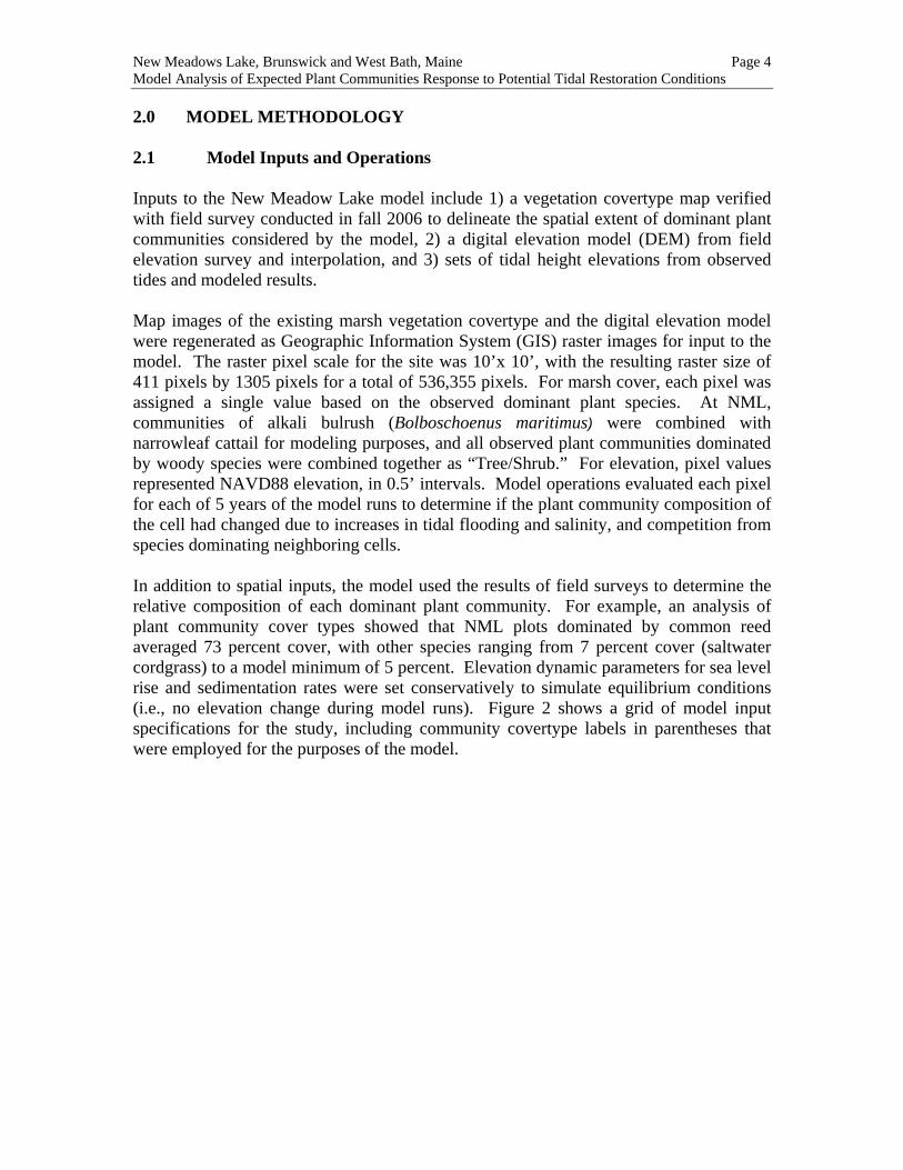
New Meadows Lake, Brunswick and West Bath, Maine Page 4 Model Analysis of Expected Plant Communities Response to Potential Tidal Restoration Conditions 2.0 MODEL METHODOLOGY 2.1 Model Inputs and Operations Inputs to the New Meadow Lake model include 1) a vegetation covertype map verified with field survey conducted in fall 2006 to delineate the spatial extent of dominant plant communities considered by the model, 2) a digital elevation model (DEM) from field elevation survey and interpolation, and 3) sets of tidal height elevations from observed tides and modeled results. Map images of the existing marsh vegetation covertype and the digital elevation model were regenerated as Geographic Information System (GIS) raster images for input to the model. The raster pixel scale for the site was 10’x 10’, with the resulting raster size of 411 pixels by 1305 pixels for a total of 536,355 pixels. For marsh cover, each pixel was assigned a single value based on the observed dominant plant species. At NML, communities of alkali bulrush (Bolboschoenus maritimus) were combined with narrowleaf cattail for modeling purposes, and all observed plant communities dominated by woody species were combined together as “Tree/Shrub.” For elevation, pixel values represented NAVD88 elevation, in 0.5’ intervals. Model operations evaluated each pixel for each of 5 years of the model runs to determine if the plant community composition of the cell had changed due to increases in tidal flooding and salinity, and competition from species dominating neighboring cells. In addition to spatial inputs, the model used the results of field surveys to determine the relative composition of each dominant plant community. For example, an analysis of plant community cover types showed that NML plots dominated by common reed averaged 73 percent cover, with other species ranging from 7 percent cover (saltwater cordgrass) to a model minimum of 5 percent. Elevation dynamic parameters for sea level rise and sedimentation rates were set conservatively to simulate equilibrium conditions (i.e., no elevation change during model runs). Figure 2 shows a grid of model input specifications for the study, including community covertype labels in parentheses that were employed for the purposes of the model.

New Meadows Lake, Brunswick and West Bath, Maine Page 5 Model Analysis of Expected Plant Communities Response to Potential Tidal Restoration Conditions Figure 2. Model Specifications Panel for New Meadows Lake Project Site
Three ecologically-significant tidal measures were developed as inputs for each modeled alternative (mean high water, median spring tide, and maximum tidal elevations). In addition, since tides are restricted from the lower lake to the upper lake (delineated by US Route 1 Causeway), each set of tidal measures included separate lower-lake and upper-lake estimates. The model determined the position of each cell as either lower or upper lake, and applied the specific estimates on execution. Three alternatives for expansion of the culvert under Bath Road Causeway were considered (Woodlot 2005): 1) Final Alternative 1 – expansion of the culvert to 24’ with a lowered bottom by 4.5’ 2) Final Alternative 2 – expansion of the culvert to 24’ with a lowered bottom by 7.5’ 3) Final Alternative 3 – complete removal of tidal restriction (full restoration) The restoration model was run for four tidal hydrology scenarios. The first scenario, “baseline,” modeled current conditions by using actual tidal heights observed in the lower lake and modeled results of tidal heights in the upper lake. Alternative scenarios 1, 2, and 3 were configured based on modeling results from hydrologic analysis conducted by

New Meadows Lake, Brunswick and West Bath, Maine Page 6 Model Analysis of Expected Plant Communities Response to Potential Tidal Restoration Conditions Woodlot. Table 1 is a summary of tidal heights from observed and hydrologic modeling analyses used as model inputs. Table 1. Tidal Heights Elevations (NAVD88)
Mean High Water Lower Upper
Median Spring TideLower Upper
Maximum Tide Lower Upper
Baseline 2.9 2.8 3.4 3.5 3.7 3.5 Alternative 1 4.0 2.7 5.0 3.5 5.2 3.7 Alternative 2 4.4 3.2 5.5 3.9 6.0 4.2 Alternative 3 4.6 3.3 5.8 4.1 6.3 4.3 2.2 DEM Model Input The elevation survey included collecting elevation measurements with a Real Time Kinetic (RTK) GPS at selected reference sites within the project area. RTK surveys were located along the transects selected for the vegetation community sampling, but also included additional translatitudinal routes across the marsh where measurable changes in elevation were observed in the field. Once the surveys were completed, the elevations measured were averaged amongst each of the vegetation community covertypes above. 2.3 Model Calibration Field survey had determined that a considerable amount of marsh habitat in the upper lake above Old Bath Road was at a low elevation relative to the existing tidal signal, but had maintained populations of cattails, rush, and woody species. The survey identified 7.5 acres of cattail at elevation 2.5’ NAVD88 (lower than the 2.8’ NAVD mean high water) and 18.7 acres of tree/shrub habitat at 3.5’ NAVD88 or lower (subject to flooding at maximum tide elevation of 3.5’ NAVD88). Persistence of brackish and freshwater marsh communities in areas subject to regular tidal flooding can be associated with the presence of a highly-stratified freshwater lens that rides over denser, saltier waters. Observations at NML suggest that this condition exists in the upper marsh, and therefore a model adjustment was required to simulate stratified flooding condition. Preliminary model runs under baseline conditions were conducted to determine a tidal elevation adjustment that simulated near-equilibrium habitat conditions for existing tidal elevations. Multiple runs determined that an adjustment of 0.75’ (9 inches) best simulated the depth of the stratified freshwater lens. Tidal heights were therefore reduced by this amount for all model runs.

New Meadows Lake, Brunswick and West Bath, Maine Page 7 Model Analysis of Expected Plant Communities Response to Potential Tidal Restoration Conditions 3.0 EXISTING NATURAL COMMUNITIES The plant communities of the NML project site belong to the Tidal Marsh Estuary Ecosystem. Salinity levels, and consequently vegetation composition, have been altered in the New Meadows River marshes by the restriction of tidal flow. Vegetation covertypes within the area of investigation in the New Meadows marsh included areas dominated by cordgrasses (Spartina spp.), cattails (Typha spp.), alkali bulrush1, common reed, purple loosestrife, and deciduous shrub swamps. These covertypes, as they occur at the site are described below. The Cowardin wetland classification2 is also provided in parentheses following the covertype heading and natural community descriptions from Natural Landscapes of Maine3 are included where applicable. Taxonomy follows the Flora of Maine (Haines & Vining 1998). Figures 3 – 7 map the vegetation covertypes of the NML project site. The covertype designations are based on modified labels and raster values required by the restoration model input design. The covertype labels are provided in Table 2. Table 2. Key to New Meadows Lake Vegetation Covertypes RASTER VALUE WAI CODE COVERTYPE
5 BG Bolboschoenus maritimus (border grass) 9 LS Lythrum salicaria 0 OW Open Water 0 PA Salt Panne (current or former) 3 FW Forested Wetland 6 PH Phragmites australis 1 SA Spartina alterniflora 3 SL Spiraea latifolia (also can be part of SS) 2 SPA Spartina patens 5 SPE Spartina pectinata 3 SS Shrub Wetland 4 TL Typha spp. 3 UF Upland Forest 5 UG Upland Field/Grass (border grass) 5 WM Wet Meadow (mowed grassy wetland) 7 UN Road and Unclassified (includes ledge) 10 -- Bare Ground and Mudflat 8 -- Juncus gerardii (black grass)
Notes: 1. Raster values are based on model requirements. 2. “ -- “ is not found within the project site.
1 Alkali bulrush is considered a "border grass" in the model. 2 Cowardin, L.M. V. Carter, F.C. Golet and E. T. LaRoe. 1979. Classification of Wetlands and Deepwater Habitats of the United States 3 Gawler, S. C. and A. R. Cutko, Natural Landscapes of Maine draft, Maine Natural Areas Program, 2004.

Old Brunswick Rd0 700350
Feet
.
3
Prepared By:
106218-F003-upper-marsh.mxd
Sheet Title:
Project:
Date: February 2007Scale: As ShownProj. No.: 106218Figure:
Existing Salt Marsh and Scrub Shrub HabitatsUpper Marsh
New Meadows RiverSalt Marsh Restoration Alternatives
Legend
Spartina pectinata
Cordgrass Community
Spartina patensSpartina alterniflora
Cattail Marsh CommunityAlkali Bulrush CommunityCommon Reed CommunityPurple Loosestrife Community
Deciduous Shrub Swamp Community
Spiraea latifoliaShrub Wetland
Forested Wetland CommunityWet Meadow CommunityUpland Field/Grass CommunityUpland Forest Community

Old Brunswick Rd
US Route 1
New
Mead
ows R
oad
0 700350
Feet
.
4
Prepared By:
106218-F004-upper-lake.mxd
Sheet Title:
Project:
Date: February 2007Scale: As ShownProj. No.: 106218Figure:
Existing Salt Marsh and Scrub Shrub HabitatsUpper Lake
New Meadows RiverSalt Marsh Restoration Alternatives
Legend
Spartina pectinata
Cordgrass Community
Spartina patensSpartina alterniflora
Cattail Marsh CommunityAlkali Bulrush CommunityCommon Reed CommunityPurple Loosestrife Community
Deciduous Shrub Swamp Community
Spiraea latifoliaShrub Wetland
Forested Wetland CommunityWet Meadow CommunityUpland Field/Grass CommunityUpland Forest Community

US Route 1
Old Bath Road
State Road
New M
eado
ws Ro
ad
0 700350
Feet
.
5
Prepared By:
106218-F005-lower-lake.mxd
Sheet Title:
Project:
Date: February 2007Scale: As ShownProj. No.: 106218Figure:
Existing Salt Marsh and Scrub Shrub HabitatsLower Lake
New Meadows RiverSalt Marsh Restoration Alternatives
Legend
Spartina pectinata
Cordgrass Community
Spartina patensSpartina alterniflora
Cattail Marsh CommunityAlkali Bulrush CommunityCommon Reed CommunityPurple Loosestrife Community
Deciduous Shrub Swamp Community
Spiraea latifoliaShrub Wetland
Forested Wetland CommunityWet Meadow CommunityUpland Field/Grass CommunityUpland Forest Community

New Meadows Lake, Brunswick and West Bath, Maine Page 11 Model Analysis of Expected Plant Communities Response to Potential Tidal Restoration Conditions Cordgrass Covertype (EEM):
Salt meadow cordgrass and smooth cordgrass were generally limited to the fringes of Lower and Upper New Meadows lakes. These impoundments are steep sloped and very little habitat for these grasses remains. North of Old Bath Road, the Spartina Community is better developed and salt meadow cordgrass and smooth cordgrass occur in a mosaic pattern on islets and fringes along the edges of the water way (Photo 1). Freshwater cordgrass (Spartina pectinata) also occurs in small patches, typically near areas of fresh water intrusion, and as a border along the west branch of the waterway. Halophytes, e.g., black-grass rush, seashore saltgrass (Distichilis spicata), seaside goldenrod (Solidago sempervriens), and sampire (Salicornia depressa) were infrequently observed. This may have been due, in part, to the October timing of the survey, but salinity levels would also be a limiting factor.
Photo 1. A cordgrass covertype located in the upper marsh that depicts a recent die-off for reasons unknown of saltwater cordgrass. The species composition of the New Meadows cordgrass community most closely resembles the Spartina Saltmarsh Natural Community but has a lower component of salt meadow cordgrass and lacks the strong zonation of these marshes. Its mosaic configuration is more typical of the Mixed Graminoid-Forb Marsh Natural Community occurring as fringe marshes in sheltered coastal pockets, estuaries, and tidal creeks. However, Spartina Communities in the area of investigation lack many of the indicator species, most notably, chair maker's rush (Schoenoplectus pungens) listed by MNAP for this community type. Complete descriptions of the Spartina Saltmarsh Community and

New Meadows Lake, Brunswick and West Bath, Maine Page 12 Model Analysis of Expected Plant Communities Response to Potential Tidal Restoration Conditions The Mixed Graminoid-Forb Marsh Community from the Natural Landscapes of Maine (2004) are provided in Appendix A. Cattail Marsh Community (EEM):
The Cattail Marsh Natural Community is described in Natural Landscapes of Maine (2004) as follows:
Tall marsh vegetation is dominated by cattails and mostly deciduous shrubs. The cattails may be patchy, locally dominant, and grow taller than the other plant species.
Cattail dominated marshes are widespread around the Lower and Upper New Meadows lakes and cover larger areas north of Old Bath Road. Narrow-leaved cattail, common in coastal or brackish environments, was observed in the northern area and other cattails observed throughout the site probably included broad-leaved cattail (Typha latifolia) and the Typha x glauca4 (Photo 2). Additional herbaceous species observed in the cattail marshes included Canada bluejoint (Calamagrostis canadensis), salt meadow cordgrass, marsh fern (Thelypteris palustris), sensitive fern (Onoclea sensibilis), alkali bulrush, and purple loosestrife. Shrubs observed in cattail marshes included meadowsweet (Spiraea alba v. latifolia), swamp dewberry (Rubus hispidus), and witherod (Viburnum nudum).
Photo 2. A plant community located in the upper marsh, west of the river channel that is dominated by cattail (Typha spp.). 4 Typha xglauca is the hybrid cross between T. angustifolia and T. latifolia.

New Meadows Lake, Brunswick and West Bath, Maine Page 13 Model Analysis of Expected Plant Communities Response to Potential Tidal Restoration Conditions Alkali Bulrush Covertype (EEM):
Pockets and fringes dominated by alkali bulrush are located along the upper marsh edge. Cattails and purple loosestrife were occasionally observed in these bulrush stands. Common Reed Covertype (EEM):
Common Reed, an introduced invasive species, occurs as almost monotypic stands located in the upper marsh of Upper New Meadows Lake and north of Old Bath Road. However, the largest stand is north of Old Bath Road and centrally located near the waterway. Plant species observed near the peripheries of common reed stands included purple loosestrife, cattails, salt meadow cordgrass, akali bulrush, rough-stemmed goldenrod (Solidago rugosa), meadowsweet, and speckled alder (Alnus incana). Purple loosestrife Covertype (EEM):
Purple loosestrife, an introduced invasive species, occurred, most commonly, as a component of cattail marshes and deciduous shrub swamps. Purple loosestrife was, however, a patchy dominant covertype just north of the railroad bridge on the west side of the Lower New Meadows Lake (Photo 3).
Photo 3. The single location of a purple loosestrife-dominated community located immediately north of the railroad bridge in the lower lake.

New Meadows Lake, Brunswick and West Bath, Maine Page 14 Model Analysis of Expected Plant Communities Response to Potential Tidal Restoration Conditions Deciduous Shrub Swamps (ESS/PSS):
Deciduous shrub swamps are widespread, but occur most frequently and cover larger areas north of Old Bath Road (Photo 4). Meadow sweet was either dominant or a component of the majority of shrub swamps observed in the survey area. Single species observed as dominant in deciduous shrub swamps were meadowsweet and winterberry. Combinations of species dominant in shrub swamps included meadowsweet-winterberry (Ilex verticillata); meadowsweet-winterberry-witherod; meadowsweet-Virginia rose (rosa virginiana)-red osier dogwood (Cornus sericea), and meadowsweet-witherod-arrowwood.
Photo 4. Deciduous shrub swamp community dominated by meadowsweet (foreground) and winterberry-witherod (background) that is located in the upper marsh. 4.0 MODEL RESULTS The results of the salt marsh restoration model and discussion of the existing natural communities are presented below. Cover composition of the vegetated portion of the 84-acre marsh (north of Old Bath Road) showed strong dominance by upland and brackish plant species. Figure 6 is a GIS image of the marsh covertype map based on the field survey, including color-coded vegetation covertypes.

New Meadows Lake, Brunswick and West Bath, Maine Page 15 Model Analysis of Expected Plant Communities Response to Potential Tidal Restoration Conditions The map shows the location of the tidal inflow culvert under Bath Road Causeway at the far south (bottom) of the image. Moving north, the map marks the delineation of the upper and lower lake by the U. S. Route 1 Causeway (large gap in open water with channel). At the top of the image, the map shows the primary vegetation communities of the site, all above Old Bath Road. The upper marsh is approximately 80 acres of the total 84 vegetated acres at the site, with the remainder as fringe marsh along the steeply sloped upper and lower lake shores.

New Meadows Lake, Brunswick and West Bath, Maine Page 16 Model Analysis of Expected Plant Communities Response to Potential Tidal Restoration Conditions Figure 6. Map Image of Existing Vegetation Covertypes Observed at New Meadows Lake (Fall 2006)

New Meadows Lake, Brunswick and West Bath, Maine Page 17 Model Analysis of Expected Plant Communities Response to Potential Tidal Restoration Conditions Figure 7 is a pie chart of existing vegetative covertypes, with 80 percent of vegetated acres either tree/shrub (35 acres of woody species) or cattail/rush (29 acres of cattail [Typha label] plus 4 acres of alkali bulrush). Other brackish communities included common reed (“Phragmites,” 1.6 acres) and purple loosestrife (“Loosestrife,” 0.5 acres). Salt marsh plant communities were found on only 17 percent of the site, with saltwater cordgrass (“Cordgrass”) covering 8.8 acres and saltmeadow cordgrass (“SaltHay”) on 5.9 acres. There were no surveyed vegetation communities dominated by black-grass rush although the species was observed in low abundances, primarily near the boat landing in the upper lake. Figure 7. Observed New Meadows Lake Cover Composition in 2006
New Meadows Lake Marsh VegetationCurrent Conditions (acres)
8.8 5.90.01.60.5
33.0
34.6CordgrassSaltHayBlackGrassPhragmitesLoosestrifeCattail/RushTree/Shrub
The model was run for baseline conditions plus three alternatives to show expected outcomes in five years based on varying tidal hydrology. The first model run, with baseline tidal heights from Table 1, showed a similar overall distribution of salt marsh and brackish species in five years (Figure 8). The model predicted some conversion of low lying cattail/rush to salt marsh (+ 5 ac), and four-fold expansion of common reed (+ 4.8 ac) in the upper marsh (Figure 9). Outcomes were generally consistent with seasonal transitions observed at typical New England salt marshes when common reed is present. Figure 8. Modeled New Meadows Lake Baseline Cover Composition in Five Years
New Meadows Lake Marsh VegetationBaseline Model at 5 yrs (acres)
8.7
11.0
0.06.4
0.5
25.8
32.2CordgrassSaltHayBlackGrassPhragmitesLoosestrifeCattail/RushTree/Shrub
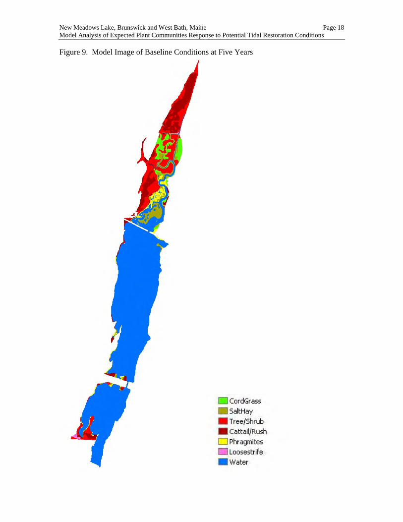
New Meadows Lake, Brunswick and West Bath, Maine Page 18 Model Analysis of Expected Plant Communities Response to Potential Tidal Restoration Conditions Figure 9. Model Image of Baseline Conditions at Five Years
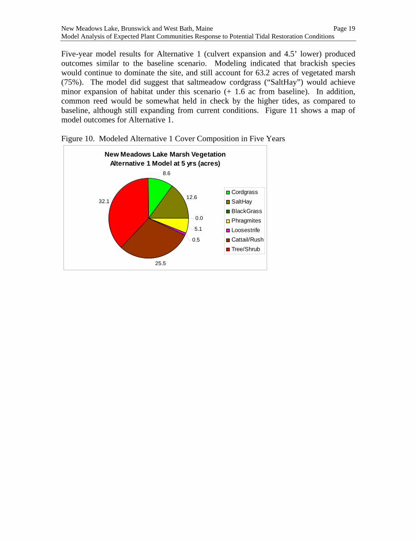
New Meadows Lake, Brunswick and West Bath, Maine Page 19 Model Analysis of Expected Plant Communities Response to Potential Tidal Restoration Conditions Five-year model results for Alternative 1 (culvert expansion and 4.5’ lower) produced outcomes similar to the baseline scenario. Modeling indicated that brackish species would continue to dominate the site, and still account for 63.2 acres of vegetated marsh (75%). The model did suggest that saltmeadow cordgrass (“SaltHay”) would achieve minor expansion of habitat under this scenario (+ 1.6 ac from baseline). In addition, common reed would be somewhat held in check by the higher tides, as compared to baseline, although still expanding from current conditions. Figure 11 shows a map of model outcomes for Alternative 1. Figure 10. Modeled Alternative 1 Cover Composition in Five Years
New Meadows Lake Marsh VegetationAlternative 1 Model at 5 yrs (acres)
8.6
12.6
0.05.1
0.5
25.5
32.1CordgrassSaltHayBlackGrassPhragmitesLoosestrifeCattail/RushTree/Shrub
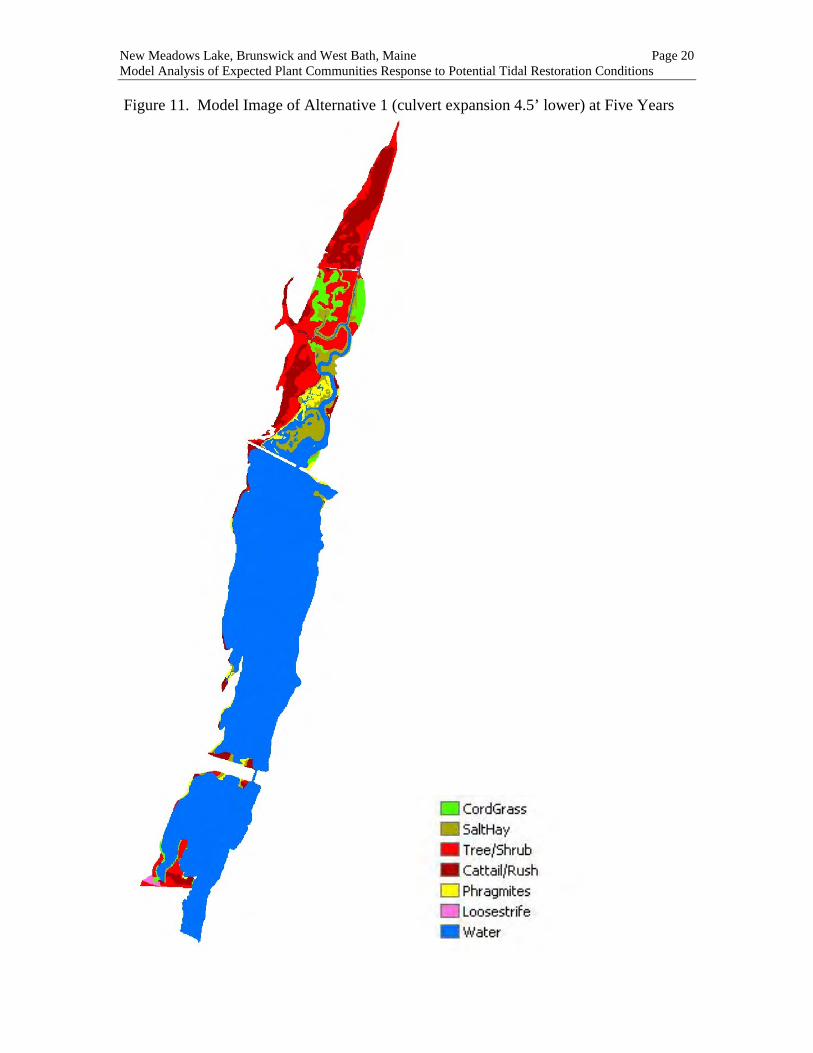
New Meadows Lake, Brunswick and West Bath, Maine Page 20 Model Analysis of Expected Plant Communities Response to Potential Tidal Restoration Conditions Figure 11. Model Image of Alternative 1 (culvert expansion 4.5’ lower) at Five Years

New Meadows Lake, Brunswick and West Bath, Maine Page 21 Model Analysis of Expected Plant Communities Response to Potential Tidal Restoration Conditions Alternative 2 (culvert expansion and 7.5’ lower) results indicated a substantial shift toward creation of salt marsh at NML. The model predicted expansion of salt marsh habitat to 38 acres, with gains of both low marsh (“Cordgrass”) and high marsh (“SaltHay”) species (Figure 12). New salt marsh expansion of about 25 acres is due largely to conversion of tree/shrub areas in the upper marsh. Also, it is expected that the new hydrology would halt the invasion of common reed and reduce this community size from current levels. Figure 13 shows a map of model outcomes for Alternative 2. Figure 12. Modeled Alternative 2 Cover Composition in Five Years
New Meadows Lake Marsh VegetationAlternative 2 Model at 5 yrs (acres)
21.0
17.1
1.325.2
19.2
0.5 0.0
CordgrassSaltHayBlackGrassPhragmitesLoosestrifeCattail/RushTree/Shrub

New Meadows Lake, Brunswick and West Bath, Maine Page 22 Model Analysis of Expected Plant Communities Response to Potential Tidal Restoration Conditions Figure 13. Model Image of Alternative 2 (culvert expansion 7.5’ lower) at Five Years

New Meadows Lake, Brunswick and West Bath, Maine Page 23 Model Analysis of Expected Plant Communities Response to Potential Tidal Restoration Conditions Alternative 3 (full restoration) results indicated only slight incremental benefit compared to Alternative 2, with an additional 3 acres of salt marsh expected to be gained (41 total, Figure 14). Alternative 3 modeling suggests that a mix of woody habitats, cattail/rush, and salt marsh species would co-exist at the site even with full restoration. Figure 16 shows a map of model outcomes for Alternative 3. Figure 14. Modeled Alternative 3 Cover Composition in Five Years
New Meadows Lake Marsh VegetationAlternative 3 Model at 5 yrs (acres)
26.1
15.01.2
24.5
17.2
0.00.5
CordgrassSaltHayBlackGrassPhragmitesLoosestrifeCattail/RushTree/Shrub
As a summary graph, modeled plant community results were combined as salt marsh species (cordgrass, salt hay) or brackish marsh species (cattail/rush, Phragmites, loosestrife and trees/shrubs), and presented for initial and modeled outcomes (Figure 15). Figure 15. Initial and Modeled Summary Results for New Meadow Lake
New Meadow Lake Model Summary
01020304050607080
CurrentConditions
Baseline - 5 yrs Alt 1 - 5 yrs Alt 2 - 5 yrs Alt 3 - 5 yrs
Model Scenarios
Mar
sh C
over
(acr
es)
Salt Marsh Brackish Marsh

New Meadows Lake, Brunswick and West Bath, Maine Page 24 Model Analysis of Expected Plant Communities Response to Potential Tidal Restoration Conditions Figure 16. Model Image of Alternative 3 (full restoration) at Five Years

New Meadows Lake, Brunswick and West Bath, Maine Page 25 Model Analysis of Expected Plant Communities Response to Potential Tidal Restoration Conditions 5.0 DISCUSSION AND CONCLUSIONS Restoration model results for NML indicate that the site is a strong candidate for re-creation of salt marsh plant communities and control of invasive plant species. Marsh covertypes currently observed at the site, now dominated by brackish communities and invasive species, would persist under existing hydrologic conditions and would likely result in a substantial expansion of Phragmites in the next five years as this and other invasive exotic species are likely to out-compete native marsh plant species. In this case, proposed design improvements to the outlet culvert under Bath Road Causeway have the potential to reverse degrading human-altered conditions at the site that now favor brackish species. In particular, increased tidal flooding would be expected to convert large tracts of scrub-shrub cover in the upper marsh to high-productivity native salt marsh species, thus increasing the distribution of these community types. Model analysis indicates that all three potential restoration alternatives would benefit native marsh communities at NML. However, the degree of improvement varied considerably with the expected increase in tidal height. Alternative 1 resulted in a relatively modest gain of salt marsh to about 20 acres (there are 15 acres currently). Alternative 2 showed much greater potential in terms of salt marsh creation (to almost 40 acres) and reduction of existing common reed coverage by 20 percent. Model results for Alternative 3, as a full-restoration scenario, showed little incremental gain beyond that of Alternative 2, suggesting that Alternative 2 is a nearly-optimal solution for tidal restoration at NML. So if Alternative 2 were to be implemented, what does this study tell us about short-term and long-term expectations for change at New Meadows Lake? First, it is apparent that increased tidal flow would significantly affect the low-lying areas of the upper marsh. For areas below about 4’ in elevation, tidal flooding would kill woody plants and inhibit other brackish species during the first growing season. At the same time, some areas of creek bottom would become exposed at low tide. Natural marsh odors would likely become more noticeable during this first season. Within a year, however, saltmarsh plants would begin to colonize open areas from on-site seed sources, likely starting with smooth cordgrass. Within the five year timeframe considered by the model exercise, saltmarsh plants would become vigorous in the 25 acres newly vacated by woody species, cattail, and common reed. Some areas of new mud-flat would also become colonized as marsh as cordgrass expanded into inhabitable areas at the waters edge. That said, one of the important conclusions of the study is what will not likely happen. Results of the field surveys show that the system is remarkably diverse in terms of plant species, habitat, and elevation gradients, and therefore resilient to change on a major scale. For example, the fringe marsh habitat along the lake seems certain to remain intact. In the upper marsh, most of the habitat would remain above the regular influence of tidal flooding. Certainly, there may be salt intrusion and occasional storm flooding, but it is seems likely that more than 50 acres of existing habitat would remain in its current state of brackish plants and woody communities. For the majority of the site, changes will be subtle and hardly detectable, as the system moves toward a new

New Meadows Lake, Brunswick and West Bath, Maine Page 26 Model Analysis of Expected Plant Communities Response to Potential Tidal Restoration Conditions equilibrium over the long term. More salt marsh will be created, but the diversity of the New Meadows Lake marsh will persist in a better balance between saltmarsh and brackish communities. It is also important to recognize limitations in models and measures that are implicit in this analytical exercise. Standard model assumptions of hydrologic conditions, degree of precision in field measures, and plant species response to stress conditions all contribute to factors of model determination. The calibration exercise for freshwater/saltwater stratification at the site also adds another level of uncertainty to the analysis. Going forward, a repeated set of salinity measures in the upper marsh, over an entire growing season, would help fine-tune this calibration. The model “lumping” of plant communities (i.e., border grasses with cattail) also leads to the assumption that grouped species share common tolerance characteristics. Therefore, given limited information about individual species tolerance, fine-scale elevations, exact tidal heights, and freshwater dynamics, modeling generalizations and smoothing algorithms are necessary. Yet despite these limitations, the model represents our best “educated guess” in consideration of the myriad of complex interactions and factors that ultimately determine plant communities at a given estuarine location. The fact that the model produced internally consistent and credible results substantiates our approach to restoration analysis, and gives decision-makers a solid frame of reference for moving forward with design construction planning at New Meadows Lake.

New Meadows Lake, Brunswick and West Bath, Maine Page 27 Model Analysis of Expected Plant Communities Response to Potential Tidal Restoration Conditions 6.0 REFERENCES Haines & Vining. 1998. Flora of Maine. V.F. Thomas Co., Bar Harbor, ME. Konisky, R.A. and D.M. Burdick. 2004. Effects of stressors on invasive and halophytic plants of New England salt marshes: A framework for predicting response to tidal restoration. Wetlands 24:434-447. Konisky, R.A., D.M. Burdick, F.T. Short, and R.M. Boumans. 2003. Spatial modeling and visualization of habitat response to hydrologic restoration in New England salt marshes. Final report to Cooperative Institute for Coastal and Estuarine Environmental Technology (CICEET), University of New Hampshire, Durham, NH, USA. Woodlot Alternatives, Inc. 2005. New Meadows Lake Tidal Restoration Feasibility Study. Topsham, ME.