new challenges for european regions and urban areas in a...
TRANSCRIPT

Sabrina Lai – Dipartimento di Ingegneria del Territorio – Università di Cagliari
E-mail [email protected] | Phone: +39-070-6755206 | Fax: +39-070-6755215
New Challenges for European Regions and Urban Areas in a Globalised World 51st European Congress of the Regional Science Association International
Barcelona, 30 August – 3 September 2011

Marinas and other ports and facilities in Sardinia (Italy) host more than 19,000 pleasure boats and yachts (Osservatorio Nautico Nazionale, 2010)
Problems Uneven distribution along the coastline Diversity (type, dimension, endowment
of facilities for sailors) Network not coherent-cohesive
A plan is needed ...
... but a proper, detailed knowledge of the system of Sardinian marinas and other facilities is missing
Introduction – setting the context

Analysis of current information (both spatial and non-spatial)
Construction of a spatial database
Analysis of inconsistencies among existing data and investigation into their causes:
structure and semantics purpose date of production/update of the data
Construction of a domain ontology as a possible solution to the problem
Introduction – layout

Data sources
Technical and economical feasibility study of Sardinian ports for the recreational craft sector (2004)
Feasibility study on the completion of the network of Sardinian ports for the recreational craft sector (2010)
Second report on the recreational craft sector – year 2010
Spatial Database of the Sardinian Regional Landscape Plan
Multi-resolution Spatial Database of the Autonomous Region of Sardinia
www.sardegnaturismo.it, web portal of the Autonomous Region of Sardinia concerning the tourism sector
websites specialized in providing sailors with services and information

Marina («porto turistico»): an infrastructure consisting of both permanent and temporary structures put in place both on the water and on the seashore, and completely or mainly dedicated to pleasure boats, which can host a range of facilities and services for sailors and yachtsmen.
Minor mooring facility («punto d’ormeggio»): public areas that host temporary and removable structures for the mooring, the launch, the hauling and storage of small pleasure boats.
Landing place («approdo»): a portion of a multi-purpose port reserved for yachts and pleasure boats; it hosts a range of facilities and services for sailors / yachtsmen.
Classification of facilities for pleasure boats Decree of the President of the Republic no. 509 of 1997 , “Regulations on the procedure for the granting of the assets of coastal areas that are state property for the construction of facilities for recreational boating”
«Campo boa»: organized and managed system of mooring buoys.

Commissioned by the Regional Department for Tourism, Handicraft and Commerce.
Adopted in 2004.
Estimates:
56 ports for pleasure boats 29 publicly owned 27 privately owned
13,140 berths
Relies on secondary data.
Data non georeferenced.
1. T
ech
nic
al a
nd
eco
no
mic
al f
eas
ibili
ty s
tud
y o
f Sa
rdin
ian
po
rts
for
ple
asu
re b
oat
s (2
00
4)

Commissioned by the Regional Department for Public Works
79 ports for pleasure boats …
… generally privately operated …
… hosting a total of 18,584 berths
The study mostly relies on secondary data.
2. F
eas
ibili
ty s
tud
y o
n t
he
co
mp
leti
on
of
Sard
inia
n
po
rts
net
wo
rk f
or
ple
asu
re b
oat
s (2
01
0)
public sector
public-private partnerships
private sector
40 11
28 Marinas
Landing places
Minor mooring facilities
14375
2100
2073 1828 Marinas
Landing places
Minor m.f.
Mooring buoys

3. S
eco
nd
nat
ion
al r
ep
ort
on
th
e r
ecr
eat
ion
al c
raft
se
cto
r –
year
20
10
78 ports for pleasure boats hosting a total of 18,584 berths are reported
11
41
26 Marinas
Multi-purpose ports
Minor mooring facilities
5049
11182
3184
by type by no. of berths

The Sardinian Regional Landscape Plan was approved in 2006
Article 102 of the PIC deals with “transport nodes” (nodi trasporti), which include ports, airports and railway stations
4. S
pat
ial D
atab
ase
of
the
Sar
din
ian
Re
gio
nal
La
nd
scap
e P
lan
(2
00
6)
In the RLP’s Spatial Dataset
transport nodes are represented by means of a Point feature class
46 points classed as
marinas (6) ports for passenger
ships and pleasure boats (40)
14,479 berths

5. M
ult
i-re
solu
tio
n S
pat
ial D
atab
ase
of
the
A
uto
no
mo
us
Re
gio
n o
f Sa
rdin
ia
It is a spatial data set that covers the whole island.
Features come from various sources, various scales ranging from 1:1,000 to 1:10,000.
Data, metadata and technical specifications are freely downloadable from www.sardegnageoportale.it
Data in the MRSD are organised according to a hierarchical three-tier structure (layer, theme, class).
Two classes deal with ports for the recreational craft sector.
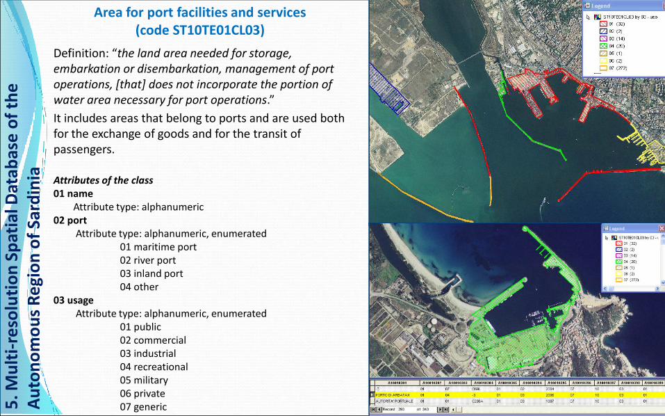
Area for port facilities and services (code ST10TE01CL03)
Definition: “the land area needed for storage, embarkation or disembarkation, management of port operations, [that] does not incorporate the portion of water area necessary for port operations.”
It includes areas that belong to ports and are used both for the exchange of goods and for the transit of passengers.
Attributes of the class 01 name Attribute type: alphanumeric 02 port Attribute type: alphanumeric, enumerated 01 maritime port 02 river port 03 inland port 04 other 03 usage Attribute type: alphanumeric, enumerated 01 public 02 commercial 03 industrial 04 recreational 05 military 06 private 07 generic 5
. Mu
lti-
reso
luti
on
Sp
atia
l Dat
abas
e o
f th
e
Au
ton
om
ou
s R
egi
on
of
Sard
inia

Port buildings and other man-made structures
(code ST02TE02CL09)
Definition: “buildings and other man-made structures pertaining to the inner area of a port”
Attributes of the class 01 type Attribute type: alphanumeric, enumerated
01 pier 03 port 04 quay 06 pontoon 07 lighthouse and other lights 08 buoy 09 dolphin structures 10 dry dock 12 crane 13 mooring
02 acad layer Attribute type: alphanumeric
5. M
ult
i-re
solu
tio
n S
pat
ial D
atab
ase
of
the
A
uto
no
mo
us
Re
gio
n o
f Sa
rdin
ia


Alghero
Cagliari
Carloforte Villasimius
Calasetta

Aim: providing sailors & yachtsmen with information
58 ports listed - a total of 14,795 berths
some are geographically referenced and superimposed on satellite imagery by means of the geo-visualizer “Sardegna 3D”
Info provided varies
6. w
ww
.sar
de
gnat
uri
smo
.it
Province no. of ports berths
Cagliari 11 3,117
Carbonia-Iglesias 7 1,400
Nuoro 2 324
Ogliastra 2 750
Olbia-Tempio 23 6,633
Oristano 2 520
Sassari 11 2,051
Medio Campidano 0 0
TOTAL 58 14,795
Province
Name
Place
Address
Telephone
Fax
Geographic coordinates
Website
Management
Available berths
Maximum permitted length of boats (metres)
Max permitted draught (metres)
Electric energy supplied
Water supplied
Meteo forecast
Waste facilities
Surveillance
Customer services
Booking
Summer transit (info availability)
Showers
Toilets
Assistance
Other services
Nearest airport(s)

6. w
ww
.sar
de
gnat
uri
smo
.it

6. w
ww
.sar
de
gnat
uri
smo
.it

marina
7. o
the
r w
eb
site
s sp
eci
alis
ed
in p
rovi
din
g sa
ilors
w
ith
info
rmat
ion
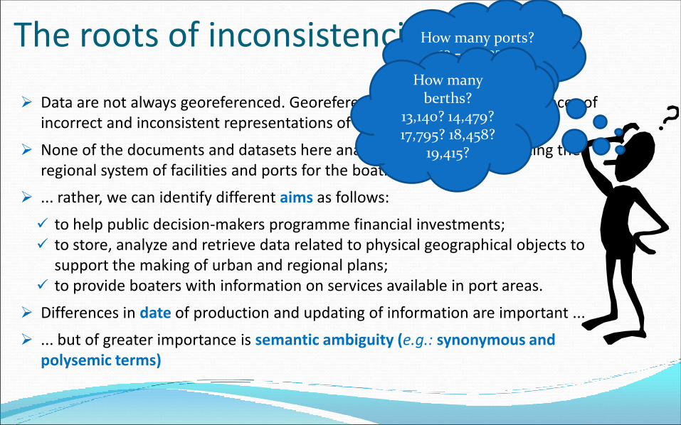
The roots of inconsistencies
Data are not always georeferenced. Georeferenced databases show evidences of incorrect and inconsistent representations of objects.
None of the documents and datasets here analysed aimed at representing the regional system of facilities and ports for the boating sector ...
... rather, we can identify different aims as follows:
to help public decision-makers programme financial investments; to store, analyze and retrieve data related to physical geographical objects to
support the making of urban and regional plans; to provide boaters with information on services available in port areas.
Differences in date of production and updating of information are important ...
... but of greater importance is semantic ambiguity (e.g.: synonymous and polysemic terms)
How many ports? 46? 56? 58? 78?
79? How many berths?
13,140? 14,479? 17,795? 18,458?
19,415?


“It is frequently necessary for multiple data sources to be combined (integrated) and used together in a structured way. As there might be differences in semantics as well as in the
structure of these datasets, the data must be adapted to fit the task … subtle differences in semantics may result in data being improperly integrated” (Mizen et al., 2005)
“It might look obvious, but before thinking at how to structure a dataset, one should tackle the more complex issue of deciding upon what should be in the dataset” (Laurini & Murgante, 2008)
“Enabling reuse of domain knowledge was one of the driving forces behind recent surge in ontology research” (Noy & McGuinness, 2001)
“Currently, there is no comprehensive ontology for the geo-spatial domain, and it is recognized that there are no definitive methods for ontology derivation available to the geographic community ” (Timpf, 2002 in Agarwal, 2005)

Geographic Data & Interoperability
Problem of the past: lack of adequate information
Today:
plenty of available data, both spatial and non-spatial
proliferation of data sets built with no common standards has become an issue
we cannot simply reuse and combine existing data and information
we need to homogenize data and solve semantic conflicts
One of the most important reasons that spurred research on ontologies was the need to reuse existing knowledge
Ontologies try and describe a given domain of interest by identifying
key concepts that define the domain
relations that connect the concepts
existing constraints
interoperability
support database modelling

What is an ontology?
“an explicit specification of a conceptualization” (Gruber, 1993)
“a formal, explicit specification of a shared conceptualisation” (Studer et al., 1998)
“a shared and common understanding of a domain that can be communicated between people and application systems” (Davies et al., 2003)
“a formal description of a domain that is understandable to people and readable between machines” (Hart et al., 2007)
“the manifestation of a shared understanding of a domain that is agreed between a number of agents, and such agreement facilitates accurate and effective communications of meaning, which in turn leads to other benefits such as inter-operability, reuse and sharing” (Agarwal, 2005)
“the creation of an ontology is usually viewed as a knowledge acquisition task, which involves eliciting, analysing and intepreting human knowledge, and transferring this knowledge into a suitable machine representation” (Mizen et al., 2005)

Building an ontology: steps (Hart et al., 2007, Hart and Goodwin, 2007, Kovacs et al., 2006)
1. Identification of purpose and scope
What is the ontology going to be used for? What is going to be included in the ontology? What needs to be left out?
2. Knowledge elicitation:
Identify core concepts Identify secondary concepts Identify relationships between concepts
3. Knowledge structuring
4. Validation

Phase 1: purpose and scope
Purpose: to develop a conceptualization of the network of Sardinian marinas that can be used for the modelling and representation of spatial information
and that can support planning processes.
Scope: only those elements that can be put on a map are included.
The ontology must not be comprehensive it should not include all those entities that somehow relate to the domain
but only those concepts, relationships, constraints that are relevant.
As an ontology domain, it must be reusable within the given domain.

Phase 2: Knowledge glossary: concepts
Table of concept terms (core and secondary) Definitions in Italian – natural language only Use of documentary sources (pieces of legislation, technical documents, dictionaries)
Original Italian term Tentative English translation Definition Source
Approdo turistico Landing place A portion of a multi-purpose port dedicated to recreational boating, which may or
may not also provide services to yachtsmen and host Ancillary activities. DPR no. 509 of 1997
Area a servizio portuale Area for port services and
facilities
Land area needed for storage, embarkation or disembarkation, management of
port operations, that does not incorporate the portion of water area necessary for
port operation. It includes those areas that belong to ports and are used both for
the exchange of goods and for passengers’ transits.
Technical specifications of the MRSD
Banchina Quay
Structure of a port that serves, together with piers and pontoons, to let
passengers on or off a boat or to moor the boat.
A quay defines the inner border of a port basin.
Technical recommendations for the designing
of ports for pleasure boats
Pontile Pier Structure of a port that can be fixed or floating and that serves, together with
quays, to let passengers on or off a boat or to moor the boat.
Technical recommendations for the designing
of ports for pleasure boats
Porto
commerciale Commercial port Port for the movement of freights and passengers. Dictionary (Il Grande Italiano di Aldo Gabrielli)
Porto di categoria I 1st Category port Port for national security and military defence. State Law no. 84 of 1994
Porto di categoria II, classe I 2nd Category, 1st class port Port that is relevant at the international level. State Law no. 84 of 1994
Porto di categoria II, classe II 2nd Category, 2nd class port Port that is economically relevant at the national level. State Law no. 84 of 1994
Porto di categoria II, classe III 2nd Category, 3rd class port Port that is economically relevant at the regional or trans-regional level. State Law no. 84 of 1994
Posto barca Berth Part of a port’s water basin, adjacent to a quay, a pier or a pontoon, where boats
are moored.
Technical recommendations for the designing
of ports for pleasure boats
Definitions translated from Italian into English
semantic imprecision in English might occur when
there is no ambiguity in Italian or vice versa
e.g. quay, pier, wharf overlap in some aspects
while the original Italian are unambiguous
this ontology proposed is language-dependent

Phase 2: Knowledge glossary: relations
Relation Definition of the relation in natural language Notes
Is a A an instance of B
Is part of A is a part of B “Is part of” is inverse of “Has part”
Has part A has B as part “Has part” is inverse of “Is part of”
Contains A completely contains B (where A is a human created legal entity or similar such as a county) “Contains” is inverse of “Contained by”
Contained by A is completely within B (where B is a human created legal entity or similar such as a county) “Contained by” is inverse of “Contains”
Does not overlap A and B do not share any physical portion Symmetric relation
Is adjacent to A is positioned such that it physically touches B Symmetric relation
The knowledge glossary is an explicit and shared specification of the entities that constitute the abstract and simplified domain model here developed,
but not a formal specification, yet.
taxonomic
mereonomic
spatial

Software program: Protégé (version 3.4.4 frame oriented)
concepts are arranged in a hierarchical structure, divided into classes and
subclasses
classes and subclasses (sets of concepts) are
defined according to the knowledge glossary
connected one another by means of the relations defined in the glossary
slots are used
to describe classes, subclasses and instances
to assign relationships
Phase 3: Knowledge structuring

Phase 3: Knowledge structuring
Software program: Protégé (version 3.4.4 frame oriented)
concepts are arranged in a hierarchical structure, divided into classes and
subclasses
classes and subclasses (sets of concepts) are
defined according to the knowledge glossary
connected one another by means of the relations defined in the glossary
slots are used
to describe classes, subclasses and instances
to assign relationships

Instances are created
Slots are filled in
Phase 3: Knowledge structuring

The ontology is now
completely defined.
It can be:
continuously updated
graphically
represented as a
graph tree
Nodes: classes,
subclasses and instances
Arcs: relations
Phase 3: Knowledge structuring

Was it worth?
This ontology allows for a better understanding of the domain of interest (Uschold and Gruninger, 1996)
Iterative and continually adjustable learning process Collaboration and participation of experts in the domain field can be included ... ... so as to improve chances of sharing and reusing the ontology in the domain field
Representation & communication of knowledge is not task-dependent Reusability in the domain (updating and refining are possible) Basis for developing task-dependent or application-oriented ontologies in the same domain
The construction of a shared vocabulary that explicitly and unambiguously defines entities of the domain and the relationships Helps reduce semantic conflicts (Las Casas and Scardaccione, 2008),
Makes it possible to address the problems highlighted in the analysis of available data
The ontological representation of the domain Facilitates the modelling of the geographic database Makes it easier to control spatial constraints, as these are defined as slots that explicit spatial
relations between classes

Controlling spatial relations Class “A” Relation Class “B”
Pier Contained in Area for services and facilities
Breakwater Contained in Area for services and facilities
Dock Does not overlap Area for services and facilities
Pier Does not overlap Breakwater

Controlling spatial relations The software looks for and
displays in real time objects
belonging to the feature class
“Pier” not contained within an
object belonging to the feature
class “Area for services and
facilities”

Controlling spatial relations The software looks for and
displays in real time objects
belonging to the feature class
“Docks” that overlap at least
an object belonging to the
feature class “Area for
services and facilities”

An attempt was made to show how the use of ontologies can contribute towards the achievement of two goals:
deepen and better organize existent knowledge concerning a given domain by formalizing the conceptualization of the domain through the construction of a glossary that makes use of a shared language
ensure that spatial entities are compliant with tests designed on the basis of the relationships themselves by making the spatial relationships between defined classes and subclasses explicit
“The term ontology is used more and more in the context of GI Science.
Is ontology then a buzzword or a real paradigm shift?
What is in it? Does it help to solve the open problems in data access and interpretation (semantic interoperability)…?
Does it improve our understanding of geographical space?
Or is ontology a modern flowery phrase for former concepts?” (Winter, 2001)