neighborhoods first - squarespace · neighborhoods first a low risk, high return strategy for a ......
TRANSCRIPT

Neighborhoods FirstA low risk, high return strategy for a better Brainerd.
2014 Neighborhood ImprovementsNortheast Brainerd
prepared by
A Better Brainerd

CREDITSA Better Brainerd is an initiative of Strong Towns, a 501(c)3 non-profit organization headquartered in Brainerd and Minneapolis, Minnesota.
This project is made possible by a grant from the Otto Bremer Foundation and ongoing support from the Blandin Foundation along with financial contributions from numerous individuals and organizations.
We would also like to thank the many unpaid volunteers who give an untold number of hours every day in support of the Strong Towns movement.
This report is available for download at www.aBetterBrainerd.org. Everything we do there and at Strong Towns is completely open source and available at no charge to copy, share and adapt to your local situation. If you want to support us and honor what we do, please share this report with others.
We dedicate this effort to the kind people we had the pleasure to meet within Northeast Brainerd as well as all of those we hope to soon be acquainted with there. The future prosperity of the entire Brainerd Lakes Area is linked to how we approach the health of your neighborhood and others like it. You may not feel it, but you are one of the most important assets of this city.
Keep doing what you can to build a strong town.

INTRODUCTIONOctober 1, 2013
In 2012, I wrote a series of posts for the Strong Towns Blog contrasting the Taco John’s restaurant site along Brain-erd’s Washington Street with the same sized “old and blighted” block just up the street to the west. The City Council had approved 26 years of tax subsidies to assist Taco John’s in moving to this new location, an action consistent with the city’s comprehensive plan, zoning codes, engineering approach and all of the professional advice they were receiving. My posts questioned the justification for that decision – tax base growth and job creation – and spelled out some hard facts.
The “old and blighted” block containing two liquor stores, a barber shop, a pawn shop and some other local busi-nesses creates a total tax base that is 41% greater than the brand new Taco John’s. It also provides more jobs, has more small business owners and the businesses there patronize more local professionals and services than the franchise restaurant. In short, the old block is simply more financially productive for the city, even before deducting the subsidy from Taco John’s.
If the city intends to grow the tax base and cre-ate jobs and is willing to commit a generation of tax subsidies to do it, why are the results so dismal? More importantly, why do the city’s plans call for more of the same transformation of properties deemed “blighted” to what they call “auto-oriented” throughout this area?
These questions were met with no small amount of pushback from officials within lo-cal government and affiliated organizations. There was an understandable defensiveness but also a sense that our data-driven approach was simply a gratuitous attack on the city. The one question that continued to be thrown back at us was:
“Okay, but what would you have us do differently?”
This is a fair question. In response I wrote a 6,000+ word essay called From the Mayor’s Office describing an alterna-tive model for neighborhood investment. Instead of pursuing grants for big “game changing” projects and offering subsidies to try and get someone to move here, why don’t we focus on using the resources we do have to make the city incrementally better for those residents and businesses that already live here?
If we do that, we won’t need to provide subsidies and chase prosperity. Prosperity will find us.
From the Mayor’s Office was picked up and published by a number of journals in the United States and Canada, but had little impact locally. As I spoke with elected officials, staff members and others around town about changing an approach that wasn’t working, the feedback I received was consistent.
Northeast Brainerd is full of renters. They’re not vested in the community. They have no pride of ownership. It’s a bunch of meth labs and drug addicts over there. Why would anybody move to Northeast when they
Something is not working here. Do we write it off as “deviant behavior” or ask a deeper question about how we are building our neighborhoods?

can get a home with a three car garage in Baxter?
Fortunately, there was significant turnover in the city council in 2012 and a new set of priorities established earlier this year. At the top of the new council’s agenda: neighborhood investments and stable financial planning.
These two priorities go hand in hand. Only by making strategic neighborhood investments, and forgoing the high risk / low return projects that have characterized our approach in recent decades, can the city stabilize their financ-es. A portfolio of low risk, high return neighborhood projects is not only within the city’s budget, but it plays to the strengths of the community.
This report – Neighborhoods First; A low risk, high return strategy for a better Brainerd – outlines how this community can make small, incremental investments in just one part of one neighborhood. By observing how our neighbors use the city, by asking them where their daily struggles are, by getting out on the street and opening our hearts and minds to what is actually going on, we can discern what the pressing needs are. These are our high return investments.
If we apply this approach to all of the community’s neighborhoods, we’ll have a solid, long term investment strategy that we own and control and that all our residents and businesses are guaranteed to benefit from.
There is a sense of urgency here. Brainerd suffered terribly in the last economic downtown when we discovered that having 42% of the budget funded by local government aid made us very fragile to the whims of lawmakers in St. Paul. With the nation’s economic trajectory still in doubt, we need to be taking this time to shore up our position and build resiliency to the next downturn.
The team at A Better Brainerd has spent the past six months getting to intimately know the neighborhood and the people who work and live there. We’ve done little projects to plant trees, paint crosswalks, put up flags to help people cross Mill Avenue and set up benches for people to use. We’ve received a lot of positive feedback, but have also been directed to stop our activities by a small number of officials from both the city of Brainerd and Crow Wing County.
We have no intention of stopping, and in fact we hope others join us in advocating for a different approach. We want to be the city’s partner, just as the people of Northeast Brainerd want to be the city’s partner, but the city needs to meet its residents and business owners where they are. This report shows one powerful way to do that.
Let’s all work together to build a better Brainerd.
Charles L. Marohn, Jr. PE AICPPresident of Strong TownsProfessional Engineer, American Institute of Certified PlannersLocal Business Owner and BHS Class of 1991
If we watch how people use the city, we will identify the high return investments.

PROJECT LOCATION MAPThe eight projects described on the following pages are all located within Northeast Brainerd, the focus area for A Better Brainerd.
The incremental, neighborhood-focused approach described in this report can be applied through-out the city to create a broad portfolio of low risk, high return public investments. This process can be built on year after year resulting in an incremental, yet continuous, focus on investments that strengthen the city and truly improves the prosperity of residents and businesses.

PROJECT #1: BIKE LANES ON H STREET
H Street serves as an important east/west corridor through Northeast Brainerd. This is where the streetcar used to run, an influence that is still perceptible in the layout and design of the adjacent properties. H Street con-
nects the neighborhood with the commercial node on Mill Avenue and with Lowell School.
Today, H Street is excessively wide and, despite the designation as a bike route, is inhospitable to anyone not trav-eling in an automobile. The width of the travel lanes, the low volume of traffic and the absence of parked cars in-duce drivers to operate beyond neighborhood-speeds. This makes crossing the street by foot or on bike needlessly dangerous.
Surface markings on H Street have been neglected for many years. In most places they have faded to the point where they are imperceptible. This project constitutes routine maintenance to reestablish pavement markings only this time with a more neighborhood-friendly design.
Immediate Objectives 1. Improve the safety for bikers operating on H Street. 2. Improve safety for pedestrians crossing H Street. 3. Reduce automobile speeds along H Street.
Project Improvements 1. Reestablish parking lanes using white paint. 2. Establish bike lanes using white paint.
Project Cost$5,875

PROJECT #1: BIKE LANES ON H STREET
Existing H Street (pavement markings absent)
The project makes a significant improvement to the neighborhood, at a nominal cost, by clarifying the accep-tance of bikers within the public realm. It is okay to bike on H Street today, but lack of anything but a small
sign fails to signal drivers for any anticipation of cyclists. This project makes it clear that bikers are welcome in Northeast Brainerd.
In addition, on-street parking is being dramatically underutilized. Brainerd taxpayers paid significantly to con-struct this space yet it goes largely unused. Parked cars provide additional safety and comfort for pedestrians using the sidewalks and help to further slow traffic. We need to make better use of this investment.
The existing 14-foot driving lanes are similar in dimension to those found on interstate highways. This gives driv-ers in a quiet, residential neighborhood a false sense of comfort and, in doing so, induces dangerously high speeds. Narrowing these lanes will improve, not impair, the safe flow of traffic at neighborhood speeds.
Improved H Street (with pavement markings)

UNDERSTANDING TRAFFIC SPEEDSpeed limits are generally established by monitoring driver behavior. This makes many people believe, including
many professional engineers, that the design of a street doesn’t matter, that people will drive what they will and the designer need not take speed into account. Worse yet, there is a common belief that speed limits and aggressive traffic enforcement can make up for bad street design. These are incorrect, outdated and dangerous beliefs.
On intercity highways, engineers build to established highway standards, which incorporate the principles of “for-giving design” (see note below). These standards are not appropriate for neighborhoods where a more complex environment exists and slower speeds are necessary.
The National Highway Traffic Safety Administration has found that pedestrians struck by a vehicle traveling 40 mph have only a 15% chance of survival. When speeds are reduced to 20 mph, the chance of survival soars to 95%. If we want to attract sound neighborhood investments, we need to make our neighborhoods safe for the people that live there. This means a deliberate and urgent focus on reducing auto speeds.
Forgiving DesignForgiving Design is an approach that was developed in the early days of highway construction. Through trial and error, engineers discovered that accidents and fatalities could be reduced on highways by widening travel lanes, adding shoulders, straightening roadways, reducing curves and by clearing obstacles away from the edge of the roadway to improve sightlines. The concept is that such a design “forgives” many of the mistakes a driver makes, reducing the likelihood that a minor mistake would become a fatal collision.
Federal funding of city street projects caused municipalities to adopt forgiving design standards for their local streets. While intercity highways are simple environments, city streets are more complex. Wider lanes, shoulders and clear zones give urban drivers a false sense of security. City streets in North America experience a much high-er rate of injury and fatality than other parts of the world where Forgiving Design is not used within cities.
Organizations like the Institute of Traffic Engineers and the American Association of State Highway and Trans-portation Officials have worked to develop new standards for city streets. These approaches abandon Forgiving Design in favor of a safer, neighborhood-scaled approach. Their improved standards can be adopted by any city. In addition to being safer, neighborhood-context streets generally cost less to build and maintain.
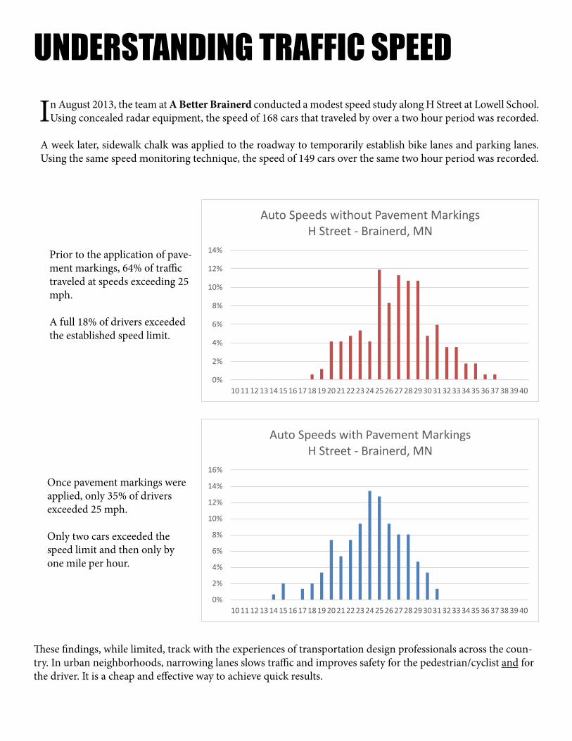
In August 2013, the team at A Better Brainerd conducted a modest speed study along H Street at Lowell School. Using concealed radar equipment, the speed of 168 cars that traveled by over a two hour period was recorded.
A week later, sidewalk chalk was applied to the roadway to temporarily establish bike lanes and parking lanes. Using the same speed monitoring technique, the speed of 149 cars over the same two hour period was recorded.
UNDERSTANDING TRAFFIC SPEED
0%
2%
4%
6%
8%
10%
12%
14%
10 11 12 13 14 15 16 17 18 19 20 21 22 23 24 25 26 27 28 29 30 31 32 33 34 35 36 37 38 39 40
Auto Speeds without Pavement MarkingsH Street - Brainerd, MN
0%
2%
4%
6%
8%
10%
12%
14%
16%
10 11 12 13 14 15 16 17 18 19 20 21 22 23 24 25 26 27 28 29 30 31 32 33 34 35 36 37 38 39 40
Auto Speeds with Pavement MarkingsH Street - Brainerd, MN
Prior to the application of pave-ment markings, 64% of traffic traveled at speeds exceeding 25 mph.
A full 18% of drivers exceeded the established speed limit.
Once pavement markings were applied, only 35% of drivers exceeded 25 mph.
Only two cars exceeded the speed limit and then only by one mile per hour.
These findings, while limited, track with the experiences of transportation design professionals across the coun-try. In urban neighborhoods, narrowing lanes slows traffic and improves safety for the pedestrian/cyclist and for the driver. It is a cheap and effective way to achieve quick results.
PROJECT #2: BIKE LANES ON 1ST AVE NE
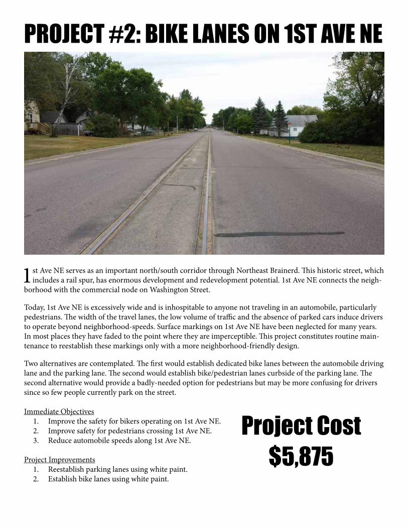
1st Ave NE serves as an important north/south corridor through Northeast Brainerd. This historic street, which includes a rail spur, has enormous development and redevelopment potential. 1st Ave NE connects the neigh-
borhood with the commercial node on Washington Street.
Today, 1st Ave NE is excessively wide and is inhospitable to anyone not traveling in an automobile, particularly pedestrians. The width of the travel lanes, the low volume of traffic and the absence of parked cars induce drivers to operate beyond neighborhood-speeds. Surface markings on 1st Ave NE have been neglected for many years. In most places they have faded to the point where they are imperceptible. This project constitutes routine main-tenance to reestablish these markings only with a more neighborhood-friendly design.
Two alternatives are contemplated. The first would establish dedicated bike lanes between the automobile driving lane and the parking lane. The second would establish bike/pedestrian lanes curbside of the parking lane. The second alternative would provide a badly-needed option for pedestrians but may be more confusing for drivers since so few people currently park on the street.
Immediate Objectives 1. Improve the safety for bikers operating on 1st Ave NE. 2. Improve safety for pedestrians crossing 1st Ave NE. 3. Reduce automobile speeds along 1st Ave NE.
Project Improvements 1. Reestablish parking lanes using white paint. 2. Establish bike lanes using white paint.
Project Cost$5,875
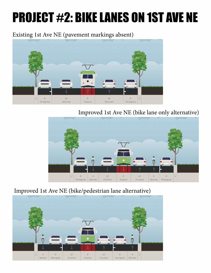
PROJECT #2: BIKE LANES ON 1ST AVE NEExisting 1st Ave NE (pavement markings absent)
Improved 1st Ave NE (bike lane only alternative)
Improved 1st Ave NE (bike/pedestrian lane alternative)

PROJECT #3: PEDESTRIAN CROSSING
Project Cost$850
D Street is an important east/west corridor for people trying to get to Cub Foods, the only grocery store within walking distance of the neighborhood. There is a lot of people walking and biking through this area out of
necessity, even though there are no facilities for walking and biking.
The most difficult part of this trip is crossing 5th Avenue. There are no crosswalks or other indicators of high non-motorized use, except for a warning sign indicating the potential for individuals in wheelchairs. Ironically, this sign faces west – not the source of the problem – and thus seems to be warning people in wheelchairs to be careful.
To raise a minimum level of awareness among drivers to the potential of pedestrians and bikers, and visa-versa, an intersection-wide crosswalk needs to be established. This is a base step in alerting everyone entering this intersec-tion to be alert for potential conflicts.
This project constitutes a small step beyond what is otherwise routine maintenance.
Immediate Objectives 1. Improve the safety for bikers crossing 5th Avenue. 2. Improve safety for pedestrians crossing 5th Avenue. 3. Improve safety for automobiles operating along 5th Avenue.
Project 1. Establish crosshatch striping throughout the intersection.
PROJECT #3: PEDESTRIAN CROSSING
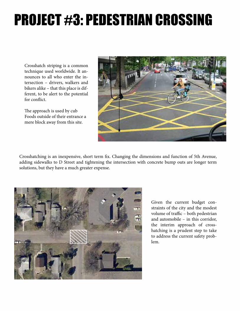
Crosshatch striping is a common technique used worldwide. It an-nounces to all who enter the in-tersection – drivers, walkers and bikers alike – that this place is dif-ferent, to be alert to the potential for conflict.
The approach is used by cub Foods outside of their entrance a mere block away from this site.
Given the current budget con-straints of the city and the modest volume of traffic – both pedestrian and automobile – in this corridor, the interim approach of cross-hatching is a prudent step to take to address the current safety prob-lem.
Crosshatching is an inexpensive, short term fix. Changing the dimensions and function of 5th Avenue, adding sidewalks to D Street and tightening the intersection with concrete bump outs are longer term solutions, but they have a much greater expense.

PROJECT #4: PEDESTRIAN CROSSING
Project Cost$400
C Street is an important east/west corridor for people trying to get to Cub Foods, the only grocery store within walking distance of the neighborhood, and other destinations in this commercial node. There is a lot of people
walking and biking through this area out of necessity, even though there are no facilities for walking and biking.
The most difficult part of this trip is crossing 5th Avenue, which is excessively wide and induces traffic to travel at dangerous speeds. There are no crosswalks or other indicators of non-motorized use. The lack of on-street parking wide curb radii mean pedestrians have a wide gap to cross.
To raise a minimum level of awareness among drivers to the potential of pedestrians and bikers, and visa-versa, a standard crosswalk needs to be established. This is a base step in alerting everyone entering this intersection to be alert for potential conflicts.
This project constitutes a small step beyond what is otherwise routine maintenance.
Immediate Objectives 1. Improve the safety for bikers crossing 5th Avenue. 2. Improve safety for pedestrians crossing 5th Avenue. 3. Improve safety for automobiles operating along 5th Avenue.
Project 1. Establish a crosswalk at the intersection.

PROJECT #4: PEDESTRIAN CROSSING
The use of a crosswalk in an intersection is a common tech-nique used throughout the city. It announces to all who enter the intersection – drivers, walkers and bikers alike – that this place is different, to be alert to the potential for conflict.
Establishing a crosswalk is an inexpensive, short term fix. Changing the dimensions and function of 5th Avenue, adding sidewalks to C Street and tightening the intersection with concrete bump outs are longer term solutions that come at much greater expense.
Given the current budget constraints of the city and the modest volume of traffic – both pedestrian and auto-mobile – in this corridor, the interim approach of estab-lishing a crosswalk is a pru-dent step to take to address the current safety problem.

PROJECT #5: PEDESTRIAN CORRIDOR
Project Cost$96
C Street is an important east/west corridor for people trying to get to Cub Foods, the only grocery store within walking distance of the neighborhood, and other destinations in this commercial node. There are a lot of
people walking and biking through this area out of necessity, even though there are no facilities for walking and biking.
After crossing 5th Avenue, walkers and bikers must proceed along a dangerous stretch of C Street NE. There are no pedestrian facilities at all and the driving lanes measure out to be an astonishing 19 feet wide. Speed through the area is so excessive that, once the street becomes private property, speed bumps have been installed.
To provide a minimum safe haven for pedestrians and bikers, this project devotes the northerly 8 feet of paved sur-face to pedestrians. A solid double stripe should begin at the crosswalk and run the length of the publicly owned property (which extends to the first curb cut on the north side of the street). This would reduce the driving lanes to 15 feet, which is still exceeds any possible motorized need by a wide margin.
Immediate Objectives 1. Improve the safety for bikers traveling C Street. 2. Improve safety for pedestrians traveling C Street.
Project 1. Establish a pedestrian safe haven on the north side of C Street west of 5th Avenue.

PROJECT #5: PEDESTRIAN CORRIDOR
Existing C Street (pavement markings absent)
The Brainerd Mall is an important commercial destination for residents in Northeast Brainerd. Unfortunately, even though the neighborhood existed decades before the mall and the surrounding properties, nothing with
the layout and design of the site concerns itself with the homes and the people that surround it.
The only safe and convenient way to travel to the site is by automobile. The drive through restaurants and strip mall built in recent years also have no safe pedestrian facilities. This is true despite the fact that there are thousands of customers living within walking distance, some literally right across the street.
Most tragically, the very design of the buildings has created a blight on the neighborhood. While the owners improve the facades and the signs that face the highway, towards the homes their buildings remain largely un-adorned. Property owners who live next to the site are forced to look at dumpsters and have learned to live with security lights shining in their windows. This impacts property values and drives out investment.
Short term we can take steps to improve the functionality of the neighborhood for residents. Long term, we need to develop an approach that ensures everyone is, first and foremost, a good neighbor.
Improved C Street (with pavement markings)
PROJECT #6: TREE TRIMMING
Project Cost$0
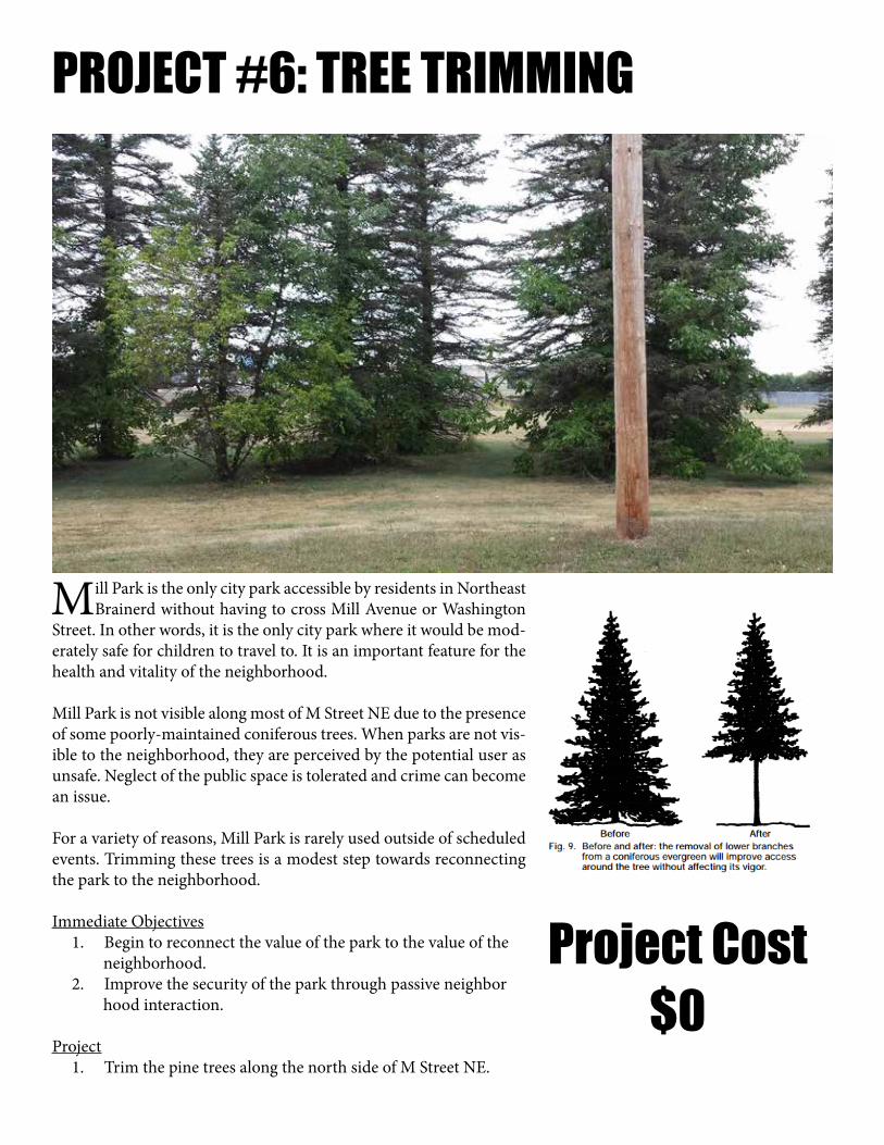
Mill Park is the only city park accessible by residents in Northeast Brainerd without having to cross Mill Avenue or Washington
Street. In other words, it is the only city park where it would be mod-erately safe for children to travel to. It is an important feature for the health and vitality of the neighborhood.
Mill Park is not visible along most of M Street NE due to the presence of some poorly-maintained coniferous trees. When parks are not vis-ible to the neighborhood, they are perceived by the potential user as unsafe. Neglect of the public space is tolerated and crime can become an issue.
For a variety of reasons, Mill Park is rarely used outside of scheduled events. Trimming these trees is a modest step towards reconnecting the park to the neighborhood.
Immediate Objectives 1. Begin to reconnect the value of the park to the value of the neighborhood. 2. Improve the security of the park through passive neighbor hood interaction.
Project 1. Trim the pine trees along the north side of M Street NE.

UNDERSTANDING PARKSToo much is expected of city parks. Far from transforming any essential
quality in their surroundings, far from automatically uplifting their neighborhoods, neighborhood parks themselves are directly and drasti-
cally affected by the way the neighborhood acts upon them.
- Jane Jacobs, The Death and Life of Great American Cities
There is a common belief that a city park is necessary to compensate for the lack of open space urban residents have when compared to those that live on the outskirts of town. This tragic misunderstanding of the role of
an urban park has caused us to overlook a prime asset in Northeast Brainerd.
A good park radiates value to the surrounding neigh-borhood in the same way the sun radiates heat; the clos-er you are, the more value the park should add. While New York City’s Central Park would be extremely valu-able if it were developed, the immense value of Manhat-tan and the other boroughs adjacent to it would suffer if the park become a housing subdivision. The location and design of the park makes the city valuable.
At the same time, it is the city that makes the parkland valuable. If we took a piece of land in rural Iowa and re-created Central Park, it would not have any real value. It takes people using the park to build and create the val-ue that is then reflected back to the neighborhood.
A lifeless park is the sign of a lifeless neigh-borhood. Fixing what is wrong with Mill Park is critical, but doing so will not restore Northeast Brainerd to prosperity. The two need to happen together.
An urban park is not compensation for a neighborhood’s shortcomings. It is a reflec-tion of a neighborhood’s value and worth and, as such, is the most revealing barome-ter of success or failure the city has.
*Recomended reading: The quote from Jane Jacobs above is Chapter 5 of the book, which is all about urban parks.
Central Park, New York City
Gregory Square, Brainerd

PROJECT #7: PARK TREE PLANTING
Project Cost$900
Mill Park is the only city park accessible by residents in Northeast Brainerd without having to cross Mill Av-enue or Washington Street. In other words, it is the only city park where it would be moderately safe for
children to travel to. It is an important feature for the health and vitality of the neighborhood.
Mill Park is not comfortable to be in during the summer because of the lack of shade. While there are picnic tables and bleachers, they are rarely used. Planting shade trees today is a modest investment that will improve the user experience of this park dramatically over time.
Additionally, while the paper mill site may have economic importance to the city, it is an unsightly backdrop to the park. Seedlings planted today in the weeds beyond the fence line of the ball field would be very low cost but, in time, will grow to provide a suitable visual buffer.
Immediate Objectives - None.
Long Term Objectives 1. Improve the enjoyment of the park. 2. Raise the property values and investment demand throughout the neighborhood.
Project 1. Plant trees within Mill Park.

A MATTER OF PRIORITIES
Vegetation in the roadway median on College Drive. Vegetation in Mill Park on the same day.
At a glance, it seems incoherent for the city of Brainerd to spend significant amounts of money to maintain flowers in the median of a road while city parks are overgrown with weeds. Do we really value the experience of the person driving
through more than we care about the resident who lives here? Is there really more to be gained by beautifying our ditches instead of our parks? Of course not.
So does this reality actually reflect the priorities of the city government? In all likelihood it doesn’t, and so we have to ponder an even more important question: Why are the priorities of public officials not reflected in city action?
There are three main reasons. The first is the way in which big projects are funded. College Drive was paid for largely with “other people’s money,” which is to say federal and state sources. While some will point out that this is still our money (we all pay federal and state taxes), the proportion paid by local taxpayers was nominal and indirect. Given that, why not add flowers to the project? We’d surely put flowers in the park too if someone else would pay for it?
The second is the way in which the staff is organized and directed. Most local governments still work in silos. It is hard to blame a traffic engineer for seeing the city as a traffic network or a zoning official for seeing it as a zoning map. While it will not be as brutally efficient as the silo approach, the way to avoid this type of dissonance is to begin, develop and finalize all projects with a team of professionals, working on equal authority, directed to prioritize the community’s values and objec-tives above their own department’s.
The third is the disconnect that exists between city government and residents. This disconnect goes way beyond being lis-tened to, which local governments generally do quite well. To really participate in a project, a resident is forced to engage within the ground rules of the city. Participating in public hearings or committees means giving up precious evening hours, standing in front of crowds and being quoted in the paper. Most residents stay away, even if they want their opinion heard.
To address these systematic shortcomings, cities should adhere to three guidelines.
1. Projects should be developed based on needs expressed within the city’s neighborhoods, not in pursuit of available fund-ing or in gambling on the potential for a big payoff. If available funding supports a local need, all the better, but a city should never undertake something they would not consider doing just because someone else will pay for it.
2. All projects should be the product of a team of professionals, not one individual department or silo. When hiring and re-taining staff, cities should emphasize cross disciplinary knowledge. There can be no such thing as a one-dimensional project.
3. All projects should be the result of neighborhood initiatives. This report presents a model for how to deeply engage and understand a neighborhood. With this approach, a city will find there are a multitude of low cost, high return things to be done. The way residents use the city will identify those projects more clearly than any study, staff member or expert.

PROJECT #8: BLVD TREE PLANTING
Project Cost$2,750
Northeast Brainerd was the city’s first suburb. It was built around the streetcar line, which ran along 3rd Ave-nue from Washington Street to H Street. The development pattern along 3rd Avenue still retains much of the
historic character from this time period. Most of the homes orient towards the street. The street retains most of its sidewalks. A boulevard between the curb and the sidewalk still has many of the towering shade trees that were planted generations prior.
For these reasons and more, this is the premiere street in Northeast Brainerd. Reversing the general stagnation and decline of the neighborhood can most easily begin along this street.
Trees are an essential component of a successful urban street. They not only provide shade, they frame the public realm and thus add to the sense of place, a powerful design tool once used extensively throughout the neighbor-hood. Filling in the gaps in the boulevard is a low cost way to build value along this street.
Immediate Objectives - None.
Long Term Objectives 1. Provide shade to the sidewalks. 2. Frame the public realm to improve property values.
Project 1. Plant trees along 3rd Avenue.

PROJECT #8: BLVD TREE PLANTING
Northeast Brainerd was originally designed and constructed using the traditional development pattern featur-ing a grid system. The grid approach has many advantages, including:
• The flexibility to accommodate many different uses on the same pattern. • The ability to naturally accommodate different price points and densities on a single block. • The ability to grow incrementally over time. • Ease of mobility, particularly for walkers and bikers. • The capacity to easily accommodate transit options. • A design that inherently improves safety and security. • Very high financial productivity for the city. High tax base with low cost of service. • Built in resistance to financial decline.
A key to creating value – real taxable wealth that provides the high financial productivity that comes with this pattern – is to enhance the sense-of-place that accompanies the traditional development pattern.
Sense-of-place is an abstract concept but is actually simple to understand. A room is a “place” because it has walls. When buildings along the street line up to form walls, they create a sense of place within the public realm. If the “walls” (buildings) are too close, the space feels too constrained (like a tight alley). If the walls are too far apart, the sense-of-place is lost (which is why the space between Baxter’s Target and Best Buy does not have a sense-of-place even though the buildings line up and face each other).
Sense-of-place is enhanced when the buildings are oriented towards the street (have their door, a porch and win-dows facing the street) and when trees accentuate the framing.
To play to the strengths of the neighborhood, ultimately a new set of land use regulations are needed that address these simple components of sense-of-place (and, in turn, repeal the many, many counterproductive regulations that inhibt the neighborhood’s growth while also degrading the sense-of-place). In addition, street trees with straight trunks and bushy tops need to be planted in a linear fashion to provide framing to all neighborhood streets.

PROJECT COST ESTIMATEMost of the projects in this report would properly be characterized as basic maintenance. Street striping of parking and
driving lanes, the painting of crosswalks and the pruning of trees clearly fall into that category. There is a reasonable expectation among residents and business owners that these tasks are a routine part of the operation of any city. The striping of bike lanes and the planting of trees are modest enhancements for Brainerd but something many cities would also consider general maintenance.
Taken together, (1) a commitment to proper maintenance of existing public spaces and (2) an ongoing, incremental, im-provement of those spaces form the backbone of a successful neighborhood investment strategy.
Local government projects are often an effort to create economic growth, jobs and opportunity for residents and local busi-nesses. Since the end of World War II, cities gradually moved away from a neighborhood-focused, incremental approach
to growth and instead have embraced the “big project” approach. The idea is that these large, high profile projects will create momentum for the community and, in doing so, attract new growth and enhance economic opportunity.
Recent examples of the “big project” approach in Brainerd include Brainerd Oaks, the industrial park expansion, annexations to the north of the city, the College Drive expansion and the newly proposed $7.1 million sewer/water extension to the airport.
While the initial costs of these big projects are generally covered by the state and federal government, additional debt or private sector partners, the long term costs of maintaining and servicing all of these systems is covered by lo-cal taxpayers. For example, the state and federal government provided grant money to expand College Drive, but in two or three decades when all that pavement needs expensive maintenance, the cost to do that will be the responsibility of Brainerd’s taxpayers.
Today the city is struggling to maintain the “big projects” of the prior generation, which were many orders of magnitude smaller than the ones we are committing future generations to by our actions today. Even with “free” money today, these projects are not without real long term costs to local taxpayers.
How do we determine if a project is a good investment? Since these projects are being undertaken to induce growth, one way is to estimate the amount the tax base would need to increase for the project to make financial sense if the city had to pay for it on their own (as it will in a generation when maintenance is required). If the project does not make sense today, it will not make sense in the future when the city’s maintenance obligation comes due.
“Today the city is struggling to
maintain the “big projects” of the prior
generation...”

PUBLIC RETURN ON INVESTMENT
To be financially viable for the future residents of the city, College Drive needs to create $80 million in additional tax base and the Airport utility extension an additional $44 million1 just to cover the long term infrastructure costs. This does not include the additional costs of snow plowing, landscape maintenance, staffing, fire and police service or other costs associated with new growth, which will require even more tax base growth to fund. Since these projects are ostensibly undertaken for the overall health and betterment of the city, it should also be pointed out that these are the bare minimum numbers needed to avoid future tax increases on all private property owners. Far more growth in the tax base is needed for the public’s “invest-ment” in these projects to actually result in a reduction in tax rates or more money for improved services.
In comparison, the Neighborhood Improvements outlined in this report can be sustained indefinitely with only a $674,000 increase in the tax base, a small percentage of the neighborhood’s overall value. No additional services will be needed so any net increase above that amount provides additional revenue that can be used to improve services and/or reduce taxes.
Will the city realize $80 million in additional tax base from the College Drive project? It is impossible to believe that could ever happen. Will the city realize $44 million in additional tax base from the airport utility extension project? The possibility seems equally remote. It is an enormous gamble that is particularly questionable given the tenuous nature of the large federal subsidies the airport is de-pendent on and the lack of demand demonstrated in numerous vacant properties in the existing industrial park.
Will the $16,746 in improvements – some of it simply routine maintenance -- outlined in this report increase the value of Northeast Brainerd by $674,000 over the next five years? Whether it will or not – and we believe it will do that and much more – it is a very small gamble, one whose success or failure will be known in short order.
And this small investment in the city’s existing neighborhoods can be replicated time and again, year after year, with more high returning, incremental improvements throughout all of the city’s neighborhoods. This is how a city grows prosperous.
Free money is bankrupting the city of Brainerd. If this community is going to gamble on future growth, it should be doing so only where the risk of failure is minimal, the potential margin for return is high and the outcome is guaranteed to improve the lives of existing residents and business owners.
1 This is in 2013 dollars. Inflation will increase the real amount dramatically over the coming decades.
“Free money is bankrupting the city
of Brainerd.”
IMPLEMENTATIONCities across the country are starting to realize that the “big project” approach takes up too much staff time,
wastes too much political energy and distracts too much from the basic needs of existing neighborhoods. The fact that this approach is also a poor bang for the buck today and a long term financial liability tomorrow only makes the need for a new approach more urgent.
While the $16,800 in neighborhood improvements outlined in this report may seem insignificant, this is only for one small neighborhood. There are more than a dozen neighborhoods throughout the city where a similar focus will produce immediate, positive results. Small, incremental steps throughout all neighborhoods over a sustained period of time is how a city becomes prosperous. It truly is slow and steady that wins the race.
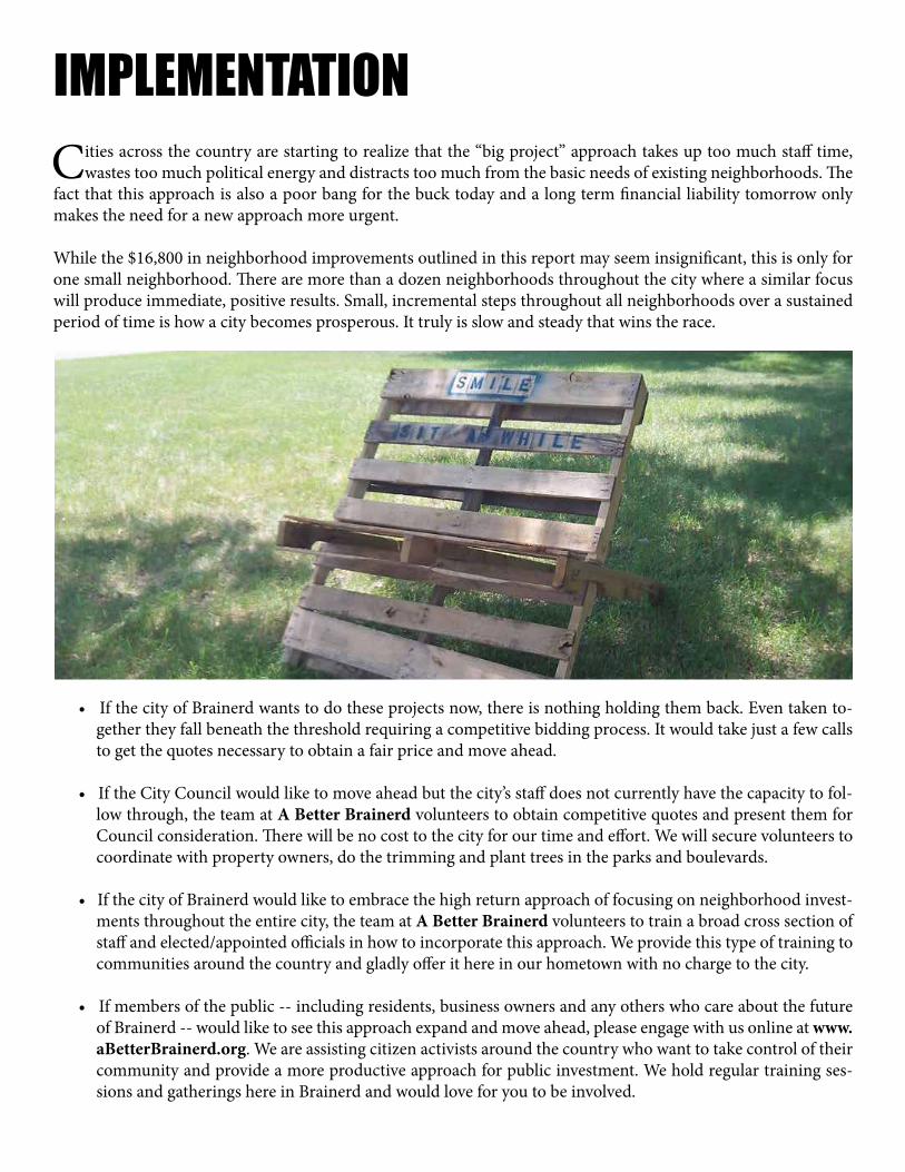
• If the city of Brainerd wants to do these projects now, there is nothing holding them back. Even taken to-gether they fall beneath the threshold requiring a competitive bidding process. It would take just a few calls to get the quotes necessary to obtain a fair price and move ahead.
• If the City Council would like to move ahead but the city’s staff does not currently have the capacity to fol-low through, the team at A Better Brainerd volunteers to obtain competitive quotes and present them for Council consideration. There will be no cost to the city for our time and effort. We will secure volunteers to coordinate with property owners, do the trimming and plant trees in the parks and boulevards.
• If the city of Brainerd would like to embrace the high return approach of focusing on neighborhood invest-ments throughout the entire city, the team at A Better Brainerd volunteers to train a broad cross section of staff and elected/appointed officials in how to incorporate this approach. We provide this type of training to communities around the country and gladly offer it here in our hometown with no charge to the city.
• If members of the public -- including residents, business owners and any others who care about the future of Brainerd -- would like to see this approach expand and move ahead, please engage with us online at www.aBetterBrainerd.org. We are assisting citizen activists around the country who want to take control of their community and provide a more productive approach for public investment. We hold regular training ses-sions and gatherings here in Brainerd and would love for you to be involved.

ABOUT A BETTER BRAINERD
“Build it and they will come is a terri-ble economic development strategy for small cities. It is high stakes gambling
of the most reckless kind.
Public officials that feel a need to do something proactive -- to undertake a“build it and they will come” ap-proach -- should focus on low risk,
high reward projects. That’s where the smart money is.”
-Charles MarohnPresident of Strong Towns
A Better Brainerd is an initiative of Strong Towns as part of Operation More George and Sandbox City. The mission of A Better Brainerd is to financially strengthen the city of Brainerd by improving the quality of life
and overall prosperity of its residents and businesses.
A strong city of Brainerd is one that:
1. Captures its share of the region’s overall growth, as measured in population, jobs and total tax base. 2. Grows without taking on onerous long-term liabilities or gambling on speculative future development. 3. Is not dependent on local government aid and other, unstable funding from state and federal sources to provide basic services.
Strong Towns is a 501(c)3 non-profit based out of Brainerd & Minneapolis, Minnesota. The mission of Strong Towns is to support a model of growth that allows America’s towns to become financially strong and resilient.
The American approach to growth is causing economic stagnation and decline along with land use practices that force a dependency on public subsidies. The inefficiencies of the current approach have left American cities fi-nancially insolvent, unable to pay even the maintenance costs of their basic infrastructure. A new approach that accounts for the full cost of growth is needed to make our places strong again.
Within hours after we installed temporary bike lanes they were being used.

For more informationStrong Towns
1511 Northern Pacific Drive, Room 211Brainerd, MN 56401
Phone: 218.828.3064email: [email protected]
Onlinewww.StrongTowns.org
www.aBetterBrainerd.orgwww.SandboxCity.org
www.facebook.com/strongtownswww.facebook.com/ABetterBrainerd
Twitter: @StrongTowns & @aBetterBrainerd