near west side - city of chicago 40 near west side while overall transit service appears to be good,...
TRANSCRIPT

PAGE 38
Near West S IDE
Ramp StudyCDOT is currently reviewing the potential to close someof the Kennedy Expressway ramps located inDowntown between the Eisenhower Expressway andLake Street. The ramp closures are being studied toreduce safety problems related to weaving of trafficcaused by the tight spacing of these ramps. Each ofthese ramps plays an important role in providingexpressway access to the Near West Side.
The ramp closure study is still underway, andimprovement plans have not been finalized. CDOT hasbeen meeting with local groups to review local accessto/from the expressways and impacts to local trafficoperations from potential ramp closures.
As traffic grows in the future, it may be difficult and/orundesirable to widen streets within the Near West Sideto address potential traffic congestion. Implementationof coordinated traffic signal systems can significantlyincrease the traffic carrying capacity of roadwayswithout the cost and disruption typically associated withstreet widening. As development occurs, thecoordination of traffic signals would be a desirable andcost effective method of dealing with traffic increases.
It appears that the Near West Side’s grid street systemhas excess capacity to handle some futuredevelopment. The improvements discussed earlierneed to be further studied regarding engineeringfeasibility. They conceptually have the potential toimprove current and future traffic movement throughoutthe area.
Projected Development & Traffic IncreasesAs noted earlier, the Near West Side can expect asignificant amount of development in the near future.If developed, each opportunity site could generatesignificant additional traffic. Development of all of thesites together, could generate as much as 20,000new trips per day to the street system.
As new development projects are proposed, trafficstudies will be required by DPD to show how existingtraffic and parking will be impacted and to identifyimprovements that might be necessary toaccommodate traffic flow and/or access.
The amount of traffic growth, and potential parkingimpact will be heaviest in the Halsted corridor whereseveral large under-developed sites exist. Severalsites already have proposed developments or strongpotential for new development in the near future.
Future traffic growth projected overall for the NearWest Side and Greektown should be incorporatedinto the Halsted Street improvement project plannedby CDOT.

PAGE 39
area analy s i s
Transit Access:Bus ServiceThe Chicago Transit Authority (CTA) operates severalmajor bus routes through the area.
Route #8: Halsted Street(Average Weekday Riders: 17,890)This route runs along Halsted from Addison to 119thStreet. This is an important route within the CTA system,ranked in the top 15 in the number of riders, and veryactive with the number of riders transferring for trips tothe west. This route experiences delays at times due totraffic congestion on Halsted.
Route #9: Ashland Avenue(Average Weekday Riders: 25,930)This route runs along Ashland from Irving Park to 95thStreet. This route carries very heavy ridership and isranked second in the CTA system. This route alsoexperiences delays due to traffic congestion alongAshland.
Route #20: Madison Street(Average Daily Riders: 12,270)This route runs along Madison from Downtown to AustinAvenue. This route is ranked in the top ten for ridershipvolumes in the CTA system, including a significantnumber of reverse commuters going to destinationswest of downtown. This route is also affected by trafficcongestion along Madison.
Route #19: Stadium ExpressThis route operates during Chicago Bulls and ChicagoBlackhawks games, running along Michigan fromChicago to Madison, and west on Madison to the UnitedCenter. The service only carries about 200 riders onaverage to the games, but serves 600 to 700 after thegame. This is reflective of fans that take cabs to gamesand find it easier to take the bus back after the game.
Route #126: Jackson/Van BurenThis route runs along Jackson from Austin Avenue toDowntown. Within the Near West Side, it follows theone-way pairing of Jackson eastbound and Van Burenwestbound. This route tends to be more reliable andless impacted by street congestion, which may be dueto its use of one-way streets. This is an important routeserving Whitney Young High School and the PoliceAcademy.
Overall, CTA bus service within the Near West Side isgenerally good. The service is delayed due to trafficcongestion along most of the routes. Theimprovements identified in the Area Land Use Plan toaddress traffic congestion will help improve theperformance and reliability of the bus service.
CTA Bus StopsWhen bus stops are provided at street intersectionsthey typically require 110 to 115 feet of curb space topick up and drop off passengers. This disrupts trafficflow and eliminates on-street parking spaces. Therelatively short distance between blocks in the NearWest Side provides an opportunity to consolidate stopsto every other block. This could increase the amount ofon-street parking, or provide for a separate right turnlane at some intersections. Reducing the number ofbus stops will also improve traffic flow, and reducetravel times for the bus routes. The CTA should beconsulted as new development or redevelopmentprojects are proposed to coordinate transit stopconsolidation with development plans. Considerationshould be given to a comprehensive consolidation of allbus stops in the Near West Side as a test or model forother Chicago communities.
Shuttle Bus ServiceThe feasibility of a special trolley shuttle bus to serveGreektown and the restaurant row along Randolphshould be considered. Such a service, which would besimilar to the Lakefront Museum Campus shuttle andDowntown tourist buses, may improve traffic movementand parking access in these busy locations. If a shuttleran through Downtown, it may be possible to drawweekday commuters to Greektown and/or theRandolph restaurant row for lunch. A feasibility studywould need to identify an appropriate service area andpotential market for riders. The estimated ridership andpotential benefits to traffic and parking operationswould need to be balanced against the cost of a shuttleservice.

PAGE 40
Near West S IDE
While overall transit service appears to be good, thenortheast corner of the Near West Side is not locatedwithin convenient walking distance of a CTA station.
• Creating a new Green Line station between Halsted and Morgan would help address this issue.
The cost and length of time needed to implement a newstation is considerable. A new station will be consideredas a long-term development option depending onridership growth in the area.
The newly reopened Blue Line Milwaukee/Grand stationprovides convenient walking access for the Near WestSide as it is located outside of the area. Reopening thisstation has provided service to a growing area just tothe north, and a small portion of the Near West Side.
Operations along the Green Line should continue to bemonitored along with the area's continued residentialand business growth to determine if a new Green Linestation is needed in the future.
Along the Blue Line, there are two stations currentlyserving the Near West Side. The UIC-Halsted Stationis located in the Eisenhower Expressway median atHalsted. This station currently provides full access atHalsted and Peoria, and provides exit only access toMorgan. The one-half mile walking service area for thisstation includes the southeast quarter of the Near WestSide, including Greektown. The other station is locatedin the Expressway median at Racine, providing fullaccess at Racine and a limited hours entrance atLoomis. The one-half mile walking service area for thisstation includes the south central portion of the NearWest Side.
Green LineAshland Station: Average Daily Riders: 1,090
Annual Riders: 221,697
Blue LineUIC-Halsted Station: Average Daily Riders: 4,150
Annual Riders: 1,487,497
Racine/Loomis Station: Average Daily Riders: 1,740Annual Riders: 542,757
Rapid Transit ServiceThe CTA also provides rapid transit service throughthe Near West Side via the elevated Green Linealong Lake and the Blue Line in the EisenhowerExpressway median. Along the Green Line, onestation is currently located within the Near West Sideat Ashland. The one-half mile walking service areafor this station includes the northwest corner of theNear West Side.
A Green Line station at Halsted was removed severalyears ago due to low ridership. When in operation,this station served the northeast corner of the NearWest Side. This corner of the Near West Side is notcurrently within a one-half mile walking distance of aCTA rail station.
CTA Green Line Station: Ashland/Lake

PAGE 42
Near West S IDE
The areas within the Near West Side facing the biggestparking challenges include Greektown, the Randolphand Fulton Markets, and the Institutional Cluster, whichincludes Whitney Young High School, SkinnerElementary School, Jackson Boulevard Historic District,and the Chicago Police Academy.
GreektownThe current parking congestion in Greektown couldincrease due to projected development of several largesurface parking lots located along the east side ofHalsted. It is critical that future development projects inGreektown, and throughout the Near West Side providesufficient on-site parking to serve the demandgenerated by the new developments, as well as somelocal demand currently served by the surface lots.
Shared off-site parking options need to be identified andimplemented to replace the loss of surface lots asdevelopment occurs. The four story parking garage(400 spaces) proposed for the southeast corner ofAdams and Halsted will address the loss of largeparking lots along Halsted at Madison to developmentand accommodate some local parking needs forproposed commercial space and residential units.
Parking:The mix of land uses located within the Near WestSide generates a variety of parking needs. Thecharacteristics of parking demand vary for differentland uses: residential, schools, commercial,restaurants, office, industrial, and institutional. Thetypes of parking demand vary based upon the time ofday, length of stay, and tolerance to walkingdistances.
The existing supply of parking within the Near WestSide is extensive, for both on-street and off-streetparking spaces. Based on Lakota and Metro’s fieldsurveys there are approximately 10,250 off-streetparking spaces located in various public and privateparking lots within the area. There are also anadditional 4,700 on-street parking spaces, for anapproximate total of 15,000 parking spaces.
The parking shortages currently experienced withinthe Near West Side are generally not due to a lack ofparking spaces. Rather, many of the parkingproblems occurring in the area are due to the locationof parking spaces, time of day restrictions on somespaces, or restricted use of private off-street parkingspaces. Therefore, an extensive program to developnew parking lots and/or parking garages does notappear to be needed. Provision of new parkingfacilities in a few selected locations and betterutilization of the existing parking supply throughimproved parking meters and shared lots, is moreappropriate.
Many visitors to Greektown look for parking on thestreet or in surface lots, and if parking is unavailable,use the free valet service offered by severalrestaurants. Significant on-street parking is availableduring peak restaurant activity within a few blocks westof Halsted. There are also several large parking lotswest of Halsted that could possibly be used for sharedparking for Greektown.

PAGE 43
area analy s i s
Streetscape improvements, including lighting andsignage along the streets west of Halsted, mayencourage the use of both on-street and off-streetparking on these western blocks.
Another way to improve parking in Greektown is toencourage the use of public transportation. Theexisting UIC-Halsted station on the Blue Line is locatedat the southern end of Greektown, and is only a fewblocks walk from the furthest restaurant.
Greektown is well served by this station, but manyvisitors are not aware of its location. Renaming theUIC-Halsted station to the UIC-Greektown station andpromoting it to visitors could increase the use of publictransit. This would be particularly helpful to tourists,who may not be as familiar with the area.
Institutional Cluster:Parking conditions in the Skinner Park area areaffected by several factors. Most of the streetssurrounding Whitney Young and Skinner schools donot allow parking during school hours (8:00 AM to 4:30PM). These school hour parking restrictions are inplace for safety reasons.
The schools, along with the Chicago Police Academy,generate significant parking demands on this sub-area.In addition, due to the narrow width of Jackson throughthe Historic District, the street does not provide on-street parking or visitor parking for residences.
Several possible changes may improve the parkingsituation in the institutional cluster:
• Chicago Public Schools is currently considering a new school campus for Skinner School. Such a campus may be expanded to the east to accommodate more parking room for employees and visitors.
• Local residents and visitors can park during off-hours in the High School parking lot located at the southeast corner of Laflin and Jackson.However, many of residents do not know of or use the lot. There is not adequate signage to inform visitors of the parking option and location.New signs could encourage more use.
• The large parking lot on Monroe north of SkinnerPark serves the adjacent Chicago 911 Emergency Response Center. There may be capacity in this lot to accommodate employees and trainees of the Chicago Police Academy located on the south side of the Park.
• It may be possible to eliminate on-street parking restrictions along several street segments to increase parking supply during the day:
- South side of Monroe between Loomis and Throop along Skinner Park. This segment is not adjacent to either school.
- East side of Laflin between Jackson and Van Buren adjacent to Whitney Young's parking lot.
- West and east sides of Loomis between Jackson and Van Buren adjacent to the High School's green space.
- North side of Van Buren between Laflin and Loomis at the south end of the High School Campus, which is not located near its main entrances.
- Eliminate parking restrictions on Adams from 4:00 pm to 6:00 pm.

PAGE 44
Near West S IDE
• Shared staging areas to accommodate trucks waiting to load/unload goods while the loading zone is occupied.
• Shared curb space and parking lots should also be identified based upon time of day. The same street frontage or parking lot could be set aside for particular uses at different times throughout the day. For instance, the same space could be restricted to loading between 4:00 AM and 8:00 AM, 2 hour metered parking between 8:00 AM and 6:00 PM, and free parking from 6:00 PM to 4:00 AM. Expansion of such an approach could allow market oriented businesses to conduct business during peak morning hours, customers and visitors to park during the day, and restaurant patrons or residents to park for free at night.
• Other types of restrictions and/or time periods could be identified according to land use mix and block needs.
• Stricter enforcement of all parking and loading regulations, including the possibility of adding police personnel to direct traffic during the peak morning period.
and signs requesting that sidewalks be kept free forpedestrian use. However, they are often misinterpretedor ignored. Enforcement of these regulations appearsto be pursued only in extreme cases, and parking,loading, and traffic circulation have become seriousproblems.
As the amount of activity increases in the area, and themix of uses continues, the potential conflicts willincrease. A consistent, clearly marked, and easilyunderstood program must be developed that balancesthe various demands within the Randolph and FultonMarkets. A traffic operations and parking plan should bedeveloped for the combined market area thatincorporates:
• Detailed review of all curb frontages and adjoining properties, to identify more appropriate locations for on-street parking.
• Appropriate locations for shared off-streetparking lots for employees and/or trucks, especially in the most congested blocks, near Green and Sangamon. Small and/or inefficient parking lots are located throughout the Markets that could be consolidated for shared parking.
• Appropriate locations for shared off-street loading zones where it may be feasible to serve several businesses within the most congested blocks.
Randolph and Fulton MarketsAs mentioned previously, there are a wide variety ofland uses within the Near West Side’s streetcorridors and blocks. Many of its streets are requiredto serve different traffic needs, including some travelneeds generated outside of the area. For thisreason, many of the corridors experience a variety ofoperational problems due to conflicting needs.
The Randolph and Fulton Markets especiallyexperience operational problems. The mix ofresidential uses, produce/meat businesses, otherbusinesses, and restaurants generates varyingtraffic, parking, and loading needs that oftenoverburden the local street and sidewalk system. Thedifferent demands generated in these sub-areasinclude:
• delivery truck access, staging, and loading;• vehicular circulation on narrow, congested
streets;• employee parking needs;• business customer parking needs; and • resident and visitor parking needs.
Although traffic volumes appear to be below thecarrying capacity of the streets in the Markets,operations often break down due to conflicts betweeneach of the needs listed above. There are a numberof regulations that attempt to balance all of thedemands, such as posted parking areas, no parkingzones, loading zones, one-way street operations,


POPULATION PROFILE
The Near West Side study area has a population ofapproximately 7,000. It is a diverse communityconsisting of a population that is approximately 62%White, 29% African American, 4% Hispanic, and 4%Asian with the remaining 1% a mix of othernationalities.
To estimate the potential impact that residentialdevelopment could have on the area, populationgrowth was generally projected based on projectsunder construction or planned from 1996 through2003, as well as the general build-out potential of thearea’s remaining vacant or underdeveloped land,excluding the Randolph Market.
If all planned and proposed residential projects arecompleted and vacant/underdeveloped land not inthe Randolph Market was developed with housing,the Near West Side could have a population ofapproximately 9,450 persons in the next few years.Projecting forward, the population could be over15,000 by 2020.
Notes:1. Based on 1980 Census provided by Claritas.
2. Based on 1990 Census data.
3. Based on 1990 population and permit data.
4. DPD estimate based on new projects completed, under construction, and under development.
5. DPD projections.
YEAR POPULATION INCREASE1980 1,396 population1
1990 2,192 population2
1996 2,737 population3
2000 7,050 population4
2003 Projected 9,450 population4
Total Projected Population by 2020: 15,3005
PAGE 46
Near West S IDE
FUTURE DEVELOPMENT PRESSURE
As the Near West Side continues to grow, under-utilized sites as well as surface parking lots willdevelop with more intensive uses. Locations could beconsidered redevelopment sites based on thepresence of sub-optimal land uses, vacant buildingspace, deteriorating buildings, under-utilized sites,key corner locations, and/or the potential toconsolidate small parcels of land to create largerredevelopment sites.
This will continue to add more residents andbusinesses to the Near West Side, placing additionalpressure on the area’s resources. Development atmaximum permitted density levels and attempts toincrease density through zoning changes or planneddevelopments could prove to be detrimental to thecharacter of the Near West Side.

Near west s ide p lan
AREA LAND USE P LAN
PAGE 48
Near West S IDE
Higher density development should be located on theeast side of the study area. Higher density mixed-usebuildings with upper-floor condominiums andapartments are more appropriate along the east side ofHalsted adjacent the Kennedy Expressway. Singlefamily homes and townhouses should be encouragedin the southwest corner of the study area, near theJackson Boulevard Historic District to maintain itsexisting residential character.
Low to moderate density development is appropriatethroughout the rest of the study area. Newdevelopment should be consistent with the density andcharacter of adjacent structures and overall area.
Commercial Development:Neighborhood oriented retail and service uses shouldbe promoted to serve the area's growing residentialand visitor population, as well as employees of localbusinesses. Grocery stores, pharmacies, video andbook stores, restaurants, delicatessans, shoe stores,and home accessory shops are examples of suchbusinesses.
These businesses should be developed at the base ofresidential buildings where access and parking isappropriate, and at major corners along Ashland andMadison. New retail development should especially beconsidered along Ashland between Adams and Warren,and at the northwest corner of Madison and Racinewhere the City owns a large site. All new commercialsites should have adequate off-street parking.
Art gallery and studio space has been expanding alongwith the growing residential population. Cultural usesand galleries should continue to be developed toactivate the Near West Side at night. They should belocated where there would be minimal conflicts withexisting uses.
The Near West Side should also continue to bepromoted for office development to accommodate smallprofessional firms and corporate headquarters as analternative location to the City’s Central BusinessDistrict. Such uses activate area streets during the dayand provide customers for shops and restaurants.
The Whittman-Hart corporate campus with office andtraining facilities, which is under construction at thenorthwest corner of the study area, is an example of an“in-town” office complex located near Downtown.
LAND USE FRAMEWORK
The Area Land Use Plan for the Near West Sideprovides the City and community with a frameworkfor continued development and redevelopment ofthis unique mixed-use community. The Plan isfocused on maintaining the area's land use mix andencouraging quality development through land useand design controls, increased open space, andimproved traffic access, parking, and streetscape.
Several design concepts are also presented alongwith the Area Land Use Plan to illustrate variousdevelopment patterns. The design concepts areconceptual, and indicate potential developmentdensities, building massing, and landscaping andparking layouts. Actual building, landscaping, andparking designs will vary for each site as morespecific improvement/development plans aregenerated by the City, property owners, businesses,and developers.
Residential Development:Except within the Randolph and Fulton Markets andKinzie Industrial Corridor, residential developmentshould continue to be promoted to activate the areaand create a more recognized neighborhoodidentity. In addition to condominiums, other housingtypes should be encouraged to further diversify thearea. Housing types should include townhouses,single-family homes, and rental apartments.


PAGE 50
Near West S IDE
Open Space:Neighborhood open space and mini-parks should bedeveloped wherever possible in the center and easternblocks of the community. Potential locations include:
• the block at the northeast corner of Adams and Sangamon (neighborhood park) (2.3 acres).
• the parkways on Madison between Green and Peoria (flower gardens/seating pockets).
• the south side of Madison between Morgan and Aberdeen within a new development (plazas).
• the southeast corner of Randolph and Morgan (corner plaza).
The site at the northeast corner of Adams andSangamon should especially be considered for aneighborhood park. If such a park were developed,there may be an opportunity to reuse the large existingUniversity building as a multi-purpose park fieldhouse,community center, library, and cultural facility.
Consideration should be given to relocating the IllinoisPublic Aid building located on the north half of the blockto provide a larger, full block site for a park.
The building at the southwest corner of Skinner Parkshould also be considered for a park/community center.
Institutional/Public Facilities:The feasibility of developing a larger institutionalcampus closer to industrial jobs for local social serviceagencies with similar missions and facility needsshould be explored. Parking, open space, recreationfacilities, maintenance, security, and food service couldpossibly be shared within such a campus. Relocationof the Salvation Army and Chicago Christian IndustrialLeague programs to new and larger facilities wouldimprove agency services and provide newdevelopment and open space opportunities on theircurrent sites.
Skinner School is considering expansion of its existingfacility to include a larger school campus and additionalparking for faculty and staff.
Industrial Development:Industrial and service companies on the Near WestSide occupy a significant amount of building space(30%) and provide numerous jobs. Such companiesshould continue to operate in the area. Recognizingthe recent trend toward residential and commercialdevelopment, such companies should work with localgroups and DPD to physically improve their sites andfacilitate truck access and employee parking. DPDwill continue to work with businesses looking toexpand at their current sites or needing to move tolarger sites.
Those companies needing to relocate because oflocal development pressures should considerlocating in the nearby Kinzie Industrial Corridor. Thisindustrial zone, which is located a few blocksnorthwest of the area, also provides excellent accessto the Central Business District and overall region.
The City has created a Planned ManufacturingDistrict and Tax Increment Financing District for theKinzie Corridor to facilitate infrastructureimprovements and industrial development. Thiscorridor contains approximately 675 acres of land,zoned primarily for industrial uses.
PAGE 51
AREA land use p lan
Randolph and Fulton Markets:The Randolph Market is a unique business districtwithin the City and Near West Side. Considerationshould be given to the establishment of oneconsolidated wholesale food district that includes boththe Randolph and Fulton Markets. The combinedRandolph-Fulton Market would be bordered byRandolph on the south, the Kennedy Expressway onthe east, Kinzie and the rail tracks on the north, andRacine on the west.
A mix of uses, including the Whittman-Hart campus,have been developing west of Racine to Ogden, northof Randolph. This sub-area should be considered amixed-use “buffer” between the Kinzie IndustrialCorridor to the west and combined Randolph-FultonMarket to the east.
Results of a recently completed real estate needsassessment for the Randolph/Fulton Market areaindicates that some existing food businesses wish toremain and expand, while others wish to relocate fromthe area. (Source: Arthur Andersen, February, 2000)
Continued careful management of any requests forzoning changes or land use changes will help tominimize conflicts between businesses and other uses,and help to manage this as a mixed-use area.
The four blocks surrounding the Halsted/Lakeintersection up to Fulton are located at the easterngateway to the combined Market and Near West Side.These deteriorated blocks should be especiallytargeted for major redevelopment with shared parking.Additional turning lanes and extensive landscaping withgateway features should be incorporated into eachblock.
The feasibility of developing a multi-purpose facility thatprovides information about the Randolph-FultonMarket's products, development opportunities,operations, and history should be explored. Such acenter could be a place for businesses to meet aboutlocal issues and development opportunities, restaurantowners to learn about available products, and visitors tolearn about the Market.
There are a few produce/meat businesses scatteredthroughout the Market that include a retail operationthat sells food directly to the public. Additional retailfood operations should be encouraged whereappropriate in regards to building layout, parking, andpedestrian access. The feasibility of a "SaturdayProduce Shopping Day" for the public should beexplored.
A critical issue facing the combined Market is itsdeteriorated physical condition, which negativelyaffects truck access/circulation, loading operations, andemployee/visitor parking. Addressing these physicalissues should be a priority in the next few years, bothto accommodate businesses who wish to remain andexpand in the area, or those who may seek toredevelop their property.
A cooperative effort by area businesses, includingrestaurants, to create shared parking opportunitiesthroughout the Randolph and Fulton Market should bepart of a comprehensive redevelopment approach.Several locations are noted in the Area Land Use Planthat may have potential to be shared parking lots.

PAGE 52
Near West S IDE
It appears at this time that the Halsted corridor will beable to accommodate the current development plansand proposals due to the following factors:
• DPD has refined the One North Halsted site planin regards to access and parking;
• a lower density commercial development is planned for the northeast corner of Adams and Monroe (approximately 30,000 square feet);
• a new parking garage is planned for the southeast corner of Adams and Monroe, rather than a large commercial development. Such a facility will also accommodate a large number of the parking spaces that will be lost when the lots are developed to the north;
• the potential to expand Greektown to the west and develop shared parking arrangements to reduce traffic congestion, parking problems, and restaurant valet/drop-off conflicts;
• CDOT’s Halsted improvement project, which will address signalization, turning movements, and turn lanes; and
• the potential to significantly improve the Halsted/Lake intersection, which CDOT will study as part of the pending corridor project.
The potential development of the Chicago ChristianIndustrial League, Quality Inn, and Mid-City Bank siteswill be considered within the CDOT project to determineappropriate building/parking densities and accesspoints.
The Halsted Corridor will experience major change inthe next five years due to the location of severalproperties that have significant redevelopmentpotential:
• One North Halsted (northeast corner Madison/Halsted) (approved for 50,000 square feet of commercial space including a Dominicks grocery store, 300 dwelling units, and 600 parking spaces).
• Chicago Christian Industrial League (southwest corner Monroe/Halsted) (considering relocation).
• Mid-City Bank (northwest corner Monroe/Halsted) (underdeveloped site).
• Quality Inn (northeast corner Monroe/Halsted)(potential for second hotel tower).
• Large Parking Lot (southeast corner Adams/Monroe) (planned parking garage; 4 stories, 400 spaces).
Greektown:Consideration should be given to expandingGreektown to the west and a block north toRandolph. This larger sub-area, would be borderedby Randolph on the north, the Expressways on thesouth and east, and Sangamon on the west.
Expansion of the district to Sangamon and north toRandolph would establish a larger special district,link Greektown to the Randolph restaurant row, andfacilitate pedestrian movement through these blocks.Such an expansion could involve extending thespecial streetscape character of Greektown alongthe east/west streets, as well as encouragingadditional shops and restaurants on the adjacentblocks.
Such an improvement should also include acooperative effort by area businesses and residentsto create shared parking opportunities on the blocksbetween Sangamon and Halsted. Extending theGreektown identity and improving its surroundingblocks could facilitate use of shared parking andstreet parking as pedestrians become morecomfortable walking beyond Halsted.
A Greek museum/visitors center has beenconsidered for the northeast corner of Halsted andVan Buren. Such a development concept, whichcould enhance Greektown's unique character, shouldbe further analyzed in regards to project feasibilityand funding.

PAGE 53
AREA land use p lan
Ashland Corridor:Ashland should be enhanced with streetscapeimprovements and area gateway elements.Establishing a “history/cultural walk” along the streetfrom the union office buildings near the Expressway toUnion Park should be considered as part of a newstreetscape design. Such a walk could celebrate thearea’s history and encourage more pedestrian activityalong the street and in the Park.
Realigning Ashland to a consistent two lanes north ofOgden and three lanes south of Ogden should beconsidered. Such an improvement may facilitate trafficflow and increase parking and/or sidewalk space.
Consideration should also be given to narrowingWashington through Union Park and closing Warreneast of Ashland at Ogden. Diagonal parking along thePark’s north side between Lake and Ogden should beimplemented.
The triangle between Ashland, Ogden, and Warrenshould be redeveloped with a coordinated mixed-usedevelopment with ground floor commercial. A mixed-uses development should be considered for the eastside of Ashland if the Salvation Army relocates to a newsite.
Buildings along Ashland should be similar in size anddensity to the buildings at the southwest corner ofAshland and Ogden to maintain the streetwall.
Streetscape/Gateways:Recent improvements to the streetscape alongRandolph, Madison, and Halsted have significantlyimproved the area's appearance and set a standard forthe rest of the community.
The City has recently completed a streetscape plan forLake Street. The Plan recommends comprehensiveimprovements including new pavement, curbing,landscaping, lighting, sidewalks, decorative lighting,fencing, trash/recycling receptacles, and signage.Funding sources for engineering and construction arecurrently being identified.
A comprehensive streetscape improvement programshould be established for the rest of the area that:
• enhances the Near West Side's visual attractiveness and "pedestrian friendliness", and encourages pedestrian circulation on the blocks west of Greektown up to and along the Randolphrestaurant row;
• establishes a distinct, recognizable area identity and links its numerous diverse blocks;
• provides easily recognizable boundaries and gateways for the overall Near West Side and its sub-areas; and
• eliminates or limits billboards.
Streetscape improvements should include:
• new lighting, street trees, landscaping, fencing, benches, fountains, and recycling/trash cans. Decorative pavers could be provided at special locations;
• gateway corners using columns, signage, fencing, pavers, and/or landscaping at highly visible entrances and intersections. Area and sub-area identity gateways should be considered for the following locations:
- Near West Side: alongExpressways and Ashland.
- Greektown: along Expressways, Sangamon and Washington.
- Randolph and Fulton Markets: alongRacine, Halsted, and Randolph;
• a coordinated kiosk/signage program to identify area businesses, activity generators, and parking. The kiosks could include area maps, parking locations and restaurant/business and entertainment listings, as well as local events; and
• improved landscaping along the Eisenhower and Kennedy Expressways.

PAGE 54
Near West S IDE
Union Park:Diagonal parking should be added on Randolphadjacent to Union Park between Ogden and Lake.
Warren should be closed at Ogden and incorporatedinto a plan for streetscape improvements andredevelopment of the blocks south of the Park.
A more detailed engineering study of the feasibility ofreducing the number of lanes on Washington throughthe Park should be conducted.
Ashland Avenue:A more detailed engineering study of the feasibility ofconsolidating lanes along Ashland should beconducted.
Bus Stop Consolidation:A study of the feasibility of consolidating CTA bus stopsto every other block to facilitate traffic turningmovements and/or gain parking/loading spaces shouldbe conducted.
Taxis:The community has identified the lack of frequent streettaxi service as a problem. Continued development willhelp to address this; however, outreach to taxioperators needs to be aggressive.
Madison/Racine Intersection:The offset Racine/Madison intersection should berealigned into one efficient intersection to facilitatetraffic flow. Such an improvement could beaccomplished by using parts of the properties locatedon the southeast and northwest corners of theintersection.
The realignment should be planned together with theredevelopment of the northwest block, which is partiallyowned by the City.
Halsted/Lake Intersection:The CTA Elevated support columns at the Halsted/Lakeintersection should be moved and the intersectionwidened. Such an improvement should be incorporatedinto a master plan for streetscape improvements alongHalsted and redevelopment of all four blocks aroundthe intersection.
TRANSPORTATION SYSTEMAs noted earlier, the Near West Side is well servedby its transportation system. To address currenttraffic concerns, improve physical conditions, andaccommodate future growth, several changes to thesystem are recommended:
Randolph Street:Traffic circulation along Randolph and its localfrontage lanes should be improved by adding stripingbetween the raised planters and restricting turningmovements at the unsignalized intersections withnew signage. Consideration should be given toredesigning the medians to improve visibility andsafety.
Taxi staging/waiting areas should be considered forRandolph near the new restaurant row to provideconvenient access to alternate transportation.

PAGE 55
area land use p lan
Transit:The long range need for a new Green Line stationbetween Morgan and Halsted should be monitored asthe area develops.
Consideration should be given to adding Greektownsignage to the UIC-Halsted CTA station.
Parking:Parking improvements within the area should focus onoptimizing available on-street and off-street parking lotsfor a variety of land uses and time periods. On-streetparking and loading restrictions/meters throughout thearea should be modified to:
• limit all day use;
• create shared loading zones and shared employee parking lots for small businesses;
• increase parking space turnover in front of local retail businesses;
• increase evening parking availability for residents, restaurant patrons, and visitors; and
• eliminate unnecessary restrictions such as during rush hour on side streets like Adams.
Large residential developments should consider theneed to accommodate parking for increasing numbersof visitors, as well as residents.
Small vacant lots, inefficient parking lots, anddeteriorated buildings should be cleared andconsolidated to create strategically located off-street,shared parking for employees during the day, andresidents, visitors, and valets in the evening.Cooperative parking arrangements betweenbusinesses for employees and visitors/patrons,especially in the Randolph and Fulton Markets andGreektown, should especially be developed. Sucharrangements could significantly improve theavailability of parking during lunchtime and eveninghours, and will become increasingly important as thelarge public parking lots along Halsted are redeveloped.
The Chicago 911 Emergency Response Center parkinglot should be considered for restricted overflow parkingfor the Chicago Police Academy.
Removing parking restrictions along Monroe (southside) between Loomis and Throop, and along Laflin(east side) and Loomis (east/west sides) betweenJackson and Van Buren should be considered.Removing the no parking restrictions along Van Buren(north side) between Laflin and Loomis should be alsobe consolidated.
Signage identifying shared parking opportunities atWhitney Young High School for residents and visitorsduring evenings and weekends should be improved toprovide better visibility to potential users.


PAGE 57
area land use p lan
DESIGN GUIDELINESA critical issue confronting the Near West Side is thephysical quality of its built environment. There is aneed for development to be more consistent with thearea's low density building scale, traditional loft districtarchitectural character, and urban streetscape.
The following standards provide the community anddevelopers with general guidelines for site andbuilding design. They are suggestive only and notintended to supplement or supersede the City'sBuilding Code, Zoning Ordinance, LandscapeOrdinance, or Department of Planning andDevelopment’s 1995 Design Guidelines forNeighborhood Commercial Districts.
Land Use: Neighborhood-oriented retail and service uses shouldbe encouraged on the ground floor of buildingsthroughout the Near West Side outside the Randolphand Fulton Street Markets.
Larger retail uses should be focused on the majorstreets such as Halsted, Madison, Randolph, andAshland.
First floor residential should be avoided in multi-familyresidential buildings, unless used to provide a duplexunit, which activates an otherwise blank facade.
Strip shopping centers with front parking lots should bediscouraged.
Uses that conflict with pedestrian activity orcompromise established building patterns should bediscouraged.
The temporary use of vacant building space forcommunity information and art display should beencouraged.
Density:New developments which do not maximize the numberof permitted units under existing zoning areencouraged to enter into a deed restriction to prohibitadditional units.
Planned development applications should be insubstantial compliance with underlying FAR. PD’sshould not be used to up-zone sites.
Zoning request changes should not seek to increase ordeviate from existing or surrounding FAR so that newdevelopment retains the scale of the existing buildingfabric.
Residential development with a diversity of unit sizes isencouraged, especially family-sized units.

PAGE 58
Near West S IDE
Site Layout:Where possible, new buildings should be built at ornear the property line to continue or recreate buildingwalls along the street (“urban streetwall pattern”).Building placement should especially attempt to "holdor frame the corners" of a site or block. At cornerlocations new construction should be built to theproperty line on both street frontages.
New buildings should be set back from property linesonly for small pedestrian spaces such as plazas andoutdoor cafes, or for additional landscaping room ifconsistent with landscaping set backs along theentire block. Building corners can be notched out orset back approximately 15 feet for plazas and/orgateway elements.
Off-street parking should be provided behindbuildings wherever possible. Off-street parkingshould be provided underground or within newbuildings when possible. When feasible, parkingshould be accessed by way of alleys.
Main entrances to stores should be located along thestreet at highly visible locations. Secondaryentrances can be located along the sides and/orbacks of buildings to provide access from side streetsand parking lots.
Driveway curb cuts on major streets, especially alongretail-oriented blocks, should be avoided wherepossible. Curb cuts should not be wider than 24 feet.
parking at rear of buildingslandscaped lots
new retail along street
typical streetscape treatment
new in-fill developmentcontinues streetwall
building framed onboth street frontages
Plan View of Corner Development Concept
Perspective View of Corner Development Concept

PAGE 59
area land use p lan
Buildings:PreservationBuildings should be preserved and renovated wherepossible to maintain existing building walls alongstreets.
Rehabilitation/renovation should be sensitive to theoriginal architectural character of the building andsurrounding area.
HeightNew buildings should not be more than 25% higherthan the average height of buildings on surroundingblocks to maintain the general scale of an urbanindustrial loft district, except on the properties abuttingthe Kennedy Expressway.
If tall buildings are developed along the Expressways,they should be stepped back away from adjacentstreets, approximately 50 feet above ground level toprovide a transition to surrounding buildings.
If a development is located in an area with buildings ofvarying heights, the transition or step down betweenbuildings should be considered in the overall heightand design of the new buildings.
New building consistent with existing streetwall.
New building at streetwall with ground level glass. Building step back along Expressways.
existing buildings

PAGE 60
Near West S IDE
Pedestrian-scale, cloth, retractable awnings thatenhance the architectural character of a building orstorefront are encouraged.
Wherever possible, exterior mechanical systems, aswell as service, loading, trash, and storage areasshould be screened from street and sidewalk views.
Solid, windowless walls should be avoided whereverpossible. If such walls are a necessary part of abuilding's function, they should include false windows,arches, piers, murals, planters or other elements thatreduce building scale and add visual interest.
New buildings should be constructed of durablematerials that are easily maintained and consistent withsurrounding buildings. Synthetic plaster should be usedonly for decorative purposes and limited to 15% ofbuilding walls.
Metal garage doors, folding security screens and othersecurity features that are visually unattractive should beavoided and/or screened from street views. If needed,retractable interior security gates or shutters should beused.
ArchitectureBuilding scale and architectural design for newbuildings should be consistent with the physicalcharacter of the Near West Side’s distinct land usesub areas: Randolph and Fulton Markets; Greektown;Jackson Boulevard Historic District; and Central Coreblocks. Traditional brick industrial buildings representthe most common building type in the area andprovide an overall context for new architecture.Building design should especially address thevisibility and prominence of street corners.
Buildings should include a low knee wall (18” to 24”)at ground level with clear glass and open windowdisplays to allow views into building interiors fromstreets and sidewalks. Where possible, building wallsalong streets at ground level should include at least70% glass.
Cinder block, wood, metal, or vinyl siding should notbe used on building facades or walls that are highlyvisible from streets and sidewalks.
Painting or mural treatments on large blank walls.

PAGE 61
area land use p lan
Signage:Signs should not be placed above the cornice line ofbuildings. Signage for upper floor office space shouldconsist of painted window signs. Signs should notblock windows.
The scale of signs should be in proportion to abuilding's wall size and street frontage. Projecting orelectronically animated signs should be avoided.
Billboards attached to sides of buildings, placed onrooftops, or in vacant lots should be removed andprohibited.
Attractive SignageUnattractive Signage
Hanging Merchant Sign
Proportioned Facade Sign
Proportioned Facade/Awning Signs
Painted Glass Window Sign with large address numbers
Building Sign Concepts
PAGE 62
Near West S IDE
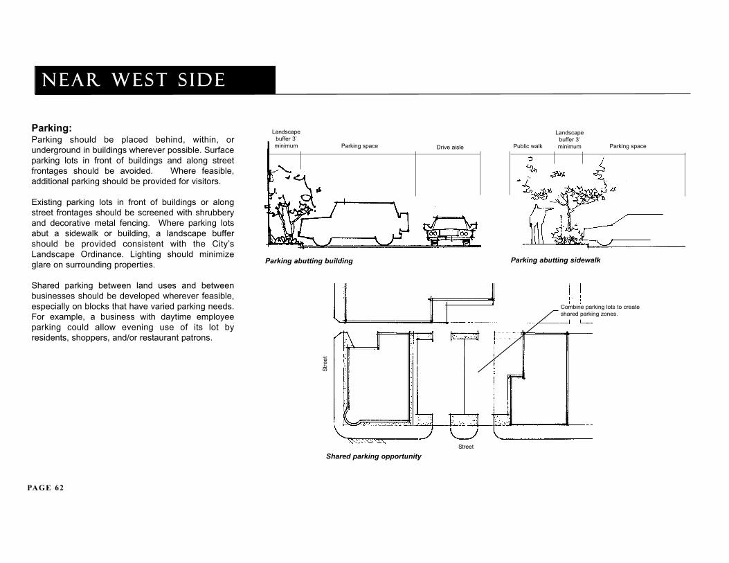
Parking:Parking should be placed behind, within, orunderground in buildings wherever possible. Surfaceparking lots in front of buildings and along streetfrontages should be avoided. Where feasible,additional parking should be provided for visitors.
Existing parking lots in front of buildings or alongstreet frontages should be screened with shrubberyand decorative metal fencing. Where parking lotsabut a sidewalk or building, a landscape buffershould be provided consistent with the City’sLandscape Ordinance. Lighting should minimizeglare on surrounding properties.
Shared parking between land uses and betweenbusinesses should be developed wherever feasible,especially on blocks that have varied parking needs.For example, a business with daytime employeeparking could allow evening use of its lot byresidents, shoppers, and/or restaurant patrons.
Shared parking opportunity
Stre
et
Street
Combine parking lots to createshared parking zones.
Landscapebuffer 3’minimum Parking space Drive aisle
Parking abutting building Parking abutting sidewalk
Parking space
Landscapebuffer 3’minimumPublic walk

PAGE 63
area land use p lan
Streetscape view with screened parking area
Decorative newsbox
Decorative pavers
Decorative street lights
Street tree indecorative tree grate
Pocket seating
Decorative metal fence
Trash receptacle
Streetscape Elevation View
Raised curbplanter
Decorativestreet light
Public walk
Decorativemetal fence
Streetscape:Streetscape amenities including pedestrian-scaledlighting, decorative paving, trash/recycling cans, anddecorative newspaper boxes should be placed in highactivity locations and grouped together to minimizeclutter along sidewalks.
Streetscape design for private development sitesshould be coordinated with the overall streetscapedesign of the Near West Side or adjacent streets toreinforce a coordinated physical character for the area.For example, lighting for a pedestrian plaza should besimilar in design to new lighting installed on nearbystreets by the City.
Seasonal flowers, evergreens, shade trees, and otherplantings are encouraged throughout the area toprovide interest, color, and seasonal variety.
Sidewalks and parking lots should be retrofitted forADA accessibility.
The perimeter and interior of all existing and futureparking lots should be extensively landscaped.
Decorative metal fencing should be used whereappropriate to enhance and define the streetscape,open spaces, landscaped areas, parking lots, andbuilding entrances. Such fencing should not be morethan three to four feet in height.
Chain link fence should not be used in locations on oralong a site that are visible from sidewalks and streets.

PAGE 64
Near West S IDE
Open Space:Where feasible, pedestrian plazas should beprovided in conjunction with new large-scaledevelopment. Plazas should be sited to maximizesouthern sun exposure. Decorative pavers, benches,landscaping, and lighting should be incorporated intoplaza designs.
Miscellaneous:The fencing and chairs of outdoor cafes located alongRandolph or elsewhere in the Near West Side shouldbe removable to provide wide sidewalk space ifneeded for loading/unloading by businesses duringpeak morning hours.
Corner Plaza Concept

PAGE 65
area land use p lan
DESIGN CONCEPTSAshland Corridor: Ashland between Lake & Madison
Randolph
Lake
Washington
Madison
Key Map
Ken
nedy
Exp
ress
way
Eisenhower Expressway
Madison Avenue
Hal
sted
Str
eet
Ash
land
Ave
nue
Lake Street

PAGE 66
Near West S IDE
DESIGN CONCEPTSMadison between Morgan & Throop with Realigned Racine Intersection
Carpenter
Aberdeen
May
Elizabeth
Key Map
Lake Street
Ken
nedy
Exp
ress
way
Eisenhower Expressway
Madison Avenue
Hal
sted
Str
eet
Ash
land
Ave
nue

PAGE 67
area land use p lan
DESIGN CONCEPTSHalsted/Lake intersection with shared parking
Lake
Fulton
Randolph Ken
nedy
Exp
ress
way
Key Map
Lake Street
Ken
nedy
Exp
ress
way
Eisenhower Expressway
Madison Avenue
Hal
sted
Str
eet
Ash
land
Ave
nue

PAGE 68
Near West S IDE
DESIGN CONCEPTSGreektown District with new park at Sangamon/Adams intersection with shared parking
Kennedy Expressway
Was
hing
ton
Mad
ison
Mon
roe
Ada
ms
Jack
son
Van
Bur
en
Key Map
Lake Street
Ken
nedy
Exp
ress
way
Eisenhower Expressway
Madison Avenue
Ash
land
Ave
nue
Hal
sted
Str
eet

Near west s ide p lan
imp l ementat ion

PAGE 70
Near West S IDE
Streetscape Design/Engineering:A next step in the area's improvement process shouldinvolve a comprehensive streetscape programincluding:
• Preparation of a coordinated streetscape design plan based on the Near West Side Area Land
Use Plan.
• Meetings with the City, Alderman, local organizations, and business/property owners to review the streetscape design.
• Consideration of an additional Special Service Area to finance on-going maintenance of the streetscape improvements.
Capital Improvement Programming:The Alderman and City have begun assessing potentialfunding sources for streetscape and infrastructureimprovements. Funding will need to be allocated inphases due to the area's large size.
Public funding should be leveraged by commitmentsfrom area developers and property owners to installportions of the comprehensive streetscape program.Capital improvement costs will be estimated during thestreetscape design/engineering process.
IMPLEMENTATIONA major commitment has been made by the City andAlderman to continue the revitalization of the NearWest Side as a vibrant, active, mixed-use community.The City, Alderman, local organizations, and areabusiness/property owners will need to continue towork closely together to implement the Area LandUse Plan and improve the area.
The following is a general framework of potential nextsteps in implementing the plan:
• Community Resources.• Streetscape Design/Engineering.• Capital Improvement Programming.• Facade Rebate Program.• Micro Loan Program.• CitySpace Program.• NeighborSpace Program.• Chicago Gateway Green Partnership.• CTA Adopt-A-Station Program.• Open Space Impact Fee Program.• Special Service Area Financing (SSA).• Tax Increment Financing (TIF).• Additional task-order studies to implement
proposed actions.
Community Resources:During the planning process, local residents, businessowners, and institutional representatives expressedconfusion with the role and function of the area's civicgroups. They also indicated a strong need for everyoneto work together because of the area's mixed-usecharacter and increasing development pressures.
A clearinghouse should be established within eachgroup to facilitate information exchange and resourcesharing, and increase local and outside awareness ofdevelopments planned for each area. In addition, sub-committees of each group should be established tofoster community stewardship regarding areaidentity/perception, beautification, and open space.

PAGE 71
i m p l ementat ion
Facade Rebate Program:The City's Facade Rebate Program assists inrevitalizing and stabilizing the City’s commercial andindustrial areas. The program, which is administeredby DPD, provides rebates for building rehabilitationactivities, including:
• complete facade renovation;• exterior lighting;• signage/graphics;• windows and doors; window displays and
awnings;• passive security and energy conservation
systems; and• truck docks.
Commercial buildings are eligible for a rebate of up to$5,000 per storefront unit. Industrial buildings areeligible for a rebate of up to $10,000 per facade unit.
Consideration should be given to creating a TIF fundedfacade rebate program which provides higher rebateamounts and a more extensive scope of rehabilitationactivities.
Micro Loan Program:The City's Micro Loan Program provides business loansto eligible small businesses which create jobs for low ormoderate income City residents by expanding in orrelocating to Chicago. The program is administered byDPD.
Provide loans up to $20,000 to Chicago’s smallbusinesses for projects that create jobs. Address theneeds of businesses that cannot obtain conventionalloans through traditional lending institutions. Loans aremade at a flat 3% rate or 75% of the prime ratedepending on the location and type of business. Fundscan be used for machinery, equipment, renovation, orworking capital.
Marketing materials for this and other City programsshould be distributed to businesses in the area.
CitySpace Program:The CitySpace Program is an intergovernmentalinitiative guided by the CitySpace Plan, which wasdeveloped jointly by the City, Chicago Park District, andCook County Forest Preserve District. The Plan setsopen space goals, and recommends programs/projectsthat create new open spaces in Chicago. The Programseeks to expand/improve open space throughintergovernmental and community partnerships.
Program initiatives include:
• School Parks: conversion of underused school grounds into landscaped open spaces.
• Greenway Planning: creation of greenways along waterways and rail corridors.
• Neighborhood Parks: working with the Park District, local businesses, and community organizations to acquire property for new open space and recreation centers.
• Streetscape: planning/development of landscaping and street furniture in special commercial and industrial districts.
A sub-committee of local organizations should beestablished to work with the CitySpace Program toimplement the open space initiatives outlined in theArea Land Use Plan, especially the neighborhood parkconcept for the northeast corner of Adams andSangamon.

PAGE 72
Near West S IDE
NeighborSpace Program:The NeighborSpace Program is a non-profitcorporation created by the City, Park District, andCook County Forest Preserve District to support andexpand small open spaces in Chicagoneighborhoods. The open spaces can be communitygardens, mini and neighborhood parks, greenways,river edge easements, wetlands and natural areas,plazas, and industrial area landscapes.
Program qualifications include:
• Commitment by a local entity to regular site maintenance through a management agreement.
• Proposed site should not contain any buildings.
• Playground structures are discouraged.• Priority NeighborSpace projects are
City-owned, tax delinquent, donated land, and/or river edges.
The program should be considered for new openspace initiatives for the Near West Side.
Chicago Gateway Green Partnership:The Chicago Gateway Green Partnership is a non-profit corporation dedicated to the beautification ofChicago area expressways through maintenance andlandscaping. The program is marketed and managedby the Gateway Green Committee and funded throughfinancial contributions of corporate sponsors.Expressway improvements include:
• Regular removal of litter and graffiti.• Planting of flowers, vines, and other
landscaping.• Installation of participant recognition signs
displaying Partnership and corporate sponsor logos.
The program should be considered for enhancementsto the Kennedy and Eisenhower Expressways.
CTA Adopt-A-Station Program:The program is an initiative whereby communitygroups can improve the physical condition of railstations/sites. Groups and/or businesses "adopt" alocal station and work closely with the CTA indetermining and maintaining station enhancements.Program benefits include:
• More attractive stations and surroundings.• Re-establishing stations as focal points of
community pride and interest.• Recognition of groups and businesses with
strong community commitment.
Open Space Impact Fee Program The City of Chicago Open Space Impact Fee requiresnew residential developments to contribute to a pool ofmoney which is used to expand the supply and/orcapacity of public open space within the communityarea in which it is collected.
Permitted use of fees include:
• Acquisition and development of land.• Development of land surrounding public
schools for parks including:• landscaping;• playground equipment;• sidewalks, paths, bikeways, overlooks,
boat launches, and paved outdoor recreation areas; and
• park furnishings such as benches, shelters, drinking fountains, and signage.
As noted earlier, a special committee should beestablished to assist in further identifying the needs andappropriate locations for new open space facilities.This could be the same committee that works with theCitySpace program.
PAGE 73
i m p l ementAT ION
Special Service Area Financing:A Special Service Area (SSA) is a state-authorizedfinancing program administered by the City thatprovides financial resources for a specific area. It isfunded through a separate property tax levy paid byproperty owners within the designated area.
An SSA can be initiated by property and businessowners wanting certain special services above thosealready available and/or not otherwise provided by theCity or other government entities, such asadvertising/marketing, parking, loan programs, capitalimprovements, and maintenance.
An SSA consists of all contiguous properties that willbenefit from the special services and elect to levy anadditional property tax to pay for the services. Afterapproval by the owners and City Council, the taxwould be levied annually and distributed to the SSA .
Local business or development organizations typicallysponsor SSA applications and a Special Service AreaCommission is formed to administer the services.Business and property owners usually make up thecommission, administer the services, and hold publicmeetings to discuss the local benefits of an SSA.
Special Service Areas are useful implementation toolsfor improving, managing, and maintaining commercialdistricts. An SSA should be considered for theRandolph and Fulton Markets and to help pay forstreetscape improvements and especially forcombined parking programs, as well as on-going areamaintenance. Greektown has an SSA in place formaintenance and marketing purposes.
Tax Increment Financing:Tax Increment Financing (TIF) is a state authorizedprogram administered by the City that providestargeted financial resources for a specificredevelopment area. A TIF district may be designatedaccording to two eligibility criteria as a "blighted area"and/or "conservation area".
Eligible costs include TIF studies, property acquisition,demolition, rehabilitation, infrastructure improvements,certain financing costs, relocation, job training, andenvironmental remediation. The versatility of TIFmakes it a popular device to finance redevelopmentactivities.
As noted earlier in the Area Analysis, the Near WestSide has three TIF districts - the Kinzie TIF, Near WestTIF, and the Central West TIF. There may be potentialto expand these districts or create additional TIFdistricts to assist redevelopment in the area.
A TIF district is structured as follows:
• Property values in the designated area are established at a base point in time (this is also known as the base value).
• All governments with property tax authority in the district continue to receive tax revenue generated at the "base value" tax rates.
• The additional value, also known as incremental value, created by new development,is taxed at the overall rate levied by the government.
• The tax revenue generated from the incremental property value is distributed to the area to pay for eligible redevelopment costs, financed either through bonds or other funding vehicles.

PAGE 74
Near West S IDE
Near west s ide p lan
ap p end ix

PAGE 76
Near West S IDE
PLANNING INITIATIVESCentral West Redevelopment Plan:In 1969, the Central West Redevelopment Plan wasprepared by Chicago’s Department of UrbanRenewal for an area bounded by Warren on thenorth, the Eisenhower Expressway on the south,Racine on the east, and Rockwell Street on the west.Its goals were to:
• provide new housing, especially for low and moderate income families;
• locate high-density development, especially residential, at points of transportation access;
• create convenient shopping clusters with priority given to local businesses;
• provide land for public spaces such as parks, schools, and pedestrian greenways;• develop a street system that separates
vehicular and pedestrian circulation; and• minimize displacement.
Twelve amendments have been added over the lastthirty years to update the Plan according to the area’schanging needs. However, due to currentdevelopment trends and community needs, many ofthe land use goals affecting the Near West Side eastof Ashland are no longer relevant.
Madison-Racine Redevelopment Plan:In May 1976, the City designated an area boundedby Lake on the north, Madison and Monroe on thesouth, the Kennedy Expressway on the east, andOgden on the west as the Madison/RacineRedevelopment Area. In August 1979, theDepartment of Urban Renewal created a generalRedevelopment Plan for the area with the followingobjectives:
• retain and strengthen businesses; • remove obsolete and substandard structures;• retain compatible sound buildings;• provide marketable parcels of land for
commercial and industrial development;• provide land for parking, loading, and open
space; and• develop a street system that will improve
safety and traffic flow.
In 1980, the Area was redesignated as a blightedcommercial district by the Commercial DistrictDevelopment Commission. An amendment in 1987updated the status of several buildings as potentialsites for acquisition. Appropriate redevelopment andreuse opportunities within the area can beimplemented using the Redevelopment Areadesignation.
West Loop Adaptive Reuse Analysis:In 1983, Hasbrouck Peterson Associates completedan Adaptive Reuse Analysis for the West Loop TaskForce of the Chicago Central Area Committee. TheAnalysis included an inventory of existing buildings inthe area bounded by Kinzie on the north, theEisenhower Expressway on the south, the ChicagoRiver on the east, and Sangamon on the west.
The survey provided a first step towardsimplementing an adaptive reuse program in the WestLoop. Further analysis and other implementationsteps needed to be established.
West Loop Task Force Report:In 1985, the Chicago Central Area Committeecreated a West Loop Task Force to study land useand economic growth in the West Loop.
The Task Force examined a large area bounded byKinzie on the north, Roosevelt on the south, Wackeron the east, and Ashland/Ogden on the west. Itprepared a report which focused mostly east of theKennedy Expressway. It identified renovationopportunities for Greektown, specifically regardingstreetscape enhancement.
Streetscape improvements were recentlyimplemented by the City along Halsted Street.

PAGE 77
APP END IX
Real Estate Market Trends Report: In 1988, Applied Real Estate Analysis prepared a RealEstate Market Trends Report for DPD for the Near WestSide bounded by Lake on the north, the EisenhowerExpressway on the south, the Kennedy Expressway onthe east, and Ashland on the west. Developmentoptions were suggested for six sub-areas:
Greektown(between Madison/Kennedy Expressway/Green/Van Buren)
• Increase the area’s attractiveness as a restaurant/entertainment center.
• Consider new high rise development.• Encourage new retail and office facilities.• Establish cultural centers and organizations,
especially those relating to the Greek culture.• Consider a parking structure to accommodate
new activities.
Residential/Institutional Area(between Monroe/Eisenhower Expressway/Throop/Ashland)
• Redevelop vacant sites for new housing.
• Improve management of open space and park facilities.
• Increase crime prevention efforts specifically related to auto theft.
Westgate Mill District(between Monroe/Van Buren/Green/Throop)
• Consider public funding for rehabilitation of large loft buildings.
• Assemble sites for long term development.• Encourage residential and institutional uses.
• Improve public facilities, especially Skinner Park, for residents and Whitney Young High School students.
• Increase crime prevention efforts.
Mixed-Use Commercial/Light Industrial Area(between Randolph/Monroe/Kennedy Expressway/Ashland)
• Establish a business/industrial park that can compete with suburban rent levels.
• Consider townhouse development.
• Establish a convenience retail area, including small grocery store, dry cleaners, etc.
Randolph Market(along Randolph between Halsted and Ogden)
• Maintain and improve the area’s attractivenessfor food and related businesses.
• Improve streetscape, parking, and access.
• Consider a farmer’s market during non-rush hours.
Lake Street Commercial/Industrial Area(between Lake, Randolph, Kennedy Expressway, Ashland)
• Attract storage operations and other businesses suitable for an older industrial area.
Since 1988, several of the report’s recommendationshave been implemented such as improvements toGreektown and Skinner Park, crime preventionprograms, and new residential development.
Physical improvements in the produce markets andindustrial blocks are still needed as are additionalneighborhood-level retail uses.

PAGE 78
Near West S IDE
Corridors of Industrial Opportunity:In 1992, DPD prepared a Corridors of IndustrialOpportunity Study, noting the important role thatindustry has played in Chicago’s history.
Included in the report was the Kinzie IndustrialDistrict bounded by Division on the north, Lake on thesouth, Halsted on the east, and Central Park on thewest. Recommendations for the Kinzie District thathave an impact on the Near West Side, especially inregards to stabilization of the Randolph Market,include:
• Industrial expansion in the Fulton Market;• Increasing viaduct clearance to improve truck
access; and• Improving major traffic routes to alleviate
congestion.
Near West Redevelopment Project Area TaxIncrement Finance Program:In 1996, the Madison-Racine TIF, originally boundedby Randolph on the north, Madison on the south,Peoria on the east, and May on the west wasexpanded and renamed the Near West TIF as animplementation tool for the Madison-Racine UrbanRenewal Area.
The objectives of the TIF were to:• encourage comprehensive area redevelopment;
• provide necessary public improvements; and
• provide public assistance to promote private redevelopment of the area.
The TIF was expanded to incorporate Greektown andthe Randolph Market Area and is now boundedgenerally by Lake on the north, Van Buren on thesouth, the Kennedy Expressway on the east, and Mayon the west.
Chicago Food Wholesaling Market DistrictRevitalization Feasibility Report:In 1995, DPD prepared a study of the City’s wholesalefood distribution businesses. Its boundaries wereCarroll on the north, Randolph on the south, Halsted onthe east, and Ogden on the west. Included in the Studywere the Randolph and Fulton Markets. It assessed theviability of food wholesaling and definedrecommendations for accelerating its development.
Redevelopment assistance, vacant land,streetscape/identity features and transportationimprovements were addressed including:
Fulton Market• encourage/assist private redevelopment efforts;
• modernize wholesale facilities;
• consider a prototype multi-tenant facility;
• implement sidewalk and sewer improvements;
• organize an association of food businesses to work with the City;
• seek funding for improvement and development;
• establish guidelines for redevelopment;
• provide conflict resolution between businesses and City agencies, with a trained ombudsman in a business express office;
• arrange for liaison with the Randolph Street Market Association;
• work with appropriate City agencies to bring about street, curb, and drainage repairs;
• develop a guide to redevelopment incentives;
• arrange additional development incentives; and
• organize a Market promotional program.

PAGE 79
app end ix
Randolph Market• accentuate the identity of the Market with exterior
features like archways and historical markers;
• develop the eastern half of Randolph with diversefood service businesses;
• develop the western half of Randolph with wholesale food distribution with modern facilities;and
• solve parking problems with employee parking facilities under buildings and customer parking ingarages.
These recommendations, which represent criticalinitiatives needed to stabilize and revitalize theMarkets, need to be implemented.
Randolph Street Market Planning Report:In 1995, Okrent Associates prepared a planningstudy of Randolph Street for the West Loop GateCommunity Organization. The study addressedRandolph from Des Plaines on the east to Ogden onthe west. It recommended:
• enhancing pedestrian amenities, activity, and safety;
• preserving the produce market function as the core of the street’s identity;
• pursuing policies that encourage further private investment initiatives;
• encouraging preservation/enhancement of historic architecture;
• enhancing the physical definition of the market as a distinct district; and• development of residential uses toward the west end of the street.
Since the study, the City has completed extensivestreet and streetscape improvements along Randolph.
Strategic Plan for Kinzie Industrial Corridor:In 1996, the Industrial Council of Northwest Chicago(ICNC) prepared a Strategic Plan for the KinzieIndustrial Corridor. The study area was bounded byGrand on the north, Lake on the south, Halsted on theeast, and Central Park on the west.
The Plan recommends improving the corridor as anurban industrial park that protects the industrialcharacter of the area and promotes business retention,expansion and attraction. Five initiatives wererecommended including:
• improving security and public safety;
• upgrading traffic and transportation access;
• preserving industrial uses and redeveloping available sites for industrial uses;
• creating a greater sense of identity and a positive image for the corridor; and
• initiating new and strengthening current business-community partnerships.
Several of the study’s recommendations areapplicable to the need to improve, stabilize, anddevelop the Randolph Market as a wholesale fooddistribution center. The 1996 study became a basefor designation of the Corridor as a PlannedManufacturing District and Tax Increment FinanceDistrict by the City in 1998.
Central West Redevelopment Project AreaFinancing District:The Central West TIF's generally bounded byMonroe on the north, Van Buren on the south,Morgan on the east, and Western on the west. TheCentral West TIF was created as an implementationtool for the Central West Redevelopment Area. Theobjectives for the Central West TIF are synonymouswith the Near West TIF.
PAGE 80
Near West S IDE
Kinzie Industrial Corridor TransportationPlan/Program (Draft):In 1997, Barton-Aschman Associates prepared aTransportation Plan for DPD for the Kinzie IndustrialCorridor that recommended:
• accessibility improvements for transit users and trucks;
• physical enhancements to improve area perceptions and personal safety/security;
• solutions for traffic and parking problems.
The key recommendations of the Plan/Program wereincorporated into the Kinzie TIF and PlannedManufacturing District (PMD) plans.
Kinzie Planned Manufacturing District:In 1998, the City designated the Kinzie IndustrialDistrict as a Planned Manufacturing District (PMD)bounded by Grand on the north, Lake on the south,Halsted on the east, and Sacramento on the west.
It addressed the encroachment on industrial uses bynon-industrial uses and the demand for zoningchanges incompatible with a manufacturing district.A PMD is designated to stabilize industrialenvironments and foster industrial developmentthrough restricting zoning. The Kinzie PMD is locatedadjacent to the Near West Side, and providesdevelopment opportunities for local industrialbusinesses which may need to relocate.
Kinzie Industrial Conservation Area Tax IncrementRedevelopment Plan and Project:In 1998, Camiros prepared a Kinzie Tax IncrementRedevelopment Plan/Project report for DPD. Thedesignated area is bounded by Grand on the north,Washington and Randolph on the south, Halsted on theeast, and Kedzie on the west.
The Plan’s goals included:
• creating a competitive, accessible, safe andattractive environment promoting industrial growth and investment;
• protecting existing industrial concentrations, from incompatible land uses;
• recycling polluted sites into marketable property for industrial use;
• enhancing the area’s tax base; and
• employing local residents.
Tax increment financing (TIF) provides the City with afunding tool to facilitate area improvements andredevelopment. The Randolph and Fulton Markets arelocated in the Kinzie TIF district.
TOD Plans at Selected CTA Green Line Stations: In 1998, the City engaged Camiros and Campbell TiuCampbell to study the transit oriented developmentpotential of the CTA Green Line. The following wasrecommended for the Ashland station:
• maintain industrial and residential land uses;
• strengthen the link between the Station and street level to draw more users;
• create a visual and physical link between the station and adjacent intersection;
• intensify and diversify neighborhood-level convenience retail south of the station;
• provide adequate parking;
• facilitate bus and taxi transfers;
• consider van shuttles to nearby businesses and institutions;
• maintain existing infrastructure to enhance safety and security;
• encourage pedestrian activity on the street;
• develop infill housing south of station; and
• improve nearby streetscape.

PAGE 81
CHAPTERReal Estate Needs Assessment for theRandolph/Fulton Market Area:
In February 2000, Arthur Andersen completed a RealEstate Needs Assessment for the Randolph/FultonMarket Area for DPD for the area bounded by Carrollon the north, Randolph on the south, Halsted on theeast and Ogden on the west. Significantredevelopment pressures occurring in the areaprompted DPD to investigate the real estate needs ofthe existing businesses in the Market Area as well asthe other uses that are proliferating.
The study determined that:
• Of the companies that were surveyed, 59% of the companies were likely to stay in the Market Area and 41% of the companies were likely to relocate from the area.
• The City should review the infrastructure that is needed and begin a schedule of capital investment. Problems relating to the Market’s aging infrastructure will be exacerbated by theincreased density of redevelopment.
• The City should review opportunities to provide shared parking facilities. The Area is under-parked for companies and the Area’s other commercial uses.
• The City should review and possibly increase parking requirements for newly developed residential units. This would further address the area’s lack of parking.
• The area’s traffic patterns should be reviewed to develop a strategy to minimize conflicts between truck and other commercial traffic and residential traffic.
• The City should work with merchants, businesses, and residents to return full functionality to the Randolph arterial, while retaining its intended beauty.
• The City needs to continue to monitor proposed redevelopments in the Market Area to determine the potential conflicts to area businesses and parking/street capacity. Acooperative forum that includes the Alderman’s office, the merchant’s association and others will be important to address issues as they arise.