nddot uas update
TRANSCRIPT

NDDOT UAS UpdateUPDATE ON THE NDDOT UAS PROGRAM AND HOW THE NDDOT ARE UTILIZING DRONESMARCH 17TH, 2021

Reasons for Getting Into UAS’s
•Bridge Inspections •Highway Construction Projects •Taking videos and photos of construction projects to show the progression of work. •Videos on file to verify when, how long, and how items were completed to look back on.
Inspections Inspections
•Potential to Produce Quantities •Intermittent borrow payments •Common excavation estimates •Stockpile payments
Survey Survey
Helping people inspect and survey areas that are unsafe.Helping people inspect and survey areas that are unsafe.

Original Pilots NDDOT Started With
The NDDOT started out with 17 pilots when we started with the UAS program.
What made up these 17 pilots were 3 Districts, along with Communications, Construction Services, Design, Materials and Research, Maintenance, and Strategy and Innovation out of Bismarck.

Current Licensed Pilots Since the program started, the NDDOT have added 7 more pilots for a total of 24.
We also have at least 1 from every district as well as the bridge division that have gotten involved.

UAS’s the NDDOT Currently Owns
Mavic 2 Zoom (9) Devils Lake Grand Forks Minot NDDOT
Communications NDDOT
Photogrammetry NDDOT Construction
Services NDDOT Maintenance NDDOT Material and
Research NDDOT Bridge Division
Mavic 2 Pro (2) NDDOT
Communications NDDOT Strategy
Mavic 2 Enterprise (1) NDDOT Strategy
Mavic 2 Mini (4) These are passed
around as practice drones to get time behind the joysticks before flying the larger ones.
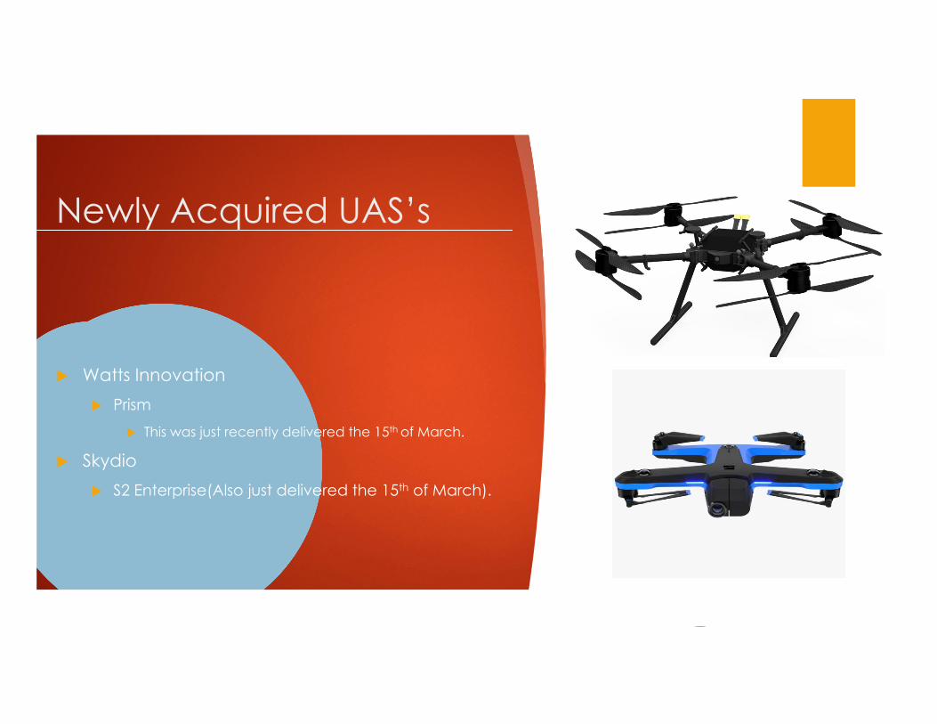
Newly Acquired UAS’s
Watts Innovation Prism
This was just recently delivered the 15th of March.
Skydio S2 Enterprise(Also just delivered the 15th of March).

New UAS the NDDOT is Looking at Acquiring
Skydio X2E Primarily for the bridge
inspection
Camera that can point straight up and straight down

Benefits of Using Skydio
Skydio drones are designed, assembled, and supported in the USA.
They don’t need GPS to fly, the flight is based on AI and sensors.
This means they can go into areas where the satellites are blocked which is good for doing bridge inspections along with flying in buildings and around structures.
If doing a 3D scan of something it will still be geo-refenced as it still does have GPS onboard.
Skydio drones have 360 degree view for obstacle avoidance
S2 Enterprise Capabilities
3.5 KM(2.175 Mi) Range
Camera is 4K60/12.3 MP
Flight time of 23 minutes
X2E
Flight time of 35 minutes
180 degree vertical view
6 KM(3.728 Mi) Range

Watts Innovation Prism Drone X8 Coaxial Propulsion
System(4 arms with 2 propellers on each arm)
Made in America
Capable of carrying a 25 lb payload
Accessories Sony Camera System
Ranger Riegl Mini-Vux3 Lidar

Range Riegl Mini-Vux3 LiDAR Sensor
200,000 Measurements per second
It has a 360 degree field of view which allows complete acquisition of the environment
Uses a SD card to store its data
Weighs in at 3.4 lbs
Accuracy is 15 mm(0.59 Inches) with the precision sitting at 10 mm(0.39 Inches).

Programs and Apps the NDDOT Has Used The NDDOT have tried and are still experimenting with different ways to fly along with different
computing programs to be able to accurately calculate quantities with the equipment we have and programs that are out there.
Flying the UAS’s
DJI Go 4
DJI GS Pro
Litchi App
Botlink Capture
Pix4D Capture
Pre-Flight LAANC/Weather
Kittyhawk
Airmap
Drone Log Book
Processing Programs
Botlink
Bentley ContextCapture
Pix4D

Waivers for NDDOT
Current waivers NDDOT currently have
Night Navigation
Operation Over Human Beings
Waivers the NDDOT are working on
Beyond Visual Line of Sight

Night Navigation Waiver
Have the capability to operate at night between civil twilight hours(30 minutes after sunset to 30 minutes before sunrise).
Requires anticollision lights that can be seen up to 3 statute miles.
Requires PIC to be trained with night operations.
Must have waiver, list of pilots on the waiver, and proof of training with them during this operation to have available to produce for a FAA rep if it is requested.

Operations Over Human Beings Ability to fly over the public
with approved parachute mounted on drone.
The PIC must contain the proper paperwork as stated above for Night Operations with additional parachute manufacture safety and compliance documents.
This also requires the model and license number of the drone to be listed as part of the waiver.

Beyond Visual Line of Sight (BVLOS)
Working with Northern Plains UAS Test Site
Tactical BVLOS
Vantis
A statewide network enabling UAS flights beyond visual line of sight

