ncpma fundamentals - · pdf filencpma fundamentals 1-2 ... the basic principle for stadia...
TRANSCRIPT

NCPMA FUNDAMENTALS
1-1
INTRODUCTION
Courts of law interpret the evidence, meaning, and intent of legal documents used to describe
land ownership and land boundaries. If property mappers are to correctly map out boundaries,
they must know what the courts have defined as the meaning and intentions of words and phrases
used in land descriptions. Property mapping includes (1) the science of measurements, (2)
knowledge of the laws and customs that define the boundaries of real property, and (3) the
evaluating of evidence to place a boundary on a map. This course was designed to assist
cadastral mappers to develop those skills for a career in mapping.
SECTION 1
BASIC SURVEYING
1.1 History of Land Surveying and Mapping
No one knows where surveying began. However, what is known is that the Egyptians brought
the measuring of land into an art. They first referred to surveying as "rope stretches." Each year
the rains in the Nile River watershed caused the river to over- flow her banks. The resulting
floods either washed away their boundary marks or buried them under the fertile silt deposits.
The "rope stretchers" job was to re-establish the markers prior to the flooding.
In Greece, this art was for a long time called Geodaesia, and later Geometry, which is still the
basis for surveying today.
The Romans used a very elaborate rectangular system to lay out their boundaries. In fact the
Roman military concluded that a man was incapable of commanding a legion if he did not at
least know enough Geometry to lay out and measure a field.
Prior to the migration of Europeans to America, the land was held in common by Indian tribes.
The right of these tribes to land was extinguished by purchase or conquest by, among others,
English, French, Spanish and finally the newly created US government. Although there was an
early preference for laying out land in rectangular form, Virginia and most colonies adopted a
metes and bounds system which allowed the prospective land owners the privilege, prior to
survey, of selecting a particular piece of land to be patented, that was neither required to be
contiguous to settled lands nor to be of any regular shape.
These early settlers used two systems. One was called Mete which means to measure or to
assign measure, and the other was Bounds which means the boundaries of the land or the limits
and extent of the property.
A metes description is a perimeter description reciting measurements, but not bounds. Very
often metes descriptions are included within the meaning of metes and bounds description.

NCPMA FUNDAMENTALS
1-2
A boundary description is written or interpreted as if one was in the center of the parcel looking
out, and recites information regarding the sides of the tract in sequence, either in a clockwise or
counterclockwise manner as, "Bounded and described as follows: Westerly by the land of Long;
Northerly by the land of Whitley; Easterly by the Catawba River; Southerly by Smith.
The term COURSE is not to be confused with Metes. Course is used to mean direction only.
Early measurements of land was in terms of work-time. Strips of open fields were apportioned
among tenants on the basis of how long it took to plow soils of varying heaviness or lightness.
An acre was originally the amount of land a yoke of oxen could plow in a day.
Gradually, the surveying profession improved. One of the most important improvements was the
Gunter's Chain. This early colonial unit of linear measure was 66 feet, invented by Edmund
Gunter an English astronomer of the seventeenth century.
In addition to the chain, many of the early grants made by the English crowns were in terms of
"pole", four poles being equivalent to one chain. In later usage the term "pole" gradually
assumed the name "perch" then "rod". Because of the early usage of the chain, the Continental
Congress logically adopted the chain as the standard unit of linear measure. One acre, being 10
square chains or 43,560 square feet, is used as the standard unit of area measurement.
The rod (16½ feet) in the sixteenth century was established as the length of the left feet of the
first 16 men out of Church on a certain Sunday.
1.2 TYPES OF SURVEYING
Surveying is the science and art of making measurements of distance and direction necessary to
determine the relative position of points on, above, or beneath the surface of the earth, or to
establish such points. Land surveying is one of the oldest skills known to the human race. From
earliest civilized times it has been necessary to make boundaries and to divide land. The ancient
Egyptians developed surveying and used it to divide land into plots for boundary relocation and
taxation. Surveying advanced rapidly during the eighteenth and nineteenth centuries as the need
to make maps grew. Rapidly increasing land values and the demand for public improvements
such as railroads and roads made accurate surveying necessary. The United States Coast and
Geodetic Survey was established by an Act of Congress in 1807 and charged with surveying
lands of the United States.

NCPMA FUNDAMENTALS
1-3
The surveying process has four phases:
Field work - making and recording measurements in the field
Computing - making the necessary calculations to determine the location of
points and size or area
Mapping - plotting the measurements and drawing a map or plat
Monumentation - setting physical markers to define points (and thus to delineate
boundaries)
Some types of surveys having an influence on cadastral mapping are:
Plane Surveying, in which the curvature of the earth is disregarded.
Geodetic Surveying, in which the curvature of the earth is considered; used
for large areas and to locate points suitable for controlling other surveys.
Land or Boundary Surveys, used to establish property corners and land lines;
usually closed surveys (start at one point and end at the same point)
Route Surveys, used to establish the center line ( and right-of-way) for roads,
railroads and other transportation lines.
1.3 BASIC EQUIPMENT
The scales used in the compilation of cadastral maps are engineer type, usually triangular or flat
in design and either 6" or 12" in length.
The division of a scale enables the mapper to measure a distance given in a deed description onto
a map. The division can be used on a variety of scales.
DIVISION SCALES__ _____ 10 1" = 10' 1" = 100' 1" = 1000' 1" = 10,000'
20 1" = 20' 1" = 200' 1" = 2000' 1" = 20,000'
30 1" = 30' 1" = 300' 1" = 3000' 1" = 30,000'
40 1" = 40' 1" = 400' 1" = 4000' 1" = 40,000'
50 1" = 50' 1" = 500' 1" = 5000' 1" = 50,000'
60 1" = 60' 1" = 600' 1" = 6000' 1" = 60,000'

NCPMA FUNDAMENTALS
1-4
As shown in the following figure, a division of 10 can be used on a scale of either 1"= 10', 1" =
100', or 1" = 1,000'. That is, on a scale of 1" = 100', an inch on the map is equal to 100 feet on
the ground. On a scale of 1" = 400', an inch on the map is equal to 400 feet on the ground.
MEASUREMENT
IN INCHES 0 1" 2" 3" 4"
SCALE
1" = 100' 0 100' 200' 300' 400'
1" = 200' 0 200' 400' 600' 800'
1" = 300' 0 300' 600' 900' 1200'
1" = 400' 0 400' 800' 1200' 1600'
1" = 500' 0 500' 1000' 1500' 2000'
1" = 600' 0 600' 1200' 1800' 2400'
EXERCISE:
DETERMINE THE LENGTH OF THE FOLLOWING LINES
1. 1" = 100'
2. 1" = 200'
3. 1" = 400'
4. 1" = 200'
DETERMINE THE PROPER SCALE (inches to feet) FOR THE FOLLOWING LINES
1. 295' SCALE =
2. 1200' SCALE =
3. 960' SCALE =
4. 775' SCALE =

NCPMA FUNDAMENTALS
1-5
The triangles used by mappers are usually identified as either 60 or 45. A 60 triangle consist
of a 60, 30, and 90 angle. A 45 triangle has two 45 angles and one 90.
A protractor is an instrument used to measure degrees in angles. Protractors are either circular or
semi-circular and are divided into degrees and half degrees.
45 Triangle 60 Triangle

NCPMA FUNDAMENTALS
1-6
A land measure compass is constructed on the principle of the surveyor's compass - 360 divided
into four 90 quadrants.
A bow compass is an instrument consisting of two pointed legs connected at one end by a pivot,
used for drawing an arc or circle.
NCPMA FUNDAMENTALS
1-7
1.4 Distance Measurements
Distance can be measured directly by pacing, optically by use of stadia, electronically by
instruments that transmit light or radio waves, or by taping.
Pacing simply involves counting steps or paces while walking naturally along the line to be
measured. The pace length is then multiplied by the number of paces counted.
The basic principle for stadia distance is that you must have a transit or theodolite with cross
hairs. The perpendicular distance between a rod and the instrument is equal to 100 times the
difference between value of the top cross hair and the bottom cross hair.
Modern electronic distance measuring devices basically transmit either a low-power laser light or
invisible infrared light that is reflected back to the EDMI by a mirror. The instrument then
records the distance on a liquid crystal display.
Taping involves the use of a steel tape most commonly 100 feet in length. When taping
horizontal distances (formerly called chaining) it is necessary to hold the tape as close to a
horizontal position as possible.
Two types of chains were used. One was the engineer's chain which was 100 feet long, with 100
links, and distance were recorded in feet and decimals. The other was the surveyor's (or
Gunter's) chain, it was 66 feet long, divided into 100 links (each 7.92 inches), and distances were
recorded in chains and links. The surveyor's chain was convenient for land surveying because of
its relation to the units of land measurement ( 1 chain = 4 rods: 80 chains = 1 mile; 10 square
chains = 1 acre).

NCPMA FUNDAMENTALS
1-8
In surveying, the desired distance between two points is always the horizontal distance. The
slope distance may be measured and then reduced to the horizontal by determining the difference
in elevation between the two points and calculating the reduction (using trigometric
relationships). The horizontal distance can be directly measured even on a steep slope by using
tape and plumb bob and following the procedure known as "breaking tape." The tape is always
held horizontally, and as many increments as needed are measured and then added to get the total
distance.
1.5 Direction Measurement
A lines direction is determined by its relationship to, or deviation from, the direction of another
line. An angle is the difference in direction of two intersecting lines. The value of an angle is
defined in the degree, the minute and the second.
The direction of a line may be given by its angle from an established line of reference called a
meridian. The reference line can be the True (geographic ) meridian, the magnetic meridian, or a
grid meridian, The True Meridian for any one place on the surface of the earth is a line that
passes through the observer's position and the North and South geographic poles.
Most early boundary surveys within the United States were made by reference to the magnetic
meridian. Magnetic north is a line directly to where the compass points (the magnetic north
pole). The first surveyors had a mariner's compass to provide orientation. Today the transit or
theodolite has superseded the compass, but, because of the numerous early compass surveys, it is
necessary to understand the earth's magnetic field.
The North pole and the magnetic north pole are not in the same position. Within the United
States magnetic north varies from 24 east of north to 22 west of north. Magnetic declination is
the horizontal angle between true north and magnetic north. Declination changes with time. The
amount of change within a one year period is called annual change. As an observer moves either

NCPMA FUNDAMENTALS
1-9
easterly or westerly from the line of no declination (the agonic line) the declination increases.
For example:
VALUES OF MAGNETIC DECLINATIONS OF LATITUDE 34 N LONGITUDE 80 W as
prepared by the National Geophysical Data Center.
YEAR
1750
1800
1850
1900
1950
1985
DEGREE
1
3
2
0
1
5
MINUTES
20 E
30 E
23 E
36 E
52 W
27W
If an attempt is being made to retrace a survey, it is necessary to know if magnetic north or true
north was used. Because magnetic north changes through time, it maybe necessary to know the
year of the survey and the magnetic declination for that year at that location. The surveyor must
retrace the footsteps of the initial survey.
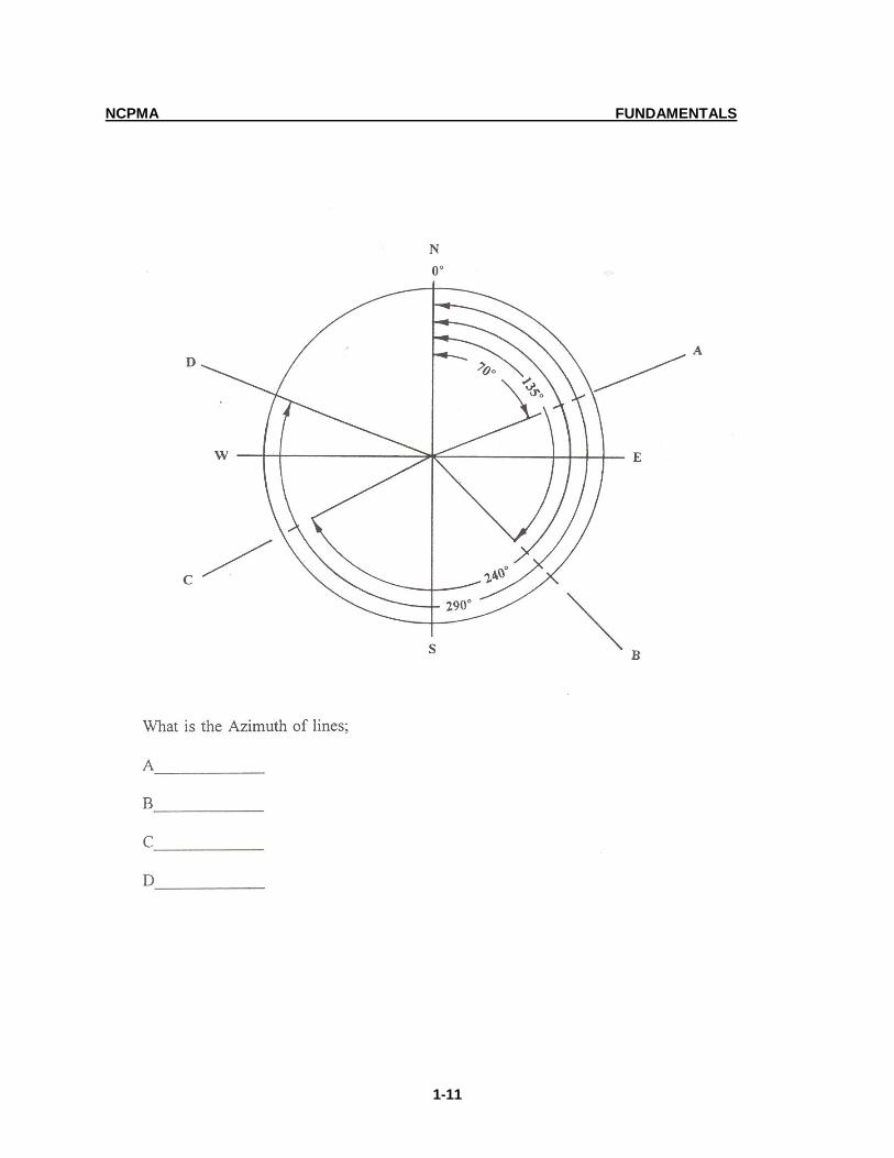
1.6 AZIMUTHS
Azimuths are angles measured clockwise from the meridian (either from due north or from due
south) to a line being described. The armed services commonly use north as the datum; geodetic
azimuths are usually from the south. In plane surveying they are usually measured from north.
Azimuths range from 0 to 360.

NCPMA FUNDAMENTALS
1-10
NCPMA FUNDAMENTALS
1-11

NCPMA FUNDAMENTALS
1-12
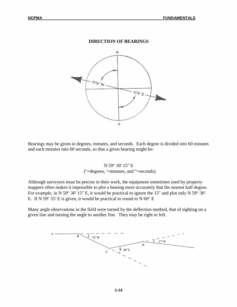
1.7 BEARING
The bearing of a line is the angle between the meridian and the line measured from the north
point or from the south point, never from the east or west points and are always read in degrees
and minutes (plus seconds if fractions of a minute are involved).
There are 360 degrees in a circle, 60 minutes in a degree, and 60 seconds in a minute. This is
best explained in reference to the four quadrants of a surveyor's compass. The following figure
shows a surveyor's compass with the four quadrants identified.
QUADRANTS OF A SURVEYOR'S COMPASS

NCPMA FUNDAMENTALS
1-13
Direction is identified by the letters N or S, the degrees, and the letters E or W, for example, N
45 E. In the next figure the line is in the NE quadrant, 45 from north in an easterly direction.
LINE BEARING N 45 E (NORTHEAST QUADRANT)
A true bearing is measured from the geographic meridian (true north); magnetic bearings are
measured from magnetic meridians (magnetic north). The opposite of a bearing is referred to as
the reverse of the bearing. The process of using the opposite bearing to find the bearing in
question is termed "reversing a bearing." When a bearing is reversed, the degree stays the same
while both directions are changed. The reverse of N 76 W is S 76 E. This is often helpful
when a call has been left out of a description. It is sometimes possible to reverse one or more of
the bearings and find the one that has been omitted.
NCPMA FUNDAMENTALS
1-14
DIRECTION OF BEARINGS
Bearings may be given in degrees, minutes, and seconds. Each degree is divided into 60 minutes
and each minutes into 60 seconds, so that a given bearing might be:
N 59 30' 15" E
(=degrees, '=minutes, and "=seconds).
Although surveyors must be precise in their work, the equipment sometimes used by property
mappers often makes it impossible to plot a bearing more accurately that the nearest half degree.
For example, in N 59 30' 15" E, it would be practical to ignore the 15" and plot only N 59 30'
E. If N 59 55' E is given, it would be practical to round to N 60 E
Many angle observations in the field were turned by the deflection method, that of sighting on a
given line and turning the angle to another line. They may be right or left.

NCPMA FUNDAMENTALS
1-15
When plotting a metes and bounds legal description where bearings are given you must first
calculate the angles between the various calls so as to be able to plot the courses using a
protractor. There are three (3) different rules or methods depending on the bearings given. The
following are examples of the three methods:
1. Calculating the angle between two (2) courses (lines, tangents, etc) when bearings
are given for the courses and the bearings are in the same quadrant (i.e. NE, NW,
SE, SW). See Example 1.
2. Calculating the angle between two (2) courses (lines, tangents, etc.) when
bearings are given for the courses and the bearings are in different quadrants and
by going from one to the other you would cross the South or North line (i.e. going
from the NE to NW or SE to SW, etc.) See Example 2.
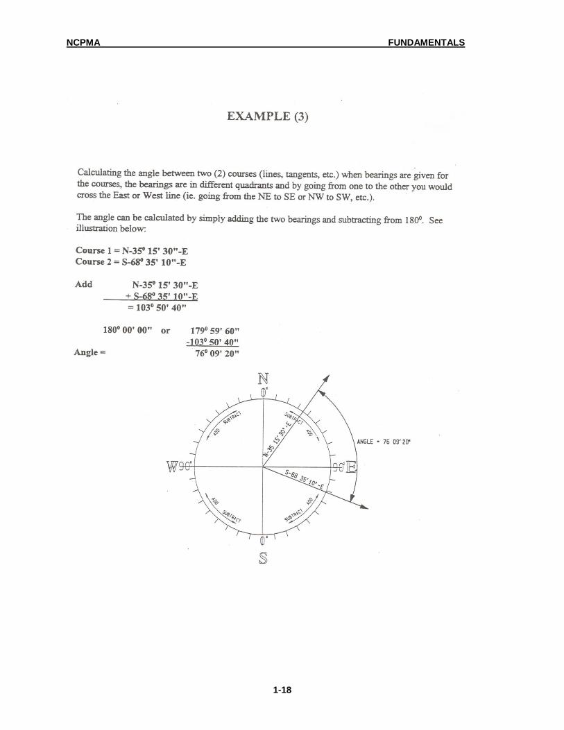
3. Calculating the angle between two (2) courses (lines, tangents, etc.) when
bearings are given for the courses, the bearings are in different quadrants and by
going from one to the other you would cross the East or West line (i.e. going from
the NE to NW or SE to SW, etc.) See Example 3.

NCPMA FUNDAMENTALS
1-16

NCPMA FUNDAMENTALS
1-17
NCPMA FUNDAMENTALS
1-18

NCPMA FUNDAMENTALS
1-19
Exercise 1

NCPMA FUNDAMENTALS
1-20
Exercise 2

NCPMA FUNDAMENTALS
1-21
Exercise 3

NCPMA FUNDAMENTALS
1-22
Exercise 4

NCPMA FUNDAMENTALS
1-23
1.8 INTERIOR ANGLES
Interior angle is the measurement between the two intersecting lines on the inside of a polygon.
In any closed polygon the sum of the "interior" angles will be (N-2) times 180, where N
represents the number of sides.
A= 120
B= 117 (N - 2 ) 180
C= 83 (5 - 2 ) 180 = 540
D= 130
E= 90
________
540

NCPMA FUNDAMENTALS
1-24
Exercise 1

NCPMA FUNDAMENTALS
1-25
Exercise 2

NCPMA FUNDAMENTALS
1-26
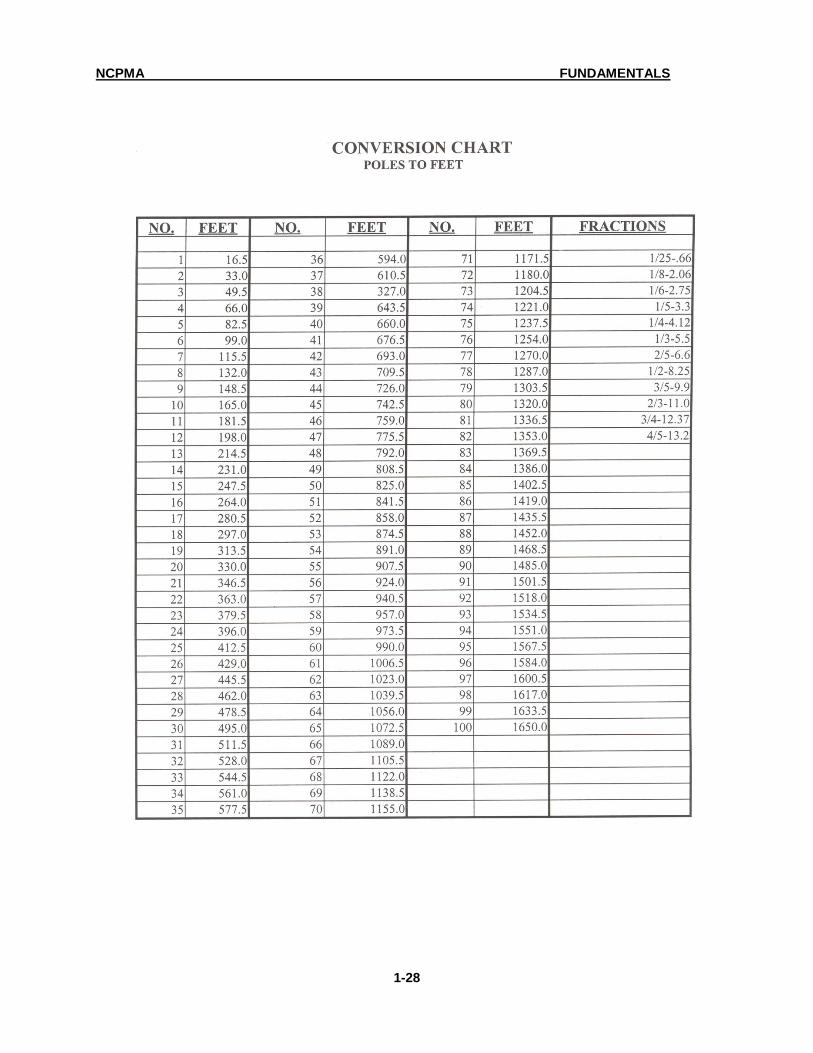
1.9 UNITS OF MEASUREMENT
COMMON UNITS OF MEASURE USED IN DEED DESCRIPTION
7.92 INCHES 1 LINK
1 CHAIN 4 RODS
1 CHAIN 66 FEET
1 CHAIN 100 LINKS
1 LINK .66 FEET
25 LINKS 1 ROD
1 ROD 16.5 FEET
1 POLE 1 ROD OR 16.5 FEET
4 RODS 1 CHAIN OR 66 FEET
10 SQUARE CHAINS OR 160 SQ. RODS 1 ACRE
1 ACRE 43,560 SQ. FEET
640 ACRES 1 SQUARE MILE
1 SQUARE MILE 640 ACRES
1 MILE 5,280 FEET
1 CIRCLE 360
1 60' ( MINUTES)
1' 60"( SECONDS)
1 METER 3.2808333 FEET (US SURVEY FOOT)
1 FOOT 0.304801 METERS
1 KILOMETER 0.62137 MILES
1 MILE 1.609 KILOMETERS

NCPMA FUNDAMENTALS
1-27
NCPMA FUNDAMENTALS
1-28
NCPMA FUNDAMENTALS
1-29

NCPMA FUNDAMENTALS
1-30
1.10 AREA
The area of a parcel may be calculated by tracing the exterior boundary using a
planimeter or electronic digitizer. A planimeter is a mechanical measuring device
used in calculating the area of a plane figure.
Area of a parcel may also be calculated mathematically by using one of the
following formulas:

NCPMA FUNDAMENTALS
1-31

NCPMA FUNDAMENTALS
1-32
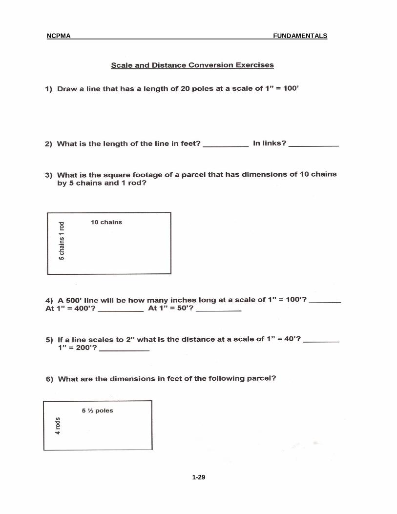
1.11 Exercises
Exercises in Area Calculation
1) A rectangular lot has dimensions of 175’ in width and 200’ in depth. What is the square footage of the lot? ______________ What is the acreage? _________
2) How many square feet would a 1.80 acre parcel of land contain?
________ 3) What is the formula for calculating the area in a triangle? __________ 4) What is the area in square feet of the figure below? _____________ 5) What is the acreage of the figure? _____________ 6) If a parcel is described as being a rectangle 10 poles by 7 ½ poles what
would the acreage of the parcel be? ______________ 7) If the tie down of a deed states that the beginning point is ½ mile from a
known intersection what is the distance in feet? _____________ 8) How many acres are contained in a square mile? _____________
200’
100
’
180’
180’
NCPMA FUNDAMENTALS
1-33
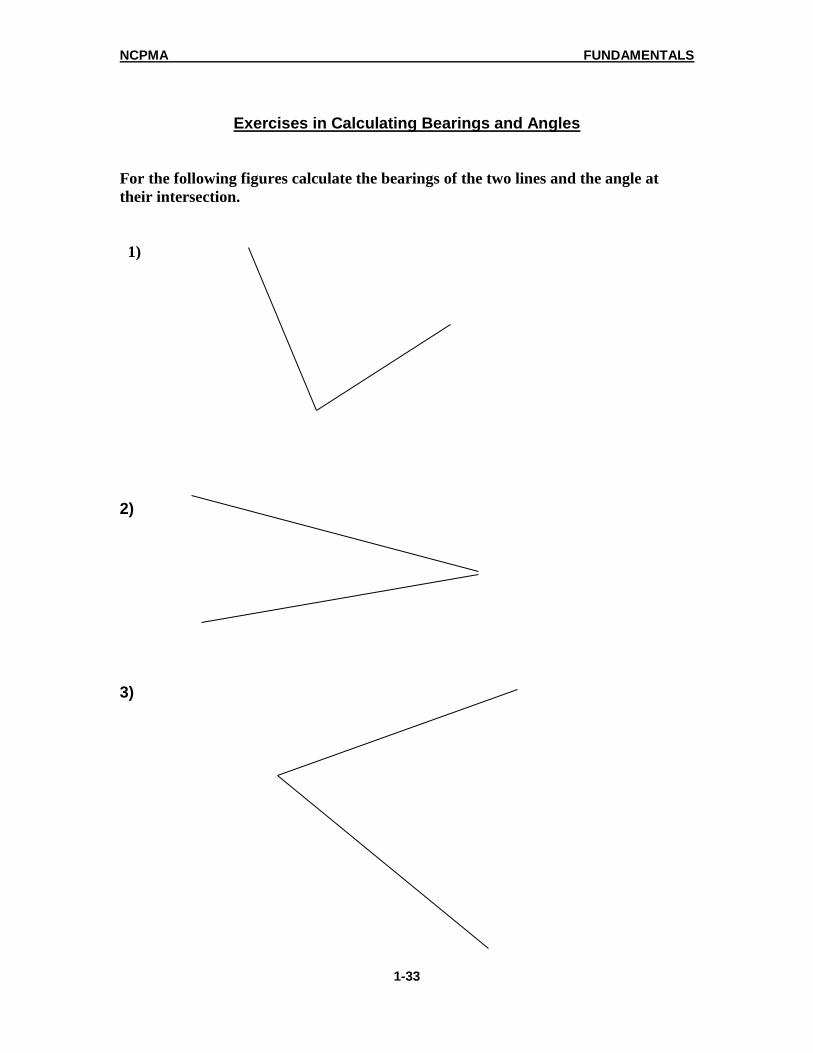
Exercises in Calculating Bearings and Angles
For the following figures calculate the bearings of the two lines and the angle at
their intersection.
1)
2) 3)