ncert book for class 10 geography chapter 7
TRANSCRIPT

We use different materials and services in ourdaily life. Some of these are available in ourimmediate surroundings, while otherrequirements are met by bringing things fromother places. Goods and services do not movefrom supply locales to demand locales on theirown. The movement of these goods and servicesfrom their supply locations to demand locationsnecessitates the need for transport. Some peopleare engaged in facilitating these movements.These are known to be traders who make theproducts come to the consumers bytransportation. Thus, the pace of developmentof a country depends upon the production ofgoods and services as well as their movementover space. Therefore, efficient means of transportare prerequisites for fast development.
Movement of these goods and services can beover three important domains of our earth i.e. land,water and air. Based on these, transport can alsobe classified into land, water and air transport.
expanded far and wide. Today, the world hasbeen converted into a large village with the helpof efficient and fast moving transport.Transport has been able to achieve this withthe help of equally developed communicationsystem. Therefore, transport, communicationand trade are complementary to each other.
Today, India is well-linked with the rest ofthe world despite its vast size, diversity andlinguistic and socio-cultural plurality.Railways, airways, waterways, newspapers,radio, television, cinema and internet, etc. havebeen contributing to its socio-economicprogress in many ways. The trades from localto international levels have added to the vitalityof its economy. It has enriched our life andadded substantially to growing amenities andfacilities for the comforts of life.
In this chapter, you will see how modernmeans of transport and communication serveas lifelines of our nation and its modern
Fig. 7.1
For a long time, trade and transport wererestricted to a limited space. With thedevelopment in science and technology, thearea of influence of trade and transport
economy. It is thus, evident that a dense andefficient network of transport andcommunication is a prerequisite for local,national and global trade of today.
2019-2020

80 CONTEMPORARY INDIA – II
TRANSPORT
Roadways
India has one of the largest road networks in
the world, aggregating to about 54.7 lakhkm. In India, roadways have preceded railways.
They still have an edge over railways in view ofthe ease with which they can be built andmaintained. The growing importance of road
transport vis-à-vis rail transport is rooted inthe following reasons; (a) construction cost ofroads is much lower than that of railway lines,
(b) roads can traverse comparatively moredissected and undulating topography, (c) roadscan negotiate higher gradients of slopes and
as such can traverse mountains such as theHimalayas, (d) road transport is economical intransportation of few persons and relatively
smaller amount of goods over short distances,(e) it also provides door-to-door service, thusthe cost of loading and unloading is much
lower, (f) road transport is also used as a feederto other modes of transport such as theyprovide a link between railway stations, air
and sea ports.In India, roads are classified in the
following six classes according to their
capacity. Look at the map of the National
Highways and find out about the significant
role played by these roads.
• Golden Quadrilateral Super Highways:
The government has launched a majorroad development project linking Delhi-
Kolkata-Chennai-Mumbai and Delhi by
six-lane Super Highways. The North-
South corridors linking Srinagar (Jammu& Kashmir) and Kanniyakumari (Tamil
Nadu), and East-West Corridor
connecting Silchar (Assam) and Porbander
(Gujarat) are part of this project. Themajor objective of these Super Highways
is to reduce the time and distance
between the mega cities of India. These
highway projects are being implementedby the National Highway Authority of
India (NHAI).
• National Highways: National Highways
link extreme parts of the country. These
are the primary road systems and are
• State Highways: Roads linking a state
capital with different district headquartersare known as State Highways. These
roads are constructed and maintained by
the State Public Works Department (PWD)
in State and Union Territories.
• District Roads: These roads connect the
district headquarters with other placesof the district. These roads are maintained
by the Zila Parishad.
• Other Roads: Rural roads, which link rural
areas and villages with towns, are classified
under this category. These roads received
special impetus under the Pradhan Mantri
Grameen Sadak Yojana. Under this scheme
special provisions are made so that every
village in the country is linked to a major
town in the country by an all seasonmotorable road.
• Border Roads: Apart from these, BorderRoads Organisation a Government of
India undertaking constructs and
Fig.7.2: Ahmedabad- Vadodara Expressway
Find out places linked by the NationalHighway 2 and 3.
laid and maintained by the Central Public
Works Department (CPWD). A number ofmajor National Highways run in North-
South and East-West directions. The
historical Sher-Shah Suri Marg is called
National Highway No.1, between Delhiand Amritsar.
2019-2020

81LIFELINES OF NATIONAL ECONOMY
India: National Highways
2019-2020

82 CONTEMPORARY INDIA – II
maintains roads in the bordering areas
of the country. This organisation wasestablished in 1960 for the developmentof the roads of strategic importance inthe northern and north-eastern borderareas. These roads have improvedaccessibility in areas of difficult terrainand have helped in the economicdevelopment of these area.
The Indian Railways is the largest publicsector undertaking in the country. The firsttrain steamed off from Mumbai to Thane in1853, covering a distance of 34 km.
Find out the current Railway zones and theirheadquarters. Also locate the headquartersof Railway zones on the map of India.
Fig. 7.3: Hilly Tracts
Fig. 7.4: Traffic on north-eastern border road
(Arunachal Pradesh)
The distribution pattern of the Railwaynetwork in the country has been largelyinfluenced by physiographic, economic andadministrative factors. The northern plainswith their vast level land, high populationdensity and rich agricultural resourcesprovided the most favourable condition for theirgrowth. However, a large number of riversrequiring construction of bridges across theirwide beds posed some obstacles. In the hillyterrains of the peninsular region, railway tractsare laid through low hills, gaps or tunnels.The Himalayan mountainous regions too areunfavourable for the construction of railwaylines due to high relief, sparse population andlack of economic opportunities. Likewise, it wasdifficult to lay railway lines on the sandy plainof western Rajasthan, swamps of Gujarat,forested tracks of Madhya Pradesh,
Roads can also be classified on the basisof the type of material used for theirconstruction such as metalled and unmetalledroads. Metalled roads may be made of cement,concrete or even bitumen of coal, therefore,these are all weather roads. Unmetalled roadsgo out of use in the rainy season.
Railways
Rai lways are the pr incipal mode oftransportation for freight and passengersin India. Railways also make it possiblefor people to conduct mul t i far iousactivities l ike business, sightseeing,pilgrimage along with transportation ofgoods over longer distances. Apart froman important means of transport theIndian Rai lways have been a greatintegrating force for more than 150 years.Railways in India bind the economic lifeof the country as well as accelerate thedeve lopment o f the industry andagriculture.
The Indian Railway is now reorganisedinto 16 zones.
2019-2020

83LIFELINES OF NATIONAL ECONOMY
Source: Railway Yearbook 2015–16, Ministry of Railways, Government of India.Website: www.indianrailways.gov.in
pipelines is high but subsequent runningcosts are minimal. It rules out trans-shipmentlosses or delays.
There are three important networks ofpipeline transportation in the country.
• From oil field in upper Assam to Kanpur(Uttar Pradesh), via Guwahati, Barauni andAllahabad. It has branches from Barauni
to Haldia, via Rajbandh, Rajbandh toMaurigram and Guwahati to Siliguri.
• From Salaya in Gujarat to Jalandhar inPunjab, via Viramgam, Mathura, Delhi and
Sonipat. It has branches to connect Koyali(near Vadodara, Gujarat) Chakshu andother places.
• Gas pipeline from Hazira in Gujaratconnects Jagdishpur in Uttar Pradesh, via
Vijaipur in Madhya Pradesh. It has branchesto Kota in Rajasthan, Shahajahanpur,Babrala and other places in Uttar Pradesh.
Waterways
Since the ancient period, India was one of
the seafaring countries. Its seamen sailedfar and near, thus, carrying and spreadingIndian commerce and culture. Waterways are
the cheapest means of transport. They aremost suitable for carrying heavy and bulkygoods. It is a fuel-efficient and environment
friendly mode of transport. India has inlandnavigation waterways of 14,500 km in length.Out of these only 5685 km are navigable bymechanised vessels. The following waterwayshave been declared as the NationalWaterways by the Government.
Gauge in metres Route (Km) Running Track (Km) Total Track (Km.)
Broad Gauge (1.676) 60,510 85,614 1,12,388
Metre Gauge (1.000) 3,880 4,170 4,747
Narrow Gauge (0.762 and 0.610) 2,297 2,297 2,495
Total 66,687 92,081 1,19,630
Table 7.1: India: Railway Track
The Indian Railway network runs on multiple gauge operationsextending over 66,687 km (excluding Metro Kolkata)
Chhattisgarh, Odisha and Jharkhand. Thecontiguous stretch of Sahyadri could becrossed only through gaps or passes (Ghats).In recent times, the development of the Konkanrailway along the west coast has facilitated themovement of passengers and goods in this mostimportant economic region of India. It has alsofaced a number of problem such as sinking oftrack in some stretches and landslides.
Today, the railways have become moreimportant in our national economy than allother means of transport put together.However, rail transport suffers from certainproblems as well. Many passengers travelwithout tickets. Thefts and damaging ofrailway property has not yet stoppedcompletely. People stop the trains, pull thechain unnecessarily and this causes heavydamage to the railway. Think over it, how wecan help our railway in running as per thescheduled time?
Pipelines
Pipeline transport network is a new arrivalon the transportation map of India. In thepast, these were used to transport water tocities and industries. Now, these are used fortransporting crude oil, petroleum productsand natural gas from oil and natural gas fieldsto refineries, fertilizer factories and big thermalpower plants. Solids can also be transportedthrough a pipeline when converted into slurry.The far inland locations of refineries likeBarauni, Mathura, Panipat and gas basedfertilizer plants could be thought of onlybecause of pipelines. Initial cost of laying
2019-2020

84 CONTEMPORARY INDIA – II
Activity
Railway line has been extended from Banihal to Baramula in the Kashmir Valley. Locate thesetwo towns on the map of India.
2019-2020
85LIFELINES OF NATIONAL ECONOMY
Fig. 7.5: Inland waterways widely used in
north-eastern states
• The Ganga river between Allahabad andHaldia (1620 km)-N.W. No.1
• The Brahmaputra river between Sadiya andDhubri (891 km)-N.W. No.2
• The West-Coast Canal in Kerala(Kottapurma-Kollam, Udyogamandal andChampakkara canals-205 km) – N.W. No.3
• Specified stretches of Godavari and Krishnarivers along with Kakinada Puducherrystretch of canals (1078 km) – N.W. No.4
• Specified stretches of river Brahmani alongwith Matai river, delta channels of Mahanadiand Brahmani rivers and East Coast Canal(588 km) – N.W. No.5
There are some other inland water ways
on which substantial transportation takesplace. These are Mandavi, Zuari and
Cumberjua, Sunderbans, Barak and
backwaters of Kerala.
Apart from these, India’s trade with foreigncountries is carried from the ports located
along the coast. 95 per cent of the country’s
trade volume (68 per cent in terms of value)
is moved by sea.
Deendayal Port, is a tidal port. It caters tothe convenient handling of exports and importsof highly productive granary and industrialbelt stretching across the states of Jammuand Kashmir, Himachal Pradesh, Punjab,Haryana, Rajasthan and Gujarat.
Major Sea Ports
With a long coastline of 7,516.6 km, India
is dotted with 12 major and 200 notified
non-majors (minor/intermediate) ports. These
major ports handle 95 per cent of India’sforeign trade.
Kandla in Kuchchh was the first port
developed soon after Independence to ease
the volume of trade on the Mumbai port, inthe wake of loss of Karachi port to Pakistan
after the Partition. Kandla also known as the
Moving along the east coast, you wouldsee the extreme south-eastern port of Tuticorin,in Tamil Nadu. This port has a natural harbourand rich hinterland. Thus, it has a flourishingtrade handling of a large variety of cargoes to
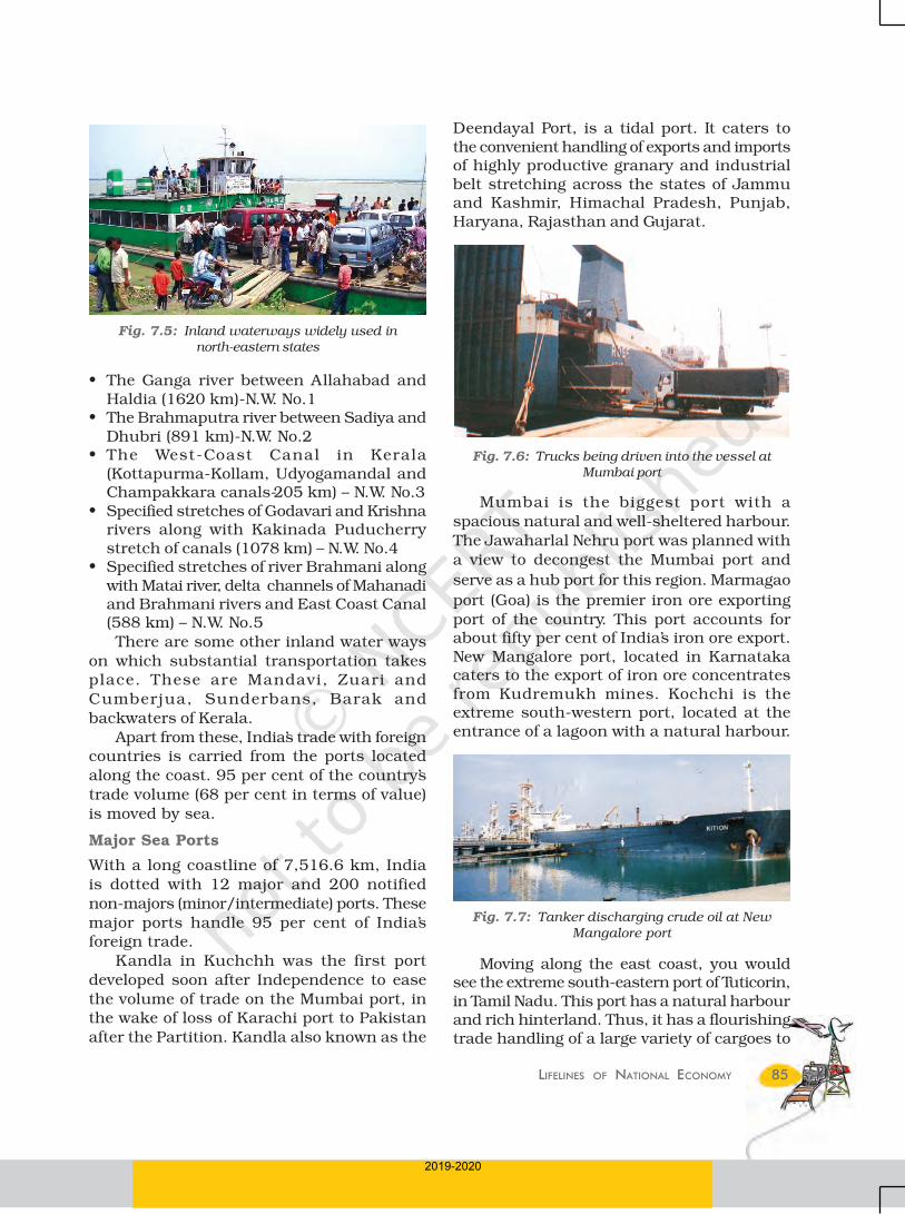
Fig. 7.6: Trucks being driven into the vessel at
Mumbai port
Mumbai is the biggest port with a
spacious natural and well-sheltered harbour.
The Jawaharlal Nehru port was planned with
a view to decongest the Mumbai port and
serve as a hub port for this region. Marmagao
port (Goa) is the premier iron ore exporting
port of the country. This port accounts forabout fifty per cent of India’s iron ore export.New Mangalore port, located in Karnatakacaters to the export of iron ore concentratesfrom Kudremukh mines. Kochchi is theextreme south-western port, located at theentrance of a lagoon with a natural harbour.
Fig. 7.7: Tanker discharging crude oil at New
Mangalore port
2019-2020

86 CONTEMPORARY INDIA – II
like high mountains, dreary deserts, denseforests and also long oceanic stretches withgreat ease. Think of the north-eastern part ofthe country, marked with the presence of bigrivers, dissected relief, dense forests andfrequent floods and international frontiers,etc. in the absence of air transport. Air travelhas made access easier.
The air transport was nationalised in 1953.Air India provides domestic and internationalair services. Pawanhans Helicopters Ltd.provides helicopter services to Oil and NaturalGas Corporation in its off-shore operations, toinaccessible areas and difficult terrains like thenorth-eastern states and the interior parts ofJammu and Kashmir, Himachal Pradesh andUttarakhand.
Find out the names of the countries connectedby Air India.
Air travel is not within the reach of thecommon people. It is only in the north-easternstates that special provisions are made toextend the services to the common people.
Communication
Ever since humans appeared on the earth,they have used different means ofcommunication. But, the pace of change, hasbeen rapid in modern times. Long distancecommunication is far easier without physicalmovement of the communicator or receiver.Personal communication and masscommunication including television, radio,press, films, etc. are the major means ofcommunication in the country. The Indianpostal network is the largest in the world. Ithandles parcels as well as personal writtencommunications. Cards and envelopes areconsidered first-class mail and are airliftedbetween stations covering both land and air.The second-class mail includes book packets,registered newspapers and periodicals. Theyare carried by surface mail, covering land andwater transport. To facilitate quick deliveryof mails in large towns and cities, six mailchannels have been introduced recently. Theyare called Rajdhani Channel, Metro Channel,Green Channel, Business Channel, Bulk MailChannel and Periodical Channel.
even our neighbouring countries like SriLanka, Maldives, etc. and the coastal regionsof India. Chennai is one of the oldest artificialports of the country. It is ranked next toMumbai in terms of the volume of trade andcargo. Vishakhapatnam is the deepestlandlocked and well-protected port. This portwas, originally, conceived as an outlet for ironore exports. Paradwip port located in Odisha,specialises in the export of iron ore. Kolkata isan inland riverine port. This port serves a verylarge and rich hinterland of Ganga-Brahmaputra basin. Being a tidal port, itrequires constant dredging of Hoogly. Haldiaport was developed as a subsidiary port, inorder to relieve growing pressure on theKolkata port.
Fig. 7.9
Airways
The air travel, today, is the fastest, mostcomfortable and prestigious mode oftransport. It can cover very difficult terrains
Why is air travel preferred in the north-eastern states?
Fig. 7.8: Handling of oversize cargo at Tuticorin port
2019-2020

87LIFELINES OF NATIONAL ECONOMY
India: Major Ports and Some International Airports
2019-2020

88 CONTEMPORARY INDIA – II
of India, is one of the largest terrestrial
networks in the world. It broadcasts a variety
of programmes from entertainment,
educational to sports, etc. for people of
different age groups.
India publishes a large number ofnewspapers and periodicals annually. They
are of different types depending upon their
periodicity. Newspapers are published in
about 100 languages and dialects. Did youknow that the largest number of newspapers
published in the country are in Hindi, followed
by English and Urdu? India is the largest
producer of feature films in the world. Itproduces short films; video feature films and
video short films. The Central Board of Film
Certification is the authority to certify both
Indian and foreign films.
International Trade
The exchange of goods among people, states
and countries is referred to as trade. The
market is the place where such exchangestake place. Trade between two countries is
called international trade. It may take place
through sea, air or land routes. While local
trade is carried in cities, towns and villages,state level trade is carried between two or more
states. Advancement of international trade of
a country is an index to its economic
prosperity. It is, therefore, considered theeconomic barometer for a country.
As the resources are space bound, no
country can survive without international
trade. Export and import are the componentsof trade. The balance of trade of a country is
the difference between its export and import.
When the value of export exceeds the value
of imports, it is called a favourable balanceof trade. On the contrary, if the value of
imports exceeds the value of exports, it is
termed as unfavourable balance of trade.
India has trade relations with all the major
trading blocks and all geographical regions
of the world. The commodities exported from
India to other countries include gems and
jewellery, chemicals and related products,
agriculture and allied products, etc.
India has one of the largest telecom
networks in Asia. Excluding urban places
more than two-thirds of the villages in India
have already been covered with Subscriber
Trunk Dialling (STD) telephone facility. In order
to strengthen the flow of information from
the grassroot to the higher level, the
government has made special provision to
extend twenty-four hours STD facility to every
village in the country. There is a uniform rate
of STD facilities all over India. It has
been made possible by integrating the
development in space technology with
communication technology.
Mass communication provides
entertainment and creates awareness among
people about various national programmes
and policies. It includes radio, television,
newspapers, magazines, books and films. All
India Radio (Akashwani) broadcasts a variety
of programmes in national, regional and local
languages for various categories of people,
spread over different parts of the country.
Doordarshan, the national television channel
Digital India is an umbrella programmeto prepare India for a knowledge basedtransformation. The focus of Digital IndiaProgramme is on being transformative torealise – IT (Indian Talent) + IT (InformationTechnology)=IT (India Tomorrow) and ison making technology central to enablingchange.
Fig.7.10 : Emergency call box on NH-8
2019-2020

89LIFELINES OF NATIONAL ECONOMY
The commodities imported to Indiainclude petroleum crude and products,gems and jewellery, chemicals and relatedproducts, base metals, electronic items,machinery, agriculture and allied products.India has emerged as a software giant at theinternational level and it is earning largeforeign exchange through the export ofinformation technology.
Tourism as a Trade
Tourism in India has grown substantially overthe last three decades.
More than 15 million people are directlyengaged in the tourism industry. Tourism alsopromotes national integration, providessupport to local handicrafts and culturalpursuits. It also helps in the development ofinternational understanding about ourculture and heritage. Foreign tourists visit
India for heritage tourism, eco tourism,
adventure tourism, cultural tourism, medical
tourism and business tourism.
There is a vast potential for development of
tourism in all parts of the country. Efforts are
being made to promote different types of
tourism for this upcoming industry.
Prepare a project on the heritage tourism in India.
*Source: Annual Report 2016–17, Ministry of Commerce and Industry, Government of India.
On the map of India show important touristplaces of your State/UT and its connectivitywith other parts of the country by railways/roadways/airways.Discuss in the class:
• What type of tourism may be developed inyour state/UT and why?
• Which areas in your state/UT you find moreattractive for development of tourism and why?
• How tourism may be helpful for the economicdevelopment of a region adopting sustainable
development approach?
2019-2020

90 CONTEMPORARY INDIA – II
EXERCISES EXERCISES EXERCISES EXERCISES EXERCISES
1. Multiple choice questions.
(i) Which two of the following extreme locations are connected by the east-west corridor?
(a) Mumbai and Nagpur (c) Mumbai and Kolkata
(b) Silchar and Porbandar (d) Nagpur and Siligudi
(ii) Which mode of transportation reduces trans-shipment losses and delays?
(a) Railways (c) Pipeline
(b) Roadways (d) Waterways
(iii) Which one of the following states is not connected with the H.V.J. pipeline?
(a) Madhya Pradesh (c) Gujarat
(b) Maharashtra (d) Uttar Pradesh
(iv) Which one of the following ports is the deepest land-locked and well-protected port along the east coast?
(a) Chennai (c) Tuticorin
(b) Paradwip (d) Vishakhapatnam
(v) Which one of the following is the most important modes of transportationin India?
(a) Pipeline (c) Roadways
(b) Railways (d) Airways
(vi) Which one of the following terms is used to describe trade between two ormore countries?
(a) Internal trade (c) External trade
(b) International trade (d) Local trade
2. Answer the following questions in about 30 words.
(i) State any three merits of roadways.
(ii) Where and why is rail transport the most convenient means oftransportation?
(iii) What is the significance of the border roads?
(iv) What is meant by trade? What is the difference between internationaland local trade?
3. Answer the following questions in about 120 words.
(i) Why are the means of transportation and communication called thelifelines of a nation and its economy?
(ii) Write a note on the changing nature of the international trade in the lastfifteen years.
QUIZ DRIVE
1. Northern terminal of the North-south corridor.
2. The name of National Highway No.2.
3. The headquarter of the southern railway zone.
4. The rail gauge with a track width of 1.676 m.
5. The southern terminal of the National Highway No.7.
6. A Riverine Port.
7. Busiest railway junction in Northern India.
2019-2020

91LIFELINES OF NATIONAL ECONOMY
ACTIVITY
Start your search vertically, horizontally or diagonally and reach variousdestinations across the country!
S H E R S H A H S U R I M A R G
A R T P R N X E L A T A D L A Y
J M M X I P O R A Y M P G H T X
Y C H E N N N A I I K M C A I M
O D C D A L M C S O T P O R C P
A P T R G S K J M J L E A N E R
R A E T A J P O R M W M A S X O
I L S B R O A D G A U G E L O T
A S N L C M E C U K Z M A A J E
L M U G H A L S A R A I B S N A
G O E T V R A Y F T O R E A J M
K Q A I P M N Y R Y A Y H L I N
Q K O L K A T A E U I T W B E A
N I T N K D E M O U R P N P J D
2019-2020