navigator and oregon explorer - odfw home page and oregon explorer ... – wetlands or sac (special...
TRANSCRIPT

NavigatOR and Oregon Explorer
Building a Distributed GIS Utility; a Digital Library; and a Portal for Oregon
Jimmy KaganInformation Program Manager and Natural
Heritage Information Center Director
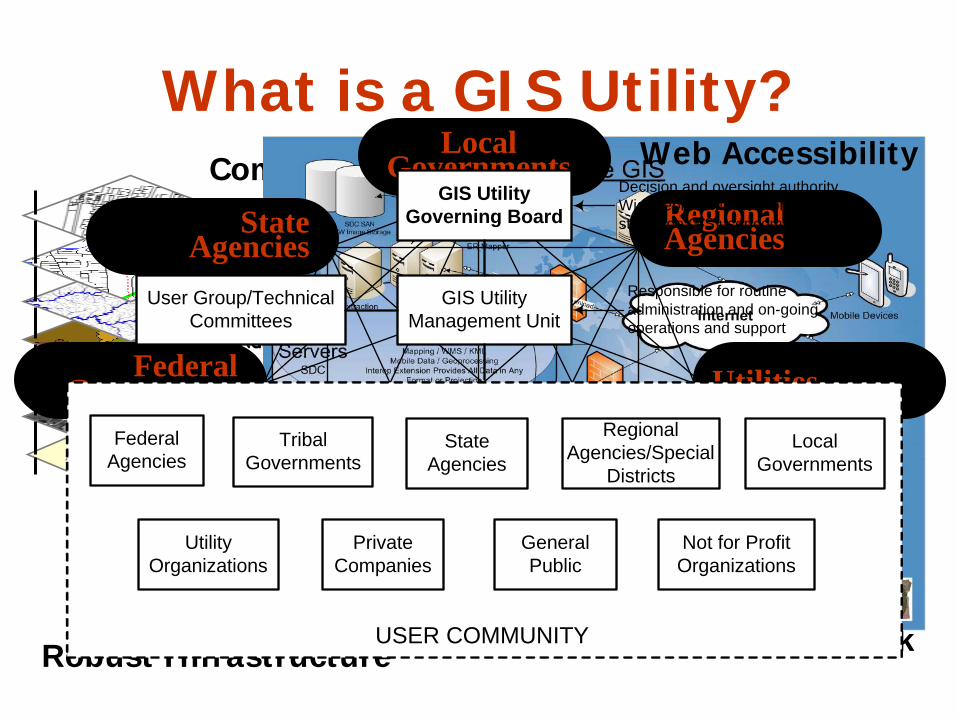
What is a GIS Utility?Common Database
Geodetic Control
Aerial Imagery
Elevation
Admin Boundaries
Hydrography
Transportation
Land Ownership
Geoscience
Preparedness
Utilities
Climate
Bioscience
Landcover/Use
Hazards
Partner NetworkRobust Infrastructure
Local Governments
Regional Agencies
Utilities
Non-Profit Organizations
Universities
Companies
Federal Government
State Agencies
GIS UtilityGoverning Board
Decision and oversight authority.Wide representation fromstatewide GIS user community
GIS UtilityManagement Unit
User Group/TechnicalCommittees
Responsible for routineadministration and on-goingoperations and support
RegionalAgencies/Special
Districts
StateAgencies
PrivateCompanies
TribalGovernments
FederalAgencies
LocalGovernments
USER COMMUNITY
Not for ProfitOrganizations
GeneralPublic
UtilityOrganizations
Web Accessibility
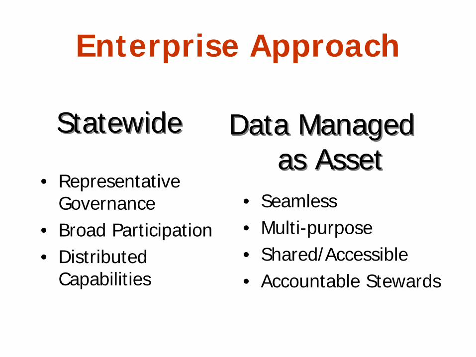
Enterprise Approach
• Representative Governance
• Broad Participation• Distributed
Capabilities
• Seamless• Multi-purpose• Shared/Accessible• Accountable Stewards
StatewideStatewide Data Managed as Asset
Data Managed as Asset
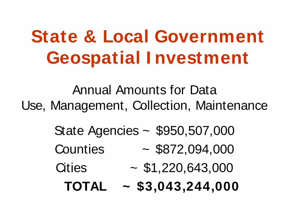
State & Local Government Geospatial Investment
Annual Amounts for Data Use, Management, Collection, Maintenance
State Agencies ~ $950,507,000Counties ~ $872,094,000Cities ~ $1,220,643,000
TOTAL ~ $3,043,244,000
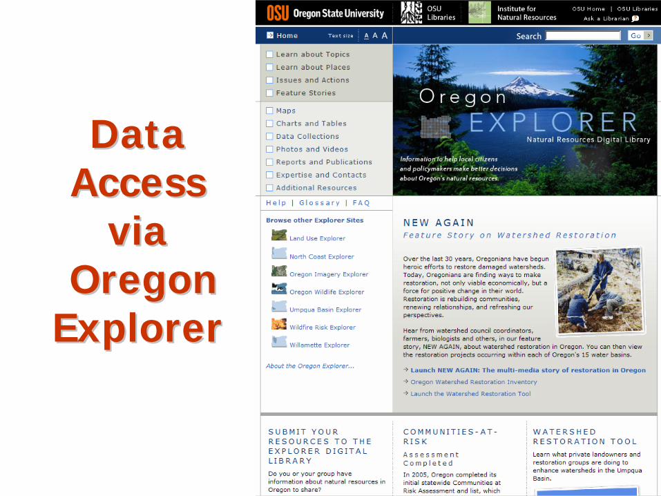
Data Data AccessAccess
viavia Oregon Oregon
ExplorerExplorer
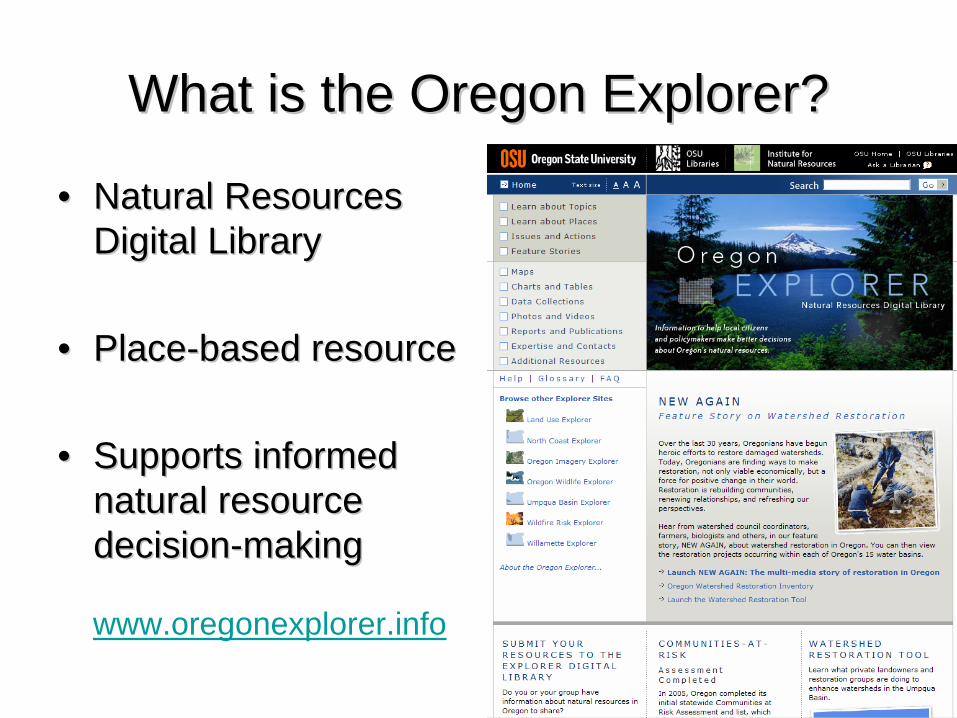
What is the Oregon Explorer?What is the Oregon Explorer?
•• Natural Resources Natural Resources Digital LibraryDigital Library
•• PlacePlace--based resourcebased resource
•• Supports informed Supports informed natural resource natural resource decisiondecision--makingmaking
www.oregonexplorer.info
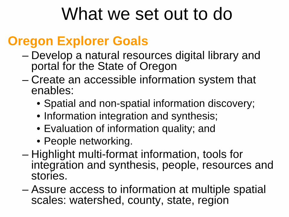
What we set out to doOregon Explorer Goals
– Develop a natural resources digital library and portal for the State of Oregon
– Create an accessible information system that enables:• Spatial and non-spatial information discovery; • Information integration and synthesis; • Evaluation of information quality; and • People networking.
– Highlight multi-format information, tools for integration and synthesis, people, resources and stories.
– Assure access to information at multiple spatial scales: watershed, county, state, region

Oregon Explorer Basin and Topic Portals

Learn about Places – regional portals
Develop portals or pages for each basin, ecoregion and county
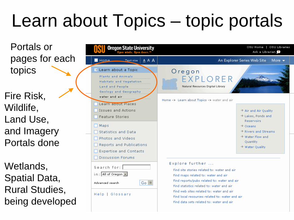
Learn about Topics – topic portalsPortals or pages for each topics
Fire Risk,Wildlife,Land Use,and ImageryPortals done
Wetlands, Spatial Data, Rural Studies, being developed

New & Potential Natural Resource Issues or New & Potential Natural Resource Issues or Basins to be addressed by Oregon ExplorerBasins to be addressed by Oregon ExplorerFunded Funded –– In Development:In Development:•• Wetlands ConservationWetlands Conservation
Wetlands ExplorerWetlands Explorer•• Community VitalityCommunity Vitality
Rural Communities ExplorerRural Communities Explorer•• Hazard EvaluationHazard Evaluation
Spatial Data ExplorerSpatial Data Explorer•• Sustainable AgricultureSustainable Agriculture
Sustainable Agriculture ExplorerSustainable Agriculture Explorer•• Deschutes BasinDeschutes Basin
Deschutes Basin ExplorerDeschutes Basin Explorer•• Oregon Closed Lake Oregon Closed Lake
Lakes Basin ExplorerLakes Basin Explorer
Proposed:Proposed:•• Water (Quality & Quantity)Water (Quality & Quantity)•• Invasive SpeciesInvasive Species•• Climate ChangeClimate Change•• Habitat ConservationHabitat Conservation•• Rural Economic DevelopmentRural Economic Development•• Integrated MonitoringIntegrated Monitoring•• Oregon Benchmarks and Oregon Benchmarks and
Key Performance MeasuresKey Performance Measures
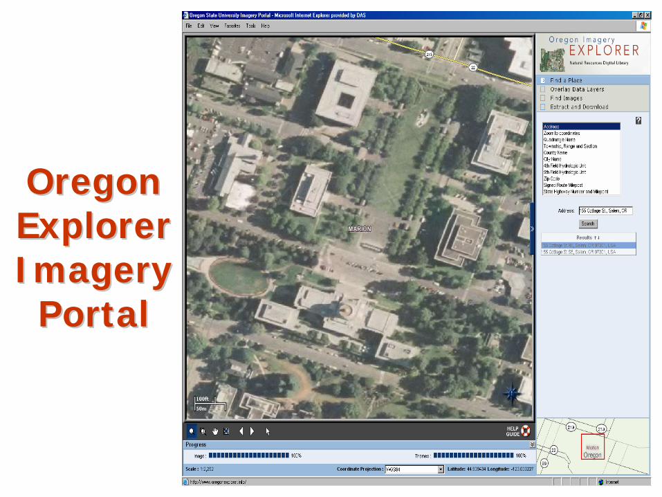
Oregon Oregon ExplorerExplorer Imagery Imagery
PortalPortal

Different issues addressed at various scales

Transportation Specific Tools
• Pre-Screening & Permitting• Mitigation• Conservation and Planning

Pre-Screening & Permit Tool• Anyone can identify potential problems with a
project before funds are spent on planning, acquisition or development.
• Map tool shows potential impacts with:– Wetlands or SAC (special area of concern)– Threatened or Endangered Species
• May provide on-line permit applications• Provides guide to the myriad of state and
federal permits required for any project
Mitigation Tools• Assure mitigation occurs in the most important
places without the net loss of acres or values by linking projects with the nearest, significant wetland.
• Link groups identifying wetlands needing conservation with agencies or developers needing mitigation credits.
• Create simpler ways to mitigate with good effect– Decision support tools– Mitigation banks– Joint mitigation projects– Access to new mitigation methods

Conservation Tools • Develop, expand & integrate conservation tools
– Identify & integrate conservation priorities (Oregon Greatest Wetlands; Oregon Conservation Plan, Sub-basin plans, ecoregional plans…)
– Track ongoing conservation projects needing funds, expertise, or partnerships.
– Provide link to funding sources and opportunities.– Provide access to experts.– Provide access to conservation partners.– Develop online education and training opportunities
to promote conservation.

Project Leads
• Institute for Natural Resources (INR)– Jimmy Kagan, Oregon Explorer Program Co-Manager– Kuuipo Walsh, INR GIS Analyst/Web Developer
• OSU Libraries– Janine Salwasser, Oregon Explorer Program Co-Manager– Marc Rempel, OE Programmer– Ruth Vonderchek, Innovative Library Services
• Geospatial Enterprise Office (GEO)– Cy Smith, State GIS Coordinator– Milt Hill, Framework Coordinator– David Mather, GIS Data Administrator