nature and engineering characteristics of foundation soils...
TRANSCRIPT
Ife Journal of Science vol. 18, no. 1 (2016)
NATURE AND ENGINEERING CHARACTERISTICS OF FOUNDATION SOILS IN IBEJU LEKKI AREA OF LAGOS, SOUTHWESTERN NIGERIA.
1 2 3Adebisi, N. O., Osammor, J. and Oyedele, K. F.
1Department of Earth Sciences, Faculty of Science, Olabisi Onabanjo University, Ago Iwoye, Ogun State, Nigeria. 2Osmo Geotechnical Engineering Services, Badagry Expressway, Ijan ikin, Lagos.
3Department of Geosciences, Akoka, Lagos.(Corresponding Author: [email protected])
th th(Received: 14 Juune, 2015; Accepted: 6 Dec., 2015)
An investigation of the geotechnical properties of foundation soils was carried out in Ibeju Lekki area of Lagos, Southwestern Nigeria. This was with a view to establishing the nature and engineering characteristics of the subsoils and their behaviour under structural loading. Twenty-five (25) Standard Penetration Tests (SPT) and thirty-five (35) Cone Penetration Tests (CPT) were carried out while thirty-three (33) soil samples were collected. In-situ test parameters (cone resistance and SPT number of blows), index properties (natural moisture content, grain-size distribution and consistency limits), shear strength parameters, compressibility properties, Califonia Bearing Ratio (CBR) and moisture-density relationship were determined in compliance with specifications of the British Standards (BS) 5930, 8004 and 1337. soils in the shallow groundwater level area, were a combination of soil types , silt = 2 - 9 %, sand = 62 - 87 %, gravel = 2 – 28 %), variable consistency (L = 43 - 118% and I = 19 – 69 %) and shear L P
2 0strength parameters (C = 20 – 100 kN/m and = 1 - 9 ). For shallow foundation within 1.0 m and 2.0 m, a total u 2settlement of 23.65 mm was estimated to occur under assumed loading intensity of 45 kN/m with allowable
2bearing capacity of 121 kN/m . For deep foundation, the allowable loading bearing capacity for a pile of 600 mm diameter set at 8.0 m would be 940 kN. CBR and compacted density results indicated a sub base thickness range of 100 mm - 150 mm for a proposed road layer compacted at optimum moisture content to take care of probable groundwater fluctuation in the area.
Keywords: Creek, Strength, Settlement, Foundation and Subsoils
ABSTRACT
The sub (clay-sized particles = 9 – 12 % -sized particles -sized particles
-sized particles
029
INTRODUCTIONLiterature shows that foundation soils from the creek areas of southeastern Nigeria have been extensively studied, with the conclusion that they pose geotechnical challenges to engineering projects. Uduji et al. (1994) showed that soils in Awgu and Okigwe southeastern Nigeria are clayey as characterised by abnormal change in bulk volume when in contact with water. Okogbue and Yakubu (1999) also reported abnormality in compressibility as well as conversion from a relatively brittle material to a viscous liquid when foundation soils from the creek areas of southeastern Nigeria are disturbed. Abnormal plasticity and compressibility have been identified as the major cause of road failures and building collapse in the area. Youdeowei and Nwakwoala (2012) and Nwankwoala and Oborie (2014) established the sub-soil types and profile underlying parts of southeastern Nigeria with a view to recommending appropriate foundation design for major construction projects.
Studies regarding the geotechnical properties of foundation soils in the creek area of southwestern Nigeria have also been carried out by some workers. Adepelumi and Olorunfemi (2000) established the geological/geo-electrical sequence of the reclaimed Lekki Peninsula, Lagos, Nigeria. They identified certain sand columns whose thicknesses revealed the geomorphological features of the original pre-fill terrain. Adeyemi and Osammor (2000) studied the degree of correlation between penetration resistance and number of blows from several penetration testing. This study was limited to determining bearing capacity of soils underlying the creek area in parts of Dahomey and Niger Delta Basins. Adepelumi et al. (2009) carried out an engineering geological survey in a reclaimed Lekki area of Lagos, Southwestern Nigeria. The cone penetrometer and finite element methods were employed to characterize sand-fill thicknesses in the area. The study revealed that structural trends of the
030
depressions in the reclaimed area were largely influenced by the oceanic fracture pattern. Oyedele et al. (2011) used integrated geophysical and geotechnical method to characterize the foundation materials at Ikoyi, Lagos, Nigeria. The materials are composed of Coastal Plain Sands and Recent Littoral Alluvium of the Dahomey Basin. From the study, Vertical Electrical Sounding revealed four to five subsurface layers with low penetration resistance values to a depth of 16 m.
Oyedele and Olorode (2010) investigated the prevalent subsurface geological conditions responsible for differential settlement of various degrees peculiar to structures at Medina Estate, Gbagada, Lagos. The area is underlain to a depth of 14 m by Recent Lithoral Alluvium and Coastal Plain Sands of the Dahomey Basin. It was discovered that foundation soils at shallow depths consist of an extensive layer of materials with extremely low shear strength and corresponding high volume of compressibility. Adebisi and Fatoba (2013) presented penetration resistance with depth and electrical resistivity curves for foundation soils across Lagos area. It noted, from a geotechnical standpoint that soils in the area are not satisfactory in terms of load-carrying capacities and structural soundness.
All previous studies from the creek area of Southwestern Nigeria cover very limited locations and are yet to involve a coordinated research on an area with potentials for future infrastructural development. Also, information regarding detailed characterization of foundation soils, as well as geotechnical properties of moisture-prone clay in the composition of the soils are scanty. The present study area is Ibeju-Lekki; a fast growing and future Free Trade Zone which offers unparallel opportunities for infrastructural development. This study intends to characterize the foundation soils, and investigate response of the moisture-prone clay component of the foundation soils to structural loads.
D E S C R I P T I O N O F T H E S T U DY ENVIRONMENTGeographical Location, Geomorphology and Climate
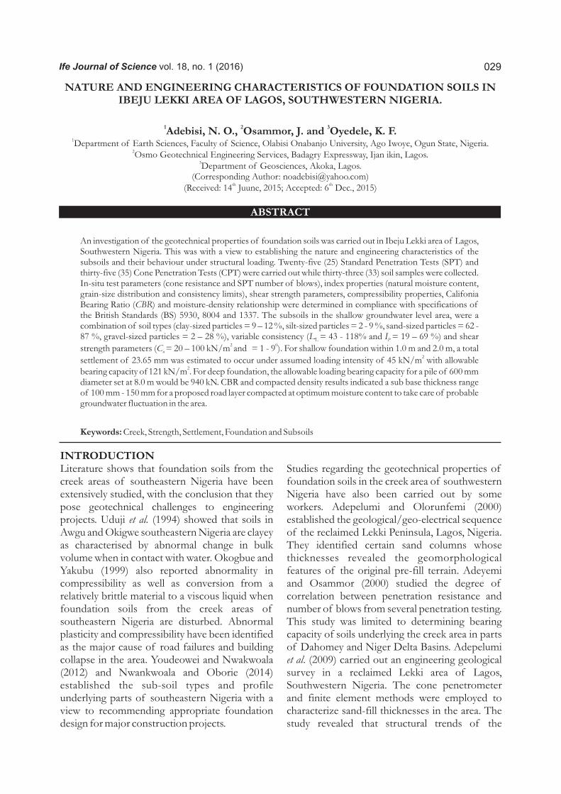
2Ibeju Lekki covers about 445 km which equals 25% of the total landmass of Lagos State (LGAs,
o o2010). It falls between longitudes 3 35' and 3 55'N o oand latitudes 6 25' and 6 45'E in the creek zone of
tropical Southwestern Nigeria (Fig.1). The area is relatively flat with an altitude of about 6.40 m.
Ibeju-Lekki
TP2
TP7
TP8TP9
TP10
TP11
TP15
TP18
TP21TP23
TP26 TP33
Figure: 1. Modified Map of Ibeju-Lekki Showing the Spatial Distribution of Test Locations (Source: http://www.maphill.com/nigeria/lagos/ibeju-lekki/)
Adebisi et al.: Nature and Engineering Characteristics of Foundation Soils in Ibeju Lekki

031
The study area falls within the lagoon-beach belt in which five physiographic units have been recognised (Adegoke et al., 1980). The first is the Abandoned Beach Ridge complex which comprises coast parallel savannah-grassed sand ridge. This is dissected by creeks and alternating muddy depressions, which support Raphia palm growth. The second is the Coastal Creeks and Lagoons which occur as a belt of nearly 1000 km between Abijan and the western flank of the Niger Delta. The third is the Swamp Flats which commonly border the lagoon, and are often densely forested with Alchornea cordifolia, a fresh water mangrove. The fourth is the Forested River Flood Plains which constitute a geomorphic form, and dissected the Benin Formation. It is characterized by gallery forests growing on the levees flanking the rivers. The fifth is the Active Barrier Beach complex consisting of a continuous line of wave-washed white to brownish sand with abundant mollusc shells. Low-angle cross stratification is common with exposed clean, fine to coarse sand layers.
According to CIL (2012), Ibeju Lekki has tropical wet and dry seasons that borders on a tropical monsoon climate. Thus it experiences two raining seasons, with the heaviest rains falling from April to July and a weaker rainy season in October and November. However, a brief relatively dry spell is prevalent in August and September and a longer dry season from December to March. WWIS (2012) report showed that monthly rainfall between May and July averaged over 400 mm (16 in), while in August and September it fell to 200 mm (7.9 in) and in December reached as low as 25 mm (0.98 in). The main dry season is accompanied by harmattan winds from the Sahara Desert, which between December and early February can be quite strong. The highest
maximum temperature ever recorded in Lagos was 37.3°C (99.1°F), and the minimum was 13.9°C (57.0°F). According to Nwajide (2013), two main vegetation types are identifiable in the area: swamp forest in the coastal belt and dry lowland rain forest in the vegetated area. The swamp forests in the state are a combination of mangrove forest and coastal vegetation developed under the brackish conditions of the coastal areas and the swamp of the freshwater lagoons and estuaries. In this area, accessibility and construction would be challenging due to the swampy nature of the terrain.
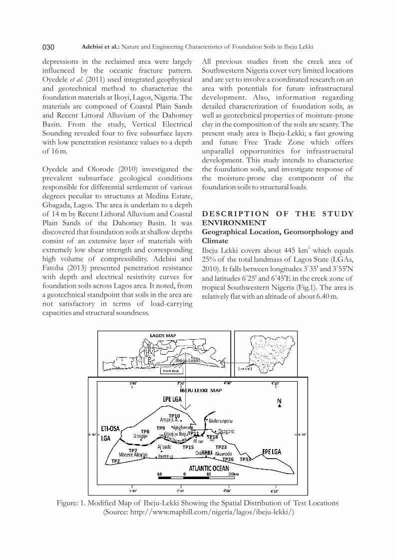
The GeologyIbeju Lekki falls within the extensive Dahomey Basin in Southwestern Nigeria. It is underlain by sand, sandy clay and lignite, with vegetated freshwater deposits of mainly Recent-Quaternary alluvium above the Ilaro Formation (Malomo and Oloruniwo, 1983; Onwuka, 1990). In the area, a consistent geological sequence was established to depth of 1.5 m through manual excavation of trial pits, while groundwater was encountered near the surface to a depth of 0.25 m (Fig. 2). The typical trial pit logs show loose organic fine- to medium-grained silty sands from the existing ground level to a depth of 0.5 m. The color varies from brown to grey with different plants roots. This can be assumed to be the top soil. The layer 0.5 - 1.5 m is mostly dominated by white colored, fine to medium-grained sands. There exist also few plants and tree roots at this depth. Borehole also confirmed a narrow discontinuous band of organic hydromorphic soils occurs to a depth of 2.0m. This is underlain by dominantly red ferrallitic soils on loose sandy sediments, which are medium grained sand, sand, clayey sand and coarse sand beyound 12.0 m, as confirmed by Oyedele et al. (2009).
Adebisi et al.: Nature and Engineering Characteristics of Foundation Soils in Ibeju Lekki
032
METHOD OF STUDYTwenty-five (25) boreholes for Standard Penetration Testing (SPT) were drilled to a maximum depth of 15.0 m in most cases; using percussion technique by means of a light cable, motorised drilling machine. Dutch Cone Penetrometer Test (CPT) was carried out using a 2.5 tons capacity penetrometer equipped with
2 o anchors, and a cone of 1000 mm with 60 apex angle to depth of machine refusal at 35 locations. Disturbed and undisturbed samples were recovered from thirty-three (33) trial pits excavated to a depth range of 1.0 – 1.5 m beneath the existing ground level. All laboratory tests (grain-size distribution, consistency, compaction, consolidation and shear strength) on thirty-three (33) selected samples were in compliance with specifications in the British Standards BS: 5930 (1981), 8004 (1986), 1337 (1990) and American Society for Testing and Materials ASTM: Designation 2487 (2011), for soil classification and civil engineering testing purposes.
Computation of total settlement and bearing capacity values was based on the Mayerhoff (1956) theory, which employed volume compressibility and penetration testing data with some assumed dimensions. Furthermore, Tomlinson (1986) and Terzaghi et al. (1996) derived equations cited in Hatanaka and Uchida (1996) were also applied.
RESULTS AND DISCUSSION
Subsoil Sequence
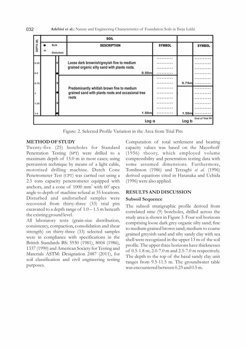
The subsoil stratigraphic profile derived from correlated nine (9) boreholes, drilled across the study area is shown in Figure 3. Four soil horizons comprising loose dark grey organic silty sand; fine to medium grained brown sand; medium to coarse grained greysish sand and silty sandy clay with sea shell were recognized in the upper 13 m of the soil profile. The upper three horizons have thicknesses of 0.5-1.8 m; 2.0-7.0 m and 2.5-7.0 m respectively. The depth to the top of the basal sandy clay unit ranges from 9.5-11.5 m. The groundwater table was encountered between 0.25 and 0.5 m.
Figure: 2. Selected Profile Variation in the Area from Trial Pits
Adebisi et al.: Nature and Engineering Characteristics of Foundation Soils in Ibeju Lekki
033
Soil Index Properties
The grading curves of the foundation soils -2 2 investigated cover a log cycle range of 10 - 10
mm (Figure 4). The soils are well-graded, consisting of a wide range of particle sizes. Table1 contains different percentages of aggregate diameters in the selected samples. Fine fractions show that the clay content ranges between 7 and 12% and silt content varies between 2 and 9%. Coarse fractions show that sand content varies from 62 to 80% and gravel-sized particles range from 2 to 28%. Sand fraction dominates the composition of the soils.
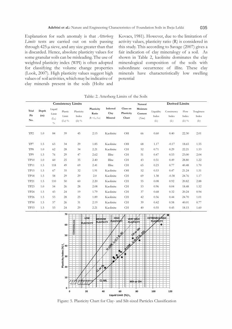
The detailed Atterberg Limits for defining consistency of the soils are summarized in Table
2. The table shows soils variation according to amount of fines (clay- and silt-sized particles) present in the studied soils. From the consistency index values (-0.38 - 0.58) and other derived limits, the effect of water content on the mechanical structure of the soils is bound to be detrimental to strength when structural load is applied. The Casagrade's Plast ic i ty Char t for f ines classification, shown in Figure 5, indicates that most of the soils fall within the zone of high inorganic clays on the plasticity chart. Jack and Liu (2007) reported this as undesirable content of any foundation material. The consistency limits of the fines content reflect in a general way, the engineering behaviour of soils in the mangrove swamp environment (Tse and Akpokodje, 2010).
Figure: 3. Selected Boreholes Showing Lithologic Variation across the Study Area
Adebisi et al.: Nature and Engineering Characteristics of Foundation Soils in Ibeju Lekki

034
a
b
Figure: 4. Particle-size Distribution Curves for the Studied Soils.
Table: 1. Particle-size Distribution of Selected Samples (ASTM D2487-11, Unified Soil Classification System)
Grading Curve
Trial Pit No.
Depth (m)
% Fines % Sand % Gravel
% Clay % Silt
Gra
din
g
Cu
rves
N
o.
I
TP2 1.0 9 9 80 2 TP7 1.5 12 4 63 21 TP8 1.0 12 2 77 9 TP9 1.5 12 6 73 9 TP10 1.0 10 4 77 9 TP11 1.5 10 2 83 5
Gra
din
g
Cu
rves
No
. II
TP15 1.5 7 3 62 28 TP18 1.5 10 2 67 21 TP21 1.5 8 2 81 9 TP23 1.0 11.5 4.5 82 2 TP26 1.5 7 4 87 2 TP33 1.5 9 5 75 11
Adebisi et al.: Nature and Engineering Characteristics of Foundation Soils in Ibeju Lekki
035
Explanation for such anomaly is that Atterberg Limits tests are carried out on soils passing through 425 µ sieve, and any size greater than that is discarded. Hence, absolute plasticity values for some granular soils can be misleading. The use of weighted plasticity index (WPI) is often adopted for classifying the volume change properties (Look, 2007). High plasticity values suggest high values of soil activities, which may be indicative of clay minerals present in the soils (Holtz and
Kovacs, 1981). However, due to the limitation of activity values, plasticity ratio (R) is considered in this study. This according to Savage (2007) gives a fair indication of clay mineralogy of a soil. As shown in Table 2, kaolinite dominates the clay mineralogical composition of the soils with subordinate occurrence of illite. These clay minerals have characteristically low swelling potential
Table: 2. Atterberg Limits of the Soils
Trial
Pit
No.
Depth
(m)
Consistency Limits
Plasticity
Ratio
(R =LL/LP)
Inferred
Clay
Mineral
Class on
Plasticity
Chart
Natural
Moisture
Content
(Nmc)
Derived Limits
Liquid
Limit
(LL)
%
Plastic
Limit
(LP) %
Plasticity
Index
(IP) %
Liquidity
Index
(IL)
Consistency
Index
(IC)
Flow
Index
(IF) %
Toughness
Index
(IT)
TP2 1.0 84 39 45 2.15 Kaolinite OH
66
0.60 0.40 22.30 2.01
TP7 1.5 63 34 29 1.85 Kaolinite OH 68 1.17 -0.17 18.65 1.55
TP8 1.0 62 28 34 2.21 Kaolinite CH 52 0.71 0.29 22.21 1.53
TP9 1.5 76 29 47 2.62 Illite CH 51 0.47 0.53 23.00 2.04
TP10 1.0 60 25 35 2.40 Illite CH 43 0.51 0.49 28.80 1.22
TP11 1.5 118 49 69 2.41 Illite CH 65 0.23 0.77 40.48 1.70
TP15 1.5 67 35 32 1.91 Kaolinite OH 52 0.53 0.47 21.24 1.51
TP18 1.5 58 29 29 2.0 Kaolinite CH 69 1.38 -0.38 24.76 1.17
TP21 1.5 110 50 60 2.20 Kaolinite CH 55 0.08 0.92 20.82 2.88
TP23 1.0 54 26 28 2.08 Kaolinite CH 53 0.96 0.04 18.48 1.52
TP24 1.5 43 24 19 1.79 Kaolinite CH 37 0.68 0.32 20.24 0.94 TP26 1.5 53 28 25 1.89 Kaolinite CH 42 0.56 0.44 24.70 1.01 TP30 1.5 57 26 31 2.19 Kaolinite CH 39 0.42 0.58 40.01 0.77 TP33
1.5
53
24
29
2.21
Kaolinite
CH
40
0.55
0.45
18.15
1.60
0
10
20
30
40
50
60
70
0 20 40 60 80 100 120
Liquid Limit (%) LL
LOW
PLASTICITY
MEDIUMPLASTICITY
HIGHPLASTICITY
VERY HIGHPLASTICITY
EXTREMELY HIGHPLASTICITY
CL-ML MH or OH
Pla
stic
ity
Ind
ex
(%
) l p
Figure: 5. Plasticity Chart for Clay- and Silt-sized Particles Classification
Adebisi et al.: Nature and Engineering Characteristics of Foundation Soils in Ibeju Lekki

036
Shear Strength Properties
Shear Strength Parameters
The strength and consolidation of foundation soils play major roles in construction projects. These engineering parameters determine the ability to carry weights, and support buildings and roads. The nature of shearing resistance of a soil offers the opportunity to analyze its stability
problems such as bearing capacity.
in Table 3. T cohesive strength (C ) u
2ranges from 20 to 100 kN/m , while the undrained angle of internal friction (f ) varies between 1 and u
O9 . The soils have C value far greater than zero U
which is characteristic of normally consolidated clay, with the values indicative of silty sand.u
The shear strength parameters of the studied soils are summarized he
Table: 3. Shear Strength Parameters
Trial
Pit
No.
Depth
(m)
(Triaxial Test) (Shear Box Test)
Undrained
Cohesion (Cu)
kN/m2
Angle of Internal Friction
(f) 0
Undrained
Cohesion
(Cu)
kN/m2
Angle of Internal Friction (f)
0
TP2
1.0
50
1
30
8
TP7 1.5 30 4 65 9
TP8 1.0 100 2 50 4
TP9 1.5 45 2 60 7
TP10 1.0 40 6 45 2
TP11 1.5 35 7 40 6
TP15 1.5 65 1 55 5
TP18 1.5 20 6 35 5
TP21 1.5 65 2 43 4
TP23 1.0 45 3 45 3
TP24 1.5 35 6 50 5
TP26 1.5 80 1 60 8
TP30 1.5 65 2 65 8
TP33 1.5 35 5 45 1
In-situ Strength Parameters
The cone penetration resistance from CPT (Figure 6) and SPT (Figure 7) blow counts help to provide a much better record of strength variation with depth in the area. From the ground level, a layer of 0-2.0 m comprises loose dark gray organic silty sand. Water levels were encountered at depths of 1.0 - 2.0 m below ground surface. The cone resistance of this layer rages from 10 to 40
2kgf/cm . The layer from 3.0 to7.5 m is composed
of loose brownish to whitish, fine to medium grained sand with cone reading of 28-192
2kgf/cm . The number of blows (N ) from the SPT
SPT tests varies between 4 and 12 from 1 to 5m. Furthermore, within the depths of 8 and 11 m the soils are medium dense to coarse silty sand with clay at the depth range of 10-11 m. N values SPT
range between 4 and 30. Logs of the lithologic variation across the area show layer below 10 to 15 m to consist of firm dark grey silty sandy clay. (Fig.7).
Adebisi et al.: Nature and Engineering Characteristics of Foundation Soils in Ibeju Lekki

037
0
1
2
3
4
5
6
7
8
0 50 100 150 200 250
De
pth
(m
)
Cone Resistance ( 2kgf/cm )
TP2
TP10
TP15
TP18
TP23
TP24
TP33
Figure: 6. Cone Resistance with Depth in Reverse Order.
Figure: 7. Selected SPT Blow Counts Record of Soils' Strength Variation with Depth
Adebisi et al.: Nature and Engineering Characteristics of Foundation Soils in Ibeju Lekki
038
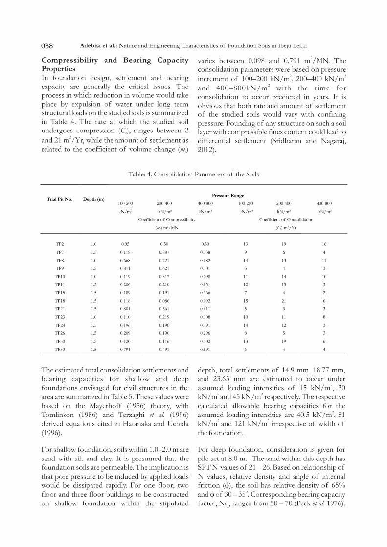
Compressibility and Bearing Capacity PropertiesIn foundation design, settlement and bearing capacity are generally the critical issues. The process in which reduction in volume would take place by expulsion of water under long term structural loads on the studied soils is summarized in Table 4. The rate at which the studied soil undergoes compression (C ), ranges between 2 v
2and 21 m /Yr, while the amount of settlement as related to the coefficient of volume change (m ) v
2varies between 0.098 and 0.791 m /MN. The consolidation parameters were based on pressure
2 2increment of 100–200 kN/m , 200–400 kN/m 2and 400–800kN/m with the time for
consolidation to occur predicted in years. It is obvious that both rate and amount of settlement of the studied soils would vary with confining pressure. Founding of any structure on such a soil layer with compressible fines content could lead to differential settlement (Sridharan and Nagaraj, 2012).
Table: 4. Consolidation Parameters of the Soils
Trial Pit No.
Depth (m)
Pressure Range
100-200
kN/m2
200-400
kN/m2
400-800
kN/m2
100-200
kN/m2
200-400
kN/m2
400-800
kN/m2
Coefficient of Compressibility
(mv) m2/MN
Coefficient of Consolidation
(Cv) m2/Yr
TP2
1.0
0.95
0.50
0.30
13
19
16
TP7
1.5
0.118
0.887
0.738
9
6
4
TP8 1.0 0.668 0.721 0.682 14 13 11
TP9 1.5 0.811 0.621 0.701 5 4 3
TP10 1.0 0.119 0.317 0.098 11 14 10
TP11 1.5 0.206 0.210 0.851 12 13 3 TP15 1.5 0.189 0.191 0.366 7 4 2 TP18
1.5
0.118
0.086
0.092
15
21
6
TP21
1.5
0.801
0.561
0.611
5
3
3
TP23
1.0
0.110
0.219
0.108
10
11
8 TP24
1.5
0.196
0.190
0.791
14
12
3
TP26
1.5
0.209
0.190
0.296
8
5
3
TP30
1.5
0.120
0.116
0.102
13
19
6
TP33 1.5 0.791 0.491 0.591 6 4 4
The estimated total consolidation settlements and bearing capacities for shallow and deep foundations envisaged for civil structures in the area are summarized in Table 5. These values were based on the Mayerhoff (1956) theory, with Tomlinson (1986) and Terzaghi et al. (1996) derived equations cited in Hatanaka and Uchida (1996).
For shallow foundation, soils within 1.0 -2.0 m are sand with silt and clay. It is presumed that the foundation soils are permeable. The implication is that pore pressure to be induced by applied loads would be dissipated rapidly. For one floor, two floor and three floor buildings to be constructed on shallow foundation within the stipulated
Adebisi et al.: Nature and Engineering Characteristics of Foundation Soils in Ibeju Lekki
depth, total settlements of 14.9 mm, 18.77 mm, and 23.65 mm are estimated to occur under
2assumed loading intensities of 15 kN/m , 30
2 2kN/m and 45 kN/m respectively. The respective calculated allowable bearing capacities for the
2 assumed loading intensities are 40.5 kN/m , 81 2 2kN/m and 121 kN/m irrespective of width of
the foundation.
For deep foundation, consideration is given for pile set at 8.0 m. The sand within this depth has SPT N-values of 21 – 26. Based on relationship of N values, relative density and angle of internal friction (f), the soil has relative density of 65%
oand f of 30 – 35 . Corresponding bearing capacity factor, Nq, ranges from 50 – 70 (Peck et al, 1976).

Some other in-situ index properties such as void ratio and submerged unit weights were based on values for typical soils (Das, 2007). Based on these parameters, the allowable loading capacity (using safety factor of 3.0) for bored piles with diameter
of 200 mm, 300 mm, 500 mm and 600 mm are: 127 kN, 345 kN, 675 kN, and 940 kN, respectively Estimated settlement for these loads are less than 50 mm
Table: 5. Engineering Characteristics Governing Foundation DesignSHALLOW FOUNDATION @ 1.0 – 2.0 m DEEP FOUNDATION @ 8.0 m
Assumed
Loading
Intensity
(sAss)
kN/m2
Actual
Consolidation
Settlement
(rc) mm
Oedometer
Settlement
(roed) mm
Total
Consolidation
Settlement
rTotal (mm)
Allowable
Bearing
Capacity
(qa)
kN/m2
Assumed
Pile
Diameter
(B) mm
Actual
Consolidation
Settlement
(rc) mm
Oedometer
Settlement
(roed) mm
Total
Consolidation
Settlement
rTotal (mm)
Ultimate
Bearing
Capacity
(qult)
kN/m2
Allowable
Load of
Piles
(sAllow)
kN
15 5.1 9.8 14.9 40.5 200 12.00 20.54 32.54 123.0 127
30 6.05
12.72
18.77
81
300
12.8
22.1
34.9
184.0
345
45 7.0 16.65
23.65
121
500
13.32
25.35
38.67
246.1
675
- - - - - 600 14.3 28.5 42.8 375.0 940
CBR and Moisture-Density RelationshipThe determination of bearing capacity of unbound pavement layers is also of interest in this study. This is to evaluate the mechanical strength of the foundation soils as road subgrades in the area. Table 6 gives a summary of the Califonia Bearing Ratio (CBR) and moisture-density relationship of the soils. Gidigasu (1980) confirmed CBR as the bonafide index of the bearing capacity for highway subgrade soils. The unsoaked CBR is 15.58% (TP2) at 1 m depth, and
the maximum soaked CBR of 12.50 (TP15) at 1.5 m implies that TP2 has greater strength reduction on account of soaking than TP15. On the basis of the CBR values, it is obvious that the strength of the soils will reduce greatly as a result of soaking. Nevertheless, the soils have high water retention capacity, and adequate drainage is required to prevent ingress of water below where pavement may be present, hence a significant loss of strength of the foundation soils causing failure of such overlying pavement.
Table: 6. Soil Characteristics Governing Design for Road Construction
Trial Pit No.
Depth
(m)
Califonia Bearing Ratio (CBR )
Moisture-Density Relationship
Compactive Effort
Soaked
CBR Unsoaked
CBR
BS Standard Level West African Standard Level
Optimum Moisture Content (OMC)
%
Maximum Dry Density
(MDD) kg/m3
Optimum Moisture Content (OMC)
%
Maximum Dry Density
(MDD) kg/m3
TP2
1.0
10.15
15.58
9.60
1.83
12.60
1.79
TP7 1.5 11.73 10.45 10.00 1.67 10.50 1.66 TP8 1.0 12.38 12.43 9.00 1.71 9.70 1.67 TP9 1.5 8.65 9.80 8.50 1.69 9.50 1.68 TP10 1.0 10.55 11.29 8.50 1.77 9.80 1.68 TP11 1.5 10.57 11.47 8.00 1.81 10.00 1.64 TP15 1.5 12.50 12.87 8.70 1.69 9.50 1.66 TP18 1.5 10.18 12.50 10.00 1.69 10.60 1.67 TP21 1.5 10.09 11.70 11.30 8.90 12.50 1.65 TP23
1.0
12.32
14.83
9.00
1.68
10.00
1.66
TP24
1.5
13.97
14.95
10.30
1.67
10.70
1.65 TP26
1.5
11.78
12.94
10.00
1.72
11.00
1.66 TP30
1.5
10.29
13.12
8.30
1.68
8.70
1.66 TP33
1.5
11.11
11.10
10.70
1.68
11.00
1.63
039Adebisi et al.: Nature and Engineering Characteristics of Foundation Soils in Ibeju Lekki

Higher optimum moisture content (OMC) and maximum dry density (MDD) values were obtained for soils compacted at West African level, compared to those compacted following British Standard. It is noted that the soils displayed to an extent, poor compaction character with respect to MDD and OMC irrespective of effort. Adopting the worst case design CBR equals 12%, a minimum sub base thickness of 100 mm will be suitable with a maximum of 150 mm thick sub base layer compacted at OMC to take care of probable groundwater fluctuation. Based on DMRB (1999) standard specified values, the soils could not be confidently adjudged fit as sub-base or base-course materials. Rigid pavement would be suitable for longetivity, considering the geological condition and shallow water level in the area.
CONCLUSIONSFoundation soils in Ibeju Lekki were a combination of soil types with clay-sized particles range of 9 – 12%, silt-sized particles range of 2 - 9%, sand-sized particles of range 62 - 87% and gravel-sized particles of range 2 – 28%. Their consistency limits were also highly variable with liquid limit range of 43 - 118% and plasticity index range of 19 – 69%. The cohesive strength ranges
2 between 20 and 100 kN/m with angle of internal
ofriction range of 1 – 9 .
Within the depth of 1.0 -2.0 m, total settlement range of 14.9 mm, - 23.65 mm was estimated to occur under assumed loading intensities of 15
2 2kN/m and 45 kN/m respectively. This applies to shallow foundation of one to three floor buildings with estimated allowable bearing
2 2capacities of 40.5 kN/m and 121 kN/m respectively.
The allowable loading bearing capacities for piles of 200 mm and 600 mm diameters if set at 8.0 m would be 127 kN and 940 kN respectively.
From Califonia Bearing Ratio and moisture-density relationship results, a sub base thickness range of 100 mm - 150 mm would be suitable for a layer of a proposed road compacted at optimum moisture content to take care of probable groundwater fluctuation. For longetivity, rigid
pavement is strongly recommended.
Considering the geological condition and shallow water level in the area, this study has set a framework, which highlighted distinct foundation geotechnical information. It has also made explicit, nature and characteristics of the foundation soils in connection with earth pressures against any project structures to be founded over foundation soils in the creek area of Ibeju Lekki in Lagos, Southwestern Nigeria.
REFERENCESAdebisi, N.O. 2010. Geotechnical Investigation of
Foundation Soils in Parts of the Basement Complex Terrain of Southwestern Nigeria. Unpublished Ph.D.Thesis, University of Ibadan, Ibadan.
Adebisi, N.O. 2012. Assessment of Plasticity and Compressibility of Engineering Soils in Ibadan, Southwestern Nigeria. Quarterly Publication of Scientific Society of Mineral Wealth Technology. Geotechnology (162), 9 - 15.
Adebisi N. O. and Fatoba J. O. 2013. Instrumentation for In-situ Foundation Investigation in Lagos, South West (SW) Nigeria. Journal of Geology and Mining Research. 5(4), 88-96.
Adepelumi, A. A. and Olorunfemi, M. O. 2000 Engineering geological and geophysical investigation investigation of the reclaimed Lekki Peninsula, Lagos, Southwest Nigeria, Bulletin of Engineering, Geology and the Environment. Vol. 58, pp.125-132.
Adepelumi, A. , Olorunfemi, M. , Falebita, D. and Bayowa, O. (2009) Structural mapping of coastal plain sands using engineering geophysical technique: Lagos Nigeria case study. Natural Science, 1, 2-9. doi: 10.4236/ns.2009.11002.
Adeyemi, G.O. Osammor, J. 2000. In-situ Geotechnical Investigation of Soils in Southtern Nigeria. Journal of Mining and Geololgy. 37(1), 69-76.
Adegoke, O. S., Jeje, L. K., Durotoye, B., Adeleye, D. R., Ebukanson, E. E. 1980. The Geomorphology and Aspects of Sedimentology of Coastal Region of
040 Adebisi et al.: Nature and Engineering Characteristics of Foundation Soils in Ibeju Lekki
Western Nigeria. Journal of Mining Geology..17, 217-223
American Society of Testing and Materials (ASTM), 2011. Standard Practice for Classification of Soils for Engineering Purposes. (Unified Soil Classification System D2487-11,), ASTM International, West Conshohocken, PA, www.astm.org
Bell, F. G., Cripps, J. C. and Culshaw, M. G. 1990. Field Testing Methods for Engineering Geological Investigations Geological Society, London, Engineering Geology Special Publications. Vol.6, pp. 3-20. doi: 10.1144/GSL.ENG.1990.006.01.01.
Billman H.G. 1976. Offshore Stratigraphy and Pa leonto log y of the Dahomey
thEmbayment. Proceeding of the 7 Afrimicro palaentological colloquium. Ile-Ife.
British Standard BS (5930), 1981. Universal Soil Classification System (USCS), Code of Practice for Site Investigation. British Standard Institution.
British Standard BS 8004: 1986. Code of Practice for Foundations. British Standard Institution.
British Standard Institute BS: (1337), 1990. Methods of Tests for Soils for Civil Engineering Purposes.
Climatological Information for Lagos, Nigeria (CIL), 2012. Hong Kong Observatory. Retrieved 28th August, 2015 fr om https://search.yahoo.com/yhs/search?p=Climatological+Information+for+Lagos%2C+ N i g e r i a & e i = U T F -8&hspart=mozilla&hsimp=yhs-001
Das, B. M. 2006. Principles of Geotechnical Engineering. Stamford,CT: Thomson Learning College.
Das, M.B. 2007. Principles of Geotechnical Engineering. Adapted International Student Edition, California State University, Sacramento, Thompson Pub. 417p.
DMRB. 1999. Design Manual for Roads and Bridges-Vol. 7. Pavement Design and Maintenance. HD 23/94. Retrieved 3 / 8 / 2 0 1 4 f r o m http://www.scribd.com/doc/140642255/Design-Manual-for-Roads-and-Bridges-Vol-7-Pavement-Design-and-Maintenance
Gidigasu, M. D. 1980. Geotechnical Evaluation of Residual Gravels in Pavement Construction. Engineering Geology. 15(3-4), 173–194
Hatanaka, M., and Uchida, A. 1996. Empirical Correlation between Penetration Resistance and Effective Friction of Sandy Soil. Soils and Foundations, Japanese Geotechnical Society. 36 (4), 1-9,
Holtz, R.D. and Kovacs, W.D. 1981. An introduction to geotechnical engineering. Prentice Hall, Inc. ISBN 0-13-1484394-0 746p..
Jack, E. and Liu, C. 2007. Soils and Foundations (7 ed.), Prentice Hall, pp. 9–29, ISBN 0132221381
Lagos State Local Government Areas (LGAs). 2010. "Local Government Areas" Retrieved 2 8 A u g u s t 2 0 1 5 f r o m https://en.wikipedia.org/wiki/Lagos_State
Look, B. G. 2007. Handbook of Geotechnical Investigation and Design Tables. Taylor and Francis, London, 356p.
Malomo, S. and Oloruniwo, M.A. 1983. Hydrogeology of Lagos Metropolis. Journal of African Earth Sciences. 6(2), 163-174
Meyerhof, G.G. 1956. Penetration Tests and Bearing Capacity of Cohesionless Soils. Journal of the Soil Mechanics and Foundation Division, ASCE, Vol. 82, No. SM1, January, pp. 1-19.
Nur, M.A., Onuoha, K.M. and Ofoegbu, C.O. 1994. Spectral Analysis of Aeromagnetic Data over the Middle Benue Trough, Nigeria. Journal of Mining and Geology. 30(2), 211-217.
Nwankwoala, H. O. and Oborie, E. 2014. Geo-t e c h n i c a l I n v e s t i g a t i o n a n d Characterization of Sub-soils in Yenagoa, Bayelsa State, Central Niger Delta, Nigeria. American Journal of Research C o m m u n i c a t i o n . 1 2 p. w w w. u s a -journals.com, ISSN: 2325-4076.
Nwajide, C. S. 2013. Geology of Nigeria's Sedimentary Basins. CSS Bookshops Ltd. Lagos 565p.
Okogbue, C. O. and Yakubu, J. A. 1999. A Review on Problem Soils in Engineering Construction. Journal of Mining and Geology. 35 (2), 237-252.
Omatsola, M.E. and Adegoke, O.S. 1981. Tectonic Evolution and Cretaceous
041Adebisi et al.: Nature and Engineering Characteristics of Foundation Soils in Ibeju Lekki

Stratigraphy of Dahomey Basin. Journal of Mining and Geology, 18, 130-137.
Onwuka M. O., 1990. Groundwater Resources of Lagos. M.Sc. dissertation, Geol. Dept., U.I.
Oyedele, K. F., Ayolabi, E. A., Adeoti, L. and Adegbola, R. B. 2009. Geophysical and Hydrogeological Evaluation of Rising Groundwater Level in the Coastal Areas of Lagos, Nigeria. Bulletin of Engineering Geology and the Environment. 68(1), 137-143
Oyedele, K. F. and Olorode, D. O. 2010. Site Investigations of Subsurface Conditions Using Electrical Resistivity Method and Cone Penetration Test at Medina Estate, Gbagada, Lagos, Nigeria. World Applied Science Journal. 19, 1097-1104
Oyedele, K. F., Oladele, S. and Adedoyin, O. 2011. Application of Geophysical and Geotechn i ca l Me thods to S i t e Characterization for Construction Purposes at Ikoyi, Lagos, Nigeria. Journal of Earth Sciences and Geotechnical Engineering. 1(1), 87-100
Peck, R.B.; Hanson, W.E. and Thornburn, W.H. nd1976. Foundation Engineering, 2 Edition,
John Wiley and Sons, New York. 568p.Savage, P. F. 2007. Evaluation of possible Swelling
thPotential of Soils. Proceedings of the 26 Southern African Transport Conference (STAC), Pretiria, South Africa.
Sridharan, A. and Nagaraj, H. B. 2012. Coefficient of Consolidation and its Correlation with Index Properties of Remolded Soils. Geotechnical Testing Journal, 27(5), 1-6.
Terzaghi, K. and Peck R. B. 1967. Soil mechanics in ndengineering practice, 2 edition, John Wiley &
Sons. New York.Terzaghi, K, Peck, R, and Mesri, G. 1996. Soil
Mechanics in Engineering Practice (3rd Edi t ion) . (Ar t ic le 16 .4 ) Wi ley-Interscience
Terzaghi, K, Peck, R, and Mesri, G. 1996. Soil Mechanics in Engineering Practice (3rd Edi t ion) . (Ar t ic le 16 .6 ) Wi ley-Interscience
Terzaghi, K, Peck, R, and Mesri, G.1996. Soil Mechanics in Engineering Practice (3rd Edi t ion) . (Ar t ic le 16 .7 ) Wi ley-Interscience
Tse, A. C., and Akpokodje, E. G. 2010. Subsurface Soil Profiles in Site Investigation for Foundation Purposes in parts of the Mangrove Swamps of the Eastern Niger Delta. Journal of Mining and Geology. 46, 79-92.
Uduji, E. R., Okogbue, C. O. and Onyebobi, T. U. S. 1994. Geotechnical Properties of Soils derived from Awgu and Mamu Formations, Awgu and Okigwe Areas of Southeastern Nigeria, and their Relations to Engineering Problems. Journal of Mining and Geology. 30 (1), 117-223.
World Weather Information Service-Lagos (WWIS). 2012. World Meteorological Organization. Retrieved 28 August 2015from http://worldweather.wmo.int/en/city.html?cityId=258
Whiteman, A.J. 1982. Nigeria: Its Petroleum Geology, Resources and Potential. Vol. 2, Graham and Trotman, London.
Youdeowei, P. O. and Nwakwoala, H. O. 2012. Preliminary Evaluation of some Engineering Geological Properties of Soils in the New Yenagoa Town, Bayelsa State, Central Niger Delta. Journal of Applied Science and Envir onmental Management. 16(32), 227-231.
042 Adebisi et al.: Nature and Engineering Characteristics of Foundation Soils in Ibeju Lekki