natural flow estimates for streams in the klamath basin · calculation of exceedance flows from...
TRANSCRIPT

Natural Flow Estimates for Streams in the Klamath Basin
Open File Report SW 04 – 001
State of Oregon Water Resources Department


Natural Flow Estimates for Streams in the Klamath Basin
By Richard M. Cooper, PE State of Oregon Water Resources Department Open File Report SW 04 – 001
Salem, Oregon June 2004
Cover photograph: Klamath Marsh near Big Springs looking west. Mt. Scott is in the background. The
photograph is courtesy of Jonathan La Marche.

i
Contents Table of contents ............................................................................................................................ i
List of figures ............................................................................................................................... iii
List of tables ................................................................................................................................... v
A note about this report and previous drafts ............................................................................... vii
Acknowledgements ..................................................................................................................... vii
Introduction .................................................................................................................................... 1
Klamath Basin ............................................................................................................................. 1
Natural stream flow ..................................................................................................................... 2
Stream flow characterization ...................................................................................................... 2
Where stream flows are calculated ............................................................................................. 2
Determining exceedance stream flows .......................................................................................... 3
Calculation of exceedance flows from a continuous record ...................................................... 5
Correcting to a base period ........................................................................................................ 5
Calculation of exceedance flows from miscellaneous measurements ....................................... 6
Correction to natural stream flow ............................................................................................... 7
Estimating consumptive use .......................................................................................................... 7
Irrigation consumptive use .......................................................................................................... 7
Municipal consumptive use ...................................................................................................... 11
Storage consumptive use ........................................................................................................... 11
Other consumptive uses ............................................................................................................ 12
Regional regression analysis ........................................................................................................ 13
Applying the regional regression analysis in the Klamath Basin ............................................. 14
ii
Stream flow correction ................................................................................................................. 17
References .................................................................................................................................... 21
Appendix A – List of gages in the Klamath Basin ...................................................................... 23
Appendix B – Miscellaneous measurements in the Klamath Basin ............................................ 41
Appendix C – List of watersheds with natural stream flow estimates in the Klamath Basin ................................................................................................ 53
Appendix D – Natural stream flow estimates in the Klamath Basin .......................................... 75

iii
Figures Figure 1. An example of nested watersheds .......................................................................... 3
Figure 2. A flow duration curve for January for USGS gaging station Williamson River below Sprague River near Chiloquin, OR (11502500) ................................ 4
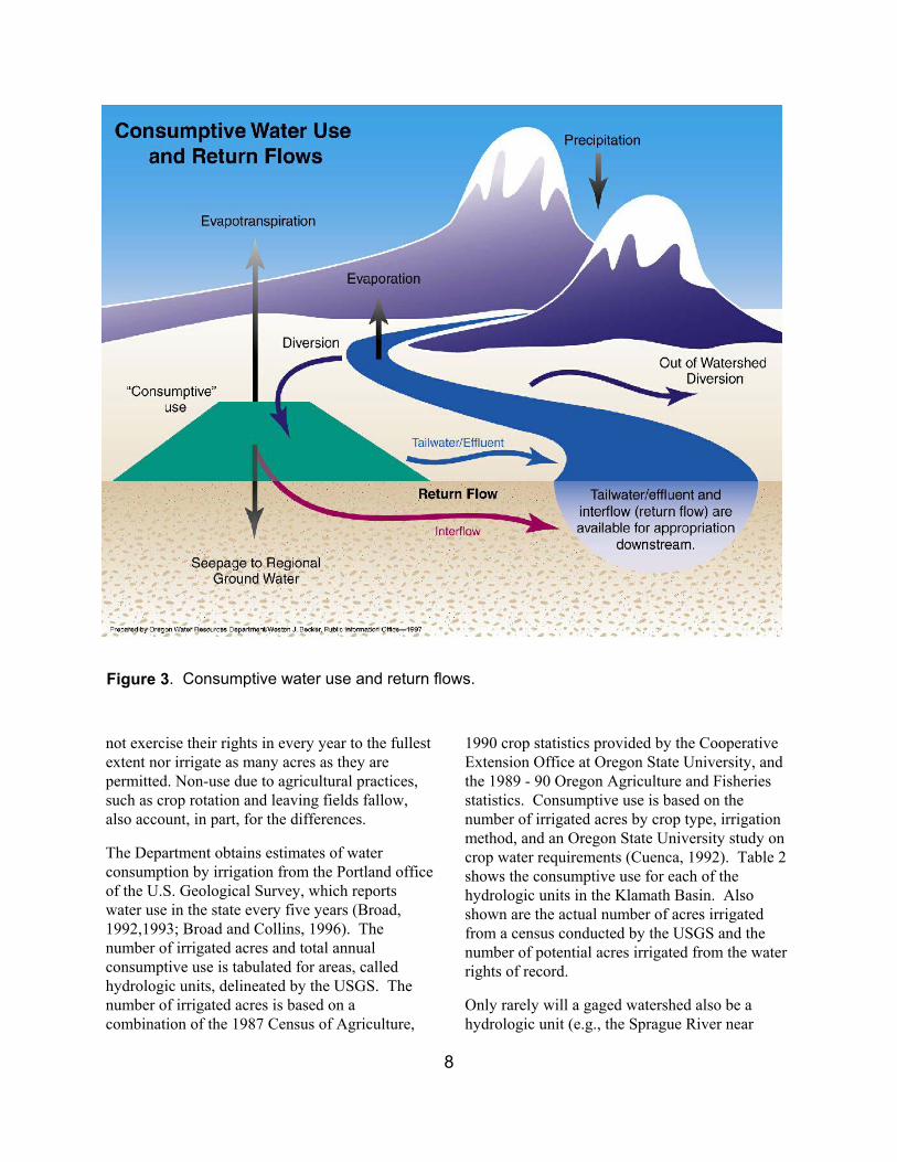
Figure 3. Consumptive water use and return flows ............................................................... 8
Figure 4. Irrigation distribution regions of the Klamath basin............................................. 10
Figure 5. January 50-percent exceedance stream flow vs. watershed area for gaged streams west of the Cascade crest using log-transformed data ............................ 13
Figure 6. Correction of model estimates with gaged stream flow ........................................18

iv

v
Tables Table 1. Example calculation of flow duration curves from continuous records ................ 6
Table 2. Annual consumptive use in the Klamath Basin ..................................................... 9
Table 3. Distribution of irrigation consumptive use by month .......................................... 10
Table 4. Municipal consumptive use coefficients .............................................................. 12
Table 5. Consumptive use coefficients for minor out-of-stream uses ............................... 12
Table 6. Watershed characteristics used in the regression analysis ................................... 14
Table 7. Watershed characteristics for Ish Tish Creek at the mouth ................................. 15
Table 8. Watershed characteristics used for region 10 ...................................................... 16
Table 9. Watershed characteristics used for region 30 ...................................................... 16
Table 10. Goodness of fit for regression models ................................................................. 17
Table 11. Correction of model estimates with gaged stream flow – an example, South Fork Sprague River .................................................................................... 19
Table 12. Correction of model estimates with gaged stream flow - an example, an unnamed tributary to Annie Creek ....................................................................... 20

vi
vii
A Note about this Report and Previous Drafts The first draft of this report was circulated in September of 2000 under the name Stream Flow Estimates for the Klamath Basin. In that first draft, Appendix D contained tables that did not correspond to the natural stream flow information given to the adjudicator. These tables were for watersheds in the Sprague River basin, along the main stem and the South Fork. The North Fork and the Sycan River were not affected.
A revised draft was circulated in May 2001. The second draft of the report contained the correct tables. Also the main body of the report was revised to improve the clarity of some of the discussions. The last section, Stream Flow Correction, was amended to include a stream flow correction not discussed in the original draft.
This final draft of the report is published under the revised title Natural Flow Estimates for Streams in the Klamath Basin. This version contains the same tables as the second draft. Also the text has been expanded to enhance clarity and to refer to another report that explains in more detail some aspects of the hydrologic methods employed here. This other report, Determining Water Availability in Oregon, was published between the second and final drafts of this report.
Acknowledgements Many thanks are due to Ken Stahr for his numerous contributions. Ken is responsible for all the GIS work done in support of this study: delineation and digitizing of watershed boundaries, calculation of watershed characteristics, estimation of consumptive use, and all the maps in the report.

viii

1
Natural Flow Estimates for Streams in the Klamath Basin
By Richard M. Cooper, PE
Introduction As part of the adjudication for the Klamath Basin, claims for in-stream use are evaluated by comparison with the natural 50-percent exceedance stream flows for the claimed reach. This report defines ‘natural 50-percent exceedance stream flow’, describes the methodology used to calculate these flows, and discusses how the methodology was applied in the Klamath Basin - specific, detailed examples are given. The natural 50-percent exceedance stream flows determined from application of this methodology to watersheds in the Klamath Basin are given in an appendix to the report.
The methodology used here for estimating stream flows is the same as is used by the Oregon Water Resources Department (OWRD) for water availability determinations. That methodology is described in the report “Determining Surface Water Availability in Oregon” (Cooper, 2002). Some of that material is repeated here using examples specific to the Klamath Basin.
Reference is made in several places in this report to data available from the OWRD web site:
http://www.wrd.state.or.us/
Follow the link to the Water Availability Reporting System (WARS) and go to the WARS utilities. These utilities provide access to the hydrographics, watershed characteristic, and flow duration curve databases. Contact the Webmaster for assistance.
Klamath Basin Upper Klamath Basin has a unique and complex hydrology. Klamath Lake, several large marshes, and numerous springs combine to create watersheds that are unlike most other watersheds.
In other, more typical basins, stream flow can be generalized from one watershed to another – watersheds with similar physical characteristics produce similar stream flows. This allows stream flows for unmeasured streams to be estimated from the stream flows of measured streams with reasonable confidence.
While this kind of generalization is possible for some watersheds in the Klamath Basin, it does not work for watersheds significantly affected by lakes, marshes or springs. Fortunately, the Klamath Basin has many more stream flow measurements available than is usual. This information has made it possible to make reasonable estimates of stream flow for many streams where otherwise it may have been impossible. In all for the Klamath Basin, natural stream flows have been estimated for one hundred fifty-seven watersheds. A list of these watersheds is given in Appendix C and the estimated natural stream flows for each are given in Appendix D.

2
Natural Stream Flow Natural stream flow occurs when there are no consumptive uses of water from the stream or regulation of stream flow from storage. Consumptive uses represent water withdrawn from a stream and lost to evaporation or transpiration, or transferred out of the watershed. Storage refers to holding of water behind a dam and implies controlled releases of water from that storage.
The definition of natural stream flow in the Klamath Basin requires an additional caveat. Anthropogenic changes to hydrologic features in the basin preclude a return of prehistoric natural conditions. Even if all consumptive uses stopped and regulatory structures were removed, stream flow would not return to its prehistoric state. These human caused changes are the isolation and draining of Lower Klamath Lake, the deepening of the outlet of Klamath Lake, and the creation of channels and dikes in Sycan and Klamath Marshes. Natural stream flows in the Klamath Basin are calculated assuming that these changes are permanent and now represent the natural condition of the basin.
Stream Flow Characterization Stream flow is naturally variable. It is useful to characterize it in some way, usually by a statistic. Typical statistics are mean daily flow, mean monthly flow, mean annual flow, ten-year event, and median (or 50-percent exceedance) monthly stream flow. The statistic chosen should have meaning in the context in which it will be used. Mean or average flow, for example, tells how much water is in a stream over a given period of time. Exceedance flows tell how often a given amount of water is in a stream.
In-stream water rights normally are limited to no more than the natural 50-percent exceedance flow. This restriction means that under natural conditions the in-stream flow will be met at least 50 percent of the time. This same condition has been applied to in-stream claims in the Klamath adjudication.
An exceedance stream flow is the stream flow exceeded a given percent of the time. For example, the 60-percent exceedance stream flow for the Williamson River below Sprague River near Chiloquin (11502500) for May is 1,230 cubic feet per second (cfs). In May, then, the stream flow in the Williamson River is greater than or equal to 1,230 cfs 60 percent of the time and less than 1,230 cfs 40 percent of the time. For comparison, the 50-percent exceedance stream flow is 1,440 cfs and the 80-percent exceedance flow is 823 cfs.
Exceedance flows are sensitive to the period of record on which they are based. In the example above, the entire period of record was used – October 1917 to September 2002. However, the 50-percent exceedance flows calculated by the methodology given in this report all represent a common base period – water years 1958 to 1987.
Where Stream Flows are Calculated Two hundred nineteen watersheds were delineated in the Klamath Basin:
1. For all gages and miscellaneous measurement sites,
2. For all in-stream water rights and in-stream claims,
3. Above the mouths of significant tributaries, and
4. On main stems above significant tributaries.
Natural stream flows are reported for the one hundred fifty-seven of these watersheds associated with an in-stream water right or in-stream claim, at the mouths of significant tributaries, and on the main stems above these tributaries (Appendix C). Not reported here are the natural stream flows for sixty-two watersheds associated with gaging stations or miscellaneous measurement sites. All of the flow duration curves derived for these watersheds, including the natural 50-percent

3
exceedance stream flows, may be found on OWRD’s web site.
A watershed includes all lands draining to the stream upstream from the ‘pour point’, or mouth, of the watershed. A watershed may include other watersheds. These watersheds are said to be ‘nested’. In the example in Figure 1, watersheds 5 and 6 are nested in watershed 3. Watershed 3 is comprised of polygons 3, 5 and 6.
Determining Exceedance Stream Flows All exceedance flows in this analysis are based on measured stream flows, either directly from continuous records and miscellaneous measurements or indirectly by use of a regional regression analysis1. The U.S. Geological Survey (USGS) and the OWRD collected the measured stream flows used in this analysis. These stream flows can be accessed from the OWRD website.
1Regional regression is a standard hydrologic technique to generalize stream flows from measured to unmeasured watersheds.
Figure 1. An example of nested watersheds.

4
Measured stream flows are commonly affected by use upstream. Exceedance flows based on these measured flows are similarly affected. Where this is the case, the consumptive use must be added back to the exceedance flows to get natural flow estimates.
Exceedance flows are also sensitive to the period over which the measurements were taken. In this case, the exceedance flows must be corrected to a common period, i.e., a base period; otherwise, some exceedance flows may represent wet periods, and others, dry periods.
It is critical that all exceedance flows represent not only the same period, but also a long period of time. As will be discussed later, the base period used for calculating exceedance stream flows at
the OWRD is represented by water years 1958 to 1987. A water year is from October 1 to September 30. For example, water year 1987 was from October 1, 1986 to September 30, 1987.
The following sections describe how measured stream flows are used to calculate flow duration curves corrected to natural flow and to a common base period. A flow duration curve represents all possible exceedance flows for a given gaging station for a specified period. The 50-percent exceedance stream flow is one point on such a curve. Figure 2 shows an example of a flow duration curve for January for USGS gaging station Williamson River below Sprague River near Chiloquin, OR (11502500). The curve represents water years 1958 to 1987.
0
500
1000
1500
2000
2500
3000
3500
0 10 20 30 40 50 60 70 80 90 100
Percent Exceedance
Stre
am F
low
(cfs
)
Figure 2. A flow duration curve for January for USGS gaging station Williamson River below Sprague River near Chiloquin, OR (11502500). The curve represents stream flow for water years 1958 to 1987.

5
Only measured stream flows unaffected by significant storage are used in this analysis. While it is possible in concept to correct the mean daily flows on which the exceedance stream flows are based for the effects of storage, this is rarely done in practice. Daily changes in storage for reservoirs are seldom recorded.
Calculation of Exceedance Flows from a Continuous Record
A continuous record is a series of mean daily stream flows calculated from measurements made continuously or at short intervals for a specific location on a stream. This location is usually referred to as a gage or gaging station.
Gaging stations are divided into those that have records that coincide with the base period, i.e., Index Records, representing water years 1958 -1987, and those that do not, i.e., Short Records, representing all other periods of record. Flow duration curves are calculated for both short and index records. The flow duration curves for the index records are used to correct the flow duration curves for the short records to the base period. Flow duration curves that correspond to the base period are then corrected to natural flow by adding back consumptive use upstream.
Lists of gaging stations in the Klamath Basin are given in Appendix A. There are separate lists for gages classified as Index Gages (30 years of record between 1958 to 1987), Short Record Gages (any other period of record), Canal Gages, and Regulated Gages (affected by storage). The flow duration curve determined for the index and short record gaging stations can be found in a database accessible from the OWRD website. Follow the link to the Water Availability Reporting System (WARS) and go to the WARS utilities. The database contains the flow duration curves calculated at all steps in the process: short, index, base period, and natural stream flow.
Calculating an exceedance stream flow from mean daily flows is best demonstrated by the example shown in Table 1. The mean daily stream flows in column 1 represent the flows as they occurred in time. In column 4, these same flows have been sorted from smallest to largest. The middle value in column 4 is the 50 percent exceedance flow. Half the time the flow was greater than this value and half the time less.
In actual practice, the calculations are made by techniques outlined by Searcy (1959) and Yevjevich (1982). Further, the flow duration curves are calculated for each month. For example, for thirty years of continuous record, for January, 930 mean daily flows (31 days x 30 years) are used to calculate the 50-percent exceedance flow.
Correcting to a Base Period An exceedance flow is specific to the time period for which it is calculated. Different time periods give different results for the same stream. For example, the first part of this century was drier than average for the whole century, the middle part wetter, and the latter part (through about 1990) more or less average. OWRD selected 1958 to 1987 as a base period because it best represents the long term average conditions for this century, and it is the period for which most stream flow information is available.
When the period of record for a gage does not coincide with the base period of 1957 to 1987, the short or out of phase record must be corrected to the base period. The correction (Searcy, 1959) is based on a linear association of the short record with the record of an index gage on a similar watershed that does coincide with the base period. All OWRD natural exceedance flows represent the base period.
See Cooper (2002) for a complete discussion of the selection of the base period and how a short record flow duration curve is corrected to the base

6
period. The correction to the base period is illustrated with an example. Cooper (2002) also discusses methods for selecting an appropriate index station. These methods are demonstrated with examples.
Calculation of Exceedance Flows from Miscellaneous Measurements Miscellaneous measurements are individual stream flow measurements made at intervals of days or months or years. Each represents stream flow at the time it was made. Typically, the available measurements are fewer than 50.
Because there are so few measurements, the variability of the stream flow is usually significantly underrepresented. Estimating flow duration curves from these measurements works best when the stream exhibits small variability, for example, when dominated by spring flow. Using miscellaneous measurements to estimate flow duration curves for highly variable, runoff-driven streams should be undertaken with great care. Appendix B lists the miscellaneous measurements available in the Klamath Basin.
In a method similar to the one used to correct continuous measurements to the base period, miscellaneous measurements are used in association with a long-term continuous stream flow record to estimate the 50-percent exceedance stream flow for the measurement site (Searcy,
Table 1. Example calculation of flow duration curves from continuous records.
Mean Daily Stream Flows
Chronological Order
Sorted Order
Day Discharge (cfs) Day Discharge
(cfs)
Percent Exceedance
1 215 4 106 100
2 175 3 123 90
3 123 10 143 80
4 106 9 156 70
5 187 11 165 60
6 199 2 175 50
7 302 5 187 40
8 210 6 199 30
9 156 8 210 20
10 143 1 215 10
11 165 7 302 0

7
1959). The relationship between the two streams is established by a linear regression of their concurrent measurements. The method scales the flow duration curves of the index gage either up or down as a function of the regression line. The resultant flow duration curves are identical in shape to the flow duration curves for the continuous record station.
Since the shapes of the resultant monthly flow duration curves depend entirely on the index gage, it is important to choose an index gage with a watershed as similar to the watershed of the miscellaneous measurements as possible. While it is most convenient to use a long-term station to create flow duration curves for the miscellaneous site, sometimes the best relationship is with a short record gage. In this case, the resulting flow duration curves must be corrected to the base period using a gage with a long-term record.
Cooper (2002) has an example calculation of flow duration curves using miscellaneous measurements for Sun Creek, a tributary of Annie Creek.
Correction to Natural Stream Flow Gaged stream flows and miscellaneous measurements, and therefore, the flow duration curves derived from them, are commonly affected by upstream consumptive uses. To obtain natural stream flow estimates, the average consumptive use during the period of record for the gage is estimated and added to the exceedance stream flow derived from the gaged stream flow.
QNSF = QGAGE + CU ................................. (1)
Where
QNSF = natural stream flow, QGAGE = measured stream flow and CU = consumptive use.
Calculation of consumptive uses is discussed in the following section. Recall that measured stream flows significantly affected by storage are not used in this analysis. Where affects of storage are minor (e.g., from farm ponds or log ponds) the gaging station record may be used and a correction applied.
Estimating Consumptive Use A consumptive use is any water use that causes a net reduction in stream flow and is usually associated with an evaporative or transpirative loss (Figure 3). OWRD uses four major categories of consumptive use: irrigation, municipal, storage and all others (e.g., domestic, livestock, industrial). Generally, all uses but storage are considered less than 100 percent consumptive. A user’s diversion is more than is lost to consumption. For example, for a domestic use very little water from showers, toilet flushing or dish washing is actually lost. Eventually, most of the diverted water (treated, of course) is returned to the stream.
In calculating natural stream flow only the part of the diversion lost to evaporation and transpiration is added to measured stream flows. The exception to this “rule” occurs when diversions are from one watershed to another. In this case, the use is 100 percent consumptive for the watershed where diversion occurs. The consumptive use is the diversion. Cooper (2002) discusses consumptive uses in more detail.
Irrigation Consumptive Use Water consumption by irrigation cannot be calculated directly from either the allocated withdrawals for irrigation or the number of acres to be irrigated by each right. Actual irrigation withdrawals may vary significantly from those permitted by the paper rights and may be as little as 50 percent of that permitted. Many growers do
8
not exercise their rights in every year to the fullest extent nor irrigate as many acres as they are permitted. Non-use due to agricultural practices, such as crop rotation and leaving fields fallow, also account, in part, for the differences.
The Department obtains estimates of water consumption by irrigation from the Portland office of the U.S. Geological Survey, which reports water use in the state every five years (Broad, 1992,1993; Broad and Collins, 1996). The number of irrigated acres and total annual consumptive use is tabulated for areas, called hydrologic units, delineated by the USGS. The number of irrigated acres is based on a combination of the 1987 Census of Agriculture,
1990 crop statistics provided by the Cooperative Extension Office at Oregon State University, and the 1989 - 90 Oregon Agriculture and Fisheries statistics. Consumptive use is based on the number of irrigated acres by crop type, irrigation method, and an Oregon State University study on crop water requirements (Cuenca, 1992). Table 2 shows the consumptive use for each of the hydrologic units in the Klamath Basin. Also shown are the actual number of acres irrigated from a census conducted by the USGS and the number of potential acres irrigated from the water rights of record.
Only rarely will a gaged watershed also be a hydrologic unit (e.g., the Sprague River near
Figure 3. Consumptive water use and return flows.

9
Chiloquin, OR, 11501000). Generally, the gaged watershed will be either larger than a single hydrologic unit (e.g., the Williamson River near Klamath Agency, OR, 11502500) or most often, smaller than and contained within a hydrologic unit (e.g., Sycan River above Snake Creek near Beatty, OR, 1149100). Where the watershed is larger than a hydrologic unit, the annual consumptive uses from the hydrologic units within the watershed must be combined to get the consumptive use for the watershed. Where the watershed is smaller than a hydrologic unit, the consumptive use for the watershed is only a part, or fraction, of the consumptive use for the hydrologic unit.
To calculate this fraction, the number of acres permitted to be irrigated is determined for both the watershed and the hydrologic unit. The fraction is found by dividing the number of acres for the watershed by the number of acres for the hydrologic unit. Multiplying this fraction by the annual water consumption in the hydrologic unit gives an estimate of the annual water consumption for the watershed.
Because the water consumption must be calculated on a monthly basis, the annual value obtained from the USGS's report must be distributed over the growing season. Table 3 shows the distributions used in the Klamath Basin. Figure 4 shows where each distribution was used.
There are two general types of distributions: 1) for the case where water is sufficient to meet crop demand and 2) for the case where it is not. In the first case, the distribution follows the crop demand and will typically peak in July and August. In the second case, irrigators typically divert more water than is required by crop demand early in the season when water is available. This over-irrigation increases soil moisture, which reduces the irrigation requirement late in the season when water may not be available. These distributions tend to have peaks in May and June rather than July and August. It is worth noting that only diversions from live flow are likely to be water limited. Diversions from storage tend to have distributions that follow the crop demand.
Table 2. Annual consumptive use in the Klamath Basin.
Consumptive Use Acres Irrigated by USGS Census
Acres Irrigated by Water Rights of
Record Hydrologic
Unit (ac-ft) (acres) (acres)
18010201 76,029 48,519 71,806
18010202 65,600 40,867 55,442
18010203 62,018 39,578 58,573
18010204 142,894 91,072 134,189
18010206 3,637 2,180 4,258
18020001 54,455 33,019 40,103

10
Table 3. Distribution of irrigation consumptive use by month.
J F M A M J J A S O N D Region
Fraction of Annual
7 .000 .000 .008 .077 .128 .175 .243 .200 .126 .041 .001 .000 18 .000 .000 .000 .067 .127 .173 .261 .207 .141 .024 .000 .000 34 .000 .000 .028 .127 .361 .289 .086 .045 .039 .025 .000 .000 35 .000 .000 .037 .084 .202 .257 .168 .100 .087 .065 .000 .000 43 .000 .000 .000 .054 .159 .201 .223 .189 .137 .038 .000 .000 55 .040 .063 .103 .234 .292 .107 .034 .022 .021 .024 .028 .032 56 .068 .074 .086 .125 .146 .117 .068 .058 .060 .064 .064 .069 83 .010 .005 .025 .060 .170 .190 .190 .180 .085 .055 .025 .015
Figure 4. Irrigation distribution regions of the Klamath Basin. See Table 3.

11
Usually, the distributions used by OWRD are based either on measured canal diversions or on theoretical crop water requirements. The Klamath Basin is unique in that it has 3 special distributions that are based on neither. These special distributions are discussed at the end of this section.
Whether water is limited or not, canal diversions provide the best information about how water use is distributed over the irrigation season. Where water is not limited, distributions based on theoretical crop water requirements may be used. OWRD uses crop water requirements taken from work by Cuenca et al (1992). Distributions based on canal diversions where water is not limited tend to resemble distributions based on theoretical crop water requirements.
The distributions for regions 7 and 18 (Table 3) are based on theoretical crop water requirements. Use of the distributions assumes that water is not limited during the growing season. Region 7 is used for Jenny Creek and Klamath River tributaries to the west. Although summer flows for these streams are naturally low, demand is small.
Region 18 is used for gages on the mainstem Sprague River below the confluence of the North and South Forks. While there is significant demand for water from the Sprague River, stream flow is sufficient to meet demand throughout the irrigation season.
The distributions for Region 34, 35, and 43 are based on canal diversions. Region 34 has been applied to many of the dry, water limited, areas of eastern Oregon. Region 35 has been applied to wetter areas, still water limited, mostly on the east slope of the Cascade Mountains. Region 43 is based on diversions to the ‘A’ canal. Generally, sufficient diversions are made in this case to meet crop demands. Not surprisingly, this distribution
strongly resembles the distributions for Region 18. Region 43 is used for watersheds near Klamath Lake where water use typically is not limited: Wood River and Crooked and Sevenmile Creeks.
Regions 55, 56, and 83 are special distributions for gages measuring stream flow passing through Sycan Marsh, Klamath Marsh and Klamath Lake. Because water is stored in the marshes and used in place for irrigation of pasture, the water is considered used when it is stored. For regions 55 and 56, then, the distributions are based on inflows to the marshes. Klamath Lake attenuates stream flow passing through it; region 83 accounts for this attenuation for gages on the mainstem Klamath River below the lake.
Municipal Consumptive Use Consumptive use is obtained by multiplying a consumptive use coefficient by the actual diversion rate of the municipality2. Table 4 gives the coefficients used around the state. These coefficients are based on actual municipal diversions and sewage outfalls.
Municipal diversion from surface water at present is insignificant in the Klamath Basin.
Storage Consumptive Use
Measured stream flows significantly impacted by storage generally are not used in this analysis, as it is difficult to account for the effects of storage and storage releases. Smaller storages (e.g., farm ponds) are accounted for by assuming that they are filled once each year and that the fill rate is proportional to stream flow over the storage season. The average fill rate is that required to fill the pond over the storage season.
2 Municipalities are required to report the amount of their diversion annually. This data is kept by the Oregon Water Resources Department.

12
Other Consumptive Uses These uses are minor in comparison to irrigation and are generally minor in comparison to stream flow. The calculation of the consumptive part of these uses is based on the associated water rights. Consumptive use is obtained by
multiplying a consumptive use coefficient by the maximum diversion rate allowed for the water right (Table 5). Coefficients are applied to all months of the year. These coefficients are based on work done by the USGS (Solley and Merk, 1985).
Table 4. Municipal consumptive use coefficients.
Coastal Basins
Willamette and Sandy
Rogue and Umpqua
East Side (Summer
Discharge)
East Side (No
Summer Discharge)
Summer 0.15 0.45 0.64 0.60 1.00
Winter 0.10 0.15 0.15 0.30 0.30
Table 5. Consumptive use coefficients for minor out-of-stream uses.
Use Coefficient
Industrial 0.10
Domestic 0.20
Commercial 0.15
Livestock 0.50
Agricultural 0.50

13
Regional Regression Analysis Some watersheds identified in the Klamath Basin do not have measured stream flows. For these cases, stream flows are generalized from measured sites using a regional regression analysis3. Regression analysis is based on the assumption that stream flow is related to various watershed characteristics. For example, stream flow increases with watershed size, other factors like precipitation being equal. A 100 square-mile watershed will produce more runoff than a 25 square-mile watershed.
3 Using statistical regression models to estimate stream flow is a standard hydrologic technique and is well documented in the literature. (Harris, et al, 1979; Harris and Hubbard, 1983; Lystrom, 1973; Riggs, 1973; Thomas and Benson, 1969)
As an example, the relationship between 50-percent exceedance natural stream flow for January and watershed area for gaged streams west of the Cascade crest is shown in Figure 5. The line shown on the plot is drawn to minimize the sum of the squared differences between the line and the points. The line “models” the relationship between stream flow and watershed area. It can be used to predict the stream flow for a watershed given its area.
Similar relationships exist between stream flow and other watershed characteristics (Table 6), each characteristic accounting for part of the variability in stream flow. These relationships can be
1
10
100
1000
10000
100000
0.1 1 10 100 1000 10000
Watershed Area - square miles
Janu
alry
50%
Exc
eeda
nce
Stre
am F
low
-cfs
Figure 5. January 50-percent exceedance stream flow vs. watershed area for gaged streams west of the Cascade crest using log-transformed data.

14
quantified in a mathematical form. For example, the following equation is the mathematical relationship between the 50-percent exceedance natural stream flow for January and watershed characteristics for watersheds east of the Cascade crest:
QNSF = exp(-12.2)A 1.02 S 0.568 As 0.962 E-1.03 JnP1.38 JlP0.617 JXT3.21 SP0.385 … (2) where
A = Area S = Mean Slope As = Mean Aspect E = Mean Elevation JnP = Mean January Precipitation JlP = Mean July Precipitation
JXT = Mean January Maximum Temperature
SP = Mean Soil Permeability
For a watershed where the 50-percent exceedance stream flow is unknown, an estimate of the stream flow is made substituting the known characteristics for the watershed into the regression equation.
Generally it is required that the known stream flow statistics used in formulating the regression equations represent natural stream flow (Thomas and Benson, 1969). Flow regulation by reservoirs or withdrawals from the stream cannot be accounted for in the regression model. Including them results in a poor regression model that gives biased stream flow estimates.
Cooper (2002) discusses regional regression in more detail. Additional topics include defining the mathematical relationship between stream flow and watershed characteristics, transforming the data to improve linearity, estimating watershed characteristics, and goodness of fit.
Applying the Regional Regression Analysis in the Klamath Basin Regression equations had limited use in the Klamath Basin. Only watersheds whose stream flow responds primarily to the watershed characteristics shown in Table 6 were candidates for these equations. The equations were used with
Table 6. Watershed characteristics used in the regression analysis.
Watershed area
Maximum watershed relief
Mean watershed slope
Mean slope aspect
Mean January precipitation
Mean July precipitation
Mean July minimum temperature
Mean January maximum temperature
Soil Permeability

15
success in parts of the upper Sycan and Sprague Rivers and for some tributaries to the Klamath below Klamath Lake. Flows for streams dominated by spring flow or by regulation from lakes or marshes generally cannot be estimated by this method.
Two regression regions are defined for use in the Klamath Basin:
1. Region 10 for all areas west of the Cascades (used west of Jenny Creek), and
2. Region 30 for all areas east of the Cascades (used east of Jenny Creek).
These regression regions and the regression equations for each region were developed for the water availability program at OWRD. See Cooper (2002) for details.
Regression equations were determined for each region for each month using the nine watershed
characteristics shown in Table 6. The east side analysis made use of 137 gages and includes all US Forest Service gages except Five Mile Creek and the Sycan River below Sycan Marsh. The west side analysis made use of 248 gages. Tables 8 and 9 show the characteristics used for each equation and Table 10 shows the goodness of fit for each equation.
As an example, consider this calculation of the 50-percent exceedance stream flow during January for Ish Tish Creek at its mouth. Ish Tish Creek is a tributary to the South Fork Sprague River in the Klamath Basin. The physical characteristics for the watershed are given in Table 7. Substituting into Equation 2:
QNSF = exp(-12.2)(19.9) 1.02(7.85) 0.568
(210)0.962 (5350)-1.03 (2.37)1.38 (0.60)0.617 (40.3)3.21 (1.24)0.385
QNSF = 3.17 cfs
Table 7. Watershed characteristics for Ish Tish Creek at the mouth.
Characteristic Characteristic Value
Area (A) 19.9 mi2
Slope (S) 7.85%
Aspect (As) 210 o
Mean Elevation (E) 5350 ft
Mean January Precipitation (JnP) 2.37 in
Mean July Precipitation (JlP) 0.60 in
Mean January Maximum Temperature (JXT) 40.3 oF
Mean Soils Permeability (SP) 1.24 in/hr

16
Table 8. Watershed characteristics used for region 10.
Watershed Characteristic J F M A M J J A S O N D
Area √ √ √ √ √ √ √ √ √ √ √ √
Relief √ √ √ √ √ √
Slope √ √ √ √
Aspect
Elevation √ √ √ √ √ √ √ √
Jan Precipitation √ √ √ √ √ √ √ √ √ √ √ √
Jul Precipitation √ √ √ √ √ √ √ √ √ √ √ √
Jan Max Temp
Jul Min Temp √ √ √ √ √ √ √
Soil Permeability √ √ √ √ √ √ √ √ √
Table 9. Watershed characteristics used for region 30.
J F M A M J J A S O N D
Area √ √ √ √ √ √ √ √ √ √ √ √
Relief √ √ √ √ √ √ √ √ √ √ √
Slope √ √ √ √ √ √ √ √
Aspect √ √ √ √ √ √ √
Elevation √ √ √ √ √ √ √ √ √ √ √ √
Jan Precipitation √ √ √ √ √ √ √ √ √ √ √ √
Jul Precipitation √ √ √ √ √ √ √ √ √ √ √ √
Jan Max Temp √ √ √ √ √ √
Jul Min Temp √ √ √ √ √
Soil Permeability √ √ √ √ √ √ √ √ √ √ √ √

17
Stream Flow Correction
Gaged stream flows can be used to improve stream flows estimated by the regression equations. Simply put, the sum of stream flows for contributing areas above a gage should equal the gaged stream flow. This case is best illustrated by an example.
Figure 6 shows the watersheds at the upper end of the South Fork Sprague River. Watershed 31420226 is Whitworth Creek. Watershed 70799 is the South Fork Sprague River above Whitworth Creek. Watershed 61420208 is the South Fork Sprague River above Brownsworth Creek and includes both of the other watersheds.
The US Forest Service operates a gage at the mouth of watershed 61420208. The area identified as 41420202 is not a watershed. It represents the area of watershed 61420208 not accounted for by watersheds 31420226 and 70799.
In Table 11, column 2 lists the monthly 50-percent exceedance stream flow for the gage at the mouth of watershed 61420208 (corrected to the base period and natural stream flow). The next 3 columns show the monthly stream flows estimated by the regression equations for area 41420202 and watersheds 31420226 and 70799. Column 6 shows the sum of the monthly stream flows for the previous 3 columns.
Table 10. Goodness of fit for regression models.
Region 10 Region 30 Month
# Gages % SE r2 # Gages % SE r2
Jan 249 24 98 137 38 95 Feb 249 23 98 139 34 96 Mar 249 22 98 139 36 95 Apr 249 26 98 139 43 93 May 247 35 96 139 56 90 Jun 245 40 96 139 55 93 Jul 245 51 94 134 55 94 Aug 245 60 92 135 68 91 Sep 245 58 93 135 71 90 Oct 247 48 94 135 67 90 Nov 249 35 96 135 49 93 Dec 249 25 98 137 46 94

18
Figure 6. Correction of model estimates with gaged stream flow.

19
Table 11. Correction of model estimates with gaged stream flow - an example, South Fork Sprague River.
Measured Stream Flows
Modeled Stream Flow Corrected Stream Flow Month
61420208 41420202 31420226 70799 Sum Correction 41420202 31420226 70799
Jan 21.1 2.3 7.0 5.4 14.7 1.44 3.3 10.0 7.8
Feb 23.0 4.4 9.0 7.7 21.1 1.09 4.8 9.8 8.4
Mar 45.2 8.0 15.9 15.0 38.9 1.16 9.3 18.4 17.4
Apr 108.0 8.9 22.4 23.9 55.2 1.96 17.4 43.9 46.8
May 137.0 5.8 26.8 27.6 60.2 2.28 13.2 61.1 62.9
Jun 52.4 2.3 14.1 14.5 30.9 1.70 3.9 24.0 24.7
Jul 16.5 0.6 4.0 4.0 8.6 1.92 1.2 7.7 7.7
Aug 11.3 0.3 1.6 1.6 3.5 3.23 1.0 5.2 5.2
Sep 11.7 0.3 1.4 1.3 3.0 3.90 1.2 5.5 5.1
Oct 13.9 0.3 1.5 1.5 3.3 4.21 1.3 6.3 6.3
Nov 17.5 0.8 2.9 2.4 6.1 2.87 2.3 8.3 6.9
Dec 17.7 1.6 5.0 3.8 10.4 1.70 2.7 8.5 6.5

20
If the estimated monthly stream flows for 41420202, 31420226, and 70799 were exact, they would sum to the actual stream flows for watershed 61420208. Clearly, they do not. In order to improve the estimates, a correction factor is calculated by dividing the actual monthly stream flows by the corresponding sum of monthly estimated stream flow. The correction factors are shown in column 7 of Table 11. If each estimated monthly stream flow is multiplied by its respective correction factor, a set of estimated stream flows is generated that sum to the actual flows at 61420208. These corrected flows are shown in columns 8 to 10.
In using this method, we assume that exceedance
stream flows represent the volume of stream flow as do average stream flows. Strictly speaking, this is not the case. However, when attenuation of peak flows and travel times are short, it is a good approximation. It is a poor approximation when gradients are low, when significant lakes or marshes occur in the waterway, and when travel times are long.
A variation on this method can be used to correct stream flows for a single ungaged watershed. In this case, the correction factors are determined by comparing modeled stream flows to actual stream flows for a gaged watershed that is hydrologically similar to the ungaged watershed. An example using this method is shown in Table 12.
Table 12. Correction of model estimates with gaged stream flow - an example, an unnamed tributary to Annie Creek.
Gaging Station 61420103
Watershed 31420309 Month
Actual Modeled Correction Modeled Corrected
Jan 17.5 20.3 0.86 3.9 3.3 Feb 17.3 17.0 1.02 3.3 3.3 Mar 17.6 19.0 0.93 3.2 2.9 Apr 22.4 32.5 0.69 4.0 2.8 May 40.5 97.3 0.42 8.6 3.6 Jun 63.4 132 0.48 9.0 4.3 Jul 51.7 74.2 0.70 4.8 3.4 Aug 31.0 49.6 0.62 3.2 2.0 Sep 27.8 49.9 0.56 3.1 1.7 Oct 22.2 46.0 0.48 3.1 1.5 Nov 20.0 30.2 0.66 3.5 2.3 Dec 19.3 19.8 0.97 3.4 3.3

21
References Broad, T. 1992. Water Resources Division, U.S.
Geological Survey, Portland, Or. Personnel Communication, November 1992.
Broad, T. 1993. Water Resources Division, U.S. Geological Survey, Portland, Or. Personnel Communication, February 1993.
Broad, T. and Collins, C. 1996. Estimated water use and general hydrologic conditions for Oregon, 1985 and 1990, U.S. Geological Survey Water-Resources Investigations Report 96-4080, 166p.
Cooper, RM. 2002. Determining Surface Water Availability in Oregon. Open File Report SW 02 – 002. Oregon Water Resources Department, Salem, Or. 57 p.
Cuenca, R.H. 1992. Oregon Crop water use and irrigation requirements. Extension Miscellaneous 8530. Oregon State University, Corvallis, Or. 184 p.
Harris, D.D., Hubbard, L.L., and Hubbard, L.E. 1979. Magnitude and frequency of floods in western Oregon. U.S. Geological Survey, open-file report 79-553. 29 p.
Harris, D.D. and Hubbard, L.E. 1983. Magnitude and frequency of floods in eastern Oregon. U.S. Geological Survey, open-file report 82-4078. 39 p.
Lystrom, D.J. 1970. Evaluation of the streamflow-data program in Oregon: U.S. Geological Survey open-file report. 28 p.
Riggs, H.C., 1973. Regional analysis of streamflow characteristics: U.S. Geological Survey Techniques of Water Resources Investigations, book 4, chapter B3, 15 p.
Searcy, J.K. 1959. Flow-duration curves: U.S. Geological Survey Water-Supply Paper 1542-A. 33 p.
Solley, W.B. and Merk, C.F. 1985 Estimated use of water in the United States in 1985. U.S. Geological Survey Circular 1004. 80 p.
Thomas, D.M. and Benson M.A. 1969. Generalization of streamflow characteristics from drainage watershed characteristics. Open file report, U.S. Geological Survey. 45 p.
Yevjevich, V. 1982. Probability and Statistics in Hydrology. Water Resources Publications, Littleton, Co. 302 p.

22

23
Appendix A
Lists of Gages in the Klamath Basin

24

Klamath Basin [Index Gages]
25
11493500 Williamson River near Klamath Agency, OR POR: 3/1908 - 1/1909, 4/1909 - 6/1910, 10/1954 -
9/1995, 10/1998 – 9/2002 [Missing: 3/1908 - 1/1909, 4/1909 - 6/1910]
Area: 1320 (Published: 1290 approx.) Elev: 4480 HUC: 18010201 OSU Region: 18 Remarks: Flow affected by natural storage in Klamath
Marsh. Small diversions for irrigation near marsh.
11497500 Sprague River near Beatty, OR
POR: 4 - 9/1912, 11/1912 - 9/1913, 10/1913 - 9/1915, 2 - 11/1916, 3/1917 - 6/1918, 5/1919 - 10/1920, 2/1921 - 9/1924 (irrigation seasons only), 4 - 9/1925, 4 - 9/1926, 10/1953 - 9/2001 [Missing: 3/1912 - 9/1924]
Area: 526 (Published: 513) Elev: 4310 HUC: 18010202 OSU Region: 18 Remarks: Diversions for irrigation near Bly. No
regulation.
11501000 Sprague River near Chiloquin, OR POR: 6 - 10/1920, 3/1921 - 9/2002 [Missing: 6 -
10/20] Area: 1590 (Published: 1580 approx.) Elev: 4200 HUC: 18010202 OSU Region: 18 Remarks: Minor regulation from irrigation diversions.
11502500 Williamson River below Sprague River, near Chiloquin, OR POR: 10/1917 - 9/2002 [Missing: 10/1922 - 9/1923] Area: 996 (Published: 3000 approx.) Elev: 4160 HUC: 18010201, 18010202 OSU Region: 18 Remarks: Some regulation by diversion dams and logponds
on Sprague River. Diversions for irrigation.

Klamath Basin
[Short Records]
26
11483500 Miller Creek at Gerber Reservoir, near Lorella, OR POR: 8/1904 - 12/1908 Area: 216 (Published: 220 approx.) Elev: 4800 HUC: 18010204 OSU Region: 18 Remarks: Diversions for irrigation.
11484000 Miller Creek near Lorella, OR POR: 1/1909 - 6/1920 [Missing: 10/1918 - 6/1920] Area: NOT Digitized. (Published: 270 approx.) Elev: 4200 HUC: 18010204 OSU Region: 18 Remarks: Diversions for irrigation.
11491400 Williamson River below Sheep Creek, near Lenz, OR POR: 10/1973 - 9/2001 Area: 197 (Published: 205) Elev: 4550 HUC: 18010201 OSU Region: 18 Remarks: Diversions for irrigation.
11492100 Williamson River at Military Crossing, near Lenz, OR
POR: 10/1995 - 9/1997 Area: 513 (Published: N/A) Elev: 4410 HUC: 18010201 OSU Region: 18 Remarks: Diversions for irrigation. Estimated record.
11492400 Big Springs Creek below Lenz Ranch, near Lenz, OR POR: 6/1992 - 9/1995 Area: indeterminate (Published: N/A) Elev: 4516 HUC: 18010201 OSU Region: 18 Remarks: All flow from springs.
11494000 Williamson River above Spring Creek, near Klamath Agency, OR POR: 5 - 9/1912, 4 - 7/1918, 1 - 6/1919, 6/1920 -
9/1922, 10/1923 - 9/1925 Area: 1340 (Published: 1330 approx.) Elev: 4200 HUC: 18010201 OSU Region: 18 Remarks: Flow affected by natural storage in Klamath
Marsh. Small diversions for irrigation near marsh.

Klamath Basin
[Short Records]
27
11494500 Williamson River at Chiloquin, OR POR: 8/1911 - 9/1915 Area: 1380 (Published: 1400 approx.) Elev: 4200 HUC: 18010201 OSU Region: 18 Remarks: Flow affected by natural storage in Klamath
Marsh. Small diversions for irrigation near marsh.
11497000 Fivemile Creek near Bly, OR
POR: 9/1917 - 9/1920 Area: 40.3 (Published: 40 approx.) Elev: 4300 HUC: 18010201 OSU Region: 18 Remarks: Many daily values missing from digital record.
Use as miscellaneous measurements. 11498500 Long Creek near Silver Lake, OR
POR: 5/1918 - 11/1923; 10/1926 - 9/1927; 4/1957 Area: 33.4 (Published: 40 approx.) Elev: 5100 HUC: 18010201 OSU Region: 18 Remarks: Numerous gaps, missing values. Use as
miscellaneous measurements. 11499000 Sycan River near Beatty, OR
POR: 5 - 7/1912, 11/1912 - 6/1913, 5/1914 - 3/1915, 7/1915 - 9/1925 [Missing: 5/1912 - 3/1917]
Area: 524 (Published: 540 approx.) Elev: 4400 HUC: 18010202 OSU Region: 18 Remarks: Large area irrigated by flooding in Sycan
Marsh. 11499100 Sycan River below Snake Creek, near Beatty, OR
POR: 10/1973 - 9/2001 Area: 559 (Published: 568) Elev: 4310 HUC: 18010202 OSU Region: 18 Remarks: Diversions for irrigation.

Klamath Basin
[Short Records]
28
11503000 Annie Spring near Crater Lake, OR POR: 6/1977 – 9/2002 Area: N/A (Published: N/A) Elev: 5980 HUC: 18010203 OSU Region: Remarks: Fluctuations caused by pumps .1 mi upstream.
Diversion for domestic use by National Park Service .1 mi upstream. Area indeterminate, flow entirely from spring.
11503500 Annie Creek near Fort Klamath, OR
POR: 11/1922 - 9/1925; 6-7/1927 Area: 55.6 (Published: 40) Elev: 4300 HUC: 18010203 OSU Region: Remarks: Regulation by flashboards on log pond dam
immediately upstream. Gaps. 11504000 Wood River at Fort Klamath, OR
POR: 8 - 11/1911, 4/1913 - 9/1916, 5 - 9/1917, 4/1918 - 1/1920, 5 - 12/1920, 7/1921 - 5/1922, 10/1922 - 9/1936 [Missing: 8 - 11/1911, 4 - 9/1913, 5 - 9/1917, 4 - 9/1918, 10/1919 - 1/1920, 7/1921 - 5/1922]
Area: 80.2 (Published: 90) Elev: 4170 HUC: 18010203 OSU Region: 18 Remarks: Many diversions for irrigation. Regulation by
diversion dams.
11504100 Wood River near Fort Klamath, OR POR: 10/1964 - 9/1967 Area: 99.6 (Published: 87.7) Elev: 4150 HUC: 18010203 OSU Region: 18 Remarks: No regulation. Several diversions for
irrigation. 11504200 Crooked Creek near Fort Klamath, OR
POR: 10/1964 - 9/1967 Area: 5.24 (Published: 5.68) Elev: 4150 HUC: 18010203 OSU Region: 18 Remarks: No regulation. Several diversions for
irrigation. Discontinued 9/67.

Klamath Basin
[Short Records]
29
11505700 Varney Creek near Rocky Point, OR POR: 10/1964 - 9/1967 Area: 16.9 (Published: 7.43) Elev: 4200 HUC: 18010203 OSU Region: 18 Remarks: Discontinued 9/67.
11507501 Link River at Klamath Falls, OR
POR: 5/1904 - 3/1919 Area: 3740 (Published: 3810 approx.) Elev: 4080 HUC: 18010201, 18010202, 18010203, 18010204 OSU Region: 18 Remarks: Flow regulated since 4/1919 by Upper Klamath
Lake. 4/1919 to 9/1981 in Regulated Gages Diversion by "A" Canal for irrigation. Many other diversions. Records include flow in Keno Canal.
11509500 Klamath River at Keno, OR
POR: 6/1904 - 12/1913 Area: 3832 (Published: 3920) Elev: 3960 HUC: 18010201, 18010202, 18010203, 18010204 OSU Region: 18 Remarks: Many diversions for irrigation. Regulated since
4/1919 by Upper Klamath Lake. 10/1929 to 9/1997 in Regulated Gages. Fluctuation by Keno Powerplant. Area approx., does not include Lost River or Lower Klamath Lake basins.
11510000 Spencer Creek near Keno, OR
POR: 10/1925 - 9/1931 Area: 84.7 (Published: 90.0) Elev: 3820 HUC: 18010206 OSU Region: 18 Remarks: Gaps and partial months. Use as miscellaneous
measurements.

Klamath Basin
[Short Records]
30
11510500 Klamath River at Spencer bridge, near Keno, OR POR: 10/1913 - 3/1919 Area: 3961 (Published: 4050) Elev: 3770 HUC: 18010201, 18010202, 18010203, 18010204 OSU Region: 18 Remarks: Area approx, does not include Lost River or
Lower Klamath Lake basins. Diversions above by "A" Canal & by South Canal. About all flow of Lost River during non-irrigation seasons diverted into Klamath River above station. Flow regulated by storage in Upper Klamath Lake. 4/1919 to 9/1931 in Regulated Gages.
11512000 Fall Creek near Copco, CA
POR: 7/1928 - 9/1959 [Missing: 7/1928 - 3/1933] Area: 14.3 (Published: 20) Elev: 2400 HUC: 18010206 OSU Region: 18 Remarks: Power diversions of about 4 cfs from Spring
Creek to Fall Creek. Occasional regulation by powerplant and fish hatchery.
11513000 Grizzly Creek near Lilyglen, OR
POR: 2/1916 - 6/1919; 11/1930 - 5/1931 (Runoff season only); 10/1941 - 9/1943; 10/1948 - 9/1950 [Missing: 2/1916 - 6/1919; 11/1930 - 5/1931; 10/1948 - 9/1950]
Area: NOT digitized. (Published: 30.3) Elev: 4406.78 HUC: 18010206 OSU Region: 18 Remarks:
11513500 Beaver Creek near Pinehurst, OR
POR: 10/1943- 9/1948 Area: 13.6 (Published: 12.90) Elev: 3348.81 HUC: 18010206 OSU Region: 18 Remarks:

Klamath Basin
[Short Records]
31
11514500 Keene Creek near Ashland, OR POR: 4/1917 - 7/1917; 12/1917 - 6/1918; 11/1918 -
6/1919; 11/1919 - 7/1920; 10/1920 - 9/1921; 11/1921 - 6/1922;
Area: 11.6 (Published: 12.1) Elev: 4710 HUC: 18010206 OSU Region: 18 Remarks: No diversions or regulation for this POR. Flow
regulated since 12/1922 by Hyatt Lake. 5/1929 - 9/1947 (summers); 10/1948 - 9/1983; 10/1989 - 9/1990; 6-9/1991; 4/1993 - 2/1995; 6/1995 - 9/1996 in Regulated Gages.
11516500 Jenny Creek near Copco,CA
POR: 10/1922 - 9/1928 Area: 210 (Published: 211) Elev: 2400 HUC: 18010206 OSU Region: 18 Remarks: Water stored in Hyatt Reservoir diverted to
Rogue Basin above station: Non-contributing. 11516600 Cottonwood Creek near Copco,CA
POR: 10/1964 - 9/1971 Area: 90.9 (Published: 89.8) Elev: 2220 HUC: 18010206 OSU Region: 18 Remarks:
61420101 Cottonwood Creek near Diamond Lake Junction, OR (28S 6E 36 SENE)
POR: 10/1992 - 9/1997 Area: 5.92 Elev: 4870 HUC: 18010201 OSU Region: 18 Remarks: US Forest Service Gage.
61420102 Miller Creek near Beaver Marsh, OR (27S 7E 32 SWSE)
POR: 10/1993 - 9/1997 Area: 20.2 Elev: 5200 HUC: 18010201 OSU Region: 18 Remarks: US Forest Service Gage.
61420103 Sand Creek near Sand Creek Junction, OR (31S 7E 29 NESW)
POR: 10/1992 - 9/1997 Area: 28.1 Elev: 4730 HUC: 18010201 OSU Region: 18 Remarks: US Forest Service Gage.

Klamath Basin
[Short Records]
32
61420104 Sink Creek near Diamond Lake Junction, OR (31S 7E 29 NESW)
POR: 10/1995 - 9/1997 Area: 9.63 Elev: 5450 HUC: 18010201 OSU Region: 18 Remarks: US Forest Service Gage.
61420201 Coyote Creek near Sycan Marsh (31S 13E 27 NWSE) POR: 10/1992 - 9/1996 Area: 9.96 Elev: 5180 HUC: 18010202 OSU Region: 18 Remarks: US Forest Service Gage. WS ID# 21420298.
61420202 Deming Creek near Bly, OR (36S 15E 10 NESE)
POR: 0/1992 - 9/1997 [Missing: 9/1996] Area: 4.50 Elev: 5400 HUC: 18010202 OSU Region: 18 Remarks: US Forest Service Gage.
61420203 Fishhole Creek near Bly, OR (38S 15E 4 SWNW) POR: 10/1992 - 9/1997 Area: 37.3 Elev: 4800 HUC: 18010202 OSU Region: 18 Remarks: US Forest Service Gage.
61420204 Fivemile Creek near Bly, OR (35S 14E 24 SWSE) POR: 10/1992 - 9/1997 Area: 35.0 Elev: 4600 HUC: 18010202 OSU Region: 18 Remarks: US Forest Service Gage.
61420205 Long Creek near Bly, OR (31S 12E 5 SWSE)
POR: 10/1992 - 9/1997 Area: 5.47 Elev: 6210 HUC: 18010202 OSU Region: 18 Remarks: US Forest Service Gage.
61420206 N FK Sprague River near Bly, OR (34S 16E 30 SWSW)
POR: 10/1992 - 9/1997 Area: 35.2 Elev: 6200 HUC: 18010202 OSU Region: 18 Remarks: US Forest Service Gage.

Klamath Basin
[Short Records]
33
61420207 Paradise Creek near Sycan Marsh (33S 15E 22 NESE)
POR: 10/1992 - 9/1997 Area: 14.3 Elev: 6010 HUC: 18010202 OSU Region: 18 Remarks: US Forest Service Gage WS ID# 70817.
61420208 S FK Sprague River near Bly, OR (37S 15E 2 SENW)
POR: 10/1992 - 9/1997 Area: 62.0 Elev: 4600 HUC: 18010202 OSU Region: 18 Remarks: US Forest Service Gage.
61420209 Sycan River above Sycan Marsh (32S 14.5E 32 SWSW)
POR: 10/1992 - 9/1997 Area: 95.5 Elev: 5090 HUC: 18010202 OSU Region: 18 Remarks: US Forest Service Gage.
61420210 Sycan River at Road Bridge below Sycan Marsh (33S 13E 16 SENW)
POR: 10/1992 - 9/1997 Area: 334 Elev: 5000 HUC: 18010202 OSU Region: 18 Remarks: US Forest Service Gage.
61420297 Long Creek at Sycan Marsh (32S 14E 4 SENW)
POR: 9/1995 - 8/1997 Area: ~41.4 Elev: ~5080 HUC: 18010202 OSU Region: 18 Remarks: BIA Gage Significant ice effects not accounted
for. 61420298 N Fk Sprague River at ~RM 12 nr The Elbow (35S 14.5E 36 NWNW)
POR: 9/1995 - 8/1997 Area: ~72.1 Elev: ~4740 HUC: 18010202 OSU Region: 18 Remarks: BIA Gage Stream flow affected by power plant
upstream.

Klamath Basin
[Short Records]
34
61420299 Sprague River at Lone Pine, OR (35S 10E 10 SENE) POR: 9/1995 - 8/1997 Area: ~1420 Elev: ~4300 HUC: 18010202 OSU Region: 18 Remarks: BIA Gage Stream flows sometimes exceed flows at
11501000.
61420301 Annie Creek near Fort Klamath, OR (32S 6E 25 SENE) POR: 10/1992 - 9/1997 Area: 28.8 Elev: 4400 HUC: 18010203 OSU Region: 18 Remarks: US Forest Service Gage.
61420302 Cherry Creek near Klamath Agency, OR (34S 6E 22 SENE)
POR: 10/1992 - 9/1997 Area: 16.2 Elev: 4400 HUC: 18010203 OSU Region: 18 Remarks: US Forest Service Gage.
61420303 Sevenmile Creek near Klamath Agency, OR (33S 6E 11 SESE)
POR: 10/1992 - 9/1997 Area: 24.9 Elev: 4400 HUC: 18010203 OSU Region: 18 Remarks: US Forest Service Gage.
61420399 Wood River near Site of Former USGS Gage 11504000 (33S 7E 27
SWSW) POR: 9/1995 - 8/1997 Area: ~81 Elev: ~4270 HUC: 18010202 OSU Region: 18 Remarks: BIA Gage.
61420601 Spencer Creek near Keno OR (38S 6E 18 NWSE) POR: 10/1992 - 9/1997 Area: 35.4 Elev: 5000 HUC: 18010203 OSU Region: 18 Remarks: US Forest Service Gage.

Klamath Basin [Regulated Gages]
35
11483500 Miller Creek at Gerber Reservoir, near Lorella, OR POR: 1/1925 - 9/1950 [BOR] Area: 118 (Published: 220 approx.) Elev: 4800 HUC: 18010204 OSU Region: 18 Remarks: Flow completely regulated by Gerber
Reservoir, capacity 94,270 acre-ft since 3/1925. 8/1904 - 12/1908 in Short Record Gages. Diversions for irrigation.
11505600 Fourmile Creek near Rocky Point, OR
POR: 10/1964 - 9/1967 Area: 98.4 (Published: 105) Elev: 4200 HUC: 18010203 OSU Region: 18 Remarks: Regulated by Fourmile Lake. Discontinued
9/67. 11507500 Link River at Klamath Falls, OR
POR: 4/1919 - 9/2002 Area: 3769 (Published: 3810 approx.) Elev: 4080 HUC: 18010201, 18010202, 18010203, 18010204 OSU Region: 18 Remarks: Flow regulated since 4/1919 by Upper
Klamath Lake. 5/1904 - 3/1919 in Short Record Gages. Large diurnal fluctuation caused by powerplant. Area includes 26.2 mi2 in closed basin of Crater Lake. Diversion by "A" Canal for irrigation. Many other diversions.
NOTE --> Prior to 10/1983 records include flow in
Keno Canal. After 10/1983, records do not include flow in Keno Canal, which, since 9/08 has diverted from Upper Klamath Lake at Link River Dam for power generation, & returns flow to Link River downstream.

Klamath Basin [Regulated Gages]
36
11507501 Link River at Klamath Falls, OR POR: 4/1919 - 9/1983 Area: 3769 (Published: 3810 approx.) Elev: 4080 HUC: 18010201, 18010202, 18010203, 18010204 OSU Region: 18 Remarks: Flow regulated since 4/1919 by Upper
Klamath Lake. 5/1904 - 3/1919 in Short Record Gages. Large diurnal fluctuation caused by powerplant. Area includes 26.2 mi2 in closed basin of Crater Lake. Diversion by "A" Canal for irrigation. Many other diversions. Records include flow in Keno Canal.
11509500 Klamath River at Keno, OR
POR: 10/1929 - 9/2002 Area: 3833 (Published: 3920) Elev: 3960 HUC: 18010201, 18010202, 18010203, 18010204 OSU Region: 18 Remarks: Area approx., does not include Lost River
or Lower Klamath Lake basins. Many diversions for irrigation. Regulated since 4/1919 by Upper Klamath Lake. 6/1904 - 12/1913 in Short Record Gages. Fluctuation by Keno Powerplant.
11510500 Klamath River at Spencer bridge, near Keno, OR
POR: 4/1919 - 9/1931 Area: 3966 (Published: 4050) Elev: 3770 HUC: 18010201, 18010202, 18010203, 18010204 OSU Region: 18 Remarks: Area approx., does not include Lost River
or Lower Klamath Lake basins. Diversions above by "A" Canal & by South Canal. About all flow of Lost River during non-irrigation seasons diverted into Klamath River above station. Flow regulated by storage in Upper Klamath Lake since 4/1919. 10/1913 - 3/1919 in Short Record Gages.

Klamath Basin [Regulated Gages]
37
11510700 Klamath River below John C. Boyle Powerplant, near Keno, OR POR: 1/1959 - 9/2002 [Missing: 10/1959 -
9/1960] Area: 3989 (Published: 4080) Elev: 3270 HUC: 18010201, 18010202, 18010203, 18010204,
18010206 OSU Region: 18 Remarks: Area approx., does not include Lost River
or Lower Klamath Lake basins. Diversions for irrigation. Regulated by Upper Klamath Lake since 4/1919. Large diurnal fluctuations caused by powerplants upstream.
11514500 Keene Creek near Ashland, OR
POR: 5/1929 - 9/1947 (summers); 10/1948 - 9/1983; 10/1989 - 9/1990; 6-9/1991; 4/1993 - 2/1995; 6/1995 - 9/1996
Area: 11.6 (Published: 12.1) Elev: 4710 HUC: 18010206 OSU Region: 18 Remarks: Flow regulated since 12/1922 by Hyatt
Lake. No diversions. 4/1917 - 7/1917; 12/1917 - 6/1918; 11/1918 - 6/1919; 11/1919 - 7/1920; 10/1920 - 9/1921; 11/1921 - 6/1922 in Short Records.
11516000 Keene Creek near Lincoln, OR
POR: Published : 10/1943 - 9/1948; Digital: 10/1940 - 9/1945 (Gaps) Area: NOT digitized. (Published: 19.3 ) Elev: HUC: 18010206 OSU Region: 18 Remarks: Flow regulated since 12/1922 by Hyatt
Lake. Diversion upstream to Keene Canal. Area includes 11.7 sq. mi. above Hyatt R. dam Which is normally non-contributing.
11512500 Klamath River below Fall Creek nr Copco, CA
POR: 10/1923 - 09/1961 Area: NOT digitized. (Published: 4370) Elev: 2310 HUC: 18010206 OSU Region: 18 Remarks:

Klamath Basin
[Canal Gages]
38
11486000 Lost River Diversion Canal near Olene, OR
POR: 5/1912 - 09/1968 HUC: 18010204 Remarks: Diversions from Lost River to Klamath
River.
11504600 Cascade Canal at Fourmile Lake nr Lakecreek, OR POR: 10/1922 - 09/1991 HUC: 18010203 Remarks: Trans-basin diversion from Fourmile Lake
to Fish Lake. Numerous gaps and breaks; summers only.
11505000 Cascade Canal near Fish Lake, OR
POR: 6/1929 - 09/1996 HUC: 18010-203 Remarks: Trans-basin diversion from Fourmile Lake
to Fish Lake. Numerous gaps and breaks; often summers only.
11507200 ‘A’ Canal at Klamath Falls, OR
POR: 4/1908 - 09/1981 HUC: 18010206 Remarks: Diversion to BOR Project in Lower Klamath
Lake. 11507400 Keno Canal at Klamath Falls, OR
POR: 10/1966 - 09/1983 HUC: 18010206 Remarks:
11508500 Diversion from Klamath River to Lost River near Olene, OR
POR: 4/1931 - 09/1968 HUC: 18010204 Remarks:
11512920 Howard Prairie Lake Prairie nr Pinehurst, CA
POR: 10/1960 - 09/1965 HUC: 18010206 Remarks: Diverts water from Howard Prairie Lake to
Keene Creek and Greensprings Diversion Canal.
11515000 Keene Creek Canal near Ashland, OR
POR: 10/1932 - 03/1940 (Winter only) HUC: 18010206 Remarks: Used until 5/1960 Trans-basin diversion
from Hyatt Reservoir to Emigrant Lake.

Klamath Basin
[Canal Gages]
39
11516100 Green Springs Power Plant Diversion near Ashland, OR POR: 10/1960 - 09/1965 HUC: 18010206 Remarks: Used from 5/1960 to present. Trans-basin
diversion from Hyatt Reservoir to Emigrant Lake.
14339400 S Fk Little Butte Cr Collection Canal near Pinehurst, OR
POR: 10/1960 - 09/1985; 10/1989 - 8/1996 HUC: 18010206 Remarks: Trans-basin diversion from S Fk Little
Butte Creek to Howard Prairie Reservoir.
14340400 Dead Indian Collection Canal near Pinehurst, OR POR: 10/1960 - 09/1986; 10/1989 - 9/1992;
10/1993 - 9/1996 [Gaps: 1980 - 1996] HUC: 18010206 Remarks: Trans-basin diversion from Dead Indian
Creek to Howard Prairie Reservoir.

40

41
Appendix B
Miscellaneous Measurements in the Klamath Basin

42

Klamath Basin [Miscellaneous Measurements]
43
21420101 Spring Creek (34S 7E 9 SENE) POR: 12 measurements (12/1983 - 12/1988) Area: 21.3 Elev: 4200 HUC: 18010201 OSU Region: 18 Remarks: OWRD - WS ID# 70818.
21420103 Scott Creek (31S 7E 18 NWSE)
POR: 52 measurements (10/1929 - 5/1993) Area: 7.14 Elev: 4790 HUC: 18010201 OSU Region: 18 Remarks: OWRD - WS ID# 21420107.
21420104 Sand Creek (31S 7E 29 SENE)
POR: 43 measurements (10/1954 - 5/1993) Area: 28.1 Elev: 4730 HUC: 18010201 OSU Region: 18 Remarks: OWRD - WS ID# 61420103.
21420105 Larkin Creek (34S 7E 11 SW)
POR: 13 measurements (10/1960 - 9/1973) Area: Not digitized Elev: HUC: 18010201 OSU Region: 18 Remarks: OWRD.
21420106 Big Springs Creek (30S 8E 22 NWSE)
POR: 7 measurements (4/1984 - 12/1988) Area: Not Digitized Elev: HUC: 18010201 OSU Region: 18 Remarks: OWRD.
21420107 Scott Creek (31S 7E 18 NWSE)
POR: 50 measurements (8/1991 - 5/1997) Area: 7.14 Elev: 4790 HUC: 18010201 OSU Region: 18 Remarks: US Forest Service.

Klamath Basin [Miscellaneous Measurements]
44
21420108 Deep Creek (31S 11E 29 SWSE) POR: 41 measurements (4/1992 - 6/1996) Area: 9.65 Elev: 4750 HUC: 18010201 OSU Region: 18 Remarks: US Forest Service.
21420109 Irving Creek (30S 11E 19 SESW)
POR: 29 measurements (11/1991 - 5/1996) Area: 1.02 Elev: 4600 HUC: 18010201 OSU Region: 18 Remarks: US Forest Service.
21420110 Jackson Creek (30S 11E 7 SENE)
POR: 68 measurements (11/1991 - 4/1997) Area: 9.64 Elev: 4800 HUC: 18010201 OSU Region: 18 Remarks: US Forest Service.
21420111 Williamson River ab Larkin Creek (34S 7E 2 SWNW)
POR: 49 measurements (5/1992 - 5/1997) Area: 1340 Elev: 4200 HUC: 18010201 OSU Region: 18 Remarks: US Forest Service.
21420112 Williamson River nr Rocky Ford (31S 10E 7 NWSW)
POR: 43 measurements (12/1991 - 5/1996) Area: 190 Elev: 4600 HUC: 18010201 OSU Region: 18 Remarks: US Forest Service.
21420194 Shellock Draw (31S 9E 15 NWNE)
POR: 31 measurements (4/1980 - 6/1989) Area: 34.5 Elev: 4590 HUC: 18010201 OSU Region: 18 Remarks: OWRD - WS ID# 31420104.

Klamath Basin [Miscellaneous Measurements]
45
21420195 Yoss Creek (32S 9E 10 SESW) POR: 27 measurements (6/1980 - 10/1988) Area: 18.2 Elev: 4590 HUC: 18010201 OSU Region: 18 Remarks: OWRD - WS ID# 31420103.
21420196 Hog Creek (32S 8E 27 SWNW)
POR: 29 measurements (6/1980 - 10/1988) Area: 52.2 Elev: 4600 HUC: 18010201 OSU Region: 18 Remarks: OWRD - WS ID# 31420101.
21420197 Jackson Creek (30S 11E 7 SWSE)
POR: 31 measurements (4/1980 - 12/1988) Area: 10.6 Elev: 4690 HUC: 18010201 OSU Region: 18 Remarks: OWRD - WS ID# 21420297.
21420201 S FK Sprague River (37S 15E 8 SWSE)
POR: 34 measurements (1/1992 - 3/1996) Area: 106 Elev: 4570 HUC: 18010202 OSU Region: 18 Remarks: US Forest Service.
21420202 N FK Sprague River (35S 14E 36 NENW)
POR: 46 measurements (1/1992 - 5/1997) Area: 72.1 Elev: 4740 HUC: 18010202 OSU Region: 18 Remarks: US Forest Service; Measurements may be
affected by power plant upstream. 21420203 N FK Sprague River (35S 15E 30 SESW)
POR: 19 measurements (4/1992 - 8/1995) Area: 71.3 Elev: 4800 HUC: 18010202 OSU Region: 18 Remarks: US Forest Service; Measurements may be
affected by power plant upstream.

Klamath Basin [Miscellaneous Measurements]
46
21420204 Sycan River (34S 12E 31 SWSE) POR: 30 measurements (12/1991 - 7/1997) Area: 504 Elev: 4600 HUC: 18010202 OSU Region: 18 Remarks: US Forest Service.
21420206 Brownsworth Creek (37S 15E 2 SENW)
POR: 46 measurements (12/1991 - 4/1997) Area: 20.4 Elev: 4600 HUC: 18010202 OSU Region: 18 Remarks: US Forest Service.
21420207 Trout Creek (35S 9E 35 NWSE)
POR: 38 measurements (2/1992 - 3/1996) Area: 27.4 Elev: 4400 HUC: 18010202 OSU Region: 18 Remarks: US Forest Service.
21420208 Sprague River (35S 9E 9 NENE)
POR: 18 measurements (5/1992 - 9/1995) Area: 1440 Elev: 4300 HUC: 18010202 OSU Region: 18 Remarks: US Forest Service.
21420297 McCready Spring (34S 8E 25 NENE)
POR: 18 measurements (4/1920 - 9/1973) Area: Not Digitized Elev: HUC: 18010202 OSU Region: 18 Remarks: OWRD.
21420298 Coyote Creek (31S 13E 27 NWSE)
POR: 27 measurements (3/1980 - 10/1988) Area: 9.96 Elev: 5180 HUC: 18010202 OSU Region: 18 Remarks: OWRD.
Klamath Basin [Miscellaneous Measurements]
47
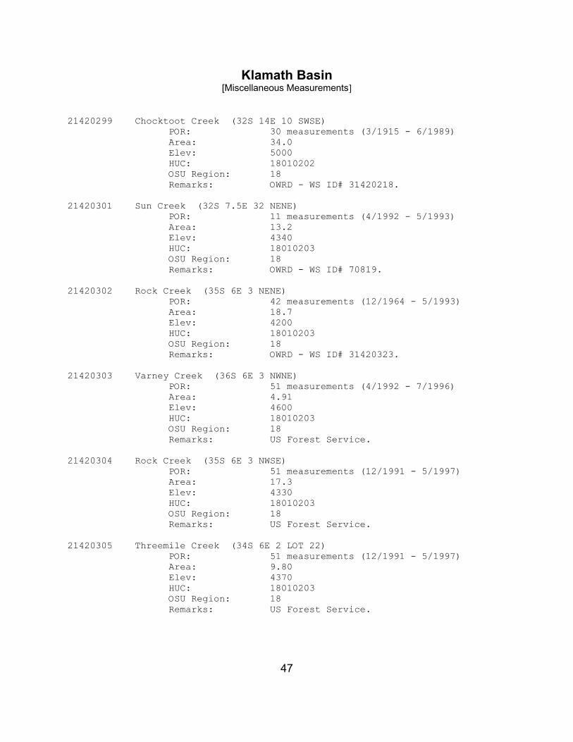
21420299 Chocktoot Creek (32S 14E 10 SWSE) POR: 30 measurements (3/1915 - 6/1989) Area: 34.0 Elev: 5000 HUC: 18010202 OSU Region: 18 Remarks: OWRD - WS ID# 31420218.
21420301 Sun Creek (32S 7.5E 32 NENE)
POR: 11 measurements (4/1992 - 5/1993) Area: 13.2 Elev: 4340 HUC: 18010203 OSU Region: 18 Remarks: OWRD - WS ID# 70819.
21420302 Rock Creek (35S 6E 3 NENE)
POR: 42 measurements (12/1964 - 5/1993) Area: 18.7 Elev: 4200 HUC: 18010203 OSU Region: 18 Remarks: OWRD - WS ID# 31420323.
21420303 Varney Creek (36S 6E 3 NWNE)
POR: 51 measurements (4/1992 - 7/1996) Area: 4.91 Elev: 4600 HUC: 18010203 OSU Region: 18 Remarks: US Forest Service.
21420304 Rock Creek (35S 6E 3 NWSE)
POR: 51 measurements (12/1991 - 5/1997) Area: 17.3 Elev: 4330 HUC: 18010203 OSU Region: 18 Remarks: US Forest Service.
21420305 Threemile Creek (34S 6E 2 LOT 22)
POR: 51 measurements (12/1991 - 5/1997) Area: 9.80 Elev: 4370 HUC: 18010203 OSU Region: 18 Remarks: US Forest Service.

Klamath Basin [Miscellaneous Measurements]
48
21420306 Billie Creek (36S 5E 28 SESW) POR: 28 measurements (4/1992 - 5/1997) Area: 3.37 Elev: 5400 HUC: 18010203 OSU Region: 18 Remarks: US Forest Service.
21420307 Fourmile Creek (36S 5E 13 NWNW)
POR: 52 measurements (4/1992 - 5/1997) Area: 43.0 Elev: 4400 HUC: 18010203 OSU Region: 18 Remarks: US Forest Service.
21420308 Wood River (33S 7.5E 15 NWSW)
POR: 27 measurements (4/1992 - 2/1996) Area: 79.4 Elev: 4290 HUC: 18010203 OSU Region: 18 Remarks: US Forest Service.
21420310 Sun Creek (@ National Park Boundary)
POR: 99 measurements (7/1989 - 9/1997) Area: 10.8 Elev: 4600 HUC: 18010203 OSU Region: 18 Remarks: NPS.
21420389 Moss Creek (36S 7.5E 31)
POR: 38 measurements (4/1964 - 10/1967) Area: Not Digitized Elev: HUC: 18010203 OSU Region: 18 Remarks: OWRD.
21420390 Threemile Creek (34S 6E 3)
POR: 43 measurements (9/1964 - 10/1967) Area: 9.45 Elev: 4670 HUC: 18010203 OSU Region: 18 Remarks: OWRD.

Klamath Basin [Miscellaneous Measurements]
49
21420393 Sevenmile Creek (33S 6E 36) POR: 31 measurements (7/1916 - 10/1954) Area: 53.9 Elev: 4200 HUC: 18010203 OSU Region: 18 Remarks: OWRD.
21420395 Wood River Springs (33S 7.5E 3)
POR: 15 measurements (10/1955 - 9/1971) Area: Not Digitized Elev: HUC: 18010203 OSU Region: 18 Remarks: OWRD.
21420396 Nannie Creek (34S 6E 14)
POR: 24 measurements (10/1954 - 10/1967) Area: Not Digitized Elev: HUC: 18010203 OSU Region: 18 Remarks: OWRD.
21420397 Cherry Creek (34S 6E 22)
POR: 38 measurements (9/1954 - 10/1967) Area: Not Digitized Elev: HUC: 18010203 OSU Region: 18 Remarks: OWRD.
21420398 Fort Creek (33S 7.5E 26)
POR: 50 measurements (11/1914 - 3/1989) Area: 2.15 Elev: 4280 HUC: 18010203 OSU Region: 18 Remarks: OWRD - WS ID# 70810.
21420399 Crooked Creek (34S 7.5E 13)
POR: 35 measurements (8/1915 - 9/1965) Area: 7.90 Elev: 4190 HUC: 18010203 OSU Region: 18 Remarks: OWRD - WS ID# 70807.

Klamath Basin [Miscellaneous Measurements]
50
21420601 Clover Creek (38S 15E 15 SESW) POR: 18 measurements (5/1993 - 11/1994) Area: 9.56 Elev: 4880 HUC: 18010203 OSU Region: 18 Remarks: US Forest Service.
21420602 Cow Creek (41S 1E 14 NENW)
POR: 34 measurements (2/1992 - 4/1997) Area: 20.1 Elev: 3950 HUC: 18010203 OSU Region: 18 Remarks: US Forest Service.
21420114 Williamson River at Ball Dam (30S 12E 23 NWNE)
POR: 197 measurements (2/1992- 12/1997 Area: NOT Digitized Elev: NA HUC: 18010201 OSU Region: 18 Remarks: US Forest Service - Used equation for
sharp crested weir applied without calibration to two - 6' stop-log structures. Significant diversions.

Klamath Basin [Miscellaneous Measurements]
51
EA-M1 Deep Creek (31S 12E 21 NESE) POR: 10 measurements (9/1995 - 8/1997) Area: <9.7 Elev: >4750 HUC: 18010201 OSU Region: 18 Remarks: BIA - ~1.5 miles upstream from 21420108.
EA-M2 Crooked Creek (34S 7E 12 NENW)
POR: 10 measurements (9/1995 - 8/1997) Area: <6.7 Elev: >4190 HUC: 18010203 OSU Region: 18 Remarks: BIA - ~2 miles upstream from 11504200.
EA-M2A Tecumseh Spring (34S 7E 12 NENW)
POR: 9 measurements (9/1995 - 8/1997) Area: Elev: >4190 HUC: 18010203 OSU Region: 18 Remarks: BIA - On Crooked Creek ~2 miles upstream
from 11504200.
EA-M2B Fort Creek (35S 7E 26 SWSW)
POR: 10 measurements (9/1995 - 8/1997) Area: <2.2 Elev: >4280 HUC: 18010203 OSU Region: 18 Remarks: BIA - ~0.5 miles upstream from 70810.
EA-M3 Fort Creek Diversion (35S 7E 26 SWSW)
POR: 10 measurements (9/1995 - 8/1997) Area: Elev: >4280 HUC: 18010203 OSU Region: 18 Remarks: BIA - On Fort Creek ~0.5 miles upstream
from 70810.
Klamath Basin [Miscellaneous Measurements]
52
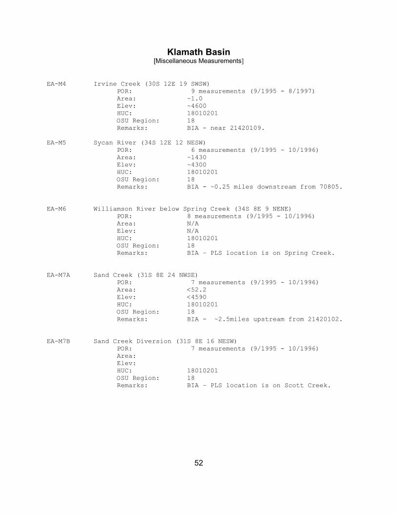
EA-M4 Irvine Creek (30S 12E 19 SWSW) POR: 9 measurements (9/1995 - 8/1997) Area: ~1.0 Elev: ~4600 HUC: 18010201 OSU Region: 18 Remarks: BIA - near 21420109.
EA-M5 Sycan River (34S 12E 12 NESW) POR: 6 measurements (9/1995 - 10/1996) Area: ~1430 Elev: ~4300 HUC: 18010201 OSU Region: 18 Remarks: BIA - ~0.25 miles downstream from 70805.
EA-M6 Williamson River below Spring Creek (34S 8E 9 NENE)
POR: 8 measurements (9/1995 - 10/1996) Area: N/A Elev: N/A HUC: 18010201 OSU Region: 18 Remarks: BIA – PLS location is on Spring Creek.
EA-M7A Sand Creek (31S 8E 24 NWSE)
POR: 7 measurements (9/1995 - 10/1996) Area: <52.2 Elev: <4590 HUC: 18010201 OSU Region: 18 Remarks: BIA - ~2.5miles upstream from 21420102.
EA-M7B Sand Creek Diversion (31S 8E 16 NESW)
POR: 7 measurements (9/1995 - 10/1996) Area: Elev: HUC: 18010201 OSU Region: 18 Remarks: BIA – PLS location is on Scott Creek.

53
Appendix C
List of Watersheds
With Natural Stream Flow Estimates for the Klamath Basin

54

55
Watershed ID # : 70094 WAB # : 01000000000000000000000000000000 Stream Name : KLAMATH R Tributary to : PACIFIC OCEAN Location : AT STATE LINE Watershed ID # : 70803 WAB # : 01010000000000000000000000000000 Stream Name : SPENCER CR Tributary to : KLAMATH R Location : AT MOUTH Watershed ID # : 31420622 WAB # : 01011000000000000000000000000000 Stream Name : SPENCER CR Tributary to : KLAMATH R Location : AT NF BOUNDARY Watershed ID # : 70812 WAB # : 01020000000000000000000000000000 Stream Name : KLAMATH R Tributary to : PACIFIC OCEAN Location : AB JOHN C BOYLE RES Watershed ID # : 70813 WAB # : 01021000000000000000000000000000 Stream Name : LINK R Tributary to : KLAMATH R Location : AB L EWAUNA Watershed ID # : 31420301 WAB # : 01021100000000000000000000000000 Stream Name : FOURMILE CR Tributary to : UPPER KLAMATH L Location : AT MOUTH Watershed ID # : 31420304 WAB # : 01021110000000000000000000000000 Stream Name : VARNEY CR Tributary to : FOURMILE CR Location : AT MOUTH AT GS GAGE 11505700 Watershed ID # : 31420308 WAB # : 01021111000000000000000000000000 Stream Name : VARNEY CR Tributary to : FOURMILE CR Location : AT NF BOUNDARY (36S 6E 21 NENW)

56
Watershed ID # : 31420327 WAB # : 01021120000000000000000000000000 Stream Name : FOURMILE CR Tributary to : UPPER KLAMATH L Location : AB VARNEY CR AT GS GAGE 11505600 Watershed ID # : 31420306 WAB # : 01021121000000000000000000000000 Stream Name : FOURMILE CR Tributary to : UPPER KLAMATH L Location : AT NF BOUNDARY (36S 6E 17 NENW) Watershed ID # : 31420307 WAB # : 01021121100000000000000000000000 Stream Name : BILLIE CR Tributary to : LAKE OF THE WOODS Location : AT MOUTH Watershed ID # : 31420302 WAB # : 01021200000000000000000000000000 Stream Name : ROCK CR Tributary to : CRYSTAL CR Location : AT MOUTH Watershed ID # : 31420330 WAB # : 01021210000000000000000000000000 Stream Name : ROCK CR Tributary to : CRYSTAL CR Location : AT NF BOUNDARY (35S 6E 3 SENE) Watershed ID # : 70798 WAB # : 01021300000000000000000000000000 Stream Name : CHERRY CR Tributary to : FOURMILE CR Location : AT MOUTH Watershed ID # : 31420311 WAB # : 01021310000000000000000000000000 Stream Name : CHERRY CR Tributary to : FOURMILE CR Location : AT NF BOUNDARY (36S 6E 14 NWSW) Watershed ID # : 31420303 WAB # : 01021400000000000000000000000000 Stream Name : THREEMILE CR Tributary to : FOURMILE CR Location : AT MOUTH

57
Watershed ID # : 31420321 WAB # : 01021410000000000000000000000000 Stream Name : THREEMILE CR Tributary to : FOURMILE CR Location : AT NF BOUNDARY (34S 6E 2 NWSE) Watershed ID # : 70830 WAB # : 01021500000000000000000000000000 Stream Name : SEVENMILE CR Tributary to : UPPER KLAMATH L Location : AT MOUTH Watershed ID # : 31420310 WAB # : 01021510000000000000000000000000 Stream Name : SEVENMILE CR Tributary to : UPPER KLAMATH L Location : AT NF BOUNDARY (33S 6E 14 SESE) Watershed ID # : 70829 WAB # : 01021600000000000000000000000000 Stream Name : WOOD R Tributary to : UPPER KLAMATH L Location : AT MOUTH Watershed ID # : 70810 WAB # : 01021610000000000000000000000000 Stream Name : FORT CR Tributary to : WOOD R Location : AT MOUTH Watershed ID # : 70831 WAB # : 01021620000000000000000000000000 Stream Name : ANNIE CR Tributary to : WOOD R Location : AT MOUTH Watershed ID # : 70819 WAB # : 01021621000000000000000000000000 Stream Name : SUN CR Tributary to : ANNIE CR Location : AT MOUTH Watershed ID # : 31420314 WAB # : 01021621100000000000000000000000 Stream Name : SUN CR Tributary to : ANNIE CR Location : AT CRATER L NP BOUNDARY

58
Watershed ID # : 31420309 WAB # : 01021622000000000000000000000000 Stream Name : UNN STR Tributary to : ANNIE CR Location : AT CRATER L NP BOUNDARY Watershed ID # : 31420328 WAB # : 01021623000000000000000000000000 Stream Name : ANNIE CR Tributary to : WOOD R Location : AT NF BOUNDARY (32S 6E 36 NENE) Watershed ID # : 31420333 WAB # : 01021623100000000000000000000000 Stream Name : ANNIE CR Tributary to : WOOD R Location : AT CRATER L NP BOUNDARY Watershed ID # : 70807 WAB # : 01021700000000000000000000000000 Stream Name : CROOKED CR Tributary to : WOOD R Location : AT MOUTH Watershed ID # : 70826 WAB # : 01021800000000000000000000000000 Stream Name : WILLIAMSON R Tributary to : UPPER KLAMATH L Location : AT MOUTH Watershed ID # : 31420125 WAB # : 01021810000000000000000000000000 Stream Name : WILLIAMSON R Tributary to : UPPER KLAMATH L Location : AT HWY 97 CROSSING Watershed ID # : 70806 WAB # : 01021811000000000000000000000000 Stream Name : SPRAGUE R Tributary to : WILLIAMSON R Location : AT MOUTH Watershed ID # : 31420268 WAB # : 01021811100000000000000000000000 Stream Name : SPRAGUE R Tributary to : WILLIAMSON R Location : AT CHILOQUIN DAM

59
Watershed ID # : 31420266 WAB # : 01021811110000000000000000000000 Stream Name : SPRAGUE R Tributary to : WILLIAMSON R Location : AT NF BOUNDARY (34S 7E 36 NENW) Watershed ID # : 31420231 WAB # : 01021811111000000000000000000000 Stream Name : SPRAGUE R Tributary to : WILLIAMSON R Location : AT BRAYMILL Watershed ID # : 31420262 WAB # : 01021811111200000000000000000000 Stream Name : SPRAGUE R Tributary to : WILLIAMSON R Location : AT UPPER S'OCHOLIS CAN Watershed ID # : 70805 WAB # : 01021811111210000000000000000000 Stream Name : SPRAGUE R Tributary to : WILLIAMSON R Location : AT LONE PINE Watershed ID # : 31420203 WAB # : 01021811111211000000000000000000 Stream Name : TROUT CR Tributary to : SPRAGUE R Location : AT MOUTH Watershed ID # : 31420233 WAB # : 01021811111212000000000000000000 Stream Name : SPRAGUE R Tributary to : WILLIAMSON R Location : AB TROUT CR Watershed ID # : 31420206 WAB # : 01021811111212100000000000000000 Stream Name : WHISKY CR Tributary to : SPRAGUE R Location : AT MOUTH Watershed ID # : 70823 WAB # : 01021811111212200000000000000000 Stream Name : SYCAN R Tributary to : SPRAGUE R Location : AT MOUTH

60
Watershed ID # : 31420208 WAB # : 01021811111212210000000000000000 Stream Name : SNAKE CR Tributary to : SYCAN R Location : AT MOUTH Watershed ID # : 31420209 WAB # : 01021811111212220000000000000000 Stream Name : BLUE CR Tributary to : SYCAN R Location : AT MOUTH Watershed ID # : 31420269 WAB # : 01021811111212230000000000000000 Stream Name : SYCAN R Tributary to : SPRAGUE R Location : AB BLUE CR Watershed ID # : 31420257 WAB # : 01021811111212231000000000000000 Stream Name : SYCAN R Tributary to : SPRAGUE R Location : AT NF BOUNDARY (34S 12E 31 SWSE) Watershed ID # : 31420237 WAB # : 01021811111212231100000000000000 Stream Name : SYCAN R Tributary to : SPRAGUE R Location : AT TEDDY POWERS MEADOW Watershed ID # : 70822 WAB # : 01021811111212231110000000000000 Stream Name : SYCAN R Tributary to : SPRAGUE R Location : AB UNN STR AT RM 23 Watershed ID # : 31420238 WAB # : 01021811111212231111000000000000 Stream Name : SYCAN R Tributary to : SPRAGUE R Location : AT TORRENT SPRING Watershed ID # : 31420210 WAB # : 01021811111212231111100000000000 Stream Name : UNN STR Tributary to : SYCAN R Location : AT MOUTH

61
Watershed ID # : 31420211 WAB # : 01021811111212231111200000000000 Stream Name : UNN STR Tributary to : SYCAN R Location : AT MOUTH Watershed ID # : 31420212 WAB # : 01021811111212231111300000000000 Stream Name : MERRITT CR Tributary to : SYCAN R Location : AT MOUTH Watershed ID # : 31420239 WAB # : 01021811111212231111400000000000 Stream Name : SYCAN R Tributary to : SPRAGUE R Location : AB MERRIT CR Watershed ID # : 31420213 WAB # : 01021811111212231111410000000000 Stream Name : UNN STR Tributary to : SYCAN R Location : AT MOUTH Watershed ID # : 70821 WAB # : 01021811111212231111420000000000 Stream Name : SYCAN R Tributary to : SPRAGUE R Location : AT SYCAN MARSH OUTLET Watershed ID # : 31420214 WAB # : 01021811111212231111421000000000 Stream Name : DRY CR Tributary to : SYCAN R Location : AT MOUTH Watershed ID # : 31420215 WAB # : 01021811111212231111422000000000 Stream Name : LONG CR Tributary to : SYCAN R Location : AT MOUTH Watershed ID # : 31420241 WAB # : 01021811111212231111422100000000 Stream Name : CALAHAN CR Tributary to : SYCAN R Location : AT MOUTH

62
Watershed ID # : 31420253 WAB # : 01021811111212231111422200000000 Stream Name : LONG CR Tributary to : SYCAN R Location : AT NF BOUNDARY (31S 12E 5 SWSE) Watershed ID # : 31420227 WAB # : 01021811111212231111422210000000 Stream Name : LONG CR Tributary to : SYCAN R Location : AT NF BOUNDARY (30S 12E 32 SESE) Watershed ID # : 31420216 WAB # : 01021811111212231111423000000000 Stream Name : COYOTE CR Tributary to : SYCAN R Location : AT MOUTH Watershed ID # : 31420252 WAB # : 01021811111212231111423100000000 Stream Name : COYOTE CR Tributary to : SYCAN R Location : AT NF BOUNDARY (31S 13E 27 SWNE) Watershed ID # : 31420217 WAB # : 01021811111212231111424000000000 Stream Name : SHAKE CR Tributary to : SYCAN R Location : AT MOUTH Watershed ID # : 31420218 WAB # : 01021811111212231111425000000000 Stream Name : CHOCKTOOT CR Tributary to : SYCAN R Location : AT MOUTH Watershed ID # : 31420219 WAB # : 01021811111212231111426000000000 Stream Name : UNN STR Tributary to : SYCAN R Location : AT MOUTH Watershed ID # : 31420251 WAB # : 01021811111212231111427000000000 Stream Name : SYCAN R Tributary to : SPRAGUE R Location : AB SYCAN MARSH

63
Watershed ID # : 31420228 WAB # : 01021811111212231111427100000000 Stream Name : SYCAN R Tributary to : SPRAGUE R Location : AT NF BOUNDARY (33S 14E 24 SWSW) Watershed ID # : 70814 WAB # : 01021811111212231111427110000000 Stream Name : LONG CR Tributary to : SYCAN R Location : AT MOUTH Watershed ID # : 31420240 WAB # : 01021811111212231111427120000000 Stream Name : SYCAN R Tributary to : SPRAGUE R Location : AB LONG CR Watershed ID # : 70817 WAB # : 01021811111212231111427121000000 Stream Name : PARADISE CR Tributary to : SYCAN CR Location : AT MOUTH Watershed ID # : 70820 WAB # : 01021811111212231111427122000000 Stream Name : SYCAN R Tributary to : SPRAGUE R Location : AB PARADISE CR Watershed ID # : 70804 WAB # : 01021811111212300000000000000000 Stream Name : SPRAGUE R Tributary to : WILLIAMSON R Location : AB SYCAN R Watershed ID # : 31420221 WAB # : 01021811111212310000000000000000 Stream Name : BROWN CR Tributary to : SPRAGUE R Location : AT MOUTH Watershed ID # : 31420250 WAB # : 01021811111212320000000000000000 Stream Name : SPRAGUE R Tributary to : WILLIAMSON R Location : AT KIRK SPRING AT GS GAGE 11497500

64
Watershed ID # : 70816 WAB # : 01021811111212321000000000000000 Stream Name : N FK SPRAGUE R Tributary to : SPRAGUE R Location : AT MOUTH Watershed ID # : 31420222 WAB # : 01021811111212321100000000000000 Stream Name : FIVEMILE CR Tributary to : N FK SPRAGUE R Location : AT MOUTH Watershed ID # : 31420248 WAB # : 01021811111212321110000000000000 Stream Name : FIVEMILE CR Tributary to : N FK SPRAGUE R Location : AT NF BOUNDARY (35S 13E 24 SWSE) Watershed ID # : 31420223 WAB # : 01021811111212321200000000000000 Stream Name : MERYL CR Tributary to : N FK SPRAGUE R Location : AT MOUTH Watershed ID # : 31420234 WAB # : 01021811111212321300000000000000 Stream Name : N FK SPRAGUE R Tributary to : SPRAGUE R Location : AT BALLEY FLATS Watershed ID # : 31420246 WAB # : 01021811111212321310000000000000 Stream Name : N FK SPRAGUE R Tributary to : SPRAGUE R Location : AT NF BOUNDARY (35S 15E 30 SWSW) Watershed ID # : 70815 WAB # : 01021811111212321311000000000000 Stream Name : N FK SPRAGUE R Tributary to : SPRAGUE R Location : AB SHEEPY CR Watershed ID # : 31420229 WAB # : 01021811111212321311100000000000 Stream Name : N FK SPRAGUE R Tributary to : SPRAGUE R Location : AT NF BOUNDARY (35S 15E 11 NESW)

65
Watershed ID # : 31420267 WAB # : 01021811111212321311110000000000 Stream Name : N FK SPRAGUE R Tributary to : SPRAGUE R Location : AT NF BOUNDARY (35S 15E 11 SENE) Watershed ID # : 70802 WAB # : 01021811111212322000000000000000 Stream Name : S FK SPRAGUE R Tributary to : SPRAGUE R Location : AT MOUTH Watershed ID # : 31420265 WAB # : 01021811111212322100000000000000 Stream Name : DEMING CR Tributary to : S FK SPRAGUE R Location : AT MOUTH Watershed ID # : 70808 WAB # : 01021811111212322110000000000000 Stream Name : DEMING CR Tributary to : S FK SPRAGUE R Location : AT NF BOUNDARY (36S 15E 9 SESE) Watershed ID # : 31420264 WAB # : 01021811111212322111000000000000 Stream Name : DEMING CR Tributary to : S FK SPRAGUE R Location : AT NF BNDRY (36S 15E 9 SESE) Watershed ID # : 70809 WAB # : 01021811111212322200000000000000 Stream Name : FISHHOLE CR Tributary to : S FK SPRAGUE R Location : AT MOUTH Watershed ID # : 31420230 WAB # : 01021811111212322210000000000000 Stream Name : FISHHOLE CR Tributary to : S FK SPRAGUE R Location : AT NF BOUNDARY (37S 15E 32 SENW) Watershed ID # : 31420235 WAB # : 01021811111212322300000000000000 Stream Name : S FK SPRAGUE R Tributary to : SPRAGUE R Location : AB FISHHOLE CR

66
Watershed ID # : 31420224 WAB # : 01021811111212322310000000000000 Stream Name : PARADISE CR Tributary to : S FK SPRAGUE R Location : AT MOUTH Watershed ID # : 31420225 WAB # : 01021811111212322320000000000000 Stream Name : ISH TISH CR Tributary to : S FK SPRAGUE R Location : AT MOUTH Watershed ID # : 70801 WAB # : 01021811111212322330000000000000 Stream Name : S FK SPRAGUE R Tributary to : SPRAGUE R Location : AB ISH TISH CR Watershed ID # : 70832 WAB # : 01021811111212322331000000000000 Stream Name : BROWNSWORTH CR Tributary to : S FK SPRAGUE R Location : AT MOUTH Watershed ID # : 31420242 WAB # : 01021811111212322332000000000000 Stream Name : S FK SPRAGUE R Tributary to : SPRAGUE R Location : AB BROWNSWORTH CR Watershed ID # : 31420226 WAB # : 01021811111212322332100000000000 Stream Name : WHITWORTH CR Tributary to : S FK SPRAGUE R Location : AT MOUTH Watershed ID # : 70799 WAB # : 01021811111212322332200000000000 Stream Name : S FK SPRAGUE R Tributary to : SPRAGUE R Location : AB WHITWORTH CR Watershed ID # : 70800 WAB # : 01021811111212322332210000000000 Stream Name : S FK SPRAGUE R Tributary to : SPRAGUE R Location : AB CAMP CR
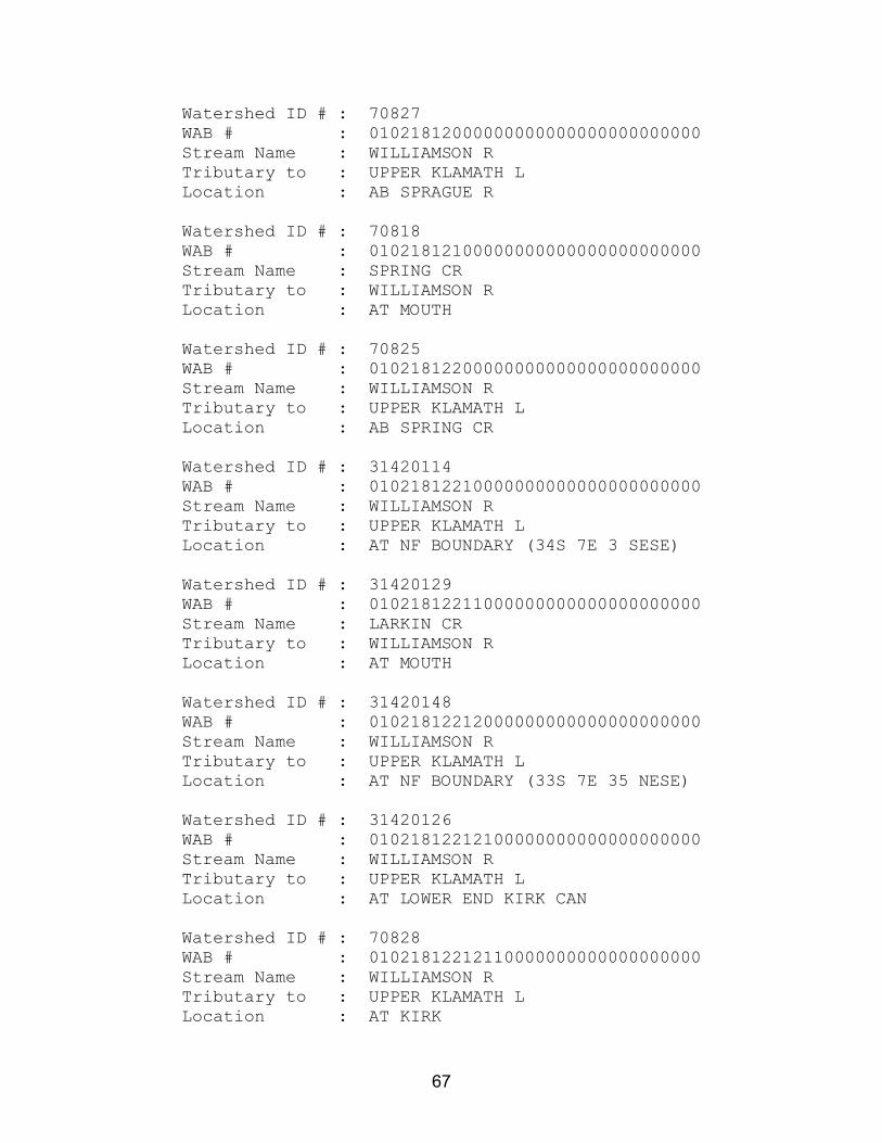
67
Watershed ID # : 70827 WAB # : 01021812000000000000000000000000 Stream Name : WILLIAMSON R Tributary to : UPPER KLAMATH L Location : AB SPRAGUE R Watershed ID # : 70818 WAB # : 01021812100000000000000000000000 Stream Name : SPRING CR Tributary to : WILLIAMSON R Location : AT MOUTH Watershed ID # : 70825 WAB # : 01021812200000000000000000000000 Stream Name : WILLIAMSON R Tributary to : UPPER KLAMATH L Location : AB SPRING CR Watershed ID # : 31420114 WAB # : 01021812210000000000000000000000 Stream Name : WILLIAMSON R Tributary to : UPPER KLAMATH L Location : AT NF BOUNDARY (34S 7E 3 SESE) Watershed ID # : 31420129 WAB # : 01021812211000000000000000000000 Stream Name : LARKIN CR Tributary to : WILLIAMSON R Location : AT MOUTH Watershed ID # : 31420148 WAB # : 01021812212000000000000000000000 Stream Name : WILLIAMSON R Tributary to : UPPER KLAMATH L Location : AT NF BOUNDARY (33S 7E 35 NESE) Watershed ID # : 31420126 WAB # : 01021812212100000000000000000000 Stream Name : WILLIAMSON R Tributary to : UPPER KLAMATH L Location : AT LOWER END KIRK CAN Watershed ID # : 70828 WAB # : 01021812212110000000000000000000 Stream Name : WILLIAMSON R Tributary to : UPPER KLAMATH L Location : AT KIRK
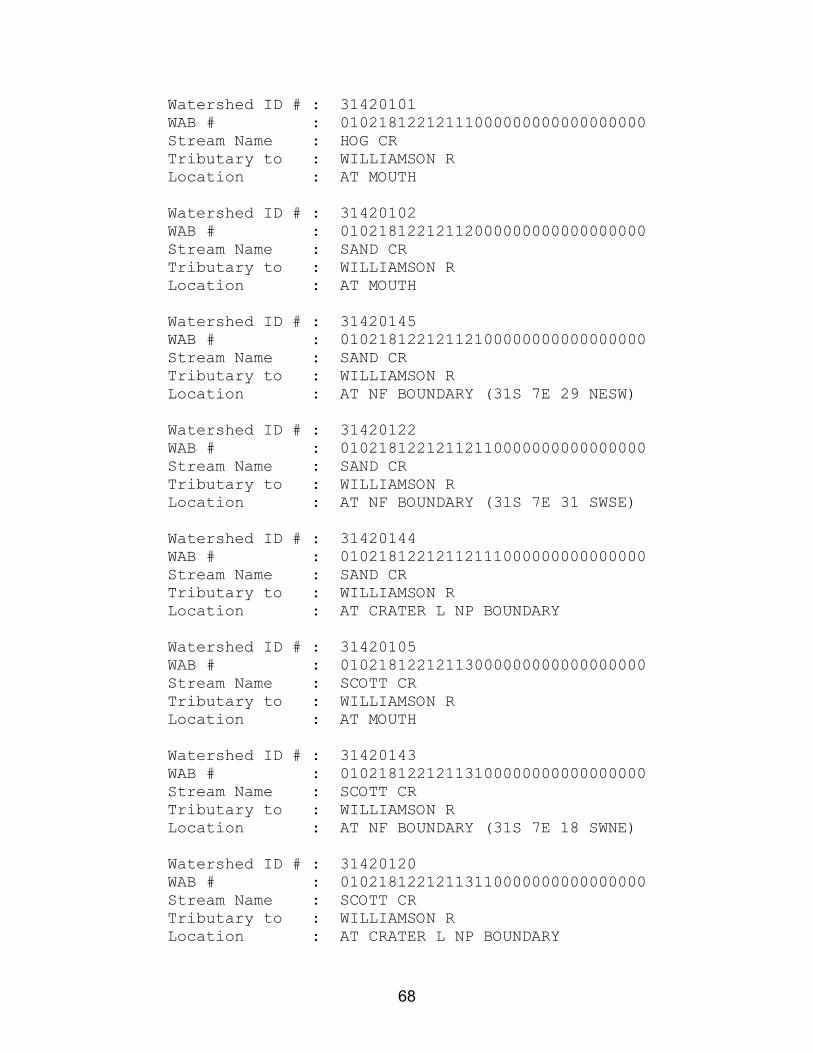
68
Watershed ID # : 31420101 WAB # : 01021812212111000000000000000000 Stream Name : HOG CR Tributary to : WILLIAMSON R Location : AT MOUTH Watershed ID # : 31420102 WAB # : 01021812212112000000000000000000 Stream Name : SAND CR Tributary to : WILLIAMSON R Location : AT MOUTH Watershed ID # : 31420145 WAB # : 01021812212112100000000000000000 Stream Name : SAND CR Tributary to : WILLIAMSON R Location : AT NF BOUNDARY (31S 7E 29 NESW) Watershed ID # : 31420122 WAB # : 01021812212112110000000000000000 Stream Name : SAND CR Tributary to : WILLIAMSON R Location : AT NF BOUNDARY (31S 7E 31 SWSE) Watershed ID # : 31420144 WAB # : 01021812212112111000000000000000 Stream Name : SAND CR Tributary to : WILLIAMSON R Location : AT CRATER L NP BOUNDARY Watershed ID # : 31420105 WAB # : 01021812212113000000000000000000 Stream Name : SCOTT CR Tributary to : WILLIAMSON R Location : AT MOUTH Watershed ID # : 31420143 WAB # : 01021812212113100000000000000000 Stream Name : SCOTT CR Tributary to : WILLIAMSON R Location : AT NF BOUNDARY (31S 7E 18 SWNE) Watershed ID # : 31420120 WAB # : 01021812212113110000000000000000 Stream Name : SCOTT CR Tributary to : WILLIAMSON R Location : AT CRATER L NP BOUNDARY
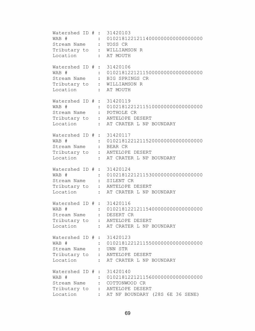
69
Watershed ID # : 31420103 WAB # : 01021812212114000000000000000000 Stream Name : YOSS CR Tributary to : WILLIAMSON R Location : AT MOUTH Watershed ID # : 31420106 WAB # : 01021812212115000000000000000000 Stream Name : BIG SPRINGS CR Tributary to : WILLIAMSON R Location : AT MOUTH Watershed ID # : 31420119 WAB # : 01021812212115100000000000000000 Stream Name : POTHOLE CR Tributary to : ANTELOPE DESERT Location : AT CRATER L NP BOUNDARY Watershed ID # : 31420117 WAB # : 01021812212115200000000000000000 Stream Name : BEAR CR Tributary to : ANTELOPE DESERT Location : AT CRATER L NP BOUNDARY Watershed ID # : 31420124 WAB # : 01021812212115300000000000000000 Stream Name : SILENT CR Tributary to : ANTELOPE DESERT Location : AT CRATER L NP BOUNDARY Watershed ID # : 31420116 WAB # : 01021812212115400000000000000000 Stream Name : DESERT CR Tributary to : ANTELOPE DESERT Location : AT CRATER L NP BOUNDARY Watershed ID # : 31420123 WAB # : 01021812212115500000000000000000 Stream Name : UNN STR Tributary to : ANTELOPE DESERT Location : AT CRATER L NP BOUNDARY Watershed ID # : 31420140 WAB # : 01021812212115600000000000000000 Stream Name : COTTONWOOD CR Tributary to : ANTELOPE DESERT Location : AT NF BOUNDARY (28S 6E 36 SENE)

70
Watershed ID # : 31420139 WAB # : 01021812212115700000000000000000 Stream Name : SINK CR Tributary to : ANTELOPE DESERT Location : AT NF BOUNDARY (28S 6E 13 NENE) Watershed ID # : 31420113 WAB # : 01021812212115800000000000000000 Stream Name : MILLER CR Tributary to : ANTELOPE DESERT Location : AT NF BOUNDARY (27S 7E 32 SENE) Watershed ID # : 31420104 WAB # : 01021812212116000000000000000000 Stream Name : SKELLOCK DRAW Tributary to : WILLIAMSON R Location : AT MOUTH Watershed ID # : 31420107 WAB # : 01021812212117000000000000000000 Stream Name : WILLIAMSON R Tributary to : UPPER KLAMATH L Location : AT MILITARY CROSSING Watershed ID # : 31420108 WAB # : 01021812212117100000000000000000 Stream Name : GOD CR Tributary to : WILLIAMSON R Location : AT MOUTH Watershed ID # : 31420109 WAB # : 01021812212117200000000000000000 Stream Name : MOSQUITO CR Tributary to : WILLIAMSON R Location : AT MOUTH Watershed ID # : 31420127 WAB # : 01021812212117300000000000000000 Stream Name : WILLIAMSON R Tributary to : UPPER KLAMATH L Location : AB KLAMATH MARSH Watershed ID # : 31420110 WAB # : 01021812212117310000000000000000 Stream Name : JACK CR Tributary to : WILLIAMSON R Location : AT MOUTH

71
Watershed ID # : 31420111 WAB # : 01021812212117320000000000000000 Stream Name : ROCK CR Tributary to : WILLIAMSON R Location : AT MOUTH Watershed ID # : 31420112 WAB # : 01021812212117330000000000000000 Stream Name : JACKSON CR Tributary to : WILLIAMSON R Location : AT MOUTH Watershed ID # : 31420130 WAB # : 01021812212117331000000000000000 Stream Name : IRVING CR Tributary to : JACKSON CR Location : AT MOUTH Watershed ID # : 31420136 WAB # : 01021812212117332000000000000000 Stream Name : JACKSON CR Tributary to : WILLIAMSON R Location : AT NF BOUNDARY (30S 11E 7 SENE) Watershed ID # : 31420142 WAB # : 01021812212117340000000000000000 Stream Name : WILLIAMSON R Tributary to : UPPER KLAMATH L Location : AT (31S 10E 12 NWNE) Watershed ID # : 70824 WAB # : 01021812212117341000000000000000 Stream Name : WILLIAMSON R Tributary to : UPPER KLAMATH L Location : AT ROCKY FORD Watershed ID # : 31420131 WAB # : 01021812212117341100000000000000 Stream Name : DEEP CR Tributary to : WILLIAMSON R Location : AT MOUTH Watershed ID # : 31420132 WAB # : 01021812212117341110000000000000 Stream Name : DEEP CR Tributary to : WILLIAMSON R Location : AT NF BOUNDARY (31S 11E 29 SESW)

72
Watershed ID # : 31420115 WAB # : 01021812212117341200000000000000 Stream Name : WILLIAMSON R Tributary to : UPPER KLAMATH L Location : AB DEEP CR Watershed ID # : 31420128 WAB # : 01021812212117341210000000000000 Stream Name : WILLIAMSON R Tributary to : UPPER KLAMATH L Location : AT WICKIUP SPRING Watershed ID # : 31420602 WAB # : 02000000000000000000000000000000 Stream Name : JENNY CR Tributary to : KLAMATH R Location : AT MOUTH Watershed ID # : 31420603 WAB # : 02010000000000000000000000000000 Stream Name : KEENE CR Tributary to : JENNY CR Location : AT MOUTH Watershed ID # : 31420619 WAB # : 02011000000000000000000000000000 Stream Name : KEENE CR Tributary to : JENNY CR Location : AT KEENE CR DAM Watershed ID # : 70811 WAB # : 02020000000000000000000000000000 Stream Name : JENNY CR Tributary to : KLAMATH R Location : AB KEENE CR Watershed ID # : 31420604 WAB # : 02021000000000000000000000000000 Stream Name : JOHNSON CR Tributary to : JENNY CR Location : AT MOUTH Watershed ID # : 31420605 WAB # : 02022000000000000000000000000000 Stream Name : JENNY CR Tributary to : KLAMATH R Location : AB JOHNSON CR

73
Watershed ID # : 31420601 WAB # : 03000000000000000000000000000000 Stream Name : HAYDEN CR Tributary to : KLAMATH R Location : AT STATE LINE Watershed ID # : 31420606 WAB # : 04000000000000000000000000000000 Stream Name : LONG PRAIRIE CR Tributary to : KLAMATH R Location : AT STATE LINE Watershed ID # : 31420607 WAB # : 05000000000000000000000000000000 Stream Name : FALL CR Tributary to : KLAMATH R Location : AT STATE LINE Watershed ID # : 31420608 WAB # : 06000000000000000000000000000000 Stream Name : SKOOKUM CR Tributary to : JENNY CR Location : AT STATE LINE Watershed ID # : 31420609 WAB # : 07000000000000000000000000000000 Stream Name : SALT CR Tributary to : CAMP CR Location : AT STATE LINE Watershed ID # : 31420610 WAB # : 08000000000000000000000000000000 Stream Name : CAMP CR Tributary to : KLAMATH R Location : AT STATE LINE Watershed ID # : 31420611 WAB # : 09000000000000000000000000000000 Stream Name : SCOTCH CR Tributary to : CAMP CR Location : AT STATE LINE Watershed ID # : 31420612 WAB # : 11000000000000000000000000000000 Stream Name : SLIDE CR Tributary to : SCOTCH CR Location : AT STATE LINE

74
Watershed ID # : 31420613 WAB # : 12000000000000000000000000000000 Stream Name : E FK COTTONWOOD CR Tributary to : COTTONWOOD CR Location : AT STATE LINE Watershed ID # : 31420614 WAB # : 13000000000000000000000000000000 Stream Name : COTTONWOOD CR Tributary to : KLAMATH R Location : AT STATE LINE Watershed ID # : 31420615 WAB # : 14000000000000000000000000000000 Stream Name : GROUSE CR Tributary to : BEAVER CR Location : AT STATE LINE Watershed ID # : 31420616 WAB # : 15000000000000000000000000000000 Stream Name : COW CR Tributary to : BEAVER CR Location : AT STATE LINE Watershed ID # : 31420630 WAB # : 15010000000000000000000000000000 Stream Name : COW CR Tributary to : BEAVER CR Location : AT NF BOUNDARY (41S 1W 11 SESW)

75
Appendix D
Natural Stream Flow Estimates for the
Klamath Basin

76
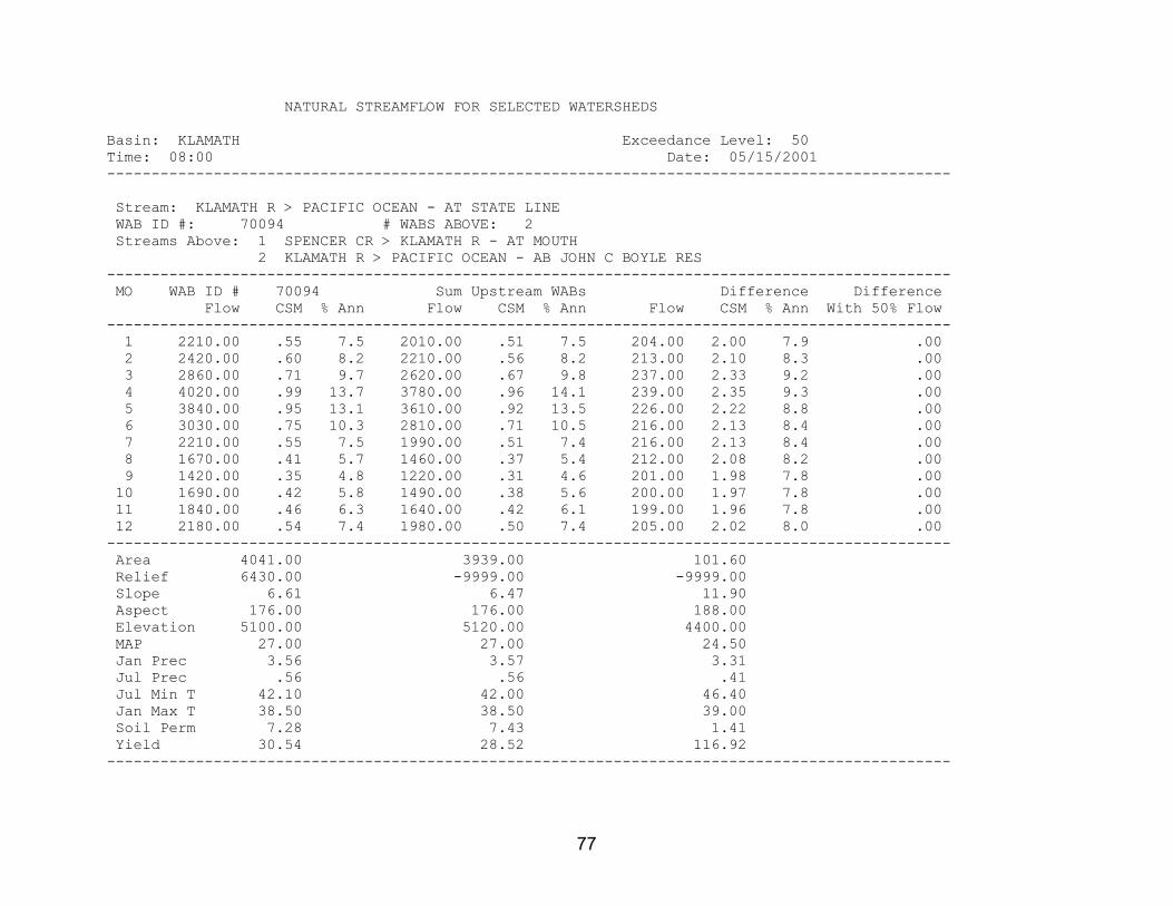
77
NATURAL STREAMFLOW FOR SELECTED WATERSHEDS Basin: KLAMATH Exceedance Level: 50 Time: 08:00 Date: 05/15/2001 ----------------------------------------------------------------------------------------------- Stream: KLAMATH R > PACIFIC OCEAN - AT STATE LINE WAB ID #: 70094 # WABS ABOVE: 2 Streams Above: 1 SPENCER CR > KLAMATH R - AT MOUTH 2 KLAMATH R > PACIFIC OCEAN - AB JOHN C BOYLE RES ----------------------------------------------------------------------------------------------- MO WAB ID # 70094 Sum Upstream WABs Difference Difference Flow CSM % Ann Flow CSM % Ann Flow CSM % Ann With 50% Flow ----------------------------------------------------------------------------------------------- 1 2210.00 .55 7.5 2010.00 .51 7.5 204.00 2.00 7.9 .00 2 2420.00 .60 8.2 2210.00 .56 8.2 213.00 2.10 8.3 .00 3 2860.00 .71 9.7 2620.00 .67 9.8 237.00 2.33 9.2 .00 4 4020.00 .99 13.7 3780.00 .96 14.1 239.00 2.35 9.3 .00 5 3840.00 .95 13.1 3610.00 .92 13.5 226.00 2.22 8.8 .00 6 3030.00 .75 10.3 2810.00 .71 10.5 216.00 2.13 8.4 .00 7 2210.00 .55 7.5 1990.00 .51 7.4 216.00 2.13 8.4 .00 8 1670.00 .41 5.7 1460.00 .37 5.4 212.00 2.08 8.2 .00 9 1420.00 .35 4.8 1220.00 .31 4.6 201.00 1.98 7.8 .00 10 1690.00 .42 5.8 1490.00 .38 5.6 200.00 1.97 7.8 .00 11 1840.00 .46 6.3 1640.00 .42 6.1 199.00 1.96 7.8 .00 12 2180.00 .54 7.4 1980.00 .50 7.4 205.00 2.02 8.0 .00 ----------------------------------------------------------------------------------------------- Area 4041.00 3939.00 101.60 Relief 6430.00 -9999.00 -9999.00 Slope 6.61 6.47 11.90 Aspect 176.00 176.00 188.00 Elevation 5100.00 5120.00 4400.00 MAP 27.00 27.00 24.50 Jan Prec 3.56 3.57 3.31 Jul Prec .56 .56 .41 Jul Min T 42.10 42.00 46.40 Jan Max T 38.50 38.50 39.00 Soil Perm 7.28 7.43 1.41 Yield 30.54 28.52 116.92 -----------------------------------------------------------------------------------------------

78
Stream: SPENCER CR > KLAMATH R - AT MOUTH WAB ID #: 70803 # WABS ABOVE: 1 Streams Above: 1 SPENCER CR > KLAMATH R - AT NF BOUNDARY ----------------------------------------------------------------------------------------------- MO WAB ID # 70803 Sum Upstream WABs Difference Difference Flow CSM % Ann Flow CSM % Ann Flow CSM % Ann With 50% Flow ----------------------------------------------------------------------------------------------- 1 26.30 .31 4.8 20.00 .57 4.5 6.30 .13 5.6 .00 2 46.60 .55 8.4 31.70 .90 7.2 14.90 .30 13.2 .00 3 63.50 .75 11.5 35.30 1.00 8.0 28.20 .57 25.1 .00 4 91.00 1.07 16.4 60.00 1.70 13.6 31.00 .63 27.6 .00 5 84.50 1.00 15.3 69.50 1.96 15.8 15.00 .30 13.3 .00 6 53.90 .64 9.7 49.10 1.39 11.1 4.80 .10 4.3 .00 7 33.80 .40 6.1 31.40 .89 7.1 2.40 .05 2.1 .00 8 28.40 .34 5.1 27.00 .76 6.1 1.40 .03 1.2 .00 9 29.30 .35 5.3 28.00 .79 6.3 1.30 .03 1.2 .00 10 30.30 .36 5.5 28.90 .82 6.6 1.40 .03 1.2 .00 11 30.60 .36 5.5 28.90 .82 6.6 1.70 .03 1.5 .00 12 35.20 .42 6.4 31.10 .88 7.1 4.10 .08 3.6 .00 ----------------------------------------------------------------------------------------------- Area 84.67 35.37 49.30 Relief 4380.00 2800.00 -9999.00 Slope 9.58 8.81 10.10 Aspect 168.00 162.00 173.00 Elevation 5270.00 5540.00 5080.00 MAP 39.90 47.80 34.30 Jan Prec 5.13 5.79 4.66 Jul Prec .74 1.01 .55 Jul Min T 45.00 44.40 45.40 Jan Max T 37.60 37.50 37.70 Soil Perm 1.44 1.53 1.38 Yield 18.53 29.53 7.53 -----------------------------------------------------------------------------------------------

79
Stream: SPENCER CR > KLAMATH R - AT NF BOUNDARY WAB ID #: 31420622 # WABS ABOVE: 0 ----------------------------------------------------------------------------------------------- MO WAB ID # 31420622 Sum Upstream WABs Difference Difference Flow CSM % Ann Flow CSM % Ann Flow CSM % Ann With 50% Flow ----------------------------------------------------------------------------------------------- 1 20.00 .57 4.5 .00 .00 .0 .00 .00 .0 .00 2 31.70 .90 7.2 .00 .00 .0 .00 .00 .0 .00 3 35.30 1.00 8.0 .00 .00 .0 .00 .00 .0 .00 4 60.00 1.70 13.6 .00 .00 .0 .00 .00 .0 .00 5 69.50 1.96 15.8 .00 .00 .0 .00 .00 .0 .00 6 49.10 1.39 11.1 .00 .00 .0 .00 .00 .0 .00 7 31.40 .89 7.1 .00 .00 .0 .00 .00 .0 .00 8 27.00 .76 6.1 .00 .00 .0 .00 .00 .0 .00 9 28.00 .79 6.3 .00 .00 .0 .00 .00 .0 .00 10 28.90 .82 6.6 .00 .00 .0 .00 .00 .0 .00 11 28.90 .82 6.6 .00 .00 .0 .00 .00 .0 .00 12 31.10 .88 7.1 .00 .00 .0 .00 .00 .0 .00 ----------------------------------------------------------------------------------------------- Area 35.37 .00 .00 Relief 2800.00 .00 .00 Slope 8.81 .00 .00 Aspect 162.00 .00 .00 Elevation 5540.00 .00 .00 MAP 47.80 .00 .00 Jan Prec 5.79 .00 .00 Jul Prec 1.01 .00 .00 Jul Min T 44.40 .00 .00 Jan Max T 37.50 .00 .00 Soil Perm 1.53 .00 .00 Yield 29.53 .00 .00 -----------------------------------------------------------------------------------------------

80
Stream: KLAMATH R > PACIFIC OCEAN - AB JOHN C BOYLE RES WAB ID #: 70812 # WABS ABOVE: 1 Streams Above: 1 LINK R > KLAMATH R - AB L EWAUNA ----------------------------------------------------------------------------------------------- MO WAB ID # 70812 Sum Upstream WABs Difference Difference Flow CSM % Ann Flow CSM % Ann Flow CSM % Ann With 50% Flow ----------------------------------------------------------------------------------------------- 1 1980.00 .51 7.5 1970.00 .52 7.6 10.00 .12 6.3 .00 2 2160.00 .56 8.2 2140.00 .57 8.2 20.00 .24 12.5 .00 3 2560.00 .66 9.7 2500.00 .66 9.6 60.00 .72 37.5 .00 4 3690.00 .96 14.0 3630.00 .96 13.9 60.00 .72 37.5 .00 5 3530.00 .92 13.4 3520.00 .93 13.5 10.00 .12 6.3 .00 6 2760.00 .72 10.5 2760.00 .73 10.6 .00 .00 .0 .00 7 1960.00 .51 7.5 1960.00 .52 7.5 .00 .00 .0 .00 8 1430.00 .37 5.4 1430.00 .38 5.5 .00 .00 .0 .00 9 1190.00 .31 4.5 1190.00 .32 4.6 .00 .00 .0 .00 10 1460.00 .38 5.6 1460.00 .39 5.6 .00 .00 .0 .00 11 1610.00 .42 6.1 1610.00 .43 6.2 .00 .00 .0 .00 12 1940.00 .50 7.4 1940.00 .51 7.4 .00 .00 .0 .00 ----------------------------------------------------------------------------------------------- Area 3854.00 3771.00 83.02 Relief 5240.00 5110.00 -9999.00 Slope 6.41 6.43 5.32 Aspect 176.00 176.00 167.00 Elevation 5120.00 5130.00 4300.00 MAP 26.70 26.90 20.00 Jan Prec 3.53 3.55 2.71 Jul Prec .56 .56 .38 Jul Min T 41.90 41.80 47.40 Jan Max T 38.50 38.50 38.60 Soil Perm 7.56 7.69 1.61 Yield 28.85 29.14 10.90 -----------------------------------------------------------------------------------------------

81
Stream: LINK R > KLAMATH R - AB L EWAUNA WAB ID #: 70813 # WABS ABOVE: 8 Streams Above: 1 FOURMILE CR > UPPER KLAMATH L - AT MOUTH 2 ROCK CR > CRYSTAL CR - AT MOUTH 3 CHERRY CR > FOURMILE CR - AT MOUTH 4 THREEMILE CR > FOURMILE CR - AT MOUTH 5 SEVENMILE CR > UPPER KLAMATH L - AT MOUTH 6 WOOD R > UPPER KLAMATH L - AT MOUTH 7 CROOKED CR > WOOD R - AT MOUTH 8 WILLIAMSON R > UPPER KLAMATH L - AT MOUTH ----------------------------------------------------------------------------------------------- MO WAB ID # 70813 Sum Upstream WABs Difference Difference Flow CSM % Ann Flow CSM % Ann Flow CSM % Ann With 50% Flow ----------------------------------------------------------------------------------------------- 1 1970.00 .52 7.6 1640.00 .49 7.4 335.00 .81 8.6 .00 2 2140.00 .57 8.2 1950.00 .58 8.8 191.00 .46 4.9 .00 3 2500.00 .66 9.6 2330.00 .69 10.5 169.00 .41 4.3 .00 4 3630.00 .96 13.9 2910.00 .87 13.1 718.00 1.73 18.3 .00 5 3520.00 .93 13.5 2890.00 .86 13.0 635.00 1.53 16.2 .00 6 2760.00 .73 10.6 2090.00 .62 9.4 674.00 1.62 17.2 .00 7 1960.00 .52 7.5 1380.00 .41 6.2 585.00 1.41 14.9 .00 8 1430.00 .38 5.5 1230.00 .37 5.5 201.00 .48 5.2 .00 9* 1190.00 .32 4.6 1250.00 .37 5.6 -56.40 -.14 -1.4 .00 10 1460.00 .39 5.6 1340.00 .40 6.1 117.00 .28 3.0 .00 11 1610.00 .43 6.2 1530.00 .46 6.9 80.30 .19 2.0 .00 12 1940.00 .51 7.4 1680.00 .50 7.6 264.00 .63 6.7 .00 ----------------------------------------------------------------------------------------------- Area 3771.00 3356.00 415.60 Relief 5110.00 -9999.00 -9999.00 Slope 6.43 6.35 7.11 Aspect 176.00 177.00 170.00 Elevation 5130.00 5210.00 4490.00 MAP 26.90 27.10 25.00 Jan Prec 3.55 3.52 3.78 Jul Prec .56 .59 .34 Jul Min T 41.80 41.60 43.70 Jan Max T 38.50 38.50 38.80 Soil Perm 7.69 8.42 1.80 Yield 29.14 27.60 42.66 -----------------------------------------------------------------------------------------------

82
Stream: FOURMILE CR > UPPER KLAMATH L - AT MOUTH WAB ID #: 31420301 # WABS ABOVE: 2 Streams Above: 1 VARNEY CR > FOURMILE CR - AT MOUTH AT GS GAGE 11505700 2 FOURMILE CR > UPPER KLAMATH L - AB VARNEY CR AT GS GAGE 115056 ----------------------------------------------------------------------------------------------- MO WAB ID # 31420301 Sum Upstream WABs Difference Difference Flow CSM % Ann Flow CSM % Ann Flow CSM % Ann With 50% Flow ----------------------------------------------------------------------------------------------- 1 4.33 .04 1.7 3.08 .03 1.3 1.25 .25 9.8 .00 2 10.30 .09 4.1 8.70 .08 3.7 1.60 .32 12.5 .00 3 16.80 .14 6.7 15.40 .14 6.5 1.43 .28 11.2 .00 4 27.80 .24 11.1 25.80 .23 10.9 1.97 .39 15.4 .00 5 94.30 .80 37.8 90.40 .81 38.2 3.89 .77 30.5 .00 6 83.30 .71 33.4 81.90 .73 34.6 1.40 .28 11.0 .00 7 2.54 .02 1.0 2.44 .02 1.0 .10 .02 .8 .00 8 .90 .01 .4 .88 .01 .4 .02 .00 .2 .00 9 .55 .00 .2 .54 .00 .2 .01 .00 .1 .00 10 1.12 .01 .4 1.10 .01 .5 .02 .00 .2 .00 11 2.33 .02 .9 2.21 .02 .9 .12 .02 .9 .00 12 5.41 .05 2.2 4.45 .04 1.9 .96 .19 7.5 .00 ----------------------------------------------------------------------------------------------- Area 117.20 112.10 5.05 Relief 5030.00 -9999.00 -9999.00 Slope 13.00 12.80 16.20 Aspect 173.00 174.00 162.00 Elevation 5630.00 5640.00 5360.00 MAP 49.80 50.50 34.80 Jan Prec 6.09 6.14 4.99 Jul Prec .94 .96 .46 Jul Min T 44.20 44.20 44.80 Jan Max T 37.20 37.10 37.90 Soil Perm 2.08 2.07 2.29 Yield 4.84 4.74 8.24 -----------------------------------------------------------------------------------------------

83
Stream: VARNEY CR > FOURMILE CR - AT MOUTH AT GS GAGE 11505700 WAB ID #: 31420304 # WABS ABOVE: 1 Streams Above: 1 VARNEY CR > FOURMILE CR - AT NF BOUNDARY (36S 6E 21 NENW) ----------------------------------------------------------------------------------------------- MO WAB ID # 31420304 Sum Upstream WABs Difference Difference Flow CSM % Ann Flow CSM % Ann Flow CSM % Ann With 50% Flow ----------------------------------------------------------------------------------------------- 1 .01 .00 .1 .01 .00 .1 .00 .00 .0 .00 2 .01 .00 .1 .00 .00 .0 .01 .00 .2 .00 3 1.17 .07 8.2 .46 .07 5.7 .71 .07 11.5 .00 4 2.33 .14 16.4 1.17 .18 14.6 1.16 .11 18.7 .00 5 6.11 .36 42.9 4.05 .61 50.4 2.06 .20 33.3 .00 6 2.10 .12 14.8 1.48 .22 18.4 .62 .06 10.0 .00 7 1.09 .06 7.7 .44 .07 5.5 .65 .06 10.5 .00 8 .56 .03 3.9 .17 .03 2.1 .39 .04 6.3 .00 9 .47 .03 3.3 .15 .02 1.9 .32 .03 5.2 .00 10 .35 .02 2.5 .09 .01 1.1 .26 .02 4.2 .00 11 .01 .00 .1 .01 .00 .1 .00 .00 .0 .00 12 .02 .00 .1 .01 .00 .1 .01 .00 .2 .00 ----------------------------------------------------------------------------------------------- Area 17.08 6.62 10.46 Relief 3680.00 3580.00 -9999.00 Slope 15.50 20.80 12.10 Aspect 195.00 190.00 197.00 Elevation 5380.00 6040.00 4960.00 MAP 42.40 50.30 37.40 Jan Prec 5.86 6.61 5.39 Jul Prec .63 .72 .57 Jul Min T 44.30 43.60 44.70 Jan Max T 36.80 36.60 37.00 Soil Perm 1.52 1.52 1.52 Yield 2.22 2.73 1.79 -----------------------------------------------------------------------------------------------

84
Stream: VARNEY CR > FOURMILE CR - AT NF BOUNDARY (36S 6E 21 NENW) WAB ID #: 31420308 # WABS ABOVE: 0 ----------------------------------------------------------------------------------------------- MO WAB ID # 31420308 Sum Upstream WABs Difference Difference Flow CSM % Ann Flow CSM % Ann Flow CSM % Ann With 50% Flow ----------------------------------------------------------------------------------------------- 1 .01 .00 .1 .00 .00 .0 .00 .00 .0 .00 2 .00 .00 .0 .00 .00 .0 .00 .00 .0 .00 3 .46 .07 5.7 .00 .00 .0 .00 .00 .0 .00 4 1.17 .18 14.6 .00 .00 .0 .00 .00 .0 .00 5 4.05 .61 50.4 .00 .00 .0 .00 .00 .0 .00 6 1.48 .22 18.4 .00 .00 .0 .00 .00 .0 .00 7 .44 .07 5.5 .00 .00 .0 .00 .00 .0 .00 8 .17 .03 2.1 .00 .00 .0 .00 .00 .0 .00 9 .15 .02 1.9 .00 .00 .0 .00 .00 .0 .00 10 .09 .01 1.1 .00 .00 .0 .00 .00 .0 .00 11 .01 .00 .1 .00 .00 .0 .00 .00 .0 .00 12 .01 .00 .1 .00 .00 .0 .00 .00 .0 .00 ----------------------------------------------------------------------------------------------- Area 6.62 .00 .00 Relief 3580.00 .00 .00 Slope 20.80 .00 .00 Aspect 190.00 .00 .00 Elevation 6040.00 .00 .00 MAP 50.30 .00 .00 Jan Prec 6.61 .00 .00 Jul Prec .72 .00 .00 Jul Min T 43.60 .00 .00 Jan Max T 36.60 .00 .00 Soil Perm 1.52 .00 .00 Yield 2.73 .00 .00 -----------------------------------------------------------------------------------------------

85
Stream: FOURMILE CR > UPPER KLAMATH L - AB VARNEY CR AT GS GAGE 11505600 WAB ID #: 31420327 # WABS ABOVE: 1 Streams Above: 1 FOURMILE CR > UPPER KLAMATH L - AT NF BOUNDARY (36S 6E 17 NENW) ----------------------------------------------------------------------------------------------- MO WAB ID # 31420327 Sum Upstream WABs Difference Difference Flow CSM % Ann Flow CSM % Ann Flow CSM % Ann With 50% Flow ----------------------------------------------------------------------------------------------- 1* 3.07 .03 1.4 4.25 .05 1.9 -1.18 -.24 -33.9 .00 2 8.69 .09 3.9 8.66 .10 4.0 .03 .01 .9 .00 3 14.20 .15 6.4 14.00 .16 6.4 .20 .04 5.8 .00 4 23.50 .25 10.6 23.40 .26 10.7 .10 .02 2.9 .00 5 84.30 .89 37.9 83.10 .92 37.9 1.20 .24 34.5 .00 6 79.80 .84 35.8 74.10 .82 33.8 5.70 1.14 164.0 .00 7* 1.35 .01 .6 2.04 .02 .9 -.69 -.14 -19.8 .00 8* .32 .00 .1 .62 .01 .3 -.30 -.06 -8.6 .00 9* .07 .00 .0 .37 .00 .2 -.30 -.06 -8.6 .00 10* .75 .01 .3 1.25 .01 .6 -.50 -.10 -14.4 .00 11* 2.20 .02 1.0 2.98 .03 1.4 -.78 -.16 -22.4 .00 12 4.43 .05 2.0 4.43 .05 2.0 .00 .00 .0 .00 ----------------------------------------------------------------------------------------------- Area 95.06 90.07 4.99 Relief 5030.00 5030.00 -9999.00 Slope 12.30 12.30 12.60 Aspect 170.00 170.00 163.00 Elevation 5690.00 5720.00 5070.00 MAP 51.90 52.90 33.60 Jan Prec 6.19 6.25 5.12 Jul Prec 1.02 1.06 .39 Jul Min T 44.20 44.10 45.20 Jan Max T 37.20 37.20 37.60 Soil Perm 2.17 2.19 1.83 Yield 5.11 5.20 2.35 -----------------------------------------------------------------------------------------------

86
Stream: FOURMILE CR > UPPER KLAMATH L - AT NF BOUNDARY (36S 6E 17 NENW) WAB ID #: 31420306 # WABS ABOVE: 1 Streams Above: 1 BILLIE CR > LAKE OF THE WOODS - AT MOUTH ----------------------------------------------------------------------------------------------- MO WAB ID # 31420306 Sum Upstream WABs Difference Difference Flow CSM % Ann Flow CSM % Ann Flow CSM % Ann With 50% Flow ----------------------------------------------------------------------------------------------- 1 4.25 .05 1.9 .75 .16 3.6 3.50 .04 1.8 .00 2 8.66 .10 4.0 .97 .21 4.7 7.69 .09 3.9 .00 3 14.00 .16 6.4 1.80 .39 8.7 12.20 .14 6.2 .00 4 23.40 .26 10.7 4.27 .93 20.7 19.10 .22 9.6 .00 5 83.10 .92 37.9 7.28 1.58 35.2 75.80 .89 38.2 .00 6 74.10 .82 33.8 3.00 .65 14.5 71.10 .83 35.8 .00 7 2.04 .02 .9 .51 .11 2.5 1.53 .02 .8 .00 8 .62 .01 .3 .28 .06 1.4 .34 .00 .2 .00 9 .37 .00 .2 .31 .07 1.5 .06 .00 .0 .00 10 1.25 .01 .6 .40 .09 1.9 .85 .01 .4 .00 11 2.98 .03 1.4 .49 .11 2.4 2.49 .03 1.3 .00 12 4.43 .05 2.0 .61 .13 3.0 3.82 .04 1.9 .00 ----------------------------------------------------------------------------------------------- Area 90.07 4.61 85.45 Relief 5030.00 1430.00 -9999.00 Slope 12.30 9.88 12.40 Aspect 170.00 179.00 170.00 Elevation 5720.00 5810.00 5720.00 MAP 52.90 55.00 52.80 Jan Prec 6.25 6.03 6.26 Jul Prec 1.06 1.11 1.05 Jul Min T 44.10 43.50 44.10 Jan Max T 37.20 37.40 37.20 Soil Perm 2.19 2.17 2.19 Yield 5.20 9.23 4.98 -----------------------------------------------------------------------------------------------

87
Stream: BILLIE CR > LAKE OF THE WOODS - AT MOUTH WAB ID #: 31420307 # WABS ABOVE: 0 ----------------------------------------------------------------------------------------------- MO WAB ID # 31420307 Sum Upstream WABs Difference Difference Flow CSM % Ann Flow CSM % Ann Flow CSM % Ann With 50% Flow ----------------------------------------------------------------------------------------------- 1 .75 .16 3.6 .00 .00 .0 .00 .00 .0 .00 2 .97 .21 4.7 .00 .00 .0 .00 .00 .0 .00 3 1.80 .39 8.7 .00 .00 .0 .00 .00 .0 .00 4 4.27 .93 20.7 .00 .00 .0 .00 .00 .0 .00 5 7.28 1.58 35.2 .00 .00 .0 .00 .00 .0 .00 6 3.00 .65 14.5 .00 .00 .0 .00 .00 .0 .00 7 .51 .11 2.5 .00 .00 .0 .00 .00 .0 .00 8 .28 .06 1.4 .00 .00 .0 .00 .00 .0 .00 9 .31 .07 1.5 .00 .00 .0 .00 .00 .0 .00 10 .40 .09 1.9 .00 .00 .0 .00 .00 .0 .00 11 .49 .11 2.4 .00 .00 .0 .00 .00 .0 .00 12 .61 .13 3.0 .00 .00 .0 .00 .00 .0 .00 ----------------------------------------------------------------------------------------------- Area 4.61 .00 .00 Relief 1430.00 .00 .00 Slope 9.88 .00 .00 Aspect 179.00 .00 .00 Elevation 5810.00 .00 .00 MAP 55.00 .00 .00 Jan Prec 6.03 .00 .00 Jul Prec 1.11 .00 .00 Jul Min T 43.50 .00 .00 Jan Max T 37.40 .00 .00 Soil Perm 2.17 .00 .00 Yield 9.23 .00 .00 -----------------------------------------------------------------------------------------------

88
Stream: ROCK CR > CRYSTAL CR - AT MOUTH WAB ID #: 31420302 # WABS ABOVE: 1 Streams Above: 1 ROCK CR > CRYSTAL CR - AT NF BOUNDARY (35S 6E 3 SENE) ----------------------------------------------------------------------------------------------- MO WAB ID # 31420302 Sum Upstream WABs Difference Difference Flow CSM % Ann Flow CSM % Ann Flow CSM % Ann With 50% Flow ----------------------------------------------------------------------------------------------- 1 5.08 .29 7.0 4.98 .30 6.9 .10 .09 11.9 .00 2 5.80 .33 8.0 5.67 .34 7.9 .13 .12 15.5 .00 3 5.50 .31 7.6 5.39 .32 7.5 .11 .10 13.1 .00 4 10.10 .57 13.9 9.99 .60 13.9 .11 .10 13.1 .00 5 28.20 1.59 38.9 28.00 1.68 39.1 .20 .18 23.8 .00 6 11.20 .63 15.4 11.10 .67 15.5 .10 .09 11.9 .00 7 1.04 .06 1.4 1.03 .06 1.4 .01 .01 1.2 .00 8 .17 .01 .2 .17 .01 .2 .00 .00 .0 .00 9 .09 .01 .1 .09 .01 .1 .00 .00 .0 .00 10 .14 .01 .2 .14 .01 .2 .00 .00 .0 .00 11 .75 .04 1.0 .74 .04 1.0 .01 .01 1.2 .00 12 4.45 .25 6.1 4.38 .26 6.1 .07 .06 8.3 .00 ----------------------------------------------------------------------------------------------- Area 17.77 16.67 1.10 Relief 3800.00 3800.00 -9999.00 Slope 15.40 15.30 18.20 Aspect 126.00 126.00 135.00 Elevation 5810.00 5890.00 4620.00 MAP 54.00 54.70 42.90 Jan Prec 6.84 6.88 6.17 Jul Prec .84 .86 .49 Jul Min T 44.60 44.70 43.40 Jan Max T 36.80 36.70 38.00 Soil Perm 2.50 2.56 1.67 Yield 8.55 8.89 2.02 -----------------------------------------------------------------------------------------------

89
Stream: ROCK CR > CRYSTAL CR - AT NF BOUNDARY (35S 6E 3 SENE) WAB ID #: 31420330 # WABS ABOVE: 0 ----------------------------------------------------------------------------------------------- MO WAB ID # 31420330 Sum Upstream WABs Difference Difference Flow CSM % Ann Flow CSM % Ann Flow CSM % Ann With 50% Flow ----------------------------------------------------------------------------------------------- 1 4.98 .30 6.9 .00 .00 .0 .00 .00 .0 .00 2 5.67 .34 7.9 .00 .00 .0 .00 .00 .0 .00 3 5.39 .32 7.5 .00 .00 .0 .00 .00 .0 .00 4 9.99 .60 13.9 .00 .00 .0 .00 .00 .0 .00 5 28.00 1.68 39.1 .00 .00 .0 .00 .00 .0 .00 6 11.10 .67 15.5 .00 .00 .0 .00 .00 .0 .00 7 1.03 .06 1.4 .00 .00 .0 .00 .00 .0 .00 8 .17 .01 .2 .00 .00 .0 .00 .00 .0 .00 9 .09 .01 .1 .00 .00 .0 .00 .00 .0 .00 10 .14 .01 .2 .00 .00 .0 .00 .00 .0 .00 11 .74 .04 1.0 .00 .00 .0 .00 .00 .0 .00 12 4.38 .26 6.1 .00 .00 .0 .00 .00 .0 .00 ----------------------------------------------------------------------------------------------- Area 16.67 .00 .00 Relief 3800.00 .00 .00 Slope 15.30 .00 .00 Aspect 126.00 .00 .00 Elevation 5890.00 .00 .00 MAP 54.70 .00 .00 Jan Prec 6.88 .00 .00 Jul Prec .86 .00 .00 Jul Min T 44.70 .00 .00 Jan Max T 36.70 .00 .00 Soil Perm 2.56 .00 .00 Yield 8.89 .00 .00 -----------------------------------------------------------------------------------------------

90
Stream: CHERRY CR > FOURMILE CR - AT MOUTH WAB ID #: 70798 # WABS ABOVE: 1 Streams Above: 1 CHERRY CR > FOURMILE CR - AT NF BOUNDARY (36S 6E 14 NWSW) ----------------------------------------------------------------------------------------------- MO WAB ID # 70798 Sum Upstream WABs Difference Difference Flow CSM % Ann Flow CSM % Ann Flow CSM % Ann With 50% Flow ----------------------------------------------------------------------------------------------- 1 13.00 .58 5.2 13.00 .76 5.3 .00 .00 .0 .00 2 16.60 .74 6.7 16.60 .98 6.8 .00 .00 .0 .00 3 17.10 .76 6.9 17.00 1.00 7.0 .10 .02 1.7 .00 4 31.30 1.39 12.6 31.10 1.83 12.8 .20 .04 3.4 .00 5 68.40 3.04 27.4 65.60 3.86 27.0 2.80 .51 47.4 .00 6 24.70 1.10 9.9 22.50 1.32 9.2 2.20 .40 37.2 .00 7 10.20 .45 4.1 9.98 .59 4.1 .22 .04 3.7 .00 8 9.50 .42 3.8 9.35 .55 3.8 .15 .03 2.5 .00 9 9.21 .41 3.7 9.07 .53 3.7 .14 .03 2.4 .00 10 10.50 .47 4.2 10.40 .61 4.3 .10 .02 1.7 .00 11 17.40 .77 7.0 17.40 1.02 7.2 .00 .00 .0 .00 12 21.40 .95 8.6 21.40 1.26 8.8 .00 .00 .0 .00 ----------------------------------------------------------------------------------------------- Area 22.50 17.02 5.49 Relief 3250.00 3250.00 -9999.00 Slope 21.10 21.80 19.10 Aspect 133.00 136.00 124.00 Elevation 5730.00 5810.00 5460.00 MAP 53.90 54.80 51.40 Jan Prec 6.87 6.89 6.81 Jul Prec .81 .86 .67 Jul Min T 44.20 44.40 43.70 Jan Max T 36.60 36.40 37.20 Soil Perm 2.28 2.47 1.70 Yield 23.25 29.57 2.37 -----------------------------------------------------------------------------------------------

91
Stream: CHERRY CR > FOURMILE CR - AT NF BOUNDARY (36S 6E 14 NWSW) WAB ID #: 31420311 # WABS ABOVE: 0 ----------------------------------------------------------------------------------------------- MO WAB ID # 31420311 Sum Upstream WABs Difference Difference Flow CSM % Ann Flow CSM % Ann Flow CSM % Ann With 50% Flow ----------------------------------------------------------------------------------------------- 1 13.00 .76 5.3 .00 .00 .0 .00 .00 .0 .00 2 16.60 .98 6.8 .00 .00 .0 .00 .00 .0 .00 3 17.00 1.00 7.0 .00 .00 .0 .00 .00 .0 .00 4 31.10 1.83 12.8 .00 .00 .0 .00 .00 .0 .00 5 65.60 3.86 27.0 .00 .00 .0 .00 .00 .0 .00 6 22.50 1.32 9.2 .00 .00 .0 .00 .00 .0 .00 7 9.98 .59 4.1 .00 .00 .0 .00 .00 .0 .00 8 9.35 .55 3.8 .00 .00 .0 .00 .00 .0 .00 9 9.07 .53 3.7 .00 .00 .0 .00 .00 .0 .00 10 10.40 .61 4.3 .00 .00 .0 .00 .00 .0 .00 11 17.40 1.02 7.2 .00 .00 .0 .00 .00 .0 .00 12 21.40 1.26 8.8 .00 .00 .0 .00 .00 .0 .00 ----------------------------------------------------------------------------------------------- Area 17.02 .00 .00 Relief 3250.00 .00 .00 Slope 21.80 .00 .00 Aspect 136.00 .00 .00 Elevation 5810.00 .00 .00 MAP 54.80 .00 .00 Jan Prec 6.89 .00 .00 Jul Prec .86 .00 .00 Jul Min T 44.40 .00 .00 Jan Max T 36.40 .00 .00 Soil Perm 2.47 .00 .00 Yield 29.57 .00 .00 -----------------------------------------------------------------------------------------------

92
Stream: THREEMILE CR > FOURMILE CR - AT MOUTH WAB ID #: 31420303 # WABS ABOVE: 1 Streams Above: 1 THREEMILE CR > FOURMILE CR - AT NF BOUNDARY (34S 6E 2 NWSE) ----------------------------------------------------------------------------------------------- MO WAB ID # 31420303 Sum Upstream WABs Difference Difference Flow CSM % Ann Flow CSM % Ann Flow CSM % Ann With 50% Flow ----------------------------------------------------------------------------------------------- 1 19.30 1.14 6.8 4.32 .44 4.5 15.00 2.12 8.0 .00 2 20.40 1.21 7.2 5.40 .55 5.7 15.00 2.13 8.0 .00 3 23.70 1.40 8.4 8.58 .87 9.0 15.10 2.14 8.1 .00 4 34.00 2.01 12.0 18.80 1.91 19.7 15.20 2.15 8.1 .00 5 46.50 2.75 16.5 28.80 2.93 30.2 17.70 2.51 9.5 .00 6 31.20 1.85 11.1 13.10 1.33 13.7 18.10 2.56 9.7 .00 7 18.50 1.09 6.6 3.14 .32 3.3 15.40 2.18 8.2 .00 8 17.10 1.01 6.1 1.88 .19 2.0 15.20 2.16 8.1 .00 9 17.30 1.02 6.1 2.06 .21 2.2 15.20 2.16 8.1 .00 10 17.70 1.05 6.3 2.58 .26 2.7 15.10 2.14 8.1 .00 11 18.00 1.07 6.4 3.04 .31 3.2 15.00 2.12 8.0 .00 12 18.60 1.10 6.6 3.58 .36 3.8 15.00 2.13 8.0 .00 ----------------------------------------------------------------------------------------------- Area 16.90 9.84 7.06 Relief 3200.00 3200.00 -9999.00 Slope 16.30 17.70 14.40 Aspect 124.00 126.00 123.00 Elevation 5680.00 6110.00 5090.00 MAP 57.10 62.80 49.00 Jan Prec 7.19 7.64 6.56 Jul Prec .80 .94 .60 Jul Min T 43.60 44.60 42.20 Jan Max T 36.60 35.80 37.70 Soil Perm 2.35 2.43 2.23 Yield 33.13 17.44 61.18 -----------------------------------------------------------------------------------------------

93
Stream: THREEMILE CR > FOURMILE CR - AT NF BOUNDARY (34S 6E 2 NWSE) WAB ID #: 31420321 # WABS ABOVE: 0 ----------------------------------------------------------------------------------------------- MO WAB ID # 31420321 Sum Upstream WABs Difference Difference Flow CSM % Ann Flow CSM % Ann Flow CSM % Ann With 50% Flow ----------------------------------------------------------------------------------------------- 1 4.32 .44 4.5 .00 .00 .0 .00 .00 .0 .00 2 5.40 .55 5.7 .00 .00 .0 .00 .00 .0 .00 3 8.58 .87 9.0 .00 .00 .0 .00 .00 .0 .00 4 18.80 1.91 19.7 .00 .00 .0 .00 .00 .0 .00 5 28.80 2.93 30.2 .00 .00 .0 .00 .00 .0 .00 6 13.10 1.33 13.7 .00 .00 .0 .00 .00 .0 .00 7 3.14 .32 3.3 .00 .00 .0 .00 .00 .0 .00 8 1.88 .19 2.0 .00 .00 .0 .00 .00 .0 .00 9 2.06 .21 2.2 .00 .00 .0 .00 .00 .0 .00 10 2.58 .26 2.7 .00 .00 .0 .00 .00 .0 .00 11 3.04 .31 3.2 .00 .00 .0 .00 .00 .0 .00 12 3.58 .36 3.8 .00 .00 .0 .00 .00 .0 .00 ----------------------------------------------------------------------------------------------- Area 9.84 .00 .00 Relief 3200.00 .00 .00 Slope 17.70 .00 .00 Aspect 126.00 .00 .00 Elevation 6110.00 .00 .00 MAP 62.80 .00 .00 Jan Prec 7.64 .00 .00 Jul Prec .94 .00 .00 Jul Min T 44.60 .00 .00 Jan Max T 35.80 .00 .00 Soil Perm 2.43 .00 .00 Yield 17.44 .00 .00 -----------------------------------------------------------------------------------------------

94
Stream: SEVENMILE CR > UPPER KLAMATH L - AT MOUTH WAB ID #: 70830 # WABS ABOVE: 1 Streams Above: 1 SEVENMILE CR > UPPER KLAMATH L - AT NF BOUNDARY (33S 6E 14 SESE) ----------------------------------------------------------------------------------------------- MO WAB ID # 70830 Sum Upstream WABs Difference Difference Flow CSM % Ann Flow CSM % Ann Flow CSM % Ann With 50% Flow ----------------------------------------------------------------------------------------------- 1 87.40 1.47 8.5 18.70 .71 7.5 68.70 2.07 8.8 .00 2 91.50 1.54 8.9 19.70 .74 7.8 71.80 2.17 9.2 .00 3 95.00 1.59 9.2 19.00 .72 7.6 76.00 2.29 9.7 .00 4 101.00 1.70 9.8 22.20 .84 8.9 78.80 2.38 10.1 .00 5 103.00 1.73 10.0 35.60 1.35 14.2 67.40 2.04 8.6 .00 6 97.20 1.63 9.4 28.30 1.07 11.3 68.90 2.08 8.8 .00 7 74.60 1.25 7.2 17.40 .66 6.9 57.20 1.73 7.3 .00 8 66.70 1.12 6.5 16.50 .62 6.6 50.20 1.52 6.4 .00 9 68.40 1.15 6.6 17.50 .66 7.0 50.90 1.54 6.5 .00 10 73.80 1.24 7.2 19.00 .72 7.6 54.80 1.65 7.0 .00 11 85.60 1.44 8.3 18.60 .70 7.4 67.00 2.02 8.6 .00 12 87.80 1.47 8.5 18.30 .69 7.3 69.50 2.10 8.9 .00 ----------------------------------------------------------------------------------------------- Area 59.58 26.46 33.12 Relief 3060.00 2930.00 -9999.00 Slope 12.00 14.40 10.10 Aspect 136.00 136.00 136.00 Elevation 5330.00 5700.00 5040.00 MAP 51.20 60.40 43.80 Jan Prec 6.73 7.58 6.04 Jul Prec .67 .83 .54 Jul Min T 42.90 44.30 41.70 Jan Max T 37.40 36.50 38.10 Soil Perm 3.88 2.99 4.59 Yield 38.33 17.76 61.03 -----------------------------------------------------------------------------------------------

95
Stream: SEVENMILE CR > UPPER KLAMATH L - AT NF BOUNDARY (33S 6E 14 SESE) WAB ID #: 31420310 # WABS ABOVE: 0 ----------------------------------------------------------------------------------------------- MO WAB ID # 31420310 Sum Upstream WABs Difference Difference Flow CSM % Ann Flow CSM % Ann Flow CSM % Ann With 50% Flow ----------------------------------------------------------------------------------------------- 1 18.70 .71 7.5 .00 .00 .0 .00 .00 .0 .00 2 19.70 .74 7.8 .00 .00 .0 .00 .00 .0 .00 3 19.00 .72 7.6 .00 .00 .0 .00 .00 .0 .00 4 22.20 .84 8.9 .00 .00 .0 .00 .00 .0 .00 5 35.60 1.35 14.2 .00 .00 .0 .00 .00 .0 .00 6 28.30 1.07 11.3 .00 .00 .0 .00 .00 .0 .00 7 17.40 .66 6.9 .00 .00 .0 .00 .00 .0 .00 8 16.50 .62 6.6 .00 .00 .0 .00 .00 .0 .00 9 17.50 .66 7.0 .00 .00 .0 .00 .00 .0 .00 10 19.00 .72 7.6 .00 .00 .0 .00 .00 .0 .00 11 18.60 .70 7.4 .00 .00 .0 .00 .00 .0 .00 12 18.30 .69 7.3 .00 .00 .0 .00 .00 .0 .00 ----------------------------------------------------------------------------------------------- Area 26.46 .00 .00 Relief 2930.00 .00 .00 Slope 14.40 .00 .00 Aspect 136.00 .00 .00 Elevation 5700.00 .00 .00 MAP 60.40 .00 .00 Jan Prec 7.58 .00 .00 Jul Prec .83 .00 .00 Jul Min T 44.30 .00 .00 Jan Max T 36.50 .00 .00 Soil Perm 2.99 .00 .00 Yield 17.76 .00 .00 -----------------------------------------------------------------------------------------------

96
Stream: WOOD R > UPPER KLAMATH L - AT MOUTH WAB ID #: 70829 # WABS ABOVE: 2 Streams Above: 1 FORT CR > WOOD R - AT MOUTH 2 ANNIE CR > WOOD R - AT MOUTH ----------------------------------------------------------------------------------------------- MO WAB ID # 70829 Sum Upstream WABs Difference Difference Flow CSM % Ann Flow CSM % Ann Flow CSM % Ann With 50% Flow ----------------------------------------------------------------------------------------------- 1 391.00 4.35 7.6 145.00 2.49 6.9 246.00 7.79 8.0 .00 2 389.00 4.33 7.5 145.00 2.49 6.9 244.00 7.73 7.9 .00 3 409.00 4.55 7.9 161.00 2.76 7.7 248.00 7.86 8.1 .00 4 434.00 4.83 8.4 168.00 2.88 8.0 266.00 8.44 8.6 .00 5 490.00 5.45 9.5 220.00 3.77 10.5 270.00 8.55 8.8 .00 6 533.00 5.93 10.3 264.00 4.53 12.6 269.00 8.52 8.7 .00 7 473.00 5.26 9.1 209.00 3.58 10.0 264.00 8.38 8.6 .00 8 431.00 4.80 8.3 173.00 2.97 8.3 258.00 8.16 8.4 .00 9 413.00 4.60 8.0 157.00 2.69 7.5 256.00 8.12 8.3 .00 10 407.00 4.53 7.9 151.00 2.59 7.2 256.00 8.12 8.3 .00 11 399.00 4.44 7.7 148.00 2.54 7.1 251.00 7.95 8.1 .00 12 399.00 4.44 7.7 150.00 2.56 7.2 249.00 7.90 8.1 .00 ----------------------------------------------------------------------------------------------- Area 89.88 58.32 31.55 Relief 3830.00 -9999.00 -9999.00 Slope 10.60 13.20 5.81 Aspect 180.00 169.00 201.00 Elevation 5320.00 5640.00 4730.00 MAP 42.90 49.00 31.80 Jan Prec 6.19 7.04 4.62 Jul Prec .53 .58 .44 Jul Min T 41.50 41.90 40.70 Jan Max T 37.50 36.80 38.80 Soil Perm 9.52 9.01 10.50 Yield 151.60 82.89 347.12 -----------------------------------------------------------------------------------------------

97
Stream: FORT CR > WOOD R - AT MOUTH WAB ID #: 70810 # WABS ABOVE: 0 ----------------------------------------------------------------------------------------------- MO WAB ID # 70810 Sum Upstream WABs Difference Difference Flow CSM % Ann Flow CSM % Ann Flow CSM % Ann With 50% Flow ----------------------------------------------------------------------------------------------- 1 82.90 38.58 8.2 .00 .00 .0 .00 .00 .0 .00 2 82.80 38.53 8.2 .00 .00 .0 .00 .00 .0 .00 3 82.90 38.58 8.2 .00 .00 .0 .00 .00 .0 .00 4 84.50 39.32 8.4 .00 .00 .0 .00 .00 .0 .00 5 85.10 39.60 8.5 .00 .00 .0 .00 .00 .0 .00 6 85.10 39.60 8.5 .00 .00 .0 .00 .00 .0 .00 7 84.60 39.37 8.4 .00 .00 .0 .00 .00 .0 .00 8 84.00 39.09 8.4 .00 .00 .0 .00 .00 .0 .00 9 83.90 39.04 8.3 .00 .00 .0 .00 .00 .0 .00 10 83.90 39.04 8.3 .00 .00 .0 .00 .00 .0 .00 11 83.40 38.81 8.3 .00 .00 .0 .00 .00 .0 .00 12 83.20 38.72 8.3 .00 .00 .0 .00 .00 .0 .00 ----------------------------------------------------------------------------------------------- Area 2.15 .00 .00 Relief 640.00 .00 .00 Slope 6.65 .00 .00 Aspect 239.00 .00 .00 Elevation 4510.00 .00 .00 MAP 24.90 .00 .00 Jan Prec 3.59 .00 .00 Jul Prec .32 .00 .00 Jul Min T 39.50 .00 .00 Jan Max T 39.00 .00 .00 Soil Perm 14.80 .00 .00 Yield 2129.71 .00 .00 -----------------------------------------------------------------------------------------------

98
Stream: ANNIE CR > WOOD R - AT MOUTH WAB ID #: 70831 # WABS ABOVE: 3 Streams Above: 1 SUN CR > ANNIE CR - AT MOUTH 2 UNN STR > ANNIE CR - AT CRATER L NP BOUNDARY 3 ANNIE CR > WOOD R - AT NF BOUNDARY (32S 6E 36 NENE) ----------------------------------------------------------------------------------------------- MO WAB ID # 70831 Sum Upstream WABs Difference Difference Flow CSM % Ann Flow CSM % Ann Flow CSM % Ann With 50% Flow ----------------------------------------------------------------------------------------------- 1 62.40 1.11 5.8 58.90 1.29 5.6 3.51 .33 9.2 .00 2 62.20 1.11 5.7 55.00 1.21 5.3 7.22 .68 19.0 .00 3 78.20 1.39 7.2 67.50 1.48 6.4 10.70 1.01 28.1 .00 4 83.30 1.48 7.7 76.30 1.67 7.3 6.96 .66 18.3 .00 5 135.00 2.40 12.4 133.00 2.91 12.7 2.22 .21 5.8 .00 6 179.00 3.19 16.5 178.00 3.91 17.0 .69 .07 1.8 .00 7 124.00 2.21 11.4 123.00 2.71 11.8 .61 .06 1.6 .00 8 89.40 1.59 8.2 88.70 1.95 8.5 .67 .06 1.8 .00 9 72.90 1.30 6.7 72.20 1.58 6.9 .70 .07 1.8 .00 10 67.00 1.19 6.2 66.40 1.46 6.3 .64 .06 1.7 .00 11 64.80 1.15 6.0 63.60 1.39 6.1 1.21 .11 3.2 .00 12 66.40 1.18 6.1 63.50 1.39 6.1 2.91 .27 7.7 .00 ----------------------------------------------------------------------------------------------- Area 56.18 45.59 10.58 Relief 3690.00 -9999.00 -9999.00 Slope 13.50 15.50 4.83 Aspect 167.00 168.00 161.00 Elevation 5680.00 5910.00 4710.00 MAP 49.90 54.00 32.10 Jan Prec 7.17 7.71 4.84 Jul Prec .59 .64 .39 Jul Min T 42.00 42.10 41.70 Jan Max T 36.70 36.20 38.60 Soil Perm 8.79 8.78 8.81 Yield 43.82 48.11 12.67 -----------------------------------------------------------------------------------------------

99
Stream: SUN CR > ANNIE CR - AT MOUTH WAB ID #: 70819 # WABS ABOVE: 1 Streams Above: 1 SUN CR > ANNIE CR - AT CRATER L NP BOUNDARY ----------------------------------------------------------------------------------------------- MO WAB ID # 70819 Sum Upstream WABs Difference Difference Flow CSM % Ann Flow CSM % Ann Flow CSM % Ann With 50% Flow ----------------------------------------------------------------------------------------------- 1* 8.14 .62 4.7 10.50 .97 5.1 -2.36 -.98 7.5 .00 2* 7.04 .53 4.0 9.85 .91 4.8 -2.81 -1.17 8.9 .00 3* 11.40 .86 6.5 14.50 1.34 7.0 -3.10 -1.29 9.9 .00 4* 12.20 .92 7.0 15.30 1.41 7.4 -3.10 -1.29 9.9 .00 5* 25.30 1.91 14.5 27.40 2.53 13.3 -2.10 -.87 6.7 .00 6* 36.10 2.73 20.6 36.60 3.38 17.7 -.50 -.21 1.6 .00 7* 22.30 1.69 12.7 24.80 2.29 12.0 -2.50 -1.04 7.9 .00 8* 14.40 1.09 8.2 17.40 1.61 8.4 -3.00 -1.25 9.5 .00 9* 10.90 .82 6.2 13.90 1.28 6.7 -3.00 -1.25 9.5 .00 10* 9.81 .74 5.6 12.90 1.19 6.3 -3.09 -1.28 9.8 .00 11* 9.24 .70 5.3 12.00 1.11 5.8 -2.76 -1.15 8.8 .00 12* 8.17 .62 4.7 11.30 1.04 5.5 -3.13 -1.30 9.9 .00 ----------------------------------------------------------------------------------------------- Area 13.23 10.82 2.40 Relief 3660.00 3400.00 -9999.00 Slope 20.20 22.60 9.39 Aspect 181.00 176.00 205.00 Elevation 5730.00 5950.00 4750.00 MAP 47.30 50.00 34.90 Jan Prec 6.93 7.33 5.15 Jul Prec .58 .61 .47 Jul Min T 43.00 43.00 43.40 Jan Max T 36.80 36.40 38.20 Soil Perm 11.60 12.20 8.56 Yield 31.68 43.17 -42.37 -----------------------------------------------------------------------------------------------
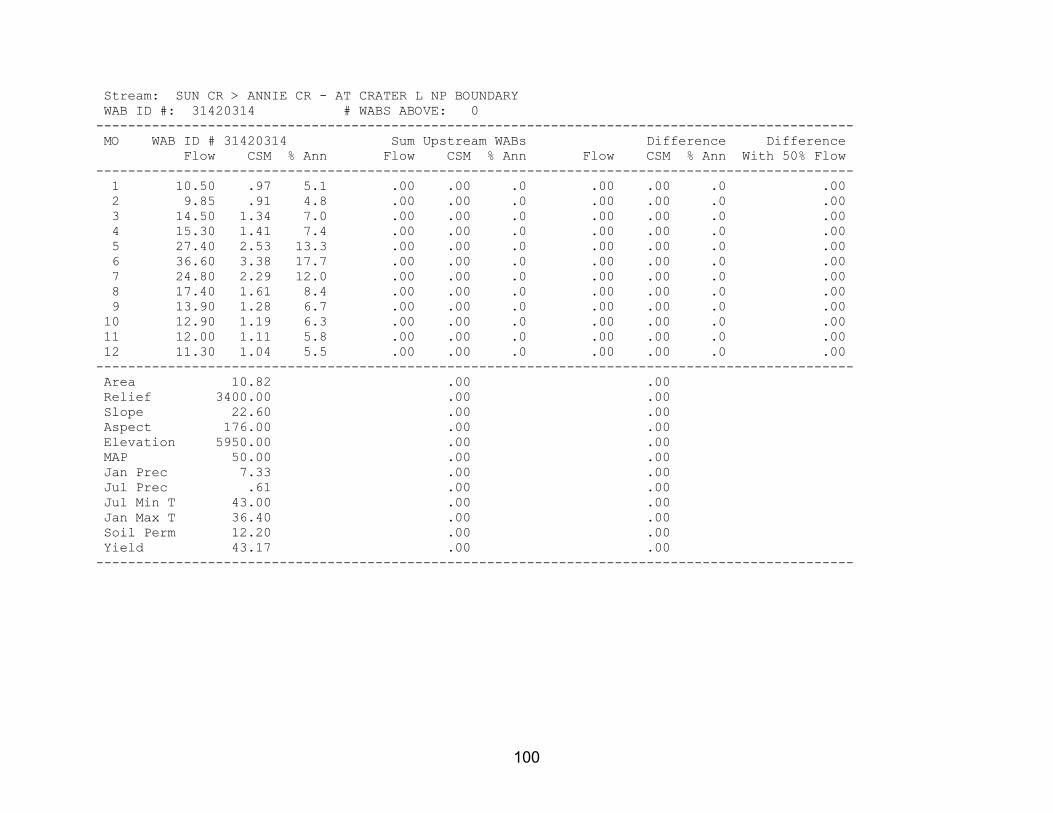
100
Stream: SUN CR > ANNIE CR - AT CRATER L NP BOUNDARY WAB ID #: 31420314 # WABS ABOVE: 0 ----------------------------------------------------------------------------------------------- MO WAB ID # 31420314 Sum Upstream WABs Difference Difference Flow CSM % Ann Flow CSM % Ann Flow CSM % Ann With 50% Flow ----------------------------------------------------------------------------------------------- 1 10.50 .97 5.1 .00 .00 .0 .00 .00 .0 .00 2 9.85 .91 4.8 .00 .00 .0 .00 .00 .0 .00 3 14.50 1.34 7.0 .00 .00 .0 .00 .00 .0 .00 4 15.30 1.41 7.4 .00 .00 .0 .00 .00 .0 .00 5 27.40 2.53 13.3 .00 .00 .0 .00 .00 .0 .00 6 36.60 3.38 17.7 .00 .00 .0 .00 .00 .0 .00 7 24.80 2.29 12.0 .00 .00 .0 .00 .00 .0 .00 8 17.40 1.61 8.4 .00 .00 .0 .00 .00 .0 .00 9 13.90 1.28 6.7 .00 .00 .0 .00 .00 .0 .00 10 12.90 1.19 6.3 .00 .00 .0 .00 .00 .0 .00 11 12.00 1.11 5.8 .00 .00 .0 .00 .00 .0 .00 12 11.30 1.04 5.5 .00 .00 .0 .00 .00 .0 .00 ----------------------------------------------------------------------------------------------- Area 10.82 .00 .00 Relief 3400.00 .00 .00 Slope 22.60 .00 .00 Aspect 176.00 .00 .00 Elevation 5950.00 .00 .00 MAP 50.00 .00 .00 Jan Prec 7.33 .00 .00 Jul Prec .61 .00 .00 Jul Min T 43.00 .00 .00 Jan Max T 36.40 .00 .00 Soil Perm 12.20 .00 .00 Yield 43.17 .00 .00 -----------------------------------------------------------------------------------------------

101
Stream: UNN STR > ANNIE CR - AT CRATER L NP BOUNDARY WAB ID #: 31420309 # WABS ABOVE: 0 ----------------------------------------------------------------------------------------------- MO WAB ID # 31420309 Sum Upstream WABs Difference Difference Flow CSM % Ann Flow CSM % Ann Flow CSM % Ann With 50% Flow ----------------------------------------------------------------------------------------------- 1 3.25 .94 9.7 .00 .00 .0 .00 .00 .0 .00 2 3.24 .93 9.7 .00 .00 .0 .00 .00 .0 .00 3 2.83 .82 8.4 .00 .00 .0 .00 .00 .0 .00 4 2.64 .76 7.9 .00 .00 .0 .00 .00 .0 .00 5 3.48 1.00 10.4 .00 .00 .0 .00 .00 .0 .00 6 4.21 1.21 12.6 .00 .00 .0 .00 .00 .0 .00 7 3.29 .95 9.8 .00 .00 .0 .00 .00 .0 .00 8 1.93 .56 5.8 .00 .00 .0 .00 .00 .0 .00 9 1.70 .49 5.1 .00 .00 .0 .00 .00 .0 .00 10 1.45 .42 4.3 .00 .00 .0 .00 .00 .0 .00 11 2.25 .65 6.7 .00 .00 .0 .00 .00 .0 .00 12 3.22 .93 9.6 .00 .00 .0 .00 .00 .0 .00 ----------------------------------------------------------------------------------------------- Area 3.47 .00 .00 Relief 2510.00 .00 .00 Slope 13.90 .00 .00 Aspect 156.00 .00 .00 Elevation 5550.00 .00 .00 MAP 45.50 .00 .00 Jan Prec 6.20 .00 .00 Jul Prec .61 .00 .00 Jul Min T 42.60 .00 .00 Jan Max T 37.50 .00 .00 Soil Perm 12.40 .00 .00 Yield 24.02 .00 .00 -----------------------------------------------------------------------------------------------

102
Stream: ANNIE CR > WOOD R - AT NF BOUNDARY (32S 6E 36 NENE) WAB ID #: 31420328 # WABS ABOVE: 1 Streams Above: 1 ANNIE CR > WOOD R - AT CRATER L NP BOUNDARY ----------------------------------------------------------------------------------------------- MO WAB ID # 31420328 Sum Upstream WABs Difference Difference Flow CSM % Ann Flow CSM % Ann Flow CSM % Ann With 50% Flow ----------------------------------------------------------------------------------------------- 1 47.50 1.64 5.7 47.50 1.67 5.7 .00 .00 .0 .00 2 44.70 1.55 5.3 44.70 1.57 5.3 .00 .00 .0 .00 3 53.30 1.84 6.4 53.30 1.87 6.4 .00 .00 .0 .00 4 61.50 2.13 7.3 61.50 2.16 7.3 .00 .00 .0 .00 5 104.00 3.60 12.4 104.00 3.65 12.4 .00 .00 .0 .00 6 138.00 4.77 16.5 138.00 4.84 16.5 .00 .00 .0 .00 7 97.80 3.38 11.7 97.80 3.43 11.7 .00 .00 .0 .00 8 72.40 2.51 8.6 72.40 2.54 8.6 .00 .00 .0 .00 9 59.60 2.06 7.1 59.60 2.09 7.1 .00 .00 .0 .00 10 55.10 1.91 6.6 55.10 1.93 6.6 .00 .00 .0 .00 11 52.10 1.80 6.2 52.10 1.83 6.2 .00 .00 .0 .00 12 52.10 1.80 6.2 52.10 1.83 6.2 .00 .00 .0 .00 ----------------------------------------------------------------------------------------------- Area 28.90 28.51 .40 Relief 3420.00 3400.00 -9999.00 Slope 13.50 13.70 .08 Aspect 163.00 164.00 116.00 Elevation 6030.00 6050.00 4370.00 MAP 58.10 58.50 31.80 Jan Prec 8.25 8.30 5.01 Jul Prec .67 .67 .38 Jul Min T 41.50 41.50 41.00 Jan Max T 35.80 35.80 39.10 Soil Perm 7.06 7.05 8.29 Yield 56.50 56.93 .00 -----------------------------------------------------------------------------------------------

103
Stream: ANNIE CR > WOOD R - AT CRATER L NP BOUNDARY WAB ID #: 31420333 # WABS ABOVE: 0 ----------------------------------------------------------------------------------------------- MO WAB ID # 31420333 Sum Upstream WABs Difference Difference Flow CSM % Ann Flow CSM % Ann Flow CSM % Ann With 50% Flow ----------------------------------------------------------------------------------------------- 1 47.50 1.67 5.7 .00 .00 .0 .00 .00 .0 .00 2 44.70 1.57 5.3 .00 .00 .0 .00 .00 .0 .00 3 53.30 1.87 6.4 .00 .00 .0 .00 .00 .0 .00 4 61.50 2.16 7.3 .00 .00 .0 .00 .00 .0 .00 5 104.00 3.65 12.4 .00 .00 .0 .00 .00 .0 .00 6 138.00 4.84 16.5 .00 .00 .0 .00 .00 .0 .00 7 97.80 3.43 11.7 .00 .00 .0 .00 .00 .0 .00 8 72.40 2.54 8.6 .00 .00 .0 .00 .00 .0 .00 9 59.60 2.09 7.1 .00 .00 .0 .00 .00 .0 .00 10 55.10 1.93 6.6 .00 .00 .0 .00 .00 .0 .00 11 52.10 1.83 6.2 .00 .00 .0 .00 .00 .0 .00 12 52.10 1.83 6.2 .00 .00 .0 .00 .00 .0 .00 ----------------------------------------------------------------------------------------------- Area 28.51 .00 .00 Relief 3400.00 .00 .00 Slope 13.70 .00 .00 Aspect 164.00 .00 .00 Elevation 6050.00 .00 .00 MAP 58.50 .00 .00 Jan Prec 8.30 .00 .00 Jul Prec .67 .00 .00 Jul Min T 41.50 .00 .00 Jan Max T 35.80 .00 .00 Soil Perm 7.05 .00 .00 Yield 56.93 .00 .00 -----------------------------------------------------------------------------------------------

104
Stream: CROOKED CR > WOOD R - AT MOUTH WAB ID #: 70807 # WABS ABOVE: 0 ----------------------------------------------------------------------------------------------- MO WAB ID # 70807 Sum Upstream WABs Difference Difference Flow CSM % Ann Flow CSM % Ann Flow CSM % Ann With 50% Flow ----------------------------------------------------------------------------------------------- 1 84.90 10.80 8.1 .00 .00 .0 .00 .00 .0 .00 2 85.00 10.81 8.1 .00 .00 .0 .00 .00 .0 .00 3 93.60 11.91 9.0 .00 .00 .0 .00 .00 .0 .00 4 93.80 11.93 9.0 .00 .00 .0 .00 .00 .0 .00 5 84.60 10.76 8.1 .00 .00 .0 .00 .00 .0 .00 6 85.00 10.81 8.1 .00 .00 .0 .00 .00 .0 .00 7 80.50 10.24 7.7 .00 .00 .0 .00 .00 .0 .00 8 83.20 10.59 8.0 .00 .00 .0 .00 .00 .0 .00 9 81.90 10.42 7.8 .00 .00 .0 .00 .00 .0 .00 10 92.50 11.77 8.9 .00 .00 .0 .00 .00 .0 .00 11 90.60 11.53 8.7 .00 .00 .0 .00 .00 .0 .00 12 89.60 11.40 8.6 .00 .00 .0 .00 .00 .0 .00 ----------------------------------------------------------------------------------------------- Area 7.86 .00 .00 Relief 643.00 .00 .00 Slope 9.87 .00 .00 Aspect 213.00 .00 .00 Elevation 4440.00 .00 .00 MAP 20.90 .00 .00 Jan Prec 3.17 .00 .00 Jul Prec .31 .00 .00 Jul Min T 39.10 .00 .00 Jan Max T 39.60 .00 .00 Soil Perm 10.40 .00 .00 Yield 719.77 .00 .00 -----------------------------------------------------------------------------------------------

105
Stream: WILLIAMSON R > UPPER KLAMATH L - AT MOUTH WAB ID #: 70826 # WABS ABOVE: 1 Streams Above: 1 WILLIAMSON R > UPPER KLAMATH L - AT HWY 97 CROSSING ----------------------------------------------------------------------------------------------- MO WAB ID # 70826 Sum Upstream WABs Difference Difference Flow CSM % Ann Flow CSM % Ann Flow CSM % Ann With 50% Flow ----------------------------------------------------------------------------------------------- 1 1030.00 .34 7.3 1030.00 .34 7.3 .00 .00 .0 .00 2 1330.00 .44 9.4 1330.00 .44 9.4 .00 .00 .0 .00 3 1670.00 .55 11.8 1660.00 .55 11.8 10.00 .56 47.6 .00 4 2180.00 .72 15.5 2170.00 .72 15.4 10.00 .56 47.6 .00 5 1970.00 .65 14.0 1970.00 .66 14.0 .00 .00 .0 .00 6 1220.00 .40 8.6 1220.00 .41 8.7 .00 .00 .0 .00 7 715.00 .24 5.1 715.00 .24 5.1 .00 .00 .0 .00 8 620.00 .21 4.4 620.00 .21 4.4 .00 .00 .0 .00 9 656.00 .22 4.7 656.00 .22 4.7 .00 .00 .0 .00 10 740.00 .24 5.3 740.00 .25 5.3 .00 .00 .0 .00 11 916.00 .30 6.5 915.00 .30 6.5 1.00 .06 4.8 .00 12 1050.00 .35 7.4 1050.00 .35 7.5 .00 .00 .0 .00 ----------------------------------------------------------------------------------------------- Area 3024.00 3006.00 17.95 Relief 4680.00 4630.00 -9999.00 Slope 5.62 5.64 3.44 Aspect 179.00 178.00 196.00 Elevation 5180.00 5190.00 4330.00 MAP 24.80 24.80 20.10 Jan Prec 3.22 3.22 3.05 Jul Prec .57 .57 .41 Jul Min T 41.40 41.40 39.90 Jan Max T 38.60 38.60 39.60 Soil Perm 8.83 8.88 1.80 Yield 21.28 21.35 6.59 -----------------------------------------------------------------------------------------------

106
Stream: WILLIAMSON R > UPPER KLAMATH L - AT HWY 97 CROSSING WAB ID #: 31420125 # WABS ABOVE: 2 Streams Above: 1 SPRAGUE R > WILLIAMSON R - AT MOUTH 2 WILLIAMSON R > UPPER KLAMATH L - AB SPRAGUE R ----------------------------------------------------------------------------------------------- MO WAB ID # 31420125 Sum Upstream WABs Difference Difference Flow CSM % Ann Flow CSM % Ann Flow CSM % Ann With 50% Flow ----------------------------------------------------------------------------------------------- 1 1030.00 .34 7.3 1020.00 .34 7.3 10.00 1.09 50.0 .00 2 1330.00 .44 9.4 1290.00 .43 9.1 44.00 4.80 220.0 .00 3* 1660.00 .55 11.8 1680.00 .56 12.0 -22.00 -2.40 -110.0 .00 4 2170.00 .72 15.4 2170.00 .72 15.4 4.00 .44 20.0 .00 5* 1970.00 .66 14.0 1990.00 .66 14.2 -20.00 -2.18 -100.0 .00 6* 1220.00 .41 8.7 1250.00 .42 8.9 -32.00 -3.49 -160.0 .00 7* 715.00 .24 5.1 746.00 .25 5.3 -31.00 -3.38 -155.0 .00 8* 620.00 .21 4.4 632.00 .21 4.5 -12.00 -1.31 -60.0 .00 9* 656.00 .22 4.7 661.00 .22 4.7 -5.00 -.55 -25.0 .00 10 740.00 .25 5.3 723.00 .24 5.1 17.00 1.85 85.0 .00 11 915.00 .30 6.5 868.00 .29 6.2 47.00 5.12 235.0 .00 12 1050.00 .35 7.5 1030.00 .34 7.3 20.00 2.18 100.0 .00 ----------------------------------------------------------------------------------------------- Area 3006.00 2997.00 9.17 Relief 4630.00 -9999.00 -9999.00 Slope 5.64 5.63 6.04 Aspect 178.00 178.00 178.00 Elevation 5190.00 5190.00 4360.00 MAP 24.80 24.80 18.70 Jan Prec 3.22 3.22 3.12 Jul Prec .57 .58 .24 Jul Min T 41.40 41.40 39.30 Jan Max T 38.60 38.60 39.60 Soil Perm 8.88 8.90 2.17 Yield 21.35 21.37 13.20 -----------------------------------------------------------------------------------------------

107
Stream: SPRAGUE R > WILLIAMSON R - AT MOUTH WAB ID #: 70806 # WABS ABOVE: 1 Streams Above: 1 SPRAGUE R > WILLIAMSON R - AT CHILOQUIN DAM ----------------------------------------------------------------------------------------------- MO WAB ID # 70806 Sum Upstream WABs Difference Difference Flow CSM % Ann Flow CSM % Ann Flow CSM % Ann With 50% Flow ----------------------------------------------------------------------------------------------- 1 435.00 .27 6.0 435.00 .27 6.0 .00 .00 .0 .00 2 578.00 .36 7.9 578.00 .36 7.9 .00 .00 .0 .00 3 849.00 .53 11.7 849.00 .53 11.7 .00 .00 .0 .00 4 1290.00 .80 17.7 1290.00 .80 17.7 .00 .00 .0 .00 5 1320.00 .82 18.1 1320.00 .82 18.1 .00 .00 .0 .00 6 745.00 .46 10.2 745.00 .46 10.2 .00 .00 .0 .00 7 354.00 .22 4.9 354.00 .22 4.9 .00 .00 .0 .00 8 264.00 .16 3.6 264.00 .16 3.6 .00 .00 .0 .00 9 290.00 .18 4.0 290.00 .18 4.0 .00 .00 .0 .00 10 350.00 .22 4.8 350.00 .22 4.8 .00 .00 .0 .00 11 379.00 .24 5.2 379.00 .24 5.2 .00 .00 .0 .00 12 427.00 .27 5.9 427.00 .27 5.9 .00 .00 .0 .00 ----------------------------------------------------------------------------------------------- Area 1610.00 1610.00 .68 Relief 4100.00 4100.00 -9999.00 Slope 6.23 6.23 8.59 Aspect 186.00 186.00 177.00 Elevation 5270.00 5270.00 4340.00 MAP 22.90 22.90 18.10 Jan Prec 2.76 2.76 2.76 Jul Prec .60 .60 .60 Jul Min T 42.70 42.70 38.00 Jan Max T 39.00 39.00 41.30 Soil Perm 5.44 5.44 3.08 Yield 22.39 22.40 .00 -----------------------------------------------------------------------------------------------
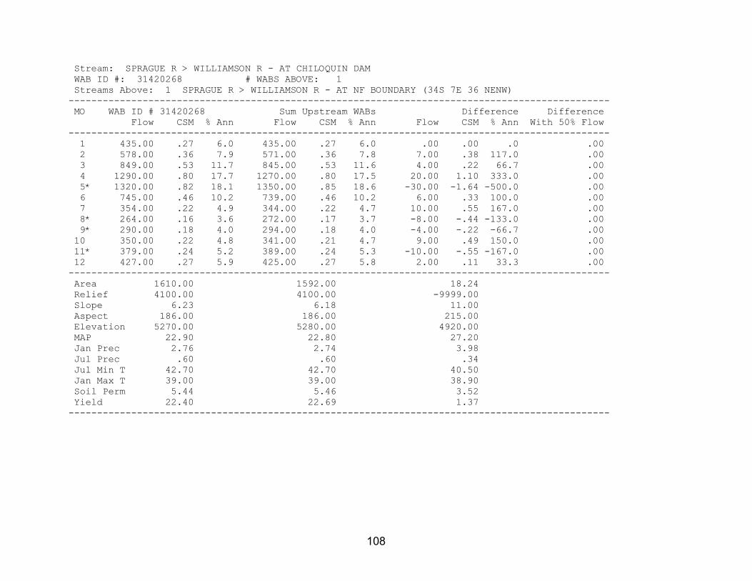
108
Stream: SPRAGUE R > WILLIAMSON R - AT CHILOQUIN DAM WAB ID #: 31420268 # WABS ABOVE: 1 Streams Above: 1 SPRAGUE R > WILLIAMSON R - AT NF BOUNDARY (34S 7E 36 NENW) ----------------------------------------------------------------------------------------------- MO WAB ID # 31420268 Sum Upstream WABs Difference Difference Flow CSM % Ann Flow CSM % Ann Flow CSM % Ann With 50% Flow ----------------------------------------------------------------------------------------------- 1 435.00 .27 6.0 435.00 .27 6.0 .00 .00 .0 .00 2 578.00 .36 7.9 571.00 .36 7.8 7.00 .38 117.0 .00 3 849.00 .53 11.7 845.00 .53 11.6 4.00 .22 66.7 .00 4 1290.00 .80 17.7 1270.00 .80 17.5 20.00 1.10 333.0 .00 5* 1320.00 .82 18.1 1350.00 .85 18.6 -30.00 -1.64 -500.0 .00 6 745.00 .46 10.2 739.00 .46 10.2 6.00 .33 100.0 .00 7 354.00 .22 4.9 344.00 .22 4.7 10.00 .55 167.0 .00 8* 264.00 .16 3.6 272.00 .17 3.7 -8.00 -.44 -133.0 .00 9* 290.00 .18 4.0 294.00 .18 4.0 -4.00 -.22 -66.7 .00 10 350.00 .22 4.8 341.00 .21 4.7 9.00 .49 150.0 .00 11* 379.00 .24 5.2 389.00 .24 5.3 -10.00 -.55 -167.0 .00 12 427.00 .27 5.9 425.00 .27 5.8 2.00 .11 33.3 .00 ----------------------------------------------------------------------------------------------- Area 1610.00 1592.00 18.24 Relief 4100.00 4100.00 -9999.00 Slope 6.23 6.18 11.00 Aspect 186.00 186.00 215.00 Elevation 5270.00 5280.00 4920.00 MAP 22.90 22.80 27.20 Jan Prec 2.76 2.74 3.98 Jul Prec .60 .60 .34 Jul Min T 42.70 42.70 40.50 Jan Max T 39.00 39.00 38.90 Soil Perm 5.44 5.46 3.52 Yield 22.40 22.69 1.37 -----------------------------------------------------------------------------------------------

109
Stream: SPRAGUE R > WILLIAMSON R - AT NF BOUNDARY (34S 7E 36 NENW) WAB ID #: 31420266 # WABS ABOVE: 1 Streams Above: 1 SPRAGUE R > WILLIAMSON R - AT BRAYMILL ----------------------------------------------------------------------------------------------- MO WAB ID # 31420266 Sum Upstream WABs Difference Difference Flow CSM % Ann Flow CSM % Ann Flow CSM % Ann With 50% Flow ----------------------------------------------------------------------------------------------- 1 435.00 .27 6.0 435.00 .27 6.0 .00 .00 .0 .00 2 571.00 .36 7.8 570.00 .36 7.8 1.00 .20 33.3 .00 3 845.00 .53 11.6 844.00 .53 11.6 1.00 .20 33.3 .00 4 1270.00 .80 17.5 1270.00 .80 17.5 .00 .00 .0 .00 5 1350.00 .85 18.6 1350.00 .85 18.6 .00 .00 .0 .00 6 739.00 .46 10.2 738.00 .47 10.1 1.00 .20 33.3 .00 7 344.00 .22 4.7 344.00 .22 4.7 .00 .00 .0 .00 8 272.00 .17 3.7 272.00 .17 3.7 .00 .00 .0 .00 9 294.00 .18 4.0 294.00 .19 4.0 .00 .00 .0 .00 10 341.00 .21 4.7 341.00 .21 4.7 .00 .00 .0 .00 11 389.00 .24 5.3 389.00 .25 5.3 .00 .00 .0 .00 12 425.00 .27 5.8 425.00 .27 5.8 .00 .00 .0 .00 ----------------------------------------------------------------------------------------------- Area 1592.00 1587.00 4.95 Relief 4100.00 4000.00 -9999.00 Slope 6.18 6.17 8.10 Aspect 186.00 186.00 189.00 Elevation 5280.00 5280.00 4630.00 MAP 22.80 22.80 21.20 Jan Prec 2.74 2.74 3.06 Jul Prec .60 .61 .28 Jul Min T 42.70 42.70 39.50 Jan Max T 39.00 39.00 39.60 Soil Perm 5.46 5.47 3.54 Yield 22.69 22.74 3.24 -----------------------------------------------------------------------------------------------

110
Stream: SPRAGUE R > WILLIAMSON R - AT BRAYMILL WAB ID #: 31420231 # WABS ABOVE: 1 Streams Above: 1 SPRAGUE R > WILLIAMSON R - AT UPPER S'OCHOLIS CAN ----------------------------------------------------------------------------------------------- MO WAB ID # 31420231 Sum Upstream WABs Difference Difference Flow CSM % Ann Flow CSM % Ann Flow CSM % Ann With 50% Flow ----------------------------------------------------------------------------------------------- 1 435.00 .27 6.0 361.00 .25 5.7 74.00 .49 7.9 .00 2 570.00 .36 7.8 480.00 .33 7.6 90.00 .59 9.6 .00 3 844.00 .53 11.6 744.00 .52 11.7 100.00 .66 10.7 .00 4 1270.00 .80 17.5 1140.00 .79 18.0 130.00 .86 13.9 .00 5 1350.00 .85 18.6 1260.00 .88 19.9 90.00 .59 9.6 .00 6 738.00 .47 10.1 645.00 .45 10.2 93.00 .61 9.9 .00 7 344.00 .22 4.7 295.00 .21 4.7 49.00 .32 5.2 .00 8 272.00 .17 3.7 225.00 .16 3.5 47.00 .31 5.0 .00 9 294.00 .19 4.0 244.00 .17 3.8 50.00 .33 5.3 .00 10 341.00 .21 4.7 280.00 .20 4.4 61.00 .40 6.5 .00 11 389.00 .25 5.3 314.00 .22 5.0 75.00 .50 8.0 .00 12 425.00 .27 5.8 347.00 .24 5.5 78.00 .52 8.3 .00 ----------------------------------------------------------------------------------------------- Area 1587.00 1435.00 151.30 Relief 4000.00 4000.00 -9999.00 Slope 6.17 6.07 7.14 Aspect 186.00 186.00 185.00 Elevation 5280.00 5330.00 4800.00 MAP 22.80 22.90 22.10 Jan Prec 2.74 2.71 3.01 Jul Prec .61 .62 .44 Jul Min T 42.70 43.00 40.00 Jan Max T 39.00 38.90 39.30 Soil Perm 5.47 5.26 7.39 Yield 22.74 21.84 31.65 -----------------------------------------------------------------------------------------------

111
Stream: SPRAGUE R > WILLIAMSON R - AT UPPER S'OCHOLIS CAN WAB ID #: 31420262 # WABS ABOVE: 1 Streams Above: 1 SPRAGUE R > WILLIAMSON R - AT LONE PINE ----------------------------------------------------------------------------------------------- MO WAB ID # 31420262 Sum Upstream WABs Difference Difference Flow CSM % Ann Flow CSM % Ann Flow CSM % Ann With 50% Flow ----------------------------------------------------------------------------------------------- 1 361.00 .25 5.7 361.00 .25 5.7 .00 .00 .0 .00 2 480.00 .33 7.6 479.00 .33 7.6 1.00 .34 50.0 .00 3 744.00 .52 11.7 743.00 .52 11.7 1.00 .34 50.0 .00 4 1140.00 .79 18.0 1140.00 .80 18.0 .00 .00 .0 .00 5 1260.00 .88 19.9 1260.00 .88 19.9 .00 .00 .0 .00 6 645.00 .45 10.2 645.00 .45 10.2 .00 .00 .0 .00 7 295.00 .21 4.7 295.00 .21 4.7 .00 .00 .0 .00 8 225.00 .16 3.5 225.00 .16 3.5 .00 .00 .0 .00 9 244.00 .17 3.8 244.00 .17 3.8 .00 .00 .0 .00 10 280.00 .20 4.4 280.00 .20 4.4 .00 .00 .0 .00 11 314.00 .22 5.0 314.00 .22 5.0 .00 .00 .0 .00 12 347.00 .24 5.5 347.00 .24 5.5 .00 .00 .0 .00 ----------------------------------------------------------------------------------------------- Area 1435.00 1432.00 2.94 Relief 4000.00 4000.00 -9999.00 Slope 6.07 6.06 8.99 Aspect 186.00 186.00 158.00 Elevation 5330.00 5330.00 4660.00 MAP 22.90 22.90 19.50 Jan Prec 2.71 2.71 2.71 Jul Prec .62 .62 .62 Jul Min T 43.00 43.00 41.50 Jan Max T 38.90 38.90 39.40 Soil Perm 5.26 5.27 2.83 Yield 21.84 21.87 3.95 -----------------------------------------------------------------------------------------------

112
Stream: SPRAGUE R > WILLIAMSON R - AT LONE PINE WAB ID #: 70805 # WABS ABOVE: 2 Streams Above: 1 TROUT CR > SPRAGUE R - AT MOUTH 2 SPRAGUE R > WILLIAMSON R - AB TROUT CR ----------------------------------------------------------------------------------------------- MO WAB ID # 70805 Sum Upstream WABs Difference Difference Flow CSM % Ann Flow CSM % Ann Flow CSM % Ann With 50% Flow ----------------------------------------------------------------------------------------------- 1 361.00 .25 5.7 355.00 .26 5.7 6.21 .11 6.0 .00 2 479.00 .33 7.6 467.00 .34 7.5 12.00 .22 11.6 .00 3 743.00 .52 11.7 729.00 .53 11.7 13.90 .25 13.4 .00 4 1140.00 .80 18.0 1110.00 .80 17.8 31.70 .57 30.6 .00 5 1260.00 .88 19.9 1250.00 .91 20.1 10.90 .20 10.5 .00 6 645.00 .45 10.2 631.00 .46 10.1 13.50 .25 13.1 .00 7 295.00 .21 4.7 294.00 .21 4.7 .87 .02 .8 .00 8 225.00 .16 3.5 225.00 .16 3.6 .35 .01 .3 .00 9 244.00 .17 3.8 244.00 .18 3.9 .26 .00 .3 .00 10 280.00 .20 4.4 278.00 .20 4.5 2.08 .04 2.0 .00 11 314.00 .22 5.0 309.00 .22 5.0 5.03 .09 4.8 .00 12 347.00 .24 5.5 340.00 .25 5.5 6.81 .12 6.6 .00 ----------------------------------------------------------------------------------------------- Area 1432.00 1377.00 55.13 Relief 4000.00 -9999.00 -9999.00 Slope 6.06 6.01 7.31 Aspect 186.00 186.00 179.00 Elevation 5330.00 5350.00 4920.00 MAP 22.90 23.00 21.30 Jan Prec 2.71 2.71 2.74 Jul Prec .62 .63 .54 Jul Min T 43.00 43.10 40.50 Jan Max T 38.90 38.90 39.40 Soil Perm 5.27 5.25 5.84 Yield 21.87 22.31 9.97 -----------------------------------------------------------------------------------------------

113
Stream: TROUT CR > SPRAGUE R - AT MOUTH WAB ID #: 31420203 # WABS ABOVE: 0 ----------------------------------------------------------------------------------------------- MO WAB ID # 31420203 Sum Upstream WABs Difference Difference Flow CSM % Ann Flow CSM % Ann Flow CSM % Ann With 50% Flow ----------------------------------------------------------------------------------------------- 1 1.79 .06 3.6 .00 .00 .0 .00 .00 .0 .00 2 3.02 .11 6.1 .00 .00 .0 .00 .00 .0 .00 3 4.12 .15 8.3 .00 .00 .0 .00 .00 .0 .00 4 8.30 .29 16.8 .00 .00 .0 .00 .00 .0 .00 5 9.08 .32 18.4 .00 .00 .0 .00 .00 .0 .00 6 5.47 .19 11.1 .00 .00 .0 .00 .00 .0 .00 7 3.13 .11 6.3 .00 .00 .0 .00 .00 .0 .00 8 2.65 .09 5.4 .00 .00 .0 .00 .00 .0 .00 9 2.74 .10 5.6 .00 .00 .0 .00 .00 .0 .00 10 2.92 .10 5.9 .00 .00 .0 .00 .00 .0 .00 11 2.97 .11 6.0 .00 .00 .0 .00 .00 .0 .00 12 3.19 .11 6.5 .00 .00 .0 .00 .00 .0 .00 ----------------------------------------------------------------------------------------------- Area 28.27 .00 .00 Relief 2900.00 .00 .00 Slope 11.70 .00 .00 Aspect 98.90 .00 .00 Elevation 5430.00 .00 .00 MAP 26.10 .00 .00 Jan Prec 3.52 .00 .00 Jul Prec .59 .00 .00 Jul Min T 40.30 .00 .00 Jan Max T 38.50 .00 .00 Soil Perm 2.34 .00 .00 Yield 7.59 .00 .00 -----------------------------------------------------------------------------------------------
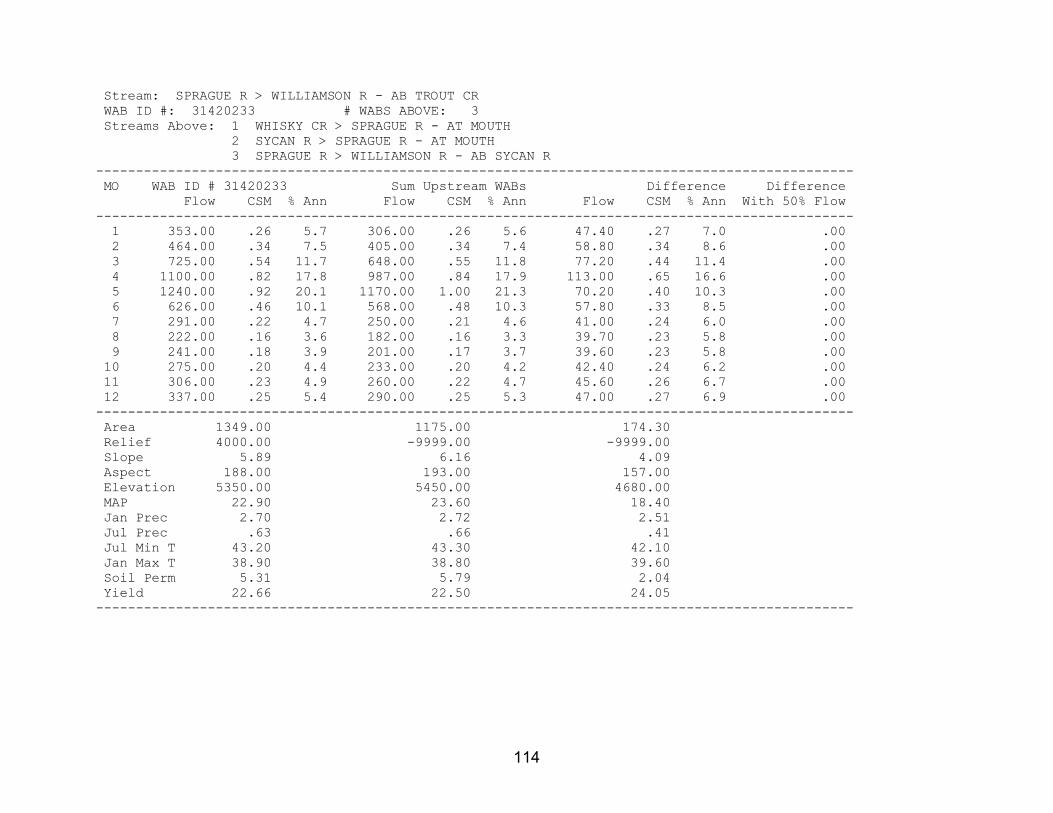
114
Stream: SPRAGUE R > WILLIAMSON R - AB TROUT CR WAB ID #: 31420233 # WABS ABOVE: 3 Streams Above: 1 WHISKY CR > SPRAGUE R - AT MOUTH 2 SYCAN R > SPRAGUE R - AT MOUTH 3 SPRAGUE R > WILLIAMSON R - AB SYCAN R ----------------------------------------------------------------------------------------------- MO WAB ID # 31420233 Sum Upstream WABs Difference Difference Flow CSM % Ann Flow CSM % Ann Flow CSM % Ann With 50% Flow ----------------------------------------------------------------------------------------------- 1 353.00 .26 5.7 306.00 .26 5.6 47.40 .27 7.0 .00 2 464.00 .34 7.5 405.00 .34 7.4 58.80 .34 8.6 .00 3 725.00 .54 11.7 648.00 .55 11.8 77.20 .44 11.4 .00 4 1100.00 .82 17.8 987.00 .84 17.9 113.00 .65 16.6 .00 5 1240.00 .92 20.1 1170.00 1.00 21.3 70.20 .40 10.3 .00 6 626.00 .46 10.1 568.00 .48 10.3 57.80 .33 8.5 .00 7 291.00 .22 4.7 250.00 .21 4.6 41.00 .24 6.0 .00 8 222.00 .16 3.6 182.00 .16 3.3 39.70 .23 5.8 .00 9 241.00 .18 3.9 201.00 .17 3.7 39.60 .23 5.8 .00 10 275.00 .20 4.4 233.00 .20 4.2 42.40 .24 6.2 .00 11 306.00 .23 4.9 260.00 .22 4.7 45.60 .26 6.7 .00 12 337.00 .25 5.4 290.00 .25 5.3 47.00 .27 6.9 .00 ----------------------------------------------------------------------------------------------- Area 1349.00 1175.00 174.30 Relief 4000.00 -9999.00 -9999.00 Slope 5.89 6.16 4.09 Aspect 188.00 193.00 157.00 Elevation 5350.00 5450.00 4680.00 MAP 22.90 23.60 18.40 Jan Prec 2.70 2.72 2.51 Jul Prec .63 .66 .41 Jul Min T 43.20 43.30 42.10 Jan Max T 38.90 38.80 39.60 Soil Perm 5.31 5.79 2.04 Yield 22.66 22.50 24.05 -----------------------------------------------------------------------------------------------

115
Stream: WHISKY CR > SPRAGUE R - AT MOUTH WAB ID #: 31420206 # WABS ABOVE: 0 ----------------------------------------------------------------------------------------------- MO WAB ID # 31420206 Sum Upstream WABs Difference Difference Flow CSM % Ann Flow CSM % Ann Flow CSM % Ann With 50% Flow ----------------------------------------------------------------------------------------------- 1 27.80 .68 8.9 .00 .00 .0 .00 .00 .0 .00 2 29.20 .71 9.4 .00 .00 .0 .00 .00 .0 .00 3 29.80 .73 9.6 .00 .00 .0 .00 .00 .0 .00 4 31.10 .76 10.0 .00 .00 .0 .00 .00 .0 .00 5 33.80 .83 10.8 .00 .00 .0 .00 .00 .0 .00 6 29.20 .71 9.4 .00 .00 .0 .00 .00 .0 .00 7 21.70 .53 7.0 .00 .00 .0 .00 .00 .0 .00 8 19.50 .48 6.3 .00 .00 .0 .00 .00 .0 .00 9 19.40 .47 6.2 .00 .00 .0 .00 .00 .0 .00 10 20.10 .49 6.4 .00 .00 .0 .00 .00 .0 .00 11 23.10 .57 7.4 .00 .00 .0 .00 .00 .0 .00 12 26.90 .66 8.6 .00 .00 .0 .00 .00 .0 .00 ----------------------------------------------------------------------------------------------- Area 40.88 .00 .00 Relief 2800.00 .00 .00 Slope 6.94 .00 .00 Aspect 177.00 .00 .00 Elevation 4930.00 .00 .00 MAP 19.10 .00 .00 Jan Prec 2.58 .00 .00 Jul Prec .45 .00 .00 Jul Min T 44.50 .00 .00 Jan Max T 40.00 .00 .00 Soil Perm 1.51 .00 .00 Yield 45.24 .00 .00 -----------------------------------------------------------------------------------------------

116
Stream: SYCAN R > SPRAGUE R - AT MOUTH WAB ID #: 70823 # WABS ABOVE: 3 Streams Above: 1 SNAKE CR > SYCAN R - AT MOUTH 2 BLUE CR > SYCAN R - AT MOUTH 3 SYCAN R > SPRAGUE R - AB BLUE CR ----------------------------------------------------------------------------------------------- MO WAB ID # 70823 Sum Upstream WABs Difference Difference Flow CSM % Ann Flow CSM % Ann Flow CSM % Ann With 50% Flow ----------------------------------------------------------------------------------------------- 1* 70.80 .13 4.3 73.00 .13 4.7 -2.23 -.13 -2.2 .00 2 106.00 .19 6.4 98.00 .18 6.3 8.05 .45 7.8 .00 3 237.00 .42 14.2 172.00 .31 11.0 65.30 3.66 63.6 .00 4* 379.00 .67 22.7 398.00 .73 25.5 -19.40 -1.09 -18.9 .00 5 447.00 .79 26.8 440.00 .81 28.1 6.78 .38 6.6 .00 6 153.00 .27 9.2 148.00 .27 9.5 4.70 .26 4.6 .00 7 45.30 .08 2.7 40.50 .07 2.6 4.85 .27 4.7 .00 8 30.80 .05 1.9 25.80 .05 1.6 4.99 .28 4.9 .00 9 35.00 .06 2.1 28.80 .05 1.8 6.21 .35 6.1 .00 10 41.50 .07 2.5 34.60 .06 2.2 6.87 .39 6.7 .00 11 57.30 .10 3.4 43.90 .08 2.8 13.40 .75 13.1 .00 12 65.10 .12 3.9 62.00 .11 4.0 3.07 .17 3.0 .00 ----------------------------------------------------------------------------------------------- Area 563.20 545.40 17.82 Relief 3600.00 -9999.00 -9999.00 Slope 4.85 4.85 4.76 Aspect 193.00 194.00 172.00 Elevation 5550.00 5580.00 4580.00 MAP 25.20 25.40 17.80 Jan Prec 2.87 2.88 2.49 Jul Prec .73 .74 .38 Jul Min T 42.60 42.60 42.30 Jan Max T 38.30 38.20 39.60 Soil Perm 8.34 8.56 1.71 Yield 13.31 12.78 36.52 -----------------------------------------------------------------------------------------------

117
Stream: SNAKE CR > SYCAN R - AT MOUTH WAB ID #: 31420208 # WABS ABOVE: 0 ----------------------------------------------------------------------------------------------- MO WAB ID # 31420208 Sum Upstream WABs Difference Difference Flow CSM % Ann Flow CSM % Ann Flow CSM % Ann With 50% Flow ----------------------------------------------------------------------------------------------- 1 8.19 .32 9.8 .00 .00 .0 .00 .00 .0 .00 2 8.87 .35 10.6 .00 .00 .0 .00 .00 .0 .00 3 8.81 .34 10.5 .00 .00 .0 .00 .00 .0 .00 4 9.74 .38 11.7 .00 .00 .0 .00 .00 .0 .00 5 11.90 .46 14.2 .00 .00 .0 .00 .00 .0 .00 6 9.12 .36 10.9 .00 .00 .0 .00 .00 .0 .00 7 4.45 .17 5.3 .00 .00 .0 .00 .00 .0 .00 8 3.03 .12 3.6 .00 .00 .0 .00 .00 .0 .00 9 3.07 .12 3.7 .00 .00 .0 .00 .00 .0 .00 10 3.49 .14 4.2 .00 .00 .0 .00 .00 .0 .00 11 5.30 .21 6.3 .00 .00 .0 .00 .00 .0 .00 12 7.63 .30 9.1 .00 .00 .0 .00 .00 .0 .00 ----------------------------------------------------------------------------------------------- Area 25.67 .00 .00 Relief 1800.00 .00 .00 Slope 10.30 .00 .00 Aspect 191.00 .00 .00 Elevation 4880.00 .00 .00 MAP 19.30 .00 .00 Jan Prec 2.55 .00 .00 Jul Prec .47 .00 .00 Jul Min T 42.90 .00 .00 Jan Max T 39.60 .00 .00 Soil Perm 2.98 .00 .00 Yield 19.14 .00 .00 -----------------------------------------------------------------------------------------------

118
Stream: BLUE CR > SYCAN R - AT MOUTH WAB ID #: 31420209 # WABS ABOVE: 0 ----------------------------------------------------------------------------------------------- MO WAB ID # 31420209 Sum Upstream WABs Difference Difference Flow CSM % Ann Flow CSM % Ann Flow CSM % Ann With 50% Flow ----------------------------------------------------------------------------------------------- 1 6.44 .39 9.8 .00 .00 .0 .00 .00 .0 .00 2 6.98 .43 10.6 .00 .00 .0 .00 .00 .0 .00 3 6.93 .42 10.5 .00 .00 .0 .00 .00 .0 .00 4 7.66 .47 11.7 .00 .00 .0 .00 .00 .0 .00 5 9.32 .57 14.2 .00 .00 .0 .00 .00 .0 .00 6 7.18 .44 10.9 .00 .00 .0 .00 .00 .0 .00 7 3.50 .21 5.3 .00 .00 .0 .00 .00 .0 .00 8 2.38 .14 3.6 .00 .00 .0 .00 .00 .0 .00 9 2.42 .15 3.7 .00 .00 .0 .00 .00 .0 .00 10 2.74 .17 4.2 .00 .00 .0 .00 .00 .0 .00 11 4.17 .25 6.3 .00 .00 .0 .00 .00 .0 .00 12 6.00 .37 9.1 .00 .00 .0 .00 .00 .0 .00 ----------------------------------------------------------------------------------------------- Area 16.42 .00 .00 Relief 1800.00 .00 .00 Slope 7.80 .00 .00 Aspect 219.00 .00 .00 Elevation 5120.00 .00 .00 MAP 22.30 .00 .00 Jan Prec 2.75 .00 .00 Jul Prec .62 .00 .00 Jul Min T 41.80 .00 .00 Jan Max T 39.60 .00 .00 Soil Perm 4.38 .00 .00 Yield 20.33 .00 .00 -----------------------------------------------------------------------------------------------

119
Stream: SYCAN R > SPRAGUE R - AB BLUE CR WAB ID #: 31420269 # WABS ABOVE: 1 Streams Above: 1 SYCAN R > SPRAGUE R - AT NF BOUNDARY (34S 12E 31 SWSE) ----------------------------------------------------------------------------------------------- MO WAB ID # 31420269 Sum Upstream WABs Difference Difference Flow CSM % Ann Flow CSM % Ann Flow CSM % Ann With 50% Flow ----------------------------------------------------------------------------------------------- 1 58.40 .12 4.1 58.40 .12 4.1 .00 .00 .0 .00 2 82.10 .16 5.8 82.00 .16 5.8 .10 .17 100.0 .00 3 156.00 .31 11.0 156.00 .31 11.0 .00 .00 .0 .00 4 381.00 .76 26.9 381.00 .76 26.9 .00 .00 .0 .00 5 419.00 .83 29.6 419.00 .83 29.6 .00 .00 .0 .00 6 132.00 .26 9.3 132.00 .26 9.3 .00 .00 .0 .00 7 32.50 .06 2.3 32.50 .06 2.3 .00 .00 .0 .00 8 20.40 .04 1.4 20.40 .04 1.4 .00 .00 .0 .00 9 23.30 .05 1.6 23.30 .05 1.6 .00 .00 .0 .00 10 28.40 .06 2.0 28.40 .06 2.0 .00 .00 .0 .00 11 34.40 .07 2.4 34.40 .07 2.4 .00 .00 .0 .00 12 48.40 .10 3.4 48.40 .10 3.4 .00 .00 .0 .00 ----------------------------------------------------------------------------------------------- Area 503.30 502.70 .58 Relief 3400.00 3400.00 -9999.00 Slope 4.48 4.48 4.48 Aspect 193.00 193.00 166.00 Elevation 5630.00 5630.00 4690.00 MAP 25.80 25.80 21.50 Jan Prec 2.90 2.90 2.90 Jul Prec .76 .76 .76 Jul Min T 42.60 42.60 41.80 Jan Max T 38.10 38.10 39.80 Soil Perm 8.98 8.99 2.08 Yield 12.32 12.33 .90 -----------------------------------------------------------------------------------------------

120
Stream: SYCAN R > SPRAGUE R - AT NF BOUNDARY (34S 12E 31 SWSE) WAB ID #: 31420257 # WABS ABOVE: 1 Streams Above: 1 SYCAN R > SPRAGUE R - AT TEDDY POWERS MEADOW ----------------------------------------------------------------------------------------------- MO WAB ID # 31420257 Sum Upstream WABs Difference Difference Flow CSM % Ann Flow CSM % Ann Flow CSM % Ann With 50% Flow ----------------------------------------------------------------------------------------------- 1 58.40 .12 4.1 57.60 .12 4.1 .80 .04 4.5 .00 2 82.00 .16 5.8 80.90 .17 5.8 1.10 .06 6.2 .00 3 156.00 .31 11.0 152.00 .31 10.9 4.00 .21 22.3 .00 4 381.00 .76 26.9 376.00 .78 26.9 5.00 .27 27.9 .00 5 419.00 .83 29.6 414.00 .86 29.6 5.00 .27 27.9 .00 6 132.00 .26 9.3 131.00 .27 9.4 1.00 .05 5.6 .00 7 32.50 .06 2.3 32.30 .07 2.3 .20 .01 1.1 .00 8 20.40 .04 1.4 20.40 .04 1.5 .00 .00 .0 .00 9 23.30 .05 1.6 23.30 .05 1.7 .00 .00 .0 .00 10 28.40 .06 2.0 28.30 .06 2.0 .10 .01 .6 .00 11 34.40 .07 2.4 34.10 .07 2.4 .30 .02 1.7 .00 12 48.40 .10 3.4 48.00 .10 3.4 .40 .02 2.2 .00 ----------------------------------------------------------------------------------------------- Area 502.70 483.90 18.79 Relief 3400.00 3200.00 -9999.00 Slope 4.48 4.43 5.58 Aspect 193.00 195.00 155.00 Elevation 5630.00 5660.00 5030.00 MAP 25.80 26.00 22.20 Jan Prec 2.90 2.90 2.74 Jul Prec .76 .76 .65 Jul Min T 42.60 42.70 40.60 Jan Max T 38.10 38.10 39.50 Soil Perm 8.99 9.06 7.06 Yield 12.33 12.58 4.85 -----------------------------------------------------------------------------------------------

121
Stream: SYCAN R > SPRAGUE R - AT TEDDY POWERS MEADOW WAB ID #: 31420237 # WABS ABOVE: 1 Streams Above: 1 SYCAN R > SPRAGUE R - AB UNN STR AT RM 23 ----------------------------------------------------------------------------------------------- MO WAB ID # 31420237 Sum Upstream WABs Difference Difference Flow CSM % Ann Flow CSM % Ann Flow CSM % Ann With 50% Flow ----------------------------------------------------------------------------------------------- 1 57.60 .12 4.1 55.50 .13 4.1 2.10 .05 4.4 .00 2 80.90 .17 5.8 77.60 .18 5.8 3.30 .08 6.9 .00 3 152.00 .31 10.9 140.00 .32 10.4 12.00 .29 25.1 .00 4 376.00 .78 26.9 360.00 .81 26.7 16.00 .39 33.4 .00 5 414.00 .86 29.6 404.00 .91 29.9 10.00 .24 20.9 .00 6 131.00 .27 9.4 129.00 .29 9.6 2.00 .05 4.2 .00 7 32.30 .07 2.3 31.90 .07 2.4 .40 .01 .8 .00 8 20.40 .04 1.5 20.40 .05 1.5 .00 .00 .0 .00 9 23.30 .05 1.7 23.20 .05 1.7 .10 .00 .2 .00 10 28.30 .06 2.0 28.00 .06 2.1 .30 .01 .6 .00 11 34.10 .07 2.4 33.40 .08 2.5 .70 .02 1.5 .00 12 48.00 .10 3.4 47.00 .11 3.5 1.00 .02 2.1 .00 ----------------------------------------------------------------------------------------------- Area 483.90 442.50 41.39 Relief 3200.00 3000.00 -9999.00 Slope 4.43 4.48 3.93 Aspect 195.00 197.00 170.00 Elevation 5660.00 5700.00 5190.00 MAP 26.00 26.20 23.50 Jan Prec 2.90 2.91 2.81 Jul Prec .76 .77 .72 Jul Min T 42.70 42.90 40.30 Jan Max T 38.10 37.90 39.50 Soil Perm 9.06 8.90 10.90 Yield 12.58 13.17 5.58 -----------------------------------------------------------------------------------------------

122
Stream: SYCAN R > SPRAGUE R - AB UNN STR AT RM 23 WAB ID #: 70822 # WABS ABOVE: 1 Streams Above: 1 SYCAN R > SPRAGUE R - AT TORRENT SPRING ----------------------------------------------------------------------------------------------- MO WAB ID # 70822 Sum Upstream WABs Difference Difference Flow CSM % Ann Flow CSM % Ann Flow CSM % Ann With 50% Flow ----------------------------------------------------------------------------------------------- 1 55.50 .13 4.1 44.70 .10 3.7 10.80 2.91 8.3 .00 2 77.60 .18 5.8 66.30 .15 5.4 11.30 3.04 8.6 .00 3 140.00 .32 10.4 128.00 .29 10.5 12.00 3.23 9.2 .00 4 360.00 .81 26.7 348.00 .79 28.5 12.00 3.23 9.2 .00 5 404.00 .91 29.9 392.00 .89 32.2 12.00 3.23 9.2 .00 6 129.00 .29 9.6 118.00 .27 9.7 11.00 2.96 8.4 .00 7 31.90 .07 2.4 21.50 .05 1.8 10.40 2.80 7.9 .00 8 20.40 .05 1.5 10.20 .02 .8 10.20 2.74 7.8 .00 9 23.20 .05 1.7 13.00 .03 1.1 10.20 2.74 7.8 .00 10 28.00 .06 2.1 17.80 .04 1.5 10.20 2.74 7.8 .00 11 33.40 .08 2.5 23.10 .05 1.9 10.30 2.77 7.9 .00 12 47.00 .11 3.5 36.50 .08 3.0 10.50 2.82 8.0 .00 ----------------------------------------------------------------------------------------------- Area 442.50 438.80 3.72 Relief 3000.00 3000.00 -9999.00 Slope 4.48 4.50 2.59 Aspect 197.00 197.00 192.00 Elevation 5700.00 5710.00 5070.00 MAP 26.20 26.30 22.80 Jan Prec 2.91 2.92 2.68 Jul Prec .77 .77 .65 Jul Min T 42.90 43.00 40.10 Jan Max T 37.90 37.90 39.60 Soil Perm 8.90 8.88 11.40 Yield 13.17 11.98 174.85 -----------------------------------------------------------------------------------------------

123
Stream: SYCAN R > SPRAGUE R - AT TORRENT SPRING WAB ID #: 31420238 # WABS ABOVE: 4 Streams Above: 1 UNN STR > SYCAN R - AT MOUTH 2 UNN STR > SYCAN R - AT MOUTH 3 MERRITT CR > SYCAN R - AT MOUTH 4 SYCAN R > SPRAGUE R - AB MERRIT CR ----------------------------------------------------------------------------------------------- MO WAB ID # 31420238 Sum Upstream WABs Difference Difference Flow CSM % Ann Flow CSM % Ann Flow CSM % Ann With 50% Flow ----------------------------------------------------------------------------------------------- 1 44.70 .10 3.7 44.60 .10 3.7 .15 .03 2.4 .00 2 66.30 .15 5.4 66.00 .15 5.4 .30 .05 4.8 .00 3 128.00 .29 10.5 127.00 .29 10.5 .68 .12 10.8 .00 4 348.00 .79 28.5 346.00 .80 28.5 1.92 .32 30.5 .00 5 392.00 .89 32.2 390.00 .90 32.1 2.47 .42 39.3 .00 6 118.00 .27 9.7 118.00 .27 9.7 .36 .06 5.7 .00 7 21.50 .05 1.8 21.40 .05 1.8 .11 .02 1.8 .00 8 10.20 .02 .8 10.20 .02 .8 .00 .00 .0 .00 9 13.00 .03 1.1 12.90 .03 1.1 .07 .01 1.1 .00 10 17.80 .04 1.5 17.70 .04 1.5 .09 .02 1.4 .00 11 23.10 .05 1.9 23.00 .05 1.9 .09 .02 1.4 .00 12 36.50 .08 3.0 36.50 .08 3.0 .05 .01 .8 .00 ----------------------------------------------------------------------------------------------- Area 438.80 432.90 5.91 Relief 3000.00 -9999.00 -9999.00 Slope 4.50 4.54 1.45 Aspect 197.00 197.00 182.00 Elevation 5710.00 5720.00 5060.00 MAP 26.30 26.30 22.40 Jan Prec 2.92 2.92 2.79 Jul Prec .77 .77 .67 Jul Min T 43.00 43.00 40.90 Jan Max T 37.90 37.90 39.60 Soil Perm 8.88 8.86 10.10 Yield 11.98 12.06 5.37 -----------------------------------------------------------------------------------------------

124
Stream: UNN STR > SYCAN R - AT MOUTH WAB ID #: 31420210 # WABS ABOVE: 0 ----------------------------------------------------------------------------------------------- MO WAB ID # 31420210 Sum Upstream WABs Difference Difference Flow CSM % Ann Flow CSM % Ann Flow CSM % Ann With 50% Flow ----------------------------------------------------------------------------------------------- 1 .65 .04 3.6 .00 .00 .0 .00 .00 .0 .00 2 1.14 .07 6.3 .00 .00 .0 .00 .00 .0 .00 3 4.69 .29 25.9 .00 .00 .0 .00 .00 .0 .00 4 6.90 .42 38.1 .00 .00 .0 .00 .00 .0 .00 5 3.57 .22 19.7 .00 .00 .0 .00 .00 .0 .00 6 .44 .03 2.4 .00 .00 .0 .00 .00 .0 .00 7 .10 .01 .6 .00 .00 .0 .00 .00 .0 .00 8 .00 .00 .0 .00 .00 .0 .00 .00 .0 .00 9 .03 .00 .2 .00 .00 .0 .00 .00 .0 .00 10 .08 .00 .4 .00 .00 .0 .00 .00 .0 .00 11 .20 .01 1.1 .00 .00 .0 .00 .00 .0 .00 12 .30 .02 1.7 .00 .00 .0 .00 .00 .0 .00 ----------------------------------------------------------------------------------------------- Area 16.41 .00 .00 Relief 1000.00 .00 .00 Slope 3.09 .00 .00 Aspect 154.00 .00 .00 Elevation 5350.00 .00 .00 MAP 25.40 .00 .00 Jan Prec 2.88 .00 .00 Jul Prec .78 .00 .00 Jul Min T 40.90 .00 .00 Jan Max T 38.80 .00 .00 Soil Perm 11.30 .00 .00 Yield 4.92 .00 .00 -----------------------------------------------------------------------------------------------

125
Stream: UNN STR > SYCAN R - AT MOUTH WAB ID #: 31420211 # WABS ABOVE: 0 ----------------------------------------------------------------------------------------------- MO WAB ID # 31420211 Sum Upstream WABs Difference Difference Flow CSM % Ann Flow CSM % Ann Flow CSM % Ann With 50% Flow ----------------------------------------------------------------------------------------------- 1 .58 .04 3.7 .00 .00 .0 .00 .00 .0 .00 2 .95 .06 6.1 .00 .00 .0 .00 .00 .0 .00 3 3.83 .25 24.5 .00 .00 .0 .00 .00 .0 .00 4 5.68 .37 36.3 .00 .00 .0 .00 .00 .0 .00 5 3.46 .22 22.1 .00 .00 .0 .00 .00 .0 .00 6 .45 .03 2.9 .00 .00 .0 .00 .00 .0 .00 7 .10 .01 .6 .00 .00 .0 .00 .00 .0 .00 8 .00 .00 .0 .00 .00 .0 .00 .00 .0 .00 9 .03 .00 .2 .00 .00 .0 .00 .00 .0 .00 10 .08 .01 .5 .00 .00 .0 .00 .00 .0 .00 11 .20 .01 1.3 .00 .00 .0 .00 .00 .0 .00 12 .28 .02 1.8 .00 .00 .0 .00 .00 .0 .00 ----------------------------------------------------------------------------------------------- Area 15.42 .00 .00 Relief 1300.00 .00 .00 Slope 4.28 .00 .00 Aspect 152.00 .00 .00 Elevation 5290.00 .00 .00 MAP 24.20 .00 .00 Jan Prec 2.79 .00 .00 Jul Prec .69 .00 .00 Jul Min T 42.60 .00 .00 Jan Max T 39.60 .00 .00 Soil Perm 7.35 .00 .00 Yield 4.75 .00 .00 -----------------------------------------------------------------------------------------------

126
Stream: MERRITT CR > SYCAN R - AT MOUTH WAB ID #: 31420212 # WABS ABOVE: 0 ----------------------------------------------------------------------------------------------- MO WAB ID # 31420212 Sum Upstream WABs Difference Difference Flow CSM % Ann Flow CSM % Ann Flow CSM % Ann With 50% Flow ----------------------------------------------------------------------------------------------- 1 2.82 .05 3.5 .00 .00 .0 .00 .00 .0 .00 2 4.21 .08 5.2 .00 .00 .0 .00 .00 .0 .00 3 14.80 .28 18.2 .00 .00 .0 .00 .00 .0 .00 4 26.50 .50 32.6 .00 .00 .0 .00 .00 .0 .00 5 25.50 .48 31.3 .00 .00 .0 .00 .00 .0 .00 6 3.75 .07 4.6 .00 .00 .0 .00 .00 .0 .00 7 .69 .01 .8 .00 .00 .0 .00 .00 .0 .00 8 .00 .00 .0 .00 .00 .0 .00 .00 .0 .00 9 .17 .00 .2 .00 .00 .0 .00 .00 .0 .00 10 .45 .01 .6 .00 .00 .0 .00 .00 .0 .00 11 1.01 .02 1.2 .00 .00 .0 .00 .00 .0 .00 12 1.47 .03 1.8 .00 .00 .0 .00 .00 .0 .00 ----------------------------------------------------------------------------------------------- Area 53.49 .00 .00 Relief 2200.00 .00 .00 Slope 4.13 .00 .00 Aspect 214.00 .00 .00 Elevation 5460.00 .00 .00 MAP 23.90 .00 .00 Jan Prec 2.74 .00 .00 Jul Prec .70 .00 .00 Jul Min T 42.80 .00 .00 Jan Max T 39.50 .00 .00 Soil Perm 8.22 .00 .00 Yield 7.22 .00 .00 -----------------------------------------------------------------------------------------------

127
Stream: SYCAN R > SPRAGUE R - AB MERRIT CR WAB ID #: 31420239 # WABS ABOVE: 2 Streams Above: 1 UNN STR > SYCAN R - AT MOUTH 2 SYCAN R > SPRAGUE R - AT SYCAN MARSH OUTLET ----------------------------------------------------------------------------------------------- MO WAB ID # 31420239 Sum Upstream WABs Difference Difference Flow CSM % Ann Flow CSM % Ann Flow CSM % Ann With 50% Flow ----------------------------------------------------------------------------------------------- 1 40.50 .12 3.7 40.10 .12 3.7 .43 .04 4.2 .00 2 59.70 .17 5.4 58.80 .17 5.4 .86 .09 8.3 .00 3 104.00 .30 9.5 101.00 .30 9.3 3.39 .34 32.8 .00 4 307.00 .88 28.0 303.00 .90 27.8 4.50 .45 43.5 .00 5 357.00 1.03 32.5 356.00 1.05 32.7 1.05 .11 10.1 .00 6 113.00 .33 10.3 113.00 .34 10.4 -.34 -.03 -3.3 .00 7 20.50 .06 1.9 20.50 .06 1.9 .02 .00 .2 .00 8 10.20 .03 .9 10.20 .03 .9 .00 .00 .0 .00 9 12.70 .04 1.2 12.70 .04 1.2 -.02 .00 -.2 .00 10 17.10 .05 1.6 17.10 .05 1.6 .03 .00 .3 .00 11 21.60 .06 2.0 21.40 .06 2.0 .15 .02 1.5 .00 12 34.40 .10 3.1 34.10 .10 3.1 .28 .03 2.7 .00 ----------------------------------------------------------------------------------------------- Area 347.60 337.60 10.00 Relief 3000.00 -9999.00 -9999.00 Slope 4.68 4.70 4.03 Aspect 199.00 199.00 193.00 Elevation 5790.00 5810.00 5170.00 MAP 26.80 26.90 22.80 Jan Prec 2.95 2.96 2.69 Jul Prec .78 .79 .66 Jul Min T 43.10 43.20 41.40 Jan Max T 37.50 37.50 39.60 Soil Perm 8.91 8.94 7.87 Yield 13.33 13.54 5.13 -----------------------------------------------------------------------------------------------

128
Stream: UNN STR > SYCAN R - AT MOUTH WAB ID #: 31420213 # WABS ABOVE: 0 ----------------------------------------------------------------------------------------------- MO WAB ID # 31420213 Sum Upstream WABs Difference Difference Flow CSM % Ann Flow CSM % Ann Flow CSM % Ann With 50% Flow ----------------------------------------------------------------------------------------------- 1 .47 .04 3.3 .00 .00 .0 .00 .00 .0 .00 2 .84 .07 5.9 .00 .00 .0 .00 .00 .0 .00 3 3.61 .29 25.3 .00 .00 .0 .00 .00 .0 .00 4 5.50 .45 38.6 .00 .00 .0 .00 .00 .0 .00 5 2.95 .24 20.7 .00 .00 .0 .00 .00 .0 .00 6 .34 .03 2.4 .00 .00 .0 .00 .00 .0 .00 7 .08 .01 .6 .00 .00 .0 .00 .00 .0 .00 8 .00 .00 .0 .00 .00 .0 .00 .00 .0 .00 9 .02 .00 .1 .00 .00 .0 .00 .00 .0 .00 10 .07 .01 .5 .00 .00 .0 .00 .00 .0 .00 11 .15 .01 1.0 .00 .00 .0 .00 .00 .0 .00 12 .22 .02 1.5 .00 .00 .0 .00 .00 .0 .00 ----------------------------------------------------------------------------------------------- Area 12.34 .00 .00 Relief 997.00 .00 .00 Slope 2.73 .00 .00 Aspect 155.00 .00 .00 Elevation 5380.00 .00 .00 MAP 26.60 .00 .00 Jan Prec 2.98 .00 .00 Jul Prec .78 .00 .00 Jul Min T 41.70 .00 .00 Jan Max T 38.90 .00 .00 Soil Perm 11.30 .00 .00 Yield 4.92 .00 .00 -----------------------------------------------------------------------------------------------

129
Stream: SYCAN R > SPRAGUE R - AT SYCAN MARSH OUTLET WAB ID #: 70821 # WABS ABOVE: 7 Streams Above: 1 DRY CR > SYCAN R - AT MOUTH 2 LONG CR > SYCAN R - AT MOUTH 3 COYOTE CR > SYCAN R - AT MOUTH 4 SHAKE CR > SYCAN R - AT MOUTH 5 CHOCKTOOT CR > SYCAN R - AT MOUTH 6 UNN STR > SYCAN R - AT MOUTH 7 SYCAN R > SPRAGUE R - AB SYCAN MARSH ----------------------------------------------------------------------------------------------- MO WAB ID # 70821 Sum Upstream WABs Difference Difference Flow CSM % Ann Flow CSM % Ann Flow CSM % Ann With 50% Flow ----------------------------------------------------------------------------------------------- 1* 39.60 .12 3.7 43.10 .18 4.0 -3.52 -.04 52.8 .00 2* 58.00 .18 5.4 68.30 .29 6.3 -10.30 -.12 154.0 .00 3* 97.00 .30 9.0 112.00 .47 10.4 -15.40 -.17 231.0 .00 4 297.00 .91 27.7 254.00 1.07 23.6 42.60 .48 -639.0 .00 5 353.00 1.09 32.9 314.00 1.33 29.1 38.60 .44 -579.0 .00 6* 113.00 .35 10.5 114.00 .48 10.6 -1.29 -.01 19.3 .00 7* 20.40 .06 1.9 35.90 .15 3.3 -15.50 -.18 233.0 .00 8* 10.20 .03 1.0 23.10 .10 2.1 -12.90 -.15 194.0 .00 9* 12.70 .04 1.2 22.60 .10 2.1 -9.90 -.11 148.0 .00 10* 17.00 .05 1.6 25.60 .11 2.4 -8.61 -.10 129.0 .00 11* 21.30 .07 2.0 30.40 .13 2.8 -9.13 -.10 137.0 .00 12* 33.90 .10 3.2 35.20 .15 3.3 -1.33 -.02 19.9 .00 ----------------------------------------------------------------------------------------------- Area 325.20 237.20 88.01 Relief 3000.00 -9999.00 -9999.00 Slope 4.78 5.81 1.99 Aspect 200.00 205.00 188.00 Elevation 5830.00 6100.00 5100.00 MAP 26.90 28.80 22.10 Jan Prec 2.96 3.11 2.56 Jul Prec .79 .83 .66 Jul Min T 43.30 43.50 42.60 Jan Max T 37.40 36.70 39.40 Soil Perm 8.85 10.10 5.54 Yield 13.86 17.92 -.39 -----------------------------------------------------------------------------------------------

130
Stream: DRY CR > SYCAN R - AT MOUTH WAB ID #: 31420214 # WABS ABOVE: 0 ----------------------------------------------------------------------------------------------- MO WAB ID # 31420214 Sum Upstream WABs Difference Difference Flow CSM % Ann Flow CSM % Ann Flow CSM % Ann With 50% Flow ----------------------------------------------------------------------------------------------- 1 .40 .03 3.5 .00 .00 .0 .00 .00 .0 .00 2 .66 .06 5.8 .00 .00 .0 .00 .00 .0 .00 3 2.86 .25 25.0 .00 .00 .0 .00 .00 .0 .00 4 4.57 .40 39.9 .00 .00 .0 .00 .00 .0 .00 5 2.19 .19 19.1 .00 .00 .0 .00 .00 .0 .00 6 .25 .02 2.2 .00 .00 .0 .00 .00 .0 .00 7 .07 .01 .6 .00 .00 .0 .00 .00 .0 .00 8 .00 .00 .0 .00 .00 .0 .00 .00 .0 .00 9 .02 .00 .2 .00 .00 .0 .00 .00 .0 .00 10 .07 .01 .6 .00 .00 .0 .00 .00 .0 .00 11 .17 .01 1.5 .00 .00 .0 .00 .00 .0 .00 12 .19 .02 1.7 .00 .00 .0 .00 .00 .0 .00 ----------------------------------------------------------------------------------------------- Area 11.56 .00 .00 Relief 951.00 .00 .00 Slope 4.08 .00 .00 Aspect 110.00 .00 .00 Elevation 5420.00 .00 .00 MAP 27.70 .00 .00 Jan Prec 3.09 .00 .00 Jul Prec .79 .00 .00 Jul Min T 42.70 .00 .00 Jan Max T 38.50 .00 .00 Soil Perm 11.00 .00 .00 Yield 4.05 .00 .00 -----------------------------------------------------------------------------------------------

131
Stream: LONG CR > SYCAN R - AT MOUTH WAB ID #: 31420215 # WABS ABOVE: 2 Streams Above: 1 CALAHAN CR > SYCAN R - AT MOUTH 2 LONG CR > SYCAN R - AT NF BOUNDARY (31S 12E 5 SWSE) ----------------------------------------------------------------------------------------------- MO WAB ID # 31420215 Sum Upstream WABs Difference Difference Flow CSM % Ann Flow CSM % Ann Flow CSM % Ann With 50% Flow ----------------------------------------------------------------------------------------------- 1 23.70 .57 6.0 9.76 .86 4.7 13.90 .46 7.6 .00 2 27.70 .67 7.1 9.62 .85 4.6 18.10 .60 9.8 .00 3 39.40 .95 10.0 10.70 .94 5.1 28.80 .95 15.6 .00 4 66.30 1.60 16.9 17.10 1.51 8.2 49.20 1.63 26.7 .00 5 84.30 2.03 21.5 46.40 4.10 22.3 37.90 1.26 20.6 .00 6 48.90 1.18 12.5 43.40 3.83 20.8 5.55 .18 3.0 .00 7 18.70 .45 4.8 17.10 1.51 8.2 1.57 .05 .9 .00 8 13.30 .32 3.4 11.80 1.04 5.7 1.48 .05 .8 .00 9 14.10 .34 3.6 10.50 .92 5.0 3.64 .12 2.0 .00 10 16.40 .40 4.2 11.30 1.00 5.4 5.08 .17 2.8 .00 11 18.60 .45 4.7 10.50 .92 5.0 8.15 .27 4.4 .00 12 20.80 .50 5.3 9.94 .88 4.8 10.90 .36 5.9 .00 ----------------------------------------------------------------------------------------------- Area 41.44 11.32 30.12 Relief 2930.00 -9999.00 -9999.00 Slope 8.99 10.60 8.39 Aspect 147.00 167.00 140.00 Elevation 6060.00 6670.00 5830.00 MAP 33.90 38.50 32.20 Jan Prec 3.49 3.87 3.35 Jul Prec .93 1.01 .90 Jul Min T 42.60 42.30 42.70 Jan Max T 36.80 35.60 37.30 Soil Perm 13.60 14.90 13.20 Yield 31.58 53.99 21.50 -----------------------------------------------------------------------------------------------

132
Stream: CALAHAN CR > SYCAN R - AT MOUTH WAB ID #: 31420241 # WABS ABOVE: 0 ----------------------------------------------------------------------------------------------- MO WAB ID # 31420241 Sum Upstream WABs Difference Difference Flow CSM % Ann Flow CSM % Ann Flow CSM % Ann With 50% Flow ----------------------------------------------------------------------------------------------- 1 3.75 .65 6.4 .00 .00 .0 .00 .00 .0 .00 2 4.11 .71 7.0 .00 .00 .0 .00 .00 .0 .00 3 5.87 1.02 10.0 .00 .00 .0 .00 .00 .0 .00 4 10.80 1.87 18.4 .00 .00 .0 .00 .00 .0 .00 5 16.70 2.89 28.5 .00 .00 .0 .00 .00 .0 .00 6 4.35 .75 7.4 .00 .00 .0 .00 .00 .0 .00 7 2.53 .44 4.3 .00 .00 .0 .00 .00 .0 .00 8 1.32 .23 2.3 .00 .00 .0 .00 .00 .0 .00 9 1.92 .33 3.3 .00 .00 .0 .00 .00 .0 .00 10 2.01 .35 3.4 .00 .00 .0 .00 .00 .0 .00 11 2.39 .41 4.1 .00 .00 .0 .00 .00 .0 .00 12 2.85 .49 4.9 .00 .00 .0 .00 .00 .0 .00 ----------------------------------------------------------------------------------------------- Area 5.77 .00 .00 Relief 2160.00 .00 .00 Slope 6.60 .00 .00 Aspect 168.00 .00 .00 Elevation 6160.00 .00 .00 MAP 36.30 .00 .00 Jan Prec 3.75 .00 .00 Jul Prec .96 .00 .00 Jul Min T 42.70 .00 .00 Jan Max T 36.70 .00 .00 Soil Perm 13.70 .00 .00 Yield 31.63 .00 .00 -----------------------------------------------------------------------------------------------

133
Stream: LONG CR > SYCAN R - AT NF BOUNDARY (31S 12E 5 SWSE) WAB ID #: 31420253 # WABS ABOVE: 1 Streams Above: 1 LONG CR > SYCAN R - AT NF BOUNDARY (30S 12E 32 SES ----------------------------------------------------------------------------------------------- MO WAB ID # 31420253 Sum Upstream WABs Difference Difference Flow CSM % Ann Flow CSM % Ann Flow CSM % Ann With 50% Flow ----------------------------------------------------------------------------------------------- 1 6.01 1.08 4.0 2.41 1.24 6.6 3.60 1.00 3.2 .00 2 5.51 .99 3.7 2.22 1.14 6.1 3.29 .92 2.9 .00 3 4.78 .86 3.2 1.99 1.02 5.5 2.79 .78 2.5 .00 4 6.27 1.13 4.2 2.44 1.25 6.7 3.83 1.07 3.4 .00 5 29.70 5.36 19.9 5.46 2.80 15.0 24.20 6.75 21.4 .00 6 39.00 7.04 26.1 7.06 3.62 19.4 31.90 8.89 28.3 .00 7 14.60 2.63 9.8 2.42 1.24 6.7 12.20 3.39 10.8 .00 8 10.50 1.89 7.0 2.06 1.06 5.7 8.44 2.35 7.5 .00 9 8.54 1.54 5.7 2.32 1.19 6.4 6.22 1.73 5.5 .00 10 9.31 1.68 6.2 2.38 1.22 6.6 6.93 1.93 6.1 .00 11 8.06 1.45 5.4 2.74 1.41 7.5 5.32 1.48 4.7 .00 12 7.09 1.28 4.8 2.83 1.45 7.8 4.26 1.19 3.8 .00 ----------------------------------------------------------------------------------------------- Area 5.54 1.95 3.59 Relief 1780.00 886.00 -9999.00 Slope 14.70 13.90 15.20 Aspect 165.00 196.00 148.00 Elevation 7200.00 7330.00 7130.00 MAP 40.80 41.00 40.70 Jan Prec 3.99 4.05 3.95 Jul Prec 1.06 1.08 1.05 Jul Min T 42.00 42.00 42.00 Jan Max T 34.60 34.40 34.70 Soil Perm 16.10 16.10 16.10 Yield 74.71 51.39 87.46 -----------------------------------------------------------------------------------------------

134
Stream: LONG CR > SYCAN R - AT NF BOUNDARY (30S 12E 32 SESE) WAB ID #: 31420227 # WABS ABOVE: 0 ----------------------------------------------------------------------------------------------- MO WAB ID # 31420227 Sum Upstream WABs Difference Difference Flow CSM % Ann Flow CSM % Ann Flow CSM % Ann With 50% Flow ----------------------------------------------------------------------------------------------- 1 2.41 1.24 6.6 .00 .00 .0 .00 .00 .0 .00 2 2.22 1.14 6.1 .00 .00 .0 .00 .00 .0 .00 3 1.99 1.02 5.5 .00 .00 .0 .00 .00 .0 .00 4 2.44 1.25 6.7 .00 .00 .0 .00 .00 .0 .00 5 5.46 2.80 15.0 .00 .00 .0 .00 .00 .0 .00 6 7.06 3.62 19.4 .00 .00 .0 .00 .00 .0 .00 7 2.42 1.24 6.7 .00 .00 .0 .00 .00 .0 .00 8 2.06 1.06 5.7 .00 .00 .0 .00 .00 .0 .00 9 2.32 1.19 6.4 .00 .00 .0 .00 .00 .0 .00 10 2.38 1.22 6.6 .00 .00 .0 .00 .00 .0 .00 11 2.74 1.41 7.5 .00 .00 .0 .00 .00 .0 .00 12 2.83 1.45 7.8 .00 .00 .0 .00 .00 .0 .00 ----------------------------------------------------------------------------------------------- Area 1.95 .00 .00 Relief 886.00 .00 .00 Slope 13.90 .00 .00 Aspect 196.00 .00 .00 Elevation 7330.00 .00 .00 MAP 41.00 .00 .00 Jan Prec 4.05 .00 .00 Jul Prec 1.08 .00 .00 Jul Min T 42.00 .00 .00 Jan Max T 34.40 .00 .00 Soil Perm 16.10 .00 .00 Yield 51.39 .00 .00 -----------------------------------------------------------------------------------------------

135
Stream: COYOTE CR > SYCAN R - AT MOUTH WAB ID #: 31420216 # WABS ABOVE: 1 Streams Above: 1 COYOTE CR > SYCAN R - AT NF BOUNDARY (31S 13E 27 SWNE) ----------------------------------------------------------------------------------------------- MO WAB ID # 31420216 Sum Upstream WABs Difference Difference Flow CSM % Ann Flow CSM % Ann Flow CSM % Ann With 50% Flow ----------------------------------------------------------------------------------------------- 1 2.20 .17 5.9 2.08 .21 6.1 .12 .04 4.1 .00 2 2.86 .22 7.7 2.66 .27 7.8 .20 .06 6.8 .00 3 4.43 .33 12.0 3.60 .36 10.5 .83 .25 28.4 .00 4 9.61 .72 25.9 8.44 .84 24.7 1.17 .36 40.1 .00 5 6.25 .47 16.9 5.79 .58 17.0 .46 .14 15.8 .00 6 4.21 .32 11.4 4.17 .42 12.2 .04 .01 1.4 .00 7 1.46 .11 3.9 1.45 .14 4.3 .01 .00 .3 .00 8 .42 .03 1.1 .42 .04 1.2 .00 .00 .0 .00 9 .91 .07 2.5 .91 .09 2.7 .00 .00 .0 .00 10 1.21 .09 3.3 1.20 .12 3.5 .01 .00 .3 .00 11 1.56 .12 4.2 1.53 .15 4.5 .03 .01 1.0 .00 12 1.94 .15 5.2 1.89 .19 5.5 .05 .02 1.7 .00 ----------------------------------------------------------------------------------------------- Area 13.30 10.01 3.29 Relief 1430.00 1260.00 -9999.00 Slope 8.18 9.50 4.17 Aspect 147.00 149.00 139.00 Elevation 5570.00 5690.00 5210.00 MAP 29.80 31.90 23.70 Jan Prec 3.30 3.50 2.70 Jul Prec .81 .86 .69 Jul Min T 43.30 43.40 42.90 Jan Max T 38.10 37.80 39.00 Soil Perm 11.40 11.50 11.20 Yield 10.58 12.12 4.25 -----------------------------------------------------------------------------------------------

136
Stream: COYOTE CR > SYCAN R - AT NF BOUNDARY (31S 13E 27 SWNE) WAB ID #: 31420252 # WABS ABOVE: 0 ----------------------------------------------------------------------------------------------- MO WAB ID # 31420252 Sum Upstream WABs Difference Difference Flow CSM % Ann Flow CSM % Ann Flow CSM % Ann With 50% Flow ----------------------------------------------------------------------------------------------- 1 2.08 .21 6.1 .00 .00 .0 .00 .00 .0 .00 2 2.66 .27 7.8 .00 .00 .0 .00 .00 .0 .00 3 3.60 .36 10.5 .00 .00 .0 .00 .00 .0 .00 4 8.44 .84 24.7 .00 .00 .0 .00 .00 .0 .00 5 5.79 .58 17.0 .00 .00 .0 .00 .00 .0 .00 6 4.17 .42 12.2 .00 .00 .0 .00 .00 .0 .00 7 1.45 .14 4.3 .00 .00 .0 .00 .00 .0 .00 8 .42 .04 1.2 .00 .00 .0 .00 .00 .0 .00 9 .91 .09 2.7 .00 .00 .0 .00 .00 .0 .00 10 1.20 .12 3.5 .00 .00 .0 .00 .00 .0 .00 11 1.53 .15 4.5 .00 .00 .0 .00 .00 .0 .00 12 1.89 .19 5.5 .00 .00 .0 .00 .00 .0 .00 ----------------------------------------------------------------------------------------------- Area 10.01 .00 .00 Relief 1260.00 .00 .00 Slope 9.50 .00 .00 Aspect 149.00 .00 .00 Elevation 5690.00 .00 .00 MAP 31.90 .00 .00 Jan Prec 3.50 .00 .00 Jul Prec .86 .00 .00 Jul Min T 43.40 .00 .00 Jan Max T 37.80 .00 .00 Soil Perm 11.50 .00 .00 Yield 12.12 .00 .00 -----------------------------------------------------------------------------------------------

137
Stream: SHAKE CR > SYCAN R - AT MOUTH WAB ID #: 31420217 # WABS ABOVE: 0 ----------------------------------------------------------------------------------------------- MO WAB ID # 31420217 Sum Upstream WABs Difference Difference Flow CSM % Ann Flow CSM % Ann Flow CSM % Ann With 50% Flow ----------------------------------------------------------------------------------------------- 1 .97 .05 2.9 .00 .00 .0 .00 .00 .0 .00 2 1.57 .07 4.7 .00 .00 .0 .00 .00 .0 .00 3 5.97 .28 17.8 .00 .00 .0 .00 .00 .0 .00 4 11.00 .52 32.7 .00 .00 .0 .00 .00 .0 .00 5 11.40 .54 33.9 .00 .00 .0 .00 .00 .0 .00 6 1.51 .07 4.5 .00 .00 .0 .00 .00 .0 .00 7 .23 .01 .7 .00 .00 .0 .00 .00 .0 .00 8 .00 .00 .0 .00 .00 .0 .00 .00 .0 .00 9 .05 .00 .1 .00 .00 .0 .00 .00 .0 .00 10 .12 .01 .4 .00 .00 .0 .00 .00 .0 .00 11 .28 .01 .8 .00 .00 .0 .00 .00 .0 .00 12 .49 .02 1.5 .00 .00 .0 .00 .00 .0 .00 ----------------------------------------------------------------------------------------------- Area 21.14 .00 .00 Relief 2130.00 .00 .00 Slope 3.88 .00 .00 Aspect 265.00 .00 .00 Elevation 5530.00 .00 .00 MAP 23.90 .00 .00 Jan Prec 2.71 .00 .00 Jul Prec .70 .00 .00 Jul Min T 43.50 .00 .00 Jan Max T 39.10 .00 .00 Soil Perm 4.65 .00 .00 Yield 7.52 .00 .00 -----------------------------------------------------------------------------------------------

138
Stream: CHOCKTOOT CR > SYCAN R - AT MOUTH WAB ID #: 31420218 # WABS ABOVE: 0 ----------------------------------------------------------------------------------------------- MO WAB ID # 31420218 Sum Upstream WABs Difference Difference Flow CSM % Ann Flow CSM % Ann Flow CSM % Ann With 50% Flow ----------------------------------------------------------------------------------------------- 1 .04 .00 .4 .00 .00 .0 .00 .00 .0 .00 2 .05 .00 .5 .00 .00 .0 .00 .00 .0 .00 3 .05 .00 .5 .00 .00 .0 .00 .00 .0 .00 4 .20 .01 1.8 .00 .00 .0 .00 .00 .0 .00 5 6.04 .18 54.8 .00 .00 .0 .00 .00 .0 .00 6 4.42 .13 40.1 .00 .00 .0 .00 .00 .0 .00 7 .06 .00 .5 .00 .00 .0 .00 .00 .0 .00 8 .03 .00 .3 .00 .00 .0 .00 .00 .0 .00 9 .03 .00 .3 .00 .00 .0 .00 .00 .0 .00 10 .03 .00 .3 .00 .00 .0 .00 .00 .0 .00 11 .03 .00 .3 .00 .00 .0 .00 .00 .0 .00 12 .04 .00 .4 .00 .00 .0 .00 .00 .0 .00 ----------------------------------------------------------------------------------------------- Area 33.86 .00 .00 Relief 2240.00 .00 .00 Slope 4.66 .00 .00 Aspect 251.00 .00 .00 Elevation 6130.00 .00 .00 MAP 28.10 .00 .00 Jan Prec 3.14 .00 .00 Jul Prec .82 .00 .00 Jul Min T 43.60 .00 .00 Jan Max T 36.60 .00 .00 Soil Perm 7.82 .00 .00 Yield 1.31 .00 .00 -----------------------------------------------------------------------------------------------

139
Stream: UNN STR > SYCAN R - AT MOUTH WAB ID #: 31420219 # WABS ABOVE: 0 ----------------------------------------------------------------------------------------------- MO WAB ID # 31420219 Sum Upstream WABs Difference Difference Flow CSM % Ann Flow CSM % Ann Flow CSM % Ann With 50% Flow ----------------------------------------------------------------------------------------------- 1 .91 .05 2.9 .00 .00 .0 .00 .00 .0 .00 2 1.35 .08 4.3 .00 .00 .0 .00 .00 .0 .00 3 4.87 .29 15.5 .00 .00 .0 .00 .00 .0 .00 4 10.70 .63 34.0 .00 .00 .0 .00 .00 .0 .00 5 11.20 .66 35.6 .00 .00 .0 .00 .00 .0 .00 6 1.30 .08 4.1 .00 .00 .0 .00 .00 .0 .00 7 .21 .01 .7 .00 .00 .0 .00 .00 .0 .00 8 .00 .00 .0 .00 .00 .0 .00 .00 .0 .00 9 .05 .00 .2 .00 .00 .0 .00 .00 .0 .00 10 .13 .01 .4 .00 .00 .0 .00 .00 .0 .00 11 .30 .02 1.0 .00 .00 .0 .00 .00 .0 .00 12 .47 .03 1.5 .00 .00 .0 .00 .00 .0 .00 ----------------------------------------------------------------------------------------------- Area 16.97 .00 .00 Relief 1800.00 .00 .00 Slope 4.37 .00 .00 Aspect 259.00 .00 .00 Elevation 5830.00 .00 .00 MAP 25.70 .00 .00 Jan Prec 2.85 .00 .00 Jul Prec .76 .00 .00 Jul Min T 43.90 .00 .00 Jan Max T 37.50 .00 .00 Soil Perm 7.45 .00 .00 Yield 8.18 .00 .00 -----------------------------------------------------------------------------------------------

140
Stream: SYCAN R > SPRAGUE R - AB SYCAN MARSH WAB ID #: 31420251 # WABS ABOVE: 1 Streams Above: 1 SYCAN R > SPRAGUE R - AT NF BOUNDARY (33S 14E 24 SWSW) ----------------------------------------------------------------------------------------------- MO WAB ID # 31420251 Sum Upstream WABs Difference Difference Flow CSM % Ann Flow CSM % Ann Flow CSM % Ann With 50% Flow ----------------------------------------------------------------------------------------------- 1* 14.90 .15 2.7 16.90 .17 3.0 -2.00 -1.82 -131.0 .00 2 34.10 .34 6.1 32.00 .33 5.7 2.10 1.91 137.0 .00 3 54.80 .55 9.7 54.10 .55 9.6 .70 .64 45.8 .00 4 152.00 1.54 27.0 152.00 1.55 27.1 .00 .00 .0 .00 5 193.00 1.95 34.3 193.00 1.97 34.4 .00 .00 .0 .00 6 53.70 .54 9.5 53.70 .55 9.6 .00 .00 .0 .00 7 15.20 .15 2.7 15.20 .16 2.7 .00 .00 .0 .00 8 9.38 .09 1.7 9.38 .10 1.7 .00 .00 .0 .00 9* 7.44 .08 1.3 7.52 .08 1.3 -.08 -.07 -5.2 .00 10 7.65 .08 1.4 7.65 .08 1.4 .00 .00 .0 .00 11 9.49 .10 1.7 9.48 .10 1.7 .01 .01 .7 .00 12 11.30 .11 2.0 10.50 .11 1.9 .80 .73 52.3 .00 ----------------------------------------------------------------------------------------------- Area 98.97 97.87 1.10 Relief 2520.00 2420.00 -9999.00 Slope 5.41 5.46 1.21 Aspect 211.00 210.00 230.00 Elevation 6420.00 6430.00 5190.00 MAP 28.30 28.40 21.70 Jan Prec 3.04 3.04 2.50 Jul Prec .85 .85 .67 Jul Min T 43.90 43.90 42.70 Jan Max T 35.60 35.50 39.60 Soil Perm 10.70 10.80 .50 Yield 22.72 22.85 7.26 -----------------------------------------------------------------------------------------------

141
Stream: SYCAN R > SPRAGUE R - AT NF BOUNDARY (33S 14E 24 SWSW) WAB ID #: 31420228 # WABS ABOVE: 2 Streams Above: 1 LONG CR > SYCAN R - AT MOUTH 2 SYCAN R > SPRAGUE R - AB LONG CR ----------------------------------------------------------------------------------------------- MO WAB ID # 31420228 Sum Upstream WABs Difference Difference Flow CSM % Ann Flow CSM % Ann Flow CSM % Ann With 50% Flow ----------------------------------------------------------------------------------------------- 1 16.90 .17 3.0 16.60 .18 3.0 .27 .05 3.5 .00 2 32.00 .33 5.7 31.60 .34 5.7 .38 .08 4.9 .00 3 54.10 .55 9.6 52.80 .57 9.5 1.29 .26 16.5 .00 4 152.00 1.55 27.1 149.00 1.61 26.9 2.80 .56 35.9 .00 5 193.00 1.97 34.4 191.00 2.05 34.4 2.50 .50 32.0 .00 6 53.70 .55 9.6 53.40 .57 9.6 .31 .06 4.0 .00 7 15.20 .16 2.7 15.20 .16 2.7 .03 .01 .4 .00 8 9.38 .10 1.7 9.38 .10 1.7 .00 .00 .0 .00 9 7.52 .08 1.3 7.51 .08 1.4 .01 .00 .1 .00 10 7.65 .08 1.4 7.62 .08 1.4 .03 .01 .4 .00 11 9.48 .10 1.7 9.41 .10 1.7 .07 .01 .9 .00 12 10.50 .11 1.9 10.40 .11 1.9 .12 .02 1.5 .00 ----------------------------------------------------------------------------------------------- Area 97.87 92.88 4.99 Relief 2420.00 -9999.00 -9999.00 Slope 5.46 5.51 4.48 Aspect 210.00 208.00 256.00 Elevation 6430.00 6470.00 5720.00 MAP 28.40 28.60 24.30 Jan Prec 3.04 3.06 2.68 Jul Prec .85 .85 .73 Jul Min T 43.90 43.90 44.40 Jan Max T 35.50 35.40 38.00 Soil Perm 10.80 11.00 7.71 Yield 22.85 23.56 7.28 -----------------------------------------------------------------------------------------------

142
Stream: LONG CR > SYCAN R - AT MOUTH WAB ID #: 70814 # WABS ABOVE: 0 ----------------------------------------------------------------------------------------------- MO WAB ID # 70814 Sum Upstream WABs Difference Difference Flow CSM % Ann Flow CSM % Ann Flow CSM % Ann With 50% Flow ----------------------------------------------------------------------------------------------- 1 .83 .05 2.2 .00 .00 .0 .00 .00 .0 .00 2 1.12 .06 2.9 .00 .00 .0 .00 .00 .0 .00 3 4.21 .24 10.9 .00 .00 .0 .00 .00 .0 .00 4 12.20 .70 31.7 .00 .00 .0 .00 .00 .0 .00 5 16.50 .95 42.9 .00 .00 .0 .00 .00 .0 .00 6 2.09 .12 5.4 .00 .00 .0 .00 .00 .0 .00 7 .37 .02 1.0 .00 .00 .0 .00 .00 .0 .00 8 .00 .00 .0 .00 .00 .0 .00 .00 .0 .00 9 .08 .00 .2 .00 .00 .0 .00 .00 .0 .00 10 .25 .01 .6 .00 .00 .0 .00 .00 .0 .00 11 .39 .02 1.0 .00 .00 .0 .00 .00 .0 .00 12 .46 .03 1.2 .00 .00 .0 .00 .00 .0 .00 ----------------------------------------------------------------------------------------------- Area 17.40 .00 .00 Relief 1910.00 .00 .00 Slope 4.14 .00 .00 Aspect 234.00 .00 .00 Elevation 6490.00 .00 .00 MAP 28.20 .00 .00 Jan Prec 3.05 .00 .00 Jul Prec .85 .00 .00 Jul Min T 43.90 .00 .00 Jan Max T 35.50 .00 .00 Soil Perm 11.00 .00 .00 Yield 8.88 .00 .00 -----------------------------------------------------------------------------------------------

143
Stream: SYCAN R > SPRAGUE R - AB LONG CR WAB ID #: 31420240 # WABS ABOVE: 2 Streams Above: 1 PARADISE CR > SYCAN CR - AT MOUTH 2 SYCAN R > SPRAGUE R - AB PARADISE CR ----------------------------------------------------------------------------------------------- MO WAB ID # 31420240 Sum Upstream WABs Difference Difference Flow CSM % Ann Flow CSM % Ann Flow CSM % Ann With 50% Flow ----------------------------------------------------------------------------------------------- 1 15.80 .21 3.1 15.10 .26 3.1 .75 .04 2.7 .00 2 30.50 .40 5.9 29.30 .50 6.0 1.20 .07 4.3 .00 3 48.60 .64 9.4 43.70 .75 9.0 4.90 .28 17.7 .00 4 137.00 1.82 26.6 125.00 2.15 25.7 11.70 .68 42.2 .00 5 174.00 2.31 33.8 166.00 2.86 34.1 7.60 .44 27.4 .00 6 51.30 .68 10.0 50.70 .87 10.4 .60 .03 2.2 .00 7 14.80 .20 2.9 14.70 .25 3.0 .13 .01 .5 .00 8 9.38 .12 1.8 9.38 .16 1.9 .00 .00 .0 .00 9 7.43 .10 1.4 7.39 .13 1.5 .04 .00 .1 .00 10 7.37 .10 1.4 7.25 .12 1.5 .12 .01 .4 .00 11 9.02 .12 1.8 8.75 .15 1.8 .27 .02 1.0 .00 12 9.92 .13 1.9 9.52 .16 2.0 .40 .02 1.4 .00 ----------------------------------------------------------------------------------------------- Area 75.48 58.28 17.21 Relief 2420.00 -9999.00 -9999.00 Slope 5.82 6.24 4.42 Aspect 202.00 203.00 199.00 Elevation 6460.00 6630.00 5900.00 MAP 28.70 29.60 26.00 Jan Prec 3.07 3.14 2.83 Jul Prec .86 .88 .76 Jul Min T 43.90 43.60 44.80 Jan Max T 35.40 34.80 37.30 Soil Perm 10.90 11.30 9.77 Yield 26.88 32.03 7.02 -----------------------------------------------------------------------------------------------

144
Stream: PARADISE CR > SYCAN CR - AT MOUTH WAB ID #: 70817 # WABS ABOVE: 0 ----------------------------------------------------------------------------------------------- MO WAB ID # 70817 Sum Upstream WABs Difference Difference Flow CSM % Ann Flow CSM % Ann Flow CSM % Ann With 50% Flow ----------------------------------------------------------------------------------------------- 1 7.50 .30 4.5 .00 .00 .0 .00 .00 .0 .00 2 6.70 .27 4.0 .00 .00 .0 .00 .00 .0 .00 3 10.20 .41 6.1 .00 .00 .0 .00 .00 .0 .00 4 51.90 2.09 30.9 .00 .00 .0 .00 .00 .0 .00 5 64.40 2.59 38.4 .00 .00 .0 .00 .00 .0 .00 6 14.20 .57 8.5 .00 .00 .0 .00 .00 .0 .00 7 3.57 .14 2.1 .00 .00 .0 .00 .00 .0 .00 8 1.78 .07 1.1 .00 .00 .0 .00 .00 .0 .00 9 1.44 .06 .9 .00 .00 .0 .00 .00 .0 .00 10 1.90 .08 1.1 .00 .00 .0 .00 .00 .0 .00 11 2.31 .09 1.4 .00 .00 .0 .00 .00 .0 .00 12 1.88 .08 1.1 .00 .00 .0 .00 .00 .0 .00 ----------------------------------------------------------------------------------------------- Area 24.88 .00 .00 Relief 1400.00 .00 .00 Slope 5.97 .00 .00 Aspect 182.00 .00 .00 Elevation 6400.00 .00 .00 MAP 28.80 .00 .00 Jan Prec 3.04 .00 .00 Jul Prec .85 .00 .00 Jul Min T 44.30 .00 .00 Jan Max T 35.50 .00 .00 Soil Perm 11.30 .00 .00 Yield 26.46 .00 .00 -----------------------------------------------------------------------------------------------
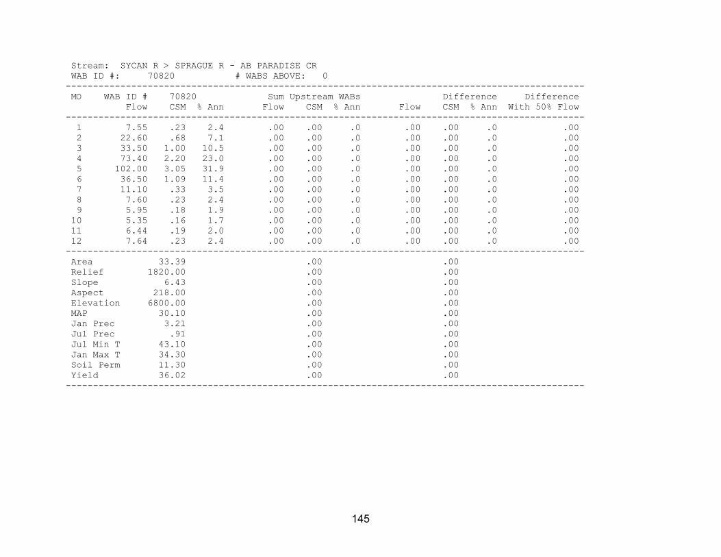
145
Stream: SYCAN R > SPRAGUE R - AB PARADISE CR WAB ID #: 70820 # WABS ABOVE: 0 ----------------------------------------------------------------------------------------------- MO WAB ID # 70820 Sum Upstream WABs Difference Difference Flow CSM % Ann Flow CSM % Ann Flow CSM % Ann With 50% Flow ----------------------------------------------------------------------------------------------- 1 7.55 .23 2.4 .00 .00 .0 .00 .00 .0 .00 2 22.60 .68 7.1 .00 .00 .0 .00 .00 .0 .00 3 33.50 1.00 10.5 .00 .00 .0 .00 .00 .0 .00 4 73.40 2.20 23.0 .00 .00 .0 .00 .00 .0 .00 5 102.00 3.05 31.9 .00 .00 .0 .00 .00 .0 .00 6 36.50 1.09 11.4 .00 .00 .0 .00 .00 .0 .00 7 11.10 .33 3.5 .00 .00 .0 .00 .00 .0 .00 8 7.60 .23 2.4 .00 .00 .0 .00 .00 .0 .00 9 5.95 .18 1.9 .00 .00 .0 .00 .00 .0 .00 10 5.35 .16 1.7 .00 .00 .0 .00 .00 .0 .00 11 6.44 .19 2.0 .00 .00 .0 .00 .00 .0 .00 12 7.64 .23 2.4 .00 .00 .0 .00 .00 .0 .00 ----------------------------------------------------------------------------------------------- Area 33.39 .00 .00 Relief 1820.00 .00 .00 Slope 6.43 .00 .00 Aspect 218.00 .00 .00 Elevation 6800.00 .00 .00 MAP 30.10 .00 .00 Jan Prec 3.21 .00 .00 Jul Prec .91 .00 .00 Jul Min T 43.10 .00 .00 Jan Max T 34.30 .00 .00 Soil Perm 11.30 .00 .00 Yield 36.02 .00 .00 -----------------------------------------------------------------------------------------------

146
Stream: SPRAGUE R > WILLIAMSON R - AB SYCAN R WAB ID #: 70804 # WABS ABOVE: 2 Streams Above: 1 BROWN CR > SPRAGUE R - AT MOUTH 2 SPRAGUE R > WILLIAMSON R - AT KIRK SPRING AT GS GAGE 11497500 ----------------------------------------------------------------------------------------------- MO WAB ID # 70804 Sum Upstream WABs Difference Difference Flow CSM % Ann Flow CSM % Ann Flow CSM % Ann With 50% Flow ----------------------------------------------------------------------------------------------- 1 207.00 .36 5.9 206.00 .37 5.9 .70 .06 4.9 .00 2 270.00 .47 7.7 268.00 .48 7.6 2.10 .18 14.6 .00 3 381.00 .67 10.8 377.00 .67 10.7 4.30 .37 29.8 .00 4 577.00 1.01 16.4 570.00 1.02 16.3 6.90 .59 47.9 .00 5 689.00 1.21 19.6 688.00 1.23 19.6 .70 .06 4.9 .00 6 386.00 .68 11.0 386.00 .69 11.0 -.20 -.02 -1.4 .00 7 183.00 .32 5.2 183.00 .33 5.2 -.30 -.03 -2.1 .00 8 132.00 .23 3.8 132.00 .24 3.8 -.16 -.01 -1.1 .00 9 147.00 .26 4.2 147.00 .26 4.2 -.21 -.02 -1.5 .00 10 171.00 .30 4.9 171.00 .31 4.9 .17 .01 1.2 .00 11 180.00 .32 5.1 180.00 .32 5.1 .11 .01 .8 .00 12 198.00 .35 5.6 198.00 .35 5.6 .30 .03 2.1 .00 ----------------------------------------------------------------------------------------------- Area 570.60 559.00 11.60 Relief 4000.00 -9999.00 -9999.00 Slope 7.39 7.44 5.26 Aspect 193.00 193.00 220.00 Elevation 5380.00 5400.00 4550.00 MAP 22.30 22.40 15.80 Jan Prec 2.60 2.60 2.32 Jul Prec .60 .61 .34 Jul Min T 43.90 43.90 43.70 Jan Max T 39.30 39.30 39.70 Soil Perm 3.58 3.61 2.06 Yield 31.36 31.69 8.87 -----------------------------------------------------------------------------------------------

147
Stream: BROWN CR > SPRAGUE R - AT MOUTH WAB ID #: 31420221 # WABS ABOVE: 0 ----------------------------------------------------------------------------------------------- MO WAB ID # 31420221 Sum Upstream WABs Difference Difference Flow CSM % Ann Flow CSM % Ann Flow CSM % Ann With 50% Flow ----------------------------------------------------------------------------------------------- 1 12.30 .40 10.9 .00 .00 .0 .00 .00 .0 .00 2 13.90 .45 12.3 .00 .00 .0 .00 .00 .0 .00 3 13.70 .44 12.2 .00 .00 .0 .00 .00 .0 .00 4 15.10 .49 13.4 .00 .00 .0 .00 .00 .0 .00 5 15.30 .49 13.6 .00 .00 .0 .00 .00 .0 .00 6 9.20 .30 8.2 .00 .00 .0 .00 .00 .0 .00 7 4.30 .14 3.8 .00 .00 .0 .00 .00 .0 .00 8 3.16 .10 2.8 .00 .00 .0 .00 .00 .0 .00 9 3.21 .10 2.8 .00 .00 .0 .00 .00 .0 .00 10 3.83 .12 3.4 .00 .00 .0 .00 .00 .0 .00 11 6.89 .22 6.1 .00 .00 .0 .00 .00 .0 .00 12 11.70 .38 10.4 .00 .00 .0 .00 .00 .0 .00 ----------------------------------------------------------------------------------------------- Area 30.98 .00 .00 Relief 2210.00 .00 .00 Slope 8.18 .00 .00 Aspect 192.00 .00 .00 Elevation 5030.00 .00 .00 MAP 19.50 .00 .00 Jan Prec 2.63 .00 .00 Jul Prec .48 .00 .00 Jul Min T 44.80 .00 .00 Jan Max T 40.10 .00 .00 Soil Perm 1.39 .00 .00 Yield 21.07 .00 .00 -----------------------------------------------------------------------------------------------
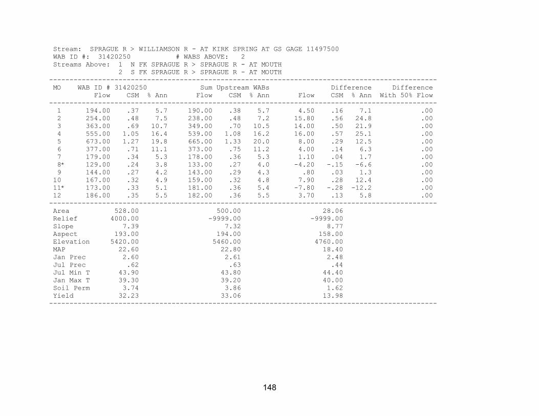
148
Stream: SPRAGUE R > WILLIAMSON R - AT KIRK SPRING AT GS GAGE 11497500 WAB ID #: 31420250 # WABS ABOVE: 2 Streams Above: 1 N FK SPRAGUE R > SPRAGUE R - AT MOUTH 2 S FK SPRAGUE R > SPRAGUE R - AT MOUTH ----------------------------------------------------------------------------------------------- MO WAB ID # 31420250 Sum Upstream WABs Difference Difference Flow CSM % Ann Flow CSM % Ann Flow CSM % Ann With 50% Flow ----------------------------------------------------------------------------------------------- 1 194.00 .37 5.7 190.00 .38 5.7 4.50 .16 7.1 .00 2 254.00 .48 7.5 238.00 .48 7.2 15.80 .56 24.8 .00 3 363.00 .69 10.7 349.00 .70 10.5 14.00 .50 21.9 .00 4 555.00 1.05 16.4 539.00 1.08 16.2 16.00 .57 25.1 .00 5 673.00 1.27 19.8 665.00 1.33 20.0 8.00 .29 12.5 .00 6 377.00 .71 11.1 373.00 .75 11.2 4.00 .14 6.3 .00 7 179.00 .34 5.3 178.00 .36 5.3 1.10 .04 1.7 .00 8* 129.00 .24 3.8 133.00 .27 4.0 -4.20 -.15 -6.6 .00 9 144.00 .27 4.2 143.00 .29 4.3 .80 .03 1.3 .00 10 167.00 .32 4.9 159.00 .32 4.8 7.90 .28 12.4 .00 11* 173.00 .33 5.1 181.00 .36 5.4 -7.80 -.28 -12.2 .00 12 186.00 .35 5.5 182.00 .36 5.5 3.70 .13 5.8 .00 ----------------------------------------------------------------------------------------------- Area 528.00 500.00 28.06 Relief 4000.00 -9999.00 -9999.00 Slope 7.39 7.32 8.77 Aspect 193.00 194.00 158.00 Elevation 5420.00 5460.00 4760.00 MAP 22.60 22.80 18.40 Jan Prec 2.60 2.61 2.48 Jul Prec .62 .63 .44 Jul Min T 43.90 43.80 44.40 Jan Max T 39.30 39.20 40.00 Soil Perm 3.74 3.86 1.62 Yield 32.23 33.06 13.98 -----------------------------------------------------------------------------------------------

149
Stream: N FK SPRAGUE R > SPRAGUE R - AT MOUTH WAB ID #: 70816 # WABS ABOVE: 3 Streams Above: 1 FIVEMILE CR > N FK SPRAGUE R - AT MOUTH 2 MERYL CR > N FK SPRAGUE R - AT MOUTH 3 N FK SPRAGUE R > SPRAGUE R - AT BALLEY FLATS ----------------------------------------------------------------------------------------------- MO WAB ID # 70816 Sum Upstream WABs Difference Difference Flow CSM % Ann Flow CSM % Ann Flow CSM % Ann With 50% Flow ----------------------------------------------------------------------------------------------- 1 126.00 .60 6.1 105.00 .53 6.0 21.50 1.98 7.1 .00 2 146.00 .70 7.1 134.00 .68 7.7 12.40 1.14 4.1 .00 3* 170.00 .81 8.3 173.00 .87 9.9 -2.90 -.27 -1.0 .00 4* 270.00 1.29 13.2 273.00 1.38 15.6 -2.70 -.25 -.9 .00 5 379.00 1.82 18.5 346.00 1.75 19.8 33.10 3.04 10.9 .00 6 234.00 1.12 11.4 193.00 .98 11.0 41.00 3.77 13.5 .00 7 126.00 .60 6.1 89.60 .45 5.1 36.40 3.35 12.0 .00 8 102.00 .49 5.0 72.20 .37 4.1 29.80 2.74 9.8 .00 9 110.00 .53 5.4 74.30 .38 4.3 35.70 3.28 11.7 .00 10 120.00 .58 5.8 81.40 .41 4.7 38.60 3.55 12.7 .00 11 136.00 .65 6.6 101.00 .51 5.8 34.90 3.21 11.5 .00 12 132.00 .63 6.4 106.00 .53 6.1 26.30 2.42 8.6 .00 ----------------------------------------------------------------------------------------------- Area 208.70 197.80 10.88 Relief 4000.00 -9999.00 -9999.00 Slope 7.46 7.72 2.62 Aspect 200.00 199.00 206.00 Elevation 5630.00 5690.00 4490.00 MAP 24.10 24.50 16.60 Jan Prec 2.77 2.80 2.25 Jul Prec .67 .69 .36 Jul Min T 43.20 43.30 43.00 Jan Max T 38.20 38.10 39.90 Soil Perm 7.40 7.75 1.11 Yield 46.11 40.73 191.09 -----------------------------------------------------------------------------------------------

150
Stream: FIVEMILE CR > N FK SPRAGUE R - AT MOUTH WAB ID #: 31420222 # WABS ABOVE: 1 Streams Above: 1 FIVEMILE CR > N FK SPRAGUE R - AT NF BOUNDARY (35S 13E 24 SWSE) ----------------------------------------------------------------------------------------------- MO WAB ID # 31420222 Sum Upstream WABs Difference Difference Flow CSM % Ann Flow CSM % Ann Flow CSM % Ann With 50% Flow ----------------------------------------------------------------------------------------------- 1 28.40 .44 7.8 24.10 .68 8.1 4.30 .15 6.6 .00 2 40.10 .63 11.0 32.60 .92 10.9 7.50 .26 11.5 .00 3 49.50 .77 13.6 36.40 1.02 12.2 13.10 .46 20.1 .00 4 56.90 .89 15.6 42.90 1.20 14.3 14.00 .49 21.4 .00 5 34.30 .53 9.4 23.90 .67 8.0 10.40 .36 15.9 .00 6 27.20 .42 7.5 21.20 .60 7.1 6.00 .21 9.2 .00 7 21.70 .34 5.9 19.70 .55 6.6 2.00 .07 3.1 .00 8 19.40 .30 5.3 18.40 .52 6.2 1.00 .04 1.5 .00 9 20.10 .31 5.5 19.10 .54 6.4 1.00 .04 1.5 .00 10 21.70 .34 5.9 20.50 .58 6.8 1.20 .04 1.8 .00 11 21.90 .34 6.0 20.00 .56 6.7 1.90 .07 2.9 .00 12 23.30 .36 6.4 20.40 .57 6.8 2.90 .10 4.4 .00 ----------------------------------------------------------------------------------------------- Area 64.14 35.61 28.54 Relief 1880.00 1620.00 -9999.00 Slope 5.88 5.61 6.22 Aspect 177.00 195.00 153.00 Elevation 5080.00 5260.00 4850.00 MAP 21.10 22.40 19.50 Jan Prec 2.60 2.67 2.51 Jul Prec .57 .63 .49 Jul Min T 42.70 42.60 42.70 Jan Max T 39.70 39.80 39.70 Soil Perm 6.91 9.70 3.42 Yield 30.43 42.44 13.25 -----------------------------------------------------------------------------------------------

151
Stream: FIVEMILE CR > N FK SPRAGUE R - AT NF BOUNDARY (35S 13E 24 SWSE) WAB ID #: 31420248 # WABS ABOVE: 0 ----------------------------------------------------------------------------------------------- MO WAB ID # 31420248 Sum Upstream WABs Difference Difference Flow CSM % Ann Flow CSM % Ann Flow CSM % Ann With 50% Flow ----------------------------------------------------------------------------------------------- 1 24.10 .68 8.1 .00 .00 .0 .00 .00 .0 .00 2 32.60 .92 10.9 .00 .00 .0 .00 .00 .0 .00 3 36.40 1.02 12.2 .00 .00 .0 .00 .00 .0 .00 4 42.90 1.20 14.3 .00 .00 .0 .00 .00 .0 .00 5 23.90 .67 8.0 .00 .00 .0 .00 .00 .0 .00 6 21.20 .60 7.1 .00 .00 .0 .00 .00 .0 .00 7 19.70 .55 6.6 .00 .00 .0 .00 .00 .0 .00 8 18.40 .52 6.2 .00 .00 .0 .00 .00 .0 .00 9 19.10 .54 6.4 .00 .00 .0 .00 .00 .0 .00 10 20.50 .58 6.8 .00 .00 .0 .00 .00 .0 .00 11 20.00 .56 6.7 .00 .00 .0 .00 .00 .0 .00 12 20.40 .57 6.8 .00 .00 .0 .00 .00 .0 .00 ----------------------------------------------------------------------------------------------- Area 35.61 .00 .00 Relief 1620.00 .00 .00 Slope 5.61 .00 .00 Aspect 195.00 .00 .00 Elevation 5260.00 .00 .00 MAP 22.40 .00 .00 Jan Prec 2.67 .00 .00 Jul Prec .63 .00 .00 Jul Min T 42.60 .00 .00 Jan Max T 39.80 .00 .00 Soil Perm 9.70 .00 .00 Yield 42.44 .00 .00 -----------------------------------------------------------------------------------------------

152
Stream: MERYL CR > N FK SPRAGUE R - AT MOUTH WAB ID #: 31420223 # WABS ABOVE: 0 ----------------------------------------------------------------------------------------------- MO WAB ID # 31420223 Sum Upstream WABs Difference Difference Flow CSM % Ann Flow CSM % Ann Flow CSM % Ann With 50% Flow ----------------------------------------------------------------------------------------------- 1 15.00 .26 5.6 .00 .00 .0 .00 .00 .0 .00 2 21.50 .37 8.1 .00 .00 .0 .00 .00 .0 .00 3 32.00 .56 12.0 .00 .00 .0 .00 .00 .0 .00 4 47.80 .83 18.0 .00 .00 .0 .00 .00 .0 .00 5 64.60 1.12 24.3 .00 .00 .0 .00 .00 .0 .00 6 38.80 .67 14.6 .00 .00 .0 .00 .00 .0 .00 7 11.20 .19 4.2 .00 .00 .0 .00 .00 .0 .00 8 5.60 .10 2.1 .00 .00 .0 .00 .00 .0 .00 9 5.00 .09 1.9 .00 .00 .0 .00 .00 .0 .00 10 5.63 .10 2.1 .00 .00 .0 .00 .00 .0 .00 11 7.61 .13 2.9 .00 .00 .0 .00 .00 .0 .00 12 11.40 .20 4.3 .00 .00 .0 .00 .00 .0 .00 ----------------------------------------------------------------------------------------------- Area 57.52 .00 .00 Relief 2920.00 .00 .00 Slope 5.99 .00 .00 Aspect 214.00 .00 .00 Elevation 5380.00 .00 .00 MAP 21.80 .00 .00 Jan Prec 2.63 .00 .00 Jul Prec .59 .00 .00 Jul Min T 43.50 .00 .00 Jan Max T 39.20 .00 .00 Soil Perm 5.64 .00 .00 Yield 24.02 .00 .00 -----------------------------------------------------------------------------------------------
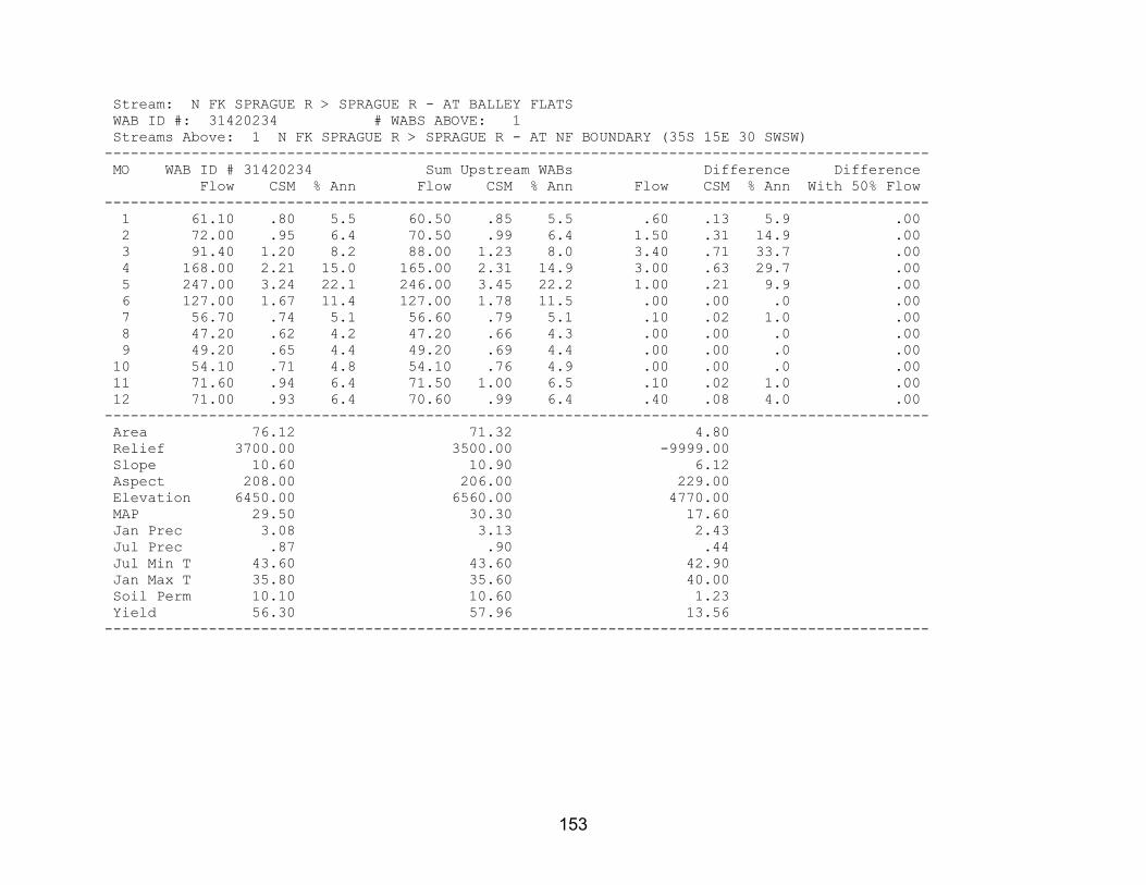
153
Stream: N FK SPRAGUE R > SPRAGUE R - AT BALLEY FLATS WAB ID #: 31420234 # WABS ABOVE: 1 Streams Above: 1 N FK SPRAGUE R > SPRAGUE R - AT NF BOUNDARY (35S 15E 30 SWSW) ----------------------------------------------------------------------------------------------- MO WAB ID # 31420234 Sum Upstream WABs Difference Difference Flow CSM % Ann Flow CSM % Ann Flow CSM % Ann With 50% Flow ----------------------------------------------------------------------------------------------- 1 61.10 .80 5.5 60.50 .85 5.5 .60 .13 5.9 .00 2 72.00 .95 6.4 70.50 .99 6.4 1.50 .31 14.9 .00 3 91.40 1.20 8.2 88.00 1.23 8.0 3.40 .71 33.7 .00 4 168.00 2.21 15.0 165.00 2.31 14.9 3.00 .63 29.7 .00 5 247.00 3.24 22.1 246.00 3.45 22.2 1.00 .21 9.9 .00 6 127.00 1.67 11.4 127.00 1.78 11.5 .00 .00 .0 .00 7 56.70 .74 5.1 56.60 .79 5.1 .10 .02 1.0 .00 8 47.20 .62 4.2 47.20 .66 4.3 .00 .00 .0 .00 9 49.20 .65 4.4 49.20 .69 4.4 .00 .00 .0 .00 10 54.10 .71 4.8 54.10 .76 4.9 .00 .00 .0 .00 11 71.60 .94 6.4 71.50 1.00 6.5 .10 .02 1.0 .00 12 71.00 .93 6.4 70.60 .99 6.4 .40 .08 4.0 .00 ----------------------------------------------------------------------------------------------- Area 76.12 71.32 4.80 Relief 3700.00 3500.00 -9999.00 Slope 10.60 10.90 6.12 Aspect 208.00 206.00 229.00 Elevation 6450.00 6560.00 4770.00 MAP 29.50 30.30 17.60 Jan Prec 3.08 3.13 2.43 Jul Prec .87 .90 .44 Jul Min T 43.60 43.60 42.90 Jan Max T 35.80 35.60 40.00 Soil Perm 10.10 10.60 1.23 Yield 56.30 57.96 13.56 -----------------------------------------------------------------------------------------------

154
Stream: N FK SPRAGUE R > SPRAGUE R - AT NF BOUNDARY (35S 15E 30 SWSW) WAB ID #: 31420246 # WABS ABOVE: 1 Streams Above: 1 N FK SPRAGUE R > SPRAGUE R - AB SHEEPY CR ----------------------------------------------------------------------------------------------- MO WAB ID # 31420246 Sum Upstream WABs Difference Difference Flow CSM % Ann Flow CSM % Ann Flow CSM % Ann With 50% Flow ----------------------------------------------------------------------------------------------- 1 60.50 .85 5.5 33.20 .63 4.6 27.30 1.45 7.2 .00 2 70.50 .99 6.4 41.10 .78 5.6 29.40 1.56 7.8 .00 3 88.00 1.23 8.0 56.60 1.08 7.8 31.40 1.67 8.3 .00 4 165.00 2.31 14.9 119.00 2.27 16.3 46.00 2.44 12.2 .00 5 246.00 3.45 22.2 184.00 3.50 25.3 62.00 3.30 16.4 .00 6 127.00 1.78 11.5 83.00 1.58 11.4 44.00 2.34 11.7 .00 7 56.60 .79 5.1 35.50 .68 4.9 21.10 1.12 5.6 .00 8 47.20 .66 4.3 29.40 .56 4.0 17.80 .95 4.7 .00 9 49.20 .69 4.4 30.90 .59 4.2 18.30 .97 4.8 .00 10 54.10 .76 4.9 34.00 .65 4.7 20.10 1.07 5.3 .00 11 71.50 1.00 6.5 42.20 .80 5.8 29.30 1.56 7.8 .00 12 70.60 .99 6.4 39.70 .76 5.4 30.90 1.64 8.2 .00 ----------------------------------------------------------------------------------------------- Area 71.32 52.50 18.82 Relief 3500.00 2700.00 -9999.00 Slope 10.90 9.00 16.10 Aspect 206.00 196.00 236.00 Elevation 6560.00 6710.00 6150.00 MAP 30.30 31.80 26.20 Jan Prec 3.13 3.23 2.84 Jul Prec .90 .94 .76 Jul Min T 43.60 43.30 44.40 Jan Max T 35.60 34.70 37.80 Soil Perm 10.60 11.30 8.80 Yield 57.96 49.44 86.84 -----------------------------------------------------------------------------------------------

155
Stream: N FK SPRAGUE R > SPRAGUE R - AB SHEEPY CR WAB ID #: 70815 # WABS ABOVE: 1 Streams Above: 1 N FK SPRAGUE R > SPRAGUE R - AT NF BOUNDARY (35S 15E 11 NESW) ----------------------------------------------------------------------------------------------- MO WAB ID # 70815 Sum Upstream WABs Difference Difference Flow CSM % Ann Flow CSM % Ann Flow CSM % Ann With 50% Flow ----------------------------------------------------------------------------------------------- 1 33.20 .63 4.6 31.10 .62 4.4 2.10 .96 8.4 .00 2 41.10 .78 5.6 38.20 .76 5.4 2.90 1.33 11.6 .00 3 56.60 1.08 7.8 52.40 1.04 7.4 4.20 1.92 16.9 .00 4 119.00 2.27 16.3 114.00 2.27 16.2 5.00 2.29 20.1 .00 5 184.00 3.50 25.3 181.00 3.60 25.7 3.00 1.37 12.0 .00 6 83.00 1.58 11.4 82.00 1.63 11.7 1.00 .46 4.0 .00 7 35.50 .68 4.9 34.90 .69 5.0 .60 .27 2.4 .00 8 29.40 .56 4.0 28.80 .57 4.1 .60 .27 2.4 .00 9 30.90 .59 4.2 30.10 .60 4.3 .80 .37 3.2 .00 10 34.00 .65 4.7 33.10 .66 4.7 .90 .41 3.6 .00 11 42.20 .80 5.8 40.60 .81 5.8 1.60 .73 6.4 .00 12 39.70 .76 5.4 37.50 .75 5.3 2.20 1.01 8.8 .00 ----------------------------------------------------------------------------------------------- Area 52.50 50.32 2.18 Relief 2700.00 2500.00 -9999.00 Slope 9.00 8.96 10.10 Aspect 196.00 196.00 190.00 Elevation 6710.00 6740.00 6130.00 MAP 31.80 32.00 27.20 Jan Prec 3.23 3.24 2.93 Jul Prec .94 .95 .78 Jul Min T 43.30 43.30 44.90 Jan Max T 34.70 34.60 37.00 Soil Perm 11.30 11.30 11.30 Yield 49.44 49.52 47.44 -----------------------------------------------------------------------------------------------

156
Stream: N FK SPRAGUE R > SPRAGUE R - AT NF BOUNDARY (35S 15E 11 NESW) WAB ID #: 31420229 # WABS ABOVE: 1 Streams Above: 1 N FK SPRAGUE R > SPRAGUE R - AT NF BOUNDARY (35S 15E 11 SENE) ----------------------------------------------------------------------------------------------- MO WAB ID # 31420229 Sum Upstream WABs Difference Difference Flow CSM % Ann Flow CSM % Ann Flow CSM % Ann With 50% Flow ----------------------------------------------------------------------------------------------- 1 31.10 .62 4.4 30.80 .61 4.4 .30 2.10 11.1 .00 2 38.20 .76 5.4 37.80 .75 5.4 .40 2.80 14.8 .00 3 52.40 1.04 7.4 52.00 1.04 7.4 .40 2.80 14.8 .00 4 114.00 2.27 16.2 113.00 2.25 16.1 1.00 6.99 37.0 .00 5 181.00 3.60 25.7 181.00 3.61 25.8 .00 .00 .0 .00 6 82.00 1.63 11.7 81.90 1.63 11.7 .10 .70 3.7 .00 7 34.90 .69 5.0 34.90 .70 5.0 .00 .00 .0 .00 8 28.80 .57 4.1 28.80 .57 4.1 .00 .00 .0 .00 9 30.10 .60 4.3 30.10 .60 4.3 .00 .00 .0 .00 10 33.10 .66 4.7 33.10 .66 4.7 .00 .00 .0 .00 11 40.60 .81 5.8 40.40 .81 5.8 .20 1.40 7.4 .00 12 37.50 .75 5.3 37.20 .74 5.3 .30 2.10 11.1 .00 ----------------------------------------------------------------------------------------------- Area 50.32 50.18 .14 Relief 2500.00 2500.00 -9999.00 Slope 8.96 8.93 19.10 Aspect 196.00 196.00 285.00 Elevation 6740.00 6740.00 6220.00 MAP 32.00 32.00 28.50 Jan Prec 3.24 3.24 3.24 Jul Prec .95 .95 .95 Jul Min T 43.30 43.30 45.00 Jan Max T 34.60 34.60 36.00 Soil Perm 11.30 11.30 11.30 Yield 49.52 49.45 75.10 -----------------------------------------------------------------------------------------------

157
Stream: N FK SPRAGUE R > SPRAGUE R - AT NF BOUNDARY (35S 15E 11 SENE) WAB ID #: 31420267 # WABS ABOVE: 0 ----------------------------------------------------------------------------------------------- MO WAB ID # 31420267 Sum Upstream WABs Difference Difference Flow CSM % Ann Flow CSM % Ann Flow CSM % Ann With 50% Flow ----------------------------------------------------------------------------------------------- 1 30.80 .61 4.4 .00 .00 .0 .00 .00 .0 .00 2 37.80 .75 5.4 .00 .00 .0 .00 .00 .0 .00 3 52.00 1.04 7.4 .00 .00 .0 .00 .00 .0 .00 4 113.00 2.25 16.1 .00 .00 .0 .00 .00 .0 .00 5 181.00 3.61 25.8 .00 .00 .0 .00 .00 .0 .00 6 81.90 1.63 11.7 .00 .00 .0 .00 .00 .0 .00 7 34.90 .70 5.0 .00 .00 .0 .00 .00 .0 .00 8 28.80 .57 4.1 .00 .00 .0 .00 .00 .0 .00 9 30.10 .60 4.3 .00 .00 .0 .00 .00 .0 .00 10 33.10 .66 4.7 .00 .00 .0 .00 .00 .0 .00 11 40.40 .81 5.8 .00 .00 .0 .00 .00 .0 .00 12 37.20 .74 5.3 .00 .00 .0 .00 .00 .0 .00 ----------------------------------------------------------------------------------------------- Area 50.18 .00 .00 Relief 2500.00 .00 .00 Slope 8.93 .00 .00 Aspect 196.00 .00 .00 Elevation 6740.00 .00 .00 MAP 32.00 .00 .00 Jan Prec 3.24 .00 .00 Jul Prec .95 .00 .00 Jul Min T 43.30 .00 .00 Jan Max T 34.60 .00 .00 Soil Perm 11.30 .00 .00 Yield 49.45 .00 .00 -----------------------------------------------------------------------------------------------

158
Stream: S FK SPRAGUE R > SPRAGUE R - AT MOUTH WAB ID #: 70802 # WABS ABOVE: 3 Streams Above: 1 DEMING CR > S FK SPRAGUE R - AT MOUTH 2 FISHHOLE CR > S FK SPRAGUE R - AT MOUTH 3 S FK SPRAGUE R > SPRAGUE R - AB FISHHOLE CR ----------------------------------------------------------------------------------------------- MO WAB ID # 70802 Sum Upstream WABs Difference Difference Flow CSM % Ann Flow CSM % Ann Flow CSM % Ann With 50% Flow ----------------------------------------------------------------------------------------------- 1 63.50 .22 5.0 62.30 .23 5.0 1.18 .07 5.3 .00 2 92.20 .32 7.2 89.60 .33 7.1 2.60 .17 11.7 .00 3 179.00 .61 14.0 173.00 .63 13.8 6.00 .38 26.9 .00 4 269.00 .92 21.0 263.00 .96 20.9 5.80 .37 26.0 .00 5 286.00 .98 22.4 283.00 1.03 22.5 2.90 .18 13.0 .00 6 139.00 .48 10.9 138.00 .50 10.9 1.40 .09 6.3 .00 7 51.90 .18 4.1 51.50 .19 4.1 .43 .03 1.9 .00 8 31.20 .11 2.4 31.00 .11 2.5 .20 .01 .9 .00 9 33.20 .11 2.6 33.00 .12 2.6 .24 .02 1.1 .00 10 39.10 .13 3.1 38.80 .14 3.1 .34 .02 1.5 .00 11 44.80 .15 3.5 44.30 .16 3.5 .47 .03 2.1 .00 12 50.30 .17 3.9 49.60 .18 3.9 .73 .05 3.3 .00 ----------------------------------------------------------------------------------------------- Area 291.30 275.60 15.76 Relief 3850.00 -9999.00 -9999.00 Slope 7.22 7.39 4.26 Aspect 191.00 194.00 138.00 Elevation 5330.00 5370.00 4650.00 MAP 21.90 22.10 17.30 Jan Prec 2.49 2.50 2.26 Jul Prec .59 .60 .42 Jul Min T 44.30 44.30 44.50 Jan Max T 40.00 40.00 39.90 Soil Perm 1.32 1.32 1.37 Yield 22.74 23.34 9.24 -----------------------------------------------------------------------------------------------

159
Stream: DEMING CR > S FK SPRAGUE R - AT MOUTH WAB ID #: 31420265 # WABS ABOVE: 1 Streams Above: 1 DEMING CR > S FK SPRAGUE R - AT NF BOUNDARY (36S 15E 9 SESE) ----------------------------------------------------------------------------------------------- MO WAB ID # 31420265 Sum Upstream WABs Difference Difference Flow CSM % Ann Flow CSM % Ann Flow CSM % Ann With 50% Flow ----------------------------------------------------------------------------------------------- 1 7.22 .22 5.3 3.75 .33 4.8 3.47 .16 5.9 .00 2 10.30 .31 7.5 4.67 .42 5.9 5.63 .26 9.6 .00 3 16.20 .49 11.8 7.04 .63 8.9 9.16 .42 15.6 .00 4 20.90 .63 15.2 11.00 .98 14.0 9.90 .45 16.9 .00 5 32.10 .97 23.4 21.40 1.90 27.2 10.70 .49 18.2 .00 6 21.90 .66 15.9 14.10 1.25 17.9 7.80 .36 13.3 .00 7 6.97 .21 5.1 4.07 .36 5.2 2.90 .13 4.9 .00 8 3.39 .10 2.5 2.03 .18 2.6 1.36 .06 2.3 .00 9 3.64 .11 2.7 2.13 .19 2.7 1.51 .07 2.6 .00 10 3.89 .12 2.8 2.27 .20 2.9 1.62 .07 2.8 .00 11 4.71 .14 3.4 2.81 .25 3.6 1.90 .09 3.2 .00 12 6.12 .18 4.5 3.42 .30 4.3 2.70 .12 4.6 .00 ----------------------------------------------------------------------------------------------- Area 33.13 11.24 21.89 Relief 3800.00 3670.00 -9999.00 Slope 8.82 15.90 5.19 Aspect 225.00 230.00 223.00 Elevation 5160.00 5760.00 4850.00 MAP 19.60 23.50 17.50 Jan Prec 2.35 2.60 2.21 Jul Prec .52 .67 .44 Jul Min T 43.20 43.60 43.00 Jan Max T 39.70 39.10 39.90 Soil Perm 1.35 1.67 1.18 Yield 23.99 33.69 17.30 -----------------------------------------------------------------------------------------------

160
Stream: DEMING CR > S FK SPRAGUE R - AT NF BOUNDARY (36S 15E 9 SESE) WAB ID #: 70808 # WABS ABOVE: 1 Streams Above: 1 DEMING CR > S FK SPRAGUE R - AT NF BNDRY (36S 15E 9 SESE) ----------------------------------------------------------------------------------------------- MO WAB ID # 70808 Sum Upstream WABs Difference Difference Flow CSM % Ann Flow CSM % Ann Flow CSM % Ann With 50% Flow ----------------------------------------------------------------------------------------------- 1 3.75 .33 4.8 2.55 .57 4.2 1.20 .18 6.5 .00 2 4.67 .42 5.9 2.75 .61 4.6 1.92 .28 10.4 .00 3 7.04 .63 8.9 4.02 .89 6.7 3.02 .45 16.4 .00 4 11.00 .98 14.0 7.61 1.69 12.6 3.39 .50 18.4 .00 5 21.40 1.90 27.2 17.40 3.87 28.9 4.00 .59 21.7 .00 6 14.10 1.25 17.9 11.60 2.58 19.2 2.50 .37 13.6 .00 7 4.07 .36 5.2 3.53 .78 5.9 .54 .08 2.9 .00 8 2.03 .18 2.6 1.83 .41 3.0 .20 .03 1.1 .00 9 2.13 .19 2.7 1.96 .44 3.3 .17 .03 .9 .00 10 2.27 .20 2.9 2.08 .46 3.5 .19 .03 1.0 .00 11 2.81 .25 3.6 2.38 .53 4.0 .43 .06 2.3 .00 12 3.42 .30 4.3 2.58 .57 4.3 .84 .12 4.6 .00 ----------------------------------------------------------------------------------------------- Area 11.24 4.50 6.74 Relief 3670.00 2800.00 -9999.00 Slope 15.90 24.10 10.40 Aspect 230.00 232.00 230.00 Elevation 5760.00 6570.00 5210.00 MAP 23.50 30.10 19.10 Jan Prec 2.60 2.96 2.36 Jul Prec .67 .89 .52 Jul Min T 43.60 43.80 43.40 Jan Max T 39.10 37.90 39.90 Soil Perm 1.67 2.27 1.26 Yield 33.69 50.40 16.15 -----------------------------------------------------------------------------------------------

161
Stream: DEMING CR > S FK SPRAGUE R - AT NF BNDRY (36S 15E 9 SESE) WAB ID #: 31420264 # WABS ABOVE: 0 ----------------------------------------------------------------------------------------------- MO WAB ID # 31420264 Sum Upstream WABs Difference Difference Flow CSM % Ann Flow CSM % Ann Flow CSM % Ann With 50% Flow ----------------------------------------------------------------------------------------------- 1 2.55 .57 4.2 .00 .00 .0 .00 .00 .0 .00 2 2.75 .61 4.6 .00 .00 .0 .00 .00 .0 .00 3 4.02 .89 6.7 .00 .00 .0 .00 .00 .0 .00 4 7.61 1.69 12.6 .00 .00 .0 .00 .00 .0 .00 5 17.40 3.87 28.9 .00 .00 .0 .00 .00 .0 .00 6 11.60 2.58 19.2 .00 .00 .0 .00 .00 .0 .00 7 3.53 .78 5.9 .00 .00 .0 .00 .00 .0 .00 8 1.83 .41 3.0 .00 .00 .0 .00 .00 .0 .00 9 1.96 .44 3.3 .00 .00 .0 .00 .00 .0 .00 10 2.08 .46 3.5 .00 .00 .0 .00 .00 .0 .00 11 2.38 .53 4.0 .00 .00 .0 .00 .00 .0 .00 12 2.58 .57 4.3 .00 .00 .0 .00 .00 .0 .00 ----------------------------------------------------------------------------------------------- Area 4.50 .00 .00 Relief 2800.00 .00 .00 Slope 24.10 .00 .00 Aspect 232.00 .00 .00 Elevation 6570.00 .00 .00 MAP 30.10 .00 .00 Jan Prec 2.96 .00 .00 Jul Prec .89 .00 .00 Jul Min T 43.80 .00 .00 Jan Max T 37.90 .00 .00 Soil Perm 2.27 .00 .00 Yield 50.40 .00 .00 -----------------------------------------------------------------------------------------------

162
Stream: FISHHOLE CR > S FK SPRAGUE R - AT MOUTH WAB ID #: 70809 # WABS ABOVE: 1 Streams Above: 1 FISHHOLE CR > S FK SPRAGUE R - AT NF BOUNDARY (37S 15E 32 SENW) ----------------------------------------------------------------------------------------------- MO WAB ID # 70809 Sum Upstream WABs Difference Difference Flow CSM % Ann Flow CSM % Ann Flow CSM % Ann With 50% Flow ----------------------------------------------------------------------------------------------- 1 14.00 .13 4.7 7.24 .13 4.1 6.76 .13 5.5 .00 2 31.50 .29 10.5 19.00 .35 10.7 12.50 .23 10.2 .00 3 71.20 .66 23.7 49.10 .91 27.7 22.10 .41 18.0 .00 4 78.30 .73 26.1 50.80 .94 28.7 27.50 .51 22.4 .00 5 42.00 .39 14.0 21.20 .39 12.0 20.80 .39 16.9 .00 6 24.50 .23 8.2 12.60 .23 7.1 11.90 .22 9.7 .00 7 10.40 .10 3.5 4.98 .09 2.8 5.42 .10 4.4 .00 8 4.41 .04 1.5 1.96 .04 1.1 2.45 .05 2.0 .00 9 4.22 .04 1.4 1.77 .03 1.0 2.45 .05 2.0 .00 10 5.67 .05 1.9 2.59 .05 1.5 3.08 .06 2.5 .00 11 5.32 .05 1.8 2.09 .04 1.2 3.23 .06 2.6 .00 12 8.45 .08 2.8 3.78 .07 2.1 4.67 .09 3.8 .00 ----------------------------------------------------------------------------------------------- Area 107.30 53.88 53.43 Relief 2690.00 2270.00 -9999.00 Slope 5.76 6.88 4.63 Aspect 168.00 193.00 143.00 Elevation 5240.00 5540.00 4930.00 MAP 21.30 23.30 19.30 Jan Prec 2.58 2.58 2.57 Jul Prec .57 .65 .49 Jul Min T 44.80 45.30 44.40 Jan Max T 40.40 40.50 40.20 Soil Perm 1.27 1.39 1.15 Yield 14.86 15.95 13.52 -----------------------------------------------------------------------------------------------

163
Stream: FISHHOLE CR > S FK SPRAGUE R - AT NF BOUNDARY (37S 15E 32 SENW) WAB ID #: 31420230 # WABS ABOVE: 0 ----------------------------------------------------------------------------------------------- MO WAB ID # 31420230 Sum Upstream WABs Difference Difference Flow CSM % Ann Flow CSM % Ann Flow CSM % Ann With 50% Flow ----------------------------------------------------------------------------------------------- 1 7.24 .13 4.1 .00 .00 .0 .00 .00 .0 .00 2 19.00 .35 10.7 .00 .00 .0 .00 .00 .0 .00 3 49.10 .91 27.7 .00 .00 .0 .00 .00 .0 .00 4 50.80 .94 28.7 .00 .00 .0 .00 .00 .0 .00 5 21.20 .39 12.0 .00 .00 .0 .00 .00 .0 .00 6 12.60 .23 7.1 .00 .00 .0 .00 .00 .0 .00 7 4.98 .09 2.8 .00 .00 .0 .00 .00 .0 .00 8 1.96 .04 1.1 .00 .00 .0 .00 .00 .0 .00 9 1.77 .03 1.0 .00 .00 .0 .00 .00 .0 .00 10 2.59 .05 1.5 .00 .00 .0 .00 .00 .0 .00 11 2.09 .04 1.2 .00 .00 .0 .00 .00 .0 .00 12 3.78 .07 2.1 .00 .00 .0 .00 .00 .0 .00 ----------------------------------------------------------------------------------------------- Area 53.88 .00 .00 Relief 2270.00 .00 .00 Slope 6.88 .00 .00 Aspect 193.00 .00 .00 Elevation 5540.00 .00 .00 MAP 23.30 .00 .00 Jan Prec 2.58 .00 .00 Jul Prec .65 .00 .00 Jul Min T 45.30 .00 .00 Jan Max T 40.50 .00 .00 Soil Perm 1.39 .00 .00 Yield 15.95 .00 .00 -----------------------------------------------------------------------------------------------
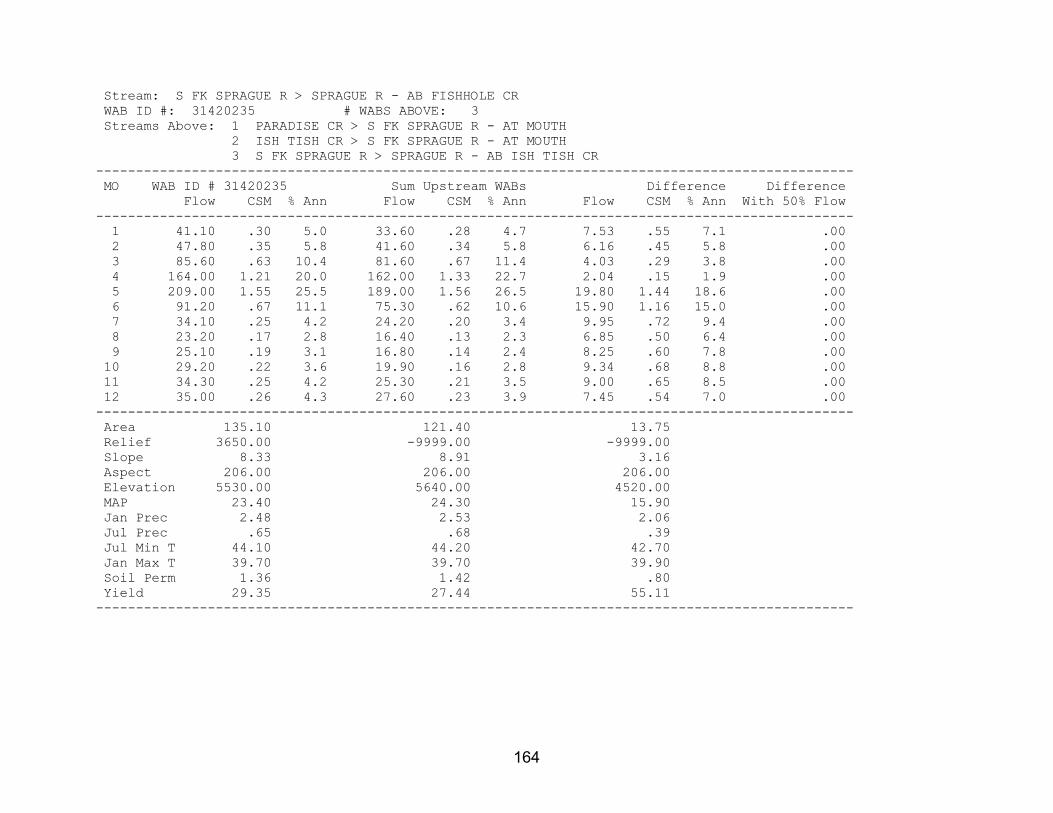
164
Stream: S FK SPRAGUE R > SPRAGUE R - AB FISHHOLE CR WAB ID #: 31420235 # WABS ABOVE: 3 Streams Above: 1 PARADISE CR > S FK SPRAGUE R - AT MOUTH 2 ISH TISH CR > S FK SPRAGUE R - AT MOUTH 3 S FK SPRAGUE R > SPRAGUE R - AB ISH TISH CR ----------------------------------------------------------------------------------------------- MO WAB ID # 31420235 Sum Upstream WABs Difference Difference Flow CSM % Ann Flow CSM % Ann Flow CSM % Ann With 50% Flow ----------------------------------------------------------------------------------------------- 1 41.10 .30 5.0 33.60 .28 4.7 7.53 .55 7.1 .00 2 47.80 .35 5.8 41.60 .34 5.8 6.16 .45 5.8 .00 3 85.60 .63 10.4 81.60 .67 11.4 4.03 .29 3.8 .00 4 164.00 1.21 20.0 162.00 1.33 22.7 2.04 .15 1.9 .00 5 209.00 1.55 25.5 189.00 1.56 26.5 19.80 1.44 18.6 .00 6 91.20 .67 11.1 75.30 .62 10.6 15.90 1.16 15.0 .00 7 34.10 .25 4.2 24.20 .20 3.4 9.95 .72 9.4 .00 8 23.20 .17 2.8 16.40 .13 2.3 6.85 .50 6.4 .00 9 25.10 .19 3.1 16.80 .14 2.4 8.25 .60 7.8 .00 10 29.20 .22 3.6 19.90 .16 2.8 9.34 .68 8.8 .00 11 34.30 .25 4.2 25.30 .21 3.5 9.00 .65 8.5 .00 12 35.00 .26 4.3 27.60 .23 3.9 7.45 .54 7.0 .00 ----------------------------------------------------------------------------------------------- Area 135.10 121.40 13.75 Relief 3650.00 -9999.00 -9999.00 Slope 8.33 8.91 3.16 Aspect 206.00 206.00 206.00 Elevation 5530.00 5640.00 4520.00 MAP 23.40 24.30 15.90 Jan Prec 2.48 2.53 2.06 Jul Prec .65 .68 .39 Jul Min T 44.10 44.20 42.70 Jan Max T 39.70 39.70 39.90 Soil Perm 1.36 1.42 .80 Yield 29.35 27.44 55.11 -----------------------------------------------------------------------------------------------

165
Stream: PARADISE CR > S FK SPRAGUE R - AT MOUTH WAB ID #: 31420224 # WABS ABOVE: 0 ----------------------------------------------------------------------------------------------- MO WAB ID # 31420224 Sum Upstream WABs Difference Difference Flow CSM % Ann Flow CSM % Ann Flow CSM % Ann With 50% Flow ----------------------------------------------------------------------------------------------- 1 1.40 .10 4.6 .00 .00 .0 .00 .00 .0 .00 2 3.38 .23 11.1 .00 .00 .0 .00 .00 .0 .00 3 7.67 .53 25.3 .00 .00 .0 .00 .00 .0 .00 4 7.76 .54 25.6 .00 .00 .0 .00 .00 .0 .00 5 5.43 .38 17.9 .00 .00 .0 .00 .00 .0 .00 6 2.45 .17 8.1 .00 .00 .0 .00 .00 .0 .00 7 .50 .03 1.6 .00 .00 .0 .00 .00 .0 .00 8 .19 .01 .6 .00 .00 .0 .00 .00 .0 .00 9 .15 .01 .5 .00 .00 .0 .00 .00 .0 .00 10 .18 .01 .6 .00 .00 .0 .00 .00 .0 .00 11 .35 .02 1.1 .00 .00 .0 .00 .00 .0 .00 12 .89 .06 2.9 .00 .00 .0 .00 .00 .0 .00 ----------------------------------------------------------------------------------------------- Area 14.42 .00 .00 Relief 1810.00 .00 .00 Slope 4.96 .00 .00 Aspect 239.00 .00 .00 Elevation 4950.00 .00 .00 MAP 18.80 .00 .00 Jan Prec 2.25 .00 .00 Jul Prec .50 .00 .00 Jul Min T 42.90 .00 .00 Jan Max T 40.10 .00 .00 Soil Perm .71 .00 .00 Yield 12.69 .00 .00 -----------------------------------------------------------------------------------------------
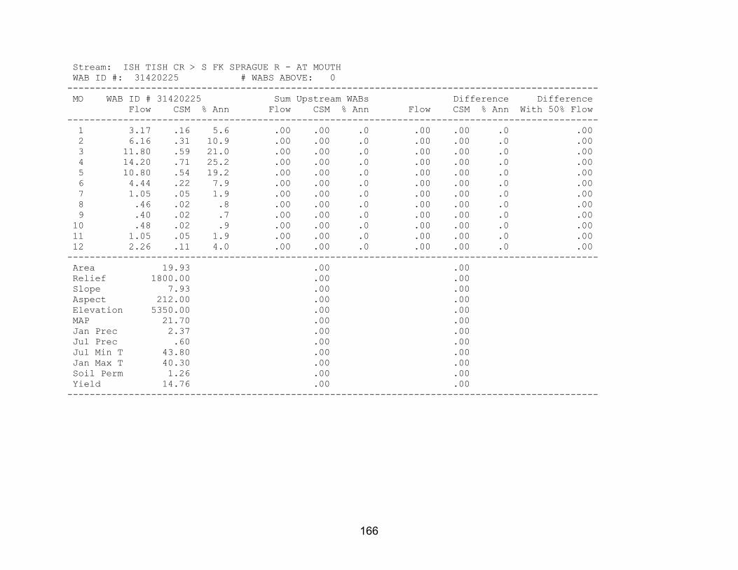
166
Stream: ISH TISH CR > S FK SPRAGUE R - AT MOUTH WAB ID #: 31420225 # WABS ABOVE: 0 ----------------------------------------------------------------------------------------------- MO WAB ID # 31420225 Sum Upstream WABs Difference Difference Flow CSM % Ann Flow CSM % Ann Flow CSM % Ann With 50% Flow ----------------------------------------------------------------------------------------------- 1 3.17 .16 5.6 .00 .00 .0 .00 .00 .0 .00 2 6.16 .31 10.9 .00 .00 .0 .00 .00 .0 .00 3 11.80 .59 21.0 .00 .00 .0 .00 .00 .0 .00 4 14.20 .71 25.2 .00 .00 .0 .00 .00 .0 .00 5 10.80 .54 19.2 .00 .00 .0 .00 .00 .0 .00 6 4.44 .22 7.9 .00 .00 .0 .00 .00 .0 .00 7 1.05 .05 1.9 .00 .00 .0 .00 .00 .0 .00 8 .46 .02 .8 .00 .00 .0 .00 .00 .0 .00 9 .40 .02 .7 .00 .00 .0 .00 .00 .0 .00 10 .48 .02 .9 .00 .00 .0 .00 .00 .0 .00 11 1.05 .05 1.9 .00 .00 .0 .00 .00 .0 .00 12 2.26 .11 4.0 .00 .00 .0 .00 .00 .0 .00 ----------------------------------------------------------------------------------------------- Area 19.93 .00 .00 Relief 1800.00 .00 .00 Slope 7.93 .00 .00 Aspect 212.00 .00 .00 Elevation 5350.00 .00 .00 MAP 21.70 .00 .00 Jan Prec 2.37 .00 .00 Jul Prec .60 .00 .00 Jul Min T 43.80 .00 .00 Jan Max T 40.30 .00 .00 Soil Perm 1.26 .00 .00 Yield 14.76 .00 .00 -----------------------------------------------------------------------------------------------

167
Stream: S FK SPRAGUE R > SPRAGUE R - AB ISH TISH CR WAB ID #: 70801 # WABS ABOVE: 2 Streams Above: 1 BROWNSWORTH CR > S FK SPRAGUE R - AT MOUTH 2 S FK SPRAGUE R > SPRAGUE R - AB BROWNSWORTH CR ----------------------------------------------------------------------------------------------- MO WAB ID # 70801 Sum Upstream WABs Difference Difference Flow CSM % Ann Flow CSM % Ann Flow CSM % Ann With 50% Flow ----------------------------------------------------------------------------------------------- 1 29.00 .33 4.6 28.60 .35 4.6 .41 .09 4.8 .00 2 32.10 .37 5.1 30.90 .37 5.0 1.20 .27 14.1 .00 3 62.10 .71 9.9 59.30 .72 9.6 2.80 .63 32.8 .00 4 140.00 1.61 22.3 137.00 1.66 22.2 2.90 .65 34.0 .00 5 173.00 1.99 27.6 173.00 2.09 27.9 .50 .11 5.9 .00 6 68.40 .79 10.9 68.20 .83 11.0 .20 .05 2.3 .00 7 22.60 .26 3.6 22.60 .27 3.7 .02 .00 .2 .00 8 15.70 .18 2.5 15.70 .19 2.5 .02 .00 .2 .00 9 16.30 .19 2.6 16.30 .20 2.6 .05 .01 .6 .00 10 19.20 .22 3.1 19.10 .23 3.1 .07 .02 .8 .00 11 23.90 .27 3.8 23.80 .29 3.8 .07 .02 .8 .00 12 24.40 .28 3.9 24.10 .29 3.9 .29 .07 3.4 .00 ----------------------------------------------------------------------------------------------- Area 87.01 82.57 4.44 Relief 3400.00 -9999.00 -9999.00 Slope 9.80 9.91 7.63 Aspect 199.00 199.00 204.00 Elevation 5820.00 5870.00 4880.00 MAP 25.80 26.20 18.10 Jan Prec 2.62 2.64 2.22 Jul Prec .73 .74 .49 Jul Min T 44.50 44.60 43.00 Jan Max T 39.40 39.40 39.80 Soil Perm 1.57 1.62 .67 Yield 31.66 32.39 12.04 -----------------------------------------------------------------------------------------------

168
Stream: BROWNSWORTH CR > S FK SPRAGUE R - AT MOUTH WAB ID #: 70832 # WABS ABOVE: 0 ----------------------------------------------------------------------------------------------- MO WAB ID # 70832 Sum Upstream WABs Difference Difference Flow CSM % Ann Flow CSM % Ann Flow CSM % Ann With 50% Flow ----------------------------------------------------------------------------------------------- 1 7.49 .37 5.2 .00 .00 .0 .00 .00 .0 .00 2 7.90 .39 5.5 .00 .00 .0 .00 .00 .0 .00 3 14.10 .69 9.9 .00 .00 .0 .00 .00 .0 .00 4 29.10 1.43 20.4 .00 .00 .0 .00 .00 .0 .00 5 35.50 1.75 24.8 .00 .00 .0 .00 .00 .0 .00 6 15.80 .78 11.1 .00 .00 .0 .00 .00 .0 .00 7 6.08 .30 4.3 .00 .00 .0 .00 .00 .0 .00 8 4.38 .22 3.1 .00 .00 .0 .00 .00 .0 .00 9 4.55 .22 3.2 .00 .00 .0 .00 .00 .0 .00 10 5.23 .26 3.7 .00 .00 .0 .00 .00 .0 .00 11 6.33 .31 4.4 .00 .00 .0 .00 .00 .0 .00 12 6.41 .32 4.5 .00 .00 .0 .00 .00 .0 .00 ----------------------------------------------------------------------------------------------- Area 20.32 .00 .00 Relief 3400.00 .00 .00 Slope 12.30 .00 .00 Aspect 201.00 .00 .00 Elevation 5820.00 .00 .00 MAP 24.90 .00 .00 Jan Prec 2.59 .00 .00 Jul Prec .71 .00 .00 Jul Min T 43.90 .00 .00 Jan Max T 39.10 .00 .00 Soil Perm 1.55 .00 .00 Yield 32.02 .00 .00 -----------------------------------------------------------------------------------------------

169
Stream: S FK SPRAGUE R > SPRAGUE R - AB BROWNSWORTH CR WAB ID #: 31420242 # WABS ABOVE: 2 Streams Above: 1 WHITWORTH CR > S FK SPRAGUE R - AT MOUTH 2 S FK SPRAGUE R > SPRAGUE R - AB WHITWORTH CR ----------------------------------------------------------------------------------------------- MO WAB ID # 31420242 Sum Upstream WABs Difference Difference Flow CSM % Ann Flow CSM % Ann Flow CSM % Ann With 50% Flow ----------------------------------------------------------------------------------------------- 1 21.10 .34 4.4 17.30 .37 4.2 3.80 .26 6.3 .00 2 23.00 .37 4.8 18.20 .38 4.4 4.85 .33 8.1 .00 3 45.20 .73 9.5 35.70 .75 8.6 9.50 .64 15.8 .00 4 108.00 1.73 22.7 91.80 1.94 22.1 16.20 1.09 27.0 .00 5 137.00 2.20 28.8 125.00 2.65 30.2 11.60 .78 19.3 .00 6 52.40 .84 11.0 48.40 1.02 11.7 4.00 .27 6.7 .00 7 16.50 .27 3.5 15.20 .32 3.7 1.28 .09 2.1 .00 8 11.30 .18 2.4 10.30 .22 2.5 .96 .06 1.6 .00 9 11.70 .19 2.5 10.70 .22 2.6 1.05 .07 1.8 .00 10 13.90 .22 2.9 12.50 .26 3.0 1.42 .10 2.4 .00 11 17.50 .28 3.7 15.10 .32 3.6 2.40 .16 4.0 .00 12 17.70 .28 3.7 14.80 .31 3.6 2.92 .20 4.9 .00 ----------------------------------------------------------------------------------------------- Area 62.26 47.37 14.89 Relief 3000.00 -9999.00 -9999.00 Slope 9.15 8.84 10.10 Aspect 199.00 203.00 184.00 Elevation 5890.00 6090.00 5230.00 MAP 26.60 28.60 20.20 Jan Prec 2.65 2.76 2.30 Jul Prec .75 .81 .56 Jul Min T 44.90 45.20 43.90 Jan Max T 39.50 39.30 40.40 Soil Perm 1.64 1.73 1.37 Yield 32.50 34.71 22.56 -----------------------------------------------------------------------------------------------

170
Stream: WHITWORTH CR > S FK SPRAGUE R - AT MOUTH WAB ID #: 31420226 # WABS ABOVE: 0 ----------------------------------------------------------------------------------------------- MO WAB ID # 31420226 Sum Upstream WABs Difference Difference Flow CSM % Ann Flow CSM % Ann Flow CSM % Ann With 50% Flow ----------------------------------------------------------------------------------------------- 1 9.79 .44 4.4 .00 .00 .0 .00 .00 .0 .00 2 10.10 .45 4.5 .00 .00 .0 .00 .00 .0 .00 3 18.80 .84 8.4 .00 .00 .0 .00 .00 .0 .00 4 48.80 2.17 21.9 .00 .00 .0 .00 .00 .0 .00 5 68.80 3.06 30.9 .00 .00 .0 .00 .00 .0 .00 6 25.00 1.11 11.2 .00 .00 .0 .00 .00 .0 .00 7 7.48 .33 3.4 .00 .00 .0 .00 .00 .0 .00 8 5.22 .23 2.3 .00 .00 .0 .00 .00 .0 .00 9 5.45 .24 2.5 .00 .00 .0 .00 .00 .0 .00 10 6.37 .28 2.9 .00 .00 .0 .00 .00 .0 .00 11 8.14 .36 3.7 .00 .00 .0 .00 .00 .0 .00 12 8.55 .38 3.8 .00 .00 .0 .00 .00 .0 .00 ----------------------------------------------------------------------------------------------- Area 22.49 .00 .00 Relief 2470.00 .00 .00 Slope 9.34 .00 .00 Aspect 227.00 .00 .00 Elevation 6090.00 .00 .00 MAP 28.50 .00 .00 Jan Prec 2.74 .00 .00 Jul Prec .80 .00 .00 Jul Min T 45.40 .00 .00 Jan Max T 39.80 .00 .00 Soil Perm 1.83 .00 .00 Yield 39.30 .00 .00 -----------------------------------------------------------------------------------------------

171
Stream: S FK SPRAGUE R > SPRAGUE R - AB WHITWORTH CR WAB ID #: 70799 # WABS ABOVE: 1 Streams Above: 1 S FK SPRAGUE R > SPRAGUE R - AB CAMP CR ----------------------------------------------------------------------------------------------- MO WAB ID # 70799 Sum Upstream WABs Difference Difference Flow CSM % Ann Flow CSM % Ann Flow CSM % Ann With 50% Flow ----------------------------------------------------------------------------------------------- 1 7.51 .30 3.9 1.60 .23 3.5 5.91 .33 4.0 .00 2 8.05 .32 4.2 1.92 .27 4.3 6.13 .34 4.2 .00 3 16.90 .68 8.8 4.75 .67 10.5 12.20 .68 8.2 .00 4 43.00 1.73 22.3 12.40 1.75 27.5 30.60 1.72 20.7 .00 5 56.60 2.28 29.4 12.10 1.71 26.9 44.50 2.50 30.1 .00 6 23.40 .94 12.1 4.18 .59 9.3 19.20 1.08 13.0 .00 7 7.74 .31 4.0 1.60 .23 3.5 6.14 .34 4.2 .00 8 5.12 .21 2.7 1.13 .16 2.5 3.99 .22 2.7 .00 9 5.20 .21 2.7 1.17 .17 2.6 4.03 .23 2.7 .00 10 6.11 .25 3.2 1.42 .20 3.2 4.69 .26 3.2 .00 11 6.96 .28 3.6 1.51 .21 3.3 5.45 .31 3.7 .00 12 6.23 .25 3.2 1.27 .18 2.8 4.96 .28 3.4 .00 ----------------------------------------------------------------------------------------------- Area 24.87 7.07 17.80 Relief 2600.00 1460.00 -9999.00 Slope 8.38 7.29 8.82 Aspect 181.00 151.00 193.00 Elevation 6090.00 6290.00 6010.00 MAP 28.70 30.60 27.90 Jan Prec 2.79 2.97 2.72 Jul Prec .81 .88 .79 Jul Min T 44.90 44.50 45.10 Jan Max T 38.80 37.40 39.30 Soil Perm 1.64 1.61 1.65 Yield 30.58 23.59 33.62 -----------------------------------------------------------------------------------------------

172
Stream: S FK SPRAGUE R > SPRAGUE R - AB CAMP CR WAB ID #: 70800 # WABS ABOVE: 0 ----------------------------------------------------------------------------------------------- MO WAB ID # 70800 Sum Upstream WABs Difference Difference Flow CSM % Ann Flow CSM % Ann Flow CSM % Ann With 50% Flow ----------------------------------------------------------------------------------------------- 1 1.60 .23 3.5 .00 .00 .0 .00 .00 .0 .00 2 1.92 .27 4.3 .00 .00 .0 .00 .00 .0 .00 3 4.75 .67 10.5 .00 .00 .0 .00 .00 .0 .00 4 12.40 1.75 27.5 .00 .00 .0 .00 .00 .0 .00 5 12.10 1.71 26.9 .00 .00 .0 .00 .00 .0 .00 6 4.18 .59 9.3 .00 .00 .0 .00 .00 .0 .00 7 1.60 .23 3.5 .00 .00 .0 .00 .00 .0 .00 8 1.13 .16 2.5 .00 .00 .0 .00 .00 .0 .00 9 1.17 .17 2.6 .00 .00 .0 .00 .00 .0 .00 10 1.42 .20 3.2 .00 .00 .0 .00 .00 .0 .00 11 1.51 .21 3.3 .00 .00 .0 .00 .00 .0 .00 12 1.27 .18 2.8 .00 .00 .0 .00 .00 .0 .00 ----------------------------------------------------------------------------------------------- Area 7.07 .00 .00 Relief 1460.00 .00 .00 Slope 7.29 .00 .00 Aspect 151.00 .00 .00 Elevation 6290.00 .00 .00 MAP 30.60 .00 .00 Jan Prec 2.97 .00 .00 Jul Prec .88 .00 .00 Jul Min T 44.50 .00 .00 Jan Max T 37.40 .00 .00 Soil Perm 1.61 .00 .00 Yield 23.59 .00 .00 -----------------------------------------------------------------------------------------------

173
Stream: WILLIAMSON R > UPPER KLAMATH L - AB SPRAGUE R WAB ID #: 70827 # WABS ABOVE: 2 Streams Above: 1 SPRING CR > WILLIAMSON R - AT MOUTH 2 WILLIAMSON R > UPPER KLAMATH L - AB SPRING CR ----------------------------------------------------------------------------------------------- MO WAB ID # 70827 Sum Upstream WABs Difference Difference Flow CSM % Ann Flow CSM % Ann Flow CSM % Ann With 50% Flow ----------------------------------------------------------------------------------------------- 1 585.00 .42 8.6 585.00 .43 8.6 .00 .00 .0 .00 2 708.00 .51 10.5 707.00 .51 10.4 1.00 .09 22.7 .00 3 833.00 .60 12.3 831.00 .60 12.3 2.00 .18 45.5 .00 4 876.00 .63 12.9 875.00 .64 12.9 1.00 .09 22.7 .00 5 670.00 .48 9.9 670.00 .49 9.9 .00 .00 .0 .00 6 507.00 .37 7.5 507.00 .37 7.5 .00 .00 .0 .00 7 392.00 .28 5.8 392.00 .28 5.8 .30 .03 6.8 .00 8 368.00 .27 5.4 368.00 .27 5.4 -.30 -.03 -6.8 .00 9 371.00 .27 5.5 371.00 .27 5.5 .30 .03 6.8 .00 10 373.00 .27 5.5 373.00 .27 5.5 .10 .01 2.3 .00 11 489.00 .35 7.2 489.00 .36 7.2 .00 .00 .0 .00 12 603.00 .43 8.9 603.00 .44 8.9 .00 .00 .0 .00 ----------------------------------------------------------------------------------------------- Area 1386.00 1375.00 11.09 Relief 4620.00 -9999.00 -9999.00 Slope 4.94 4.93 5.58 Aspect 170.00 170.00 159.00 Elevation 5090.00 5100.00 4320.00 MAP 27.20 27.20 18.70 Jan Prec 3.75 3.76 2.98 Jul Prec .55 .55 .31 Jul Min T 40.00 40.00 39.50 Jan Max T 38.20 38.20 39.50 Soil Perm 12.90 13.00 7.05 Yield 20.37 20.47 2.40 -----------------------------------------------------------------------------------------------

174
Stream: SPRING CR > WILLIAMSON R - AT MOUTH WAB ID #: 70818 # WABS ABOVE: 0 ----------------------------------------------------------------------------------------------- MO WAB ID # 70818 Sum Upstream WABs Difference Difference Flow CSM % Ann Flow CSM % Ann Flow CSM % Ann With 50% Flow ----------------------------------------------------------------------------------------------- 1 301.00 14.16 8.3 .00 .00 .0 .00 .00 .0 .00 2 300.00 14.11 8.3 .00 .00 .0 .00 .00 .0 .00 3 301.00 14.16 8.3 .00 .00 .0 .00 .00 .0 .00 4 305.00 14.35 8.4 .00 .00 .0 .00 .00 .0 .00 5 306.00 14.39 8.4 .00 .00 .0 .00 .00 .0 .00 6 306.00 14.39 8.4 .00 .00 .0 .00 .00 .0 .00 7 305.00 14.35 8.4 .00 .00 .0 .00 .00 .0 .00 8 304.00 14.30 8.4 .00 .00 .0 .00 .00 .0 .00 9 303.00 14.25 8.3 .00 .00 .0 .00 .00 .0 .00 10 303.00 14.25 8.3 .00 .00 .0 .00 .00 .0 .00 11 302.00 14.21 8.3 .00 .00 .0 .00 .00 .0 .00 12 302.00 14.21 8.3 .00 .00 .0 .00 .00 .0 .00 ----------------------------------------------------------------------------------------------- Area 21.26 .00 .00 Relief 1010.00 .00 .00 Slope 3.97 .00 .00 Aspect 167.00 .00 .00 Elevation 4680.00 .00 .00 MAP 25.30 .00 .00 Jan Prec 3.90 .00 .00 Jul Prec .35 .00 .00 Jul Min T 39.30 .00 .00 Jan Max T 39.10 .00 .00 Soil Perm 14.20 .00 .00 Yield 766.88 .00 .00 -----------------------------------------------------------------------------------------------

175
Stream: WILLIAMSON R > UPPER KLAMATH L - AB SPRING CR WAB ID #: 70825 # WABS ABOVE: 1 Streams Above: 1 WILLIAMSON R > UPPER KLAMATH L - AT NF BOUNDARY (34S 7E 3 SESE) ----------------------------------------------------------------------------------------------- MO WAB ID # 70825 Sum Upstream WABs Difference Difference Flow CSM % Ann Flow CSM % Ann Flow CSM % Ann With 50% Flow ----------------------------------------------------------------------------------------------- 1 284.00 .21 9.1 273.00 .20 9.1 11.00 9.82 8.7 .00 2 407.00 .30 13.0 396.00 .29 13.2 11.00 9.82 8.7 .00 3 530.00 .39 16.9 519.00 .38 17.3 11.00 9.82 8.7 .00 4 570.00 .42 18.2 559.00 .41 18.6 11.00 9.82 8.7 .00 5 364.00 .27 11.6 354.00 .26 11.8 10.00 8.93 7.9 .00 6 201.00 .15 6.4 191.00 .14 6.3 10.00 8.93 7.9 .00 7 86.70 .06 2.8 77.10 .06 2.6 9.60 8.57 7.6 .00 8 64.30 .05 2.0 54.50 .04 1.8 9.80 8.75 7.8 .00 9 67.70 .05 2.2 57.60 .04 1.9 10.10 9.02 8.0 .00 10 69.90 .05 2.2 59.30 .04 2.0 10.60 9.46 8.4 .00 11 187.00 .14 6.0 176.00 .13 5.8 11.00 9.82 8.7 .00 12 301.00 .22 9.6 290.00 .21 9.6 11.00 9.82 8.7 .00 ----------------------------------------------------------------------------------------------- Area 1354.00 1353.00 1.12 Relief 4620.00 4620.00 -9999.00 Slope 4.95 4.95 .12 Aspect 170.00 170.00 181.00 Elevation 5110.00 5110.00 4200.00 MAP 27.30 27.30 18.80 Jan Prec 3.76 3.76 2.55 Jul Prec .55 .55 .55 Jul Min T 40.00 40.00 40.00 Jan Max T 38.20 38.20 39.40 Soil Perm 12.90 12.90 11.70 Yield 9.61 9.23 678.08 -----------------------------------------------------------------------------------------------

176
Stream: WILLIAMSON R > UPPER KLAMATH L - AT NF BOUNDARY (34S 7E 3 SESE) WAB ID #: 31420114 # WABS ABOVE: 2 Streams Above: 1 LARKIN CR > WILLIAMSON R - AT MOUTH 2 WILLIAMSON R > UPPER KLAMATH L - AT NF BOUNDARY (33S 7E 35 NESE) ----------------------------------------------------------------------------------------------- MO WAB ID # 31420114 Sum Upstream WABs Difference Difference Flow CSM % Ann Flow CSM % Ann Flow CSM % Ann With 50% Flow ----------------------------------------------------------------------------------------------- 1 273.00 .20 9.1 273.00 .20 9.1 .20 .04 4.2 .00 2 396.00 .29 13.2 395.00 .29 13.2 1.00 .19 20.8 .00 3 519.00 .38 17.3 516.00 .38 17.2 3.20 .62 66.7 .00 4 559.00 .41 18.6 558.00 .41 18.6 1.20 .23 25.0 .00 5 354.00 .26 11.8 354.00 .26 11.8 .00 .00 .0 .00 6 191.00 .14 6.3 191.00 .14 6.4 -.20 -.04 -4.2 .00 7 77.10 .06 2.6 77.10 .06 2.6 .00 .00 .0 .00 8 54.50 .04 1.8 54.50 .04 1.8 .00 .00 .0 .00 9 57.60 .04 1.9 57.60 .04 1.9 .00 .00 .0 .00 10 59.30 .04 2.0 59.30 .04 2.0 .00 .00 .0 .00 11 176.00 .13 5.8 176.00 .13 5.9 -.40 -.08 -8.3 .00 12 290.00 .21 9.6 290.00 .22 9.7 -.20 -.04 -4.2 .00 ----------------------------------------------------------------------------------------------- Area 1353.00 1348.00 5.18 Relief 4620.00 -9999.00 -9999.00 Slope 4.95 4.95 5.06 Aspect 170.00 170.00 190.00 Elevation 5110.00 5110.00 4470.00 MAP 27.30 27.30 22.50 Jan Prec 3.76 3.76 3.59 Jul Prec .55 .55 .40 Jul Min T 40.00 40.00 39.90 Jan Max T 38.20 38.10 39.60 Soil Perm 12.90 12.90 11.40 Yield 9.23 9.24 4.66 -----------------------------------------------------------------------------------------------

177
Stream: LARKIN CR > WILLIAMSON R - AT MOUTH WAB ID #: 31420129 # WABS ABOVE: 0 ----------------------------------------------------------------------------------------------- MO WAB ID # 31420129 Sum Upstream WABs Difference Difference Flow CSM % Ann Flow CSM % Ann Flow CSM % Ann With 50% Flow ----------------------------------------------------------------------------------------------- 1 12.80 1.64 7.9 .00 .00 .0 .00 .00 .0 .00 2 15.00 1.92 9.3 .00 .00 .0 .00 .00 .0 .00 3 17.80 2.28 11.0 .00 .00 .0 .00 .00 .0 .00 4 16.80 2.15 10.4 .00 .00 .0 .00 .00 .0 .00 5 16.00 2.05 9.9 .00 .00 .0 .00 .00 .0 .00 6 14.20 1.82 8.8 .00 .00 .0 .00 .00 .0 .00 7 11.40 1.46 7.1 .00 .00 .0 .00 .00 .0 .00 8 11.10 1.42 6.9 .00 .00 .0 .00 .00 .0 .00 9 11.20 1.44 6.9 .00 .00 .0 .00 .00 .0 .00 10 11.40 1.46 7.1 .00 .00 .0 .00 .00 .0 .00 11 11.40 1.46 7.1 .00 .00 .0 .00 .00 .0 .00 12 12.20 1.56 7.6 .00 .00 .0 .00 .00 .0 .00 ----------------------------------------------------------------------------------------------- Area 7.80 .00 .00 Relief 728.00 .00 .00 Slope 3.86 .00 .00 Aspect 250.00 .00 .00 Elevation 4420.00 .00 .00 MAP 19.60 .00 .00 Jan Prec 3.01 .00 .00 Jul Prec .31 .00 .00 Jul Min T 39.60 .00 .00 Jan Max T 39.60 .00 .00 Soil Perm 7.29 .00 .00 Yield 119.55 .00 .00 -----------------------------------------------------------------------------------------------

178
Stream: WILLIAMSON R > UPPER KLAMATH L - AT NF BOUNDARY (33S 7E 35 NESE) WAB ID #: 31420148 # WABS ABOVE: 1 Streams Above: 1 WILLIAMSON R > UPPER KLAMATH L - AT LOWER END KIRK CAN ----------------------------------------------------------------------------------------------- MO WAB ID # 31420148 Sum Upstream WABs Difference Difference Flow CSM % Ann Flow CSM % Ann Flow CSM % Ann With 50% Flow ----------------------------------------------------------------------------------------------- 1 260.00 .19 9.1 260.00 .19 9.1 .00 .00 .0 .00 2 380.00 .28 13.4 380.00 .28 13.4 .00 .00 .0 .00 3 498.00 .37 17.5 498.00 .37 17.5 .00 .00 .0 .00 4 541.00 .40 19.0 541.00 .40 19.0 .00 .00 .0 .00 5 338.00 .25 11.9 338.00 .25 11.9 .00 .00 .0 .00 6 177.00 .13 6.2 177.00 .13 6.2 .00 .00 .0 .00 7 65.70 .05 2.3 65.70 .05 2.3 .00 .00 .0 .00 8 43.40 .03 1.5 43.40 .03 1.5 .00 .00 .0 .00 9 46.40 .03 1.6 46.40 .03 1.6 .00 .00 .0 .00 10 47.90 .04 1.7 47.90 .04 1.7 .00 .00 .0 .00 11 165.00 .12 5.8 165.00 .12 5.8 .00 .00 .0 .00 12 278.00 .21 9.8 278.00 .21 9.8 .00 .00 .0 .00 ----------------------------------------------------------------------------------------------- Area 1340.00 1337.00 2.48 Relief 4620.00 4620.00 -9999.00 Slope 4.96 4.96 4.96 Aspect 169.00 169.00 222.00 Elevation 5110.00 5120.00 4540.00 MAP 27.30 27.30 21.90 Jan Prec 3.76 3.76 3.22 Jul Prec .55 .56 .01 Jul Min T 40.00 40.00 39.50 Jan Max T 38.10 38.10 39.80 Soil Perm 13.00 13.00 10.80 Yield 8.78 8.80 .00 -----------------------------------------------------------------------------------------------

179
Stream: WILLIAMSON R > UPPER KLAMATH L - AT LOWER END KIRK CAN WAB ID #: 31420126 # WABS ABOVE: 1 Streams Above: 1 WILLIAMSON R > UPPER KLAMATH L - AT KIRK ----------------------------------------------------------------------------------------------- MO WAB ID # 31420126 Sum Upstream WABs Difference Difference Flow CSM % Ann Flow CSM % Ann Flow CSM % Ann With 50% Flow ----------------------------------------------------------------------------------------------- 1 260.00 .19 9.1 259.00 .20 9.2 1.00 .07 7.3 .00 2 380.00 .28 13.4 378.00 .29 13.4 2.00 .13 14.7 .00 3 498.00 .37 17.5 492.00 .37 17.4 6.00 .40 44.1 .00 4 541.00 .40 19.0 539.00 .41 19.1 2.00 .13 14.7 .00 5 338.00 .25 11.9 337.00 .25 11.9 1.00 .07 7.3 .00 6 177.00 .13 6.2 177.00 .13 6.3 .00 .00 .0 .00 7 65.70 .05 2.3 65.60 .05 2.3 .10 .01 .7 .00 8 43.40 .03 1.5 43.30 .03 1.5 .10 .01 .7 .00 9 46.40 .03 1.6 46.20 .03 1.6 .20 .01 1.5 .00 10 47.90 .04 1.7 47.70 .04 1.7 .20 .01 1.5 .00 11 165.00 .12 5.8 165.00 .12 5.8 .00 .00 .0 .00 12 278.00 .21 9.8 277.00 .21 9.8 1.00 .07 7.3 .00 ----------------------------------------------------------------------------------------------- Area 1337.00 1322.00 14.98 Relief 4620.00 4410.00 -9999.00 Slope 4.96 4.95 5.58 Aspect 169.00 169.00 174.00 Elevation 5120.00 5120.00 4760.00 MAP 27.30 27.40 24.90 Jan Prec 3.76 3.76 3.67 Jul Prec .56 .56 .38 Jul Min T 40.00 40.00 39.50 Jan Max T 38.10 38.10 39.40 Soil Perm 13.00 13.00 12.90 Yield 8.80 8.84 4.13 -----------------------------------------------------------------------------------------------
180
Stream: WILLIAMSON R > UPPER KLAMATH L - AT KIRK WAB ID #: 70828 # WABS ABOVE: 7 Streams Above: 1 HOG CR > WILLIAMSON R - AT MOUTH 2 SAND CR > WILLIAMSON R - AT MOUTH 3 SCOTT CR > WILLIAMSON R - AT MOUTH 4 YOSS CR > WILLIAMSON R - AT MOUTH 5 BIG SPRINGS CR > WILLIAMSON R - AT MOUTH 6 SKELLOCK DRAW > WILLIAMSON R - AT MOUTH 7 WILLIAMSON R > UPPER KLAMATH L - AT MILITARY CROSSING ----------------------------------------------------------------------------------------------- MO WAB ID # 70828 Sum Upstream WABs Difference Difference Flow CSM % Ann Flow CSM % Ann Flow CSM % Ann With 50% Flow ----------------------------------------------------------------------------------------------- 1 259.00 .20 9.2 167.00 .14 7.5 92.40 .54 15.0 .00 2 378.00 .29 13.4 214.00 .19 9.7 164.00 .95 26.7 .00 3 492.00 .37 17.4 255.00 .22 11.5 237.00 1.38 38.5 .00 4 539.00 .41 19.1 305.00 .27 13.8 234.00 1.36 38.1 .00 5 337.00 .25 11.9 302.00 .26 13.6 35.00 .20 5.7 .00 6* 177.00 .13 6.3 248.00 .22 11.2 -71.00 -.41 -11.6 .00 7* 65.60 .05 2.3 150.00 .13 6.8 -84.50 -.49 -13.8 .00 8* 43.30 .03 1.5 101.00 .09 4.6 -57.50 -.33 -9.4 .00 9* 46.20 .03 1.6 95.70 .08 4.3 -49.50 -.29 -8.1 .00 10* 47.70 .04 1.7 85.50 .07 3.9 -37.80 -.22 -6.2 .00 11 165.00 .12 5.8 117.00 .10 5.3 47.60 .28 7.8 .00 12 277.00 .21 9.8 172.00 .15 7.8 105.00 .61 17.1 .00 ----------------------------------------------------------------------------------------------- Area 1322.00 1151.00 171.90 Relief 4410.00 -9999.00 -9999.00 Slope 4.95 5.35 2.27 Aspect 169.00 169.00 165.00 Elevation 5120.00 5180.00 4730.00 MAP 27.40 27.80 24.70 Jan Prec 3.76 3.79 3.59 Jul Prec .56 .58 .42 Jul Min T 40.00 40.00 40.10 Jan Max T 38.10 38.00 38.70 Soil Perm 13.00 13.60 9.10 Yield 8.84 7.84 16.35 -----------------------------------------------------------------------------------------------

181
Stream: HOG CR > WILLIAMSON R - AT MOUTH WAB ID #: 31420101 # WABS ABOVE: 0 ----------------------------------------------------------------------------------------------- MO WAB ID # 31420101 Sum Upstream WABs Difference Difference Flow CSM % Ann Flow CSM % Ann Flow CSM % Ann With 50% Flow ----------------------------------------------------------------------------------------------- 1 2.30 .03 5.8 .00 .00 .0 .00 .00 .0 .00 2 2.61 .04 6.6 .00 .00 .0 .00 .00 .0 .00 3 2.66 .04 6.7 .00 .00 .0 .00 .00 .0 .00 4 5.42 .08 13.7 .00 .00 .0 .00 .00 .0 .00 5 15.20 .21 38.4 .00 .00 .0 .00 .00 .0 .00 6 6.99 .10 17.7 .00 .00 .0 .00 .00 .0 .00 7 1.04 .01 2.6 .00 .00 .0 .00 .00 .0 .00 8 .38 .01 1.0 .00 .00 .0 .00 .00 .0 .00 9 .35 .00 .9 .00 .00 .0 .00 .00 .0 .00 10 .26 .00 .7 .00 .00 .0 .00 .00 .0 .00 11 .37 .01 .9 .00 .00 .0 .00 .00 .0 .00 12 2.02 .03 5.1 .00 .00 .0 .00 .00 .0 .00 ----------------------------------------------------------------------------------------------- Area 70.92 .00 .00 Relief 1810.00 .00 .00 Slope 4.64 .00 .00 Aspect 180.00 .00 .00 Elevation 4870.00 .00 .00 MAP 21.90 .00 .00 Jan Prec 2.81 .00 .00 Jul Prec .54 .00 .00 Jul Min T 39.60 .00 .00 Jan Max T 39.50 .00 .00 Soil Perm 15.20 .00 .00 Yield 2.89 .00 .00 -----------------------------------------------------------------------------------------------

182
Stream: SAND CR > WILLIAMSON R - AT MOUTH WAB ID #: 31420102 # WABS ABOVE: 1 Streams Above: 1 SAND CR > WILLIAMSON R - AT NF BOUNDARY (31S 7E 29 NESW) ----------------------------------------------------------------------------------------------- MO WAB ID # 31420102 Sum Upstream WABs Difference Difference Flow CSM % Ann Flow CSM % Ann Flow CSM % Ann With 50% Flow ----------------------------------------------------------------------------------------------- 1 17.50 .54 5.0 17.50 .63 5.0 .00 .00 .0 .00 2 17.30 .54 4.9 17.30 .62 4.9 .00 .00 .0 .00 3 17.70 .55 5.0 17.60 .63 5.0 .10 .02 6.7 .00 4 22.60 .70 6.4 22.40 .80 6.4 .20 .05 13.3 .00 5 41.10 1.28 11.7 40.50 1.46 11.5 .60 .14 40.0 .00 6 63.90 1.98 18.1 63.40 2.28 18.1 .50 .11 33.3 .00 7 51.80 1.61 14.7 51.70 1.86 14.7 .10 .02 6.7 .00 8 31.00 .96 8.8 31.00 1.11 8.8 .00 .00 .0 .00 9 27.80 .86 7.9 27.80 1.00 7.9 .00 .00 .0 .00 10 22.20 .69 6.3 22.20 .80 6.3 .00 .00 .0 .00 11 20.00 .62 5.7 20.00 .72 5.7 .00 .00 .0 .00 12 19.30 .60 5.5 19.30 .69 5.5 .00 .00 .0 .00 ----------------------------------------------------------------------------------------------- Area 32.20 27.83 4.37 Relief 4200.00 4060.00 -9999.00 Slope 10.60 12.10 1.24 Aspect 144.00 148.00 113.00 Elevation 5960.00 6160.00 4690.00 MAP 41.50 43.80 26.30 Jan Prec 6.00 6.35 3.80 Jul Prec .52 .55 .38 Jul Min T 41.80 42.10 39.80 Jan Max T 36.00 35.70 38.50 Soil Perm 11.40 11.60 10.30 Yield 29.87 32.54 1.48 -----------------------------------------------------------------------------------------------

183
Stream: SAND CR > WILLIAMSON R - AT NF BOUNDARY (31S 7E 29 NESW WAB ID #: 31420145 # WABS ABOVE: 1 Streams Above: 1 SAND CR > WILLIAMSON R - AT NF BOUNDARY (31S 7E 31 SWSE) ----------------------------------------------------------------------------------------------- MO WAB ID # 31420145 Sum Upstream WABs Difference Difference Flow CSM % Ann Flow CSM % Ann Flow CSM % Ann With 50% Flow ----------------------------------------------------------------------------------------------- 1 17.50 .63 5.0 17.30 .65 5.0 .20 .17 8.3 .00 2 17.30 .62 4.9 16.90 .63 4.8 .40 .34 16.7 .00 3 17.60 .63 5.0 17.00 .64 4.9 .60 .51 25.0 .00 4 22.40 .80 6.4 21.80 .82 6.3 .60 .51 25.0 .00 5 40.50 1.46 11.5 40.30 1.51 11.6 .20 .17 8.3 .00 6 63.40 2.28 18.1 63.30 2.38 18.2 .10 .08 4.2 .00 7 51.70 1.86 14.7 51.60 1.94 14.8 .10 .08 4.2 .00 8 31.00 1.11 8.8 31.00 1.16 8.9 .00 .00 .0 .00 9 27.80 1.00 7.9 27.80 1.04 8.0 .00 .00 .0 .00 10 22.20 .80 6.3 22.10 .83 6.3 .10 .08 4.2 .00 11 20.00 .72 5.7 20.00 .75 5.7 .00 .00 .0 .00 12 19.30 .69 5.5 19.20 .72 5.5 .10 .08 4.2 .00 ----------------------------------------------------------------------------------------------- Area 27.83 26.65 1.18 Relief 4060.00 3950.00 -9999.00 Slope 12.10 12.50 2.77 Aspect 148.00 151.00 87.00 Elevation 6160.00 6220.00 4850.00 MAP 43.80 44.40 31.60 Jan Prec 6.35 6.43 4.48 Jul Prec .55 .55 .50 Jul Min T 42.10 42.20 40.60 Jan Max T 35.70 35.60 38.00 Soil Perm 11.60 11.60 11.70 Yield 32.54 33.34 7.26 -----------------------------------------------------------------------------------------------

184
Stream: SAND CR > WILLIAMSON R - AT NF BOUNDARY (31S 7E 31 SWSE) WAB ID #: 31420122 # WABS ABOVE: 1 Streams Above: 1 SAND CR > WILLIAMSON R - AT CRATER L NP BOUNDARY ----------------------------------------------------------------------------------------------- MO WAB ID # 31420122 Sum Upstream WABs Difference Difference Flow CSM % Ann Flow CSM % Ann Flow CSM % Ann With 50% Flow ----------------------------------------------------------------------------------------------- 1 17.30 .65 5.0 15.70 .68 4.8 1.60 .45 7.2 .00 2 16.90 .63 4.8 15.00 .65 4.6 1.90 .53 8.6 .00 3 17.00 .64 4.9 14.80 .64 4.5 2.20 .61 9.9 .00 4 21.80 .82 6.3 18.50 .80 5.7 3.30 .92 14.9 .00 5 40.30 1.51 11.6 36.70 1.59 11.3 3.60 1.00 16.3 .00 6 63.30 2.38 18.2 61.00 2.65 18.7 2.30 .64 10.4 .00 7 51.60 1.94 14.8 50.30 2.18 15.4 1.30 .36 5.9 .00 8 31.00 1.16 8.9 29.90 1.30 9.2 1.10 .31 5.0 .00 9 27.80 1.04 8.0 26.60 1.15 8.1 1.20 .33 5.4 .00 10 22.10 .83 6.3 20.90 .91 6.4 1.20 .33 5.4 .00 11 20.00 .75 5.7 18.90 .82 5.8 1.10 .31 5.0 .00 12 19.20 .72 5.5 17.90 .78 5.5 1.30 .36 5.9 .00 ----------------------------------------------------------------------------------------------- Area 26.65 23.06 3.59 Relief 3950.00 3440.00 -9999.00 Slope 12.50 13.40 6.53 Aspect 151.00 152.00 145.00 Elevation 6220.00 6350.00 5410.00 MAP 44.40 45.10 39.60 Jan Prec 6.43 6.54 5.76 Jul Prec .55 .56 .48 Jul Min T 42.20 42.00 43.40 Jan Max T 35.60 35.30 37.30 Soil Perm 11.60 11.60 11.60 Yield 33.34 35.49 17.59 -----------------------------------------------------------------------------------------------

185
Stream: SAND CR > WILLIAMSON R - AT CRATER L NP BOUNDARY WAB ID #: 31420144 # WABS ABOVE: 0 ----------------------------------------------------------------------------------------------- MO WAB ID # 31420144 Sum Upstream WABs Difference Difference Flow CSM % Ann Flow CSM % Ann Flow CSM % Ann With 50% Flow ----------------------------------------------------------------------------------------------- 1 15.70 .68 4.8 .00 .00 .0 .00 .00 .0 .00 2 15.00 .65 4.6 .00 .00 .0 .00 .00 .0 .00 3 14.80 .64 4.5 .00 .00 .0 .00 .00 .0 .00 4 18.50 .80 5.7 .00 .00 .0 .00 .00 .0 .00 5 36.70 1.59 11.3 .00 .00 .0 .00 .00 .0 .00 6 61.00 2.65 18.7 .00 .00 .0 .00 .00 .0 .00 7 50.30 2.18 15.4 .00 .00 .0 .00 .00 .0 .00 8 29.90 1.30 9.2 .00 .00 .0 .00 .00 .0 .00 9 26.60 1.15 8.1 .00 .00 .0 .00 .00 .0 .00 10 20.90 .91 6.4 .00 .00 .0 .00 .00 .0 .00 11 18.90 .82 5.8 .00 .00 .0 .00 .00 .0 .00 12 17.90 .78 5.5 .00 .00 .0 .00 .00 .0 .00 ----------------------------------------------------------------------------------------------- Area 23.06 .00 .00 Relief 3440.00 .00 .00 Slope 13.40 .00 .00 Aspect 152.00 .00 .00 Elevation 6350.00 .00 .00 MAP 45.10 .00 .00 Jan Prec 6.54 .00 .00 Jul Prec .56 .00 .00 Jul Min T 42.00 .00 .00 Jan Max T 35.30 .00 .00 Soil Perm 11.60 .00 .00 Yield 35.49 .00 .00 -----------------------------------------------------------------------------------------------

186
Stream: SCOTT CR > WILLIAMSON R - AT MOUTH WAB ID #: 31420105 # WABS ABOVE: 1 Streams Above: 1 SCOTT CR > WILLIAMSON R - AT NF BOUNDARY (31S 7E 18 SWNE) ----------------------------------------------------------------------------------------------- MO WAB ID # 31420105 Sum Upstream WABs Difference Difference Flow CSM % Ann Flow CSM % Ann Flow CSM % Ann With 50% Flow ----------------------------------------------------------------------------------------------- 1 7.77 .20 4.4 6.83 .97 4.4 .94 .03 4.3 .00 2 7.45 .19 4.2 6.57 .93 4.2 .88 .03 4.0 .00 3 7.63 .19 4.3 6.68 .94 4.3 .95 .03 4.4 .00 4 10.70 .27 6.0 8.79 1.24 5.7 1.91 .06 8.8 .00 5 26.60 .67 15.0 18.90 2.67 12.2 7.70 .24 35.3 .00 6 38.20 .97 21.6 32.30 4.57 20.8 5.90 .18 27.1 .00 7 26.30 .67 14.8 25.10 3.55 16.2 1.20 .04 5.5 .00 8 14.00 .35 7.9 13.50 1.91 8.7 .50 .02 2.3 .00 9 12.20 .31 6.9 11.80 1.67 7.6 .40 .01 1.8 .00 10 9.34 .24 5.3 9.05 1.28 5.8 .29 .01 1.3 .00 11 8.31 .21 4.7 8.04 1.14 5.2 .27 .01 1.2 .00 12 8.69 .22 4.9 7.84 1.11 5.1 .85 .03 3.9 .00 ----------------------------------------------------------------------------------------------- Area 39.48 7.07 32.41 Relief 4220.00 4020.00 -9999.00 Slope 7.83 16.00 6.05 Aspect 120.00 123.00 119.00 Elevation 5130.00 6170.00 4900.00 MAP 30.50 40.00 28.50 Jan Prec 4.36 5.60 4.09 Jul Prec .45 .54 .43 Jul Min T 40.60 41.50 40.40 Jan Max T 37.60 35.60 38.10 Soil Perm 11.70 12.70 11.50 Yield 16.63 62.21 2.67 -----------------------------------------------------------------------------------------------

187
Stream: SCOTT CR > WILLIAMSON R - AT NF BOUNDARY (31S 7E 18 SWNE) WAB ID #: 31420143 # WABS ABOVE: 1 Streams Above: 1 SCOTT CR > WILLIAMSON R - AT CRATER L NP BOUNDARY ----------------------------------------------------------------------------------------------- MO WAB ID # 31420143 Sum Upstream WABs Difference Difference Flow CSM % Ann Flow CSM % Ann Flow CSM % Ann With 50% Flow ----------------------------------------------------------------------------------------------- 1 6.83 .97 4.4 .90 .84 2.9 5.93 .99 4.8 .00 2 6.57 .93 4.2 .70 .65 2.3 5.87 .98 4.7 .00 3 6.68 .94 4.3 .69 .64 2.2 5.99 1.00 4.8 .00 4 8.79 1.24 5.7 1.01 .94 3.3 7.78 1.30 6.3 .00 5 18.90 2.67 12.2 3.41 3.19 11.0 15.50 2.58 12.4 .00 6 32.30 4.57 20.8 7.79 7.28 25.2 24.50 4.09 19.7 .00 7 25.10 3.55 16.2 5.97 5.58 19.3 19.10 3.19 15.4 .00 8 13.50 1.91 8.7 3.07 2.87 9.9 10.40 1.74 8.4 .00 9 11.80 1.67 7.6 2.76 2.58 8.9 9.04 1.51 7.3 .00 10 9.05 1.28 5.8 2.00 1.87 6.5 7.05 1.18 5.7 .00 11 8.04 1.14 5.2 1.51 1.41 4.9 6.53 1.09 5.3 .00 12 7.84 1.11 5.1 1.11 1.04 3.6 6.73 1.12 5.4 .00 ----------------------------------------------------------------------------------------------- Area 7.07 1.07 6.00 Relief 4020.00 2370.00 -9999.00 Slope 16.00 23.80 14.60 Aspect 123.00 126.00 122.00 Elevation 6170.00 7220.00 5980.00 MAP 40.00 41.10 39.80 Jan Prec 5.60 6.02 5.53 Jul Prec .54 .42 .56 Jul Min T 41.50 40.70 41.60 Jan Max T 35.60 34.40 35.80 Soil Perm 12.70 11.30 13.00 Yield 62.21 79.55 59.01 -----------------------------------------------------------------------------------------------

188
Stream: SCOTT CR > WILLIAMSON R - AT CRATER L NP BOUNDARY WAB ID #: 31420120 # WABS ABOVE: 0 ----------------------------------------------------------------------------------------------- MO WAB ID # 31420120 Sum Upstream WABs Difference Difference Flow CSM % Ann Flow CSM % Ann Flow CSM % Ann With 50% Flow ----------------------------------------------------------------------------------------------- 1 .90 .84 2.9 .00 .00 .0 .00 .00 .0 .00 2 .70 .65 2.3 .00 .00 .0 .00 .00 .0 .00 3 .69 .64 2.2 .00 .00 .0 .00 .00 .0 .00 4 1.01 .94 3.3 .00 .00 .0 .00 .00 .0 .00 5 3.41 3.19 11.0 .00 .00 .0 .00 .00 .0 .00 6 7.79 7.28 25.2 .00 .00 .0 .00 .00 .0 .00 7 5.97 5.58 19.3 .00 .00 .0 .00 .00 .0 .00 8 3.07 2.87 9.9 .00 .00 .0 .00 .00 .0 .00 9 2.76 2.58 8.9 .00 .00 .0 .00 .00 .0 .00 10 2.00 1.87 6.5 .00 .00 .0 .00 .00 .0 .00 11 1.51 1.41 4.9 .00 .00 .0 .00 .00 .0 .00 12 1.11 1.04 3.6 .00 .00 .0 .00 .00 .0 .00 ----------------------------------------------------------------------------------------------- Area 1.07 .00 .00 Relief 2370.00 .00 .00 Slope 23.80 .00 .00 Aspect 126.00 .00 .00 Elevation 7220.00 .00 .00 MAP 41.10 .00 .00 Jan Prec 6.02 .00 .00 Jul Prec .42 .00 .00 Jul Min T 40.70 .00 .00 Jan Max T 34.40 .00 .00 Soil Perm 11.30 .00 .00 Yield 79.55 .00 .00 -----------------------------------------------------------------------------------------------

189
Stream: YOSS CR > WILLIAMSON R - AT MOUTH WAB ID #: 31420103 # WABS ABOVE: 0 ----------------------------------------------------------------------------------------------- MO WAB ID # 31420103 Sum Upstream WABs Difference Difference Flow CSM % Ann Flow CSM % Ann Flow CSM % Ann With 50% Flow ----------------------------------------------------------------------------------------------- 1 .16 .01 2.9 .00 .00 .0 .00 .00 .0 .00 2 .28 .02 5.1 .00 .00 .0 .00 .00 .0 .00 3 .63 .04 11.5 .00 .00 .0 .00 .00 .0 .00 4 1.53 .10 27.8 .00 .00 .0 .00 .00 .0 .00 5 1.92 .12 34.9 .00 .00 .0 .00 .00 .0 .00 6 .41 .03 7.4 .00 .00 .0 .00 .00 .0 .00 7 .09 .01 1.6 .00 .00 .0 .00 .00 .0 .00 8 .05 .00 .9 .00 .00 .0 .00 .00 .0 .00 9 .06 .00 1.1 .00 .00 .0 .00 .00 .0 .00 10 .10 .01 1.8 .00 .00 .0 .00 .00 .0 .00 11 .13 .01 2.4 .00 .00 .0 .00 .00 .0 .00 12 .14 .01 2.5 .00 .00 .0 .00 .00 .0 .00 ----------------------------------------------------------------------------------------------- Area 15.42 .00 .00 Relief 1010.00 .00 .00 Slope 7.55 .00 .00 Aspect 187.00 .00 .00 Elevation 4950.00 .00 .00 MAP 22.40 .00 .00 Jan Prec 2.79 .00 .00 Jul Prec .62 .00 .00 Jul Min T 39.60 .00 .00 Jan Max T 39.40 .00 .00 Soil Perm 16.10 .00 .00 Yield 1.80 .00 .00 -----------------------------------------------------------------------------------------------

190
Stream: BIG SPRINGS CR > WILLIAMSON R - AT MOUTH WAB ID #: 31420106 # WABS ABOVE: 8 Streams Above: 1 POTHOLE CR > ANTELOPE DESERT - AT CRATER L NP BOUNDARY 2 BEAR CR > ANTELOPE DESERT - AT CRATER L NP BOUNDARY 3 SILENT CR > ANTELOPE DESERT - AT CRATER L NP BOUNDARY 4 DESERT CR > ANTELOPE DESERT - AT CRATER L NP BOUNDARY 5 UNN STR > ANTELOPE DESERT - AT CRATER L NP BOUNDARY 6 COTTONWOOD CR > ANTELOPE DESERT - AT NF BOUNDARY (28S 6E 36 SENE) 7 SINK CR > ANTELOPE DESERT - AT NF BOUNDARY (28S 6E 13 NENE) 8 MILLER CR > ANTELOPE DESERT - AT NF BOUNDARY (27S 7E 32 SENE) ----------------------------------------------------------------------------------------------- MO WAB ID # 31420106 Sum Upstream WABs Difference Difference Flow CSM % Ann Flow CSM % Ann Flow CSM % Ann With 50% Flow ----------------------------------------------------------------------------------------------- 1* 34.70 .08 5.8 45.40 .55 6.0 -10.60 -.03 6.8 .00 2* 34.10 .08 5.7 44.90 .55 6.0 -10.80 -.03 6.9 .00 3* 38.40 .08 6.4 52.20 .64 6.9 -13.80 -.04 8.9 .00 4* 58.30 .13 9.8 58.90 .72 7.8 -.63 .00 .4 .00 5* 91.40 .20 15.3 102.00 1.24 13.6 -10.60 -.03 6.8 .00 6* 83.10 .18 14.0 141.00 1.72 18.8 -58.20 -.16 37.4 .00 7* 52.90 .12 8.9 98.00 1.19 13.0 -45.10 -.12 28.9 .00 8* 44.50 .10 7.5 53.10 .65 7.1 -8.60 -.02 5.5 .00 9 44.10 .10 7.4 42.60 .52 5.7 1.50 .00 -1.0 .00 10 41.60 .09 7.0 39.10 .48 5.2 2.51 .01 -1.6 .00 11 36.50 .08 6.1 36.10 .44 4.8 .39 .00 -.3 .00 12* 35.90 .08 6.0 37.70 .46 5.0 -1.81 .00 1.2 .00 ----------------------------------------------------------------------------------------------- Area 452.70 82.06 370.60 Relief 4260.00 -9999.00 -9999.00 Slope 5.44 11.70 4.06 Aspect 151.00 129.00 155.00 Elevation 5290.00 6290.00 5070.00 MAP 31.30 44.70 28.30 Jan Prec 4.43 5.98 4.09 Jul Prec .54 .68 .51 Jul Min T 39.80 39.50 39.90 Jan Max T 37.40 36.00 37.70 Soil Perm 11.90 9.35 12.40 Yield 4.76 23.16 -1.68 -----------------------------------------------------------------------------------------------

191
Stream: POTHOLE CR > ANTELOPE DESERT - AT CRATER L NP BOUNDARY WAB ID #: 31420119 # WABS ABOVE: 0 ----------------------------------------------------------------------------------------------- MO WAB ID # 31420119 Sum Upstream WABs Difference Difference Flow CSM % Ann Flow CSM % Ann Flow CSM % Ann With 50% Flow ----------------------------------------------------------------------------------------------- 1 1.19 .56 3.4 .00 .00 .0 .00 .00 .0 .00 2 1.21 .57 3.5 .00 .00 .0 .00 .00 .0 .00 3 1.54 .72 4.4 .00 .00 .0 .00 .00 .0 .00 4 2.13 1.00 6.1 .00 .00 .0 .00 .00 .0 .00 5 4.30 2.02 12.4 .00 .00 .0 .00 .00 .0 .00 6 7.28 3.42 21.0 .00 .00 .0 .00 .00 .0 .00 7 5.71 2.68 16.4 .00 .00 .0 .00 .00 .0 .00 8 3.11 1.46 8.9 .00 .00 .0 .00 .00 .0 .00 9 2.94 1.38 8.5 .00 .00 .0 .00 .00 .0 .00 10 2.20 1.03 6.3 .00 .00 .0 .00 .00 .0 .00 11 1.71 .80 4.9 .00 .00 .0 .00 .00 .0 .00 12 1.42 .67 4.1 .00 .00 .0 .00 .00 .0 .00 ----------------------------------------------------------------------------------------------- Area 2.13 .00 .00 Relief 2610.00 .00 .00 Slope 19.80 .00 .00 Aspect 117.00 .00 .00 Elevation 7280.00 .00 .00 MAP 40.90 .00 .00 Jan Prec 5.98 .00 .00 Jul Prec .42 .00 .00 Jul Min T 40.50 .00 .00 Jan Max T 34.30 .00 .00 Soil Perm 6.96 .00 .00 Yield 45.15 .00 .00 -----------------------------------------------------------------------------------------------

192
Stream: BEAR CR > ANTELOPE DESERT - AT CRATER L NP BOUNDARY WAB ID #: 31420117 # WABS ABOVE: 0 ----------------------------------------------------------------------------------------------- MO WAB ID # 31420117 Sum Upstream WABs Difference Difference Flow CSM % Ann Flow CSM % Ann Flow CSM % Ann With 50% Flow ----------------------------------------------------------------------------------------------- 1 2.49 .52 4.7 .00 .00 .0 .00 .00 .0 .00 2 2.80 .59 5.3 .00 .00 .0 .00 .00 .0 .00 3 3.38 .71 6.4 .00 .00 .0 .00 .00 .0 .00 4 4.19 .88 7.9 .00 .00 .0 .00 .00 .0 .00 5 6.49 1.36 12.2 .00 .00 .0 .00 .00 .0 .00 6 9.48 1.99 17.9 .00 .00 .0 .00 .00 .0 .00 7 6.89 1.45 13.0 .00 .00 .0 .00 .00 .0 .00 8 4.15 .87 7.8 .00 .00 .0 .00 .00 .0 .00 9 4.16 .87 7.8 .00 .00 .0 .00 .00 .0 .00 10 3.36 .71 6.3 .00 .00 .0 .00 .00 .0 .00 11 2.79 .59 5.3 .00 .00 .0 .00 .00 .0 .00 12 2.82 .59 5.3 .00 .00 .0 .00 .00 .0 .00 ----------------------------------------------------------------------------------------------- Area 4.76 .00 .00 Relief 2410.00 .00 .00 Slope 15.60 .00 .00 Aspect 133.00 .00 .00 Elevation 6560.00 .00 .00 MAP 34.10 .00 .00 Jan Prec 5.00 .00 .00 Jul Prec .34 .00 .00 Jul Min T 40.20 .00 .00 Jan Max T 34.70 .00 .00 Soil Perm 10.40 .00 .00 Yield 36.98 .00 .00 -----------------------------------------------------------------------------------------------
193
Stream: SILENT CR > ANTELOPE DESERT - AT CRATER L NP BOUNDARY WAB ID #: 31420124 # WABS ABOVE: 0 ----------------------------------------------------------------------------------------------- MO WAB ID # 31420124 Sum Upstream WABs Difference Difference Flow CSM % Ann Flow CSM % Ann Flow CSM % Ann With 50% Flow ----------------------------------------------------------------------------------------------- 1 .65 .33 8.2 .00 .00 .0 .00 .00 .0 .00 2 .70 .36 8.9 .00 .00 .0 .00 .00 .0 .00 3 .89 .46 11.3 .00 .00 .0 .00 .00 .0 .00 4 .95 .49 12.0 .00 .00 .0 .00 .00 .0 .00 5 1.04 .54 13.2 .00 .00 .0 .00 .00 .0 .00 6 .84 .43 10.6 .00 .00 .0 .00 .00 .0 .00 7 .44 .23 5.6 .00 .00 .0 .00 .00 .0 .00 8 .36 .19 4.6 .00 .00 .0 .00 .00 .0 .00 9 .45 .23 5.7 .00 .00 .0 .00 .00 .0 .00 10 .51 .26 6.5 .00 .00 .0 .00 .00 .0 .00 11 .54 .28 6.8 .00 .00 .0 .00 .00 .0 .00 12 .52 .27 6.6 .00 .00 .0 .00 .00 .0 .00 ----------------------------------------------------------------------------------------------- Area 1.94 .00 .00 Relief 1010.00 .00 .00 Slope 11.70 .00 .00 Aspect 151.00 .00 .00 Elevation 5840.00 .00 .00 MAP 28.30 .00 .00 Jan Prec 4.48 .00 .00 Jul Prec .26 .00 .00 Jul Min T 40.70 .00 .00 Jan Max T 36.80 .00 .00 Soil Perm 13.00 .00 .00 Yield 16.27 .00 .00 -----------------------------------------------------------------------------------------------

194
Stream: DESERT CR > ANTELOPE DESERT - AT CRATER L NP BOUNDARY WAB ID #: 31420116 # WABS ABOVE: 0 ----------------------------------------------------------------------------------------------- MO WAB ID # 31420116 Sum Upstream WABs Difference Difference Flow CSM % Ann Flow CSM % Ann Flow CSM % Ann With 50% Flow ----------------------------------------------------------------------------------------------- 1 14.60 .45 6.2 .00 .00 .0 .00 .00 .0 .00 2 18.70 .58 7.9 .00 .00 .0 .00 .00 .0 .00 3 23.00 .71 9.7 .00 .00 .0 .00 .00 .0 .00 4 25.30 .78 10.7 .00 .00 .0 .00 .00 .0 .00 5 24.80 .77 10.5 .00 .00 .0 .00 .00 .0 .00 6 28.80 .89 12.1 .00 .00 .0 .00 .00 .0 .00 7 25.70 .80 10.8 .00 .00 .0 .00 .00 .0 .00 8 17.40 .54 7.3 .00 .00 .0 .00 .00 .0 .00 9 16.30 .51 6.9 .00 .00 .0 .00 .00 .0 .00 10 13.90 .43 5.9 .00 .00 .0 .00 .00 .0 .00 11 13.30 .41 5.6 .00 .00 .0 .00 .00 .0 .00 12 15.30 .47 6.4 .00 .00 .0 .00 .00 .0 .00 ----------------------------------------------------------------------------------------------- Area 32.25 .00 .00 Relief 2720.00 .00 .00 Slope 8.93 .00 .00 Aspect 142.00 .00 .00 Elevation 6200.00 .00 .00 MAP 45.50 .00 .00 Jan Prec 6.46 .00 .00 Jul Prec .60 .00 .00 Jul Min T 40.20 .00 .00 Jan Max T 35.60 .00 .00 Soil Perm 11.80 .00 .00 Yield 18.30 .00 .00 -----------------------------------------------------------------------------------------------

195
Stream: UNN STR > ANTELOPE DESERT - AT CRATER L NP BOUNDARY WAB ID #: 31420123 # WABS ABOVE: 0 ----------------------------------------------------------------------------------------------- MO WAB ID # 31420123 Sum Upstream WABs Difference Difference Flow CSM % Ann Flow CSM % Ann Flow CSM % Ann With 50% Flow ----------------------------------------------------------------------------------------------- 1 1.66 .34 4.3 .00 .00 .0 .00 .00 .0 .00 2 2.11 .43 5.5 .00 .00 .0 .00 .00 .0 .00 3 2.53 .52 6.6 .00 .00 .0 .00 .00 .0 .00 4 2.71 .56 7.1 .00 .00 .0 .00 .00 .0 .00 5 5.15 1.06 13.5 .00 .00 .0 .00 .00 .0 .00 6 6.40 1.31 16.8 .00 .00 .0 .00 .00 .0 .00 7 6.63 1.36 17.4 .00 .00 .0 .00 .00 .0 .00 8 3.22 .66 8.4 .00 .00 .0 .00 .00 .0 .00 9 1.88 .39 4.9 .00 .00 .0 .00 .00 .0 .00 10 2.28 .47 6.0 .00 .00 .0 .00 .00 .0 .00 11 1.82 .37 4.8 .00 .00 .0 .00 .00 .0 .00 12 1.76 .36 4.6 .00 .00 .0 .00 .00 .0 .00 ----------------------------------------------------------------------------------------------- Area 4.88 .00 .00 Relief 1570.00 .00 .00 Slope 6.24 .00 .00 Aspect 129.00 .00 .00 Elevation 5820.00 .00 .00 MAP 45.10 .00 .00 Jan Prec 6.01 .00 .00 Jul Prec .73 .00 .00 Jul Min T 40.10 .00 .00 Jan Max T 37.60 .00 .00 Soil Perm 13.00 .00 .00 Yield 19.63 .00 .00 -----------------------------------------------------------------------------------------------

196
Stream: COTTONWOOD CR > ANTELOPE DESERT - AT NF BOUNDARY (28S 6E 36 SENE) WAB ID #: 31420140 # WABS ABOVE: 0 ----------------------------------------------------------------------------------------------- MO WAB ID # 31420140 Sum Upstream WABs Difference Difference Flow CSM % Ann Flow CSM % Ann Flow CSM % Ann With 50% Flow ----------------------------------------------------------------------------------------------- 1 2.54 .43 3.2 .00 .00 .0 .00 .00 .0 .00 2 2.28 .39 2.9 .00 .00 .0 .00 .00 .0 .00 3 2.02 .34 2.5 .00 .00 .0 .00 .00 .0 .00 4 2.29 .39 2.9 .00 .00 .0 .00 .00 .0 .00 5 8.69 1.47 11.0 .00 .00 .0 .00 .00 .0 .00 6 20.00 3.38 25.3 .00 .00 .0 .00 .00 .0 .00 7 18.50 3.13 23.4 .00 .00 .0 .00 .00 .0 .00 8 7.30 1.23 9.2 .00 .00 .0 .00 .00 .0 .00 9 3.80 .64 4.8 .00 .00 .0 .00 .00 .0 .00 10 4.49 .76 5.7 .00 .00 .0 .00 .00 .0 .00 11 4.20 .71 5.3 .00 .00 .0 .00 .00 .0 .00 12 3.07 .52 3.9 .00 .00 .0 .00 .00 .0 .00 ----------------------------------------------------------------------------------------------- Area 5.92 .00 .00 Relief 3240.00 .00 .00 Slope 18.80 .00 .00 Aspect 123.00 .00 .00 Elevation 6160.00 .00 .00 MAP 45.00 .00 .00 Jan Prec 5.73 .00 .00 Jul Prec .73 .00 .00 Jul Min T 39.90 .00 .00 Jan Max T 37.40 .00 .00 Soil Perm 7.56 .00 .00 Yield 33.68 .00 .00 -----------------------------------------------------------------------------------------------

197
Stream: SINK CR > ANTELOPE DESERT - AT NF BOUNDARY (28S 6E 13 NENE) WAB ID #: 31420139 # WABS ABOVE: 0 ----------------------------------------------------------------------------------------------- MO WAB ID # 31420139 Sum Upstream WABs Difference Difference Flow CSM % Ann Flow CSM % Ann Flow CSM % Ann With 50% Flow ----------------------------------------------------------------------------------------------- 1 4.42 .46 4.6 .00 .00 .0 .00 .00 .0 .00 2 5.82 .60 6.1 .00 .00 .0 .00 .00 .0 .00 3 5.48 .57 5.7 .00 .00 .0 .00 .00 .0 .00 4 5.36 .56 5.6 .00 .00 .0 .00 .00 .0 .00 5 12.60 1.31 13.2 .00 .00 .0 .00 .00 .0 .00 6 27.80 2.89 29.1 .00 .00 .0 .00 .00 .0 .00 7 11.90 1.24 12.5 .00 .00 .0 .00 .00 .0 .00 8 5.86 .61 6.1 .00 .00 .0 .00 .00 .0 .00 9 4.28 .44 4.5 .00 .00 .0 .00 .00 .0 .00 10 4.00 .42 4.2 .00 .00 .0 .00 .00 .0 .00 11 3.69 .38 3.9 .00 .00 .0 .00 .00 .0 .00 12 4.30 .45 4.5 .00 .00 .0 .00 .00 .0 .00 ----------------------------------------------------------------------------------------------- Area 9.63 .00 .00 Relief 2740.00 .00 .00 Slope 15.90 .00 .00 Aspect 114.00 .00 .00 Elevation 6600.00 .00 .00 MAP 51.50 .00 .00 Jan Prec 6.21 .00 .00 Jul Prec .89 .00 .00 Jul Min T 38.50 .00 .00 Jan Max T 36.70 .00 .00 Soil Perm 5.09 .00 .00 Yield 21.80 .00 .00 -----------------------------------------------------------------------------------------------

198
Stream: MILLER CR > ANTELOPE DESERT - AT NF BOUNDARY (27S 7E 32 SENE) WAB ID #: 31420113 # WABS ABOVE: 0 ----------------------------------------------------------------------------------------------- MO WAB ID # 31420113 Sum Upstream WABs Difference Difference Flow CSM % Ann Flow CSM % Ann Flow CSM % Ann With 50% Flow ----------------------------------------------------------------------------------------------- 1 17.80 .87 8.6 .00 .00 .0 .00 .00 .0 .00 2 11.30 .55 5.5 .00 .00 .0 .00 .00 .0 .00 3 13.40 .65 6.5 .00 .00 .0 .00 .00 .0 .00 4 16.00 .78 7.8 .00 .00 .0 .00 .00 .0 .00 5 38.90 1.89 18.9 .00 .00 .0 .00 .00 .0 .00 6 40.70 1.98 19.8 .00 .00 .0 .00 .00 .0 .00 7 22.20 1.08 10.8 .00 .00 .0 .00 .00 .0 .00 8 11.70 .57 5.7 .00 .00 .0 .00 .00 .0 .00 9 8.79 .43 4.3 .00 .00 .0 .00 .00 .0 .00 10 8.35 .41 4.1 .00 .00 .0 .00 .00 .0 .00 11 8.06 .39 3.9 .00 .00 .0 .00 .00 .0 .00 12 8.52 .41 4.1 .00 .00 .0 .00 .00 .0 .00 ----------------------------------------------------------------------------------------------- Area 20.56 .00 .00 Relief 2870.00 .00 .00 Slope 11.50 .00 .00 Aspect 117.00 .00 .00 Elevation 6300.00 .00 .00 MAP 44.70 .00 .00 Jan Prec 5.55 .00 .00 Jul Prec .82 .00 .00 Jul Min T 38.20 .00 .00 Jan Max T 36.10 .00 .00 Soil Perm 6.85 .00 .00 Yield 25.35 .00 .00 -----------------------------------------------------------------------------------------------

199
Stream: SKELLOCK DRAW > WILLIAMSON R - AT MOUTH WAB ID #: 31420104 # WABS ABOVE: 0 ----------------------------------------------------------------------------------------------- MO WAB ID # 31420104 Sum Upstream WABs Difference Difference Flow CSM % Ann Flow CSM % Ann Flow CSM % Ann With 50% Flow ----------------------------------------------------------------------------------------------- 1 .22 .01 2.3 .00 .00 .0 .00 .00 .0 .00 2 .49 .01 5.1 .00 .00 .0 .00 .00 .0 .00 3 1.41 .04 14.6 .00 .00 .0 .00 .00 .0 .00 4 3.41 .10 35.2 .00 .00 .0 .00 .00 .0 .00 5 2.83 .08 29.2 .00 .00 .0 .00 .00 .0 .00 6 .48 .01 5.0 .00 .00 .0 .00 .00 .0 .00 7 .12 .00 1.2 .00 .00 .0 .00 .00 .0 .00 8 .08 .00 .8 .00 .00 .0 .00 .00 .0 .00 9 .10 .00 1.0 .00 .00 .0 .00 .00 .0 .00 10 .17 .00 1.8 .00 .00 .0 .00 .00 .0 .00 11 .18 .01 1.9 .00 .00 .0 .00 .00 .0 .00 12 .19 .01 2.0 .00 .00 .0 .00 .00 .0 .00 ----------------------------------------------------------------------------------------------- Area 34.27 .00 .00 Relief 807.00 .00 .00 Slope 4.73 .00 .00 Aspect 162.00 .00 .00 Elevation 4840.00 .00 .00 MAP 21.00 .00 .00 Jan Prec 2.76 .00 .00 Jul Prec .55 .00 .00 Jul Min T 39.80 .00 .00 Jan Max T 39.20 .00 .00 Soil Perm 16.10 .00 .00 Yield 1.52 .00 .00 -----------------------------------------------------------------------------------------------

200
Stream: WILLIAMSON R > UPPER KLAMATH L - AT MILITARY CROSSING WAB ID #: 31420107 # WABS ABOVE: 3 Streams Above: 1 GOD CR > WILLIAMSON R - AT MOUTH 2 MOSQUITO CR > WILLIAMSON R - AT MOUTH 3 WILLIAMSON R > UPPER KLAMATH L - AB KLAMATH MARSH ----------------------------------------------------------------------------------------------- MO WAB ID # 31420107 Sum Upstream WABs Difference Difference Flow CSM % Ann Flow CSM % Ann Flow CSM % Ann With 50% Flow ----------------------------------------------------------------------------------------------- 1 104.00 .21 10.1 77.90 .19 6.8 26.20 .29 -24.5 .00 2 152.00 .30 14.7 83.90 .20 7.4 68.10 .75 -63.9 .00 3 187.00 .37 18.1 97.30 .23 8.5 89.70 .99 -84.1 .00 4 203.00 .40 19.6 141.00 .34 12.4 61.70 .68 -57.8 .00 5* 123.00 .24 11.9 167.00 .40 14.7 -44.50 -.49 41.7 .00 6* 54.90 .11 5.3 136.00 .33 11.9 -80.80 -.89 75.7 .00 7* 17.80 .04 1.7 78.10 .19 6.8 -60.30 -.66 56.5 .00 8* 10.80 .02 1.0 65.90 .16 5.8 -55.10 -.61 51.6 .00 9* 11.10 .02 1.1 68.40 .17 6.0 -57.30 -.63 53.7 .00 10* 11.80 .02 1.1 72.60 .18 6.4 -60.80 -.67 57.0 .00 11* 51.90 .10 5.0 73.10 .18 6.4 -21.20 -.23 19.8 .00 12 106.00 .21 10.3 78.50 .19 6.9 27.50 .30 -25.8 .00 ----------------------------------------------------------------------------------------------- Area 505.60 414.70 90.96 Relief 3590.00 -9999.00 -9999.00 Slope 4.82 5.47 1.86 Aspect 190.00 191.00 189.00 Elevation 5110.00 5210.00 4640.00 MAP 24.90 25.70 21.60 Jan Prec 3.27 3.33 2.98 Jul Prec .63 .66 .51 Jul Min T 40.20 40.30 39.50 Jan Max T 38.40 38.50 38.40 Soil Perm 14.90 15.60 11.60 Yield 9.27 12.12 -6.15 -----------------------------------------------------------------------------------------------

201
Stream: GOD CR > WILLIAMSON R - AT MOUTH WAB ID #: 31420108 # WABS ABOVE: 0 ----------------------------------------------------------------------------------------------- MO WAB ID # 31420108 Sum Upstream WABs Difference Difference Flow CSM % Ann Flow CSM % Ann Flow CSM % Ann With 50% Flow ----------------------------------------------------------------------------------------------- 1 .45 .03 6.8 .00 .00 .0 .00 .00 .0 .00 2 .46 .04 7.0 .00 .00 .0 .00 .00 .0 .00 3 .34 .03 5.2 .00 .00 .0 .00 .00 .0 .00 4 .45 .03 6.8 .00 .00 .0 .00 .00 .0 .00 5 1.41 .11 21.5 .00 .00 .0 .00 .00 .0 .00 6 1.54 .12 23.4 .00 .00 .0 .00 .00 .0 .00 7 .44 .03 6.7 .00 .00 .0 .00 .00 .0 .00 8 .25 .02 3.8 .00 .00 .0 .00 .00 .0 .00 9 .19 .01 2.9 .00 .00 .0 .00 .00 .0 .00 10 .20 .02 3.0 .00 .00 .0 .00 .00 .0 .00 11 .34 .03 5.2 .00 .00 .0 .00 .00 .0 .00 12 .50 .04 7.6 .00 .00 .0 .00 .00 .0 .00 ----------------------------------------------------------------------------------------------- Area 13.11 .00 .00 Relief 1820.00 .00 .00 Slope 8.13 .00 .00 Aspect 193.00 .00 .00 Elevation 5230.00 .00 .00 MAP 28.20 .00 .00 Jan Prec 3.97 .00 .00 Jul Prec .64 .00 .00 Jul Min T 39.60 .00 .00 Jan Max T 37.80 .00 .00 Soil Perm 16.10 .00 .00 Yield 2.01 .00 .00 -----------------------------------------------------------------------------------------------

202
Stream: MOSQUITO CR > WILLIAMSON R - AT MOUTH WAB ID #: 31420109 # WABS ABOVE: 0 ----------------------------------------------------------------------------------------------- MO WAB ID # 31420109 Sum Upstream WABs Difference Difference Flow CSM % Ann Flow CSM % Ann Flow CSM % Ann With 50% Flow ----------------------------------------------------------------------------------------------- 1 .50 .02 5.3 .00 .00 .0 .00 .00 .0 .00 2 .61 .02 6.4 .00 .00 .0 .00 .00 .0 .00 3 .63 .02 6.6 .00 .00 .0 .00 .00 .0 .00 4 .85 .03 8.9 .00 .00 .0 .00 .00 .0 .00 5 2.07 .08 21.8 .00 .00 .0 .00 .00 .0 .00 6 2.13 .08 22.4 .00 .00 .0 .00 .00 .0 .00 7 .71 .03 7.5 .00 .00 .0 .00 .00 .0 .00 8 .42 .02 4.4 .00 .00 .0 .00 .00 .0 .00 9 .33 .01 3.5 .00 .00 .0 .00 .00 .0 .00 10 .33 .01 3.5 .00 .00 .0 .00 .00 .0 .00 11 .42 .02 4.4 .00 .00 .0 .00 .00 .0 .00 12 .51 .02 5.4 .00 .00 .0 .00 .00 .0 .00 ----------------------------------------------------------------------------------------------- Area 26.84 .00 .00 Relief 1710.00 .00 .00 Slope 4.12 .00 .00 Aspect 147.00 .00 .00 Elevation 5150.00 .00 .00 MAP 28.40 .00 .00 Jan Prec 3.97 .00 .00 Jul Prec .64 .00 .00 Jul Min T 39.90 .00 .00 Jan Max T 37.90 .00 .00 Soil Perm 16.10 .00 .00 Yield 1.41 .00 .00 -----------------------------------------------------------------------------------------------

203
Stream: WILLIAMSON R > UPPER KLAMATH L - AB KLAMATH MARSH WAB ID #: 31420127 # WABS ABOVE: 4 Streams Above: 1 JACK CR > WILLIAMSON R - AT MOUTH 2 DOE CR > WILLIAMSON R - AT MOUTH 3 JACKSON CR > WILLIAMSON R - AT MOUTH 4 WILLIAMSON R > UPPER KLAMATH L - AT (31S 10E 12 NWNE) ----------------------------------------------------------------------------------------------- MO WAB ID # 31420127 Sum Upstream WABs Difference Difference Flow CSM % Ann Flow CSM % Ann Flow CSM % Ann With 50% Flow ----------------------------------------------------------------------------------------------- 1 76.90 .21 6.8 75.70 .22 6.9 1.21 .04 4.7 .00 2 82.80 .22 7.4 81.40 .24 7.4 1.38 .05 5.4 .00 3 96.30 .26 8.6 94.60 .27 8.6 1.69 .06 6.6 .00 4 140.00 .37 12.5 137.00 .40 12.5 3.13 .11 12.2 .00 5 164.00 .44 14.6 157.00 .46 14.3 6.54 .22 25.4 .00 6 132.00 .35 11.7 126.00 .36 11.5 6.08 .21 23.6 .00 7 76.90 .21 6.8 75.30 .22 6.9 1.56 .05 6.1 .00 8 65.20 .17 5.8 64.70 .19 5.9 .53 .02 2.1 .00 9 67.90 .18 6.0 67.00 .19 6.1 .92 .03 3.6 .00 10 72.10 .19 6.4 69.80 .20 6.4 2.28 .08 8.9 .00 11* 72.30 .19 6.4 73.00 .21 6.6 -.66 -.02 -2.6 .00 12 77.50 .21 6.9 76.40 .22 7.0 1.08 .04 4.2 .00 ----------------------------------------------------------------------------------------------- Area 374.70 345.30 29.43 Relief 3470.00 -9999.00 -9999.00 Slope 5.48 5.49 5.32 Aspect 194.00 194.00 195.00 Elevation 5210.00 5230.00 4970.00 MAP 25.40 25.80 21.10 Jan Prec 3.26 3.30 2.79 Jul Prec .66 .67 .55 Jul Min T 40.40 40.30 41.00 Jan Max T 38.50 38.50 38.70 Soil Perm 15.50 15.70 13.50 Yield 13.37 13.97 4.69 -----------------------------------------------------------------------------------------------

204
Stream: JACK CR > WILLIAMSON R - AT MOUTH WAB ID #: 31420110 # WABS ABOVE: 0 ----------------------------------------------------------------------------------------------- MO WAB ID # 31420110 Sum Upstream WABs Difference Difference Flow CSM % Ann Flow CSM % Ann Flow CSM % Ann With 50% Flow ----------------------------------------------------------------------------------------------- 1 2.26 .02 4.0 .00 .00 .0 .00 .00 .0 .00 2 2.85 .03 5.0 .00 .00 .0 .00 .00 .0 .00 3 2.99 .03 5.3 .00 .00 .0 .00 .00 .0 .00 4 4.59 .04 8.1 .00 .00 .0 .00 .00 .0 .00 5 13.80 .13 24.4 .00 .00 .0 .00 .00 .0 .00 6 14.50 .14 25.6 .00 .00 .0 .00 .00 .0 .00 7 4.46 .04 7.9 .00 .00 .0 .00 .00 .0 .00 8 2.62 .03 4.6 .00 .00 .0 .00 .00 .0 .00 9 2.05 .02 3.6 .00 .00 .0 .00 .00 .0 .00 10 1.97 .02 3.5 .00 .00 .0 .00 .00 .0 .00 11 1.98 .02 3.5 .00 .00 .0 .00 .00 .0 .00 12 2.47 .02 4.4 .00 .00 .0 .00 .00 .0 .00 ----------------------------------------------------------------------------------------------- Area 104.50 .00 .00 Relief 2450.00 .00 .00 Slope 3.23 .00 .00 Aspect 181.00 .00 .00 Elevation 5240.00 .00 .00 MAP 30.00 .00 .00 Jan Prec 4.19 .00 .00 Jul Prec .63 .00 .00 Jul Min T 40.10 .00 .00 Jan Max T 37.80 .00 .00 Soil Perm 16.10 .00 .00 Yield 2.04 .00 .00 -----------------------------------------------------------------------------------------------

205
Stream: DOE CR > WILLIAMSON R - AT MOUTH WAB ID #: 31420111 # WABS ABOVE: 0 ----------------------------------------------------------------------------------------------- MO WAB ID # 31420111 Sum Upstream WABs Difference Difference Flow CSM % Ann Flow CSM % Ann Flow CSM % Ann With 50% Flow ----------------------------------------------------------------------------------------------- 1 .72 .02 5.4 .00 .00 .0 .00 .00 .0 .00 2 .77 .03 5.8 .00 .00 .0 .00 .00 .0 .00 3 .62 .02 4.6 .00 .00 .0 .00 .00 .0 .00 4 .98 .03 7.3 .00 .00 .0 .00 .00 .0 .00 5 3.76 .12 28.1 .00 .00 .0 .00 .00 .0 .00 6 3.62 .12 27.1 .00 .00 .0 .00 .00 .0 .00 7 .76 .03 5.7 .00 .00 .0 .00 .00 .0 .00 8 .37 .01 2.8 .00 .00 .0 .00 .00 .0 .00 9 .28 .01 2.1 .00 .00 .0 .00 .00 .0 .00 10 .28 .01 2.1 .00 .00 .0 .00 .00 .0 .00 11 .47 .02 3.5 .00 .00 .0 .00 .00 .0 .00 12 .75 .02 5.6 .00 .00 .0 .00 .00 .0 .00 ----------------------------------------------------------------------------------------------- Area 30.39 .00 .00 Relief 2620.00 .00 .00 Slope 5.52 .00 .00 Aspect 244.00 .00 .00 Elevation 5140.00 .00 .00 MAP 22.50 .00 .00 Jan Prec 2.87 .00 .00 Jul Prec .61 .00 .00 Jul Min T 41.40 .00 .00 Jan Max T 38.50 .00 .00 Soil Perm 16.10 .00 .00 Yield 2.22 .00 .00 -----------------------------------------------------------------------------------------------

206
Stream: JACKSON CR > WILLIAMSON R - AT MOUTH WAB ID #: 31420112 # WABS ABOVE: 2 Streams Above: 1 IRVING CR > JACKSON CR - AT MOUTH 2 JACKSON CR > WILLIAMSON R - AT NF BOUNDARY (30S 11E 7 SENE) ----------------------------------------------------------------------------------------------- MO WAB ID # 31420112 Sum Upstream WABs Difference Difference Flow CSM % Ann Flow CSM % Ann Flow CSM % Ann With 50% Flow ----------------------------------------------------------------------------------------------- 1 8.51 .40 6.8 6.91 .45 6.8 1.60 .27 6.9 .00 2 10.10 .47 8.1 8.00 .52 7.8 2.10 .36 9.1 .00 3 13.30 .62 10.6 10.30 .67 10.1 2.97 .51 12.8 .00 4 19.30 .90 15.4 15.50 1.00 15.2 3.79 .65 16.4 .00 5 23.90 1.12 19.1 19.50 1.26 19.0 4.44 .76 19.2 .00 6 15.40 .72 12.3 12.30 .80 12.0 3.08 .53 13.3 .00 7 6.42 .30 5.1 5.37 .35 5.3 1.05 .18 4.5 .00 8 4.68 .22 3.7 4.04 .26 4.0 .64 .11 2.8 .00 9 4.85 .23 3.9 4.21 .27 4.1 .64 .11 2.8 .00 10 5.47 .26 4.4 4.72 .31 4.6 .75 .13 3.2 .00 11 6.21 .29 4.9 5.32 .34 5.2 .89 .15 3.8 .00 12 7.30 .34 5.8 6.08 .39 5.9 1.22 .21 5.3 .00 ----------------------------------------------------------------------------------------------- Area 21.33 15.46 5.86 Relief 3400.00 -9999.00 -9999.00 Slope 12.30 13.50 9.01 Aspect 249.00 246.00 256.00 Elevation 5820.00 5960.00 5440.00 MAP 27.60 29.10 23.70 Jan Prec 3.22 3.34 2.93 Jul Prec .71 .74 .63 Jul Min T 42.10 42.20 41.80 Jan Max T 37.60 37.40 38.20 Soil Perm 15.50 15.90 14.40 Yield 24.13 25.76 18.86 -----------------------------------------------------------------------------------------------

207
Stream: IRVING CR > JACKSON CR - AT MOUTH WAB ID #: 31420130 # WABS ABOVE: 0 ----------------------------------------------------------------------------------------------- MO WAB ID # 31420130 Sum Upstream WABs Difference Difference Flow CSM % Ann Flow CSM % Ann Flow CSM % Ann With 50% Flow ----------------------------------------------------------------------------------------------- 1 2.89 .50 7.7 .00 .00 .0 .00 .00 .0 .00 2 3.36 .58 9.0 .00 .00 .0 .00 .00 .0 .00 3 4.08 .70 10.9 .00 .00 .0 .00 .00 .0 .00 4 5.11 .88 13.7 .00 .00 .0 .00 .00 .0 .00 5 5.86 1.00 15.7 .00 .00 .0 .00 .00 .0 .00 6 4.12 .71 11.0 .00 .00 .0 .00 .00 .0 .00 7 2.09 .36 5.6 .00 .00 .0 .00 .00 .0 .00 8 1.68 .29 4.5 .00 .00 .0 .00 .00 .0 .00 9 1.71 .29 4.6 .00 .00 .0 .00 .00 .0 .00 10 1.84 .32 4.9 .00 .00 .0 .00 .00 .0 .00 11 2.11 .36 5.7 .00 .00 .0 .00 .00 .0 .00 12 2.52 .43 6.7 .00 .00 .0 .00 .00 .0 .00 ----------------------------------------------------------------------------------------------- Area 5.84 .00 .00 Relief 2900.00 .00 .00 Slope 11.70 .00 .00 Aspect 269.00 .00 .00 Elevation 5500.00 .00 .00 MAP 23.00 .00 .00 Jan Prec 2.86 .00 .00 Jul Prec .62 .00 .00 Jul Min T 41.80 .00 .00 Jan Max T 38.30 .00 .00 Soil Perm 15.50 .00 .00 Yield 31.49 .00 .00 -----------------------------------------------------------------------------------------------

208
Stream: JACKSON CR > WILLIAMSON R - AT NF BOUNDARY (30S 11E 7 SENE) WAB ID #: 31420136 # WABS ABOVE: 0 ----------------------------------------------------------------------------------------------- MO WAB ID # 31420136 Sum Upstream WABs Difference Difference Flow CSM % Ann Flow CSM % Ann Flow CSM % Ann With 50% Flow ----------------------------------------------------------------------------------------------- 1 4.02 .42 6.2 .00 .00 .0 .00 .00 .0 .00 2 4.64 .48 7.2 .00 .00 .0 .00 .00 .0 .00 3 6.25 .65 9.6 .00 .00 .0 .00 .00 .0 .00 4 10.40 1.08 16.0 .00 .00 .0 .00 .00 .0 .00 5 13.60 1.41 21.0 .00 .00 .0 .00 .00 .0 .00 6 8.20 .85 12.6 .00 .00 .0 .00 .00 .0 .00 7 3.28 .34 5.1 .00 .00 .0 .00 .00 .0 .00 8 2.36 .25 3.6 .00 .00 .0 .00 .00 .0 .00 9 2.50 .26 3.8 .00 .00 .0 .00 .00 .0 .00 10 2.88 .30 4.4 .00 .00 .0 .00 .00 .0 .00 11 3.21 .33 4.9 .00 .00 .0 .00 .00 .0 .00 12 3.56 .37 5.5 .00 .00 .0 .00 .00 .0 .00 ----------------------------------------------------------------------------------------------- Area 9.63 .00 .00 Relief 3210.00 .00 .00 Slope 14.60 .00 .00 Aspect 232.00 .00 .00 Elevation 6240.00 .00 .00 MAP 32.70 .00 .00 Jan Prec 3.63 .00 .00 Jul Prec .80 .00 .00 Jul Min T 42.50 .00 .00 Jan Max T 36.80 .00 .00 Soil Perm 16.10 .00 .00 Yield 23.31 .00 .00 -----------------------------------------------------------------------------------------------
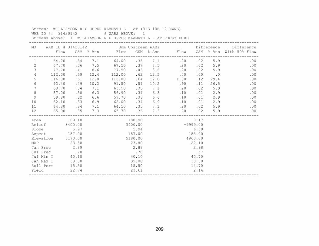
209
Stream: WILLIAMSON R > UPPER KLAMATH L - AT (31S 10E 12 NWNE) WAB ID #: 31420142 # WABS ABOVE: 1 Streams Above: 1 WILLIAMSON R > UPPER KLAMATH L - AT ROCKY FORD ----------------------------------------------------------------------------------------------- MO WAB ID # 31420142 Sum Upstream WABs Difference Difference Flow CSM % Ann Flow CSM % Ann Flow CSM % Ann With 50% Flow ----------------------------------------------------------------------------------------------- 1 64.20 .34 7.1 64.00 .35 7.1 .20 .02 5.9 .00 2 67.70 .36 7.5 67.50 .37 7.5 .20 .02 5.9 .00 3 77.70 .41 8.6 77.50 .43 8.6 .20 .02 5.9 .00 4 112.00 .59 12.4 112.00 .62 12.5 .00 .00 .0 .00 5 116.00 .61 12.8 115.00 .64 12.8 1.00 .12 29.4 .00 6 92.40 .49 10.2 91.50 .51 10.2 .90 .11 26.5 .00 7 63.70 .34 7.1 63.50 .35 7.1 .20 .02 5.9 .00 8 57.00 .30 6.3 56.90 .31 6.3 .10 .01 2.9 .00 9 59.80 .32 6.6 59.70 .33 6.6 .10 .01 2.9 .00 10 62.10 .33 6.9 62.00 .34 6.9 .10 .01 2.9 .00 11 64.30 .34 7.1 64.10 .35 7.1 .20 .02 5.9 .00 12 65.90 .35 7.3 65.70 .36 7.3 .20 .02 5.9 .00 ----------------------------------------------------------------------------------------------- Area 189.10 180.90 8.17 Relief 3400.00 3400.00 -9999.00 Slope 5.97 5.94 6.59 Aspect 187.00 187.00 183.00 Elevation 5170.00 5180.00 4960.00 MAP 23.80 23.80 22.10 Jan Prec 2.89 2.88 2.98 Jul Prec .70 .70 .57 Jul Min T 40.10 40.10 40.70 Jan Max T 39.00 39.00 38.50 Soil Perm 15.50 15.50 14.70 Yield 22.74 23.61 2.14 -----------------------------------------------------------------------------------------------

210
Stream: WILLIAMSON R > UPPER KLAMATH L - AT ROCKY FORD WAB ID #: 70824 # WABS ABOVE: 2 Streams Above: 1 DEEP CR > WILLIAMSON R - AT MOUTH 2 WILLIAMSON R > UPPER KLAMATH L - AB DEEP CR ----------------------------------------------------------------------------------------------- MO WAB ID # 70824 Sum Upstream WABs Difference Difference Flow CSM % Ann Flow CSM % Ann Flow CSM % Ann With 50% Flow ----------------------------------------------------------------------------------------------- 1 64.00 .35 7.1 60.90 .37 7.3 3.12 .17 5.0 .00 2 67.50 .37 7.5 62.80 .39 7.5 4.71 .26 7.6 .00 3 77.50 .43 8.6 69.30 .43 8.3 8.21 .45 13.2 .00 4 112.00 .62 12.5 99.70 .61 11.9 12.30 .67 19.8 .00 5 115.00 .64 12.8 101.00 .62 12.1 13.80 .76 22.2 .00 6 91.50 .51 10.2 83.60 .51 10.0 7.88 .43 12.7 .00 7 63.50 .35 7.1 61.10 .38 7.3 2.41 .13 3.9 .00 8 56.90 .31 6.3 55.40 .34 6.6 1.53 .08 2.5 .00 9 59.70 .33 6.6 58.00 .36 6.9 1.73 .09 2.8 .00 10 62.00 .34 6.9 59.90 .37 7.2 2.13 .12 3.4 .00 11 64.10 .35 7.1 62.10 .38 7.4 1.98 .11 3.2 .00 12 65.70 .36 7.3 63.20 .39 7.6 2.46 .13 4.0 .00 ----------------------------------------------------------------------------------------------- Area 180.90 162.60 18.24 Relief 3400.00 -9999.00 -9999.00 Slope 5.94 5.70 8.08 Aspect 187.00 185.00 200.00 Elevation 5180.00 5180.00 5260.00 MAP 23.80 23.80 24.60 Jan Prec 2.88 2.87 3.05 Jul Prec .70 .71 .63 Jul Min T 40.10 40.00 40.70 Jan Max T 39.00 39.10 38.50 Soil Perm 15.50 15.50 15.20 Yield 23.61 24.52 15.72 -----------------------------------------------------------------------------------------------

211
Stream: DEEP CR > WILLIAMSON R - AT MOUTH WAB ID #: 31420131 # WABS ABOVE: 1 Streams Above: 1 DEEP CR > WILLIAMSON R - AT NF BOUNDARY (31S 11E 29 SESW) ----------------------------------------------------------------------------------------------- MO WAB ID # 31420131 Sum Upstream WABs Difference Difference Flow CSM % Ann Flow CSM % Ann Flow CSM % Ann With 50% Flow ----------------------------------------------------------------------------------------------- 1 2.78 .28 4.9 2.78 .29 4.9 .00 .00 .0 .00 2 3.39 .34 5.9 3.39 .35 5.9 .00 .00 .0 .00 3 5.19 .52 9.1 5.19 .53 9.1 .00 .00 .0 .00 4 10.70 1.06 18.8 10.70 1.10 18.8 .00 .00 .0 .00 5 15.80 1.57 27.7 15.80 1.62 27.7 .00 .00 .0 .00 6 7.92 .79 13.9 7.92 .81 13.9 .00 .00 .0 .00 7 2.19 .22 3.8 2.19 .22 3.8 .00 .00 .0 .00 8 1.37 .14 2.4 1.37 .14 2.4 .00 .00 .0 .00 9 1.47 .15 2.6 1.47 .15 2.6 .00 .00 .0 .00 10 1.77 .18 3.1 1.77 .18 3.1 .00 .00 .0 .00 11 2.02 .20 3.5 2.02 .21 3.5 .00 .00 .0 .00 12 2.34 .23 4.1 2.34 .24 4.1 .00 .00 .0 .00 ----------------------------------------------------------------------------------------------- Area 10.05 9.75 .30 Relief 3400.00 3300.00 -9999.00 Slope 14.10 14.50 -1.73 Aspect 231.00 230.00 270.00 Elevation 6160.00 6220.00 4390.00 MAP 30.10 30.40 21.10 Jan Prec 3.18 3.19 2.85 Jul Prec .91 .92 .58 Jul Min T 41.40 41.40 40.10 Jan Max T 37.30 37.20 39.00 Soil Perm 16.10 16.10 15.80 Yield 21.28 21.73 .00 -----------------------------------------------------------------------------------------------

212
Stream: DEEP CR > WILLIAMSON R - AT NF BOUNDARY (31S 11E 29 SESW) WAB ID #: 31420132 # WABS ABOVE: 0 ----------------------------------------------------------------------------------------------- MO WAB ID # 31420132 Sum Upstream WABs Difference Difference Flow CSM % Ann Flow CSM % Ann Flow CSM % Ann With 50% Flow ----------------------------------------------------------------------------------------------- 1 2.78 .29 4.9 .00 .00 .0 .00 .00 .0 .00 2 3.39 .35 5.9 .00 .00 .0 .00 .00 .0 .00 3 5.19 .53 9.1 .00 .00 .0 .00 .00 .0 .00 4 10.70 1.10 18.8 .00 .00 .0 .00 .00 .0 .00 5 15.80 1.62 27.7 .00 .00 .0 .00 .00 .0 .00 6 7.92 .81 13.9 .00 .00 .0 .00 .00 .0 .00 7 2.19 .22 3.8 .00 .00 .0 .00 .00 .0 .00 8 1.37 .14 2.4 .00 .00 .0 .00 .00 .0 .00 9 1.47 .15 2.6 .00 .00 .0 .00 .00 .0 .00 10 1.77 .18 3.1 .00 .00 .0 .00 .00 .0 .00 11 2.02 .21 3.5 .00 .00 .0 .00 .00 .0 .00 12 2.34 .24 4.1 .00 .00 .0 .00 .00 .0 .00 ----------------------------------------------------------------------------------------------- Area 9.75 .00 .00 Relief 3300.00 .00 .00 Slope 14.50 .00 .00 Aspect 230.00 .00 .00 Elevation 6220.00 .00 .00 MAP 30.40 .00 .00 Jan Prec 3.19 .00 .00 Jul Prec .92 .00 .00 Jul Min T 41.40 .00 .00 Jan Max T 37.20 .00 .00 Soil Perm 16.10 .00 .00 Yield 21.73 .00 .00 -----------------------------------------------------------------------------------------------

213
Stream: WILLIAMSON R > UPPER KLAMATH L - AB DEEP CR WAB ID #: 31420115 # WABS ABOVE: 1 Streams Above: 1 WILLIAMSON R > UPPER KLAMATH L - AT WICKIUP SPRING ----------------------------------------------------------------------------------------------- MO WAB ID # 31420115 Sum Upstream WABs Difference Difference Flow CSM % Ann Flow CSM % Ann Flow CSM % Ann With 50% Flow ----------------------------------------------------------------------------------------------- 1 58.10 .38 7.4 36.40 .39 7.6 21.70 .36 7.2 .00 2 59.40 .39 7.6 36.80 .40 7.7 22.60 .38 7.5 .00 3 64.10 .42 8.2 38.80 .42 8.1 25.30 .42 8.4 .00 4 89.00 .58 11.4 52.70 .57 11.0 36.30 .61 12.1 .00 5 85.40 .56 10.9 50.40 .54 10.5 35.00 .58 11.6 .00 6 75.70 .50 9.7 46.70 .50 9.7 29.00 .48 9.6 .00 7 58.90 .39 7.6 36.70 .40 7.7 22.20 .37 7.4 .00 8 54.00 .35 6.9 33.60 .36 7.0 20.40 .34 6.8 .00 9 56.50 .37 7.2 34.80 .38 7.3 21.70 .36 7.2 .00 10 58.10 .38 7.4 36.00 .39 7.5 22.10 .37 7.3 .00 11 60.10 .39 7.7 38.30 .41 8.0 21.80 .36 7.3 .00 12 60.90 .40 7.8 38.50 .42 8.0 22.40 .37 7.4 .00 ----------------------------------------------------------------------------------------------- Area 152.60 92.61 59.97 Relief 2200.00 2200.00 -9999.00 Slope 5.15 5.44 4.70 Aspect 182.00 177.00 190.00 Elevation 5110.00 5080.00 5150.00 MAP 23.30 23.30 23.50 Jan Prec 2.85 2.82 2.88 Jul Prec .70 .72 .68 Jul Min T 39.90 39.60 40.30 Jan Max T 39.20 39.40 38.90 Soil Perm 15.50 15.50 15.50 Yield 24.80 25.20 24.17 -----------------------------------------------------------------------------------------------

214
Stream: WILLIAMSON R > UPPER KLAMATH L - AT WICKIUP SPRING WAB ID #: 31420128 # WABS ABOVE: 0 ----------------------------------------------------------------------------------------------- MO WAB ID # 31420128 Sum Upstream WABs Difference Difference Flow CSM % Ann Flow CSM % Ann Flow CSM % Ann With 50% Flow ----------------------------------------------------------------------------------------------- 1 36.40 .39 7.6 .00 .00 .0 .00 .00 .0 .00 2 36.80 .40 7.7 .00 .00 .0 .00 .00 .0 .00 3 38.80 .42 8.1 .00 .00 .0 .00 .00 .0 .00 4 52.70 .57 11.0 .00 .00 .0 .00 .00 .0 .00 5 50.40 .54 10.5 .00 .00 .0 .00 .00 .0 .00 6 46.70 .50 9.7 .00 .00 .0 .00 .00 .0 .00 7 36.70 .40 7.7 .00 .00 .0 .00 .00 .0 .00 8 33.60 .36 7.0 .00 .00 .0 .00 .00 .0 .00 9 34.80 .38 7.3 .00 .00 .0 .00 .00 .0 .00 10 36.00 .39 7.5 .00 .00 .0 .00 .00 .0 .00 11 38.30 .41 8.0 .00 .00 .0 .00 .00 .0 .00 12 38.50 .42 8.0 .00 .00 .0 .00 .00 .0 .00 ----------------------------------------------------------------------------------------------- Area 92.61 .00 .00 Relief 2200.00 .00 .00 Slope 5.44 .00 .00 Aspect 177.00 .00 .00 Elevation 5080.00 .00 .00 MAP 23.30 .00 .00 Jan Prec 2.82 .00 .00 Jul Prec .72 .00 .00 Jul Min T 39.60 .00 .00 Jan Max T 39.40 .00 .00 Soil Perm 15.50 .00 .00 Yield 25.20 .00 .00 -----------------------------------------------------------------------------------------------

215
Stream: JENNY CR > KLAMATH R - AT MOUTH WAB ID #: 31420602 # WABS ABOVE: 2 Streams Above: 1 KEENE CR > JENNY CR - AT MOUTH 2 JENNY CR > KLAMATH R - AB KEENE CR ----------------------------------------------------------------------------------------------- MO WAB ID # 31420602 Sum Upstream WABs Difference Difference Flow CSM % Ann Flow CSM % Ann Flow CSM % Ann With 50% Flow ----------------------------------------------------------------------------------------------- 1 56.70 .29 6.6 54.40 .30 6.7 2.30 .13 6.0 .00 2 127.00 .65 14.9 120.00 .67 14.7 7.40 .43 19.4 .00 3 219.00 1.11 25.6 207.00 1.15 25.3 12.10 .70 31.7 .00 4 248.00 1.26 29.0 240.00 1.34 29.4 8.20 .48 21.4 .00 5 93.30 .47 10.9 89.50 .50 11.0 3.80 .22 9.9 .00 6 25.70 .13 3.0 24.60 .14 3.0 1.07 .06 2.8 .00 7 12.70 .06 1.5 12.20 .07 1.5 .53 .03 1.4 .00 8 8.06 .04 .9 7.74 .04 .9 .32 .02 .8 .00 9 7.80 .04 .9 7.49 .04 .9 .31 .02 .8 .00 10 8.45 .04 1.0 8.13 .05 1.0 .32 .02 .8 .00 11 11.70 .06 1.4 11.40 .06 1.4 .34 .02 .9 .00 12 36.00 .18 4.2 34.50 .19 4.2 1.54 .09 4.0 .00 ----------------------------------------------------------------------------------------------- Area 196.70 179.50 17.21 Relief 3380.00 -9999.00 -9999.00 Slope 9.91 9.88 10.20 Aspect 184.00 183.00 191.00 Elevation 4590.00 4680.00 3650.00 MAP 33.00 33.90 23.00 Jan Prec 4.51 4.63 3.29 Jul Prec .49 .50 .32 Jul Min T 46.10 45.90 47.80 Jan Max T 39.00 38.80 41.40 Soil Perm 1.50 1.57 .75 Yield 14.91 15.17 10.93 -----------------------------------------------------------------------------------------------

216
Stream: KEENE CR > JENNY CR - AT MOUTH WAB ID #: 31420603 # WABS ABOVE: 1 Streams Above: 1 KEENE CR > JENNY CR - AT KEENE CR DAM ----------------------------------------------------------------------------------------------- MO WAB ID # 31420603 Sum Upstream WABs Difference Difference Flow CSM % Ann Flow CSM % Ann Flow CSM % Ann With 50% Flow ----------------------------------------------------------------------------------------------- 1 11.70 .29 6.6 7.72 .40 7.0 3.98 .18 5.8 .00 2 24.60 .60 13.8 12.90 .67 11.8 11.70 .54 17.0 .00 3 45.90 1.12 25.7 25.90 1.34 23.6 20.00 .93 29.0 .00 4 59.80 1.46 33.5 44.20 2.29 40.3 15.60 .72 22.6 .00 5 19.30 .47 10.8 10.60 .55 9.7 8.70 .40 12.6 .00 6 4.53 .11 2.5 2.21 .11 2.0 2.32 .11 3.4 .00 7 1.77 .04 1.0 .69 .04 .6 1.08 .05 1.6 .00 8 1.03 .03 .6 .43 .02 .4 .60 .03 .9 .00 9 .92 .02 .5 .35 .02 .3 .57 .03 .8 .00 10 .92 .02 .5 .28 .01 .3 .64 .03 .9 .00 11 1.62 .04 .9 .67 .03 .6 .95 .04 1.4 .00 12 6.56 .16 3.7 3.70 .19 3.4 2.86 .13 4.1 .00 ----------------------------------------------------------------------------------------------- Area 40.90 19.28 21.62 Relief 2680.00 1680.00 -9999.00 Slope 12.40 9.10 15.30 Aspect 163.00 189.00 140.00 Elevation 4810.00 5210.00 4460.00 MAP 33.30 37.80 29.40 Jan Prec 4.53 4.95 4.16 Jul Prec .45 .53 .38 Jul Min T 47.30 47.00 47.60 Jan Max T 39.30 38.40 40.00 Soil Perm 1.88 2.09 1.68 Yield 14.84 17.05 12.30 -----------------------------------------------------------------------------------------------

217
Stream: KEENE CR > JENNY CR - AT KEENE CR DAM WAB ID #: 31420619 # WABS ABOVE: 0 ----------------------------------------------------------------------------------------------- MO WAB ID # 31420619 Sum Upstream WABs Difference Difference Flow CSM % Ann Flow CSM % Ann Flow CSM % Ann With 50% Flow ----------------------------------------------------------------------------------------------- 1 7.72 .40 7.0 .00 .00 .0 .00 .00 .0 .00 2 12.90 .67 11.8 .00 .00 .0 .00 .00 .0 .00 3 25.90 1.34 23.6 .00 .00 .0 .00 .00 .0 .00 4 44.20 2.29 40.3 .00 .00 .0 .00 .00 .0 .00 5 10.60 .55 9.7 .00 .00 .0 .00 .00 .0 .00 6 2.21 .11 2.0 .00 .00 .0 .00 .00 .0 .00 7 .69 .04 .6 .00 .00 .0 .00 .00 .0 .00 8 .43 .02 .4 .00 .00 .0 .00 .00 .0 .00 9 .35 .02 .3 .00 .00 .0 .00 .00 .0 .00 10 .28 .01 .3 .00 .00 .0 .00 .00 .0 .00 11 .67 .03 .6 .00 .00 .0 .00 .00 .0 .00 12 3.70 .19 3.4 .00 .00 .0 .00 .00 .0 .00 ----------------------------------------------------------------------------------------------- Area 19.28 .00 .00 Relief 1680.00 .00 .00 Slope 9.10 .00 .00 Aspect 189.00 .00 .00 Elevation 5210.00 .00 .00 MAP 37.80 .00 .00 Jan Prec 4.95 .00 .00 Jul Prec .53 .00 .00 Jul Min T 47.00 .00 .00 Jan Max T 38.40 .00 .00 Soil Perm 2.09 .00 .00 Yield 17.05 .00 .00 -----------------------------------------------------------------------------------------------

218
Stream: JENNY CR > KLAMATH R - AB KEENE CR WAB ID #: 70811 # WABS ABOVE: 2 Streams Above: 1 JOHNSON CR > JENNY CR - AT MOUTH 2 JENNY CR > KLAMATH R - AB JOHNSON CR ----------------------------------------------------------------------------------------------- MO WAB ID # 70811 Sum Upstream WABs Difference Difference Flow CSM % Ann Flow CSM % Ann Flow CSM % Ann With 50% Flow ----------------------------------------------------------------------------------------------- 1 42.70 .31 6.7 31.70 .31 6.3 11.00 .31 8.1 .00 2 95.00 .69 14.9 70.60 .69 14.1 24.40 .69 18.0 .00 3 161.00 1.16 25.3 128.00 1.24 25.4 33.50 .94 24.7 .00 4 180.00 1.30 28.2 151.00 1.47 30.1 29.10 .82 21.4 .00 5 70.20 .51 11.0 56.70 .55 11.3 13.50 .38 9.9 .00 6 20.10 .15 3.2 15.60 .15 3.1 4.52 .13 3.3 .00 7 10.40 .08 1.6 7.93 .08 1.6 2.47 .07 1.8 .00 8 6.71 .05 1.0 4.87 .05 1.0 1.84 .05 1.4 .00 9 6.57 .05 1.0 4.74 .05 .9 1.83 .05 1.4 .00 10 7.21 .05 1.1 5.17 .05 1.0 2.04 .06 1.5 .00 11 9.74 .07 1.5 6.62 .06 1.3 3.12 .09 2.3 .00 12 27.90 .20 4.4 19.50 .19 3.9 8.40 .24 6.2 .00 ----------------------------------------------------------------------------------------------- Area 138.60 103.00 35.61 Relief 3180.00 -9999.00 -9999.00 Slope 9.15 8.38 11.40 Aspect 189.00 191.00 185.00 Elevation 4650.00 4780.00 4270.00 MAP 34.10 36.10 28.40 Jan Prec 4.66 4.86 4.08 Jul Prec .52 .57 .35 Jul Min T 45.50 45.10 46.50 Jan Max T 38.60 38.30 39.40 Soil Perm 1.48 1.41 1.69 Yield 15.26 15.28 15.18 -----------------------------------------------------------------------------------------------

219
Stream: JOHNSON CR > JENNY CR - AT MOUTH WAB ID #: 31420604 # WABS ABOVE: 0 ----------------------------------------------------------------------------------------------- MO WAB ID # 31420604 Sum Upstream WABs Difference Difference Flow CSM % Ann Flow CSM % Ann Flow CSM % Ann With 50% Flow ----------------------------------------------------------------------------------------------- 1 13.70 .23 5.6 .00 .00 .0 .00 .00 .0 .00 2 38.50 .64 15.7 .00 .00 .0 .00 .00 .0 .00 3 65.50 1.09 26.6 .00 .00 .0 .00 .00 .0 .00 4 56.60 .94 23.0 .00 .00 .0 .00 .00 .0 .00 5 32.10 .53 13.1 .00 .00 .0 .00 .00 .0 .00 6 9.22 .15 3.8 .00 .00 .0 .00 .00 .0 .00 7 5.23 .09 2.1 .00 .00 .0 .00 .00 .0 .00 8 3.13 .05 1.3 .00 .00 .0 .00 .00 .0 .00 9 3.25 .05 1.3 .00 .00 .0 .00 .00 .0 .00 10 3.85 .06 1.6 .00 .00 .0 .00 .00 .0 .00 11 4.52 .08 1.8 .00 .00 .0 .00 .00 .0 .00 12 10.30 .17 4.2 .00 .00 .0 .00 .00 .0 .00 ----------------------------------------------------------------------------------------------- Area 60.02 .00 .00 Relief 2800.00 .00 .00 Slope 9.10 .00 .00 Aspect 200.00 .00 .00 Elevation 4770.00 .00 .00 MAP 36.20 .00 .00 Jan Prec 4.80 .00 .00 Jul Prec .61 .00 .00 Jul Min T 45.20 .00 .00 Jan Max T 38.40 .00 .00 Soil Perm 1.18 .00 .00 Yield 12.81 .00 .00 -----------------------------------------------------------------------------------------------

220
Stream: JENNY CR > KLAMATH R - AB JOHNSON CR WAB ID #: 31420605 # WABS ABOVE: 0 ----------------------------------------------------------------------------------------------- MO WAB ID # 31420605 Sum Upstream WABs Difference Difference Flow CSM % Ann Flow CSM % Ann Flow CSM % Ann With 50% Flow ----------------------------------------------------------------------------------------------- 1 18.00 .42 7.0 .00 .00 .0 .00 .00 .0 .00 2 32.10 .75 12.5 .00 .00 .0 .00 .00 .0 .00 3 62.00 1.44 24.2 .00 .00 .0 .00 .00 .0 .00 4 94.30 2.20 36.8 .00 .00 .0 .00 .00 .0 .00 5 24.60 .57 9.6 .00 .00 .0 .00 .00 .0 .00 6 6.36 .15 2.5 .00 .00 .0 .00 .00 .0 .00 7 2.70 .06 1.1 .00 .00 .0 .00 .00 .0 .00 8 1.74 .04 .7 .00 .00 .0 .00 .00 .0 .00 9 1.49 .03 .6 .00 .00 .0 .00 .00 .0 .00 10 1.32 .03 .5 .00 .00 .0 .00 .00 .0 .00 11 2.10 .05 .8 .00 .00 .0 .00 .00 .0 .00 12 9.20 .21 3.6 .00 .00 .0 .00 .00 .0 .00 ----------------------------------------------------------------------------------------------- Area 42.94 .00 .00 Relief 2400.00 .00 .00 Slope 7.37 .00 .00 Aspect 179.00 .00 .00 Elevation 4790.00 .00 .00 MAP 36.00 .00 .00 Jan Prec 4.96 .00 .00 Jul Prec .52 .00 .00 Jul Min T 44.90 .00 .00 Jan Max T 38.30 .00 .00 Soil Perm 1.73 .00 .00 Yield 18.76 .00 .00 -----------------------------------------------------------------------------------------------

221
Stream: HAYDEN CR > KLAMATH R - AT STATE LINE WAB ID #: 31420601 # WABS ABOVE: 0 ----------------------------------------------------------------------------------------------- MO WAB ID # 31420601 Sum Upstream WABs Difference Difference Flow CSM % Ann Flow CSM % Ann Flow CSM % Ann With 50% Flow ----------------------------------------------------------------------------------------------- 1 3.31 .12 5.2 .00 .00 .0 .00 .00 .0 .00 2 10.30 .38 16.2 .00 .00 .0 .00 .00 .0 .00 3 22.10 .81 34.8 .00 .00 .0 .00 .00 .0 .00 4 18.60 .68 29.3 .00 .00 .0 .00 .00 .0 .00 5 4.82 .18 7.6 .00 .00 .0 .00 .00 .0 .00 6 .99 .04 1.6 .00 .00 .0 .00 .00 .0 .00 7 .43 .02 .7 .00 .00 .0 .00 .00 .0 .00 8 .24 .01 .4 .00 .00 .0 .00 .00 .0 .00 9 .24 .01 .4 .00 .00 .0 .00 .00 .0 .00 10 .28 .01 .4 .00 .00 .0 .00 .00 .0 .00 11 .45 .02 .7 .00 .00 .0 .00 .00 .0 .00 12 1.80 .07 2.8 .00 .00 .0 .00 .00 .0 .00 ----------------------------------------------------------------------------------------------- Area 27.37 .00 .00 Relief 2200.00 .00 .00 Slope 6.07 .00 .00 Aspect 194.00 .00 .00 Elevation 4270.00 .00 .00 MAP 26.50 .00 .00 Jan Prec 3.60 .00 .00 Jul Prec .39 .00 .00 Jul Min T 46.40 .00 .00 Jan Max T 39.60 .00 .00 Soil Perm 1.03 .00 .00 Yield 9.90 .00 .00 -----------------------------------------------------------------------------------------------

222
Stream: LONG PRAIRIE CR > KLAMATH R - AT STATE LINE WAB ID #: 31420606 # WABS ABOVE: 0 ----------------------------------------------------------------------------------------------- MO WAB ID # 31420606 Sum Upstream WABs Difference Difference Flow CSM % Ann Flow CSM % Ann Flow CSM % Ann With 50% Flow ----------------------------------------------------------------------------------------------- 1 5.88 .15 5.3 .00 .00 .0 .00 .00 .0 .00 2 17.50 .46 15.7 .00 .00 .0 .00 .00 .0 .00 3 36.60 .96 32.9 .00 .00 .0 .00 .00 .0 .00 4 32.90 .86 29.6 .00 .00 .0 .00 .00 .0 .00 5 9.54 .25 8.6 .00 .00 .0 .00 .00 .0 .00 6 2.01 .05 1.8 .00 .00 .0 .00 .00 .0 .00 7 .92 .02 .8 .00 .00 .0 .00 .00 .0 .00 8 .53 .01 .5 .00 .00 .0 .00 .00 .0 .00 9 .51 .01 .5 .00 .00 .0 .00 .00 .0 .00 10 .57 .01 .5 .00 .00 .0 .00 .00 .0 .00 11 .86 .02 .8 .00 .00 .0 .00 .00 .0 .00 12 3.33 .09 3.0 .00 .00 .0 .00 .00 .0 .00 ----------------------------------------------------------------------------------------------- Area 38.15 .00 .00 Relief 2450.00 .00 .00 Slope 6.01 .00 .00 Aspect 197.00 .00 .00 Elevation 4350.00 .00 .00 MAP 29.30 .00 .00 Jan Prec 4.01 .00 .00 Jul Prec .45 .00 .00 Jul Min T 46.40 .00 .00 Jan Max T 39.30 .00 .00 Soil Perm 1.14 .00 .00 Yield 11.24 .00 .00 -----------------------------------------------------------------------------------------------

223
Stream: FALL CR > KLAMATH R - AT STATE LINE WAB ID #: 31420607 # WABS ABOVE: 0 ----------------------------------------------------------------------------------------------- MO WAB ID # 31420607 Sum Upstream WABs Difference Difference Flow CSM % Ann Flow CSM % Ann Flow CSM % Ann With 50% Flow ----------------------------------------------------------------------------------------------- 1 42.70 4.10 8.9 .00 .00 .0 .00 .00 .0 .00 2 52.90 5.08 11.1 .00 .00 .0 .00 .00 .0 .00 3 51.30 4.93 10.7 .00 .00 .0 .00 .00 .0 .00 4 44.30 4.26 9.3 .00 .00 .0 .00 .00 .0 .00 5 36.60 3.52 7.7 .00 .00 .0 .00 .00 .0 .00 6 35.00 3.36 7.3 .00 .00 .0 .00 .00 .0 .00 7 33.70 3.24 7.1 .00 .00 .0 .00 .00 .0 .00 8 33.60 3.23 7.0 .00 .00 .0 .00 .00 .0 .00 9 34.30 3.30 7.2 .00 .00 .0 .00 .00 .0 .00 10 35.30 3.39 7.4 .00 .00 .0 .00 .00 .0 .00 11 38.10 3.66 8.0 .00 .00 .0 .00 .00 .0 .00 12 39.90 3.83 8.4 .00 .00 .0 .00 .00 .0 .00 ----------------------------------------------------------------------------------------------- Area 10.41 .00 .00 Relief 1800.00 .00 .00 Slope 9.90 .00 .00 Aspect 236.00 .00 .00 Elevation 3950.00 .00 .00 MAP 26.20 .00 .00 Jan Prec 3.67 .00 .00 Jul Prec .36 .00 .00 Jul Min T 47.10 .00 .00 Jan Max T 40.40 .00 .00 Soil Perm 1.48 .00 .00 Yield 198.28 .00 .00 -----------------------------------------------------------------------------------------------

224
Stream: SKOOKUM CR > JENNY CR - AT STATE LINE WAB ID #: 31420608 # WABS ABOVE: 0 ----------------------------------------------------------------------------------------------- MO WAB ID # 31420608 Sum Upstream WABs Difference Difference Flow CSM % Ann Flow CSM % Ann Flow CSM % Ann With 50% Flow ----------------------------------------------------------------------------------------------- 1 1.34 .12 6.1 .00 .00 .0 .00 .00 .0 .00 2 4.11 .37 18.8 .00 .00 .0 .00 .00 .0 .00 3 6.96 .62 31.9 .00 .00 .0 .00 .00 .0 .00 4 4.85 .43 22.2 .00 .00 .0 .00 .00 .0 .00 5 2.24 .20 10.3 .00 .00 .0 .00 .00 .0 .00 6 .56 .05 2.6 .00 .00 .0 .00 .00 .0 .00 7 .25 .02 1.1 .00 .00 .0 .00 .00 .0 .00 8 .14 .01 .6 .00 .00 .0 .00 .00 .0 .00 9 .13 .01 .6 .00 .00 .0 .00 .00 .0 .00 10 .14 .01 .6 .00 .00 .0 .00 .00 .0 .00 11 .21 .02 1.0 .00 .00 .0 .00 .00 .0 .00 12 .89 .08 4.1 .00 .00 .0 .00 .00 .0 .00 ----------------------------------------------------------------------------------------------- Area 11.22 .00 .00 Relief 2200.00 .00 .00 Slope 11.80 .00 .00 Aspect 144.00 .00 .00 Elevation 3880.00 .00 .00 MAP 22.20 .00 .00 Jan Prec 3.25 .00 .00 Jul Prec .31 .00 .00 Jul Min T 48.60 .00 .00 Jan Max T 41.80 .00 .00 Soil Perm .68 .00 .00 Yield 9.93 .00 .00 -----------------------------------------------------------------------------------------------

225
Stream: SALT CR > CAMP CR - AT STATE LINE WAB ID #: 31420609 # WABS ABOVE: 0 ----------------------------------------------------------------------------------------------- MO WAB ID # 31420609 Sum Upstream WABs Difference Difference Flow CSM % Ann Flow CSM % Ann Flow CSM % Ann With 50% Flow ----------------------------------------------------------------------------------------------- 1 .36 .14 6.6 .00 .00 .0 .00 .00 .0 .00 2 1.09 .44 20.0 .00 .00 .0 .00 .00 .0 .00 3 1.84 .74 33.8 .00 .00 .0 .00 .00 .0 .00 4 1.18 .47 21.7 .00 .00 .0 .00 .00 .0 .00 5 .47 .19 8.6 .00 .00 .0 .00 .00 .0 .00 6 .11 .04 2.0 .00 .00 .0 .00 .00 .0 .00 7 .04 .02 .7 .00 .00 .0 .00 .00 .0 .00 8 .02 .01 .4 .00 .00 .0 .00 .00 .0 .00 9 .02 .01 .4 .00 .00 .0 .00 .00 .0 .00 10 .03 .01 .6 .00 .00 .0 .00 .00 .0 .00 11 .05 .02 .9 .00 .00 .0 .00 .00 .0 .00 12 .23 .09 4.2 .00 .00 .0 .00 .00 .0 .00 ----------------------------------------------------------------------------------------------- Area 2.49 .00 .00 Relief 1800.00 .00 .00 Slope 21.70 .00 .00 Aspect 184.00 .00 .00 Elevation 3640.00 .00 .00 MAP 23.90 .00 .00 Jan Prec 3.60 .00 .00 Jul Prec .32 .00 .00 Jul Min T 48.70 .00 .00 Jan Max T 41.30 .00 .00 Soil Perm .38 .00 .00 Yield 10.35 .00 .00 -----------------------------------------------------------------------------------------------

226
Stream: CAMP CR > KLAMATH R - AT STATE LINE WAB ID #: 31420610 # WABS ABOVE: 0 ----------------------------------------------------------------------------------------------- MO WAB ID # 31420610 Sum Upstream WABs Difference Difference Flow CSM % Ann Flow CSM % Ann Flow CSM % Ann With 50% Flow ----------------------------------------------------------------------------------------------- 1 1.70 .18 5.7 .00 .00 .0 .00 .00 .0 .00 2 5.16 .53 17.2 .00 .00 .0 .00 .00 .0 .00 3 8.85 .92 29.6 .00 .00 .0 .00 .00 .0 .00 4 6.67 .69 22.3 .00 .00 .0 .00 .00 .0 .00 5 3.75 .39 12.5 .00 .00 .0 .00 .00 .0 .00 6 1.05 .11 3.5 .00 .00 .0 .00 .00 .0 .00 7 .44 .05 1.5 .00 .00 .0 .00 .00 .0 .00 8 .25 .03 .8 .00 .00 .0 .00 .00 .0 .00 9 .22 .02 .7 .00 .00 .0 .00 .00 .0 .00 10 .24 .02 .8 .00 .00 .0 .00 .00 .0 .00 11 .37 .04 1.2 .00 .00 .0 .00 .00 .0 .00 12 1.22 .13 4.1 .00 .00 .0 .00 .00 .0 .00 ----------------------------------------------------------------------------------------------- Area 9.67 .00 .00 Relief 3030.00 .00 .00 Slope 27.10 .00 .00 Aspect 156.00 .00 .00 Elevation 4520.00 .00 .00 MAP 27.00 .00 .00 Jan Prec 4.20 .00 .00 Jul Prec .34 .00 .00 Jul Min T 48.20 .00 .00 Jan Max T 40.60 .00 .00 Soil Perm 1.76 .00 .00 Yield 12.98 .00 .00 -----------------------------------------------------------------------------------------------

227
Stream: SCOTCH CR > CAMP CR - AT STATE LINE WAB ID #: 31420611 # WABS ABOVE: 0 ----------------------------------------------------------------------------------------------- MO WAB ID # 31420611 Sum Upstream WABs Difference Difference Flow CSM % Ann Flow CSM % Ann Flow CSM % Ann With 50% Flow ----------------------------------------------------------------------------------------------- 1 1.01 .21 5.9 .00 .00 .0 .00 .00 .0 .00 2 3.07 .64 17.9 .00 .00 .0 .00 .00 .0 .00 3 5.22 1.10 30.4 .00 .00 .0 .00 .00 .0 .00 4 3.80 .80 22.1 .00 .00 .0 .00 .00 .0 .00 5 1.99 .42 11.6 .00 .00 .0 .00 .00 .0 .00 6 .54 .11 3.1 .00 .00 .0 .00 .00 .0 .00 7 .22 .05 1.3 .00 .00 .0 .00 .00 .0 .00 8 .12 .03 .7 .00 .00 .0 .00 .00 .0 .00 9 .11 .02 .6 .00 .00 .0 .00 .00 .0 .00 10 .13 .03 .8 .00 .00 .0 .00 .00 .0 .00 11 .23 .05 1.3 .00 .00 .0 .00 .00 .0 .00 12 .74 .16 4.3 .00 .00 .0 .00 .00 .0 .00 ----------------------------------------------------------------------------------------------- Area 4.77 .00 .00 Relief 2210.00 .00 .00 Slope 25.60 .00 .00 Aspect 153.00 .00 .00 Elevation 4350.00 .00 .00 MAP 30.00 .00 .00 Jan Prec 4.90 .00 .00 Jul Prec .35 .00 .00 Jul Min T 47.90 .00 .00 Jan Max T 40.40 .00 .00 Soil Perm 1.70 .00 .00 Yield 13.58 .00 .00 -----------------------------------------------------------------------------------------------

228
Stream: SLIDE CR > SCOTCH CR - AT STATE LINE WAB ID #: 31420612 # WABS ABOVE: 0 ----------------------------------------------------------------------------------------------- MO WAB ID # 31420612 Sum Upstream WABs Difference Difference Flow CSM % Ann Flow CSM % Ann Flow CSM % Ann With 50% Flow ----------------------------------------------------------------------------------------------- 1 .17 .22 6.4 .00 .00 .0 .00 .00 .0 .00 2 .50 .65 18.8 .00 .00 .0 .00 .00 .0 .00 3 .86 1.11 32.3 .00 .00 .0 .00 .00 .0 .00 4 .59 .76 22.2 .00 .00 .0 .00 .00 .0 .00 5 .27 .35 10.2 .00 .00 .0 .00 .00 .0 .00 6 .06 .08 2.3 .00 .00 .0 .00 .00 .0 .00 7 .02 .03 .8 .00 .00 .0 .00 .00 .0 .00 8 .01 .01 .4 .00 .00 .0 .00 .00 .0 .00 9 .01 .01 .4 .00 .00 .0 .00 .00 .0 .00 10 .01 .01 .4 .00 .00 .0 .00 .00 .0 .00 11 .04 .05 1.5 .00 .00 .0 .00 .00 .0 .00 12 .12 .16 4.5 .00 .00 .0 .00 .00 .0 .00 ----------------------------------------------------------------------------------------------- Area .77 .00 .00 Relief 1160.00 .00 .00 Slope 23.90 .00 .00 Aspect 147.00 .00 .00 Elevation 4140.00 .00 .00 MAP 30.50 .00 .00 Jan Prec 5.06 .00 .00 Jul Prec .36 .00 .00 Jul Min T 48.20 .00 .00 Jan Max T 40.90 .00 .00 Soil Perm 1.20 .00 .00 Yield 12.75 .00 .00 -----------------------------------------------------------------------------------------------

229
Stream: E FK COTTONWOOD CR > COTTONWOOD CR - AT STATE LINE WAB ID #: 31420613 # WABS ABOVE: 0 ----------------------------------------------------------------------------------------------- MO WAB ID # 31420613 Sum Upstream WABs Difference Difference Flow CSM % Ann Flow CSM % Ann Flow CSM % Ann With 50% Flow ----------------------------------------------------------------------------------------------- 1 7.43 .47 9.4 .00 .00 .0 .00 .00 .0 .00 2 21.00 1.34 26.5 .00 .00 .0 .00 .00 .0 .00 3 20.00 1.27 25.2 .00 .00 .0 .00 .00 .0 .00 4 15.30 .97 19.3 .00 .00 .0 .00 .00 .0 .00 5 5.90 .38 7.4 .00 .00 .0 .00 .00 .0 .00 6 2.61 .17 3.3 .00 .00 .0 .00 .00 .0 .00 7 .60 .04 .8 .00 .00 .0 .00 .00 .0 .00 8 .26 .02 .3 .00 .00 .0 .00 .00 .0 .00 9 .21 .01 .3 .00 .00 .0 .00 .00 .0 .00 10 .60 .04 .8 .00 .00 .0 .00 .00 .0 .00 11 2.02 .13 2.5 .00 .00 .0 .00 .00 .0 .00 12 3.28 .21 4.1 .00 .00 .0 .00 .00 .0 .00 ----------------------------------------------------------------------------------------------- Area 15.70 .00 .00 Relief 2820.00 .00 .00 Slope 17.50 .00 .00 Aspect 197.00 .00 .00 Elevation 3910.00 .00 .00 MAP 28.40 .00 .00 Jan Prec 4.90 .00 .00 Jul Prec .32 .00 .00 Jul Min T 48.70 .00 .00 Jan Max T 41.00 .00 .00 Soil Perm 1.02 .00 .00 Yield 20.12 .00 .00 -----------------------------------------------------------------------------------------------

230
Stream: COTTONWOOD CR > KLAMATH R - AT STATE LINE WAB ID #: 31420614 # WABS ABOVE: 0 ----------------------------------------------------------------------------------------------- MO WAB ID # 31420614 Sum Upstream WABs Difference Difference Flow CSM % Ann Flow CSM % Ann Flow CSM % Ann With 50% Flow ----------------------------------------------------------------------------------------------- 1 9.19 .49 8.6 .00 .00 .0 .00 .00 .0 .00 2 25.80 1.38 24.1 .00 .00 .0 .00 .00 .0 .00 3 24.90 1.33 23.3 .00 .00 .0 .00 .00 .0 .00 4 20.80 1.11 19.5 .00 .00 .0 .00 .00 .0 .00 5 10.20 .54 9.5 .00 .00 .0 .00 .00 .0 .00 6 5.20 .28 4.9 .00 .00 .0 .00 .00 .0 .00 7 1.30 .07 1.2 .00 .00 .0 .00 .00 .0 .00 8 .61 .03 .6 .00 .00 .0 .00 .00 .0 .00 9 .49 .03 .5 .00 .00 .0 .00 .00 .0 .00 10 1.19 .06 1.1 .00 .00 .0 .00 .00 .0 .00 11 2.98 .16 2.8 .00 .00 .0 .00 .00 .0 .00 12 4.26 .23 4.0 .00 .00 .0 .00 .00 .0 .00 ----------------------------------------------------------------------------------------------- Area 18.75 .00 .00 Relief 4340.00 .00 .00 Slope 22.00 .00 .00 Aspect 141.00 .00 .00 Elevation 4240.00 .00 .00 MAP 30.50 .00 .00 Jan Prec 4.96 .00 .00 Jul Prec .34 .00 .00 Jul Min T 48.90 .00 .00 Jan Max T 40.00 .00 .00 Soil Perm 2.17 .00 .00 Yield 21.18 .00 .00 -----------------------------------------------------------------------------------------------

231
Stream: GROUSE CR > BEAVER CR - AT STATE LINE WAB ID #: 31420615 # WABS ABOVE: 0 ----------------------------------------------------------------------------------------------- MO WAB ID # 31420615 Sum Upstream WABs Difference Difference Flow CSM % Ann Flow CSM % Ann Flow CSM % Ann With 50% Flow ----------------------------------------------------------------------------------------------- 1 13.20 1.41 11.0 .00 .00 .0 .00 .00 .0 .00 2 15.80 1.69 13.2 .00 .00 .0 .00 .00 .0 .00 3 16.20 1.74 13.5 .00 .00 .0 .00 .00 .0 .00 4 17.90 1.92 15.0 .00 .00 .0 .00 .00 .0 .00 5 18.40 1.97 15.4 .00 .00 .0 .00 .00 .0 .00 6 9.69 1.04 8.1 .00 .00 .0 .00 .00 .0 .00 7 4.32 .46 3.6 .00 .00 .0 .00 .00 .0 .00 8 2.99 .32 2.5 .00 .00 .0 .00 .00 .0 .00 9 2.62 .28 2.2 .00 .00 .0 .00 .00 .0 .00 10 2.62 .28 2.2 .00 .00 .0 .00 .00 .0 .00 11 4.98 .53 4.2 .00 .00 .0 .00 .00 .0 .00 12 10.90 1.17 9.1 .00 .00 .0 .00 .00 .0 .00 ----------------------------------------------------------------------------------------------- Area 9.33 .00 .00 Relief 3810.00 .00 .00 Slope 26.70 .00 .00 Aspect 184.00 .00 .00 Elevation 5300.00 .00 .00 MAP 42.20 .00 .00 Jan Prec 5.51 .00 .00 Jul Prec .53 .00 .00 Jul Min T 48.40 .00 .00 Jan Max T 37.90 .00 .00 Soil Perm 2.46 .00 .00 Yield 34.38 .00 .00 -----------------------------------------------------------------------------------------------

232
Stream: COW CR > BEAVER CR - AT STATE LINE WAB ID #: 31420616 # WABS ABOVE: 1 Streams Above: 1 COW CR > BEAVER CR - AT NF BOUNDARY (41S 1W 11 SESW) ----------------------------------------------------------------------------------------------- MO WAB ID # 31420616 Sum Upstream WABs Difference Difference Flow CSM % Ann Flow CSM % Ann Flow CSM % Ann With 50% Flow ----------------------------------------------------------------------------------------------- 1 30.00 1.43 6.3 29.00 1.44 6.3 1.00 1.25 12.8 .00 2 34.60 1.65 7.3 33.40 1.66 7.2 1.20 1.50 15.4 .00 3 45.90 2.19 9.7 44.70 2.22 9.6 1.20 1.50 15.4 .00 4 74.80 3.58 15.8 73.60 3.66 15.9 1.20 1.50 15.4 .00 5 97.40 4.66 20.6 96.30 4.79 20.7 1.10 1.37 14.1 .00 6 58.90 2.82 12.5 58.40 2.90 12.6 .50 .63 6.4 .00 7 23.90 1.14 5.1 23.70 1.18 5.1 .20 .25 2.6 .00 8 17.30 .83 3.7 17.20 .86 3.7 .10 .12 1.3 .00 9 18.30 .88 3.9 18.20 .90 3.9 .10 .12 1.3 .00 10 21.00 1.00 4.4 20.90 1.04 4.5 .10 .13 1.3 .00 11 23.50 1.12 5.0 23.20 1.15 5.0 .30 .37 3.8 .00 12 26.50 1.27 5.6 25.70 1.28 5.5 .80 1.00 10.3 .00 ----------------------------------------------------------------------------------------------- Area 20.91 20.11 .80 Relief 3410.00 3250.00 -9999.00 Slope 27.20 26.90 34.90 Aspect 149.00 149.00 144.00 Elevation 5540.00 5590.00 4320.00 MAP 52.20 52.70 40.10 Jan Prec 6.13 6.16 5.30 Jul Prec .71 .71 .56 Jul Min T 48.30 48.30 48.80 Jan Max T 37.00 36.90 38.70 Soil Perm 1.83 1.84 1.71 Yield 48.93 49.57 27.52 -----------------------------------------------------------------------------------------------

233
Stream: COW CR > BEAVER CR - AT NF BOUNDARY (41S 1W 11 SESW) WAB ID #: 31420630 # WABS ABOVE: 0 ----------------------------------------------------------------------------------------------- MO WAB ID # 31420630 Sum Upstream WABs Difference Difference Flow CSM % Ann Flow CSM % Ann Flow CSM % Ann With 50% Flow ----------------------------------------------------------------------------------------------- 1 29.00 1.44 6.3 .00 .00 .0 .00 .00 .0 .00 2 33.40 1.66 7.2 .00 .00 .0 .00 .00 .0 .00 3 44.70 2.22 9.6 .00 .00 .0 .00 .00 .0 .00 4 73.60 3.66 15.9 .00 .00 .0 .00 .00 .0 .00 5 96.30 4.79 20.7 .00 .00 .0 .00 .00 .0 .00 6 58.40 2.90 12.6 .00 .00 .0 .00 .00 .0 .00 7 23.70 1.18 5.1 .00 .00 .0 .00 .00 .0 .00 8 17.20 .86 3.7 .00 .00 .0 .00 .00 .0 .00 9 18.20 .90 3.9 .00 .00 .0 .00 .00 .0 .00 10 20.90 1.04 4.5 .00 .00 .0 .00 .00 .0 .00 11 23.20 1.15 5.0 .00 .00 .0 .00 .00 .0 .00 12 25.70 1.28 5.5 .00 .00 .0 .00 .00 .0 .00 ----------------------------------------------------------------------------------------------- Area 20.11 .00 .00 Relief 3250.00 .00 .00 Slope 26.90 .00 .00 Aspect 149.00 .00 .00 Elevation 5590.00 .00 .00 MAP 52.70 .00 .00 Jan Prec 6.16 .00 .00 Jul Prec .71 .00 .00 Jul Min T 48.30 .00 .00 Jan Max T 36.90 .00 .00 Soil Perm 1.84 .00 .00 Yield 49.57 .00 .00 -----------------------------------------------------------------------------------------------