natural and human induced hazards - encyclopedia of life ... · natural and human induced hazards...
TRANSCRIPT

UNESCO – EOLS
S
SAMPLE C
HAPTERS
NATURAL AND HUMAN INDUCED HAZARDS AND ENVIRONMENTAL WASTE MANAGEMENT – Vol. III - Natural and Human Induced Hazards - Chen Yong
©Encyclopedia of Life Support Systems (EOLSS)
NATURAL AND HUMAN INDUCED HAZARDS Chen Yong China Seismological Bureau, Beijing, China Keywords: Natural hazards, Magnitude and frequency of hazards, Risk, Vulnerability, Urbanization, Catastrophes, Human induced hazards, Earthquakes, Volcanoes, Tsunamis, Floods, Landslides, Forest fire, Storms, Soil erosion, Contamination of groundwater, Toxic chemicals and hazardous waste, Acid rain, Ozone, Hazard reduction, Hazard and risk assessment, Disaster preparedness, Hazard mitigation, Prediction and early warning of hazards, Emergency response, Recovery and redevelopment. Contents 1. Introduction 1.1. The home planet 1.2. Dynamic Earth 1.3. Natural hazards: geographic distribution and magnitude / frequency relationship 1.4. World at risk 2. Natural hazards 2.1. Types of hazard 2.2. Natural hazards 3. Human-induced hazards 3.1. Terrestrial human-induced hazards 3.2. Aerial and atmospheric human-induced hazards 4. Hazard reduction 4.1. Physical adjustments 4.2. Social adjustments Glossary Bibliography Biographical Sketch Summary During the past two decades as many as 3 million lives have been lost as a direct result of hazardous events, and at least 800 million people have suffered adverse effects, such as loss of property or damage to health. According to researchers at Munich Reinsurance Group, natural disasters cause about US$40 billion each year in physical damage. Windstorms, floods, and earthquakes alone cost about US$18.8 million per day! Hazards that affect human life may be classified within two main categories: hazards that are not caused by human activities (natural hazards); and human-induced hazards. Various natural disasters (such as earthquakes, volcanic eruption, tsunamis, storms, floods, and landslides) and human-induced phenomena (such as acid rain, soil erosion, water contamination, atmosphere pollution, and ozone concentration/depletion) are

UNESCO – EOLS
S
SAMPLE C
HAPTERS
NATURAL AND HUMAN INDUCED HAZARDS AND ENVIRONMENTAL WASTE MANAGEMENT – Vol. III - Natural and Human Induced Hazards - Chen Yong
©Encyclopedia of Life Support Systems (EOLSS)
introduced briefly, with some consideration of their mechanism, characteristics, and possible future development. Comparative study of various hazards is also attempted. All humanity is at risk, and volcanic eruptions, earthquakes, hurricanes, and floods cannot be stopped. Disastrous events may, however, be avoided or minimized through the application of science and technology. The necessary adjustments to human behavior may be either physical or social. 1. Introduction The United Nations has estimated that during the 1990s the Earth experienced tens of thousands of landslides and earthquakes, 1 million thunderstorms; 100,000 floods, many thousands of tropical cyclones and hurricanes, tsunamis, droughts, and volcanic eruptions. Four major topics are stressed throughout this article. The first is the dynamic nature of the Earth: the slow, lateral motions of fragments, or plates, forming the outermost 100 km of the Earth’s crust at rates of up to 20 cm per year. The various associated dynamic processes are the main cause of natural hazards to humanity. The shapes and locations of continents and oceans, the locations of mountains and volcanoes, and the violence of earthquakes are all determined by plate tectonics. Plate tectonics may be used as a framework within which to integrate understanding of most of the Earth’s dynamic processes, and to link internal and external processes. It must be emphasized that the Earth is a complex, interactive, and dynamic system, in which a change in one part is likely to change other parts, often in unanticipated ways. The second topic considers the various natural hazards on our planet. These are introduced briefly, with consideration of their mechanism, characteristics, and possible future migration effects. Third, the impact of human activity on the Earth’s external processes is emphasized, as it is essential that everyone understands what is happening both to the human race and to the planet upon which we live. Our environment – the air, water, soil, and plant and animal life – is constantly changing as a result of human actions, as well as natural processes. We humans are now so numerous (about 5.5 billion, and increasing by approximately three people per second) that our daily activities are having measurable effects on rainfall, climate, and rates of soil erosion. To understand how the Earth functions today, therefore, we must appreciate the part played by humans in the Earth’s dynamic processes. The last topic considered is the mitigation of natural and human-induced hazards. In one way or another all of us are at risk. While we cannot stop volcanic eruptions, earthquakes, hurricanes, and floods, by understanding how the Earth works we can warn populations of impending danger, and reduce their threat by taking appropriate actions. 1.1. The home planet Perhaps the single most powerful image of all time is the photograph of the Earth taken from space. We can see everything simultaneously at a glance: the clouds, the oceans,

UNESCO – EOLS
S
SAMPLE C
HAPTERS
NATURAL AND HUMAN INDUCED HAZARDS AND ENVIRONMENTAL WASTE MANAGEMENT – Vol. III - Natural and Human Induced Hazards - Chen Yong
©Encyclopedia of Life Support Systems (EOLSS)
polar ice-caps, and continents. Although the terrestrial planets are broadly alike in composition, temperature, and density, they differ greatly in the composition of their atmospheres, and in the presence or absence of water and life. The space image of our blue planet (shown in Plate 1) reveals just what makes the Earth different from the other planetary bodies. The Earth has an overall blue-and-white hue because it is surrounded by an atmosphere of gases, predominantly of nitrogen, oxygen, carbon dioxide, and water vapor. No other planet in the solar system has such an atmosphere. The atmosphere contains white clouds of condensed water vapor. Clouds form because water evaporates from the hydrosphere (“water sphere”), which consists of the oceans, lakes, streams, underground water, and snow and ice masses, including glaciers. This water-dominated hydrosphere is another unique characteristic of the Earth. Planets farther from the Sun are too cold for water to exist as both a liquid and a gas, while planets closer to the Sun are too hot. Other planets have hydrospheres, but only the Earth has a hydrosphere consisting of water, ice, and water vapor. (As Figure 1 shows, only Earth and Mars lie within the narrow band, neither too near the Sun nor too far from it, that permits life.)
Plate 1. The Earth from space. The blue ocean, the thin oxygen rich layer of atmosphere, and the green, plant-covered land areas make it clear that the Earth is unique planet
(courtesy of NASA) Another feature of the Earth is the biosphere (“life sphere”): the totality of the planet’s living matter. When the Earth is viewed from space, the biosphere is most dramatically seen in the blankets of green covering some of the landmasses. The biosphere embraces innumerable living things, large and small, which are grouped into millions of different species.

UNESCO – EOLS
S
SAMPLE C
HAPTERS
NATURAL AND HUMAN INDUCED HAZARDS AND ENVIRONMENTAL WASTE MANAGEMENT – Vol. III - Natural and Human Induced Hazards - Chen Yong
©Encyclopedia of Life Support Systems (EOLSS)
A fourth feature of the Earth is a special lithosphere. The lithosphere is the outermost shell of the Earth. Most life has been living on or in the surface of the lithosphere, which is referred to as the regolith. The lithosphere maintains continuous movement, resulting from the dynamic actions of the Earth’s interior which give rise to earthquakes, volcanoes, and other disturbances. Wind and ice action, ocean currents and tides, the flow of water over the Earth’s surface, erosion, and landslides all occur upon the regolith. As a result of erosive actions, the Earth is covered by an irregular blanket of loose rock debris. Soil, mud in river valleys, sands in the deserts, and other friable rock debris, all form part of regolith. Other planets and planetary bodies with rock surfaces have regoliths too, but in these have formed primarily as a result of endless meteorite-impact cratering. The Earth’s regolith is unique because it has been formed by complex interaction among physical, chemical, and biological processes, usually involving water, and because it teems with life forms. Most of world’s plants and animals live on or in the regolith, or in the hydrosphere.

UNESCO – EOLS
S
SAMPLE C
HAPTERS
NATURAL AND HUMAN INDUCED HAZARDS AND ENVIRONMENTAL WASTE MANAGEMENT – Vol. III - Natural and Human Induced Hazards - Chen Yong
©Encyclopedia of Life Support Systems (EOLSS)
Figure 1.In the solar system only the Earth and Mars are within the narrow band, not too far from the sun and not too near, in which life as we know it is a possibility
The system concept is a helpful way to break down a large, complex problem into smaller, more easily studied pieces. While the Earth must be studied as a unified whole, it can also be considered as a big system with four sub-systems: the atmosphere; the hydrosphere; the biosphere; and the lithosphere. 1.2. Dynamic Earth The Earth looks solid and stable, but is in fact an active planet. For example, its outermost part – the lithosphere – is in continuous motion, as a result of processes driven by geothermal energy.

UNESCO – EOLS
S
SAMPLE C
HAPTERS
NATURAL AND HUMAN INDUCED HAZARDS AND ENVIRONMENTAL WASTE MANAGEMENT – Vol. III - Natural and Human Induced Hazards - Chen Yong
©Encyclopedia of Life Support Systems (EOLSS)
Some of the Earth’s internal heat makes its way slowly to the surface through the process of conduction. A faster and more efficient way for an entire “packet” of hot material to be transferred upward, however, is by convection. When fluid boils, it turns over as packets of hot material rise from the bottom to top. When hot fluid reaches the surface, it releases its heat and is swept back down. The cycle of motion from bottom to top and back again is called convection. If you watch a pot of boiling pudding or milk, you will see that a thin, hard layer forms on top of the fluid, where it is coolest. This film tends to ride on the convecting fluid underneath. The same is true of the Earth: the lithosphere, or outer 100 km (approximately) of the Earth’s perimeter, is a cold, brittle outer layer lying on top of the hot, convecting mantle. As a result, the lithosphere has broken into large, jagged plates that range from several hundred to several thousand kilometers in width. The continents, the ocean basins, and everything else on the surface of the Earth, move like passengers on large rafts, the rafts being huge mobile plates. As a result, all of the major features on the Earth’s surface, whether submerged beneath the sea or exposed on land, arise either as a direct or an indirect result of the motion of plates. The idea of continental movement was most fully propounded by a German scientist, Alfred Wegener. When first proposed, the idea did not receive widespread support, because at that time no adequate observations could be offered to support it. However, many important pieces of evidence – like the manner in which seafloor and continental masses on the same plate of lithosphere move at the same velocity – were identified subsequently. Much new evidence of plate motion has come from satellite observations. Broadly speaking, plates of lithosphere behave as rigid bodies. Earthquakes occur when plates move under, over, or slide against each other. Plate 2 shows how most earthquakes occur along the edges of the large plates that make up the Earth’s crust. The red dot represents the epicenter of each earthquake, and the figures of arrows on the map indicate how fast the plates are moving in millimeters per year: typically about as fast as our fingernails grow. Over the past four decades, scientists have developed a theory of plate tectonics that explains the locations of volcanoes, and their relationship to other large-scale geological features. Many traumatic processes, such as earthquakes and volcanoes, are closely related to plate tectonics. To cope better with hazards it is necessary to understand their causes and effects, and something of the dynamics of the underlying processes: why they come about and just how they occur. Many of these natural processes generate hazards capable of injuring, killing, or causing serious damage to humans, animals, buildings, and agricultural land. Hazards are unpreventable events that may expose populations to the risk of death or injury, and may damage or destroy property, societal infrastructure, and agricultural or other developed land. A natural hazard becomes a catastrophe if a long recovery or rehabilitation process is necessary to restore normal activities after a disaster. Floods, landslides, hurricanes, tornadoes, tsunamis, volcanoes, earthquakes, and large fires are the most common natural hazards that lead to catastrophes.
UNESCO – EOLS
S
SAMPLE C
HAPTERS
NATURAL AND HUMAN INDUCED HAZARDS AND ENVIRONMENTAL WASTE MANAGEMENT – Vol. III - Natural and Human Induced Hazards - Chen Yong
©Encyclopedia of Life Support Systems (EOLSS)
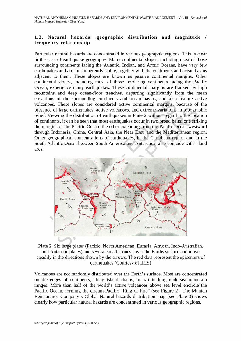
1.3. Natural hazards: geographic distribution and magnitude / frequency relationship Particular natural hazards are concentrated in various geographic regions. This is clear in the case of earthquake geography. Many continental slopes, including most of those surrounding continents facing the Atlantic, Indian, and Arctic Oceans, have very few earthquakes and are thus inherently stable, together with the continents and ocean basins adjacent to them. These slopes are known as passive continental margins. Other continental slopes, including most of those bordering continents facing the Pacific Ocean, experience many earthquakes. These continental margins are flanked by high mountains and deep ocean-floor trenches, departing significantly from the mean elevations of the surrounding continents and ocean basins, and also feature active volcanoes. These slopes are considered active continental margins, because of the presence of large earthquakes, active volcanoes, and extreme variations in topographic relief. Viewing the distribution of earthquakes in Plate 2 without regard to the location of continents, it can be seen that most earthquakes occur in two broad belts: one striking the margins of the Pacific Ocean, the other extending from the Pacific Ocean westward through Indonesia, China, Central Asia, the Near East, and the Mediterranean region. Other geographical concentrations of earthquakes, in the Caribbean region and in the South Atlantic Ocean between South America and Antarctica, also coincide with island arcs.
Plate 2. Six large plates (Pacific, North American, Eurasia, African, Indo-Australian, and Antarctic plates) and several smaller ones cover the Earths surface and move
steadily in the directions shown by the arrows. The red dots represent the epicenters of earthquakes (Courtesy of IRIS)
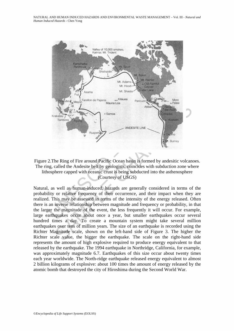
Volcanoes are not randomly distributed over the Earth’s surface. Most are concentrated on the edges of continents, along island chains, or within long undersea mountain ranges. More than half of the world’s active volcanoes above sea level encircle the Pacific Ocean, forming the circum-Pacific “Ring of Fire” (see Figure 2). The Munich Reinsurance Company’s Global Natural hazards distribution map (see Plate 3) shows clearly how particular natural hazards are concentrated in various geographic regions.
UNESCO – EOLS
S
SAMPLE C
HAPTERS
NATURAL AND HUMAN INDUCED HAZARDS AND ENVIRONMENTAL WASTE MANAGEMENT – Vol. III - Natural and Human Induced Hazards - Chen Yong
©Encyclopedia of Life Support Systems (EOLSS)
Figure 2.The Ring of Fire around Pacific Ocean basin is formed by andesitic volcanoes. The ring, called the Andesite belt by geologists, coincides with subduction zone where
lithosphere capped with oceanic crust is being subducted into the asthenosphere (Courtesy of USGS)
Natural, as well as human-induced, hazards are generally considered in terms of the probability or relative frequency of their occurrence, and their impact when they are realized. This may be assessed in terms of the intensity of the energy released. Often there is an inverse relationship between magnitude and frequency or probability, in that the larger the magnitude of the event, the less frequently it will occur. For example, large earthquakes occur about once a year, but smaller earthquakes occur several hundred times a day. To create a mountain system might take several million earthquakes over tens of million years. The size of an earthquake is recorded using the Richter Magnitude scale, shown on the left-hand side of Figure 3. The higher the Richter scale value, the bigger the earthquake. The scale on the right-hand side represents the amount of high explosive required to produce energy equivalent to that released by the earthquake. The 1994 earthquake in Northridge, California, for example, was approximately magnitude 6.7. Earthquakes of this size occur about twenty times each year worldwide. The North-ridge earthquake released energy equivalent to almost 2 billion kilograms of explosive: about 100 times the amount of energy released by the atomic bomb that destroyed the city of Hiroshima during the Second World War.

UNESCO – EOLS
S
SAMPLE C
HAPTERS
NATURAL AND HUMAN INDUCED HAZARDS AND ENVIRONMENTAL WASTE MANAGEMENT – Vol. III - Natural and Human Induced Hazards - Chen Yong
©Encyclopedia of Life Support Systems (EOLSS)
Plate 3.Global Natural hazards distribution map, which shows that the particular natural hazards of the world are concentrated in various geographic region (Courtesy of Munich
Reinsurance Co.)
Figure 3.Magnitude and frequency of earthquake (Courtesy of IRIS) Flood frequency data have been collected for only short spans of historical time, ranging from decades to at most a century or so (see Figure 4). As with earthquakes, however, these data are useful for long-term predictions of unusually great events. A probability
UNESCO – EOLS
S
SAMPLE C
HAPTERS
NATURAL AND HUMAN INDUCED HAZARDS AND ENVIRONMENTAL WASTE MANAGEMENT – Vol. III - Natural and Human Induced Hazards - Chen Yong
©Encyclopedia of Life Support Systems (EOLSS)
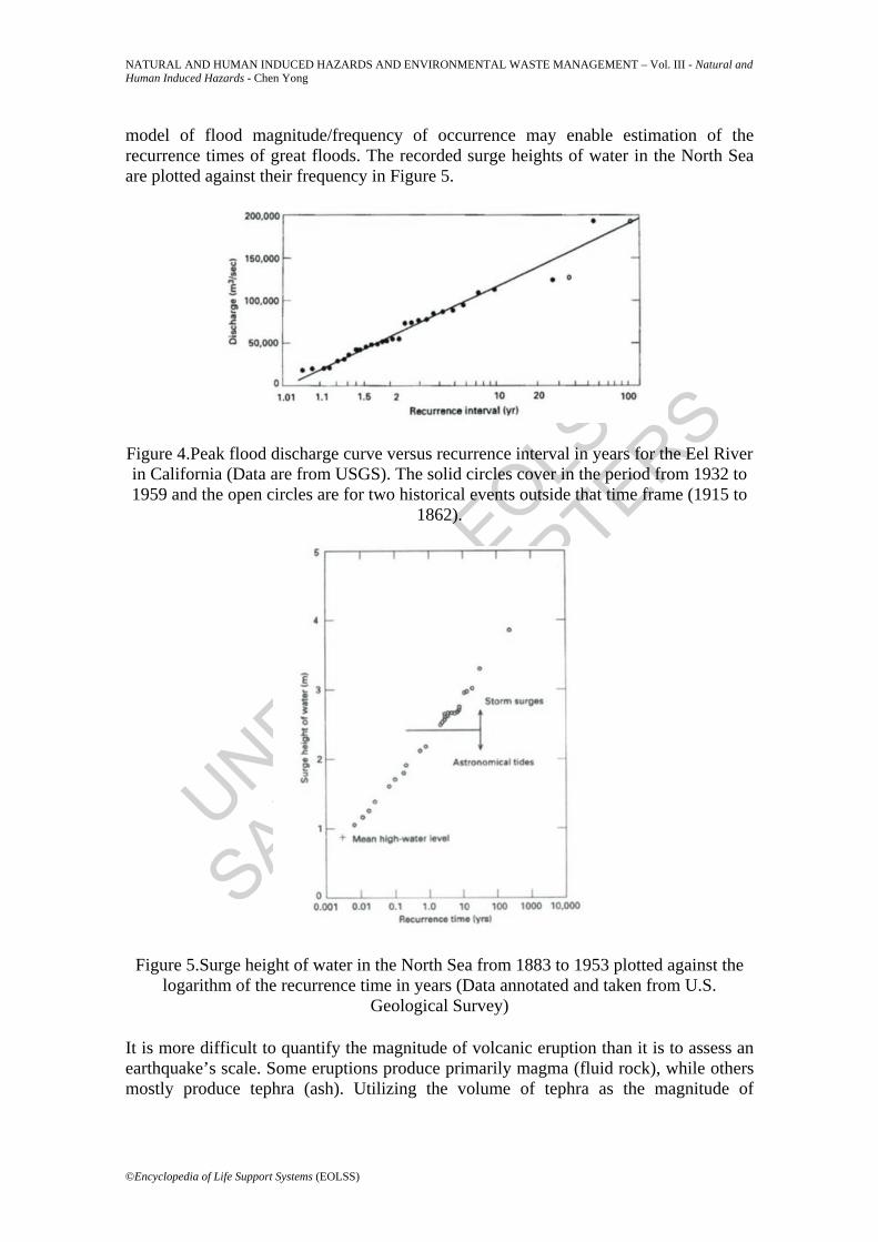
model of flood magnitude/frequency of occurrence may enable estimation of the recurrence times of great floods. The recorded surge heights of water in the North Sea are plotted against their frequency in Figure 5.
Figure 4.Peak flood discharge curve versus recurrence interval in years for the Eel River in California (Data are from USGS). The solid circles cover in the period from 1932 to 1959 and the open circles are for two historical events outside that time frame (1915 to
1862).
Figure 5.Surge height of water in the North Sea from 1883 to 1953 plotted against the logarithm of the recurrence time in years (Data annotated and taken from U.S.
Geological Survey) It is more difficult to quantify the magnitude of volcanic eruption than it is to assess an earthquake’s scale. Some eruptions produce primarily magma (fluid rock), while others mostly produce tephra (ash). Utilizing the volume of tephra as the magnitude of

UNESCO – EOLS
S
SAMPLE C
HAPTERS
NATURAL AND HUMAN INDUCED HAZARDS AND ENVIRONMENTAL WASTE MANAGEMENT – Vol. III - Natural and Human Induced Hazards - Chen Yong
©Encyclopedia of Life Support Systems (EOLSS)
eruption, we can obtain magnitude/frequency statistics for volcanic eruptions. The data for eruptions during the period 1975–85, and for other eruptions over the last 200 years, are given in Figure 6. The number of eruptions with a volume of tephra greater than a specified value is given as a function of the volume. All of these examples illustrate the inverse relationship between event magnitude and frequency: the larger the magnitude of hazard, the less frequent the hazard events. 1.4. World at risk According to UN figures, the rate of urbanization throughout the world is continually rising. Whereas in 1950 a little under 30 percent of the world’s population lived in cities, this figure is now about 45 percent , and will increase to over 60 percent by the year 2025. On the one hand, economic growth is increasing with urbanization; on the other, the risks posed by natural and human-induced hazards, such as seismic risk, increase more rapidly with the increasing concentration of population. Table 1 gives the relation between the losses caused by various natural disasters (Munich Reinsurance Company, 2000) and the Gross Domestic Product (World Bank, 1996) during 1980–93. This relation between losses and GDP may be expressed approximately by a formula: Loss (GDP) 2
Figure 6.Number of volcanic eruptions per year Nc, with a tephra volume greater than V as a function of V for the period 1975-1985 (squares) and for the last 200 years (circles)
(Courtesy of McClelland et al, 1989) Plate 4 shows losses caused by great natural catastrophes since 1960. The upper graph shows the number of catastrophes in each year, subdivided by event type. The lower graph shows the economic and insured losses for each year, adjusted to present values as well as trends up to the year 2000. The table allows comparison between the condensed figures of recent decades. Comparing the figures for the last ten years and

UNESCO – EOLS
S
SAMPLE C
HAPTERS
NATURAL AND HUMAN INDUCED HAZARDS AND ENVIRONMENTAL WASTE MANAGEMENT – Vol. III - Natural and Human Induced Hazards - Chen Yong
©Encyclopedia of Life Support Systems (EOLSS)
those of the 1960s shows a dramatic recent increase in natural catastrophes. This increase applies both to the number of events and to the extent of losses. More than 50,000 people lost their lives in natural disasters in 1998, and economic losses amounted to $93 billion, according to Munich Reinsurance Company. The number of natural disasters in the 1990s has multiplied by three, whilst economic losses (after adjustment for inflation) have increased nine times. Some countries lost up to 5 percent of Gross National Product (GNP) to natural disasters, thereby hampering their capacity for development and investment.
Plate 4.Great natural catastrophes during the time 1960 ~ 1999 (Courtesy of Munich Reinsurance, 2000)
The world today is increasingly vulnerable to natural hazards. Rapid growth brings with it increasing complexity, more extensive systems of infrastructure, dense populations, and excessive demands on the immediate environment and on essential natural

UNESCO – EOLS
S
SAMPLE C
HAPTERS
NATURAL AND HUMAN INDUCED HAZARDS AND ENVIRONMENTAL WASTE MANAGEMENT – Vol. III - Natural and Human Induced Hazards - Chen Yong
©Encyclopedia of Life Support Systems (EOLSS)
resources. We must reduce our vulnerability to hazards, so that they do not necessarily become disasters with terrible consequences. Disaster-prone countries will not attain their goal of sustainable development if they cannot control or reduce their vulnerability to natural hazards. Our Earth systems are very fragile. The human population is expanding in both highly urbanized and less habitable parts of the world. This increases vulnerability to a range of natural hazards, and strains the biological and geological systems that sustain life. Humans dispose of waste materials in some sedimentary basins that supply us with much of our ground-water, energy, and mineral resources. Our social, industrial, and agricultural activities are changing the composition of the atmosphere, with potential serious effects on climate, and on terrestrial and marine ecosystems. If present trends continue, the integrity of the more fragile systems on which human societies depend cannot be assured. The time-scale for the breakdown of these systems may be decades or centuries, but we cannot continue to use the planet as we have become accustomed to do. Present trends need not continue, because we are unique among the influences that affect Earth systems: we have the ability to decide between various courses of action, and to adjust our behavior accordingly.
The history of the geological sciences offers many grounds for optimism. One of the triumphs of twentieth-century science and technology has been the worldwide identification and extraction of energy and mineral resources, bringing an increasing standard of living to an expanding human population. The geological sciences have developed methods of maintaining water supply and quality, disposing of wastes safely, and securing human structures and facilities against natural hazards. They offer valuable information about the nature of the Earth, and about our impact upon it.
2. Natural Hazards 2.1. Types of hazard Some natural hazards are catastrophic occurrences that strike quickly but with devastating consequences. Events that strike with little warning, such as earthquakes or sudden windstorms, are called rapid-onset hazards. Many of them, such as massive volcanic eruptions, are natural events wholly beyond human influence. Other harmful natural processes operate more slowly. Droughts, for instance, can last ten years or more. Slow processes arising from pollution and degradation of the natural environment have led to problems such as acid rain, contamination of surface and underground water bodies, depletion of the ozone layer, and global warming. Many these processes, however, can be influenced – positively or negatively – by human activities. In fact, human actions have generated a whole new category of hazardous processes: human-induced hazards.

UNESCO – EOLS
S
SAMPLE C
HAPTERS
NATURAL AND HUMAN INDUCED HAZARDS AND ENVIRONMENTAL WASTE MANAGEMENT – Vol. III - Natural and Human Induced Hazards - Chen Yong
©Encyclopedia of Life Support Systems (EOLSS)
1980 1981 1982 1983 1984 1985 1986 1987 1988 1989 1990 1991 1992 1993
GDP 10.8 11.3 11.3 11.4 11.9 12.3 14.3 16.2 18.2 19.1 21.0 21.9 23.2 23.6
Loss 32.0 2.2 2.1 7.4 2.1 11.0 12.0 9.5 23.0 17.0 18.0 25.0 17.0 24.0
Table 1. Losses caused to various natural disasters against Gross Domestic Product
during 1980-93 Figure 7 shows the different time-scales of natural hazards.
Figure 7.Human activity and geological processes operate on different time scales. The things that are important to us socially, economically, and politically are measured on a scale of days to years. Geological processes, meanwhile, operate on scales from ranging from a few seconds (e.g. an earthquake) to a few millennia (e.g. soil formation) to a few
hundred million years (e.g. the mountain building)
Major hazards by type
>1% of the total annual GNP lost
>1% of country’s population affected
>100 deaths caused
Floods 76 162 202 Tropical storms 73 100 153 Drought 53 167 21 Earthquakes 24 20 102
Landslides 1 2 54
UNESCO – EOLS
S
SAMPLE C
HAPTERS
NATURAL AND HUMAN INDUCED HAZARDS AND ENVIRONMENTAL WASTE MANAGEMENT – Vol. III - Natural and Human Induced Hazards - Chen Yong
©Encyclopedia of Life Support Systems (EOLSS)
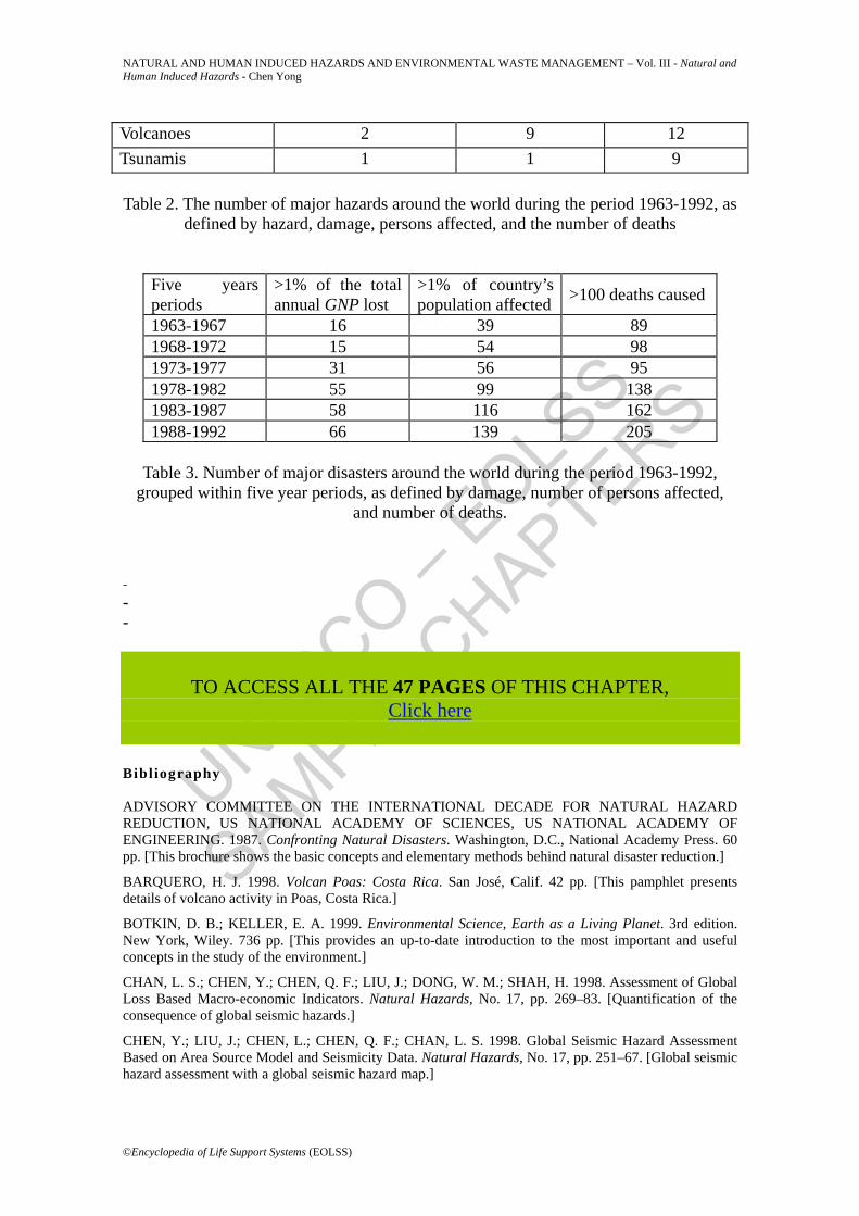
Volcanoes 2 9 12
Tsunamis 1 1 9
Table 2. The number of major hazards around the world during the period 1963-1992, as defined by hazard, damage, persons affected, and the number of deaths
Five years periods
>1% of the total annual GNP lost
>1% of country’s population affected >100 deaths caused
1963-1967 16 39 89 1968-1972 15 54 98 1973-1977 31 56 95 1978-1982 55 99 138 1983-1987 58 116 162 1988-1992 66 139 205
Table 3. Number of major disasters around the world during the period 1963-1992,
grouped within five year periods, as defined by damage, number of persons affected, and number of deaths.
- - -
TO ACCESS ALL THE 47 PAGES OF THIS CHAPTER,
Click here
Bibliography ADVISORY COMMITTEE ON THE INTERNATIONAL DECADE FOR NATURAL HAZARD REDUCTION, US NATIONAL ACADEMY OF SCIENCES, US NATIONAL ACADEMY OF ENGINEERING. 1987. Confronting Natural Disasters. Washington, D.C., National Academy Press. 60 pp. [This brochure shows the basic concepts and elementary methods behind natural disaster reduction.]
BARQUERO, H. J. 1998. Volcan Poas: Costa Rica. San José, Calif. 42 pp. [This pamphlet presents details of volcano activity in Poas, Costa Rica.]
BOTKIN, D. B.; KELLER, E. A. 1999. Environmental Science, Earth as a Living Planet. 3rd edition. New York, Wiley. 736 pp. [This provides an up-to-date introduction to the most important and useful concepts in the study of the environment.]
CHAN, L. S.; CHEN, Y.; CHEN, Q. F.; LIU, J.; DONG, W. M.; SHAH, H. 1998. Assessment of Global Loss Based Macro-economic Indicators. Natural Hazards, No. 17, pp. 269–83. [Quantification of the consequence of global seismic hazards.]
CHEN, Y.; LIU, J.; CHEN, L.; CHEN, Q. F.; CHAN, L. S. 1998. Global Seismic Hazard Assessment Based on Area Source Model and Seismicity Data. Natural Hazards, No. 17, pp. 251–67. [Global seismic hazard assessment with a global seismic hazard map.]
UNESCO – EOLS
S
SAMPLE C
HAPTERS
NATURAL AND HUMAN INDUCED HAZARDS AND ENVIRONMENTAL WASTE MANAGEMENT – Vol. III - Natural and Human Induced Hazards - Chen Yong
©Encyclopedia of Life Support Systems (EOLSS)
GEOHAZARD INTERNATIONAL, 1994. The Quito, Ecuador, Earthquake Risk Management Project: A Compilation of Methods, Data, and Finding. Standford. 283 pp. [Example showing earthquake risk management.]
HU, H. P., LEI, Z. D.; YANG, S. X. 1998. Yangtze River Flood 1998. INCEDE Newsletter, Vol. 7, No. 3, pp 1–3. [Account of Yangtze River flood, China, 1998.]
MCCLELLAND, L., SIMKIN, T., SUMMERS, M., NIELSON, E., STEIN, T. C. (eds.) 1989. Global Volcanism 1975–1985. Englewood Cliffs, N.J., Prentice Hall. 655 pp. [An elementary book with detailed description of global volcanism.]
MUNICH REINSURANCE GROUP 2000. Topics 2000: Natural catastrophes: The Current Position, Special Millennium Issue. pp. 1–40. [Up-to-date details of natural hazards and their impact on human beings with many interesting data and photos.]
STEBELSKY, I. 1995. Radionuclide Contamination and Settlement Abandonment around Chernobyl. Annals of the Association of American Geographers, Vol. 85. 291 pp. [This book introduces the nuclear plant accident at Chernobyl, former USSR.]
TILLING, R. I. 1999. Volcanoes. US Geological Survey. pp. 5–15. [This booklet presents a generalized summary of the nature, working, and products of volcanoes around the world, and the hazards which they pose, along with a brief introduction to the techniques of volcano monitoring and research.]
UNEP (UNITED NATIONS ENVIRONMENT PROGRAMME). 1996. (UNEP/18). On the web site: www.unep.org.
––––. 1998. (UNEP/54). On the web site: www.unep.org. UNITED NATIONS. 1990. Demographic estimates and projections, 1950–2025. [Charts progressive urbanization of world population.]
UNITED NATIONS. 1994. Disaster Around the World: A Global and Regional View. World Conference on Natural Disaster Reduction. Japan, UN Information Paper DHA/94/132. [An overview of natural disasters and approaches to their reduction.]
WORLD BANK. 1996. World Development Report 1995. Oxford University Press. 254 pp.
Resources on the Internet
http://ns.noaa.gov/NESDIS/NESDIS_home.html. [National Oceanic & Atmospheric Administration: a resource guide to natural hazards, such as tsunamis, storms, and forest fires.]
http://pubs.usgs.gov/gip/acidrain. [With text descriptions and a few diagrams illustrating earthquakes, landslides, volcanoes, and other phenomena, provided by US Geological Survey.]
www.dlese.org [Digital Library for Earth System Education.]
www.Earth.nasa.gov [A collection of images highlighting NASA’s Earth Science Enterprise efforts.]
www.gcmd.nasa.gov [Global Change Master Directory: a directory to Earth data and more.]
www.gdl.ucar.edu [Geoscience Digital Library.]
www.idndr.org [Internal Decade for Natural Disaster Reduction.]
www.ngdc.noaa.gov [National Geophysical Data Center, NOAA, a resource for disaster and hazard management.]
www.usgs.gov/education [Much popular material concerning volcanoes, land and people.]
www.windows.umich.edu [A new interdisciplinary web site on earth and space science.]
Biographical Sketch Professor Chen Yong graduated from the University of Science and Technology of China in 1965. He is a Member of the Chinese Academy of Sciences, Vice-president of the Chinese Geophysical Society, and Vice-president of the Chinese Seismological Society. He is now engaging in the geophysical characteristics of active continental tectonics, fractal analysis of seismicity, the simulation of natural disasters, and rock physical property study.

UNESCO – EOLS
S
SAMPLE C
HAPTERS
NATURAL AND HUMAN INDUCED HAZARDS AND ENVIRONMENTAL WASTE MANAGEMENT – Vol. III - Natural and Human Induced Hazards - Chen Yong
©Encyclopedia of Life Support Systems (EOLSS)