natural and cultural resource management program an
TRANSCRIPT
natural and cultural resource management program
an addendum to the general management plan
revised May 1982
Cft-lS
CHANNEL ISLANDS
NATIONAL PARK / CALIFORNIA


APPENDIX TO
NATURAL AND CULTURAL RESOURCES MANAGEMENT
PLAN AND PROGRAM: SEPTEMBER 1980
CHANNEL ISLANDS NATIONAL PARKCALIFORNIA
March 1982National Park Service
Department of the Interior
Digitized by the Internet Archive
in 2012 with funding from
LYRASIS Members and Sloan Foundation
http://archive.org/details/naturalculturalr82revis
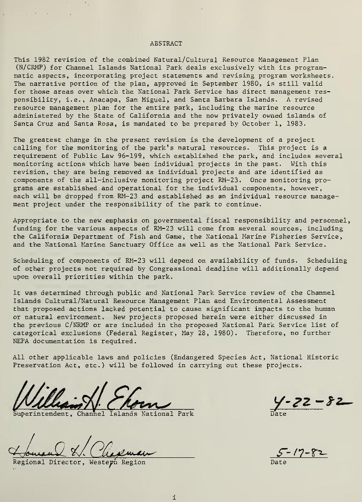
ABSTRACT
This 1982 revision of the combined Natural/Cultural Resource Management Plan(N/CRMP) for Channel Islands National Park deals exclusively with its program-matic aspects, incorporating project statements and revising program worksheets.The narrative portion of the plan, approved in September 1980, is still validfor those areas over which the National Park Service has direct management res-ponsibility, i.e., Anacapa, San Miguel, and Santa Barbara Islands. A revisedresource management plan for the entire park, including the marine resourceadministered by the State of California and the now privately owned islands of
Santa Cruz and Santa Rosa, is mandated to be prepared by October 1, 1983.
The greatest change in the present revision is the development of a projectcalling for the monitoring of the park's natural resources. This project is a
requirement of Public Law 96-199, which established the park, and includes severalmonitoring actions which have been individual projects in the past. With thisrevision, they are being removed as individual projects and are identified as
components of the all-inclusive monitoring project RM-23. Once monitoring pro-grams are established and operational for the individual components, however,each will be dropped from RM-23 and established as an individual resource manage-ment project under the responsibility of the park to continue.
Appropriate to the new emphasis on governmental fiscal responsibility and personnel,funding for the various aspects of RM-23 will come from several sources, includingthe California Department of Fish and Game, the National Marine Fisheries Service,and the National Marine Sanctuary Office as well as the National Park Service.
Scheduling of components of RM-23 will depend on availability of funds. Schedulingof other projects not required by Congressional deadline will additionally dependupon overall priorities within the park.
It was determined through public and National Park Service review of the ChannelIslands Cultural/Natural Resource Management Plan and Environmental Assessmentthat proposed actions lacked potential to cause significant impacts to the humanor natural environment. New projects proposed herein were either discussed in
the previous C/NRMP or are included in the proposed National Park Service list of
categorical exclusions (Federal Register, May 28, 1980). Therefore, no furtherNEPA documentation is required.
All other applicable laws and policies (Endangered Species Act, National HistoricPreservation Act, etc.) will be followed in carrying out these projects.
uperintendent , Channel Islands National Park Date
y-zz -*
4Ju\l_ £\A im>ua^ s~- n-TT-Regional Director, Western Region Date


TABLE OF CONTENTS
ABSTRACT i
NATURAL RESOURCES MANAGEMENT PLANOverview and Needs 1
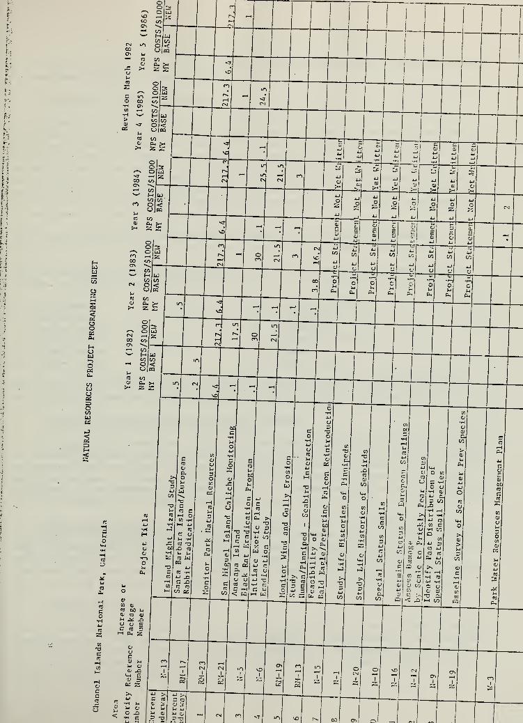
NATURAL RESOURCES PROJECTS PROGRAMMING SHEET 3
Long-term monitoring of park resources (RM-23) 4
Black rat (Rattus rattus ) eradication programon Anacapa Island (N-5) 5
Monitoring of San Miguel caliche concentration (RM-21) .... 7
Exotic plant eradication feasibility (N-6) 9
Monitor wind and gully erosion (RM-19) 11Visitation and human disturbance to
pinniped and seabird activities (RM-13) 12
Park water resource management plan (W-3) 14
CULTURAL RESOURCES MANAGEMENT PLAN 16
CULTURAL RESOURCES PROJECTS PROGRAMMING SHEET 17
Formulate research design for archeologicalsites affected by erosion (C-5) 18
Historical-archeological site survey (C-2) 20Nidever adobe site testing (C-3) 22
San Miguel Island archeological sitesurvey (C-4) 24


NATURAL RESOURCES MANAGEMENT PLAN
Overview and Needs
Revision - March 1982
Thorough discussion of park natural resources and identified problems concerningtheir management are found within the N/CRMP approved September 1980. Additionalproject needs were mandated by Public Law 96-199, which directed the National ParkService to prepare a natural resources study report including both an inventoryof all terrestrial and marine species, and recommendation as to what actions wouldprotect the park's natural resources.
Projects concerning natural resources in the near future will be heavily weightedtoward two areas: 1) Monitoring of the park's resources; and 2) Deciding howmuch active manipulation is necessary to allow island ecosystems to return to a
more "natural" state (this latter will be concerned primarily with eradication of
exotic species, encouraging the reestablishment of native communities).
In response to the mandates of Public Law 96-199, a package project to monitor thepark's resources has been developed. Enclosed is Project Statement RM-23, reflect-ing this program. Its components include several actions previously identified as
separate projects, including N-3 (Visitor Impact of Intertidal Resources), N-4(Impacts of Marine Resources Harvest), N-ll (Determine Status of Globose DuneBeetle), N-14 (Determine Status of Amphibians and Reptiles), N-18 (Determine Statusof Bats), RM-9 (Monitor Special Status Plant Species), RM-10 (Monitor Plant Tran-sects), RM-11 (Pinniped Census/Monitoring), RM-12 (Monitor Special Status SnailSpecies), RM-16 (Monitor Seabird Populations), RM-17 (Monitor Brown Pelican Status),and RM-22 (Monitor Status of Island Fox). However, since RM-23 as a project dealsprimarily with establishing monitoring programs, it is most likely that individualcomponents of the project will be separated again into individual projects followingtheir establishment, for continuation. But for the present, the funding requestedfor this project includes initial implementation of project components as they aredesigned. The hoped-for timetable of these projects follows:
Fiscal Year 1932 - Initiate N-5 (Anacapa Island Black Rat Eradication), RM-21 (San
Miguel Island Caliche Monitoring), N-6 (Initiate Exotic Plant Eradication Study).Continue N-13 (Island Night Lizard Study) and N-17 (Santa Barbara Island EuropeanRabbit Eradication). For RM-23 (Monitor Park Natural Resources), these componentswill be addressed:
1. Design Pinniped Monitoring System2. Design Sea Bird Monitoring System3. Design Resource Data Management System4. Design Boating Visitor Use Monitoring System5. Design Marine Resources Monitoring System6. Design Island Bird Monitoring System
Fiscal Year 1983 - Continue N-5 (Anacapa Island Black Rat Eradication). RM-21 (San
Miguel Island Caliche Monitoring), N-6 (Exotic Plant Eradication Study). For RM-23Monitor Park Natural Resources), these components will be addressed:

1. Continue Design of Marine Resource Monitoring System2. Implement Pinniped Monitoring System3. Implement Sea Bird Monitoring System4. Implement Boating Visitor Monitoring System5
.
Implement Resource Data Management System
Fiscal Years 1984-1986 - At this time we can anticipate only that N-21 and RM-21
will need to be contiued. More realistic projections will be possible after thedevelopment of the first natural resource report to Congress, due October 1, 1982.

=3
<
w
cCO
aiuo
r4 Q'
raW 0)
c m go l>l
o CJ CO 0)
•H p ^ X)j_i o y an C CO 3•z
l-H d. 2
E0)
ocTO
cID
0)
s§to
01
oii
i-
(0


1.1 Channel Islands National Park - RM-23- Long-term monitoring of park resourcesin compliance with Public Law 96-199.
1.2 Statement of Issue or Problem
Public Law 96-199 requires that the National Park Service monitor the abundance,distribution, reproductive activity, recruitment, age and sex compositions, phen-ology, and growth and mortality rates of all marine and terrestrial plants andanimals in Channel Islands National Park. Many species in the park are also pro-tected by the Marine Mammal Act of 1972, The Enaangered Species Act of 1973, or
state statutes. Many other species exist only in the park, and increasing harvestsinflict unknown levels of impact on marine resources. Little historical informa-tion regarding the population dynamics of these species is available, and even lesscontemporary information is being collected.
Continuous long-term data on population dynamics is required to determine theimpacts of fishery harvests, visitor use, and adjacent coastal development.
For the purposes of designing population monitoring systems, park resources weredivided into several categories:
1. Pinnipeds2. Sea Birds3. Marine AnimalsA. Marine Plants5. Island Birds6. Island Plants
7. Island Vertebrates8. Tide Pools9. Fisheries
10. Boating Visitors11. Climate12. Water Quality
Monitoring systems were designed and field tested for all but island plants andvertebrates, climate and water quality in Fiscal Year 1931, 1982 and 1983.
1.
3
Alternative Actions and Their Probable Impacts
1. No Action - This would be contrary to the precise legislation direction givento the National Park Service to inventory the park biota and to report to Congressconcerning this action and recommendations for management of these resources. In
addition, without the baseline information to be generated by this project, the
resources of the expanded park would have to be managed without adequate knowledgeof their historic and present conditions, to the likely detriment of these resources,
2. Proceed with a Smaller Number of Components - Public Law 96-199 does not givethe option of addressing an incomplete list of resources; to do so would not sat-isfy the requirements of the reports to Congress. In addition, it is the profes-sional opinion of the park staff, including the research scientist assigned to
the park, that this baseline information is necessary for adequate resource manage-ment, and that it is most logically separated into the components listed above.
1.4 Recommended Course of Action
The project should be begun as soon as fiscally possible, in its entirety. Whilefunding sources will be sought from other agencies in some cases, it is necessaryfor the National Park Service to assume responsibility for initiation and continu-ation of the project with all its components, in order to ensure complete and
timely reports to Congress.


CULTURAL AND NATURAL RESOURCES PROJECT STATEMENT
1. PARK AND REGION : Channel Islands National ParkH Western Region
2. PROJECT NAME AND NUMBER : Black Rat ( Rattus rattus ) Eradication Program on
Anacapa Island (CHIS N-5)
.
3. STATEMENT OF PROBLEM : The black rat, an Old World species, has inhabitatedAnacapa Island for several years. It is potentially undesirable for severalreasons, including its possible role as: a disease carrier; a destroyer of
property; a serious competitor with the native deer mouse; a predator on
various species of birds and their eggs, on intertidal organisms, and on
native plants; and an unsettling presence to monument personnel and visitorsalike. Little concrete information on the actual impact of the rat on theisland ecosystem has been gathered, but policy and good sense dictate that an
attempt should be made to eradicate or at least control this species onAnacapa Island.
4. WHAT HAS BEEN DONE : Basic studies were made in the early 1970s concerningthe Anacapa black rat, primarily from the point of view of eradication, byRod Hiemstra from the County of Ventura, but were not carried through to
implementation. The 1979 Natural Resources Study by the Santa Barbara Museumof Natural History addressed the black rat and resulted in the design of a
proposed eradication program for this animal on Anacapa Island. Throughoutthe years, a small number of rats has been eliminated by trapping, particularlyaround the buildings.
5. DESCRIPTION OF WORK TO BE UNDERTAKEN : Initially, the plan designed in the
Museum study referred to above will be accepted, but before its implementationon the island, both field and laboratory studies will be undertaken concerningthe impacts of the eradication program on the other island resources, parti-cularly the secondary effects of the anti-coagulant poison "Pival" on predatorybirds. As a result of this study, changes in design of the actual eradicationproject may be made. The project will be conducted first only on East Anacapaand results, as well as impact, will be continually monitored. With refinementsmade at that time, the program will then be undertaken on Middle and WestAnacapa Islands. Should it prove impossible to totally eliminate the rat fromAnacapa, annual control measures will be designed, and funds for their yearlyimplementation will be sought.
6. LENGTH OF TIME NEEDED : Four years.
7. WHAT WILL HAPPEN IF NOT UNDERTAKEN : The black rat will remain a common and
important member of the Anacapa ecosystem, a condition unacceptable under NFSpolicy. The rat will continue to play an unknown but possibly detrimental role
with many other biota of the island. In addition, the rat will remaindestructive to human facilities and supplies on the island, as well as a
potential vector of dangerous diseases.
8. WHAT ARE THE ALTERNATIVES : a. Nc action, b. Attempt to proceed with the
actual eradication program without addressing the possible impacts. It is
unlikely that, without the initial' studies , enough information is present to
satisfy NEPA documentation. c. Separate the impact studies from the actualeradication program in order to fund these two phases of the rat projects from
separate sources, and proceed at the present time only with the impact studies.


» 9. PERSONNEL : Scientific personnel (NPS or contract) for the impact study.
Contract pest eradication expertise, aided by NPS personnel, required for
the actual eradication program, along with continuing scientific consul-tatation, to monitor.
10. ADMINISTRATION AND LOGISTICS
Year in Program Sequence1st " 2nd
""3rd Ath 5th
Personal Services 20,000 20,000 17,000 17,000
Other than Personal Services 10,000 10,000 7,500 7,500
GRAND TOTAL 30,000 30,000 25,5000 2 A, 500
Funds Available in Park Base
Funds Requested from RegionalOffice
On Form
10-237
10-238
10-250
10-A51
y
30,000 30,000 2A,500 2A,500
Date Submitted
March 1982
11. REFERENCES AND CONTACTS ;
Collins, Paul W. 1979. Vertebrate zoology: the biology of introducedblack rats on Anacapa and San Miguel Islands. Pages 1A.1-1A.A9 in
D. W. Power, ed. Natural Resources Study of the Channel Islands Nationa l
Monument , California, National Park Service, Denver Service CenterContract No. CX-2000-8-00A0.
Hiemstra, Rod. 1979. A program for control of the black rat on AnacapaIsland. Pages 16.1-16.28 in D. W. Power, ed. Natural Resources Study
of the Channel Islands National Monument , California, National ParkService Center Contract No, CX-2000-8-00A0.
12. DATE OF PROJECT STATEMENT SUBMISSION: March 1982

CULTURAL AND NATURAL RESOURCES PROJECT STATEMENT
1. PARK AND REGION : Channel Islands National Park, Western Region
2. PROJECT NAME AND NUMBEP • Monitoring of the San Miguel Island CalicheConcentration (CHIS RT-21)
3. STATEMENT OF PROBLEM : Large areas of calcified rhizoconcretions , or caliches,cccur on San Miguel Island. These geological features, in many cases havingformed around vegetation underground and now through erosion exposed at thesurface, are quite fragile. Potential threats include an ever-increasingamount of visitation, and, more seriously, the possibly very strong sonic boomsfrom the U. S. Air Force Space Shuttle program scheduled to overfly San Miguelon its launches and returns beginning in 1983. Before these caliche "forests"are damaged, their extent should be documented and a monitoringsystem established so that any change in the status of this resource can bedetailed.
U. WHAT HAS BEEN DONE : The San Miguel Island caliches have been examinedscientifically in years past, primarily by Dr. Donald Johnson of the Universityof Illinois. Dr. Johnson also addressed the recent status of the caliches, as
well as having mapped the major concentrations of the "forests" as part of theSanta Barbara Museum of Natural History's 1979 Natural Resources Study for theNPS. Dr. Johnson is currently studying the potential impacts of the SpaceShuttle sonic booms on the caliche "forests" under a contract with the U. S.
Air Force.
5. DESCRIPTION OF WORK TO BE UNDERTAKEN ; A thorough survey of the caliche concen-trations should be undertaken, the most extensive areas outlined and the locationsof the largest or in other respects most interesting individuals plotted; photo-graphic stations should be established, as well as other means of monitoring,covering not only these areas, but also a wide variety of topographic conditions,as well as some areas of caliche most likely to be disturbed by direct humanactivity. Monitoring of these areas should occur on an annual basis, as well as
directly before and after scheduled Space Shuttle launches.
6. LENGTH OF TIME NEEDED : Continuing
7. WHAT WILL HAPPEN IF NOT UNDERTAKEN: Management will not have baseline informationregarding the present status of the caliche concentrations on San Miguel Islandnecessary to evaluate the potential future destruction of this resource; anyfuture discussions with such agencies as the U. S. Air Force regarding such anissue would have to be based on hearsay and speculation.
8. WHAT ARE THE ALTERNATIVES :
" No action.
9. PERSONNEL : Scientific contract personnel to establish the monitoring program;
NPS personnel to carry out the actual monitoring,


10. ADMINISTRATION AND LOGISTICS
Funding Year in Program Sequence
Personal Services
Other than Personal Services
GRAND TOTAL
Funds Available in Park Base
Funds Requested from RegionalOffice
On Form
10-237 n^7]
10-238 | ]
10-250
1st 2nd 3rd 4 th 5 th
10,000
7,500 1,000 1,000 1,000 1,000
17,500 1,000 1,000 1,000 1,000
17,500 1,000 1,000 1,000 1,000
Date Submitted
March 1982
10-451 |~~j
11. REFERENCES AND CONTACTS :
Johnson, Donald L. , Department of Georgraphy, University of Illinois,Urbana, Illinois 61801
12. DATE OF PROJECT STATEMENT SUBMISSION: March 1982


CULTURAL AND NATURAL RESOURCES PROJECT STATEMENT
1. PARK AND REGION : Channel Islands National Park, ^Western. .Region
2. PROJECT NAME AND NUMBER : Exotic Plant Eradication Feasibility (CHIS N-6)
.
3. STATEMENT OF PROBLEM : A management goal for natural areas in the NationalPark System is to eliminate all exotic biota, when feasible. The RMPidentifies several species of exotic plants which, by virtue of smallnumbers or restricted island range, will be relatively easy to eliminate.Others, such as various annual grasses, or the crystalline iceplant( Mesembryanthemum crystallinum ) , will be much more difficult, and may proveimpossible, to eliminate. It is these plants, however, which providegreatest competition with native species, and it is their widespreadpresence which most alters the aura of the islands. But without furtherwork to indicate the actual extent of their influence on the islands, andan inquiry made as to the possible detrimental effects of eradication, it
cannot be unequivocally stated that total removal of all the exotic plantswould be in the best interest of the islands' ecosystems. Moreover,experimentation must be made of the various types of eradication methods
.. . available.
A. WHAT HAS BEEN DONE : The Natural Resources Study by the Santa BarbaraMuseum of Natural History (1979) studied vegetation on the islands, includingupdating of plant lists, the historic fluctuations in plant communities,the formulation of community maps, and the establishment of transects to
monitor changes in these communities. General suggestions to minimize theimpacts of exotic vegetation were included as part of the study.
5. DESCRIPTION OF WORK TO BE UNDERTAKEN : Existing information will be gatheredregarding exotic plant eradication experiments and techniques, as well as
specific life history studies of those plants identified as target species.Field studies will be undertaken to ascertain the true extent of these exotics'influence on native plants, animals, and on the relationship between thesebiological, chemical, and manual controls, will be tested on sample plots,and results will be discussed, with respect to effectiveness, cost, ease,and detrimental and/or positive resulting conditions. A report discussingall the above items will be prepared, and will include alternative levels of
control if total elimination proves unfeasible.
6. LENGTH OF TIME NEEDED : Three years.
7. WHAT WILL HAPPEN IF NOT UNDERTAKEN : Management will not know what methods of
exotic plant eradication are most effective or least destructive, or even howimportant from an ecological viewpoint it is to remove the plants. Manage-ment will not have at its disposal a discussion of various alternatives, otherthan total elimination or doing nothing.


\
8. WHAT ARE THE ALTERNATIVES : a. No action, b. Attempt to actively
manage the islands' vegetation without the information which would result
from the study.
9. PERSONNEL : Contract research personnel, aided by monument personnel.
10. ADMINISTRATION AND LOGISTICS :
Funding Year in Program Sequence
Personal Services
Other than Personal Services
GRAND TOTAL
Funds Available in Park Base
Funds Requested from Regional Office
On Form
10-2371 1
10-2381 1
10-250 I ]
10-451 QREFERENCES AND CONTACTS :
Hochberg, M. , S. Junak, Dr. R. Philbrick, and Dr. S. Timbrook. 1979.
Botany. Pages 5.1-5.85, in Dr. Power, ed. , Natural Resources Study,
Channel Islands National Monument, California. National Park Service,Denver Service Center Contract No. "CX-2T)UU-b-0040
.
Vivette, Dr. N. , Department of Botany, University of California,Berkeley, CA.
DATE OF PROJECT STATEMENT SUBMISSION: March 1982
1st
13,500
2nd
13,500
8,000
21,500
3rd
13,500
8,000
21,500
4 th 5 th
8,000
21,500
21,500 21,500
Submitted
21,500
Date
10


1.1 Channel Islands National Park - RM-19 - Monitor wind and gully erosion
1.2 Statement of Issue or Problem
A combination of domestic animal overgrazing, farming cultivation, and fire hasresulted in significant levels of soil erosion on all of the islands withinhistoric times. Such erosional activity has had impact on such aspects of thepark as vegetational destruction, disturbance of archeological sites and loss of
artifacts, and trail damage and sloughing of cliffs, a potential danger to bothpersonnel and visitors. Because of the large amount of erosion occurring on theislands and the need to prioritize projects to curb such activity, the SantaBarbara Museum of Natural History, as part of its contract study on naturalresources of the park in 1978, was requested to identify those areas in which ero-sion was occurring naturally as opposed to those which were man-caused. Thisquestion proved impractical to answer but rebar was placed at several gullynickpoints in those areas of highest erosional activity on Anacapa, San Miguel,and Santa Barbara Islands in order to be able to monitor changes in erosionalpatterns and to ascertain erosional rates. A program for the cyclic reading of
these monitoring stations will be initiated to gather such data on the basis of
each island being read every third year.
1 .
3
Alternative Actions and Their Probable Impacts
1. No Action - If the rebar stations are not read, and the information concerningthe erosional processes on the islands not gathered, a waste of funding, opportunity,and time will result. Future decisions concerning areas of erosion and erosionalprocesses will be made with inadequate information, or in some cases, none at all.
2. Monitor Only Some of the Existing Rebar Sites - The sites were chosen in areaswhich were identified as important or troublesome from the point of view of manage-ment concerns. Not only would the reading of all the sites be most valuable, butsince the cost would be no greater once the personnel were on the particular island,reading only a partial number of sites would be wasteful from many points of view.
1.4 Recommended Course of Action
The rebar points on the islands (10 sites on Anacapa, 22 sites on San Miguel, and
eight sites on Santa Barbara) will be monitored, one island per year on a recurringbasis every third year. Changes in erosion patterns and rates will be noted bymeasuring distances between rebar and new gully nickpoints, and rate of headwallerosion calculated. From these data, decisions can be made regarding need to
directly address erosional activity with a maintenance project.
11


CULTURAL AND NATURAL RESOURCES PROJECT STATEMENT
1. PARK AND REGION : Channel Islands National Park, Western Region
2. PROJECT NAME AND NUMBER : Visitation and Human Disturbance to Pinnipedand Seabird Activities (CHIS RM-13)
3. STATEMENT OF THE PROBLEM : Disturbance to pinnipeds and breeding seabirds on
monument islands results from both island based and offshore visitor activities.Because the islands have extensive coastlines and the National Park. Service hasa limited staff, disturbance cannot always be prevented. At the present time,no documentation exists that quantifies the frequency and end result of variousdegrees of disturbance caused by monument visitors and staff activities. Thisinformation is essential to devise plans for mitigation or elimination of
disturbance. With the knowledge of disturbance thresholds, recommendations to
other agencies can be made, if necessary, to lower the incidence of disturbanceto pinnipeds and seabirds.
A. WHAT HAS BEEN DONE : A video-tape monitoring program to study the effects of
sonic booms to pinniped populations was initiated at Point Bennett, San MiguelIsland, by the U. S. Air Force, Space Shuttle Program in 1978. Because of thelow incidence of visitation to this island, further study in an area characterizedby frequent human use needs to be undertaken. No other quantifiable disturbancestudies have been implemented or are proposed,
5. DESCRIPTION OF WORK TO BE UNDERTAKEN : Activity patterns and disturbance to
pinnipeds and seabirds will be monitored by video-tape sampling stations onAnacapa Island during the months of heaviest visitation and breeding andnesting periods. Periodic on-site observations will be made to supplementrecorded data. Tapes will be analyzed to document and classify the type andintensity of disturbance and to assess the long term implications of thoseactivities. Based on the data collected, recommendations for distances betweenvisitors, staff and pinnipeds and seabirds will be made for appropriate areasand activities.
6. LENGTH OF TIME NEEDED : Six months
7. WHAT WILL HAPPEN IF NOT UNDERTAKEN : Management will continue to lack harddata on which to base recommendations for visitor use and to provide to the
State for establishment of regulations within Ecological Reserves. Managementwill continue to be unaware that disturbance is occurring in some locales.
Locally marginal breeding populations may become extirpated,
8. WHAT ARE THE ALTERNATIVES : a. No action. b. Combine this study with othernatural resource pinniped studies.
12


9. PERSONNEL : Contracted research technicians and equipment. Park Rangers to
assist and to provide logistical support.
10. ADMINISTRATION AND LOGISTICS :
1st
Personal Services 13,000
Other than Personal Services 7 , 000
Grand Total 20,000
Funds Available in Park Base 3,800
Funds Requested from Regional Office 16,200
On Form Date Submitted
10-237
10-238
10-250
10-451| |
11. REFERENCES AND CONTACTS :
Mr. George Antonelis, NMFS , National Marine Mammal Lab, Seattle, WADr. Joseph Jehl, Hubbs Sea World Research InstituteMr. Brent Stewart, Hubbs Sea World Research Institute
12, DATE OF PROJECT STATEMENT SUBMISSION: March 1982
13


1
NATURAL RESOURCES PROJECT STATEMENT
1. PARK AND REGION : Channel Islands National Park, Western Region
2. PROJECT NAME AND NUMBER : Park Water Resource Management Plan (W-3; incorporatesW-l and W-2).
3. STATEMENT OF PROBLEM : In compliance with Public Law 92-500 (Federal WaterPollution Control Act) and as amended by Public Law 95-217 (Clean Water Actof 1977) and as furthered by the Service Memorandum of Understanding withEnvironmental Protection Agency (EPA), each area must develop a Park Water Plan.
4. WHAT HAS BEEN DONE : No comprehensive water quality management plan has beendeveloped for the area, though adequate information concerning the threeislands over which the National Park Service has management authority is
included in the 1980 Channel Islands National park Resource Management Plan.
5. DESCRIPTION OF WORK TO BE UNDERTAKEN :
a. An historical report on management of water resources in the entire park.
b. Classification of all surface waters by present and proposed uses.
• c. An analysis of the present status of park waters, including:
(1) Identification of water quality required to support specifieduses and, where appropriate, to comply with or assist in estab-lishing state water quality standards.
(2) Relationship of water quality to any threatened, known, rare or
endangered species indigenous to the park and the relationship of
water quality to the protection of all natural resources.
(3) A bibliography of available information concerning the existingquality of park waters.
d. A description of proposed actions relating to management of park waters.
e. A detailed plan for monitoring the quality of park waters that will revealexisting water quality and significant trends.
Future coordination/cooperation with EPA and the state is required to ascertainestablished water standards.
6. LENGTH OF TIME NEEDED : Three years
7. WHAT WILL HAPPEN IF PROJECT NOT UNDERTAKEN : Service noncompliance with the
above federal laws; lack of knowledge upon which to base future developmentalternatives
.
8. WHAT ARE THE ALTERNATIVES : None
9. PERSONNEL : Regional assistance with contracted U.S. Geological Survey to
develop/initiate basic aspects. After which, future monitoring will be doneby area staff.
14


10. ADMINISTRATION AND LOGISITICS
Funding
Personal Services
Other than pergonal services
Grand Total
Funds available in park base
Funds requested from RegionalOffice
Year in Program Sequence1st 2nd 3rd 4th 5th
2000
2000
2000
On Form
11. REFERENCES AND CONTACTS
Date Submitted
12.
Dr. D.L. Johnson, University of Illinois
DATE OF SUBMISSION: March 1982
15

1
CULTURAL RESOURCES MANAGEMENT PLAN
Overview and Needs
Revision - March 1982
Two primary aspects of the current cultural resources management programare: 1) Continuing survey of cultural resources in the park; and 2)
Decision about stabilization of cultural sites, possible stabilization of
some sites, salvaging of others. The hoped for timetable of these projectsfollows:
Fiscal Year 1982 - Initiate C-5 (Fornulate Research Design for ArcheologicalSites Affected by Erosion). Continue C-4 (Continue Archaeological Survey of
San Miguel Island).
Fiscal Year 1983 - Initiate C-2 (Locate Historical/Archaeological Sites),C-3 (Decision on Nidever Adobe)
.
Fiscal Year 1984 - Initiate C-6 (Record and Map Paleontological Sites)
,
C-7 (Further Evaluate Lester Ranch)
.
If the status of access to the privately owned park islands changes, additionalprojects will be needed. As practicality allows, certain identified projectswill be combined.
16


oob^N O UJO —*\1&00 </>o\ *^j—t to\s
to toCN U-) O <CO U|mCT\ u~H CO 10
X 01
>><J
o25
OoPh
HUW•-)
o«
COwo
otowcm
2
CO
o
to
Ph
2Scw 01 u
•o Ui QJc <D X>CO <M E
<-H <U 3to « icl-l
^>-l fcj01 •H Mc ti CDc « o xjTO 01 H px: u lJ Do «J-


CULTURAL AND NATURAL RESOURCES PROJECT STATEMENT
1. PARK AND REGION : Channel Islands National Park, Western Region
2. PROJECT NAME AND NUMBER : Formulate Research Design for ArcheologicalSites Affected by Erosion (CHIS C-5)
3. STATEMENT OF PROBLEM : Erosion of historic and prehistoric archeologicalresources as well as unauthorized excavation in the past has alteredappearance, internal depositional structure, artifact associations, and
integrity for scientific data gathering at many park sites. Paleotologicallocalities containing evidence of mammoth and possibly human activitiesare also undergoing erosion and may be highly significant in researchpotential. Density of habitation and other sites on the park islandsexceeds many other California areas and affords close comparisons withinpark islands and other Channel Islands. A few sites are in proximityto park visitor and management operations. Evaluation of what data maybe gathered from surface appearance of sites has been accomplished butlittle information exists on site cross-sections, rate of effect fromsources of erosion, methods to increase site preservation and decreaseseverity of erosion, and comparisons of site characteristics in terms of
research approachs between islands' site groups.
A. WHAT HAS BEEN DONE : Projects have resulted in preparation of reportsdetailing past excavation work (R.oaire 1978), revisiting site locationsfor upgrading information (Greenwood 1978, 1982), testing applicationof remote sensing methods for site recognition (Glassow 1982) , summariesof existing data for Santa Rosa and Santa Cruz Islands (Glassow 1982) ,
and an Archeological Overview study (Glassow 197-). These projects haveresulted in reliable and professionally sound data base desciptions of
site appearance and location and past excavations.
In Fiscal Year 1982, a project on San Miguel Island will include establish-ment of an erosion monitoring system at seven sites, experiments in sitedeposit stabilization at four sites, and recording of vertical profilesat seven sites. Results of this project will be available in late 1982.
A five year monitoring program should give objective information on effectsof natural processes upon archeological resources located on the windwardside of San Miguel Island. Stabilization experiments will give informationregarding protection of deposits with sandbag walls and use of groundcover mats in encouragement of vegetation growth.
5. DESCRIPTION OF WORK TO BE UNDERTAKEN :
Using available archeological reports and site information, a researchdesign document for known resources within the park will be preparedstressing the following: 1) preservation and study of paleotogicallocalities, 2) preservation methods and prestabilization work needed to
emplace additional corrective measures and monitoring systems, 3)
approachs to cross-site comparisons in terms of stratigraphic formation,deposit contents, seriation of artifact assemblages as may be recovered,
18


and chronological age, 4) research questions and test implications to
be answered through excavations, surveys, and intensive data gatheringtechniques. This research design shall utilize current statisticalconcepts, interdisciplinary specialists, ethnographic information, and
applicable theoretical strategies and will result in a report in
publishable form.
6. LENGTH OF TIME NEEDED : One year from funding date to production of
final document.
7. WHAT WILL HAPPEN IF NOT UNDERTAKEN : Any further archeological project -
terrain survey, emergency excavation or data collection, archeologicalclearance, examination, interpretation of accidental finds, and NativeAmerican interests - will not have guidelines fulfilling NPS-28 (CulturalResource Management Guidelines), Chapter 5 and will be disconnectedactions. Repetition, potential waste of funds, overlap, and misuse of
manpower may result. The Service would be open to critism fromprofessional community for not having sound guidelines for actionsdealing with preservation, research, mitigation of effect, and legalcompliance regarding archeological resources. Loss of data of unknownsignificance will occur at unknown rates.
8. WHAT ARE THE ALTERNATIVES : a. No action. b. Study only paleotologicalresources. c. Study only prehistoric midden sites. d. Study onlyhistorical archeological resource sites, c. Design excavation projectsonly. d. Formulate all stabilization, research, and preservation actionsfrom results of FY. 82 project on San Miguel Island.
9. PERSONNEL : Professional archeological personnel, in house or contracted.Western Archeological/Conservation Center and Regional Office staff to becontract reviewers or contracting officer's representative.
10. ADMINISTRATION AND LOGISTICS :
Personnel Services: $15,000Other than Personnel Services: $4000 (island travel, duplication of
report)Total: $19,000
On Form: Date Submitted:
11. REFERENCES AND CONTACTS :
Regional Archeologist R. Kelly, WROGreenwood and Associates, Pacific PalisadesMichael Glassow, UCSBSanta Barbara Natural History Museum: Travis Hudson and othersSanta Barbara Indian CenterLos Angeles County Natural History Museum: Chas. Rozaire
19

CULTURAL AND NATURAL RESOURCES PROJECT STATEMENT
1. PARK AND REGION : Channel Islands National Park, Western Region
2. PROJECT NAME AND NUMBER : Historical-Archaeological Site Survey of ChannelIslands National Monument (CHIS C-2).
3. STATEMENT OF PROBLEM : Though both an archaeological and a historical surveyof the monument islands has been accomplished, no thorough on-ground surveyshave been made of either historical or historical-archaeological sites on
the monument islands. There is knowledge that such sites are present, butsince very little actual information is known, these sites and their attendantresources are being lost through susceptibility to vandalism, weathering,and misguided management practices.
4. WHAT HAS BEEN DONE : In September 1978, an archaeological survey (by Greenwood)of known sites on Anacapa, San Miguel, and Santa Barbara Islands was completed;though its purpose was to address the archaeological potential of the islands,as well as to check known sites, several historical-archaeological areas wereperipherally noted. In May 1979, a historical resource study (by Roberts) of
the monument was completed; while it told the historical story of the monument,this study was not designed to study sites. Much of what is known regardingthe occurrence and location of sites if found in the "Channel Islands Photo-graphic Survey" (by Morgan) ; this project encompassed primarily historical sitesof all the Channel Islands, and the combination of current and historical photo-graphs, background information and, in many cases, historic site diagrams, makesthis a particularly valuable reference source. Still, none of these reportsoffers a complete and scientifically accurate description of even the majorityof the sites in the monument.
5. DESCRIPTION OF WORK TO BE UNDERTAKEN : Based upon literature search and uponpersonal interviews, develop a list of potential historical sites and tentativelocations. Perform surveys of these sites, completing site forms for each.Collects objects in immediate danger of loss, and other items of special signi-ficance upon consultation with monument and regional NPS personnel. Developa final report in which will be included site forms, historical background ofeach site, and recommendations for each site's management.
6. LENGTH OF TIME NEEDED : Two years.
7. WHAT WILL HAPPEN IF NOT UNDERTAKEN : Information on these cultural resourceswill be incomplete, if available at all, and in no case in a form useful to
management. Without such information, management will not know the extent of
a valuable and non-renewable resource, and unable to provide for its protection
8. WHAT ARE THE ALTERNATIVES : a. No action. b, Rely on existing information
as a basis for management decisions.
20

9.
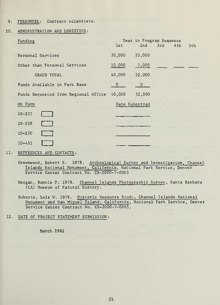
10.
PERSONNEL : Contract scientists.
ADMINISTRATION AND LOGISTICS :
Funding
Personal Services
Other than Personal Services
GRAND TOTAL
Funds Available in Park Base
Funds Requested from Regional Office 40,000 32,000
Year in Program Sequence1st 2nd
30,000 25,000
10,000 7 ,000
40,000 32,000
3rd 4th 5th
On Form
10-237
10-238
10-250
10-451
Date Submitted
C
cmen
11. REFERENCES AND CONTACTS :
Greenwood, Robert S. 1978. Archeological Survey and Investigation, ChannelIslands National Monument, California , National Park Service, DenverService Center Contract No. CX-2000-7-0063
Morgan, Ronnie P. 1979. Channel Islands Photographic Survey , Santa Barbara(CA) Museum of Natural History.
Roberts, Lois W, 1979. Historic Resource Study, Channel Islands NationalMonument and San Miguel Island, California , National Park Service, DenverService Center Contract No. CX-2000-7-0065
.
12. DATE OF PROJECT STATEMENT SUBMISSION:
March 1982
21

CULTURAL AND NATURAL RESOURCES PROJECT STATEMENT
1. PARK AND REGION : Channel Islands National Park, Western Region
2. PROJECT NAME AND NUMBER : Nidever Adobe Site Testing (CHIS C-3)
3. STATEMENT OF PROBLEM : The ruins of the adobe building built by George Nideverin the 1850s on San Miguel Island have been identified as a major resource in
the San Miguel Island Archaeological District within the National Register of
Historic Places. The Nidever Adobe is currently in imminent danger of totalloss as a result of stream erosion, and decisions must be made regarding itsfuture. Its importance indicates that stabilization should be attempted if
this is both feasible and practical. If not, archaeological salvage, as wellas recording by measured drawings and photographic survey should be undertaken.
A. WHAT HAS BEEN DONE : In September 1978, an archaeological survey (by Greenwood)of Anacapa, San Miguel, and Santa Barbara Islands was completed; though itspurpose was to address the archaeological resources of the islands, the NideverAdobe site was examined as well, Recommendation from this survey was that the
site should be stabilized. In May 1979, a historical resource study (by Roberts)of the three islands was completed, with a recommendation that the adobe bepreserved; this resulted in a nomination of the site to the National Registerof Historic Places, though this was ultimately included in a broader nominationfor the entire island.
5. DESCRIPTION OF WORK TO BE UNDERTAKEN : Survey of the Nidever Adobe site should be
undertaken to address the potential of stabilization, from the viewpoints of
possibility of success, environmental impact on the surrounding area, and costeffectiveness. Decision will be made in consulation with NPS cultural resourcemanagers, regarding whether to stabilize this ruin. If so, plans will bedeveloped to effect this protective action. If not, plans will be developedfor archaeological salvage, recording, and monitoring. In both cases, the
work will be implemented.
6. LENGTH OF TIME NEEDED ; One year
7. WHAT WILL HAPPEN IF NOT UNDERTAKEN: Lack of sufficient information will preclude
making an informed decision regarding advisability of stabilization. Without
development of plans leading to either stabilization or salvage, a valuable
cultural resource will be lost.
8. WHAT ARE THE ALTERNATIVES ; a. No action, b. Proceed with survey withoutimplementation of either salvage or stabilization, c, Decide to either
stabilize or salvage ruin without sufficient consideration,
9. PERSONNEL : Professional archaeologist, crew.
22


10. ADMINISTRATION AND LOGISTICS :
Funding Year in Program Sequence1st 2nd 3rd 4th 5th
Personal Services - 20,000 -
Other Than Personnal Services - 20,000 -
GRAND TOTAL $40,000
Funds Available in Park Base
Funds Requested from Regional Office $40,000
On Form Date Submitted
10-237
10-238
10-250
10-451
11. REFERENCES AND CONTACTS :
Greenwood, Roberta S. 1978. Archaeological Survey and Investigation,
Channel Islands National Monument, California , National Park Service,Denver Service Center Contract No. CX-2000- 7-0063
Morgan, Ronnie P. 1979. Channel Islands Photographic Survey , SantaBarbara Museum of Natural History, California
Roberts, Lois W. 1979. Historic Resource Study, Channel Islands NationalMonument and San Miguel Island, California , National Park Service, DenverService Center Contract No. CX-2000- 7-0065
.
12. DATE OF PROJECT STATEMENT SUBMISSION :
March 1982
23


CULTURAL AND NATURAL RESOURCES PROJECT STATEMENT
1. PARK AND REGION : Channel Islands National Park, Western Region
2. PROJECT NAME AND NUMBER : San Miguel Island Archaeological Site Survey(CHIS C-4)
.
3. STATEMENT OF PROBLEM : Of 548 archaeological sites known from San Miguel,only 159 were examined as a part of Roberta Greenwood's ArchaeologicalSurvey of the monument (1978). Her work yielded clarification of siterecords, additions of new records, much more complete and useful mappingof locations, and, as well, discovered and warned of several managementproblems (such as human remains eroding from some sites) needing activesolution. Not revisited are still 388 known sites, and for this majorityof the sites on the island no up-to-date information is known.
A. WHAT HAS BEEN DONE : Preliminary archeological site surveys on San MiguelIsland were undertaken by Charles Rozaire in 1958, continuing through theearly 1970s. As part of her NPS contract, Greenwood was asked to revisit28 percent of Rozaire 's sites, totalling 155 of the 543 known at that time.Greenwood found 154 of these sites, and identified five new ones, fillingout site records on them all. Her report indicated that several siteswhich she examined had eroding human remains, and she formulated managementrecommendations addressing these and other problems. Her report composedthe basis upon which the CHIS General Management Plan and Resource Manage-ment Plan were formulated regarding archeological resources.
5. DESCRIPTION OF WORK TO BE UNDERTAKEN : Using the same methods described byGreenwood (1978) , remaining areas on San Miguel Island will be examined, siterecords updated, maps and numbering systems reconciled, and selected artifactscollected by means of a random sample method. New sites discovered will be.
recorded and mapped. A resulting report will include management recommendationsand will prioritize sites for which future actions are necessary. All the abovework will be undertaken in consultation with Native American representation.
6. LENGTH OF TIME NEEDED : Three years.
7. WHAT WILL HAPPEN IF NOT UNDERTAKEN : Current status of all known archeologicalsites in the monument will not be available to management, nor will thepossibility of discovering new sites be available, Potential future managementactions will be undertaken without complete knowledge of this non-renewableresource. As well, management will be unaware of site conditions for whichcorrective action should be taken.
8. WHAT ARE THE ALTERNATIVES : a. No Action. b. Fund a less than complete surveyof the remaining sites.
9. PERSONNEL ': Professional archeologist and field party.
24


10. ADMINISTRATION AND LOGISTICS:
Funding Year in Program Sequence
Personal Services
Other than Personal Services
GRAND TOTAL
Funds Available in Park Base
Funds Requested from RegionalOffice
On Form
1st 2nd 3rd
20 ,000 20 ,000 20,000
12 ,000 8 ,000 8,000
32 ,000 28 ,000 • 28,000
(D
32 ,000 28 ,ooc
Date
28,000
Submitted
10-237
10-238
10-250
10-451 1 |
11. REFERENCES AND CONTACTS :
Greenwood, Roberta S. 1978. Archeological Survey and Investigation,
Channel Islands National Monument , California, National Park Service,Denver Service Center Contract No. CX-2000-7-0063.
Kelly, Roger, Regional Archeologist , National Park Service, WesternRegional Office, 450 Golden Gate Avenue, San Francisco, CA,
Rozaire, Charles E, 1978. A Report on the Archeological Investigationsof Three California Islands: Santa Barbara, Anacapa, and San
Miguel. National Park Service, Ves tern' Regional Of fice" "Purchase
Order No. PX-8000-60916
.
12
.
DATE OF PROJECT STATEMENT SUBMISSION;
March 1982
25


