national instrument 43-101 technical report for the big...
TRANSCRIPT

National Instrument 43-101 Technical Report For The Big Easy Exploration Property
Clarenville Area Newfoundland And Labrador
Canada
For
Prepared by Michael P. Cullen, P. Geo.
Effective Date: April 20th, 2018
Report Date: June 5th, 2018

Big Easy Project i June, 2018
DATE AND SIGNATURE PAGE
The effective date of this Technical Report is April 20th, 2018. “Original signed and stamped by” _______________________________ Michael P. Cullen, P. Geo. Mercator Geological Services Limited Date: June 5th, 2018

Big Easy Project ii June, 2018
Table of Contents
1 SUMMARY ........................................................................................................................... 1
1.1 Introduction and Terms of Reference ................................................................................. 1 1.2 Property Description, Location, and Ownership ................................................................. 1 1.3 History................................................................................................................................. 2 1.4 Geological Setting and Mineralization ............................................................................... 2 1.5 Deposit Type ....................................................................................................................... 4 1.6 Exploration .......................................................................................................................... 5 1.7 Drilling ................................................................................................................................ 5 1.8 Interpretation and Conclusions ........................................................................................... 7 1.9 Recommendations ............................................................................................................... 9
2 INTRODUCTION............................................................................................................... 12
2.1 Terms of Reference ........................................................................................................... 12 2.2 Information Sources .......................................................................................................... 13 2.3 Site Visits .......................................................................................................................... 13 2.4 Qualifications of Authors and Responsibilities ................................................................ 14 2.5 Abbreviations Used in this Report .................................................................................... 14
3 RELIANCE ON OTHER EXPERTS ............................................................................... 16
4 PROPERTY DESCRIPTION AND LOCATION ........................................................... 17
4.1 Mineral Exploration Licences ........................................................................................... 17 4.2 Status of Mineral Exploration Licences ........................................................................... 17 4.3 Royalties and Agreements ................................................................................................ 20 4.4 Exploration Title Regulatory Information ........................................................................ 21 4.5 Ownership of Surface Rights ............................................................................................ 23 4.6 Access to Land for Future Exploration and Development Purposes ................................ 23 4.7 Environmental Site Conditions ......................................................................................... 24
5 ACCESSIBILITY, CLIMATE, LOCAL RESOURCES, INFRASTRUCTURE AND PHYSIOGRAPHY ............................................................................................................ 26
5.1 Accessibility ...................................................................................................................... 26 5.2 Climate .............................................................................................................................. 26 5.3 Local Resources and Infrastructure .................................................................................. 28 5.4 Physiography..................................................................................................................... 28
6 HISTORY ............................................................................................................................ 30
6.1 Introduction ....................................................................................................................... 30 6.2 Government/Academic ..................................................................................................... 30 6.3 Exploration History of the Big Easy Property .................................................................. 32
7 GEOLOGICAL SETTING AND MINERALIZATION ................................................. 44
7.1 Geological Setting ............................................................................................................. 44

Big Easy Project iii June, 2018
7.2 Mineralization ................................................................................................................... 51
8 DEPOSIT TYPE ................................................................................................................. 60
8.1 Introduction ....................................................................................................................... 60 8.2 Classification of Big Easy Zone and ET Zone Mineralization ......................................... 60 8.3 Prominent Avalon Zone Examples of Epithermal Deposits ............................................. 63
9 EXPLORATION ................................................................................................................. 64
9.1 Introduction ....................................................................................................................... 64 9.2 Geophysical Surveys Compilation and Review ................................................................ 64 9.3 Core Sample Physical Properties Study ............................................................................ 68 9.4 Geophysical Program Recommendations ......................................................................... 69
10 DRILLING .......................................................................................................................... 70
10.1 Introduction ....................................................................................................................... 70 10.2 Silver Spruce Programs – 2011 to 2015 ........................................................................... 70
10.3 65241 NL Inc. Drilling – 2016 ........................................................................................ 76
10.4 2017 Drilling Program ...................................................................................................... 80 10.5 Hole Deviation and Core Loss in Silver Spruce and 65241 NL Inc. Programs ................ 81
10.6 Discussion of Drilling Program Results ........................................................................... 82
11 SAMPLE PREPARATION, ANALYSES AND SECURITY ......................................... 84
11.1 Introduction ....................................................................................................................... 84 11.2 Radex Minerals Ltd.: 1969 to 1971 .................................................................................. 84 11.3 GT Exploration Ltd.: 1995 and 1996 ................................................................................ 86 11.4 Cornerstone Resources: 2002 and 2008 ............................................................................ 86 11.5 Alex Turpin: 2009 and 2010 ............................................................................................. 87 11.6 Silver Spruce: 2011 to 2015 Period .................................................................................. 87 11.7 65241 NL Inc.: 2016 to 2017 Period ................................................................................ 88

Big Easy Project iv June, 2018
11.8 Mercator Comment on Sample Preparation, Analyses and Security ................................ 91
12 DATA VERIFICATION .................................................................................................... 92
12.1 Review and Validation of Project Data Sets ..................................................................... 92 12.2 Mercator Site Visit ............................................................................................................ 92
13 MINERAL PROCESSING AND METALLURGICAL TESTING............................. 100
14 MINERAL RESOURCE ESTIMATES .......................................................................... 101
15 MINERAL RESERVE ESTIMATES ............................................................................. 101
16 MINING METHODS ....................................................................................................... 101
17 RECOVERY METHODS ................................................................................................ 101
18 PROJECT INFRASTCUTURE ...................................................................................... 101
19 MARKET STUDIES AND CONTRACTS ..................................................................... 101
20 ENIRONMENTAL STUDIES, PERMITTING, AND SOCIAL OR COMMUNITY IMPACT ........................................................................................................................... 101
21 CAPITAL AND OPERAATING COSTS ....................................................................... 101
22 ECONOMIC ANALYSIS ................................................................................................ 101
23 ADJACENT PROPERTIES ............................................................................................ 102
24 OTHER RELEVANT DATA AND INFORMATION .................................................. 103
25 INTERPRETATION AND CONCLUSIONS ................................................................ 104
26 RECOMMENDATIONS .................................................................................................. 107
26.1 Exploration Opportunities and Relative Priority ............................................................ 107 26.2 Proposed Structure of Exploration Program and Estimated Budget ............................... 108 26.3 Recommended Exploration Budget ................................................................................ 110
27 REFERENCES .................................................................................................................. 112
28 CERTIFICATE OF AUTHOR QUALIFICATIONS ................................................... 117
APPENDIX 1 ............................................................................................................................. 120

Big Easy Project v June, 2018
LIST OF FIGURES Figure 4.1: Location Map for the Big Easy Project Area, Thorburn Lake area, NL, Canada ...... 18 Figure 4.2 Claims map for the Big Easy Project .......................................................................... 19 Figure 5.1: Access Routes for the Big Easy Property ................................................................... 27 Figure 6.1: 2009 Rock Sample Locations – Cornerstone Resources ............................................ 34 Figure 6.2: 2010 Trench locations – Silver Spruce Resources Inc. .............................................. 36 Figure 6.3: 2011 Silver Spruce Resources Inc. chargeability interpretation ................................ 37 Figure 6.4: 2014 Soil Survey Results – Silver Spruce Resources Inc. ......................................... 39 Figure 6.5: 2016 Diamond Drill Program – 65241 NL Inc. ......................................................... 41 Figure 6.6: 2017 Diamond Drill program – 65241 NL Inc. .......................................................... 43 Figure 7.1: Major Litho-Tectonic Subdivisions of the Northern Appalachian Orogen ................ 45 Figure 7.2: Regional Geology of the Western Avalon Zone ........................................................ 47 Figure 7.3: Property Geology Interpretation from McCarthy (2013) .......................................... 49 Figure 7.4: Airborne Survey TMI Results with Historic Claim Boundaries as Interpreted by McCarthy (2013) ........................................................................................................................... 50 Figure 7.5: Interpreted Spatial Extent of Epithermal Alteration Zones ........................................ 52 Figure 7.6: Representative Geological Cross Section Through the Big Easy Alteration Zone ... 53 Figure 7.7: Location map for Figure 7.6 cross section (red line) ................................................ 54 Figure 7.8: Banded Chalcedonic Quartz Vein in Hole BE-14-18 – 89.9 m ................................. 56 Figure 7.9: Vein Breccia Texture in Hole BE-14-13 – 236.5 M .................................................. 56 Figure 7.10: Ginguro Banding in Chalcedonic Quartz Vein in Hole BE-12-09 -5.6 M ............... 57 Figure 7.11: Hand Specimen of Big Easy Zone Finely Layered Silica-Gel Sinter Deposits ....... 57 Figure 7.12: Outcrop Example of Big Easy Zone Finely Layered Silica-Gel Sinter Deposits .... 58 Figure 8.1: Simplified Cross Sections of High and Low Sulphidation Epithermal Systems ....... 62 Figure 9.1: Compiled Total Magnetic Intensity (TMI) Map for the Study Area .......................... 66 Figure 9.2: Compiled ASIG Map for the Study Area ................................................................... 67 Figure 10.1: Drill Hole Locations for Silver Spruce Programs 2011-2015 .................................. 71 Figure 10.2: Drill Hole Locations for 65241 NL Inc. 2016 Drill Program .................................. 77 Figure 10.3: Drill Hole Locations for 65241 NL Inc. 2017 Drill Program .................................. 78 Figure 11.1 : Duplicate Split Analytical Results From 2016 Drilling Program ........................... 90 Figure 12.1: Alteration Zone Outcrop at Big Easy prospect; pencil defines vein trend .............. 94 Figure 12.2: “Sinter” Textures in Sub-crop at Big Easy Zone ..................................................... 94 Figure 12.3: Typical Drill Hole Collar at Big Easy Zone ............................................................. 96 Figure 12.4 : Mercator Check Sample Tag Marking Sample Location in Hole BE-17-02 .......... 97 Figure 12.5: Mercator Check Sample Gold Results ..................................................................... 98 Figure 12.6: Mercator Check Sample Silver Results .................................................................... 99
Big Easy Project vi June, 2018
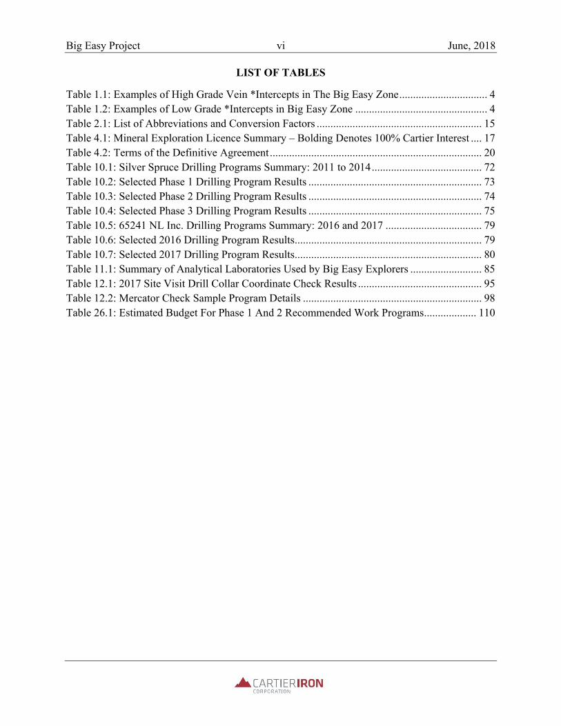
LIST OF TABLES
Table 1.1: Examples of High Grade Vein *Intercepts in The Big Easy Zone ................................ 4 Table 1.2: Examples of Low Grade *Intercepts in Big Easy Zone ................................................ 4 Table 2.1: List of Abbreviations and Conversion Factors ............................................................ 15 Table 4.1: Mineral Exploration Licence Summary – Bolding Denotes 100% Cartier Interest .... 17 Table 4.2: Terms of the Definitive Agreement ............................................................................. 20 Table 10.1: Silver Spruce Drilling Programs Summary: 2011 to 2014 ........................................ 72 Table 10.2: Selected Phase 1 Drilling Program Results ............................................................... 73 Table 10.3: Selected Phase 2 Drilling Program Results ............................................................... 74 Table 10.4: Selected Phase 3 Drilling Program Results ............................................................... 75 Table 10.5: 65241 NL Inc. Drilling Programs Summary: 2016 and 2017 ................................... 79 Table 10.6: Selected 2016 Drilling Program Results .................................................................... 79 Table 10.7: Selected 2017 Drilling Program Results .................................................................... 80 Table 11.1: Summary of Analytical Laboratories Used by Big Easy Explorers .......................... 85 Table 12.1: 2017 Site Visit Drill Collar Coordinate Check Results ............................................. 95 Table 12.2: Mercator Check Sample Program Details ................................................................. 98 Table 26.1: Estimated Budget For Phase 1 And 2 Recommended Work Programs ................... 110
Big Easy Project 1 June, 2018
1 SUMMARY
1.1 Introduction and Terms of Reference
Mercator Geological Services Limited (“Mercator”) was retained by Cartier Iron Corporation (“Cartier”) to prepare a property Technical Report in accordance with National Instrument 43-101 (“NI 43-101”) for the company’s Big Easy Property (the “Property”) gold exploration project located near Clarenville, Newfoundland and Labrador (NL), Canada. Cartier is a Canadian exploration and development company publicly traded on the Canadian Securities Exchange (CSE) under the trading symbol “CFE”. The Company is headquartered in Toronto, Ontario, with an exploration office in Val-d’Or, Quebec, and has substantial iron exploration and resource holdings in the southern extent of the Labrador trough, near Gagnon, Quebec. The Big Easy Property was the company’s main non-iron exploration asset at the effective date of this report.
1.2 Property Description, Location, and Ownership
The Property is located in eastern Newfoundland within NTS map sheets 2 D/1 and 8, south and to the west south of Thorburn Lake, approximately 20 km northwest of the town of Clarenville, and 125 km west of the provincial capital city of Saint John’s. The License area of the property at the effective date of this report covers 9225 hectares. This includes 78 mineral claims on License 023249M and an additional 200 map staked mineral claims (Licenses 025446M and 025452M) acquired by 65421 NL Inc. in late 2017. These three Licences cover a total surface area of 6950 hectares and fall under terms of a Definitive Agreement between Cartier and 65421 NL Inc. Cartier also staked an additional 91 claims (License 025688M) in early 2018 that adjoin the original claims to the west and holds a 100% interest in those claims. These comprise the remaining surface area. Licence 023249M claims are subject to an underlying 3% royalty (“Royalty”) of which Cartier has been granted the option to purchase half of the Royalty (1.5%) in exchange for staged payments to the Royalty holders in the aggregate of $700,000 on or before 60 months following the closing date of the Definitive Agreement. On Nov. 22, 2017 Cartier announced completion of the acquisition of a 100% interest (“Acquisition”) in the Property. Access to Project area lands by previous explorers for the purpose of exploration activities has been arranged through standard exploration permit agreements with the province of Newfoundland and Labrador. Greater than 95% of the area covered by the Property occurs on provincial Crown land. The remaining surface area reflects numerous small holdings related to cottage developments along the shorelines of various small lakes. Cartier has applied to the

Big Easy Project 2 June, 2018
provincial Crown for all exploration access permits required to carry out the full extent of future work programs that are recommended in this report. Cartier has asserted that it knows of no site environmental issues on the property resulting from the company’s activities to date, or activities of past explorers. A portion of the property falls within the designated watershed area of the community of Clarenville and additional permitting requirements apply to this area.
1.3 History
Documentation of the Big Easy property’s history of exploration spans the period between 1963 and the present day, but assessment for gold potential started more recently, following regional lake sediment geochemical surveying carried out by the NL government in 1980. The alteration zone now known as the Big Easy zone was discovered in 1994 during follow up of a 10 ppb Au in lake sediment result in Grassy Pond by Mr. James Harris, P. Geo., and Mr. Philip Saunders, P. Geo., then of GT Exploration. Exploration since that time has been carried out by GT Exploration, Mr. Alex Turpin, Cornerstone Resources Inc., Silver Spruce Resources and 65241 NL Inc. Silver Spruce Resources completed the most extensive exploration programs recorded to date, followed by 65241 NL Inc. The Big Easy alteration and mineralization zone has received most exploration attention to date, with geophysical, trenching and drilling programs being concentrated in that area. Comparatively little exploration has been carried out at the ET zone (named after the initials of the original prospectors who discovered the showing) or in the intervening area of covered ground that separates the two areas of defined epithermal alteration. A total of 6,504.8m of core drilling in 31 holes has been carried out on the Big Easy and ET zones to date and limited trenching has also been completed at the Big Easy zone. Very little exploration has been completed on the more peripheral exploration licences staked by Cartier in late 2017 and early 2018.
1.4 Geological Setting and Mineralization
Geological Setting There are 5 major litho-tectonic zones within the Appalachian Orogen of eastern Canada, as reflected on the island of Newfoundland, these being: 1) Humber; 2) Dunnage; 3) Gander; 4) Avalon and 5) Meguma. Most of the Avalon and Burin Peninsulas of the island of Newfoundland occur within the Avalon Zone and are comprised of a series of accreted magmatic arc and sedimentary basin sequences developed during Neoproterozoic time. The Big Easy Property is located within the Avalon Zone.
Big Easy Project 3 June, 2018
The Avalon Zone consists of a late Neoproterozoic (760-540 Ma) assemblage of active plate margin sequences that accumulated prior to development and closure of Iapetus. Four main tectono-magmatic events affected the sequences, these being at ca. 760 Ma, ca. 680-670 Ma, 640-600 Ma and 595-560 Ma. The most significant period of magmatic activity with respect to epithermal precious metal mineralization within the Avalon Zone is the 640-550 Ma period, when substantial volumes of bimodal volcanic and plutonic rocks evolved under back-arc or continental arc settings. Development of auriferous, high level hydrothermal alteration systems along the length of the Avalon Zone in the northern and central Appalachians broadly assign to this time frame (O’Brien et al., 1998). The geology of the Property forms a portion of the northern strike extension of the geology of the western Avalon Zone, as reflected on the Burin Peninsula. Mineralization Gold and silver mineralization of interpreted epithermal origin occurs on the Property within an extensive hydrothermal alteration zone superimposed upon clastic sedimentary and volcaniclastic lithologies of the Musgravetown Group. Pervasively distributed silicification and argillic to propylitic alteration assemblages define the extents of the alteration zone, within which quartz and quartz-adularia veins and vein breccias showing classic epithermal textures occur. Two areas of bedrock hosted mineralization are currently known on the property, these being the Big Easy and ET occurrences. Examples of both high and low-grade gold and/or silver mineralization occur within the Big Easy zone and are typically associated with intervals of chalcedonic quartz or quartz-adularia veining that show banded internal textures or combinations of banded and brecciated textures that are diagnostic of epithermal mineralizing systems. Where silver values are strongly anomalous, sub-millimetric ginguro-style bands are commonly present. Gold grades associated with vein and vein breccia intervals tested to date range from near detection limit to a maximum of 9.98 g/t over 0.3 m that was returned from hole BE-14-13 beginning at a down hole depth of 156 m. Silver grades ranging from detection limit to as high as 1094 g/t over 0.2 m, returned from hole BE-14-13 and beginning at a down hole depth of 226.5 m, have also been returned from vein settings and in some cases follow elevated gold levels. Several examples of high grade vein and vein breccia intercepts are presented below in Table 1.1. Low grade gold and silver values also occur in the Big Easy zone and have been best defined through detailed continuous sampling of drill core from the various drilling programs completed on the Property between 2011 and 2017. This style of mineralization is restricted to strongly altered sections and often occurs in highly silicified host rock peripheral to high grade vein or vein breccia intervals. Low grade intervals commonly include low levels (<2%) of finely disseminated pyrite,

Big Easy Project 4 June, 2018
Table 1.1: Examples of High Grade Vein *Intercepts in The Big Easy Zone Hole Number From (m) To (m) Length (m) Au g/t **Ag g/t BE-11-03 240.5 242.0 1.5 6.1 174 BE-11-07 43.0 44.0 1.0 7.6 10 BE-12-12 202.3 203.5 1.2 7.9 130 BE-14-13 226.5 226.7 0.2 9.97 1094 BE-16-22 198.0 200.0 2.0 3.54 511 BE-17-27 107.0 107.2 0.20 2.73 707
Note: *apparent widths; true widths not determined; *rounded have gold grades between detection limit and 0.5 g/t and silver grades between detection limit and 100 g/t. Low grade mineralization may contain chalcedonic quartz or quartz-adularia veins or stringers, but their presence is not a prerequisite for anomalism in precious metals. Examples of Big Easy zone low grade mineralization intervals are presented in Table 1.2. Table 1.2: Examples of Low Grade *Intercepts in Big Easy Zone Hole Number From (m) To (m) Length (m) Au g/t *Ag g/t BE-11-03 183.0 272.2 89.2 0.4 15 BE-11-07 231.3 249.9 18.6 0.319 13 BE-14-15 209.0 211.0 2.0 0.15 11 BE-16-21 192.2 208.5 16.3 0.077 24 BE-16-22 197.0 221.6 24.6 0.43 608 BE-17-27 215 219.5 4.5 0.032 87
Note: *apparent widths; true widths not determined; *rounded The ET zone, centered approximately 3.5 km south of the Big Easy, zone consists of float and outcrop occurrences of strongly silicified, locally pyritized and clay altered sedimentary lithologies similar to those that host Big Easy zone mineralization. Several higher grade precious metal occurrences that are vein-related as well as several intervals of low grade mineralization that do not show direct association with veining have also been identified through drilling to date in this area.
1.5 Deposit Type
Precious metal mineralization and associated epithermal alteration zones have been identified at various locations along a 3000 km north-south extent of the Proterozoic Avalon Zone within the Appalachian orogen. Several gold deposits that have supported commercial production also occur within the Avalon Zone, the most notable of these being the Haile, Ridgeway, Brewer and Barite Hill deposits of the Carolina Slate Belt of the United Sates and the Hope Brook deposit that is

Big Easy Project 5 June, 2018
located near the western margin of the Avalon Zone, on the southwest coast of the island Newfoundland. Based on geology, alteration style and mineralization present, the Big Easy Property mineral occurrences can be classified as Neoproterozoic examples of a low supination, epithermal, precious metal deposit type. While these deposit examples provide support for regional level documentation of epithermal precious metal mineralization within the Avalon Zone, Cartier is not suggesting that mineralization of comparable grade and/or dimension as seen at the deposits named above has been defined to data on the Property.
1.6 Exploration
Since finalizing acquisition of the Property in late November of 2017, Cartier has focused its exploration efforts on digital compilation of existing exploration data and assessment of existing airborne magnetometer and Induced Polarization-Resistivity (IP-Resistivity) survey results that are available for the area. This work was carried out to provide input for on-going property exploration planning and to guide acquisition of additional exploration holdings in adjacent areas. The airborne survey assessment program was augmented by a physical properties study carried out on samples of archived drill core. Cartier’s airborne magnetometer survey compilation and assessment program results indicate that the Big Easy and ET alteration zones are contained within a clearly differentiated block of elevated magnetic susceptibility that is interpreted as reflecting volcanic or intrusive sources. More equant anomalies with apparently higher magnetic susceptibilities occur near the east contact of the block and may mark stratigraphically lower intrusives. All of the physical properties study core samples exhibit moderately high resistivity and silicified samples, including the precious metal mineralized samples, show extremely high DC resistivity. On this basis, the DC apparent resistivity measurements that are a by-product of IP/Resistivity surveying should distinguish silicified host and vein material from unaltered epiclastic rocks if sufficient sub-surface volumes of such material are present. Most samples from the alteration zone exhibit moderate to high early time chargeability. On this basis, they constitute good candidates for Induced Polarization (IP) surveying.
1.7 Drilling
Cartier has not completed any drilling on the property to date. During the 2011 through 2015 period, Silver Spruce completed 4048.4 m of core drilling in 19 holes comprising three program phases. 65241 NL Inc. acquired the Big Easy property in 2015 and in 2017 completed two core drilling programs totaling 2456.4 m of drilling in 12 holes. Local

Big Easy Project 6 June, 2018
drilling contractors provided drilling services for all programs, with Cabo Drilling Corporation being retained in 2011, 2012, 206 and 2017. Whitewulf Drilling Ltd. was retained in 2014. The longest significant intersection reviewed by Mercator for 2011 drilling is 30.5 m in BE-11-03 that returned grades of 870 ppb Au (0.87 g/t Au) and 33 g/t Ag, beginning at a depth of 228.0 m. This includes 7 m grading 2.5 g/t Au and 74.1 g/t Ag beginning at a downhole depth of 239.0 m. A 1.5 m interval in the latter interval graded 6.05 g/t Au and 174 g/t Ag. Strongly anomalous gold and silver values were also returned from hole BE-11-7, which intercepted 1 m grading 7.65 g/t Au and 10 g/t Ag, beginning at a downhole depth of 43 m. BE-11-7 also intercepted 18.6 m grading 319.34 ppb Au and 12.96 g/t Ag, beginning at a downhole depth of 231.3 m. The best mineralized zone intercept reviewed by Mercator for 2012 drilling was returned from hole BE-12-12 and graded 1.42 g/t Au and 39.25 g/t Ag over a length of 7.9 m, beginning at a downhole depth of 200.7 m. This interval includes one sample grading 7.9 g/t Au and 130 g/t Ag over 1.2 m, beginning at a downhole depth of 202.3 m. The mineralized zone is comprised of brecciated quartz- adularia veining in a fine grained black matrix. Chalcedonic silica is also present in higher levels of the hole and core sampling was carried out across the full extent of the logged alteration zone.
The best mineralized zone intercept reviewed by Mercator for 2014 drilling was returned from hole BE-14-13 and graded 9.98 g/t Au and 8.5 g/t Ag over a length of 0.30 m, beginning at a downhole depth of 156 m. The interval is comprised of brecciated quartz-adularia veining in a fine grained black matrix. Chalcedonic silica is also noted at higher levels of the hole. The highest grade mineralized zone reviewed by Mercator for Phase 3 drilling was returned from hole BE-14-13 and graded 9.98 g/t Au and 8.5 g/t Ag over a length of 0.30 m, beginning at a depth of 156 m. This interval includes one sample grading 7.9 g/t Au and 130 g/t Ag over 1.2 m, beginning at a depth of 202.3 m. As described in drill logs contained in the report by Delazzer and Dimmell (2012), the mineralized zone is comprised of brecciated quartz-adularia veining in a fine grained black matrix. Chalcedonic silica is also noted in the logging as being present in higher levels of the hole. Core sampling was typically carried out across the full extent of the logged alteration zone. The best mineralized zone intercept reviewed by Mercator for 2017 drilling on the Big Easy zone was returned from BE-17-27 and graded 32.33 ppb Au and 84.65 g/t Ag over a length of 4.50 m, beginning at a depth of 215.0 m. The same hole also returned a shorter high-grade intercept grading 2.73 g/t Au and 726 g/t Ag over 0.20 m length, beginning at a down hole depth of 107.0 m. The best mineralized zone intercept reviewed by Mercator for 2017 ET Zone drilling was returned form hole TC-17-02 that intersected a 3.3 m vein and vein breccia interval within altered sandstone grading 98 ppb Au and 29.9 g/t Ag over 2.8 m, beginning at a depth of 159.2 m. A separate veined and silicified interval returned 665 ppb Au and 16.3 g/t Ag over 1.5 m, beginning

Big Easy Project 7 June, 2018
at a depth of 143.1 m. TC-17-02 undercut a silicified outcrop located about 100 m south of the first 2017 hole and intersected a lengthy zone of quartz veining and vein breccia of which a 14.0 m interval returned low but anomalous values of 24 ppb Au and 6.82 g/t Ag beginning at a down hole depth of 124.0 m. Systematic collection of drill hole deviation measurements formed part of all drilling programs carried out to date on the property. Review by Mercator of downhole survey data showed that rates of deviation in both inclination and azimuth fall within ranges that are typical of such relatively shallow NQ core drilling operations. Based on review of all currently available drilling program data and associated reporting prepared by Silver Spruce and 65241 NL Inc. for Big Easy property, Mercator is of the opinion that all programs were carried out to meet existing industry standards of professional planning, execution and management. Although areas of fractured, brecciated and sheared lithologies were encountered in all drill holes reviewed by Mercator, poor core recovery does not appear to be an extensive and problematic factor with respect to quality of core samples and geological interpretation. Downhole deviation also does not appear to have been problematic with respect to drilling completed to date. The current lithocode system for core logging and surface geological mapping results is highly detailed and could be improved through careful review and simplification. After a new system is developed, re-logging of all drill holes by Cartier staff using the new, comprehensive lithocode system is recommended. In addition, the current digital drilling database should be thoroughly validated by Cartier to ensure that all records accurately reflect source documents.
1.8 Interpretation and Conclusions
Presence of an orogen-scale epithermal metallogenic association has been well documented within Neoproterozoic magmatic arc sequences of the Avalon Zone lithotectonic domain of the Appalachian orogen (Sparkes, 2016; Foley and Ayuso, 2012; O’Brien et al. 1998). This association is defined by variably deformed examples of both high and low sulphidation classes of precious metal bearing epithermal alteration systems. Combined results of work carried out by government, industry and academia, particularly since the late 1980’s, demonstrate that development of epithermal mineralizing systems was related to emplacement of deeper, variably mineralized intrusive phases during Neoproterozoic magmatic arc evolution. Magmatic activity that occurred along the evolving western margin(s) of the Avalon Zone, where the Property is located, is of importance, since many examples of epithermal systems in this part of the Avalon Zone show genetic association with granitoid intrusive complexes and related volcanic sequences developed during the 570 Ma to 590 Ma period (O’Brien et al. 1999).

Big Easy Project 8 June, 2018
In the case of the Cartier Property, the volcanic sequence of immediate interest is located at the base of the Musgravetown Group and is comprised of mafic to felsic extrusive volcanics and related intrusions and volcaniclastics. Immediately overlying Musgravetown Group sandstones, epiclastic sandstones and conglomerates host the Big Easy and ET alteration zones and associated gold-silver mineralization and form the northern strike extension of broadly coeval volcanic and sedimentary units recognized on the Burin Peninsula to the south. The Big Easy and ET alteration zones host classic, low sulphidation epithermal system attributes such as banded quartz adularia veining and related vein breccias, intense silicification, minor levels of disseminated pyrite, and extensive sericite/chlorite/clay alteration. It parallels the interpreted north-south faulted contact between slightly older Love Cove Group volcanics to the east and parallels interpreted trends of sedimentary and volcano-sedimentary sequences within the Musgravetown Group that are interpreted from airborne geophysics. Work carried out to date on the Property has shown that alteration associated with a low sulphidation epithermal system of substantial dimension is present, and that banded, chalcedonic quartz veins and vein breccias associated with the system locally carry trace to high grade levels of precious metal mineralization in drilling intercepts developed over widths ranging from a few centimeters to several tens of meters, depending upon metal and grade level considered. These occur within mineralized alteration haloes that in several instances have also been shown to host low grade precious metal values over various widths. Currently, correlation of mineralized intercepts between and along drilling sections is speculative. More drilling is required to characterize these relationships. Abundant evidence of paleo-surface sinter deposition has been recognized in both drill core and surface exposures of the altered Musgravetown Group sedimentary succession on the Property. This succession is interpreted to be right side up and dipping shallowly to moderately westward. Paleo-surface evidence provides an important input for exploration planning and geological interpretation for the Property, since low sulphidation epithermal systems are characterized by near-surface zones of alteration material that are largely barren of precious metals, and may show only weak vein development. The paleo-sinter intervals represent important time lines that can be used to develop a three-dimensional geological model of the alteration system, its related structures and stratigraphy. Observations from other epithermal districts prompted Hedenquist (2013) to conclude, in the simplest case, that high grade precious metal intercepts at the Big Easy Property would be most likely to occur at paleo-depth levels exceeding 150 to 200 m vertically below the level of demonstrated paleo-sinter deposition. Since sinter materials occur in outcrop and boulders at the Big Easy zone and may exist at the ET zone, and assuming that stratigraphy strikes north and dips moderately to the west, it is reasonable to conclude that exploration for higher grade, feeder zone

Big Easy Project 9 June, 2018
style vein mineralization related to the sinter-associated hydrothermal phase represented in outcrop could be encountered down section of the outcropping and sub-cropping sinters. On the property scale, geological and geophysical survey results indicate that the mineralized alteration zones documented at the Big Easy and ET areas are parts of a larger, north-south striking alteration corridor that measures at least 3.5 km in north-south dimension and up to 400 m or more in width. The 3.5 km extent along this corridor that separates the two zones has received only cursory investigation to date but holds good potential for continuity of alteration across the zone. By association, potential for high grade vein occurrences and associated low grade mineralization can also be invoked for this intervening area of largely covered ground. Work completed to date by Cartier has shown that properly configured and interpreted IP/resistivity surveying in future could effectively define the limits of the favorable alteration zone in this and other covered areas of the Property. Application of the method across the Property, in combination with drill core re-logging and development of a property scale three-dimensional geological model, will significantly contribute to development of future drilling targets. Results of 2011 through 2017 drilling and trenching programs confirm presence of both high and low-grade styles of gold-silver mineralization typical of low sulphidation epithermal settings and substantiate Cartier’s current assessment of the Property’s exploration potential. This information also defines good potential for discovery of additional epithermal alteration zones and related precious metal mineralization along the strike of the Musgravetown Group and/or its equivalents to both north and south of the Property. Cartier has in part addressed this potential through staking License 025688M that covers the main airborne magnetometer survey responses defined to date by the company’s geophysics consultant as marking the Big Easy and ET zone host stratigraphy and its associated north-trending structural corridor.
1.9 Recommendations
A two-phase program of recommended future exploration has been proposed by Cartier and is summarized below. Mercator considers the program and associated budget to be reasonable and justified. Estimated expenditures total $500,000 (Cdn) for Phase 1 and $2.0 million (Cdn) for Phase 2. All expenditures would be incurred over a 24 month period. Phase 2 work relies upon acquisition of Phase 1 data for determination of precise siting information for Phase 2 drill holes and geophysical surveying and is therefore contingent on positive results of Phase 1. The following program components are recommended for the proposed Phase 1 and Phase 2 work programs and include allocations for data interpretation and associated report preparation, where applicable.

Big Easy Project 10 June, 2018
Phase 1 Exploration Program This program is directed toward establishing an up to date “best information” understanding of geological and geophysical features of the Property upon which further exploration, including targeting of an initial core drilling program, can be confidently planned and carried out. The proposed work is initially focused in the north-south corridor measuring 3.5 km in length that includes both the Big Easy and ET alteration zones, as well as on immediately adjacent claims further to the south, west and north, with timing of field work coordinated to address seasonal project area access conditions. Phase 1 includes the following program components:
1. All core from the 2011 through 2017 historic drilling programs should be re-logged by Cartier to create consistency in lithologic and structural observations. A simplified lithocode system should be developed prior to initiation of the core re-logging program and this system should be applied in future core drilling and logging programs. Identification of structural features present in drill core should be a priority and Rock Quality Determination (RQD) logging as well as systematic collection of bulk density determinations should be incorporated in future programs.
2. A full digital compilation of property exploration data, including drill holes, trenching
results, rock sampling results, soil and stream geochemistry results, ground and airborne geophysical survey results, etc. should be carried out. The existing drill hole database should be validated against source data as part of this program phase, with completion ensured prior to planning of additional drilling on the property.
3. Surface IP-Resistivity surveying and grid establishment programs should be carried out to
define limits of alteration and to assess potential for non-outcropping mineralized zones. Coverage should include the Big Easy and ET alteration zones, the intervening area between these zones, and immediately adjacent areas to north and south of these zones. Additional physical properties testing for geophysical surveying purposes should be carried out, as required.
4. A few historical diamond drill holes remain open to depth in the vicinity of the Big Easy
occurrence. These should be used to assess effectiveness of borehole IP-Resistivity surveying as a method of extending the search volume for assessment of continuity of known mineralization and also to assess potential for discovery of off-hole zones of new mineralization. Additional grid-based IP-Resistivity surveying beyond the Phase 1 limits of the main alteration zone should also be carried out, as required, along with high resolution ground grid or UAV magnetometer surveying.

Big Easy Project 11 June, 2018
5. Litho-geochemical, orientation level soil surveying, geological mapping, prospecting and
surface trenching programs should be completed as required to define throughout the Property area new exploration targets for drill testing.
Phase 2 Exploration Program The purpose of Phase 2 work programs is to expand drilling, geophysical, geochemical, and geological program coverage, establish a clear understanding of the spatial aspects, controls and trends of known alteration and associated precious metal mineralization, and to test new target areas recognized on the Property. The following recommendations for Phase 2 are proposed:
1. Lithological and soil geochemistry surveys, geological mapping, prospecting and surface trenching programs should be carried out to expand existing targets and define new target areas.
2. Further grid and borehole IP-Resistivity surveying, grid establishment and high-resolution
ground or UAV magnetometer surveying should be carried out over remaining high prospectively areas within the known alteration zone corridor that extends from the Big Easy area south to the ET area, and also on the broader property holding, including any newly staked areas.
3. A 5000m core drilling program should be carried out to (1) better define the geological
character, controls and extents of existing gold and silver mineralization, alteration, and structural relationships defined to date in the Big Easy and ET occurrence areas, including closely spaced step out core holes from previously drilled holes BE-11-03, BE-14-13, and BE-14-15 in the Big Easy area and from BE-16-22 in the ET area, and (2) test target areas and concepts defined and fine tuned by results of other Phase 1 and Phase 2 programs, with emphasis placed on interpreted results of the recommended IP-Resistivity programs.
Big Easy Project 12 June, 2018
2 INTRODUCTION
2.1 Terms of Reference
Mercator Geological Services Limited (“Mercator”) was retained by Cartier Iron Corporation (“Cartier”) to prepare a property Technical Report in accordance with National Instrument 43-101 (“NI 43-101”) for the company’s Big Easy Property gold exploration project located near Clarenville, Newfoundland and Labrador (NL), Canada.
Cartier is a Canadian exploration and development company publicly traded on the Canadian Securities Exchange (CSE) under the trading symbol “CFE”. The Company is headquartered in Toronto, Ontario with an exploration office in Val d’Or, Quebec and has substantial iron exploration and resource holdings in the southern extent of the Labrador trough, near Gagnon, Quebec. The Big Easy Property was the company’s main non-iron exploration asset at the effective date of this report. Cartier completed acquisition of a 100% interest in the Big Easy Property in late November 2017, pursuant to fulfillment of terms of a Definitive Agreement with 65241 Newfoundland and Labrador Inc. (65241NL Inc.) dated October 31, 2017. The Property is currently subject to an underlying 3% royalty to which Cartier has an option to purchase one half (1.5%).
The total property area consists of 78 claims on License 023249M with an additional 200 map staked mineral exploration claims (Licenses 025446M and 025452M) acquired in late 2017 under terms of the Definitive Agreement with 65241NL Inc., covering a total surface area of 6950 hectares. In early 2018, Cartier staked an additional 91 claims (License 025688M) to the west and owns 100% interest for those claims. The total area covers approximately 9250 hectares and hosts multiple occurrences of Neoproterozoic gold-silver mineralization of low supination epithermal association. Mineralization is hosted by highly altered sedimentary and volcanic lithologies of the Musgravetown Group and takes the form of high grade vein and vein breccia zones plus lower grade zones of dispersed mineralization associated with intense host rock silicification and minor pyritization. Paleo-surface siliceous sinter deposits of epithermal origin have been identified on the property and provide some registration of mineralizing system geometry within the host stratigraphic sequence.
The specific purpose of this Technical Report is to provide an independent review and assessment of historic technical information pertaining to the property and to provide recommendations for continued evaluation of the property’s gold exploration potential.

Big Easy Project 13 June, 2018
2.2 Information Sources
The primary information sources consulted in support of this report consist of mineral exploration industry assessment reports submitted to the government of Newfoundland and Labrador that present results of historic exploration programs carried out by companies other than Cartier. In addition, pertinent academic publications, government reports and associated maps, and relevant NI 43-101 Technical Report s were reviewed to support report preparation. Mercator also reviewed hard copy and digital records of historic data provided by Cartier. This includes government assessment reports, drill logs, drill plans, sampling records and laboratory reports for historic exploration programs carried out in the area that are publicly available in hard copy or digital format from the Newfoundland and Labrador Department of Natural Resources (NLDNR). Assessment reports prepared by Silver Spruce Resources Inc. (Silver Spruce) for the period 2010 through 2016 present results of the most extensive exploration carried out to date on the property. Additional reporting by GT Exploration (GT) applies to the 1995-1998 period and 65241 NL Inc. reported on the most recent work on the property carried out in the 2016-2017 period.
Information for regional context was acquired through review of published research and archived government files, academic theses, and various NI-43-101 Technical Report s filed by other explorers pertaining to similar-age epithermal alteration systems and precious metal mineralization within Avalon Zone sequences elsewhere along the Appalachian orogen.
Geoscientists at the Geological Surveys Branch of the NLDNR have reported extensively on epithermal alteration systems and related precious metal occurrences in Neoproterozoic sequences of the Avalon Zone, beginning in the 1980’s. This information was extensively consulted to support report preparation. Government and academic research continues at present and provides valuable evolving insight with respect to understanding and evaluation of Avalon Zone epithermal systems.
2.3 Site Visits
The author visited the Property on October 2nd and 3rd of 2017 and viewed/sampled drill core from the property on October 4th, 2017 at the government core library located at Torbay, NL. Cartier’s consultants, Mr. James Harris, P. Geo., and Dr. Christopher Hale, P. Geo., participated in all aspects of the site visit and core review. Mr. Harris had previously provided geological consulting services at this site with past explorers GT, Silver Spruce and 65241NL Inc.
Trenching and outcrop exposures were visited during the site visit at both the Big Easy and TC alteration zone areas and 5 quarter core check samples, one outcrop channel check sample and one

Big Easy Project 14 June, 2018
outcrop mineral occurrence check sample were collected for later analysis at Activation Laboratories Ltd. in Mississauga, ON.
2.4 Qualifications of Authors and Responsibilities
The author of this report an independent Qualified Person as defined under NI 43-101 and is a registered member in good standing with the Professional Engineers and Geoscientists of Newfoundland and Labrador (Member Number 05058), Association of Professional Geoscientists of Nova Scotia (Registration Number 064), and Association of Professional Engineers and Geoscientists of New Brunswick, (Registration Number L4333). The author is an employee of Mercator, which is also fully independent of Cartier and licenced to practise geoscience in the province of Newfoundland and Labrador.
Mercator staff assisted the author with various aspects of report preparation, including drill hole database review plus related interpretation and validation work. Mr. Jeffrey Burke, P. Geo., Exploration Manager for the Big Easy Project for Cartier, Dr. William Pearson, P. Geo., Technical Advisor to Cartier, Dr. Christopher Hale, P. Geo., geophysical consultant to Cartier, and Mr. James Harris, P. Geo., geological consultant to Cartier, all provided information that was considered during preparation of this report. The author, however, is responsible, within the meaning of NI 43-101, for use herein of such information.
2.5 Abbreviations Used in this Report
The following abbreviations and conversion factors (Table 2.1) have been used in this report and certain others are individually defined where they initially appear in the text. All currency references in this report reflect Canadian funds unless otherwise indicated.

Big Easy Project 15 June, 2018
Table 2.1: List of Abbreviations and Conversion Factors
Abbreviation Description Cartier Cartier Mining CorporationCEO Chief Executive OfficerCIM Canadian Institute of Mining, Metallurgy and Petroleum Cornerstone Cornerstone Resources Corp.CSA Canadian Securities AdministratorsGT GT ExplorationMercator Mercator Geological Services LimitedNI 43-101 National Instrument 43-101 NL Newfoundland and LabradorNLDNR Newfoundland and Labrador Department of Natural Resources QA-QC Quality Assurance and Quality ControlQP Qualified Person as defined under NI 43-101Silver Spruce Silver Spruce Resources Inc.Km kilometer $(Cdn) Canadian dollars$(US) United States dollarsHa hectare C Celsius Oz troy ounce (31.04 g)G gram (0.03215 troy oz)Kg kilogram Lb pound T tonne (1000 kg or 2,204.6 lb)T ton (2000 lb or 907.2 kg)Oz/T to g/t 1oz/T = 34.28 g/tAu Gold Cu Copper Ag Silver Sb Antimony O Oxygen Zn Zinc S Sulphur Pb Lead Fe Iron Ba Barium Mn Manganese As Arsenic K Potassium Al Aluminum Na Sodium Si Silicon

Big Easy Project 16 June, 2018
3 RELIANCE ON OTHER EXPERTS
Mercator has relied upon Cartier for confirmation of mineral exploration title ownership, which was reviewed by the law firm Stewart McKelvey as part of the agreement with 65241 NL Inc.; the status of exploration title and associated encumbrances, if any, status of land access agreements; provision of agreement and royalty terms associated with the property, and an opinion with regard to site environmental liabilities. This information was used in the preparation of section 4.0 of this report and was confirmed for report purposes by Cartier.
Mercator has referenced various public record reports and assessment reports filed with the NL government, plus other published government, academic and industry information, and takes responsibility for such referenced use in this report.

Big Easy Project 17 June, 2018
4 PROPERTY DESCRIPTION AND LOCATION
4.1 Mineral Exploration Licences
The Big Easy Property is located in eastern Newfoundland within NTS map sheets 2 D/1 and 8, south and centred at 5,344,000 mN and 710,000 mE UTM NAD 83 Zone 21, and located to the south of Thorburn Lake, approximately 20 km northwest of the town of Clarenville, and 125 km west of the provincial capital city of Saint John’s (Figure 4.1).
The property consists of 369 mineral exploration claims, of which 78 claims on License 023249M acquired by 65241 NL Inc. and an additional 200 map staked mineral claims (Licenses 025446M and 025452M) acquired in late 2017 are subject to terms of the Definitive Agreement between Cartier and 65241 NL Inc. These cover a total surface area of 6950 hectares. Cartier staked an additional 91 claims totaling 2275 hectares (License 025688M) in early 2018 in which it holds a 100% interest. In combination with the earlier claims, these bring the total size of the property to a surface area of 9225 hectares (Figure 4.2). Details of Cartier’s holding at the effective date of this report are presented below in Table 4.1. Table 4.1: Mineral Exploration Licence Summary – Bolding Denotes 100% Cartier Interest
License No. No. Claims
No. Hectares
Issuance Date Expiry Date Reporting Date
Expenditure Required.
*023249M 78 1950 5/14/2007 02/14/2026 7/13/2018 $ 61, 060.00
**025446M 100 2500 10/20/2017 10/20/2018 12/19/2018 $ 20, 000.00
**025452M 100 2500 10/20/2017 10/20/2018 12/19/2018 $ 20, 000.00
***025688M 91 2275 01/17/2018 01/17/2019 3/18/2019 $ 18, 200.00
Totals 369 9225 $ 119, 260.00
*Acquired under terms of Definitive Agreement with 65241 NL Inc. in 2017 **Map staked under terms of Definitive Agreement with 65241 NL Inc. in 2017 ***Map staked on behalf of Cartier (100% interest) in 2018
4.2 Status of Mineral Exploration Licences
Cartier has advised that it has 100% interest in the core property (Licences 023249M, 025446M and 025452M) subject to fulfilling the terms of the Definitive Agreement with 65241NL Inc. outlined in section 4.3. It holds a 100% interest in the remaining staked ground (License 025688M) and has advised that at the effective date of this report all of the exploration titles set out in Table 4.1 were in good standing. Similarly, Mercator was advised that no lien, mortgage, or royalty other than that addressed under its Definitive Agreement with 65241 NL Inc., was held against these exploration titles at the effective date of this report. Cartier retained the law firm Stewart McKelvey

Big Easy Project 18 June, 2018
Figure 4.1: Location Map for the Big Easy Project Area, Thorburn Lake area, NL, Canada

Big Easy Project 19 June, 2018
Figure 4.2 Claims map for the Big Easy Project

Big Easy Project 20 June, 2018
in 2017 to, in part, provide an opinion on the status of the exploration titles subject to terms of the Definitive Agreement with 65241 NL Inc., and that these were found to be in good standing and free of additional encumbrances. Mercator has not independently confirmed currency and ownership of mineral exploration title and has relied upon Cartier in this regard.
4.3 Royalties and Agreements
Cartier signed a Definitive Agreement with 65421 NL to acquire a 100% interest (“Acquisition”) in the Big Easy Property, consisting of 278 mining claims covering 6950 hectares, all located in the province of Newfoundland and Labrador, details of which were initially announced by Cartier on September 28, 2017. The terms of the acquisition are summarized in Table 4.2. Table 4.2: Terms of the Definitive Agreement
Stage
Event
CartierInterestEarned
OptionorInterest Retained
Exploration Spend CAD$
Common Shares Issued
1
Sign Definitive Agreement (“Closing”) and Receipt of Exchange Approval 0% 100% N/A 500,000
2 12 Months after Closing 0% 100%
500,000
500,000
3 24 Months after Closing 0% 100%
800,000
500,000
4 36 Months after Closing 100% 0%
1,200,000
1,000,000
Totals
2,500,000 2,500,000 The property is subject to an underlying 3% royalty (“Royalty”), of which Cartier has been granted the option to purchase half of the Royalty (1.5%) in exchange for staged payments to the Royalty holders in the aggregate of $700,000 on or before 60 months following the closing date of the Definitive Agreement. Additionally, in connection with the securities issued to the vendors pursuant to the Acquisition, the Definitive Agreement also includes terms that restrict the vendors from voting in certain circumstances, including not voting against the election of any nominees to the Board of Directors of Cartier or against any resolutions supported by Cartier’s Board of Directors, for a period of four years following the Closing Date. On Nov. 22, 2017 Cartier announced completion of the acquisition of a 100% interest (“Acquisition”) in the Big Easy Property (“Property”).
Big Easy Project 21 June, 2018
Mercator has relied upon Cartier’s public disclosure with respect to terms, conditions and status of the Definitive Agreement to acquire a 100% interest in the Big Easy Property.
4.4 Exploration Title Regulatory Information
Mineral exploration titles in Newfoundland and Labrador are defined and managed under terms and conditions of the Mineral Act (RSNL1990 – Chapter M-12) and associated Mineral Regulations, as amended to date. The following summary of the mineral exploration title holding system in NL is taken from information made available by the NLDNR, particularly the Staking and Exploration Guidebook publication that, for current report purposes, is referred to as NLDNR (2010).
The basic unit of map staking in Newfoundland and Labrador is the claim, which is a 25 ha (500 m x 500 m) square area, being one quarter of a (1 km x 1 km) UTM grid square and bounded by one corner of such a UTM grid square. The UTM grid square referred to is the one thousand metre grid used on the 1:50,000 National Topographic Map Series (NAD 27). An application for a map staked licence is made on-line through the Mineral Rights Administration System (MIRIAD) and can be for a maximum of 256 claims, all of which must be coterminous. Coterminous is defined as having at least one side in common. There are no restrictions on the shape of mineral licenses. Licenses extended past year twenty have a maximum size of 100 claims. A mineral license may be converted to a mining lease at any time if the owner deems there to be sufficient mineral resources to warrant conversion and further work.
At the time of staking, each claim in a license requires payment of a total fee of CDN $65. This total includes a non-fundable CDN $15 recording fee and a CDN $50 security deposit that is refunded upon submission and acceptance of a report covering first year work requirements for the licence. The security deposit submitted with the application for a map staked licence will be refunded to the current licence holder upon the completion of the first year assessment work and acceptance of such work by government. If a map staked licence has been partially surrendered in the first year and the assessment work required to be done has not been completed, a portion of the deposit in proportion to the partial surrender is forfeited. Also, if a map staked licence is cancelled or surrendered in the first year, the security deposit is forfeited. The Mineral Act and Regulations in Newfoundland and Labrador state that there is a 30-day wait period for a staking application to be reviewed before a mineral license is issued. After the license is issued (Issuance Date), the license holder has 365 days until the Anniversary Date during which required first year work must be carried out. Sixty-days after the Work Due Date, a report documenting the work performed and a statement of expenditures must be submitted to the Mineral Lands Division.

Big Easy Project 22 June, 2018
A mineral exploration licence is issued for a term of five years (which is renewable for 3 additional five-year terms and 10 additional one year terms) and can be held for a maximum of 30 years provided that:
• the minimum annual assessment work is completed • the annual work is reported upon • the mineral exploration licence is renewed every five years
The minimum annual assessment work values required to be completed on each claim held in a licence are:
• CDN $200 / claim in the first year • CDN $250 / claim in the second year • CDN $300 / claim in the third year • CDN $350 / claim in the fourth year • CDN $400 / claim in the fifth year • CDN $600 / claim / year for years six to ten, inclusive • CDN $900 / claim / year for years eleven to fifteen, inclusive • CDN $1,200 / claim / year for years sixteen to twenty, inclusive • CDN $2,000 / claim/ year for years twenty-one to twenty-five, inclusive • CDN $2,500 / claim/ year for years twenty-six to thirty inclusive
The minimum annual assessment work must be completed on or before the anniversary date. The assessment report must be submitted within 60 days after the anniversary date. Excess work performed in a given year has a ten-year carry forward currency. This means that should no other work be performed on the license, and adequate excess expenditures exist, the annual requirement will be allocated from the excess until such time the excess runs out or the ten-year time period is reached – whatever comes first. Although no work may have been done by the license holder in the subsequent year or years, provided excess assessment expenditures sufficient to cover the requirement exist, there is no requirement to do work annually. Should a license holder be deficient in the required expenditures for a license, a security for the amount of the deficiency can be submitted. However, this requires that the deficient work be completed in the next year in addition to the minimum assessment work amount required during that subsequent year. This is referred to as a Condition 2 (CON2) extension and the security is refundable upon acceptance of report documenting that the required expenditures were incurred. For a license to remain in good standing with the Government of Newfoundland and Labrador, the license must be renewed every fifth year on the anniversary date. The renewal fees escalate for Term 1, Term 2 and Term 3 and are as follows:
Big Easy Project 23 June, 2018
Term 1 Renewal (year 5 of license) is CDN $25 / claim
Term 2 Renewal (year 10 of license) is CDN $50 / claim
Term 3 Renewal (year 15 of license) is CDN $100 / claim Any person who intends to conduct an exploration program on a staked or licenced area must submit prior notice with a detailed description of the activity to the Department of Natural Resources. An exploration program that may result in major ground disturbance or disruption to wildlife or wildlife habitat must have an Exploration Approval from the department before the activity can commence. An exploration licence conveys an exclusive right to explore for named minerals but does not provide certainty with regard to land access or ownership of minerals. Access to lands is at the discretion of surface title holders and a Mining Lease or Special Mining Lease must be granted by the government to establish ownership of mineral resources for which production is planned. Mining activities can only be initiated after an Environmental Approval has been granted and various permits relating to industrial, environmental and engineering aspects of the proposed mining operation have been obtained.
4.5 Ownership of Surface Rights
The surface rights within the property area are almost exclusively held by the province of Newfoundland and Labrador as Crown land. However, numerous small recreational holdings occur around the shorelines of Thorburn Lake, Angle Pond and other small ponds in the northernmost extent of the property. A designated watershed area related to the town of Clarenville is present in the northeast area of the property and establishes certain restrictions on activity in the designated area (see previous Figure 4.2).
4.6 Access to Land for Future Exploration and Development Purposes
Cartier has advised that access to project area lands by previous explorers for the purpose of exploration activities has been arranged through standard exploration permit agreements with the province of Newfoundland and Labrador. Greater than 95 % of the area covered by Cartier’s Big Easy holdings occur on provincial Crown land. As noted above, the remaining surface area reflects numerous small holdings related to cottage developments along the shorelines of various small lakes. No need has existed to date to access private lands for exploration purposes but if required in future this would necessitate establishment of specific access agreements with affected surface title holders. Cartier has also advised that it has applied to the provincial Crown for all exploration access permits required to carry out the full extent of future work programs that are recommended in this report.

Big Easy Project 24 June, 2018
Cartier does not own any surface rights in the project area at present and there has been no reason to date for it to enter into negotiations with government to obtain such rights. Development of any future mining operations at the site would require gaining access to currently undeveloped Crown land and would necessitate formal application to the provincial government for such use. No certainty exists with respect to the outcome of such a process. The Big Easy project is a very early stage exploration undertaking and no mineral deposit has been defined to date upon which assessments of economic viability could be designed and assessed. On this basis, it is difficult to accurately comment on the availability of land in the area to support a potential future mining operation. However, based on the essentially non-populated and undeveloped nature of almost the entire property and its surrounding area, with the exception of the cottage developments noted above, it is reasonable to conclude that sufficient land could be available within the general property area to support development of future mining infrastructure designed to exploit the types of gold mineralization defined to date and to be explored for by Cartier on the property. Mercator notes that at the effective date of this report, Cartier held access agreements that specifically apply to the geophysical and drilling program activities that comprise the Phase 1 exploration program recommended in report section 18.0 below.
4.7 Environmental Site Conditions
The property is subject to provincial guidelines, regulations and legislation with respect to environmental issues associated with exploration, development and mining and reclamation. These regulations mandate, among other things, the maintenance of air and water quality standards and land reclamation. They also set forth limitations on the generation, transportation, storage and disposal of solid and hazardous waste. Programs recommended in this report are limited to common exploration activities and that these will be appropriately addressed under terms of permits normally required for completion of these activities including, but not limited to:
Mineral Regulations under the Mineral Act (O.C.96-299), in particular with Sections 41-45, regarding mineral assessment work, site management, maintenance and operation of equipment on-site;
A Water Use Licence/Permit issued under the Water Rights and Investigations Section of the Department of Municipal Affairs and Environment. A water use report must be completed and filed annually within thirty (30) days of the completion of the year’s mineral exploration activities;
The Forestry Act and regulations by obtaining cutting and operating permits as required;

Big Easy Project 25 June, 2018
As noted in section 4.1 above, Cartier recognizes that a portion of the property falls within the designated watershed area of the community of Clarenville and that additional care during field operations will be mandated within that area. An application to obtain a “Development Adjacent to or Within Protected Public Water Supply Area” permit is required under the Water Resources Act, 2002, specifically Section 39. The company has carried out site exploration to date under this assurance and has complied with all permit terms associated with completion of work programs in a manner that minimizes potential site impacts. Based on the early stage nature of the property, no environmental baseline work has been completed. Due to the lack of significant development projects in the direct vicinity of the Big Easy project area, there is little information available on any environmental considerations which could potentially affect future development. Mercator is not aware of any environmental liabilities that may have arisen from previous exploration work by others and understands that Cartier is of the same opinion. It should also be noted that during site visitations by Cartier in December of 2017, various unregistered all-terrain vehicle paths were observed along with minor debris associated near those paths.

Big Easy Project 26 June, 2018
5 ACCESSIBILITY, CLIMATE, LOCAL RESOURCES, INFRASTRUCTURE AND PHYSIOGRAPHY
5.1 Accessibility
The Big Easy Property is located in eastern Newfoundland on NTS map sheets 2 D/1 and 8, to the west and south of Thorburn Lake, and is directly accessible from the Trans-Canada Highway (TCH). The northern end of the property lies within 2 km of the TCH and approximately 20 km northwest of the town of Clarenville (Population 6,291 – 2016 Census). National and international air service is available from the community of Gander (population 11,668 – 2016 Consensus) that is located approximately 120 km to the northwest of the Property, and from St. John’s, the provincial capital, located approximately 220 km to the southeast of the property. TCH travel time to the Property from St. John’s and Gander is approximately 2 and 1.5 hours, respectively. Access to the north end of the Property is by the Thorburn Lake gravel secondary road that is directly accessible from the TCH. This road is four-season passable and provides access to numerous cabins in the Thorburn Lake and Angle Pond areas (Figure 5.1). Some cabins are located within 1 km of the northern boundary the Big Easy property. An additional forest access road parallels the eastern property boundary, east of Andrews and Shoal Harbour Ponds, and provides limited access to this area, which forms part of the Town of Clarenville watershed. All-terrain vehicle (ATV) trails extend southerly from the Thorburn Lake access road and cross the northern and central parts of the Property, terminating to the south of Grassy Pond. The remainder of the northern portion of the Property can be easily accessed on foot or ATV via the ATV trails. During the winter months, when boggy areas freeze over, efficient access throughout the Property is possible via snowmobile.
5.2 Climate
The climate of eastern Newfoundland is strongly affected by proximity of the Atlantic Ocean, which exerts a moderating effect with respect to temperature extremes. However, dramatic seasonal variations occur, with winter conditions of freezing temperatures and moderate to heavy snowfall expected from late December through late March. Spring and fall seasons are cool, with frequent periods of rain. Summer conditions typically prevail from July through early September and provide good working conditions for field work. Environment Canada records for the 1981 to 2010 period for Goobies, located approximately 30 km south of the project area, show daily mean temperatures in August of 15.8 degrees C and an average maximum August daily temperature of 21.0 degrees C. Average daily winter maximum temperature in February is -1.4 degrees C and the

Big Easy Project 27 June, 2018
Figure 5.1: Access Routes for the Big Easy Property

Big Easy Project 28 June, 2018
corresponding average minimum is -10.9 degrees C. The extreme winter minimum is -31.0 degrees C. Average yearly precipitation totals 1235.8 mm which includes 228.9 cm of snowfall. Inclement weather and frozen ground conditions in winter can prevent prospecting and certain other exploration activities from being carried out. However, frozen surface conditions that exist in winter facilitate travel via snowmobile, completion of ground geophysical surveys and movement of core drilling equipment. Access for drilling in some very wet areas may only be possible during the winter period.
5.3 Local Resources and Infrastructure
The nearby community of Clarenville provides a wide range of support services, including ready access to accommodations and meals plus health services, grocery and hardware stores mechanical, heavy equipment and vehicle maintenance services, and various contracting services. Charter helicopter service provided by Newfoundland Helicopters is available at Clarenville and Universal Helicopters provides such service from a base located 80 km to the northwest at Gander. The community’s population base, in combination with other nearby small communities, could potentially contribute to future mining development requirements at the Big Easy property. A major electrical power transmission line crosses the Big Easy property and domestic electrical service is available to cottages in the Thorburn Lake and Angle Pond areas. Cellular phone service is accessible in all areas of the property. Numerous lakes, ponds and streams characterize the property area and it is reasonable to conclude that access to water for future industrial purposes should not be problematic in this area. The port city and provincial capital, Saint John’s, has a population of approximately 220,000 as of 2017, and is located approximately 2 hours travel to the east on the TCH from the property. It offers access to central government services, international air and seaborne transportation services, a large university and medical school (Memorial University of Newfoundland), hospitals and schools, other training facilities and a broad range of technical, professional, business and legal services. The population base in the Saint John’s area could potentially serve as a workforce pool for any future mine development in the Big Easy property area.
5.4 Physiography
Topography of the Property area is relatively gently rolling with land surfaces often exhibiting predominantly boggy and poorly forested character. Elevations range from 120 m above sea level (asl) at the lowest points along small creek valleys, bogs and lakes to 160 m asl along localized outcropping bedrock ridges within the claim boundary areas.

Big Easy Project 29 June, 2018
East of the property area, topography rises to about 240 metres asl. This physiographic transition corresponds with a faulted contact of this sequence with Neo-Proterozoic Love Cove Group volcanics. Coniferous forest cover is moderately well developed on the Property and consists primarily of spruce and balsam fir stands that occur at lower elevations. Large open areas of raised bog characterize much of the property at higher elevations. Very few bedrock exposures are present, but overburden is relatively shallow (<2 m) and trenching has been successfully carried out to date at several locations by past explorers. The soil profile on glacial overburden is not well developed and peat development is common in association with the large bog areas. Since all of this area has been glaciated, most low relief areas are now mantled with a thin to moderate layer of glacial till. Past explorers have successfully applied geochemical soil surveying as an exploration technique on the Property.
Big Easy Project 30 June, 2018
6 HISTORY
6.1 Introduction
Documentation of the Property’s history of exploration spans the period between 1963 and the present day, but assessment for gold potential started more recently, following regional lake sediment geochemical surveying carried out by the NL government in 1980. The alteration zone now known as the Big Easy zone was discovered in 1994 during follow up of a 10 ppb Au in lake sediment result in Grassy Pond by Mr. James Harris, P. Geo., and Mr. Philip Saunders, P. Geo., then of GT Exploration. Exploration since that time has been carried out by GT Exploration, Alex Turpin, Cornerstone Resources Inc., Silver Spruce Resources and 65241 NL Inc. Silver Spruce Resources completed the most extensive exploration programs recorded to date, followed by 65241 NL Inc. The property’s exploration history is described below in summary form based on chronological order of program initiation. Relevant government and academic work is similarly summarized and was sourced primarily from references noted in assessment reporting.
6.2 Government/Academic
The following investigations of note have been carried out by government or academic interests in or relative to the property area in the last 60 years:
The Property was included in a regional scale geological mapping program carried out by the Geological Survey of Canada (GSC), with results presented in Jenness (1963).
A portion of the Property was included in a regional mapping program carried out in
support of a M.Sc. thesis project (Hussey, 1979) at Memorial University of Newfoundland.
Airborne magnetometer and gamma ray spectrometer surveying of the Belleoram- Gander Lake (South Central) Newfoundland area was carried out by the Geological Survey of Canada in 1982 and included the Property area (Geofile NFLD/1681- Survey ID N00157).
A study of epithermal alteration and gold mineralization in Late Precambrian volcanic rocks on the northern Burin Peninsula was carried out in support of a M.Sc. Thesis project (Huard, 1989) at Memorial University of Newfoundland.

Big Easy Project 31 June, 2018
The NL government completed 1:50,000 geological mapping in the area in the 1986 through 1992 period, with most work taking place to the northeast of Thorburn Lake.
Regional lake sediment surveying by the NL government was completed over the district
in 1980 and results of the program were reported by Davenport et. Al. (1988). This survey identified a 10 ppb lake sediment anomaly in Grassy Lake, follow up of which resulted in discovery of the Big Easy alteration zone and associated gold occurrence in 1994 by GT Exploration.
A study of mineralogical zones of the Big Easy alteration zone was completed at MUN in
2012 and reported in Wilton (2012). This work identified presence of native silver (Ag), electrum (Au/Ag), acanthite (Ag2S) and unidentified silver-sulfide-selenides (Ag-S-Se) and determined that these often define “ginguro” bands, or narrow erratic black bands, in banded silica quartz-adularia veins present on the Property.
A mineralogical study of the Big Easy alteration zone formed the basis for a B. Sc. (Honours) thesis (Clarke, 2013) prepared at Memorial University of Newfoundland. This documented several contrasting styles and generations of quartz and quartz-adularia veining in drill core and highlighted evidence of vein-associated boiling plus paleo-surface silica gel deposits interpreted as sinters.
Regional geology in the northern portion of the Burin peninsula, including the Big Easy
alteration zone, were addressed in a M.Sc. thesis (Ferguson, 2017) prepared at Memorial University of Newfoundland.
A geophysical methods study of the Big Easy alteration zone formed the basis of a M.Sc. thesis (Wall, 2017) prepared at Memorial University of Newfoundland.
In addition to the above, numerous publications, reports and presentations have been prepared by NL Department of Mines and Energy staff that specifically address epithermal gold mineralization systems documented within the Avalon Zone in Newfoundland and Labrador. The following references are examples of such publications and cover the time period from first recognition of epithermal mineralization within the Avalon Zone of Newfoundland and Labrador in the early 1980’s to the present day.
Huard and O’Driscoll (1985): Epithermal gold mineralization in the late Precambrian rocks on the Burin Peninsula.

Big Easy Project 32 June, 2018
O’Brien et al. (1998): Geological setting of gold mineralization and related hydrothermal alteration in late Neoproterozoic [post-640 Ma] Avalonian rocks of Newfoundland, with a review of coeval gold deposits elsewhere in the Appalachian Avalonian belt.
O’Brien et al. (2001): New insights into the Neoproterozoic geology of the of the central Avalon Peninsula (parts of NTS map areas 1N/6, 1N/7 and 1N/3), eastern Newfoundland.
O’Brien et al, (1996): Late Neoproterozoic evolution of Avalonian and associated peri-Gondwanan rocks of the Newfoundland Appalachians.
O’Brien and Sparkes (2004): Bonanza-grade gold from Neoproterozoic low supination-style epithermal veins and breccias, Bergs Prospect, Avalon Zone, Eastern Newfoundland.
Sparkes et al. (2005): U–Pb geochronological constraints on the timing of magmatism, epithermal alteration and low-supination gold mineralization, eastern Avalon Zone, Newfoundland.
Sparkes (2012): New developments concerning epithermal alteration and related mineralization along the western margin of the Avalon Zone, Newfoundland.
Sparkes and Dunning (2014): Late Neoproterozoic epithermal alteration and mineralization in the western Avalon Zone: a summary of mineralogical investigations and new U–Pb geochronological results.
Sparkes (2014): Neoproterozoic low-supination epithermal mineralization: examples from the western Avalon Zone.
Sparkes et al. (2016) the nature and timing of Neoproterozoic high-supination gold mineralization from the Newfoundland Avalon Zone: Insights from new U–Pb ages, ore petrography and spectral data from the Hickey’s Pond Prospect
6.3 Exploration History of the Big Easy Property
The following chronologically ordered review presents key aspects of historic exploration carried out within the main Big Easy alteration zone area and to a lesser extent the ET alteration zone area located ~ 3.5 km south of Big Easy. The Big Easy alteration zone has received most exploration attention to date, with geophysical, trenching and drilling programs being concentrated in that area to date. Comparatively little exploration has been carried out at the ET zone or in the intervening area of covered ground that separates the two areas of defined epithermal alteration.

Big Easy Project 33 June, 2018
1980: Exploration in the property area was first defined in the current property area by a 10 ppb gold value in a NL government 1980 regional geochemical survey sample site in Henry’s Pond, which is located within the Big Easy alteration zone. Details of the lake sediment survey were reported by Davenport (1988), but no industry follow up of the anomalous lake sediment sample value appears to have occurred until 1994. 1994 – 1996: The area was staked by GT Exploration after carrying out follow up prospecting in the vicinity of the anomalous 1980 lake sediment sample site in Henry’s Pond (also termed Grassy Pond). The company carried out prospecting and geological mapping programs followed by grid-based soil and till geochemistry programs. Gold in soil values up to 370 ppb and rock sample values up to 196 ppb Au were returned and the Big Easy silica/pyrite alteration zone was traced for > 1.5 km along strike, mainly through mapping of float occurrences. Soil and till samples consistently showed elevated gold (Au) values along the zone and mapping results were interpreted as indicating that a fault cuts the alteration zone off to the south. Although exploration results were positive, the company ceased exploration and the property reverted to the crown. Recommended work programs of Induced Polarization/Resistivity (IP/Resistivity) surveying and trenching that were put forward by Harris (1996) and Saunders (1996) were not carried out at that time. 2007: Mr. Alex Turpin staked the property and carried out prospecting along the length of the alteration zone. Cornerstone Resources Corporation (Cornerstone) optioned the property from Mr. Turpin later in 2007 and subsequently carried out the work programs described below for the 2008-2009 period. 2008-2009: After optioning the property from Mr. Turpin, Cornerstone carried out work in 2009 that was concentrated on the alteration zone. This included a property evaluation, prospecting and TerraSpec® near infrared (NIR) spectroscopy analysis programs. The property evaluation confirmed the alteration zone to be up to 1.7 km in strike length and to be 300 m to 500 m in width, as defined by float and bedrock occurrences. Six (6) of 43 rock samples retuned values >100 ppb Au with a maximum of 0.4 g/t Au. Nineteen (19) rock samples returned values > 1000 ppb (1 ppm) Ag with a high of 4.6 g/t (ppm) Ag. Most of the anomalous samples were taken in the Henry’s Pond / Grassy Pond area (Figure 6.1). The TerraSpec® analysis program identified argillic to sub-propylitic hydrothermal mineral assemblages and recommendations for further work included an IP/Resistivity survey and trenching. Notwithstanding the positive exploration results, the option was terminated, and the property was returned to the vendor in late 2009 (Dyke, 2009). Later in 2009, Mr. Turpin continued to prospect the property, concentrating on the central portion near Henry / Grassy Pond area. A total of 37 rock samples, mostly from angular, altered/silicified boulders, gave a mean value for gold of 248 ppb with a high value of 997 ppb (~1 g/t Au) while silver gave a mean of 9.9 ppm with a high of 145 ppm (145 g/t Ag). Fifteen (15) samples gave values > 100 ppb Au including three (3) > 900 ppb Au. Ten (10) samples gave values > 10 ppm Ag, including five (5) > 20 ppm (Turpin, 2010).

Big Easy Project 34 June, 2018
Figure 6.1: 2009 Rock Sample Locations – Cornerstone Resources
Taken from Dyke (2009)

Big Easy Project 35 June, 2018
2010: Silver Spruce optioned the Big Easy property from Mr. Turpin and Mr. Colin Kendall in 2010 and exploration was carried out by the company in two phases during the summer and fall of that year. Work programs undertaken included trenching and prospecting followed by gridding and completion of IP/Resistivity surveying. Trenches 3 to 7 (Figure 6.2) served to outline a 700 x 75 m area of epithermal style alteration consisting of intensely sheared to brecciated, silicified and pyritized conglomerate and sandstone of the Musgravetown Group that are locally cut by finely banded to massive quartz veins ranging from a few millimeters to 20 centimeters in width. A total of 121 channel samples were collected and analyzed and these returned Au values ranging between 30 and 2083 ppb Au (2.08 g/t Au). The mean Au value for these samples is 72 ppb Au and the highest value of 2.08 g/t Au over 0.7 m was returned from a silicified sandstone interval cut by a 1 metre wide quartz vein in Trench 5 (Dimmell et al., 2011). A cut survey grid totalling 30 line km in 21 lines was established over the Big Easy alteration zone and IP/Resistivity surveying was completed on 7 of the cut lines (Lines 173 to 189 N). Surveying was carried out at a line spacing of approximately 200 m and totalled 8.9 line km. A dipole-dipole array was applied with “a” spacing of 75 m and N = 6. Survey results were interpreted as defining nine shallow (i.e. 25 m approximate depth) anomalous IP (chargeability) features, all of which were classified as “non-conductive”, indicating presence of disseminated to stringer sulphides. These occur in two linear trends (Figure 6.3), one of which extends through the altered/mineralized area in a north to north-northeast direction (Dimmell et al., 2011). 2011-2012: Continued exploration in 2011 included prospecting towards the southern part of the property and a two-phase drill program. The first phase was designed to target the main Big Easy mineralization zone while a second phase, located 3.5 km south, targeted a zone that prospecting had identified as being similar in surface expression to the Big Easy alteration zone. Three rock samples from this area returned anomalous Au and Ag values with a high of 125 ppb Au and 3.5 ppm Ag. This area was subsequently designated as the ET zone and it was suggested that it could be a southern strike extension of the Big Easy alteration zone (Dimmell, 2012). First phase diamond drilling by Silver Spruce tested the Big Easy alteration zone over an approximate 1 km strike length with 7 holes. All holes intersected anomalous gold and silver values. The best result was returned from hole BE-11-03 and consists of 30.5 m grading 870 ppb (0.87 g/t) Au and 33 g/t Ag, beginning at a downhole depth of 228 m. This intercept included 7 m grading 2.5 g/t Au and 74.1 g/t Ag, beginning at a downhole depth of 239 m, and 1.5 m grading of 6.05 g/T Au and 174 g/T Ag, beginning at a downhole depth of 240.5. Hole BE-11-7 was the northernmost drilled and intercepted 1 m of 7.65 g/t Au and 10 g/t Ag, beginning at a downhole depth of 43 m, plus 18.6 m grading 319 ppb Au and 13 g/t Ag beginning at a downhole depth of 231.3 m (Dimmell, 2012). Further details of the Phase 1 program appear in report section 10.

Big Easy Project 36 June, 2018
Figure 6.2: 2010 Trench locations – Silver Spruce Resources Inc.
Taken from Dimmell et al. (2011)

Big Easy Project 37 June, 2018
Figure 6.3: 2011 Silver Spruce Resources Inc. chargeability interpretation
Taken from Dimmell (2012)
2012: Second phase diamond drilling by Silver Spruce consisted of 5 holes that assessed a 200 m strike length in the southern part of the area drilled in 2011. Hole BE-12-12 intersected 1.3 g/t Au and 36.7 g/t Ag over 8.7 m beginning at a downhole depth of 200.1 m, including 7.9 g/t Au and 130 g/t Ag over 1.2 m beginning at a down hole depth of 202.3 m. The mineralized zone is comprised of brecciated quartz-adularia veining in a fine-grained black matrix of undefined composition. Short, isolated intervals with high values in silver and lower, but significant, values in gold are present, an example being 0.25 m grading 276 g/t Ag and 1.73 g/t Au in hole BE-12-9 beginning at 5.65 m to 5.90 m down-hole. Chalcedonic silica that is typical of the upper parts of an epithermal system is common in core from this drill hole (Dimmell, 2012).
Big Easy Project 38 June, 2018
An airborne magnetometer and Very Low Frequency Electromagnetic (VLF-EM) survey was also carried out in 2012 and results were interpreted as defining a broad, NNE (025 degrees) oriented, multi-component magnetic high trend passing through the main portion of the claim group, with several associated narrow, NNE trending magnetic lows within the high response. The magnetic lows are offset by linear zones identified as possible dikes emplaced along faults that trend approximately NNW (340 degrees). A sinuous magnetic low was also identified that appears to join the Big Easy and ET zones and continues southward. VLF-EM data show NNE and NNW conductivity trends as well as E-W to ENE-WSW trends that cross the property. Interpretation of survey results by a professional geophysicist was not carried out in 2012 (Dimmell, 2012). 2013: Exploration consisted of limited prospecting in the southern portion of the claim group and in the ET zone, a mineralogical study of the mineralized zones, band a data compilation program and interpretation of combined results of Silver Spruce’s 2012 high resolution airborne survey merged with results of airborne magnetometer and radiometric surveys carried out previously by Cornerstone Resources. The airborne survey interpretation results were reported by McCarthy (2013) and provided a comprehensive base for interpretation of geological and structural features of the property area. Dr. Jeffrey Hedenquist. P. Geo., a recognized authority on epithermal precious metal systems, completed a geological evaluation of the property and characterized surface outcrops of the alteration zone and associated mineralization as representing the near-paleosurface imprint of a low supination epithermal system. As such, potential for occurrence of high-grade Au and Ag veins at deeper levels (+250 m) below the paleo surface elevation was recognized (Hedenquist, 2013). In addition, the property was visited and assessed by several industry representatives in 2013 and brief reports describing their assessments are included in Dimmell (2013). 2014: With the assistance of a Joint Exploration Assistance grant from the provincial government, a late fall exploration program consisting of a phase three diamond drilling program of 7 holes was completed along the south extension of the Big Easy baseline toward the ET zone area. Additionally, a soil geochemical survey over the ET zone was carried out and defined weak to moderately anomalous values in Au, As, Mo and Hg (Figure 6.4). Prospecting found weakly anomalous values in the Big Easy zone and background values were returned for a series of samples collected in the area between the Big Easy and ET zones.

Big Easy Project 39 June, 2018
Figure 6.4: 2014 Soil Survey Results – Silver Spruce Resources Inc.
Taken from Dimmell (2015)

Big Easy Project 40 June, 2018
The 2014 drill program located numerous narrow quartz-adularia veins having well developed banded silica structure and thin, black “ginguro” banding indicative of epithermal development. Most holes did not reach planned depths due to drilling issues but those that did intersected silica, pyrite and sericite alteration, local Au and Ag mineralization and variable amounts of associated quartz veining at depth. The highest grades were returned from a quartz-adularia vein interval in hole BE-14-13 that graded 9.97 g/t Au and 1,094 g/t Ag over 0.2 m beginning at a down-hole depth of 226.5 m. Wider anomalous zones were also defined, such as 38 ppb Au and 3.6 g/ Ag over 27.9 m beginning at a downhole depth of 61.5 m in BE-14-17 (Dimmell, 2015). Subsequent to completion of the 2014 drilling program, Silver Spruce returned the property to its owner, Mr. Alex Turpin, due to the company’s inability to meet option agreement terms. 2015: Prospecting of the area was carried out by Mr. Turpin on both the Big Easy and ET zones and soil geochemistry samples were collected over the ET zone. Emphasis was placed on the relatively unexplored ET zone and resulted in bedrock sample values to 637 ppb Au and 42 g/t Ag t) being returned. Soil sample values ranged from the 5 ppb detection limit to 92 ppb. In 2015 three original licences containing 78 claims (1950 ha) were combined into new licence 23249M. 2016: The property was purchased in 2016 from Mr. Turpin and Mr. Colin Kendall by 65241 NL Inc. a private corporation registered in Newfoundland and Labrador. Subsequent exploration carried out on the Big Easy alteration zone consisted of prospecting in the early summer and a diamond drill program in the September – October period (see Figure 6.5 for hole locations). Based on review and interpretation of existing drill core, 65241 NL Inc. tentatively concluded that the main silica-rich alteration zone and associated intervals of quartz-adularia veining may dip gently towards the east, opposite to the westward dip direction of stratigraphy. In addition, repetition of silicic alteration zones in hole BE-16-20 was tentatively attributed to faulting (Harris, 2016). All 2016 drill holes intersected mineralized alteration lithologies to varying degrees but BE-16-22, which was drilled within the Big Easy alteration zone area, returned the most interesting precious metal results. Highlights from the hole include 24.6 m grading 0.43 g/t Au and 59.8 g/t Ag beginning at a down-hole depth of 197.0 m, including 2.0 m grading 3.54 g/t Au and 511.0 g/t Ag beginning at a down-hole depth of 198 m (Dimmell and Harris, 2017).

Big Easy Project 41 June, 2018
Figure 6.5: 2016 Diamond Drill Program – 65241 NL Inc.

Big Easy Project 42 June, 2018
2017: 65241 NL Inc. completed a 5 hole core drilling program in early 2017 on the Big Easy property (Figure 6.6). As described by Harris (2017) three holes were drilled on the ET Zone, which was changed in name to the Treasure Chest Zone (TC Zone) and two holes were drilled on the Big Easy Zone. Three TC Zone holes tested alteration zone float and outcrop occurrences located along a small brook, for which earlier sampling had returned anomalous gold and silver levels. The holes are separated by approximately 100 m (north-south) and both cut significant sections of strongly altered, and locally faulted, sediment and tuff. The strong silica +/- sericite +/- clay alteration intercepted was logged as being similar to that seen at the Big Easy zone and locally returned anomalous Au and Ag values. The best TC zone core sampling result of 2.8 m grading 97.9 ppb Au and 29.9 g/t Ag begins at a down-hole depth of 159.2 m in drill hole TC-17-03. Two holes were also drilled on the Big Easy zone to test for extensions of mineralization identified in earlier holes. Both successfully intercepted potential extensions, with the highest result of 2.73 g/t Au and 707 g/t Ag over 0.20 m being returned from an interval beginning at a down-hole depth of 107.0 m in drill hole BE-17-27. Upon completion of the 2017 program, Harris (2017) recommended that core from all previous drill holes be re-logged, with emphasis placed on description and correlation of quartz vein and vein-breccia intervals. IP surveying between the BE and TC zones as also recommended, along with further drilling to test existing IP targets and to assess extension potential of mineralized quartz vein-breccia zones intersected previously in holes BE-11-03, BE-14-13 and BE-14-15. In November of 2017, 65241 NL Inc. entered into an option to purchase agreement with Cartier with respect to the Big Easy property mineral exploration titles. Details of the agreement were presented previously in report section 4 “Property Description”. Work programs subsequently initiated by Cartier are discussed below in report section 9 “Exploration”.

Big Easy Project 43 June, 2018
Figure 6.6: 2017 Diamond Drill program – 65241 NL Inc.

Big Easy Project 44 June, 2018
7 GEOLOGICAL SETTING AND MINERALIZATION
7.1 Geological Setting
Introduction
The Big Easy Property is located in the central portion of eastern Newfoundland, north of the Burin Peninsula Belt, that extends for approximately 275 km in length. This belt and its northward extension through the Property host numerous preserved examples of both high and low supination epithermal alteration systems that occur within Neoproterozoic assemblages of the Avalon lithotectonic zone. Some, but not all, systems carry anomalous levels of gold and/or silver. Key aspects of the property’s geological setting and its relationship to precious metal exploration potential are presented below.
Tectonic Summary
There are 5 major litho-tectonic zones within the Appalachian Orogen of eastern Canada, as reflected on the island of Newfoundland, these being: 1) Humber; 2) Dunnage; 3) Gander; 4) Avalon and 5) Meguma (Figure 7.1). Most of the Avalon and Burin Peninsulas on the island of Newfoundland occur within the Avalon Zone and are comprised of a series of accreted magmatic arc and sedimentary basin sequences developed during Neoproterozoic time. The Big Easy property is located within the Avalon Zone. As currently described, the Avalon Zone consists of a late Neoproterozoic (760-540 Ma) assemblage of active plate margin sequences that accumulated prior to development and closure of Iapetus. Four main tectono-magmatic events affected the sequences, these being at ca. 760 Ma, ca. 680-670 Ma, 640-600 Ma and 595-560 Ma. The most significant period of magmatic activity with respect to epithermal precious metal mineralization within the Avalon Zone is the 640-560 Ma period, when substantial volumes of bimodal volcanic and plutonic rocks evolved under back-arc or continental arc settings. Development of auriferous, high level hydrothermal alteration systems along the length of the Avalon Zone in the northern and central Appalachians broadly assign to this time frame (O’Brien et al., 1998).

Big Easy Project 45 June, 2018
Figure 7.1: Major Litho-Tectonic Subdivisions of the Northern Appalachian Orogen
Taken from NLDNR files
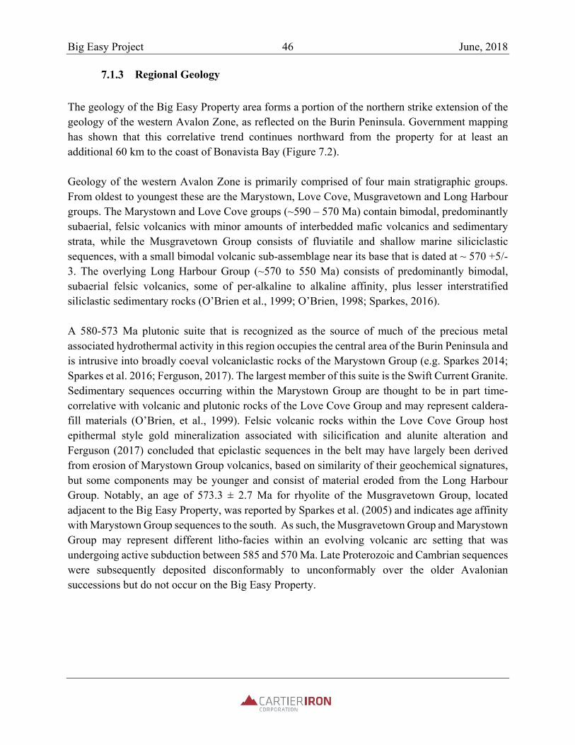
Big Easy Project 46 June, 2018
Regional Geology
The geology of the Big Easy Property area forms a portion of the northern strike extension of the geology of the western Avalon Zone, as reflected on the Burin Peninsula. Government mapping has shown that this correlative trend continues northward from the property for at least an additional 60 km to the coast of Bonavista Bay (Figure 7.2). Geology of the western Avalon Zone is primarily comprised of four main stratigraphic groups. From oldest to youngest these are the Marystown, Love Cove, Musgravetown and Long Harbour groups. The Marystown and Love Cove groups (~590 – 570 Ma) contain bimodal, predominantly subaerial, felsic volcanics with minor amounts of interbedded mafic volcanics and sedimentary strata, while the Musgravetown Group consists of fluviatile and shallow marine siliciclastic sequences, with a small bimodal volcanic sub-assemblage near its base that is dated at ~ 570 +5/-3. The overlying Long Harbour Group (~570 to 550 Ma) consists of predominantly bimodal, subaerial felsic volcanics, some of per-alkaline to alkaline affinity, plus lesser interstratified siliclastic sedimentary rocks (O’Brien et al., 1999; O’Brien, 1998; Sparkes, 2016). A 580-573 Ma plutonic suite that is recognized as the source of much of the precious metal associated hydrothermal activity in this region occupies the central area of the Burin Peninsula and is intrusive into broadly coeval volcaniclastic rocks of the Marystown Group (e.g. Sparkes 2014; Sparkes et al. 2016; Ferguson, 2017). The largest member of this suite is the Swift Current Granite. Sedimentary sequences occurring within the Marystown Group are thought to be in part time-correlative with volcanic and plutonic rocks of the Love Cove Group and may represent caldera-fill materials (O’Brien, et al., 1999). Felsic volcanic rocks within the Love Cove Group host epithermal style gold mineralization associated with silicification and alunite alteration and Ferguson (2017) concluded that epiclastic sequences in the belt may have largely been derived from erosion of Marystown Group volcanics, based on similarity of their geochemical signatures, but some components may be younger and consist of material eroded from the Long Harbour Group. Notably, an age of 573.3 ± 2.7 Ma for rhyolite of the Musgravetown Group, located adjacent to the Big Easy Property, was reported by Sparkes et al. (2005) and indicates age affinity with Marystown Group sequences to the south. As such, the Musgravetown Group and Marystown Group may represent different litho-facies within an evolving volcanic arc setting that was undergoing active subduction between 585 and 570 Ma. Late Proterozoic and Cambrian sequences were subsequently deposited disconformably to unconformably over the older Avalonian successions but do not occur on the Big Easy Property.
Big Easy Project 47 June, 2018
Figure 7.2: Regional Geology of the Western Avalon Zone
Taken from NLDNR files

Big Easy Project 48 June, 2018
Local Geology
Geology of the Property area was originally mapped by the Geological Survey of Canada (GSC) and results were reported by Jenness (1963). This interpretation has been locally updated since that time by other government and academic interests (e.g. Hussey, 1979; O’Brien, 1986, 1987, 1992, 1993; Ferguson, 2017) and property level investigations by industry have also contributed to refinement of larger scale interpretations (e.g. Froude et al. (2002), Dimmell (2012), Dimmell (2015)). Current best information results show that the Property is predominantly underlain by red, grey and green sandstones, lesser conglomerates and tuffaceous volcaniclastic sedimentary rocks of the Neoproterozoic Musgravetown Group. These strike NNE and dip moderately to the NW. O’Brien (1993) described the sequence as shoaling upwards and to consist of coarse grained, mainly red, fluviatile clastic sedimentary rocks with locally developed basal conglomerate, overlain by a bimodal, predominantly subaerial volcanic sequence. These sequences are intruded locally by at least two generations of mafic dykes that reflect both pre and post tectonic emplacement history. The predominantly sedimentary and volcaniclastic Musgravetown Group rocks that predominate on the property and host the Big Easy and ET epithermal alteration zones become increasingly intercalated with mafic volcanic and felsic volcanic units of the Musgravetown Group to the north, in the area between Thorburn Lake and Clode Sound (Froude et al. 2002). An interpretation of compiled airborne magnetometer survey results presented by McCarthy (2013) identified discrete, but discontinuous, mafic volcanic units (basalt) occurring along the entire north-south extent of the property, primarily in its central region (Figure 7.3). Immediately east of the property, Love Cove Group felsic and mafic volcanic and volcaniclastic rocks are in faulted north-south contact with Musgravetown Group sedimentary units that predominate in the central property area. This structure is clearly resolved in the McCarthy (2013) total magnetic intensity (TMI) geophysical interpretation and can be identified through comparison of the geological and geophysical interpretations presented in Figures 7.3 and 7.4, respectively. To the west of the property, undivided Musgravetown Group units are interpreted to be in faulted north-south contact with the altered sedimentary sequence of the central property area where mafic volcanic units mentioned above are concentrated. Transition from the volcanic-bearing central zone to a sandstone dominated stratigraphy to the west is also interpreted by McCarthy (2013), along with prominent sets of northwest trending mafic dikes that do not cross the major eastern boundary fault mentioned above. A Musgravetown Group succession similar to that seen in the immediate area of the Big Easy and ET alteration zones appears to be present along the entire north-south extent of the Property and also appears to extend north and south beyond Property limits (Figure 7.3).

Big Easy Project 49 June, 2018
Figure 7.3: Property Geology Interpretation from McCarthy (2013)

Big Easy Project 50 June, 2018
Figure 7.4: Airborne Survey TMI Results with Historic Claim Boundaries as Interpreted by McCarthy (2013)

Big Easy Project 51 June, 2018
Epithermal Alteration Zones and Their Extents.
Two main centers of defined low supination epithermal alteration have been identified to date on the Property and these correlate with the Big Easy and ET gold/silver mineral occurrence areas. Presence of intense silicification, clay alteration, quartz or quartz-adularia veins or vein breccias, paleo-sinter silica deposits, and low levels of finely disseminated pyrite characterize both zones and gold and silver grades of potential economic interest have locally been returned in each case. Combined results of mapping, sampling, drilling and geophysical surveys completed to date on the property support interpretation of these separate zones as being parts of a larger alteration envelope that trends north – south for at least 3.5 km along strike and locally measures 400 m or more in width (Figure 7.5). An east-west trending late fault marks the current interpreted southern limit of the alteration zone but to the north it remains open. Extent of movement along the southern fault has not been determined nor have lateral east-west extents of the alteration envelope. Trenching, mapping and drilling results currently available for the Big Easy and ET alteration zones provide definition of key spatial aspects of the epithermal alteration system present on the property, but substantial additional work is required to better define and assess system details. Figure 7.6 presents a schematic geological cross section through the Big Easy alteration zone as interpreted by Sparkes (2014) and the section location is noted on Figure 7.7. This interpretation generally parallels that developed earlier by Silver Spruce and is also reflected in a more recent interpretation by Dimmell and Harris (2017).
7.2 Mineralization
Introduction
Gold and silver mineralization of interpreted epithermal origin occurs on the Big Easy property within an extensive hydrothermal alteration zone superimposed upon clastic sedimentary and volcaniclastic lithologies of the Musgravetown Group. Pervasively distributed silicification and argillic to propylitic alteration assemblages define the extents of the alteration zone, within which quartz and quartz-adularia veins and vein breccias showing classic epithermal textures occur. As presented previously in report section 6, results of focused historic exploration of the property through outcrop sampling, trenching and core drilling have identified numerous examples of low supination system low and high grade epithermal gold and silver occurrences. Sampling has shown that high grade veins (>5 g/t Au; >100 g/t Ag), vein arrays or related vein breccia zones typically occur within halos of intensely silicified and clay altered wall rock that locally carry dispersed, low grade gold and silver mineralization along with trace levels of finely disseminated pyrite.

Big Easy Project 52 June, 2018
Figure 7.5: Interpreted Spatial Extent of Epithermal Alteration Zones
BE
ET

Big Easy Project 53 June, 2018
Figure 7.6: Representative Geological Cross Section Through the Big Easy Alteration Zone (View to north)
Taken from Sparkes (2017)
Exploration to date has indicated that the Big Easy and ET zones of epithermal style hydrothermal alteration and related mineralization are related to a larger, spatially extensive alteration system that trends north-south across the property, paralleling the regional structural and stratigraphic fabric of the area. The spatial extents of this large alteration signature have not been fully defined yet and it is possible that it extends to both north and south beyond the limit of current Cartier exploration. The Big Easy zone mineral occurrence comprises the northernmost area on the Cartier holding that contains confirmed high grade and low-grade gold-silver mineralization and the ET zone marks the southernmost confirmed location of such mineralization within the large alteration system. The intervening strike length of overburden covered area has not yet been investigated by detailed exploration work such as core drilling and trenching.

Big Easy Project 54 June, 2018
Figure 7.7: Location map for Figure 7.6 cross section (red line)

Big Easy Project 55 June, 2018
Big Easy Zone
The Big Easy zone is defined by the mapped extent of silicification and related propylitic or argillic alteration assemblages that have been defined to date through mapping, trenching, sampling, core drilling and induced polarization geophysical surveying. It extends along a minimum strike length of approximately 1.5 km, centered on the original mineralized outcrop discovery area located approximately 1 km south of Thorburn Lake. Based on interpretation of magnetometer survey results, the alteration zone may extend to the soutyh for about 3 km to the vicinity of the ET occurrence (see previous Figure 7.5). Examples of both high and low-grade gold and/or silver mineralization occur within the Big Easy zone and are typically associated with intervals of chalcedonic quartz, or quartz-adularia veining that show banded internal textures, including ginguro banding, or combinations of banded and brecciated textures that are diagnostic of epithermal mineralizing systems (Figures 7.8, 7.9 and 7.10). Details of corresponding low and high grade gold and silver assay values corresponding to selected drilling intercepts from mineralized areas are presented later in report section 10.0, “Drilling”. Finely banded (mm scale) chalcedonic quartz deposits that are interpreted as paleo-sinters, originally deposited as silica gels, have been identified in both drill core and outcrop occurrences within highly altered volcaniclastic stratigraphy affected by the Big Easy alteration zone (Figures 7.11 and 7.12). Hedenquist (2013) concurred with conclusions of earlier workers (e.g. Harris, 1996; Dimmell et al. 2011; Sparkes, 2012) as to the epithermal nature of these delicately banded deposits and emphasized their value as paleo-surface indicators within the causative alteration system. He also concluded that in the simplest case, near surface deposits such as these would not be expected to carry high grade precious metal values. Rather, high grade values would be expected in association with boiling zone veining and breccia intervals located at depth below associated paleo-surface deposits. Higher grade intervals intercepted by drilling to date on the Property have gold grades between detection limit and ~10 g/t Au and silver grades between detection limit and ~1094 g/t Ag. Low grade intervals from drilling or outcrop sampling typically have gold grades ranging between detection limit and 1 g/t Au and silver grades ranging between detection limit and 50 g/t Ag.

Big Easy Project 56 June, 2018
Figure 7.8: Banded Chalcedonic Quartz Vein in Hole BE-14-18 – 89.9 m
Taken from Dimmell (2015)
Figure 7.9: Vein Breccia Texture in Hole BE-14-13 – 236.5 M
Taken from Dimmell (2015)

Big Easy Project 57 June, 2018
Figure 7.10: Ginguro Banding in Chalcedonic Quartz Vein in Hole BE-12-09 -5.6 M
Taken from Hedenquist (2013)
Figure 7.11: Hand Specimen of Big Easy Zone Finely Layered Silica-Gel Sinter Deposits
Taken from Hedenquist (2013)

Big Easy Project 58 June, 2018
Figure 7.12: Outcrop Example of Big Easy Zone Finely Layered Silica-Gel Sinter Deposits
Taken from Smith (2013)
Low grade gold and silver values occur throughout the Big Easy zone and have been best defined through detailed continuous sampling of drill core from the various drilling programs completed on the property between 2011 and 2017. This style of mineralization is restricted to strongly altered sections and often occurs in highly silicified host rock peripheral to high grade vein or vein breccia intervals Low grade mineralization may contain chalcedonic quartz or quartz-adularia veins or stringers, but their presence is not a prerequisite for anomalism in precious metals. Finely disseminated pyrite is typical of such zones.
ET Zone
The ET zone is centered approximately 3.5 km south of the Big Easy zone and consists of float and outcrop occurrences of strongly silicified, locally pyritized and clay altered sedimentary lithologies similar to those that host Big Easy zone mineralization. Several higher grade precious metal occurrences that are vein-related as well as several intervals of low grade mineralization that do not show direct association with veining have been identified through drilling to date in this area.

Big Easy Project 59 June, 2018
Outcrop is generally sparse on the Property, but several exposures of pyritic and silicified sedimentary lithologies have been mapped along a small stream that crosses the ET zone. These rocks show northerly strikes and low angle dips to the west for stratigraphy. The section is cross cut by discrete silicification or vein trends, one of which measures about 1 m in true thickness and outcrops along the brook. Three diamond drill holes were completed in 2017 at ET by 65241 NL Inc. (TC-17-01, TC-17-02 and TC-17-03) and are discussed in more detail below in report section 10.0 “Drilling”. Core from these holes shows the main mineralization styles present in the area as being quartz vein or vein breccia intervals and strongly silicified non-veined zones carrying minor amounts of disseminated pyrite. All holes were drilled along a north-south strike length of approximately 150 m and tested interpreted subsurface extensions of the alteration zone exposed in the stream outcrop section mentioned above. The holes intercepted intensely silicified and locally pyritized stratigraphy similar to that of the Big Easy alteration zone as well as several intervals of chalcedonic quartz and quartz-adularia veining and related vein breccia. Individual core sample assay values for gold are typically low, but anomalous in the quartz veined sections, ranging between 24 ppb and 665 ppb (0.66 g/t Au), while silver values are more anomalous, ranging from 7.0 g/t to 29.9 g/t. for individual samples of vein or vein breccia lithologies.

Big Easy Project 60 June, 2018
8 DEPOSIT TYPE
8.1 Introduction
Precious metal mineralization and associated epithermal alteration zones have been identified at various locations along a 3,000 km north-south extent of the Proterozoic Avalon Zone within the Appalachian orogen. Several deposits have supported commercial production, including the Haile, Ridgeway, Brewer and Barite Hill deposits of the Carolina Slate Belt and the Hope Brook deposit, located on the southwest coast of the island Newfoundland, approximately 400 km southwest of the Big Easy property. The past producing Hope Brook deposit is commonly interpreted as a strongly deformed example of a high supination epithermal system hosted by strata assigned to the Avalon Zone. In addition to these prominent deposits, numerous high and low supination epithermal style mineral occurrences have been defined to date along the length of the Burin and Avalon peninsulas of Newfoundland and Labrador. Prominent examples of the latter that have been investigated by detailed core drilling to date include the Hickey’s Pond and Heritage gold prospects, among others. All of the deposits noted above have been studied in detail and their alteration, styles of mineralization and geological settings indicate development in association with Neoproterozoic to early Cambrian epithermal mineralizing systems. In addition, numerous other mineral occurrences of similar style are known along the length of the Avalon Zone within the Appalachian orogen and have been investigated to varying degrees by both government and industry interests.
Several authors have reported on gold mineralization styles specific to the Avalon Zone’s extent on the island of Newfoundland, prominent examples of such being Huard and O’Driscoll (1986), Yule et al. (1990), Stewart (1992), Dube et al. (1998), O’Brien et al. (1999), Sparkes (2012) and Sparkes (2014), among others. A consensus from these based on consideration of host sequence geology, alteration zone and mineralized zone mineralogy and geochemistry, and textural characteristics is that well documented examples of both low supination and high supination epithermal precious metal systems are present within Neoproterozoic sequences of the Avalon Zone on the island of Newfoundland. These are spatially associated with bimodal volcanic and associated sedimentary and intrusive units present on both the Burin and Avalon peninsulas and near the western onshore limit of the Avalon Zone, near the past-producing Hope Brook gold mine. They also show general temporal association with volcanic and associated intrusive magmatic events that assign to the ca. 550 Ma to ca.580 Ma period.
8.2 Classification of Big Easy Zone and ET Zone Mineralization
Classification of precious metal deposits as being of epithermal association and reflective of either high or low supination affinity reflects application of commonly cited geological criteria and

Big Easy Project 61 June, 2018
assessment of interpreted tectonic environments. In the case of high supination systems, gold mineralization is associated with advanced argillic alteration zones containing pyrophyllite, alunite, muscovite, illite, topaz, diaspore, lazulite, pyrite and intense silicification. These often occur above deeply buried intrusions that may host porphyry style mineralization systems. In the case of low supination systems, diagnostic features include bedded silica gel units interpreted as paleo-sinter deposits, multi-phase chalcedonic silica veins and vein breccias and massive silicification of host rock. These features occur within broader propylitic and argillic alteration zones that host mineralized vein assemblages as well as narrow, lower grade disseminated mineralization in some cases. Vein systems typically show vertical zonation with respect to metal distribution, with highest gold and silver values occurring in association with vein intervals that show textural evidence of multi-episodic boiling. Host rocks of both clastic sedimentary and volcanic association are typical and alteration and vein-associated mineralization systems may show direct association with intrusive and/or volcanic center (caldera) settings. The thermal driving forces for metallizing systems of both low and high supination association are thought to be buried intrusions that may represent components of sub-volcanic intrusive complexes associated with buried porphyry style mineralizing systems (Hedenquist and Lowenstern, 1994). Key distinguishing factors in development of both low and high supination epithermal systems are the amount of mixing that takes place between hydrothermal mineralizing fluids of volcanic derivation and meteoric water, and the depth below surface at which such mixing occurs. High mixing rates that result in early neutralization of acidic fluids and boiling-related vapor phases result in development of low rather than high supination systems. In contrast, lower mixing rates and predominance of hotter acidic hydrothermal system fluids promotes development of sulphide-rich advanced argillic alteration assemblages that characterise high supination epithermal systems. Figure 8.1 (Upper) presents a simplified schematic that identifies main components of both low and high supination epithermal systems as distinguished by Hedenquist and Lowenstern (1994) and Figure 8.1 (Lower) presents a simplified schematic of associated fluid types and alteration system zoning envisioned by White and Hedenquist (1995). These basic schematic models were specifically applied to the Big Easy Property in reporting by Hedenquist (2013) with respect to a 2013 site visit to the property and associated study of drill core and outcrops available at that time. Based on the above and the itemized property characteristics noted below, the Big Easy exploration property’s alteration system and associated precious metal mineralization can be classified as a Neoproterozoic example of a low supination, epithermal, precious metal deposit type.

Big Easy Project 62 June, 2018
Figure 8.1: Simplified Cross Sections of High and Low Sulphidation Epithermal Systems
Upper figure taken from Hedenquist and Lowenstern (1994) as presented in Sparks (2012)
Lower figure taken from White and Hedenquist (1995) as presented in Sparks (2012)

Big Easy Project 63 June, 2018
Big Easy Property Characteristics Considered in Low Sulphidation Epithermal Designation
Neoproterozoic age
Location along the western margin of the Avalon Zone
Interpreted back-arc extensional tectonic setting
Extensive development of silicification, argillic and propylitic alteration imprints
Presence of low levels of finely disseminated pyrite in alteration assemblages
Lack of heavily pyritized zones within the alteration assemblages
Presence of banded, crustiform, cockade and ginguro banding textures in chalcedomic quartz and quartz-adularia veins and related vein breccias
Textural evidence of multi-episodic boiling in vein systems
Occurrence of thinly banded silica gel deposits that are interpreted as paleo-sinters
Occurrence of high grade gold and silver mineralization associated with veins and vein breccias
Association with an orogen-scale magmatic cycle that includes volcanics, volcaniclastics and related intrusions developed during the 550 Ma to 580 Ma period.
8.3 Prominent Avalon Zone Examples of Epithermal Deposits
For context, the Haile epithermal deposit in South Carolina is the largest commercially developed gold deposit discovered to date within the Avalon Zone and supports the zone’s only currently producing gold mine, operated by Oceana Gold Inc. Current combined underground and open pit Measured and Indicated category Mineral Resources for the Haile deposit, reported in accordance with NI 43-101 by Carr et al. (2017) at cut off values of 0.45 g/t Au (open pit) and 1.17 g/t Au (underground) total 61.9 million tonnes grading 1.84 g/t Au (3.67 million contained ounces). Combined associated Inferred Mineral Resources reported at the same cut off values total 12.3 million tonnes grading 1.7 g/t Au (0.69 million contained ounces). The Hope Brook deposit, now owned by First Mining Corp., produced approximately 775,000 ounces of Au during its 1986 to 1997 historic operating period. It currently has Indicated Mineral Resources reported in accordance with NI 43-101 by Cullen (2015), at a 3.00 g/t Au cut off value, of 5.5 million tonnes grading 4.77 g/t Au (844,000 contained ounces) and Inferred Mineral Resources at the same cut off value totaling 836,000 tonnes grading 4.11 g/t Au (110,000 contained ounces). These deposits are examples of the Avalon Zone’s potential to host substantial epithermal style gold concentrations that are worthy of exploration. Cartier and Mercator caution that presence of the above noted deposits and their associated current Mineral Resources within the Avalon Zone should not be taken as an indication that deposits of similar size and grade are, or may be, present on the Cartier Property.

Big Easy Project 64 June, 2018
9 EXPLORATION
9.1 Introduction
Since finalizing acquisition of the Big Easy Property in late November of 2017, Cartier has focused its exploration efforts on digital compilation and assessment of available exploration and drilling results, review and reprocessing of historic airborne magnetometer and IP-Resistivity survey results and completion of a core physical properties testing program. This work was carried out to provide input for on-going property exploration planning and to guide acquisition of additional exploration holdings in adjacent areas. Preliminary results of the airborne survey compilation program were reported to Cartier in Hale and Gilliat (2018) and at the report effective date Cartier had not finalized all aspects of its digital compilation program of historic exploration work carried out in and adjacent to the property. This compilation includes review and re-interpretation of drilling, geochemical prospecting and mapping results and is scheduled for completion prior to initiation of substantive 2017 field work.
9.2 Geophysical Surveys Compilation and Review
The following description of geophysical program components, results and associated conclusions is summarized from Hale and Gilliat (2018). Magnetic field data were combined from three surveys of the property and its surrounding setting. The data sets include:
1) Regional aeromagnetic data compiled by the Newfoundland Department of Natural Resources Geochemistry, Geophysics and Terrain Sciences Division;
2) An aeromagnetic survey over part of the property flown for Cornerstone Resources Inc. in 2000 and described in Scott and St-Hilaire (2001);
3) Silver Spruce’s 2012 airborne survey of the Big Easy property that is described in Dimmell et al. (2012).
The Cornerstone and Silver Spruce data were merged in 2013 by G. Kilfoil, Project Geophysicist of NLDNR’s Geochemistry, Geophysics and Terrain Sciences Division. The Cornerstone survey was flown at a line spacing of 200 m at a height of 90 m above the terrain while the Silver Spruce survey used either 200 m or 300 m spacing on different parts of the property at a flying height of 60 m. Processing in 2013 included averaging of overlapping data and cut and splice merging of the data sets so that original survey values are preserved in the
Big Easy Project 65 June, 2018
resulting grids where there is no overlap between the surveys. Cartier obtained these data grids from NLDNR and used them to calculate additional geophysical products for future interpretation. Figure 9.1 presents a plot of Total Magnetic Intensity (TMI) assembled from the three surveys. The more detailed central part of the map reflects the higher resolution of the Cornerstone and Silver Spruce surveys, while the adjoining regional data are less detailed, reflecting a higher flying height and widely spaced flight lines. McCarthy (2013) interpreted the merged survey results as defining a faulted contact between volcanic sequences of the Love Cove Group in the east with lower sedimentary sequences of the Musgravetown Group. In contrast, Hale and Gilliatt (2018) propose a non-faulting alternative interpretation in which the lowest sedimentary units of the Musgravetown Group are older than the more magnetically susceptible volcanic-volcaniclastic package hosting the Big Easy and ET showings. McCarthy’s main reason for correlating the lowest Musgravetown units with an upper sedimentary package is similarity of their weak magnetic susceptibilities. Unless a synclinal structure is proposed for the entire volcaniclastic package, the weakly magnetic rocks between the Musgravetown and Love Cove volcanic rocks can also be interpreted as simply an older sedimentary sequence. O’Brien (1993) mapped a basal conglomerate in the Musgravetown Group north and east of the Property that could be a lower sedimentary sequence candidate for the model proposed by Hale and Gilliatt (2018), but a faulted contact is still a possibility. Both the Big Easy and ET alteration zones are contained within a clearly differentiated block of elevated magnetic susceptibility that is interpreted as reflecting volcanic or intrusive sources. These display anomalies that are elongated parallel to the ESE and WNW side contacts of the block and are also parallel to the structural trend of the Love Cove volcanic rocks to the east (Figure 9.1). More equant anomalies with apparently higher magnetic susceptibilities occur near the east contact of the block, particularly to the east of the Big Easy occurrence. Hale and Gilliatt (2018) interpret these to be stratigraphically lower intrusives and speculate that they may have provided heat sources to drive the Big Easy and ET epithermal system. The elongated anomaly shapes within the Big Easy and ET magnetic domain block are more typical of NNE striking sources with moderate to steep dips rather than the shallow eastward dips interpreted by Dimmell and Harris (2017) from limited drilling. They are similar to the magnetic texture of volcanic rocks in the Love Cove Group to the east. The west-northwest (upper?) contact of the block containing the showings is interpreted to mark a sharp transition from volcanic to essentially non-magnetic sedimentary rocks. This contact is irregular, but broadly parallel to the faulted Musgravetown Group-Love Cove Group contact on the east side of the block and the Big Easy and ET alteration zones are located along this contact. It is possible that this major contact reflects a fault.

Big Easy Project 66 June, 2018
Figure 9.1: Compiled Total Magnetic Intensity (TMI) Map for the Study Area
Modified after Hale and Gilliatt (2018) The Analytical Signal (ASIG) map from the airborne surveys (Figure 9.2) clearly shows both NNW and NE trending dykes of probable mafic composition crossing the Big Easy and ET alteration zone area, but it is difficult to trace these across interpreted boundaries between some

Big Easy Project 67 June, 2018
Figure 9.2: Compiled ASIG Map for the Study Area
Modified after Hale and Gilliat (2018)

Big Easy Project 68 June, 2018
of the main structural blocks defined by magnetics. This is consistent with block contacts being faulted.
TMI anomalies interpreted by Hale and Gilliatt (2018) as having intrusive sources are characterized by smoother, more rounded shapes on the ASIG map and ASIG anomalies reflecting sedimentary rocks northwest of the Big Easy and ET block differ from those to the southeast, possibly indicating that these may not be fault or fold repeated time-stratigraphic equivalents (Figure 9.2).
9.3 Core Sample Physical Properties Study
Hale and Gilliatt (2018) measured physical properties on a suite of 29 archived drill core samples and a further 12 polished slab and hand samples collected from the Big Easy occurrence area. The properties measured are: magnetic susceptibility, specific gravity, DC resistivity, chargeability and electro-magnetic conductivity (EM) at two frequencies. In concept, these properties should provide a basis for identifying a signature of the target mineralization and designing a survey to pinpoint the target type. The comments below with respect to results of individual phases of the physical properties testing program are directly summarized from Hale and Gilliatt (2018). Results of Big Easy core sampling define a wide range in magnetic susceptibility. Alteration frequently occurs at the expense of magnetite, the mineral that contributes most to magnetic susceptibility, so it is common for gold to be associated with reduced magnetic susceptibility. In general, the Big Easy core samples are non-magnetic to weakly magnetic with only two having a susceptibility higher than 5x10⁻⁴. While there is no direct correlation between gold grade and magnetic susceptibility, a detailed magnetic survey may help to distinguish between unaltered and altered volcanic rocks and in delineating structural features within the Big Easy and ET host sequence. Specific gravity data from the study group tightly around an average value of 2.68, with the highest results being returned from epiclastic samples and a quartz-adularia vein sample with abundant hematite. All of the core samples exhibit moderately high resistivity and the silicified samples, including the precious metal mineralized samples, show extremely high DC electrical resistivity. In general, lower resistivity results were obtained from epiclastic samples and breccias while quartz vein and strongly silicified samples yielded very high (>100 K-ohm) resistivity values. All of the rocks in the collection are considered to be non-conductive and samples of silicified material are extremely non-conductive. On this basis, the DC apparent resistivity measurements that are a by-product of IP/Resistivity surveying should distinguish silicified host and vein material from unaltered

Big Easy Project 69 June, 2018
epiclastic rocks if sufficient sub-surface volumes of such material are present. Both high and low frequency EM measurements yielded negligible conductivity. This indicates that a mineralized zone target will not be conductive and that electromagnetic techniques will not be useful for direct detection of such targets. Most samples from the alteration zone exhibit moderate to high early time chargeability. Chargeability generally increases with sulphide concentration and also tends to rise with the increase in resistivity that accompanies silicification. The highest chargeability values, meaning those over 100 mV/V, are associated with the mineralized quartz veins samples that also have very high resistivity; as such, they constitute ideal candidates for Induced Polarization (IP) surveying. One highly silicified sinter sample also showed an elevated chargeability.
9.4 Geophysical Program Recommendations
Hale and Gilliatt (2018) conclude that results of the physical properties study carried out for Cartier indicate that the best geophysical approach for detailing the BE and ET target type will be an IP/Resistivity survey in which a correlation is sought between higher than normal resistivity and high initial chargeability, i.e. chargeability with a short decay time constant (Tau). On this basis, they recommend that IP/Resistivity field surveys be carried out on the Big Easy property to exploit these target characteristics. Detailed measurements of the near surface are recommended on several survey lines over the Big Easy occurrence area to register laboratory results to field survey results and conditions. Pole-dipole array survey parameters of “a”=25 m, “n”=8 and 100 m spaced lines apply in this case. For reconnaissance surveys, a large pole-dipole array with “a”=50 m and “n” =50 m is recommended to map silicified zones on the basis of their elevated resistivity and their chargeability derived from fine grained pyrite occurring within the zone of alteration. Use of a pole-dipole rather than the dipole-dipole approach used earlier by Silver Spruce is recommended to increase depth of surveying. An increase in line spacing to 200 m with eight dipoles is recommended to efficiently resolve and map alteration zone limits. In addition to the studies described above, Hale and Gilliatt (2018) note that it may be possible to carry out three-dimensional resistivity mapping through inversion modelling and that Cartier could benefit from modelling of the Big Easy and ET target areas using borehole IP/Resistivity methods. Initial probing of drill holes by Cartier in late 2017 showed that many of the 2011 through 2017 holes are open and clear. These could be used as geophysical platforms for future off-hole and inter-hole exploration. Follow-up of this concept in 2018 is recommended.

Big Easy Project 70 June, 2018
10 DRILLING
10.1 Introduction
Cartier has not carried out any drilling programs to date on the Property but is planning to do so in the coming year. This report section describes drilling programs carried out by past explorers only, these being Silver Spruce and 65421 NL Inc. The respective programs were briefly summarized previously in report section 5 “History”. This Technical Report contains recommendations for completion of further core drilling on the property. The historic core drilling programs completed to date on the property are described below in chronological order, beginning with the first program completed by Silver Spruce in 2011 and ending with the 2017 program by 65421 NL Inc.
10.2 Silver Spruce Programs – 2011 to 2015
Introduction
During the 2011 through 2015 period, Silver Spruce completed 5,507.4 m of core drilling in 26 holes comprising three program phases. Figure 10.1 presents related hole locations and Table 10.1 identifies drill holes and total meterage completed in each of the Silver Spruce program phases. Drill collar location coordinates and hole orientation data accompany this report in Appendix 1.
Phase 1 Drilling – 2011 Cabo Drilling Corporation provided drilling services for the 2011 program and recovered NQ (47 mm diameter) core using a track mounted drill rig. The Phase 1 program consisted of 7 holes totaling 1,577 metres of drilling and was carried out along five east-west oriented section lines. Section spacing ranged from 175 m to 200 m and the program was designed to provide subsurface detail to alteration and gold mineralization zones encountered in trenching and mapping completed to that date. Hole BE-11-01 undercut the mineralized Trench 6 area, while BE-11-02 and BE-11-03 undercut the Trench 5 area. BE-11-04 and BE-11-05 were completed between Trench 4 and Trench 5 (Figure 10.1). BE-11-06 was completed approximately 500 m north of the other holes and BE-11-07 is located approximately 200 m further north on a separate section line. Both holes were designed to test the northern extent of the mapped alteration zone. Descriptions of geology, mineralization and sampling results pertaining to each of the trenches referred to above are presented in MacGillivray et al. (2011) and were summarized previously in report section 6.

Big Easy Project 71 June, 2018
Figure 10.1: Drill Hole Locations for Silver Spruce Programs 2011-2015

Big Easy Project 72 June, 2018
Table 10.1: Silver Spruce Drilling Programs Summary: 2011 to 2014
Drill Hole Year Program Phase Target Area Depth_m BE-11-01 2011 1 Big Easy 107
BE-11-02 1 Big Easy 98
BE-11-03 1 Big Easy 302
BE-11-04 1 Big Easy 167
BE-11-05 1 Big Easy 239
BE-11-06 1 Big Easy 359
BE-11-07 1 Big Easy 305
Subtotal 1577
BE-12-08 2012 2 Big Easy 146
BE-12-09a 2 Big Easy 23
BE-12-09 2 Big Easy 230
BE-12-10 2 Big Easy 236
BE-12-11 2 Big Easy 209
BE-12-12 2 Big Easy 236
Subtotal 1080
BE-14-13 2014 3 Big Easy 279.6
BE-14-14 3 Big Easy 131.1
BE-14-15 3 Big Easy 248.7
BE-14-16 3 Big Easy 130.2
BE-14-17 3 Big Easy 267.4
BE-14-18 3 Big Easy 157.9
BE-14-19 3 Big Easy 176.5
Subtotal 1,391.4
Grand Total 4048.4 All 2011 drill holes intersected intervals of silicic alteration containing shorter included intervals of anomalous gold and silver values. Table 10.2 below presents selected anomalous drilling results reviewed by Mercator that illustrate the general nature of gold and silver mineralization intercepted by Phase 1 holes. The longest significant intersection independently calculated by Mercator is 30.5 m in BE-11-03 that returned grades of 870 ppb Au and 33 g/t Ag, beginning at a downhole depth of 228.0 m. This includes 7 m grading 2.5 g/t Au and 74.1 g/t Ag beginning at a downhole depth of 239.0 m. A 1.5 m interval in the latter interval graded 6.05 g/t Au and 174 g/t Ag. Strongly anomalous gold and silver values were also returned from hole BE-11-7, which intercepted 1 m grading 7.65 g/t Au and 10 g/t Ag, beginning at a downhole depth of 43 m. BE-11-7 also intercepted 18.6 m grading 319.34 ppb Au and 12.96 g/t Ag, beginning at a downhole depth of 231.3 m.

Big Easy Project 73 June, 2018
Table 10.2: Selected Phase 1 Drilling Program Results
Drill Hole From (m) To (m) *Length (m) Au (ppb) Ag (ppm)**
BE-11-02 34 35.5 1.5 175 17
BE-11-02 76.7 78.2 1.5 151 1
BE-11-02 79.5 81 1.5 183 1
BE-11-03 183 184 1 1334 2
BE-11-03 187 188 1 220 33
BE-11-03 214.5 216 1.5 150 9
BE-11-03 228 258.5 30.5 870 33
Incl 239 240.5 1.5 1,040 67
And 240.5 242 1.5 6,052 174
And 245 246 1 6,043 114
BE-11-03 264 272.2 8.2 669 23
Incl. 269 270 1 1,493 55
And 270 271 1 1,399 29
BE-11-05 86.2 89 2.8 299 9
BE-11-05 97 98.5 1.5 460 49
BE-11-06 37.7 42 4.3 260 11
BE-11-06 53 60 7 168 5
BE-11-07 43 47 4 1,933 3
Incl. 43 44 1 7,645 10
BE-11-07 52 53 1 480 4
BE-11-07 231.3 249.9 18.6 319 13
Incl. 231.3 231.6 0.3 2,569 335 Note: *apparent widths; true widths not determined; **rounded
Phase 2 Drilling – 2012
Cabo Drilling Corporation provided drilling services for the 2012 program and recovered NQ core using a track mounted drill rig. The program consisted of 5 holes totaling 1,080 metres of drilling that were completed within a 200 metre north-south strike length of the Big Easy alteration zone that includes the area of mineralized drill hole BE-11-03 (see previous Figure 10.1). Significant analytical results selected by Mercator from the Phase 2 program are presented below in Table 10.3. The best mineralized zone intercept reviewed by Mercator for Phase 2 drilling was returned from hole BE-12-12 and graded 1.42 g/t Au and 39.25 g/t Ag over a length of 7.9 m, beginning at a downhole depth of 200.7 m. This interval includes one sample grading 7.9 g/t Au and 130 g/t Ag over 1.2 m, beginning at a downhole depth of 202.3 m. As described in drill logs contained in

Big Easy Project 74 June, 2018
Table 10.3: Selected Phase 2 Drilling Program Results
Drill Hole From (m) To (m) *Length (m) Au (ppb) **Ag (ppm)
BE-12-08 22.3 26.5 4.2 168.5 1.83
BE-12-09 5 7.3 2.3 417 50
BE-12-09 12.8 17.6 4.75 667 44
BE-12-09 37.4 40 2.6 170 4
BE-12-09 57.2 57.6 0.4 372 0.4
BE-12-09 187.3 190.7 3.4 204 4
BE-12-10 10.8 13.5 2.7 491 5
BE-12-10 25.6 25.85 0.25 3396 3
BE-12-10 29.6 43.5 13.9 323 9
BE-12-10 94.5 95.4 0.9 1052 1
BE-12-10 101 112.25 11.25 795 4
BE-12-10 179 188.3 9.3 306 3
BE-12-10 201.55 202.5 0.95 321 0.3
BE-12-11 9.8 14 4.2 1085 21
Incl. 10.8 11.2 0.4 4391 69
BE-12-11 61 62.5 1.5 177 11
BE-12-11 65.5 65.8 0.3 179 1
BE-12-11 95.3 98 2.7 168 2
BE-12-11 146 147.7 1.7 401 2
BE-12-11 165.5 166.6 1.1 215 0.2
BE-12-12 18.5 20.3 1.8 160 6
BE-12-12 27.7 29.4 1.7 534 29
BE-12-12 38.5 42.8 4.3 175.53 4
BE-12-12 73.5 76 2.5 165 1
BE-12-12 165 166.5 1.5 422 3
BE-12-12 171.3 176.5 5.2 403 3
BE-12-12 200.7 208 7.9 1416 40
Incl. 202.3 203.5 1.2 7894 130 Note: *apparent widths; true widths not determined; **rounded reporting by Delazzer and Dimmell (2012), the mineralized zone is comprised of brecciated quartz-adularia veining in a fine grained black matrix. Chalcedonic silica is also present in higher levels of the hole and core sampling was carried out across the full extent of the logged alteration zone.

Big Easy Project 75 June, 2018
Phase 3 Drilling – 2014
Whitewulf Drilling Ltd. of Baie Verte, NL provided drilling services in the 2014 Phase 3 program and recovered NQ core using a track mounted drill rig. The program consisted of 7 holes (BE-14-13 through BE-14-19) totaling 1,391.4 metres of drilling (previous Figure 10.1). Representative analytical results selected by Mercator from the Phase 3 program are presented in Table 10.4.
Table 10.4: Selected Phase 3 Drilling Program Results
Drill Hole From (m) To (m) *Length (m) Au (g/t) Ag (g/t)** BE-14-13 133.5 133.8 0.3 0.18 129 BE-14-13 151.7 152.4 0.7 0.38 4 BE-14-13 156 156.3 0.3 9.98 9 BE-14-13 159.4 161.3 1.9 0.301 6 BE-14-13 175.2 176.1 0.9 0.325 16 BE-14-13 185.3 186.5 1.2 0.215 5 BE-14-13 213.1 213.4 0.3 0.196 2 BE-14-13 222.3 222.7 0.4 0.225 3 BE-14-13 225.1 226.7 1.6 1.43 159 BE-14-13 226.5 226.7 0.2 9.97 1094 BE-14-14 96.8 97 0.2 0.626 3 BE-14-15 198.5 199 0.5 0.323 2 BE-14-15 204.4 205 0.6 0.165 6 BE-14-15 209 211 2 0.15 11 BE-14-17 16.5 21.8 5.3 0.164 3 BE-14-17 39 54.5 15.5 0.151 2 BE-14-17 110.8 111.2 0.4 0.219 7.7 BE-14-17 121.9 122.2 0.3 1.2 4 BE-14-17 123.1 123.5 0.4 0.477 2 BE-14-17 158.7 159.2 0.5 0.1 16 BE-14-17 206.5 209.9 3.4 0.216 10 BE-14-18 20.3 22.2 0.45 0.28 3 BE-14-18 47 47.3 0.3 0.582 44 BE-14-18 53.9 54.2 0.3 3.86 119 BE-14-18 84.8 85.3 0.5 0.42 70 BE-14-18 89.5 89.9 0.4 1.56 7 BE-14-18 92 92.15 0.15 1.89 33 BE-14-18 93.8 94.8 1 0.736 6 BE-14-18 120.3 121 0.7 0.598 11 BE-14-18 126.85 126.95 0.1 3.7 22 BE-14-18 138.1 138.6 0.5 0.378 2 BE-14-19 135.6 135.75 0.15 5.46 79 BE-14-19 140.9 141.4 0.5 1.02 2

Big Easy Project 76 June, 2018
Drill Hole From (m) To (m) *Length (m) Au (g/t) Ag (g/t)** BE-14-19 148.6 148.8 0.2 6.23 99 BE-14-19 153.7 153.9 0.2 4.49 41 BE-14-19 163.6 163.85 0.25 0.83 170
Note: *apparent widths; true widths not determined; **rounded
Holes BE-14-13 through BE-14-16 tested a 500 m long interval of the Big Easy alteration zone that had not previously been tested by drilling. Holes BE-14-17 through BE-14-19 were completed as undercuts in the area of gold and silver mineralization previously intercepted by holes BE-12-9 through BE-12-11. Due to coring difficulties, only holes BE-14-13, BE-14-15 and BE-14-17 were completed to their planned depths. All holes intercepted broad sections of alteration containing multiple intervals of anomalous gold-silver values, with those stopped before planned completion depth ending in alteration. The highest grade mineralized zone reviewed by Mercator for Phase 3 drilling was returned from hole BE-14-13 and graded 9.98 g/t Au and 9 g/t Ag over a length of 0.30 m, beginning at a downhole depth of 156 m. As described in drill logs contained in reporting by Delazzer and Dimmell (2012), this interval is comprised of brecciated quartz-adularia veining in a fine grained black matrix. Chalcedonic silica is also noted as being present in higher levels of the hole. Core sampling was typically carried out across the full extent of the logged alteration zone.
10.3 65241 NL Inc. Drilling – 2016
Introduction
65241 NL Inc. acquired the Big Easy property in 2015 under terms of a purchase agreement after the earlier option agreement between Silver Spruce and the owners was terminated. During the 2016 through 2017 period the company completed two core drilling programs totaling 2,456.4 metres of drilling in 12 holes (Figures 10.2 and 10.3). For completeness, Table 10.5 identifies drill holes and total meterage completed in each 65241 NL Inc. program and Table 10.6 presents representative mineralized intercept data for the 2016 program. Drill collar location coordinates and hole orientation data for the 2016 and 2017 holes accompany this report in Appendix 1 and details of the two drilling programs carried out by the company appear below.

Big Easy Project 77 June, 2018
Figure 10.2: Drill Hole Locations for 65241 NL Inc. 2016 Drill Program
BE

Big Easy Project 78 June, 2018
Figure 10.3: Drill Hole Locations for 65241 NL Inc. 2017 Drill Program
BE
ET

Big Easy Project 79 June, 2018
Table 10.5: 65241 NL Inc. Drilling Programs Summary: 2016 and 2017
Drill Hole Year Target Area Depth_m BE-16-20 2016 Big Easy 146.0 BE-16-21 2016 Big Easy 290.0 BE-16-22 2016 Big Easy 233.0 BE-16-23 2016 Big Easy 101.0 BE-16-24 2016 Big Easy 104.0 BE-16-25 2016 Big Easy 284.0 BE-16-26 2016 Big Easy 293.0
Subtotal 1451 BE-17-27 2017 Big Easy 167.7
BE-17-28 2017 Big Easy 267.7
TC-17-1 2017 ET 173.0
TC-17-2 2017 ET 179.0
TC-17-3 2017 ET 218.0
Subtotal 1005.4
Grand Total 2456.4
Table 10.6: Selected 2016 Drilling Program Results
Drill Hole From (m) To (m) Length (m)* Au (ppb) Ag (g/t)**
BE-16-20 79.10 79.70 0.60 167.0 30
BE-16-21 196.10 196.85 0.75 157.0 65
BE-16-21 207.10 208.50 1.40 155.0 54
BE-16-22 63.70 66.30 2.60 201.31 4
BE-16-22 161.90 162.60 0.70 155.0 13
BE-16-22 197.00 201.00 4.00 1,965.30 290
BE-16-22 207.40 208.10 1.70 300.18 27
BE-16-22 211.60 212.50 0.90 222.0 54
BE-16-23 54.50 56.00 1.50 224.0 3
BE-16-25 74.50 76.00 1.50 162.0 4
BE-16-26 208.20 209.40 1.20 163.0 2
BE-16-26 283.50 285.00 1.50 185.0 0.9 Note: *apparent widths; true widths not determined; **rounded

Big Easy Project 80 June, 2018
10.4 2017 Drilling Program
Cabo Drilling Corp. provided drilling services for the 2017 program and recovered NQ (47 mm diameter) core using a C20 track mounted drill rig. The program consisted of 5 holes in total (1005.4 m) with two (BE-17-27 and BE-17-28) completed within the Big Easy alteration zone and three (TC-17-01 through TC-17-03) completed within the ET alteration zone area to the south of Big Easy (see previous Figure 10.3 for hole locations). The ET zone was referred to by 65241 NL Inc. as the “Treasure Chest” (TC) zone but Cartier has chosen to adopt the original ET zone nomenclature established by Silver Spruce. Significant analytical results selected by Mercator from the 2017 drilling program are presented below in Table 10.6 Hole BE-17-27 tested the eastward downdip extension of strong silver mineralization defined earlier in BE-16-22 and intersected alteration-hosted quartz veining over a 1.75 m interval that returned gold and silver values of 89 ppb and 7.5 g/t, respectively. Several other mineralized intervals were also intersected and are reflected in Table 9.6. BE-17-28 was sited to assess alteration zone strike characteristics approximately 300 m east of BE-11-07. Both altered and unaltered sections were cut by this hole and the best associated analytical results were returned from a 1.0 m quartz veined interval that graded 378 ppb Au and 4.2 g/t Ag beginning at a depth of 168.8m.
Table 10.7: Selected 2017 Drilling Program Results
Drill Hole From (m) To (m) Length (m)* Au (ppb) Ag (g/t)**
BE-17-27 48.3 48.8 0.5 45 7
BE-17-27 107.00 107.20 0.20 2730.0 726 BE-17-27 116.5 120.8 4.30 47.1 7.52 BE-17-27 133.8 147.3 13.50 34 6 Including 133.8 136.2 2.40 42 4 BE-17-27 165.0 176.8 11.80 31.9 5
Including 172.30 173.80 1.50 173.0 6
BE-17-27 174.6 175.6 1.0
BE-17-27 215 219.5 4.5 32.33 85
Including 216.5 218 1.5 66 235
BE-17-27 244 245.75 1.75 89.43 7
BE-17-28 168.80 169.20 0.40 378.0 4
BE-17-28 174.60 175.60 1.00 396.0 3
BE-17-28 230.70 232.20 1.50 221.0 2
TC-17-01 150.70 153.70 3.00 487 5
TC-17-02 124.0 138.0 14.0 24 7
TC-17-03 143.10 144.60 1.50 665 13
TC-17-03 159.20 160.00 0.80 269 44 Note: *apparent widths; true widths not determined; **rounded

Big Easy Project 81 June, 2018
TC-17-01 through TC-17-03 tested an area of float and outcrop from which low but anomalous Au and Ag values had previously been returned. TC-17-01 intersected faulting and alteration plus approximately 16 m of quartz veining and vein breccia that is cut off by faulting at a depth of 163 m. The highest values of gold and silver returned from the quartz veined zone were 487 ppb Au and 5.1 g/t Ag over 3.0 m beginning at a depth of 150.7 m. TC-17-02 undercut a silicified outcrop located about 100 m south of the first hole and intersected about 18.5 m of quartz veining and vein breccia of which a 14.0 m interval returned low but anomalous gold and silver values of 24 ppb and 6.82 g/t, respectively, beginning at a depth of 124.0 m (Harris, 2017). TC-17-03 tested a dip extension of the veined zone in TC-17-02 and intersected a 3.3 m vein and vein breccia interval in altered sandstone grading 98 ppb Au and 29.9 g/t Ag over 2.8 m, beginning at a depth of 159.2 m. A separate veined and silicified interval returned 665 ppb Au and 16.3 g/t Ag over 1.5 m, beginning at a depth of 143.1 m.
10.5 Hole Deviation and Core Loss in Silver Spruce and 65241 NL Inc. Programs
Hole Orientation Testing
Systematic collection of drill hole deviation measurements formed part of all drilling programs carried out to date on the property. The 2011, 2012, 2014, 2016 and 2017 programs typically used Flexit™ or Reflex™ downhole instrumentation to collect orientation data, typically with one reading at a depth between 10 and 30 m below the collar and one reading at or near the end of the hole. One 2012 hole (BE-12-09) was not tested. For deeper holes, a third reading was generally collected about 100 m below the first reading depth. The last two holes of the 2011 program were tested using a multi-shot system that recorded hole orientation data at 30 m intervals down the hole and the first 2 holes of the program were only tested at their respective ends using a Pajari mechanical instrument. Review by Mercator of downhole survey data for the entire compiled drilling dataset showed that rates of deviation in both inclination and azimuth fall within ranges that are typical of such relatively shallow NQ core drilling operations. Continued use of a multi-shot system collecting orientation data at 5 to 25 m down hole intervals is a preferred approach.
Core Recovery
Physical review of drill core from 8 holes was completed during the Mercator site visit in November of 2017 and a wide range of fracture densities and loss rates was noted. In some cases, substantial local core loss was noted in association with sheared or faulted intervals and this was identified in the associated logging records. However, no evidence of pervasive and extensive core

Big Easy Project 82 June, 2018
loss was noted. Cursory review of drill core photos for other holes showed the same trends, with local areas of strongly enhanced fracturing, core fragmentation and possible core loss associated with faulted or sheared zones being apparent. Rock Quality Determination (RQD) logging of the core was not carried out during any of the programs completed to date. Based upon its review of drill core, drill core photo records for various holes, and core log descriptions, Mercator is of the opinion that strongly fractured ground conditions are common in the holes reviewed and that local core loss has occurred over short intervals in some cases. Evidence of systematic and substantive core loss is not present in the drill core reviewed. Based on results of the drilling data compilation and validation processes, plus visual core assessments and discussion with Cartier consultants, Mercator is of the opinion that core loss factors should not substantively influence the process of geological interpretation of drilling data or associated core sample assay data assembled to date for the Big Easy Property. In future, drilling programs should be closely monitored with respect to core recovery to ensure that fractured or sheared ground conditions do not detrimentally affect core recovery and core sample quality.
10.6 Discussion of Drilling Program Results
Geological Framework Interpreted from Drilling Results
The 2011 through 2017 drilling programs carried out by Silver Spruce and subsequently 65241 NL Inc. provided initial investigation of the large hydrothermal alteration system identified through earlier and concurrent geological mapping, surface trenching and geophysical surveying completed on the Property, which began with work by the original licensees in 1995. Possibly the most important determination with respect to early assessment of the property’s exploration potential is that the mineralization present originated in association with a well developed low supination style epithermal system. More particularly, evidence at surface of siliceous sinter material and finely banded, colloidal silica deposits provides a good relative depth registration for that stratigraphic level relative to the associated paleo-alteration system. Since surface geology at both the Big Easy and ET alteration zone areas is largely similar, it follows that these two areas may reflect a common time line within the alteration system that appears to have been superimposed on both bedded Musgravetown Formation epiclastic sedimentary and volcaniclastic deposits, and, possibly, on early (coeval?) cross cutting felsic and mafic intrusive rocks. The geological framework assembled from interpretation of surface geology was recognized early in the history of property exploration as having characteristics of a low supination epithermal system. Importantly, it was recognized that such systems have potential for occurrence of high grade precious metal accumulations in paleo-boiling zone regions at depth below related paleo-surfaces that are commonly marked by sinters, banded silica deposits and silica replaced host

Big Easy Project 83 June, 2018
rocks. This framework provided guidance to varying degrees for the drilling programs carried out to date on the property, and its application has resulted in local confirmation of higher grade precious metals mineralization being present on the property at various depths below the current surface. Spatial relationships defined by drilling between higher grade epithermal style intercepts and presumably related, but largely non-mineralized, surface sinter deposits indicate that the Big Easy and ET alteration system rocks and associated mineralization may have been affected by post-mineralization faulting, details of which are not entirely clear at present.
Mercator Comments on 2011 to 2017 Drilling Programs
Based on review of all currently available drilling program data and associated reporting prepared by Silver Spruce and 65241 NL Inc. for Big Easy property, Mercator is of the opinion that all programs were carried out to meet existing industry standards of professional planning, execution and management. Although areas of fractured, brecciated and sheared lithologies were encountered in all drill holes reviewed by Mercator, poor core recovery does not appear to be an extensive and problematic factor with respect to quality of core samples and geological interpretation. Downhole deviation also does not appear to have been problematic with respect to drilling completed to date and continued use of multi-shot downhole orientation survey instrumentation is recommended by Mercator. True thickness of mineralized intervals is in many instances difficult to determine at the Big Easy Property. As a general statement applicable to all 2011 to 2017 programs, trues thickness values that assign to recognizable vein or vein breccia intercepts having discrete contacts range between a few centimeters to approximately 1 m. Longer mineralized intercepts of breccia or vein breccia are more difficult to assess, as are the mineralized alteration halo zones that measure up to several tens of meters in length. Neither of these styles of mineralization can be accurately assessed as to associated true widths until reliable geological sub-surface interpretations of corresponding drilling data have been developed. Until such time, when classification on a hole by hole and intercept by intercept basis can be carried out, such intercept lengths must be qualified as apparent thicknesses for which true thicknesses have not been determined. The current lithocode system for core logging and surface geological mapping results is highly detailed and could be improved through careful review and simplification. After a new system is developed, re-logging of all drill holes by Cartier staff using the new, comprehensive lithocode system is recommended. In addition, the current digital drilling database should be thoroughly validated by Cartier to ensure that all records accurately reflect source documents.

Big Easy Project 84 June, 2018
11 SAMPLE PREPARATION, ANALYSES AND SECURITY
11.1 Introduction
Cartier has not carried out any rock or core sampling for assaying purposes on the property to date. The following descriptions of sampling protocols, analytical methods and security considerations apply to previous exploration programs completed on the Big Easy property and were compiled from review of government assessment reports filed by past explorers. This information was augmented through discussion during the Mercator site visit with Mr. James Harris, P. Geo., an independent geological consultant retained by Cartier. Mr. Harris is attributed with joint discovery of the Big Easy alteration zone in 1995 and provided field management, core logging and geological consulting services for the 2017, 2016 and 2014 core drilling programs completed on the property for Silver Spruce and/or 65241 NL Inc. He was also involved in early property exploration carried out by GT Exploration Ltd. in the 1995 to 1996 period. Table 11.1 presents compiled general information pertaining to various sampling programs and associated analytical services firms that are documented in assessment reporting. Brief notes pertaining to each listed program are presented below. Property assessment reports do not provide detailed descriptions of field methods with respect to collection of soil, rock or channel samples, Descriptions of core sampling, handling and analytical protocols for the drilling programs completed between 2011 and 2017 are slightly more complete.
11.2 Radex Minerals Ltd.: 1969 to 1971
Reporting for this period shows that exploration on the current property was limited to its inclusion in regional hydrogeochemical and stream sediment sampling surveys carried out by Radex Minerals Ltd. No information describing methods of sampling, handling or security appears in associated reports but Bondar Clegg and Company Ltd., a commercial analytical services firm based in Ottawa, Ontario, Canada provided analytical services for both the 1969 and 1971 programs. Bondar Clegg and Company Limited was acquired by ALS Chemex in 2001 and ALS Chemex has since evolved to ALS Global, a fully accredited analytical services firm registered to the ISO 17025 standard with international scope. No records of laboratory accreditation were noted for the 1969 through 1971 period. ALS Global is fully independent of Cartier. Program reporting does also not address sample security measures. Analytical methods applied are as presented in Table 11.1.

Big Easy Project 85 June, 2018
Table 11.1: Summary of Analytical Laboratories Used by Big Easy Explorers
Year Operator Survey Type Laboratory Analysis Type 2017 65241 NL
Inc. Core AGAT Laboratories; Au Fire Assay (ICP-MS) + AAS
(Ag)2016 65241 NL
Inc. Rock, core Eastern Analytical Ltd.;
Activation Laboratories Ltd.
Au Fire Assay (AA) + 34 element ICP Au Fire Assay (AA) check samples
2014 Silver Spruce Resources Inc.
Rock, soil, stream sediment, core
Eastern Analytical Ltd.; Accurassay Ltd.
Au Fire Assay (AA) + 34 element ICP Au Fire Assay check samples
2012 Silver Spruce Resources Inc.
Rock, stream sediment
Eastern Analytical Ltd. Au Fire Assay (AA) + 11 element ICP
2011 Silver Spruce Resources Inc.
Core, rock, core reject
Accurassay Ltd.; Eastern Analytical Ltd.
Au Fire Assay (AA) + 30 element ICP Au Fire Assay (AA) + 11 element ICP
2010 2011
Silver Spruce Resources Inc.
Stream sediment, soil, rock
Accurassay Ltd.; Eastern Analytical Ltd.
Au Fire Assay (AA) + 30 element ICP Au Fire Assay (AA) + 11 element ICP
2009 Alex Turpin Rock Accurassay Ltd.; Eastern Analytical Ltd.
Au Fire Assay (AA) + 30 element ICP Au Fire Assay (AA) + 30 element ICP
2008 Cornerstone Resources Inc.
Rock samples
Eastern Analytical Ltd. Acme Analytical Ltd.
Au Fire Assay (AA) + 30 element ICP Au Fire Assay (AA) + 30 element ICP
2001 Cornerstone Resources Inc.
Core, stream sediment, soil, rock
Eastern Analytical Ltd. Au Fire Assay (AA) + 30 element ICP
1996 GT Exploration Ltd.
Soil, till, rock
Eastern Analytical Ltd. Au Fire Assay (AA) + 30 element ICP
1996 GT Exploration Ltd.
Rock, Stream sediment
Eastern Analytical Ltd. Au Fire Assay (AA) + 30 element ICP
1971 Radex Minerals Ltd.
Stream sediment, rock
Bondar Clegg and Company Ltd.
Cu, Pb, Zn, Ag (AA); U (Fluorimetry)
1969 Radex Minerals Ltd.
Hydrogeochemistry
Bondar Clegg and Company Ltd.
Cu, Pb, Zn, Ag (AA); U (Fluorimetry)

Big Easy Project 86 June, 2018
11.3 GT Exploration Ltd.: 1995 and 1996
No details of sample collection or security considerations appear in exploration reports reviewed by Mercator that were prepared by GT Exploration Ltd. Reports show that exploration programs were planned and coordinated by experienced geologists and it can be assumed that industry standard rock and soil sample preparation protocols set out by Eastern Analytical Ltd. (Eastern Analytical) were applied prior to geochemical analysis by the methods presented in Table 11.1 above. Eastern Analytical is a commercial analytical services firm that has served the region since 1987. It was fully independent of GT Exploration Ltd. and is also fully independent of Cartier. Government assessment reporting for this period (Harris, 1996; Saunders, 1996) does also not specifically address sample security or chain of custody issues.
11.4 Cornerstone Resources: 2002 and 2008
A small area of the current property’s northern extent was held by Cornerstone Resources as part of its West Princess Property, which was being assessed for its volcanic-sediment hosted copper potential. Work on the current Cartier property appears to have been largely limited to collection of several stream sediment samples in 2001 from tributaries of Southwest River, south of the Trans Canada Highway. Samples of active bottom sediment were collected on a nominal 200 m site separation basis and were subsequently delivered to Eastern Analytical in Springdale, NL for analysis using the Au Fire Assay / 30 Element ICP protocol. No record of QAQC related sample insertions or project sample security protocols appears in the associated Froude (2002) assessment report. As noted above, Eastern Analytical was operating as an independent, commercial analytical services firm at the time but was not fully accredited or ISO registered. In 2008, Cornerstone Resources optioned the claims covering the main Big Easy alteration zone from then licensee, Mr. Alex Turpin. The company completed geological mapping and rock sampling surveys before relinquishing the option the following year. As described by Dyke (2009), all rock samples were shipped to Eastern Analytical in Springdale, NL for standard rock preparation and resulting pulps were shipped from Eastern Analytical via DHL courier to Acme Analytical Laboratories Ltd. (Acme) in Vancouver, BC for analysis by multi-element ICP mass spectrometry methods. A certified control standard from CDN Resource Laboratories Ltd. (CDN-CGS-2) was inserted in each block of 20 rock samples and assay results received for standard samples were within acceptable assay ranges. Both Eastern Analytical and Acme were fully independent of Mr. Turpin and Cornerstone Resources and were operating as independent commercial analytical services firms at the time. Although Acme was Canadian Association for Laboratory Accreditation Inc. (CALA) accredited and registered to the ISO 17025 standard at the time, the multi-element methods applied were not accredited under that standard at that time.

Big Easy Project 87 June, 2018
Eastern Analytical was not ISO registered or fully accredited at the time but had operated as an independent, commercial analytical services firm since 1987.
11.5 Alex Turpin: 2009 and 2010
Rock samples collected during prospecting and property evaluation programs carried out on behalf of licensee Alex Turpin were submitted to either Eastern Analytical in Springdale, NL for preparation and analysis or to or the Accurassay Laboratories Ltd. (Accurassay) preparation facility in Gambo, NL with subsequent analysis at that company’s laboratory in Thunder Bay, ON. After standard rock preparation, Eastern Analytical carried out Fire Assay (AA) + 30 Element ICP analysis of sample pulps. Acme completed Au +33 Multi-element analyses of pulps after standard rock preparation. As noted above, both Eastern Analytical and Acme were fully independent of Mr. Turpin during this period and operating as independent, commercial analytical services firms at the time. Although Acme was CALA accredited to the ISO 17025 standard at the time, the multi-element methods applied in the case of the 2009 and 2010 samples were not accredited under that standard. Assessment reporting (Turpin and MacGillivray, 2010) for this period does not describe any QAQC sample insertion protocol that may have been applied. Similarly, no discussions of sample security and chain of custody issues are included.
11.6 Silver Spruce: 2011 to 2015 Period
Silver Spruce staff and consultants carried out all field programs under supervision of registered professional geologists. Program planning was similarly supervised, as was interpretation and reporting of program results for either corporate of government assessment purposes. Table 11.1 above presents a chronologically ordered summary of field programs carried out during the Silver Spruce exploration period and identifies related sampling programs and analytical services firms. Bedrock sampling associated with prospecting and mapping, trenching and diamond drilling are included, along with small programs of geochemical stream sediment and soil sampling. Program reporting for this period also does not directly address sample security measures implemented for the various drilling and surface trenching programs, but evidence of industry standard levels of security is apparent from descriptions of drilling program logistics and discussion with Cartier’s geological consultant, Mr. James Harris, P. Geo., who participated in the last of three drilling programs carried out by Silver Spruce. All Silver Spruce site activities were planned by professional geoscientists and site supervision, core logging and core sampling programs were carried out under direct supervision of professional geoscientists. In 2011 and 2014 core was logged and sampled at a secure site located at Thorburn Lake and logging geologists were responsible for laying out sampling intervals. Project technical

Big Easy Project 88 June, 2018
staff checked boxes and sample intervals prior to cutting half core samples using a diamond saw. Sample lengths ranged between 0.10 m and 1.5 m. No minimum sample length protocol was assigned. Each half core sample was placed in a pre-numbered plastic bag along with a paper sample number tag and both hard copy and digital records of sampling and core logging details were maintained. After cutting and bagging, samples were checked, QAQC materials were inserted, and groups of samples were placed in larger bags for delivery to the selected laboratory by either commercial carrier or project staff. Silver Spruce staff were responsible for security of the core and associated samples from the drilling site through to either delivery at the laboratory or transfer to a commercial carrier for subsequent delivery to the laboratory. Core for holes BE11-01 through BE14-19 from Silver Spruce programs is now archived at the provincial government’s core library facility in Torbay, near Sant John’s, NL. Analytical services for Silver Spruce programs were primarily provided by Eastern Analytical. As noted above, this firm was fully independent of Mr. A. Turpin and Silver Spruce and has operated as an independent, commercial analytical services firm since 1987. Since February of 2014 it has held CALA accreditation and been registered to the ISO/IEC 17025 standard for completion of fire assay gold – atomic absorption (AA) determinations as well as multi-acid digestions and AA determinations for cobalt, copper, lead, zinc and silver. Check sampling of selected samples was carried out for the 2011 and 2014 programs and Accurassay Ltd. and Acme Analytical Ltd. provided related analytical services for the respective years. Accurassy Ltd. was also fully independent of Silver Spruce, held CALA accreditation and was registered to the ISO/IEC 17025 standard at this time.
11.7 65241 NL Inc.: 2016 to 2017 Period
Introduction Field and logging procedures for the 65241 NL Inc. drilling programs in 2016 and 2017 were carried out under the same operational protocols established by Silver Spruce and program planning, management and reporting functions were carried out under direction of the same professionals responsible for the Silver Spruce programs. However, preparation and analysis of half core samples for each of the two drilling programs was carried out at separate analytical services firms and differences exist in QAQC approaches. Details of the 2016 and 2017 programs are presented below under separate headings.

Big Easy Project 89 June, 2018
2016 Drilling Program As described by Dimmell and Harris, (2017) preparation and analysis of 2016 core and rock samples was carried out at Eastern Analytical in Springdale, NL using Fire Assay Au (AA) and ICP 34 Element methods. Soil samples were analyzed for gold only. Drill core was cut using a diamond saw with one half sent for analysis and the remainder retained. Re-analysis to “high grade” standards was carried out for samples that exceeded the 6 ppm ICP upper detection limit for Ag. Check analyses on selected core pulps prepared by Eastern Analytical were carried out using comparable analytical techniques at either Activation Laboratories in Ancaster ON or at Acme Laboratories in Vancouver, BC. While QAQC program details for the 2016 programs are not specifically described, it is apparent that analysis of duplicate pulp splits was systematically carried out for 2016 program samples and that selected check sample analyses at accredited laboratories that were fully independent of 65241 NL Inc. was carried out. No mention is made by Dimmell and Harris (2017) regarding insertion of blind blank samples or certified reference materials in the laboratory sample stream. Core from the 2016 program is currently located in a secure commercial storage facility located in Clarenville, NL, where access is being maintained by Cartier for future inspection and re-logging purposes. Mercator inspected and sampled drill core at this location during its November, 2017 site visit. The Figure 11.1 scatter plot below presents analytical results for duplicate pulp splits from the 2016 drilling program and shows that data pairs group closely along the 1:1 correlation line and define a R2 correlation factor of 0.97. In combination, these indicate good analytical method precision for the method used.

Big Easy Project 90 June, 2018
Figure 11.1 : Duplicate Split Analytical Results From 2016 Drilling Program
No specific discussion of sample security provisions related to the 2016 program appears in the preliminary draft drilling report reviewed by Mercator, but discussions by the author with Mr. James Harris, P. Geo., who managed the program, showed that industry standard levels of sample security were implemented.
2017 Drilling Program Final reporting for the 2017 program had not been completed at the effective date of this Technical Report , but Mercator reviewed a draft report (Harris, 2017) on the program prepared by independent consultant, Mr. James Harris, P. Geo. This showed that field, logging, sampling and sample handling procedures closely followed those of 2016 that are presented above.

Big Easy Project 91 June, 2018
Core samples were delivered to the AGAT Laboratories Ltd. (AGAT) facility in St. Johns, NL and subsequently shipped to the company’s laboratory in Mississauga, ON for analysis of Au and Ag levels using ICP-OES methods after standard rock preparation processing and four acid digestion. Samples that returned values above 6 ppm Ag in the multi-element analysis were re-analyzed using four acid digestion followed by analysis using atomic absorption methods. Internal AGAT protocols were relied upon for QAQC assessment of analytical results for the 2017 program. All results provided by the laboratory met the firm’s internal QAQC thresholds. AGAT was fully independent of 65241 NL Inc., held CALA accreditation and was registered to the ISO/IEC 17025 -2005 and 2015 standards at that time. No specific discussion of sample security provisions related to the 2017 program appears in the preliminary draft drilling report reviewed by Mercator, but discussions held with Mr. Harris showed that industry standard levels of sample security were implemented during the program. It is Mercator’s understanding that all core from the 2017 program is currently located along with some of the 2016 core at Cartier’s secure commercial storage facility in Clarenville, NL. Mercator inspected drill core at this location during its November 2017 site visit to the Big Easy property, at which time not all core had been delivered to the storage site. Some 2017 holes were still in private storage at Thorburn Lake at that time and were inspected by the author at that location during the site visit.
11.8 Mercator Comment on Sample Preparation, Analyses and Security
Mercator is of the opinion that sample preparation, analysis and security methodologies associated with exploration programs completed to date on the Big Easy property have been planned, managed and carried out by qualified professionals and support staff and that they generally reflect current industry standards. Additionally, independent commercial laboratories have provided analytical services throughout the history of the property’s exploration and all since 2014 have had accreditation and ISO 17025 registration. Prior to that, Eastern Analytical was not ISO registered but participated in rigorous inter-laboratory round robin quality control assessments. In future, Mercator recommends that more comprehensive QAQC programs be implemented for all materials submitted to analytical laboratories and that results of such programs be systematically monitored on an ongoing basis. At minimum, these programs should include systematic, blind insertion of certified reference materials and coarse blank materials, analysis of duplicate pulp splits and quarter core splits, plus third-party analysis of check sample pulps. Development of a comprehensive rock density database for the project should also be implemented.

Big Easy Project 92 June, 2018
12 DATA VERIFICATION
12.1 Review and Validation of Project Data Sets
Mercator received digital Big Easy project records from Cartier and accessed additional information through NLDNR’s publications and its on-line geodatabase that includes electronic records of assessment reporting for the property and surrounding district. Particular attention was paid to reports containing drilling program data such as collar locations, core sample records, lithologic logs and associated laboratory reports. A total of 31 core holes from five separate campaigns been 2011 and 2017 have been completed on the property and details of these were described previously in report section 10.0. Descriptive core logs and sample records for all holes were provided in electronic spreadsheet format (MS-Excel™) and separate spreadsheet files containing compiled collar, orientation, (survey), lithocode, sample interval data and assay results for the holes were also provided. The latter group of files had been used by previous explorers to generate electronic drilling sections and plans. Mercator spot checked collar location, survey and sample record entries for several holes against corresponding entries that appear in respective drill logs. Additionally, some, but not all, gold and silver analytical results for core samples from selected holes reviewed during the November site visit were checked against associated source files. Sample records and source files associated with Trenches 3, which was also visited during the site visit, were similarly spot checked. The combined results of report review and spot checking showed that, with a few exceptions, good agreement is present between original records and digital database values for the respective exploration data sets. The spot checking carried out by Mercator does not constitute a database validation program and Mercator recommends completion of a complete validation program by Cartier prior to initiation of further drilling on the property.
12.2 Mercator Site Visit
Introduction
The author carried out a site visit to the Big Easy Property during the October 2nd through 4th period of 2017, accompanied by Cartier’s geological consultant, Mr. James Harris, P. Geo., and its geophysical consultant, Dr. Christopher Hale, P. Geo. Outcrop and trench exposures in both the Big Easy and ET prospect areas were visited, drill collar locations were checked, drill core from several holes completed by Silver Spruce and 65241 NL Inc. was inspected, and quarter-core check

Big Easy Project 93 June, 2018
samples were collected for laboratory analysis. Check samples were submitted to Activation Laboratories Ltd. (Actlabs) in Mississauga, ON for preparation and analysis. Details of site visit activities and sampling results are presented below.
Field Inspection
General observations regarding the character of the landscape, vegetation, site elevations, surface drainage, road/drill pad features, drill sites, site reclamation features, surface geology, and other physical aspects of the site were made during the site visits. In particular, trenching locations 3, 7 and 5 were inspected in detail. Exposures viewed during the field inspection phase of the visit confirmed the described nature of the broadly developed, low supination, silica-rich alteration zone and provided numerous examples of important “sinter textures”, intense silicification carrying finely disseminated pyrite, and cross cutting quartz-adularia veins showing crustiform and banded/brecciated epithermal style textures. Evidence of the interpreted moderately west-dipping sequence of bedded Musgravetown Group siliciclastic (epiclastic) units was observed in the trench exposures and presence of the cut-line ground geophysical survey grid established in the past by Silver Spruce was noted. In addition, numerous drilling sites from the 2011 through 2017 programs carried out on the property were visited and collar coordinates for associated drill casings were collected (Figures 12.1 and 12.2).

Big Easy Project 94 June, 2018
Figure 12.1: Alteration Zone Outcrop at Big Easy prospect; pencil defines vein trend
Figure 12.2: “Sinter” Textures in Sub-crop at Big Easy Zone

Big Easy Project 95 June, 2018
Drill Collar Coordinate Checking
A drill collar coordinate check program was carried out during the site visit. This consisted of field collection of collar coordinates for 18 drill holes using a hand-held GPS device (Figure 12.3). These coordinates were compared against Cartier drilling database records and show good correlation. Results of the collar coordinate check program appear in Table 12.1 below and show that variation in easting ranges from -2.0 m to 4 m, variation in northing ranges between -6.0 m and 8 m, and variation in elevation ranges between – 8.0 m and 8.0 m. These results indicate that the Cartier database does not include gross drill collar coordination errors. Mercator is of the pinion that the variations in coordination values that appear in Table 12.1 are reasonable for a comparison of point data acquired by separate, non-differential hand-held GPS units at differing dates. It is recommended that coordinates for all drill collars be determined on an on-going using high resolution differential GPS instrumentation. This will establish location control sufficient to support any future resource estimation programs.
Table 12.1: 2017 Site Visit Drill Collar Coordinate Check Results
Note: *UTM NAD 83 Zone 21 Coordination
Drill Hole
*GPS Easting
(m)
*GPS Northing
(m)
*GPS Elevation
(m)
GPS Easting vs Database
(m)
GPS Northing vs Database
(m)
GPS Elevation vs Database
(m) BE-14-16 710201 5348593 115 1.00 -3.00 -7.00BE-14-14 710124 5348405 111 0.00 3.00 -6.00BE-14-15 710084 5348405 113 1.00 1.00 -5.00BE-11-06 709937 5348624 110 -2.00 -6.00 -3.00BE-16-20 709920 5348409 122 4.00 -1.00 -8.00BE-12-11 710035 5348109 116 -1.00 3.00 -2.00BE-12-09 710032 5348008 115 1.00 2.00 -2.00BE-12-10 710082 5348008 120 1.00 2.00 1.00BE-16-22 710091 5347959 115 -2.00 -2.00 -1.00BE-12-12 710058 5347960 112 -1.00 1.00 -3.00BE-12-08 709990 5347909 112 0.00 3.00 2.00BE-11-02 709932 5347911 110 0.00 -2.00 8.00BE-14-17 710128 5348006 123 0.00 0.00 4.00BE-12-10 710080 5348009 114 -1.00 3.00 -5.00BE-14-18 710100 5348105 122 2.00 0.00 2.00BE-14-13 710116 5348204 113 2.00 1.00 -4.00TC-17-01 710202 5344442 100 4.00 -1.00 -7.00TC-17-02 710188 5344345 101 4.00 0.00 -5.00TC-17-03 710213 5344346 98 1.00 8.00 -8.00

Big Easy Project 96 June, 2018
Figure 12.3: Typical Drill Hole Collar at Big Easy Zone
Drill Core Inspection and Check Sampling
Database lithocodes, drill log descriptions and core sample records were randomly checked against the archived core and associated sample tags for 6 drill holes selected for review during the site visit, these being BE-11-07, BE-11-21, BE-14-13, BE-16-22, BE-16-23 and TC-17-02. Generally good correlation was found in the cases reviewed but a few instances of inaccuracy against underlying records were noted, typically with respect to lithocode selection or, in one case, a core sample record. None of these items is of a serious nature but their presence substantiates the need for Cartier to complete a thorough validation of the digital drilling database against supporting documents, including laboratory reports and downhole survey records. A check sampling program consisting of five quarter-core samples and two outcrop samples was completed in association with the core review and site visit. Examples of low to moderate grade gold mineralized intervals were selected and the archived half core samples were quarter sawn at the NLDNR core library at Tor Bay, NL by NLDNR staff under supervision of the author. All sampled intervals were photographed and a sample tag providing Mercator sample information was inserted and stapled at each check sample location (Figure 12.4).
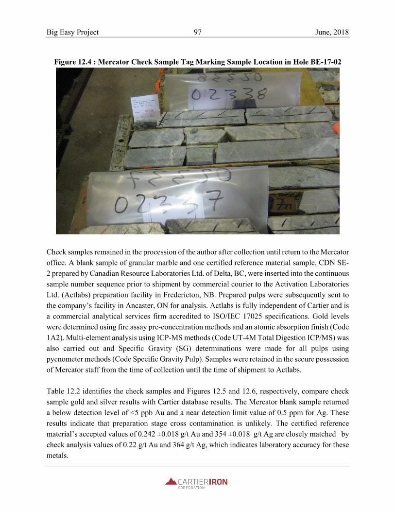
Big Easy Project 97 June, 2018
Figure 12.4 : Mercator Check Sample Tag Marking Sample Location in Hole BE-17-02
Check samples remained in the procession of the author after collection until return to the Mercator office. A blank sample of granular marble and one certified reference material sample, CDN SE-2 prepared by Canadian Resource Laboratories Ltd. of Delta, BC, were inserted into the continuous sample number sequence prior to shipment by commercial courier to the Activation Laboratories Ltd. (Actlabs) preparation facility in Fredericton, NB. Prepared pulps were subsequently sent to the company’s facility in Ancaster, ON for analysis. Actlabs is fully independent of Cartier and is a commercial analytical services firm accredited to ISO/IEC 17025 specifications. Gold levels were determined using fire assay pre-concentration methods and an atomic absorption finish (Code 1A2). Multi-element analysis using ICP-MS methods (Code UT-4M Total Digestion ICP/MS) was also carried out and Specific Gravity (SG) determinations were made for all pulps using pycnometer methods (Code Specific Gravity Pulp). Samples were retained in the secure possession of Mercator staff from the time of collection until the time of shipment to Actlabs. Table 12.2 identifies the check samples and Figures 12.5 and 12.6, respectively, compare check sample gold and silver results with Cartier database results. The Mercator blank sample returned a below detection level of <5 ppb Au and a near detection limit value of 0.5 ppm for Ag. These results indicate that preparation stage cross contamination is unlikely. The certified reference material’s accepted values of 0.242 ±0.018 g/t Au and 354 ±0.018 g/t Ag are closely matched by check analysis values of 0.22 g/t Au and 364 g/t Ag, which indicates laboratory accuracy for these metals.

Big Easy Project 98 June, 2018
Table 12.2: Mercator Check Sample Program Details
Hole or Site
Sample Number
Sample Type
From (m)
To (m)
Original (ppb Au)
Check (ppb Au)
Original (g/t Ag)
Check (g/t Ag)
BE-16-21 2337 Quarter Core 198
199.2 94 105 29.7 30
TC-17-02 2338 Quarter Core 131 132 63 56 14.9 15.2
BE-14-13 2339 Quarter Core 131.5 132 137 105 40.5 22
Trench 5 2340 Chip Channel 1 2083 748 4.08 3.4MGS Blank 2341 Marble NA NA 2.5 2.5 0.25 0.25Quarry 2342 Grab NA NA 2.5 2.5 0.25 0.25CDN-SE-2 2343 Standard NA NA 242 256 354 364
BE-11-07 135223 Quarter Core 226.4
226.9 369 238 11 6.1
BE-11-07 135224 Quarter Core 231.3
231.6 2569 1720 335 159
Figure 12.5: Mercator Check Sample Gold Results
1
10
100
1000
10000
Au (ppb)
Check Sample Number
Original (ppb Au)
Check (ppb Au)

Big Easy Project 99 June, 2018
Figure 12.6: Mercator Check Sample Silver Results
Results for the core and trench check samples confirm their previously determined mineralized character and define acceptable correlation between datasets. Variance that exits probably reflects heterogeneity of metal distribution within the samples relative to sample size and otherwise combined elements of sampling error. Based on above results, Mercator is of the opinion that no quality control issues are apparent in the check analysis gold dataset presented in Table 12.2.
SG determinations for check sample pulps were also carried out at Actlabs using pycnometer methods. Results from the property range between 2.64 and 2.78 and average 2.71. It is recommended that Cartier systematically acquire water immersion SG determinations on core samples from future drilling programs as part of its sample processing procedure. A QAQC protocol should be applied and include third party check determinations. Development of a comprehensive density database facilitates later creation of interpolated density models that contribute to improved tonnage estimation.
0.1
1
10
100
1000
2337 2338 2339 2340 2341 2342 2343 135223135224
Ag (g/t)
Check Sample Number
Original (g/t Ag)
Check (g/t Ag)

Big Easy Project 100 June, 2018
13 MINERAL PROCESSING AND METALLURGICAL TESTING
No metallurgical work has been carried out to date by Cartier or other parties with respect to gold or other mineralization present on the Big Easy property.
Big Easy Project 101 June, 2018
14 MINERAL RESOURCE ESTIMATES
This NI 43-101 Form F1 Item does not apply to the current property Technical Report .
15 MINERAL RESERVE ESTIMATES
This NI 43-101 Form F1 Item does not apply to the current property Technical Report . 16 MINING METHODS
This NI 43-101 Form F1 Item does not apply to the current property Technical Report .
17 RECOVERY METHODS
This NI 43-101 Form F1 Item does not apply to the current property Technical Report .
18 PROJECT INFRASTCUTURE
This NI 43-101 Form F1 Item does not apply to the current property Technical Report .
19 MARKET STUDIES AND CONTRACTS
This NI 43-101 Form F1 Item does not apply to the current property Technical Report .
20 ENIRONMENTAL STUDIES, PERMITTING, AND SOCIAL OR
COMMUNITY IMPACT
This NI 43-101 Form F1 Item does not apply to the current property Technical Report .
21 CAPITAL AND OPERAATING COSTS
This NI 43-101 Form F1 Item does not apply to the current property Technical Report .
22 ECONOMIC ANALYSIS
This NI 43-101 Form F1 Item does not apply to the current property Technical Report .

Big Easy Project 102 June, 2018
23 ADJACENT PROPERTIES
There are no adjacent properties as defined under NI 43-101 that are pertinent to the current property Technical Report . However, as documented earlier in this report, numerous examples of low and high supination epithermal alteration system mineralization have been publicly described in government, academic and industry studies completed to date in age-correlative Neoproterozoic sequences of the western Avalon zone in Newfoundland, as well as further to the south along the Appalachian orogen, particularly in the Carolina Slate Belt. However, neither Mercator or Cartier is suggesting that mineralization of comparable grade and dimensions to any of these has been defined by work completed to date on the Cartier property.

Big Easy Project 103 June, 2018
24 OTHER RELEVANT DATA AND INFORMATION
All data and information considered relevant to the current mineral exploration property review and assessment are presented or referenced in the various sections that comprise this report.

Big Easy Project 104 June, 2018
25 INTERPRETATION AND CONCLUSIONS
Presence of an orogen-scale epithermal metallogenic association has been well documented within Neoproterozoic magmatic arc sequences of the Avalon Zone of the Appalachian orogen (Sparkes, 2016; Foley and Ayuso, 2012; O’Brien et al., 1998). This association is defined by variably deformed examples of both high and low supination style, precious metal bearing, epithermal alteration systems. These include the currently producing Haile gold mine, operated by Oceana Gold Corporation, and the past producing Brewer and Ridgeway mines, all in the Carolina Slate Belt of South Carolina, USA, plus the past producing Hope Brook gold mine, located within Avalon Zone sequences on the south coast of the island of Newfoundland. In addition, numerous gold-silver prospects of recognized epithermal association are located on the Avalon and Burin Peninsula of the island of Newfoundland, as referenced earlier in this report. Combined results of work carried out by government, industry and university interests, particularly since the late 1980’s, demonstrate that development of Avalon Zone epithermal mineralizing systems was related to emplacement of deeper, variably mineralized intrusive phases during Neoproterozoic magmatic arc evolution. Magmatic activity that occurred along the evolving western margin(s) of the Avalon Zone, where the Big Easy Property is located, is of particular importance, since many examples of epithermal systems in this region show genetic association with granitoid intrusive complexes and related volcanic sequences developed during the 570 Ma to 590 Ma period (O’Brien et al. 1999). In the particular case Big Easy Property, the volcanic sequence of immediate interest is located at the base of the Musgravetown Group and is comprised of mafic to felsic extrusive volcanics and related intrusions and volcaniclastics. Immediately overlying Musgravetown Group sandstones, epiclastic sandstones and conglomerates host the Big Easy and ET alteration zones and associated gold-silver mineralization and form the northern strike extension of broadly coeval volcanic and sedimentary units recognized on the Burin Peninsula. The Big Easy and ET alteration zones host classic low supination epithermal system attributes such as banded quartz adularia veining and related vein breccias, intense silicification, minor levels of disseminated pyrite, and extensive sericite/chlorite/clay alteration. Alteration parallels the interpreted north-south faulted contact between slightly older Love Cove Group volcanics to the east and also parallels geophysically interpreted trends of sedimentary and volcano-sedimentary sequences within the Musgravetown Group. Work carried out to date on the Property has clearly demonstrated that a low supination epithermal system of substantial dimension is present and that banded, chalcedonic quartz veins associated with the system locally carry high grade (~10 g/t Au and/or >100 g/t Ag) precious metal mineralization developed over widths ranging from a few centimetres to a few meters. These occur within mineralized alteration haloes that in several instances have also been shown to host

Big Easy Project 105 June, 2018
lower grade precious metal values over widths of several tens of meters. Additionally, abundant evidence of paleo-surface sinter deposition has been recognized in both drill core and surface exposures of the altered Musgravetown Group sedimentary succession on the Big Easy Property. This succession is interpreted to be right side up and dipping shallowly to moderately westward. Paleo-surface evidence provides an important input for exploration planning and geological interpretation for the property, since low supination epithermal systems are characterized by near-surface sinter zones and alteration zone material that are largely barren of precious metals and may show only weak vein development. It follows that outcropping zones of paleo-surface sinter deposits and related lithologies identified to date on the Big Easy property should not be expected to directly host high grade vein-style mineralization related to the same stage of hydrothermal system development at the same paleo-elevation level. Rather, paleo-sinter intervals represent important time lines that can be used to develop a three dimensional geological model of the alteration system, its related structures and stratigraphy. Observations from other epithermal districts prompted Hedenquist (2013) to conclude, in part, that high grade precious metal intercepts at the Big Easy property would be most likely to occur at paleo-depth levels exceeding 150 to 200 m vertically below the level of demonstrated paleo-sinter deposition. Since sinter materials occur in outcrop and boulders at the Big Easy zone, and assuming that stratigraphy strikes north and dips moderately to the west, it is reasonable to conclude that exploration for high grade vein and vein breccia intercepts related to the sinter-associated hydrothermal phase will be developed to the east, or down section, of the outcropping and sub cropping sinters. While this concept has been considered by past explorers of the property, it does not appear to have been rigorously assessed. On the property scale, geological and geophysical survey results strongly indicate that the mineralized alteration zones documented at the Big Easy and ET areas are parts of a larger, north-south striking alteration corridor that measures at least 3.5 km in north-south dimension and up to 400 m or more in width. The extent along this corridor that separates the two zones has received only cursory investigation to date but holds good potential for continuity of alteration across the zone. By association, potential for high grade vein occurrences and possibly associated low grade mineralization can be inferred for this intervening area of largely covered ground. Work completed to date by Cartier has shown that properly configured and interpreted IP-resistivity surveying in future could effectively define the limits of the favourable alteration zone in this and other covered areas. Application of the method across the property, in combination with drill core re-logging and development of a property scale three-dimensional geological model, could significantly contribute to development of future drill targets. In Mercator’s opinion, 2011 through 2017 drilling and trenching program results confirm presence on the property of both high and low grade styles of gold-silver mineralization typical of low

Big Easy Project 106 June, 2018
supination epithermal settings and substantiate the Property’s exploration potential. This information also defines good potential for discovery of additional epithermal alteration zones and related precious metal mineralization along the strike of the Musgravetown Group and/or its equivalents to both north and south of the Property. Cartier should therefore consider acquiring additional holdings in these directions that cover the main airborne magnetometer survey responses defined to date by the company’s geophysical consultant as marking the Big Easy and ET zone host stratigraphy and the associated north-trending structural corridor.

Big Easy Project 107 June, 2018
26 RECOMMENDATIONS
26.1 Exploration Opportunities and Relative Priority
Based on results of the technical review presented in this report, further exploration of the Big Easy and ET zones is recommended. Highest immediate priority should be given to defining the broad limits of the currently identified Big Easy and ET alteration zones through IP-Resistivity surveying. Surveying along 400 m spaced lines should be sufficient to define these zones, with lines being of sufficient length to completely cover the currently inferred alteration zone limits. It is also recommended that a detailed IP-Resistivity survey section be completed along line L77+00N to check the response to the mineralized zone in drill holes BE-11-03 and BE-12-21, since the strong quartz-adularia veining in this area may register as a resistivity anomaly. An additional effective means of providing assessment in the vicinity of any proposed exploratory drill hole in areas of know alteration and current drilling is through systematic incorporation of down hole IP-Resistivity surveying. The purpose of such surveying would be to identify geometry of strike and dip extensions to zones of known alteration and mineralization and to identify off-hole responses that could signify presence of otherwise blind zones of gold mineralization hosted by additional silicified or intensely quart-adularia veined zones. Cartier’s drill core physical properties study carried out in 2017 showed that veined and mineralized Big Easy core intervals are characterized by very high electrical resistivity values, attributable to silicification and veining present, plus high chargeability values attributable to presence of fine grained pyrite disseminated within quartz veins and adjacent silicified/altered wall rock. If present over a sufficient spatial extent, such rocks would be good candidates for detection using IP-Resistivity surveying. Consideration of such surveying is therefore recommended as the Big Easy exploration program develops. Organization and digital compilation of the historic exploration and drilling data set is also required to properly support future exploration programs. Priorities in this regard are the validation of the present digital diamond drilling information and assay results, followed by re-logging of the 2011-2017 diamond drill core to support creation of a validated and standardized drilling database. A three-dimensional geological model for the drilled area of the property can be developed after completion of compilation and database work and this should support definition of spatial aspects and possible correlations of mineralized quartz veins, related quartz breccias and alteration zone intervals observed in existing drill holes. The historic lithological coding system used for the project should be revised and simplified to aid in development of this and future geological and targeting models.

Big Easy Project 108 June, 2018
After completion of the above programs, a core drilling targeting exercise incorporating all available property information should be carried out. This should provide a plan for initial testing of both new and existing IP-Resistivity and geological targets. Initial drilling should include step out drill testing of existing mineralized zones in holes BE-11-03, BE-14-13 and BE-14-15 in the Big Easy area and from BE-16-22 in the ET area. Success in initial core drilling should define areas for subsequent drilling and completion of data compilation, geophysical (IP-Resistivity or magnetometer) surveying, geological mapping and surface geochemistry should provide definition of exploration targets worthy of initial drill testing. Subsequent testing of both levels of targets will have to be based on assessment of results of the on-going work programs. The phased exploration approach described below is recommended to meet these general exploration requirements.
26.2 Proposed Structure of Exploration Program and Estimated Budget
A two-phase program of recommended future exploration has been proposed by Cartier and is presented in Table 18.1. Estimated expenditures total $ 500,000 for Phase 1 and $2.0 million for Phase 2. All expenditures would be incurred over a 24 month period. Phase 2 work relies upon acquisition of Phase 1 data for determination of precise siting information for Phase 2 drill holes and geophysical surveying and is therefore contingent on positive results of Phase 1. Key aspects of the recommended Phase 1 and Phase 2 work programs are presented below. Phase 1 This program is directed toward establishing an up to date “best information” understanding of geological and geophysical features of the property upon which further exploration, including targeting of an initial core drilling program, can be confidently planned and carried out. The proposed work is initially focused in the north-south alteration corridor measuring 3.5 km in length that includes both the Big Easy and ET alteration zones, as well as on immediately adjacent claims further to the south, west and north, with timing of field work coordinated to address seasonal project area access conditions. Phase 1 includes the following recommended program components:
1. All core from the 2011 through 2017 historic drilling programs should be re-logged by Cartier to create consistency in lithologic and structural observations. A simplified lithocode system should be developed prior to initiation of the core re-logging program and this system should be applied in future core drilling and logging programs. Identification of structural features present in drill core should be a priority and Rock Quality Determination (RQD) logging as well as systematic collection of bulk density determinations should be incorporated in future programs.

Big Easy Project 109 June, 2018
2. A full digital compilation of property exploration data, including drill holes, trenching
results, rock sampling results, soil and stream geochemistry results, ground and airborne geophysical survey results, etc. should be carried out. The existing drill hole database should be validated against source data as part of this program phase, with completion ensured prior to planning of additional drilling on the property.
3. Surface IP-Resistivity surveying and grid establishment programs should be carried out to
define limits of alteration and to assess potential for non-outcropping mineralized zones. Coverage should include the Big Easy and ET alteration zones, the intervening area between these zones, and immediately adjacent areas to north and south of these zones. Additional physical properties testing for geophysical surveying purposes should be carried out, as required.
4. Litho-geochemical, orientation level soil surveying, geological mapping and prospecting
and surface trenching programs should be completed as required to define new exploration targets for drill testing.
5. A few historical diamond drill holes remain open to depth in the vicinity of the Big Easy
showing. These should be used to assess effectiveness of borehole IP-Resistivity surveying as a method of extending the search volume for assessment of continuity of known mineralization and also to assess potential for discovery of off-hole zones of new mineralization. Additional grid-based IP-Resistivity surveying beyond the Phase 1 limits of the main alteration zone should also be carried out, as required, along with high resolution ground grid or UAV magnetometer surveying.
Phase 2 The purpose of Phase 2 work programs is to expand drilling, geophysical, geochemical, and geological program coverage, establish a clear understanding of the spatial aspects, controls and trends of known alteration and associated precious metal mineralization, and to test new target areas recognized within the Cartier holding. Phase 2 includes the following recommended program components:
1. Lithological and soil geochemistry surveys, geological mapping, prospecting and surface trenching programs should be carried out to expand existing targets and define new target areas.
2. Further grid and borehole IP-Resistivity surveying, grid establishment and high-resolution
ground or UAV magnetometer surveying should be carried out over remaining high prospectively areas within the known alteration zone corridor that extends from the Big

Big Easy Project 110 June, 2018
Easy area south to the ET area, and also on the broader property holding, including any newly staked areas.
3. A 5000m core drilling program should be carried out to (1) better define the geological character, controls and extents of existing gold and silver mineralization, alteration, and structural relationships defined to date in the Big Easy and ET occurrence areas, including closely spaced step out core holes from previously drilled holes BE-11-03, BE-14-13, and BE-14-15 in the Big Easy area and from BE-16-22 in the ET area, and (2) test target areas and concepts defined and fine tuned by results of other Phase 1 and Phase 2 programs, with emphasis placed on interpreted results of the recommended IP-Resistivity programs.
26.3 Recommended Exploration Budget
The estimated costs and summarized program components for Phase 1 and Phase 2 recommended work programs are summarized below in Table 18.1.
Table 26.1: Estimated Budget For Phase 1 And 2 Recommended Work Programs
Phase 1 – Summarized Program Components Estimated Cost ($Cdn)
1. Re-logging of 2011 through 2017 historic drill core and related activities (includes establishment of new core archive site and rental, related staffing, warehouse setup, field support, vehicle rentals, administration and reporting).
100,000
2. Digital compilation of exploration data and drill hole database validation 50,000
3. Grid IP-Resistivity surveying and gridding to define limits of the known alteration zones and to assess potential for non-outcropping mineralization in the zones (includes professional services and sub-contractors, field support, vehicle rentals, administration and reporting).
150,000
4. Borehole IP-Resistivity surveying of several accessible historic diamond drill holes in the Big Easy occurrence area to assess effectiveness of this method in extending the search volume for assessment of continuity of known mineralization and also to assess potential for discovery of off-hole zones of new mineralization.
50,000
5. Litho-geochemical and soil surveying, geological mapping, prospecting, surface trenching (includes sample collection and analytical charges, field support, vehicle rentals, administration and reporting).
150,000
Phase 1 Total 500,000
Phase 2 - Summarized Program Components Estimated Cost ($Cdn)
1. Litho-geochemical and soil surveying, geological mapping, prospecting, surface trenching (includes sample collection and analytical charges, field support, vehicle rentals, administration and reporting).
250,000

Big Easy Project 111 June, 2018
2. Grid and borehole IP-Resistivity surveying, gridding and high-resolution ground or UAV magnetometer surveying, as required, for additional drill target definition (includes field support, vehicle rentals and administration and reporting).
250,000
3. Core drilling program of 5000 m proportioned between continuation of systematic investigations of the known mineralized zones and testing of geophysical survey targets generated in Phase 1 and early Phase 2 programs (includes drilling, logging, sampling, environmental consulting services, analytical charges, field support, vehicle rentals, administration and reporting)
1,500,000
Phase 2 Total 2,000,000
Grand Total – Phase 1 and 2 programs 2,500,000

Big Easy Project 112 June, 2018
27 REFERENCES
Cullen, M. 2015: Mineral Resource Estimate Technical Report, Hope Brook Gold Project, Newfoundland and Labrador, Canada; prepared for Coastal Gold Corp. by Mercator Geological Services Limited (Michael Cullen, P. Geo.), Effective Date: January 12, 2015; 137 p. Carr, D., Van Brunt, B., Jory, J., Howe, P., Poeck, J., Osborn, J., Newton, J., Tinucci, J., Swanson, B., Kinakin, D., Malensek, G., Bird, D., Stryhas, B., Prosser, B. (2017): NI 43-101 Technical Report, Haile Gold Mine, Lancaster County, South Carolina; August, 2017. Davenport, P.H., Nolan, L.W. and Hayes, J.P. (1988): Gold and associated elements in lake sediment from regional surveys in the Gander Lake map area [NTS 2D], Geofile 2D/0175, 220 p. DeLazzer, A., Dimmell, P.M. (2012): Report on 2011 Exploration (Diamond Drilling, Trench/DDH Reclamation, Compilation) on the Big Easy (BE) Property, Lic’s 13446M, 16633M, 17315M, 17342M, 19157M, NTS 2D/1,8, Thorburn Lake Area, Eastern Newfoundland, for Silver Spruce Resources Inc.; Work Conducted: Jan.-Dec. 2011, Jan./Feb. 2012; Feb. 28, 2012; Newfoundland and Labrador Geological Survey, Assessment File. Dimmell, DeLazzer, A., P.M., Mac Gillivray, G. (2011): Report on 2010/2011 Exploration (Prospecting, Trenching, and IP/Resistivity Surveys) on the Big Easy Property, Licences 13446M, 16633M, 17315M, 17342M, NTS 2D/1 and 8, Silver Spruce Resources Inc., Thorburn Lake Area, Newfoundland, June 30, 2011; Newfoundland and Labrador Geological Survey, Assessment File. Dimmell, P. and Delazzer, A., 2012: Report on 2011 Exploration (Diamond Drilling, Trench/DDH Reclamation, Compilation) on the Big Easy (BE) Property, Licences 13446M, 16633M, 17315M, 17342M, 19157M, NTS 2D/1,8, Thorburn Lake Area, Eastern Newfoundland, For Silver Spruce Resources Inc.; Newfoundland and Labrador Geological Survey, Assessment File. 181p. Dimmell, P.M. (2013): Report on 2013 Exploration - Geological Evaluation, Geophysical/Geological Interpretation, Compilation on the Big Easy (BE) Property, Licences 13446M, 16633M, 17315M, 20943M, 20944M, NTS 2D/1, 8, Thorburn Lake Area, Eastern Newfoundland for Silver Spruce Resources Inc., Work Conducted: Jan–Nov 2013; Nov. 26, 2013; Newfoundland and Labrador Geological Survey, Assessment File. Dimmell, P.M. (2012): Report on 2012 Exploration (Prospecting, Stream Sediment Geochemistry, Airborne Geophysics, Diamond Drilling, Compilation,) on the Big Easy (BE) Property, Licences 13446M, 16633M, 17315M, 17342M, 19157M, NTS 2D/1, 8; Thorburn Lake Area, Eastern Newfoundland, for Silver Spruce Resources Inc. Work Conducted: Jan. – Dec. 2012, Dec. 20, 2012; Newfoundland and Labrador Geological Survey, Assessment File Dimmell, P.M., 2015: Report on 2014 Exploration (Prospecting, Soil Sediment Geochemistry, Diamond Drilling, Compilation,) on the Big Easy (BE) Property, Licences 13446M, 16633M,
Big Easy Project 113 June, 2018
23023M, NTS 2D/1, 8; Thorburn Lake Area, Eastern Newfoundland, for Silver Spruce Resources; Newfoundland and Labrador Geological Survey, Assessment File; 154p. Dimmell, P.M., and Harris, J., 2017: Report on 2016 Exploration, (Prospecting, Diamond Drilling), on the Big Easy (BE) Property, Licence 23249M, NTS 2D/1, 8, Thorburn Lake Area, Eastern Newfoundland, for 65241 Newfoundland and Labrador Inc.; Newfoundland and Labrador Geological Survey, Assessment File; 59 p.
Dubé, B., Dunning, G. and Lauziere, K. (1998): Geology of the Hope Brook Mine, Newfoundland, Canada: A preserved Late Proterozoic high-supination epithermal gold deposit and its implications for exploration. Economic Geology, Volume 93, pp. 405-436. Dyke, B., 2009: Assessment Report of Prospecting and Terraspec Analysis, of Licence 13446M (1st and 2nd year , Thorburn Lake Gold Project, NTS 2D/01 and 2D/08, Thorburn Lake, NL, for Cornerstone Resources Inc.; Newfoundland and Labrador Geological Survey, Assessment File; 37p. Ferguson, S. (2017): Late Neoproterozoic Epithermal-Style Au Mineralization of the Burin Peninsula, Newfoundland: U-Pb Geochronology and Deposit Characteristics, MSc, Memorial University of Newfoundland, St John’s, Newfoundland, October, 2017, 394 p. Foley, Nora K., And Ayuso, R. A., 2012: Gold Deposits Of The Carolina Slate Belt, Southeastern United States--Age And Origin Of The Major Gold Producers: U.S Geological Survey Open-File Report 2012-1179 Froude, T., Way, R., and Wilton, D., 2002: Second and third year assessment report on prospecting and geochemical; and diamond drilling exploration for licences 7183M, 7366M and 7845M on claims in the Port Balndford area, eastern Newfoundland, for Trinity Resources and Energy Limited; Newfoundland and Labrador Geological Survey, Assessment File; 39p. Harris, J., (2017): Big Easy Drill Stats-all, unpublished data compilation and drilling report prepared for 65241 NL Inc. Harris, J., (1996): First and second year assessment report on geological and geochemical exploration for licences 4554M and 4679M on claims in the Henry’s Pond area, eastern Newfoundland, GT Exploration Ltd.: Newfoundland and Labrador Geological Survey, Assessment File 2D/0312; , 29 p. Hedinquist, J., 2013: Observations on the Big Easy epithermal Au-Ag prospect Eastern Newfoundland and comments on its potential; internal report to Silver Spruce Resources Inc., September, 2013; 21p. Hussey, E.M. (1979): The stratigraphy, structure and petrochemistry of the Clode Sound map area, northwestern Avalon Zone, Newfoundland, MSc, Memorial University

Big Easy Project 114 June, 2018
of Newfoundland, St John's, Newfoundland, Geofile 2D/0101, 335 p. Huard, A. and O’Driscoll, C.F. (1986): Epithermal gold mineralization in the late Precambrian rocks on the Burin Peninsula. In Current Research. Newfoundland Department of Mines and Energy, Mineral Development Division, Report 86-1, pp.65-78. Jenness, S.E. (1963): Geology Terra Nova, Gander Lake, East Half, Newfoundland, Geological Survey of Canada, "A" Series Map 1129A, Geofile NFLD/0219, 1963, 14 p. Lambert, G., (2010): Report on Time-Domain Induced Polarization surveys by Eastern Geophysics for Silver Spruce Resources Inc. McCarthy, J., (2013): Geological Interpretation of Airborne Geophysics at the Big Easy Gold/Silver Property, eastern Newfoundland for Silver Spruce Resources Inc.; internal report; 22p. O’Brien, S.J., (1993): A preliminary account of geological investigations in the Clode Sound‐Goose Bay region, Bonavista Bay, Newfoundland [NTS 2C5/NW and 2D8/NE]. In Current Research. Newfoundland and Labrador Department of Mines and Energy, Geological Survey Branch, Report 93‐1, pp. 293‐309. O’Brien, S., (1992): Preliminary geological map of the Sweet Bay (2C/5NW) and Port Blandford (2D/8NE) map areas, Bonavista Bay, Newfoundland Department of Mines and Energy, Mineral Development Division, Map 92-93. O’Brien, S., (1987): Geology of the St. Brendan’s (2C/13) map area, Newfoundland Department of Mines and Energy, Mineral Development Division, Map 92-93. O’Brien, S., (1986): Geology of the Eastport (2C/12) map area, Newfoundland Department of Mines and Energy, Mineral Development Division, Map 87-55. O’Brien, S.J., Dubé, B. and O’Driscoll, C.F., (1999): High-sulfidation, epithermal-style hydrothermal systems in late Neoproterozoic Avalonian rocks on the Burin Peninsula, Newfoundland: implications for gold exploration, In Current Research, Newfoundland Department of Mines and Energy, Geological Survey, Report 99-1, pp. 275-296. O’Brien, S.J., Dubé, B., O’Driscoll, C.F. and Mills, J., (1998): Geological setting of gold mineralization and related hydrothermal alteration in late Neoproterozoic (post-640 Ma) Avalonian rocks of Newfoundland, with a review of coeval gold deposits elsewhere in the Appalachian Avalonian belt, In Current Research, Newfoundland Department of Mines and Energy, Geological Survey, Report 98-1, pp. 93-124. O’Brien, S. J., O’Driscoll, C. F. and Tucker, R. D., (1992): A reinterpretation of the geology of parts of the Hermitage Peninsula, southwestern Avalon Zone, Newfoundland, In Current research, Newfoundland Department of Mines and Energy, Geological Survey Branch, Report 92-1, pp. 185– 194.

Big Easy Project 115 June, 2018
O’Brien, S.J., Dunning, G.R., Dubé, B., O’Driscoll, C.F., Sparkes, B., Israel, S. and Ketchum, J. 2001: New insights into the Neoproterozoic geology of the of the central Avalon Peninsula (parts of NTS map areas 1N/6, 1N/7 and 1N/3), eastern Newfoundland. In Current Research, Government of Newfoundland and Labrador, Department of Mines and Energy, Geological Survey, Report 01-1, pp.169-189. O’Brien, S.J. and Sparkes, G., 2004: Bonanza-grade gold from Neoproterozoic low supination-style epithermal veins and breccias, Bergs Prospect, Avalon Zone, Eastern Newfoundland. Government of Newfoundland and Labrador, Department of Mines and Energy, Geological Survey, Open File [001N/10/0742]. Saunders, P., 1996: Assessment Report on the Henry’s Pond Gold Property, Eastern Newfoundland, Licence 4554, NTS 2D/1,2D/8 for GT Exploration Ltd.; Newfoundland and Labrador Geological Survey, Assessment File; 19 p. Scott, W. J. and St‐Hilaire, C., (2001): First year supplementary and second year supplementary assessment report on geophysical exploration for licences 7183M and 7366M‐7368M on claims in thePort Blandford area, eastern Newfoundland, 2 reports, Cornerstone Resources Incorporated Newfoundland and Labrador Geological Survey, Assessment File 2D/0616, 2001, 43 p. Smith, P., 2013: Big Easy Property (Silver Spruce Resources Inc.) Licences 13446M, 16633M, 17315M, 17342M, 19157M, NTS 2D 1/8, Thorburn Lake Area, Eastern Newfoundland, Field Visit Evaluation Report, October 29, 30, November 2, 2013, Mountain Lake Minerals Inc.; internal report to Silver Spruce Resoutrces Inc.; 21p. Sparkes, G. W., O’Brien, S.J., Dunning, G. R., and Dube, B., 2005: U-Pb geochronolohgical constraints on the timing of magnatism, epithermal alteration and low sulphidationgold mineraalzation, easternm, Avalaon Zone, Newfoundland, in Current Research, Government of Newfoundland and Labrador, Deparetment of Natural Resources, Geological Survey, Report 05-01, pages 115-130. Sparkes, G.W. (2012): New developments concerning epithermal alteration and related mineralization along the western margin of the Avalon Zone, Newfoundland; Current Research, Newfoundland and Labrador, Department of Natural Resources, Geological Survey, Report 12-1, pp.103-120. Sparkes, G. W., 2017: Neoproterozoic Low -Sulphidation Epithermal System: Examples from the Western Avalion Zone; Newfoundland and Labrador Natural Resources, Geological Survey, Mineral Deposits Section; powerpoint presentation for Annual Open House; 37 slides Sparkes, G.W. and Dunning, G.R. (2014): Late Neoproterozoic Epithermal Alteration and Mineralization in the Western Avalon Zone: A summary of Mineralogical Investigations and New U/Pb Geochronological Results; Current Research, Newfoundland and Labrador, Department of Natural Resources Geological Survey, Report 14-1, pp. 99-128.

Big Easy Project 116 June, 2018
Sparkes, G.W., Ferguson, S.A., Layne, G.D., Dunning, G.R., O’Brien, S.J., and Langille, A. (2016): The nature and timing of Neoproterozoic high-supination gold mineralization from the Newfoundland Avalon Zone: Insights from new U-Pb ages, ore petrography and spectral data from the Hickey’s Pod prospect; Current Research, Newfoundland and Labrador, Department of Natural Resources Geological Survey, Report 16-1, pp. 91-116. Stewart, P.W., (1992): The origin of the Hope Brook Mine, Newfoundland, a Shear-Zone-Hosted Acid Sulphate Gold Deposit. Unpublished Ph. D. Thesis, University of Western Ontario, London, Ontario, 398 p. Turpin, A., 2010: report on 2009-2010 Exploration on the Big Easy Property, Licences 13446M and 16633m, NTS 02D/01 and 08, Thorburn Lake, Newfoundland; Newfoundland and Labrador Geological Survey, Assessment File; 41p. Yule, A., McKenzie, C.B., and Zentilli, M., (1990): Hope Brook, a new Appalachian gold deposit in Newfoundland, Canada, and the significance of hydrothermally altered mafic dikes, Chronique de la Recherche Miniere, no. 498, pp. 29-42.

Big Easy Project 117 June, 2018
28 CERTIFICATE OF AUTHOR QUALIFICATIONS

Big Easy Project 118 June, 2018
CERTIFICATE OF AUTHOR
I, Michael P. Cullen, P. Geo., do hereby certify that:
1. I reside at 2071 Poplar St. in Halifax, Nova Scotia, Canada
2. I am currently employed as a Chief Geologist with:
Mercator Geological Services Limited 65 Queen St Dartmouth, Nova Scotia, Canada B2Y 1G4
3. I received a Master of Science Degree (Geology) from Dalhousie University in 1984 and a Bachelor of Science Degree (Honours, Geology) in 1980 from Mount Allison University.
4. I am a registered member in good standing of the Association of Professional Geoscientists of Nova Scotia (Registration Number 064), Newfoundland and Labrador Professional Engineers and Geoscientists (Member Number 05058) and Association of Professional Engineers and Geoscientists of New Brunswick, (Registration Number L4333).
5. I have worked as a geologist in Canada and internationally since graduation.
6. I have read the definition of “qualified person” set out in National Instrument 43-101 (“NI 43-101”) and certify that by reason of my education, affiliation with a professional association (as defined in NI 43-101) and past relevant work experience, I fulfill the requirements to be a “qualified person” for the purposes of NI 43-101.
7. I am the qualified person responsible for preparation of the Technical Report titled:
National Instrument 43-101 Technical Report For The Big Easy Exploration Property
Clarenville Area Newfoundland And Labrador
Canada For
Cartier Iron Corporation Prepared by
Michael P. Cullen, P. Geo. Mercator Geological Services Limited
Effective Date: April 20th, 2018

Big Easy Project 119 June, 2018
I supervised work on, and am responsible for, all Items and Sections of this Technical Report.
8. I have extensive professional experience with respect to geology of the Northern Appalachians and, more specifically, with geology of epithermal gold mineralization of the Avalon Zone in Newfoundland and Labrador, having worked extensively on the Hope Brook gold deposit and to a lesser degree on gold prospects of the Burin Peninsula. I also have experience in exploration and evaluation of epithermal gold and silver deposits in the San Juan volcanic field of the southwest US and also in Tertiary and younger sequences of Central and South America. I have been responsible for various exploration programs with respect to such deposits and my experience includes responsibility for programs of resource estimation and evaluation plus surface and underground exploration.
9. I visited the Big Easy exploration property most recently between October 2nd and 4th of 2017 to carry out the site visit described in this report. I was accompanied by Mr. James Harris, P. Geo. and Dr. Christopher Hale, P. Geo., both consultants to Cartier at that time.
10. I am independent of Cartier, applying all of the tests in section 1.5 of National Instrument 43-101 and National Instrument 43-101 Companion Policy Section 5.3
11. I have read National Instrument 43-101, Form 43-101F1 and the Companion Policy and believe that this Technical Report has been prepared in compliance with that Instrument and Form.
12. As of the date of this certificate, to the best of my knowledge, information and belief, this Technical Report contains all scientific and technical information that is required to be disclosed to make this report not misleading.
Dated this 5th day of June 2018 “Original signed and stamped by” _____________________________ Michael P. Cullen, P. Geo. Chief Geologist Mercator Geological Services Limited

Big Easy Project 120 June, 2018
Appendix 1
2011 to 2017 Drilling Program Collar Coordinates and Orientation Data

Big Easy Project 121 June, 2018
2011 To 2014 Silver Spruce Drilling Programs
Drill Hole *Easting (m) *Northing (m) Dip (Deg.) Azimuth (Deg.) **Elev. (m) asl Depth (m)
BE-11-01 710032 5347782 -52 90 111 107
BE-11-02 709932 5347913 -50 90 109 98
BE-11-03 709826 5347910 -50 90 107 302
BE-11-04 709768 5348094 -48 95 110 167
BE-11-05 709671 5348091 -50 90 120 239
BE-11-06 709939 5348630 -50 90 113 359
BE-11-07 710027 5348805 -55 90 116 305
BE-12-08 709990 5347906 -59 270 110 146
BE-12-09a 710031 5348006 -60 90 117 23
BE-12-09 710031 5348006 -60 270 117 230
BE-12-10 710081 5348006 -64 270 119 236
BE-12-11 710036 5348106 -60 270 118 209
BE-12-12 710059 5347959 -65 270 115 236
BE-14-13 710114 5348203 -74 270 117 279.6
BE-14-14 710124 5348402 -75 270 117 131.1
BE-14-15 710083 5348404 -80 270 118 248.7
BE-14-16 710200 5348596 -75 270 122 130.2
BE-14-17 710128 5348006 -75 270 119 267.4
BE-14-18 710098 5348105 -45 270 120 157.9
BE-14-19 710156 5348106 -43 270 115 176.5
Total 4048.4 Note: * UTM NAD 83 Zone 21; asl = approximate elevation above sea level
2016 and 2017 65241 NL Inc. Drilling Programs
Drill Hole *Easting (m) *Northing (m) Dip (Deg.) Azimuth (Deg.) **Elev. (m) asl Depth (m)
BE-16-20 709916 5348410 -50 240 130 146.0
BE-16-21 709826 5347910 -56 90 110 290.0
BE-16-22 710093 5347961 -65 270 116 233.0
BE-16-23 710500 5347568 -50 90 114 101.0
BE-16-24 710499 5347568 -50 270 114 104.0
BE-16-25 710102 5347789 -65 270 115 284.0
BE-16-26 709982 5348804 -55 90 130 293.0
BE-17-27 710141 5347956 -70 268 115 167.7
BE-17-28 710328 5348797 -65 270 111 267.7
TC-17-01 710198 5344443 -48 273 107 173.0
TC-17-02 710184 5344345 -50 273 106 179.0
TC-17-03 710212 5344338 -65 275 106 218.0
Total 2456.4 Note: * UTM NAD 83 Zone 21;** asl = approximate elevation above sea level