national environmental policy act statement
TRANSCRIPT


NATIONAL ENVIRONMENTAL POLICY ACT STATEMENT
The National Environmental Policy Act (NEPA), 42 USC 4321-4347, became effective January 1, 1970. This law requires that all federal agencies have prepared for every recommendation or report on proposals for legislation and other major federal actions significantly affecting the quality of the human environment a detailed Environmental Impact Statement (EIS). The Federal Highway Administration (FHWA) is therefore required to have prepared an EIS on proposals that are funded under its authority if the proposal is determined to be a major action significantly affecting the quality of the human environment.
EISs are required for many transportation projects as outlined in NEPA. This Limited Scope Supplement Draft Environmental Impact Statement will follow the same procedure as a normally prepared EIS. The processing of an EIS is carried out in two stages. Draft EISs are first written and forwarded for review and comment to federal, state, and local agencies with jurisdiction by law or special expertise and are made available to the public. This availability to the public must occur at least 15 days before the public hearing and no later than the time of the first public hearing notice or notice of opportunity for a hearing. Normally, 45 days plus mailing time will be allowed for comments to be made on the Draft EIS unless a time extension is granted by the Bureau of Technical Services (Wisconsin Department of Transportation). Supplemental Draft EISs are prepared whenever there are changes, new information, or further developments on a project that result in significant environmental impacts not identified in the most recently distributed version of the DEIS [23 CFR 771.130]. They have the same review period and hearing requirements as a Draft EIS. After this period has elapsed for a Draft EIS or Supplement Draft EIS, preparation of the Final EIS can begin. The Final EIS includes:
1. Basic content of the Draft Statement (or Supplemental Draft Statement), as amended, due to internalagency comments, editing, additional alternatives being considered, and changes due to the time lagbetween the Draft, Supplemental Draft, and Final EIS.
2. Summary of public hearing environmental comments.
3. Copies of comments received on the Draft Statement or Supplemental Draft Statement.
4. Evaluation and disposition of each substantive comment.
The Draft, Supplemental Draft, and Final EIS are full-disclosure documents, which provide a full description of the proposed project, the existing environment, and an analysis of the anticipated beneficial or adverse environmental effects.
The name, address, and telephone number of the individual from whom additional information can be obtained is listed on the cover of this document.
GENERAL REVIEWER INFORMATION
A gray box provided at the beginning of each section provides an introduction to the section and describes what has changed since the 2014 LS SFEIS
Preface
History The Wisconsin State Highway (WIS) 23 study evaluates a 19.1-mile section of rural highway that spans from US 151 in Fond du Lac County to County P in Sheboygan County, Wisconsin. Evaluation of this portion of the WIS 23 corridor started in 2003 and extends through this document. Within that time the Wisconsin Department of Transportation (WisDOT) and Federal Highway Administration (FHWA) prepared and released Environmental Impact Statements and Supplemental Environmental Impact Statements. The following timeline summarizes key events in the study history.
October 1999 Wisconsin State Legislature enumerates WIS 23 as a major project and authorizes WisDOT to begin construction.1
November 2003 Notice of Intent published.
November 2004 WisDOT and FHWA release a Draft Environmental Impact Statement (DEIS) for the WIS 23 corridor.
December 2009 WisDOT and FHWA release a Supplemental DEIS (SDEIS) to address added alternative components such as multi-use path, interchanges, and access management measures.
June 2010 WisDOT and FHWA release a Final Environmental Impact Statement (FEIS) for the WIS 23 corridor.
September 2010 WisDOT and FHWA issue a Record of Decision (ROD) for WIS 23 project; selecting a 4-lane expansion (Preferred Alternative) for implementation.
June 2011 1,000 Friends of Wisconsin files a complaint against WisDOT and the US Department of Transportation in the US District Court, Eastern District of Wisconsin.
July 2013 WisDOT and FHWA release a Limited Scope SDEIS (LS SDEIS) that identified 4-lane expansion as the Preferred Alternative.
March 2014 WisDOT and FHWA release a combined Limited Scope SFEIS/ROD. The Limited Scope SFEIS identified 4-lane expansion as the Preferred Alternative. The ROD selects a 4-lane expansion as the Preferred Alternative.
August 2014 1,000 Friends of Wisconsin file an amended complaint.
May 2015 US District Court, Eastern District of Wisconsin vacates WIS 23 ROD.
May 2015 WisDOT cancels let construction project.
April 2016 WisDOT and FHWA’s request to reinstate ROD is denied.
November 2016 WisDOT appeals and argues before US Court of Appeals, 7th Circuit to reinstate ROD.
June 2017 US Court of Appeals, 7th Circuit dismisses appeal for jurisdictional reasons.
August 2017 WisDOT and FHWA publish Notice of Intent to prepare a new LS SEIS.
Purpose WisDOT and FHWA are preparing this new 2018 LS SEIS to evaluate and provide additional analysis on new or changed impacts since the March 2014 LS SFEIS. This 2018 LS SEIS will:
• Update and explain the methodology used to develop the traffic forecasts.
• Explain the role of demographic data in traffic forecasts.
1 Wisconsin State Statute 84.013(3)(ra) Project ID 1440-13/15-00 i WIS 23-Fond du Lac to Plymouth

Preface
• Address new or changed impacts to the human and natural environment since the March 2014 LS SFEIS.
• Review the evaluation of reasonable alternatives in light of updated demographic, traffic, and environmental data.
While this is a LS SEIS, it will contain the same level of analysis and format as a regularly prepared EIS. This 2018 LS SEIS will incorporate analysis and decisions made in the 2014 LS SFEIS by reference. Specifically, this 2018 LS SEIS will adopt the following decisions of the 2014 LS SFEIS:
• Eliminating the off-existing alignment highway alternatives from further consideration (Alternatives 2 through 6).
• Eliminating the Transportation System Management alternative from further consideration.
• Eliminating the Transit alternative from further consideration.
• Eliminating the reconstruction of the existing 2-lane highway from further consideration.
• Selecting the No Corridor Preservation Alternative for the US 151/WIS 23 connection.
The analyses and decisions for these adopted solutions can be reviewed at the following web link:
http://wisconsindot.gov/Pages/projects/by-region/ne/wis23exp/enviro.aspx
The Purpose and Need for this project remains the same with updated information. This 2018 LS SEIS re-evaluates the range of reasonable alternatives. In the 2014 LS SFEIS two-lane alternatives with passing lanes as well as a Hybrid 2- and 4-lane alternative were evaluated and eliminated from consideration because they did not satisfy the project Purpose and Need. Updated 2017 traffic counts and traffic forecasts, prepared in 2018, that are lower than those used in the 2014 LS SFEIS now allow two-lane alternatives with passing lanes to partially satisfy the project Purpose and Need. While they do not fully satisfy the Purpose and Need, they are carried forward for detailed evaluation, as is the No-Build Alternative, in the Environmental Consequences section of this document to provide a comparison to the 4-lane On-alignment Alternative.
Regulatory Authority FHWA is the federal lead agency for this EIS under the National Environmental Policy Act of 1970. WisDOT is the state lead agency and is preparing the EIS in consultation with FHWA.
Because this is a LS SEIS, scoping is not required according to 23 CFR 771.130(d). While scoping is not required, WisDOT and FHWA have coordinated with local, state, and federal agencies as well as the public in the preparation of this LS SEIS. These efforts have included:
• An Agency Coordination Meeting October 10, 2017. • A Local Officials Meeting October 12, 2017. • A Public Involvement Meeting October 12, 2017. • An Indirect and Cumulative Effects Workshop with Local Land Use Experts on October 24, 2017. • Correspondence with State and Federal Agencies • Correspondence with Native American Tribes.
This coordination identified issues to be addressed as well as developing the range of alternatives in accordance with 23 CFR 771.123.
The planning, agency coordination, public involvement, and impact evaluation for the project have been conducted in accordance with the National Environmental Policy Act (NEPA), the Clean Water Act, Executive Orders regarding wetland and floodplain protection, the Fish and Wildlife Coordination Act, the Migratory Bird Treaty Act, the Executive Order on Environmental Justice 12898, the National Historic Preservation Act of 1966, and other state and federal laws, executive orders, policies, and procedures for environmental impact analyses and preparation of environmental documents. Project ID 1440-13/15-00 ii WIS 23-Fond du Lac to Plymouth

TABLE OF CONTENTS

THIS PAGE INTENTIONALLY LEFT BLANK

TABLE OF CONTENTS Page No.
EXECUTIVE SUMMARY
SECTION 1–PURPOSE AND NEED FOR PROPOSED ACTION
1.1 Project Limits and Background.......................................................... 1-1 1.2 Project Purpose................................................................................. 1-3 1.3 Project Need ..................................................................................... 1-3 1.4 Related and Associated Projects....................................................... 1-19 1.5 Summary of Purpose and Need ........................................................ 1-19
SECTION 2–ALTERNATIVES
2.1 Alternatives and Advances................................................................ 2-1 2.2 No-Build Alternative .......................................................................... 2-6 2.3 Passing Lane Alternative................................................................... 2-8 2.4 Hybrid Alternative.............................................................................. 2-13 2.5 4-Lane On-Alignment Alternative ...................................................... 2-16 2.6 Access .............................................................................................. 2-18 2.7 Traffic Forecasts and Resulting Operations....................................... 2-21 2.8 Summary of Impacts ......................................................................... 2-26
SECTION 3–AFFECTED ENVIRONMENT
3.1 Geographical Setting .......................................................................... 3-1 3.2 Socioeconomic Characteristics........................................................... 3-1 3.3 Protected Classes .............................................................................. 3-8 3.4 Land Use and Related Characteristics................................................ 3-14 3.5 Natural Environment and Related Resources ..................................... 3-20 3.6 Cultural Resources ............................................................................. 3-32
SECTION 4–ENVIRONMENTAL CONSEQUENCES
4.1 Introduction......................................................................................... 4-1 4.2 Irreversible or Irretrievable Commitments of Resources ..................... 4-2 4.3 Relationship Between Short-Term Uses of the Environment and the
Maintenance and Enhancement of Long-Term Productivity................ 4-5 4.4 Indirect Effects.................................................................................... 4-7 4.5 Cumulative Effects.............................................................................. 4-57 4.6 Environmental Cost Matrices .............................................................. 4-89 4.7 Environmental Evaluation Matrix ........................................................ 4-92 4.7 A-1 General Economics Evaluation–Factor Sheet A-1 .............................. 4-121 4.7 A-2 Business Evaluation–Factor Sheet A-2............................................... 4-128 4.7 A-3 Agriculture Evaluation–Factor Sheet A-3 ............................................ 4-138 4.7 B-1 Community or Residential Evaluation–Factor Sheet B-1..................... 4-148 4.7 B-4 Environmental Justice Evaluation–Factor Sheet B-4 .......................... 4-165 4.7 B-5 Historic Resources Evaluation–Factor Sheet B-5 ............................... 4-170 4.7 B-6 Archaeological Sites Evaluation–Factor Sheet B-6 ............................. 4-175
i

TABLE OF CONTENTS Continued Page No.
4.7 B-8 Unique Area Impact Evaluation–Factor Sheet B-8.............................. 4-191 4.7 B-9 Aesthetics Evaluation–Factor Sheet B-9............................................. 4-201 4.7 C-1 Wetlands Evaluation–Factor Sheet C-1 .............................................. 4-205 4.7 C-2.1 Rivers, Streams, and Floodplains Evaluation–Factor Sheet C-2.1...... 4-229 4.7 C-2.2 Rivers, Streams, and Floodplains Evaluation–Factor Sheet C-2.2...... 4-234 4.7 C-2.3 Rivers, Streams, and Floodplains Evaluation–Factor Sheet C-2.3...... 4-237 4.7 C-5 Upland Wildlife and Habitat Evaluation–Factor Sheet C-5 .................. 4-241 4.7 C-7 Threatened and Endangered Species Evaluation–Factor Sheet C-7 .. 4-247 4.7 D-1 Air Quality Evaluation–Factor Sheet D-1............................................. 4-252 4.7 D-2 Construction Stage Sound Quality Evaluation–Factor Sheet D-2........ 4-260 4.7 D-3 Traffic Noise Evaluation–Factor Sheet D-3 ......................................... 4-263 4.7 D-4 Hazardous Substances, Contamination, and Asbestos
Evaluation–Factor Sheet D-4.............................................................. 4-283 4.7 D-5 Stormwater Evaluation–Factor Sheet D-5........................................... 4-287 4.7 D-6 Erosion Control Evaluation–Factor Sheet D-6 .................................... 4-290
SECTION 5–SECTION 4(F) AND 6(F)
5.1 Introduction ....................................................................................... 5-1 5.2 Listing of Unique Resources ............................................................. 5-2 5.3 Northern Unit Kettle Moraine State Forest, IAT/State Equestrian
Trail................................................................................................... 5-6 5.4 Wade House Historic Site and Wetland Mitigation Site...................... 5-20 5.5 Sippel Site......................................................................................... 5-31 5.6 Northern Unit of the Kettle Moraine State Forest Section 4(f)
Conversion....................................................................................... 5-33
SECTION 6–MEASURES TO MINIMIZE ADVERSE EFFECTS
6.1 Transportation................................................................................... 6-1 6.2 Aesthetics ......................................................................................... 6-2 6.3 Noise and Air Quality ........................................................................ 6-2 6.4 Property Acquisition .......................................................................... 6-3 6.5 Material Source/Disposal Sites.......................................................... 6-3 6.6 Water Quality, Hydrology, and Hydraulics ......................................... 6-5 6.7 Fish, Wildlife, and Threatened and Endangered Species .................. 6-9 6.8 Wetlands........................................................................................... 6-11 6.9 Uplands and Woodlands ................................................................... 6-13 6.10 Contaminated Sites........................................................................... 6-13 6.11 Utilities .............................................................................................. 6-14 6.12 Historical/Archaeological Resources ................................................. 6-16 6.13 Public Use Lands .............................................................................. 6-17 6.14 Agricultural Land ............................................................................... 6-18 6.15 Pollution Prevention .......................................................................... 6-19
SECTION 7–COMMENTS AND COORDINATION
7.0 Introduction ....................................................................................... 7-1 7.1 Project Meetings ............................................................................... 7-1 7.2 Public Involvement ............................................................................ 7-2 7.3 Local Government Coordination........................................................ 7-3 7.4 Coordination Letters.......................................................................... 7-4
ii

TABLE OF CONTENTS Continued Page No.
SECTION 8–LIST OF PREPARERS
8.1 Preparers .......................................................................................... 8-1
SECTION 9–RECIPIENTS
9.1 List of Recipients............................................................................... 9-1
SECTION 10–INDEX
10.0 Index ................................................................................................. 10-1
APPENDICES
A Traffic Memoranda ............................................................................ A-1 B Traffic Forecasting Memorandum...................................................... B-1 C Coordination...................................................................................... C-1 D Conceptual Stage Relocation Plan.................................................... D-1 E Indirect and Cumulative Effects Analysis........................................... E-1 F Preferred Alternative Identification Memorandum.............................. F-1
iii

TABLE OF CONTENTS Continued Page No.
TABLES
ES.3-1 2017 Level of Service in 2-Lane Sections of WIS 23 ................................ ES-3 ES.3-2 Projected 2040 No-Build Level of Service in 2-Lane Sections of WIS 23.. ES-4 ES.5-1 Alternative Operations–County UU to County G....................................... ES-13 ES.5-2 Alternative Operations–County G to County P.......................................... ES-14 ES.6-1 Alternative Comparison Matrix.................................................................. ES-16 ES.6-2 Corridor Preservation Comparison ........................................................... ES-17
1.3-1 2017 Level of Service in 2-Lane Sections of WIS 23 ................................ 1-9 1.3-2 Projected 2040 No-Build Level of Service in 2-Lane Sections of WIS 23.. 1-10 1.3-3 Existing WIS 23 Access Summary............................................................ 1-12 1.3-4 Summary of WIS 23 Crashes Not Including Deer (2012-2016 Analysis)... 1-13 1.3-5 Crashes with Vehicle Crossing Centerline (2012-2016)............................ 1-14 1.3-6 Crash Type Frequency............................................................................. 1-15
2.1-1 Preferred Alternative Identification............................................................ 2-5 2.6-1 Intersection Access Treatment for Each Alternative ................................. 2-19 2.7-1 Alternative Operations–County UU to County G....................................... 2-23 2.7-2 Alternative Operations–County G to County P.......................................... 2-23 2.7-3 Side Road Operations .............................................................................. 2-25 2.8-1 Alternative Comparison Matrix.................................................................. 2-27 2.8-2 Corridor Preservation Comparison ........................................................... 2-28
3.2-1 Population Trends and Projections........................................................... 3-1 3.2-2 Demographic Characteristics.................................................................... 3-2 3.2-3 Owner-Occupied Housing Units Year 2015 .............................................. 3-2 3.2-4a Difference Between Poverty Thresholds and Guidelines .......................... 3-3 3.2-4b Comparison of HHS Poverty Guidelines with Census Poverty Thresholds 3-3 3.2-5 Income and Poverty Statistics for Wisconsin Counties and
Municipalities 2011................................................................................... 3-4 3.2-6 Wisconsin Labor Market Information–Sheboygan County ........................ 3-6 3.2-7 Wisconsin Labor Market Information–Fond du Lac County....................... 3-7 3.2-8 2012 Economic Census: Summary Statistics for Fond du Lac County, WI 3-7 3.2-9 2012 Economic Census: Summary Statistics for Sheboygan County, WI . 3-7 3.2-10 Percent of Residents Employed by Industry Year 2011............................ 3-8 3.5-1 Rare Species Occurrences....................................................................... 3-25 3.5-2 Rare Species with WIS 23 Townships ...................................................... 3-26 3.5-3 Typical A-Weighted Sound Levels ............................................................ 3-31
4.4-1 Population Projection for the Indirect Effects Study Area, 2010-2030, 2040......................................................................................................... 4-17
4.4-2 Housing Units and Average Household Size 2010 ................................... 4-17 4.4-3 Household Projections, 2030, 2040.......................................................... 4-18 4.4-4 Income and Employment Trends.............................................................. 4-21 4.4-5 Workplace Destinations for Fond du Lac County Residents ..................... 4-21 4.4-6 Top Counties of Residence for Fond du Lac County Workers .................. 4-22 4.4-7 Top Workplace Destinations for Sheboygan County Residents ................ 4-22 4.4-8 Top Counties of Residence for Sheboygan County Workers .................... 4-22 4.4-9 Census of Agriculture Data....................................................................... 4-23 4.4-10 Rare Species Occurrences in Towns and Counties within Indirect Effect
Study Area ............................................................................................... 4-26 4.4-11 National Ambient Air Quality Standards.................................................... 4-27
iv

TABLE OF CONTENTS Continued Page No.
4.5-1 Past, Present, and Future Roadway Project Impacts................................ 4-61 4.5-2 Annual Residential Building Permits, Estimates with Imputation............... 4-62 4.5-3 Stresses Affecting Resources................................................................... 4-69 4.5-4 Example Cause Effect Relationships........................................................ 4-70 4.5-5 Farmland Losses–WIS 23 Alternatives and Possible Associated
Corridor Preservation .............................................................................. 4-73 4.5-6 Wetland Losses–WIS 23 Alternatives and Possible Associated
Corridor Preservation ............................................................................... 4-74 4.5-7 Increase in Impervious Surface–WIS 23 Alternatives and Possible
Associated Corridor Preservation ............................................................. 4-75 4.5-8 Woodland/Upland Losses–WIS 23 Alternatives and Possible Associated
Corridor Preservation ............................................................................... 4-76 4.5-9 Right of Way Acquisition–WIS 23 Alternatives and Possible Associated
Corridor Preservation .............................................................................. 4-77 4.5-10 Projected 2040 Average Weighted Daily Traffic Volumes 2-lane Portion.. 4-80 4.6-1 Alternative Comparison Matrix.................................................................. 4-90 4.6-2 Alternative Comparison Matrix.................................................................. 4-91 4.7 A-2.1 No-Build Businesses Acquired ................................................................. 4-128 4.7 A-2.2 Hybrid and 4-lane On-alignment Alternative Business Relocations .......... 4-129 4.7 A-2.3 Job Displacement for Build Alternatives ................................................... 4-135 4.7 A-2.4 Available Business Buildings.................................................................... 4-136 4.7 A-3.1 Type of Agricultural Land Acquired........................................................... 4-138 4.7 A-3.2 Farm Property within Corridor Preservation Area ..................................... 4-138 4.7 A-3.3 Number of Farm Operations..................................................................... 4-139 4.7 A-3.4 Number of Farm Operations within Corridor Preservation Area ................ 4-139 4.7 A-3.5 Farm Severances ..................................................................................... 4-143 4.7 B-1.1 Demographic Characteristics.................................................................... 4-148 4.7 B-1.2 Residential Building Relocations .............................................................. 4-160 4.7 B-1.3 Residential Buildings within Corridor Preservation Area ........................... 4-160 4.7 B-1.4 Passing Lane Alternative Relocation Types.............................................. 4-161 4.7 B-1.5 Corridor Preservation associated with the Passing Lane Alternative
Relocation Types...................................................................................... 4-161 4.7 B-1.6 Hybrid Alternative Relocation Types......................................................... 4-161 4.7 B-1.7 Corridor Preservation associated with the Hybrid Alternative Relocation
Types ....................................................................................................... 4-162 4.7 B-1.8 4-lane On-alignment Alternative Relocation Types ................................... 4-162 4.7 B-1.9 Corridor Preservation associated with the 4-lane On-alignment
Alternative Future Relocation Types......................................................... 4-162 4.7 B-1.10 Relocation Potential ................................................................................. 4-163 4.7 B-5.1 Summary of Historical Sites ..................................................................... 4-170 4.7 B-5.2 Changes in Contributing Factors to St. Mary’s Springs Academy ............. 4-171 4.7 B-5.3 Agency Contacts ...................................................................................... 4-172 4.7 B-6.1 Native American Parties Contacted.......................................................... 4-175 4.7 B-6.2 Archaeological Sites WIS 23 .................................................................... 4-176 4.7 B-6.3 Phase II Survey Findings.......................................................................... 4-178 4.7 B-8.1 Unique Properties..................................................................................... 4-192 4.7 C-1.1 Wetland Impacts (acres) by Type and Alternative..................................... 4-206 4.7 C-1.2 Summary of Wetland Impacts................................................................... 4-209 4.7 C-1.3 Corridor Preservation Areas Containing Wetlands.................................... 4-209 4.7 C-5.1 Summary of Upland Impacts .................................................................... 4-241 4.7 C-7.1 Threatened and Endangered Species ...................................................... 4-248 4.7 D-2.1 Approximate Number of Residences Within 1,000 feet of Roadway ......... 4-261 4.7 D-2.2 Construction Equipment Sound Levels..................................................... 4-262
v

TABLE OF CONTENTS Continued Page No.
4.7 D-3.2 4-lane On-alignment Alternative (Alternative 1 for the 2014 LS SFEIS) County K–County UU................................................................... 4-266
4.7 D-4.1 Possibly Contaminated Sites .................................................................... 4-283 4.7 D-4.2 Recommended Phase 2, 2.5, or 3 ............................................................ 4-284
5.2-1 Unique Resources.................................................................................... 5-3 5.4-1 Wade House Events................................................................................. 5-21
7.1-1 Key Project Meetings ............................................................................... 7-1 7.3-1 Recent Local Government Comments...................................................... 7-3 7.4-1 Project Correspondence........................................................................... 7-4
8.1-1 List of Preparers....................................................................................... 8-1
FIGURES
ES.2-1 2018 LS SEIS Study Limits ...................................................................... ES-1 ES.3-1 System Linkage........................................................................................ ES-2 ES.4-1 No-Build Alternative.................................................................................. ES-5 ES.4-2 Passing Lane Alternative.......................................................................... ES-6 ES.4-3 Ice Age Trail Treatments .......................................................................... ES-7 ES.4-4 Corridor Preservation Associated with Passing Lane ............................... ES-8 ES.4-5 Hybrid Alternative–4-Lanes from US 151 to County G, 2 Lanes from
County G to County P .............................................................................. ES-8 ES.4-6 RCUT Layout ........................................................................................... ES-9 ES.4-7 Corridor Preservation with the Hybrid Alternative ..................................... ES-9 ES.4-8 4-Lane On-Alignment Alternative.............................................................. ES-10 ES.4-9 4-Lane On-Alignment Typical Sections..................................................... ES-10 ES.4-10 Corridor Preservation Associated with the 4-Lane On-Alignment
Alternative ................................................................................................ ES-11 ES.5-1 2040 Traffic Forecast Volumes for Alternatives ........................................ ES-13
1.1-1 2018 LS SEIS Study Limits ...................................................................... 1-1 1.3-1 Corridors 2030 Routes ............................................................................. 1-4 1.3-2 4-Lane Highways in Southeast and South Central Wisconsin................... 1-4 1.3-3 2040 WIS 23 Forecasts for No-Build Condition ........................................ 1-7 1.3-4 2-Lane LOS.............................................................................................. 1-8 1.3-5 Relationship Between Access Points and Crash Rates ............................ 1-11 1.3-6 WIS 23 Fatal and Serious Injury Crash Rate Compared to Statewide
Average Crash Rate................................................................................. 1-14 1.3-7 Areas with High Fatality and Injury Crash Rates 2012-2016..................... 1-15 1.3-8 Intersection Crashes 2012-2016............................................................... 1-15 1.3-9 Regional Gap in Bicycle/Pedestrian Facilities........................................... 1-17
2.1-1 Range of Alternatives ............................................................................... 2-4 2.2-1 No-Build Alternative.................................................................................. 2-7 2.3-1 Passing Lane Alternative.......................................................................... 2-8 2.3-2 Passing Lane Typical Section................................................................... 2-8 2.3-3 Typical Left-Turn Layout........................................................................... 2-9 2.3-4 Wisconsin American Parkway Roundabout (left) and County K
Jughandle (right) ...................................................................................... 2-10 2.3-5 Old Plank Road Trail Extension................................................................ 2-10 2.3-6 Old Plank Road Trail Typical Sections...................................................... 2-11
vi

TABLE OF CONTENTS Continued Page No.
2.3-7 Ice Age Trail Treatments .......................................................................... 2-12 2.3-8 Corridor Preservation Associated with Passing Lane Alternative.............. 2-13 2.4-1 Hybrid Alternative–4-Lanes from US 151 to County G, 2 Lanes from
County G to County P .............................................................................. 2-14 2.4-2 County UU Interchange............................................................................ 2-14 2.4-3 County G Interchange .............................................................................. 2-15 2.4-4 RCUT Layout ........................................................................................... 2-15 2.4-5 Corridor Preservation with the Hybrid Alternative ..................................... 2-16 2.5-1 4-Lane On-Alignment Alternative.............................................................. 2-17 2.5-2 4-Lane On-Alignment Typical Sections..................................................... 2-17 2.5-3 Corridor Preservation Associated with the 4-Lane On-Alignment
Alternative ................................................................................................ 2-18 2.7-1 2040 Traffic Forecast Volumes for Alternatives ........................................ 2-22 2.7-2 Left Turns with the Passing Lane with Left-Turn Lanes Alternative........... 2-24 2.8-1 to 44 Alternatives .............................................................................................. 2-29
3.2-1 Low Income Population by Census Tract.................................................. 3-5 3.2-2 Percentage of County Employed in Manufacturing ................................... 3-6 3.3-1 FHWA Definition of Minority ..................................................................... 3-9 3.3-2 Environmental Justice Populations........................................................... 3-11 3.3-3 Non-White Population by Census Block ................................................... 3-12 3.3-4 Hispanic Population by Census Block ...................................................... 3-13 3.4-1 Area Communities.................................................................................... 3-14 3.4-2 Public Use Lands ..................................................................................... 3-15 3.4-3 Kettle Moraine Scenic Drive ..................................................................... 3-15 3.4-4 Snowmobile Trails in the Project Corridor................................................. 3-16 3.4-5 WIS 23 Existing Land Use–Fond du Lac County ...................................... 3-18 3.4-6 WIS 23 Existing Land Use–Sheboygan County........................................ 3-19 3.5-1 Eastern Lake Winnebago Watershed ....................................................... 3-21 3.5-2 Onion River Watershed ............................................................................ 3-21 3.5-3 Sheboygan River Watershed.................................................................... 3-22 3.5-4 Mullet River Watershed ............................................................................ 3-23 3.5-5 Pit Road Wetland Mitigation Site .............................................................. 3-24 3.5-6 Wade House Enhancement and Wetland Mitigation Site.......................... 3-24
4.2-1 2017-19 Wisconsin Transportation Revenue Sources .............................. 4-4 4.2-2 2017-19 Wisconsin Transportation Expenditures...................................... 4-4 4.4-1 ICE Study Area ........................................................................................ 4-11 4.4-2 Non-white Population by Census Block .................................................... 4-13 4.4-3 Hispanic Population by Census Block ...................................................... 4-14 4.4-4 Low Income Population by Census Tract.................................................. 4-15 4.4-5 Elderly Population by Census Block ......................................................... 4-16 4.4-6 Projected 2040 Traffic Volume Forecasts................................................. 4-30 4.4-7 No-Build Alternative Expert Panel Summary ............................................ 4-33 4.4-8 No-Build Alternative Expert Panel Summary ............................................ 4-34 4.4-9 Passing Lane Alternative Expert Panel Summary..................................... 4-38 4.4-10 Passing Lane Alternative Expert Panel Summary..................................... 4-39 4.4-11 4-lane On-alignment Alternative Expert Panel Summary .......................... 4-44 4.4-12 4-lane On-alignment Alternative Expert Panel Summary .......................... 4-45 4.5-1 Cumulative Impacts (FHWA Environmental Review Toolkit)..................... 4-57 4.5-2 Northern Unit of the Kettle Moraine State Forest Boundaries ................... 4-64 4.5-3 The Niagara Escarpment (shown in dark line) .......................................... 4-65 4.5-4 Snowmobile Trails in the Project Corridor................................................. 4-68
vii
TABLE OF CONTENTS Continued Page No.
4.5-5 Example of Cumulative Effects on Resources .......................................... 4-70 4.5-6 Generic Emission vs Speed ..................................................................... 4-79 4.5-7 Emissions Factors by Speed for Light-Duty Vehicles and Trucks, 2006
(arterials) .................................................................................................. 4-79 4.7 A-1.1 WIS 23 Existing Land Use–Fond du Lac County ...................................... 4-121 4.7 A-1.2 WIS 23 Existing Land Use–Sheboygan County........................................ 4-121 4.7 A-1.3 Industry Employed Civilian Population...................................................... 4-123 4.7 B-1.1 WIS 23 Local Government Jurisdictions ................................................... 4-148 4.7 B-1.2 Access Changes, Passing Lane Alternative ............................................. 4-150 4.7 B-1.3 Access Changes, Hybrid Alternative......................................................... 4-151 4.7 B-1.4 Access Changes, 4-lane On-alignment Alternative................................... 4-152 4.7 B-1.5 Corridor Preservation, Possible Access Changes–County A .................... 4-153 4.7 B-1.6 Proposed Old Plank Road Trail ................................................................ 4-159 4.7 B-5.1 St. Mary’s Springs at WIS 23/County K Intersection (All build
Alternatives) ............................................................................................. 4-172 4.7 B-6.1 Sippel Site Impacts................................................................................... 4-181 4.7 B-6.2 2013 MOA................................................................................................ 4-183 4.7 B-8.1 Unique Area Locations ............................................................................. 4-194 4.7 B-8.2 Snowmobile and ATV Trail Locations ....................................................... 4-195 4.7 B-8.3 Wetland Enhancement and Mitigation Site ............................................... 4-196 4.7 B-8.4 Pit Road Site–4-lane On-alignment and Hybrid Alternatives..................... 4-197 4.7 B-8.5 Pit Road Site–Passing Lane Alternative ................................................... 4-197 4.7 B-8.6 Kettle Moraine Scenic Drive ..................................................................... 4-198 4.7 B-8.7 Rustic Road County S .............................................................................. 4-198 4.7 B-8.8 Snowmobile Trails in the Project Corridor................................................. 4-199 4.7 C-1.1 High Quality Wetland Sites....................................................................... 4-206 4.7 C-1.2 WIS 23 Wetland Impacts .......................................................................... 4-217 4.7 C-1.3 WIS 23 Wetland Impacts .......................................................................... 4-218 4.7 C-1.4 WIS 23 Wetland Impacts .......................................................................... 4-219 4.7 C-1.5 WIS 23 Wetland Impacts .......................................................................... 4-220 4.7 C-1.6 WIS 23 Wetland Impacts .......................................................................... 4-221 4.7 C-1.7 WIS 23 Wetland Impacts .......................................................................... 4-222 4.7 C-1.8 WIS 23 Wetland Impacts .......................................................................... 4-223 4.7 C-1.9 WIS 23 Wetland Impacts .......................................................................... 4-224 4.7 C-1.10 WIS 23 Wetland Impacts .......................................................................... 4-225 4.7 C-1.11 WIS 23 Wetland Impacts .......................................................................... 4-226 4.7 C-1.12 WIS 23 Wetland Impacts .......................................................................... 4-227 4.7 C-1.13 WIS 23 Wetland Impacts .......................................................................... 4-228 4.7 C-2.1 Sheboygan River Crossings ..................................................................... 4-229 4.7 C-2.2 Unnamed Tributary to Sheboygan River................................................... 4-234 4.7 C-2.3 Mullet River .............................................................................................. 4-237 4.7 C-5.1 Project Area Upland Wildlife Habitat Resources....................................... 4-242 2.7 C-5.2 Ice Age Trail Underpass ........................................................................... 4-245 4.7 D-1.1 National MSAT Emission Trends 2010 to 2050 for Vehicles Operating on
Roadways Using USEPA’s MOVES2014a Model..................................... 4-256 4.7 D-3.1 Traffic Noise Exhibits................................................................................ 4-268 4.7 D-3.2 Traffic Noise Exhibits................................................................................ 4-269 4.7 D-3.3 Traffic Noise Exhibits................................................................................ 4-270 4.7 D-3.4 Traffic Noise Exhibits................................................................................ 4-271 4.7 D-3.5 Traffic Noise Exhibits................................................................................ 4-272 4.7 D-3.6 Traffic Noise Exhibits................................................................................ 4-273 4.7 D-3.7 Traffic Noise Exhibits................................................................................ 4-274 4.7 D-3.8 Traffic Noise Exhibits................................................................................ 4-275
viii

TABLE OF CONTENTS Continued Page No.
4.7 D-3.9 Traffic Noise Exhibits................................................................................ 4-276 4.7 D-3.10 Traffic Noise Exhibits................................................................................ 4-277 4.7 D-3.11 Traffic Noise Exhibits................................................................................ 4-278 4.7 D-3.12 Traffic Noise Exhibits................................................................................ 4-279 4.7 D-3.13 Traffic Noise Exhibits................................................................................ 4-280 4.7 D-3.14 Traffic Noise Exhibits................................................................................ 4-281 4.7 D-3.15 Traffic Noise Exhibits................................................................................ 4-282
5.2-1 Unique Area Locations ............................................................................. 5-5 5.2-2 Snowmobile and ATV Trail Locations ....................................................... 5-5 5.3-1 Passing Lane and Hybrid Alternatives - Section 4(f) Effects, Existing
and Proposed Routes of IAT/State Equestrian Trail ................................. 5-8 5.3-2 4-lane On-alignment Alternative - Section 4(f) Effects,
Existing and Proposed Routes of IAT/State Equestrian Trail .................... 5-9 5.3-3 IAT Grade Separation .............................................................................. 5-9 5.3-4 KMSF-NU................................................................................................. 5-10 5.3-5 KMSF-NU Master Plan Land Uses Classifications.................................... 5-10 5.3-6 Areas of Kettle Moraine State Forest Affected by WIS 23 Project............. 5-11 5.3-7 IAT and State Equestrian Trail Photos...................................................... 5-12 5.3-8 Right of Way Purchased and Replacement Land Transferred to Kettle
Moraine State Forest................................................................................ 5-13 5.3-9 Letter from WDNR State Forest Superintendent for IAT/State
Equestrian Trail ........................................................................................ 5-14 5.3-10 Letter from WDNR State Forest Superintendent for Northern Unit
Kettle Moraine State Forest...................................................................... 5-15 5.3-11 Letter from NPS Trail Superintendent for IAT/State Equestrian Trail ........ 5-16 5.4-1 Wade House Historic Site......................................................................... 5-20 5.4-2 Passing Lane and Hybrid Alternatives at Wade House Historic Site ......... 5-22 5.4-3 4-lane On-alignment Alternative at Wade House Historic Site .................. 5-23 5.4-4 Wade House Historic Site Buildings on NRHP ......................................... 5-24 5.4-5 Wade House Historic Site Wetland Enhancement and Mitigation Site ...... 5-25 5.4-6 Letter from State Historical Society........................................................... 5-27 5.4-7 Letter from State Historical Society........................................................... 5-28 5.5-1 Sippel Site Impacts................................................................................... 5-31 5.5-2 Email Correspondence to SHPO Regarding Sippel Site ........................... 5-32 5.6-1 Northern Unit of Kettle Moraine State Forest ............................................ 5-33 5.6-2 WIS 23 Land Transfers Associated with Northern Unit of Kettle Moraine
State Forest.............................................................................................. 5-34 5.6-3 US Department of Interior Letter............................................................... 5-35 5.6-4 Amendment to Project Agreement............................................................ 5-36
7.4-1 USEPA September 9, 2013 Letter............................................................ 7-5 7.4-2 USACE September 26, 2013 Letter.......................................................... 7-7 7.4-3 USACE January 27, 2014 Letter .............................................................. 7-10 7.4-4 USDOI September 15, 2017 Letter........................................................... 7-12 7.4-5 Sheboygan County Resolution October 24, 2017..................................... 7-13 7.4-6 USEPA October 26, 2017 Letter............................................................... 7-15 7.4-7 City of Plymouth Resolution October 31, 2017 ......................................... 7-17 7.4-8 City of Sheboygan Falls Resolution November 1, 2017............................ 7-18 7.4-9 Fond du Lac County November 7, 2017 Resolution ................................. 7-20 7.4-10 Town of Marshfield November 13, 2017 Resolution ................................. 7-23 7.4-11 WDNR November 21, 2017 Letter............................................................ 7-24 7.4-12 US Coast Guard May 11, 2018 Letter....................................................... 7-28
ix

EXECUTIVE SUMMARY

THIS PAGE INTENTIONALLY LEFT BLANK

ES Executive Summary ES.2 Location and Description of Existing Facility
The Executive Summary briefly describes the Purpose and Need, the Alternatives considered, and the impacts associated with the Alternatives. This Executive Summary is different from the 2014 Limited Scope Supplemental Final Environmental Impact Statement (LS SFEIS) in that:
• The Purpose and Need remains the same but has been updated to reflect more recent information.
• It does not summarize Alternatives that are dismissed through the adoption of decisions made in the 2014 LS SFEIS. These include the 4-lane Off-alignment Alternatives, Transportation System Management, the Transit Alternative, reconstruction of the existing 2-lane Highway, and Corridor Preservation associated with the WIS 23/US 151 connection.
• It includes a description and analysis of build alternatives other than the 4-lane On-alignment Alternative, including the Passing Lane Alternative and Hybrid (4-lane and 2-lane) Alternative.
• The crash analysis has been updated and follows a new format.
ES.1 DOCUMENT BASIS AND DESCRIPTION
The Wisconsin State Highway (WIS) 23 study started in 2003 and extends through this document. Within that time, the Wisconsin Department of Transportation (WisDOT) and Federal Highway Administration (FHWA) prepared and released Environmental Impact Statements and Supplemental Environmental Impact Statements.
WisDOT and FHWA have prepared this new 2018 LS SEIS to evaluate and provide additional analysis on new or changed impacts since the March 2014 LS SFEIS. This 2018 LS SEIS will:
• Update and explain the methodology used to develop the traffic forecasts.
• Explain the role of demographic data in traffic forecasts.
• Address new or changed impacts to the human and natural environment since the March 2014 LS SFEIS.
• Review the evaluation of reasonable alternatives in light of updated demographic, traffic, and environmental data.
This 2018 LS SEIS was prepared in accordance with Title 23, Part 771.130 of the Code of Federal Regulations. It will incorporate analysis and decisions made in the 2014 LS SFEIS by reference. ES.2 LOCATION AND DESCRIPTION OF EXISTING FACILITY
The WIS 23 study evaluates a 19.1-mile section of rural highway that spans from US Highway 151 (US 151) in Fond du Lac County to County P in Sheboygan County, Wisconsin. Figure ES.2-1 shows the project limits.
Except for the western 1-mile 4-lane section, the majority of WIS 23 is a rural 2-lane highway with a posted speed of 55 miles per hour (mph). The 2018 LS SEIS study corridor begins at the US 151/WIS 23 interchange, on the east side of the city of Fond du Lac. The highway then extends 19.1 miles east to County P on the northwest side of the city of
Figure ES.2-1 2018 LS SEIS Study Limits
Project ID 1440-13/15-00 ES-1 WIS 23–Fond du Lac to Plymouth

ES Executive Summary ES.3 Project Purpose and Need
Plymouth. East of County P to WIS 67 in the city of Plymouth, WIS 23 was expanded to four lanes in 2004 and 2005. WIS 23 from WIS 67 to I-43 in the city of Sheboygan was previously expanded to four lanes. This leaves the Fond du Lac to Plymouth section as the remaining 2-lane segment between US 151 in the city of Fond du Lac and I-43 in the city of Sheboygan.
The project limits represent logical termini, spanning from one major US Highway (US 151) to a County Highway (County P) where the existing 4-lane WIS 23 begins. The 19.1-mile corridor is also of sufficient length to address environmental matters on a broad scope. The study corridor and range of alternatives being evaluated also have independent utility. The improvements would provide benefits that are usable to WIS 23 travelers and are a reasonable expenditure of funds even if no other transportation improvements are made in the surrounding area.
ES.3 PROJECT PURPOSE AND NEED
A. Project Objectives
Objectives for a proposed action on WIS 23 include the following:
• Preserve the corridor for future transportation needs by coordinating local governmental land use plans with transportation improvement plans. These plans include nonmotorized transportation accommodations. Proper planning will help alleviate development pressures on WIS 23 while addressing environmental issues for the future highway project.
• Provide a safe and dependable highway connection to and from regional communities while reducing conflicts between local and through traffic.
• Improve the highway facility to meet the current design standards for this Connector Route in Corridors 2030, part of the Connections 2030 Statewide Long-Range Transportation Plan.1
• Provide system continuity between the city of Sheboygan and the city of Fond du Lac. WIS 23 is a major east-west connecting highway between these population centers of east central Wisconsin.
• Improve safety at intersections, private driveways, and farm crossings.
• Increase the mobility by adding capacity [i.e., to provide appropriate and effective Level of Service (LOS)2] and minimizing public and private access.
• Improve the operational efficiency of the WIS 23 corridor, appropriate for the highway’s function as a Corridors 2030 Connector route, promoting regional and statewide economic development.
• Maintain a rural highway-type facility while addressing the increased traffic needs of the expanding urban areas.
• Provide accommodations for nonmotorized transportation.
• Preserve right of way needed for future grade separations and interchanges so future safety improvements are easily implemented.
1 The Connections 2030 Long Range Transportation Plan includes Corridors 2030, the identification of a series of system-level priority corridors that are critical to Wisconsin’s travel patterns and support the state’s economy. WIS 23 is a Connector Route in Corridors 2030, part of the Connections 2030 Statewide Long-Range Transportation Plan. Additional information is available at: http://wisconsindot.gov/Pages/projects/multimodal/c2030-maps.aspx2 LOS is a measure of traffic congestion which ranges from A (excellent conditions) to F (extremely congested conditions)
Figure ES.3-1 System Linkage
Project ID 1440-13/15-00 ES-2 WIS 23–Fond du Lac to Plymouth

ES Executive Summary ES.3 Project Purpose and Need
B. Summary of Project Purpose and Need
The purpose of the WIS 23 project is to provide additional highway capacity (i.e., to provide appropriate and effective LOS) to service existing and projected traffic volumes and improve operational efficiency and safety for local and through traffic while avoiding or minimizing environmental effects. Needs that support this purpose include:
System Linkage and Route Importance–WIS 23 is a Connector route in Corridors 2030, part of the Connections 2030 Statewide Long-Range Transportation Plan. It is a rural principal arterial between the city of Fond du Lac and the city of Sheboygan and a major east-west connecting highway between these and other population centers of east central Wisconsin. The route is also a National Highway System (NHS) route and a major link between I-43 and I-41. WIS 23 is a state-designated long truck route. The 115-mile Connector route link from the Madison metropolitan area to the city of Sheboygan and nearby recreational areas travels on 4-lane divided expressways and freeways except for the 2-lane section of WIS 23 addressed in this document (see Figure ES.3-1). Of the 33 miles from US 151 in Fond du Lac to I-43 in Sheboygan, 15 miles are already a 4-lane divided expressway facility and the remaining 18 miles between County K and County P is a 2-lane roadway. As a Connector route and NHS route, it should be upgraded on accordance with criteria that adequately serve the existing and planned future traffic of the highway in a manner that is conducive to safety, durability, and economy of maintenance. Transportation Demand and Regional Economic Development–WIS 23 provides a connection to numerous economic sectors within the east Wisconsin region. It helps connect east central Wisconsin to the Fox Valley, Green Bay, Milwaukee, and Madison, Wisconsin, and Chicago, Illinois, economic centers. The current roadway does not adequately meet the regional transportation needs of these economic sectors and decreases the region’s competitiveness. Legislative and Planning History–As a Corridors 2030 Connector, WIS 23 warrants increasing attention to mobility and safety. Because of this, in the 1999 biennial budget, the legislature enumerated WIS 23 as a major project. Authorization for a major project along the portion of WIS 23 from WIS 67 to US 41 in Sheboygan and Fond du Lac Counties is found in Wisconsin State Statute 84.013(3)(ra). Existing and Future Traffic Volumes and Resulting Operation–Roadway LOS is a measure of how well a highway serves the travel demands placed on it. LOS ranges from A to F in order of decreasing operational quality. Table ES.3-1 shows the 2017 daily traffic volumes and the LOS, numeric LOS, and percent time spent following another vehicle along WIS 23 during the peak hours of the day for the 2-lane portion of WIS 23. Table ES.3-1 2017 Level of Service in 2-Lane Sections of WIS 23
County UU to County G County G to County P Length 9.7 miles 8.0 miles Westbound
Weighted Average Daily Volume* (both directions-vehicles per day) 2017 7,140 7,640
% Time Spent Following 67.7% 66.3% Numeric LOS 4.18 4.09
LOS D D Eastbound
Weighted Average Daily Volume* (both directions-vehicles per day) 2017 7,140 7,640
% Time Spent Following 67.5% 64.2% Numeric LOS 4.17 3.95
LOS D C This table divides the corridor into two sections because the 2017 volumes are slightly higher east of County G. Refer to Appendix A for more detail on segmentation and information on traffic analysis inputs. *Weighted Average Daily Volume, needed for the traffic operations analysis, is the sum of all daily volumes multiplied by the length of highway they represent, divided by the total length of the analysis segment. Refer to Appendix A for sample calculations of the weighted average daily volume.
Project ID 1440-13/15-00 ES-3 WIS 23–Fond du Lac to Plymouth

ES Executive Summary ES.3 Project Purpose and Need
Table ES.3-2 provides the LOS for projected 2040 traffic volumes using a uniform peak hour.3
Table ES.3-2 Projected 2040 No-Build Level of Service in 2-Lane Sections of WIS 23
County UU to County G County G to County P Length 9.7 miles 8.0 miles Westbound
Weighted Forecast Average Daily Volume* (both directions -vehicles per day) 2040 7,610 7,810
% Time Spent Following 66.6% 64.9% Numeric LOS 4.11 3.99#
LOS D C Eastbound
Weighted Forecast Average Daily Volume* (both directions -vehicles per day) 2040 7,610 7,810
% Time Spent Following 66.3% 62.0% Numeric LOS 4.09 3.80
LOS D C *Weighted Forecast Average Daily Volume, needed for the traffic operations analysis, is the sum of all daily volumes multiplied by the length of highway they represent, divided by the total length of the analysis segment. Refer to Appendix A for sample calculations of the weighted forecast average daily volume. # The numeric LOS range for LOS C is 3.01 to 4.00, and for LOS D the range is 4.01 to 5.00. For County G to County P westbound, the 2040 No-Build LOS of 3.99 is just 0.02 away from LOS D.
According to WisDOT policy, the desired LOS is C (or at or below the numeric LOS of 4.0) for a Corridors 2030 Connector route in rural or small urban areas.4 These thresholds are based on a balance of social, environmental, and dollar costs and may not match with every traveler’s perception of when congestion warrants roadway improvements.
Portions of WIS 23 have traffic operations that warrant consideration of capacity expansion.
Existing Highway Geometric Characteristics–Much of the route is marked for no passing and when passing zones are available, opposing traffic volumes reduce passing opportunities and result in a lower LOS.
Access–The high number of access points impacts both highway safety and mobility. WIS 23 has greater numbers of driveway and side-road access than what is desired for a rural principle arterial. Local traffic and farm machinery enter and exit the highway from approximately 235 county and local roads, private driveways, and field access points.5
Safety–While the overall WIS 23 crash rate is below the statewide average for a 2-lane rural state trunk highway, some sections, particularly near high use intersections, experience higher than average crash rates. The area from 7 Hills Road to County W/Loehr Road experiences fatal and injury crash rates higher than the state average. From 2012 to 2016 there were 53 crashes involving vehicles crossing the highway centerline. On high priority corridors, such as WIS 23, it is desirable to reduce risk factors that contribute to crashes, particularly at intersections.
3 Within the four 15-minute periods of the peak hour, some periods have higher traffic volumes than others, and this is accounted for by using a peak hour factor. WisDOT policy is to account for peak hour traffic volume variations based on existing field data when performing traffic operations analysis for existing conditions. However, because it is difficult to predict how traffic volumes will vary within an hour in the future design year, WisDOT’s Facilities Development Manual policy assumes uniform traffic volumes throughout the hour for the future design year. The combination of the small increase in the weighted forecast average daily volumes (2 to 7 percent) and the leveling of volumes within the peak hour contributes to a projected 2040 LOS that will be about the same or slightly better than the LOS calculated for 2017 (0.08 to 0.15 difference in numeric LOS). See Appendix A. 4 Facilities Development Manual 11-5-3.2.1 Congestion and Facility LOS. Accessed March 23, 2018. 5 The recent acquisitions result in a net change of 3 fewer access points along the corridor, or a revised total of 232 access points along WIS 23.
Project ID 1440-13/15-00 ES-4 WIS 23–Fond du Lac to Plymouth

ES Executive Summary ES.4 Alternatives
Nonmotorized Travel Accommodations–Currently, there are no good east-west routes or accommodations on WIS 23 for nonmotorized travel between Fond du Lac’s Prairie Trail and Sheboygan County’s Old Plank Road Trail. Additionally, WIS 23 provides one of the few crossings of the Sheboygan River and other topographic features, yet there is a 16-mile gap on WIS 23 where separated pedestrian and bicycle facilities are not provided.
ES.4 ALTERNATIVES
This 2018 LS SEIS re-evaluated the range of reasonable alternatives in light of current socio-economic data, crash data, and updated traffic forecasts. Because of this updated information, two alternatives that were previously dismissed in the 2014 LS SFEIS (Passing Lane and Hybrid Alternatives) satisfy more of the Purpose and Need criteria, specifically criteria related to traffic operations. These two alternatives do not satisfy all of the Purpose and Need, yet they are brought forward for detailed evaluation in this 2018 LS SEIS to provide lower impact alternatives for comparison to the 4-lane On-alignment Alternative.
A. No-Build Alternative
The No-Build Alternative involves the continued use of the existing WIS 23 without reconstruction or enhancements of the existing roadway. It includes routine maintenance activities necessary to keep the highway infrastructure in satisfactory condition. An example of a routine maintenance activity is the planned 2018 overlay of WIS 23 in Sheboygan County to address poor pavement conditions. Figure ES.4-1 schematically illustrates the No-Build Alternative.
Because this alternative does not satisfy the Purpose and Need, it was eliminated from consideration. The No-Build Alternative is still carried forward in the document as a baseline for comparison in accordance with 40 CFR 1502.14(d).
Figure ES.4-1 No-Build Alternative
B. Passing Lane Alternative 1. Passing Lane Alternative
WIS 23 is not designated as a passing lane corridor6 in WisDOT’s Facilities Development Manual (FDM), yet current traffic forecasts indicate design-hour volumes fall within the thresholds where passing lanes could be considered based on FDM policy. The Passing Lane Alternative installs two passing lanes in the eastbound direction and two passing lanes in the westbound direction to complement the existing eastbound and westbound climbing lanes that exist between County A and County P in Sheboygan County. Posted speeds along WIS 23 would not be modified in this alternative. Figure ES.4-2 schematically illustrates the Passing Lane Alternative.
6 Passing lane corridors are specified in the WisDOT FDM 11-15-10, Attachment 10.1 which shows a map of the Wisconsin roadways that are considered passing lane corridors.
Project ID 1440-13/15-00 ES-5 WIS 23–Fond du Lac to Plymouth

ES Executive Summary ES.4 Alternatives
There are two suboptions with the Passing Lane Alternative: one that installs left-turn lanes at higher volume intersections and one that does not. The Passing Lane Alternative without left-turn lanes would upgrade side-road intersections with the intersection type recommended in WisDOT’s FDM. However, under this alternative, left-turn lanes that would facilitate turning movements at higher volume intersections on WIS 23, would not be provided as part of the intersection upgrades because they would decrease the amount of roadway available for passing.7
The Passing Lane Alternative suboption with left-turn lanes adds left-turn lanes on WIS 23 at nine higher volume intersections. The left-turn lane provides a refuge for left-turning vehicles, removing them from exposure to the through travel stream. The left-turn lane also adds a median area so that side road traffic can make a left turn onto WIS 23 as a two-stage maneuver. Adding the left-turn refuge decreases the amount of roadway that is available for passing.
Figure ES.4-2 Passing Lane Alternative
The Passing Lane Alternative would install a roundabout intersection at the Wisconsin American Parkway intersection with WIS 23 in the city of Fond du Lac. It would also install a new jughandle intersection at County K to address crashes and higher traffic volumes at this intersection. The jughandle would have a grade separation with bridges that carry WIS 23 traffic over County K.
The Passing Lane Alternative would extend the Old Plank Road Trail, a multi-use path, from where it currently ends, near the Northern Unit of the Kettle Moraine State Forest (KMSF-NU) in Sheboygan County, west to the Prairie Trail in Fond du Lac.8 The section of the trail from the Prairie Trail to 2.5 miles east of County UU would be located on the north side of the WIS 23. Between Tower Road and Poplar Road, the trail would cross to the south side of WIS 23 through a grade-separated underpass. From that point east until it connects with the existing Old Plank Road Trail, near Plymouth, the Old Plank Road Trail extension would travel on the south side of WIS 23.
7 Providing left-turn lanes requires the installation of a median for a portion of the highway, reducing the ability to pass in these locations.
8 For the Passing Lane Alternative, the Old Plank Road Trail is located to minimize right of way requirements. If in the future the Passing Lane Alternative were expanded to 4-lanes, about 12 miles of the Old Plank Road Trail would need to be reconstructed.
Project ID 1440-13/15-00 ES-6 WIS 23–Fond du Lac to Plymouth
ES Executive Summary ES.4 Alternatives
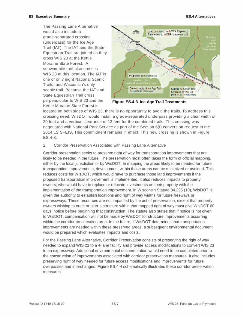
The Passing Lane Alternative would also include a grade-separated crossing (underpass) for the Ice Age Trail (IAT). The IAT and the State Equestrian Trail are joined as they cross WIS 23 at the Kettle Moraine State Forest. A snowmobile trail also crosses WIS 23 at this location. The IAT is one of only eight National Scenic Trails, and Wisconsin’s only scenic trail. Because the IAT and State Equestrian Trail cross perpendicular to WIS 23 and the Kettle Moraine State Forest is located on both sides of WIS 23, there is no opportunity to avoid the trails. To address this crossing need, WisDOT would install a grade-separated underpass providing a clear width of 20 feet and a vertical clearance of 12 feet for the combined trails. This crossing was negotiated with National Park Service as part of the Section 6(f) conversion request in the 2014 LS SFEIS. This commitment remains in effect. This new crossing is shown in Figure ES.4-3.
2. Corridor Preservation Associated with Passing Lane Alternative
Corridor preservation seeks to preserve right of way for transportation improvements that are likely to be needed in the future. The preservation most often takes the form of official mapping, either by the local jurisdiction or by WisDOT. In mapping the areas likely to be needed for future transportation improvements, development within those areas can be minimized or avoided. This reduces costs for WisDOT, which would have to purchase those land improvements if the proposed transportation improvement is implemented. It also reduces impacts to property owners, who would have to replace or relocate investments on their property with the implementation of the transportation improvement. In Wisconsin Statute 84.295 (10), WisDOT is given the authority to establish locations and right of way widths for future freeways or expressways. These resources are not impacted by the act of preservation, except that property owners wishing to erect or alter a structure within that mapped right of way must give WisDOT 60 days’ notice before beginning that construction. The statute also states that if notice is not given to WisDOT, compensation will not be made by WisDOT for structure improvements occurring within the corridor preservation area. In the future, if WisDOT determines that transportation improvements are needed within these preserved areas, a subsequent environmental document would be prepared which evaluates impacts and costs.
For the Passing Lane Alternative, Corridor Preservation consists of preserving the right of way needed to expand WIS 23 to a 4-lane facility and provide access modifications to convert WIS 23 to an expressway. Additional environmental documentation would need to be completed prior to the construction of improvements associated with corridor preservation measures. It also includes preserving right of way needed for future access modifications and improvements for future overpasses and interchanges. Figure ES.4-4 schematically illustrates these corridor preservation measures.
Figure ES.4-3 Ice Age Trail Treatments
Project ID 1440-13/15-00 ES-7 WIS 23–Fond du Lac to Plymouth

ES Executive Summary ES.4 Alternatives
Figure ES.4-4 Corridor Preservation Associated with Passing Lane Alternative
C. Hybrid Alternative
1. Hybrid Alternative
The Hybrid Alternative provides a 4-lane divided highway from US 151 to County G, and a 2-lane roadway with passing lanes from County G to County P. The 4-lane divided highway would span approximately 12 miles from US 151 in Fond du Lac to County G. East of County G, WIS 23 would be a 2-lane roadway with passing lanes and left turn lanes for the remaining 7 miles. Posted speeds along WIS 23 would not be modified in this alternative.
With this alternative, the eastbound passing lane east of County G is combined with the County G interchange on-ramp. Figure ES.4-5 schematically illustrates this alternative.
Figure ES.4-5 Hybrid Alternative–4 Lanes from US 151 to County G, 2 Lanes from County G to County P
The Hybrid Alternative has a roundabout intersection at Wisconsin American Parkway and a jughandle intersection at County K. The Old Plank Road Trail extension would span from US 151 to the existing Old Plank Road Trail west of the city of Plymouth.
The Hybrid Alternative also installs a diamond interchange at County UU with County UU passing over WIS 23. This interchange includes access roads that connect to adjacent property and a park and ride lot that connects with the Old Plank Road Trail extension. With the Hybrid Alternative, the Old Plank Road Trail would cross from the north to the south side of WIS 23 on County UU at the interchange.
Project ID 1440-13/15-00 ES-8 WIS 23–Fond du Lac to Plymouth

ES Executive Summary ES.4 Alternatives
The Hybrid Alternative also includes a diamond interchange at County G. The interchange includes a park and ride lot in the southeast quadrant, as well as an access road to connect to adjacent properties.
The Hybrid Alternative makes access modifications in the 4-lane portion of the alternative. These access modifications include the installation of a Restricted Crossing U-Turn (RCUT), also known as a J-turn, at several high-volume intersections. The RCUT intersection design only allows right-in/right-out/left-in movements and removes the most hazardous movements from the intersection. Drivers that want to turn left or travel across WIS 23 from a side road must take a right and then make a U-turn at an appropriate distance from the intersection. The RCUT concept is shown in Figure ES.4-6.
Figure ES.4-6 RCUT Layout
2. Corridor Preservation Associated with Hybrid Alternative
The Corridor Preservation associated with the Hybrid Alternative preserves right of way for possible future transportation improvements, as discussed with the Corridor Preservation for the Passing Lane Alternative. It includes preserving right of way needed to expand the WIS 23 section from County G to County P to a 4-lane roadway and provide access modifications to convert WIS 23 to an expressway. Additional environmental documentation would be completed prior to the construction of improvements associated with the corridor preservation measures. Figure ES.4-7 schematically illustrates the Corridor Preservation for the Hybrid Alternative.
Figure ES.4-7 Corridor Preservation Associated with Hybrid Alternative
Project ID 1440-13/15-00 ES-9 WIS 23–Fond du Lac to Plymouth

ES Executive Summary ES.4 Alternatives
D. 4-lane On-alignment Alternative
1. 4-lane On-alignment Alternative
The 4-lane On-alignment Alternative evaluated in this document was the Preferred Alternative in the 2014 LS SFEIS. This alternative would provide a 4-lane divided highway on the existing alignment for the full length of the project. It includes the roundabout at Wisconsin American Parkway, the County K jughandle, and diamond interchanges at County UU and County G. As discussed with the Hybrid Alternative, RCUTs are proposed at seven intersections. The 4-lane On-alignment Alternative also includes the Old Plank Road Trail extension that extends from US 151 to the existing Old Plank Road Trail just west of Plymouth. The trail would cross from north to south of WIS 23 on County UU at the interchange, the same crossing as with the Hybrid Alternative. Figure ES.4-8 schematically illustrates the 4-lane On-alignment Alternative.
From US 151 to County UU, the 4-lane On-alignment typical section would include four 12-foot lanes, 6-foot inside shoulders, 10-foot outside shoulders, and an 18-foot median with mountable curb. The outside edges may flow into either a rural section with a ditch or use mountable curb and gutter. The design speed for this section of roadway will be 55 mph and will be posted for 45 mph. Figure ES.4-9 illustrates this cross section.
Figure ES.4-8 4-lane On-alignment Alternative From County UU east to County P in Sheboygan County, WIS 23 has a typical expressway cross section. This includes four 12-foot lanes, 6-foot inside shoulders, 10-foot outside shoulders, and a 60-foot median. Generally, the existing roadbed will carry the eastbound lanes, and the westbound lanes will be constructed north of the existing roadway. The exception to this is between County W and Division Street, where the new lanes will be south of the existing roadbed. Figure ES.4-9 illustrates this cross section.
Conversion to a 4-lane expressway would allow for the existing posted speeds of 55 mph along WIS 23 to be increased to 65 mph, similar to portions of WIS 23 east of the study limits and other nearby 4-lane expressways such as US 151 between Columbus and Fond du Lac.
Figure ES.4-9 4-lane On-alignment Typical Sections
Project ID 1440-13/15-00 ES-10 WIS 23–Fond du Lac to Plymouth

ES Executive Summary ES.4 Alternatives
2. Corridor Preservation Associated with 4-lane On-alignment Alternative
The Corridor Preservation for 4-lane On-alignment Alternative includes preserving right of way for interchanges at County W and County A, and overpasses at Tower Road, 7 Hills Road, Scenic View Drive, and Sugarbush Road. Additional environmental documentation would be completed prior to the construction of improvements associated with corridor preservation measures. Figure ES.4-10 schematically illustrates the Corridor Preservation for 4-lane On-alignment Alternative.
Figure ES.4-10 Corridor Preservation for 4-lane On-alignment
E. Preferred Alternative
WisDOT and FHWA have identified a Preferred Alternative for WIS 23 and present it in this section. During the process of identification of a Preferred Alternative, many factors pertinent to the WIS 23 corridor were considered. The discussion about the factors considered and the reasons for the selection are discussed in detail in Appendix F. A summary is presented as follows.
1. Build Alternatives
The 4-lane On-alignment Alternative with Corridor Preservation is identified as the Preferred Alternative in this 2018 LS SEIS. Reasons for this selection include:
• The 4-lane On-alignment Alternative best fulfills WisDOT’s statutory mission and responsibilities:
o It provides better traffic operations.
o It provides more opportunities to incorporate safety countermeasures.
• The 4-lane On-alignment Alternative most optimally addresses the Purpose and Need factors compared to the other alternatives.
• The impacts do not outweigh the benefit derived from the 4-lane On-alignment Alternative.
• The majority of local governmental entities, along with commenting stakeholders, support the 4-lane On-alignment Alternative.
2. Corridor Preservation
Corridor Preservation that also designates WIS 23 as an expressway will be included in the 4-lane On-alignment Alternative, which preserves right of way for future improvements. Reasons for including Corridor Preservation with the 4-lane On-Alignment include:
• WIS 23 Corridor Preservation will protect right of way for transportation improvements that are likely to be needed in the future. In preserving these areas for future transportation
Project ID 1440-13/15-00 ES-11 WIS 23–Fond du Lac to Plymouth

ES Executive Summary ES.5 Traffic
improvements, development within those areas can be minimized or avoided, reducing costs for WisDOT.
• WIS 23 Corridor Preservation, while having some current effect on property owners, will reduce impacts to the property owners in the long term. Without corridor preservation, these property owners may invest in improvements that may later need to be removed or relocated for transportation improvements.
• Implementation of the improvements associated with the WIS 23 Corridor Preservation measures is likely to occur within the planning horizon (30 years from official mapping).
• WIS 23 Corridor Preservation provides information useful to local property owners and governments as they make property acquisition and development approval decisions.
• WIS 23 Corridor Preservation measures will facilitate future access reductions. Without preserving right of way needed for future access roads, development could make access removal prohibitively expensive. This in turn would diminish the future safety and mobility of the corridor.
• Designating WIS 23 as an expressway will provide cost savings in the future as right of way can be purchased before development can occur, will allow for fully conceptualized design concepts to be developed and approved, and will help local units of government in planning their development along the corridor.9
Additional environmental documentation would be completed prior to construction of improvements associated with any of the corridor preservation measures.
ES.5 TRAFFIC
A. Traffic Forecasts
The traffic forecasting analysis developed for and presented in the main body of this WIS 23 2018 LS SEIS used an updated version of the Northeast Region Travel Demand Model (NERTDM) and recent traffic counts to develop consistent forecasts for the No-Build Alternative and each of the Build Alternatives. Appendix B provides a more detailed explanation of the traffic forecasting procedures for this WIS 23 corridor.
Once the No-Build forecast was developed WisDOT set up the NERTDM to analyze the build alternatives. Network changes were coded in the model to develop traffic forecasts for the Build Alternatives including the Passing Lane Alternative, Hybrid Alternative, and 4-lane On-alignment Alternative. The network changes showed modest capacity increases and access changes that affected traffic volumes in the Passing Lane alternative. The Hybrid alternative and 4-lane On-alignment alternative showed larger traffic effects due to greater capacity increases and additional access improvements. The Hybrid and 4-lane On-alignment alternatives attracted more traffic from the local system than the No-Build and Passing Lane alternatives. Figure ES.5-1 shows the WIS 23 corridor 2040 forecasts for each of the alternatives being considered.
9 WisDOT FDM 11-7-40-1.2, Accessed May 11, 2018.
Project ID 1440-13/15-00 ES-12 WIS 23–Fond du Lac to Plymouth

W
H
--
ES Executive Summary ES.5 Traffic
Lake Winnebago
Fond du Lac
Plymouth
Tower Rd
7 Hills Rd
Scenic View Dr.
WH
K
UU
T
W
D
T
G
C
A
P C
J
Legend – Daily Traffic Volumes Average Annual Daily Traffic Volumes # = 2017 Count (#) = 2040 No Build [#] = 2040 Passing Lane Alternatives* {#} = 2040 Hybrid Alternative<#> = 2040 4-lane On-alignment Alternative
= Existing two-lane mainline within study limits = Existing four-lane mainline within study limits
NOTES Forecasts completed by WisDOT Central Office Forecasting (April 6, 2018,NERTDM) *Passing lane projections [#] include both with and without left-turn lane options on WIS 23
13,300 (17,500)[16,900]{20,100} <21,100>
11,500 (13,400) [12,500]{15,600}<16,700>
7,400 (8,300)[8,500]{11,000}<11,900>
7,400 (7,800) [8,000]{10,300}<11,200>
6,900 (7,100)[7,300]{9,000}<10,100>
6,700 (6,800)[7,000]{7,900}<9,500>
8,400 (8,700)[8,800]{9,600}<11,200>
7,800 (7,900)[8,100]{9,000}<10,900>
6,800 (6,900)[7,100]{8,800}<9,900>
9,400 (9,700) [9,900]{10,600}<12,300>
7,300 (7,900)[8,100]{10,800}<11,700>
Figure ES.5-1 2040 Traffic Forecast Volumes for Alternatives
B. Operational Analysis
WisDOT performed an operational analysis for each alternative using Highway Capacity Software (HCS). Appendix A contains two memoranda describing the inputs and methodology used for the operational analysis. WIS 23 is a Corridors 2030 Connector route in the Connections 2030 Statewide Long-Range Transportation Plan. For a Corridors 2030 Connector route, the desirable LOS is C, or at or below the numeric LOS of 4.0 for rural and small urban areas as outlined in the WisDOT’s FDM.10 These thresholds are based on a balance of social, environmental, and dollar costs and may not match with every traveler’s perception of when congestion warrants roadway improvements.11 Tables ES.5-1 and -2 show the operational analyses for the WIS 23 mainline. The tables divide the corridor into two sections because the 2017 volumes are slightly higher east of County G. As mentioned in Section ES.3, the 2017 operations analysis accounts for traffic variations within the peak hour.
Table ES.5-1 Alternative Operations–County UU to County G12
No-Build
Passing LaneAlternative Without Left Turn Lanes
Passing LaneAlternative
With Left Turn Lanes
Hybrid Alternative
4 lane On alignmentAlternative
EB WB EB WB EB WB EB* WB* EB* WB* LOS 2017 (numeric) 4.17 4.18 2017 values are not shown for the Passing Lane, Hybrid, and 4-lane On-alignment
Alternatives since 2017 represents an existing condition. LOS 2017 D D LOS 2040 (numeric) 4.09 4.11 3.21 3.19 3.32 3.29 -- -- -- --
LOS 2040 D D C C C C A A A A *4-Lane Freeway Analysis
10 Facilities Development Manual 11-5-3.2.1 Congestion and Facility LOS. Accessed March 23, 2018 11 As mentioned, the tables show the 2040 LOS using fully uniform peaking characteristics. See footnote in Section ES.3. 12 See Appendix A for two memoranda detailing the inputs and methodology used for the mainline operations analysis. For Table ES.5-1 and ES.5-2, 2017 values are not shown for the Passing Lane, Hybrid, and 4-lane On-alignment Alternatives since 2017 represents an existing condition. Additionally, the numeric LOS is not shown in alternatives with a 4-lane cross section because the variables in determining LOS are different for 2-lane and 4-lane analyses. More detail on the operations results is included in Section 2 of this 2018 LS SEIS as well as in Appendix A.
Project ID 1440-13/15-00 ES-13 WIS 23–Fond du Lac to Plymouth

--
ES Executive Summary ES.6 Environmental Impacts
Table ES.5-2 Alternative Operations–County G to County P
No-Build
Passing Lane Alternative Without Left Turn Lanes
Passing Lane Alternative
With Left Turn Lanes Hybrid Alternative
4 lane On alignment Alternative
EB WB EB WB EB WB EB WB EB* WB* LOS 2017 (numeric) 3.95 4.09 2017 values are not shown for the Passing Lane, Hybrid, and 4-lane On-alignment
Alternatives since 2017 represents an existing condition. LOS 2017 C D LOS 2040 (numeric) 3.80 3.99 3.80 3.17 3.95 3.31 4.05 3.38 -- --LOS 2040 C C C C C C D C A A
*4-Lane Freeway Analysis
ES.6 ENVIRONMENTAL IMPACTS Environmental impacts are identified for each alternative. The impact analysis reviewed the following: economic and community/residential impacts; air and noise effects; farmland impacts; residential and business relocations; upland habitat impacts; wetlands, streams, lakes, and floodplains impacted; erosion control and potential stormwater impacts; endangered species impacted; potential impacts to archaeological and historical sites that may be eligible for the National Register of Historic Places (NRHP); locations of possibly contaminated sites; public and private access points; estimated right of way required; public input; and project costs. A detailed discussion of environmental consequences is provided in Section 4.0. There have been several updates from that provided in the 2014 LS SFEIS. These include the following:
• The impact evaluation is updated to reflect the Passing Lane and Hybrid Alternatives that have been brought forward for detailed evaluation.
• Much of the right of way for the 4-lane On-alignment Alternative, the Preferred Alternative in the 2014 LS SFEIS, has been purchased and buildings razed based on the decisions in the 2010 FEIS and the 2014 LS SFEIS. The total environmental impacts under each resource category before acquisition are shown and considered in the discussion of impacts resulting from each alternative. The amount that has already been purchased is also presented.
• Since the release of the 2014 LS SFEIS, there have been species removed and added to the Wisconsin and Federal threatened and endangered species lists.
• Since the release of the 2014 LS SFEIS, the Transportation Construction General Permit (TCGP) is in force.
• Since the release of the 2014 LS SFEIS, additional hazardous materials were identified in the corridor.
• Since the release of the 2014 LS SFEIS, demographic data has been updated.
• The 2014 LS SFEIS included a Section 4(f) de minimis finding for the Old Wade House State Park. The property is no longer a state park and is called the Wade House Historic Site. Recently obtained property title information suggests Land and Water Conservation Fund (LWCF) funds may have been used on this site. The applicability of Section 6(f) to portions of the site near WIS 23 are being investigated.
Table ES.6-1 summarizes the impacts associated with the No-Build, Passing Lane, Hybrid, and 4-lane On-alignment Alternatives. Table ES.6-2 summarizes the resources, land types, residences, and businesses within the Corridor Preservation area for the Passing Lane, Hybrid, and 4-lane On-alignment Alternatives. These resources are not impacted by the act of preservation, except that property owners wishing to erect or alter a structure within that mapped right of way must give WisDOT 60 days’ notice before beginning that construction. The statute also states that if notice is not given to WisDOT, compensation will not be made by WisDOT for structure improvements occurring within the corridor preservation area. In the future, if WisDOT determines that transportation improvements are needed within these preserved areas, a subsequent environmental document would be prepared which evaluates impacts and costs.
Project ID 1440-13/15-00 ES-14 WIS 23–Fond du Lac to Plymouth

ES Executive Summary ES.6 Environmental Impacts
Table ES.6-1 designates how much acreage is needed based on the existing right of way prior to 2010, as well as how much has been purchased since 2010 but prior to the 2014 ROD being vacated. In some instances, more land was purchased than was needed because not purchasing the land would leave an uneconomic remnant. This land is considered excess right of way (see Figures 2.8-1 through -47). Right of way previously purchased for the 4-lane On-alignment Alternative may not be needed for the Passing Lane Alternative or Hybrid Alternatives, yet is shown as land needed for the Corridor preservation associated with the Passing Lane or Hybrid Alternatives. The WisDOT expenditures for right of way already acquired were not considered in the identification of the Preferred Alternative since they are a sunk cost. The land could be resold to abutting landowners, but the human cost of relocations and the cost of razing buildings is irretrievable. Additionally, impacts to natural and physical environment resources associated with right of way acquisitions already completed have not occurred nor has mitigation for potential impacts progressed beyond the conceptual evaluation stage other than the Section 6(f) land conversion and boundary update.
Project ID 1440-13/15-00 ES-15 WIS 23–Fond du Lac to Plymouth

ES Executive Summary ES.6 Environmental Impacts
Project ID 1440-13/15-00 ES-16 WIS 23–Fond du Lac to Plymouth
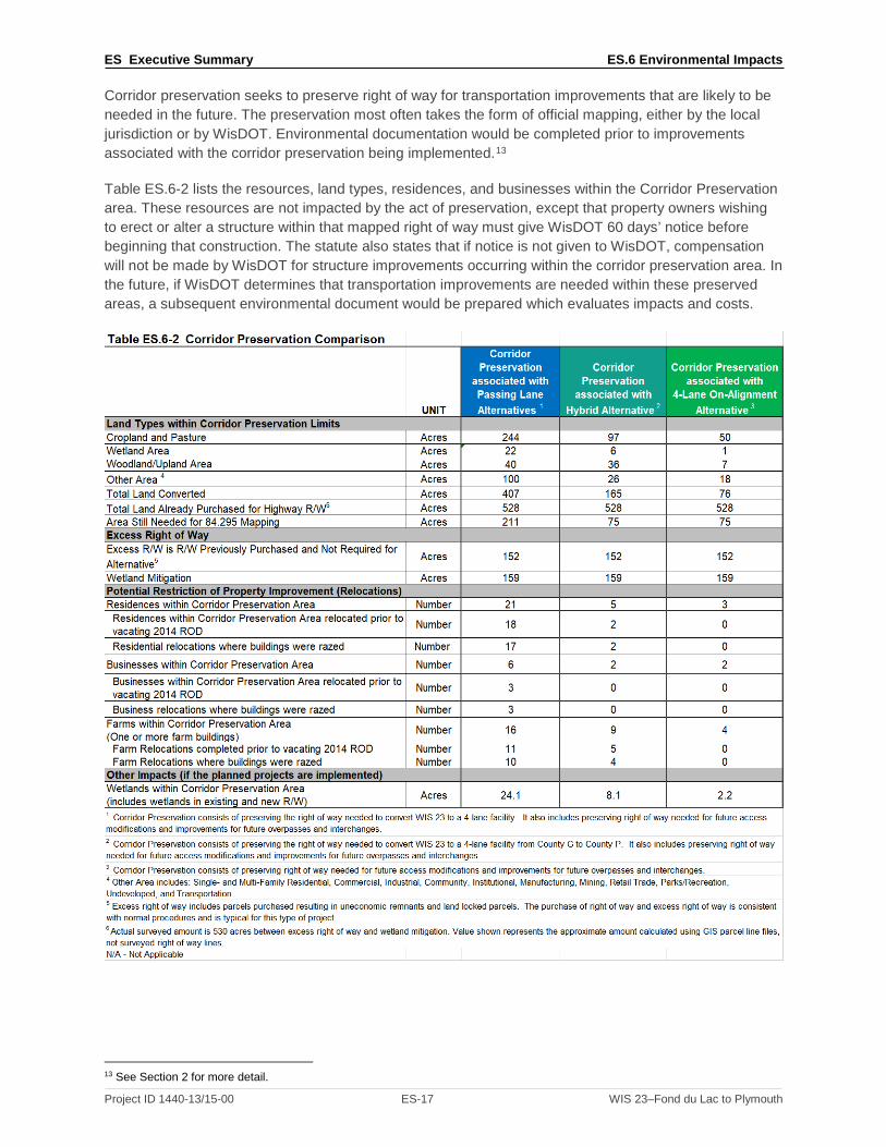
ES Executive Summary ES.6 Environmental Impacts
Corridor preservation seeks to preserve right of way for transportation improvements that are likely to be needed in the future. The preservation most often takes the form of official mapping, either by the local jurisdiction or by WisDOT. Environmental documentation would be completed prior to improvements associated with the corridor preservation being implemented.13
Table ES.6-2 lists the resources, land types, residences, and businesses within the Corridor Preservation area. These resources are not impacted by the act of preservation, except that property owners wishing to erect or alter a structure within that mapped right of way must give WisDOT 60 days’ notice before beginning that construction. The statute also states that if notice is not given to WisDOT, compensation will not be made by WisDOT for structure improvements occurring within the corridor preservation area. In the future, if WisDOT determines that transportation improvements are needed within these preserved areas, a subsequent environmental document would be prepared which evaluates impacts and costs.
13 See Section 2 for more detail.
Project ID 1440-13/15-00 ES-17 WIS 23–Fond du Lac to Plymouth

ES Executive Summary ES.9 Other Activities Required
ES.7 LEAD AND COOPERATING AGENCY
FHWA is the federal lead agency for this EIS under the National Environmental Policy Act of 1970. WisDOT is the state lead agency and is preparing the EIS in consultation with FHWA.
Because this is a LS SEIS, scoping is not required according to 23 CFR 771.130(d). While scoping is not required, WisDOT and FHWA have coordinated with local, state, and federal agencies as well as the public in the preparation of this LS SEIS. These efforts have included:
• An Agency Coordination Meeting October 10, 2017. • A Local Officials Meeting October 12, 2017. • A Public Involvement Meeting October 12, 2017. • An Indirect and Cumulative Effects Workshop with Local Land Use Experts on October 24, 2017. • Correspondence with State and Federal Agencies. • Correspondence with Native American Tribes.
This coordination identified issues to be addressed as well as developing the range of alternatives in accordance with 23 CFR 771.123.
The planning, agency coordination, public involvement, and impact evaluation for the project have been conducted in accordance with the National Environmental Policy Act (NEPA), the Clean Water Act, Executive Orders regarding wetland and floodplain protection, the Fish and Wildlife Coordination Act, the Migratory Bird Treaty Act, the Executive Order on Environmental Justice 12898, the National Historic Preservation Act of 1966, and other state and federal laws, executive orders, policies, and procedures for environmental impact analyses and preparation of environmental documents.
ES.8 ENVIRONMENTAL JUSTICE
This document is in compliance with USDOT and FHWA policies to determine whether a proposed project will have induced socioeconomic impacts or any other adverse impacts on minority or low-income populations, and it meets the requirements of Executive Order on Environmental Justice 12898–“Federal Actions to Address Environmental Justice in Minority and Low-Income Populations.” Minority or low-income individuals may be dispersed throughout the study area, though no known minority or low-income populations will be disproportionately impacted by the alternatives selected for detailed study.
ES.9 OTHER ACTIVITIES REQUIRED Because a WIS 23 construction project was previously awarded, based on the 4-lane On-alignment Alternative, much of the environmental compliance activities have already occurred. Specifically:
• All 30 of the residence relocations, 3 of the 4 business relocations, and 17 of the 18 farm relocations have already occurred prior to the 2014 ROD being vacated. WisDOT has purchased land for compensatory wetland mitigation sites and has plans for their conversion.
• Land was transferred to the KMSF-NU to compensate for right of way needed for WIS 23 to satisfy Section 6(f) conversion requirements, except for the Wade House Historic Site, which is still pending investigation.
• Previously applicable wetland permits and Section 401 water quality certifications were obtained for the corridor.
• Some pre-construction stipulations associated with the Section 106 Memorandum of Agreement have been fulfilled.
Depending on if the stated Preferred Alternative remains the Preferred Alternative in the Record of Decision, the following activities may be required.
• Relocation Assistance Plans will be revised to address any remaining farms or businesses that may be required.
Project ID 1440-13/15-00 ES-18 WIS 23–Fond du Lac to Plymouth

WIS 23 Preferred Alternative Identification ES.11 Public Comments and Agency Coordination
• New Section 404 permits (wetland) and water quality certifications may need to be issued prior to project construction.
• A grade-separated structure for the Ice Age Trail will need to be constructed to fulfill agreements with the National Park Service associated with the Section 6(f) conversion request.
• Remaining stipulations of the Section 106 Memorandum of Agreement will need to be fulfilled. This includes construction site monitoring in certain areas and public education measures associated with the Sippel Site.
Mitigation commitments for affected Section 4(f) and Section 6(f) properties are included in this document in Section 5. A summary of project commitments is provided in Section 6.
ES.10 REGULATORY COMPLIANCE
The planning, agency coordination, public involvement, and impact evaluation for the project have been conducted in accordance with the NEPA, the Clean Water Act, Executive Orders regarding wetland and floodplain protection, the Fish and Wildlife Coordination Act, the Migratory Bird Treaty Act, the Executive Order on Environmental Justice 12898, the National Historic Preservation Act of 1966, and other state and federal laws, executive orders, policies, and procedures for environmental impact analyses and preparation of environmental documents.
ES.11 PUBLIC COMMENTS AND AGENCY COORDINATION
Since the issuance of the Notice of Intent to Prepare an LS SEIS on August 29, 2017; WisDOT has had one agency meeting, one public involvement meeting, one local government officials meeting, and one workshop to determine indirect and cumulative effects. Of the over 700 comments received during the comment period following the public involvement meeting, 615 residents supported the 4-lane On-alignment Alternative and 24 residents supported the Passing Lane Alternative. The remaining comments did not mention support of any particular alternative.
The study has received official correspondence/resolutions from eight government entities. All eight supported improvements to WIS 23, with five of the eight supporting four-lane improvements.
An agency coordination meeting was held on October 10, 2018. Agency comments are included in Section 7 of this 2018 LS SEIS.
Concurrence Points/Synchronization Points 1 (Purpose and Need) and 2 (Range of Alternatives) were obtained with previous NEPA documents. Concurrence Point 1 was reaffirmed at the agency coordination meeting in October 2017 and coordination continues for Concurrence Point 2. Concurrence Point 3, Least Environmentally Damaging Practicable Alternative, will need to be identified/reaffirmed prior to issuance of the Record of Decision.
Project ID 1440-13/15-00 ES-19 WIS 23–Fond du Lac to Plymouth

ES Executive Summary ES.12 List of Abbreviations ES.12 LIST OF ABBREVIATIONS
Section 106 Section 106 of the National Historic Preservation Act, requires Federal agencies to take into account the effects of their undertakings on historic properties
Section 4(f) Section 4(f) of the Department of Transportation Act dealing with impacts on historic places, parks, and wildlife refuges.
Section 6(f) Section 6(f) of the Land and Water Conservation Act requires that the conversion of lands or facilities acquired with Land and Water Conservation Act funds be coordinated with the Department of Interior.
AADT Annual Average Daily Traffic
ADID Advanced Identification Program
ADT Average Daily Traffic
AIN Agricultural Impact Notice
AIS Agricultural Impact Statement
ATC American Transmission Company
ATV All-Terrain Vehicle
APE Area of Potential Effect
BMPs Best Management Practices
CEQ Council on Environmental Quality
CMM Construction and Materials Manual
CO carbon monoxide
CSRP Conceptual Stage Relocation Plan
DATCP Wisconsin Department of Agriculture, Trade, and Consumer Protection
dBA Decibel–a unit of measurement for sound level
DEIS Draft Environmental Impact Statement
DHV Design hourly volume
DOE Determination of Eligibility, for the National Register of Historic Places
ECIP Erosion Control Implementation Plan
EIS Environmental Impact Statement
EJ environmental justice
Endangered Species Species identified by either the state or the federal government as likely to be in danger of becoming extinct through a significant portion of or all of its range
FDM Facilities Development Manual
FEIS Final Environmental Impact Statement
FHWA Federal Highway Administration
GIS Geographic Information System
GPS Global Positioning System
HazMat Hazardous Materials
HCS Highway Capacity Software
HEI Health Effects Institute
Project ID 1440-13/15-00 ES-20 WIS 23–Fond du Lac to Plymouth

ES Executive Summary ES.12 List of Abbreviations HHS Health and Human Services
IAT Ice Age Trail
ICE Indirect and Cumulative Effects
KMSF-NU Kettle Moraine State Forest - Northern Unit
LF linear foot
LOS Level of Service, refers to the overall quality of traffic flow at an intersection or mainline section.
LS SDEIS Limited Scope Supplemental Draft Environmental Impact Statement
LS SEIS Limited Scope Supplemental Environmental Impact Statement
LS SFEIS Limited Scope Supplemental Final Environmental Impact Statement
LUST Leaking Underground Storage Tank
LWCF Land and Water Conservation Fund
MOA Memorandum of Agreement
mph Miles per hour
MPO Metropolitan Planning Organization
MSAT Mobile Source Air Toxics
MVEB Motor Vehicle Emissions Budget
NAAQS National Ambient Air Quality Standards
NAC Noise Abatement Criteria
NCHRP National Cooperative Highway Research Program
NEPA National Environmental Policy Act
NERTDM Northeast Region Travel Demand Model
NEWRPC Northeast Wisconsin Regional Planning Commission
NHI National Heritage Inventory
NHS National Highway System
NLC Noise Level Criteria
NO nitrogen oxide
Npfc Not available for counties
NPS National Park Service
NRCS Natural Resources Conservation Service
NRHP National Register of Historic Places
O3 ozone
PAC Public Advisory Committee
Pb lead
PCB polychlorinated Biphenyls
PCN Pre-Construction Notification
PM particulate matter
RCUT Restricted Crossing U-Turn
Project ID 1440-13/15-00 ES-21 WIS 23–Fond du Lac to Plymouth

ES Executive Summary ES.12 List of Abbreviations RI/RO Right-in/Right-out
ROD Record of Decision
RTP Regional Transportation Plan
SATP Sheboygan Area Transportation Plan
SDEIS Supplemental Draft Environmental Impact Statement
SEIS Supplemental Environmental Impact Statement
SHPO State Historic Preservation Officer
SO2 sulfur dioxide
STIP Statewide Transportation Improvement Program
TAFIS Traffic Analysis Forecasting Information System
TAZ Traffic Analysis Zones
TCGP Transportation Construction General Permit
Threatened Species Species identified by either the state of federal government as likely to be in danger of becoming endangered in the foreseeable future
TEA-21 Transportation Equity Act for the 21st Century
THPO Tribal Historic Preservation Officers
TIP Transportation Improvement Program
TPC Transportation Projects Committee
TSS Total Suspended Solids
TWLTL Two-Way Left-Turn Lane
USACE United States Army Corps of Engineers
USDOT United States Department of Transportation
USEPA United States Environmental Protection Agency
USFWS United States Fish and Wildlife Services
UST Underground Storage Tank
VMT vehicle miles traveled
vpd vehicles per day
WDNR Wisconsin Department of Natural Resources
WisDOT Wisconsin Department of Transportation
WIS 23 Wisconsin State Highway 23
WPDES Wisconsin Pollutant Discharge Elimination System
Project ID 1440-13/15-00 ES-22 WIS 23–Fond du Lac to Plymouth