national environmental policy act compliance …
TRANSCRIPT

Q:\Jobs\200's\229.56\NEPA Compliance Evaluation Tech Memo.doc WestLand Resources, Inc. Engineering and Environmental Consultants
NATIONAL ENVIRONMENTAL POLICY ACT COMPLIANCE EVALUATION URBAN LOOP TIGER II GRANT APPLICATION
Prepared for: Pima County Department of Transportation Donna Lewandowski, M.S Prepared by: WestLand Resources, Inc. Date: August 19, 2010 Project No.: 0229.56 Pima County has initiated its environmental review of each of the project segments included in their request for funding by the TIGER II grant program. This effort has included a preliminary assessment of the independence of each segment with respect to review under the National Environmental Policy Act (NEPA), Class I cultural resources investigations, preliminary assessment of 4(f) properties, and screening analysis for threatened and endangered species. These results support our determination that, like prior projects completed along the Urban Loop, the substantive requirements of the NEPA for the Urban Loop Projects for which we are requesting funding can be satisfied by either a programmatic or non-programmatic categorical exclusion. For purposes of NEPA review and analysis, each of the individual Urban Loop projects for which funding is being requested is a single and complete project with independent utility. We have carefully evaluated each of the individual segments of the proposed Urban Loop with respect to the Federal Highways Administration (FHWA) policy regarding project segmentation. Each of the segments is based upon logical termini and is of sufficient length to address environmental matters in a broad scope. As illustrated by the community’s extensive use of linear park segments that comprise the completed portions of the Urban Loop, each segment has independent utility and independent significance with regard to expected community benefits. Further, the existence of these segments would not alter the identification and evaluation of alternative alignments and design for the adjacent connecting segment. Each of these segments is depicted in Figure 1. The FHWA and Arizona Department of Transportation (ADOT) executed an Arizona Programmatic Categorical Exclusion Approval Memorandum in June of 2008. In this memorandum ADOT and FHWA concurred in advance with the classification of Categorical Exclusions (CE) identified at 23 CFR 771.117 and ADOT certified that all of the conditions indicated in this blanket classification will be satisfied for any action processed under the programmatic classification and approval process. Two levels of programmatic approval are available. Group 1 approvals are those actions identified at 23 CFR 771.117 (c) that meet the criteria of 23 CFR 771.117 (a) and (b) and do not require further approvals by FHWA. Group 2 actions are those actions that described at 23 CFR 771.117 (d) that meet the criteria of 23 CFR 771.117 (a) and (b) and may be designated as CEs upon submission to FHWA of documentation that demonstrates that specific conditions and criteria for CE are satisfied and that significant impacts will not result. Should a specific segment not qualify for programmatic CE, non-programmatic CEs are available provided that the environmental analysis determines that the proposed action satisfies all of the conditions outlined in 23 CFR 771.117 (a) and (b).

National Environmental Policy Act Compliance Evaluation Urban Loop TIGER II Grant Application
Q:\Jobs\200's\229.56\NEPA Compliance Evaluation Tech Memo.doc WestLand Resources, Inc. Engineering and Environmental Consultants
August 19, 2010 Page 2
Each of the individual segments for which TIGER II Grant Funding is being requested is expected to be categorically excluded from National Environmental Policy Act requirements. While ultimately an ADOT and FHWA determination, none of the projects are expected to have significant adverse impact and none are expected to require preparation of an Environmental Assessment (EA) or Environmental Impact Statement (EIS). The environmental review process for each of the proposed segments has been initiated. Environmental planning and expected clearances for all segments are expected to be completed by June of 2012. Attachment 1 provides our analysis of each segment’s NEPA obligations. Our analysis relied upon a preliminary screening analysis to determine the presence of federally listed threatened and endangered species and designated critical habitat has been completed and the proposed Urban Loop is not expected to adversely affect any federally listed threatened or endangered species or critical habitat designated by the US Fish and Wildlife Service (FWS). Attachment 2 of this memorandum provides a listing of the species considered in our analysis. This analysis has relied heavily upon the extensive resource investigations completed by Pima County in support of its Sonoran Desert Conservation Plan as well as previously completed site specific studies and survey that include or are near portions of the proposed Urban Loop. The southernmost portion of the Urban Loop occurs within or near the northern edge of the published range of Pima Pineapple Cactus, a plant species listed as endangered by the USFWS. Surveys for this species on and within the immediate vicinity of specific Urban Loop segments have failed to detect this plant within this portion of its published range. Based upon the results of these surveys and the habitat requirements of the plant it is not expected to occur within any of the segments proposed for Urban Loop. As environmental planning and design efforts progress, segment specific biological evaluations will be completed and incorporated into the CE documentation for each of the Urban Loop segments. An archaeological records check of the proposed route of the Urban Loop project has been completed. The purpose of the records check was to identify all previously conducted archaeological surveys and previously recorded archaeological sites that intersect the Urban Loop project area (Figure 1). This review relied upon the database of current archaeological site information and survey data maintained by the Arizona State Museum (ASM). Using this data, the percentage of each project segment that has been previously surveyed was calculated, and known archaeological sites that intersect each project segment were identified. The results of this investigation are summarized in Attachment 3 of this memorandum. JAT:emr

FIGURE 1

úú
úú
ú
ú
File: M:\projects\229.56\ARC\MXD\Figures\Fig1_Project_location.mxd
³0 2 4
Kilometers
0 1 2Miles
LegendCompleted
Fully Funded
Funds Requested
Project LocationFigure 1
URBAN LOOP

ATTACHMENT 1

Q:\Jobs\200's\229.56\Segment Narrative (2).doc
Segment # Segment Name Miles Description
01 Bridge at Camino de la Tierra 0.25
This bridge connects existing segments of the Urban Loop located immediately east and west of Camino de la Tierra. Currently, path users cross this busy street at-grade making this a hazardous crossing and the site of a severe bicyclist injury. Status: In design.
Anticipated NEPA Requirement: Non-Programmatic CE
Significant Impacts: None Anticipated.
Unusual Circumstances: No
Acquisition of more than a minor amount of ROW: No
Properties Protected by Section 4(f): Within the Rillito River Park; the proposed project will enhance connectivity and the functionality of the park; no adverse impacts anticipated to 4(f) property.
US Coast guard Construction Permit: No
Individual 404 or NWP 23: No
Work in Wetlands: No
On Tribal Lands: No
Wild and Scenic River System: No
Change in Access Control: No
Known Hazardous Materials: No; a PISA will be completed as part of final environmental documentation.
Road, detour or ramp closure: No
NHPA Adverse Affect: Survey Completed; No Cultural Sites and No Adverse Affect.
NHPA MOA Required: No
Level 3 Mobile Source Air Toxic Analysis Required: No
Threatened and Endangered Species May Affect Determination: No

Q:\Jobs\200's\229.56\Segment Narrative (2).doc
Segment # Segment Name Miles Description
02 Mountain Ave. to First Ave. 0.60
This project will connect two existing segments of the Urban Loop with a paved pathway and installation of a pre-fabricated bridge over the Mountain Avenue Wash.Status: In design.
Anticipated NEPA Requirement: Non-Programmatic CE Completed and Approved by ADOT
Significant Impacts: No
Unusual Circumstances: No
Acquisition of more than a minor amount of ROW: No
Properties Protected by Section 4(f): Within the Rillito River Park; the proposed project will enhance connectivity and the functionality of the park; no adverse impacts anticipated to 4(f) property.
US Coast guard Construction Permit: No
Individual 404 or NWP 23: No
Work in Wetlands: No
On Tribal Lands: No
Wild and Scenic River System: No
Change in Access Control: No
Known Hazardous Materials: No
Road, detour or ramp closure: No
NHPA Adverse Affect: Survey Completed; No Cultural Sites and No Adverse Affect
NHPA MOA Required: No
Level 3 Mobile Source Air Toxic Analysis Required: No
Threatened and Endangered Species May Affect Determination: No

Q:\Jobs\200's\229.56\Segment Narrative (2).doc
Segment # Segment Name Miles Description
03 Country Club Rd. to Hacienda del Sol 0.30
This is the final segment necessary to complete the Rillito River alignment of the Urban Loop. This project will be completed in two phases. The alternate modes path will be constructed first to provide immediate connectivity. Required soil cement and adjacent drainage improvements will be completed in phase 2. Status: In design.
Anticipated NEPA Requirement: Non Programmatic CE due to presence of cultural resources and 4(f) property
Significant Impacts: None Anticipated.
Unusual Circumstances: No
Acquisition of more than a minor amount of ROW: No
Properties Protected by Section 4(f): Within the Rillito River Park; the proposed project will enhance connectivity and the functionality of the park; no adverse impacts anticipated to 4(f) property.
US Coast guard Construction Permit: No
Individual 404 or NWP 23: No; NWP 13 may be required for bank protection.
Work in Wetlands: No
On Tribal Lands: No
Wild and Scenic River System: No
Change in Access Control: No
Known Hazardous Materials: No; a Preliminary Initial Site Assessment will be completed as part of final environmental documentation.
Road, detour or ramp closure: No
NHPA Adverse Affect: Approximately 89 percent of segment has been previously surveyed; One previously recorded site intersects this segment-AZ BB:9:17(ASM); mitigation will be required if site is eligible and adversely affected by project.
NHPA MOA Required: Consultation is likely.
Level 3 Mobile Source Air Toxic Analysis Required: No
Threatened and Endangered Species May Affect Determination: No

Q:\Jobs\200's\229.56\Segment Narrative (2).doc
Segment # Segment Name Miles Description
04 Tanque Verde Rd. to Rillito 2.00
Due to the topography of this area, this is one of the most challenging sections of the Urban Loop. The $16.8 million project is one of two key connectors that remain incomplete and unfunded. This section not only connects the Pantano Wash to the Rillito River, it provides a Loop Link with the Tanque Verde Wash. The connection is the confluence of three major waterways and includes some of the areas oldest remaining riparian habitat. Status: In preliminary design.
Anticipated NEPA Requirement: Non Programmatic CE due to presence of cultural resources; land acquisition requirements
Significant Impacts: None Anticipated; County plans to avoid and minimize impacts to riparian habitat to the extent practicable.
Unusual Circumstances: No
Acquisition of more than a minor amount of ROW:
Approximately 65 acres of land acquisition required. All land acquisition would be accomplished in accordance with the Uniform Relocation Assistance and Real Property Acquisition Policy Act of 1979 (The Uniform Act 49CFR Part 24).
Properties Protected by Section 4(f): No
US Coast guard Construction Permit: No
Individual 404 or NWP 23: No; 404 permitting will be required and previous bank revetment work by County along Pantano Wash has been permitted by Corps with NWP 13.
Work in Wetlands: No
On Tribal Lands: No
Wild and Scenic River System: No
Change in Access Control: No
Known Hazardous Materials: No; a Preliminary Initial Site Assessment will be completed as part of final environmental documentation.
Road, detour or ramp closure: No
NHPA Adverse Affect: Approximately 27 percent of segment has been previously surveyed; One previously recorded site intersects segment-AZ BB:9:325(ASM) (considered eligible [recorders]); mitigation will be required if site is eligible and adversely affected by project.
NHPA MOA Required: Consultation is likely.
Level 3 Mobile Source Air Toxic Analysis Required: No
Threatened and Endangered Species May Affect Determination: No

Q:\Jobs\200's\229.56\Segment Narrative (2).doc
Segment # Segment Name Miles Description
05 Speedway Blvd. to Tanque Verde Rd. 1.00
This segment will connect to the 5th Street to Speedway Boulevard Transportation Enhancement Project immediately to the south. Status: Under construction.
Anticipated NEPA Requirement: Work in progress, permitted by COE using nationwide permit 13. TIGER II NEPA compliance not required.
Significant Impacts: No
Unusual Circumstances: No
Acquisition of more than a minor amount of ROW: No
Properties Protected by Section 4(f): No
US Coast guard Construction Permit: No
Individual 404 or NWP 23: No
Work in Wetlands: No
On Tribal Lands: No
Wild and Scenic River System: No
Change in Access Control: No
Known Hazardous Materials: No
Road, detour or ramp closure: No
NHPA Adverse Affect: No
NHPA MOA Required: No
Level 3 Mobile Source Air Toxic Analysis Required: No
Threatened and Endangered Species May Affect Determination: No

Q:\Jobs\200's\229.56\Segment Narrative (2).doc
Segment # Segment Name Miles Description
06 5th St. to Speedway Blvd. 0.60
A private development constructed the path from Speedway south for 670 feet. This segment extends the existing pathway south to 5th Street and connects with local neighborhoods, businesses and schools. The project includes a bridge over the 5th Street wash for bicycle and pedestrian access. Status: In design.
Anticipated NEPA Requirement: Already funded and TIGER II NEPA Compliance Not Required
Significant Impacts: No
Unusual Circumstances: No
Acquisition of more than a minor amount of ROW:
Only minor acquisition anticipated; All land acquisition would be accomplished in accordance with the Uniform Relocation Assistance and Real Property Acquisition Policy Act of 1979 (The Uniform Act 49CFR Part 24).
Properties Protected by Section 4(f): No
US Coast guard Construction Permit: No
Individual 404 or NWP 23: No; culvert would be permitted under NWP 14.
Work in Wetlands: No
On Tribal Lands: No
Wild and Scenic River System: No
Change in Access Control: No
Known Hazardous Materials: No; a Preliminary Initial Site Assessment will be completed as part of final environmental documentation.
Road, detour or ramp closure: No
NHPA Adverse Affect: Approximately 20 percent of site has been surveyed. No known sites; There is potential for cultural resources within the project area.
NHPA MOA Required: If sites found, consultation in accordance with the requirements of Section 106 would be required.
Level 3 Mobile Source Air Toxic Analysis Required: No
Threatened and Endangered Species May Affect Determination: No

Q:\Jobs\200's\229.56\Segment Narrative (2).doc
Segment # Segment Name Miles Description
07 Broadway Blvd. Underpass 0.25
Currently, path users must cross this busy arterial at-grade with no signalized crossing, creating a safety hazard as well as a disincentive to use the path. This is a key underpass for the Pantano reach. It provides access to major eastside business centers and allows an alternative transportation mode in one of the region’s most congested areas. Status: In design.
Anticipated NEPA Requirement: Already funded and TIGER II NEPA Compliance Not Required.
Significant Impacts: No
Unusual Circumstances: No
Acquisition of more than a minor amount of ROW: No
Properties Protected by Section 4(f): No
US Coast guard Construction Permit: No
Individual 404 or NWP 23: No
Work in Wetlands: No
On Tribal Lands: No
Wild and Scenic River System: No
Change in Access Control: No
Known Hazardous Materials: No
Road, detour or ramp closure: No
NHPA Adverse Affect: Approximately 92 percent of segment surveyed, no known sites.
NHPA MOA Required: Not expected.
Level 3 Mobile Source Air Toxic Analysis Required: No
Threatened and Endangered Species May Affect Determination: No

Q:\Jobs\200's\229.56\Segment Narrative (2).doc
Segment # Segment Name Miles Description
08 Kenyon Dr. to Broadway Blvd. 0.50
This segment will connect the existing pathway north of Broadway and the proposed Broadway underpass with a new path that is currently under construction from Kenyon to Golf Links. Status: In design.
Anticipated NEPA Requirement: Already funded and TIGER II NEPA Compliance Not Required.
Significant Impacts: No
Unusual Circumstances: No
Acquisition of more than a minor amount of ROW: No
Properties Protected by Section 4(f): No
US Coast guard Construction Permit: No
Individual 404 or NWP 23: No
Work in Wetlands: No
On Tribal Lands: No
Wild and Scenic River System: No
Change in Access Control: No
Known Hazardous Materials: No; a Preliminary Initial Site Assessment will be completed as part of final environmental documentation.
Road, detour or ramp closure: No
NHPA Adverse Affect: Approximately 86 percent of segment surveyed for cultural resources; no known sites along segment, some potential for sites but it is not likely.
NHPA MOA Required: Consultation possible but not likely.
Level 3 Mobile Source Air Toxic Analysis Required: No
Threatened and Endangered Species May Affect Determination: No

Q:\Jobs\200's\229.56\Segment Narrative (2).doc
Segment # Segment Name Miles Description
09 Golf Links Rd. to Kenyon Dr. 2.00
This segment is under construction with anticipated completion in fall 2010. Status: Under construction.
Anticipated NEPA Requirement: Already funded, TIGER II NEPA Compliance Not Required.
Significant Impacts: No
Unusual Circumstances: No
Acquisition of more than a minor amount of ROW: No
Properties Protected by Section 4(f): No
US Coast guard Construction Permit: No
Individual 404 or NWP 23: No
Work in Wetlands: No
On Tribal Lands: No
Wild and Scenic River System: No
Change in Access Control: No
Known Hazardous Materials: No
Road, detour or ramp closure: No
NHPA Adverse Affect: No
NHPA MOA Required: No
Level 3 Mobile Source Air Toxic Analysis Required: No
Threatened and Endangered Species May Affect Determination: No

Q:\Jobs\200's\229.56\Segment Narrative (2).doc
Segment # Segment Name Miles Description
10 Sellarole St. to Golf Links Rd. 1.00
This segment will provide linkages to area neighborhoods through street connections along the Sellarole Street alignment. Status: In design.
Anticipated NEPA Requirement: Non Programmatic CE due to potential beneficial 4(f) considerations.
Significant Impacts: Not anticipated.
Unusual Circumstances: No
Acquisition of more than a minor amount of ROW:
No; may be constructed without any acquisition. All land acquisition would be accomplished in accordance with the Uniform Relocation Assistance and Real Property Acquisition Policy Act of 1979 (The Uniform Act 49CFR Part 24).
Properties Protected by Section 4(f): Michael Perry Park is located east of the project area; this proposed project is intended to benefit this park and neighborhoods by providing linkages to area neighborhoods.
US Coast guard Construction Permit: No
Individual 404 or NWP 23: No, CWA compliance likely to require NWP 13 and 14.
Work in Wetlands: No
On Tribal Lands: No
Wild and Scenic River System: No
Change in Access Control: No
Known Hazardous Materials: No; a Preliminary Initial Site Assessment will be completed as part of final environmental documentation.
Road, detour or ramp closure: No
NHPA Adverse Affect: No, 100 percent the proposed alignment of this segment has been surveyed, No known sites.
NHPA MOA Required: No
Level 3 Mobile Source Air Toxic Analysis Required: No
Threatened and Endangered Species May Affect Determination: No

Q:\Jobs\200's\229.56\Segment Narrative (2).doc
Segment # Segment Name Miles Description
11 Houghton Greenway to Sellarole St. 2.00
This segment is a challenging section of the Loop due to topography and soil conditions. This is another key connector that will link up the Pantano River alignment with the Houghton Greenway alignment of the Loop. This area is also favored by off-road bicycle enthusiasts. There are several nearby off-road bicycle facilities including Fantasy Island and Atterbury Wash. Status: In the preliminary planning stage.
Anticipated NEPA Requirement: Programmatic Group II CE.
Significant Impacts: No
Unusual Circumstances: No
Acquisition of more than a minor amount of ROW: No, can be built without acquisition.
Properties Protected by Section 4(f): No
US Coast guard Construction Permit: No
Individual 404 or NWP 23: No
Work in Wetlands: No
On Tribal Lands: No
Wild and Scenic River System: No
Change in Access Control: No
Known Hazardous Materials: No; a Preliminary Initial Site Assessment will be completed as part of final environmental documentation.
Road, detour or ramp closure: No
NHPA Adverse Affect: No, 100 percent the proposed alignment of this segment has been surveyed, No known sites.
NHPA MOA Required: No
Level 3 Mobile Source Air Toxic Analysis Required: No
Threatened and Endangered Species May Affect Determination: No

Q:\Jobs\200's\229.56\Segment Narrative (2).doc
Segment # Segment Name Miles Description
12 Houghton Greenway 6.00
This segment is the principle north-south alignment that lies within the right-of-way of the Houghton Road Parkway, connecting the Pantano River with the Julian Wash. This segment provides access from Interstate 10 to a major bicycle destination, Mt. Lemmon. Status: In design.
Anticipated NEPA Requirement: Already funded, TIGER II NEPA Compliance Not Required.
Significant Impacts: No
Unusual Circumstances: No
Acquisition of more than a minor amount of ROW:
All land acquisition would be accomplished in accordance with the Uniform Relocation Assistance and Real Property Acquisition Policy Act of 1979 (The Uniform Act 49CFR Part 24).
Properties Protected by Section 4(f): No adjacent parks, Purple Heart Park is west of project.
US Coast guard Construction Permit: No
Individual 404 or NWP 23: No, 404 permitting obligations would most likely be met using NWP 14.
Work in Wetlands: No
On Tribal Lands: No
Wild and Scenic River System: No
Change in Access Control: No
Known Hazardous Materials: None Know.
Road, detour or ramp closure: No closure anticipated.
NHPA Adverse Affect:
100% of segment has been previously surveyed; Three previously recorded sites intersect segment: AZ AA:12:928(ASM) (not considered eligible [SHPO 1999]), AZ BB:13:676(ASM) (not considered eligible [recorders]), and AZ Z:2:40(ASM) (determined eligible [SHPO 2003]).
NHPA MOA Required: Consultation expected and would be conducted if there are any adverse impacts in accordance with Pima County regulation or through the Army Corps of Engineers if the sites are proximate to areas of Corps Jurisdiction.
Level 3 Mobile Source Air Toxic Analysis Required: No
Threatened and Endangered Species May Affect Determination: No

Q:\Jobs\200's\229.56\Segment Narrative (2).doc
Segment # Segment Name Miles Description
13 Houghton Greenway to Rita Rd. 2.30
This segment will connect the Houghton Greenway (the eastern segment of the Urban Loop) to the Julian Wash (the southern segment). Status: In the preliminary planning stage.
Anticipated NEPA Requirement: Non Programmatic CE due to the state land acquisition requirements.
Significant Impacts: None Anticipated.
Unusual Circumstances: No
Acquisition of more than a minor amount of ROW: State Land Acquisition along entire route.
Properties Protected by Section 4(f): No
US Coast guard Construction Permit: No
Individual 404 or NWP 23: No, any wash crossings along this segment of the Urban Loop would be authorized by NWP 14.
Work in Wetlands: No
On Tribal Lands: No
Wild and Scenic River System: No
Change in Access Control: No
Known Hazardous Materials: No; a Preliminary Initial Site Assessment will be completed as part of final environmental documentation.
Road, detour or ramp closure: No
NHPA Adverse Affect: Approximately 34 percent of segment has been surveyed for cultural resources; no known sites intersect segment but cultural sites may be found in the area.
NHPA MOA Required: Consultation is possible.
Level 3 Mobile Source Air Toxic Analysis Required: No
Threatened and Endangered Species May Affect Determination:
Not likely, but survey of this alignment for Pima Pineapple Cactus will be completed.

Q:\Jobs\200's\229.56\Segment Narrative (2).doc
Segment # Segment Name Miles Description
14 Rita Rd. to Kolb Rd. 3.00
This segment is adjacent to the University of Arizona Science Tech park and provides access between area neighborhoods and the University, a high school, and businesses. The site will also be home to six major solar companies. All employers actively promote and support alternative modes and have contributed to the continued development of the Urban Loop in this segment. Status: In design.
Anticipated NEPA Requirement: Already funded, TIGER II NEPA Compliance Not Required.
Significant Impacts: None Anticipated.
Unusual Circumstances: No
Acquisition of more than a minor amount of ROW: Acquired in cooperation with adjacent UofA Tech Park.
Properties Protected by Section 4(f): No
US Coast guard Construction Permit: No
Individual 404 or NWP 23: If crossing of Julian Wash is required, would be done using NWP 14.
Work in Wetlands: No
On Tribal Lands: No
Wild and Scenic River System: No
Change in Access Control: No
Known Hazardous Materials: No; a Preliminary Initial Site Assessment will be completed as part of final environmental documentation.
Road, detour or ramp closure: No
NHPA Adverse Affect: Approximately 86 percent of site surveyed. No known sites along segment alignment.
NHPA MOA Required: Consultation is possible but not likely.
Level 3 Mobile Source Air Toxic Analysis Required: No
Threatened and Endangered Species May Affect Determination:
Not likely, adjacent parcel surveyed with no PPC detections, but survey of this alignment for Pima Pineapple Cactus will be completed.

Q:\Jobs\200's\229.56\Segment Narrative (2).doc
Segment # Segment Name Miles Description
15 Kolb Rd. to Wilmot Rd. 1.40
This segment is being partially constructed by a developer but needs several key crossings which are currently unfunded. This is a major employment hub with large industrial businesses, the Davis-Monthan Air Force Base, and Pima Air and Space Museum adjacent to the facility. Status: In design.
Anticipated NEPA Requirement: Programmatic CE
Significant Impacts: None Anticipated.
Unusual Circumstances: No
Acquisition of more than a minor amount of ROW: No
Properties Protected by Section 4(f): None
US Coast guard Construction Permit: No
Individual 404 or NWP 23: No, existing bank revetment permitted as part of larger master plan, no new NWP anticipated. Any crossings that require a 404 would be expected to be authorized by NWP 14.
Work in Wetlands: No
On Tribal Lands: No
Wild and Scenic River System: No
Change in Access Control: No
Known Hazardous Materials: No; a Preliminary Initial Site Assessment will be completed as part of final environmental documentation.
Road, detour or ramp closure: No
NHPA Adverse Affect: No, cultural resource clearance for original site development and realignment of Julian Wash provided by Army Corps of Engineers.
NHPA MOA Required: No
Level 3 Mobile Source Air Toxic Analysis Required: No
Threatened and Endangered Species May Affect Determination:
No, Site was previously surveyed for PPC and none were found. Considering the previously authorized development, no further survey appears warranted.

Q:\Jobs\200's\229.56\Segment Narrative (2).doc
Segment # Segment Name Miles Description
16 Littletown Rd. to Valencia Rd. 0.60
This small segment is a key connector that includes a developer's parcel and county lands. This is a highly stressed neighborhood with high unemployment and a large number of low-income families. Alternate transportation modes are used heavily. The Urban Loop will improve accessibility and options for this portion of the population. Status: In preliminary design.
Anticipated NEPA Requirement: Programmatic CE
Significant Impacts: None Anticipated.
Unusual Circumstances: No
Acquisition of more than a minor amount of ROW: No
Properties Protected by Section 4(f): No
US Coast guard Construction Permit: No
Individual 404 or NWP 23: None Anticipated, if minor wash crossing are required they would be authorized under NWP 14.
Work in Wetlands: No
On Tribal Lands: No
Wild and Scenic River System: No
Change in Access Control: No
Known Hazardous Materials: No; a Preliminary Initial Site Assessment will be completed as part of final environmental documentation.
Road, detour or ramp closure: No
NHPA Adverse Affect: Approximately 21 percent of this segment has been previously surveyed. One previously recorded site intersects segment-AZ BB:13:660(ASM) (not considered eligible [recorders]); If eligible sites are found they may be adversely affected by the projects.
NHPA MOA Required: Only if additional sites recorded during survey and adverse impacts are anticipated.
Level 3 Mobile Source Air Toxic Analysis Required: No
Threatened and Endangered Species May Affect Determination:
Segment located near the northern boundary of PPC Ranch, PPC not expected but survey will be conducted.

Q:\Jobs\200's\229.56\Segment Narrative (2).doc
Segment # Segment Name Miles Description
17 Valencia Rd. to Ajo Way 6.50
This segment will complete the last leg of the Julian Wash and connect to the Santa Cruz River. It is the lengthiest segment that remains unfunded, and is a combination of multiple smaller reaches. This segment connects to many stressed neighborhoods and has a high utilization of transit. The Urban loop will provide additional transportation modes for this population as well as a healthy recreational alternative. Status: In the preliminary planning stage.
Anticipated NEPA Requirement: Non-Programmatic CE anticipated due to ADOT Encroachment Permit, presence of cultural resources, and land acquisition requirements.
Significant Impacts: None Anticipated.
Unusual Circumstances: No
Acquisition of more than a minor amount of ROW:
Some Acquisition Required; All land acquisition would be accomplished in accordance with the Uniform Relocation Assistance and Real Property Acquisition Policy Act of 1979 (The Uniform Act 49CFR Part 24).
Properties Protected by Section 4(f): No
US Coast guard Construction Permit: No
Individual 404 or NWP 23: No, minor wash crossings along this alignment would be authorized using NWP 14.
Work in Wetlands: No
On Tribal Lands: No
Wild and Scenic River System: No
Change in Access Control: No, but encroachment permit from ADOT anticipated for crossing of I-10.
Known Hazardous Materials: No; a Preliminary Initial Site Assessment will be completed as part of final environmental documentation.
Road, detour or ramp closure: No
NHPA Adverse Affect:
Approximately 59 percent of alignment surveyed according to ASM records. Four previously recorded sites intersect segment: AZ AA:12:875(ASM) (determined eligible [SHPO 2004]), AZ BB:13:122(ASM) (not evaluated), AZ EE:1:300(ASM) (not considered eligible [recorders]), and AZ FF:9:17(ASM) (determined eligible [SHPO 2004]).
NHPA MOA Required: Section 106 Consultation Likely.
Level 3 Mobile Source Air Toxic Analysis Required: No
Threatened and Endangered Species May Affect Determination: No

Q:\Jobs\200's\229.56\Segment Narrative (2).doc
Segment # Segment Name Miles Description
18 Ajo Way to 29th St. 2.20
This major connection is adjacent to the Pascua Yaqui Tribe and provide a link with the area’s southern jurisdictions and the Tohono O’odham nation. Status: In design.
Anticipated NEPA Requirement: CE has been completed and submitted for this segment of the Urban Loop.
Significant Impacts: No
Unusual Circumstances: No
Acquisition of more than a minor amount of ROW:
All land acquisition would be accomplished in accordance with the Uniform Relocation Assistance and Real Property Acquisition Policy Act of 1979 (The Uniform Act 49CFR Part 24).
Properties Protected by Section 4(f): No
US Coast guard Construction Permit: No
Individual 404 or NWP 23: No, any minor wash crossings would be authorized with NWP 14.
Work in Wetlands: No
On Tribal Lands: No – though it is near the Pascua Yaqui Tribe.
Wild and Scenic River System: No
Change in Access Control: No
Known Hazardous Materials: A Preliminary Initial Site Assessment has been completed as part of final environmental documentation.
Road, detour or ramp closure: No
NHPA Adverse Affect:
ASM Records indicate that more than 95 percent of this segment has been surveyed for cultural resources. Two previously recorded sites intersect segment: AZ BB:13:17(ASM) (determined eligible [SHPO 2002]) and AZ BB:13:97(ASM) not evaluated [SHPO 2000]).
NHPA MOA Required: Consultation Expected.
Level 3 Mobile Source Air Toxic Analysis Required: No
Threatened and Endangered Species May Affect Determination: No

Q:\Jobs\200's\229.56\Segment Narrative (2).doc
Segment # Segment Name Miles Description
19 Grant Rd. to Camino del Cerro 4.30
This segment is divided into two phases, the east and west bank. This 3-mile segment passes through several man-made wetlands and runs adjacent to restored sections of the Santa Cruz River, numerous parks, and the University of Arizona Farms. Status: The west bank is currently under construction. The east bank is in design.
Anticipated NEPA Requirement: Already funded, TIGER II NEPA Compliance Not Required.
Significant Impacts: None Anticipated.
Unusual Circumstances: No
Acquisition of more than a minor amount of ROW: ROW from City of Tucson Required.
Properties Protected by Section 4(f): Christopher Columbus Park is located along west side of project, this park will benefit from the construction of this segment of the Urban Loop.
US Coast guard Construction Permit: No
Individual 404 or NWP 23: No
Work in Wetlands: No
On Tribal Lands: No
Wild and Scenic River System: No
Change in Access Control: No
Known Hazardous Materials: No, A Preliminary Initial Site Assessment has been completed as part of final environmental documentation.
Road, detour or ramp closure: No
NHPA Adverse Affect: Approximately 56 percent of the segment has been previously surveyed. Two previously recorded sites intersect segment: AZ BB:13:17(ASM) (determined eligible [SHPO 2002]) and AZ BB:13:97(ASM) (not evaluated [SHPO 2000]).
NHPA MOA Required: Consultation is likely.
Level 3 Mobile Source Air Toxic Analysis Required: No
Threatened and Endangered Species May Affect Determination: No

Q:\Jobs\200's\229.56\Segment Narrative (2).doc
Segment # Segment Name Miles Description
20 Camino del Cerro to Rillito River 1.70
This project provides the northern linkage of the Santa Cruz River to the Rillito River. The area is being considered for a future recharge basin and considerable recreational and riparian restoration and development. Status: Portions Under construction.
Anticipated NEPA Requirement: Non-Programmatic CE anticipated for the work to be funded by Tiger II Grant monies due to presence of cultural resources, and possible land acquisition requirements
Significant Impacts: None Anticipated.
Unusual Circumstances: No
Acquisition of more than a minor amount of ROW:
Possible. All land acquisition would be accomplished in accordance with the Uniform Relocation Assistance and Real Property Acquisition Policy Act of 1979 (The Uniform Act 49CFR Part 24).
Properties Protected by Section 4(f): No
US Coast guard Construction Permit: No
Individual 404 or NWP 23: No
Work in Wetlands: No
On Tribal Lands: No
Wild and Scenic River System: No
Change in Access Control: No
Known Hazardous Materials: No, A Preliminary Initial Site Assessment has been completed as part of final environmental documentation.
Road, detour or ramp closure: No
NHPA Adverse Affect: Approximately 45 percent of segment has been surveyed. Two previously recorded sites intersect segment: AZ AA:12:788(ASM) (determined eligible [SHPO 2001]) and AZ AA:12:10(ASM) (considered eligible [recorders]).
NHPA MOA Required: Consultation is likely.
Level 3 Mobile Source Air Toxic Analysis Required: No
Threatened and Endangered Species May Affect Determination: No

Q:\Jobs\200's\229.56\Segment Narrative (2).doc
Segment # Segment Name Miles Description
NA Rillito repaving,
widened bridges & underpasses
Repaving of riverpath from I-10 to Craycroft Road (13.3 miles). Includes reconstruction of 15 scupper crossings. Widening of 5 underpasses on north bank to meet AASHTO and ADA standards (La Cañada, Oracle, 1st Ave, Campbell, Alvernon). Widening of 5 bridges to meet AASHTO and ADA standards (1 between La Cañada and Oracle; 1 between Oracle and Stone; 1 between Stone and 1st; 2 between 1st and Campbell).
Anticipated NEPA Requirement: Programmatic CE
Significant Impacts: None
Unusual Circumstances: No
Acquisition of more than a minor amount of ROW: No
Properties Protected by Section 4(f): The linear park is a 4(f) property but the anticipated maintenance activities will have a beneficial effect and increase accessibility of linear park resources.
US Coast guard Construction Permit: No
Individual 404 or NWP 23: No, widening of the five underpasses on the north side, if they required discharge of fill would be accomplished by NWP 14 or other appropriate NWP permit vehicle.
Work in Wetlands: No
On Tribal Lands: No
Wild and Scenic River System: No
Change in Access Control: No
Known Hazardous Materials: No, A Preliminary Initial Site Assessment has been completed as part of final environmental documentation.
Road, detour or ramp closure: No
NHPA Adverse Affect: No
NHPA MOA Required: No
Level 3 Mobile Source Air Toxic Analysis Required: No
Threatened and Endangered Species May Affect Determination: No

Q:\Jobs\200's\229.56\Segment Narrative (2).doc
Segment # Segment Name Miles Description
Santa Cruz repaving & widened underpasses
Repaving of riverpath from Grant to 29th Street (4.1 miles). Widening of 6 underpasses on both banks to meet AASHTO and ADA standards (2 underpasses at Grant; 2 underpasses at Speedway; 2 underpasses at St. Mary's).
Anticipated NEPA Requirement: Programmatic CE
Significant Impacts: None Anticipated.
Unusual Circumstances: No
Acquisition of more than a minor amount of ROW: No
Properties Protected by Section 4(f): The linear park is a 4(f) property but the anticipated maintenance activities will have a beneficial effect and increase accessibility of linear park resources.
US Coast guard Construction Permit: No
Individual 404 or NWP 23: No, widening of the six underpasses on the north side, if they required discharge of fill would be accomplished by NWP 14 or other appropriate NWP permit vehicle.
Work in Wetlands: No
On Tribal Lands: No
Wild and Scenic River System: No
Change in Access Control: No
Known Hazardous Materials: No, A Preliminary Initial Site Assessment has been completed as part of final environmental documentation.
Road, detour or ramp closure: No
NHPA Adverse Affect: No
NHPA MOA Required: No
Level 3 Mobile Source Air Toxic Analysis Required: No
Threatened and Endangered Species May Affect Determination: No

ATTACHMENT 2

Pima CountyCOMMON NAME SCIENTIFIC NAME DESCRIPTION COUNTY ELEVATION HABITAT COMMENTSSTATUS
California Least Tern
Sterna antillarum browni
Smallest of the North American Terns. Body length is 21 to 24 cm (8 to 9 inches) with a wingspan of 45 to 51cm (18 to 20 inches). Has black crown and loral stripe on head, snowy white forehead and underside, and gray upperparts. Outer two primaries black, yellow or orange bill with black tip, and orange legs. Males have a wider dark loral stripe but sexes mostly distinguished by behavior.
Maricopa, Mohave, Pima
< 2,000 ft Open, bare or sparsely vegetated sand, sandbars, gravel pits, or exposed flats along shorelines of inland rivers, lakes, reservoirs, or drainage systems.
Breeding occasionally documented in Arizona; migrants may occur more frequently. Feeds primarily on fish in shallow waters and secondarily on invertebrates. Nests in a simple scrape on sandy or gravelly soil.
Endangered
Chiricahua leopard frog
Lithobates [Rana] chiricahuensis
Cream colored tubercles (spots) on a dark background on the rear of the thigh, dorsolateral folds that are interrupted and deflected medially, and a call given out of water distinguish this spotted frog from other leopard frogs.
Apache, Cochise, Coconino, Gila, Graham, Greenlee, Navajo, Pima, Santa Cruz, Yavapai
3,300-8,900 ft Streams, rivers, backwaters, ponds, and stock tanks that are mostly free from introduced fish, crayfish, and bullfrogs.
Require permanent or nearly permanent water sources. Populations north of the Gila River may be a closely-related, but distinct, undescribed species. A special rule allows take of frogs due to operation and maintenance of livestock tanks on State and private lands.
Threatened
Desert pupfish Cyprinodon macularius
Small (2 inches) smoothly rounded body shape with narrow vertical bars on the sides. Breeding males blue on head and sides with yellow on tail. Females and juveniles tan to olive colored back and silvery sides.
Cochise, Graham, Maricopa, Pima, Pinal, Santa Cruz, Yavapai
< 4,000 ft Shallow springs, small streams, and marshes. Tolerates saline and warm water.
Two subspecies are recognized: Desert Pupfish (C.m. macularis) and Quitobaquito Pupfish (C.m. eremus). Critical habitat includes Quitobaquito Springs, Pima County, portions of San Felipe Creek, Carrizo Wash, and Fish Creek Wash, Imperial County, California.
Endangered
Tuesday, July 27, 2010 Page 1 of 7Pima County

COMMON NAME SCIENTIFIC NAME DESCRIPTION COUNTY ELEVATION HABITAT COMMENTSSTATUS
Gila chub Gila intermedia Deep compressed body, flat head. Dark olive-gray color above, silver sides. Endemic to Gila River Basin.
Cochise, Gila, Graham, Greenlee, Pima, Pinal, Santa Cruz, Yavapai
2,000-5,500 ft Pools, springs, cienegas, and streams.
Found on multiple private lands, including the Nature Conservancy and the Audubon Society. Also occurs on Federal and state lands and in Sonora, Mexico. Critical habitat occurs in Cochise, Gila, Graham, Greenlee, Pima, Pinal, Santa Cruz, and Yavapai counties.
Endangered
Gila topminnow Poeciliopsis occidentalis occidentalis
Small (2 inches), guppy-like, live bearing, lacks dark spots on its fins. Breeding males are jet black with yellow fins.
Cochise, Gila, Graham, Maricopa, Pima, Santa Cruz, Yavapai
< 4,500 ft Small streams, springs, and cienegas vegetated shallows.
Species historically also occurred in backwaters of large rivers but is currently isolated to small streams and springs.
Endangered
Huachuca water umbel
Lilaeopsis schaffneriana ssp. recurva
Herbaceous, semi-aquatic perennial in the parsley family (Umbelliferae) with slender erect, hollow, leaves that grow from the nodes of creeping rhizomes. Flower: 3 to 10 flowered umbels arise from root nodes.
Cochise, Pima, Santa Cruz
3,500-6,500 ft Cienegas, perennial low gradient streams, wetlands.
Species also occurs in adjacent Sonora, Mexico, west of the continental divide. Critical habitat in Cochise and Santa Cruz counties (64 FR 37441, July 12, 1999).
Endangered
Jaguar Panthera onca Largest species of cat native to Southwest. Muscular, with relatively short, massive limbs, and a deep-chested body. Usually cinnamon-buff in color with many black spots. Weights ranges from 90-300 lbs.
Cochise, Pima, Santa Cruz
1,600-9,000 ft Found in Sonoran desertscrub up through subalpine conifer forest.
Also occurs in New Mexico. A Jaguar conservation team is being formed that is being led by Arizona and New Mexico state entities along with private organizations.
Endangered
Kearney's blue star Amsonia kearneyana
A herbaceous perennial about 2 feet tall in the dogbane family (Apocynaceae). Thickened woody root and many pubescent (hairy) stems that rarely branch. Flowers: white terminal inflorescence in April and May.
Pima 3,600-3,800 ft West-facing drainages in the Baboquivari Mountains.
Plants grow in stable, partially shaded, coarse alluvium along a dry wash in the Baboquivari Mountains. Range is extremely limited. Protected by Arizona Native Plant Law.
Endangered
Tuesday, July 27, 2010 Page 2 of 7Pima County

COMMON NAME SCIENTIFIC NAME DESCRIPTION COUNTY ELEVATION HABITAT COMMENTSSTATUS
Lesser long-nosed bat
Leptonycteris curasoae yerbabuenae
Elongated muzzle, small leaf nose, and long tongue. Yellowish brown or gray above and cinnamon brown below. Tail minute and appears to be lacking. Easily disturbed.
Cochise, Gila, Graham, Greenlee, Maricopa, Pima, Pinal, Santa Cruz, Yuma
1,600-11,500 ft Desert scrub habitat with agave and columnar cacti present as food plants.
Day roosts in caves and abandoned tunnels. Forages at night on nectar, pollen, and fruit of paniculate agaves and columnar cacti. This species is migratory and is present in Arizona usually from April to September and south of the border the remainder of the year.
Endangered
Masked bobwhite Colinus virginianus ridgewayi
Males have a brick-red breast and black head and throat. Females are generally nondescript but resemble other races such as the Texas bobwhite.
Pima 1,000-4,000 ft Desert grasslands with diversity of dense native grasses, forbs, and brush.
Species is closely associated with Prairie acacia (Acacia angustissima). Formerly occurred in Altar and Santa Cruz valleys, as well as Sonora, Mexico. Presently only known from reintroduced populations on Buenos Aires NWR.
Endangered
Mexican spotted owl Strix occidentalis lucida
Medium sized with dark eyes and no ear tufts. Brownish and heavily spotted with white or beige.
Apache, Cochise, Coconino, Gila, Graham, Greenlee, Maricopa, Mohave, Navajo, Pima, Pinal, Santa Cruz, Yavapai
4,100-9,000 ft Nests in canyons and dense forests with multi-layered foliage structure.
Generally nest in older forests of mixed conifer or ponderosa pine/gambel oak type, in canyons, and use variety of habitats for foraging. Sites with cool microclimates appear to be of importance or are preferred. Critical habitat was finalized on August 31, 2004 (69 FR 53182) in Arizona in Apache, Cochise, Coconino, Gila, Graham, Greenlee, Maricopa, Navajo, Pima, Pinal, Santa Cruz, and Yavapai counties.
Threatened
Mountain plover Charadrius montanus
Small bird (8 – 9 ½-in), about the size of a killdeer, with longer legs and more upright posture. Light brown above with white forehead,throat, and breast but lacks the black breast band typical of many plovers. Crown may be mottled black tosolid black during the breeding season and distinct black loral stripe extending from the black bill to theeye. In winter, the crown and loral stripe become pale brown in coloration.
Apache, Cochise, La Paz, Maricopa, Navajo, Pima, Pinal, Yuma
< 7,200 ft Semi-desert grasslands and agricultural lands with sparse vegetation or vegetation interspersed with bare ground and flat topography.
Arizona primarily provides winter habitat for the species but some breeding occurs near Springerville.
Proposed threatened
Tuesday, July 27, 2010 Page 3 of 7Pima County

COMMON NAME SCIENTIFIC NAME DESCRIPTION COUNTY ELEVATION HABITAT COMMENTSSTATUS
Nichol Turk's head cactus
Echinocactus horizonthalonius var. nicholii
Blue-green to yellowish-green, columnar, 18 inches tall, 8 inches in diameter. Spine clusters have 5 radial and 3 central spines; one curves downward and is short; 2 spines curve upward and are red or pale gray. Flowers: pink; fruit: woolly white.
Pima, Pinal 2,400-4,100 ft Sonoran desertscrub. Found in unshaded microsites in Sonoran desertscrub on dissected alluvial fans at the foot of limestone mountains and on inclined terraces and saddles on limestone mountain sides.
Endangered
Ocelot Leopardus (=Felis) pardalis
Medium-sized spotted cat that is yellowish with black streaks and stripes running from front to back. Tail is spotted and about 1/2 the length of head and body. Face is less heavily streaked than the back and sides.
Cochise, Pima, Santa Cruz
< 8,000 ft Desert scrub in Arizona. Humid tropical and sub-tropical forests, and savannahs in areas south of the U.S.
May persist in partly-cleared forests, second-growth woodland, and abandoned cultivated areas reverted to brush. Universal component is presence of dense cover. Unconfirmed reports of individuals in the southern part of the State continue to be received.
Endangered
Pima pineapple cactus
Coryphantha scheeri var. robustispina
Hemispherical stems 4-7 inches tall 3-4 inches diameter. Central spine 1 inch long straw colored hooked surrounded by 6-15 radial spines. Flower: yellow, salmon, or rarely white narrow floral tube.
Pima, Santa Cruz 2,300-5,000 ft Sonoran desertscrub or semi-desert grassland communities.
Occurs in alluvial valleys or on hillsides in rocky to sandy or silty soils. This species can be confused with juvenile barrel cactus (Ferocactus). However, the spines of the later are flattened, in contrast with the round cross-section of the Coryphanta spines. About 80-90% of individuals occur on state or private land.
Endangered
Sonoran pronghorn Antilocapra americana sonoriensis
Upperparts tan; underparts, rump, and two bands across the neck are white. Male has two black cheek pouches. Hoofed with slightly curved black horns having a single prong. Smallest and palest of the pronghorn subspecies.
Maricopa, Pima, Yuma
2,000-4,000 ft Broad intermountain alluvial valleys with creosote-bursage and palo verde-mixed cacti associations.
Typically, bajadas are used as fawning areas and sandy dune areas provide food seasonally. Cacti (jumping cholla) appears to make up substantial part of diet. This subspecies also occurs in Mexico.
Endangered
Tuesday, July 27, 2010 Page 4 of 7Pima County

COMMON NAME SCIENTIFIC NAME DESCRIPTION COUNTY ELEVATION HABITAT COMMENTSSTATUS
Southwestern willow flycatcher
Empidonax traillii extimus
Small passerine (about 6 inches) grayish-green back and wings, whitish throat, light olive-gray breast and pale yellowish belly. Two wingbars visible. Eye-ring faint or absent.
Apache, Cochise, Coconino, Gila, Graham, Greenlee, La Paz, Maricopa, Mohave, Navajo, Pima, Pinal, Santa Cruz, Yavapai, Yuma
< 8,500 ft Cottonwood/willow and tamarisk vegetation communities along rivers and streams.
Migratory riparian-obligate species that occupies breeding habitat from late April to September. Distribution within its range is restricted to riparian corridors. Difficult to distinguish from other members of the Empidonax complex by sight alone. Training seminar required for those conducting flycatcher surveys. Critical habitat was finalized on October 19, 2005 (50 CFR 60886). In Arizona there are critical habitat segments in Apache, Cochise, Gila, Graham, Greenlee, Maricopa, Mohave, Pima, Pinal, and Yavapai counties.
Endangered
Acuna cactus Echinomastus erectocentrus var. acunensis
Less than 12 inches tall; spine clusters borne on tubercles, each with a groove on the upper surface. 2-3 central spines and 12 radial spines. Radial spines are dirty white with maroon tips. Flowers pink to purple.
Pima, Pinal 1,300-2,000 ft Well drained knolls and gravel ridges in Sonoran desertscrub.
Immature plants distinctly different from mature plants. Immatures are disc-shaped or spherical and have no central spines until they are about 1.5 inches.
Candidate
Northern Mexican Gartersnake
Thamnophis eques megalops
Background color ranges from olive, olive-brown, to olive-gray. Body has three yellow or light colored stripes running down the length of the body, darker towards tail. Species distinguished from other native gartersnakes by the lateral stripes reaching the 3rd and 4th scale rows. Paired black spots extend along dorsolateral fields.
Apache, Cochise, Coconino, Gila, Graham, Navajo, Pima, Pinal, Santa Cruz, Yavapai
130-8,500 ft Cienegas, stock tanks, large-river riparian woodlands and forests, streamside gallery forests.
Core population areas in the U.S. include mid/upper Verde River drainage, mid/lower Tonto Creek, and the San Rafael Valley and surrounding area. Status on tribal lands unknown. Distributed south into Mexico along the Sierra Madre Occidental and Mexican Plateau. Strongly associated with the presence of a native prey base including leopard frogs and native fish.
Candidate
Sonoyta mud turtle Kinosternon sonoriense longifemorale
Aquatic; dark, medium-sized; shell up to 7 inches long; head, neck, and limbs mottled; carapace is olive brown to dark brown; plastron hinged; long barbels on chin, webbed feet.
Pima 1,100 ft Ponds and streams. Found only in Quitobaquito Springs in Organ Pipe Cactus National Monument, Arizona. Species also occurs in Rio Sonoyta, Sonora, Mexico.
Candidate
Tuesday, July 27, 2010 Page 5 of 7Pima County

COMMON NAME SCIENTIFIC NAME DESCRIPTION COUNTY ELEVATION HABITAT COMMENTSSTATUS
Tucson shovel-nosed snake
Chionactis occipitalis klauberi
Small snake (10-17 inches total length) in the family Colubridae, with a shovel-shaped snout and an inset lower jaw. Overall coloring mimics coral snakes, with pale yellow to cream-colored body, 21 or more black or brown saddle-like bands across the back, and orange-red saddle-like bands in between. The subspecies is distinguished from the other subspecies in that these secondary orange-red crossbands are suffused with dark pigment, making them appear brown or partly black, and the black and red crossbands do not encircle the entire body.
Maricopa, Pima, Pinal
785-1,662 ft Sonoran Desertscrub; associated with soft, sandy soils having sparse gravel.
Found in creosote-mesquite floodplain environments, finds refuge under desert shrubs,active during crepuscular (dawn and dusk) and daylight hours.
Candidate
Yellow-billed cuckoo Coccyzus americanus
Medium-sized bird with a slender, long-tailed profile, slightly down-curved bill that is blue-black with yellow on the lower half. Plumage is grayish-brown above and white below, with rufous primary flight feathers.
Apache, Cochise, Coconino, Gila, Graham, Greenlee, La Paz, Maricopa, Mohave, Navajo, Pima, Pinal, Santa Cruz, Yavapai, Yuma
< 6,500 ft Large blocks of riparian woodlands (cottonwood, willow, or tamarisk galleries).
Neotropical migrant that winters primarily in South America and breeds primarily in the U.S. (but also in southern Canada and northern Mexico). As a migrant it is rarely detected; can occur outside of riparian areas. Cuckoos are found nesting statewide, mostly below 5,000 feet in central, western, and southeastern Arizona. Concern for cuckoos are primarily focused upon alterations to its nesting and foraging habitat. Nesting cuckoos are associated with relatively dense, wooded, streamside riparian habitat, with varying combinations of Fremont cottonwood, willow, velvet ash, Arizona walnut, mesquite, and tamarisk. Some cuckoos have also been detected nesting in velvet mesquite, netleaf hackberry, Arizona sycamore, Arizona alder, and some exotic neighborhood shade trees.
Candidate
Tuesday, July 27, 2010 Page 6 of 7Pima County

COMMON NAME SCIENTIFIC NAME DESCRIPTION COUNTY ELEVATION HABITAT COMMENTSSTATUS
Gooddings onion Allium gooddingii Herbaceous perennial plant; broad, flat, rather blunt leaves; flowering stalk 14-18 inches tall, flattened, and narrowly winged toward apex; fruit is broader than long; seeds are short and thick.
Apache, Greenlee, Pima
7,500-11,250 ft Shaded sites on north-trending drainages, on slopes, or in narrow canyons, within mixed conifer and spruce fir forests.
Known from the White, Santa Catalina, and Chuska Mountains. Also found in New Mexico on the Lincoln and Gila National Forests. A Conservation Agreement between the Service and the Forest Service signed in February 1998.
Conservation Agreement
San Xavier talussnail
Sonorella eremita Land snail, less than one inch in diameter (about .75 inches); round shell with 4.5 whorls; white to pinkish tint and chestnut-brown shoulder band.
Pima 3,850-3,920 ft Inhabits a deep, northwest-facing limestone rockslide.
Restricted to 50 by 100 foot area of land privately owned in southeastern Arizona. A Conservation Agreement was finalized in 1995 and renewed in May 2008.
Conservation Agreement
American peregrine falcon
Falco pereginus anatum
A crow-sized falcon with slate blue-gray on the back and wings, and white on the underside; a black head with vertical “bandit’s mask” pattern over the eyes; long pointed wings; and a long wailing call made during breeding. Very adept flyers and hunters, reaching diving speeds of 200 mph.
Apache, Cochise, Coconino, Gila, Graham, Greenlee, La Paz, Maricopa, Mohave, Navajo, Pima, Pinal, Santa Cruz, Yavapai, Yuma
3,500-9,000 ft Areas with rocky, steep cliffs, primarily near water, where prey (primarily shorebirds, songbirds, and waterfowl) concentrations are high. Nests are found on ledges of cliffs, and sometimes on man-made structures such as office towers and bridge abutments.
Species recovered with over 1,650 breeding birds in the US and Canada.
Delisted
Cactus ferruginous pygmy-owl
Glaucidium brasilianum cactorum
Small reddish-brown owl with a cream-colored belly streaked with reddish-brown. Males average 2.2 oz and females average 2.6 oz. Length is approximately 6.5 in., including a relatively long tail. Lacks ear tufts, and has paired black spots on the back of the head.
Pima, Pinal < 4,000 ft Areas of desert woodlands with tall canopy cover. Primarily found in Sonoran desert scrub and occasionally in riparian drainages and woodlands within semi-desert grassland communities. Prefers to nest in cavities in saguaro cacti but has been found in low-density suburban developments that include natural open spaces.
Not recognized as a protected taxonomic entity under the Act, but protected from direct take of individuals and nests/eggs under the Migratory Bird Treaty Act. A 2006 petition for relisting under the Act is currently being evaluated. Due to low population numbers, captive breeding research was initiated in 2006 with some success.
Delisted; petitioned for
relisting
Tuesday, July 27, 2010 Page 7 of 7Pima County

ATTACHMENT 3

Q:\Jobs\200's\229.56\Urban Loop Cultural Resources Memo.doc WestLand Resources, Inc. Engineering and Environmental Consultants
URBAN LOOP CULTURAL RESOURCES TECHNICAL MEMORANDUM
Prepared for: Jim Tress Prepared by: Mary Prasciunas Date: August 19, 2010 Project No.: WESTLAND PROJECT NO. 229.56 WestLand Resources, Inc. (WestLand), conducted an archaeological records check of the proposed route of the Urban Loop project in Pima County, Arizona. The purpose of the records check was to identify all previously conducted archaeological surveys and previously recorded archaeological sites that intersect the Urban Loop project area (Figures 1 and 2). WestLand archaeologists requested and received a database from the Arizona State Museum (ASM) containing current site file and project data housed in ASM site files and ASM’s record keeping database AZSITE. ASM shapefiles containing the locations of previously conducted surveys and previously recorded sites were imported into project area maps. Using this data, the percentage of each project segment that has been previously surveyed was calculated, and the archaeological sites that intersect each project segment were identified (Table 1, Previous Surveys and Sites columns). The register eligibility of sites that intersect the project area is also included in Table 1 (Sites column). At this point in the planning process it is uncertain if one or both sides of the river or wash alignment will be developed for the project. Therefore, when previous surveys did not completely cover both sides of the alignment, WestLand’s percentage calculations are based on the side of the alignment with the least survey coverage. WestLand’s calculations therefore provide a conservative estimate of the percentage of each project segment previously surveyed. To locate significant historic period cultural properties within the project area, the National and State Register of Historic Places were consulted. National and State register-eligible properties located in the vicinity of the project area were overlain on project area maps to determine if the proposed project would impact any previously recorded register-eligible historic property (Figure 3). In addition to these data sets, the Pima County cultural resource zone maps were consulted. No 4f historic properties were identified in any segment of project area (Table 1, 4f Historic Properties column). Because the last survey listed on AZSITE was dated 2007, supplemental data for several project segments was acquired from the Pima County Archaeology and Historic Preservation Office and Westland’s own GIS site and project data base. Copies of all survey reports were also acquired from Pima County or the Arizona State Museum. Although WestLand does not anticipate significant changes to the cultural and historic property assessments shown in Table 1, the assessments will nonetheless be updated during the formal permitting phase.
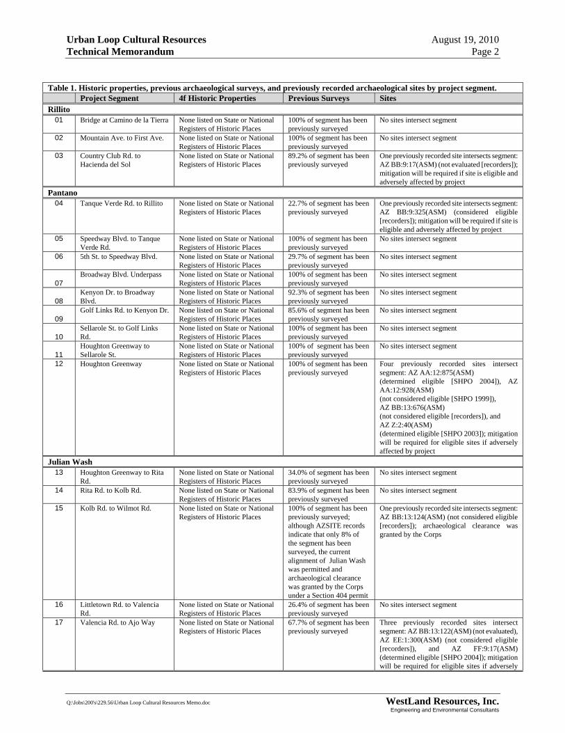
Urban Loop Cultural Resources August 19, 2010 Technical Memorandum Page 2
Q:\Jobs\200's\229.56\Urban Loop Cultural Resources Memo.doc WestLand Resources, Inc. Engineering and Environmental Consultants
Table 1. Historic properties, previous archaeological surveys, and previously recorded archaeological sites by project segment. Project Segment 4f Historic Properties Previous Surveys Sites Rillito
01 Bridge at Camino de la Tierra None listed on State or National Registers of Historic Places
100% of segment has been previously surveyed
No sites intersect segment
02 Mountain Ave. to First Ave. None listed on State or National Registers of Historic Places
100% of segment has been previously surveyed
No sites intersect segment
03 Country Club Rd. to Hacienda del Sol
None listed on State or National Registers of Historic Places
89.2% of segment has been previously surveyed
One previously recorded site intersects segment: AZ BB:9:17(ASM) (not evaluated [recorders]); mitigation will be required if site is eligible and adversely affected by project
Pantano 04 Tanque Verde Rd. to Rillito None listed on State or National
Registers of Historic Places 22.7% of segment has been previously surveyed
One previously recorded site intersects segment: AZ BB:9:325(ASM) (considered eligible [recorders]); mitigation will be required if site is eligible and adversely affected by project
05 Speedway Blvd. to Tanque Verde Rd.
None listed on State or National Registers of Historic Places
100% of segment has been previously surveyed
No sites intersect segment
06 5th St. to Speedway Blvd. None listed on State or National Registers of Historic Places
29.7% of segment has been previously surveyed
No sites intersect segment
07 Broadway Blvd. Underpass None listed on State or National
Registers of Historic Places 100% of segment has been previously surveyed
No sites intersect segment
08 Kenyon Dr. to Broadway Blvd.
None listed on State or National Registers of Historic Places
92.3% of segment has been previously surveyed
No sites intersect segment
09 Golf Links Rd. to Kenyon Dr. None listed on State or National
Registers of Historic Places 85.6% of segment has been previously surveyed
No sites intersect segment
10 Sellarole St. to Golf Links Rd.
None listed on State or National Registers of Historic Places
100% of segment has been previously surveyed
No sites intersect segment
11 Houghton Greenway to Sellarole St.
None listed on State or National Registers of Historic Places
100% of segment has been previously surveyed
No sites intersect segment
12 Houghton Greenway None listed on State or National Registers of Historic Places
100% of segment has been previously surveyed
Four previously recorded sites intersect segment: AZ AA:12:875(ASM) (determined eligible [SHPO 2004]), AZ AA:12:928(ASM) (not considered eligible [SHPO 1999]), AZ BB:13:676(ASM) (not considered eligible [recorders]), and AZ Z:2:40(ASM) (determined eligible [SHPO 2003]); mitigation will be required for eligible sites if adversely affected by project
Julian Wash 13 Houghton Greenway to Rita
Rd. None listed on State or National Registers of Historic Places
34.0% of segment has been previously surveyed
No sites intersect segment
14 Rita Rd. to Kolb Rd. None listed on State or National Registers of Historic Places
83.9% of segment has been previously surveyed
No sites intersect segment
15 Kolb Rd. to Wilmot Rd. None listed on State or National Registers of Historic Places
100% of segment has been previously surveyed; although AZSITE records indicate that only 8% of the segment has been surveyed, the current alignment of Julian Wash was permitted and archaeological clearance was granted by the Corps under a Section 404 permit
One previously recorded site intersects segment: AZ BB:13:124(ASM) (not considered eligible [recorders]); archaeological clearance was granted by the Corps
16 Littletown Rd. to Valencia Rd.
None listed on State or National Registers of Historic Places
26.4% of segment has been previously surveyed
No sites intersect segment
17 Valencia Rd. to Ajo Way None listed on State or National Registers of Historic Places
67.7% of segment has been previously surveyed
Three previously recorded sites intersect segment: AZ BB:13:122(ASM) (not evaluated), AZ EE:1:300(ASM) (not considered eligible [recorders]), and AZ FF:9:17(ASM) (determined eligible [SHPO 2004]); mitigation will be required for eligible sites if adversely

Urban Loop Cultural Resources August 19, 2010 Technical Memorandum Page 3
Q:\Jobs\200's\229.56\Urban Loop Cultural Resources Memo.doc WestLand Resources, Inc. Engineering and Environmental Consultants
affected by project Santa Cruz
18 Ajo Way to 29th St. None listed on State or National Registers of Historic Places
95.3% of segment has been previously surveyed
One previously recorded site intersects segment: AZ BB:13:17(ASM) (determined eligible [SHPO 2002]); mitigation will be required if site is adversely affected by project
19 Grant Rd. to Camino del Cerro
None listed on State or National Registers of Historic Places
53.1% of segment has been previously surveyed
Four previously recorded sites intersect segment: AZ AA:12:44(ASM)(not considered eligible [SHPO 2001]), AZ AA:12:95(ASM) (determined eligible [SHPO 2004]), AZ AA:12:96(ASM) (determined eligible [SHPO 2003]), and AZ AA:12:99(ASM) (not evaluated); mitigation will be required for eligible sites if adversely affected by project
20 Camino del Cerro to Rillito River
None listed on State or National Registers of Historic Places
100% of segment has been previously surveyed
No sites intersect segment
Table 2 provides a qualitative assessment of the probability of adverse effects to cultural resources and required Section 106 consultation resulting from each proposed project segment. This assessment takes into account 1) Pima County’s archaeological sensitivity classification of the area in which the segment lies, 2) the percentage of the project segment that has been previously surveyed, and 3) the number and eligibility status of archaeological sites that intersect the segment. Required Section 106 consultation was identified as not likely for eight segments (1, 2, 5, 7, 10, 11, 15, and 20), and possible but not likely for four segments (segments 8, 9, 13, and 14). Consultation may be required for three segments (segments 4, 6, and 16), and is likely for five segments (segments 3, 12, 17, 18, and 19).
Table 2. Potential for adverse effect and Section 106 Consultation in accordance with the requirements of the National Historic Preservation Act.Segment
No. Pima County
Cultural Resource Zone Probability of Required
Consultation 1 Priority Archaeological Sites Consultation not likely 2 Priority Historic Sites Consultation not likely 3 Priority Historic Sites Consultation may be required 4 Priority Archaeological Sites, Priority Archaeological Site
Complexes Consultation likely
5 Priority Archaeological Site Complexes Consultation not likely 6 Priority Archaeological Site Complexes Consultation may be required 7 Priority Archaeological Site Complexes Consultation not likely 8 Priority Archaeological Site Complexes, None Consultation possible, but not likely 9 Archaeological Sensitivity Zone Consultation possible, but not likely 10 Archaeological Sensitivity Zone, None Consultation not likely 11 Archaeological Sensitivity Zone Consultation not likely 12 Archaeological Sensitivity Zone, Priority Historic Sites Consultation likely 13 Not Classified Consultation possible, but not likely 14 Not Classified Consultation possible, but not likely 15 Not Classified Consultation not likely 16 Not Classified Consultation may be required 17 Not Classified Consultation likely 18 Priority Historic Sites, Priority Archaeological Site
Complexes Consultation likely
19 Priority Archaeological Sites, Priority Archaeological Site Complexes
Consultation likely
20 Priority Archaeological Sites Consultation not likely

úú
úú
ú
ú
File: M:\projects\229.56\ARC\MXD\Figures\Fig1_Project_location.mxd
³0 2 4
Kilometers
0 1 2Miles
LegendCompleted
Fully Funded
Funds Requested
Project LocationFigure 1
URBAN LOOP

")17
")12
")19
")14
")13
")04
")11
")09
")20
")16
")15
")10
")05
")18
")06
")02
")08
")03
")07
")01
"
AZ BB:13:17(ASM)
"
AZ FF:9:17(ASM)
"
AZ AA:12:95(ASM)
"AZ AA:12:96(ASM)
"
AZ AA:12:875(ASM)"
AZ AA:12:99(ASM)
"
AZ Z:2:40(ASM)
"AZ AA:12:928(ASM)
"
AZ AA:12:44(ASM)
"
AZ AA:12:875(ASM)
"AZ AA:12:928(ASM)
"
AZ EE:1:300(ASM)
"
AZ BB:13:676(ASM)"
AZ AA:12:875(ASM)
"AZ AA:12:875(ASM)
"AZ AA:12:875(ASM)
"AZ BB:9:325(ASM)
"
AZ BB:13:124(ASM)
"
AZ BB:13:122(ASM)
"AZ BB:9:17(ASM)
úú
úú
ú
ú
File: M:\projects\229.56\ARC\MXD\Figures\Fig2_Path_with_Previous_Research.mxd
³0 2 4
Kilometers
0 1 2Miles
LegendCompleted
Fully Funded
Funds Requested
Archaeological Site
Previous Project
Previous ResearchFigure 2
URBAN LOOP

") ")
")
")")")
")
")
")")")
")
")
")
")
")
")
") ")
")
")
")
")")
")") ")
")
")
")
")
") ")")") ")
")
")
")")")
")
")
")
")
")
")
")")
")
")")
")")")
")
") ")")
")
")
")")
")
")
")
")
")
")
")")")")")") ")")")")
")
")
")
")
")
")
")
")
")
")")
")
")
")
")")
")
")
")
")
úú
úú
ú
ú
File: M:\projects\229.56\ARC\MXD\Figures\Fig3_Path_with_Historic_Properties.mxd
³0 2 4
Kilometers
0 1 2Miles
Legend") Historic Property
Completed
Fully Funded
Funds Requested
Historic PropertiesFigure 3
URBAN LOOP