nathan w stottler landscape architectue design process portfolio
DESCRIPTION
Portfolio of my student work, detailing the desgin process I follow in all of my landscape architectural works.TRANSCRIPT

NATHAN W STOTTLER . glandscape architecture design process portfolio

CHAPTERSSKETCH 01
ANALYZE 02PLAN 03
DEVELOP 04CONSTRUCT 05
PHOTOGRAPH 062 . G G . 31241 111/2 st. n. fargo, nd. 58102 | [email protected] | 320.226.7688

SKETCHMy design process begins with site immersion. Going beyond a mere site visit, practicing full immersion with a potential design locale allows me to gain a more accurate perception for sense of place. The initial observations I gain on site I record not only in photograph form, but also in sketch form. This allows me to capture feelings and emotions more accurately and preserve them for my own use throughout the design process. These initial impressions are vital to informing my designs. I also use sketching to communicate conceptual site ideas within design teams and also with clients. The sketch to the right, and the full-page sketch on the next page, is a practice in sense of place capture at a harbor in Liverpool, England that I completed for an urban design seminar in my third year of study at North Dakota State.
4 . G G . 5
2 . G

The sketch above is a conceptual design perspective for a farmers’ market plaza that I proposed for a regional park during a second-year park design studio. The sketch, accompanied with others, shaped my early design ideas and provided a basis for those ideas as I moved forward. Though the design changed, this sketch embodied the sense of place I eventually created.
This sketch is a conceptual perspective for a waterfront renewal project on the East River Esplanade in New York City for a third-year site planning studio. It details a conceptual farmers’ market on an introduced pierway system along the river. A drawing at this scale captures not only proposed forms but also a suggestion of human interaction within the site.
This final sketch is from a site immersion activity I completed while studying the SoHo neighborhood of London. During a fantasy literature course I completed while studying in London, I was to write a short story in the fantasy genre that took place in the city. Using my site immersion techniques was vital to writing an engaging and descriptive short story.
G . 7

ANALYZEAnalysis is the next step in my design process. Through site analysis, designs can become informed through not only intangible elements but through physical features as well. Proper inventory of a prospective site allows me to develop a detailed analysis, which in turn provides me with the information I need to begin the development of a design proposal. Information gathered during site immersion couples with intense research and, at times, self-conducted surveys or studies to provide a solid base of information from which I begin to form a site-appropriate design intervention proposal. The graphic opposite is an early-stage plan overlay from a fourth-year site remediation studio that pulls out key site elements and begins to examine possible future site functions.
8 . G G . 9
london, england
block pattern building pattern
node/connection primary/secondary
prim
ary
seco
ndar
y
void/density
frontagedistrict centrality footprint
figure/groundL I V E R P O O L U N I T E D K I N G D O M
NathanStottler
+
Prof.D
onFaulkner
+
Arch4
61 +
Spring2012Population:4
45,200[20
06]
+
PopulationDensity:10,072.5/sq.km
.
F i g u r e .G r o u n d C i t y . E l e m e n t s
Weat her.Patt er n s S i t e . F u n c t i o n s
S c a l e : 1 ” = 10 0 0 ’
Ind
ustria
lR
esidential
Co
mm
erc
ial
BATTLE CREEK EMERGENT WETLAND PIG’S EYE LAKE
PCBS, VOCS, HEAVY METALS (CONTAINED)
HEAVY METALS (STABILIZED) PFCS(LEACHING)
SOILS ANALYSIS
WATERSHED ANALYSIS
CONTAMINATION ANALYSIS
STRUCTURAL ANALYSIS
Udorthents Kerston Muck Chaska Silt Loam
Battle creek emergent Wetlands Pig’s eye lake
Vocs, PcBs, contained heaVy metals, staBilized PFcs, leaching
roads rail yards Water treatment Plant chiPPing FacilityWood
This soil layer is composed of wet substratum, the majority of which consists of landfill material. The water table is located near or above the 10-foot mark, allowing for much leaching of contaminants. Slopes of no more than 6 percent occur here.
This soil layer is composed of saturated alluvial soils, being at or below the water table. Pooling is common and prevalent, leading to the existence of extensive emergent wetlands at the north end of Pig’s Eye Lake. Slopes are not present here.
This soil layer is composed of poorly-drained alluvium, commonly found in flood plains. Located just above the water table, this area is prone to frequent flooding, though water will not often pond here. Slopes of no more than 2 percent occur here.
Battle creek flows down to Pig’s Eye Lake from a ravine beyond the rail yard. Formerly a meandering stream, the landfill has forced it into a channelized path as it flows through contaminated areas, bringing PFCs to the lake itself.
Emergent wetlands at the head of the lake are all that remains of an extensive network of sloughs and bogs that used to stretch across what is now the landfill. They wrap from the edge of the woodland on the west around past the mouth of the creek on the east.
Pig’s Eye Lake is a back water of the Mississippi River, receiving water from Battle Creek and discharging it into the river. Contaminants from the landfill have accumulated in the sediments of the lake, where extensive
The main body of the landfill is still contaminated with a variety of toxins, ranging from VOCs to PCBs and heavy metals. A high-organic filter strip, located at the edge of Battle Creek, filters all contaminated groundwater before it enters the lake. This has effectively contained the majority of contaminants on-site.
Two ponds were formerly located on site. These two locations were the source of significant heavy metal contamination found in surface water samples from the lake. The ponds were filled in and trees planted in place. This has stablilized, but not removed, the heavy metals located here.
The only toxin currently found to exceed state surface water quality standards in Pig’s Eye Lake are PFCs. Their source has been narrowed to an area spanning both banks of Battle Creek in management areas 1A and 1B. The contaminants are washing into the creek and completely missing the filter strip, allowing them to flow freely into the lake.
The site can only be accessed via Pig’s Eye Lake Road, which is used primarily for industrial traffic to the wood chipping facility, water treatment plant, and rail yards. Together with HWY 61 and the rail yards, the site is completely cut off fromthe rest of the city.
The site is pinched between two rail yards, to the northeast and southwest. The northeastern site is one of the largest rail yards in the metro area, with a constant stream of train traffic. The southern rail yard must be crossed by any vechicles approaching the site.
The Metro Water Treatment Plant located across Pig’s Eye Lake Road to the southwest provides much of the traffic on Pig’s Eye Lake Road. Together with the rail yard and the road, the site is completely blocked off from the Mississippi River.
The Wood Chipping Facility exists on a portion of the old landfill. It is separated from the savannah management area by a belt of trees runningaround it. This is the only active use curently associated with the former landfill grounds.
SITE MAPPING BREAKDOWN
Further remediation efforts are needed in the main area of the landfill. We find the largest remediation needs in locations where contaminants are leaching into the surface water. Removal of these contaminants through various techniques is necessary. However, understanding the contaminants, where they are found and how toxic they may be, is all crucial inventory for future design efforts.
The soils on the site are very wet, due to their proximity to the river, their floodplain location, and their alluvial makeup. This causes much difficulty in containing contaminants on site and protecting surface water. Existing measures are only temporary in nature, and a more permanent solution should be sought.
As the high-organic soil buffer is currently filtering most contamination from the ground water seeps at the edge of the wetlands, contaminants entering from Battle Creek take the highest priority for remediation efforts here.
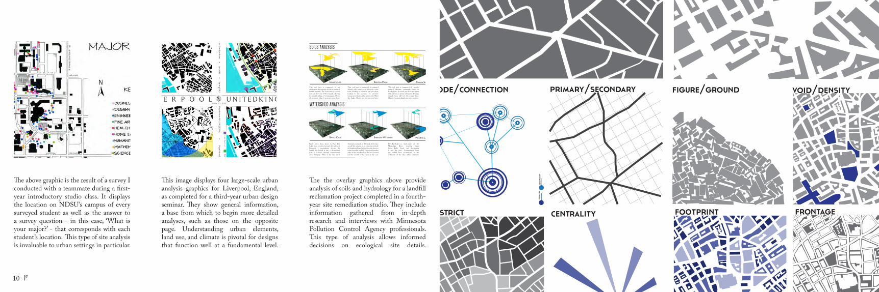
The above graphic is the result of a survey I conducted with a teammate during a first-year introductory studio class. It displays the location on NDSU’s campus of every surveyed student as well as the answer to a survey question - in this case, ‘What is your major?’ - that corresponds with each student’s location. This type of site analysis is invaluable to urban settings in particular.
This image displays four large-scale urban analysis graphics for Liverpool, England, as completed for a third-year urban design seminar. They show general information, a base from which to begin more detailed analyses, such as those on the opposite page. Understanding urban elements, land use, and climate is pivotal for designs that function well at a fundamental level.
The the overlay graphics above provide analysis of soils and hydrology for a landfill reclamation project completed in a fourth-year site remediation studio. They include information gathered from in-depth research and interviews with Minnesota Pollution Control Agency professionals. This type of analysis allows informed decisions on ecological site details.
10 . G

PLANWhen analysis is done, site planning commences. Beginning with conceptual design planning and leading up through the master planning of a site, this phase is the workhorse of my design process. The first two steps inform a design typology - this step sees that design come to life. Overall site layout is determined by those site uses the analysis phase revealed as necessary. Site elements are chosen and placed, all based upon the first two steps. Iteration replaces iteration until I reach a design which I can deem satisfactory. The conceptual sketch at left is one of the first drawings I used to begin shaping the street and park structure for a greenfield development project in a third year neighborhood design studio. It is these sorts of graphics that first inform, and then give way to, more detailed and well-rendered images later in the planning process. This conceptual plan turned into the final master plan that is displayed on the next page.
12 . G G . 13

32nd Avenue South
51th
Ave
S
Bran
dt D
r
31st
Ave
S
33rd Ave S
36th Ave S
49th
Ave
S
45th Street Southwest
This is the final rendered bird’s-eye plan for the farmers’ market plaza that was displayed in a conceptual sketch on page seven. Here we see how the planning process led to a series of continual modifications until an end product was reached. A bird’s-eye site plan was used because this project was presented to an audience of lay-persons, who may find plan graphics difficult to read.
This rendered bird’s-eye plan is the final product of the New York City waterfront revitalization project also shown in conceptual sketch form on page seven. This project was entered in a contest judged by lay-people, and therefore a bird’s-eye perspective was chosen. At this scale, human interaction is not shown so much as overall placement and site form.
This final bird’s-eye plan is for a marketplace designed in Denver, Colorado for a fourth-year urban design studio. Again, a bird’s-eye graphic was chosen for readability during the proposal’s presentation. The plan form shown here is the final reached after many consecutive ideas were improved, reworked, or discarded. I find that much reworking leads to a more successful product.
G . 15

DEVELOPDevelopment of site details and final rendered perspectives is the fourth phase of my design process. Here, the final pieces of proposed designs come together to inform viewers of the exact sense of place I have developed over the last three phases. Using 3D modelling and rendering programs, I am able to display my design proposals in highly developed, accurate perspective images. These renderings place the viewer in-site, giving them the perspective of an active user of the design. This allows clients to gain an accurate sense of how the design will look, feel, and function when it is finished. I choose perspectives from among the many possible locations on site based upon both aesthetic composition and maximum design communication. The sketch at left was used in a third-year neighborhood design studio to help choose perspective images on site.
16 . G G . 17

The above perspective is from the same farmers’ market plaza as seen in the plan on page 15. Shown is the viewshed of a patron sitting at a table on the plaza, taking in the sight of a small child interacting with a water feature. In the background can be seen numerous farmers’ market stalls on both levels of the plaza. The perspective was rendered from a Sketch-up model.
This perspective is from the waterfront revitalization project plan as seen on page 15. Again rendered from a Sketch-up model, this image shows a person interacting with the site in the foreground, and a pair of boaters deboarding from a sailboat docked at the pier in the mid-ground. In the background, the sun sets behind the Manhattan skyline.
The perspectives both above and to the right are from the marketplace as seen in the plan on page 15. They detail two separate areas of the marketplace - The plaza space occupied by temporary market stalls and a trolley (above) and a restaurant/dining area (right). The inclusion of furniture, materials, lighting, people, and other details make the scene come to life.
18 . G

CONSTRUCTThe final stage of my design process is construction. Here, I take the designs I have carefully developed over the last four steps and turn them into accurate, readable documents that detail the process by which my designs may be built. I am fluent with AutoCAD, and am able to produce detailed, readable construction drawings for construction managers and builders to use. From large-scale site development drawings to small-scale detail drawings, I am able to produce the documents needed to see a site developed to its fullest. My skills extend from site grading, drainage planning, watershed management, and road alignment to structural detailing, pavement detailing, and planting detailing. The sketch at left was used to set up an elevation graphic for a trail system and remediation plantings in a fourth-year site remediation studio.
20 . G G . 21

The plan graphics above and at left are for a high school design proposal, from a third-year site development class. At left is a proposed grading plan, including grading for fields, roads, and parking lots. Above is a watershed delineation plan imposed upon the grading plan. Calculations were then done for each watershed to plan for runoff conveyance and storage.
This graphic is an elevation, detailing a park shelter for a fourth-year site detailing class. The document details materials and support systems, and also includes measurements necessary for construction. In full, the document also included other elevation graphics, structural details, and an overall structural plan. Together, they worked to complete the construction plan.
The above graphic belonged to a set of planting details, and is from the same project as the park shelter to the left. This particular graphic is a planting detail for a tree, and includes specifications for the tree, as well as detailed instructions for planting. Accompanying graphics include shrub and grass planting details, plant specifications, and an overall planting plan.
G . 23

PHOTOGRAPHEnvironmental design pervades through all portions of my life. Though the design process I have detailed thus far applies to the work I do, I am constantly thinking about design work, and continually seeking ways for my everyday life to inform my work. I have had the privilege to do a fair amount of travelling in my life, and everywhere I go I do my best to practice full site-immersion activities. I do my best to soak in my surroundings, gain an understanding of their functions, and use those understandings to inform my own design work. By constantly seeking, finding, and learning, I am able to continually develop my own design talents as I seek to become the best designer I can be. The photograph at left is a shot of myself in full site immersion, in this case along the banks of the River Thames in London, England during the summer of 2012.
24 . G G . 25

This is a photograph I took along the banks of the Chicago River in Chicago, Illinois during a third-year neighborhood design studio trip. Though I come from a rural home, I am able to find myself at home both in the wilderness and in urban areas. Chicago was an eye-opening experience for this small-town country kid, and I reveled in every moment I spent there.
Above is a photograph of a small creek in the El Yunque National Rainforest outside of San Juan, Puerto Rico, taken during a fourth-year advanced planning seminar trip. This trip embodied both of my design loves - environmental planning and urban design. Immersing myself during a twelve-mile hike in the rainforest was one of the most memorable experiences of my life.
The pictures above and at right were taken in London, England during a summer of 2012 study abroad trip. There, I broadened my studies through a London fantasy literature course, which helped me immerse myself in the city in a way no tourist could. The photograph above is of Tower Bridge in full Olympic regalia, while the photograph at right is a street scene along The Strand.
26 . G

NATHAN W STOTTLERI hope you have enjoyed reading about the design process I work through as a landscape architecture student. Now, let me tell you a little bit more about myself. Though I am currently a fourth-year student of landscape architecture and natural resources management at North Dakota State University in Fargo, ND, I was born and raised in rural Minnesota. There, I grew up in a family that revolved around the outdoors. Hunting and fishing have been my way of life since I was old enough to walk in the field with my family members, and they continue to be my favorite pastimes to this day. It is through my outdoor childhood experiences that I came to choose landscape architecture as a profession. My greatest passions in environmental design center upon urban and regional planning as well as environmental planning. My hope as a landscape architect is to influence both the human and natural environments in a manner that employs maximum mutual benefit. Outside of this, I am an avid learner - both in and out of school - and greatly enjoy both reading and writing. I travel at any chance I can get, to any destination I can reach. I am a huge proponent of environmentalism, with my designs and editorial writings centered upon progressive environmental issues.
28 . G G . 29

1241 111/2 st. n. fargo, nd. [email protected] | 320.226.7688NATHAN W STOTTLER . g