nasa satellite laser ranging program monument peak
TRANSCRIPT
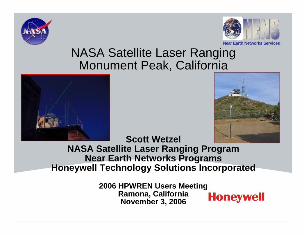
NASA Satellite Laser Ranging Monument Peak, California
Scott WetzelNASA Satellite Laser Ranging Program
Near Earth Networks ProgramsHoneywell Technology Solutions Incorporated
2006 HPWREN Users MeetingRamona, CaliforniaNovember 3, 2006
Near Earth Networks Services

2N e a r E arth N e tw o rks S e rv ic e s
2
NASA Satellite Laser Ranging, Monument Peak, CA
3N e a r E arth N e tw o rks S e rv ic e s
3
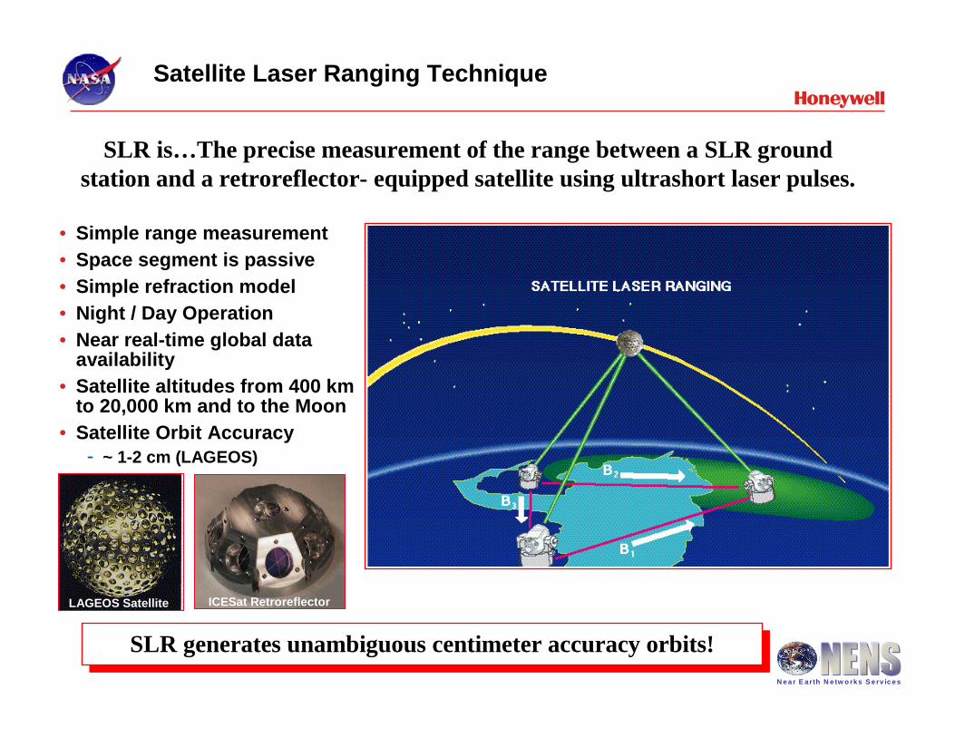
• Simple range measurement• Space segment is passive• Simple refraction model• Night / Day Operation• Near real-time global data
availability• Satellite altitudes from 400 km
to 20,000 km and to the Moon• Satellite Orbit Accuracy
- ~ 1-2 cm (LAGEOS)
SLR generates unambiguous centimeter accuracy orbits!SLR generates unambiguous centimeter accuracy orbits!
SLR is…The precise measurement of the range between a SLR ground station and a retroreflector- equipped satellite using ultrashort laser pulses.
Satellite Laser Ranging Technique
LAGEOS Satellite ICESat Retroreflector
4N e a r E arth N e tw o rks S e rv ic e s
4
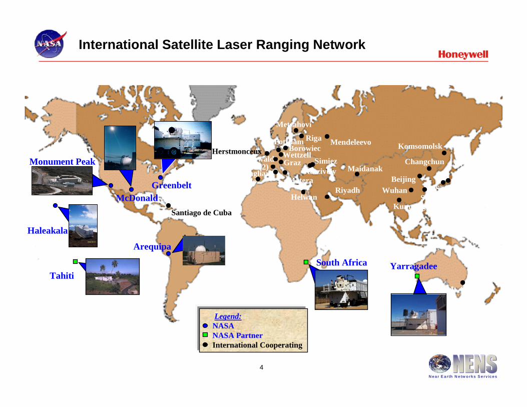
Keystone (4)
Haleakala
McDonaldGreenbelt
Arequipa
South Africa
Monument Peak
Santiago de Cuba
Herstmonceux
RiyadhHelwan
San FernandoCagliari
Grasse (2) GrazZimmerwald Wettzell
PotsdamBorowiec
Metsahovi
SimiezKatzively Maidanak
Wuhan
Komsomolsk
Changchun
Beijing
ShanghaiSimosato
Yarragadee
Mt. Stromlo
Matera
Tahiti
Riga
Kunming
Mendeleevo
Legend:NASANASA Partner International Cooperating
International Satellite Laser Ranging Network
5N e a r E arth N e tw o rks S e rv ic e s
5
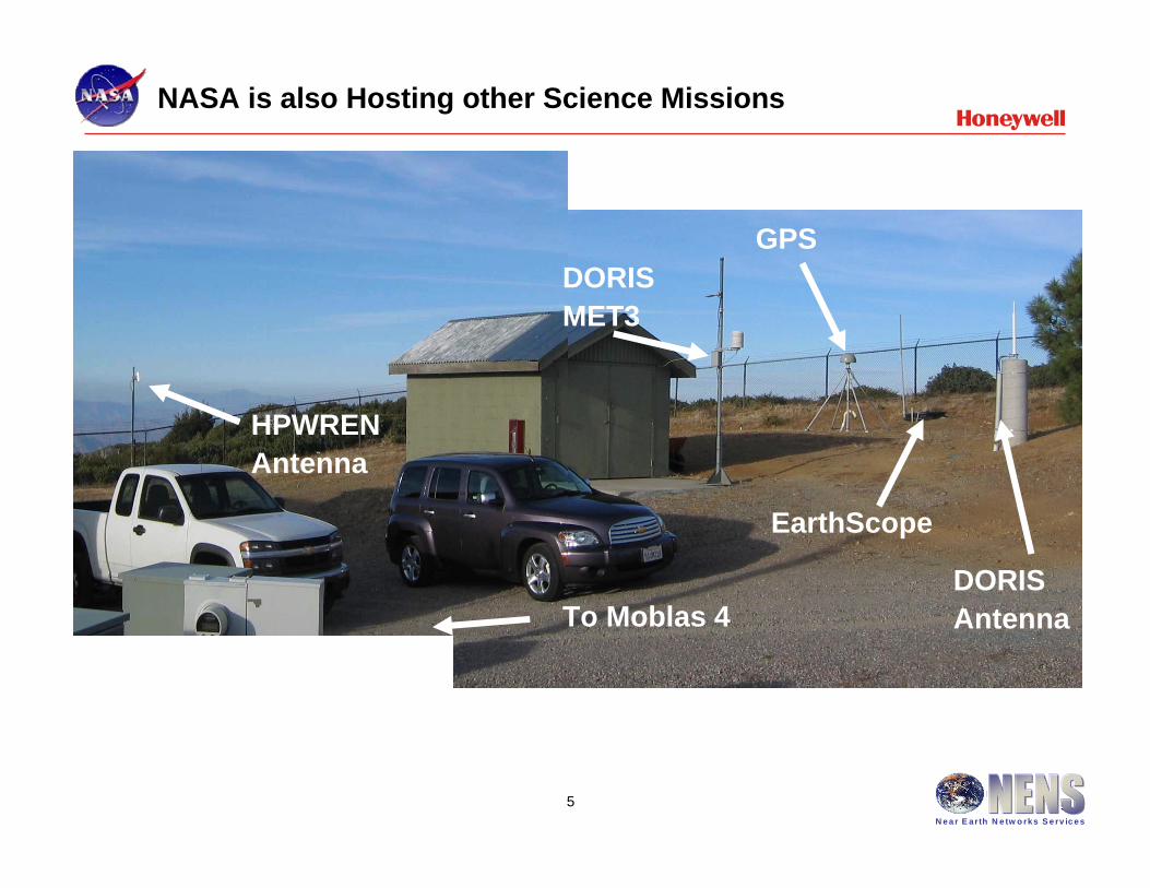
NASA is also Hosting other Science Missions
HPWRENAntenna
DORIS AntennaTo Moblas 4
EarthScope
DORIS MET3
GPS
6N e a r E arth N e tw o rks S e rv ic e s
6
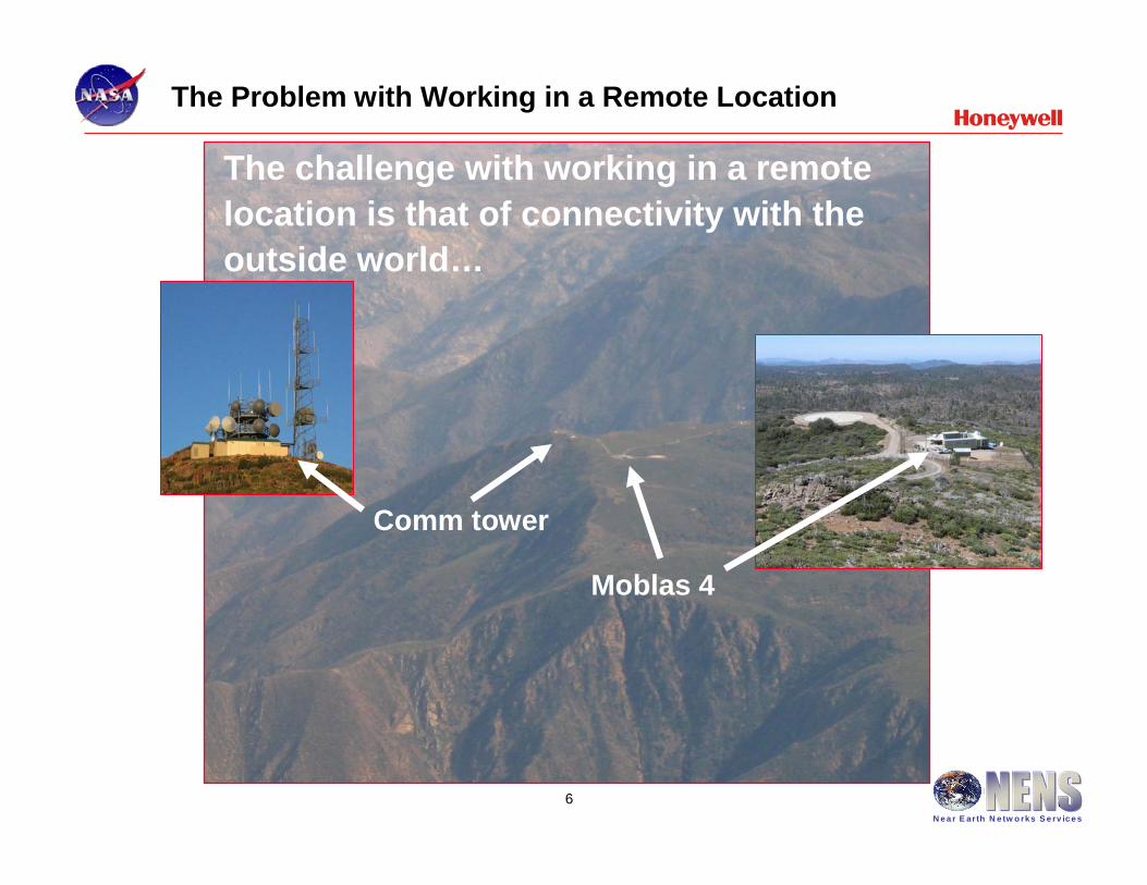
The Problem with Working in a Remote Location
Moblas 4
The challenge with working in a remote location is that of connectivity with the outside world…
Comm tower
7N e a r E arth N e tw o rks S e rv ic e s
7
How Did We Come to Join HPWREN
• We connected to the HPWREN in January 2005.
• HPWREN allows NASA to move SLR data hourly to NASA SLR HQ quickly and reliably and to allow engineering support from Maryland
• NASA appreciates the HPWREN and the service provided to our remote system
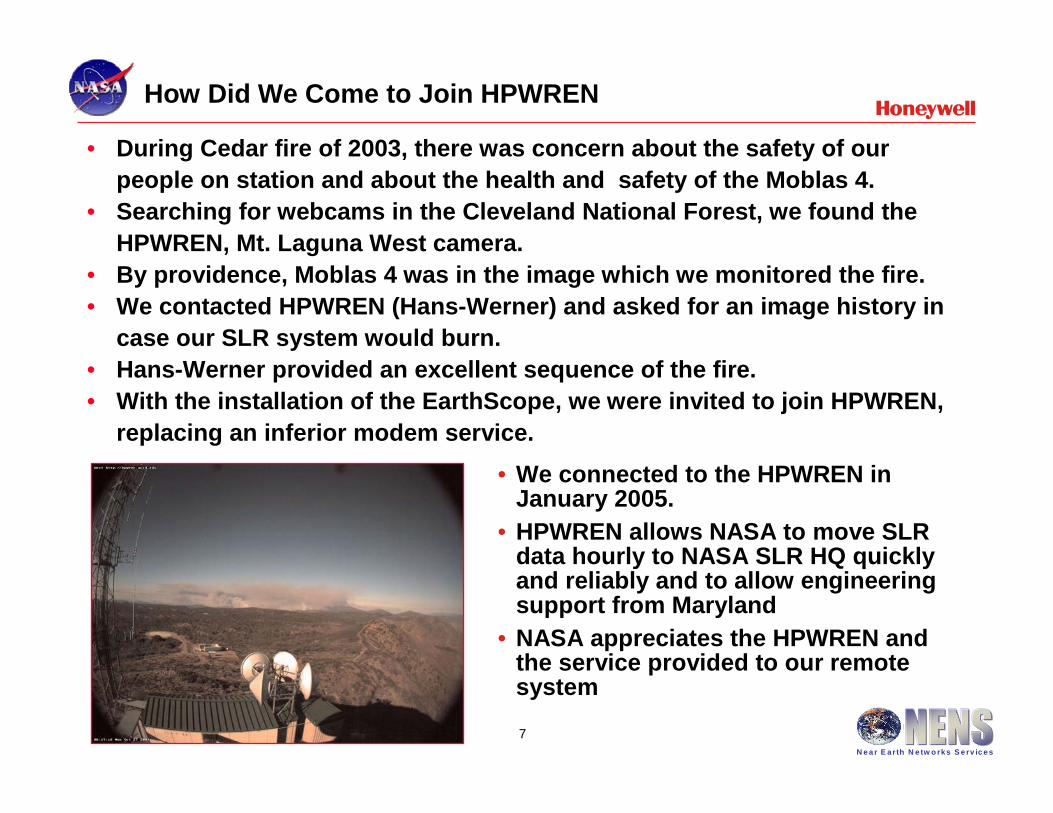
• During Cedar fire of 2003, there was concern about the safety of our people on station and about the health and safety of the Moblas 4.
• Searching for webcams in the Cleveland National Forest, we found the HPWREN, Mt. Laguna West camera.
• By providence, Moblas 4 was in the image which we monitored the fire.• We contacted HPWREN (Hans-Werner) and asked for an image history in
case our SLR system would burn.• Hans-Werner provided an excellent sequence of the fire. • With the installation of the EarthScope, we were invited to join HPWREN,
replacing an inferior modem service.
8N e a r E arth N e tw o rks S e rv ic e s
8
Our Request to Become Part of the HPWREN Team
• The MOBLAS-4 system is located in Monument Peak, California on a NASA GSFC site which is in cooperation with the California Cleveland National Forest Service. This is a remote site situated about 1 hour east of San Diego with limited communications and self sufficient metropolitan services. The MOBLAS-4 compound is also home to other scientific observational systems such as the Scripps Orbit and Permanent Array Center (SOPAC - http://sopac.ucsd.edu/) permanent Global Positioning System station, the soon to be upgraded EarthScope geophysical station (http://www.earthscope.org/), and the soon to be constructed Doppler Orbitography and Radiopositioning Integrated by Satellite Precise orbit determination and location system (DORIS - http://ids.cls.fr/welcome.html).
• Presently, the MOBLAS-4 system uses a commercial 56 kilobit data communications line to transmit an average of 120 kilobytes of tracking data per hour, with an approximate peak of 265 kilobytes, using File Transfer Protocol (FTP). Each hour, the Lynx based data processing computer automatically transmits satellite laser ranging data. This data communications line is also used by the three person crew to send text based system status reports once per shift, monitor weather conditions every few hours for several minutes, communicate with NASA SLR Headquarters in Greenbelt, Maryland, communicate with other SLR systems throughout the world using electronic mail, and to maintain the MOBLAS-4 site via a Windows based desktop computer. The NASA SLR Program engineering staff in Greenbelt, Maryland uses the communication line, via FTP and Telenet, to troubleshoot software anomalies, investigate hardware problems, and upgrade system software. The engineering staff communicates with the data processing computer mentioned above as well as the controller computer, both of which require a static IP address. Unfortunately, the commercial communications service is relatively slow with network connections intermittent. The service is many times interrupted during data communications and system functions, requiring repeated data transmissions and delayed system operations. The 56 kilobit service is also used by the MOBLAS-4 crew to periodically communicate with the sponsors of the other geophysical experiments taking place at the MOBLAS-4 site, such as SOPAC, EarthScope, and DORIS.
• Permission is requested to become part of the HPWREN collaboration of researchers. The NASA MOBLAS-4 site is home to several other geophysical experiments, one of which is already part of the HPWREN alliance, EarthScope. The HPWREN Usage Conditions and Participants Protocol agreement has been read and will be followed. Requests and questions cited in the agreement will be addressed when directed. The following are pictures of the MOBLAS 4 during daytime and nighttime operations. These may be a familiar as the MOBLAS-4 can be seen in the view of the HPWREN Mt. Laguna West camera.