name regents review #6 date - abbott...
TRANSCRIPT

Name ________________________ Regents Review #6 Date _____________
A) B)
C) D)
1. Which profile best shows the general depositional pattern that occurs when water from a stream entersthe ocean?
A) decreasing temperature and decreasingprecipitation
B) decreasing temperature and increasingprecipitation
C) increasing temperature and decreasingprecipitation
D) increasing temperature and increasingprecipitation
2. Which long-term atmospheric changes wouldincrease the rate of chemical weathering of surfacebedrock?
A) B)
C) D)
3. Which graph shows the relationship between thedensity of particles and their settling time in stillwater?[Assume that the particles have the samesize and shape.]
4. Four samples of aluminum, A, B, C, and D, haveidentical volumes and densities, but differentshapes. Each piece is dropped into a long tubefilled with water. The time each sample takes tosettle to the bottom of the tube is shown in thetable below.
A) B)
C) D)
Which diagram most likely represents the shape ofsample A?
A) cobbles B) pebblesC) sand D) silt
5. Which sediment is most easily picked up andtransported by the wind?

Regents Review #6
Base your answers to questions 6 and 7 on the cross section below, which shows the bedrock of a portionof the Helderberg Escarpment, located in Tacher State Park near Albany, New York. The rock formationsare identified by name.
A) Esopus and OriskanyB) Onondaga and CoeymansC) Schoharie, and Marcellus and HamiltonD) New Scotland, and Schenectady and Indian Ladder beds
6. Which formations appear to be the most resistant to weathering?
A) elevation above sea level B) mineral compositionC) age of rock layers D) environment of formation
7. What is the main factor that causes the bedrock to weather at different rates?
8. The diagram below shows sand particles beingmoved by wind.
A) deserts and beachesB) deltas and floodplainsC) glaciers and morainesD) mountain peaks and escarpments
At which Earth surface locations is this process usuallythe most dominant type of erosion?
A) Glacial deposits and river deposits are bothsorted.
B) Glacial deposits are sorted, and river depositsare unsorted.
C) Glacial deposits are unsorted, and riverdeposits are sorted.
D) Glacial deposits and river deposits are bothunsorted.
9. Which statement best describes sedimentsdeposited by glaciers and rivers?
A) pebble B) sandC) silt D) clay
10. Which size particle will remain suspendedlongest as a river enters the ocean?

Regents Review #6
Base your answers to questions 11 through 13 on the map of Long Island, New York. AB, CD, EF and GH are reference lines on the map.
A) AB B) CD C) EF D) GH
11.The cross section below represents the sediments beneath the land surface along one of the referencelines shown on the map.
Along which reference line was the cross section taken?
A) water B) windC) ice D) mass movement
12. Which agent of erosion transported the sediments that formed the moraines shown on the map?
A) larger B) sorted C) more angular D) older
13. A major difference between sediments in the outwash and sediments in the moraines is that thesediments deposited in the outwash are
A) water velocity decreasesB) stream gradient increasesC) water is deeperD) stream is narrower
14. Deposition within a meandering stream usuallyoccurs on the inside of the curves because the
A) mass movement B) running waterC) prevailing winds D) ocean waves
15. Which natural agent of erosion is mainlyresponsible for the formation of the barrierislands along the southern coast of Long Island,New York?
16. The diagram below shows a cross section of ariver. Letters A, B, C, and D represent points inthe river.
A) A B) B C) C D) D
At which point is the water most likely to have thegreatest velocity?

Regents Review #6
17. The diagram below shows the stump of a tree whose root grew into a small crack in bedrock andsplit the rock apart.
A) chemical weathering B) depositionC) erosion D) physical weathering
The action of the root splitting the bedrock is an example of
18. The picture below shows a geological feature inthe Kalahari Desert of southwestern Africa.
A) wind erosionB) volcanic eruptionC) earthquake vibrationsD) plate tectonics
Which process most likely produced the presentappearance of this feature?
A) It will become jagged and its mass willdecrease.
B) It will become jagged and its volume willincrease.
C) It will become rounded and its mass willincrease.
D) It will become rounded and its volume willdecrease.
19. What change will a pebble usually undergo whenit is transported a great distance by streams?
20. The map below shows a meandering stream as itenters a lake. The arrow shows the direction ofstream flow. Points A through D representlocations on the surface of the stream.
A) A and B B) B and CC) C and D D) D and A
The greatest stream velocities are found closest topoints
A) windB) landslidesC) meandering streamsD) continental glaciers
21. Which agent of erosion was primarily responsiblefor forming the long, narrow, U-shaped valleys inthe Finger Lakes region of New York State?

Regents Review #6
Base your answers to questions 22 through 24 on flowchart below, which shows a general overview of theprocesses and substances involved in the weathering of rocks at Earth’s surface. Letter X represents animportant substance involved in both major types of weathering, labeled A and Bon the flowchart. Someweathering processes are defined below the flowchart.
A) physical B) biological C) chemical D) glacial
22. Which term best identifies the type of weathering represented by A?
A) abrasion B) carbonation C) frost action D) hydrolysis
23. Which weathering process is most common in a hot, dry environment?
A) potassium feldspar B) airC) hydrochloric acid D) water
24. Which substance is represented by X on both sides of the flowchart?
A) high latitude or high altitudeB) low latitude or low altitudeC) middle latitude and high altitudeD) middle latitude and low altitude
25. At the present time, glaciers occur mostly inareas of
A) depth of the water tableB) elevation of the surfaceC) steepness of hillslopesD) type of bedrock material
26. The mineral composition of a residual soil ismost affected by the

Regents Review #6
27. The block diagram below shows a part of the eastern coastline of North America. Points A, B, and C are reference points along the coast.
A) A — folding; B — subduction; C — crosscuttingB) A — weathering; B — erosion; C — depositionC) A — faulting; B — conduction; C — mass movementD) A — precipitation; B — infiltration; C — evaporation
Which list best represents the primary processes occurring along the coastline atpoints A, B, and C?
Base your answers to questions 28 and 29 on the three maps below, which show the ice movement andchanges at the ice front of an alpine glacier from the years 1874 to 1882. Points A, B. C, D, and E representthe positions of large markers placed on the glacial ice and left there for a period of eight years.
A) The ice front was advancing, and the ice within the glacier was advancing.B) The ice front was advancing, and the ice within the glacier was retreating.C) The ice front was retreating, and the ice within the glacier was advancing.D) The ice front was retreating, and the ice within the glacier was retreating.
28. Which statement best describes the changes happening to this glacier between 1874 and 1882?

Regents Review #6
A) slowly becoming thicker B) forming smaller crystalsC) gradually shifting northward D) moving fastest near the middle
29. The changing positions of markers A, B. C, D, and E show that the glacial ice is
A)
B)
C)
D)
30. Which graph best represents the relationshipbetween the discharge of a stream and thevelocity of stream flow?
31. The table below shows the rate of erosion and therate of deposition at four stream locations.
A) A B) B C) C D) D
A state of dynamic equilibrium exists at location
32. The diagram below shows a post set in thestreambed of a river. The river levels betweenMay 5 and May 10 were recorded on the post byan observer at noon each day.
A) B)
C) D)
Which graph shows the probable stream currentvelocity that occurred during this same time period?
A) decrease in stream velocityB) decrease in stream widthC) increase in stream slopeD) increase in stream discharge
33. Which change at a particular location in a streamusually causes more sediments to be deposited atthat location?
A) cold and dry B) cold and humidC) warm and dry D) warm and humid
34. In which climate would the chemical weatheringof limestone occur most rapidly?

Regents Review #6
35. Base your answer to the following question on the map below.
A) northeast B) south C) southeast D) west
Toward which direction is sand being transported along the shoreline within the zone of breaking waves?
36. The cross section below illustrates the general sorting of sediment by a river as it flows from amountain to a plain.
A) velocity of the river water B) hardness of the surface bedrockC) mineral composition of the sediment D) temperature of the water
Which factor most likely caused the sediment to be sorted in the pattern shown?
A) deposit sediment in unsorted pilesB) deposit rounded sand in V-shaped valleysC) continually melt and refreezeD) drag loose rocks over Earth’s surface
37. Glaciers often form parallel scratches andgrooves in bedrock because glaciers
A) lower temperature in winterB) lower humidity in winterC) higher atmospheric pressure in summerD) greater precipitation in summer
38. Which change in climate would most likely causethe greatest increase in chemical weathering oflocal bedrock?

Regents Review #6
39. The two photographs below show dates ontombstones found in a cemetery in St. Remy,New York. The tombstones were 5 meters apartand both faced north. Tombstone A had dates cutinto the rock in 1922. Tombstone B had dates cutinto the rock in 1892.
A) Tombstone A is composed of minerals lessresistant to weathering than tombstone B.
B) Tombstone A has undergone a longer period ofweathering than tombstone B.
C) Tombstone A experienced cooler temperaturesthan tombstone B.
D) Tombstone A was exposed to less acid rain thantombstone B.
Which statement best explains why the dates are moredifficult to read on tombstone A than on tombstone B?
40. The cross section below shows rock layers thatunderwent crustal movement during an igneousintrusion in the Cretaceous Period.
A) The rock layers were evenly weathered.B) Some rock layers were more resistant to
weathering and erosion.C) The igneous intrusion flowed over the surface.D) More deposition occurred at the ridge sites after
uplift.
Which statement best describes the cause of the ridgesshown?
41. Four different kinds of particles (A, B, C, and D)with the same shape and diameter were mixedand poured into a column of water. The mass,volume, and density of the particles are shownbelow.
A) B)
C) D)
Which diagram best shows how the particle beds wouldbe arranged in the column of water after settling?
A) B)
C) D)
42. Which graph best represents the chemicalweathering rate of a limestone boulder as theboulder is broken into pebble-sized particles?

Regents Review #6
Base your answers to questions 43 and 44 on the block diagram and the cross section below. The blockdiagram shows the present position of Niagara Falls in relation to the Niagara Escarpment. The crosssection shows the general bedrock structure of present-day Niagara Falls.
A) upper rock units of early Silurian ageB) layering of the rock units of the face of the fallsC) sand grains within the Grimsby and Whirlpool sandstonesD) piles of rock fragments at the base of the falls
43. Which evidence in the cross section of Niagara Falls most clearly shows that erosion is occurringtoday?
A) Erosion removed the rock layers north of the escarpment.B) The rock layers north of the escarpment were folded upward.C) The Lockport dolomite was deposited south of the escarpment only.D) The unconformity provided a layer that was resistant to the erosion of the river.
44. There are no major faults in the vicinity of the Niagara Escarpment that would explain its formationby crustal movement. What is the most logical explanation of how the escarpment formed?

Regents Review #6
45. The photograph below shows a large boulder ofmetamorphic rock in a field in the AlleghenyPlateau region of New York State.
A) glacial ice B) prevailing windC) streamfiow D) volcanic action
The boulder was most likely moved to this location by
Base your answers to questions 46 through 48 on thediagram which represents a profile of a mountain glacierin the northern United States.
A) B)
C) D)
46. Which cross section best represents the sedimentthat was transported and deposited by thisglacier?
A) U-shaped valley with polished bedrockB) V-shaped valley with jagged bedrockC) flat plain with bedrock that has been
metamorphosedD) deep ocean trench with bedrock that has
been melted and cooled
47. If the climate warms, causing the glacier to meltaway, the region that the glacier formerlyoccupied will be a
A) The glacier will decrease in size, and the icefront will retreat.
B) The glacier will decrease in size, and the icefront will advance.
C) The glacier will increase in size, and the icefront will retreat.
D) The glacier will increase in size, and the icefront will advance.
48. Over a period of years, this glacier gains moresnow mass than it loses. What will be the mostlikely result of this gain?
49. The diagram below shows a glacial landscape.
A) U-shaped valleysB) many stream valleysC) sorted sediment on the valley floorD) the landslide near the valley
Which evidence suggests that ice created thislandscape?

Regents Review #6
Base your answers to questions 50 through 54 on the diagram below, which represents the landscapefeatures associated with a meandering river. Letters W, X, Y, and Z represent locations on the floodplain.
A)
B)
C)
D)
50. The choices below represent stages in the formation of a meandering river. Which sequence best represents the usual changes over time?
A) weathering of the soil on the riverbanksB) erosion on the inside curves of the meandersC) deposition by the yazoo streamD) deposition when the river overflowed its banks
51. The natural levees are ridges of sediment that slope away from the riverbank toward the floodplain.Which process most likely formed these levees?
A) W B) X C) Y D) Z
52. At which location is erosion greatest?

Regents Review #6
A) a decrease in the slope of the riverB) a decrease in the temperature of the riverC) an increase in the river's dischargeD) an increase in the width of the river
53. Which change would most likely increase the velocity of the river?
A) more rounded B) more dense C) heavier D) larger
54. During transport by this river, a sediment particle will most likely become
55. The diagram below shows the surface features ofa landscape.
A) running water B) moving iceC) prevailing wind D) mass movement
Based on the features shown, which erosional agent hadthe greatest effect on tree growth and the structures thathumans have built on this landscape?
56. The photograph below shows farm buildingspartially buried in silt.
A) glacial ice B) ocean wavesC) wind D) mass movement
Which erosional agent most likely piled the silt againstthese buildings?
57. The diagram below shows a soil profile formed inan area of granite bedrock. Four different soilhorizons, A, B, C, and D, are shown.
A) A B) B C) C D) D
Which soil horizon contains the greatest amount ofmaterial formed by biological activity?
A) They encounter the ocean.B) The crust beneath them is uplifted.C) Earth’s average temperature decreases.D) Their rate of melting exceeds their rate of
advancing.
58. Which condition causes glaciers to retreat?
A) stream erosion and mass movementB) stream deposition and runoffC) precipitation and wind erosionD) weathering and biological activity
59. The formation of soil is primarily the result of

Regents Review #6
60. Base your answer to the following question on the diagram below. The arrows show the direction inwhich sediment is being transported along the shoreline. A barrier beach has formed, creating alagoon (a shallow body of water in which sediments are being deposited). The eroded headlands arecomposed of diorite bedrock. A groin has recently been constructed. Groins are wall-like structuresbuilt into the water perpendicular to the shoreline to trap beach sand.
A) wider on the western side of the groin B) wider on the eastern side of the groinC) narrower on both sides of the groin D) wider on both sides of the groin
The groin structure will change the pattern of deposition along the shoreline, initially causing the beach tobecome
61. In the cartoon below, Lucy gives Linus incorrect information about pebbles.
A) Pebbles can become cemented together to form a rock called gabbro.B) Pebble is the name given to the smallest-size sediment.C) Any large rock that weathers could become a pebble.D) Magma is composed of pebbles.
If Lucy wanted to give Linus correct information about pebbles, which statement would be most accurate?
A) low density and round shapeB) low density and flat shapeC) high density and round shapeD) high density and flat shape
62. Which characteristics of a particle would usuallyresult in the longest settling time for the particlein calm water? A) sorted and layered
B) sorted and not layeredC) unsorted and layeredD) unsorted and not layered
63. Sediments found in glacial moraines are bestdescribed as

Regents Review #6
Base your answers to questions 64 and 65 on the graph below, which shows the effect that average yearlyprecipitation and temperature have on the type of weathering that will occur in a particular region.
A) air temperature decreases and precipitation decreasesB) air temperature decreases and precipitation increasesC) air temperature increases and precipitation decreasesD) air temperature increases and precipitation increases
64. The amount of chemical weathering will increase if
A) moderate chemical weatheringB) very slight weatheringC) moderate chemical weathering with frost actionD) slight frost action
65. Which type of weathering is most common where the average yearly temperature is 5°C and theaverage yearly precipitation is 45 cm?
A) Large amounts of oil and natural gas wereformed.
B) The number of usable water reservoirs wasreduced.
C) Many deposits of sand and gravel wereformed.
D) Deposits of fertile soil were removed.
66. Which statement identifies a result of glaciationthat has had a positive effect on the economy ofConnecticut?
A) Potential evapotranspiration is greater inspring than in summer.
B) More transpiration occurs in spring than insummer.
C) Most New York State water budgets have adeficit in spring.
D) Melting snow increases runoff in spring.
67. Why do most streams in the Northeast have agreater stream discharge in spring than insummer?
Regents Review #6
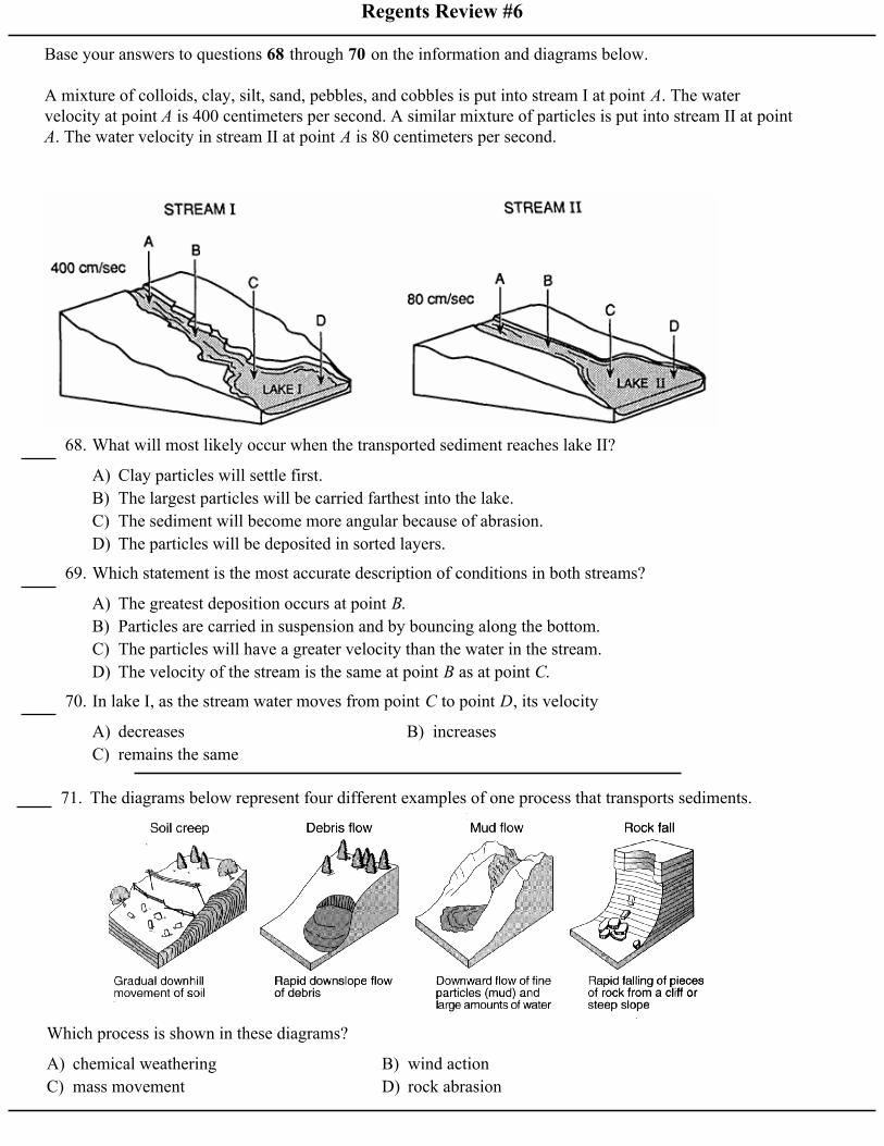
Base your answers to questions 68 through 70 on the information and diagrams below.
A mixture of colloids, clay, silt, sand, pebbles, and cobbles is put into stream I at point A. The watervelocity at point A is 400 centimeters per second. A similar mixture of particles is put into stream II at pointA. The water velocity in stream II at point A is 80 centimeters per second.
A) Clay particles will settle first.B) The largest particles will be carried farthest into the lake.C) The sediment will become more angular because of abrasion.D) The particles will be deposited in sorted layers.
68. What will most likely occur when the transported sediment reaches lake II?
A) The greatest deposition occurs at point B.B) Particles are carried in suspension and by bouncing along the bottom.C) The particles will have a greater velocity than the water in the stream.D) The velocity of the stream is the same at point B as at point C.
69. Which statement is the most accurate description of conditions in both streams?
A) decreases B) increasesC) remains the same
70. In lake I, as the stream water moves from point C to point D, its velocity
71. The diagrams below represent four different examples of one process that transports sediments.
A) chemical weathering B) wind actionC) mass movement D) rock abrasion
Which process is shown in these diagrams?

Regents Review #6
Base your answers to questions 72 through 74 on the map below, which shows the drainage basin of theMississippi River system. Several rivers that flow into the Mississippi River are labeled. The arrow atlocation X shows where the Mississippi River enters the Gulf of Mexico.
A) moraine B) tributary C) delta D) drumlin
72. The structure formed by the deposition of sediments at location X is best described as a
A) angular fragments arranged as mixturesB) rock particles arranged in sorted bedsC) rocks with parallel scratches and groovesD) high-density minerals with hexagonal crystals
73. Sediments deposited at location X by the Missisippi River most likely have which characteristics?
A) levee B) watershed C) meander belt D) floodplain
74. The entire land area drained by the Mississippi River system is referred to as a
75. The graph below is incomplete because it doesnot identify the sediment characteristic (X) thatwould produce the line plotted on the graph.
A) B)
C) D)
Which label should be placed on the horizontal axis toaccurately complete the graph?
A) a wet climate in which temperatures remainbelow freezing
B) a wet climate in which temperaturesalternate from below freezing to abovefreezing
C) a dry climate in which temperatures remainbelow freezing
D) a dry climate in which temperaturesalternate from below freezing to abovefreezing
76. Which type of climate has the greatest amount ofrock weathering caused by frost action?

Regents Review #6
Base your answers to questions 77 through 79 on the contour map below, which shows a hill formed byglacial deposition near Rochester, New York. Letters A through E are reference points. Elevations are infeet.
A) a V-shaped valley B) a sand duneC) a drumlin D) an outwash plain
77. This glacial deposit is best identified as
A) north B) south C) east D) west
78. In which direction was the glacier moving?
A) sorted and layered B) sorted and not layeredC) unsorted and not layered D) unsorted and layered
79. Which set of characteristics most likely describes the sediment in this glacial deposit?

Regents Review #6
80. The map below represents a meandering streamflowing into a lake. A student measured waterdepths in the stream at three locations: A–A', B–B', and C–C'.
A)
B)
C)
D)
Which set of cross sections best represents thestreambed at the three locations?
81. The demonstration shown in the diagram belowindicates that powdered limestone reacts fasterthan a single large piece of limestone of equalmass when both are placed in acid.
A) less total volumeB) more chemical bondsC) more total surface areaD) lower density
The most likely reason powdered limestone reacts fasteris that it has
82. The generalized cross section below shows thesedimentary rock layers at Niagara Falls inwestern New York State.
A) Lockport dolostone B) Rochester shaleC) Grimsby sandstone D) Queenston shale
Which rock layer appears to be most resistant toweathering and erosion?
83. Two different kinds of minerals, A and B, wereplaced in the same container and shaken for 15minutes. The diagrams below represent the sizeand shape of the various pieces of mineral beforeand after shaking. What caused the resultingdifferences in shapes and sizes of the minerals?
A) Mineral B was shaken harder.B) Mineral B had a glossy luster.C) Mineral A was more resistant to abrasion.D) Mineral A consisted of smaller pieces before
shaking began.
A) shape B) massC) volume D) composition
84. Which characteristic would most likely remainconstant when a limestone cobble is subjected toextensive abrasion?

Regents Review #6
Base your answers to questions 85 through 87 on the diagrams below. Diagrams A, B, and C representthree different river valleys.
A) B)
C) D)
85. Which bar graph best represents the relative gradients of the main rivers shown in diagrams A, B, and C?
A) angular and weathered from underlying bedrockB) angular and weathered from bedrock upstreamC) rounded and weathered from underlying bedrockD) rounded and weathered from bedrock upstream
86. Most sediments found on the floodplain shown in diagram A are likely to be
A) A, B, C B) C, B, A C) A, C, B D) B, C, A
87. Which sequence of diagrams shows the progression over time of the stream channel?
A) local air pressureB) angle of insolationC) age of the bedrockD) regional climate
88. Which factor has the greatest influence on theweathering rate of Earth’s surface bedrock? A) in solution
B) in suspensionC) by precipitationD) by bouncing and rolling
89. How are dissolved materials carried in a river?
A) lighter B) flatterC) better sorted D) more dense
90. When small particles settle through water fasterthan large particles, the small particles areprobably

Regents Review #6
91. Base your answer to the following question on the block diagram below, which shows some of thelandscape features formed as the most recent continental glacier melted and retreated across westernNew York State.
A) age of the glacier B) direction of glacial movementC) thickness of the glacial ice D) rate of glacial movement
The shape of elongated hills labeled drumlins is most useful in determining the
92. Base your answer to the following question on the diagram below, which shows a model used toinvestigate the erosional-depositional system of a stream. The model was tilted to create a gentleslope, and a hose supplied water to form the meandering stream shown.
A) decrease the temperature of the sediment B) decrease the slopeC) increase the size of the sediment D) increase the rate of the water flow
How can the model be changed to increase the amount of sediment transported by the stream?

Regents Review #6
93. The cross section below shows residual soils thatdeveloped on rock outcrops of metamorphicquartzite and sedimentary limestone.
A) The quartzite formed from molten magma.B) The limestone is thicker than the quartzite.C) The quartzite is older than the limestone.D) The limestone is less resistant to weathering than
the quartzite.
Which statement best explains why the soil is thickerabove the limestone than it is above the quartzite?
94. The diagram below shows a stream profile beforeand after an earthquake. Points A and B arelocations along the streambed.
A) There is more deposition at point A and moreerosion at point B.
B) There is more erosion at point A and moredeposition at point B.
C) There is more deposition than erosion at points A and B.
D) There is more erosion than deposition at points A and B.
What is the probable relationship between erosion anddeposition at points A and B after the earthquake?
A) B)
C) D)
95. Stream velocity and stream discharge wererecorded continuously at the same location in astream channel. Which graph best shows therelationship between stream velocity and streamdischarge at this location?
96. The photograph below shows a valley.
A) wave action B) moving iceC) blowing wind D) flowing water
Which agent of erosion most likely produced thisvalley's shape?
A) sorted fine-grained particles in cross-beddedlayers
B) a range of particle sizes from 1.0 to 10.0 cmin diameter in thick layers
C) flat, angular boulders in unsorted pilesD) shells of varying size, shape, and
composition in isolated mounds
97. A sedimentary deposit produced by wind erosionis most likely composed of
A) running water B) windC) gravity D) ocean currents
98. Unsorted, angular, rough-surfaced cobbles andboulders are found at the base of a cliff. Whatmost likely transported these cobbles andboulders?

Regents Review #6
99. The diagram below shows a glacial landscape feature forming over time from a melting block of ice.
A) a kettle lake B) an outwash plainC) a finger lake D) a moraine
This glacial landscape feature is best identified as
100. The diagram below shows four magnified block-shaped sandstone samples labeled A, B, C, and D. Each sandstone sample contains quartz grains of different shapes and sizes. The quartz grains areheld together by hematite cement.
A) A B) B C) C D) D
In which sample did the quartz grains undergo the most abrasion during erosional transport?
A) B)
C) D)
101.A sample of rounded quartz sediments ofdifferent particle sizes is dropped into a containerof water. Which graph best shows the settlingtime for these particles? A) pebbles, sand, silt, and clay
B) sand, silt, and clay, onlyC) silt and clay, onlyD) clay, only
102.A stream’s velocity decreases from 100 cm/s to5cm/s. Which size sediment particles will still betransported by the stream?
A) soil particle sizes and method of depositionB) bedrock composition and climate
characteristicsC) direction of prevailing winds and storm
tracksD) earthquake intensity and volcanic activity
103. Which factors most directly control thedevelopment of soils?

Regents Review #6
104. The photograph below shows a sand dune thatformed in a coastal area.
A) water flowing from the leftB) water flowing from the rightC) wind blowing from the leftD) wind blowing from the right
This sand dune was most likely formed by
A) rocks falling off the face of a steep cliffB) feldspar in granite being crushed into
clay-sized particlesC) water freezing in cracks in a roadside
outcropD) acid rain reacting with limestone bedrock
105. Which event is an example of chemicalweathering?
A) B)
C) D)
106. Which quartz sample has probably undergoneabrasion in a stream for the longest period oftime?
A) large caves in limestone bedrockB) a pattern of parallel cracks in a granite
mountainC) blocks of basalt at the base of a steep slopeD) the smooth, polished surface of a rock in a
dry, sandy area
107. Which geologic feature is caused primarily bychemical weathering?
108. The diagram below shows the cross section of astream channel and the height of the streamsurface on various dates of the year.
A) decreased, onlyB) decreased, then increasedC) increased, onlyD) remained constant
The stream's velocity from June 19 to July 20 at thissection of the stream most likely
109. The landscape diagram below shows afan-shaped pattern of sediment deposits.
A) glacial ice B) ocean wavesC) running water D) prevailing winds
The fan-shaped pattern of these sediments is mostlikely the result of deposition by
A) B)
C) D)
110. Which diagram best represents a cross sectionof a valley which was glaciated and then erodedby a stream?

Regents Review #6
111. The map below shows Rockaway Peninsula, part of Long Island's south shore, and the location ofseveral stone barriers, A, B, C, and D, that were built to trap sand being transported along the coastby wave action.
A) B)
C) D)
On which map do the arrows best show the direction of wave movement that created the beaches in thisarea?
A) The rock's potential energy and kineticenergy decrease.
B) The rock's potential energy decreases andthe rock's kinetic energy increases.
C) The rock's potential energy increases andthe rock's kinetic energy decreases.
D) The rock's potential energy and kineticenergy increase.
112. Which energy transformation occurs as a rockfalls freely from the top of a vertical cliff?
A) angular and smallerB) angular and largerC) rounded and smallerD) rounded and larger
113. The greater the time that stream sediment istransported, the greater the probability that thesediment will become more

Regents Review #6
114. The diagram below shows four identical columns containing the same amount of water. Fourdifferent-sized spherical particles, made of the same uniform material, are dropped into the columnsand settle to the bottom.
A) B)
C) D)
Which graph best shows the relative settling times of the four particles?
115. The four particles shown in the table below areof equal volume and are dropped into a columnfilled with water.
A) A B) B C) C D) D
Which particle would usually settle most rapidly?
A) The faster stream contains more dissolvedminerals.
B) The faster stream has a much steepergradient.
C) The streams are flowing in differentdirections.
D) The faster stream has a temperature of10°C, and the slower stream has atemperature of 20°C.
116. Two streams begin at the same elevation andhave equal volumes. Which statement bestexplains why one stream could be flowing fasterthan the other stream?
Regents Review #6
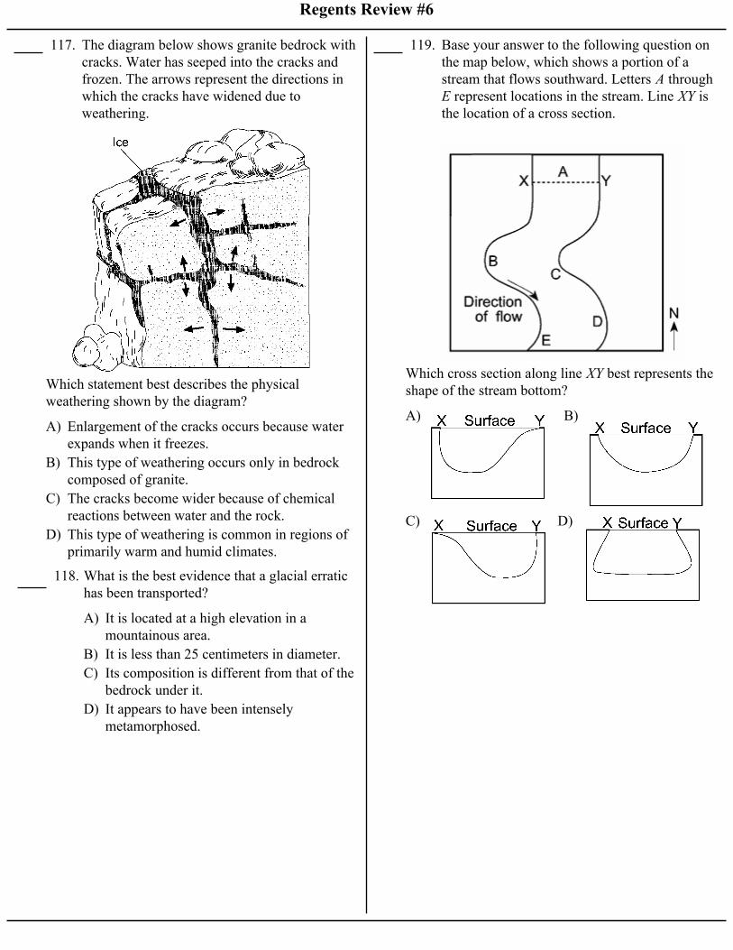
117. The diagram below shows granite bedrock withcracks. Water has seeped into the cracks andfrozen. The arrows represent the directions inwhich the cracks have widened due toweathering.
A) Enlargement of the cracks occurs because waterexpands when it freezes.
B) This type of weathering occurs only in bedrockcomposed of granite.
C) The cracks become wider because of chemicalreactions between water and the rock.
D) This type of weathering is common in regions ofprimarily warm and humid climates.
Which statement best describes the physicalweathering shown by the diagram?
A) It is located at a high elevation in amountainous area.
B) It is less than 25 centimeters in diameter.C) Its composition is different from that of the
bedrock under it.D) It appears to have been intensely
metamorphosed.
118. What is the best evidence that a glacial erratichas been transported?
119. Base your answer to the following question onthe map below, which shows a portion of astream that flows southward. Letters A through E represent locations in the stream. Line XY isthe location of a cross section.
A) B)
C) D)
Which cross section along line XY best represents theshape of the stream bottom?

Regents Review #6
120. The diagrams below show the stages, A through D, in the formation of an oxbow lake over aperiod of time. [The arrows indicate thedirection of streamflow.]
A) erosion, resulting in a sudden increase in thestream's gradient
B) deposition, resulting in a sudden increase in thestream's gradient
C) erosion along the outside banks of the curve in ameandering stream
D) deposition along the outside banks of the curve ina meandering stream
Oxbow lakes are generally formed by